METROPOLITAN COUNCIL 390 North Robert Street, St. Paul, MN Phone (651) TDD (651)
|
|
|
- Josephine George
- 6 years ago
- Views:
Transcription
1 METROPOLITAN COUNCIL 390 North Robert Street, St. Paul, MN Phone (651) TDD (651) DATE: November 23, 2009 TO: Metropolitan Parks and Open Space Commission FROM: Jan Youngquist, Senior Planner-Parks (651) SUBJECT: ( ) Rice Creek Chain of Lakes Park Reserve Restrictive Covenant Exchange, Anoka County INTRODUCTION Anoka County has requested that the Metropolitan Council release the restrictive covenant on 2.7 acres of wetland ponds at the Chomonix Golf Course portion of Rice Creek Chain of Lakes Park Reserve and in exchange, allow a restrictive covenant to be placed on 10 acres located along the southern edge of Rice Lake, which is also within the park reserve. (See Attachment 1 for the request letter from Anoka County). This staff report includes a review of the request based on criteria outlined in the 2030 Regional Parks Policy Plan and recommends approval of the restrictive covenant exchange. AUTHORITY TO REVIEW The 2030 Regional Parks Policy Plan ( Parks Policy Plan ) indicates that restrictive covenants on regional parkland cannot be released without approval from the Metropolitan Council. In order to release a restrictive covenant, Strategy 5(b) of the Parks Policy Plan requires an equally valuable land or facility exchange and outlines criteria that must be satisfied to exchange regional parks system land for other parkland. BACKGROUND The Metropolitan Council provided grant funds toward the acquisition of several parcels of land within Rice Creek Chain of Lakes Park Reserve. On December 9, 1980, the Metropolitan Council and Anoka County entered into an Agreement and Restrictive Covenant, which was recorded against these parcels on June 3, The restrictive covenant prohibits the sale, lease, conveyance, or creation of any easement, restriction or other encumbrance against the property without written approval of the Metropolitan Council. The covenant also restricts the use of the property to regional recreation open space purposes. In 1995, Anoka County created a series of wetlands at Chomonix Golf Course within Rice Creek Chain of Lakes Park Reserve to be banked for wetland credits that could be used when a future regional park or trail project required wetland mitigation. The wetlands that were created also provide benefits to the park reserve by addressing drainage issues, improving the course of play along the fairways, and increasing the ecological diversity and wildlife in the area. The wetlands include a series of nine ponds 1
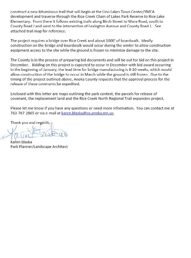
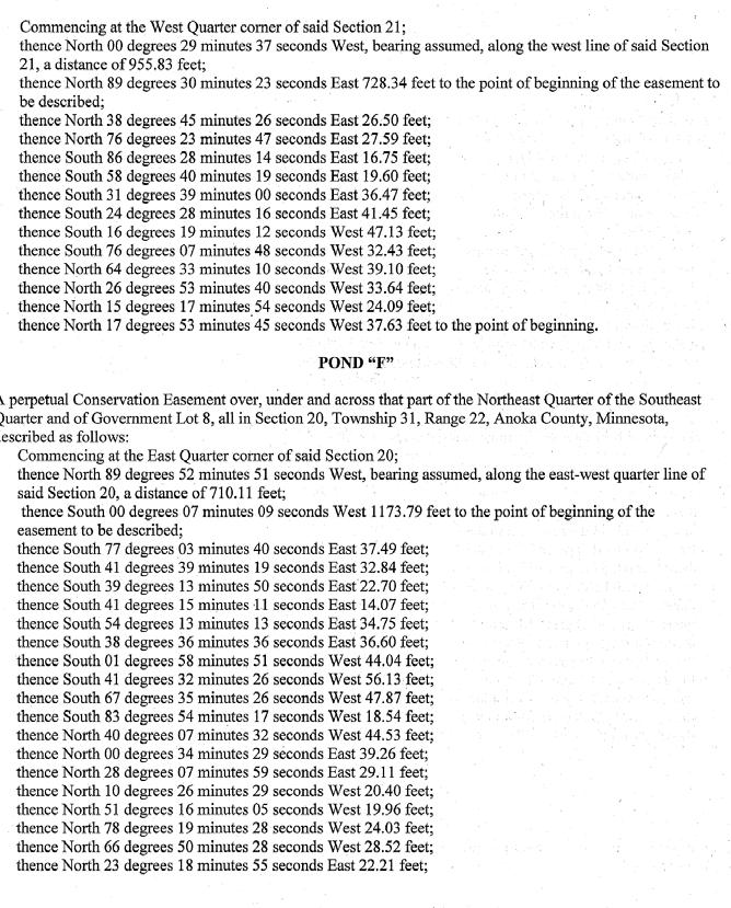
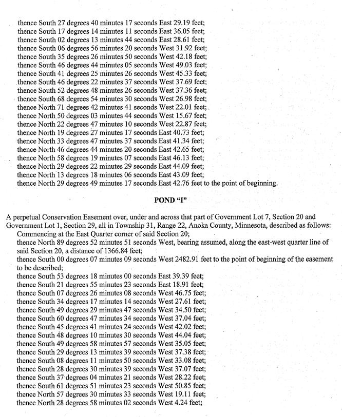
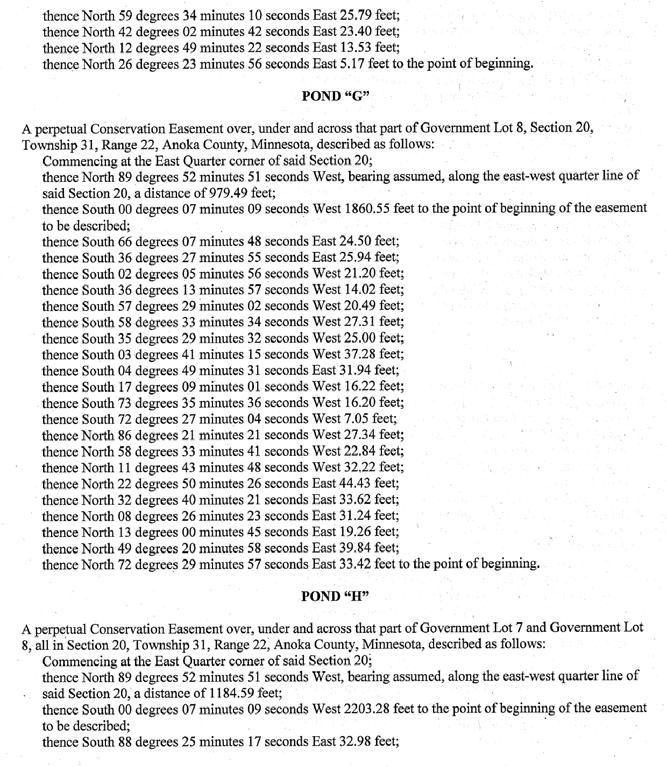
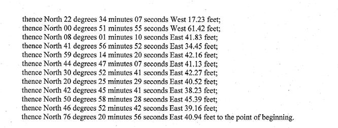
2 totaling 2.7 acres. (Aerial maps showing the location of the ponds are shown in Attachment 2. Legal descriptions of these ponds are included in Attachment 3) Anoka County is planning to begin work on an expansion of the Rice Creek North Regional Trail in The $2,000,000 project includes constructing a new bituminous trail that will begin at the Lino Lakes Town Center/YMCA development and traverse through the Rice Creek Chain of Lakes Park Reserve to Rice Lake Elementary School. New trail construction will also occur north of Baldwin Lake within the park reserve. The trail project will require wetland mitigation for impacts from boardwalks and crossings over Rice Creek, including a pedestrian bridge. (See Attachment 4 for a map of the planned trail route) Anoka County plans to use the wetland bank credits toward the required wetland mitigation as part of the regional trail project. The Minnesota Board of Soil and Water Resources ( BWSR ) oversees the wetland banking program. In order to deposit the wetland credits, BWSR requires that a perpetual conservation easement be placed on the wetlands; the easement states that the wetland bank area be preserved in a natural condition in perpetuity. The wetland bank area is located on land which has the above-mentioned restrictive covenant recorded against it. Since the restrictive covenant prohibits the creation of any easements, BWSR prepared a draft Consent and Subordination Agreement, which stated that the Metropolitan Council agreed to the easement and would subordinate the restrictive covenant to the provisions in the easement. Council legal staff strongly advised against subordinating its interest in the property due to the poor precedent it would set. Council legal staff drafted an alternate document which stated that the Council would consent to the easement; however, the easement would be subordinate to the restrictive covenant. BWSR would not accept the alternate consent. In order to proceed with the Rice Creek North Regional Trail project and take advantage of the wetland credits, Anoka County proposes removing the restrictive covenant from the 2.7 acre wetland bank site and in exchange, placing a restrictive covenant on 10 acres located elsewhere in the park reserve. The 10 acre site is located on the south side of Rice Lake and contains undisturbed wetlands as part of a larger wetland complex. The site also has approximately 700 feet of shoreline along Rice Lake. (The proposed covenant exchange land is shown in Attachment 5. The legal description for this property is included in Attachment 6) ANALYSIS Strategy 5(b) of the Parks Policy Plan requires an equally valuable land or facility exchange to be approved in order to release a restrictive covenant. Anoka County is proposing to place a restrictive covenant on 10 acres of land in exchange for the removal of the restrictive covenant on 2.7 acres of land. Strategy 5(b) defines equally valuable land as follows: Equally valuable land is defined in this context as land that is contiguous to the regional parks system unit containing the land proposed to be exchanged (that is, only add and take away land in the same park/trail unit) and/or, the land has comparable or better natural resource characteristics and could provide comparable or better recreation opportunities as what is being exchanged. 2
3 Both areas of land that are party to the restrictive covenant exchange are located in Rice Creek Chain of Lakes Park Reserve. (The location of these properties is shown in Attachment 7) The 2.7 acre wetland bank area is part of a developed golf course. These wetlands were created along the sides of the fairways. The 10 acre exchange site contains undisturbed natural wetlands as part of a larger wetland complex and has approximately 700 feet of shoreline along Rice Lake. The master plan for the park reserve calls for this area to remain in its natural state. Therefore, the 10 acre covenant exchange site has better natural resource characteristics than the wetland bank site. The restrictive covenant exchange will also facilitate the development of the Rice Creek North Regional Trail, which will provide additional recreation opportunities to the region. Strategy 5(b) requires that the following criteria be evaluated in order to determine whether regional parks system land may be exchanged for other parkland: Issues with respect to the existing park system unit: 1. How well can the park system unit (Rice Creek Chain of Lakes Park Reserve) continue to meet Council site and site attribute standards established for the particular type of park system unit (regional park, park reserve, trail or special recreation feature)? The Parks Policy Plan indicates that park reserves must be a minimum of 1,000 acres. Eighty percent of the park reserve must be managed as wild lands to protect high quality natural resources and the ecological functions of the native landscape; up to 20 percent may be developed for recreational purposes. Anoka County owns 4,473 acres in this park reserve. The area of land on which the restrictive covenant is proposed to be released is 2.7 acres. Although the covenant is proposed to be released, this land would remain within the park reserve boundary, since it is still being used for regional recreational open space purposes. The 10 acre site on which the restrictive covenant is proposed to be recorded is already within the boundary of the park reserve. Therefore, the overall park reserve acreage will not be affected. The wetlands created for the wetland bank are located on Chomonix Golf Course, which has been developed for recreational purposes, so wild lands were not affected. The 10 acre covenant exchange site is part of a wetland complex, which will be afforded another layer of protection by the restrictive covenant, which will limit use of the land to regional recreation open space purposes. 2. Can the park system unit (Rice Creek Chain of Lakes Park Reserve) continue to function as the Council intended? How will use of the park system unit be affected? The park reserve will continue to function as intended. The wetlands created at Chomonix Golf Course improved the conditions of the course and are not a detriment to the function of the park reserve. 3. Will environmental features (wildlife habitat, water quality) be adversely affected? Can they be protected with the new use? The wetlands that were created provide a benefit to the park reserve by addressing drainage issues, improving the course of play at Chomonix Golf Course, and increasing the ecological diversity and wildlife in the area. The perpetual conservation easement required by BWSR will ensure that the wetlands will be protected in perpetuity. 3
4 4. Can any loss of site or function be made up through acquisition of a site with comparable characteristics adjacent to or in the immediate area of the current location? Is there a need to replace a site or function for comparable uses in comparable location? Would the system benefit from a different park system unit in a different location? Does the park system unit benefit from a facility in exchange for land? The wetland bank area did not result in any loss of the site or of the function of the park reserve. The land will remain within the park reserve boundaries. The exchange of restrictive covenants will provide an additional layer of protection to 10 acres of land located within the park reserve. Additionally, the exchange will facilitate the development of the Rice Creek North Regional Trail, which will provide additional recreational opportunities within and adjacent to the park reserve. 5. Will all costs of relocation be covered by nonregional recreation funds? The creation of the wetlands for the wetland bank program did not use regional recreation funds. The restrictive covenant exchange site already is part of a wetland complex. No type of relocation is necessary for this exchange; therefore this issue is not applicable. 6. Are there mitigating measures that may be preferable to land exchange, particularly with respect to minor conversions? Is the need for the conversion, as in the instance of transportation improvements, generated by the recreational park system unit? The land exchange is preferable since the wetland bank area will be protected via the perpetual conservation easement, and an additional 10 acres within the park reserve will be protected through a restrictive covenant. The wetland bank area is consistent with regional parkland use and does not convert the land to another land use; therefore the second issue is not applicable. Issues with respect to the alternative use: 1. What are the land area needs of the proposed project? Anoka County created 2.7 acres of wetlands to be used as credits for future park and trail projects that require wetland mitigation. 2. What are the specific site requirements for the proposed project and how unique are they to the area proposed for conversion? The land on which the wetlands were created was chosen in order to achieve two goals. One goal was to establish a wetland bank to be used as credits for future projects that require wetland mitigation. The other goal was to address site specific problems at Chomonix Golf Course. Drainage issues along some of the fairways which caused standing water and poor conditions for golfers after a large rain event. The creation of the wetlands helped alleviate these problems and brought birds and wildlife back to the area. 3. What is the duration of the proposed project? Anoka County completed the wetland project at Chomonix Golf Course in These banked wetlands will serve as a credit for the necessary wetland mitigation associated with the Rice Creek 4
5 North Regional Trail project, which is anticipated to begin in January 2010 and be completed before the end of the year. 4. Is the proposed project consistent with Council policies? The wetland bank and the Rice Creek North Regional Trail extension projects are both consistent with the Parks Policy Plan. The Council s 2030 Regional Development Framework includes goals of working with local and regional partners to conserve, protect and enhance the region s vital natural resources. The creation of 2.7 acres of wetlands adds natural resource value to the site, and the BWSR perpetual conservation easement will ensure that these wetlands will be protected. The restrictive covenant that will be recorded on the exchange site will help protect its natural resources. 5. Is the proposed project of greater benefit to the region than continuance of the regional parks system unit (Rice Creek Chain of Lakes Park Reserve)? The wetlands that were created on Chomonix Golf Course do not result in a discontinuation of the land being used as regional parkland. These wetlands are consistent with regional park uses; therefore this issue is not applicable. CONCLUSIONS: 1. Anoka County must record a perpetual conservation easement on the 2.7 acres of wetlands it created on Chomonix Golf Course in order to participate in the BWSR wetland banking program and receive credits to be used for other regional park and trail projects that require wetland mitigation. 2. The Metropolitan Council should not subordinate its restrictive covenant interest in the property to the BWSR easement. 3. The Rice Creek North Regional Trail expansion project relies on using the wetland credits created at Rice Creek Chain of Lakes Park Reserve to mitigate the project s wetland impacts. 4. The wetland bank area is consistent with regional park uses and the perpetual conservation easement will protect this area in perpetuity. The placement of a restrictive covenant on 10 acres in another area of the park reserve will afford that site another layer of protection. The exchange of restrictive covenants will indirectly facilitate development of the Rice Creek North Regional Trail. Therefore, the release of the restrictive covenant on the wetland bank area in exchange for the placement of a restrictive covenant on the 10 acre site will benefit the regional parks system. RECOMMENDATION: 1. That the Metropolitan Council release the restrictive covenant on 2.7 acres of wetlands depicted in Attachment 1 and described in Attachment 2, in exchange for Anoka County placing a restrictive covenant on the10 acre property shown in Attachment 5 and described in Attachment 6. 5
6 ATTACHMENT 1 REQUEST LETTER FROM ANOKA COUNTY 6
7 7

8 ATTACHMENT 2 WETLAND BANK PONDS PROPOSAL TO REMOVE RESTRICTIVE COVENANT 8
9 9
10 ATTACHMENT 3 LEGAL DESCRIPTION OF WETLAND BANK PONDS PROPOSAL TO REMOVE RESTRICTIVE COVENANT 10
11 11
12 12
13 13
14 14
15 15
16 16

17 ATTACHMENT 4 RICE CREEK NORTH REGIONAL TRAIL EXPANSION 17

18 ATTACHMENT 5 LOCATION OF RESTRICTIVE COVENANT EXCHANGE REPLACEMENT SITE 18
19 ATTACHMENT 6 LEGAL DESCRIPTION OF RESTRICTIVE COVENANT EXCHANGE REPLACEMENT SITE November 23, 2009 Rice Creek Chain of Lakes Park Reserve That part of Government Lot 5, Section 30, Township 31, Range 22, Anoka County, Minnesota, lying northerly and easterly of the following described line: Beginning at the northeast corner of Lot 19, Block 1, SPIRIT HILLS, Anoka County, Minnesota; thence southwesterly, along the north line of said Block 1, SPIRIT HILLS, to the northwest corner of Lot 14 of said Block 1, SPIRIT HILLS, thence northerly, parallel with the east line of said Government Lot 5, to the southerly shore line of Rice Lake and said line there terminating. Containing 10 acres, more or less. P.I.N

20 ATTACHMENT 7 LOCATION OF RESTRICTIVE COVENANT EXCHANGE SITES 20
Community Development Committee
 C Date Prepared: Subject: Community Development Committee For the Metropolitan Council meeting of December 9, 2009 December 8, 2009 Committee Report SW Item: 2009-444 ADVISORY INFORMATION Rice Creek Chain
METROPOLITAN COUNCIL 390 North Robert Street, St. Paul, MN Phone (651) TDD (651)
 TDD (651)") METROPOLITAN COUNCIL 390 North Robert Street, St. Paul, MN 55101 Phone (651) 602-1000 TDD (651) 291-0904 DATE: April 27, 2011 TO: Metropolitan Parks and Open Space Commission FROM: Arne Stefferud, Planning
METROPOLITAN COUNCIL 390 North Robert Street, St. Paul, MN 55101 Phone (651) 602-1000 TDD (651) 291-0904 DATE: April 27, 2011 TO: Metropolitan Parks and Open Space Commission FROM: Arne Stefferud, Planning
METROPOLITAN COUNCIL 390 North Robert Street, St. Paul, MN Phone (651) TDD (651)
 TDD (651)") METROPOLITAN COUNCIL 390 North Robert Street, St. Paul, MN 55101 Phone (651) 602-1000 TDD (651) 291-0904 DATE: December 26, 2012 TO: Metropolitan Parks and Open Space Commission FROM: Jan Youngquist, AICP;
METROPOLITAN COUNCIL 390 North Robert Street, St. Paul, MN 55101 Phone (651) 602-1000 TDD (651) 291-0904 DATE: December 26, 2012 TO: Metropolitan Parks and Open Space Commission FROM: Jan Youngquist, AICP;
Business Item No xxx
 Business Item No. 2015-xxx Metropolitan Parks and Open Space Commission Meeting date: October 6, 2015 For the Community Development Committee meeting of October 19, 2015 For the Metropolitan Council meeting
Community Development Committee
 Community Development Committee For the Metropolitan Council meeting of February 13, 2013 Committee Report Business Item 2013-29 ADVISORY INFORMATION Date Prepared: January 25, 2013 Subject: Rice Creek
Metropolitan Parks and Open Space Commission
 Business Item No. 2015-xxx Metropolitan Parks and Open Space Commission Meeting date: October 6, 2015 For the Community Development Committee meeting of October 9, 2015 For the Metropolitan Council meeting
METROPOLITAN COUNCIL 390 North Robert Street, St. Paul, Minnesota Phone (651) TDD (651)
 TDD (651)") DATE: July 30, 2007 METROPOLITAN COUNCIL 390 North Robert Street, St. Paul, Minnesota 55101-1805 Phone (651) 602-1000 TDD (651) 291-0904 TO: Metropolitan Parks and Open Space Commission FROM: Arne Stefferud,
DATE: July 30, 2007 METROPOLITAN COUNCIL 390 North Robert Street, St. Paul, Minnesota 55101-1805 Phone (651) 602-1000 TDD (651) 291-0904 TO: Metropolitan Parks and Open Space Commission FROM: Arne Stefferud,
METROPOLITAN COUNCIL 390 North Robert Street, St. Paul, MN Phone (651) TDD (651)
 TDD (651)") METROPOLITAN COUNCIL 390 North Robert Street, St. Paul, MN 55101 Phone (651) 602-1000 TDD (651) 291-0904 DATE: March 21, 2008 TO: Metropolitan Parks and Open Space Commission FROM: Arne Stefferud, Planning
METROPOLITAN COUNCIL 390 North Robert Street, St. Paul, MN 55101 Phone (651) 602-1000 TDD (651) 291-0904 DATE: March 21, 2008 TO: Metropolitan Parks and Open Space Commission FROM: Arne Stefferud, Planning
REVIEWED BY: Administrator Counsel Program Mgr.: Tiffany Schaufler Board Committee Engineer Other
 Minnehaha Creek Watershed District REQUEST FOR BOARD ACTION MEETING DATE: May 11, 2017 TITLE: Authorization to Grant a Temporary Easement to the City of Minnetrista RESOLUTION NUMBER: 17-034 PREPARED BY:
DRAINAGE AND UTILITY EASEMENT. That Bruce Conrad, a single adult, hereinafter referred to as Grantor for good and
 DRAINAGE AND UTILITY EASEMENT KNOW ALL PERSONS BY THESE PRESENTS: That Bruce Conrad, a single adult, hereinafter referred to as Grantor for good and valuable consideration, the receipt and sufficiency
Easement Criteria Evaluation Project: Black Gum Mitigation Bank southern Upshur County, Texas
 Easement Criteria Evaluation Project: Black Gum Mitigation Bank southern Upshur County, Texas Project Address: on the Sabine River south of Hwy 80 in southern Upshur County, Texas (entrance located about
Claudia Stuart, Williamson Act Program Manager and Nick Hernandez, Planning Intern
 Land Conservation (Williamson) Act Advisory Committee STAFF REPORT September 15, 2014 Prepared by: Claudia Stuart, Williamson Act Program Manager and Nick Hernandez, Planning Intern Subject: Discussion:
OFFICIAL SUMMARY OF AN ORDINANCE TO CONVEY CERTAIN RAMSEY COUNTY PARK AND OPEN SPACE LANDS TO THE CITY OF MAPLEWOOD.
 OFFICIAL SUMMARY OF AN ORDINANCE TO CONVEY CERTAIN RAMSEY COUNTY PARK AND OPEN SPACE LANDS TO THE CITY OF MAPLEWOOD. This ordinance authorizes the conveyance of park and open space land owned by Ramsey
Submittal of the Minutes from the March 9, 2011, April 5, 2011, and April 19, 2011 Cabinet Meetings.
 AGENDA BOARD OF TRUSTEES OF THE INTERNAL IMPROVEMENT TRUST FUND JUNE 16, 2011 Attachments to the items below can be viewed at the following link: http://www.dep.state.fl.us/secretary/cab/public_notices.htm
Conservation Easement Stewardship
 Conservation Easements are effective tools to preserve significant natural, historical or cultural resources. Conservation Easement Stewardship Level of Service Standards March 2013 The mission of the
These matters are addressed in this report and other technical reports provided with this submission.
 September 14, 2012 Lorraine Stevens, Planner II City of Ottawa Planning and Growth Management 110 Laurier Ave. West 4th Floor Ottawa, ON K1P 1J1 Re: Jock River Estates Phase 2 Revised Draft Plan - Lot
CITY OF FORT COLLINS NATURAL AREAS AND CONSERVED LANDS EASEMENT POLICY
 CITY OF FORT COLLINS NATURAL AREAS AND CONSERVED LANDS EASEMENT POLICY Adopted January 3, 2012 PURPOSE: The purpose of the policy statement is to clarify the policies and procedures of the City of Fort
City of Grande Prairie Development Services Department
 City of Grande Prairie Development Services Department COUNTRYSIDE SOUTH OUTLINE PLAN Prepared by: GPEC Consulting Ltd. #202, 10712-100th Street Grande Prairie, AB Council Resolution of August 20, 2001
AGENDA STATEMENT NO BUSINESS OF THE PLANNING COMMISSION City of Victoria, Minnesota STAFF REPORT. Casco Ventures (Developer)
") AGENDA STATEMENT NO. 17-1 BUSINESS OF THE PLANNING COMMISSION City of Victoria, Minnesota STAFF REPORT TO: Planning Commission PREPARED BY: Erin Smith, Senior Planner RE: Waterford Landing Project Rezoning
AGENDA STATEMENT NO. 17-1 BUSINESS OF THE PLANNING COMMISSION City of Victoria, Minnesota STAFF REPORT TO: Planning Commission PREPARED BY: Erin Smith, Senior Planner RE: Waterford Landing Project Rezoning
Concept Planned Unit Development Memorandum. Duke Realty is requesting Park 81 be considered for a Planned Unit Development
 Dtike 1550 Utica Avenue South Suite 420 Minneapolis, MN 55416 952.543.2900 To: From: Maple Grove City Planner Bill Shank Duke Realty Date: December 11, 2017 Subject: Concept Planned Unit Development Memorandum
A. Preserve natural resources as identified in the Comprehensive Plan.
 1370.08 Conservation Residential Overlay District. Subd. 1 Findings. The City finds that the lands and resources within the Conservation Residential Overlay District are a unique and valuable resource
METROPOLITAN COUNCIL 390 North Robert Street, St. Paul, MN Phone (651) TDD (651)
 TDD (651)") METROPOLITAN COUNCIL 390 North Robert Street, St. Paul, MN 55101 Phone (651) 602-1000 TDD (651) 291-0904 DATE: December 3, 2012 TO: Metropolitan Parks and Open Space Commission FROM: Arne Stefferud, Manager
METROPOLITAN COUNCIL 390 North Robert Street, St. Paul, MN 55101 Phone (651) 602-1000 TDD (651) 291-0904 DATE: December 3, 2012 TO: Metropolitan Parks and Open Space Commission FROM: Arne Stefferud, Manager
ARTICLE XI - CONSERVATION SUBDIVISIONS
 ARTICLE XI - CONSERVATION SUBDIVISIONS Section 1101: Purpose and Intent. This Article is intended to provide for residential subdivisions that are designed based first and foremost on the preservation
Residential Project Convenience Facilities
 Standards for Specific Land Uses 35.42.220 E. Findings. The review authority shall approve a Land Use Permit in compliance with Subsection 35.82.110.E (Findings required for approval) or a Conditional
Implementation of Permanent Easements and Associated Nutrient Load Reductions
 1 Minnesota Nutrient Reduction Strategy Agricultural Sector/BWSR RIM Program Measure Implementation of Permanent and Associated Nutrient Load Reductions Measure Background Visual Depiction The map in Figure
DESCRIPTION OF A LAND TRUST
 DESCRIPTION OF A LAND TRUST What is a land trust? Land trusts are non-profit organizations that work hand-in-hand with landowners to protect our valuable natural resources. Land trusts have become increasingly
Yolo Habitat Conservancy County of Yolo City of Davis City of Winters City of West Sacramento City of Woodland University of California, Davis
 Yolo Habitat Conservancy County of Yolo City of Davis City of Winters City of West Sacramento City of Woodland University of California, Davis Science & Technical Advisory Committee (STAC) Operational
STAFF REPORT FOR MAJOR SUBDIVISION
 STAFF REPORT FOR MAJOR SUBDIVISION FINAL PLAT CASE NO. FA-13-001 HEARING DATE: November 6, 2013 CASE NAME: Solterra Subdivision Filing No. 14 PROCEDURE: Planning Commission ADDRESS OF MAJOR SUBDIVISION
PLANNED UNIT DEVELOPMENTS (Ordinance No.: 3036, 12/3/07; Repealed & Replaced by Ordinance No.: 4166, 10/15/12)
") 159.62 PLANNED UNIT DEVELOPMENTS (Ordinance No.: 3036, 12/3/07; Repealed & Replaced by Ordinance No.: 4166, 10/15/12) A. PURPOSE 1. General. The Planned Unit Development (PUD) approach provides the flexibility
159.62 PLANNED UNIT DEVELOPMENTS (Ordinance No.: 3036, 12/3/07; Repealed & Replaced by Ordinance No.: 4166, 10/15/12) A. PURPOSE 1. General. The Planned Unit Development (PUD) approach provides the flexibility
REGENTS POLICY PART V FINANCE AND BUSINESS MANAGEMENT Chapter Real Property
 REGENTS POLICY PART V FINANCE AND BUSINESS MANAGEMENT Chapter 05.11 Real Property P05.11.010. Purpose and Scope. A. This chapter establishes guidelines for the prudent management, including trust management,
FINAL DRAFT 12/1/16, Rev. to 7/18/17
 FINAL DRAFT 12/1/16, Rev. to 7/18/17 (As Adopted 8/8/17 Effective 9/1/17) SHELTON PLANNING AND ZONING COMMISSION Proposed Amendments to Zoning Regulations I. Amend Section 23 PERMITTED USES by inserting
Common July 24, 2017 PROJECT
 CITY OF WAUSAU TAX INCREMENT DISTRICT ELEVEN PROJECT PLAN Economic Development Committee June 6, 2017 Finance Committee June 12, 2017 Plan Commission: June 20, 2017 Common Council: July 18, 2017 Joint
Establishing an Individual Wetland Bank Site in Minnesota
 Establishing an Individual Wetland Bank Site in Minnesota March 14, 2013 This document provides a general summary of the key steps in establishing a an individual wetland bank site within the state wetland
Planned Unit Development (PUD). Sections:
. Sections:") Chapter 19.07. Planned Unit Development (PUD). Sections: 19.07.01. Purpose. 19.07.02. PUD Definition and Design Compatibility. 19.07.03. General PUD Standards. 19.07.04. Underlying Zones. 19.07.05. Permitted
Chapter 19.07. Planned Unit Development (PUD). Sections: 19.07.01. Purpose. 19.07.02. PUD Definition and Design Compatibility. 19.07.03. General PUD Standards. 19.07.04. Underlying Zones. 19.07.05. Permitted
GeoPoint 213 Hobbs Street Tampa, Florida
 AIRPORT ROAD PINELAND P.R.D. SUBDIVISION - PHASES 2 & 3 DESCRIPTION: A parcel of land lying in Sections 13 and 24, Township 14 South, Range 31 East, Volusia County, Florida, and being more particularly
CURRENT THROUGH PL , APPROVED 11/11/2009
 CURRENT THROUGH PL 111-98, APPROVED 11/11/2009 TITLE 10. ARMED FORCES SUBTITLE A. GENERAL MILITARY LAW PART IV. SERVICE, SUPPLY, AND PROCUREMENT CHAPTER 159. REAL PROPERTY; RELATED PERSONAL PROPERTY; AND
MITIGATION POLICY FOR DISTRICT-PROTECTED LANDS
 MITIGATION POLICY FOR DISTRICT-PROTECTED LANDS Approved by the District Board of Directors on July 18, 2017 The following Mitigation Policy is intended to inform the evaluation of environmental mitigation-related
TOWN OF WHITBY REPORT RECOMMENDATION REPORT
 TOWN OF WHITBY REPORT RECOMMENDATION REPORT REPORT TO: Planning and Development Committee REPORT NO: PL 4-08 DATE OF MEETING: January 21, 2008 FILE NO(S): MI-01-07 (SW- 2002-03) PREPARED BY: Planning Department
STAFF REPORT. Permit Number: Porter. Kitsap County Board of Commissioners; Kitsap County Planning Commission
 STAFF REPORT Permit Number: 15 00461 Porter DATE: November 9, 2015 TO: FROM: Kitsap County Board of Commissioners; Kitsap County Planning Commission Katrina Knutson, AICP, Senior Planner, DCD and Jeff
RESOLUTION NO. R
 RESOLUTION NO. R-2009-0485 RESOLUTION APPROVING ZONING APPLICATION Z-2008-01745 (CONTROL NO. 2003-00062) OFFICIAL ZONING MAP AMENDMENT (REZONING) WITH A CONDITIONAL OVERLAY ZONE (COZ) APPLICATION OF Habitat
CHAPTER 5. PLANNED UNIT DEVELOPMENT REGULATIONS
 Section 5.1. Purpose CHAPTER 5. PLANNED UNIT DEVELOPMENT REGULATIONS 5.1. PURPOSE The purpose for Planned Unit Developments (PUDs) is established in Section 4.5 Zoning District Purpose Statements. 5.2.
19.12 CLUSTER RESIDENTIAL DISTRICT
 Chapter 19.12 CLUSTER RESIDENTIAL DISTRICT (Adopted 12/22/2003; Ordinance #0061970). Amended 7/3/17, Ordinance #079100. Section 19.12.010 - Declaration of Intent. The Cluster Residential District provides
DESCRIPTION OF THE DISTRICT
 DESCRIPTION OF THE DISTRICT The project plan for City of Wausau, Tax Increment District #11 has been prepared in compliance with Wisconsin Statutes Chapter 66.1105(4). The plan establishes the need for
78th OREGON LEGISLATIVE ASSEMBLY Regular Session. House Bill 2510 SUMMARY
 th OREGON LEGISLATIVE ASSEMBLY--0 Regular Session Sponsored by Representative CLEM (Presession filed.) House Bill 0 SUMMARY The following summary is not prepared by the sponsors of the measure and is not
SETTLEMENT AGREEMENT. and Department of Transportation and Public Facilities (collectively, the State ), hereby
, hereby") SETTLEMENT AGREEMENT Ahtna, Inc. ( Ahtna ) and the State of Alaska, Department of Natural Resources and Department of Transportation and Public Facilities (collectively, the State ), hereby agree to the
SETTLEMENT AGREEMENT Ahtna, Inc. ( Ahtna ) and the State of Alaska, Department of Natural Resources and Department of Transportation and Public Facilities (collectively, the State ), hereby agree to the
Environmental Assessment
 Environmental Assessment For a conversion of land protected under Section 6(f)3 of the Land and Water Conservation Fund Act Teague Park Caribou, Maine Submitted By: Project Sponsor: City of Caribou Attn:
PROJECT SCORING GUIDANCE. Introduction: National Proiect Selection:
 FOREST LEGACY PROGRAM PROJECT SCORING GUIDANCE Introduction: This document provides guidance to the National Review Panel on how to score individual Forest Legacy Program (FLP) projects, including additional
Draft Model Access Management Overlay Ordinance
 Draft Model Access Management Overlay Ordinance This model was developed using the City of Hutchinson and the Trunk Highway 7 corridor. The basic provisions of this model may be adopted by any jurisdiction
ARTICLE FIVE FINAL DRAFT
 ARTICLE FIVE 021218 FINAL DRAFT Sec. 503.6 Open Space Preservation Option Open Space Preservation Option Open Space Preservation developments may be approved in the AR, R-1, R-2 and R-3 zoning districts,
Tejon Ranch Conservation and Land Use Agreement Executive Summary
 Tejon Ranch Conservation and Land Use Agreement Executive Summary The Tejon Ranch Company (TRC) and Audubon California, the Endangered Habitats League, Natural Resources Defense Council, Planning and Conservation
2015 WETLAND CONSERVATION ACT STATUTE CHANGES
 2015 WETLAND CONSERVATION ACT STATUTE CHANGES Summary of Key Statute Changes and Related Legislation with Explanations This summary includes excerpts from Laws of MN 2015, Chapter 4, Article 4. It includes
Lessard Sams Outdoor Heritage Council
 Lessard Sams Outdoor Heritage Council MEMO: Agenda Item # 10 DATE: December 11, 2014 SUBJECT: PRESENTER: 2015 Legislative Appropriation Recommendation Bill Heather Koop, LSOHC staff Background: On October
Draft Continuing Authorities Program Section 1135 Detailed Project Report and Integrated Environmental Assessment
 Appendix G Real Estate Shorty s Island / Meander Reach Ecosystem Restoration Kootenai River, Idaho Draft Continuing Authorities Program Section 1135 Detailed Project Report and Integrated Environmental
Special Use Permit - Planned Unit Development Checklist. Property Address:
 Special Use Permit - Planned Unit Development Checklist Special Use Permit Number. Parcel Code/s #28-11- - - Property Address: Applicant: ARTICLE VIII Ordinance Reference - Section 8.1.2 Permit Procedures:
The Corporation of the TOWN OF MILTON
 Report to: From: Chair & Members of the Administration & Planning Standing Committee W.F. Mann, Director of Planning and Development Date: March 21, 2011 Report No. PD-013-11 (Town File Z.08/10 - Radha
Land Asset Management Policy
 Page 1 Land Asset Management Policy The following policy is based on the needs and land assets of Beltrami County, and Minnesota Statutes. Purpose This policy is to assist Beltrami County in maintaining
TRANSFERABLE DEVELOPMENT RIGHTS PROCESS GUIDE
 TRANSFERABLE DEVELOPMENT RIGHTS PROCESS GUIDE Clear Creek County Planning Department P.O. Box 2000 Georgetown, Colorado 80444 (303) 679-2436 - phone (303) 569-1103 - fax 1 PURPOSE: A Transfer of Development
DRAFT FOR PUBLIC HEARING (rev. March, 2016)
") Chapter 200. ZONING Article VI. Conservation/Cluster Subdivisions 200-45. Intent and Purpose These provisions are intended to: A. Guide the future growth and development of the community consistent with
Chapter 200. ZONING Article VI. Conservation/Cluster Subdivisions 200-45. Intent and Purpose These provisions are intended to: A. Guide the future growth and development of the community consistent with
Conceptual Scheme SE W4
 December 2012 1. PURPOSE 1.1. The purpose of a Conceptual Scheme (CS) is as follows: a) To provide a framework for the subsequent subdivision and/or development of land within the Country Residential Policy
LIST OF TAX FORFEITED LAND # FOR SALE TO PUBLIC
 LIST OF TAX FORFEITED LAND #218-1 FOR SALE TO PUBLIC Residential Properties RADON WARNING STATEMENT The Minnesota Department of Health strongly recommends that ALL homebuyers have an indoor radon test
Date: June 17, Recreation and Park Commission. Dawn Kamalanathan Planning Director
 Date: June 17, 2010 To: From: Recreation and Park Commission Dawn Kamalanathan Planning Director Subject: Candlestick Point Hunters Point Shipyard Phase 2 Project Agenda Wording: Resolution approving and
Diamond Falls Subdivision PROPOSED YELLOWSTONE COUNTY BOARD OF PLANNING FINDINGS OF FACT
 Diamond Falls Subdivision PROPOSED YELLOWSTONE COUNTY BOARD OF PLANNING FINDINGS OF FACT The City/County Planning Staff has prepared the Findings of Fact for the Diamond Falls Subdivision. These findings
Torch Lake Township Antrim County, Michigan
 Torch Lake Township Antrim County, Michigan Farmland and Open Space Development Rights Ordinance Ordinance No. 04-01 Effective September 3, 2004 AN ORDINANCE creating a farmland and open space protection
TOOELE COUNTY LAND USE ORDINANCE CHAPTER 31 Page 1
 CHAPTER 31 PLANNED COMMUNITY ZONE (P-C) Section 31-1 Definitions. 31-2 Purpose. 31-3 Land use districts. 31-4 P-C zone area minimum requirements. 31-5 Permitted uses. 31-6 Conditional uses. 31-7 Planning
DEED AND DEDICATION FOR PUBLIC RIGHT OF WAY
 TO : BOARD OF DIRECTORS FROM : GARY PLATT, EXEC. DIRECTOR BUSINESS AND OPERATIONS SUBJECT : CITY OF STANWOOD CONSTRUCTION EASEMENT AND RIGHT-OF-WAY DEDICATION DATE : MARCH 17, 2009 TYPE : ACTION NEEDED
STAFF REPORT FOR MAJOR SUBDIVISION
 STAFF REPORT FOR MAJOR SUBDIVISION FINAL PLAT CASE NO. FA-12-003 HEARING DATE: November 6, 2013 CASE NAME: Solterra Subdivision Filing No. 13 PROCEDURE: Planning Commission ADDRESS OF MAJOR SUBDIVISION
CASE SUMMARY Conditional District Zoning Modification Planning Commission January 9, 2013 CD M1212
 CASE SUMMARY Conditional District Zoning Modification Planning Commission January 9, 2013 CD-3-109-M1212 Jim Diepenbrock, Associate Planner jim.diepenbrock@wilmingtonnc.gov 910-341-3257 Staff recommendation
Inverness Area Planning Advisory Committee Inverness County Planning Advisory Committee Inverness County Council Planning Staff (EDPC)
") STAFF REPORT To: From: Inverness Area Planning Advisory Committee Inverness County Planning Advisory Committee Inverness County Council Planning Staff (EDPC) Date: January 18, 2018 Reference: Request for
STAFF REPORT To: From: Inverness Area Planning Advisory Committee Inverness County Planning Advisory Committee Inverness County Council Planning Staff (EDPC) Date: January 18, 2018 Reference: Request for
CHAPTER Committee Substitute for Committee Substitute for Senate Bill No. 2188
 CHAPTER 2004-372 Committee Substitute for Committee Substitute for Senate Bill No. 2188 An act relating to land development; amending s. 197.502, F.S.; providing for the issuance of an escheatment tax
MARK TWAIN LAKE MASTER PLAN CLARENCE CANNON DAM AND MARK TWAIN LAKE MONROE CITY, MISSOURI
 MARK TWAIN LAKE MASTER PLAN CLARENCE CANNON DAM AND MARK TWAIN LAKE MONROE CITY, MISSOURI CHAPTER 4 LAND ALLOCATION, LAND CLASSIFICATION, WATER SURFACE, AND EASEMENT LANDS This Master Plan is a land use
Title summary for property offered for sale by Peppertree-Atlantic Beach Association, Inc.
 Title summary for property offered for sale by Peppertree-Atlantic Beach Association, Inc. The bulk of the property offered for sale consists of a total of 4.392 acres of land, more or less, as more particularly
Environment and Natural Resources Trust Fund 2018 Request for Proposals (RFP)
") Environment and atural Resources Trust Fund 2018 Request for Proposals (RFP) Project Title: Bayport St. Croix Conservation Initiative Category: G. Land Acquisition, Habitat and Recreation ERTF ID: 210-G
Environment and atural Resources Trust Fund 2018 Request for Proposals (RFP) Project Title: Bayport St. Croix Conservation Initiative Category: G. Land Acquisition, Habitat and Recreation ERTF ID: 210-G
Cover Letter with Narrative Statement
 Cover Letter with Narrative Statement March 31, 2017 rev July 27, 2017 RE: Rushton Pointe Residential Planned Unit Development Application for Public Hearing for RPUD Rezone PL2015 000 0306 Mr. Eric Johnson,
Draft Zoning Changes for the 2nd Planning Board Public Hearing, January 22, 2018.
 Draft Zoning Changes for the 2nd Planning Board Public Hearing, January 22, 2018. No changes were made at the 1st Public Hearing. Proposed wording for the 1 st Public Hearing in red, eliminated text in
Establishing a Wetland Bank in Minnesota
 Establishing a Wetland Bank in Minnesota Updated February 1, 2018 This document provides a general summary of the key steps in establishing an individual wetland bank site within the state wetland banking
A FOR SALE OFFERING THE LEE SHORE MARINA 119 & 135 JOHNNY MERCER BOULEVARD SAVANNAH, CHATHAM COUNTY, GEORGIA 31410
 A FOR SALE OFFERING THE LEE SHORE MARINA 119 & 135 JOHNNY MERCER BOULEVARD SAVANNAH, CHATHAM COUNTY, GEORGIA 31410 PRESENTED BY WHITLEY AND ASSOCIATES, INC. 800 COMMERCIAL COURT, SUITE TWO, SAVANNAH, GEORGIA
Site Selection and Acquisition
 Site Selection and Acquisition School site selection and acquisition involve a diligent team effort by District staff, appropriate facility planning individuals and real property professionals in cooperation
42-Acre Parcel Rezoning and Master Plan Amendment. Danny Cagle and Patrick Stanley 6301 Duckweed Rd. Lake Worth, FL 33449
 STAFF REPORT CITY OF PARKLAND DEVELOPMENT SERVICES DEPARTMENT Date Prepared: May 2, 2014 I. Petition Description Petition No.: Project Name: Owners: RZ14-001; MPA14-002 42-Acre Parcel Rezoning and Master
RATE AND METHOD OF APPORTIONMENT FOR COMMUNITY FACILITIES DISTRICT NO. 4 - MAINTENANCE OF THE CITY OF MORENO VALLEY
 CFD No. 4 Maintenance Page 1 RATE AND METHOD OF APPORTIONMENT FOR COMMUNITY FACILITIES DISTRICT NO. 4 - MAINTENANCE OF THE CITY OF MORENO VALLEY A Special Tax as hereinafter defined shall be levied on
CHAPTER XIX ANNEXATION ARTICLE 1. ANNEXATION
 CHAPTER XIX ANNEXATION ARTICLE 1. ANNEXATION 19.0101 JABORSKY ADDITION: WHEREAS, The City of Belfield pursuant to Section 40-51.2-07 of the North Dakota Century Code has amended having passed a Resolution
ARLINGTON COUNTY, VIRGINIA. County Board Agenda Item Meeting of June 17, 2017
 ARLINGTON COUNTY, VIRGINIA County Board Agenda Item Meeting of June 17, 2017 DATE: June 9, 2017 SUBJECT: Request to authorize advertisement of public hearings by the Planning Commission and County Board
MINUTES OF A REGULAR PLANNING COMMISSION MEETING HELD, TUESDAY, OCTOBER 11, :30 P.M. ROCKVILLE CITY HALL
 28 MINUTES OF A REGULAR PLANNING COMMISSION MEETING HELD, TUESDAY, OCTOBER 11, 2011 6:30 P.M. ROCKVILLE CITY HALL The meeting was called to order by Chair Toni Honer. Roll call was taken and the following
OPEN SPACE & RECREATION PLAN
 OPEN SPACE & RECREATION PLAN HOPEWELL TOWNSHIP Cumberland County, New Jersey Prepared by: Hopewell Township Environmental Commission Final October 2011 (THIS PAGE INTENTIONALLY LEFT BLANK) PUBLIC MEETINGS
Proposed DNR Acquisition to add to the Cannon River Turtle Preserve Scientific and Natural Area (SNA)
") Proposed DNR Acquisition to add to the Cannon River Turtle Preserve Scientific and Natural Area (SNA) Cannon River Turtle Preserve SNA consists of 900 acres of primarily floodplain forest along the Cannon
Proposed DNR Acquisition to add to the Cannon River Turtle Preserve Scientific and Natural Area (SNA) Cannon River Turtle Preserve SNA consists of 900 acres of primarily floodplain forest along the Cannon
STAFF REPORT FOR MAJOR SUBDIVISION
 STAFF REPORT FOR MAJOR SUBDIVISION FINAL PLAT CASE NO. FA-14-001 HEARING DATE: January 6, 2016 CASE NAME: Solterra Subdivision Filing No. 16 PROCEDURE: Planning Commission ADDRESS OF MAJOR SUBDIVISION
Spirit Lake North, LLC
 BONNER COUNTY PLANNING DEPARTMENT PLANNING AND ZONING COMMISSION STAFF REPORT FOR March 1, 2018 Project Name: Amendment & Zone Change: Spirit Lake North, LLC File Number,Type: AM 162-18/ZC365-18 Request:
PLANNED RESIDENTIAL DEVELOPMENT (PRD)
") PLANNED RESIDENTIAL DEVELOPMENT SECTION 10. PLANNED RESIDENTIAL DEVELOPMENT (PRD) 10.1 Purpose Planned Residential Development allows by special permit from the Board an alternative pattern of residential
PLANNED RESIDENTIAL DEVELOPMENT SECTION 10. PLANNED RESIDENTIAL DEVELOPMENT (PRD) 10.1 Purpose Planned Residential Development allows by special permit from the Board an alternative pattern of residential
ARLINGTON COUNTY, VIRGINIA
 ARLINGTON COUNTY, VIRGINIA County Board Agenda Item Meeting of January 26, 2013 DATE: January 8, 2013 SUBJECT: Amend and Restate the Deed of Easement and Declaration of Restrictive Covenants for to permit
Staff Report: Date: Applicant: Property Identification: Acreage of Request: Current Zoning of Requested Area: Requested Action: Attached:
 Staff Report: Completed by Jeff Palmer Director of Planning & Zoning Date: November 7, 2018, Updated November 20, 2018 Applicant: Greg Smith, Oberer Land Developer agent for Ronald Montgomery ET AL Property
L. LAND USE. Page L-1
 L. LAND USE 1. Purpose This section discusses current and likely future land use patterns in Orland. An understanding of land use trends is very important in determining Orland's ability to absorb future
Municipality of Anchorage, Alaska Parks & Recreation Department
 Municipality of Anchorage, Alaska Parks & Recreation Department 632 W. 6 th Avenue, Suite 630 P.O. Box 196650 Anchorage, AK 99519 Tel 907-343-4355 URL www.muni.org/departments/parks Memorandum Date: April
IRC INTERNATIONAL REALTY CORPORATION
 Rental Rate: $16/SF 3480 Pelican Colony Blvd., Estero, Florida 34134 IRC INTERNATIONAL REALTY CORPORATION 3838 Tamiami Trail North, Suite 416 Naples, FL 34103 (P) 239.213.4000 rainer@inter-realty.com www.inter-realty.com
Staff Report: Date: Applicant: Property Identification: Acreage of Request: Current Zoning of Requested Area: Requested Action: Attached:
 Staff Report: Completed by Jeff Palmer Director of Planning & Zoning Date: November 7, 2018 Applicant: Greg Smith, Oberer Land Developer agent for Ronald Montgomery ET AL Property Identification: Frontage
FINAL SPUD APPLICATION
 The Planning & Development Services Department is here to assist you with your development application pursuant to the Community Development Code (CDC). This publication outlines the Final SPUD Development
CITY OF INVER GROVE HEIGHTS 8150 Barbara Avenue Inver Grove Heights, MN (651)
") 8150 Barbara Avenue Inver Grove Heights, MN 55077 (651) 450-2545 www.invergroveheights.org FINAL PLANNED UNIT DEVELOPMENT (City Code Section 10-13A) The following must be submitted prior to review and
8150 Barbara Avenue Inver Grove Heights, MN 55077 (651) 450-2545 www.invergroveheights.org FINAL PLANNED UNIT DEVELOPMENT (City Code Section 10-13A) The following must be submitted prior to review and
Committee of Adjustment Hearing Date: October 4, 2016
 Committee of Adjustment Hearing Date: October 4, 2016 Staff Comments Regarding: Files A28/16, A34/16, A35/16, B13/16, B14/16, B15/16 A28/16 545 The Queensway - Kevin M. Duguay/SBLAC Peterborough Inc. The
5. That the Owner shall agree that all development Blocks shown within the Draft Plan will be connected to full municipal services.
 Conditions Relating to Draft Plan of Subdivision Approval East Fonthill 26T 01014 (Draft Plan dated December 1, 2013, and revised August 28, 2014), the Town of Pelham 1. This approval applies to the Draft
3.3 Acquisitions and Displacements/Relocations
 Chapter 3 Social Effects 3.3 Acquisitions and Displacements/Relocations This section discusses property displacements, relocations, and acquisitions (partial or full) that might occur due to implementation
City of Palo Alto (ID # 4882) City Council Staff Report
 City Council Staff Report") City of Palo Alto (ID # 4882) City Council Staff Report Report Type: Consent Calendar Meeting Date: 12/15/2014 Summary Title: Easements for San Francisquito Creek Joint Powers Authority Initial Flood Protection
City of Palo Alto (ID # 4882) City Council Staff Report Report Type: Consent Calendar Meeting Date: 12/15/2014 Summary Title: Easements for San Francisquito Creek Joint Powers Authority Initial Flood Protection
Cherokee Webster Development, LP. City of Webster, Texas Planned Development No. 3. Proposed Revision No. 4
 Cherokee Webster Development, LP. City of Webster, Texas Planned Development No. 3 Proposed Revision No. 4 October 2013 1 Statement of Intent This Revision No. 4 of the Statement of Intent is written in