RICHLAND COUNTY PLANNING COMMISSION
|
|
|
- Joella Pitts
- 6 years ago
- Views:
Transcription

1 RICHLAND COUNTY PLANNING COMMISSION DECEMBER 1, 2014
2


3 RICHLAND COUNTY PLANNING COMMISSION DECEMBER 1, 2014 SC 215 Joyce Dickerson 176 Bill Malinowski Torrey Rush Julie Ann Dixon!( Jim Manning 3 Lake 321 Murray 76 20!( 5!( 1 1 Paul Livingston!( 4 76 SC 277 Seth Rose Damon Jeter SC SC 16 SC 555 Greg Pearce SC 12 Kelvin Washington SC 262!( 2 Norman Jackson 76 SC 769 SC 764 SC 263 SC CASE NO. APPLICANT TMS NO. LOCATION DISTRICT MA David Wheeler Monticello Rd. Rush MA Ken Simmons /14, Trotter Rd. Jackson MA George Goff & & 1105 Sparkleberry Lane Ext. Dixon MA Tobias Ward & / Elm Abode Terr. Livingston MA Carl Parrott North Brickyard Rd. Manning
4
5 RICHLAND COUNTY PLANNING COMMISSION Monday, December 1, 2014 Agenda 1:00 PM 2020 Hampton Street 2 nd Floor, Council Chambers STAFF Tracy Hegler, AICP...Planning Director Geonard Price... Deputy Planning Director/Zoning Administrator Amelia R. Linder, Esq.... Attorney Holland Jay Leger, AICP.. Planning Services Manager PUBLIC MEETING CALL TO ORDER... Patrick Palmer, Chairman PUBLIC NOTICE ANNOUNCEMENT PRESENTATION OF MINUTES FOR APPROVAL November 2014 Minutes ADOPTION OF THE AGENDA ROAD NAMES [ACTION] MAP AMENDMENTS [ACTION] 1. Case #14-36 MA David Wheeler GC to RS-LD (1.30 acres) 7640 Monticello Rd. TMS# ADMINISTRATIVE DEFERRAL 2. Case # MA Ken Simmons PDD to PDD (89.2 acres) Trotter Rd. TMS# R /14, R Page 1 3. Case # MA George Goff HI to GC (15.39 acres) 1117 & 1105 Sparkleberry Lane Ext. TMS# & Page 9
6 4. Case # MA Tobias Ward RS-LD to PDD (2.9 acres) 1335 Elm Abode Terr. TMS# Page Case # MA Carl Parrott RS-LD to OI (3.5 acres) 908 North Brickyard Rd TMS# Page 31 TEXT AMENDMENTS [ACTION] 1. AN ORDINANCE AMENDING THE RICHLAND COUNTY CODE OF ORDINANCES; CHAPTER 26, LAND DEVELOPMENT; ARTICLE VII, GENERAL DEVELOPMENT, SITE, AND PERFORMANCE STANDARDS; SECTION , OFF-STREET PARKING STANDARDS; SUBSECTION (F), PARKING OF RECREATIONAL VEHICLES, BOATS, AND TRAVEL TRAILERS; SO AS TO ADD UTILITY TRAILERS. Page 39 COMPREHENSIVE PLAN [ACTION] 1. AN ORDINANCE UPDATING THE 2009 COMPREHENSIVE PLAN THROUGH THE ADOPTION OF A NEW PLAN FOR THE COUNTY OF RICHLAND, PURSUANT TO THE STATE OF SOUTH CAROLINA COMPREHENSIVE PLANNING ENABLING ACT OF Page 41 OTHER BUSINESS 1. ADOPTION OF THE 2015 CALENDAR DIRECTOR S REPORT OF ACTION 1. ZONING PUBLIC HEARING REPORT 2. DEVELOPMENT REVIEW TEAM REPORT ADJOURNMENT **The Planning Commission is a recommending body to Richland County Council. Recommendations for Approval or Disapproval are forwarded to County Council for their consideration at the Zoning Public Hearing. The Zoning Public Hearing is another opportunity to voice your opinion for or against a rezoning or amendment to the Land Development Code and is open to the public. Check the County s website for dates and times.**
 Approval Request Pursuant Section 6-29-1200 (A), SC Code of Laws requires the Planning")
7 2020 Hampton St., 1 st Floor Columbia, SC Phone: (803) Fax: (803) TO: FROM: Planning Commission Members; Interested Parties Alfreda W. Tindal, E9-1-1 Addressing Coordinator Specialist DATE: November 20, 2014 SUBJECT: December s Street Name(s) Approval Request Pursuant Section (A), SC Code of Laws requires the Planning Commission to approve street names. Specifically, states A local planning commission created under the provisions of this chapter shall, by proper certificate, approve and authorize the name of a street or road laid out within the territory over which the commission has jurisdiction The proposed street name(s) listed below has/ have been reviewed and meet(s) the Enhanced emergency road naming requirements. Action Requested: The Planning Commission Board approval. PROPOSED STREET NAME(S) APPLICANT/CONTACT DEVELOPEMENT NAME PROPERTY TMS# COUNCIL DISTRICT (HONORABLE) 1. Branch Creek Drive 2. Fly Cast Lane 3. Stone Fly Lane 4. Troutman Lane Mike Dinkins, Civil Engineering of Columbia Proposed Oaks at Branch Creek R R & 03; R &06 Bill Malinowski (1) Planning
8
9 Richland County Planning & Development Services Department Map Amendment Staff Report PC MEETING DATE: December 1, 2014 RC PROJECT: MA APPLICANT: Ken Simmons LOCATION: TAX MAP NUMBER: ACREAGE: EXISTING ZONING: PROPOSED ZONING: Trotter Rd and Garners Ferry Rd R , 14, and R acres PDD PDD PC SIGN POSTING: November 14, 2014 Staff Recommendation Approval Background Zoning History The original zoning of the parcel as adopted September 7, 1977 was Rural District (RU). The subject parcel was rezoned to Planned Development District (PDD) in 2005 under Ordinance Number HR (case number 05-32MA). Zoning History for the General Area A parcel southeast of the site was rezoned from RU to General Commercial (GC) District under ordinance number HR (case number 12-27MA). A parcel adjacent east of the site was rezoned from RU to Planned Development (PDD) District under ordinance number HR (case number 05-89MA). A parcel east of the site adjacent to the Garners Ferry Sports Complex was rezoned from RU to General Commercial (GC) District under ordinance number HR (case number 02-42MA). A parcel west of the site was rezoned from RU to General Commercial (GC) District under ordinance number HR (case number 04-60MA). A parcel southeast of the site was rezoned from RU to Office and Institutional (OI) District under ordinance number HR (case number 04-09MA). A parcel east of the site was rezoned from RU to Planned Development (PDD) District under ordinance number HR (case number 07-28MA). 1
10 Zoning District Summary The Planned Development (PDD) District is intended to allow flexibility in development that will result in improved design, character, and quality of new mixed-use developments, and that will preserve natural and scenic features of open spaces. Planned Development Districts must involve innovation in site planning for residential, commercial, institutional, and/or industrial developments within the district. Such developments must be in accordance with the comprehensive plan for the county, and in doing so, may provide for variations from the regulations of the county s zoning districts concerning use, setbacks, lot size, density, bulk, and other such requirements. Direction Existing Zoning Use North: RS-MD and RU Single-family residences South: RU Undeveloped East: PDD/RU Undeveloped/undeveloped West: GC/RU Commercial use/undeveloped/residential Discussion Parcel/Area Characteristics The PDD parcels have frontage along Garners Ferry Road and Trotter Road. The site is undeveloped, with gentle slopes, some wooded areas and some cleared for agriculture, no sidewalks or streetlights along Garners Ferry Road and Trotter Road. The overall PDD identifies 89.2 total acres with a current residential yield as 376 units at 4.39 dwelling units per acre (du/ac). The rezoning proposes 78.7 acres of residential and 351 total allowable dwelling units. The proposed PDD will increase the commercial acreage from 1.7 acres to 5.7 acres. The proposed changes would decrease the residential yield from 376 units to 351 units. Though the total number of residential units will decrease, the total dwelling units per acre will increase from 4.39du/ac to 4.45 du/ac. Proposed PDD Amendments Land Use Existing Acreage Proposed Acreage Acreage Change Open Space Single Family Residential Multi-Family Residential Commercial Development Road R-O-W
11 Public Services Water would be provided by the City of Columbia and sewer would be provided by Richland County. There is a fire hydrant located along Garners Ferry Road. The Lower Richland fire station (station number 22) is located on Lower Richland Boulevard, approximately.8 miles east of the subject parcel. Plans & Policies The 2009 Richland County Comprehensive Plan Future Land Use Map designates the area as Suburban in the Southeast Planning Area. Objective: Residential areas are encouraged to contain a mix of residential and civic land uses. Existing single family developments may be adjacent to multifamily or a PDD including a buffer from higher intensity uses. Residential developments should occur at medium densities of 4-8 dwelling units per acre. Compliance: The proposed PDD would allow for 4.45 dwelling units per acre which meets the objective of 4-8 dwelling units per acre Southeast Richland Neighborhood Master Plan (SERN) The subject parcel is located just west of the SERN boundary and outside of the area designated for the Plan. The recommendations and guidelines outlined in the SERN would not be applicable to the subject parcel at this time. Lower Richland Master Plan (LRMP) The subject parcel would be part of the LRMP area, and is identified as the Suburban Transition Area. The Suburban Transition Area is categorized by the presence of existing infrastructure, and its proximity to Fort Jackson and to Columbia s suburban footprint. Furthermore, the LRMP supports the Southeast Richland Neighborhood Master Plan (SERN) s recommendation that development in this area should be a concentrated mix of uses that offer commercial, retail and residential spaces. This Plan suggests guided development that provides small-scale pockets of commercial uses connected to multi-family and single-family housings by sidewalks, plazas and other pedestrian-friendly walkways. Traffic Characteristics The 2013 SCDOT traffic count (Station # 170) located adjacent to the subject parcel on Garners Ferry Road identifies 24,200 Average Daily Trips (ADT s). Garners Ferry Road is classified as a four lane divided principal arterial, maintained by SCDOT with a design capacity of 33,600 ADT s. This segment of Garners Ferry Road is currently operating at Level of Service (LOS) B. There are no planned or programmed improvements for this section of Garners Ferry Road, either through SCDOT or the County Penny Sales Tax program. 3
12 Conclusion The parcels north and west of the site contain residential uses. The parcels located north are zoned Residential Single-family Medium Density (RS-MD) and are mostly developed residentially. The southernmost portion of the proposed PDD is adjacent to a GC parcel with established commercial uses. The proposed request is in compliance with the Comprehensive Plan, as it provides a mix of uses, open space and a density between the ranges of 4 8 units per acre. In addition it is in compliance with the LRMP. Approval of the rezoning request would not be out of character with the existing, surrounding, development pattern and zoning districts for the area. Staff believes that the proposed rezoning would be consistent with the intentions of the Comprehensive Plan. For these reasons, staff recommends Approval of this map amendment. Zoning Public Hearing Date December 16, Proposed PDD Conditions a) The Farms on McCords Ferry dated shall adhere to the Richland County Land Development Code as amended through b) Proposed changes to the approved Master Plan shall be subject to the requirements of Section (j) of the Richland County Land Development Code. c) Richland County shall not be responsible for the enforcement of any deed restrictions imposed by the applicant, the developer, or their successors in interest. d) All the conditions described herein shall apply to the applicant, the developer and/or their successors in interest. e) In the amended Commercial Land Use District Parcel A as designated by the Amendment Dated 10/17/14 THE FARM on McCord s Ferry PUD 1-R, there shall be no more than five point seven (5.7) total acres dedicated to commercial uses. f) In the amended Residential Land Use District Parcel B as designated by the Amendment Dated 10/17/14 THE FARM on McCord s Ferry PUD 1-R, there shall be no more than thirty five point four (35.4) total acres dedicated to single-family uses with a maximum of 195 units. g) In the amended Residential Land Use District Parcel C as designated by the Amendment Dated 10/17/14 THE FARM on McCord s Ferry PUD 1-R, there shall be no more than forty three point three (43.3) total acres dedicated to single-family uses with a maximum of 156 units. 4
13 Case MA PDD to PDD Puritan Rd Dominion Dr Dominion Hills Trl Trotter Rd Kempshire Blvd Rabbit Run t Trotter Ln s t Old Hopkins Rd Garners Ferry Rd Garners Ferry Rd Century Oaks Ln ZONING CLASSIFICATIONS CC-1 CC-2 CC-3 C-1 C-3 RG-2 RS-E RS-LD RS-MD MH RM-MD RM-HD NC GC RC LI HI PDD TROS Subject Property ± CC-4 RR RS-HD OI M-1 RU 5


14 in io n lls Tr Ros e c liff Dr un bi t R p shi Ci r re Bl vd Rab Kem Rd Hi Rosebroo k Dr TMS /14, s l t Tr ot te rr d m Rd ck nd r in io Do ita n an Case MA PDD to PDD Dom Pur hm S to ug New Ca t Gar ne rs Gar ne rs Ferr y Rd Fer ry Rd Old FLOOD ZONE A k ins Ho p FLOOD ZONE AE Ê Air 6 Ba s er d ,000 2,000 Cen tu ry O a Rd k s Ln 401 # *WETLANDS 3,000 4,000 Feet Google


15 CASE MA From PDD to PDDD TMS# R /14, R Trotter Rd & Garners Ferry Rd Looking at subject parcel & contiguous GC parcel along Garners Ferry Rd Looking s Looking south along Trotter Rd 7
16 8
17 Richland County Planning & Development Services Department Map Amendment Staff Report PC MEETING DATE: December 1, 2014 RC PROJECT: MA APPLICANT: George Goff LOCATION: 1105 & 1117 Sparkleberry Lane Extension TAX MAP NUMBER: R & R ACREAGE: EXISTING ZONING: HI PROPOSED ZONING: GC PC SIGN POSTING: November 14, 2014 Staff Recommendation Approval Background Zoning History The original zoning as adopted September 7, 1977 was Heavy Industrial District (M-2). With the adoption of the 2005 Land Development Code the M-2 District was designated Heavy Industrial District (HI). Zoning District Summary The General Commercial (GC) District is intended to accommodate a variety of commercial and non-residential uses characterized primarily by retail, office, and service establishments oriented primarily to major traffic arteries or extensive areas of predominantly commercial usage. No minimum lot area, except as required by DHEC. The maximum allowed density for residential uses is sixteen (16) dwelling units per acre. Based upon a gross density calculation, the maximum number of units for this site is approximately: 246 dwelling units. Direction Existing Zoning Use North: M-1/M-1 Retail Uses/ Place of Worship South: M-1/M-1 Restaurants/Retail Uses East: HI Manufacturing (Metso Industries) West: HI/HI Major Auto Repair/ HVAC Services 9
18 Discussion Parcel/Area Characteristics The parcels only have frontage along Sparkleberry Lane Extension. The largest parcel contains a vacant warehouse structure and an undeveloped lot currently utilized for parking, little vegetation and very little slope. There are sidewalks along the road frontage, but no streetlights along this section of Sparkleberry Lane Extension. The immediate and surrounding areas are primarily characterized by commercial and industrial uses. The surrounding parcels are zoned Light Industrial (M-1) District, Heavy Industrial District (HI) and GC District. Along the southernmost boundary of the property is a railroad track with associated right of way. The County s Economic Development Director was contacted regarding this application and indicated that GC would be more suitable at this location. Public Services The subject parcels are within the boundaries of School District Two. Spring Valley High School is.19 miles south west of the subject parcels on Sparkleberry Lane. Water would be provided by the City of Columbia and sewer would be provided by East Richland County Public Service District. There is a fire hydrant west of the subject parcels on Mill Field Road. The Sandhill fire station (station number 21) is located on Sparkleberry Lane, approximately.55 miles south of the subject parcels. Plans & Policies The 2009 Richland County Comprehensive Plan Future Land Use Map designates this area as Priority Investment Area in the North East Planning Area. Priority Investment Area Objective: Commercial/Office activities should be located along arterial roads, traffic junctions, or areas where existing commercial and office uses are located. Compliance: The proposed zoning is located near existing commercial uses. Proposed 2014 Comprehensive Plan The draft 2014 Richland County Comprehensive Plan, PUTTING THE PIECES IN PLACE, designates this area as Mixed-Use Corridor. The proposed change would also comply with the proposed draft 2014 Richland County Comprehensive Plan recommendations. Although the 2014 draft Comprehensive Plan has not been adopted, staff feels it is important to consider the draft plan s recommendations where they may impact current decisions, given the amount of public input and long-range visioning that has recently occurred. Traffic Characteristics The 2013 SCDOT traffic count (Station # 117) located southwest of the subject parcel on Two Notch Road identifies 30,800 Average Daily Trips (ADT s). Two Notch Road is classified as a five lane undivided principal arterial, maintained by SCDOT with a design capacity of 33,600 ADT s. This segment of Two Notch Road is currently operating at Level of Service (LOS) C. 10
19 There is no traffic count station on Sparkleberry Lane Extension; however, 2013 SCDOT traffic count (Station #447) located on Sparkleberry Lane south of Two Notch Road identifies 11,700 Average Daily Trips (ADT s). Sparkleberry Lane is classified as a two lane undivided collector, maintained by SCDOT with a design capacity of 8,600 ADT s. This segment of Sparkleberry Lane is currently operating at Level of Service (LOS) F. There are no planned improvements for Two Notch Road or Sparkleberry Lane in this area, either through SCDOT or the County Penny Tax program. Conclusion Approval of the rezoning request would be consistent with the character of the existing, surrounding, commercial development pattern and zoning districts for the area. Staff believes that the proposed rezoning would be consistent with the recommended intent of the Comprehensive Plan for commercial as outlined in the Suburban Priority Investment Area Land Use designation. For these reasons, staff recommends Approval of this map amendment. Zoning Public Hearing Date December 16, 2014, 11
20 Case MA HI to GC Risdon Way McNeely Rd Metso Way s Sparkleberry Ln Ext Mill Field Rd Unnamed St Unnamed St Two Notch Rd Sparkleberry Ln ZONING CLASSIFICATIONS CC-1 CC-2 CC-3 C-1 C-3 RG-2 RS-E RS-LD RS-MD MH RM-MD RM-HD NC GC RC LI HI PDD TROS Subject Property ± CC-4 RR RS-HD OI M-1 RU 12


21 W is R es n do tp W en g le Co n u rt D TMS & l an r dd r M Nee n ridg Mc Tho r et d ly R e Rd ay s Va lh a rk al la leb M W Sp il l d dr l Fi e so Dr err yl ne xt # * Tw o tc No hr 117 m na Un d S ed t es ra c G y Wa FLOOD ZONE A FLOOD ZONE AE kl ar Sp vd ,260 Ln Bl Ê y in rr vk e eb Ri WETLANDS am e d St re r Unn G Case MA HI to GC td ay Springhurst Dr or 1,890 2,520 nt Dr iff Feet l c Hu 13 Google


22 CASE MA From HI to GC R & R & 1117 Sparkleberry Lane Ext Looking at subject parcel along Sparkle Berry Lane Ext Looking s Looking west at commercial uses 14
23 The zoning change from HI (Heavy Industrial) to GC (General Commercial) would permit the introduction of the following uses which were not allowed previously in the original zoning 15 USE TYPES GC Common Area Recreation and Service P Facilities Continued Care Retirement SR Communities Dormitories SE Multi-Family, Not Otherwise Listed P Single-Family, Zero Lot Line, SR Common Fraternity and Sorority Houses P Group Homes (10 or More) SE Rooming and Boarding Houses P Special Congregate Facilities SE Home Occupations SR Swimming Pools SR Yard Sales SR Amusement or Water Parks, SR Fairgrounds Amusement Arcades P Athletic Fields P Batting Cages SR Billiard Parlors P Bowling Centers P Clubs or Lodges (Ord No HR; P ) Country Clubs with Golf Courses Golf Driving Ranges (Freestanding) SR Martial Arts Instructional Schools P Auditoriums, Coliseums, Stadiums P Day Care, Adult, Home Occupation (5 SR Fewer) (Ord HR; ) Day Care Centers, Adult (Ord SR Day Care, Child, Family Day Care, SR Home Occupation (5 or Fewer) (Ord No HR; ; (Ord SR Dance Studios and Schools P Golf Courses SR Golf Courses, Miniature P Marinas and Boat Ramps P Physical Fitness Centers P Skating Rinks P Swim and Tennis Clubs P Swimming Pools SR Ambulance Services, Transport P Animal Shelters SR Colleges and Universities P Community Food Services P Courts P or 09HR; ) 09HR; ) Day Care, Child, Licensed Center SR (Ord HR; )
24 16 Government Offices P Hospitals P Individual and Family Services, Not P Otherwise Listed Libraries P Museums and Galleries P Nursing and Convalescent Homes P Postal Service Processing & P Distribution Schools, Administrative Facilities P Schools, Business, Computer and P Management Training Schools, Fine Arts Instruction P Schools, Junior Colleges P Schools, Including Public and Private, P Having a Curriculum Similar to Those Given in Public Schools) Schools, Technical and Trade (Except P Truck Driving) Zoos and Botanical Gardens SR Accounting, Tax Preparation, P Bookeeping, and Payroll Services Advertising, Public Relations, and P Related Agencies Banks, Finance, and Insurance Offices P Barber Shops, Beauty Salons, and P Related Services Bed and Breakfast Homes/Inns (Ord. SR HR; ) Body Piercing Facilities SR Clothing Alterations/Repairs; Footwear P Repairs Employment Services P Engineering, Architectural, and P Related Services Exterminating and Pest Control P Services Funeral Homes and Services P Hotels and Motels P Kennels SR Landscape and Horticultural Services P Laundromats, Coin Operated P Legal Services (Law Offices, Etc.) P Locksmith Shops P Management, Scientific, and Technical P Consulting Services Massage Therapists P Medical/Health Care Offices P Medical, Dental, or Related P Laboratories Motion Picture Production/Sound P Recording Office Administrative and Support P
25 17 Services, Not Otherwise Listed Pet Care Services (Excluding P Veterinary Offices and Kennels) Photography Studios P Picture Framing Shops P Professional, Scientific, and Technical P Services, Not Otherwise Listed Real Estate and Leasing Offices P Repair and Maintenance Services, P Home and Garden Equipment Repair and Maintenance Services, P Personal and Household Goods Repair and Maintenance Services, P Television, Radio, or Other Consumer Electronics Security and Related Services P Tanning Salons P Tattoo Facilities (Ord HR; P 07) and (Ord No HR; ) Taxidermists P Theaters, Live Performances P Theaters, Motion Picture, Other Than P Drive-Ins Theaters, Motion Picture, Drive-Ins SE Travel Agencies (without Tour Buses P or Other Vehicles) Traveler Accommodations, Not P Otherwise Listed Veterinary Services (Non-Livestock, P May Include Totally Enclosed Kennels Operated in Connection with Veterinary Services) Watch and Jewelry Repair Shops P Weight Reducing Centers P Antique Stores (See Also Used P Merchandise Shops and Pawn Shops) Appliance Stores P Art Dealers P Arts and Crafts Supply Stores P Auction Houses P Automotive Parts and Accessories P Stores Bakeries, Retail P Bars and Other Drinking Places SR Bicycle Sales and Repair P Boat and RV Dealers, New and Used P Book, Periodical, and Music Stores P Camera and Photographic Sales and P Service Candle Shops P Candy Stores (Confectionery, Nuts, P Etc.) Caterers, No On Site Consumption P Clothing, Shoe, and Accessories P Stores
26 18 Coin, Stamp, or Similar Collectibles P Shops Computer and Software Stores P Cosmetics, Beauty Supplies, and P Perfume Stores Department, Variety or General P Merchandise Stores Direct Selling Establishments, Not P Otherwise Listed Drugstores, Pharmacies, with Drive- P Thru Drugstores, Pharmacies, without P Drive- Thru Fabric and Piece Goods Stores P Flea Markets, Indoor P Flea Markets, Outdoor P Floor Covering Stores P Florists P Food Service Contractors P Food Stores, Specialty, Not Otherwise P Listed Formal Wear and Costume Rental P Fruit and Vegetable Markets P Furniture and Home Furnishings P Garden Centers, Farm Supplies, or P Retail Nurseries Gift, Novelty, Souvenir, or Card Shops P Grocery/Food Stores (Not Including P Convenience Stores) Hardware Stores P Health and Personal Care Stores, Not P Otherwise Listed Hobby, Toy, and Game Stores P Home Centers P Home Furnishing Stores, Not P Otherwise Listed Jewelry, Luggage, and Leather Goods P (May Include Repair) Liquor Stores P Manufactured Home Sales SR Meat Markets P Miscellaneous Retail Sales Where P Not Listed Elsewhere, and Where All Sales and Services are Conducted within an Enclosed Building Motor Vehicle Sales Car and Truck P New and Used Motorcycle Dealers, New and Used P Musical Instrument and Supplies P Stores (May Include Instrument Repair) News Dealers and Newsstands P Office Supplies and Stationery Stores P
27 Optical Goods Stores P Outdoor Power Equipment Stores P Paint, Wallpaper, and Window P Treatment Sales Pawnshops P Pet and Pet Supplies Stores P Record, Video Tape, and Disc Stores P Restaurants, Cafeterias P Restaurants, Full Service (Dine-In P Only) Restaurants, Limited Service P (Delivery, Carry Out) Restaurants, Limited Service (Drive- P Thru) Restaurants, Snack and Nonalcoholic P Beverage Stores Service Stations, Gasoline P Sporting Goods Stores P Television, Radio or Electronic Sales P Tire Sales P Tobacco Stores P Used Merchandise Stores P Video Tape and Disc Rental P Warehouse Clubs and Superstores P Paper and Paper Products P Buildings, High Rise, 4 or 5 Stories SR Buildings, High Rise, 6 or More Stories SE 19
28 20
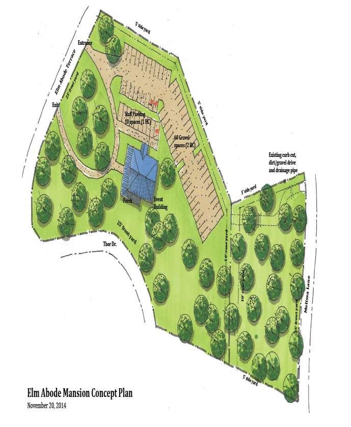
29 Richland County Planning & Development Services Department Map Amendment Staff Report PC MEETING DATE: December 1, 2014 RC PROJECT: MA APPLICANT: Toby Ward LOCATION: 1335 Elm Abode Terrace TAX MAP NUMBER: R ACREAGE: 3.92 EXISTING ZONING: RS-LD PROPOSED ZONING: PDD PC SIGN POSTING: November 14, 2014 Staff Recommendation Disapproval Background Zoning History The original zoning as adopted September 7, 1977 was Residential Single-family Low Density District (RS-1). With the adoption of the 2005 Land Development Code the RS-1 District was designated Residential Single-Family Low Density District (RS-LD). Zoning District Summary The Planned Development (PDD) District is intended to allow flexibility in development that will result in improved design, character, and quality of new mixed-use developments, and that will preserve natural and scenic features of open spaces. Planned Development Districts must involve innovation in site planning for residential, commercial, institutional, and/or industrial developments within the district. Such developments must be in accordance with the comprehensive plan for the county, and in doing so, may provide for variations from the regulations of the county s zoning districts concerning use, setbacks, lot size, density, bulk, and other such requirements. Direction Existing Zoning Use North: RS-LD/RS-LD Undeveloped/Residence South: GC Church East: RS-LD/RS-LD Residence/Residence West: RS-LD/GC Residence /Law Office 21
30 Discussion Parcel/Area Characteristics The site is located at 1335 Elm Abode Terrace. The parcel has three hundred and fifty seven (357) feet of frontage along Elm Abode Terrace and three hundred and forty (340) feet of frontage along Thor Drive. The parcel has a little slope and scattered residential vegetation. The parcel contains a large two story residence. Both Elm Abode Terrace and Thor Drive are two lane collector roads, without sidewalks or streetlamps along this section. The immediate area is primarily characterized by residential uses with the institutional use (church) south of the site and a law office located to the west. Otherwise, parcels north and east of the subject parcel are zoned as single family residential properties and utilized as such. The Planned Development District proposes the following lot requirements: Minimum Area Acres (No subdivision without Planning Commission approval) Minimum front setback- not specified per development plan Minimum side setback- not specified per development plan Minimum rear setback- not specified per development plan Maximum Height- no structure may be erected that is higher than the Elm Abode mansion. The allowed uses defined in the proposed PDD are: 1. Residential use The property shall be used as a residence for a single family and any other uses permitted in an RS-LD Residential, Single-Family - Low Density District. 2. Home occupation The property may be used for commercial business activity conducted entirely within the dwelling or an accessory building which is incidental and secondary to the use of the dwelling purposes and which does not change the character thereof, and in connection with which there is no outside display or storage. Such home occupation shall not employ more than two (2) persons who are not members of the family. 3. Event The property may be used as a commercial event venue which shall be defined as any use of the property by a gathering of people for a specific planned purpose for which a fee is charged for the use of the property. Any use of the site by more than 50 guests, whether for payment or not, shall be an event. There may be only 10 weekday events during any calendar month, and there may be only 10 weeknight (after 6 pm) events per month; there may be only 4 weekend day events per month, and there may be only 2 weekend night (after 6 pm) events per month. Any event shall conclude by 12 a.m. 4. Vacation rental The property may be used for vacation rental which shall be defined as renting the property for a fee to one or more persons who shall occupy all or part of the property for a specific interval of time not to exceed one month. Vacation rentals shall be limited to 3 per month, and no event may take place during a vacation rental, except weddings, bridal showers, and certain retreats accompanied by overnight stays. 5. Bed & Breakfast The property may be used as a Bed and Breakfast which shall be defined as renting individual bedrooms in Elm Abode Mansion for a fee which may include the provision of a breakfast to guests staying at Elm Abode Mansion. The maximum number of guest rooms shall be limited to the number of bedrooms in the Elm Abode mansion as of October 28, The PDD also proposes the following noise regulations: 22
31 The current Richland County noise ordinance Section 18-3 Noise applicable to residential uses shall apply to the site and all uses on the site. Also, the following restrictions shall apply: 1. All music shall be inside, except for soft music associated with outdoor activities such as a wedding ceremony; 2. All music shall be turned down by 11 pm; 3. No subwoofers shall be used on the site; and No music shall be located so as to project outside. Public Services The subject parcel is within the boundaries of School District One. H.B. Rhame Elementary School and Saint Andrews Middle School are located.2 miles to the southwest of the subject parcel. The Saint Andrews fire station (number 6) is located.9 miles northwest of the subject parcel on Briargate Circle. There are no fire hydrants located along Elm Abode Terrace or Thor Drive. Water and sewer service would be provided by the City of Columbia. Plans & Policies The 2009 Richland County Comprehensive Plan Future Land Use Map designates this area as Priority Investment Area in the Beltway Planning Area. Objective: Commercial/Office activities should be located along arterial roads, traffic junctions, or areas where existing commercial and office uses are located. Compliance: The proposed zoning is located near existing commercial uses. Traffic Characteristics No traffic count stations are located on Elm Abode Terrace. The closest count stations are on Broad River Road and Bush River Road. The 2012 SCDOT traffic count (Station # 183) located south of the subject parcel on Broad River Road identifies 26,500 Average Daily Trips (ADT s). Broad River Road is classified as a five lane undivided Principal Arterial, maintained by SCDOT with a design capacity of 33,600 ADT s. Broad River Road is currently operating at Level of Service (LOS) C. The 2012 SCDOT traffic count (Station # 469) located west of the subject parcel on Bush River Road identifies 31,300 Average Daily Trips (ADT s). Bush River Road is classified as a five lane undivided Minor Arterial, maintained by SCDOT with a design capacity of 24,800 ADT s. Bush River Road is currently operating at Level of Service (LOS) E. Currently, construction is underway to rebuild the River Drive Bridge, crossing the Broad River, along with the east and west approaches to the bridge and associated improvement to all intersections within that construction zone. Otherwise, there are no planned or programmed improvements for this area, either from SCDOT or as part of the County s Transportation Penny Program. Conclusion The proposed request is in compliance with the recommendations of the Comprehensive Plan, as it is located near commercial and office uses however, the PDD contains language that staff 23
32 has deemed unenforceable by Richland County as it pertains to number and frequency of events and types of events specifically; 1. Event a. Any use of the site by more than 50 guests, whether for payment or not, shall be an event. b. There may be only 10 weekday events during any calendar month. c. There may be only 10 weeknight (after 6 pm) events per month. d. There may be only 4 weekend day events per month. e. There may be only 2 weekend night (after 6 pm) events per month. f. Any event shall conclude by 12 a.m. 2. Vacation rental a. Vacation rentals shall be limited to 3 per month b. No event may take place during a vacation rental, except weddings, bridal showers, and certain retreats accompanied by overnight stays. 3. Bed & Breakfast a. The maximum number of guest rooms shall be limited to the number of bedrooms in the Elm Abode mansion as of October 28, 2014 (which have not been established in the PDD). In addition, noise regulations outside of the purview of Section 18-3 are subjective specifically; 1. Noise a. All music shall be inside, except for soft music associated with outdoor activities such as a wedding ceremony; b. All music shall be turned down by 11 pm. c. No subwoofers shall be used on the site. d. No music shall be located so as to project outside. Also under the RS-LD zoning district any uses should be clearly established as per Section (C) does not require uses in a PDD to be established by Special Exception or by Special Requirements as the safeguards and conditions normally imposed upon special exception uses will substantially be met by the site plan and development controls of the proposed planned development. Staff also has identified that additional signage regulation outside of Section would be difficult to enforce specifically; 1. Signage a. No sign may be lit unless an event is planned that day. Staff has also noted that the required 10% open space designation has not been clearly identified on the master plan nor have general details as outlined by the PDD Development Checklist been provided such as; 1. Boundary of the subject property, identified by a heavy line; including a legal description, total acreage and location map. 2. A statement which identifies the relationship of the proposed PDD to the general character of the area and the uses to be included in the proposed PPD. A breakdown of specific densities proposed for the PDD shall be included. 24
33 3. Separate location map (to scale) showing the boundary lines of adjacent land and existing zoning of the area proposed to be developed as well as the adjacent land. 4. Calculate the acreage, square footage, type, and mix of land uses, including the total number of residential units, residential densities, and non-residential intensities within each development area or the total number, type and mix of land uses for the entire PDD Master Plan. 5. A map depicting existing natural features of the site, including the existing tree canopy, topography (with contour intervals no greater than 2 foot intervals), and streams, ponds, or other wetland areas(as defined by the National Wetlands Inventory map). 6. Identify the location of proposed open space and tree-save areas. 7. A site analysis and Inventory shall be submitted that addresses the following: a. Adjacent Land uses; b. Surface water and drainage; c. Natural vegetation; d. Site contours; e. Existing public facilities; f. Adequacy of existing utilities; g. Soil types and regional geology 8. Identify the general location of all public facility sites, parks, fire, police, EMS, storm water, and schools. 9. Include an inset map at a scale of not less than one inch to one mile, showing the property in relation to surrounding roads, subdivisions or major landmarks. 10. Include a north arrow. 11. Identify guarantees and arrangements for the perpetual maintenance of open space that meet the following requirements and must be approved by the planning department. Any conveyance to a homeowner s association shall be subject to appropriately recorded and filed restrictive covenants and easements. The covenants and easements shall prohibit future development of the open space for other than open space and recreation purposes and shall provide for continued maintenance of the open space and recreation facilities. 12. Please list any community meeting(s) pertaining to the project. Please provide, times, locations, and dates. While the requested zoning would provide a transition between the established residential subdivisions to the east and the nonresidential uses along the commercial corridor of Broad River Road to the west, the development district regulations outlined in the proposed PDD would be problematic in regards to enforcement and compliance. For these reasons, staff recommends Disapproval of this map amendment. Zoning Public Hearing Date December 16, Proposed PDD Conditions *Note- If the PDD is approved the following conditions are strongly recommended. a) The Elm Abode Mansion/Aiken Residence (Elm Abode Mansion PDD) dated October 27, 2014 and revised November 19 th, 2014 shall adhere to the Richland County Land Development Code as amended through b) Proposed changes to the approved Master Plan shall be subject to the requirements of Section (j) of the Richland County Land Development Code. 25
34 c) Richland County shall not be responsible for the enforcement of any deed restrictions imposed by the applicant, the developer, or their successors in interest. d) Removal of development district regulations that would be difficult for the County to enforce. e) All the conditions described herein shall apply to the applicant, the developer and/or their successors in interest. f) No further subdivision of parcels R , R and R will be permitted as outlined in The Elm Abode Mansion/Aiken Residence (Elm Abode Mansion PDD) dated October 27, 2014 and revised November 19th,
35 Case MA RS-LD to PDD Carl Rd!!!!!!!!!!!!!!!!!!!!!!!!!!!!!!!!!!!!!!!!!!!!!!!!!!!!!!!! City of Columbia!!!!!!!!!!!!!!! Omarest Dr!!!!!!!!!!!!!!!!! Elm Abode Ter s Cheryl Dr Jayne Ln Melissa Ln Thor Dr!!!!!!!!!!!!!!!!!!!!!!!!!!!!!!!!!!!!!!!!!!!!!!!!!!!! Bush River Rd!!!!!!!!!! Elm Abode Ter!!!! Bluefield Dr Atlantic Dr Broad River Rd Greenville Cir City of Columbia Balsam Rd!!!!!!!!!!!!!!!!!!!!!!!!!!!!!!!!!!! Pardee St!!! ZONING CLASSIFICATIONS CC-1 CC-2 CC-3 C-1 C-3 RG-2 RS-E RS-LD RS-MD MH RM-MD RM-HD NC GC RC LI HI PDD TROS Subject Property ± CC-4 RR RS-HD OI M-1 RU 27


36 Mangum St Omarest Dr Case MA RS-LD to PDD TMS & /03 Carl Rd Jayne Ln Columbia Cheryl Dr Melissa Ln s Thor Dr Bush River Rd Elm Abode Ter Bluefield Dr Atlantic Dr Greenville Cir #* 183 Broad River Rd Balsam Rd Columbia FLOOD ZONE A FLOOD ZONE AE WETLANDS Pardee St Means Ave Arrowwood Rd Ê Brevard St 28 Bob Brooks Ct Susan Rd Columbia ,260 1,680 Feet Google
37


38 CASE MA From RS-LD to PDD TMS# R , 03 & Elm Abode Terrace Looking at subject parcel Looking s Looking driveway on Melissa Drive 30
39 Richland County Planning & Development Services Department Map Amendment Staff Report PC MEETING DATE: December 1, 2014 RC PROJECT: MA APPLICANT: Carl Parrott LOCATION: TAX MAP NUMBER: ACREAGE: EXISTING ZONING: PROPOSED ZONING: 908 North Brickyard Rd R Acres RS-LD OI PC SIGN POSTING: November 14, 2014 Staff Recommendation Disapproval Background Zoning History The original zoning as adopted September 7, 1977 was Residential Single-family Low Density District (RS-1). With the adoption of the 2005 Land Development Code the RS-1 District was designated Residential Single-Family Low Density District (RS-LD). A Special Exception for a Place of Worship was granted on March 3, 2010 for the subject property under Case Number 09-27MA Zoning History for the General Area A parcel west of the site was rezoned from RU to Residential Single-Family Medium Density District (RS-MD) in 2004 under ordinance number HR (case number 04-23MA). Zoning District Summary The Office and Institutional District (OI) is intended to accommodate office, institutional, and certain types of residential uses in an area whose characteristics are neither general commercial nor exclusively residential in nature. Certain related structures and uses required to serve the needs of the area are permitted outright or are permitted as special exceptions subject to restrictions and requirements. No minimum lot area, except as determined by DHEC. 31
40 Direction Existing Zoning Use North: RS-LD Residence/undeveloped South: RS-LD Residence East: RS-LD Residence West: RS-LD Residence Discussion Parcel/Area Characteristics The parcel has frontage along North Brickyard Road, has little slope, contains a place of worship and a single-family residential structure to the rear. North Brickyard Road is a two lane collector road, without sidewalks or streetlamps along this section. The immediate area is primarily characterized by residential uses with single-family residential subdivisions west and east. Public Services The subject parcel is within the boundaries of School District Two. Killian Elementary School is located.8 miles to the northwest of the subject parcel on Clemson Road. The Killian fire station (number 27) is located 1.5 miles northwest of the subject parcel on Farrow Road. There are no fire hydrants located along this section of North Brickyard Road. Water is provided by the City of Columbia. Plans & Policies The 2009 Richland County Comprehensive Plan Future Land Use Map designates this area as Suburban in the North East Planning Area. Objective: Commercial/Office activities should be located at traffic junctions or areas where existing commercial and office uses are located. These uses should not encroach on established residential areas. Non-Compliance: The site is not located at a traffic junction, nor is it located near commercial or office uses. Proposed 2014 Comprehensive Plan The draft 2014 Richland County Comprehensive Plan, PUTTING THE PIECES IN PLACE, designates this area as Neighborhood Low Density. The proposed change also would not be appropriate when applying the proposed draft 2014 Richland County Comprehensive Plan recommendations. The Neighborhood Medium Density Future Land Use designation notes that nonresidential uses should be focused at primary arterial intersections, preferably within Neighborhood and Community Activity Centers, and should be designated to be easily accessible to surrounding neighborhoods via multiple transportation modes. Although the 2014 draft Comprehensive Plan has not been adopted, staff feels it is important to consider the draft plan s recommendations where they may impact current decisions, given the amount of public input and long-range visioning that has recently occurred. 32
41 Traffic Characteristics The 2013 SCDOT traffic count (Station # 445) located east of the subject parcel on North Brickyard Road identifies 11,600 Average Daily Trips (ADT s). North Brickyard Road is classified as a two lane collector, maintained by SCDOT with a design capacity of 8,600 ADT s. North Brickyard Road is currently operating at Level of Service (LOS) F. There are no planned or programmed improvements to North Brickyard Road, either through SCDOT or the County Penny Tax Program. Conclusion The subject property is surrounded on all four sides by residential development and residential zoning districts. North Brickyard Road is a ditch-to-ditch-designed, residential collector road intended to serve the needs of residential development. Although the site contains a place of worship, which is non-residential in nature, places of worship are allowed with Special Requirements and by Special Exception in residential districts, as they provide services for the community, similar to schools, parks and libraries. Staff is of the opinion, that were the site to be rezoned, doing so would set a precedent for additional rezoning applications nearby and could serve to the detriment of the established residential nature of this community by allowing for more non-residential uses in proximity. Furthermore, the proposed request is not in compliance with the recommendations of the Comprehensive Plan, as it is not located near commercial and office uses or a traffic junction. For these reasons, staff recommends Disapproval of this map amendment. Zoning Public Hearing Date December 16,
42 Case MA RS-LD to OI Kenmore Park Dr s Shadow Grey Ct Iron Spot Cir Shale Ln Squire Rd N Brickyard Rd Rockingham Ct Rockingham Rd Shady Vale Dr ZONING CLASSIFICATIONS CC-1 CC-2 CC-3 C-1 C-3 RG-2 RS-E RS-LD RS-MD MH RM-MD RM-HD NC GC RC LI HI PDD TROS Subject Property ± CC-4 RR RS-HD OI M-1 RU 34


43 Case MA RS-LD to OI Sp yc Iron Gre do w le L n Rd Sha Squ ire Ken m o s Sha re Pa rk Dr t ot C ir TMS rd Rd ic ky a N Br Roc kin gh am C t Sha FLOOD ZONE A a le dy V FLOOD ZONE AE WETLANDS Ln ar d Dr Tab am Flo ra i ngh k Roc Ê Rd Dr ,260 1,680 d Feet nr a Slo Google 35


44 CASE MA From RS-LD to OI TMS# R North Brickyard Rd Looking at subject parcel along North Brickyard Road Looking s Looking south of site 36
45 37 OI USE TYPES Continued Care Retirement Communities SR Dormitories SE Multi-Family, Not Otherwise Listed P Single-Family, Zero Lot Line, Common SR Fraternity and Sorority Houses P Group Homes (10 or More) SE Rooming and Boarding Houses SE Special Congregate Facilities SE Bowling Centers Clubs or Lodges (Ord No HR; ) P Dance Studios and Schools P Martial Arts Instructional Schools P Physical Fitness Centers P Ambulance Services, Transport P Auditoriums, Coliseums, Stadiums P Cemeteries, Mausoleums (Ord HR) SR Colleges and Universities P Community Food Services P Courts P Day Care Centers, Adult (Ord HR; ) SR Day Care, Child, Licensed Center (Ord HR; ) Government Offices P Hospitals P SR Individual and Family Services, Not Otherwise Listed Museums and Galleries P Nursing and Convalescent Homes P Orphanages P Post Offices P Schools, Administrative Facilities P Schools, Business, Computer and Management Training P Schools, Fine Arts Instruction P Schools, Junior Colleges P Schools, Technical and Trade (ExceptTruck Driving) P Zoos and Botanical Gardens Accounting, Tax Preparation, Bookeeping, and Payroll P Advertising, Public Relations, and Related Agencies P Barber Shops, Beauty Salons, and Related Services P Bed and Breakfast Homes/Inns (Ord HR; ) SR Computer Systems Design and Related Services P Clothing Alterations/Repairs; Footwear Repairs P Construction, Building, General Contracting, without P Construction, Special Trades, without Outside Storage P SE Services Automatic Teller Machines P Automobile Parking (Commercial) P Banks, Finance, and Insurance Offices P Outside Storage Employment Services P P
46 38 Engineering, Architectural, and Related Services P Funeral Homes and Services P Kennels SR Laundry and Dry Cleaning Services, Non- Coin Operated P Legal Services (Law Offices, Etc.) P Management, Scientific, and Technical Consulting Services P Massage Therapists P Medical/Health Care Offices P Medical, Dental, or Related Laboratories P Office Administrative and Support Services, Not Otherwise Listed Packaging and Labeling Services P Pet Care Services (Excluding Veterinary Offices and Kennels) Photocopying and Duplicating Services P Photofinishing Laboratories P Photography Studios P Picture Framing Shops P Professional, Scientific, and Technical Services, Not P Otherwise Listed Real Estate and Leasing Offices P Research and Development Services SR Travel Agencies (without Tour Buses or Other Vehicles) P Watch and Jewelry Repair Shops P Weight Reducing Centers P Antique Stores (See Also Used Merchandise Shops and P Pawn Shops) Art Dealers P P P Bars and Other Drinking Places Drugstores, Pharmacies, with Drive-Thru P Drugstores, Pharmacies, without Drive- Thru P SE Book, Periodical, and Music Stores P Caterers, No On Site Consumption P Office Supplies and Stationery Stores Restaurants, Limited Service (Delivery, Carry Out) P Restaurants, Snack and Nonalcoholic Beverage Stores P Radio and Television Broadcasting Facilities (Except P Radio, Television, and Other Similar Transmitting Towers SE P Optical Goods Stores P Restaurants, Cafeterias P Restaurants, Full Service (Dine-In Only) P Courier Services, Substations P Towers) Utility Company Offices P Buildings, High Rise, 4 or 5 Stories SR Buildings, High Rise, 6 or More Stories SE
47 STATE OF SOUTH CAROLINA COUNTY COUNCIL FOR RICHLAND COUNTY ORDINANCE NO. 15HR AN ORDINANCE AMENDING THE RICHLAND COUNTY CODE OF ORDINANCES; CHAPTER 26, LAND DEVELOPMENT; ARTICLE VII, GENERAL DEVELOPMENT, SITE, AND PERFORMANCE STANDARDS; SECTION , OFF-STREET PARKING STANDARDS; SUBSECTION (F), PARKING OF RECREATIONAL VEHICLES, BOATS, AND TRAVEL TRAILERS; SO AS TO ADD UTILITY TRAILERS. Pursuant to the authority granted by the Constitution and the General Assembly of the State of South Carolina, BE IT ENACTED BY THE RICHLAND COUNTY COUNCIL: SECTION I. The Richland County Code of Ordinances, Chapter 26, Land Development; Article VII, General Development, Site, and Performance Standards; Section , Off-Street Parking Standards; Subsection (f), Parking of Recreational Vehicles, Boats, and Travel Trailers; is hereby amended to read as follows: (f) Parking of recreational vehicles, boats, and travel and utility trailers. (1) Travel or camping vehicles: Not more than one (1) travel or camping vehicle, per family living on the premises, shall be permitted to be parked on a lot in any residential zone. The vehicle shall not be parked in the required front or side yard nor shall any such vehicle be parked or stored in front of the principal structure on a residentially zoned lot. The vehicle shall not be occupied temporarily or permanently while it is parked or stored, except in an authorized recreational vehicle park. (2) Boats, or travel or utility trailers: No boat, or travel or utility trailer, shall be stored in any required front or side yard of any residentially zoned property nor shall any boat, or travel or utility trailer, be stored or parked in front of a principal structure on a residentially zoned lot. SECTION II. Severability. If any section, subsection, or clause of this ordinance shall be deemed to be unconstitutional or otherwise invalid, the validity of the remaining sections, subsections, and clauses shall not be affected thereby. SECTION III. Conflicting Ordinances Repealed. All ordinances or parts of ordinances in conflict with the provisions of this ordinance are hereby repealed. SECTION IV. Effective Date. This ordinance shall be enforced from and after, RICHLAND COUNTY COUNCIL BY: Norman Jackson, Chair 39
48 ATTEST THIS THE DAY OF, 2015 Michelle Onley Clerk of Council RICHLAND COUNTY ATTORNEY S OFFICE Approved As To LEGAL Form Only No Opinion Rendered As To Content Public Hearing: First Reading: Second Reading: Third Reading: December 16, 2014 (tentative) December 16, 2014 (tentative) 40
49 STATE OF SOUTH CAROLINA COUNTY COUNCIL FOR RICHLAND COUNTY ORDINANCE NO. 15HR AN ORDINANCE UPDATING THE 2009 COMPREHENSIVE PLAN THROUGH THE ADOPTION OF A NEW PLAN FOR THE COUNTY OF RICHLAND, PURSUANT TO THE STATE OF SOUTH CAROLINA COMPREHENSIVE PLANNING ENABLING ACT OF WHEREAS, the 1994 State of South Carolina Comprehensive Planning Enabling Act (Section , et seq., of the Code of Laws of South Carolina 1976, as amended) requires the development and adoption of a local Comprehensive Plan designed to promote public health, safety, morals, convenience, prosperity, or the general welfare as well as the efficiency and economy of the County; and WHEREAS, on May 3, 1999, Richland County Council adopted the Imagine Richland 2020 Comprehensive Plan pursuant to S.C. Code Section , et al. (Ordinance No HR); and WHEREAS, the Imagine Richland 2020 Comprehensive Plan was amended on December 20, 2005 by the incorporation of the Southeast Richland Neighborhood Master Plan (dated November 3, 2005) into the Lower Richland Area Plan (Ordinance No HR); and WHEREAS, the Imagine Richland 2020 Comprehensive Plan was amended on October 3, 2006 by the incorporation of the Broad River Neighborhoods Master Plan, dated July 6, 2006, into the I-20 Interbeltway Subarea Plan (Ordinance No HR); and WHEREAS, the Imagine Richland 2020 Comprehensive Plan was amended on June 19, 2007 by the incorporation of The Renaissance Plan for the Decker Boulevard/Woodfield Park Area (dated March 12, 2007) into the I-20 Corridor Sub-area Plan (Ordinance No HR); and WHEREAS, the Imagine Richland 2020 Comprehensive Plan was amended on February 17, 2009 by the incorporation of The Candlewood Neighborhood Master Plan (dated December 1, 2008) into the Northeast Area Plan (Ordinance No HR); and WHEREAS, on December 15, 2009, Richland County Council adopted the 2009 Comprehensive Plan pursuant to S.C. Code Section , et al., with the above referenced Neighborhood Master Plans included in such Plan (Ordinance No HR); and WHEREAS, the 2009 Comprehensive Plan was amended on January 19, 2010 by the incorporation of the Trenholm Acres/Newcastle Neighborhood Master Plan, dated July 2008 (Ordinance No HR); and by the incorporation of the Crane Creek Neighborhood Master Plan, dated May 2009 (Ordinance No HR); and 41
50 WHEREAS, the 2009 Comprehensive Plan was amended on December 14, 2010 by the incorporation of the Broad River Road Corridor and Community Master Plan, dated August 2010 (Ordinance No HR); and WHEREAS, the 2009 Comprehensive Plan was amended on March 18, 2014 by the incorporation of the Spring Hill Strategic Community Master Plan, dated December 2013 (Ordinance No HR); and by the incorporation of the Lower Richland Strategic Community Master Plan, dated December 2013 (Ordinance No HR); and WHEREAS, the Comprehensive Plan must be comprised of certain defined elements, including, but not limited to: (1) a population element, (2) an economic development element, (3) a natural resources element, (4) a cultural resources element, (5) a community facilities element, (6) a housing element, (7) a land use element, (8) a transportation element, and (9) a priority investment element; and WHEREAS, pursuant to Section (E), the comprehensive plan, including all elements of it, must be updated at least every ten years; and WHEREAS, Richland County s Planning and Development Services Department hired a qualified and reputable consultant to assist with the updating process, and took numerous steps to engage the public in this process, including: holding fifteen (15) community meetings throughout the County, holding several meetings with a number of identified stakeholders, reaching out to municipalities, receiving feedback and direction from County Council members and Planning Commission members, and coordination with the City of Columbia, all of which occurred over a one year time frame; and WHEREAS, the Richland County Planning Commission has recommended to County Council the adoption of an updated plan, said plan being dated December 1, 2014, and entitled PLAN RICHLAND COUNTY ; and WHEREAS, it appears to County Council that the Comprehensive Plan is comprised of all required elements, is proper in all other material respects, and that the adoption of the Plan is in the best interest of the County; NOW, THEREFORE, pursuant to the authority granted by the Constitution and the General Assembly of the State of South Carolina, be it enacted by the County Council for Richland County as follows: SECTION I. Pursuant to Section of the Code of Laws of South Carolina 1976, as amended, Richland County Council does hereby adopt, approve, and ratify the December 1, 2014 Comprehensive Plan entitled PLAN RICHLAND COUNTY, which is on file in the Planning and Development Services Department. SECTION II. The Southeast Richland Neighborhood Master Plan (dated November 3, 2005), and the Broad River Neighborhoods Master Plan (dated July 6, 2006), and The Renaissance Plan for the Decker Boulevard/Woodfield Park Area (dated March 12, 2007), and the 42
51 Candlewood Neighborhood Master Plan (dated December 1, 2008), and the Trenholm Acres/Newcastle Neighborhood Master Plan (dated July 2008), and the Crane Creek Neighborhood Master Plan (dated May 2009), and the Broad River Road Corridor and Community Master Plan (dated August 2010), and the Spring Hill Strategic Community Master Plan (dated December 2013), and the Lower Richland Strategic Community Master Plan (dated December 2013) are all incorporated into the aforementioned PLAN RICHLAND COUNTY Comprehensive Plan and shall remain in full force and effect. SECTION III. Severability. If any section, subsection, or clause of this ordinance shall be deemed to be unconstitutional or otherwise invalid, the validity of the remaining sections, subsections, and clauses shall not be affected thereby. SECTION IV. Conflicting Ordinances Repealed. All ordinances or parts of ordinances in conflict with the provisions of this ordinance are hereby repealed. SECTION V. Effective Date. This ordinance shall be enforced from and after, RICHLAND COUNTY COUNCIL ATTEST THIS THE DAY OF, BY: Norman Jackson, Chair S. Monique McDaniels Clerk of Council RICHLAND COUNTY ATTORNEY S OFFICE Approved As To LEGAL Form Only. No Opinion Rendered As To Content. Public Hearing: First Reading: Second Reading: Third Reading: December 16, 2014 (tentative) December 16, 2014 (tentative) 43
52 44

53 RICHLAND COUNTY GOVERNMENT Planning and Development Services Department PLANNING DIRECTOR S REPORT OF COUNCIL ACTIONS ZONING PUBLIC HEARING October 28, :00 PM Call to Order: Honorable Norman Jackson, Chair Additions/Deletions to the Agenda: Tracy Hegler, Planning Director, stated that she had handed out copies of the proposed 2014 Comprehensive Plan to Council members, and that the Planning Commission would be reviewing this document at their November 5, 2014 meeting. Adoption of the Agenda: Approved unanimously. Map Amendments: Case # MA, Toby Ward, RS-LD to OI (2.9 acres), TMS # , 1335 Elm- Abode Terrace: The public hearing was heard on July 22, The applicant stated that he would like to withdraw the current map amendment request and resubmit an application for PDD zoning. Council unanimously approved the withdrawal of this map amendment. ACTION: PLANNING Case # MA, John May, RU to RC (.22 acres), TMS # , Wilson Boulevard: The public hearing was opened, and the applicant spoke in favor of the rezoning. The public hearing was closed. Council unanimously approved the rezoning request and gave first reading to the ordinance. ACTION: PLANNING, CLERK OF COUNCIL Case # MA, Eddie Roberts, M-1 to GC (.36 acres), TMS # TMS# , Two Notch Road.: The public hearing was opened, and the applicant spoke in favor of the rezoning. The public hearing was closed. Council unanimously approved the rezoning request and gave first reading to the ordinance. ACTION: PLANNING, CLERK OF COUNCIL Case # MA, Daryl Barnes, RS-LD to NC (.57 acres), TMS # , 5430 Lower Richland Boulevard.: The public hearing was opened, and no one spoke. The public hearing was closed. Council unanimously deferred further action on this request until the November Zoning Public hearing. Council further directed that another public hearing be allowed in November. ACTION: PLANNING Case # MA, Thomas Crowther, RM-HD to GC (11.90 acres), TMS # (p), 3533 Broad River Road: The public hearing was opened, and no one spoke. The 45
54 public hearing was closed. Council unanimously approved the rezoning request and gave first reading to the ordinance. Council further stated that the applicant could speak at the November 18, 2014 Council meeting prior to the ordinance receiving second reading. ACTION: PLANNING, CLERK OF COUNCIL Council recessed at 7:20 p.m. in order to open the Special Called Council meeting scheduled for 7:15 p.m. Council reconvened the Zoning Public Hearing at 7:22 p.m. Case # MA, Ray O Neal, RU to GC (.66 acres), TMS # , 8505 Garners Ferry Road: The public hearing was opened, and no one spoke. The public hearing was closed. Council unanimously approved the rezoning request and gave first reading to the ordinance. ACTION: PLANNING, CLERK OF COUNCIL Case # MA, Bill Dixon, amended PDD (65.94 acres), TMS # , Greenhill Parkway & Two Notch Road: The public hearing was opened, and the applicant spoke in favor of the rezoning. The public hearing was closed. Council unanimously approved the rezoning request and gave first reading to the ordinance. ACTION: PLANNING, CLERK OF COUNCIL Adjournment: Council adjourned at 7:24 p.m. 46


55 Development Review Team Project for October 30, 2014 at 1:00 pm Project # Development Location Council District SD SD Wakefield Development S/D TMS # R Sketch Plan Hiller Road S/D TMS # R Sketch Plan B/S of Jacobs Mill Pond Road Lots/ Units/ Square Feet Acres Hiller Road SD Longreen Commercial S/D Preliminary Plan W/S Longreen Partkway Development Review Team Members Tracy Hegler, Planning Director Geonard Price, Deputy Planning Director/Zoning Administrator William Simon, Engineer II Development Division Manager Andrea Bolling, Floodplain Administrator Carroll Williamson, Land Development Administrator Miranda Spivey, Fire Marshal 47
RICHLAND COUNTY COUNCIL ZONING PUBLIC HEARING
 RICHLAND COUNTY COUNCIL ZONING PUBLIC HEARING MAY 27, 2014 RICHLAND COUNTY COUNCIL ZONING PUBLIC HEARING MAY 27, 2014 SC 215 Joyce Dickerson 176 Bill Malinowski 21 26 Torrey Rush Julie Ann Dixon!( Jim
RICHLAND COUNTY COUNCIL ZONING PUBLIC HEARING
 RICHLAND COUNTY COUNCIL ZONING PUBLIC HEARING FEBRUARY 24, 2015 RICHLAND COUNTY COUNCIL ZONING PUBLIC HEARING FEBRUARY 24, 2015 SC 215 Joyce Dickerson 176 Bill Malinowski 21 26 Torrey Rush!( 3 Julie Ann
Commercial Zoning Districts
 Article 4 Commercial Zoning Districts Section 4.1 Section 4.2 Section 4.3 C-D Downtown Commercial District C-1 General Commercial District C-2 Heavy Service Commercial District 4.1 C-D, Downtown Commercial
City of Sanibel Planning Department
 City of Sanibel Planning Department STAFF REPORT Planning Commission Meeting July 9, 2013 Agenda Item: No. 7 a. Subject: Commercial Redevelopment Kickoff Discussion by the Planning Commission At the June
Sec Tier 2 principal uses and structures. The principal uses of land and structures allowed in Tier 2 are provided below subject to the
 Sec. 27-730.4.9. Tier 2 principal uses and structures. The principal uses of land and structures allowed in Tier 2 are provided below subject to the standards and limitations contained within this division.
ZONING ORDINANCE FOR THE CITY OF RICHLAND CENTER CHAPTER 408 SPECIFIC REGULATIONS AFFECTING LANDS IN A "C-DT" CENTRAL [DOWNTOWN] BUSINESS DISTRICT
![ZONING ORDINANCE FOR THE CITY OF RICHLAND CENTER CHAPTER 408 SPECIFIC REGULATIONS AFFECTING LANDS IN A C-DT CENTRAL [DOWNTOWN] BUSINESS DISTRICT](/thumbs/96/126607517.jpg "ZONING ORDINANCE FOR THE CITY OF RICHLAND CENTER CHAPTER 408 SPECIFIC REGULATIONS AFFECTING LANDS IN A C-DT CENTRAL [DOWNTOWN] BUSINESS DISTRICT") ZONING ORDINANCE FOR THE CITY OF RICHLAND CENTER CHAPTER SPECIFIC REGULATIONS AFFECTING LANDS IN A "C-DT" CENTRAL [DOWNTOWN] BUSINESS DISTRICT.01 APPLICABILITY OF CHAPTER 400 TO A "C-DT" CENTRAL BUSINESS
ZONING ORDINANCE FOR THE CITY OF RICHLAND CENTER CHAPTER SPECIFIC REGULATIONS AFFECTING LANDS IN A "C-DT" CENTRAL [DOWNTOWN] BUSINESS DISTRICT.01 APPLICABILITY OF CHAPTER 400 TO A "C-DT" CENTRAL BUSINESS
SECTION 838 "C-6" - GENERAL COMMERCIAL DISTRICT
 SECTION 838 "C-6" - GENERAL COMMERCIAL DISTRICT The "C-6" District is intended to serve as sites for the many uses in the commercial classifications which do not belong in either the Neighborhood, Community
3.92 Acres Chesterfield County, VA
 3.92 Acres Chesterfield County, VA ASKING PRICE - $154,500 Represented By: William G. Grant ALC. VLS (804) 754-3476 JEFFREY S. HUFF ALC, FORESTER (804) 750-1207 Table of Contents I. Property Description
Land use regulations (4SRC, CSMU, HO, 2/3 MUE, 2/3 MUW, WEV, 5/M R/O). Type of Land Use 4SRC HO CSMU
. Type of Land Use 4SRC HO CSMU") 14.05.022 - Land use regulations (4SR, SMU, HO, 2/3 MUE, 2/3 MUW, WEV, 5/M R/O). P: Permitted by right; : onditional permit/planning commission; Z: onditional use permit/zoning administrator; A: Administrative
14.05.022 - Land use regulations (4SR, SMU, HO, 2/3 MUE, 2/3 MUW, WEV, 5/M R/O). P: Permitted by right; : onditional permit/planning commission; Z: onditional use permit/zoning administrator; A: Administrative
13. Automobile maintenance service, but not commercial truck maintenance service
 SECTION 60 B-3 COMMUNITY BUSINESS DISTRICT 60.01 General Description: This business district is intended for the conduct of personal and business services and retail business of the community. Traffic
ORDINANCE WHEREAS, the Board of County Commissioners has determined that it is
 ORDINANCE 2002-63 AN ORDINANCE AMENDING ORDINANCE 97-19, AS AMENDED, KNOWN AS THE NASSAU COUNTY COMPREHENSIVE ZONING CODE; SPECIFICALLY ADDING ARTICLE 9-A, RESIDENTIAL, SINGLE FAMILY - AMERICAN BEACH:
CHAPTER COMMERCIAL ZONING DISTRICTS
 CHAPTER 27.10 - COMMERCIAL ZONING DISTRICTS 27.10.010 - Purpose of Chapter This Chapter lists the land uses that may be allowed within the commercial zoning districts established by Section 27.04.020 (Zoning
FOR SALE th Avenue South South St. Paul, MN UNIT RETAIL STRIP CENTER FACTS & FEATURES
 FACTS & FEATURES List Price: $1,750,000 Price Per Square Foot: $41..82 41,846 Total Square Feet Lot Acreage: 4.207 Acres Year Built: 1960 Re-Development Opportunity Great Visibility & Easy Access Ample
Division S-19. PD Subdistrict 19.
 Division S-19. PD Subdistrict 19. SEC. S-19.101. LEGISLATIVE HISTORY. PD Subdistrict 19 was established by Ordinance No. 23022, passed by the Dallas City Council on February 12, 1997. Ordinance No. 23022
2.110 COMMERICAL MIXED USE (CM)
") CITY OF KEIZER DEVELOPMENT BULLETIN 2.110.01 Purpose 2.110 COMMERICAL MIXED USE (CM) The Commercial Mixed Use (CM) zone is the primary commercial zone within the City. The zone is specifically designed
CITY OF KEIZER DEVELOPMENT BULLETIN 2.110.01 Purpose 2.110 COMMERICAL MIXED USE (CM) The Commercial Mixed Use (CM) zone is the primary commercial zone within the City. The zone is specifically designed
CITY OF BONITA SPRINGS ZONING ORDINANCE NO
 CITY OF BONITA SPRINGS ZONING ORDINANCE NO. 04-16 A ZONING ORDINANCE OF THE CITY OF BONITA SPRINGS, FLORIDA; APPROVING A REQUEST BY CUSSON S CPD TO REZONE FROM AGRICULTURE (AG-2) AND COMMERCIAL PLANNED
ARTICLE 5. ZONING DISTRICTS
 ARTICLE 5. ZONING DISTRICTS Section 5.1 Purpose Statement.......................................... 5-2 Section 5.2 Interpretation............................................. 5-2 Section 5.3......................................
Pleasant Hill, IA Code of Ordinances
 Print Pleasant Hill, IA Code of Ordinances 167.08 C 1 NEIGHBORHOOD/LOCAL COMMERCIAL DISTRICT. 1. Statement of Intent. The C 1 District is intended to provide for the orderly development of central shopping
FC-1 District Schedule
 District Schedule (East False Creek) 1 Intent The intent of this Schedule is to permit and encourage the development of a high-density mixed commercial use neighbourhood, including some residential and
C-2B District Schedule
 District Schedule 1 Intent The intent of this Schedule is to provide for a wide range of goods and services, to maintain commercial activities and personal services that require central locations to serve
B 1 Restricted Retail Commercial District
 Pursuant to the zoning information provided below a stand-alone parking lot would not be a permitted use at this location. Permitted uses for the B-1 zoning district will be inserted below for your review.
DIVISION FIVE COMMERCIAL ZONES. 1. Permitted Uses of Land, Buildings, and Structures
 DIVISION FIVE - COMMERCIAL ZONES 501 GENERAL COMMERCIAL ZONE () 1. Permitted Uses of Land, Buildings, and Structures Subject to the provisions of Divisions Three and Four of this bylaw, the following uses
SERVICE COMMERCIAL ZONES
 PART 16 SERVICE COMMERCIAL ZONES 1601 CS-1 Service Commercial (1) Intent This zone provides for most types of service commercial and related uses requiring large lots, location along major transportation
910 S. CEDAR RIDGE DRIVE
 910 S. CEDAR RIDGE DRIVE RETAIL/OFFICE/WAREHOUSE PROPERTY FOR LEASE Duncanville, TX 75137 OFFERING SUMMARY Available SF: 3,126 SF PROPERTY OVERVIEW Previous print shop; retail space with warehouse. Lease
Farming & Livestock related activities Y Y Y Y Y Y. Commercial Type Animal Facility Y Y Y
 ( = Permitted) TABLE A PERMITTED USES B DISTRICT MU MU2 CC MH/ RV Agricultural Uses (Light) Agricultural Uses (Heavy) Residential Uses Recreational and Institutional Uses RM R C LI MI HI A Farming & Livestock
List Price $595,000. Lease Price $5,000/mo (3n) Property Details. For Sale or Lease 345 N Main Street Chatham, Illinois Medical Office Bldg.
 Property Details. For Sale or Lease 345 N Main Street Chatham, Illinois Medical Office Bldg.") For Sale or Lease reet Chatham, Illinois Medical Office Bldg. List Price $595,000 Lease Price $5,000/mo (3n) Property Details Highly Visible Building Suitable For A Variety Of Businesses Daily Traffic
For Sale or Lease reet Chatham, Illinois Medical Office Bldg. List Price $595,000 Lease Price $5,000/mo (3n) Property Details Highly Visible Building Suitable For A Variety Of Businesses Daily Traffic
CITY OF FOLLY BEACH. FOOTCANDLE. The amount of light that falls onto a surface as emitted by an exterior lighting device.
 CITY OF FOLLY BEACH 1 st Reading: August 14 th, 2018 Introduced by: Mayor Tim Goodwin 2 nd Reading: Date: August 14th, 2018 ORDINANCE 11-18 AN ORDINANCE AMENDING CHAPTER 161 (DEFINITIONS) SECTION 161.02,
2.54 Acres Redevelopment Opportunity
 2.54 Acres Redevelopment Opportunity Redevelopment Site: Pat s Muffler, Sports Shop, ABC Liquor, Tire s N More, City-Owned Lot 2848 Pat s Muffler 2840 ABC Liquor County Rd 10 7861 EDA 2832 & 0 Tires-N-
The intent of Business District B 1 is to provide an area for local and neighborhood shopping where
 CODE OF THE COUNTY DIVISION 9. BUSINESS DISTRICT B 1 Botetourt County, Virginia, Code of Ordinances Page 71 DIVISION 9. BUSINESS DISTRICT B 1 Sec. 25 221. Purpose. Sec. 25 222. Permitted uses. Sec. 25
Section 25. HB, Highway Business District. A. Permitted Uses. B. Special Uses
 Section 25. HB, Highway Business District The HB, Highway Business District is generally located on the major radial highways into Town and provide offices, services and retail goods. The regulations for
ARTICLE 383. PD 383.
 ARTICLE 383. PD 383. SEC. 51P-383.101. LEGISLATIVE HISTORY. PD 383 was established by Ordinance No. 21928, passed by the Dallas City Council on December 8, 1993. Ordinance No. 21928 amended Ordinance No.
$595,000. List Price. Lease Price $5,000/mo (3n) For Sale or Lease 345 N Main Street Chatham, Illinois Medical Office Bldg.
 For Sale or Lease 345 N Main Street Chatham, Illinois Medical Office Bldg.") For Sale or Lease reet Chatham, Illinois Medical Office Bldg. List Price $595,000 Property Details Highly Visible Building Suitable For A Variety Of Businesses Daily Traffic Count: 14,400 New roof added
For Sale or Lease reet Chatham, Illinois Medical Office Bldg. List Price $595,000 Property Details Highly Visible Building Suitable For A Variety Of Businesses Daily Traffic Count: 14,400 New roof added
C-2C1 District Schedule
 District Schedule 1 Intent The intent of this Schedule is to provide for a wide range of goods and services, to maintain commercial activities and personal services that require central locations to serve
AH-2, B-3-R, C-R & C ZONE DISTRICTS
 PROPOSED AMENDMENT TO LAND USE PLAN ELEMENT OF THE VILLAGE OF RIDGEWOOD MASTER PLAN AH-2, B-3-R, C-R & C ZONE DISTRICTS Village of Ridgewood Planning Board December 2013 The original of this report was
PR, CD and CS Zoning Districts
 PR, CD and CS Zoning Districts Excerpts from Land Use Code Chapter 20.08, Article VI Permitted and conditionally-permitted uses The following permitted and conditionally-permitted uses may be allowed in
CHAPTER CC (COMMUNITY COMMERCIAL) ZONE
 ZONE") CHAPTER 17.143 CC (COMMUNITY COMMERCIAL) ZONE Section Title Page 17.143.010 Purpose 1 17.143.020 Permitted Uses 1 17.143.030 Conditional Uses 3 17.143.040 Approval Standards for Conditional Uses 3 17.143.050
CHAPTER 17.143 CC (COMMUNITY COMMERCIAL) ZONE Section Title Page 17.143.010 Purpose 1 17.143.020 Permitted Uses 1 17.143.030 Conditional Uses 3 17.143.040 Approval Standards for Conditional Uses 3 17.143.050
For Sale 2 Lots Kagy Crossroads Commercial Area Lot Acres Lot Acres
 For Sale 2 Lots Kagy Crossroads Commercial Area Lot 1 2.50 Acres Lot 6 2.56 Acres B-2 Zoning City Services Water & Sewer High Traffic Area Very Close to Montana State University Prime Development Property
FREESTANDING RETAIL BLDG WITH US 1 FRONTAGE
 FREESTANDING RETAIL BLDG WITH US 1 FRONTAGE PROPERTY DESCRIPTION: Many possible uses for this free standing building with 5,164 square feet under air plus a 1,859 square foot outdoor deck. Great US 1 visibility
CHAPTER COMMERCIAL AND INDUSTRIAL ZONING DISTRICTS
 Commercial and Industrial Zoning Districts 106.26.010 CHAPTER 106.26 - COMMERCIAL AND INDUSTRIAL ZONING DISTRICTS COMMERCIAL AND INDUSTRIAL ZONING DISTRICTS Sections: 106.26.010 - Purpose 106.26.020 -
EDBB- Other streets. MIXED USE [subject to section ] OPEN SPACE [subject to article 312] Accessory uses P P P P P P P P. Parks P P P P P P P P
![EDBB- Other streets. MIXED USE [subject to section ] OPEN SPACE [subject to article 312] Accessory uses P P P P P P P P. Parks P P P P P P P P](/thumbs/89/99587674.jpg "EDBB- Other streets. MIXED USE [subject to section ] OPEN SPACE [subject to article 312] Accessory uses P P P P P P P P. Parks P P P P P P P P") Sec. 302-10. - Permitted, special exception and prohibited uses. Legend: P = Permitted = Special Exception use (#) = Permitted subject to the restriction in section 302-20 having the same number that is
Sec. 302-10. - Permitted, special exception and prohibited uses. Legend: P = Permitted = Special Exception use (#) = Permitted subject to the restriction in section 302-20 having the same number that is
Within PUD-LU districts, the following provisions shall apply:
 Sec. 8-3047. Development standards in PUD-LU zoning districts. Within PUD-LU districts, the following provisions shall apply: (a) (b) (c) Definition: planned unit development-limited use (PUD-LU). The
September 20, 2017 Via and hand delivery
 September 20, 2017 Via email and hand delivery Plan Commission, Urban Design Commission, City Planning & Zoning Departments City of Madison 126 S. Hamilton St. Madison, WI 53701 Re: Letter of Intent for
C-2 District Schedule
 C-2 District Schedule 1 Intent The intent of this Schedule is to provide for a wide range of commercial uses serving both local and city wide needs, as well as residential uses, along arterial streets.
Sec Temporary Uses. Secs Reserved
 subject to any referenced use-specific standards and all other applicable regulations of this Ordinance: 1. Accessory dwelling unit (detached) 2. Kennel, private (for parcels less than 2 acres in size;
±2.61 ACRES OF LAND FOR SALE CENTRAL AVENUE, WILDOMAR, CA ZONED COMMERCIAL
 NEW REDUCED PRICE BELOW MARKET PRICE: $498,000.00 PROPERTY FEATURES APN: 376-150-002, 003 & 007 Present Zoning CI/CP General Plan CR Center of Old Town Wildomar 3/4 of a mile from I-15 Freeway 302 new
ARTICLE III District Regulations. A map entitled "Franklin Zoning Map" is hereby adopted as part of this chapter 1.
 ARTICLE III District Regulations ~ 305-8. Adoption of Zoning Map. A map entitled "Franklin Zoning Map" is hereby adopted as part of this chapter 1. ~ 305-9. Official Zoning Map; amendments. Regardless
Sec HC - Highway commercial district.
 Sec. 36-422. - HC - Highway commercial district. (1) Purpose. This district is intended for commercial uses which depend upon high visibility, generate high traffic volumes, or cater to the traveling public.
ORDINANCE NO. 7,394 N.S.
 ORDINANCE NO. 7,394 N.S. ZONING ORDINANCE AMENDMENT TO TITLE 23 OF THE BERKELEY MUNICIPAL CODE TO AMEND THE EXISTING REQUIREMENTS FOR OFFICE USES IN THE TELEGRAPH AVENUE COMMERCIAL (C-T) DISTRICT BE IT
EXHIBIT D North Main Street PUD Amended Written Description July 19, 2016
 EXHIBIT D 1636 North Main Street PUD Amended Written Description July 19, 2016 I. PROJECT DESCRIPTION Applicant proposes to rezone approximately.11 acres of property from CCG-S to PUD. The parcel is located
FOR SALE COMMERCIAL BEACHSIDE LOT
 FOR SALE COMMERCIAL BEACHSIDE LOT 1100 South Patrick Dr., Satellite Beach, Florida 32937.69 Acres, Zoning C-Commercial Lot is Cleared Numerous Allowable Intended Uses (see zoning on next page) High Visibility
ORDINANCE NO An Ordinance Updating Impact Fees. The Common Council of the City of Cedarburg, Wisconsin, hereby ordains as follows:
 ORDINANCE NO. 2014-26 An Ordinance Updating Impact Fees The Common Council of the City of Cedarburg, Wisconsin, hereby ordains as follows: SECTION 1. Section 3-6-3 of the Municipal Code of the City of
CORNER OUTPARCEL AVAILABLE NE Corner of Midway Road & 25th Street Fort Pierce, FL
 CORNER OUTPARCEL AVAILABLE NE Corner of Midway Road & 25th Street Fort Pierce, FL Advanced Eye Care Center Midway Dental Center Cheyne Chiropractic Ctr Sabal Palm Denture Ctr LOCATION: 4946 South 25 th
ARTICLE XI CSC COMMUNITY SERVICE COMMERCIAL DISTRICT
 ARTICLE XI CSC COMMUNITY SERVICE COMMERCIAL DISTRICT SECTION 11.01 PURPOSE This district is intended to provide areas where retail trades and service outlets can be located that are convenient to the residents
C-3A District Schedule
 District Schedule 1 Intent The intent of this Schedule is to provide for a wide range of goods and services, to maintain commercial activities, specialized services and some light manufacturing enterprises
SECTION 13 COMMERCIAL DISTRICT 1 (C.1)
") SECTION 13 COMMERCIAL DISTRICT 1 (C.1) 13.1 No person shall within a C.1 District use any land or erect, alter or use any building or part thereof for any purpose other than; (a) a barber shop (b) a beauty
SECTION 13 COMMERCIAL DISTRICT 1 (C.1) 13.1 No person shall within a C.1 District use any land or erect, alter or use any building or part thereof for any purpose other than; (a) a barber shop (b) a beauty
Campus Sector Animal hospital SE N P (for properties abutting Adams and Van Buren Avenues) Antique shops N P N Appliance sales/ service
 Antique shops N P N Appliance sales/ service") 143-136. Use Regulations for. [Amended 7-20-2000 by Ord. o. 448; 2-15-2001 by Ord. o. 453; 9-21-2006 by Ord. o. 556; 12-3-2009 by Ord. o. 586] A. In the, and in the and s, land, buildings or premises shall
143-136. Use Regulations for. [Amended 7-20-2000 by Ord. o. 448; 2-15-2001 by Ord. o. 453; 9-21-2006 by Ord. o. 556; 12-3-2009 by Ord. o. 586] A. In the, and in the and s, land, buildings or premises shall
ARTICLE C. ZONING TEXT, DISTRICT CLASSIFICATIONS AND BOUNDARIES
 ARTICLE C. ZONING TEXT, DISTRICT CLASSIFICATIONS AND BOUNDARIES Sec. 10-2054. ZONING TEXT, DISTRICT CLASSIFICATIONS AND BOUNDARIES. In order to regulate the location of structures, the height and bulk
C-4 Regional Scale Commercial Uses
 Chapter 3356 - C-4 REGIONAL SCALE COMMERCIAL DISTRICT Sections: 3356.01 - Purpose. The purpose of the C-4, Commercial District is to provide a zoning district which promotes a range of uses from office
ICB AVAILABLE IDAHO COMMERCIAL BROKERAGE ASHTON ESTATES COMMERCIAL
 ICB IDAHO COMMERCIAL BROKERAGE Deer Flat Rd. Kuna High School 31,448 SF 252,045 SF 31,425 SF AVAILABLE 64,621 SF 46,438 SF 49,861 SF PENDING (Single Family Housing) 51,576 SF 51,576 SF 51,905 SF N. Meridian
AVAILABLE IDAHO COMMERCIAL BROKERAGE. ASHTON ESTATES 6 Commercial Lots Available LAND OFFERING. Kuna, Idaho Deer Flat Rd. N. Meridian Rd.
 LAND OFFERING Deer Flat Rd. Kuna High School (Mid-Box Anchor) AVAILABLE 64,621 SF 46,438 SF 49,861 SF (Single Family Housing) 51,576 SF 51,576 SF 51,905 SF N. Meridian Rd. Meadow View Rd. ASHTON ESTATES
ARTICLE VIII. ZONING DISTRICTS DIVISION 1. PERMITTED USES
 Sec. 130-241. Use tables. ARTICLE VIII. ZONING DISTRICTS DIVISION 1. PERMITTED USES (a) Tables 1 and 2 list all use types and all zoning districts where the use type is permitted ( P ) or permitted with
CHAPTER 5 ZONING DISTRICTS AND REGULATIONS
 CHAPTER 5 ZONING DISTRICTS AND REGULATIONS Section 500.00 Section 500.01 Zoning Districts and Regulations Purpose The purpose of this Chapter is to establish Zoning Districts in order to carry out the
Intersection of Baldwin Road West and Green Valley Road
 FOR SALE Tract 1 $1,400,000 Tract 2 2,900,000 Baldwin Road West, Monrovia, Maryland 21770 Commercial and Industrial Real Estate Sites in New Market Established industrial and commercial area with I-70
ARTICLE 5. ZONING DISTRICTS
 ARTICLE 5. ZONING DISTRICTS Section 5.1 urpose Statement.......................................... 5-2 Section 5.2 Interpretation............................................. 5-2 Section 5.3 rimary Zoning
ARTICLE 598. PD 598.
 ARTICLE 598. PD 598. SEC. 51P-598.101. LEGISLATIVE HISTORY. PD 598 was established by Ordinance No. 24683, passed by the Dallas City Council on August 8, 2001, and was amended on the same day by Ordinance
CHAPTER 7 WR WATERFRONT RESIDENTIAL DISTRICT
 SECT ION 7.01 SECT ION 7.02 SECT ION 7.03 SECT ION 7.04 CHAPTER 7 WR WATERFRONT RESIDENTIAL DISTRICT DESCRIPTION AND PURPOSE This District is intended for medium density single family residential development
Commercial Land in Neptune Beach
 Commercial Land in Neptune Beach 0.25± ACRE AVAILABLE Mayport Rd Atlantic Blvd Penman Rd Property Features > > 0.25± Acres on Poinciana Rd, off of in Neptune Beach > > Zoned NC-2 (Neptune Commercial 2)-
DEVELOPMENT LAND PARCEL FOR SALE IN POWHATAN
 LAND FOR SALE DEVELOPMENT LAND PARCEL FOR SALE IN POWHATAN 3400 Anderson Hwy, Powhatan, VA 23139 OFFERING SUMMARY PROPERTY OVERVIEW SALE PRICE: $350,000 LOT SIZE: 1.235 acre lot (2) 1.235 Acre Pad Commercial
Chapter MIXED USE ZONING DISTRICTS
 Page 1 of 12 Page 1/12 Chapter 17.18 MIXED USE ZONING DISTRICTS Sections: 17.18.010 Purposes. 17.18.020 Permitted, conditional and prohibited uses. 17.18.030 Bulk, 17.18.010 Purposes. A. Mixed Use Districts.
Sec (JULY 2000 EDITION, Pub. by City of LA) 161
 161") Sec. 12.09 SEC. 12.09 -- R2 TWO-FAMILY ZONE. The following regulations shall apply in the R2 Two-family Zone: A. Use -- No building, structure or land shall be used and no building or structure shall be
Sec. 12.09 SEC. 12.09 -- R2 TWO-FAMILY ZONE. The following regulations shall apply in the R2 Two-family Zone: A. Use -- No building, structure or land shall be used and no building or structure shall be
DIVISION 9. SD1 SPECIAL DEVELOPMENT DISTRICT SMALL- SCALE, MIXED-USE
 Sec. 61-11-154 Conditional other uses. (23) Steel barrel, drum, or pail renovation or reclaiming; (24) Steel mills; (25) Tanning, curing, or storage of raw hides or skins; (26) Tar products manufacture;
Re-Zoning C a s e N u m b e r R # 6-17
 S t a f f R e p o r t Re-Zoning C a s e N u m b e r R # 6-17 Lo c at i o n m a p/a e r i a l P h oto g r a p h Subject Property 102 Hospital Ave NW (NCPIN 2850202045) N S u m m a r y Owner JOSEPH & BETTY
CITY OF MADISON INTERDEPARTMENTAL CORRESPONDENCE. James Madison Park Disposal Surplus Criteria and Selection Committee
 CITY OF MADISON INTERDEPARTMENTAL CORRESPONDENCE TO: FROM: James Madison Park Disposal Surplus Criteria and Selection Committee Dan Rolfs, Community Development Project Manager DATE: 2 December 2010 SUBJECT:
SHOPPING CENTER DISTRICT (Zone BSC)
") Sec. 3-27. SHOPPING CENTER DISTRICT (Zone BSC) (a) (b) Area. All land designated as Zone BSC is subject to the regulations of this Section and Sec. 20.3-10. Such areas are established to provide for planned
Sec. 3-27. SHOPPING CENTER DISTRICT (Zone BSC) (a) (b) Area. All land designated as Zone BSC is subject to the regulations of this Section and Sec. 20.3-10. Such areas are established to provide for planned
ARTICLE 426. PD 426.
 ARTICLE 426. PD 426. SEC. 51P-426.101. LEGISLATIVE HISTORY. PD 426 was established by Ordinance No. 22741, passed by the Dallas City Council on April 24, 1996. Ordinance No. 22741 amended Ordinance No.
TC- Districts TC-1 TC-2 Standards Key: = Permitted = Subject to Special Use Review RESIDENTIAL USES Single-family detached, semi-detached or endrow,
 Sec. 8-3216. Traditional Commercial Districts (TC-). (1) Purpose. (a) Traditional Commercial Neighborhood (TC-1). The TC-1 District is intended to ensure the vibrancy of historic mixed use neighborhoods
4. Public service facilities, such as police and fire stations.
 CHAPTER 500. SECTION 525. ZONING STANDARDS C-1 NEIGHBORHOOD COMMERCIAL DISTRICT 525.1. Purpose The purpose of the C-1 Neighborhood Commercial District is to provide and require a unified and organized
ZONING. 145 Attachment 1
 ZOIG 145 Attachment 1 Town of Belchertown Schedule of Use Regulations [Amended 3-20-1995 STM by Art. 15; 3-3-1997 STM by Art. 25; 11-17-1997 STM by Art. 19; 11-17-1997 STM by Art. 21; 3-16-1998 STM by
5-1.3 Parking and Loading. The parking and loading regulations applicable in all Commercial Districts are set forth in Article 10 of this Code.
 LIBERTYVILLE ZONING CODE PART A - GENERAL PURPOSE AND REQUIREMENTS 5-1.1 General Purpose Statement. The Commercial Districts set forth herein, when taken together, are intended to permit a broad range
Village of Thiensville
 Village of Thiensville REQUEST FOR PROPOSAL: DOWNTOWN REDEVELOPMENT OF TWO PARCELS February 2013 Commercial/Business Property For Sale Located in the heart of Downtown Historic Thiensville, this property
RO-1 HIGH DENSITY RESIDENTIAL-PROFESSIONAL OFFICE DISTRICT
 6.12 - RO-1 HIGH DENSITY RESIDENTIAL-PROFESSIONAL OFFICE DISTRICT 6.12.1 PERMITTED USES: Within the RO-1 High Density Residential- Professional Office District the following uses are permitted: 6.12.1.1
Section TOC-C Corridor permitted uses.
 Section 7.3. - TOC-C Corridor permitted uses. (A) [Permitted uses.] No building or structure, or part thereof, shall be erected, altered or used, or land or water used, in whole or in part, for other than
1060 EAST MAIN STREET BLUE BALL, PA 17506
 For Sale/Lease 717.293.4477 1060 EAST MAIN STREET BLUE BALL, PA 17506 William Boben, CCIM, SIOR Michael Bowser 717.209.4012 direct line 717.293.4553 direct line bboben@high.net mbowser@high.net Table of
Broadway Corridor Woodcliff Lake, NJ
 Broadway Corridor Woodcliff Lake, NJ December 5 th, 2016 History 1985 Master Plan 1995 Re examination Study 2002 Master Plan Update Identifies need to improve Broadway Corridor 2008 Broadway Corridor Study
701 G Street Brunswick, Georgia Phone: (912) Fax: (912)
 Fax: (912)") GLYNN COUNTY BOARD OF COMMISSIONERS MEMO TO: Glynn County Mainland Planning Commission 701 G Street Brunswick, Georgia 31520 Phone: (912) 554-7400 Fax: (912) 554-7596 FROM: SUBJECT: Eric Landon, Planner
GLYNN COUNTY BOARD OF COMMISSIONERS MEMO TO: Glynn County Mainland Planning Commission 701 G Street Brunswick, Georgia 31520 Phone: (912) 554-7400 Fax: (912) 554-7596 FROM: SUBJECT: Eric Landon, Planner
The following uses may be allowed in the CL zone with administrative approval, subject to section of this ordinance:
 Sec. 4-100 - CL/Commercial low zone. 4-101 - Purpose. The CL zone is intended to provide for small scale retail and service uses offering pedestrian oriented shopping and services for individual consumers
Suburban Commercial Center ( CE-S ) Permitted Principal Uses and Structures
 Permitted Principal Uses and Structures") Division 12. Suburban Commercial Center ( CE-S ) 2.9.1 Purpose Suburban commercial centers provide regional commercial destinations with design and site elements compatible with suburban character. Dimensional
Division 12. Suburban Commercial Center ( CE-S ) 2.9.1 Purpose Suburban commercial centers provide regional commercial destinations with design and site elements compatible with suburban character. Dimensional
ARTICLE 408. PD 408.
 ARTICLE 408. PD 408. SEC. 51P-408.101. LEGISLATIVE HISTORY. PD 408 was established by Ordinance No. 22435, passed by the Dallas City Council on May 24, 1995. Ordinance No. 22435 amended Ordinance No. 19455,
Attachment 5 - Ordinance 3154 Exhibit D (Revised for 9/15 Council Meeting) Page 1 of 7 Port Townsend Municipal Code. Chapter 17.18
 Page 1 of 7 Port Townsend Municipal Code. Chapter 17.18") Page 1 of 7 Page 1/7 Chapter 17.18 MIXED USE ZONING DISTRICTS Sections: 17.18.010 Purposes. 17.18.020 Permitted, conditional and prohibited uses. 17.18.030 Bulk, 17.18.010 Purposes. A. Mixed Use Districts.
Page 1 of 7 Page 1/7 Chapter 17.18 MIXED USE ZONING DISTRICTS Sections: 17.18.010 Purposes. 17.18.020 Permitted, conditional and prohibited uses. 17.18.030 Bulk, 17.18.010 Purposes. A. Mixed Use Districts.
C-2C District Schedule
 District Schedule 1 Intent The intent of this Schedule is to provide for a wide range of goods and services, to maintain commercial activities and personal services that require central locations to serve
East Side Community Meeting
 East Side Community Meeting November 29, 2017 Pam Thompson, Senior Planner Sustainable Development and Construction City of Dallas Authorized Hearing Process City Plan Commission authorized a hearing to
COMMERCIAL DEVELOPMENT SITES 0 TASKER ROAD, Winchester, VA 22602
 LAND - 30.45 AC FOR SALE COMMERCIAL DEVELOPMENT SITES 0 TASKER ROAD, Winchester, VA 22602 SALE PRICE: Subject To Offer PROPERTY OVERVIEW Commercial B2 zoned site consisting of 30.45 AC with frontage on
CHAPTER XII C-2 GENERAL BUSINESS DISTRICT
 CHAPTER XII C-2 GENERAL BUSINESS DISTRICT Section 12.1 Description and Purpose. The C-2 General Business District is intended for general shopping areas, including retail businesses or service establishments
ORDINANCE NUMBER 2015-
 1 1 1 1 1 1 1 1 0 0 1 ORDINANCE NUMBER 01- AN ORDINANCE OF ESCAMBIA COUNTY, FLORIDA, AMENDING PART III OF THE ESCAMBIA COUNTY CODE OF ORDINANCES, THE LAND DEVELOPMENT CODE OF ESCAMBIA COUNTY, FLORIDA;
ARTICLE 5: CENTRAL BUSINESS DISTRICT (CBD)
") ARTICLE 5: CENTRAL BUSINESS DISTRICT (CBD) SECTION 2.5.010 DISTRICT 1) Purpose The CBD (Central Business District) classification is intended to provide for general retail, residential, professional office/service,
ARTICLE 5: CENTRAL BUSINESS DISTRICT (CBD) SECTION 2.5.010 DISTRICT 1) Purpose The CBD (Central Business District) classification is intended to provide for general retail, residential, professional office/service,
Bufferyard shall mean a landscaped setback area at the boundary of a development.
 For the purposes of this Specific Plan, certain terms shall be defined as set forth in this Section. Terms not listed herein shall be defined per the City s Zoning Ordinance, or if not listed in said Zoning
Permitted Uses and Conditional Uses Key: P Permitted Use C Conditional Use
 Table 1153.01 ermitted Uses and onditional Uses Key: ermitted Use onditional Use RESIDENTIAL USES R1 R2 R3 R4 R5 D T1 1 2 3 O1 I1 MU One-family dwelling Two-family dwelling Multi-family dwelling Renting
FOR SALE > MULTIFAMILY/COMMERCIAL REDEVELOPMENT OPPORTUNITY
 FOR SALE > MULTIFAMILY/COMMERCIAL REDEVELOPMENT OPPORTUNITY 2220 W. Cary Street RICHMOND, VA 23220 CURRENT PROPERTY ILLUSTRATION CONCEPTUAL ONLY (NOT PROPOSED) Property Information Zoning: R-63, Multifamily
Income Producing Flex Warehouse
 Income Producing Flex Warehouse 6,250± SF AVAILABLE Property Features > > Flex warehouse space totaling 6,250± SF > > Total of 5 Bay Windows: 4 with 1,041± SF 1 with 810± SF > >.89± acres zoned CCG-2 >
Road frontage 287 Sewer and Well Propane Central Air
 FOR SALE/LEASE FOR SALE $149,900 FOR LEASE $13.75/sf Modified Net 1027 Voluntown Rd., Griswold 1,440sf+/- commercial bldg. with full basement (total 2,880sf) 0.96 acre Zone C-1 15 parking spaces John Jensen,