Wisc. County Surveyors Association 2017 Annual Meeting. Diann Danielsen WisDOT Bureau of Aeronautics
|
|
|
- Cody Walker
- 6 years ago
- Views:
Transcription


1 Wisc. County Surveyors Association 2017 Annual Meeting Diann Danielsen WisDOT Bureau of Aeronautics
 8 Primary Airports (commercial service) 87 NPIAS (federal system)")
2 89 public-use General Aviation Airports (Hillsboro airport recently closed) 8 Primary Airports (commercial service) 87 NPIAS (federal system) Airports
3 Airports Owned and Operated by Local Governments 5 Year Capital Improvement Program Project Development Initiative Operations and Maintenance Wisconsin Channeling Act State Channel FAA Funding & Wisconsin Trans55 Funding Provide Guidance, Monitor Compliance Administer Airport Projects as agent for Airport Owner FAA Provide Funding, National Standards 3
4 Airport Operations Safety Area Protection Airspace Protection Land Use Compatibility Coordination/Access to Airfield Airport Compliance Maintain Obligations to Grant Assurances Future Airport Development Does Not Restrict Future Development Projects

5 Grant obligations to engineering projects are 20 years Grant obligations to airport property are PERPETUAL Airport property depicted on an Airport Layout Plan or Exhibit A Property Map, is federally obligated & may only be used for aeronautical purposes
6 FAA Grant Assurances Related to Airport Property #4 Good Title #5 Preserving Rights & Powers Airport owner will not take or permit action to deprive airport owner of rights & powers necessary to meet grant assurances; act promptly to extinguish, modify or acquire rights of others; will not sell, lease, encumber, transfer or dispose of any part of its title without approval of FAA #19 Operations & Maintenance Airport owner. will not take or permit action which would interfere with its use for airport purposes #20 Hazard Removal & Mitigation #21 Compatible Land Use
7

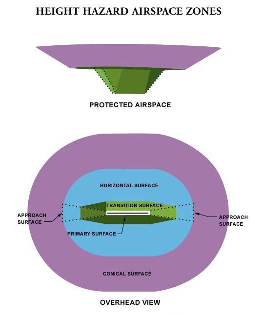
8 Airport Property Rights Protect Critical Safety Areas Critical Safety Areas clear of objects & people Runway Safety Area Runway Object Free Area Runway Protection Zone
9 Airport Property Rights Protect RPZ and Critical Safety Areas Runway Protection Zone (RPZ) Most accidents are over/undershoots of runway RPZ protects planes and persons on the ground RPZ must be kept clear of objects, structures, growth RPZ can extend from end of runway Note: Introduction of new roads into the RPZ, or significant modification, will require an FAA RPZ Alternatives Analysis prior to project
10 Fee Simple Clear Zone & Avigation Easement Purchase of air rights from ground level No structures or objects of any kind No assemblies of persons Also includes avigation easement rights and conditions Avigation Easement Purchase of airspace above a specified height Typical easement rights and conditions: right of flight; right to cause noise, vibration, and dust; right to prevent growth or obstructions into easement airspace; right of entry to maintain easement; right to prevent interference with aviation communication, navigation or lighting; restrictions on wildlife attractants
11 Safe Operations Clear and Safe Approaches Mitigate Hazards Good Title/Preserving Rights & Powers Do not sell, lease, encumber, transfer or dispose of airport property without approval of FAA/BOA Prevent incompatible land uses Control non-aeronautical use of airport property Utilities controlled by easement FAA does not allow utility permitting Subordinate interests of others
12 Clearly Identify Aeronautically Obligated Property in Public Records Include Airport in the grantee name Badger County, a municipal corporation, on behalf of its Badger County Airport [GRANTEE] Include Aero-obligation note on deeds & surveys This property or easement is acquired on behalf of the Badger County Airport. The airport owner is obligated to preserve airport property in accordance with state and federal grant assurances. Obligated airport property interests may not be sold or used for non-aeronautical purposes without prior written release approval by WisDOT Bureau of Aeronautics and the Federal Aviation Administration. New - FAA Grant Agreement & Assurances Must be Recorded against Newly Acquired Airport Property (when federally funded)


13 FAA Exhibit A Map Official Airport Property Record County GIS Owned by Town
 Creating CSMs or plat for hanger leases is strongly discouraged Coordinate with BOA on platting")
14 Clearly Mark Airport Property Monument Airport Property & Easements Mark Airport Property Line Vacate Potential Public Interests on Airport Property Streets and Roads Plats Do Not Divide Airport Property (except for sale) Creating CSMs or plat for hanger leases is strongly discouraged Coordinate with BOA on platting questions

15 Property Acquisition Boundary Surveys Type of Survey County Surveyor Coordination Geodetic Control Airport PACs & SACs Geodetic Control Stations on Airport Property Coordinate with BOA

16 Existing Clear Zone Easement & Avigation Easement Hospital Moved to Accommodate Easements Hospital Desires to Construct Access Road in Easement Area


17 RPZ Analysis & Land Release Approvals Critical Safety Area and Approach Protection Roadway Height - Height of Signs, Light Poles - Structures Utility Coordination


18 Road in RPZ - Relocated to Reduce Impact on Aviation Safety Existing Avigation Easements Height of Light Poles Buried Utilities Utility Easements Wildlife Hazard
19 Understand Airport Owners Concerns Safety Clear and Safe Approaches Land Use Control - Preventing Incompatible Land Use Compliance with Grant Assurances Airport Impact Extends Beyond the Runway Know What is Obligated Airport Property Allow Sufficient Time Airport RPZ Analysis Can Takes 1 year+ Airport Land Releases Can Take 2-3 years Title Transfer Cannot Occur Until Both are Completed and Approved by FAA


20 Questions? Thank You! WisDOT Bureau of Aeronautics Airport Real Estate, Property Surveying & Mapping Diann Danielsen, Airport Land Program Manager
Bowman Field Airport Area Safety Program
 Bowman Field Airport Area Safety Program Background Bowman Field Airport is a more than 90-year-old aeronautical facility established in 1919. The Louisville Regional Airport Authority (LRAA) and its predecessors
GRANT OF SURFACE AND OVERHEAD AVIGATION EASEMENTS W I T N E S S E T H:
 GRANT OF SURFACE AND OVERHEAD AVIGATION EASEMENTS As a requirement of a land use application for property in the Airport Influence Area, THIS GRANT of Avigation Easements is made and executed this day
BTV Sound Mitigation Meeting Burlington International Airport
 BTV Sound Mitigation Meeting Burlington International Airport September 14, 2016 1 2020 Noise Contours Last update to the Part 150 Noise Study was in 2008 Due to changes in VT ANG operations, a new update
INTENT GENERAL PROVISIONS PART 1 ZONING REGULATIONS SECTION 3400 OVERLAY DISTRICT AIRPORT INFLUENCE AREA
 PART 1 ZONING REGULATIONS SECTION 3400 OVERLAY DISTRICT AIRPORT INFLUENCE AREA 1-3401 INTENT The Airport Influence Area District is hereby established as an overlay district which includes within its boundaries
DETROIT METROPOLITAN WAYNE COUNTY AIRPORT DETROIT, MICHIGAN NOISE LAND REUSE PLAN
 DETROIT METROPOLITAN WAYNE COUNTY AIRPORT DETROIT, MICHIGAN NOISE LAND REUSE PLAN Submitted: August 8, 2008 As required by Federal Aviation Administration Program Guidance Letter 08-02 Management of Acquired
The policies set forth in Chapters 2 and 3 of the Oakland International Airport Land Use Compatibility Plan serve two functions:
 CHAPTER 2 County-wide Policies 2.1 Introduction The policies set forth in Chapters 2 and 3 of the Oakland International Airport Land Use Compatibility Plan serve two functions: 1. To articulate the procedures
NOTICE OF AVAILABILITY Airport Property Development and Leasing Opportunities Rhode Island Airport System Various Locations, Rhode Island
 March 10, 2015 NOTICE OF AVAILABILITY Airport Property Development and Leasing Opportunities Rhode Island Airport System Various Locations, Rhode Island The Rhode Island Airport Corporation (RIAC) is issuing
Attachment A First Submittal JAZB Safety Zones A and B
 Attachment A First Submittal JAZB Safety Zones A and B Attachment B Second Submittal JAZB Safety Zones A and B Attachment C Flying Cloud Airport (FCM) Draft Airport Zoning Ordinance Social and Economic
What does the New Land Use Handbook have to offer?
 What does the New Land Use Handbook have to offer? 2006 AirTAP Fall Forum Kathy Vesely, Gina Mitchell 1 New Legislation 2 SF 1940 Effective August 1, 2006 The operation and maintenance of airports is an
-Section Contents- 201 Districts Overlay Districts Incorporation of Maps District Boundaries...
 SECTION 2 GENERAL REQUIREMENTS AND EXCEPTIONS -Section Contents- ZONING DISTRICTS 201 Districts... 2-2 202 Overlay Districts... 2-2 203 Incorporation of Maps... 2-3 204 District Boundaries... 2-3 LAND
Montréal Pierre Elliott Trudeau International Airport Zoning Regulation RDIMS #
 Montréal Pierre Elliott Trudeau International Airport Zoning Regulation RDIMS #11429076 AIRPORT ZONING REGULATIONS 1. Zoning Regulation 2. Responsibilities 3. Zoning Regulation and Owners 4. Key Changes
RESOLUTION NO WHEREAS, an airport land use report was subsequently prepared by Johnson Aviation for the City of Perris; and
 RESOLUTION NO. 4202 A RESOLUTION OF THE CITY COUNCIL OF THE CITY OF PERRIS, COUNTY OF RIVERSIDE, STATE OF CALIFORNIA, OVERRULING THE RIVERSIDE COUNTY AIRPORT LAND USE COMMISSION (ALUC) FINDING OF INCONSISTENCY
AERONAUTICAL USE LEASE POLICYPOLICY GRAND JUNCTION REGIONAL AIRPORT Revised: November 18, 2014
 AERONAUTICAL USE LEASE POLICYPOLICY GRAND JUNCTION REGIONAL AIRPORT Revised: November 18, 2014 BACKGROUND, SUMMARY, RESPONSE TO COMMENTS AND TEXT The Grand Junction Regional Airport Authority (the Authority
Buchanan Field. Buchanan Field. Airport Planning Program. Steering Committee. Airport Master Planning Program. March 15, 2007
 Airport Planning Program Master Plan FAR Part 150 Noise Study Strategic Business Plan Steering Committee March 15, 2007 Airport Planning Program Master Plan FAR Part 150 Noise Study Strategic Business
Understand Exhibit A foundational info. Definition Update triggers Value to an airport Sponsor Where we ve been & where we re at today
 Pulling Together the Exhibit A Presented to: By: Date: 2017 Airports Fall Seminar Gina Mitchell, AICP November 30, 2016 Agenda Understand Exhibit A foundational info Definition Update triggers Value to
ZONING: From R-1/UGM/cz & R-2/UGM/cz to R-1/UGM/cz
 CITY OF FRESNO - DEVELOPMENT AND RESOURCE MANAGEMENT DEPARTMENT REQUEST FOR COMMENTS, CONDITIONS, ENVIRONMENTAL ASSESSMENT, AND ENTITLEMENT APPLICATION REVIEW OF REZONE APPLICATIO NO. 4-010 ALUC Return
Amended Noise Mitigation Plan
 1 of 54 Amended Noise Mitigation Plan Runway 9R/27L Expansion Project Broward County Aviation Department PREPARED BY: The Urban Group, Inc. The Jones Payne Group October 8, 2012 00010859-1 2 of 54 Amended
Sec F Airport Approach Overlay District. (4mended by Ord. 3561, March 17, 1986)
") Sec. 35-100. F Airport Approach Overlay District. (4mended by Ord. 3561, March 17, 1986) Sec.35-100.1. Purpose and Intent. The purpose of this overlay district is to re_date land uses with Auport Clear
Sec. 35-100. F Airport Approach Overlay District. (4mended by Ord. 3561, March 17, 1986) Sec.35-100.1. Purpose and Intent. The purpose of this overlay district is to re_date land uses with Auport Clear
Hillsboro Airport Compatibility Study Technical Conference Land Use Technical Advisory Group Meeting #1 June 23, 2005-Hillsboro Civic Center
 Attendees: Group Members: Hillsboro Airport Compatibility Study Technical Conference Land Use Technical Advisory Group Meeting #1 June 23, 2005-Hillsboro Civic Center Wink Brooks Ken Dyar Darlene Green
Noise Mitigation Plan
 Runway 9R/27L Expansion Project Broward County Aviation Department PREPARED BY: The Urban Group, Inc. September 26, 2011 00010859-1 Noise Mitigation Plan Runway 9R/27L Expansion Project Prepared By: The
Noise Mitigation Plan
 1 of 61 Noise Mitigation Plan Runway 9R/27L Expansion Project Broward County Aviation Department PREPARED BY: The Urban Group, Inc. October 25, 2010 2 of 61 Noise Mitigation Plan Prepared By: The Urban
In Development. Property Acquisition. Design-Permitting. Construction Phase. Closeout Phase. Planning
 PROJECT LIST BY PHASE In Development CIP No. Project Title Employee Parking Expansion Property Acquisition CIP No. Project Title 0099 Property Acquisition - Runway 22 RPZ 0100 Property Acquisition - Runway
In Development. Consultant Selection. Consultant - Scope of Work. Design-Permitting. Planning. Construction. Closeout
 CAPITAL IMPROVEMENT PROGRAM REPORT - AUGUST 2018 PROJECT LIST by PHASE In Development 999-16 Property Acquisition - RW 33 RPZ 999-17 Wetland Mitigation Phase 2 of 2 999-19 Property Acquisition - RW 22
PROJECT MANAGEMENT INSTITUTE
 Presentation to PROJECT MANAGEMENT INSTITUTE Erie Chapter by Erie International Airport, Tom Ridge Field Runway 6-24 Improvement Program Consultants April 15, 2010 INTRODUCTIONS Mark Petranchuk Program
Subdivision (Plat) Checklist
 Checklist") Subdivision (Plat) Checklist This Checklist is intended to assist you in preparing a complete application for submittal. Occasionally, additional items may be required to complete the review. Incomplete
Subdivision (Plat) Checklist This Checklist is intended to assist you in preparing a complete application for submittal. Occasionally, additional items may be required to complete the review. Incomplete
Belfast Municipal Airport Airspace Obstruction Analysis
 Belfast Municipal Airport Airspace Obstruction Analysis BST MEETING NOTES project: meeting date: location: subject: EA AND DATA COLLECTION FOR AIRSPACE OBSTRUCTION ANALYSIS WEDNESDAY, MARCH 18, 2015 6:30
Airport Influence District
 Airport Influence District Sections 800-822, Article 8, Chapter 146, Aurora Municipal Code (Includes up to Ordinance 2006-06, Effective April 8, 2006) City of Aurora Planning Department 15151 E. Alameda
LAnd Acquisition for PubLic AiRPoRts
 LAnd Acquisition for PubLic AiRPoRts How and Why Your Local Government Acquires Real Property U.S. DEPARTMENT OF TRANSPORTATION FEDERAL AVIATION ADMINISTRATION introduction Whenever feasible, the Federal
Potential Land Use and Administrative Alternatives
 DETROIT METROPOLITAN WAYNE COUNTY AIRPORT FAR PART 150 NOISE COMPATIBILITY STUDY UPDATE CHAPTER H POTENTIAL LAND USE & ADMINISTRATIVE ALTERNATIVES Potential Land Use and Administrative Alternatives The
ANCHORAGE, ALASKA AO No
 Submitted by: Chair of the Assembly at the Request of the Mayor Prepared by: Merrill Field Airport For reading: July, ANCHORAGE, ALASKA AO No. -0 0 0 AN ORDINANCE AUTHORIZING THE ACQUISITION OF REAL PROPERTY
Article 10. Overlay Zones
 Article 10. Overlay Zones Sections: Sec. 1001 - Purpose and Objectives Sec. 1002 - DDOZ - Dairy Development Overlay Zone Sec. 1003 - NSOZ - Nutrient Spreading Overlay Zone Sec. 1004 - AOZ - Agriculture
CHAPTER 4: DISTRICT REGULATIONS
 CHAPTER 4: DISTRICT REGULATIONS 4.1 COMPLIANCE WITH DISTRICT STANDARDS 4.1.1 No building or structure may be erected, converted, enlarged, reconstructed, altered for use, or used except in accordance with
HOMEOWNER PARTICIPATION AGREEMENT RESIDENTIAL SOUND INSULATION PROGRAM
 HOMEOWNER PARTICIPATION AGREEMENT RESIDENTIAL SOUND INSULATION PROGRAM PARTIES Piedmont Triad Airport Authority ("Authority") 1000-A Ted Johnson Parkway Greensboro, N.C. 27409 ("Homeowners") RECITALS Homeowners
Menominee Regional Airport PRIVATE TENANT LAND LEASE
 Menominee Regional Airport PRIVATE TENANT LAND LEASE THIS AGREEMENT, made and entered into this day of, 20, by and between MENOMINEE COUNTY, of Menominee, Michigan, a governmental entity existing by and
VOLUNTARY SALES ASSISTANCE PROGRAM CONSISTING OF TWO OPTIONS:
 VOLUNTARY SALES ASSISTANCE PROGRAM CONSISTING OF TWO OPTIONS: STANDARD SALES ASSISTANCE PROGRAM & CONVEYANCE AND RELEASE PROGRAM POLICIES AND PROCEDURES MANUAL Broward County Aviation Department Fort Lauderdale
HALLER POLICY MANUAL SECTION ONE
 HALLER POLICY MANUAL SECTION ONE OVERVIEW/GENERAL 1. PURPOSE T&G Aero, Inc., a Florida corporation, is responsible to shareholders and the Haller Air Park community to set appropriate and fair policies
Compark Village South Filing 2 Submittal Comments from Trakit Reviews tab CLCPKC3.05/SUB Updated as of 11/19/16
 Compark Village South Filing 2 Submittal Comments from Trakit Reviews tab CLCPKC3.05/SUB16-034 Updated as of 11/19/16 1. Completeness Review Patrick Mulready STATUS: APPROVED. 2. Address Plat 20 Steve
PRELIMINARY ANALYSIS
 PRELIMINARY ANALYSIS The Burbank-Glendale-Pasadena Airport Authority (the Authority ) has filed an application under California Public Utilities Code (PUC) Section 21661.6 requesting approval to acquire
Allow continued use of existing grass runway for personal use by landowner.
 CUP-13-00193 Item No. 4-1 PLANNING COMMISSION REPORT Regular Agenda PC Staff Report 7/22/13 ITEM NO. 4: CONDITIONAL USE PERMIT; PRIVATE LANDING STRIP; 2215 N 500 (MKM) CUP-13-00193: Consider a Conditional
2. The aforesaid easement and right-of-way includes the uses, rights, and restrictions described as follows:
 NOW THEREFORE, Grantor, for good and valuable consideration, the receipt and sufficiency of which is hereby acknowledged, does hereby grant to the Grantee, its successors and assigns, a perpetual and assignable
Avigation Easement Instructions
 Avigation Easement Instructions Based on the project location, you will need to complete the Avigation Easement process. 1.) Provide Legal Description: Include a legal description labeled Exhibit A that
LAND ACQUISITION FOR PUBLIC AIRPORTS
 LAND ACQUISITION FOR PUBLIC AIRPORTS How and why your Local Government Acquires Real Property for Public Airports U.S. DEPARTMENT OF TRANSPORTATION FEDERAL AVIATION ADMINISTRATION Introduction Whenever
4.0. Land Use Management Measures. Land Use Management Measures 4.0
 4.0 4.0 Philadelphia International Airport FAR Part 150 Report Prepared by: DMJM Aviation AECOM In association with: Wyle Portfolio Associates, Inc. 4-1 Philadelphia International Airport 4. 4.1 Introduction
ACTION ITEM #3 WSU Pullman, Approval of Pullman Moscow Regional Airport s
 ACTION ITEM #3 (Pearson/Yang) September 22, 2017 TO ALL MEMBERS OF THE BOARD OF REGENTS SUBJECT: PROPOSED: SUBMITTED BY: BACKGROUND: That the Board of Regents approve the land acquisition offer from the
The applicant is requesting to amend the note to allow for 18 townhouse units in lieu of the commercial use. The requested note reads as follows:
 Page 1 of 27 STAFF REPORT Davie 39 Street Addition 133-MP-83 A request to amend the plat note has been filed with the Planning and Redevelopment Division. This plat was approved by the County Commission
LAND OWNER OF SITE ADDRESS PHONE NUMBER FAX NUMBER. APPLICANT (if other than owner) ADDRESS PHONE NUMBER FAX NUMBER
 ADDRESS PHONE NUMBER FAX NUMBER") TELECOMMUNICATION TOWER CONDITIONAL USE PERMIT APPLICATION FOR WALWORTH COUNTY - $1025 The undersigned hereby applies to the Walworth County Zoning Agency (Walworth County Land Use and Resource Management
TELECOMMUNICATION TOWER CONDITIONAL USE PERMIT APPLICATION FOR WALWORTH COUNTY - $1025 The undersigned hereby applies to the Walworth County Zoning Agency (Walworth County Land Use and Resource Management
Siting Renewable Energy: Land Use & Environmental Due Diligence. Polly B. Jessen Catherine M. van Heuven March 8, 2013
 Siting Renewable Energy: Land Use & Environmental Due Diligence Polly B. Jessen Catherine M. van Heuven March 8, 2013 1 Due Diligence Generally Due diligence for siting renewable projects involves many
RESOLUTION NUMBER 5059
 RESOLUTION NUMBER 5059 A RESOLUTION OF THE CITY COUNCIL OF THE CITY OF PERRIS, COUNTY OF RIVERSIDE, STATE OF CALIFORNIA, APPROVING MITIGATED NEGATIVE DECLARATION 2325 FOR GENERAL PLAN AMENDMENT 15-05207,
NEWPORT CODE DRAFT latest revision 11/11/13 APPENDIX A. SPECIAL USE and CONDITIONAL USE PERMITS
 PROVISIONS FOR SPECIAL and CONDITIONAL USES 9-6 Tall Structures, General Tall Structures are defined as but not limited to: Steeples, Towers, Smoke Chimneys, Wind activated Devices, Wind Energy Facilities
ARTICLE 2 ZONING DISTRICTS AND MAPS
 ARTICLE 2 ZONING DISTRICTS AND MAPS SECTION 2.100 PURPOSE OF DISTRICTS Section 2.101. For the purpose of this Ordinance, Billings Township is hereby divided into districts as follows: DISTRICT NAME SYMBOL
DRAFT BEND MUNICIPAL AIRPORT URBAN RENEWAL PLAN. Deschutes County
 DRAFT BEND MUNICIPAL AIRPORT URBAN RENEWAL PLAN Deschutes County County Commission: Dennis Luke, Chair Tammy (Baney) Melton, Vice Chair Mike Daly, Commissioner County Planning Commission: Keith Cyrus,
JOINT AIRPORT ZONING BOARD. Approval of the minutes of the June 9, 2014, Joint Airport Zoning Board meeting
 JOINT AIRPORT ZONING BOARD ITEM NUMBER: Two MEETING DATE: 06-25-14 ITEM TITLE: SUBMITTED BY: Approval of the minutes of the June 9, 2014, Joint Airport Zoning Board meeting Terry Morrow, Administrative
CITY OF FORT COLLINS NATURAL AREAS AND CONSERVED LANDS EASEMENT POLICY
 CITY OF FORT COLLINS NATURAL AREAS AND CONSERVED LANDS EASEMENT POLICY Adopted January 3, 2012 PURPOSE: The purpose of the policy statement is to clarify the policies and procedures of the City of Fort
4 August 8, 2012 Public Hearing APPLICANT AND PROPERTY OWNER: ARAI AMERICAS, INC.
 4 August 8, 2012 Public Hearing APPLICANT AND PROPERTY OWNER: ARAI AMERICAS, INC. STAFF PLANNER: Faith Christie REQUEST: Modification of the Conditions of a Street Closure for a portion of Bayside Road
POTENTIAL HIGH-RISE RESIDENTIAL DEVELOPMENT SITE
 POTENTIAL HIGH-RISE RESIDENTIAL DEVELOPMENT SITE 50-90 NORTH FIRST STREET, DOWNTOWN SAN JOSE, CA August 2012 PREPARED BY: David Buchholz Senior Vice President +1 404 282 3843 david.buchholz@colliers.com
City Council Briefing Clear Creek Holdings, LLC. April 16, 2019 Robert J. Tajan, Director Planning and Community Development
 City Council Briefing April 16, 2019 Robert J. Tajan, Director Planning and Community Development 1 AICUZ Background Air Installation Compatible Use Zones Established in response to the Noise Control Act
SECOND SUBMITTAL OF DRAFT FLYING CLOUD AIRPORT ZONING ORDINANCE
 September 21, 2018 Mr. Charles A. Zelle Commissioner of Transportation Minnesota Department of Transportation 395 John Ireland Boulevard Mailstop 100 St. Paul, MN 55155-1899 RE: SECOND SUBMITTAL OF DRAFT
AGENDA DANIA BEACH CITY COMMISSION SECOND PUBLIC HEARING AIRPORT SETTLEMENT AGREEMENT MONDAY, OCTOBER 03, :00 P.M.
 AGENDA DANIA BEACH CITY COMMISSION SECOND PUBLIC HEARING AIRPORT SETTLEMENT AGREEMENT MONDAY, OCTOBER 03, 2011-7:00 P.M. ANY PERSON WHO DECIDES TO APPEAL ANY DECISION MADE WITH REGARD TO ANY MATTER CONSIDERED
City of Melissa, Texas Plat Dedication Language
 City of Melissa, Texas Plat Dedication Language [INCLUDE THE FOLLOWING DEDICATION LANGUAGE FOR INDIVIDUALS (MODIFY APPROPRIATELY TO REFLECT EXACTLY AS SHOWN ON PROPERTY DEED)]: NOW THEREFORE, KNOW ALL
REVISED STAFF REPORT:CITY OF PASO ROBLES Page 1 of 8 STAFF REPORT SAN LUIS OBISPO COUNTY AIRPORT LAND USE COMMISSION
 REVISED STAFF REPORT:CITY OF PASO ROBLES Page 1 of 8 STAFF REPORT SAN LUIS OBISPO COUNTY AIRPORT LAND USE COMMISSION DATE: MAY 20, 2015 TO: FROM: AIRPORT LAND USE COMMISSION (ALUC) BRIAN PEDROTTI, COUNTY
MILFORD, IOWA FULLER AIRPORT 2013 AIRPORT LAND USE AND HEIGHT OVERLAY ZONING ORDINANCE
 MILFORD, IOWA FULLER AIRPORT 2013 AIRPORT LAND USE AND HEIGHT OVERLAY ZONING ORDINANCE With Information Provided By: Iowa Airport Land Use Guidebook Prepared with Planning Assistance from Northwest Iowa
Absent: Major Chris Hanson, Volk Field John Ross, Jackson County Emergency Management; Paul Wydeven, Wisconsin Department of Transportation
 Monroe County/Fort McCoy Joint Land Use Study (JLUS) Technical Advisory Group (TAG) December 8, 2011, 2:00 4:00 p.m. Angelo Town Hall, 14123 Co. Hwy. I, Sparta, WI Meeting Minutes Attendance: Bryan Law,
REDMOND MUNICIPAL AIRPORT ROBERTS FIELD REDMOND, OREGON
 REDMOND MUNICIPAL AIRPORT ROBERTS FIELD REDMOND, OREGON A POLICY TO GOVERN LEASES INVOLVING THE USE OR DISPOSAL OF CITY PROPERTY FOR AERONAUTICAL ACTIVITIES ADOPTED CITY OF REDMOND, OREGON A POLICY TO
A Minor Land Excavation Operating Permit is used to:
 CHAPTER 400. SECTION 404. PERMIT TYPES AND APPLICATIONS OPERATING PERMITS 404.1. Minor Land Excavation A. Intent and Purpose The intent and purpose of this section is to protect the public health, safety,
R/W PREQUALIFICATION ODOT, 3/14/2018
 R/W PREQUALIFICATION ODOT, 3/14/2018 BRETT SHEARER, C.O. REAL ESTATE PROPOSED RIGHT OF WAY DESIGN 172 PROPOSED RIGHT OF WAY DESIGN PROPOSED RIGHT OF WAY DESIGN Section 3200 Types of Title 173 PROPOSED
THIS INTERGOVERNMENTAL AGREEMENT is entered into this day. of, 2004 A.D., by and between the STATE OF ILLINOIS, acting by and through its
 INTERGOVERNMENTAL AGREEMENT BETWEEN THE STATE OF ILLINOIS, THE ILLINOIS STATE TOLL HIGHWAY AUTHORITY, THE COUNTY OF DUPAGE AND THE CITY OF CHICAGO CONCERNING ROADWAY IMPROVEMENTS IN THE VICINITY OF THE
Residential Project Convenience Facilities
 Standards for Specific Land Uses 35.42.220 E. Findings. The review authority shall approve a Land Use Permit in compliance with Subsection 35.82.110.E (Findings required for approval) or a Conditional
Obstruction Removal Projects:
 Obstruction Removal Projects: A Survival Guide to THE most unpopular FAA type of project David Parker, BOA Engineering Region 1 THE Obstruction Removal OFF AIRPORT, the 2 words everyone in the business
Section 4.1 LAND TITLE
 Section 4.1 LAND TITLE PURPOSE... 4-1-1 AUTHORITY... 4-1-1 SCOPE... 4-1-1 REFERENCES... 4-1-1 TRAINING... 4-1-2 FORMS... 4-1-2 DEFINITIONS... 4-1-2 4.1.1 QUALITY AND QUANTITY OF TITLE... 4-1-3 4.1.2 TITLE
PROPERTY ASSESSMENT and WARRANTY for [Insert Bank Name]
![PROPERTY ASSESSMENT and WARRANTY for [Insert Bank Name]](/thumbs/72/66340377.jpg "PROPERTY ASSESSMENT and WARRANTY for [Insert Bank Name]") PLEASE NOTE: The following Property Assessment and Warranty is provided as a standard template document. Any modifications to this template shall be identified and explained in an attached addendum. (Version
PLEASE NOTE: The following Property Assessment and Warranty is provided as a standard template document. Any modifications to this template shall be identified and explained in an attached addendum. (Version
LAND USE, ZONING, & DEVELOPMENT STANDARDS
 02 LAND USE, ZONING, & DEVELOPMENT STANDARDS CHAPTER 2: LAND USE, ZONING, & DEVELOPMENT STANDARDS 2.1 Introduction The City s General Plan Land Use Map (LUE Figure 3) designates the Froom Ranch Area as
COMPREHENSIVE LAND USE PLAN SANTA CLARA COUNTY HELIPORTS
 COMPREHENSIVE LAND USE PLAN SANTA CLARA COUNTY HELIPORTS Adopted by SANTA CLARA COUNTY AIRPORT LAND USE COMMISSION San Jose, California October 28, 2015 Prepared by Walter B. Windus Aviation Consultant
TECHNICAL REPORT Lee s Summit Airport Business Plan Non-Aviation Development Evaluation
 Business Plan September, 2009 1. INTRODUCTION TECHNICAL REPORT Lee s Summit Airport Business Plan Non-Aviation Development Evaluation This technical report serves as a supplement to the draft Lee s Summit
AIRPORT LEASING. Presented By: Vinicio Lenny LLerena, A.A.E.,ACE
 AIRPORT LEASING Presented By: Vinicio Lenny LLerena, A.A.E.,ACE Presentation Outline Grant Assurances Airport Primary Guiding Documents Appraisals & Financial Considerations Lease Requirements Lessons
Wind Energy Conversion System Ordinance No. 467
 Wind Energy Conversion System Ordinance No. 467 AN ORDINANCE ESTABLISHING A PERMITTING PROCESS FOR WIND ENERGY CONVERSION SYSTEMS ADOPTED BY THE Big Timber City Council on this day of, 2006. ADOPTED BY
Land Use. Existing Land Use
 8 Land Use 8.1 Land Use Chapter Purpose and Contents This element includes a brief summary of existing land use conditions and trends followed by a series of goals, objectives, and recommendations to guide
SUBDIVISION REGULATIONS OF THE CITY OF DERBY, KANSAS
 SUBDIVISION REGULATIONS OF THE CITY OF DERBY, KANSAS ARTICLE 1. TITLE, PURPOSE, AUTHORITY, JURISDICTION, APPLICABILITY AND EXEMPTIONS 100 TITLE. These regulations shall be known and may be cited as the
CHAPTER 14 SPECIAL DEVELOPMENTS
 10-14-1 10-14-1 CHAPTER 14 SPECIAL DEVELOPMENTS SECTION: 10-14-1: Cluster and Inner Block Development 10-14-2: Planned Unit Development 10-14-1: CLUSTER AND INNER BLOCK DEVELOPMENT: A. Land Use: Cluster
Article 4. Zoning Districts
 Section 4.1: Establishment of Districts Article 4. Zoning Districts 4.1 Establishment of Districts For the purpose of this UDO, portions of the City as specified on the Official Zoning Map of the City
DEPARTMENT OF THE ARMY OFFICE OF THE CHIEF OF ENGINEERS WASHINGTON, D.C
 DEPARTMENT OF THE ARMY OFFICE OF THE CHIEF OF ENGINEERS WASHINGTON, D.C. 20314-1000 REPLY TO ATTENTION OF: CECW-PM (10-1-7a) THE SECRETARY OF THE ARMY 1. I submit for transmission to Congress my report
Final. Chapter Four: Land Use
 Chapter Four: Land Use Purpose and Intent Goals and Policies Existing Land Use Patterns AICUZ Airport Overlay Zone Zoning Existing Land Use Land Use Designations Land Use Demand and Forecast Existing Population
SHAWNEE REGIONAL AIRPORT GENERAL AVIATION HANGAR DEVELOPMENT AREA APPLICATION PROCESS AND LEASING POLICY
 General Information SHAWNEE REGIONAL AIRPORT GENERAL AVIATION HANGAR DEVELOPMENT AREA APPLICATION PROCESS AND LEASING POLICY The Shawnee Regional Airport is located two miles NW from downtown Shawnee and
R E S O L U T I O N. 2. Development Data Summary:
 R E S O L U T I O N WHEREAS, the Prince George s County Planning Board is charged with the approval of Detailed Site Plans pursuant to Part 3, Division 9 of the Zoning Ordinance of the Prince George s
REQUEST FOR PROPOSALS (RFP) LOT 8 HANGAR DEVELOPMENT AT SKY HARBOR AIRPORT
 LOT 8 HANGAR DEVELOPMENT AT SKY HARBOR AIRPORT") REQUEST FOR PROPOSALS (RFP) LOT 8 HANGAR DEVELOPMENT AT SKY HARBOR AIRPORT ISSUE DATE: ONE ON ONE ON SITE PRE PROPOSAL CONFERENCE DUE DATE (NON MANDATORY): WRITTEN QUESTIONS/COMMENTS DUE DATE: WRITTEN
REQUEST FOR PROPOSALS (RFP) LOT 8 HANGAR DEVELOPMENT AT SKY HARBOR AIRPORT ISSUE DATE: ONE ON ONE ON SITE PRE PROPOSAL CONFERENCE DUE DATE (NON MANDATORY): WRITTEN QUESTIONS/COMMENTS DUE DATE: WRITTEN
Division 4 Large Lot Residential Zone: Assessment Criteria and Assessment Tables
 Division 4 Large Lot Residential Zone: Assessment Criteria and Assessment Tables 4.4.1 Large Lot Residential Zone The provisions in this division relate to the Large Lot Residential Zone as follows overall
IOWA SOLID WASTE PROGRAM ENVIRONMENTAL COVENANT
 IOWA SOLID WASTE PROGRAM ENVIRONMENTAL COVENANT This environmental covenant is established pursuant to Iowa Code (IC) chapter 455I entitled Uniform Environmental Covenants Act. {INSERT name(s) of fee title
PROWERS COUNTY ZONING REGULATIONS
 PROWERS COUNTY ZONING REGULATIONS Adopted; February 16, 2006 As Amended; April 12, 2012 Prowers County Zoning Regulations, Adopted 2-16-2006 and Amended 4-12-2012 1 TABLE OF CONTENTS SECTION NO. CONTENTS
ARTICLE 7 (A-1) AGRICULTURAL PRESERVATION DISTRICT
 AGRICULTURAL PRESERVATION DISTRICT") ARTICLE 7 (A-1) AGRICULTURAL PRESERVATION DISTRICT 7TCC 1-7 (a) Purpose. The A-1 Zoning District is established to benefit and protect agricultural uses throughout the County. The intent of the Agriculture
ARTICLE 7 (A-1) AGRICULTURAL PRESERVATION DISTRICT 7TCC 1-7 (a) Purpose. The A-1 Zoning District is established to benefit and protect agricultural uses throughout the County. The intent of the Agriculture
Avigation Easement Instructions
 Avigation Easement Instructions Based on the project location, you will need to complete the Avigation Easement process. 1.) Provide Legal Description: Include a legal description labeled Exhibit A that
Chapter 100 Planned Unit Development in Corvallis Urban Fringe
 100.100 Scope and Purpose. Chapter 100 Planned Unit Development in Corvallis Urban Fringe (1) All applications for land divisions in the Urban Residential (UR) and Flood Plain Agriculture (FPA) zones within
Marco Island Executive Airport - New Terminal Building & Airside Improvements
 April 20, 2017 Collier County Development Review Re: Marco Island Executive Airport - New Terminal Building & Airside Improvements The Marco Island Executive Airport (MKY or Airport) is a general aviation
Effective Date, Revisions and Renewals
 ARTICLE I. Introduction Section 1.01 The City of Midland recognizes the importance of Midland International and Midland Airpark Airport Systems to the City, the community, Texas Aviation System Plan (TASP)
Town of Prairie du Sac Sauk County, WI. Land Division Ordinance 07-3
 Town of Prairie du Sac Sauk County, WI Land Division Ordinance 07-3 1.01 DISCLAIMER (1) Multiple Jurisdictions. All persons reviewing the provisions of this Ordinance should be aware that the Town of Prairie
REQUEST FOR PROPOSAL
 REQUEST FOR PROPOSAL Manufacturing and Office Facility Located at 747 Fortress Street, Chico, CA 95973 * Proposals are due no later than 4:00 p.m. on Tuesday, December 22, 2015 * The City of Chico (City)
PICKENS COUNTY UNIFIED DEVELOPMENT STANDARDS ORDINANCE. Organization of the Ordinance
 PICKENS COUNTY UNIFIED DEVELOPMENT STANDARDS ORDINANCE Organization of the Ordinance Article 1. Article 2. Article 3. Article 4. Article 5. Article 6. Article 7. Adoption, Applicability and Interpretation
STATEMENT OF CONDITIONS FOR USE OF
 STATEMENT OF CONDITIONS FOR USE OF WATER FACILITY EASEMENT GRANTEE: PORTLAND WATER BUREAU of the CITY OF PORTLAND, a municipal corporation of the State of Oregon LEGAL DESCRIPTION: (Attached hereto) SITE
Appendix B Real Estate Plan
 Appendix B Real Estate Plan B-1 REAL ESTATE PLAN Prepared for U.S. Army Corps of Engineers Southwestern Division Little Rock District As of May 1, 2013 Prepared by Ronald Bridges Real Estate Division ANY
Independence Township Planning Commission. Richard K. Carlisle, AICP. DATE: November 30, Millstone Golden, LLC Special Land Use
 TO: FROM: Independence Township Planning Commission Richard K. Carlisle, AICP DATE: RE: I have received the subject special land use request and support materials for a dog kennel. The site is 3.03 acres
ARVIAT COMMUNITY PLAN - TABLE OF CONTENTS -
 ARVIAT COMMUNITY PLAN - TABLE OF CONTENTS - Page Arviat Community Plan By-law No. 206 SECTION 1 - INTRODUCTION...1 1.1 Purpose of the Plan...1 1.2 Goals of the Community Plan...1 1.3 Administration of
MINOR PLAT. The following documents are provided as required by the City of Conroe for use in the above titled platting submittals:
 Public Works - Engineering Division CITY OF CONROE MINOR PLAT The following documents are provided as required by the City of Conroe for use in the above titled platting submittals: Submittal Questionnaire