CHAPTER XX ZONING PART 1 GENERAL PROVISIONS PART 2 RESIDENTIAL DISTRICTS
|
|
|
- Mercy Little
- 6 years ago
- Views:
Transcription
1 CHAPTER XX ZONING PART 1 GENERAL PROVISIONS 101 Titles 102 General Intent 103 General Goals 104 General Provisions 105 Relationship to the Comprehensive Plan 106 Establishment of Controls and Districts 107 Severability 108 Effective Date 109 Savings Clause PART 2 RESIDENTIAL DISTRICTS 201 Purpose 202 R-1 Single-family Residential District 203 R-2 Single-family Residential District 204 R-3 Low Density-Mixed Residential District 205 R-4 Multi-family, Mixed Residential District 206 R-5 Multi-family, Multi-Story District 207 R-6 Multi-family, Multi-Story District 208 R-7 High Density, High-Rise, Multi-Family Limited Commercial District PART 3 COMMERCIAL DISTRICTS 301 Purpose 302 C-1 Neighborhood Commercial District 303 C-2 Community Commercial District 304 CBD Commercial District 401 OB Office Boutique Overlay 402 OS-P Open Space Passive District 403 OS-A Open Space Active District 404 CD Conservation District PART 4 SPECIAL DISTRICTS xx-i
2 405 CC Continuing Care Overlay District 406 MX Mixed Use Overlay District PART 5 PLANNED DEVELOPMENT DISTRICTS 501 Planned Development Regulations Purpose 502 Statement of Intent and Community Development Objectives 503 Administration and Procedures for Approval 504 Development Requirements and Standards PART 6 ADDITIONAL REQUIREMENTS FOR SPECIFIED USES 601 Purpose 602 Ancillary Garage or Parking Lots 603 Animal Hospitals 604 Attached Single-family Dwellings 605 Bed and Breakfast Establishments 606 Commercial Uses in Multi-family Dwellings in Residential Districts 607 Communications Antennas and Communications Equipment Buildings 608 Community Garage or Parking Lots 609 Continuing Care Facilities 610 Day Care Centers 611 Drive-Thrus 612 Housing for the Elderly 613 Mixed-use 614 Mobile Home Parks 615 Multi-family Dwellings 616 Municipal Facilities 617 Municipal Garage, Garage or Parking Lots 618 No-Impact Home-Based Business 619 Nursery 620 Outdoor Seating/Assembly Areas 621 Personal Care Home for Adults 622 Public Service Corporation Facility 623 Single-family Attached Dwellings 624 Sexually Oriented Businesses 625 Temporary Uses 626 Vehicle Rental Services 627 Vehicle Repair Stations 628 Vehicle Sales Areas 629 Vehicle Service Stations 630 Brewpub/Brewery xx-ii
3 631 Medical Marijuana Facilities 632 Warehousing and Self-storage Facilities 701 Purpose 702 Municipality-Wide Design Guidelines 703 Municipality-Wide Design Standards 704 Non-Residential Building Standards 705 Residential Building Standards PART 7 DESIGN GUIDELINES AND STANDARDS PART 8 REQUIREMENTS APPLYING TO ALL DISTRICTS 801 Purpose 802 Lot Coverage 803 Accessory Uses 804 Air Conditioning Systems/Mechanical Equipment 805 Carports 806 Dumpsters and Refuse Collection Areas 807 Dwelling Unit Standards 808 Fences and Walls 809 Fire and Explosive Hazards 810 Flood-Prone Area 811 Grading 812 Junk Vehicles 813 Hazardous Materials and Disturbances 814 Landscaping, Buffers and Screening 815 Lighting 816 Off-Street Loading 817 Off-Street Parking 818 Off-Street Stacking Requirements 819 Outdoor Storage 820 Outdoor Displays 821 Radio or Television Antenna Structures 822 Satellite Dish Antenna Structures 823 Sign Regulations xx-iii
4 PART 9 NONCONFORMITIES 901 Purpose 902 Nonconforming Use 903 Nonconforming Buildings or Structures 904 Nonconforming Lots of Record 905 Nonconforming Sign PART 10 PROCEDURES 1001 Certificates of Use, Occupancy and Compliance 1002 Conditional Uses 1003 Site Plan Review 1004 Special Exceptions 1005 Variance 1006 Optional Notice of Ordinance or Decision 1007 Lapse 1101 Commission 1102 Planning Board 1103 Zoning Hearing Board 1104 Zoning Officer PART 11 RESPONSIBILITIES AND AUTHORITIES 1201 Amendments 1202 Fee Schedule 1203 Notification of Violation 1204 Penalties 1205 Other Remedies PART 12 ADMINISTRATION 1301 Lot Area Exceptions 1302 Front Yard Exceptions PART 13 EXCEPTIONS xx-iv
5 1303 Height Exceptions 1304 Projections as Exceptions 1305 Unenclosed Porch Exceptions PART 14 DEFINITIONS 1401 Word Usage and Interpretation 1402 Definitions PART 15 APPENDIX PART 16 INDEX PART 17 DIAGRAMS PART 18 MAPS xx-v
6 PART I GENERAL PROVISIONS 101 Titles Long Title This Chapter includes regulations to permit, prohibit, regulate, restrict and determine: The Use of land, Buildings and Structures Area and dimensions of land to be occupied by Uses and Structures Areas, Courts, Yards and other open spaces Setbacks and Yards to be left unoccupied by Uses and Structures Density of population and intensity of Use Size, height, bulk, location, erection, construction, repair, maintenance of Buildings and other Structures For such purposes to divide the Municipality into zoning districts and transitional areas Further, to provide for administrative enforcement and amendment in accordance with the provisions of the Pennsylvania Municipalities Planning Code To repeal all ordinances or portions hereof, in conflict with this Chapter Short Title. This Chapter shall be known and may be referred to as the Mt. Lebanon Zoning Ordinance hereinafter designated as this Chapter. 102 General Intent. It is the intent, purpose and scope of this Chapter to protect and promote safety, health and morals; to accomplish coordinated development; to provide for the general welfare by guiding the use of land and structures, type and location of streets, public grounds and other facilities; to promote the conservation of energy through the use of planning practices; to promote the effective utilization of renewable energy sources; to promote the preservation of natural and historic resources; to ensure that the zoning ordinance is generally consistent with the adopted comprehensive plan; to encourage the revitalization of established urban centers; and to minimize such problems as may presently exist or which may be foreseen and whenever the provisions of this ordinance promote, encourage require XX-1
7 or authorize governing bodies to protect, preserve or conserve open land, consisting of natural resources, forests and woodlands, any actions taken to protect, preserve or conserve such land shall not be for the purposes of precluding access for forestry. This chapter is designed: To promote, protect and facilitate any or all of the following: the public health, safety, morals, and the general welfare; coordinated and practical community development and proper density of population; emergency management preparedness and operations, airports, and national defense facilities, the provisions of adequate light and air, access to incident solar energy, police protection, Vehicle parking and Loading Space, transportation, water, sewerage, Schools, recreational facilities, Public grounds, the provision of a safe, reliable and adequate water supply for domestic, commercial, agricultural or industrial Uses, and other public requirements; as well as preservation of the natural, scenic and historic values in the environment and preservation of forests, wetlands, aquifers, and Flood-prone Areas To prevent one or more of the following: overcrowding of land, blight, danger and congestion in travel and transportation, loss of health, life or property from fire, Flood, panic or other dangers To preserve prime agriculture and farmland considering topography, soil type and classification, and present use To provide for the Use of land within the Municipality for residential housing of various Dwelling types encompassing all basic forms of housing, including Singlefamily and Two-family Dwellings, and a reasonable range of Multi-family Dwellings in various arrangements, Mobile Homes and Mobile Home Parks, provided, however, that no zoning ordinance shall be deemed invalid for the failure to provide for any other specific Dwelling type To accommodate reasonable overall community growth, including population and employment growth, and opportunities for development of a variety of residential Dwelling types and non-residential Use. 103 General Goals. This Chapter establishes and implements zoning regulations for Mt. Lebanon to meet the General Intent and Purpose outlined in 102. The goals of this Chapter include: Proactive Planning Guide and regulate the orderly growth, development and redevelopment of Mt. Lebanon in accordance with long-term objectives, principles and standards deemed beneficial to the interest and welfare of the people. XX-2
8 103.2 Protection of our Character Protect and preserve the historic character of Mt. Lebanon Ensure the pedestrian vitality is protected and enhanced Protect the residential character of our established neighborhoods Community Vitality Ensure the social and economic well-being of both Private and Public property Promote, in the public interest, the utilization of land for the purposes for which it is most desirable and best adapted Flexible Opportunities Utilize performance-based regulations to promote creative design solutions Regulate and limit the height, bulk and location of Buildings in context with surrounding properties Establish, regulate and limit the Building or setback lines on or along Streets in Mt. Lebanon to promote attractive design solutions Regulate the density of population and the intensity of Uses of Lot Areas as appropriate and in context with the surrounding neighborhood Regulate and determine the area of Yards, Courts and other open spaces within and surrounding Buildings Classify, regulate and restrict the location of trades and industries and the location of Buildings designed for specified industrial, business, residential and other Uses Divide the entire Municipality into districts of such number, shape and area, and of such different classes according to Use of land and Buildings, height and bulk of Buildings, intensity of Use of Lot Areas, area of open spaces and other classifications as may be deemed best suited to regulate development Fix standards to which Buildings or Structures in such districts shall conform. XX-3
9 Provide regulations pertaining to pre-existing Lots, Structures and Uses that do not conform to the regulations, standards, restrictions and limitations established by this Chapter Prevent additions to and Alteration or remodeling of existing Buildings or Structures in such a way as to avoid the restrictions and limitations lawfully imposed by this Chapter Streamlined Process. 104 General Provisions Provide for Variances from such regulations, standards, restrictions and limitations Provide for Conditional Uses, Planned Development District and other Uses requiring special approval, within the established districts Provide administrative bodies and procedures as shall be necessary to the implementation and enforcement of the various provisions of this Chapter Provide for the orderly amendment of this Chapter Annexed Land. All land annexed to the Municipality after the enactment of this Chapter shall be classified immediately and automatically as an R-1 District. The Planning Board shall recommend appropriate zoning for the annexed area to the Commission within ninety (90) days after the date of annexation Boundary Line and Building Line. No boundary lines of Lots in Recorded Plats shall be altered except by a revised Subdivision plan. All Building Lines established by Recorded Plats or deeds are hereby adopted except where the same are in conflict with Building Lines as established by this Chapter Frontage on Public Street Required. Each Single-family, Two-family, and Multi- Family Dwelling shall have a Lot Line front on a Public Street dedicated for Public Use and improved to Municipal Standards. This regulation also shall apply to Single-family Dwellings, Two-family Dwellings, and Multi-Family Dwellings located in a development consisting of varied housing types Lot Area Any Lot, as well as the open space reserved on it, must equal or exceed the Minimum Lot Areas prescribed by this Chapter for the district in which the Lot is located. XX-4
10 A portion of a Lot once designated as a Yard, or a Lot Area, or portion thereof, used in calculating the number of Dwelling Units permitted on that Lot, shall not be again used as a factor in determining the required area for another Lot or Building, nor shall it be sold as a Lot or parcel thereof, separate from the Lot of which it is a part Any portion of a Lot, which is recorded or otherwise reserved for future Street purposes shall not be used as a factor in determining Lot Area per Dwelling Unit or Yard dimensions Principal Building. In any R-1, R-2 or R-3 District, only one (1) Principal Building may be built on each Lot, except when such Lot is within an Overlay (Transitional) area of said district. 105 Relationship to the Comprehensive Plan. This Chapter is enacted to promote an orderly plan of development according to the Comprehensive Plan including data on existing conditions, statements concerning the Plan and evaluation of implementation techniques, and with reasonable consideration, among other things, of the existing character of the various areas within the Municipality and their respective suitability to particular land Uses. 106 Establishment of Controls and Districts. The regulations established by this Chapter shall be minimum regulations and shall apply uniformly to each class or kind of Use, Structure or land, except that additional classifications may be made within any district for the purpose of making transitional provisions at and near the boundaries of districts, and for the regulation, restriction or prohibition of Uses and Structures at or near: Major thoroughfares, their intersections and interchanges and transportation arteries; Places of relatively steep Slope or Grade, and Public Buildings and grounds. As among several classes of zoning districts, the provisions for authorized Uses may be mutually exclusive in whole or in part Zoning Districts Established. In order to carry out the purposes and provisions of this Chapter, Mt. Lebanon is hereby divided into the following districts: CATEGORY Residential Districts DISTRICT R-1 Single-Family Residential R-2 Single-Family Residential R-3 Low Density-Mixed Residential R-4 Multi-Family-Mixed Residential R-5 Multi-Family, Multi-Story Residential R-6 Multi-Family, Multi-Story Residential R-7 High Density, High Rise, Multi-Family Limited Commercial District XX-5
11 CATEGORY Commercial Districts Special Districts Overlay Districts DISTRICT C-1 Neighborhood Commercial C-2 Community Commercial CBD Central Business District OS P Open Space Passive OS A Open Space Active CD Conservation District PD Planned Development OB Office Boutique Overlay CC Continuing Care Overlay MX Mixed Use Overlay Zoning District Boundaries. Where uncertainty exists with respect to the boundaries of the various zoning districts, as shown on the Zoning District Map, the following rules shall apply: Where designation of a boundary line on the Zoning District Map coincides with the location of a Street, Alley or Right-of-Way, the Center Line of such Street, Alley and Right-of-Way shall be construed to be the boundary of such district Where the designation on the Zoning District Map indicates a boundary approximately upon a Lot Line, such Lot Line shall be construed to be the boundary Distances shown on the Zoning District Map are perpendicular distances from road referring to Zoning District boundaries as Center Lines measured to the zoning district boundary, which boundaries in all cases where distances are given are parallel to the road Center Line Where a zoning district boundary divides a Lot of Record at the time such boundary is adopted, the district zoning requirements of the more restrictive zone will become the requirements of the entire Lot Adoption of Zoning District Map. The Mt. Lebanon Zoning District Map shall be properly attested and kept on file in the Office of the Zoning Officer for any party interested in examining the Map Map Incorporated. The boundaries of the zoning districts hereby established are shown on a map entitled Mt. Lebanon Zoning District Map. The Zoning District Map and all notations, references and other information shown thereon shall have the same force and effect as if fully set forth or described herein, and such map is hereby made part of this Chapter. XX-6
12 Omitted Land. This Chapter intends to include the entire area of the Municipality, including all land, Streets, Alleys, railroads and other Right-of-Way, which are included in the districts established by this Chapter. Any area not shown on the Zoning District Map as being included in such a district shall be deemed to be, and it is hereby, classified in the R-1 Single-family Residential District. 107 Severability. If any court of competent jurisdiction shall adjudge any provision of this Chapter to be invalid, such judgment shall not affect any other provisions of this Chapter. If any court of competent jurisdiction shall adjudge invalid the application of any provision of this Chapter to a particular property, Building or Structure, such judgment shall not affect the application of the said provision to any other property, Building or Structure. 108 Effective Date. This Chapter shall become effective from the date of its adoption. Whenever used in this Chapter, the term effective date shall mean September 26, Savings Clause. In the case where a use is not specifically listed as permitted or conditional or by special exception in any zoning district established by this chapter, the property Owner may request approval as a special exception as per the provisions of this part. Said use shall be situated on land in the C-2 Zoning District. In addition to the general requirements for special exceptions, the following will apply: The proposed use must be demonstrated to not be permitted in any other zoning district under the terms of this Chapter The proposed use must comply with Municipal building, health, housing, rental, safety, property and other applicable local, county, state, and federal code and licensing requirements. All such licenses, certificates, and permits shall have been obtained and presented to the Municipality, or shall be a condition of approval In addition to any other requirement in this Chapter or other applicable law, the applicant shall provide: A plan demonstrating compliance with Parts 7 and 8 of the Chapter. This information is required for both residential and non residential uses A detailed description of how the proposed use and development complies with the requirements of the C-2 District, this subsection, and the general Special Exception standards A schematic architectural drawing of the principal building(s) front façade(s). XX-7
13 PART II RESIDENTIAL DISTRICTS 201 Purpose. In addition to the goals set forth in Part 1 of this Chapter, the establishment and regulation of residential zoning districts is intended to achieve the following goals: Provide sufficient space for a variety of housing types adequate to meet the needs of the present and projected population of the Municipality consistent with the policies set forth in the Comprehensive Plan; Assure adequate light, air and privacy; Protect residents of the Municipality against environmental hazards such as fire, excessive noise, smoke and other pollutants, offensive odors and glare; Prevent environmental blight resulting from congested housing conditions and excessive vehicular traffic in residential neighborhoods; Encourage those varieties of land uses and Building developments, which conserve and enhance the residential character of the Municipality while recognizing and preserving the unique physical characteristics of particular areas within the Municipality. 202 R-1 Single-Family Residential District Purpose The R-1 Single-Family Residential District preserves Mt. Lebanon s distinctive, low-density residential areas. These areas are characterized predominantly by Owner-occupied, Single-family Detached homes and are unique in their character and scale. The district requirements promote and protect the quality urban residential living of the existing residential neighborhood Uses by Right. The following Uses are permitted in the R-1 District: Single-family Detached Dwellings Accessory Uses as outlined in When conducted entirely within a School: Business and Professional Office Civic, Social, Recreational, Educational or Cultural Center. XX-8
14 Day Care Centers, subject to the Additional Requirements for Specified Uses in Studio for art, dancing, or music activities For the purpose of this Subsection only, the term School shall mean a Public School, which is an authorized Use when more than fifty percent (50%) of the total area is used for School purposes Municipal Facilities Municipal Parks and Recreation Areas Non-Tower WCF mounted on an existing Public Utility Transmission Tower Conditional Uses. The following Uses are authorized as conditional uses subject to the conditions as set forth in 1002 of this Chapter: Places of Worship Public and Semi-Public Uses Office Boutique Overlay (where indicated in 401.1) Mixed Use Overlay Uses by Special Exception. The following Uses are authorized by Special Exception, subject to the conditions as set forth in 1004 of this Chapter: Essential Services Public Service Corporation Facilities Area and Bulk Regulations. In the R-1 District, the following regulations shall be observed on each Lot, and on each Lot upon which a Building or Structure is erected, altered, enlarged or maintained: Lot Width Requirements Residential Uses Minimum Lot Width: sixty (60) feet Non-Residential Uses and Conditional Uses. XX-9
15 Lot Area Requirements Minimum Lot Width: sixty (60) feet Residential Uses Minimum Lot Area: eight thousand (8,000) square feet Maximum Building Coverage: the coverage by the Main Building and Accessory Structures shall not exceed forty percent (40%) of the lot area Non-Residential Uses and Conditional Uses Yard Requirements Minimum Lot Area: twenty thousand (20,000) square feet Maximum Building Coverage: thirty-five percent (35%) of the lot area Maximum Lot Coverage: fifty percent (50%) of the lot area Residential Uses Front Yard Principal or Accessory Use or Structure: As shown on the Recorded Plat; if none is shown on the Recorded Plat, where a Lot is situated between two (2) Lots having on each a Principal Use, the Front Yard shall be the average of the Front yards of the adjacent Principal Uses. If a Lot is situated between two (2) Lots that do not have a Principal Use and no Front Yard is shown on the Recorded Plat, the minimum Front Yard shall be thirty-five (35) feet. XX-10
16 For Subdivisions of five (5) Lots or more, the required Front Yard may be reduced in accordance with the following requirements: Side Yards When the average natural ground surface Slope, perpendicular to and within one hundred twenty-five (125) feet of the Center Line of the proposed Street, is greater than fourteen percent (14%) but not more than eighteen percent (18%), the required depth of the Front Yard shall be no less than thirty (30) feet When the average natural ground surface Slope, perpendicular to and within one hundred twenty-five (125) feet of the Center Line of the proposed Street, is greater than eighteen percent (18%), the required depth of the Front Yard shall be no less than twentyfive (25) feet There shall be no difference between Building Lines of adjacent Lots greater than five (5) feet Principal Use or Structure: two (2) Side Yards, totaling fifteen (15) feet, but in no case shall any Side Yard be less than five (5) feet Accessory Use or Structure: five (5) feet. XX-11
17 Rear Yard Principal Use or Structure: thirty (30) feet Accessory Use or Structure: five (5) feet Non-Residential Uses and Conditional Uses Building Height Front Yard Principal or Accessory Use or Structure: As shown on the Recorded Plat; if none is shown on the Recorded Plat, thirtyfive (35) feet Side Yard Principal or Accessory Use or Structure: two (2) Side Yards required, each thirty-five (35) feet Rear Yard Principal or Accessory Use or Structure: seventy-five (75) feet Residential Uses Maximum Building Height Principal Use or Structure: thirty-five (35) feet Maximum Building Height Accessory Use or Structure: fourteen (14) feet Non-Residential Uses and Conditional Uses Maximum Building Height Principal Use or Structure: forty-five (45) feet Maximum Building Height Accessory Use or Structure: fourteen (14) feet Summary Chart Area and Bulk Requirements R-1 District. REQUIREMENT RESIDENTIAL NON-RESIDENTIAL LOT WIDTH REQUIREMENTS Minimum Lot Width 60 feet 60 feet XX-12
18 REQUIREMENT RESIDENTIAL NON-RESIDENTIAL LOT AREA REQUIREMENTS Minimum Lot Area 8,000 sq. ft 20,000 sq. ft Maximum Building Coverage 40% 35% Maximum Lot Coverage 50% YARD REQUIREMENTS Minimum Front Yard Setback Principal or Accessory Use or Structure Minimum Side Yard Setback Principal Use or Structure Minimum Side Yard Setback Accessory Use or Structure Minimum Rear Yard Setback Principal Use or Structure Minimum Rear Yard Setback Accessory Use or Structure Maximum Building Height Principal Use or Structure Maximum Building Height Accessory Use or Structure Recorded Plat or average of abutting Two Side Yards totaling 15 feet - none less than 5 feet. Recorded Plat or 35 ft. Two Side Yards required, each 35 feet. 5 feet 35 feet 30 feet 75 feet 5 feet 75 feet BUILDING HEIGHTS 35 feet 45 feet 14 feet 14 eet Additional Regulations. The applicable Design Guidelines and Standards (Part 7) and Requirements Applying to All Zoning Districts (Part 8) in this Chapter shall apply to all Uses in the R-1 District. 203 R-2 Single-family Residential District The R-2 Single-family Residential District is designed to provide for the development of neighborhoods that are occupied primarily by Single-Family residences, but with smaller Lots than the R-1 Single-family Residential District. The purpose of the R-2 District is to promote orderly development of the Municipality and encourage well-designed living environments which protect and stabilize the residential characteristics of Mt. Lebanon. The District requirements are intended to preserve, promote and protect a quality of urban residential living characterized by unobstructed Front Yards, pedestrian-scale streetscapes and Buildings scaled and designed to be compatible with the neighborhood Uses by Right. The following Uses are permitted in the R-2 District: Single-family Detached Dwelling Accessory Uses as outlined in 803. XX-13
19 When conducted entirely within a School: Business and Professional Office Civic, Social, Recreational, Educational or Cultural Center Day Care Centers, subject to the Additional Requirements for Specified Uses in Studio for art, dancing, or music activities For the purpose of this Subsection only, the term School shall mean a Public School, which is an authorized Use in this District in which more than fifty percent (50%) of the total area is used for School purposes Municipal Facilities Municipal Parks and Recreation Areas Non-Tower WCF mounted on an existing Public Utility Transmission Tower, subject to the requirements of Conditional Uses. The following Uses are authorized as conditional uses subject to the conditions as set forth in 1002 of this Chapter: Places of Worship Public and Semi-Public Uses Office Boutique Overlay (where indicated in 401.1) Mixed Use Overlay Hospital Uses by Special Exception. The following Uses are authorized by Special Exception, subject to the conditions as set forth in 1004 of this Chapter: Essential Services Public Service Corporation Facilities Tower-Based WCF, subject to the requirements of 607. XX-14
20 203.5 Area and Bulk Regulations. In the R-2 District, the following regulations shall be observed on each Lot, and on each Lot upon which a Building or Structure is erected, altered, enlarged or maintained: Lot Width Requirements Residential Uses Minimum Lot Width: fifty (50) feet Non-Residential Uses and Conditional Uses Lot Area Requirements Minimum Lot Width: fifty (50) feet Residential Uses Minimum Lot Area: six thousand (6,000) square feet Maximum Building Coverage: the coverage by the Main Building and Accessory Structures shall not exceed forty percent (40%) of the lot area Non-Residential Uses and Conditional Uses Yard Requirements Minimum Lot Area: twenty thousand (20,000) square feet Maximum Building Coverage: thirty-five (35) percent of the lot area Maximum Lot Coverage: fifty percent (50%) of the lot area Residential Uses Front Yard Principal or Accessory Use or Structure: As shown on the Recorded Plat; if none is shown on XX-15
21 the Recorded Plat, where a Lot is situated between two (2) Lots having on each a Principal Use, the Front Yard shall be the average of the Front Yards of the adjacent Principal Uses. If a Lot is situated between two (2) Lots that do not have a Principal Use and no Front Yard is shown on the Recorded Plat, the minimum Front Yard shall be thirty-five (35) feet For Subdivisions of five (5) Lots or more the required depth of the Front Yard may be reduced in accordance with the following requirements: When the average natural ground surface Slope, perpendicular to and within one hundred twenty-five (125) feet of the Center Line of the proposed Street is greater than fourteen percent (14%) but not more than eighteen percent (18%), the required depth of the Front Yard shall be no less than thirty (30) feet When the average natural ground surface Slope, perpendicular to and within one hundred twenty-five (125) feet of the Center Line of the proposed Street, is greater than eighteen percent (18%), the required depth of the Front Yard shall be no less than twentyfive (25) feet There shall be no difference between Building Lines of XX-16
22 adjacent Lots greater than five (5) feet Side Yard Principal Use or Structure: two (2) Side Yards required, totaling fifteen (15) feet when measured from the Building to the property line, but in no case shall any Side Yard be less than five (5) feet Accessory Use or Structure: five (5) feet Rear Yard Principal Use or Structure: thirty (30) feet Accessory Use or Structure: five (5) feet Non-Residential Uses and Conditional Uses Building Height Front Yard Principal or Accessory Use or Structure: As shown upon the Recorded Plat; if none is shown on the Recorded Plat, thirtyfive (35) feet Side Yard Principal or Accessory Use or Structure: two (2) Side Yards required, each thirty-five (35) feet Rear Yard Principal or Accessory Use or Structure: seventy-five (75) feet Residential Uses Maximum Building Height Principal Use or Structure: thirty-five (35) feet Maximum Building Height Accessory Use or Structure: fourteen (14) feet. XX-17
23 Non-Residential Uses and Conditional Uses Maximum Building Height Principal Use or Structure: forty-five (45) feet Maximum Building Height Accessory Use or Structure: fourteen (14) feet Summary Chart Area and Bulk Regulations R-2 District. REQUIREMENT RESIDENTIAL NON-RESIDENTIAL LOT WIDTH REQUIREMENTS Minimum Lot Width 50 feet 50 feet LOT AREA REQUIREMENTS Minimum Lot Area 6,000 sq. ft 20,000 sq. ft Maximum Building Coverage 40 % 35 % Maximum Lot Coverage 50 % YARD REQUIREMENTS Minimum Front Yard Setback Principal or Accessory Use or Structure Minimum Side Yard Setback Principal Use or Structure Minimum Side Yard Setback Accessory Use or Structure Minimum Rear Yard Setback Principal Use or Structure Minimum Rear Yard Setback Accessory Use or Structure Maximum Building Height Principal Use or Structure Maximum Building Height Accessory Use or Structure Recorded Plat or average of abutting Two Side Yards totaling 15 feet - none less than 5 feet Recorded Plat or 35 ft. Two Side Yards required none less than 35 feet 5 feet 35 feet 30 feet 75 feet BUILDING HEIGHTS 5 feet 75 feet 35 feet 45 feet 14 feet 14 feet Additional Regulations. The applicable Design Guidelines and Standards (Part 7) and Requirements Applying to All Districts (Part 8) in this Chapter shall apply to all Uses in the R-2 District. 204 R-3 Low Density-Mixed Residential District Purpose. The R-3 Low Density-Mixed Residential District provides a mix of housing choices. The inclusion of Single-family, Two-family and Multi-family Dwellings provide a diversity of housing choices while the bulk and density XX-18
24 regulations maintain the lower density scale of the neighborhoods. These residential areas are usually located proximate to neighborhood-scale shopping and service opportunities. The district requirements are intended to preserve, promote and protect a quality of urban residential living characterized by unobstructed Front Yards, pedestrian-scale streetscapes and Buildings scaled and designed to be compatible with the neighborhood Uses by Right. The following Uses are permitted in the R-3 District: Single-family Detached Dwellings Single-family Attached Dwellings Townhouses Two-family Dwellings Accessory Uses as outlined in Adult Family Day Care Homes Family Day Care Homes Municipal Facilities Municipal Parks and Recreation Areas Non-Tower WCF mounted on an existing Public Utility Transmission Tower Non-Tower WCF mounted on an existing Tower-Based WCF subject to the additional requirements of Authorized Uses Subject to Site Plan Review. The following Uses are allowed in the R-3 District subject to Site Plan Review: Day Care Centers, subject to the Additional Requirements for Specified Uses in Multi-family Dwellings, subject to the Additional Requirements for Specified Uses in Conditional Uses. The following Uses are authorized as conditional use subject to the conditions as set forth in 1002 of this Chapter: XX-19
25 Ancillary Garage or Parking Lots, subject to the Additional Requirements for Specified Uses in Continuing Care Facility subject to the Additional Requirements for Specified Uses in Community Garage or Parking Lots, subject to the Additional Requirements for Specified Uses in Mobile Home Parks, subject to the Additional Requirements for Specified Uses in Places of Worship Hospice Hospital Institutional Home Nursing or Convalescent Homes Public and Semi-Public Uses Uses by Special Exception. The following Uses are authorized by Special Exception, subject to the conditions as set forth in 1004 of this Chapter: Essential Services Public Service Corporation Facilities Tower-Based WCF, subject to the additional requirements of Area and Bulk Regulations. In the R-3 District, the following regulations shall be observed on each Lot and on each Lot upon which a Building or Structure is erected, altered, enlarged or maintained: Lot Width Requirement Residential Uses Minimum Lot Width Detached fifty (50) feet Minimum Lot Width Attached: XX-20
26 Two (2) units: twenty-five (25) feet per unit Three (3) or more units: sixty (60) feet Minimum Lot Width Two-Family: fifty (50) feet Minimum Lot Width Multi-family: seventy (70) feet Non-Residential Uses and Conditional Uses Lot Area Requirements Minimum Lot Width: one hundred (100) feet Single-family Detached and Attached Minimum Lot Area Detached: five thousand (5,000) square feet Minimum Lot Area Attached: three thousand (3,000) square feet per unit; provided, however, no more than thirteen (13) Dwelling Units per acre shall be authorized Maximum Building Coverage: the coverage by the Main Building and Accessory Structures shall not exceed forty percent (40%) of the lot area Two-family Minimum Lot Area: six thousand (6,000) square feet Maximum Building Coverage: the coverage by the Main Building and Accessory Structures shall not exceed forty percent (40%) of the lot area. XX-21
27 Multi-family Minimum Lot Area: twenty thousand (20,000) square feet Maximum Building Coverage: forty percent (40%) of the lot area Non-Residential Uses and Conditional Uses Yard Requirements Minimum Lot Area: twenty thousand (20,000) square feet Maximum Building Coverage: forty percent (40%) of the lot area Maximum Lot Coverage: sixty percent (60%) of the lot area Residential Uses Front Yard Principal or Accessory Use or Structure: As shown on the Recorded Plat; if none is shown on the Recorded Plat, where a Lot is situated between two (2) Lots having on each a Principal Use, the Front Yard shall be the average of the Front Yards of the adjacent Principal Uses. If a Lot is situated between two (2) Lots that do not have a Principal Use and no Front Yard is shown on the Recorded Plat, the minimum Front Yard shall be thirty-five (35) feet For Subdivisions of five (5) Lots or more, the required depth of the Front Yard may be reduced in accordance with the following requirements: XX-22
28 Side Yard When the average natural ground surface Slope, perpendicular to and within one hundred twenty-five (125) feet of the Center Line of the proposed Street, is greater than fourteen percent (14%) but not more than eighteen percent (18%), the required depth of the Front Yard shall be no less than thirty (30) feet When the average natural ground surface Slope, perpendicular to and within one hundred twenty-five (125) feet of the Center Line of the proposed Street, is greater than eighteen percent (18%), the required depth of the Front Yard shall be no less than twentyfive (25) feet There shall be no difference between Building Lines of adjacent Lots greater than five (5) feet Single-family Detached or Accessory Use or Structure: two (2) Side Yards required, totaling fifteen (15) feet when measured from the Building to the property line, but in no case less than five (5) feet Single-family Attached, Twofamily, Multi-family or Accessory Use or Structure: two (2) Side Yards totaling twenty (20) feet when measured from the Building to the property line, but in no case, less than five (5) feet. XX-23
29 Rear Yard Principal Use or Structure: thirty (30) feet Accessory Use or Structure: five (5) feet Non-Residential Uses and Conditional Uses Building Height Front Yard Principal or Accessory Use or Structure: As shown on the Recorded Plat; if none is shown on the Recorded Plat, where a Lot is situated between two (2) Lots having on each a Principal Use, the Front Yard shall be the average of the Front Yards of the adjacent Principal Uses Side Yard Principal or Accessory Use or Structure: two (2) Side Yards required, each thirty-five (35) feet Rear Yard Principal or Accessory Use or Structure: seventy-five (75) feet Residential Uses Maximum Building Height Principal Use or Structure: thirty-five (35) feet Maximum Building Height Multi-family: forty-five (45) feet Maximum Building Height Accessory Use or Structure: fourteen (14) feet Non-Residential Uses and Conditional Uses Maximum Building Height Principal Use or Structure: forty-five (45) feet Maximum Building Height Accessory Use or Structure: fourteen (14) feet. XX-24
30 204.7 Summary Chart Area and Bulk Regulations R-3 District. RESIDENTIAL NON- REQUIREMENT Twofamily Detached Attached Multi RESIDENTIAL LOT WIDTH REQUIREMENTS Minimum Lot Width 50 feet 50/60 feet 50 feet 70 feet 100 feet LOT AREA REQUIREMENTS Minimum Lot Area Maximum Building Coverage Maximum Lot Coverage Minimum Front Yard Setback Principal or Accessory Use or Structure Minimum Side Yard Setback Principal Use or Structure Minimum Side Yard Setback Accessory Use or Structure Minimum Rear Yard Setback Principal Use or Structure Minimum Rear Yard Setback Accessory Use or Structure Maximum Building Height Principal Use or Structure 5,000 Sq. ft. 3,000 Sq. ft./unit 6,000 Sq. ft. 20,000 Sq. ft. 20,000 Sq. ft. 40 % 40% 40% 40% 40% Recorded Plat or average of abutting Two Side Yards totaling 15 feet, none less than 5 feet Two Side Yards totaling 15 feet, none less than 5 feet YARD REQUIREMENTS Recorded Recorded Plat or Plat or average average of of abutting abutting Two Side Yards totaling 20 feet, none less than 5 feet Two Side Yards totaling 20 feet, none less than 5 feet Two Side Yards totaling 20 feet, none less than 5 feet Two Side Yards totaling 20 feet, none less than 5 feet Recorded Plat or average of abutting Two Side Yards totaling 20 feet, none less than 5 feet Two Side Yards totaling 20 feet, none less than 5 feet 60% Recorded Plat or average of abutting Two Side Yards required, each 35 feet Two Side Yards required, each 35 feet 30 feet 30 feet 30 feet 30 feet 75 feet 5 feet 5 feet 5 feet 5 feet 75 feet BUILDING HEIGHTS 35 feet 35 feet 35 feet 45 feet 45 feet XX-25
31 REQUIREMENT Maximum Building Height Accessory Use or Structure Detached RESIDENTIAL Twofamily Attached Multi NON- RESIDENTIAL 14 feet 14 feet 14 feet 14 feet 14 feet Additional Regulations. The applicable Design Guidelines and Standards (Part 7) and Requirements Applying to All Zoning Districts (Part 8) in this Chapter shall apply to all Uses in the R-3 District. 205 R-4 Multi-Family-Mixed Residential District Purpose. The R-4 Multi-Family-Mixed Residential District protects, preserves and enhances existing residential areas of higher density which include Multifamily Dwellings mixed with other housing types. The R-4 Multi-Family-Mixed Residential is intended to provide residential areas that accommodate higher density housing while protecting, maintaining and enhancing existing residential character. The R-4 District may include various housing types from Single-family Detached to Multi-family Dwellings. The district adds to the urban character of Mt. Lebanon and provides diversity in housing types Uses by Right. The following Uses are permitted in the R-4 District: Single-family Detached Dwellings Single-family Attached Dwellings Townhouses Two-family Dwellings Accessory Uses as outlined in Adult Family Day Care Homes Family Day Care Homes Municipal Facilities Municipal Parks and Recreation Areas Non-Tower WCF mounted on an existing Public Utility Transmission Tower Non-Tower WCF mounted on an existing Building. XX-26
32 Non-Tower WCF mounted on an existing Tower-Based WCF subject to the requirements of Transit Station Authorized Uses Subject to Site Plan Review. The following Uses are allowed in the R-4 District subject to Site Plan Review: Day Care Centers, subject to the Additional Requirements for Specified Uses in Hospice Multi-family Dwellings, subject to the Additional Requirements for Specified Uses in Conditional Uses. The following Uses are authorized as conditional uses subject to the conditions as set forth in 1002 of this Chapter: Ancillary Garage or Parking Lots, subject to the Additional Requirements for Specified Uses in Community Garage or Parking Lots, subject to the Additional Requirements for Specified Uses in Municipal Garage or Parking Lots, subject to the Additional Requirements for Specified Uses in First floor Commercial Use in Multi-family Dwellings over twenty (20) units, subject to the Additional Requirements for Specified Uses in Personal Care Home for Adults having no more than five (5) persons occupying any one Dwelling Unit and having an aggregate of no more than fifteen (15) persons occupying all Structures on the Lot Places of Worship Nursing or Convalescent Homes Public and Semi-Public Uses Office Boutique Overlay (where indicated in 401.1) Uses by Special Exception. The following Uses are authorized by Special Exception, subject to the conditions as set forth in 1004 of this Chapter: XX-27
33 Essential Services Public Service Corporation Facilities Tower-Based WCF, subject to the additional requirements of Area and Bulk Regulations. In the R-4 District, the following regulations shall be observed on each Lot and on each Lot upon which a Building or Structure is erected, altered, enlarged or maintained: Lot Width Requirement Residential Uses Minimum Lot Width Single-family Detached: forty (40) feet Minimum Lot Width Single-family Attached: Two (2) units: twenty (20) feet per unit Three (3) or more units: sixty (60) feet Minimum Lot Width Two-family: fifty (50) feet Minimum Lot Width Multi-family: seventy (70) feet Non-Residential Uses and Conditional Uses: Lot Area Requirements Minimum Lot Width: one hundred (100) feet Single-family Detached and Attached Minimum Lot Area Detached: five thousand (5,000) square feet Minimum Lot Area Attached: three thousand (3,000) per unit. XX-28
34 Maximum Building Coverage: forty percent (40%) of the lot area Two-family Minimum Lot Area: six thousand (6,000) square feet Maximum Building Coverage: forty percent (40%) of the lot area Multi-family Minimum Lot Area: One thousand two hundred (1,200) square feet for each Dwelling Unit for any Townhouse Unit or Multi-Family Dwelling, but not more than thirty-six (36) Dwelling Units per acre Maximum Building Coverage: forty percent (40%) of the lot area Non-Residential Uses and Conditional Uses Yard Requirements Minimum Lot Area: twenty thousand (20,000) square feet Maximum Building Coverage: forty percent (40%) of the lot area Maximum Lot Coverage: sixty percent (60%) of the lot area Residential Uses Front Yard Principal or Accessory Use or Structure: As shown on the Recorded Plat; if none is shown on the Recorded Plat, where a Lot is situated between two (2) Lots having on each a Principal Use, the Front Yard shall be the average of the Front Yards of the adjacent Principal Uses. If a Lot is situated between two (2) Lots that do not have a Principal Use and no Front Yard is shown on the Recorded XX-29
35 Plat, the minimum Front Yard shall be thirtyfive (35) feet Side Yards, Required Width Single-family Attached Dwelling, Single family Detached Dwelling or Two-family Dwelling and Accessory Structure: two (2) Side Yards totaling (15) feet, when measured from the Building to the property line, but in no case shall any Side Yard be less than (5) feet. For Single-family Attached Dwellings, there shall be no side yard required at the point of attachment between the dwellings Multi-Family Dwelling and Accessory Structure: two (2) Side Yards required, totaling twenty-five (25) feet, none less than ten (10) feet Rear Yard Principal Use or Structure: thirty (30) feet Rear Yard Accessory Use or Structure: five (5) feet Non-Residential Uses and Conditional Uses Front Yard Principal or Accessory Use or Structure: As shown on the Recorded Plat; if none is shown on the Recorded Plat, where a Lot is situated between two (2) Lots having on each a Principal Use, the Front Yard shall be the average of the Front Yards of the adjacent Principal Uses Side Yard Principal or Accessory Use or Structure: two (2) Side Yards required, each thirty-five (35) feet Rear Yard Principal or Accessory Use or Structure: seventy-five (75) feet. XX-30
36 Building Height Residential Uses Maximum Building Height Single-family Detached and Single-family Attached Principal Use or Structure: thirty-five (35) feet Maximum Building Height Two-family Principal Use or Structure: thirty-five (35) feet Maximum Building Height Multi-Family Principal Use or Structure: forty-five (45) feet Maximum Building Height Accessory Use or Structure: fourteen (14) feet Non-Residential Uses and Conditional Uses Maximum Building Height Principal Use or Structure: forty-five (45) feet Maximum Building Height Accessory Use or Structure: fourteen (14) feet Summary Chart Area and Bulk Regulations R-4 District. RESIDENTIAL NON- REQUIREMENT Twofamily Detached Attached Multi RESIDENTIAL LOT WIDTH REQUIREMENTS Minimum Lot Width 40 feet 40/60 feet 50 feet 70 feet 100 feet LOT AREA REQUIREMENTS Minimum Lot Area 5,000 Sq. ft. Maximum Building Coverage Maximum Lot Coverage 3,000 Sq. ft./unit 6,000 Sq. ft. 1,200 Sq. ft./unit 20,000 Sq. ft. 40% 40% 40% 40% 40% 60% XX-31
37 REQUIREMENT Minimum Front Yard Setback Principal or Accessory Use or Structure Minimum Side Yard Setback Principal Use or Structure Minimum Side Yard Setback Accessory Use or Structure Minimum Rear Yard Setback Principal Use or Structure Minimum Rear Yard Setback Accessory Use or Structure Maximum Building Height Principal Use or Structure Maximum Building Height Accessory Use or Structure RESIDENTIAL Twofamily Detached Attached YARD REQUIREMENTS Recorded Recorded Recorded Plat or Plat or Plat or average average of average of of abutting abutting abutting Two Side Yards totaling 15 feet, none less than 5 feet Two Side Yards totaling 15 feet, none less than 5 feet Two Side Yards totaling 15 feet, none less than 5 feet, no side yard required at point of attachment Two Side Yards totaling 15 feet, none less than 5 feet Two Side Yards totaling 15 feet, none less than 5 feet Two Side Yards totaling 15 feet, none less than 5 feet Multi Recorded Plat or average of abutting Two Side Yards totaling 25 feet, none less than 10 feet Two Side Yards totaling 25 feet, none less than 10 feet NON- RESIDENTIAL Recorded Plat or average of abutting Two Side Yards required, each 35 feet Two Side Yards required, each 35 feet 30 feet 30 feet 30 feet 30 feet 75 feet 5 feet 5 feet 5 feet 5 feet 75 feet BUILDING HEIGHTS 35 feet 35 feet 35 feet 45 feet 45 feet 14 feet 14 feet 14 feet 14 feet 14 feet Additional Regulations. The applicable Design Guidelines and Standards (Part 7) and Requirements Applying to All Districts (Part 8) in this Chapter shall apply to all Uses in the R-4 District. 206 R-5 Multi-Family, Multi-Story District. The R-5 Multi-Family, Multi-Story District protects, preserves and enhances existing high-density residential areas. The R-5 District XX-32
38 is intended to provide residential areas that accommodate multi-story, higher density housing while protecting, maintaining and enhancing existing residential character. The district adds to the urban character of Mt. Lebanon and provides diversity in housing types Uses by Right. The following Uses are permitted in the R-5 District: Accessory Uses as outlined in Adult Family Day Care Homes Family Day Care Homes Municipal Facilities Municipal Parks and Recreation Areas Professional Offices not exceeding a total of one thousand (1,000) square feet in area for each professional Office Non-Tower WCF mounted on an existing Public Utility Transmission Tower Non-Tower WCF mounted on an existing Building Non-Tower WCF mounted on an existing Tower-Based WCF subject to the requirements of Authorized Uses Subject to Site Plan Review. The following Uses are allowed in the R-5 District subject to Site Plan Review: Day Care Centers, subject to the Additional Requirements for Specified Uses in Multi-family, or Multi-family, Multi-Story Dwellings, subject to the Additional Requirements for Specified Uses in Conditional Uses. The following Uses are authorized as conditional use subject to the conditions as set forth in 1002 of this Chapter: First floor Commercial Use in Multi-family Dwellings over twenty (20) units, subject to the Additional Requirements for Specified Uses in 606, not exceeding two thousand (2,000) square feet Personal Care Home for Adults having no more than five (5) persons occupying any one Dwelling Unit and having an aggregate of no more than fifteen (15) persons occupying all Structures on the Lot. XX-33
39 Hotel or Motel Nursing or Convalescent Homes Places of Worship Public and Semi-Public Uses Multi-family, Multi-Story Dwelling for the elderly Uses by Special Exception. The following Uses are authorized by Special Exception, subject to the conditions as set forth in 1004 of this Chapter: Essential Services Public Service Corporation Facilities, subject to the additional requirements of Tower-Based WCF, subject to the additional requirements of Area and Bulk Regulations. In the R-5 District, the following regulations shall be observed on each Lot and on each Lot upon which a Building or Structure is erected, altered, enlarged or maintained: Lot Width Requirements Residential Uses Minimum Lot Width: eighty (80) feet Non-Residential Uses and Conditional Uses Minimum Lot Width: eighty (80) feet Lot Area Requirements Residential Uses Minimum Lot Area not less than eight hundred (800) square feet of Lot Area per unit, but not more than fifty-four (54) units per acre; in no event shall minimum total Lot Area be less than thirty thousand (30,000) square feet Maximum Building Coverage fifty (50) percent of the lot area. XX-34
40 Non-Residential Uses and Conditional Uses Yard Requirements Minimum Lot Area thirty thousand (30,000) square feet Maximum Building Coverage thirty-five percent (35%) of the lot area Maximum Lot Coverage fifty (50) percent of the lot area Residential Uses Front Yard Principal or Accessory Use or Structure As shown on the Recorded Plat; if none is shown on the Recorded Plat, where a Lot is situated between two (2) Lots having on each a Principal Use, the Front Yard shall be the average of the Front Yards of the adjacent Principal Uses. If a Lot is situated between two (2) Lots that do not have a Principal Use and no Front Yard is shown on the Recorded Plat, the minimum Front Yard shall be thirty-five (35) feet Side Yard Principal or Accessory Use or Structure: two (2) Side Yards required, each fifteen (15) feet For each two (2) feet of Building Height in excess of forty-five (45) feet, the required Side Yards shall be increased by one (1) foot Rear Yard Principal Use or Structure: thirty (30) feet Rear Yard Accessory Use or Structure: five (5) feet. XX-35
41 Non-Residential Uses and Conditional Uses Building Height Front Yard Principal or Accessory Use or Structure As shown on the Recorded Plat: if none is shown on the Recorded Plat, where a Lot is situated between two (2) Lots having on each a Principal Use, the Front Yard shall be the average of the Front Yards of the adjacent Principal Uses Side Yard Principal or Accessory Use or Structure: two (2) Side Yards required, each fifteen (15) feet For each two (2) feet of Building Height in excess of forty-five (45) feet, the required Side Yards shall be increased by one (1) foot Rear Yard Principal or Accessory Use or Structure: thirty (30) feet Residential Uses Maximum Building Height Principal Use or Structure: seventy-five (75) feet Maximum Building Height Accessory Use or Structure: fourteen (14) Non-Residential Uses and Conditional Uses Maximum Building Height Principal Use or Structure: seventy-five (75) feet Maximum Building Height Accessory Use or Structure: fourteen (14) feet. XX-36
42 206.6 Summary Chart Area and Bulk Regulations R-5 District. REQUIREMENT RESIDENTIAL NON-RESIDENTIAL LOT WIDTH REQUIREMENTS Minimum Lot Width 80 feet 80 feet LOT AREA REQUIREMENTS Minimum Lot Area 30,000 sq. ft. not less 30,000 sq. ft than 800 sq. ft. /unit Maximum Building Coverage 50% 35% Maximum Lot Coverage 50% YARD REQUIREMENTS Minimum Front Yard Setback Principal or Accessory Use or Structure Minimum Side Yard Setback Principal Use or Structure Minimum Side Yard Setback Accessory Use or Structure Minimum Rear Yard Setback Principal Use or Structure Minimum Rear Yard Setback Accessory Use or Structure Maximum Building Height Principal Use or Structure Maximum Building Height Accessory Use or Structure Recorded Plat or average of abutting Two Side Yards required, each 15 feet Two Side Yards required, each 15 feet Recorded Plat or average of abutting Two Side Yards required, each 15 feet Two Side Yards required, each 15 feet 30 feet 30 feet 5 feet 30 feet BUILDING HEIGHTS 75 feet 75 feet 14 feet 14 feet Additional Regulations. The applicable Design Guidelines and Standards (Part 7) and Requirements Applying to All Districts (Part 8) in this Chapter shall apply to all Uses in the R-5 District. 207 R-6 Multi-Family, Multi-Story District Purpose. Like the R-5 Multi-Family, Multi-Story District, the R-6 District allows multi-story, higher density housing while protecting, maintaining and enhancing existing residential character. The district adds to the urban character of Mt. Lebanon Uses by Right. The following Uses are permitted in the R-6 District: Multi-family, Multi-Story Dwellings, subject to the Additional Requirements for Specified Uses in 616. XX-37
43 Accessory Uses as outlined in Medical Facility limited to doctor s and dentist s Offices and not exceeding a total of one thousand (1,000) square feet in area for each doctor s and dentist s Office Municipal Facilities Municipal Parks and Recreation Areas Non-Tower WCF mounted on an existing Public Utility Transmission Tower Non-Tower WCF mounted on an existing Building Non-Tower WCF mounted on an existing Tower-Based WCF subject to the requirements of Conditional Uses. The following Uses are authorized as conditional subject to the conditions as set forth in 1002 of this Chapter: First floor Commercial Use in Multi-family Dwellings over twenty (20) units, subject to the Additional Requirements for Specified Uses in 606, not exceeding two thousand (2,000) square feet and with no entrance to the commercial areas that are visible from the outside of the Building Places of Worship Uses by Special Exception The following Uses are authorized by Special Exception, subject to the conditions as set forth in 1004 of this Chapter Essential Services Public Service Corporation Facilities Tower-Based WCF, subject to the additional requirements of Area and Bulk Regulations. In the R-6 District, the following regulations shall be observed on each Lot and on each Lot upon which a Building or Structure is erected, altered, enlarged or maintained: Lot Area Requirement Residential. XX-38
44 Minimum Lot Area each Dwelling Unit shall require not less than two thousand seven hundred (2,700) square feet of Lot Area; minimum total Lot Area shall be two hundred thousand (200,000) square feet Maximum Building Coverage twenty percent (20%) of the lot area Non-Residential Uses and Conditional Uses Yard Requirements Minimum Lot Area two hundred thousand (200,000) square feet Maximum Building Coverage twenty percent (20%) of the lot area Maximum Lot Coverage fifty percent (50%) of the lot area Residential Uses Front Yard Principal or Accessory Use or Structure As shown on the Recorded Plat; but not less than, one hundred twenty-five (125) feet Side Yard Principal Use or Structure seventy-five (75) feet from any other Residential, C-1 or OS District For each two (2) feet of Building Height in excess of forty-five (45) feet, the required Side Yards shall be increased by one (1) foot Accessory Use or Structure twenty-five (25) feet from any Main Building or from any Side Lot Line. XX-39
45 Rear Yard Principal Use or Structure seventy-five (75) feet from any Residential, C-1 or OS District For each two (2) feet of Building Height in excess of forty-five (45) feet, the required Rear Yard shall be increased by one (1) foot Accessory Use or Structure twenty-five (25) feet from any main Building or Rear Lot Line Non-Residential Uses and Conditional Uses Front Yard Principal or Accessory Use or Structure As shown on the Recorded Plat; but not less than one hundred twenty-five (125) feet Side Yard Principal Use or Structure: seventyfive (75) feet from any other Residential, C-1 or OS District For each two (2) feet of Building Height in excess of forty-five (45) feet, the required Side Yards shall be increased by one (1) foot Accessory Use or Structure: twenty-five (25) feet from any Main Building or from any Side Lot Line Rear Yard Principal Use or Structure: seventy-five (75) feet from any Residential, C-1 or OS District For each two (2) feet of Building Height in excess of forty-five (45) XX-40
46 feet, the required Rear Yard shall be increased by one (1) foot Accessory Use or Structure: twenty-five (25) feet Distance Between Main Buildings Building Height Front to front, front to rear, or rear to rear: sixty (60) feet End to end: not less than a distance equal to the average heights of the Buildings There shall be no Interior Courts Residential Uses Maximum Building Height Principal Use or Structure: one hundred ten (110) feet Maximum Building Height Accessory Use or Structure: fourteen (14) feet Non-Residential Uses and Conditional Uses Maximum Building Height Principal Use or Structure: one hundred ten (110) feet Maximum Building Height Accessory Use or Structure: fourteen (14) feet Summary Chart Area and Bulk Regulations R-6 District. REQUIREMENT RESIDENTIAL NON-RESIDENTIAL LOT WIDTH REQUIREMENTS Minimum Lot Width N/A N/A LOT AREA REQUIREMENTS Minimum Lot Area 200,000 feet not less than 2,700 feet/unit 200,000 feet Maximum Building Coverage 20% 20% XX-41
47 REQUIREMENT RESIDENTIAL NON-RESIDENTIAL Maximum Lot Coverage 50% YARD REQUIREMENTS Minimum Front Yard Setback Principal or Accessory Use or Structure Minimum Side Yard Setback Principal Use or Structure Minimum Side Yard Setback Accessory Use or Structure Minimum Rear Yard Setback Principal Use or Structure Minimum Rear Yard Setback Accessory Use or Structure Maximum Building Height Principal Use or Structure Maximum Building Height Accessory Use or Structure Recorded Plat, but not less than 125 feet Recorded Plat, but not less than 125 feet 75 feet see requirements 75 feet see requirements 25 feet 25 feet 75 feet see requirements 75 feet see requirements 25 feet 25 feet BUILDING HEIGHTS 110 feet 110 feet 14 feet 14 feet Additional Regulations. The applicable Design Guidelines and Standards (Part 7) and Requirements Applying to All Districts (Part 8) in this Chapter shall apply to all Uses in the R-6 District. 208 R-7 High Density, High-Rise, Multi-Family Limited Commercial District Purpose. The R-7 Zoning District is intended to provide locations in Mt. Lebanon that are primarily high-rise, high-density housing. The R-7 Zoning District includes limited commercial development as part of the residential Uses that are allowed Uses by Right. The following Uses are permitted in the R-7 District: Accessory Uses as outlined in Non-Tower WCF mounted on an existing Public Utility Transmission Tower Non-Tower WCF mounted on an existing Building Non-Tower WCF mounted on an existing Tower-Based WCF subject to the requirements of Hotel or Motel. XX-42
48 Multi-family, Multi-Story Dwellings, subject to the Additional Requirements for Specified Uses in Municipal Facilities Municipal Parks and Recreation Areas Conditional Uses. The following Uses are authorized as conditional uses subject to the conditions as set forth in 1002 of this Chapter: Personal Care Home for Adults having no more than five (5) persons occupying any one Dwelling Unit and having an aggregate of no more than fifteen (15) persons occupying all Structures on the Lot Public and Semi-Public Uses Places of Worship Limited Conditional Uses. The following Uses are subject to the conditions as set forth in 1002 of this Chapter. These Uses authorized as conditional uses shall be located only within a Building or Structure authorized as a Use by Right within this district: Office / Office Building Retail Sales and Service A Civic, Social, Recreational, Educational or Cultural Center Restaurant Uses by Special Exception. The following Uses are authorized by Special Exception, subject to the conditions as set forth in 1004 of this Chapter: Essential Services Public Service Corporation Facilities Tower-Based WCF, subject to the additional requirements of Area and Bulk Regulations. In the R-7 District, the following regulations shall be observed on each Lot and on each Lot upon which a Building or Structure is erected, altered, enlarged or maintained: Lot Width Requirements. XX-43
49 Residential Uses Minimum Lot Width: seventy-five (75) feet Non-Residential Uses and Conditional Uses Minimum Lot Width; seventy-five (75) feet Lot Area Requirement Residential Minimum Lot Area: four hundred (400) square feet of Lot Area per unit except that Housing for the Elderly shall require three hundred twenty (320) square feet; minimum total Lot Area shall be thirty thousand (30,000) square feet Maximum Building Coverage: fifty percent (50%) of the Lot Area Non-Residential Uses and Conditional Uses Yard Requirements Minimum Lot Area: thirty thousand (30,000) square feet Maximum Building Coverage: forty percent (40%) of the Lot Area Maximum Lot Coverage: sixty percent (60%) of the Lot Area Residential Uses Front Yard Principal or Accessory Use or Structure: As shown on the Recorded Plat; if none is shown on the Recorded Plat, where a Lot is situated between two (2) Lots having on each a Principal Use, the Front Yard shall be the average of the Front Yards of the adjacent Principal Uses, but not less than 20 feet Side Yard Principal or Accessory Use or Structure: two (2) Side Yards required, each fifteen (15) feet. XX-44
50 Rear Yard Principal or Accessory Use or Structure: twenty (20) feet Non-Residential Uses and Conditional Uses Building Height Front Yard Principal or Accessory Use or Structure: As shown on the Recorded Plat; if none is shown on the Recorded Plat, where a Lot is situated between two (2) Lots having on each a Principal Use, the Front Yard shall be the average of the Front Yards of the adjacent Principal Uses, but not less than 20 feet Side Yard Principal or Accessory Use or Structure: two (2) Side Yards required, each fifteen (15) feet Rear Yard Principal or Accessory Use or Structure: twenty (20) feet Residential Uses Maximum Building Height Principal Use or Structure: ninety-eight (98) feet For each additional foot of Front Yard, the Building Height of a Principal Use or Structure may be increased by one (1) foot, to a maximum Building Height of one hundred ten (110) feet Maximum Building Height Accessory Use or Structure: fourteen (14) feet Non-Residential Uses and Conditional Uses Maximum Building Height Principal Use or Structure: ninety-eight (98) feet For each additional foot of Front Yard, the Building Height of a Principal Use or Structure may be increased by one (1) foot, XX-45
51 to a maximum Building Height of one hundred ten (110) feet Maximum Building Height Accessory Use or Structure: fourteen (14) feet Summary Chart Area and Requirements- R-7 District. REQUIREMENT RESIDENTIAL NON-RESIDENTIAL LOT WIDTH REQUIREMENTS Minimum Lot Width 75 feet 75 feet LOT AREA REQUIREMENTS Minimum Lot Area 30,000 sq. ft. not less than 400 feet/unit 30,000 sq. ft. Maximum Building Coverage 50% 40% Maximum Lot Coverage 60% YARD REQUIREMENTS Minimum Front Yard Setback v or Structure Minimum Side Yard Setback Principal Use or Structure Minimum Side Yard Setback Accessory Use or Structure Minimum Rear Yard Setback Principal Use or Structure Minimum Rear Yard Setback Accessory Use or Structure Maximum Building Height Principal Use or Structure Maximum Building Height Accessory Use or Structure Recorded Plat or average of abutting, but not less than 20 feet Two Side Yards required each 15 feet Two Side Yards required each 15 feet Recorded Plat or average of abutting, but not less than 20 feet Two Side Yards required each 15 feet Two Side Yards required each 15 feet 20 feet 20 feet 20 feet 20 feet BUILDING HEIGHTS 98 feet 98 feet 14 feet 14 feet Additional Regulations. The applicable Design Guidelines and Standards (Part 7) and Requirements Applying to All Districts (Part 8) in this Chapter shall apply to all Uses in the R-7 District. XX-46
52 PART III COMMERCIAL DISTRICTS 301 Purpose. In addition to the goals set forth in Part 1 of this Chapter, the establishment and regulation of commercial zoning districts is intended to achieve the following goals: Provide sufficient space for a variety of commercial and service establishments including adequate provision for merchandising requirements and off-street Parking Facilities while ensuring safe circulation of pedestrian and vehicular traffic Encourage those varieties of land Uses and Building development which promote commercial development, enhance the character of commercial areas, protect nearby residential districts and conserve the value of land and Buildings in accordance with the Comprehensive Plan. 302 C-1 Neighborhood Commercial District Purpose. The C-1 Neighborhood Commercial District provides for small-scale Commercial Uses offering primarily convenience shopping and services for adjacent residential areas. The intent of the District is to provide locations to accommodate general retail, service, finance, insurance and real estate and related Structures and Uses. Proximity to residences requires that commercial operations in the C-1 District are low intensity, unobtrusive and conducted at a scale and density compatible with the surrounding neighborhood. There is a relatively low demand on public services, transportation and utilities Uses by Right. The following Uses are permitted in the C-1 District: Single-family Attached Dwellings Multi-family Dwellings, subject to the Additional Requirements for Specified Uses in Apartments only on second floor or above of commercial Structures Accessory Uses as outlined in Bed and Breakfast Establishments, subject to the Additional Requirements for Specified Uses in Brewpub Mixed-use. XX-47
53 Municipal Facilities Municipal Parks and Recreation Areas Offices between the hours of 6:00 AM and 11:00 PM Public and Semi-Public Uses Retail Sales and Service operating between the hours of 6:00 AM and 11:00 PM, except the sale, storage or display of firearms, ammunition or explosives Non-Tower WCF mounted on an existing Public Utility Transmission Tower Non-Tower WCF mounted on an existing Building Non-Tower WCF mounted on an existing Tower-Based WCF subject to the requirements of Restaurants operating between the hours of 6 AM and 11 PM, including accessory outdoor seating/assembly areas but excluding Drive-Thru facilities. Subject to additional requirements for specified Uses in Health Clubs or Spas Conditional Use. The following Uses are authorized as conditional uses subject to the conditions as set forth in 1002 of this Chapter: Ancillary Parking Lots, subject to the Additional Requirements for Specified Uses in Community Parking Lots, subject to the Additional Requirements for Specified Uses in Municipal Parking Lots, subject to the Additional Requirements for Specified Uses in Bar, Cocktail Lounge and Tavern, operating between the hours of 6 AM and 11 PM, including accessory outdoor seating/assembly areas, subject to Medical Clinics or Medical Facilities operating between the hours of 6:00 AM and 11:00 PM Offices operating beyond the hours of 6 AM and 11 PM. XX-48
54 Places of Worship Retail Sales and Service operating beyond the hours of 6 AM and 11 PM Uses by Special Exception. The following Uses are authorized by Special Exception, subject to the conditions as set forth in 1004 of this Chapter: Essential Services Public Service Corporation Facilities Tower-Based WCF subject to the additional requirements of Area and Bulk Regulations. In the C-1 District, the following regulations shall be observed on each Lot upon which a Building or Structure hereafter is erected, altered, enlarged or maintained: Lot Width Requirement Residential Uses: forty (40) feet Lot Area Requirement Residential Uses Minimum Lot Area: four thousand (4,000) square feet Maximum Building Coverage: forty percent (40%) of Lot Area Non-Residential Uses and Conditional Uses Yard Requirements Minimum Lot Area: four thousand (4,000) square feet Maximum Building Coverage: fifty percent (50%) of Lot Area Maximum Lot Coverage: seventy percent (70%) of Lot Area Residential Uses. XX-49
55 Front Yard Principal or Accessory Use or Structure: as shown upon the Recorded Plat; but not less than ten (10) feet Side Yard Abutting any Residential District Principal or Accessory Use or Structure: same as Side Yard required in abutting District Rear Yard Abutting any other Commercial District Principal or Accessory Use or Structure: ten (10) feet Abutting any Residential District Principal or Accessory Use or Structure: twenty (20) feet measured from either the Rear Lot Line or the Way/Alley/Lane Right-of-Way line abutting R District Non-Residential Uses and Conditional Uses Front Yard Principal or Accessory Use or Structure: as shown upon the Recorded Plat; but not less than ten (10) feet Side Yard Abutting any Residential District Principal or Accessory Use or Structure; same as Side Yard required in abutting District Rear Yard Abutting any other Commercial District Principal or Accessory Use or Structure; ten (10) feet Abutting any Residential District Principal or Accessory Use or XX-50
56 Structure; twenty (20) feet measured from either the Rear Lot Line or the Way/Alley/Lane Right-of-Way line abutting R District Building Height Residential Uses Maximum Building Height Principal Use or Structure; thirty-five (35) feet Maximum Building Height Accessory Use or Structure; fourteen (14) feet Non-Residential Uses and Conditional Uses Maximum Building Height Principal Use or Structure; thirty-five (35) feet Maximum Building Height Accessory Use or Structure; fourteen (14) feet Summary Chart Area and Bulk Regulations C-1 District. REQUIREMENT Minimum Lot Width Minimum Lot Area Maximum Building Coverage Maximum Lot Coverage Minimum Front Yard Setback Principal or Accessory Use or Structure RESIDENTIAL Attached Two-family Multi LOT WIDTH REQUIREMENTS NON- RESIDENTIAL 40 feet 40 feet 40 feet N/A 4,000 sq. ft LOT AREA REQUIREMENTS 4,000 sq. ft 4,000 sq. ft 40% 40% 40% 50% Recorded Plat, but not less than 10 feet YARD REQUIREMENTS Recorded Plat, but not less than 10 feet Recorded Plat, but not less than 10 feet 70% Recorded Plat, but not less than 10 feet XX-51
57 REQUIREMENT Minimum Side Yard Setback Principal Use or Structure Minimum Side Yard Setback Accessory Use or Structure Minimum Rear Yard Setback Principal Use or Structure Minimum Rear Yard Setback Accessory Use or Structure Maximum Building Height Principal Use or Structure Maximum Building Height Accessory Use or Structure RESIDENTIAL Attached Two-family Multi Abutting commercial district no side required Abutting residential district same as abutting district Abutting commercial district no side required Abutting residential district same as abutting district Abutting commercial district 10 feet Abutting residential district 20 feet Abutting commercial district 10 feet Abutting residential district 20 feet BUILDING HEIGHTS NON- RESIDENTIAL 35 feet 35 feet 35 feet 35 feet 14 feet 14 feet 14 feet 14 feet Additional Regulations. The applicable Design Guidelines and Standards (Part 7) and Requirements Applying to All Districts (Part 8) in this Chapter shall apply to all Uses in the C-1 District. 303 C-2 Community Commercial District Purpose. The C-2 Community Commercial District provides diverse commercial development along gateway transportation corridors and neighborhoods. The District includes a dense mixture of Uses such as housing, retail and other complementary Uses that serve the adjacent neighborhood and the community as a whole. The C-2 District is preserved through appropriate design elements, amenities or treatments that create, enhance and reinforce the design relationships between the Buildings, sites and Streets and still establish an ambience that is uniquely urban Uses by Right. The following Uses are permitted in the C-2 District: Single-family Attached Dwellings. XX-52
58 Multi-family Dwellings, subject to the Additional Requirements for Specified Uses in Apartments only on second floor or above of commercial Structures Accessory Uses as outlined in Adult Family Day Care Home Animal Day Care Animal hospitals when conducted entirely within an enclosed Building Bar, Cocktail Lounge and Tavern Bed and Breakfast Establishments, subject to the Additional Requirements for Specified Uses in Day Care Centers, subject to the Additional Requirements for Specified Uses in Family Day Care Homes Funeral homes and mortuaries Health clubs and similar facilities Hospice Limited Adult Retail Store when conducted entirely within an enclosed Building Medical Clinic or Medical Facility Mixed-use Municipal Facilities Municipal Parks and Recreation Areas Nursery Nursing or Convalescent Homes Offices. XX-53
59 Restaurants and banquet facilities Retail Sales and Service Public and Semi-Public Uses Theaters Non-Tower WCF mounted on an existing Public Utility Transmission Tower Non-Tower WCF mounted on an existing Building Non-Tower WCF mounted on an existing Tower-Based WCF subject to the requirements of Outdoor Advertising Sign Brewpub Conditional Uses. The following Uses are authorized as conditional uses subject to the conditions as set forth in 1002 of this Chapter: Ancillary Garage or Parking Lots, subject to the Additional Requirements for Specified Uses in Community Garage or Parking Lots, subject to the Additional Requirements for Specified Uses in Municipal Garage or Parking Lots, subject to the Additional Requirements for Specified Uses in Drive-Thrus subject to the Additional Requirements for Specified Uses in Hotel or Motel Places of Worship Research laboratories Transit Station Vehicle-Related Businesses, subject to the Additional Requirements for Specified Uses , including: XX-54
60 Brewery Vehicle Repair Vehicle Sales Areas Vehicle Service Station Vehicle Storage Medical Marijuana Growing Facility, subject to regulations outlined in Medical Marijuana Dispensing Facility, subject to regulations outlined in Private and For-Profit Schools Warehousing/Self-Storage Uses by Special Exception. The following Uses are authorized by Special Exception, subject to the conditions as set forth in 1004 of this Chapter: Essential Services Public Service Corporation Facilities Tower-Based WCF, subject to the additional requirements of Sexually Oriented Businesses, subject to the Additional Requirements for Specified Uses Other uses not otherwise listed (see 109) Area and Bulk Regulations. In the C-2 District, the following regulations shall be observed on each Lot upon which a Building or Structure hereafter is erected, altered, enlarged or maintained: Lot Width Requirement Residential Uses: forty (40) feet Lot Area Requirement Residential Uses. XX-55
61 Minimum Lot Area: four thousand (4,000) square feet Maximum Building Coverage: forty percent (40%) of Lot Area Non-Residential Uses and Conditional Uses Minimum Lot Frontage; none Yard Requirements Maximum Building Coverage; fifty percent (50%) of Lot Area Maximum Lot Coverage; eighty percent (80%) of Lot Area Residential Uses Front Yard Principal or Accessory Use or Structure as shown upon the Recorded Plat: if none is shown on the Recorded Plat, ten (10) feet For each additional foot or Front Yard, the Building Height may be increased by one (1) foot, to a maximum Building Height of ninety-eight (98) feet Side Yard Abutting any Residential District Principal or Accessory Use or Structure: same as Side Yard required in abutting District Rear Yard Abutting any other Commercial District Principal or Accessory Use or Structure: ten (10) feet. XX-56
62 Abutting any Residential District twenty (20) feet, measured from either the Rear Lot Line or the Way/Alley/Lane Right-of-Way line abutting R District Non-Residential Uses and Conditional Uses Front Yard Principal or Accessory Use or Structure as shown upon the Recorded Plat; if none is shown on the Recorded Plat, ten (10) feet For each additional foot of Front Yard, the Building Height may be increased as outlined in Building Height Side Yard Abutting any other Commercial District Principal or Accessory Use or Structure; no Side Yards required Abutting any Residential District Principal or Accessory Use or Structure: same as Side Yard required in abutting District Rear Yard Abutting any other Commercial District Principal or Accessory Use or Structure; ten (10) feet Abutting any Residential District twenty (20) feet, measured from either the Rear Lot Line or the Way/Alley/Lane Right-of-Way line abutting R District Corner Lot. All Yards abutting Streets shall be considered Front Yards and shall follow the regulations for Front Yards XX-57
63 Building Height. outlined in this Part; all Side and Rear Yards shall follow the regulations of this Part Residential Uses Maximum Building Height Single-family Attached; thirty-five (35) feet Maximum Building Height Multi-Family Principal Use or Structure; eighty (80) feet For each additional foot of Front Yard, the Building Height may be increased by one (1) foot to a maximum Building Height of ninety-eight (98) feet Maximum Building Height Accessory Use or Structure; fourteen (14) feet Non-Residential Uses and Conditional Uses Maximum Building Height Principal Use or Structure; eighty (80) feet For each additional foot of Front Yard, the Building Height may be increased by one (1) foot to a maximum Building Height of ninety-eight (98) feet Maximum Building Height Accessory Use or Structure; fourteen (14) feet Summary Chart Area and Bulk Regulations C-2 District. REQUIREMENT RESIDENTIAL NON- Attached Multi RESIDENTIAL LOT WIDTH REQUIREMENTS Minimum Lot Width 40 feet 40 feet N/A LOT AREA REQUIREMENTS Minimum Lot Area 4,000 sq ft 4,000 sq ft N/A Maximum Building Coverage 40% 40% 50% Maximum Lot Coverage 80% XX-58
64 REQUIREMENT Minimum Front Yard Setback Principal or Accessory Use or Structure Minimum Side Yard Setback Principal Use or Structure Minimum Side Yard Setback Accessory Use or Structure Minimum Rear Yard Setback Principal Use or Structure Minimum Rear Yard Setback Accessory Use or Structure Maximum Building Height Principal Use or Structure Maximum Building Height Accessory Use or Structure RESIDENTIAL Attached Multi YARD REQUIREMENTS Recorded Plat, but not less than 10 feet Recorded Plat, but not less than 10 feet Depends on Building Height NON- RESIDENTIAL Recorded Plat, but not less than 10 feet Abutting commercial district no Side Yard required Abutting residential district same as abutting district Abutting commercial district no Side Yard required Abutting residential district same as abutting district Abutting commercial district 10 feet Abutting residential district 20 feet Abutting commercial district 10 feet Abutting residential district 20 feet BUILDING HEIGHTS 35 feet feet feet 14 feet 14 feet 14 feet Additional Regulations. The applicable Design Guidelines and Standards (Part 7) and Requirements Applying to All Districts (Part 8) in this chapter shall apply to all Uses in the C-2 District. 304 CBD Commercial District Purpose. The CBD Commercial District recognizes the historic and cultural significance of the traditional commercial area of Mt. Lebanon. The District encourages a lively, pedestrian friendly, Mixed-use district by allowing an appropriate mix of Uses such as residential, commercial, civic and open space. This results in protecting the traditional character of the CBD and allows people to live near where they work, shop and recreate all in close proximity to the transit station. A mix of housing styles, types and sizes is also allowed to accommodate households of varying ages, sizes and incomes Uses by Right. The following Uses are permitted in the CBD District: XX-59
65 Multi-family Dwellings subject to the Additional Requirements for Specified Uses in Apartments only on second floor or above existing commercial Structures Accessory Uses as outlined in Bar, Cocktail Lounge and Tavern Bed and Breakfast Establishments, subject to the Additional Requirements for Specified Uses in Health Clubs and similar facilities Medical Clinics or Medical Facilities Mixed-use with residential only on the second Story or above Municipal Facilities Municipal Parks and Recreation Areas Offices Public and Semi-Public Uses Restaurants and Banquet Facilities Retail Sales and Service operating between the hours of 6 AM and 11 PM, except the sale, storage or display of firearms, ammunition or explosives Theaters Transit Station Non-Tower WCF mounted on an existing Public Utility Transmission Tower Non-Tower WCF mounted on an existing Building Non-Tower WCF mounted on an existing Tower-Based WCF subject to the requirements of Brewpub. XX-60
66 Museums Greens and Commons Conditional Uses. The following Uses are authorized as conditional uses subject to the conditions as set forth in 1002 of this chapter: Ancillary Garage or Parking Lots, subject to the Additional Requirements for Specified Uses in Community Garage or Parking Lots, subject to the Additional Requirements for Specified Uses in Municipal Garage or Parking Lots, subject to the Additional Requirements for Specified Uses in Hotels Places of Worship Private Clubs Office Boutique Overlay (where indicated in 401.1) Uses by Special Exception. The following Uses are authorized by Special Exception, subject to the conditions as set forth in 1004 of this chapter: Essential Services Public Service Corporation Facilities Tower-Based WCF, subject to the additional requirements of Area and Bulk Regulations. In the CBD District, the following regulations shall be observed on each Lot upon which a Building or Structure is erected, altered, enlarged or maintained: Lot Width Requirement: none required Lot Area Requirement Residential Uses Minimum Lot Area: four thousand (4,000) square feet. XX-61
67 Maximum Lot Coverage: eighty-five percent (85%) of Lot Area Maximum Lot Coverage Bonus: Maximum Lot Coverage may be increased to ninety percent (90%) of Lot Area if a Vegetated Roof is provided Non-Residential Uses and Conditional Uses Yard Requirements Maximum Lot Coverage: eighty-five percent (85%) of Lot Area Maximum Lot Coverage Bonus: Maximum Lot Coverage may be increased to ninety percent (90%) of Lot Area if a Vegetated Roof is provided Residential Uses Front Yard Principal or Accessory Use or Structure: none For each additional foot of Front Yard, the Building Height may be increased as outlined in Building Height Principal Use or Structure For Stories 4 and above: fifteen (15) feet Side Yard Abutting any Residential District Principal or Accessory Use or Structure: fifteen (15) feet Abutting any Commercial District: none required Rear Yard. XX-62
68 Abutting any other Commercial District Principal or Accessory Use or Structure: ten (10) feet Abutting any Residential District: fifteen (15) feet measured from either the Rear Lot Line or the Way/Alley/Lane Right-of-Way line abutting said R District For each additional foot of Rear Yard, the Building Height may be increased as outlined in Building Height Non-Residential Uses and Conditional Uses Front Yard Principal or Accessory Use or Structure: none For each additional foot of Front Yard, the Building Height may be increased as outlined in Building Height Principal Use or Structure For Stories four (4) and above: fifteen (15) feet Side Yard Abutting any Residential District Principal or Accessory Use or Structure, fifteen (15) feet Abutting any Commercial District: none required Rear Yard Abutting any other Commercial District Principal or Accessory Use or Structure: ten (10) feet. XX-63
69 Abutting any Residential District: fifteen (15) feet measured from either the Rear Lot Line or the Way/Alley/Lane Right-of-Way line abutting said R District For each additional foot of Rear Yard, the Building Height may be increased as outlined in Building Height Corner Lot. All Yards abutting Streets shall be considered Front Yards and shall follow the regulations for Front Yards outlined in this Part; all Side and Rear Yards shall follow the regulations of this Part Building Height Residential Uses Maximum Building Height Principal Use or Structure: ninety-eight (98) feet For each additional foot of Front or Rear Yard, the Building Height may be increased by one (1) foot to a maximum Building Height of one hundred twenty (120) feet Maximum Building Height Accessory Use or Structure: fourteen (14) feet Non-Residential Uses and Conditional Uses Maximum Building Height Principal Use or Structure: ninety-eight (98) feet For each additional foot of Front or Rear Yard, the Building Height may be increased by one (1) foot to a maximum Building Height of one hundred twenty (120) feet Maximum Building Height Accessory Use or Structure: fourteen (14) feet. XX-64
70 304.6 Summary Chart Area and Bulk Regulations CBD District. REQUIREMENT Minimum Lot Width RESIDENTIAL Multi LOT WIDTH REQUIREMENTS None LOT AREA REQUIREMENTS NON-RESIDENTIAL Minimum Lot Area 4,000 sq ft N/A Maximum Lot Coverage 85% 85% YARD REQUIREMENTS Minimum Front Yard Setback Principal or Accessory Use or Structure Minimum Side Yard Setback Principal Use or Structure Minimum Side Yard Setback Accessory Use or Structure Minimum Rear Yard Setback Principal Use or Structure Minimum Rear Yard Setback Accessory Use or Structure Maximum Building Height Principal Use or Structure Maximum Building Height Accessory Use or Structure None 15 feet for principle Structure with 4 or more stories dependent on Building Height Abutting commercial district No Side Yard required Abutting residential district 15 feet Abutting commercial district No Side Yard required Abutting residential district 15 feet Abutting commercial district 10 feet Abutting residential district 15 feet Dependent on Building Height Abutting commercial district 10 feet Abutting residential district 15 feet Dependent on Building Height BUILDING HEIGHTS feet feet 14 feet 14 feet Summary Chart Area and Bulk Regulations CBD District. The applicable Design Guidelines and Standards (Part 7) and Requirements Applying to All Districts (Part 8) in this chapter shall apply to all Uses in the CBD District. XX-65
71 401 OB Office Boutique Overlay. PART IV SPECIAL DISTRICTS Purpose; Location. The OB Office Boutique Overlay District protects the older, well-established neighborhoods along major and secondary thoroughfares or proximate to commercial or cultural centers in Mt. Lebanon. These areas may experience pressure for Offices or smaller retail to service the residents within close proximity. The OB District permits mixed residential and limited smallscale Commercial Uses. The accessibility and exposure provides an environment suitable for certain small-scale Commercial Uses that can exist proximate to neighborhoods without adversely affecting the residential environment. The OB Overlay District is a Conditional Use in the following areas: Any lot that abuts McNeilly Road and is located along said road between McCormick Lane and Pearce Road; and for any lot that abuts Washington Road and is located along said road between Shady Drive West/Shady Drive East and Lebanon Avenue Uses by Right. The following Uses are permitted in the OB Overlay District, to conduct its sales and store its inventory: Uses by right allowed in the underlying district Studios for artists, craftsmen, photographers, composers, writers and the like Authorized Uses Subject to Site Plan Review. The following Uses are authorized in the OB Overlay District subject to Site Plan Review to conduct its sales and store its inventory: Uses subject to Site Plan Review in the underlying District Commercial Uses when limited to the following: Art galleries Retail Sales and Service limited to the following types of businesses: Antiques Art objects Art and craft supplies. XX-66
72 Books Clothing Flowers and plants Handicrafts Home decorative accessories Jewelry Offices, excluding Medical Facilities Specialty foods Specialty toys Barbers and hairdressers Retail sales and service establishments shall only operate between the hours of 6 AM and 11 PM Conditional Use. The following Uses are authorized as Conditional Uses in the OB Overlay District, subject to the conditions as set forth in 1002, to conduct its sales and store its inventory: Uses authorized as Conditional Uses in the underlying district Retail Sales and Service when operating beyond the hours of 6 AM and 11 PM Special Exceptions. The following Uses are authorized as Special Exceptions in the OB Overlay District, subject to the conditions as set forth in 1004, to conduct its sales and store its inventory: Uses authorized as Special Exceptions in the underlying district Area and Bulk Regulations The Lot, Area and Yard requirements of the OB Overlay District shall conform to the underlying district; structures originally constructed for residential use may use the underlying residential Lot, Area and Yard requirements. XX-67
73 In addition to the requirements of the underlying district, the following shall apply to all Conditional Uses in the OB Overlay District: Buffer Area Requirements Developments shall have a minimum Buffer Area established around the entire perimeter of the property a minimum of thirty-five (35) feet When the maximum natural ground surface Slope, perpendicular to and within one hundred (100) feet of the perimeter, at any point on the perimeter, is greater than ten percent (10%), the width of the Buffer Area shall be increased by one (1) foot at that location for each one percent (1%) increase in Grade in excess of ten percent (10%) In the case of small or irregular properties, where the minimum Buffer Area prescribed as aforesaid would create a special hardship, the Commission, after receiving the recommendation of the Planning Board, may reduce such minimum Buffer Area or eliminate it in its entirety, in its sole discretion The Buffer Area shall be preserved in its Natural State Additional planting and screening may be required Vehicular and pedestrian access to the development through the Buffer Area shall be so constructed as to minimally disturb the Buffer Area Building Height Requirements The maximum Building Height authorized in the zoning district in which the property is located shall not be exceeded. XX-68
74 Where two (2) districts abut, the lesser authorized Building Height shall prevail Density Requirements Single-family Attached and Multi-family Dwellings shall have a maximum density of fifteen (15) Dwelling Units Per Acre Additional Regulations. The applicable Design Guidelines and Standards (Part 7) and Requirements Applying to All Districts (Part 8) in this chapter shall apply to all Uses in the OB Overlay District. 402 OS-P Open Space Passive District Purpose. The Open Space Districts preserve and enhance Mt. Lebanon s open spaces and recreational areas by protecting these amenities and restricting development that does not respect these environmentally sensitive areas while providing necessary recreational facilities. Mt. Lebanon recognizes the value and importance of the resources for Mt. Lebanon and regional residents, and, therefore, strictly limits the development of these areas. Open Space Districts are intended to apply to all cemeteries, squares, natural wildlife areas and publicly owned Recreational Areas and Parks. The OS-P Open Space Passive District is designed to provide for the maintenance and protection of naturalized Public open space areas Uses by Rights. The following Uses are permitted in the OS-P District: Botanical gardens, arboretums and conservatories Conservation areas Creative play areas and playgrounds Greens and commons Hiking and walking trails Natural wildlife areas Outdoor nature study areas Picnic Areas Sitting Areas. XX-69
75 Public Reserved Open Space Non-Tower WCF mounted on an existing Public Utility Transmission Tower Municipal Facilities Municipal Parks and Recreation Areas Conditional Uses. The following Uses are authorized as conditional uses subject to the conditions as set forth in 1002 of this chapter: Facility for nature study Structure classified as having historical significance Cemeteries, mausoleums, provided that no such Structure shall be located within fifty (50) feet of any residential district boundary line Uses by Special Exception. The following Uses are authorized by Special Exception, subject to the conditions as set forth in 1004 of this chapter: Essential Services Public Service Corporation Facilities Area and Bulk Regulations. Any Use listed in this Section shall comply with the Area and Bulk Regulations of the most restrictive district that abuts the OS-P Open Space Passive District. 403 OS-A Open Space Active District Purpose. The OS-A Open Space Active District allows those Uses specified in the OS-P District and is also designed to provide indoor and outdoor sporting and health/fitness related facilities to enhance the wellbeing of the residents of the Municipality Uses by Right. The following Uses are permitted in the OS-A District: Botanical gardens, arboretums and conservatories Camping facilities Conservation areas Creative play areas and playgrounds. XX-70
76 Hiking, bicycle and walking trails Greens and commons Natural wildlife areas Outdoor nature study areas Picnic facilities Sitting Areas Plant and wildlife sanctuary Public Reserved Open Space Non-Tower WCF mounted on an existing Public Utility Transmission Tower Municipal Facilities Municipal Parks and Recreation Areas Conditional Uses. The following Uses are authorized as conditional uses subject to the conditions as set forth in 1002 of this chapter: A Civic, Social, Recreational, Educational or Cultural Center Band shells and outdoor theaters, not including drive-in theaters Facility for nature study Commercial facilities incidental to the operation of Public recreational Uses, such as refreshment stands, small concessionaire shops dispensing sporting goods, miniature golf and similar amusement and recreational facilities Cultural facilities, such as Museums and observatories Golf courses, including Par 3 courses and driving ranges Lighting of all outdoor recreational activity areas for nighttime use Parking Lots of ten (10) or more spaces. XX-71
77 Indoor facilities providing rooms for sports and health and fitness instruction, child day care, community group meetings, art, dancing, music activities and recreation administration Indoor and outdoor courts, fields and other playing facilities for sports activities of all types, including but not limited to: football; baseball; softball; rugby; soccer; ice and field hockey; skating, skiing, sledding and other winter sports; basketball; volleyball; tennis, racquetball and other racket sports; handball; swimming; weight lifting; golf Structure classified as having historical significance Uses by Special Exception. The following Uses are authorized by Special Exception, subject to the conditions as set forth in 1004 of this chapter: Essential Services Public Service Corporation Facilities Area and Bulk Regulations. Any Use listed in 403 shall comply with the Area and Bulk Regulations of the most restrictive district that abuts the OS-A Open Space Active District. 404 CD Conservation District. The CD Conservation District preserves municipally owned lands, where appropriate, for greenspace in accordance with the most recent Comprehensive Plan of Mt. Lebanon Uses by Right. The following Uses are permitted in the CD - Conservation District: Public Reserved Open Space Non-Tower WCF mounted on an existing Public Utility Transmission Tower Municipal Facilities Municipal Parks and Recreation Areas Uses by Special Exception. The following Uses are authorized by Special Exception, subject to the conditions as set forth in 1004 of this chapter: Essential Services Public Service Corporation Facilities. XX-72
78 404.3 Area and Bulk Regulations. Any Use listed in this Section shall comply with the Area and Bulk Regulations of the most restrictive district that abuts the CD Conservation District. 405 CC Continuing Care Overlay District Purpose. The Continuing Care Overlay District provides for a residential facility, consisting of either a single Building or group of Buildings, located on a single Lot or on contiguous Lots, containing services for the elderly or disabled persons who are residents of the facility Uses by Right Permitted Uses allowed in underlying district Conditional Uses. The following Uses are authorized as conditional uses subject to the conditions as set forth in 1002 of this chapter: Uses allowed as Conditional Uses in the underlying district Continuing Care Facility containing two or more of the following: Adult Family Day Care Home Family Day Care Home Home and Community Based Services Facility Housing for the Elderly Independent Living Facility Nursing Home Personal Care Home for Adults Personal Support Services Residential Care Facilities Skilled Nursing Assisted Living Institutional Home. XX-73
79 405.4 Area and Bulk Regulations The Lot, Area and Yard requirements of the CC District shall conform to the underlying district In addition to the requirements of the underlying district the following shall apply to all Conditional Uses in the CC Overlay District: Buffer Area Requirements Developments shall have a minimum Buffer Area established around the entire perimeter of the property a minimum of thirty-five (35) feet When the maximum natural ground surface Slope, perpendicular to and within one hundred (100) feet of the perimeter, at any point on the perimeter, is greater than ten percent (10%), the width of the Buffer Area at that location shall be increased by one (1) foot for each one percent (1%) increase in Grade in excess of ten (10%) In the case of small or irregular properties, where the minimum Buffer Area prescribed as aforesaid would create a special hardship, the Commission, after receiving the recommendation of the Planning Board, may reduce such minimum Buffer Area or eliminate it in its entirety, in its sole discretion The Buffer Area shall be preserved in its Natural State Additional planting and screening may be required Vehicular and pedestrian access to the development through the Buffer Area shall be so constructed as to minimally disturb the Buffer Area. XX-74
80 Building Height Requirements The maximum Building Height authorized in the zoning district in which the property is located shall not be exceeded Where two (2) districts abut, the lesser authorized Building Height shall prevail Additional Regulations. The applicable Design Guidelines and Standards (Part 7) and Requirements Applying to All Districts (Part 8) in this chapter shall apply to all Uses in the CC Overlay District. 406 MX Mixed Use Overlay District Purpose. The MX Mixed Use Overlay District provides for a mix of Residential and Office Uses. The MX Overlay District provides flexibility for a transition between Districts abutting major arterial roadways Uses by Right Permitted Uses allowed in the underlying district Permitted Uses subject to Site Plan Review Single-family, Attached Townhouses Conditional Uses. The following Uses are authorized as conditional uses subject to the conditions as set forth in 1002 of this chapter: Office Buildings excluding Medical Clinics or Medical Facilities Health Club Area and Bulk Regulations The Lot, Area and Yard requirements of the MX Overlay District shall conform to the underlying district In addition to the requirements of the underlying district the following shall apply to all Conditional Uses in the MX District. XX-75
81 Buffer Area Requirements Developments shall have a minimum Buffer Area established around the entire perimeter of the property a minimum of thirty-five (35) feet When the maximum natural ground surface Slope, perpendicular to and within one hundred (100) feet of the perimeter, at any point on the perimeter, is greater than ten percent (10%), the width of the Buffer Area at that location shall be increased by one (1) foot for each one percent (1%) increase in Grade in excess of ten (10%) In the case of small or irregular properties, where the minimum Buffer Area prescribed as aforesaid would create a special hardship, the Commission, after receiving the recommendation of the Planning Board, may reduce such minimum Buffer Area or eliminate it in its entirety, in its sole discretion The Buffer Area shall be preserved in its Natural State Additional planting and screening may be required Vehicular and pedestrian access to the development through the Buffer Area shall be so constructed as to minimally disturb the Buffer Area Building Height Requirements The maximum Building Height authorized in the zoning district in which the property is located shall not be exceeded Where two (2) Zoning districts abut, the lesser authorized Building Height shall prevail. XX-76
82 406.6 Density Requirements Single-family, Attached and Multi-family shall have a maximum density of fifteen (15) Dwelling Units Per Acre Additional Regulations. The applicable Design Guidelines and Standards (Part 7) and Requirements Applying to All Zoning Districts (Part 8) in this chapter shall apply to all Uses in the MX Overlay District. XX-77
83 PART V PLANNED DEVELOPMENT DISTRICTS 501 Planned Development Regulations Purpose. This Part regulates and controls Planned Development both Planned Residential Development and Planned Mixed-use Development activities within the Municipality of Mt. Lebanon. When a Developer proposes flexible and innovative design techniques, the Planned Development District process offers an opportunity for creative solutions and development. This Part provides uniform development standards and application processes for the Planned Development District applications. The Traditional Neighborhood Development concepts are desirable for all Planned Development Districts. 502 Statement of Intent and Community Development Objectives. The Planned Residential Development regulations set forth in this Part 5 are made in accordance with the Comprehensive Plan and are intended to achieve the following goals: Preserve natural topography, trees, geologic features and prevent soil erosion Provide more usable open space including Recreation Space Promote an efficient Use of land resulting in smaller networks of utilities and Streets Provide a maximum choice in the types of environment, occupancy tenure, types of housing, Lot sizes and common facilities Provide a method for redeveloping older residential areas. 503 Administration and Procedures for Approval Administration. The Zoning Officer is hereby appointed the Administrator Procedure for Approval Preliminary Consideration. Initially, the Developer who wishes to have his property considered for Planned Residential Development shall consult with the Planning Board, the Administrator and other Public officials prior to the preparation of the application for tentative approval of the Development Plan Submitting Application for Tentative Approval. A Developer desiring tentative approval of a Planned Residential Development plan shall submit an application for tentative approval to the Planning Board. Ten (10) copies of said application, together with at least ten (10) prints of each drawing or study submitted as part of the application and prepared XX-78
84 as required in of this chapter shall be submitted to the office of the Administrator no later than four (4) weeks prior to the Planning Board meeting at which consideration is desired. At the time of submission, a fee shall be paid to the Treasurer in an amount specified by him in accordance with a schedule of fees, charges, and expenses established by the Commission. Said schedule of fees shall be posted in the office of the Administrator. The Commission may alter the fee schedule from time to time by resolution adopted at any public meeting of the Commission Tentative Approval Procedure County Planning Review. The Administrator shall review the application and shall submit a copy of the application to the planning agency of Allegheny County for its review and comment as required by the Pennsylvania Municipalities Planning Code. The planning agency of Allegheny County shall be requested to report its comments to the Administrator within thirty (30) days or else forgo such opportunity for review Planning Board Review. The Planning Board shall review the Development Plan and forward its comments and recommendations and any other pertinent information to the Commission within thirty (30) days from the date of the Planning Board meeting upon the matter. The Planning Board may hold a Public Hearing with respect to the Development Plan Public Hearings. Public Hearings shall be held in accordance with the applicable provisions established for Public Hearings, as set forth in the Pennsylvania Municipalities Planning Code as amended Findings on the Application for Tentative Approval. The Commission, within sixty (60) days following the conclusion of the Public Hearing referred to herein, or within one hundred eighty (180) days after the date of filing of the application, whichever occurs first shall make a written report and direct a copy thereof to the Developer either personally or mailed to him at his last known address. Said report shall either: Grant tentative approval of the Development Plan as submitted; or XX-79
85 Grant tentative approval subject to specified conditions not included in the Development Plan as submitted; or Deny tentative approval to the Development Plan Failure to so act within the said period shall be deemed to be a grant of tentative approval of the Development Plan as submitted Developer s Acceptance. If tentative approval is granted subject to conditions, the Developer may, within thirty (30) days after receiving a copy of the official written report, notify the Commission of his refusal to accept all said conditions; in which case, the Commission shall be deemed to have denied tentative approval of the Development Plan. If the Developer does not, within said period, notify the Commission of his refusal to accept all said conditions, tentative approval of the Development Plan, with all said conditions, shall stand as granted Explanation of Preliminary Findings. The grant or denial of tentative approval shall include both conclusions and findings of fact related to the specific proposal and shall set forth the reasons for the grant with or without conditions, or for the denial. Also, the communication shall set forth with particularity in what respects the Planned Residential Development is or is not in the public interest, including, but not limited to, findings of fact and conclusions on the following: Those respects in which the Development Plan is or is not consistent with the Comprehensive Plan The extent to which the Development Plan departs from zoning and Subdivision Regulations otherwise applicable to the subject property, including, but not limited to, density, bulk and Use, and the reasons why such departures are or are not deemed to be in the Public interest. XX-80
86 The purpose, location and amount of the Common Open Space and Common Service Facilities in the Planned Residential Development; the reliability of the proposal for maintenance and conservation of the Common Open Spaces, Common Elements and Common Service Facilities; and the adequacy or inadequacy of the amount and purpose of the Common Open Space and Common Service Facilities as related to the proposed density and type of residential development The physical design of the Development Plan and the manner in which said design does or does not make adequate provisions for public Services; provide adequate control over vehicular traffic; and promote amenities of light and air, recreation and visual enjoyment The relationship, beneficial or adverse of the proposed Planned Residential Development to the neighborhood in which it is proposed to be established In the case of a Development Plan which proposes development over a period of more than one (1) year, the sufficiency of the terms and conditions intended to protect the interests of the public and of the residents of the Planned Residential Development in the integrity of the Development Plan Filing of Final Application. In the event a Development Plan is granted tentative approval, with or without conditions, the application for final approval shall be filed not less than three (3) months nor more than six (6) months from the date of grant of tentative approval. In the case of a Development Plan which provides for development over a period of more than one (1) year, the time between applications for final approval of each part of a Development XX-81
87 Plan shall be not less than twelve (12) months Recognition of Tentative Approval on Zoning District Map the official written communication shall be certified by the Secretary and filed in his office, and a copy mailed to the Developer. Whenever tentative approval has been granted, such Tentative Approval shall be noted on the Zoning District Map. Tentative approval shall not qualify a plat of the Planned Residential Development for recording, development or the issuance of any building or other development or Use permits. A Development Plan which has received tentative approval shall not be modified, revoked nor otherwise impaired by action of the Commission without the consent of the Developer if the time period(s) for submission of final application(s) specified in said written communication are being fulfilled. The notation of Tentative Approval on the Zoning District Map shall not be deemed to constitute a change of zoning Revocation of Tentative Approval and Recognition on Zoning District Map. In the event tentative approval is granted, but prior to final approval, the Developer elects to abandon said Development Plan and notifies the Commission in writing or fails to file for final approval within the specified times, the tentative approval shall be deemed to be revoked. All areas within the Development Plan which have not received final approval shall be controlled by the zoning and Subdivision Regulations otherwise applicable thereto, and the Revocation of Tentative Approval shall be noted on the Zoning District Map and in the records of the Secretary Tentative Approval Requirements. A comprehensive Development Plan consisting of the following documents, all of which shall be prepared by XX-82
88 an Architect, Landscape Architect or Engineer, shall be submitted by the Developer with the application for tentative approval: An area map showing adjacent property owners within two hundred (200) feet of the parcel and identifying the existing Uses of land extending to the nearest Streets in all directions A Preliminary Subdivision Plat of the total site prepared in accordance with the provisions of the Subdivision Regulations (Chapter XVI) for the zoning district or districts in which the site proposed for a Planned Residential Development is located. Land which cannot be developed feasibly due to size, shape, topography, or location shall not be subdivided. The number of Dwelling Units shown on this Preliminary Plat shall be deemed to be the base Dwelling Unit Density for purposes of calculating densities in the proposed Planned Residential Development A legal description by metes and bounds of the parcel A plan of the Planned Residential Development prepared in accordance with the specifications set forth in of this chapter. The following additional specifications shall be shown on the plan: The location of the proposed Uses and their areas in acreage The proposed Uses of all existing and proposed Structures Proposed density of the total project and the proposed density of the various Uses The Height, size, shape, bulk and location of proposed Buildings and other Structures The location of natural and artificial buffering facilities including screen planting The location and proposed grades of Streets to be dedicated to the Municipality A general outline including proposed grades of the interior roadway system and all existing XX-83
89 rights-of-way and Easements, whether Public or Private Delineation of the various residential areas indicating for each such area its general extent, size, and composition in terms of total number of Dwelling Units and approximate percentage allocation by Dwelling Unit type Where any portions of the site are subject to flooding, the plan shall indicate extent and frequency A plan showing the proposed circulation system for vehicular and pedestrian traffic, and the location and widths of proposed Public and Private Streets A plan for the provision of sanitary sewer and water systems A plan for the provisions of adequate storm drainage facilities to prevent soil erosion and sedimentation during and after development A plan showing the location and amount of open space A statement of the form of the organizations or legal entity proposed by the Developer to maintain, own and manage the Common Elements, Common Open Spaces and Common Service Facilities within the Planned Residential Development, together with the proposed implementing documentations. Such statements and documentation shall be sufficient to permit the Municipality to determine the feasibility, operational adequacy, and legal sufficiency of such organization or legal entity A statement reflecting the nature and proposed method of implementation of any covenants, grants and Easements or other restrictions proposed to be imposed upon the Use of the land, Buildings, and Structures, including proposed covenants, grants, and Easements for Public utilities A statement indicating any required modification of the land development regulations otherwise applicable to the subject property. XX-84
90 A general description of the availability of community facilities, such as Schools, fire protection services, and cultural facilities, if any, and how these facilities would be affected by the proposal A statement demonstrating that the proposal is compatible with the goals of the Comprehensive Plan If the development is to be phased over a period of more than one (1) year, a schedule of the proposed times within which applications for final approval of all sections will be submitted A statement identifying the Developer s ownership and interest in the land proposed to be developed A statement setting forth the factors relied upon by the Developer to support a finding that the planned Residential Development would be in the public interest Additional Tentative Approval Requirements. Where, because of the magnitude of the Planned Residential Development or the possible impact of the Planned Residential Development upon the environment or surrounding neighborhood, the Administrator determines that additional information and data are required in order to evaluate properly the Development Plan, the Administrator may require any or all of the following: A statement assessing the environmental impact of the proposed Development Plan. Adverse effects which cannot be avoided should the Development Plan be approved shall be analyzed, and other implications adequately evaluated. The statement shall also analyze the proposed Development Plan short-term use of the environment as compared with the long-term maintenance and enhancement of the site, and shall examine any irreversible and irretrievable commitments of resources. The statement shall compare the environmental benefits and costs presented by the site as presently existing, as it could be developed under existing land development ordinances, and as proposed in the Development Plan A statement demonstrating that financing is available to the developer on conditions and in amounts sufficient to assure completion of the Planned Residential Development. XX-85
91 A transparent overlay showing all soils, areas, and their classifications, and those areas, if any, with moderate to high susceptibility to erosion. For areas with potential erosion problems, the overlay shall also include an out-line and description of existing vegetation and tree coverage Final Approval Procedure. The application for final approval may be for all the land included in the Development Plan or, to the extent set forth in tentative approval, for a section thereof. The application shall be in writing on a form provided by the Municipality and shall be submitted to the Administrator within the time or times authorized by the tentative approval Relationship to Other Regulations. The Subdivision Regulations (Chapter XVI), Common Ownership Property Regulations (Chapter XVI), and any other provisions of the Mt. Lebanon Code shall apply to a Planned Residential Development if such proposed Planned Residential Development comes within the scope of such provisions. Further, the Administrator shall be empowered to relieve the Developer of various procedural and other incidental requirements of such other provisions in order to minimize or avoid a duplication of effort on the part of the Developer Grant of Final Approval In the event the Municipality does not propose to accept the Streets and sewers which have been dedicated by the Developer, the Municipality may authorize the Developer, without in any way precluding the Municipality from accepting the dedication at some future time, to install said Streets, sewers and other improvements in accordance with the following procedures At the time the Final Plat and final Development Plan are submitted, the Developer shall furnish a surety bond to the Municipality in an amount sufficient to cover one hundred ten percent (110%), as determined by the Commission, of the estimated costs of installing the necessary grading, paving and other Street improvements, including, XX-86
92 where specified by the Commission, curbs, sidewalks, Street lights, shade trees, fire hydrants, water mains, sanitary sewers, and storm sewers in accordance with the standards and specifications of the Municipality Said improvements shall be subject to inspection by the Municipality in accordance with the provisions of of this chapter A Public Hearing on an application for final approval of the Development Plan or part thereof shall not be required, provided the Development Plan, or part thereof, submitted for final approval is in compliance with the Development Plan previously given tentative approval, and with any stated conditions of such tentative approval In the event the application for final approval has been filed, together with all drawings, specifications and other documents in support thereof as required by applicable provisions of the Mt. Lebanon Code and the official written communication of the tentative approval, the Commission shall, within thirty (30) days of such filing, grant final approval to said Development Plan The Developer shall also obtain a building permit, Street opening permit, Parking Facilities permit, or other applicable permits as required by the Mt. Lebanon Code or by State or federal laws Denial of Final Approval. In the event the development plan as submitted contains variations from the development plan given tentative approval, the approving body may refuse to grant final approval and shall, within 45 days from the date of the regular meeting of the governing body or the planning agency, whichever first reviews the application, next following the date the application is filed, so advise the landowner in writing of said refusal, setting forth in said XX-87
93 notice the reasons why one or more of said variations are not in the public interest. Provided, however, that should the next regular meeting occur more than 30 days following the filing of the application, the 45-day period shall be measured from the 30th day following the day the application has been filed, In the event of such refusal, the landowner may either: refile his application for final approval without the variations objected: or file a written request with the approving body that it hold a public hearing on his application for final approval. If the landowner wishes to take either such alternate action he may do so at any time within which he shall be entitled to apply for final approval, or within 30 additional days if the time for applying for final approval shall have already passed at the time when the landowner was advised that the development plan was not in substantial compliance. In the event the landowner shall fail to take either of these alternate actions within said time, he shall be deemed to have abandoned the development plan. Any such public hearing shall be held pursuant to public notice within 30 days after request for the hearing is made by the landowner, and the hearing shall be conducted in the manner described in this article for public hearings on applications for tentative approval. Within 30 days after the conclusion of the hearing, the approving body shall by official written communication either grant final approval to the development plan or deny final approval. The grant or denial of final approval of the development plan shall, in cases arising under this section, be in the form and contain the findings required for an application for tentative approval set forth in this article. Failure of the governing body or agency to render a decision on an application for final approval and communicate it to the applicant within the time and in the manner required by this section shall be deemed an approval of the application for final approval, as presented, unless the applicant has agreed in writing to an extension of time or change in the prescribed manner of presentation of communication of the decision, in which case, failure to meet the extended time or change in manner or presentation of communication shall have like effect. XX-88
94 A Development Plan, or any part thereof, which has been given final approval shall be so certified without delay by the approving body and shall be filed of record forthwith in the office of the recorder of deeds before any development shall take place in accordance therewith. Upon the filing of record of the development plan the zoning and subdivision regulations otherwise applicable to the land included in such plan shall cease to apply thereto. Pending completion, in accordance with of said planned residential development or of that part thereof, as the case may be, that has been finally approved, no modification of the provisions of said development plan, or part thereof; as finally approved, shall be made except with the consent of the landowner. Upon approval of a final plat, the developer shall record the plat in the office of the recorder of deeds. Forthwith upon the recording of the final Development Plan, the Commission, by ordinance, shall amend the Zoning District Map to designate the area covered by the recorded Development Plan as a Planned Residential District Following such action by the Commission, the zoning and Subdivision Regulations otherwise applicable to the land included in such Development Plan shall cease to apply thereto Phasing of Development Plan. In the event the Planned Residential Development is to be phased over a period of more than one (1) year, the schedule of the proposed times within which applications for final approval of all sections as required by of this chapter, shall be updated annually on the anniversary of its approval until the Planned Residential Development is completed and accepted in its totality. The construction and provision of all of the Common Open Spaces and public facilities which are shown on the final Development Plan should proceed at the same rate as the construction of development. At least once every six (6) months following approval of the final Development Plan, the Administrator shall review all building permits issued for the Planned Residential Development and examine the construction which has taken place on the site. If he shall find that the rate of construction of Dwelling Units is greater than the rate at which Common Open Spaces and Common Service Facilities are being constructed and provided, he shall notify the Commission. In this latter event, the Commission may direct the Developer to accelerate the XX-89
95 construction and provision of Common Open Space and Common Service Facilities; and if the Developer shall fail to accelerate as directed, the Commission may in addition to, or in lieu of, any other remedy afforded hereunder or otherwise provided by law, direct the Developer to cease all work in the Planned Residential Development Change in Development Plan. In the event a Development Plan or section thereof has been given final approval, and the Developer decides to abandon said Development Plan or section or shall so notify the Commission in writing of his intention to abandon said Development Plan, no development or further development shall take place on the property covered by the Development Plan until the said property is re-subdivided and reclassified by enactment of an amendment to the Zoning District Map Control of Planned Residential Development Following Completion The Administrator shall issue a certificate certifying the completion of the Planned Residential Development, and shall note the issuance of the certificate of completion on the final Development Plan After the certificate of completion has been issued, the Use of land and the construction, modification, alteration or Structural Alteration of any Buildings or Structures within the Planned Residential Development, shall be governed by the approved final Development Plan, rather than by any other provision of this chapter After the certificate of completion has been issued, no changes may be made in the approved final Development Plan except upon application to the Commission which may, after Public Hearing, authorize changes in the previously approved final Development Plan Extension of Time Limitation. The time limitations provided herein for review, approval or other action by the Municipality shall be subject to extension or extensions with the written consent of the Developer. XX-90
96 504 Development Requirements and Standards Site Requirements The minimum site area for a Planned Residential Development shall be five (5) contiguous acres; provided, however, in areas designated for redevelopment of the Residential Redevelopment Map made part of this chapter, the minimum site area shall be one (1) contiguous acre or ten (10) contiguous Lots, whichever shall be the lesser The Developer shall provide within the Planned Residential Development a sanitary sewage disposal system which shall be of sufficient design to collect and dispose of all sewage from all existing and proposed Structures in the Planned Residential Development, and shall be constructed and maintained in conformity with regulations of the Municipality, of the Allegheny County Health Department, and of the Pennsylvania Department of Environmental Protection, and shall be subject to the approval of the Municipal Engineer. All sanitary sewers other than six (6) inch laterals shall be constructed in accordance with 811 of the Mt. Lebanon Subdivision and Land Development Ordinance (Chapter XVI) The Developer shall provide within the Planned Residential Development a storm drainage system which shall be of sufficient design to collect, carry off and dispose of all predictable surface water runoff within the Planned Residential Development, and shall be constructed as to conform with regulations of the Municipality, and of the Pennsylvania Department of Environmental Protection, and shall be subject to the approval of the Municipal Engineer. In the event the Municipal Engineer shall deem it necessary the storm drainage system or portions thereof shall be constructed in accordance with and 810 of the Mt. Lebanon Subdivision and Land Development Ordinance (Chapter XVI) Public water service shall be supplied to each Structure to be erected within the Planned Residential Development Public utility service, such as gas, electricity and telephone, shall be supplied to each structure to be erected within the Planned Residential Development Authorized Uses. A Building may be erected or used and a Lot may be used or occupied for any of the following purposes, alone or in combination with one another: One-Family Dwelling. XX-91
97 Two-Family Dwelling Townhouse Units Multi-family Dwellings Multi-family, Multi-Story Dwellings Open spaces and Recreation Spaces including natural unimproved land, recreational facilities such as tot lots, playfields, playgrounds, Private Swimming Pools, tennis courts, ice skating rink and other similar Uses On sites within the boundaries of the Residential Redevelopment Map where the current zoning is other than C-1 or C-2, additional Uses such as the following are Authorized provided they do not occupy more than twenty percent (20%) of the total gross Floor Area of all residential Structures within the Planned Residential Development: Bank or savings and loan institutions Barber shop Beauty shop Business and professional offices Club, fraternal organization, Residence Club Convenience grocery store Health spa Laundry or cleaning agency for deposit and pickup only Private or Public civic, social, recreational, educational or cultural center Restaurant Studio for art, dancing or music activities Area and Density Standards Area Standards. A maximum of eighty percent (80%) of the total site area may be devoted to residential Use. Said residential use shall be deemed to include all Structures, Streets, paved vehicular and XX-92
98 pedestrian access and those paved Parking Areas, private open spaces and Courts which abut and primarily service residential Uses. For sites of five (5) acres or more, the maximum area, as a percentage of total site area, specifically devoted to residential Use shall be as follows: Residential Structures: sixteen percent (16%) of coverage Accessory Structures: four percent (4%) coverage Streets, Parking Areas, paved vehicular and pedestrian access: eighteen percent (18%) coverage Minimum area requirements for Recreation Space as a percentage of total site area shall be twenty percent (20%). For sites of five (5) acres or more a minimum of twenty-five percent (25%) shall be designated for active recreation Density Standards Maximum Density. The maximum density of the proposed Planned Residential Development shall be determined by the Commission at the time of tentative approval based upon the statements and plans submitted by the Developer and the recommendations of the staff of the Municipality, the Planning Board, the planning agency of Allegheny County, and such other persons or agencies as may be deemed appropriate by the Commission. The Commission shall consider such factors as topography and physiography of the site, the type of proposed Dwellings and Accessory Structures, the amount and location of Common Open Space, the traffic circulation plan, and the adequacy of Schools and other Public facilities which serve, or are proposed to serve, the Planned Residential Development. Development Plans shall be encouraged which propose redevelopment of areas designated on the Residential Redevelopment Map, a minimal grading of steep Slopes and innovatively designed Parking Facilities The Commission may either prohibit any increase in density or limit the increase in density by an amount which is sufficient to avoid the creation of any of these conditions: Inconvenient or unsafe vehicular and pedestrian access to the Planned Residential Development; XX-93
99 Traffic congestion on Streets which adjoin the Planned Residential Development; An excessive burden on Parks, recreation areas, Schools, and other Public facilities or Public utilities which serve or are proposed to serve the Planned Residential Development; Hazardous conditions for the operation of emergency services and public safety functions The Commission may refuse to increase the density in the Planned Residential Development if the Development Plan does not exhibit efficient Use of open space, variety of types, design and layout of Dwellings, efficient Use of land and adequacy of public services related to the Planned Residential Development as determined by the reviewing bodies and their consultants Lot Size and Yard Requirements There shall be no minimum Lot size, Required yard, Lot Width or maximum site coverage except as otherwise set forth in these Planned Residential Development regulations Required Yards. The following regulations shall apply to sites of five (5) acres or more: A Dwelling Unit which abuts on a Major Arterial or Collector Street shall have a minimum Required Yard of fifty (50) feet for that Yard or Yards which abut said Streets. The minimum Required Yard shall be increased by one (1) foot for each additional foot by which a residential Structure exceeds thirty-six (36) feet in height The minimum Required Yard adjacent to the Planned Residential Development boundary for a Townhouse Unit and Multi-family Dwelling shall be fifty (50) feet The minimum Required Yard adjacent to the Planned Residential Development boundary for a Multi-family, Multi-Story Dwelling shall be as specified in Building Grouping and Height. XX-94
100 Building Grouping. Each Building used for Multi-family Dwellings or Accessory Uses shall be oriented or arranged to insure adequate light and air, to avoid undue exposure to loading or Parking Facilities and to preserve visual and audible privacy between adjacent Buildings and Lots Building Height. Maximum height for a Townhouse Unit or Multifamily Dwelling shall be thirty-six (36) feet. Maximum height for a Multi-family, Multi-Story Dwelling shall be one hundred (100) feet On sites within the boundaries of the Residential Redevelopment Map, maximum height may be increased provided that one or more of the following amenities, satisfactory to the Municipality, are provided: Orientation of all Buildings to protect principal views through the site Reduced Building volume at Building Heights above eighty (80) feet Provision of a facility available to the public such as a public observation deck at a Building Height above one hundred (100) feet Provision of a Street level pedestrian plaza or other open space accessible to the general public and containing one or more features such as Gardens, fountains, sculpture or other art forms Vehicular and Pedestrian Access. The Development Plan shall provide for vehicular and pedestrian access to the Planned Residential Development. For sites of five (5) acres or more, vehicular access to Multi-family Structures in a proposed Planned Residential Development shall not be through existing Streets classified as Local Streets Perimeter Requirements. The following requirements shall apply to sites of five (5) acres or more: Protection of Principal Views. Portions of Buildings exceeding thirtysix (36) feet in height in Planned Residential Developments shall be located, oriented and dimensioned to interfere minimally with principal views from other residential districts, or from important public viewpoints. XX-95
101 Uses Adjacent to R-1 and R-2 Residential Districts. In the event that the site for a proposed Planned Residential Development adjoins an existing single-family residential zoning district at Front and Side Lot Lines without an intervening Major Street or permanent open space providing a minimum buffer area of one hundred fifty (150) feet, the following regulations shall apply: That portion of the perimeter of the Planned Residential Development which adjoins said one-family residential district shall be planned and developed for Uses authorized in the said adjacent one-family residential district and in accordance with the other requirements for such a onefamily residential district set forth in applicable provisions of the Mt. Lebanon Code; provided, however, that Common Open Space in the Planned Residential Development providing a buffer area of at least one hundred fifty (150) feet from the boundary line of said adjacent one-family residential district shall be required in cases where other types of Structures are proposed No intensive recreational Use shall be authorized in any portion of any Common Open Space within one hundred fifty (150) feet of the boundary of said adjacent one-family residential district Screening at Perimeter of Planned Residential Development. Fences, walls, or vegetative screening shall be provided along the perimeter of the Planned Residential Development where needed to shield residents or visitors to the Planned Residential Development from undesirable views, glare, noise or other off-site conditions or to shield residents or visitors in adjoining residential districts from similar adverse conditions emanating from the Planned Residential Development Off-Street Parking. Off-street Parking Spaces shall be provided in accordance with the following requirements: One-Family and Two-Family Dwellings and Townhouse Units shall have a minimum of two (2) Parking Spaces per Dwelling Unit of which one (1) shall be covered or enclosed Multi-family Dwellings and Multi-family, Multi-Story Dwellings shall have a minimum of one-and-one-half (1½) Parking Spaces per Dwelling Unit of which one-half (½) shall be covered or enclosed. One (1) additional space for visitor parking shall be provided for every two (2) Dwelling Units in a Multi-family and Multi-family, Multi- Story Dwelling. XX-96
102 On sites within the boundaries of the Residential Redevelopment Map, and contiguous either vertically or horizontally to a municipal Parking Facility, the off-street parking requirements may be satisfied by the Developer s written certification that the required Parking Spaces shall be provided in said municipal Parking Facility by the Municipality by appropriate arrangements between the Developer and said Municipality Parking Facilities shall be designed in conformance with 816 and 817 of this chapter Parking Facilities shall be designed to be compatible with the architecture and residential character of the Planned Residential Development. The imaginative use of walls, Fences, land forms and planting to screen Motor Vehicles is encouraged Parking Space for the storage of residents recreational and Other Vehicles shall be provided and screened in accordance with 816 and 817 of this chapter Suitable loading and service areas shall be provided for a Multi-family Dwelling and Multi-family, Multi-Story Dwelling containing more than ten (10) Dwelling Units The Commission may require such additional parking, loading and service areas for recreational facilities as shall be required to meet the needs of residents and other potential users Open Space. Open space shall be provided in accordance with the following standards: The size, density, anticipated population, and other similar characteristics of the proposed Planned Residential Development Open space containing natural features worthy of preservation may be left in its Natural State. Any improvements to the open space shall be designed to enhance the particular qualities of the open space The development schedule, which is part of the Planned Residential Development application, shall coordinate the improvements of Common Open Space and Common Service Facilities with construction of residential units and other Structures in the Planned Residential Development. XX-97
103 In the event the Commission determines that improvements to the Common Open Space including the construction, addition or alteration of Buildings or Structures thereon, as shown on the final Development Plan, shall have a value exceeding twenty-five thousand dollars ($25,000), said Commission shall require the Developer to provide a surety bond, letter of credit, cash or other adequate assurance in an amount equal to one hundred percent (100%) of the estimated costs of said improvements as determined by the Manager. Such bond or other assurance is for the purpose of certifying that such improvements to the Common Open Space will be completed before the construction of more than twenty-five percent (25%) of the Dwelling Units is completed The Developer shall structure the ownership of all Common Open Space, Common Elements and Common Service Facilities to a Property Owners Association, Trusteeship or other Approved Entity established in accordance with the regulations set forth in the Common Ownership Property Regulations (Chapter XVI); provided, however, that the said Developer may dedicate a portion of the whole of said Common Open Space, Common Elements and Common Service Facilities to the Municipality. In the event the Municipality does not accept the Common Open Space, Common Elements and Common Service Facilities so dedicated, the ownership and responsibility for maintenance shall be transferred to the Property Owners Association, Trusteeship or Other Approved Entity prior to the issuance of a certificate of completion for the Planned Residential Development or any section thereof Failure to Maintain Common Open Space, Common Elements or Common Service Facilities. In addition to each and every other remedy afforded hereunder or otherwise provided by applicable law, the Municipality, in the event that the organization or legal entity established to own, manage or operate the Common Open Space, Common Elements and Common Service Facilities, or any successor organization or legal entity, shall at any time after establishment of the Planned Residential Development fail to maintain the Common Open Space, Common Elements and Common Service Facilities in reasonable order and condition in accordance with the Development Plan, may serve written notice upon such organization or legal entity or upon the residents of the Planned Residential Development setting forth the manner in which the organization or legal entity has failed to maintain the Common Open Space, Common Elements or Common Service Facilities in reasonable condition. Said notice shall include a demand that such deficiencies of maintenance be corrected within thirty (30) day thereof, and shall state the date and place of a hearing thereon which shall be held within fourteen (14) days of the notice. At such hearing, the Municipality may modify the terms of the original notice as to the deficiencies and may give an extension of time within which they shall be corrected. If the deficiencies set for in the original notice or in the modifications thereof shall not be corrected within said thirty (30) days or any extension thereof, the Municipality in order to preserve the XX-98
104 taxable values of the properties within the Planned Residential Development and to prevent the Common Open Space, Common Elements and Common Service Facilities from becoming a public nuisance, may enter upon or into said Common Open Space, Common Elements and Common Service Facilities and maintain the same for a period of one (1) year. Said maintenance by the Municipality shall not constitute a taking of said Common Open Space, Common Elements and Common Service Facilities, nor vest in the public any rights to use the same. Before the expiration of said year, the Municipality shall, upon its initiative, or upon the request of the organization or legal entity theretofore responsible for the maintenance of the Common Open Space, Common Elements and Common Service Facilities, call a Public Hearing upon notice to such organization or legal entity, or to the residents of the Planned Residential Development, to be held by the Commission, at which hearing such organization or legal entity or the residents of the Planned Residential Development shall show cause why such maintenance by the Municipality shall not continue for a succeeding year at the option of the Municipality. If the Commission shall determine that such organization or legal entity is ready and able to maintain said Common Open Space, Common Elements and Common Service Facilities in reasonable condition, the Municipality shall cease to maintain said Common Open Space, Common Elements and Common Service Facilities at the end of said year. If the Commission shall determine that such organization or legal entity is not ready and able to maintain said Common Open Space, Common Elements and Common Service Facilities in a reasonable condition, the Municipality, in its discretion, may continue to maintain said Common Open Space, Common Elements and Common Service Facilities during the next succeeding year and, subject to a similar hearing and determination, in each year thereafter. The decision of the Commission shall be subject to appeal to court in the same manner, and within the same time limitation, as is provided for zoning appeals under applicable State law. The cost of such maintenance by the Municipality shall be assessed ratably against the properties within the Planned Residential Development that have a right to enjoyment of the Common Open Space, Common Elements and Common Service Facilities, and shall become a lien on said properties. The Municipality at the time of entering upon or into said Common Open Space, Common Elements and Common Service Facilities for the purpose of maintenance shall file a notice of lien in the office of the Prothonotary of Allegheny County upon the properties affected by the liens within the Planned Residential Development Statement of Intent and Community Development Objectives. The Planned Mixed-use Development Regulations set forth in this Part 5 are designed to strengthen the social and economic stability of the areas within the PMXD MAP by improving the working, shopping and living environment and are made in accordance with the Comprehensive Plan. This general goal includes, among others, the following specific purposes: Promote more efficient use and development of these areas and thus conserve and enhance the value of buildings and land. XX-99
105 Coordinate development with plans for the provision of public facilities and services required to accommodate such expansion Provide a maximum choice in the types of environment and occupancy tenure Encourage the functional and physical integration of the various uses within a project area Encourage private development activity in conjunction with public mass transit station sites Reduce automobile transportation demand by locating housing near commercial and mass transit facilities Facilitate pedestrian circulation and access to transportation, shopping, recreation, natural features and other amenities Encourage a balance between nature and development by pre-serving views, creating visual corridors and providing convenient access to vistas, open spaces and recreation areas Encourage the use of renewable energy systems and energy conserving building design Provide an incentive for development in a manner consistent with the foregoing objectives Administration and Procedure for Approval. These Regulations shall be the same as those set forth at 503 of this chapter with the following exceptions References to Planned Residential Development shall read Planned Mixed-use Development References to Dwelling Units shall read Residential or commercial Structures authorized in this Part Development Requirements and Standards Site Requirements. The minimum site area for a Planned Mixed-use Development shall be one (1) acre or ten (10) consecutively abutting lots, whichever shall be the lesser. The remainder of these Site Requirements shall be the same as those set forth at , , and of this chapter with XX-100
106 the following exception: References to Planned Residential Development shall read Planned Mixed-use Development Authorized Uses. A building may be erected or used and a Lot may be used or occupied for any of the following purposes, alone or in combination with one another: Townhouse Units Multi-Family Dwellings Multi-family, Multi-Story Dwellings Any use authorized in the Central Business District Open spaces and recreation areas Child Day Care Center, provided, that the facility is licensed according to Section 8-A of the Pennsylvania Department of Public Welfare regulations; that the facility has a valid license from the Pennsylvania Department of Public Welfare regulations; that the facility has a valid license from the Pennsylvania Department of Labor and Industry; and that the facility has a certificate of approval from the Allegheny County Health Department Area Standards. Minimum area requirements for open space as a percentage of total site area shall be forty percent (40%). This shall be deemed to include open space on levels other than ground level Building Grouping and Height Building Grouping. Each building shall be oriented or arranged to insure adequate light and air, to avoid undue exposure to loading or Parking Facilities and to preserve visual and auditory privacy between adjacent Buildings and Lots Building Height. Maximum height for residential and commercial uses authorized in this Part 5 shall be one hundred (100) feet. On sites within the boundaries of the Planned Mixed-use Development, maximum height may be increased provided that one or more of the following amenities, satisfactory to the Municipality, are provided: Orientation of all Buildings to protect principal views through the site. XX-101
107 Reduced Building volume at Building Heights above eighty (80) feet Provision of a facility available to the public such as a public observation deck at a Building Height above one hundred (100) feet Provision of a Street level pedestrian plaza or other open space accessible to the general public and containing one or more features such as Gardens, fountains, sculpture or other art forms Pedestrian connection between buildings, parking areas and mass transit stops Subsurface concourse or bridge connection to other buildings Vehicular and Pedestrian Access. The Development Plan shall provide for vehicular and pedestrian access to the Planned Mixed-use Development. For sites of five (5) areas or more, vehicular access to multi-family or commercial Structures in a proposed Planned Mixeduse Development shall not be through existing streets classified as Local Streets Off-Street Parking. Off-street Parking Spaces shall be provided in accordance with the following requirements One-family and Two-family Dwellings and Townhouse Units shall have a minimum of two (2) Parking Spaces per Dwelling Unit of which one (1) shall be covered or enclosed Multi-family Dwellings and Multi-family, Multi-Story Dwellings shall have a Minimum of One (1) Parking Space per Dwelling Unit which shall be in a Garage Parking requirements for Commercial Uses shall be as set forth in 817 of this chapter. For Commercial Uses in which applicable parking ratios are established by reference to zoning districts, the ratios set forth for the Commercial Business District shall apply Parking Facilities shall be designed to be compatible with the architectural character of the Planned Mixed-use Development. The imaginative use of walls, Fences, land forms and planting to screen Motor Vehicles is encouraged. XX-102
108 Parking Space for the storage of residents recreational and Other Vehicles shall be provided and screened in accordance with 816 & 817 of this chapter The Commission may require such additional parking, loading and service Areas for recreational facilities as shall be required to meet the needs of residents and other potential users Parking facilities shall be designed to provide convenient, safe, secure access to the main structure. Access to residential units shall be protected from inclement weather conditions. A maximum of one Garage is authorized for each Structure in which there is a residential Use Open Space. Open space shall be provided in accordance with the following standards The Commission shall consider size, density, anticipated uses and population, relationship to surrounding properties as they exist or as they may be developed or redeveloped and other similar characteristics of the proposed Planned Mixed-use Development in determining the adequacy and effectiveness of the open space plan Open space shall be designed to encourage safe comfortable pedestrian movement; connection with nearby commercial, residential and transit facilities; imaginative use of night lighting, benches and other open space furniture, pavement textures, water fountains, art forms, shade structures and the like The remainder of these standards shall be the same as those set forth at Sections , , and of this chapter with the following exceptions: References to Planned Residential Development shall read Planned Mixed Use Development References to Dwelling Units shall read Residential or commercial Structure authorized in this Part Failure to Maintain Common Open Space, Common Elements or Common Service Facilities. These regulations shall be the same as those set forth at of this chapter except that references to Planned Residential Development shall read Planned Mixed Use Development. XX-103
109 PART VI ADDITIONAL REQUIREMENTS FOR SPECIFIED USES 601 Purpose. The purpose of this Part is to place restrictions on specific Uses. These restrictions are applied to mitigate impacts including noise, off-site parking, traffic, unsightliness, odors, dust and fumes. The regulations promote the public health, general safety and neighborhood character of the immediate neighborhood and the larger community. 602 Ancillary Garage or Parking Lots. Ancillary Garage or Parking Lots shall be subject to the following additional requirements: Ancillary Garage or Parking Lots shall only be allowed in the district where the Principal Use is located or a less restrictive District Ancillary Garage or Parking Lots shall be subject to all the provisions of 817 Off-Street Parking Ancillary Garage or Parking Lots shall be used exclusively for parking of passenger Vehicles Ancillary Garage or Parking Lots shall be equipped and controlled to discourage illegal parking, vandalism and other unlawful or nuisance-creating activities. When so equipped and controlled, such lots and Garages may be open 24 hours a day No commercial repair work or services of any kind shall be conducted in any Ancillary Garage or Parking Lots No Sign of any kind other than designating entrances, exits and conditions of Use shall be maintained on any Ancillary Garage or Parking Lots Subsurface Ancillary Parking Subsurface parking is not included in the Lot Coverage computations and is authorized to the limits of all Lot and/or Street Right-of-Way lines Subsurface Parking Facility shall be completely enclosed on all sides and roof. Should any portion of a Parking Facility project above grade, the portion of the Parking Facility that is above Grade shall be counted in Lot coverage calculations and that portion shall be subject to the Yard Requirements of the district. XX-104
110 That portion of the finished surface of the roof within required Yards shall be not more than two (2) feet above Finished Grades at any point on the perimeter of said facility That portion of the roof within required Yards shall be used as a plaza or landscaped in an appropriate manner. 603 Animal Hospitals. Animal hospitals shall be subject to the following requirements: All animal hospitals shall comply with the applicable state and county health regulations prior to the issuance of any permit All animal hospitals having outside runs shall be no closer than one hundred (100) feet from any residential Lot boundary. 604 Attached Single-family Dwellings. Single-family Attached Dwellings shall be subject to the following requirements: Single-family Attached Dwellings shall have no more than three (3) consecutive Dwellings with identical facades with identical Front Yard setbacks Alternating groups of three (3) facades may have identical setbacks. 605 Bed and Breakfast Establishments. Bed and Breakfast Establishments shall be subject to the following requirements: The Owner/Operator of shall live on Premises of the Bed and Breakfast Establishment No Alteration to either the exterior or the interior of any Principal or Accessory Structure shall be made which changes the character and appearance of the residential Premises No Sign, other than one unlit Address Sign, not more than two (2) square feet in area, shall be permitted No occupancy permit shall be issued for a Structure to be used as a Bed and Breakfast Establishment that is located within two thousand five hundred (2,500) lineal feet from an existing Bed and Breakfast Establishment The Bed and Breakfast Establishment shall obtain and maintain licenses from the applicable State and County agencies An annual permit and fee from the Municipality shall be required for the inspection of the Bed and Breakfast Establishment to ensure compliance with all building and fire codes. XX-105
111 605.7 Licenses shall not be transferable Only rooms designed originally as bedrooms shall be used for guest lodging The maximum number of overnight guests shall not exceed two (2) per bedroom. In no case, shall more than a total of eight (8) guests be permitted in each Bed and Breakfast Establishment Guest parking shall include one (1) off-street Parking Space for each bedroom as outlined in Meals shall be served to overnight guests only No events, meetings or other activities for people who are not overnight guests shall be permitted Bed and Breakfast shall only be permitted in Commercial Districts or a Residential Structure within 200 feet of the existing CBD Commercial District. 606 Commercial Uses in Multi-family Dwellings in Residential Districts. Commercial Uses in Multi-family Dwellings shall be subject to the following requirements: Commercial Uses may be located on the first floor only of any principal residential Building of twenty (20) units or more Parking shall be required as indicated in 817 of this chapter Shared parking for Commercial and Residential Uses shall be encouraged in all developments. 607 Wireless Communications Facilities General and specific requirements for Non-Tower Wireless Communications Facilities The following regulations shall apply to all Non-Tower WCF Permitted in all zones subject to regulations. Non-Tower WCF are permitted in all zones subject to the restrictions and conditions prescribed below and subject to applicable permitting by the Municipality Non-conforming wireless support structures. Non-Tower WCF shall be permitted to co-locate upon non-conforming Tower-Based WCF. Co-location of WCF upon existing XX-106
112 Tower-Based WCF is encouraged even if the Tower-Based WCF is non-conforming as to use within a zoning district Standard of care. Any Non-Tower WCF shall be designed, constructed, operated, maintained, repaired, modified and removed in strict compliance with all current applicable technical, safety and safety-related codes, including but not limited to the most recent editions of the American National Standards Institute (ANSI) Code, National Electrical Safety Code, and National Electrical Code. Any WCF shall at all times be kept and maintained in good condition, order and repair by qualified maintenance and construction personnel Wind and ice. All Non-Tower WCF structures shall be designed to withstand the effects of wind gusts and ice storms according to the standard designed by the American National Standards Institute as prepared by the engineering departments of the Electronics Industry Association, and Telecommunications Industry Association (ANSI/EIA/TIA- 222, as amended) Aviation safety. Non-Tower WCF shall comply with all federal and state laws and regulations concerning aviation safety Public safety communications. Non-Tower WCF shall not interfere with public safety communications or the reception of broadband, television, radio or other communication services enjoyed by occupants of nearby properties Radio frequency emissions. A Non-Tower WCF shall not, by itself or in conjunction with other WCFs, generate radio frequency emissions in excess of the standards and regulations of the FCC, including but not limited to, the FCC Office of Engineering Technology Bulletin 65 entitled Evaluating Compliance with FCC Guidelines for Human Exposure to Radio Frequency Electromagnetic Fields, as amended Removal. In the event that use of a Non-Tower WCF is discontinued, the owner shall provide written notice to the Municipality of its intent to discontinue use and the date when the use shall be discontinued. Unused or abandoned WCF or portions of WCF shall be removed as follows: XX-107
113 All abandoned or unused WCFs and accessory facilities shall be removed within two (2) months of the cessation of operations at the site unless a time extension is approved by the Municipality If the WCF or accessory facility is not removed within two (2) months of the cessation of operations at a site, or within any longer period approved by the Municipality, the WCF and/or associated facilities and equipment may be removed by the Municipality and the cost of removal assessed against the owner of the WCF Insurance. Each person that owns or operates a Non-Tower WCF shall annually provide the Municipality with a certificate of insurance evidencing general liability coverage in the minimum amount of one million dollars ($1,000,000) per occurrence and property damage coverage in the minimum amount of one million dollars ($1,000,000) per occurrence covering the Non-Tower WCF Indemnification. Each person that owns or operates a Non- Tower WCF shall, at its sole cost and expense, indemnify, defend and hold harmless the Municipality, its elected and appointed officials, employees and agents, at all times against any and all claims for personal injury, including death, and property damage arising in whole or in part from, caused by or connected with any act or omission of the person, its officers, agents, employees or contractors arising out of, but not limited to, the construction, installation, operation, maintenance or removal of the Non-Tower WCF. Each person that owns or operates a Non-Tower WCF shall defend any actions or proceedings against the Municipality in which it is claimed that personal injury, including death, or property damage was caused by the construction, installation, operation, maintenance or removal of a Non- Tower WCF. The obligation to indemnify, hold harmless and defend shall include, but not be limited to, the obligation to pay judgments, injuries, liabilities, damages, reasonable attorneys fees, reasonable expert fees, court costs and all other costs of indemnification Maintenance. To the extent permitted by law, the following maintenance requirements shall apply: XX-108
114 The Non-Tower WCF shall be fully automated and unattended on a daily basis and shall be visited only for maintenance or emergency repair Such maintenance shall be performed to ensure the upkeep of the facility in order to promote the safety and security of the Municipality s residents All maintenance activities shall utilize nothing less than the best available technology for preventing failures and accidents Reservation of rights. In accordance with applicable law and as set forth in more detail in subsequent design and development standards below, the Municipality reserves the right to deny an application for the construction or placement of any Non-Tower WCF for numerous factors, which include but are not limited to, visual impact, design, and safety standards The following regulations shall apply to all collocated Non-Tower WCF that do not Substantially change the Physical Dimensions of the Wireless Support Structure to which they are attached, and/or fall under the Pennsylvania Wireless Broadband Collocation Act: Building permit required. WCF Applicants proposing the modification of an existing Tower-Based WCF shall obtain a building permit from the Municipality. In order to be considered for such permit, the WCF Applicant must submit a permit application to the Municipality in accordance with applicable permit policies and procedures Timing of approval for applications that fall under the WBCA. Within thirty (30) calendar days of the date that an application for a Non-Tower WCF is filed with the Municipality, the Municipality shall notify the WCF Applicant in writing of any information that may be required to complete such application. Within sixty (60) calendar days of receipt of a complete application, the Municipality shall make its final decision on whether to approve the application and shall advise the WCF Applicant in writing of such decision. If additional information was requested by XX-109
115 the Municipality to complete an application, the time required by the WCF Applicant to provide the information shall not be counted toward the Municipality s sixty (60) day review period Related Equipment. Ground-mounted Related Equipment greater than three (3) cubic feet shall not be located within fifty (50) feet of a lot in residential use or zoned residential Permit fees. The Municipality may assess appropriate and reasonable permit fees directly related to the Municipality s actual costs in reviewing and processing the application for approval of a Non-Tower WCF or one thousand dollars ($1,000), whichever is less The following regulations shall apply to all Non-Tower WCF that do Substantially Change the Wireless Support Structure to which they are attached, or that otherwise do not fall under the Pennsylvania Wireless Broadband Collocation Act: Prohibited on Certain Structures. No Non-Tower WCF shall be located on any Single-family Dwelling or Two-Family Dwelling Special exception permit required. Any WCF Applicant proposing the construction of a new Non-Tower WCF, or the modification of an existing Non-Tower WCF, shall first obtain a special exception permit from the Mt. Lebanon Zoning Hearing Board. New constructions, modifications, and replacements that do fall under the WBCA shall not be subject to the special exception process. The special exception permit application shall demonstrate that the proposed facility complies with all applicable Non-Tower WCF provisions in the Mt. Lebanon Zoning Ordinance Retention of Experts. The Municipality may hire any consultant(s) and/or expert(s) necessary to assist the Municipality in reviewing and evaluating the application for approval of the WCF and, once approved, in reviewing and evaluating any potential violations of the terms and conditions of these WCF provisions. The WCF Applicant and/or owner of the WCF shall reimburse the Municipality for all costs of the Municipality s consultant(s) in providing expert evaluation and consultation in connection with these activities. XX-110
116 Permit Fees. The Municipality may assess appropriate and reasonable permit fees directly related to the Municipality s actual costs in reviewing and processing the application for approval of a Non-Tower WCF, as well as related inspection, monitoring and related costs. These fees will be set by Resolution of the Commission Development Regulations. Non-Tower WCF shall be colocated on existing Wireless Support Structures, such as existing buildings or Tower-Based WCF, subject to the following conditions: The total height of any Wireless Support Structure and mounted WCF shall not exceed twenty (20) feet above the maximum height permitted in the underlying zoning district, unless the WCF Applicant applies for, and subsequently obtains, a variance, with the exception of Non-Tower WCFs attached to high-tension utility poles, towers or structures, where the height may not exceed the height of the existing utility pole, tower or structure. To the greatest extent permitted by law, Non-Tower WCFs attached to an existing building or structure shall not protrude horizontally more than three (3) feet and shall be of such type and scale so as to match and blend in with the building In accordance with industry standards, all Non-Tower WCF Applicants must submit documentation to the Municipality justifying the total height of the Non-Tower WCF. Such documentation shall be analyzed in the context of such justification on an individual basis If the WCF Applicant proposes to locate the Related Equipment in a separate building, the building shall comply with the minimum requirements for the applicable zoning district A security fence shall surround any separate communications equipment building. Such fence shall be constructed in compliance with XX-111
117 Design Regulations. 808 of the Mt. Lebanon Zoning Code. Vehicular access to the communications equipment building shall not interfere with the parking or vehicular circulations on the site for the principal use Non-Tower WCF shall employ Stealth Technology and be treated to match the Wireless Support Structure in order to minimize the effect on property values. The application of the Stealth Technology chosen by the WCF Applicant shall be subject to the approval of the Municipality Non-commercial usage exemption. Mt. Lebanon residents utilizing satellite dishes, amateur or band radios, and antennae for the purpose of maintaining television, phone, radio, and/or internet connections at their respective residences shall be exempt from the regulations enumerated in this section of the Zoning Ordinance Removal, Replacement and Modification The removal and replacement of Non-Tower WCF and/or accessory equipment for the purpose of upgrading or repairing the WCF is permitted, so long as such repair or upgrade does not substantially change or materially change the overall size of the WCF or the numbers of antennae Any material modification to a WCF shall require notice to be provided to the Municipality, and possible supplemental permit approval to the original permit or authorization Inspection. The owner of the WCF shall provide the Municipality with an annual inspection report, signed by an engineer licensed by the Commonwealth of Pennsylvania, and evidencing that the WCF XX-112
118 complies with all applicable provisions of the Zoning Ordinance and any other provisions found within the Municipal Code or state or federal law Regulations Applicable to all Non-Tower WCF located in the Public Rights-of- Way. In addition to the Non-Tower WCF provisions listed in 607.1, the following regulations shall apply to Non-Tower WCF located in the public rights-of-way: Location. Non-Tower WCF in the ROW shall be located or co-located on existing poles, such as existing utility poles or light poles. If colocation is not technologically feasible, the WCF Applicant shall locate its Non-Tower WCF on existing poles or freestanding structures that do not already act as Wireless Support Structures with the Municipality s approval Design Requirements: WCF installations located above the surface grade in the public ROW including, but not limited to, those on streetlights and joint utility poles, shall consist of equipment components that are no more than six (6) feet in height and that are compatible in scale and proportion to the structures upon which they are mounted. All equipment shall be the smallest and least visibly intrusive equipment feasible Antenna and Related Equipment shall be treated to match the supporting structure and may be required to be painted, or otherwise coated, to be visually compatible with the support structure upon which they are mounted. The base of such WCF shall be landscaped so as to screen the foundation and base and any communications building from abutting properties Time, Place and Manner. The Municipality shall determine the time, place and manner of construction, maintenance, repair and/or removal of all Non-Tower WCF in the ROW based on public safety, traffic management, physical burden on the ROW, and related considerations. For public utilities, the time, place and manner requirements shall be consistent with the police powers of the Municipality and the requirements of the Public Utility Code Equipment Location. Non-Tower WCFs and Related Equipment shall be located so as not to cause any physical or visual obstruction to XX-113
119 pedestrian or vehicular traffic, or to otherwise create safety hazards to pedestrians and/or motorists or to otherwise inconvenience public use of the ROW as determined by the Municipality. In addition: In no case shall ground-mounted Related Equipment, walls, or landscaping be located within eighteen (18) inches of the face of the curb or within an easement extending onto a privately-owned lot; Ground-mounted Related Equipment shall not be located in the cartway, pathway, or along any sidewalks; Ground-mounted Related Equipment, such as electrical meter cabinets, shall be screened to the fullest extent possible, from the sightline of abutting property owner Any graffiti on any Wireless Support Structures or any Related Equipment shall be removed at the sole expense of the owner Relocation or Removal of Facilities. Within sixty (60) days following written notice from the Municipality, or such longer period as the Municipality determines is reasonably necessary or such shorter period in the case of an emergency, an owner of a WCF in the ROW shall, at its own expense, temporarily or permanently remove, relocate, change or alter the position of any WCF when the Municipality, consistent with its police powers and applicable Public Utility Commission regulations, shall have determined that such removal, relocation, change or alteration is reasonably necessary under the following circumstances: The construction, repair, maintenance or installation of any Municipal or other public improvement in the right-of-way; The operations of the Municipality or other governmental entity in the Right-of-Way, including any desire by the Municipality to enhance the safety of its rights-of-way; Vacation of a street or road or the release of a utility easement; or An emergency as determined by the Municipality General and Specific Requirements for all Tower-Based Wireless Communications Facilities. XX-114
120 The following regulations shall apply to all Tower-Based Wireless Communications Facilities Standard of Care. Any Tower-Based WCF shall be designed, constructed, operated, maintained, repaired, modified and removed in strict compliance with all current applicable technical, safety and safety-related codes, including but not limited to, the most recent editions of the American National Standards Institute (ANSI) Code, National Electrical Safety Code, National Electrical Code, as well as the accepted and responsible workmanlike industry practices of the National Association of Tower Erectors. Any Tower-Based WCF shall at all times be kept and maintained in good condition, order and repair by qualified maintenance and construction personnel Notice. Upon submission of an application for a Tower- Based WCF and the scheduling of the public hearing (if required) upon the application, the WCF Applicant shall mail notice to all owners of every property within five hundred (500) feet of the proposed facility. The WCF Applicant shall provide proof of the notification to the Municipality Special Exception Authorization Required. Tower-Based WCF are permitted in certain zoning districts by special exception and at a height necessary to satisfy their function in the WCF Applicant s wireless communications system. No Tower-Based WCF Applicant shall have the right under these regulations to erect a tower to the maximum height specified in this section unless it proves the necessity for such height. The WCF Applicant shall demonstrate that the antenna/tower/pole for the Tower-Based WCF is the minimum height necessary for the service area. The Special Exception application be accompanied by the following: Documentation demonstrating that the WCF Applicant cannot adequately extend or infill its communications system by the use of equipment such as redoes, repeaters, antenna(s) and other similar equipment installed on existing structures, such as utility poles or their appurtenances and other available tall structures. The WCF Applicant shall further demonstrate that the proposed Tower-Based WCF must be located where it XX-115
121 is proposed in order to serve the WCF Applicant s service area and that no other viable alternative location exists A propagation study evidencing the need for the proposed tower or other communication facilities and equipment, a description of the type and manufacturer of the proposed transmission/radio equipment, the frequency range (megahertz band) assigned to the WCF Applicant, the power in watts at which the WCF Applicant transmits, and any relevant related tests conducted by the WCF Applicant in determining the need for the proposed site and installation Documentation demonstrating that the proposed Tower-Based WCF complies with all state and federal laws and regulations concerning aviation safety Where the Tower-Based WCF is located on a property with another principal use, the WCF Applicant shall present documentation to the Zoning Hearing Board that the owner of the property has granted an easement for the proposed WCF and that vehicular access will be provided to the facility The special exception application shall also be accompanied by documentation demonstrating that the proposed Tower- Based WCF complies with all other applicable provisions in this section Engineer Inspection. Prior to the Municipality s issuance of a permit authorizing construction and erection of a Tower- Based WCF, a structural engineer registered in Pennsylvania shall issue to the Municipality a written certification of the proposed WCF s ability to meet the structural standards offered by either the Electronic Industries Association or the Telecommunication Industry Association and certify the proper construction of the foundation and the erection of the structure. This certification shall be provided to the Zoning Hearing Board. XX-116
122 Visual Appearance and Land Use Compatibility. Tower- Based WCF shall employ Stealth Technology which may include the tower portion to be painted silver or another color approved by the Zoning Hearing Board, or shall have a galvanized finish. All Tower-Based WCF and Related Equipment shall be aesthetically and architecturally compatible with the surrounding environment and shall maximize the use of a like façade to blend with the existing surroundings and neighboring buildings to the greatest extent possible. The Zoning Hearing Board shall consider whether its decision upon the subject application will promote the harmonious and orderly development of the zoning district involved; encourage compatibility with the character and type of development existing in the area; benefit neighboring properties by preventing a negative impact on the aesthetic character of the community; preserve woodlands and trees existing at the site to the greatest possible extent; and encourage sound engineering and land development design and construction principles, practices and techniques Co-location and siting. An application for a new Tower- Based WCF shall demonstrate that the proposed Tower- Based WCF cannot be accommodated on an existing or approved structure or building. The Zoning Hearing Board may deny an application to construct a new Tower-Based WCF if the WCF Applicant has not made a good faith effort to mount the commercial communications antenna(s) on an existing structure. The WCF Applicant shall demonstrate that it contacted the owners of tall structures, buildings, and towers within one-quarter (¼) of a mile radius of the site proposed, sought permission to install an antenna on those structures, buildings, and towers and was denied for one of the following reasons: The proposed antenna and Related Equipment would exceed the structural capacity of the existing building, structure or tower, and its reinforcement cannot be accomplished at a reasonable cost The proposed antenna and Related Equipment would cause radio frequency interference with other existing equipment for that existing building, structure, or tower XX-117
123 and the interference cannot be prevented at a reasonable cost Such existing buildings, structures, or towers do not have adequate location, space, access, or height to accommodate the proposed equipment or to allow it to perform its intended function A commercially reasonable agreement could not be reached with the owner of such building, structure, or tower Permit Required for Modifications. To the extent permissible under applicable state and federal law, any WCF Applicant proposing the modification of an existing Tower- Based WCF, which increases the overall height or such WCF, shall first obtain a permit from the Municipality. To the extent permissible under applicable law, non-routine modifications shall be prohibited without a permit Gap in Coverage. A WCF Applicant for a Tower-Based WCF must demonstrate that a significant gap in wireless coverage or capacity exists with respect to all wireless operators in the applicable area and that the type of WCF being proposed is the least intrusive means by which to fill that gap in wireless coverage. The existence or nonexistence of a gap in wireless coverage or capacity shall be a factor in the Zoning Hearing Board s decision on an application for approval of Tower-Based WCF Additional Antennae. As a condition of approval for all Tower-Based WCF, the WCF Applicant shall provide the Zoning Hearing Board with a written commitment that it will allow other service providers to co-locate antennae on Tower-Based WCF where technically and economically feasible. The owner of a Tower Based WCF shall not install any additional antennae without obtaining the prior written approval of the Municipality Wind and ice. Any Tower-Based WCF structures shall be designed to withstand the effects of wind gusts and ice storms according to the standard designed by the American National Standards Institute as prepared by the engineering departments of the Electronics Industry Association, and XX-118
124 Telecommunications Industry Association (ANSI/EIA/ TIA-222, as amended) Height. Any Tower-Based WCF shall be designed at the minimum functional height. The maximum total height of a Tower-Based WCF, which is not located in the public ROW, shall not exceed one hundred fifty (150) feet, as measured vertically from the ground level to the highest point on the structure, including antennae and subsequent alterations. Tower-Based WCF in residential districts shall not exceed seventy-five (75) feet in height Related Equipment. Either one single-story wireless communications equipment building not exceeding five hundred (500) square feet in area or up to five (5) metal boxes placed on a concrete pad not exceeding ten (10) feet by twenty (20) feet in area housing the receiving and transmitting equipment may be located on the site for each unrelated company sharing commercial communications antenna(e) space on the Tower-Based Wireless Communications Facility Public Safety Communications. No Tower Based WCF shall interfere with public safety communications or the reception of broadband, television, radio or other communication services enjoyed by occupants of nearby properties Maintenance. The following maintenance requirements shall apply: Any Tower-Based WCF shall be fully automated and unattended on a daily basis and shall be visited only for maintenance or emergency repair Such maintenance shall be performed to ensure the upkeep of the WCF in order to promote the safety and security of the Municipality s residents, and utilize the best available technology for preventing failures and accidents Radio Frequency Emissions. A Tower-Based WCF shall not, by itself or in conjunction with other WCFs, generate radio frequency emissions in excess of the standards and regulations of the FCC, including but not limited to, the FCC XX-119
125 Office of Engineering Technology Bulletin 65 entitled Evaluating Compliance with FCC Guidelines for Human Exposure to Radio Frequency Electromagnetic Fields, as amended Signs. All Tower-Based WCFs shall post a sign in a readily visible location identifying the name and phone number of a party to contact in the event of an emergency. The only other signage permitted on the WCF shall be those required by the FCC, or any other federal or state agency Lighting. No Tower-Based WCF shall be artificially lighted, except as required by law. If lighting is required, the WCF Applicant shall provide a detailed plan for sufficient lighting, demonstrating as unobtrusive and inoffensive an effect as is permissible under state and federal regulations. The WCF Applicant shall promptly report any outage or malfunction of FAA-mandated lighting to the appropriate governmental authorities Noise. Tower-Based WCF shall be operated and maintained so as not to produce noise in excess of applicable noise standards under state law and the Municipal Code, except in emergency situations requiring the use of a backup generator, where such noise standards may be exceeded on a temporary basis only Aviation Safety. Tower-Based WCF shall comply with all federal, state and municipal laws and regulations concerning aviation safety Retention of Experts. The Municipality may hire any consultant and/or expert necessary to assist the Municipality in reviewing and evaluating the application for approval of the Tower-Based WCF and, once approved, in reviewing and evaluating any potential violations of the terms and conditions of these provisions. The WCF Applicant and/or owner of the WCF shall reimburse the Municipality for all costs of the Municipality s consultant(s) in providing expert evaluation and consultation in connection with these activities Timing of Approval. Within thirty (30) calendar days of the date that an application for a Tower-Based WCF is filed with the Municipality, the Municipality shall notify the WCF Applicant in writing of any information that may be required XX-120
126 to complete such application. All applications for Tower- Based WCFs shall be acted upon within one hundred fifty (150) calendar days of the receipt of a fully completed application for the approval of such Tower-Based WCF and the Municipality shall advise the WCF Applicant in writing of its decision. If additional information was requested by the Municipality to complete an application, the time required by the WCF Applicant to provide the information shall not be counted toward the one hundred fifty (150) day review period Non-Conforming Uses. Non-conforming Tower-Based WCF which are hereafter damaged or destroyed due to any reason or cause may be repaired and restored at their former location, but must otherwise comply with the terms and conditions of this section. Co-locations shall be permitted on non-conforming structures Removal. In the event that use of a Tower-Based WCF is planned to be discontinued, the owner shall provide written notice to the Municipality of its intent to discontinue use and the date when the use shall be discontinued. Unused or abandoned WCF or portions of WCF shall be removed as follows: All unused or abandoned Tower-Based WCFs and accessory facilities shall be removed within ninety (90) days of the cessation of operations at the site unless a time extension is approved by the Municipality If the WCF and/or accessory facility is not removed within ninety (90) days of the cessation of operations at a site, or within any longer period approved by the Municipality, the WCF and accessory facilities and equipment may be removed by the Municipality and the cost of removal assessed against the owner of the WCF Any unused portions of Tower-Based WCF, including antennae, shall be removed within ninety (90) days of the time of cessation of operations. The Municipality must approve XX-121
127 all replacements of portions of a Tower- Based WCF previously removed Permit Fees. The Municipality may assess appropriate and reasonable permit fees directly related to the Municipality s actual costs in reviewing and processing the application for approval of a Tower-Based WCF, as well as related inspection, monitoring, and related costs. Such fees may be set by Resolution of the Commission FCC License. Each person that owns or operates a Tower- Based WCF over forty (40) feet in height shall submit a copy of its current FCC license, if maintained, including the name, address, and emergency telephone number for the operator of the facility Insurance. Each person that owns or operates a Tower-Based WCF greater than forty (40) feet in height shall provide the Municipality with an annual certificate of insurance evidencing general liability coverage in the minimum amount of five million dollars ($5,000,000) per occurrence and property damage coverage in the minimum amount of five million dollars ($5,000,000) per occurrence covering the Tower-Based WCF Indemnification. Each person that owns or operates a Tower- Based WCF shall, at its sole cost and expense, indemnify, defend and hold harmless the Municipality, its elected and appointed officials, employees and agents, at all times against any and all claims for personal injury, including death, and property damage arising in whole or in part from, caused by or connected with any act or omission of the person, its officers, agents, employees or contractors arising out of, but not limited to, the construction, installation, operation, maintenance or removal of the Tower-Based WCF. Each person that owns or operates a Tower-Based WCF shall defend any actions or proceedings against the Municipality in which it is claimed that personal injury, including death, or property damage was caused by the construction, installation, operation, maintenance or removal of Tower-Based WCF. The obligation to indemnify, hold harmless and defend shall include, but not be limited to, the obligation to pay judgments, injuries, liabilities, damages, reasonable attorneys fees, reasonable expert fees, court costs and all other costs of indemnification. XX-122
128 Engineer signature. All plans and drawings for a Tower- Based WCF shall contain a seal and signature of a professional structural engineer, licensed in the Commonwealth of Pennsylvania The following regulations shall apply to Tower-Based Wireless Communications Facilities located outside the public rights-of-way: Development Regulations Tower-Based WCF shall not be located in, or within one hundred (100) feet of, an area in which utilities are primarily located underground Tower-Based WCF greater than forty (40) feet in height are permitted outside the public Rights-of-Way in the following zoning districts by special exception, subject to the above prohibition: R-1 Single Family Residential District R-2 Single Family Residential District R-3 Low Density-Mixed Residential District R-4 Multi-family Mixed Residential District R-5 Multi-family, Multi-Story District R-6 Multi-family, Multi-Story District R-7 High Density, High-Rise, Multi-Family-Limited Commercial District PMXD Planned Mixed Use Development. XX-123
129 PRD Planned Residential District C-1 Neighborhood Commercial District C-2 Community Commercial District CBD Commercial District Sole use on a lot. A Tower-Based WCF shall be permitted as a sole use on a lot, provided that the underlying lot is a minimum of six thousand (6,000) square feet. The minimum distance between the base of a Tower-Based WCF and any adjoining property line or street right-of-way line shall equal one hundred ten percent (110%) of the proposed WCF structure height Combined with another use. A Tower-Based WCF may be permitted on a property with an existing use, or on a vacant parcel in combination with another use, except residential, subject to the following conditions: The existing use on the property may be any permitted use in the applicable district, and need not be affiliated with the WCF Minimum lot area. The minimum lot shall comply with the requirements for the applicable district and shall be the area needed to accommodate the Tower-Based WCF and guy wires, the equipment building, security fence, and buffer planting if the proposed WCF is greater than forty (40) feet in height. When abutting an R District, there shall also be provided a twenty (20) foot buffer area in addition to any other setback requirements. XX-124
130 Design Regulations Minimum setbacks. The minimum distance between the base of a Tower-Based WCF and any adjoining property line or street right-of-way line shall equal the greatest setback distance in the underlying zoning district. Where the site on which a Tower-Based WCF is proposed to be located is contiguous to an educational use, child day-care facility or residential use, the minimum distance between the base of a Tower-Based WCF and any such adjoining uses shall equal one hundred ten percent (110%) of the proposed height of the Tower-Based WCF unless it is demonstrated to the reasonable satisfaction of the Zoning Hearing Board that in the event of failure the WCF is designed to collapse upon itself within a setback area less than the required minimum setback without endangering such adjoining uses and their occupants The maximum height of any Tower-Based WCF shall be seventy-five (75) feet in Residential Districts In Commercial Districts, the maximum height of any Tower-Based WCF Tower shall be one hundred (100) feet; provided, however, that such height may be increased to no more than one hundred fifty (150) feet, provided the required setbacks from adjoining property lines (not lease lines) are increased by one (1) foot for each one (1) foot of height in excess of one hundred (100) feet The WCF shall employ the most current Stealth Technology available in an effort to appropriately blend into the surrounding XX-125
131 environment and minimize aesthetic impact. Application of the Stealth Technology chosen by the WCF Applicant shall be subject to the approval of the Municipality To the extent permissible by law, any height extensions to an existing Tower-Based WCF shall require prior approval of the Municipality Any proposed Tower-Based WCF shall be designed structurally, electrically, and in all respects to accommodate both the WCF Applicant s antennae and comparable antennae for future users Any Tower-Based WCF over forty (40) feet in height shall be equipped with an anticlimbing device, as approved by the manufacturer Surrounding Environs The WCF Applicant shall ensure that the existing vegetation, trees and shrubs located within proximity to the WCF structure shall be preserved to the maximum extent possible The WCF Applicant shall submit a soil report to the Municipality complying with the standards of Appendix I: Geotechnical Investigations, ANSI/EIA-222, as amended, to document and verify the design specifications of the foundation of the Tower- Based WCF, and anchors for guy wires, if used Fence/Screen A security fence shall completely surround any Tower-Based WCF greater than forty (40) feet in height, as well as guy wires, or any building housing WCF equipment. Such fence shall be constructed in XX-126
132 compliance with 808 of the Mt. Lebanon Zoning Code Landscaping shall be required to screen as much of a newly constructed Tower-Based WCF as possible. The Zoning Hearing Board may permit any combination of existing vegetation, topography, walls, decorative fences or other features instead of landscaping, if, in the discretion of the Board, they achieve the same degree of screening. Existing vegetation shall be preserved to the maximum extent possible Accessory Equipment Ground-mounted Related Equipment associate to, or connected with a Tower-Based WCF shall be placed underground or screened from public view using Stealth Technologies, as described above All Related Equipment, utility buildings and accessory structures shall be architecturally designed to blend into the environment in which they are situated and shall meet the minimum setback requirements of the underlying zoning district Access Road. An access road, turnaround space and parking shall be provided to ensure adequate emergency and service access to Tower-Based WCF. Maximum use of existing roads, whether public or private, shall be made to the extent practicable. Road grades shall closely follow natural contours to assure minimal visual disturbance and minimize soil erosion. Where applicable, the WCF owner shall present documentation to the Municipality that the property owner has granted an easement for the proposed facility. XX-127
133 Parking. For each Tower-Based WCF greater than forty (40) feet in height, there shall be two (2) off-street parking spaces Inspection. The owner of the WCF shall provide the Municipality with an annual inspection report, signed by an engineer licensed by the Commonwealth of Pennsylvania, and evidencing that the WCF complies with all applicable provisions of the Zoning Ordinance and any other provisions found within the Municipal Code or state or federal law The following regulations shall apply to Tower-Based Wireless Communications Facilities located in the Public Rights-of-Way Location and development standards Tower-Based WCF in the public right-of-way shall not exceed forty (40) feet in height Tower-Based WCF are prohibited in areas in which utilities are located underground Tower-Based WCF shall not be located in the front façade area of any structure Tower-Based WCF shall be permitted along collector roads and arterial roads throughout the Municipality, regardless of the underlying zoning district, provided that they are not situated within fifty (50) feet of an area in which utilities are underground. Tower-Based WCF are prohibited along roads where utilities are located underground Time, Place and Manner. The Municipality shall determine the time, place and manner of construction, maintenance, repair and/or removal of all Tower-Based WCF in the ROW based on public safety, traffic management, physical burden on the ROW, and related considerations. For public utilities, the time, place and manner requirements shall be consistent XX-128
134 with the police powers of the Municipality and the requirements of the Public Utility Code Equipment Location. Tower-Based WCF and Related Equipment shall be located so as not to cause any physical or visual obstruction to pedestrian or vehicular traffic, or to otherwise create safety hazards to pedestrians and/or motorists or to otherwise inconvenience public use of the ROW as determined by the Municipality. In addition: In no case shall ground-mounted Related Equipment, walls, or landscaping be located within eighteen (18) inches of the face of the curb Ground-mounted Related Equipment that cannot be placed underground shall be screened, to the fullest extent possible, through the use of landscaping or other decorative features to the satisfaction of the Municipality Required electrical meter cabinets shall be screened to blend in with the surrounding area to the satisfaction of the Municipality Any graffiti on the tower or on any Related Equipment shall be removed at the sole expense of the owner Any underground vaults related to Tower- Based WCFs shall be reviewed and approved by the Municipality Design regulations The WCF shall employ the most current Stealth Technology available in an effort to appropriately blend into the surrounding environment and minimize aesthetic impact. The application of the Stealth Technology chosen by the WCF Applicant shall be subject to the approval of the Municipality Tower-Based WCF in the public ROW shall not exceed forty (40) feet in height. XX-129
135 To the extent permissible under state and federal law, any height extensions to an existing Tower-Based WCF shall require prior approval of the Municipality, and shall not increase the overall height of the Tower- Based WCF to more than forty (40) feet Any proposed Tower-Based WCF shall be designed structurally, electrically, and in all respects to accommodate both the WCF Applicant s antennae and comparable antennae for future users Relocation or Removal of Facilities. Within sixty (60) days following written notice from the Municipality, or such longer period as the Municipality determines is reasonably necessary or such shorter period in the case of an emergency, an owner of Tower-Based WCF in the ROW shall, at its own expense, temporarily or permanently remove, relocate, change or alter the position of any WCF when the Municipality, consistent with its police powers and applicable Public Utility Commission regulations, shall determine that such removal, relocation, change or alteration is reasonably necessary under the following circumstances: The construction, repair, maintenance or installation of any Municipal or other public improvement in the Right-of-Way; The operations of the Municipality or other governmental entity in the right-of-way; Vacation of a street or road or the release of a utility easement; or An emergency as determined by the Municipality Reimbursement for ROW Use. In addition to permit fees as described in this section, every Tower-Based WCF in the ROW is subject to the Municipality s right to fix annually a fair and reasonable fee to be paid for use and occupancy of the ROW. Such compensation for ROW use shall be directly related to the Municipality s actual ROW management costs including, but not limited to, the costs of the administration XX-130
136 and performance of all reviewing, inspecting, permitting, supervising and other ROW management activities by the Municipality. The owner of each Tower-Based WCF shall pay an annual fee to the Municipality to compensate the Municipality for the Municipality s costs incurred in connection with the activities described above. 608 Community Garage or Parking Lots. Community Garage or Parking Lots shall be subject to the following requirements: Community Garage or Parking Lots shall be subject to all the provisions of 817 Off-Street Parking Community Garage or Parking Lots shall be used exclusively for parking of passenger Vehicles Community Garage or Parking Lots shall be equipped and controlled to discourage illegal parking, vandalism and other unlawful or nuisance-creating activities. When so equipped and controlled, such lots and Garages may be open 24 hours a day No commercial repair work or services of any kind shall be conducted in any Community Garage or Parking Lots No Sign of any kind other than designating entrances, exits and conditions of Use shall be maintained on any Community Garage or Parking Lots Subsurface Community Parking Subsurface parking is not included in the Lot Coverage computations and is authorized to the limits of all Lot and/or Street Right-of-Way lines Subsurface Parking Facility shall be completely enclosed on all sides and roof. Should any portion of a Parking Facility project above grade, the portion of the Parking Facility that is above Grade shall be counted in Lot Coverage calculations and that portion shall be subject to the Yard Requirements of the district That portion of the finished surface of the roof within required Yards shall be not more than two (2) feet above Finished Grade at any point on the perimeter of said facility That portion of the roof within required Yards shall be used as a plaza or landscaped. XX-131
137 609 Continuing Care Facilities. Continuing Care Facilities shall be subject to the following requirements: Continuing Care Facilities shall be located on property, which consists of one or more Lots and contains a minimum of five (5) acres. If more than one Lot or parcel is used, they must be contiguous. Continuing Care Facilities occupying more than one Lot or parcel shall obtain Subdivision approval consolidating such Lots All mechanical equipment shall be screened from the view of adjoining properties in accordance with the requirements of this chapter Height Limitations Any Principal Building in a Continuing Care Facility shall not exceed forty-five (45) feet One (1) Principal Building comprising a portion of a Continuing Care Facility may be increased to no more than sixty (60) feet, provided that the Front, Side and Rear Yards with respect to such Principal Building adjoining property containing a Single-family or Two-family Dwelling shall be increased by three (3) feet for each additional one (1) foot of Building Height above forty-five (45) feet Personal Support Services within a Principal Building shall not occupy more than twenty percent (20%) of the square footage of that Principal Building The Lot Coverage by all Principal and Accessory Buildings shall not exceed forty percent (40%) Parking shall conform to the requirements set forth in Day Care Centers. Day Care Centers shall be subject to the following requirements: No permanently installed play equipment shall be located in the required Front Yards Day Care Centers shall be located a minimum of one thousand (1,000) feet from any existing Sexually Oriented Business Every application for a Day Care Center shall obtain and maintain licenses from the appropriate state and county agencies. 611 Drive-Thrus. Drive-Thrus shall be subject to the following requirements: XX-132
138 611.1 Drive-Thrus shall be prohibited in the Front Yard and shall not be located to prevent direct pedestrian access from the Public Right-of-Way to the Principal Building When adjacent to Residential Uses, Drive-Thrus, including both the facility and queuing lanes, shall be screened from the adjacent residential properties Queuing lanes shall be subject to the Requirements Applying to All Districts in In the C-2 District, Drive-Thru establishments, as Principal Uses, shall be permitted in Front Yards, but shall meet the Front Yard setbacks. 612 Housing for the Elderly. Housing for the Elderly shall be subject to the following requirements: The Commission shall require a covenant running with the land, in recordable form, providing that said Dwelling shall be used exclusively for Housing for the Elderly In the event any Dwelling for Housing for the Elderly is at any time and for any reason whatsoever not used exclusively for Housing for the Elderly, then, and in that event, the parking requirements for the zoning district in which said Dwelling is located shall apply The Site Plan for any proposed Dwelling for Housing for the Elderly shall include the Parking Spaces which the Developer will provide for the additional Parking Spaces that would be required if said Dwelling were not used exclusively for Housing for the Elderly Alternate schemes for he required additional parking may be considered by the Commission upon the recommendation of the Planning Board at the time and in the event said Dwelling is not to be used exclusively for Housing for the Elderly provided that such alternate schemes meet the zoning requirements in effect at the time The Commission shall further require a certificate of feasibility from the State or Federal agency guaranteeing the mortgage on any proposed Dwelling for Housing for the Elderly stating that a market analysis for the proposed Dwelling has been completed and meets the requirements of said guaranteeing agency. 613 Mixed-use. Mixed-use developments shall be subject to the following requirements: Except where specifically authorized under provisions of this chapter, multiple Uses are prohibited Portions of Buildings designated for commercial purposes shall not be used for dwelling purposes. XX-133
139 613.3 Portions of Buildings designated for dwelling purposes shall not be used for commercial purposes Dwelling Units in any R District shall not be converted or altered to allow other Uses This provision shall not be deemed to prohibit the use of a portion of the Building or Structure as living quarters for caretakers or attendants of Place of Worship or institutions where such Uses are authorized in any zoning district. 614 Mobile Home Parks. Mobile Home Parks shall be subject to the following requirements: Mobile Homes in Mt. Lebanon shall only be allowed in Mobile Home Parks It shall be unlawful within Mt. Lebanon for any person or persons to construct or operate a Mobile Home Park without first securing the required Conditional Use Permit and approvals from Mt. Lebanon and complying with the regulations of this chapter Any Applicant for a Mobile Home Park shall state, that as Developer or Owner, he shall be responsible for the proper maintenance and upkeep of the proposed park. The Applicant shall furnish the following information: Boundaries of Plat area Entrances, exits and walkways Mobile Home sites or Lots Method and plan of sewage disposal Method and plan of garbage disposal Water supply Electric lighting Owners and operators name and address A Mobile Home Park shall have an area of not less than fifteen (15) acres No Mobile Home or Mobile Home Lot or service Building shall be closer to any Street or road line than one hundred (100) feet or closer to any other property line than fifty (50) feet. XX-134
140 614.6 Wherever located, a Mobile Home Park shall conform to the following additional requirements: The park shall be located on a well-drained site, with an entrance road at least twenty-two (22) feet wide Individual Mobile Home Lots shall have an area of not less than three thousand (3,000) square feet with a minimum width of forty (40) feet and a minimum Lot Depth of seventy-five (75) feet The total number of Mobile Home Lots shall not exceed twelve (12) per acre Margins alongside the front, side and rear property line shall be densely planted with trees and shrubs for a depth of not less than twenty-five (25) feet Each Mobile Home shall have an entrance platform or Patio to conform to the overall plan Each Mobile Home Park shall provide sanitary services and conveniences including water supply, sewage disposal, Street lighting and garbage disposal, according to this chapter. 615 Multi-family Dwellings. Multi-family Dwellings shall be subject to the following requirements: Balconies, if provided, shall not extend into any required Yard and shall not extend more than eight (8) feet from the face of any Principal Building Principal Buildings having Dwelling Units twenty-seven (27) feet or more above the main entrance shall be provided with elevators. 616 Municipal Facilities. Facilities shall be subject to the following requirements: Any Municipal Facility owned and operated by the Municipality shall not be required to comply with the area and bulk regulations and off-street parking and loading standards and requirements of the zoning district in which the facility is located. 617 Municipal Garage, Garage or Parking Lots. Municipal Garage, Garage or Parking Lots shall be subject to the following requirements: Municipal Garage or Parking Lots shall be used exclusively for parking of passenger Vehicles. XX-135
141 617.2 No commercial repair work or services of any kind shall be conducted in any Municipal Garage or Parking Lots No Sign of any kind other than designating entrances, exits and conditions of Use shall be maintained on any Municipal Garage or Parking Lots Subsurface Municipal Garage, Garage or Parking Lots: Subsurface parking is not included in the Lot Coverage computations and is authorized to the limits of all Lot and/or Street Right-of-Way lines Subsurface Parking Facility shall be completely enclosed on all sides and roof. Should any portion of a Parking Facility project above grade, the portion of the Parking Facility that is above Grade shall be counted in Lot coverage calculations and that portion shall be subject to the Yard Requirements of the district That portion of the finished surface of the roof within required Yards shall be not more than two (2) feet above Finished Grade at any point on the perimeter of said facility That portion of the roof within required Yards shall be used as a plaza or landscaped in an appropriate manner. 618 No-Impact Home-Based Business. No-Impact Home-Based Businesses shall be subject to the following requirements: A Home Occupation Permit shall be required for all No-Impact Home-Based Business before any portion of the Building may be used for such Use. The Home Occupation permit shall be issued only upon certification by the Zoning Officer that the business complies with this Section No more than three hundred fifty (350) square feet of the Floor Area of the Dwelling Unit(s), shall be devoted to the No-impact Home-based Business. This requirement shall not apply to Adult Family Day Care Homes or Family Day Care Homes No stock-in-trade shall be displayed or sold on the Premises There shall be no Outdoor Storage of Commercial Vehicles, equipment or materials used in the No-Impact Home-Based Business Not more than one (1) Vehicle used in commerce shall be permitted in connection with any No-Impact Home-Based Business and any such Vehicle shall be stored in an enclosed Garage at all times. XX-136
142 618.6 No mechanical, electrical or other equipment that produces noise, electrical or magnetic interference, vibration, heat, glare or other nuisance outside the residential or Accessory Structure shall be used No No-Impact Home-Based Business shall be permitted which is noxious, offensive or hazardous by reason of hours of operation, vehicular traffic, generation or emission of noise, vibration, smoke, dust or other particulate matter, odorous matter, heat, humidity, glare, refuse, radiation or other objectionable emissions One unlighted Sign, not over two (2) square feet in area, attached flat against the Dwelling and displaying only the occupant s name and occupation, shall be permitted to advertise the presence or conduct of the No-Impact Home-Based Business Any Building or Lot where more than two (2) domesticated animals are housed, groomed, bred, boarded or trained for compensation shall not be considered a No- Impact Home-Based Business. 619 Nursery. Nurseries shall be subject to the following requirements: In the case of a nursery, this chapter shall not be deemed to prohibit display of flowers or plants outside of an enclosed Building, provided such display is within the Lot Lines and not closer than five (5) feet thereto. 620 Outdoor Seating/Assembly Areas. Outdoor Seating/Assembly Areas shall be subject to the following requirements: In all Commercial Districts, a Restaurant may offer food service on an outdoor seating/assembly area abutting the Restaurant provided that: The Owner furnishes the Zoning Officer with a certificate of insurance, in an amount at least equal to one million dollars ($1,000,000) per occurrence and two million dollars ($2,000,000) aggregate, indemnifying the Municipality against liability resulting from such use; No Restaurant shall serve food or beverage outside the Building either on the Premises or on an abutting sidewalk on any Street without first obtaining a permit from the Zoning Officer; The Restaurant shall meet all applicable requirements of the Municipality, County and State; There be maintained on such sidewalk adjacent to the curb a minimum of five (5) feet of unobstructed space for the passage of pedestrians; for any such sidewalk along which parallel parking of motor Vehicles is XX-137
143 permitted, a minimum of six (6) feet of unobstructed space adjacent to the curb must be maintained for the passage of pedestrians; The outdoor dining area shall be kept clean from all litter and debris. It shall also be swept and washed with water at the close of each business day; Appurtenances: All Street furniture and appurtenances must be removed from sidewalks at the close of business each day Umbrellas: Table umbrellas must be free of advertising text and images and are subject to the same setback limitations set forth in above; Space heaters are permitted only with utility hookups. Fuel tanks are prohibited; Temporary railings, ropes, fencing or other physical delineations of the food service area are not permitted; The width of the outside dining area cannot exceed the width of the Restaurant s façade; Restaurants located on a corner may offer sidewalk food service at the corner and along the second sidewalk for a distance equal to the interior depth of the Restaurant; Outside cooking and food preparation is not permitted; No music or other audio performance may be broadcast in the sidewalk seating area or performed in the sidewalk seating area; Sidewalk food service is permitted only between the hours of 7 AM and 10 PM on Sunday through Thursday, and between 7 AM and 11:30 PM on Friday and Saturday; and The sidewalk food service permit shall be valid for a period of one year only, and must be renewed annually. 621 Personal Care Home for Adults. Personal Care Home for Adults shall be subject to the following requirements: A Certificate of Occupancy shall be required before any Dwelling Unit may be occupied as a Personal Care Home for Adults A Certificate of Occupancy shall not be issued until the Building Inspector certifies that the Dwelling Unit and Structure comply with all applicable XX-138
144 provisions of the Mt. Lebanon Code and the rules and regulations of the Allegheny County Health Department, and applicable state agencies No occupancy permit shall be issued for a Structure located one thousand (1,000) lineal feet or less from an existing Personal Care Home for Adults The Certificate of Occupancy shall be valid for one year and may be reissued only upon certification by the Building Inspector that the Structure complies with the aforementioned codes. 622 Public Service Corporation Facility. Public Utilities, except Public Utility Transmission Towers, Communications Antennas and Communication Towers, shall be subject to the following requirements: Any Structure shall be set back not less than twenty-five (25) feet from all property lines or the minimum setback requirements of the applicable zoning district, whichever is greater No parking or storage areas/facilities shall be located in the front setback The Uses shall be enclosed by a screen and landscaped as required by The storage of Vehicles and equipment on the Premises shall be prohibited All Buildings and Structures shall either have exteriors which give the appearance of a Structure permitted in the district where located or shall be screened from view from any Private property located in any residential district; any such screening located in or adjoining any Front Yard shall be limited to vegetation which provides effective year-round screening All such Uses shall be Fenced where any hazard to the safety of human or animal life is present No service or storage yard or Building shall be permitted except as permitted for other Uses in the district The level of noise emanating from such Use shall not exceed sixty-six (66) decibels (db) by day and forty-five (45) db by night measured at any Lot Line which is also the Lot Line of a property in a residential or Planned Development District, or a permitted or conditionally permitted Residential Use in any other zoning district, if the Residential Use was established prior to the establishment of the utility. 623 Single-family Attached Dwellings. Single-family Attached Dwellings shall be subject to the following requirements: XX-139
145 623.1 All existing Single-family Attached Dwellings to be subdivided shall require separately metered utilities There shall be a zero (0) Side Yard requirement for all Single-family Attached Dwellings. 624 Sexually Oriented Businesses It shall be a violation of this Ordinance if a person operates or causes to be operated a Sexually Oriented Business in any zoning district other than the C-2 District A Sexually Oriented Business shall require a Special Exception permit from the Zoning Hearing Board It shall be a violation of this Ordinance if a person operates or causes to be operated a Sexually Oriented Business within five hundred (500) feet of: A church, synagogue, mosque, temple, or Building which is used primarily for religious worship and related religious activities; A Public or Private educational facility including, but not limited to, child day care facilities, nursery Schools, preschools, kindergartens, elementary Schools, Private Schools, intermediate Schools, junior high Schools, middle Schools, high Schools, vocational Schools, secondary Schools, continuation Schools, special education Schools, junior colleges, and universities; School includes the School grounds, but does not include facilities used primarily for another purpose and only incidentally as a School; A Public Park or Recreational Area which has been designated for park or recreational activities including, but not limited to, a park, playground, nature trails, swimming pool, reservoir, athletic field, basketball or tennis courts, pedestrian/bicycle paths, wilderness areas, or other similar Public land within the Municipality which is under the control, operation, or management of the Municipality park and recreation authorities; An entertainment business which is oriented primarily towards children or family entertainment; or Any Premises licensed pursuant to the alcoholic beverage control regulations of the Commonwealth. XX-140
146 624.4 It shall be a violation of this Ordinance if a person operates or causes to be operated a Sexually Oriented Business within one hundred (100) feet of a boundary of an R-1 or R-2 residential zoning district Regulations pertaining to exhibition of sexually oriented films, videos, or live entertainment in viewing rooms: A person who operates or causes to be operated a Sexually Oriented Business (other than an Adult Motel) which exhibits on the Premises, in a viewing room of less than one hundred fifty (150) square feet of floor space, a film, video cassette, live entertainment, or other video reproduction which depicts specified sexual activities or Specified Anatomical Areas, shall comply with the following requirements: One employee must be on duty at all times that any patron is present inside the Premises; The interior of the Premises must be configured in such a manner that there is an unobstructed view from a manager s station of every area of the Premises to which any patron is permitted access for any purpose, excluding restrooms. Restrooms may not contain video reproduction equipment. If the premises have two or more manager s stations designated, then the interior of the Premises shall be configured in such a manner that there is an unobstructed view of each area of the Premises to which any patron is permitted access for any purpose from at least one of the manager s station The view area specified in must remain unobstructed by any doors, curtains, partitions, walls, merchandise, display racks, or other materials No viewing room may be occupied by more than one (1) person at any time The Premises shall be equipped with overhead lighting fixtures of sufficient intensity to illuminate every place to which patrons are permitted access at an illumination of not less than five (5.0) foot-candles as measured at the floor level The illumination required in must be maintained at all times that any patron is present in the Premises. XX-141
147 No openings of any kind shall exist between viewing rooms or booths No person shall make or attempt to make an opening of any kind between viewing booths or rooms All floor coverings in viewing booths must be non-porous, easily cleanable surfaces, with no rugs or carpeting All wall surfaces and ceiling surfaces in viewing booths must be constructed of, or permanently covered by, nonporous, easily cleanable material. No wood, plywood, composition board, or other porous material shall be used within forty-eight (48) inches of the floor The operation, establishment, substantial enlargement, or transfer of ownership or control of a Sexually Oriented Business may not occur within one thousand (1,000) feet of another Sexually Oriented Business The operation, establishment, or maintenance of more than one Sexually Oriented Business is not permitted in the same Building, Structure, or portion thereof, nor is the increase of floor area of any Sexually Oriented Business in any Building, Structure, or portion thereof containing another Sexually Oriented Business For the purpose of of this Section, measurement shall be made in a straight line, without regard to the intervening structures or objects, from the nearest portion of the Building or Structure used as the part of a Premises where a Sexually Oriented Business is conducted, to the nearest property line of the Premises of a Use listed in The presence of a city, county or other political subdivision boundary shall be irrelevant for purposes of calculating and applying the distance requirements of this Section For the purposes of of this Section, the distance between any two sexually oriented business shall be measured in a straight line, without regard to the intervening structures or objects or political boundaries, from the closest exterior wall of the structure in which each business is located Any Sexually Oriented Business lawfully operating on September 5, 2005, that is in violation of and/or shall be deemed a Nonconforming Use. The Nonconforming Use will be permitted to continue for a period not to exceed one (1) year, unless sooner terminated for any reason or voluntarily discontinued for a period of thirty (30) days or more. Such Nonconforming Uses shall not be increased, enlarged, extended, or altered except that the Use may be changed to a conforming Use. If two (2) or more Sexually Oriented Businesses are located within one thousand (1,000) feet of one another and otherwise in a permissible location, the Sexually Oriented Business which was first established and XX-142
148 continually operating at a particular location is the conforming Use and the later established business(es) is/are nonconforming Hours of Operation. No Sexually Oriented Business, except for an Adult Motel, may remain open at any time between the hours of 1:00 AM and 8:00 PM on weekdays and Saturdays, and 1:00 AM and 12:00 PM on Sundays Additional Regulations for Escort Agencies. An Escort Agency shall not employ any person under the age of eighteen (18) years Additional Regulations concerning Public Nudity: A person may not knowingly and intentionally, in a Sexually Oriented Business, appear in a state of Nudity or engage in Specified Sexual Activities Only employees of Sexually Oriented Business may appear in a Semi- Nude Condition, and the employee must, while Semi-Nude, be at least six (6) feet from any patron or customer and on a stage at least two (2) feet from the floor Employees, while Semi-Nude in a Sexually Oriented Business, may not receive directly any pay or gratuity from any patron or customer, nor may any patron or customer pay or give any gratuity directly to any employee while that employee is Semi-Nude in a Sexually Oriented Business Employees, while Semi-Nude in a Sexually Oriented Business, may not knowingly and intentionally touch a customer or the clothing of a customer. 625 Temporary Uses. Except as otherwise expressly provided in this Section, temporary Uses are permitted subject to the standards hereinafter established Particular Temporary Uses Permitted. Subject to the specific regulations and time limits that follow, and to the other applicable regulations of the district in which the Use is permitted, the following temporary Uses of land are permitted in the zoning districts herein specified: Contractors Offices, Equipment Sheds and Construction Staging Areas Contractors Offices, equipment sheds and construction staging areas containing no sleeping or cooking accommodations may be permitted in any district when accessory to a construction project. XX-143
149 Temporary storage shall be allowed as an Accessory Use to the contractor s office or equipment shed Such use shall be limited to a period not to exceed the duration of such project Indoor and Outdoor Art and Craft Shows, Exhibits and Sales Indoor and outdoor art craft shows, exhibits and sales may be permitted in any Commercial District, or in any Public Park adjacent to a Residential District subject to approval of the Municipality Such use shall be limited to a period not to exceed five (5) days Such use shall be limited to two (2) events/year for each organization Real Estate Offices Real estate Offices containing no sleeping or cooking accommodations unless located in a model Dwelling Unit may be permitted in any district when accessory to a new housing development Such use shall be limited to the period of the active selling or leasing of Dwelling Units in such development Seasonal Sales Seasonal sales, including, but not limited to, Christmas tree sales, may be permitted in any Commercial District and in any residential district on property owned by any not-forprofit group or organization when conducted by such group or organization and when approved by the Zoning Officer on the basis of the adequacy of the parcel size, parking provisions and traffic access and the absence of undue adverse impact on other properties in the residential district Such use shall be limited to a period not to exceed forty-five (45) days Display of Christmas trees need not comply with the Yard and setback requirements of this chapter, except that no tree XX-144
150 shall be displayed within thirty (30) feet of the intersection of the curb-lines of any two Streets Parking. Before approving any temporary use, the Zoning Officer shall make an assessment of the total number of off-street Parking Spaces which shall be reasonably required for the particular use, its intensity, and the availability of other Parking Facilities in the area, and shall approve such temporary use only if such off-street parking is provided Hours or Days of Operation. No temporary use shall be operated during any hours or on any days of the week except such as are designated by the Zoning Officer on the basis of the nature of the temporary use and the surrounding Uses. 626 Vehicle Rental Services. Vehicle Rental Services shall be subject to the following requirements: No repairs, other than minor repairs, shall be performed on the Premises and any such minor repairs shall be performed only within the Principal Building on the Premises Screening shall be provided along all Lot Lines abutting or adjacent to residentially zoned or developed property, to block any view of the Use, its operations and stored materials and equipment from all points on such residential property when viewed from ground level Outdoor display of rental Vehicles shall be set back a minimum of twenty (20) feet from all Lot Lines abutting residentially zoned or developed property Setback areas shall be designed to prevent access by rental Vehicles Landscaping shall be a minimum of ten (10) feet in width along all Street Frontage(s). 627 Vehicle Repair Services. Vehicle Repair Services shall be subject to the following requirements: All Vehicles located on the Premises and awaiting repairs shall be subject to an active work order All repairs shall be performed within an enclosed Principal Building on the Premises All permanent storage of material, merchandise and equipment shall be within the Principal Building, with the exception of refuse and trash which shall be stored in closed containers and in an area screened from view at all points on any Public or Private property or Street when viewed from ground level. XX-145
151 627.4 No petroleum products or hazardous wastes shall be buried or disposed of on the Premises Any used tires kept on the Premises shall be covered, screened and removed from the Premises at regular intervals and shall not exceed fifty (50) in number at any time Sufficient screening shall be provided along all Lot Lines abutting or adjacent to residentially zoned or developed property to block any view of repair operations and stored material and equipment from all points on such residential property when viewed from ground level Accessory sales of Vehicles are allowed provided they do not: Constitute more than twenty-five percent (25%) of the Lot size; and Occupy the required Parking Spaces Any business engaged in a towing service shall remove from the Lot any Vehicles within twenty-four (24) hours, unless they are stored in a Building or subject to an active work order. 628 Vehicle Sales Areas. Vehicle Sales Areas shall be subject to the following requirements: All Vehicle Sales Areas shall require a sales Building associated with the business One (1) Vehicle may be allowed for every one thousand (1,000) square feet of Lot Area Outdoor Vehicle Storage shall be surfaced with an asphalt or portland cement binder pavement providing an all-weather, durable and dustless surface and shall be graded and drained to dispose of surface water accumulation by means of a positive stormwater drainage system connected to a Public sewer system No repairs, other than minor repairs, shall be performed on the Premises and any such minor repairs shall be performed only within the Principal Building on the Premises All permanent storage of material, merchandise and equipment shall be within the Principal Building, with the exception of refuse and trash which shall be stored in closed containers and in an area screened from view at all points on any Public or Private property or Street when viewed from ground level. XX-146
152 628.6 Sufficient screening shall be provided along all Lot Lines abutting or adjacent to residentially zoned or developed property to block any view of repair operations and stored material and equipment from all points on such residential property when viewed from ground level Vehicle Storage shall be subject to the Off-Street Parking Requirements set forth in All signage shall be subject to the Signage Requirements set forth in Vehicle Service Stations. Vehicle Service Stations shall be subject to the following requirements: No open-air Outdoor Storage of materials, merchandise and equipment shall be permitted during non-business hours. Automobile supplies may be displayed for sale at gasoline pumps at a distance not to exceed five (5) feet from the pumps Storage of materials, merchandise and equipment during non-business hours shall take place within the Principal Building or within closed, secure containers such as Outdoor Storage cabinets Refuse and trash may be stored outdoors at all times only if placed in closed containers located in an area screened from view at all points on any Public or Private property or Street when viewed from ground level No partially dismantled, wrecked or unlicensed Vehicle shall be stored for more than seventy-two (72) hours outside of a completely enclosed Building Screening shall be provided along all Lot Lines abutting or adjacent to residentially zoned or developed property to block any view of Vehicle Service Station operations and stored material and equipment from all points on such residential property when viewed from ground level An accessory Car Wash shall have no more than a single point of access for entering and exiting, shall be arranged to prevent Drive-Thru operation and shall be limited to a single bay Queuing lanes shall be subject to the Requirements Applying to All Districts in Brewpub/Brewery A Brewpub or a Brewery must provide that all shipping traffic must have adequate access to an arterial or collector street and cannot be required to travel through a residential neighborhood on local streets. XX-147
153 630.2 Brewpubs must maintain at least fifteen percent (15%) of the gross floor area or five hundred (500) square feet of floor space, whichever is greater, for public use as a tavern and/or restaurant use Brewpubs may not exceed four thousand (4,000) square feet of gross floor area Brewpubs may not exceed an annual production of fifteen thousand (15,000) barrels, all beverages totaled. Brewpubs are required to be able to demonstrate, upon request of the Zoning Officer, that they have not exceeded the fifteen thousand (15,000) barrel annual limit in any twelve (12) month period Breweries may not exceed fifteen thousand (15,000) square feet in gross floor area All truck parking and loading docks or areas must be screened with landscaping. 631 Medical Marijuana Facilities. Medical Marijuana Dispensaries and Medical Marijuana Growing/Processing Facilities shall be subject to the following requirements: Medical Marijuana Facilities shall obtain and maintain licenses from the appropriate state and county agencies Medical Marijuana Facilities shall not be established or operated within five hundred (500) feet of an existing School, Public playground, Public park, Day care or Nursery School, Place of Worship Medical Marijuana Facilities shall be subject to the off-street parking requirements as specified in Warehousing and Self-Storage Facilities. Warehousing/Self-Storage Facilities shall be subject to the following requirements: The facility s operating hours will be from 7:00am to 10:00pm An on-site manager will be available at all times during the facility s established operating hours No outside storage of customer goods shall be permitted No hazardous materials or flammable items will be permitted to be stored in the facility Customers shall not be permitted to operate a business or equipment within a Self- Storage unit The size of a Self-Storage unit shall not exceed one thousand (1,000) square feet. XX-148
154 PART VII DESIGN GUIDELINES AND STANDARDS 701 Purpose. The following Design Guidelines and Standards are established to, through the review and regulation of design characteristics, preserve and promote the unique urban character of Mt. Lebanon. The guidelines and standards are intended to encourage lively, pedestrian-friendly and attractive streetscapes and open spaces where Mt. Lebanon residents and visitors will enjoy walking, biking, driving and shopping. Focusing on the immediate neighborhood of any development project, the guidelines and standards maximize visibility for pedestrians, ensure appropriate building design including entrances, doors and windows, promote sensitive and contextual design of Buildings in residential neighborhoods, require attractive signage and ensure its compatibility with the surrounding neighborhood. 702 Municipality-Wide Design Guidelines. Buildings, Structures, sites, Signs and Public spaces should be designed to: Retain, reflect and enhance the dominant aesthetic or visual qualities of the neighborhood as much as possible Encourage and promote a sense of design continuity that appropriately relates the historic past of the neighborhood to ongoing revitalization and redevelopment efforts Appropriately relate proposed development to existing designs, styles, building forms and land Uses Encourage and promote the sensitive and contextual design of Buildings, Signs, sites and Public spaces through the use of design elements, details, styles and architectural features as well as other amenities, materials or treatments that may be appropriate to further the design standards. Blank end walls should incorporate building components or design features. Blank rear walls should be screened with landscaping Encourage a pedestrian-oriented and human-scaled Right-of-Way, Public realm and streetscape and promote safe pedestrian movement, access and circulation Define access from Streets, sidewalks and Public Right-of-Way and, where a service Alley is viable, Garages and loading areas should be accessed only from the Alley Encourage and promote the incorporation of design features and other amenities in the Private and Public realms that reinforce the importance of terminating Streets, Public ways and vistas with focal points. XX-149
155 702.8 Encourage and promote the use of predominant existing building materials within the neighborhood and the predominant existing building materials, architectural features and fenestration on specific Structures as a guide in determining appropriate replacement and new construction materials. Where possible, all replacement windows in elevations visible from any Public Right-of-Way should match the original windows in size and configuration Protect, respect and expand the design of green space, landscaping and open space within the neighborhood and encourage Public and Private development that enhances this character with landscape design details such as trees, lawns, plantings, fountains and malls Encourage and promote direct visual access to views and vistas within Mt. Lebanon. 703 Municipality-Wide Design Standards Building Elevations Any facade facing a sidewalk, Public Right-of-Way, Public Street or Open Space District shall have an Active Building Elevation. Active Building Elevations shall include windows, Building entrances and other architectural features that enhance the pedestrian scale and experience of the Building facade New construction shall respect existing Building widths by providing a division of the facade into visible Building increments no larger than the average width of existing Buildings on the block Where the Street Frontage is defined by a continuous Building facade, the proposed new Building or infill construction shall maintain such continuous facade by Building from Side Lot Line to Side Lot Line unless access is required for Rear Yard parking Structures where all Building elements are less than thirty-five (35) feet in height and with wall surfaces of more than one thousand, five hundred (1,500) square feet shall incorporate fascias, Canopies, arcades, Building setbacks of three (3) feet or more, or other design features to break up large wall surfaces on the Street-facing elevations. Wall surfaces shall be visually divided by such features into areas of seven hundred fifty (750) square feet or less Allowed Materials. The following materials are authorized for inclusion in any development or redevelopment in Mt. Lebanon. Materials used other than these listed below shall be subject to review and approval by the Commission upon review and recommendation of the Planning Board. XX-150
156 Street Curbs Street Right-of-Way. Concrete deck, roll or straight curb. Stone. Bituminous Street Curbs Private. Bituminous full depth. Bituminous surface coarse aggregate base. Concrete Edging Curbs for Planting Strips. Concrete. Brick. Stone. Wood. Poly vinyl chloride (PVC) or equal. Metal Stop Bar. Precast concrete. Poly vinyl chloride (PVC) or equal. Wood. Metal Fences and Screens. Wood picket, panel, post and rail. Poly vinyl chloride (PVC) or equal picket, panel, post and rail. Metal chain link (fabric of aluminum, steel or plastic coated, bent selvage on tip), panel, post and aluminum or steel wire, picket. Concrete panel (not including solid concrete or concrete block) Walls Free-Standing. Stone natural, block stone or rubblestone. Brick plain or glazed. Concrete plain or textured. Concrete block pattered or glaze. Tile Walls Retaining. Stone Masonry. Brick. Concrete. Cribbing concrete or metal. Sheet piling. Treated Lumber. XX-151
157 Walkways Private. Concrete colored or uncolored, textured finish. Terrazzo textured surface only. Brick. Precast blocks. Flagstone. Rubblestone. Blockstone Driveways Intersecting Public Street within the Street Right-of-Way Driveways. Bituminous. Concrete. Stone. Paving Block Barriers. Stone. Concrete. Fence. Metal. Post and Chain. Post and Cable. 704 Non-Residential Building Standards Building Entrances. The front facade and main entrance shall face a Public Street and shall have a direct pedestrian connection to the Street Building Context and Compatibility New non-residential development shall be constructed to be generally compatible with Buildings on the same block frontage within two hundred (200) feet. This provision shall be satisfied by constructing the subject Structure so that at least three (3) of the following features are similar to the majority of other Structures within two hundred (200) feet on the block frontage (both sides of the Street): Building Height; Roof style/overhang; Building massing; XX-152
158 Window coverage; Exterior Building material; or Pattern of window and door openings Building Materials Along Street Frontage(s), all exterior Building walls and Structures shall be constructed with durable materials such as masonry, stone, brick, finishing wood, stucco (EIFS) or glass Windows and Transparency Renovations of the first floor of existing Buildings shall not decrease the area of transparency. Where feasible, renovations shall increase the area of transparency to that required for new construction unless the original historic character of the Building requires less transparency area All glazing shall be clear or lightly tinted In all C-1 and CBD Districts, all new construction along the Street shall provide areas of transparency equal to seventy percent (70%) of the wall area between the height of two (2) and eight (8) feet from the ground In the C-2 Districts, all new commercial construction along the Street shall provide areas of transparency equal to forty percent (40%) of the wall area. This requirement shall not apply to Sexually Oriented Businesses Prohibited Materials Concrete finishes or pre-cast concrete panels (tilt wall) that are not exposed aggregate, hammered, embossed, imprinted, sandblasted or covered with a cement-based acrylic coating shall not be used as exterior Building materials and shall be prohibited on all exterior walls Metal panels with a depth of less than one (1) inch or a thickness less than U.S. Standard twenty-six (26) gauge shall not be used as exterior Building materials and shall be prohibited on all exterior walls In the C-1 and CBD Districts no unpainted masonry or brick materials may be painted if originally designed to be unpainted. This shall not include cement block construction. XX-153
159 In any District, mirrored glass with a reflectance greater than forty percent (40%) shall be prohibited from covering more than forty percent (40%) of the exterior walls of any Building Residential Use Standards. The Applicant for conversion of a commercial storefront to a Residential Use in an area that is predominantly residential shall have the option to either: Retain the storefront features (for example, display windows, transoms, lintels, etc.); or Remove the entire storefront and redesign the facade to a residential appearance Commercial Conversions When converting only one portion of a Building, the entire commercial character of the storefront must be retained In cases where demolition of a commercial addition to a house is proposed, the new facade shall approximate, as closely as possible, the original design of the house The Applicant for conversion of a commercial storefront to a Residential Use in an area that is predominantly commercial shall be required to maintain the commercial character of the storefront. 705 Residential Building Standards Building Context and Compatibility. New infill Single-family and Two-family Dwellings shall be constructed to be generally compatible with other existing Dwelling Units on the same block frontage within two hundred (200) feet. This provision shall be satisfied only by constructing the subject Dwelling Unit so that the features listed as mandatory are fulfilled and at least three (3) of the optional features are similar to the majority of other Dwelling Units within two hundred (200) feet of the subject Lot along both sides of the Street on the same block: Mandatory Features Building Massing: The total square footage of the Primary Façade of the Dwelling Unit shall not exceed one hundred thirty-five percent (135%) of the average square footage of the facades facing the street of the Dwelling Units within two hundred (200) feet on the block frontage. XX-154
160 Primary Façade shall be the entire façade facing the street on which the dwelling has a street address The Primary Façade shall include the square footage of all elements, including without limitation roofs, as measured in full frontal elevation Floor Area Ratio Single-family Dwelling: The Floor Area of the proposed Single-family Dwelling Unit shall meet both the following: (i) it shall be not less than eighty percent (80%) of the average Floor Area of the Relevant Singlefamily Dwellings, and (ii) it shall not exceed the greater of: (a) one hundred forty-five percent (145%) of the average Floor Area of the Relevant Single-family Dwellings, or (b) the largest Floor Area of any of the Relevant Single family Dwellings. For purposes hereof, Relevant Single-family Dwellings shall mean all other Single-family Dwellings, as indicated in the Tax Assessor s Records, within two hundred (200) feet of the subject Lot, including Single-family Dwellings along both sides of the Street on the same block Two-family Dwelling: The Floor Area of the proposed Two-family Dwelling Unit shall meet both the following: (i) it shall be not less than eighty percent (80%) of the average Floor Area of the Relevant Two-family Dwellings, and (ii) it shall not exceed the greater of: (a) one hundred forty-five percent (145%) of the average Floor Area of the Relevant Two-family Dwellings, or (b) the largest Floor Area of any of the Relevant Two-family Dwellings. For purposes hereof, Relevant Two-family Dwellings shall mean all other Two-family Dwellings, as indicated in the Tax Assessor s Records, within two hundred (200) feet of the subject Lot, XX-155
161 including Two-family Dwellings along both sides of the Street on the same block Optional Features Yard Areas Roof style/overhang (e.g. gable, mansard, hip, A-frame, ridge height, eaves height); Garage orientation and access (e.g., attached/front-loaded, attached side-loaded, detached/alley-loaded); Front porches (existence of); or Exterior Building material (e.g. brick; stucco; stone; wood; aluminum siding); or Pattern and scale of window and door openings (e.g., central door and four windows; offset door and three windows; scale also considered) Except for Driveways, Parking Areas and walks, no portion of the Front Yard shall be paved with asphalt or concrete Decorative stone surfaces shall be used only when an integral part of a landscape plan To the maximum extent practical, the Front Yard, Side Yard and the unpaved area between the sidewalk and the Street paving shall be covered with turf grass or vegetative ground cover To the maximum extent practical, the Rear Yard shall be fine graded to ensure proper Grades and drainage Commercial Buildings in Residential Districts. Design standards for commercial and Mixed-use Buildings shall follow the design standards for non-residential Uses. XX-156
162 PART VIII REQUIREMENTS APPLYING TO ALL DISTRICTS 801 Purpose. These Requirements Applying to All Districts regulate activities, Uses, Structures, conditions and treatments in all zoning districts present on a property whether or not a Principal Building or Use is present. These requirements contribute to and promote the health, safety, comforts, conveniences and/or necessities of the property s occupants, the immediate neighborhood and/or the entire Mt. Lebanon community. 802 Lot Coverage. The coverage with Impervious Surface materials of a required Front Yard on a Lot containing a One-family or Two-family Dwelling shall not exceed fifty-five percent (55%) of the total area of the required Front Yard. 803 Accessory Uses. Accessory Uses or Structures are permitted in any zoning district in connection with any Principal Use lawfully existing within such district. No Accessory Use or Structure shall be established or constructed until the primary Use or Structure is constructed and unless evidence of compliance of such Use or Structure shall have first been issued. Accessory Uses or Structures deemed to be similar in nature, as determined by the Zoning Officer, may also be allowed Not Authorized in Required Yards. Accessory Uses or Structures shall not be erected, altered, enlarged or maintained in required Yards, except as otherwise provided in this chapter. A Parking Facility incidental to a Principal Building is deemed to be an Accessory Use. A Driveway or Governor s Drive may be located in required Yards, subject to specifications outlined in 817.9, and Sales on Exterior Premises. There shall be no sales on the Premises and no display or advertising except as authorized in this chapter; provided that a business may sell merchandise and advertise outside of a Building for a maximum of seven (7) business days per year if such merchandise or advertising is sold, stored or displayed in an area at least thirty-five (35) feet from the front property line and does not interfere with any pedestrian or vehicular traffic on the Lot. A permit for such outdoor sales and advertising must be obtained from the Zoning Officer For Residential Uses, the following Accessory Uses or Structures are permitted: Child s playhouse Decks, Patios and Terraces Detached residential Garage Fire escapes. XX-157
163 Private Swimming Pool (A Private Swimming Pool shall not be included in Lot Coverage calculations) Storage Structure with a maximum of one (1) Sports courts limited to use by the occupants thereof and their guests providing such courts are not illuminated Attached residential Garages and carports Building management Offices, when limited to the management of the Building in which such Office is located, or a complex of Buildings forming an integrated development of which such Building is a part Outdoor parking or storage of the following: boats and boat trailers, camping trailers, ATVs, camping Vehicles or the like provided that such boat, trailer or Vehicle shall not be used for living, sleeping or housekeeping purposes and meets the following requirements: Other Vehicle: Including, but not limited to, recreational Vehicle, motor home with a maximum length of thirty (30) feet and a maximum height of eleven (11) feet; trailer with a maximum length of twenty-five (25) feet from front of hitch to rear of trailer and a maximum height of eleven (11) feet; boat on a trailer with a maximum length of twenty (20) feet from front of hitch to rear of boat Dish antennas one (1) meter or less in diameter Fences, Walls and Hedges subject to the provisions of 808 Fences and Walls Handicapped ramps, provided the ramp does not obstruct access to required parking Home Occupations and No-Impact Home-Based Business subject to the Additional Requirements for Specified Uses in Subject to the standards in this Section, it shall be lawful to have one PODS per lot as an accessory use in any residential district A resident shall be allowed to have a PODS for ten (10) days without need of permit as long as its use is to assist with the XX-158
164 moving into or out of the dwelling, or any other lawful use not dealing with construction or catastrophe as described below. After the ten (10) day period, the owner must submit an application to receive a permit not to exceed thirty (30) days in length from the Municipality. There is a fee of twenty-five dollars ($25) for a thirty (30) day permit. A resident may receive no more than one (1) permit in any twelve (12) month period under this subsection A resident shall be allowed to have a PODS in conjunction with an active building permit issued for residential construction or renovation at the site. A permit shall be required, which permit shall run concurrent with the length of the building permit. The fee shall be twenty-five dollars ($25) for the first thirty (30) days and ten dollars ($10) per additional month In event of a catastrophe (fire, water, storm damage, or other similar occurrence) a PODS is allowed without permit for thirty (30) days. After the thirty (30) day period, a permit will be required, and a PODS will be permitted only in connection with a building permit PODS are prohibited from being placed in the street or in a location that blocks a public sidewalk. PODS placed in the front yard must be at a location furthest from the street and any adjacent property as reasonably possible Absent catastrophe or building permit justifying the need, only one PODS shall be permitted on a residential property at a time For purposes hereof, a PODS shall mean a portable shed or similar storage facility that is capable of being loaded with materials and placed on a residential property for the purpose of storing materials The fees herein may be modified by the Commission by resolution Subject to the standards in this Section, it shall be lawful to keep up to fifteen (15) domestic chickens (hens) as an accessory use in any residential district Number. The number of chickens authorized shall comply with the following: XX-159
165 For the first three thousand (3,000) square feet of any residential parcel, up to four (4) chickens For each additional one thousand (1,000) square feet of any residential parcel one (1) additional chicken up to a maximum of fifteen (15) Specific Standards for Chickens No male chickens (roosters) over the age of six (6) months are permitted No chickens may run at large within the corporate limits of the Municipality All chickens must be contained within the owner s property boundary Any coop or enclosure for the chickens must be a covered, predator-proof chicken house that is thoroughly ventilated, or sufficient size to admit free movement of the chickens, and kept clean Any coop or enclosure for the chickens must be located a minimum of ten (10) feet from any side or rear lot line and must be closer to the principal structure than to any side or rear lot line, and cannot be located in any front yard A coop that is not occupied for a period of one (1) year must be removed All feed must be kept in a vermin-proof, airtight container Subject to the standards in this Section, it shall be lawful to maintain an Apiary as an accessory use in any residential district Number. The number of Hives authorized shall comply with the following: XX-160
166 For the two thousand (2,000) square feet of any residential parcel, up to two (2) Hives; For each additional two thousand (2,000) square feet of any residential parcel two (2) additional Hives up to a maximum of six (6) Hive registration; best management practices All beekeepers owning or maintaining an Apiary in the Municipality shall register all bee apiaries with the Department as required by the Pennsylvania Law, 3 Pa. Cons. Stat. Ann. 2102, as amended All beekeepers owning or maintaining an Apiary in the Municipality shall also register all apiaries with the municipal zoning officer All beekeepers owning or maintaining an Apiary in the Municipality shall practice those best management practices as set forth by the Department It shall be unlawful to maintain or be the owner of an Apiary located in the Municipality without first obtaining from the Department a Best Management Certification and executing the Department Compliance Agreement for Bee-keepers. The Compliance Agreement must be filed with the registration with the Municipality. In addition, a certificate of completion from an introductory Beekeeping 101 course (or equivalent) must be provided with the registration All beekeepers owning or maintaining an Apiary in the Municipality shall promptly notify the municipal zoning officer without unnecessary delay and in no event longer than forty-eight (48) hours if the Department revokes such beekeeper s Best Manage-ment Certification. XX-161
167 A Hive that is not occupied for a period of one (1) year must be removed Location of Hive(s) Hive(s) shall be located a minimum of ten (10) feet from any side or rear lot line, and must be closer to the principal structure than to any side or rear lot line Hive(s) shall not be located in a front yard Water. All Beekeepers in the Municipality shall ensure that a convenient source of fresh water is available to the bees from March 1 to November 1 so that the bees will not congregate at swimming pools, pet watering bowls, bird baths or other water sources where they may cause human, bird or domestic contact Flyway barrier. A Flyway barrier, at least six (6) feet in height shall be placed along the side of the Hive(s) that contains the entrance to the Hive(s), shall be located within five (5) feet of the Hive(s) and shall extend at least two (2) feet on either side of the Hive(s). A Flyway barrier shall consist of a solid panel, dense vegetation, or some combination thereof Definitions. The following definitions apply to this section: Apiary: Any place where one or more colonies of bees are kept. Bee: Any stage of common hive or honeybee (Apis mellifera) or other species of genus Apis. Beekeeper: An owner of an Apiary or a person who has charge of an Apiary or one or more colonies of bees in Mt. Lebanon Municipality. The term Beekeeper will include the owner of the property upon which a Hive is located. Best Management Practices: The policies, procedures and methods contained in the compliance agreement for beekeepers who are certified by the Pennsylvania Department of Agriculture. XX-162
168 Keeping of Animals. Colony: An aggregate of bees consisting principally of workers, but having, when perfect, one queen and at times many drones, including brood, combs, honey and the receptacle inhabited by the bees. Department: The Pennsylvania Department of Agriculture. Hive: Any frame hive, box hive, box, barrel, log, gum, skep or other receptacle or container, natural or artificial, or any part thereof, which may be used or employed as a domicile for bees. Flyway: A barrier composed of dense vegetation or manmade materials which direct bees quickly into the sky Subject to the standards set forth herein, all kinds of animals may be maintained within any residential district in the Municipality as an accessory use for non-commercial purposes provided such maintenance is not in violation of Federal, State and/or County law, rule and/or regulation Equine animals (but not including horses measuring thirtyfive (35) inches or less in height, measured at the last hair of the mane [the withers]), bovine animals, sheep, goats, porcine (pigs), fowl and poultry may be maintained subject to the following standards (except that chickens are permitted if they meet the requirements of ): A minimum lot size of one (1) acre is required to keep such animals All animals must be contained within the owner s property boundary Any structure or enclosure for the animal must be fifty (50) feet from any lot line; must be removed if unoccupied for one (1) year, and may not be in a front yard For non-residential Uses, the following Accessory Uses or Structures are permitted. XX-163
169 Commercial vending machines in the C-2 District, but not within the required setbacks and, if located within one hundred fifty (150) feet of a residential district, the machine shall be screened from the residential district Decks, Patios and Terraces when associated with a legal outdoor seating/assembly area Detached Garage Dish antennas one (1) meter or less in diameter in the C-1 or CBD District Dish antennas two (2) meter or less in diameter in the C-2 Districts Fences, Walls and Hedges subject to the provisions of 808 Fences and Walls Fire escapes but only when attached to that portion of the Dwelling bordering on the Side and Rear Yards Free standing radio antennas located in the Rear Yard Parish Houses when associated with a Place of Worship Parking Lots and Parking Areas Storage Structure, one (1), incidental to a Use by Right located in the Rear Yard only in the CBD and C-1 Districts Structures for storage incidental to a Use by Right located in the Rear Yard only in the C-2 District Temporary outdoor display of retail merchandise Walk-up service windows facing any Public Right-of-Way when accessory to a permitted Commercial Use when associated with a legal retail operation For open space Uses, the following Accessory Uses or Structures are permitted: Fences, walls and Hedges subject to the provisions of 808 Fences and Walls Prohibited Accessory Use or Structures. XX-164
170 In no case, shall a Vehicle of any kind or type without current license plates be parked or stored on any property other than in a completely enclosed Building Outdoor placement of commercial vending machines anywhere on site in a Residential or CBD District are prohibited Solar Photovoltaic Systems Solar Photovoltaic Systems are permitted as an accessory use in all Zoning Districts Definitions: The following definitions apply to this section: Alley: A public or private way permanently reserved as a secondary means of access to abutting property. Array: Any number of electrically connected photovoltaic (PV) modules providing a single electrical output. Building-Integrated System: A solar photovoltaic system that is constructed as an integral part of a principal or accessory building or structure and where the building-integrated system features maintain a uniform profile or surface of vertical walls, window openings, and roofing. Such a system is used in lieu of a separate mechanical device, replacing or substituting for an architectural or structural component of the building or structure that appends or interrupts the uniform surfaces of walls, window openings and roofing. A building-integrated system may occur within vertical facades, replacing view glass, spandrel glass or other façade material; into semitransparent skylight systems; into roofing systems, replacing traditional roofing materials; or other building or structure envelope systems. Building-Mounted System: A solar photovoltaic system attached to any part or type of roof on a building or structure that has an occupancy permit on file with the Municipality and that is either the principal structure or an accessory structure on a recorded parcel. This system also includes any solar-based architectural elements and Building- Integrated Systems. Cell: The smallest basic solar electric device which generates electricity when exposed to light. Drip line: The outermost edge of a roof including eaves, overhangs and gutters. XX-165
171 Ground-Mounted System: A solar photovoltaic system mounted on a structure, pole or series of poles constructed specifically to support the photovoltaic system and not attached to any other structure. A Ground- Mounted System that is incidental in size to the overall pole or structure and provides energy only to such structure or pole is exempt from this Ordinance. HVAC: Equipment used to heat, cool or ventilate a structure. Impervious Surface: A surface area, which has been compacted or covered with a layer of material so that it is resistant to infiltration by water. It includes semi-pervious surfaces such as compacted clayey soils, as well as most conventionally surfaced streets, roofs, sidewalks, parking lots, and other similar surfaces. Net increase of impervious surface refers to the difference between the existing impervious coverage and the total impervious surface proposed. Interconnection: The technical and practical link between the solar generator and the grid providing electricity to the greater community. Kilowatt (kw): A unit of electrical power equal to 1,000 Watts, which constitutes the basic unit of electrical demand. A watt is a metric measurement of power (not energy) and is the rate (not the duration) at which electricity is used. 1,000 kw is equal to 1 megawatt (MW). Module: A module is the smallest protected assembly of interconnected PV cells. Net Metering Agreement: An agreement with a local electric utility that allows customers to receive a credit for surplus electricity generated by certain renewable energy systems. Photovoltaic (PV): A semiconductor-based device that converts light directly into electricity. Solar-based Architectural Element: Structural/architectural element that provides protection from weather that includes awnings, canopies, porches or sunshades and that is constructed with the primary covering consisting of solar PV modules, and may or may not include additional solar PV related equipment. Solar Photovoltaic (PV) Related Equipment: Items including a solar photovoltaic cell, panel or array, lines, mounting brackets, framing and foundations used for or intended to be used for collection of solar energy. XX-166
172 Solar Photovoltaic (PV) System: A solar collection system consisting of one or more building- and/or ground-mounted systems. Such a system includes all solar photovoltaic cells, panels or arrays and solar related equipment that rely upon solar radiation as an energy source for collection, inversion, storage and distribution of solar energy for electricity generation. A solar PV system is a generation system with a nameplate capacity of not greater than 50 kilowatts if installed at a residential service or not larger than 3,000 kilowatts at other customer service locations, and does not produce excess on-site energy greater than currently permitted by Pennsylvania Public Utility Commission guidelines. Tracking System: A number of photovoltaic modules mounted such that they track the movement of the sun across the sky to maximize energy production, either with a single-axis or dual-axis mechanism Unregulated Yard Area: Area not within a building and not in a defined yard area Requirements. A Solar Photovoltaic System shall be subject to the following requirements: Applicability This ordinance applies to building-mounted and ground-mounted systems installed and constructed after the effective date of this ordinance Solar PV systems constructed prior to the effective date of this Ordinance are not required to meet the requirements of this Ordinance Any upgrade, modification or structural change that materially alters the size or placement of an existing solar PV system shall comply with the provisions of this ordinance Location Within a Lot Building-mounted systems are permitted to face any rear, side and front yard or any unregulated yard area as defined in of this Ordinance. Building-mounted systems XX-167
173 may only be mounted on lawfully permitted principal or accessory structures Ground-mounted systems are permitted based on the requirements for accessory uses or structures in the property s zoning district Design and Installation Standards The solar PV system must be constructed to comply with the Pennsylvania Uniform Construction Code (UCC), Act 45 of 1999, as amended, and any regulations adopted by the Pennsylvania Department of Labor and Industry as they relate to the UCC, except where an applicable industry standard has been approved by the Pennsylvania Department of Labor and Industry under its regulatory authority All wiring must comply with the National Electrical Code, most recent edition, as amended and adopted by the Commonwealth of Pennsylvania. For ground-mounted systems, all exterior electrical lines must be buried below the surface of the ground where possible or be placed in conduit The solar PV system must be constructed to comply with the most recent fire code as amended and adopted by the Commonwealth of Pennsylvania Setback Requirements Ground-mounted systems. Ground-mounted systems are subject to the accessory use or structure yard requirements in the zoning district in which the system is to be constructed. The required yards are measured from the lot line to the nearest part of the system. No part of the ground-mounted system shall extend into the required yard due to a tracking system or other adjustment of solar PV related equipment or parts. XX-168
174 Height Restrictions Notwithstanding the height limitations of the zoning districts: For a building-mounted system installed on a sloped roof that faces the front yard of a lot the system must be installed at the same angle as the roof on which it is installed with a maximum distance, measured perpendicular to the roof, of eighteen (18) inches between the roof and highest edge or surface of the system For a building-mounted system installed on a sloped roof, the highest point of the system shall not exceed the highest point of the roof to which it is attached Notwithstanding the height limitations of the zoning district: For a building-mounted system installed on a flat roof, the highest point of the system shall be permitted to extend up to six (6) feet above the roof to which it is attached Ground-mounted systems may not exceed the permitted height of accessory structures in the zoning district where the solar PV system is to be installed Screening and Visibility Building-mounted systems on a sloped roof shall not be required to be screened Building-mounted systems mounted on a flat roof shall not be visible from the public rightof-way within a forty (40) foot radius of the property, exclusive of an alley as defined by XX-169
175 this Ordinance, at a level of five (5) feet from the ground in a similar manner as to any other rooftop HVAC or mechanical equipment. This can be accomplished with architectural screening such as a building parapet or by setting the system back from the roof edge in such a manner that the solar PV system is not visible from the public right-of-way within a forty (40) foot radius when measured at a distance of five (5) feet from the ground Impervious Lot Coverage Restrictions. The surface area of any ground-mounted system, regardless of the mounted angle of any portion of the system, is considered impervious surface and shall be calculated as part of the property lot coverage limitations for the zoning district. If the groundmounted system is mounted above existing impervious surface, it shall not be calculated as part of the property lot coverage limitations for the zoning district Non-Conformance Building-mounted systems If a building-mounted system is to be installed on any building or structure that is non-conforming because its height violates the height restrictions of the zoning district in which it is located, the building-mounted system shall be permitted so long as the buildingmounted system does not extend above the peak or highest point of the roof to which it is mounted and so long as it complies with the other provisions of this Ordinance If a building-mounted system is to be installed on a building or structure on a non-conforming lot that does not meet the minimum setbacks re-quired and/or exceeds the lot coverage limits for the zoning district in which it is located, a building-mounted system shall be XX-170
176 permitted so long as there is no expansion of any setback or lot coverage non-conformity and so long as it complies with the other provisions of this Ordinance Ground-mounted systems. If a groundmounted system is to be installed on a lot containing a structure that is non-conforming because the required minimum setbacks are exceeded, the proposed system shall be permitted so long as the system does not encroach into the established setback for the lot. If a ground-mounted system is to be installed on a lot that is non-conforming because it violates zoning district requirements other than setbacks, then a variance must be obtained for the proposed installation Signage and/or Graphic Content. No signage or graphic content may be displayed on the solar PV system except the manufacturer s badge, safety information and equipment specification information. Said information shall be depicted within an area no more than thirty-six (36) square inches in size Inspection, Safety and Removal The Municipality reserves the right to inspect a solar PV system for building or fire code compliance and safety In addition to the remedies available under this Zoning Ordinance, if upon inspection the Municipality determines that a fire code or building code violation exists, or that the system otherwise poses a safety hazard to persons or property, the Municipality may order the owner/property owner/land owner/facility owner/ operator to repair or remove the system within a reasonable time. Such an order shall be in writing, shall offer the option to repair, shall specify the code violation or safety hazard found and shall notify the owner/property owner/land owner/ XX-171
177 facility owner/ operator of his or her right to appeal such determination If an owner/property owner/land owner/facility owner/operator fails to repair or remove a solar PV system as ordered, and any appeal rights have been exhausted, the Municipality may enter the structure/property, remove the system and charge the owner/property owner/land owner/facility owner/ operator for all costs and expenses of removal, including reasonable attorney s fees or pursue other legal action to have the system removed at the owner/property owner/land owner/ facility owner/operator s expense In addition to any other available remedies, any unpaid costs resulting from the Municipality s removal of a vacated abandoned or de-commissioned solar PV system shall constitute a lien upon the property against which the costs were charged. Legal counsel of the Municipality shall institute appropriate action for the recovery of such cost, plus attorney s fees, including, but not limited to filing of municipal claims pursuant to 53 P.S. 7107, et seq., for the cost of such work, six percent (6%) interest per annum, plus a penalty of five percent (5%) of the amount due plus attorney s fees and costs incurred by the Municipality in connection with the removal work and the filing of the Municipality claim Permit Requirements. Before any construction or installation on any solar PV system shall commence, a permit issued by the Municipality of Mt. Lebanon shall be obtained to document compliance with this Ordinance. The Commission may establish a fee for said permit by Resolution. 804 Air Conditioning Systems/Mechanical Equipment. Air conditioning systems shall be subject to the following additional requirements: In all R-1 and R-2 Districts, any outdoor installation constructed or placed on a Lot in connection with an air conditioning system designed to air condition all or XX-172
178 part of a residence shall be located in a Front Yard provided that it shall not be located more than five (5) feet in front of the Building Line or shall not be located less than seven (7) feet from the Side Lot Line and adequately screened as outlined in 814. In a Side and Rear Yard, no less than seven (7) feet from the side or Rear Lot Line In all other Residential Districts, any outdoor installation constructed or placed on a Lot in connection with an air conditioning system designed to air condition all or part of a residence may be located in a Front Yard provided that it shall not be located more than five (5) feet in front of the Building Line or shall not be located less than five (5) feet from the Side Lot Line and adequately screened as outlined in 814. In a Side or Rear Yard, no less than five (5) feet from the side or Rear Lot Line In all Districts, the front and side setbacks for an air conditioning system shall follow the setbacks set for the most restrictive of the abutting districts To the maximum extent practical, all roof-mounted and ground-mounted mechanical equipment shall be screened from view or isolated so as not to be visible from any Public Right-of-Way or residential district within one hundred fifty (150) feet of the subject Lot, measured from a point five (5) feet above Grade. Roof screens, when used, shall be coordinated with the Building to maintain a unified appearance Mechanical equipment and open storage areas shall be screened from Public Streets, Alleys, paths, Private Streets and abutting Lots to a minimum height of six (6) feet. When solid screening is used, the materials shall be compatible with the Building as outlined in Allowed Materials. 805 Carports. A carport or porte-cochere may be erected over a Driveway in a portion of a Side Yard, provided that such a Structure is: Not more than one (1) Story or fourteen (14) feet in height and twenty-four (24) feet in length Entirely open on at least three (3) sides, except for the necessary supporting columns and customary architectural features Not located less than (3) feet from a Side Lot Line; provided, however, that no carport shall be located within a required Side Yard abutting a Street Right-of- Way for a Corner Lot. 806 Dumpsters and Refuse Collection Areas Dumpsters. Dumpsters must be completely screened from view when visible from any Residential or Open Space District with screening that is at least as tall XX-173
179 as the dumpster. This provision shall apply to all dumpsters, including those used for the collection and storage of recyclable materials, whether Public or Private Refuse Collection Areas in All R-1, R-2, R-3 and O-S Districts All refuse storage shall be in the side and rear of the Buildings and shall be screened from the Public Right-of-Way Deposited refuse should not be visible from outside the refuse enclosure Refuse Collection Areas in All R-4, R-5, R-6, R-7 and Commercial Districts All refuse collection areas shall be in the side and rear of the Buildings All refuse collection areas should be effectively designed to contain all refuse generated on site and deposited between collections. Deposited refuse should not be visible from outside the refuse enclosure Screening shall be of sufficient height and density to completely hide the storage from public view. All screening shall be maintained in such manner as to present a neat and orderly appearance at all times Refuse collection areas should be so located upon the Lot as to provide clear and convenient access to refuse collection Vehicles. 807 Dwelling Unit Standards. The intent of this Section is to establish standards to prevent the overcrowding of Dwelling Units and overly dense development of neighborhoods, and to ensure satisfactory amenities as conversions take place. Conversion of existing Buildings to increase the number of Dwelling Units contained in them presents issues surrounding overcrowding, parking, open space and neighborhood character Minimum Unit Size. No Dwelling Unit conversion shall be permitted which results in any Dwelling Unit having less than the minimum habitable Floor Area required by the following: Bedrooms five hundred (500) square feet Bedroom six hundred fifty (650) square feet Bedroom seven hundred fifty (750) square feet Bedroom eight hundred fifty (850) square feet Bedroom one-thousand (1,000) square feet Bedroom one-thousand one hundred (1,100) square feet. XX-174
180 807.2 No Basement shall contain a complete Dwelling Unit or Units. 808 Fences and Walls. The following requirements for fencing and walls apply to all districts in Mt. Lebanon: No Fence or wall shall be erected replaced or altered unless an application has been made to, and a permit issued by, the Zoning Officer Fence Heights The height of all Fences or walls shall be measured from the average Finished Grade within two (2) feet of the Fence line No Fence in a residential district shall exceed six (6) feet in height A Fence of ten (10) feet shall be allowed to enclose a Private or Public tennis court or Public basketball courts provided that the Fence is not more than sixty (60) percent solid A Fence of six (6) feet shall be allowed to enclose a Private Swimming Pool In no event shall Fences in non-residential districts abutting residential districts exceed six (6) feet in height unless otherwise provided in this chapter A Fence no more than ten (10) feet shall be allowed to enclose a School, playground or Park provided that the Fence is not more than sixty (60) percent solid A Fence no more than ten (10) feet shall be allowed to enclose a rapid transit Right-of-Way or Communications Tower provided that the Fence is not more than sixty percent (60%) solid Fence Location Unless otherwise stated, no Fence shall be allowed in the Front Yard On Through-Lots, Fences may be located in the Rear Yard a distance from the Street Right-of-Way equal to the depth of the Front Yard on the same Lot Fence Design All Fences shall be so installed so that the finished side shall face outward; all bracing shall be on the inside of the Fence. XX-175
181 Where walls and Fences are required, they shall be of a material compatible with the Building architecture and as authorized in Allowed Materials All Fences and walls shall be maintained and, when necessary, repaired or replaced Fences and all supporting Structures must be entirely on the property of the party erecting the Fence and shall not encroach upon a Public Rightof-Way A Fence must be constructed so that the open space between each solid face panel is a minimum of fifty percent (50%) of the width of the horizontal or vertical solid face panel measured perpendicular to the Fence face unless otherwise provided for in this chapter A Shadowbox Fence up to four (4) feet in height shall be permitted in all residential districts A Flyway barrier is permitted in all residential districts, but only in connection with a properly registered and administered Apiary Street Intersections. In residential districts, at all Street intersections, a Clear Sight Triangle shall be maintained to ensure no obstruction to vision (other than an existing Building, post, column or tree) exceeding thirty (30) inches in height shall be erected or maintained on any Lot within the triangle formed by the Street lines on such Lot and a line drawn between points along such Street Right-of-Way thirty (30) feet distant from the point of intersection Fences on Lots with No Principal Structure. Fences may be permitted on Lots with no Principal Use subject to the requirements of this Section. 809 Fire and Explosive Hazards Adequate safety devices and measures against the hazards of fire and explosion shall be provided for all activities and all storage of flammable and explosive material at any point Adequate fire-fighting and fire-suppression equipment and devices, as detailed and specified by the Department of Labor and Industry and the laws of the Commonwealth of Pennsylvania, shall be provided All Buildings and Structures and activities within such Buildings and Structures shall conform to the Mt. Lebanon Code, and other applicable ordinances. XX-176
182 810 Flood-Prone Area. All development in Flood-prone Areas shall conform to the requirements of The Mt. Lebanon Code. In addition, the following shall apply: Use of Land. In identified Flood-prone Areas, development and/or Use of any land shall be permitted provided that the development and/or Use adheres to the restrictions and requirements of all other applicable codes and ordinances in force in the Municipality Residential Structures. Within any identified Flood-prone Areas, the elevation of the lowest floor (including Basement) of any new or improved residential Structures shall be at or above the Regulatory Flood Elevation Non-residential Structures. Within any identified Flood-prone Areas, the elevation of the lowest floor (including Basement) of non-residential Structures shall be at or above the Regulatory Flood Elevation or be Flood-proofed up to that height Changes in Designation of Area(s). The delineation of any of the identified Flood-prone Areas may be revised by the Commission where natural or manmade changes have occurred and/or more detailed studies conducted or undertaken by the U.S. Army Corps of Engineers, River Basin Commission or other qualified individual documents the notification for such changes. However, prior to any such change, approval must be obtained from the Federal Insurance Administration (FIA). 811 Grading. Where Infill Single-Family Development is proposed to occur on a Lot, which is situated between two (2) Lots having on each a Principal Use, the finished Grade of the Single-Family Development shall be no greater than the average finished Grade immediately adjacent to the front of the Principal Uses immediately adjacent to the Infill Development. 812 Junk Vehicles. Junk Vehicles shall be stored within a completely enclosed Building. 813 Hazardous Materials and Disturbances No activities in Mt. Lebanon shall emit radioactivity at any point No activities in Mt. Lebanon shall emit radio or electrical disturbance adversely affecting the operation of equipment belonging to someone other than the creator of the disturbance No hazardous materials shall be discharged at any point into any Public or Private sewerage system, watercourse or the ground. XX-177
183 813.4 No liquid or solid materials shall be discharged in such a way as to contaminate or otherwise cause the emission of hazardous materials in violation of the laws of the County of Allegheny and Commonwealth of Pennsylvania. 814 Landscaping, Buffers and Screening Lawn Areas (Seeded or Sodded) The minimum Slope shall be one percent (1%) The maximum Slope shall be one (1) unit of vertical distance on two (2) units of horizontal distance Cut areas treated as lawn shall have rock covered with twelve (12) inches minimum of suitable subsoil below topsoil The depth of topsoil shall be a minimum of four (4) inches. The maximum depth shall be twelve (12) inches, placed in a uniform depth to prevent uneven settlement Topsoil shall not be stripped, placed or worked while frozen or wet The Finished Grade of topsoil shall be one-half (½) inch to three-fourths (¾) inch below top of walks and curbs to provide positive drainage off walks Lawn or ground cover areas shall be designed as a plane or convex surface A swale for surface drainage in lawn or paved areas shall be a shallowdished section with a uniform longitudinal fall, one percent (1%) minimum, four percent (4%) maximum, and shall be used to provide a drainage system that can be easily maintained and traversed Ground Cover Areas All surfaces shall have a minimum Slope of one percent (1%) and a maximum Slope of fifty percent (50%), two (2) horizontal to one (1) vertical Slopes steeper than two (2) horizontal to one (1) vertical may receive all approved types of ground cover except lawn or sod Other Plantings. All plantings shall conform to the requirements of Part Walls, Fences and Screens. XX-178
184 Planting screens or Hedges shall not exceed three (3) feet in height where location is such that sight lines are necessary for vehicular movement across pedestrian ways in accordance with Diagrams 8 and 9 in Part Untreated wooden retaining walls are prohibited. 815 Lighting. The following lighting requirements are provided to ensure coordinated, safe and functional lighting systems in all zoning districts. The site lighting requirements include: No Use shall produce a strong light or reflection of a strong light or glare that is visible from any point along a Lot Line Pedestrian areas, plazas and walk lights shall not exceed fifteen (15) feet in height and should be designed to be harmonious with light fixtures on site All pedestrian areas, plazas and walks with steps or change of grade shall be suitably lighted at all times. Details of proposed lighting fixtures and supports and the locations thereof shall be submitted as required by this chapter All light fixtures shall be concealed source fixtures except for pedestrian oriented accent lights Feature lighting, such as uplighting of trees or other plant material, seasonal lighting, etc., shall be so arranged to reflect away from any residential Structure Security lighting fixtures shall not project above the facade or roofline of any Building and shall be shielded. Security lighting fixtures shall not be substituted for Parking Lot or walkway lighting fixtures and are restricted to lighting only loading and storage locations or other similar areas requiring security lighting For all non-residential Uses, service-area lighting shall be contained within the service yard boundary. No light spillover shall occur outside the service area For all non-residential Uses, exterior wall-mounted floodlights shall be prohibited except for security lighting in enclosed service courtyards When practical, overhead wiring shall be avoided Spotlights or other types of artificial lighting that provide a concentrated beam of light shall be directed so that the beam of light does not extend beyond any property lines No artificial lighting shall shine directly upon any neighborhood property or be so established that it shall shine directly upon any neighboring property or shall XX-179
185 816 Off-Street Loading. shine directly on or into any room or rooms, porches or patios of any neighboring property Location of Required Loading Spaces. Loading Spaces shall be located on the same Lot, or on a directly adjoining Lot in the same zoning district, as the Building or Structure to which they are accessory. No Loading Space shall be located in any required Front Yard setback Required Spaces. Loading Spaces shall be provided in sufficient number and of sufficient size so that no loading and unloading operations infringe upon any Street or sidewalk Design and Maintenance. Every Loading Space shall be designed, constructed and maintained in accordance with the standards and requirements herein set forth: Screening Sufficient screening shall be provided along all Lot Lines abutting any residentially zoned or developed property to buffer the Residential Use from all operations, materials and Vehicles within any Loading Space Loading areas accessory to Commercial Uses, shopping centers or planned developments shall be screened from public view Design Standards Loading Spaces shall be designed and arranged to provide access to a Street or Alley in a manner that shall create the least possible interference with traffic movement. Access to and from the Right-of-Way to the Loading Spaces shall be referred to the Municipal Engineer for comment Loading and unloading operations shall be designed so they minimize the number and width of curb cuts Every Loading Space shall be surfaced with an asphalt or Portland cement binder pavement providing an all-weather, durable and dustless surface and shall be graded and drained to dispose of surface water accumulation by means of a positive stormwater drainage system connected to a Public sewer system. Individual stalls shall be clearly identified by markings four (4) inches to six (6) inches in width. XX-180
186 817 Off-Street Parking Loading Space Uses No part of a loading area utilized for the access, maneuvering and temporary parking of delivery Vehicles shall also be used for the open-air Outdoor Storage of materials, merchandise and equipment When any part of a loading area is also utilized for refuse and trash disposal and storage purposes, all outdoor containers shall be closed and permanently stationed in an area that is easily accessible for pick up and removal and that satisfies the screening requirements of this chapter No Vehicle, in any district, shall be parked off-street at any time except on an authorized Parking Lot, Parking Area or Driveway Computation of Required Spaces When determination of the number of required Parking Spaces results in the requirement of a fractional space, any fraction up to one-half (½) shall be disregarded and fractions including or greater than one-half shall require one additional Parking Space In stadiums, sports arenas, churches and other places of assembly in which patrons or spectators occupy benches, pews or other similar seating facilities, each twenty (20) inches of such seating facility shall be counted as one seat for the purpose of determining the requirement for off-street Parking Facilities under this chapter When Parking Spaces are required on the basis of the number of faculty, staff, students or employees, the maximum number per peak shift shall govern Shared Parking provision: Two (2) or more uses may provide for required parking in a common parking lot if the total number of spaces provided are not less than the sum of the spaces required for each use individually. However, the number of spaces required in a common parking facility may be reduced below this total by special exception if it can be demonstrated to the Zoning Hearing Board that, in addition to the standards set forth in , the following standards have been met; Location. Shared off-street parking spaces shall be located no further than one thousand (1,000) feet from the buildings and uses they are intended to serve. XX-181
187 Zoning Classification. Shared parking areas shall be considered accessory uses of primary uses that the parking spaces are intended to serve. Shared parking areas shall comply with the requirements of the zoning classification of the most intensive of the uses shared by the shared parking area Required Study and Analysis. The applicant shall submit a shared parking analysis to the Zoning Hearing Board which clearly demonstrates the feasibility of shared parking. The study shall be provided in a form established by the Municipality and made available to the public. It shall address, at a minimum, the size and type of the proposed development, the composition of tenants, the anticipated rate of parking turnover and the anticipated peak parking and traffic loads for all uses that will be sharing off-street parking spaces Report from Municipal Planner. The Zoning Hearing Board shall request a report and recommendation from the Municipal Planner on the planning aspects of the proposed shared parking use Shared Parking Agreement. A shared parking plan shall be enforced through written agreement among the owners of record. An attested copy of the agreement shall be submitted to the County recorder s office for recordation on forms made available by the Municipality. Proof of recordation of the agreement shall be presented to the Municipality prior to issuance of a building and/or occupancy permit Uses Not Specified. For Uses not expressly listed in this Section, Parking Spaces shall be provided on the same basis as required for the most similar listed Use Required Parking Spaces For all Uses by Right in the CBD Commercial District except uses that require a parking demand analysis, Day Care or Nursery School, Nursing Home or other Medical Facility or uses with a drive-thru facility, the first two thousand five hundred (2,500) square feet of new construction shall be exempt from providing the required vehicular parking Vehicular Parking. For the following Uses, the number of off-street Parking Spaces shall include: XX-182
188 Use RESIDENTIAL Single-family Detached, Single-family Attached and Two-family Multi-family Dwelling Housing for the Elderly EDUCATIONAL AND RELIGIOUS College or University Day care or Nursery School Place of Worship Schools School, Business, Occupational and Skill Training CULTURAL AND RECREATIONAL Auditorium Bowling Alley Community Centers Convention Hall Health Clubs and Similar Facilities Library Museum or Art Gallery Private Club or Lodge Skating Rink Stadium or Sports Arena Swimming Pool Tennis Club Theaters 1 /2.5 seats GOVERNMENT, SAFETY AND HEALTH Medical Clinic, Medical Facilities Hospital Nursing Home and other Health-related Facility RETAIL Furniture, Carpet or Floor Covering Store General Retail Shopping Center SERVICES Bank Bar, Tavern, Nightclub Minimum 2 per Dwelling Unit 1 per efficiency unit 1 per one-bedroom unit 2.0 per two-bedroom unit 2.0 per three-bedroom or larger unit.5/unit Parking Demand Analysis 1per 6 persons enrolled 1 per 4 seats 1 / classroom and other rooms used by students and/or faculty plus.25 /student over the driving age 1 per instructor plus 1 per 6 students 1 per 4 seats 3 per lane 3 per 1,000 SF Net Floor Area Parking Demand Analysis 4 per 1,000 SF Net Floor Area 1 per 1,000 SF Net Floor Area 2 per 1,000 SF Net Floor Area 1 per 50 SF Net Floor Area.33/person in permitted max. occupancy 1 per 5 seats 1 per 4 persons design capacity 3 per court 1 per 4 seats 5 per 1,000 SF Gross Floor Area Parking Demand Analysis (.33/resident) 1 per 1,000 SF Net Floor Area 2 per 1,000 SF Net Floor Area 3 per 1,000 SF Net Floor Area 2 per 1,000 SF Net Floor Area 10 per 1,000 SF Net Floor Area XX-183
189 Use Bed and Breakfast Establishments Beauty Parlor, Barbershops Brewpubs Breweries Dry Cleaning and Laundromat Hotel and Motel Mortuaries and Funeral homes Medical Marijuana Dispensary Medical Marijuana Grower/Processor Office / Office Buildings Restaurant, Carry-out only Restaurant, with Drive-Thru Facility Restaurant, sit-down VEHICLE RELATED USES Vehicle Repair/Vehicle Service Station Vehicle Sales Vehicle Rental PLANNED DEVELOPMENT DISTRICTS All Uses Minimum 1 per guest bedroom plus 1 for the owner 2/treatment station but not less than 4/1,000 GFA 12 parking spaces per 1,000 square feet of gross floor area 1 parking space per employee on the largest shift, plus one space per four seats in any tasting room or other visitor facility open to the general public 2 per 1,000 SF Net Floor Area 1 per sleeping unit + 10/1,000 SF Gross Floor Area of rest/lounge /meeting rooms 1 per 100 SF Net Floor Area 4 per 1,000 SF Gross Floor Area 1 per 1000 SF Gross Floor Area or 1 space per employee on the largest shift, whichever is greater 3 per 1,000 SF net floor area 4 per 1,000 SF net floor area 10 per 1,000 SF net floor area 12 per 1,000 SF net floor area 2 per bay 2.5/1,000 GFA interior sales space + 1.5/1,000 of external display (not inc. stock area) +3/service bay 2.5/1,000 GFA interior sales space + 1.5/1,000 of external display (not inc. stock area) +3/service bay Parking Demand Analysis Uses requiring parking demand analysis have widely varying parking demand, making it difficult to specify a single requirement. The offstreet parking requirement for such uses shall be established by the Zoning Officer based on estimates of parking demand, which may include recommendations of the Institute of Traffic Engineers (ITE), data collected from uses that are the same or comparable to the proposed use, or other relevant information. The Zoning Officer may require that an applicant submit a parking study that provides analysis and justification for the proposed number of spaces to be provided. Parking studies shall document the sources of data used to develop the recommendations. The Zoning Officer will review the submitted study XX-184
190 along with any other traffic engineering and planning data that are appropriate and establish the minimum off-street parking requirement for the proposed use Bicycle Parking. Bicycle parking shall be provided at ten percent (10%) of the Vehicle parking requirements but not less than a minimum of two (2) bicycles for all Multi-family Dwellings (over ten (10) units) and Commercial Uses Assessment of Shared Parking. A study shall be provided with all new development addressing the potential for and efforts to develop shared or connected parking with adjoining properties as well as shared or combined access from the Streets. The proposed site design shall not limit the future potential for shared or connected access and parking between and among adjoining properties Design and Maintenance for Vehicle Parking. Every Parking Area or Parking Lot shall be designed, constructed and maintained in accordance with the standards and requirements set forth herein Location Parking shall be located within one thousand (1,000) feet of the use served In all Residential Districts, no parking shall be located in the required Front Yard except in a legal Driveway that provides access to the Rear Yard, a detached or attached Garage. This shall not apply to Governor s Drives Except in the C-2 District, parking shall not be permitted between a Building and the sidewalk on the Street. Where existing or proposed Buildings are set back from the Public Right-of-Way, the Front Yard shall not be converted to parking Customer or employee parking for non-residential Use shall not be located within ten (10) feet of any residential district or use, except where a solid screening wall at least six (6) feet in height is placed on the Lot Line, in which case no setback shall be required Parking shall not be located within ten (10) feet of any Street Frontage, except where a decorative Fence or wall of no more than three (3) feet in height is used in conjunction with landscaping. XX-185
191 Parking Access. Vehicular access to parking shall not be located on a principal pedestrian-oriented Street unless there is no other practical alternative Parking Drainage. Parking shall include provisions for positive subsurface and sub-base drainage under and at the outside edges of the paving. In major cut or potentially wet areas, underdrains shall be installed under edges of ingress/egress and connected to the storm drainage system Parking Enclosure. Parking Facility abutting a Slope exceeding one (1) on three (3) shall be enclosed on said Slope side by a guardrail or Fence of a strength sufficient to prevent Vehicles using the Parking Facility from going over the Slope. This section is applicable to both Fill Slopes and downward Slopes Parking Design Standards. The following minimum standards shall apply to the width and length of required Parking Spaces Parking Areas shall be located and designed in accordance with Diagrams 8 through 15, 21 & 29 in Part Nine (9) foot minimum wide stalls for cars shall be provided Curbs for each stall shall be provided in accordance with Diagrams 10 through 15 in Part Line markings shall be provided to separate parking stalls. Double loaded stalls shall include three (3) inch wide lines separated by twelve (12) to fifteen (15) inches and placed in accordance with Diagrams 10 through 15 in Part Permissible Parking Lot gradients shall be maximum five percent (5%) cross Slope and maximum seven percent (7%) longitudinal Slope in accordance with Diagram 21 in Part The following face of stall to face of stall width requirements shall apply to Parking Area: Perpendicular or Ninety (90) Degree Double- Loaded Parking. In accordance with Diagrams 10 and 11 in Part 17, Vehicles shall be free to overhang the face of the stall; width from the face of stall to face of stall shall be fifty-six (56) feet minimum. The area behind XX-186
192 817.8 Parking Lot Standards face of stall shall be clear of Structures, earth mounding or Slopes, trees or Hedges for a minimum distance of four (4) feet Sixty (60) Degree Double-Loaded Parking. In accordance with Diagrams 12 and 13 in Part 17, Vehicles shall be free to overhang face of stall; width face of stall to face of stall shall be fifty-three (53) feet minimum, allowing seventeen (17) feet six (6) inches for motor Vehicle bays and eighteen (18) feet minimum for one-way access lane. The area behind face of stall shall be clear of Structures, earth mounding, Slopes, trees or Hedges for a minimum distance of four (4) feet Forty-Five (45) Degree Double-Loaded Parking. In accordance with Diagrams 14 and 15 in Part 17, Vehicles shall be free to overhang face of stall; width face of stall to face of stall shall be fifty (50) feet minimum, allowing eighteen (18) feet six (6) inches for motor Vehicle bays and thirteen (13) feet minimum for one-way access lane. The area behind face of stall shall be clear of Structures, earth mounding, Slopes, trees or Hedges for a minimum distance of four (4) feet Parallel Parking. In accordance with Diagram 57 in Part 17, the stall length shall be twentythree (23) feet in length and eight (8) feet in width If the area within the parking limit line exceeds three thousand five hundred (3,500) square feet, two trees shall be provided for each three thousand (3,000) square feet of Parking Area in the Parking Area in accordance with Diagrams 8 and 9 in Part These requirements may be reduced by the Commission at its discretion where the Commission has obtained written proof from the Applicant that valet parking will be provided. XX-187
193 Parking Lot Landscaping Planting screens or Hedges shall not exceed three (3) feet in height where location is such that sight lines are necessary for vehicular movement across pedestrian ways in accordance with Diagrams 8 and 9 in Part Parking Facilities shall be suitably screened through the use of a Fence or wall at least four (4) feet in height or a planting screen of a four (4) foot minimum width and height. The Fence, wall or screen planting shall be installed in accordance with 814 of this chapter Any portion of a Parking Facility which is effectively screened by a cut Slope or Structure shall not be required to be screened by a Fence, wall or screen planting Any Parking Facility abutting a Fill Slope exceeding one (1) on three (3) shall be enclosed on the Slope side by a guardrail or Fence of a strength sufficient to prevent Vehicles using the Parking Facility from going over the Slope Parking Lot Ingress and Egress Every Parking Lot shall be provided with one (1) two-way entry/exit at least twenty-two (22) feet in width or two (2) one-way entry/exit, each at least fifteen (15) feet in width When ingress and egress are less than twenty-two (22) feet in width, marked separate entrances and exits shall be provided so that traffic shall flow in one direction only The junction with the edge of a Public Street for a new entry or exit exceeding five percent (5%) gradient shall include a vertical curve to provide a suitable transition and levelingout area Curbs shall be installed on sides of access points to contain vehicular traffic, protect pedestrians and reduce maintenance of adjacent seeded or planted areas Parking Lot Maneuvering Space Maneuvering space shall be located completely off the Right-of-Way of a Public Street, place or Court. XX-188
194 Maneuvering space shall be designed to prevent any Vehicles from backing into the Public Right-of-Way except for Single-family and Two-family Dwellings Parking Lot Surface Off-street Parking Lots and Parking Areas shall be constructed in such a manner so as to provide an all-weather, durable and dustless surface. Individual stalls shall be clearly identified by markings four (4) to six (6) inches in width Parking Lot surfaces shall be graded and drained to dispose of all surface water accumulation in the area without shedding additional water on an adjoining property or Rightof-Way, unless other local or state permits allow such surface water to be accumulated at the Right-of-Way Parking Lot Lighting All pedestrian ways and walks, steps or change of grade of walks shall be lighted at all times. Details of proposed lighting fixtures and supports and the locations thereof shall be submitted as part of the Land Development Plan Parking and pedestrian areas on the property shall be lighted to create a level of not less than one (1) foot-candle when measured three (3) feet above the pavement throughout the paved areas on the property. Such lighting may be from freestanding lampposts within the Parking Areas, from nearby streetlights or from lights mounted on Buildings. Lighting shall be shielded or aimed so as not to create glare conditions on adjacent Streets or properties. Light standards in Parking Areas shall be protected from accidental damage by Vehicles Lighting devices which produce objectionable direct or reflected glare on adjoining properties or thoroughfares shall not be permitted. No light in excess of 0.5 foot-candles shall be emitted on adjoining property for a distance of more than twenty-five (25) feet from the property line of the property on which the source of the light is located All lighting devices located within one hundred (100) feet of any property line adjoining a residential use or zoning classification shall be designed with shields, reflectors or refractor panels which direct and cut off the light at an angle XX-189
195 that is less than ninety (90) degrees. Cutoff angle is defined as the angle formed by a line drawn from the direction of the light rays at the light source and a line perpendicular to the ground from the light source above which no light is emitted Parking Area, Driveway and Turnaround Standards. The following shall apply to all Parking Areas, Driveways and Turnarounds in all districts: A permit for a Parking Area shall be required. A separate Parking Area permit shall be required for each lot No Parking Area shall exceed four hundred forty (440) square feet, exclusive of required maneuvering space No Parking Area, Driveway or Turnaround shall be authorized within the Street Right-of-Way between the curb and the Right-of-Way line The paved portion of the Parking Area, Driveway or Turnaround shall not extend across the front of the Dwelling more than one-half (½) the width of the Dwelling No Driveway shall be wider than eighteen (18) feet at the Street Rightof-Way. No Driveway and Parking Area combined shall be wider than twenty-eight (28) feet. The Driveway and Turnaround shall be no wider than thirty (30) feet A side or rear entrance Driveway or Parking Area may extend to the Side Lot Line A front entrance Driveway or Parking Area may extend to within two (2) feet of the Side Lot Line Fencing as Screening. The Parking Area and Turnaround shall be screened from the Street and adjacent properties as follows: If the topography of the site screens the Parking Area, no additional screening shall be required On all Side and Rear Lot Lines, a privacy Fence, no less than three (3) feet or more than six (6) feet can be used for screening Plant materials shall be placed between the Fence and the adjacent property line as outlined above. XX-190
196 The Fence materials shall consist of Allowed Materials as outlined in Turnaround areas shall conform to the following additional specifications: The turnaround shall not be used as a permanent Parking Area Turnaround areas shall not exceed ten (10) feet in width and fifteen (15) feet in length For proposed Dwellings and existing Dwellings which have or have had Garages, all Driveways and Parking Spaces shall conform to the following additional specifications: If any Lot now has, or ever has had an enclosed Parking Space in a Garage, an enclosed Parking Space in a Garage shall be provided before a Parking Area may be constructed A required Garage shall not be removed, converted to another use, or replaced with a Parking Area until an enclosed Parking Space in a Garage is provided For existing Dwellings which do not have and which never have had a Garage, all Driveways and Parking Spaces shall conform to the following additional specifications: The Applicant shall establish that it is physically impossible to construct a Garage in accordance with the requirements of this chapter The Applicant shall establish that it is not economically practical to construct a Garage on the Lot based on the relationship between the cost of the Garage and the total value of the Lot and the Dwelling In the event the Dwelling has a porch in front of the Building Line, the Applicant shall construct a Garage under the porch, provided it does not protrude beyond the existing porch If the above three (three) conditions do not apply, a Parking Area may be constructed as outlined in this Section. XX-191
197 Governor s Drive Governor s Drives shall be allowed only on a Lot with a minimum Lot Width of seventy (70) feet Vehicular ingress and egress from the Street to the Lot shall be no more than two (2) points, one (1) point which may be a Driveway In no event shall more than two (2) curb cuts per Lot on any one Street be authorized The minimum width of a Governor s Drive shall be twelve (12) feet and the maximum width shall be fifteen (15) feet The outer edge of the Governor s Drive shall be at least three (3) feet from the property line of the adjacent property The distance between the inside edges of the two (2) sides of the Governor s Drive shall be at least fifteen (15) feet as measured at the front property line Bicycle Parking Standards Bicycle parking shall be located and clearly designated in a safe and convenient location, at least as convenient as the majority of auto spaces provided Facilities shall be designed to accommodate U-shaped locking devices and shall support bicycles in a stable position without damage to wheels, frame or other components and shall be securely anchored and of sufficient strength to resist vandalism and theft Alternative Parking Plans (APP). An Alternative Parking Plan is a means to meet Vehicle parking requirements other than providing Parking Spaces on-site in accordance with the ratios established in this Section. Applicants seeking to meet the requirements of this Section by alternative means shall be required to secure approval of an Alternative Parking Plan in accordance with the standards of this Section Contents. Alternative Parking Plans shall be submitted in a form and with such documentation as established by the Zoning Officer and made available to the public. At a minimum, such plans shall include the parking alternative and rationale for how the alternative will compensate for the provision of the required parking on site. XX-192
198 Review and Approval Procedure. An Alternative Parking Plan pursuant to this Section shall require a Conditional Use Permit from the Commission pursuant to Eligible Alternatives. Potential alternatives to be considered include, but are not limited to: Shared Parking. Shared Parking is encouraged to promote efficient use of land and resources by allowing users to share off-street Parking Facilities for Uses that are located near one another and that have different peak parking demands or different operating hours. Shared parking shall be subject to the following standards: Location. Shared off-street Parking Spaces shall be located no further than one thousand (1,000) feet from the Buildings and Uses they are intended to serve. The Commission may waive this distance limitation if adequate assurances are offered that shuttle service shall be operated between the shared Lot and the Principal Use Shared Parking Agreement A shared parking plan shall require a written shared parking agreement, acceptable to the Commission, which shall include an agreement by the Owner(s) of record of the Parking Area and of the Applicant. The agreement shall be submitted to the Com-mission prior to issuance of a Conditional Use Permit A shared parking agreement shall be revocable by the parties to the agreement only if the off-street parking requirement is satisfied The agreement shall specify that the shared spaces are not leased for a Use that operates during the same time frame and would create a conflict. XX-193
199 The agreement shall specify the time frame, number and location of spaces to be shared Site Plan. A Site Plan shall be submitted to indicate the spaces that are to be leased and the Owners of the Uses seeking a parking alternative that specifies the number of Parking Spaces and time frames for Use of the spaces Credit for On-Street Parking Spaces. On-street Parking Spaces may be used to satisfy twenty percent (20%) of the requirements for off-street parking. Such on-street parking shall be located only on arterials or collector Streets within the Public Right-of-Way and shall be located within one thousand (1,000) feet of the Use Pedestrian Oriented Use. For Uses that serve the immediate neighborhood, a reduction in the number of required Parking Spaces may be made by the Commission Valet Parking. Valet parking may be used as a means of satisfying otherwise applicable off-street parking standards by the Commission Transit Credit. When proximate to a transit stop, credit towards the required parking may be granted. The transit stop shall be within one thousand (1,000) feet of the Principle Use. The Credit shall be determined by the Commission and shall be no greater than fifteen (15) percent. 818 Off-Street Stacking Requirements. The Vehicle stacking standards of this Section shall comply with all setback standards established for the district and the following shall also apply: Minimum Number of Spaces. In addition to minimum parking requirements established in this chapter, the following stacking or queuing areas are required: Activity Type Minimum Stacking Spaces Measured From Automated Teller Machine 3 Teller Bank Teller Lane 4 Teller or Window Gasoline Pump Island 2 Pump Island Pharmacy 4 Window Restaurant Drive-Thru 6 Order Box XX-194
200 Activity Type Minimum Stacking Spaces Measured From Restaurant Drive-Thru 4 Order Box to Pick-Up Window Oil Change and Quick Lube 3 Per Bay Other Determined by Zoning Officer Design and Layout. Required stacking spaces are subject to the following design and layout standards The size of a stacking or queuing space shall be twenty (20) feet in length by ten (10) feet in width Each lane shall be clearly defined in a manner that is identifiable during all seasons Stacking spaces may not impede on- or off-site traffic movements or movements into or out of off-street Parking Spaces Stacking spaces must be separated from other internal roadways for traffic movement and safety Place of Worship and Accessory Place of Worship Structures. One (1) Parking Space for each five (5) seats in the sanctuary, nave and main congregational assembly area of the Place of Worship. For other areas of assembly, one (1) additional Parking Space shall be provided for each three (3) occupants as determined by the maximum lawful capacity of any such areas of assembly. The following types of Parking Spaces shall qualify as available off-street Parking Spaces for a Place of Worship: Any Parking Space on a Lot occupied by a Place of Worship or accessory Place of Worship Structures complying with 817 of this chapter Stacked parking on Lot occupied by a Place of Worship or accessory Place of Worship Structures complying with the following requirements Stacks shall contain not more than five (5) Vehicles in length before a maneuvering aisle twenty (20) feet in width is required as shown on Diagram Not more than two (2) stacks in width shall be permitted before a maneuvering aisle nine (9) feet in width is required as shown on Diagram 29. XX-195
201 Stack areas shall be painted with white lines not fewer than four (4) inches wide. Aisles and other no parking areas shall be delineated with yellow painted lines not fewer than four (4) inches wide Stacks must be attended by at least one person while in use If the number of off-street Parking Spaces required by this chapter cannot be provided pursuant to 817 or 818, then spaces may be provided in a Parking Area within one thousand (1,000) feet of the Lot on which the Place of Worship is located; provided, however, that the Owner of any such Parking Area and the Place of Worship shall have executed a written lease or license agreement authorizing the Place of Worship to use exclusively such Parking Spaces at the usual times of worship, or where the Parking Area is publicly owned, the Place of Worship may provide a letter from the Public Owner of the Parking Area confirming that such Parking Spaces are available to Place of Worship members at the usual times of worship If the number of off-street Parking Spaces required by this chapter cannot be provided pursuant to 817 or 818, then spaces may be provided in a Parking Area located more than one thousand(1000) feet from the Lot on which the Place of Worship is located, provided that a dedicated shuttle service shall be provided by the Place of Worship and used to transport parkers to and from the Place of Worship: and provided that the Owner of any such Parking Area and the Place of Worship shall have executed a written lease or license agreement authorizing the Place of Worship to use exclusively such Parking Spaces at the usual times of worship, or where the Parking Area is publicly owned, the Place of Worship may provide a letter from the Public Owner of the Parking Area confirming that such Parking Spaces are available to Place of Worship members at the usual times of worship. 819 Outdoor Storage. Outdoor Storage, shall be authorized only in non-residential districts and shall be subject to the following: C-1 and CBD Districts Outdoor Storage shall not be allowed in the Front Yard. XX-196
202 Outdoor Storage shall not occupy more than ten percent (10%) of the entire Lot Area All Outdoor Storage shall be screened to ensure the area is not visible from the Public Right-of-Way or adjacent residential districts Screening shall be of sufficient height and density to screen the storage from public view Screening shall be of sufficient height and density to screen storage from major highways, passenger rail-lines and other Public access ways All screening shall be maintained in such a manner as to present a neat and orderly appearance at all times C-2 Districts Outdoor Storage shall not be allowed in the Front Yard setback All Outdoor Storage shall be screened to ensure the area is not visible from the Public Right-of-Way or adjacent residential districts Screening shall be of sufficient height and density to screen the storage from public view Screening shall be of sufficient height and density to screen storage from major highways, passenger rail-lines and other Public access ways All screening shall be maintained in such a manner as to present a neat and orderly appearance at all times Shopping Cart Storage All Commercial Uses, furnishing carts or mobile baskets as a service to shoppers, shall provide storage areas, within the required Parking Lot, for the carts or mobile baskets The storage area shall be clearly marked for storage of carts or mobile baskets Temporary Storage. When temporary exterior storage of material is authorized under the provisions of this chapter, such temporary storage shall be screened by opaque ornamental Fences, walls or evergreen planting, so as not to be visible from adjoining Public Streets or adjacent Lots to a person standing at the ground level. XX-197
203 820 Outdoor Displays. Outdoor displays shall be allowed in the non-residential districts subject to the following: Outdoor displays shall be allowed adjacent to a Principal Building wall and extending to a distance no greater than five (5) feet from the wall Such displays shall not be permitted to block windows, entrances or exits, and shall not impair the ability of pedestrians to use the Building Outdoor displays shall be temporary or seasonal in nature. 821 Radio or Television Antenna Structures A radio or television antenna Structure may be installed or used only in a Rear Yard; provided that said Structure shall not be located in a required Yard and further provided that such Structure be located a minimum of twenty (20) feet from any property line; has a maximum height of fifty (50) feet and is screened from adjacent properties as approved by the Municipality and as set forth in 814 of this chapter Such a Structure may be mounted on the roof provided it has a maximum height of twelve (12) feet above the roof line as measured from the highest point of the roof for flat roofs, the deck line of mansard roofs, or the mean height between eaves and ridge for gable, hip and gambrel roofs No radio or television Structures shall be installed or used before securing a Building Permit. 822 Satellite Dish Antenna Structures A satellite dish antenna Structure may be installed or used only in a Rear Yard provided such Structure is not located in a required Yard and further provided such Structure is located a minimum of twenty (20) feet from any property line; has a maximum height of thirteen (13) feet above the ground when positioned vertically, a maximum diameter of ten (10) feet, and is screened from adjacent properties as approved by the Municipality and as set forth in 814 of this chapter No satellite dish antenna Structure shall be installed or used before securing a Building Permit. 823 Sign Regulations Purpose. The purpose of this Section is to provide standards for the regulations of the height, size, location and appearance of Signs to: Protect and enhance property values and neighborhood character. XX-198
204 Protect Public and Private investment in Buildings and open spaces Encourage sound signing practices to aid business and provide information to the public Prevent excessive and confusing Sign displays Reduce hazards to motorists and pedestrians Protect the public health, safety and general welfare Allowed Signs. The following are allowed in any district Any Public Notice or warning required by a valid applicable federal, state or local law, regulation or ordinance Works of art that do not include a commercial message Temporary signs advertising auctions, garage, or yard sales provided that they do not exceed six (6) square feet in area and are removed as soon as the event or activity has occurred, and provided that they shall not be permitted to be erected more than seven (7) days prior to the event and shall be permitted only at the site at which the event will take place Flags in residential districts provided that they do not exceed fifteen (15) square feet in area. This size limitation shall not apply to a Flag of the United States of America Customary holiday decorations One (1) prominently displayed Building Address Sign that is pedestrian and automobile-oriented Family name Signs Not to exceed two (2) square feet in area No trespassing and similar Signs Traffic control Sign No more than two (2) directional and parking Signs not exceeding two (2) square feet per business and no taller than three (3) feet high Signs, Flags or emblems erected and maintained pursuant to any government function. XX-199
205 Decorative or architectural features of a Building, except letters or trademarks Memorial or historic plaques, markers, monuments or tablets. not to exceed five (5) square feet in area One Bulletin Board Sign for a Place of Worship or Public and Semi- Public Uses where such sign meets the requirements of an Accessory Use, has no more than two sides, where any side contains no more than twenty (20) square feet for the message display area and no more than twelve (12) square feet for permanent facility identification, and is set back ten (10) feet from any Lot Line. Such a sign may be illuminated in accordance with of this chapter. If such sign is electronic, it must meet the definition of a Programmable Electronic Sign General Provisions Conformance to Codes No sign shall be erected, moved, enlarged, replaced, illuminated or altered except in accordance with the provisions of this ordinance and any other ordinances and/or regulations enacted by the Municipality. The completion of an application and the subsequent issuance of a permit by the Zoning Officer are required prior to any of these actions occurring General repair and maintenance of any sign shall not be considered an Alteration Any application for a permit for the erection of a sign or other advertising Structure in which electrical wiring and connections are to be used shall be submitted to the Zoning Officer. All specifications for each sign and all parts thereof (including framework, supports, background, anchors, and wiring systems) must meet, at a minimum, the requirements as set forth in the Building (ICC), electrical, and fire prevention codes adopted by the Municipality, as they now exist or as they may hereafter exist. In the absence of an adopted electrical code, the most recent edition of the National Electrical Code shall be used as the standard for all wiring systems Notwithstanding anything herein to the contrary, noncommercial Sign Copy may be substituted for commercial Sign Copy on any lawful sign structure. XX-200
206 Applicable Procedures No sign shall be erected, replaced or altered, except a Temporary Sign for a Use by Right in a residential zoning district, unless an application has been properly completed, any required fees have been paid and a permit issued by the Zoning Officer The sign application, which will be provided by the Municipality, is required to establish at a minimum, the following: Illumination Proposed sign location Materials Type of illumination Design of freestanding sign Size Quantity No sign shall have flashing or intermittent illumination, change colors, vary in intensity or hue, or emit any sound. Signs shall be nonmoving stationary Structures and shall have nonmoving components Except as otherwise provided in this chapter, no signs other than those located in a Commercial District may be illuminated internally or by directed or reflected light, provided that the source of light is not visible and does not directly illuminate any adjoining Premises, and provided that such illumination shall not be so placed as to cause confusion or a hazard to traffic or conflict with traffic control signs or lights. Such lighting shall not be directed towards a residential zoning district or residential Building or be located less than one hundred (100) feet from the boundary line of any residential zoning district Traffic Visibility. Signs shall not interfere with the line of sight of motor Vehicle drivers along any Street or intersection in such a manner as to obstruct free and clear vision of other Vehicles, any traffic signal or XX-201
207 sign, parking meters or Street furniture. Signs shall be erected so that their position, shape, or color shall not be confused with any traffic sign, signal or device Signs in Rights-of-Way. No signs, except official traffic signs of the Municipality, county or state, on Streets within their respective jurisdiction, shall be erected within two (2) feet of any Street, or within any Public Right-of-Way unless otherwise provided herein. All signs located on properties adjacent to Public rights of way shall allow adequate clearance for motor Vehicles and pedestrians. Signs, architectural projections, or sign Structures projecting over Streets must be at a minimum, seventeen (17) feet, six (6) inches above the Finished Grade. Any signs over pedestrian access areas must be at least seven (7) feet above the Finished Grade Building Facades Facing More Than One Street. For signs on different Building walls facing more than one property line or more than one Street, the sign for each Building wall will be calculated separately Obsolete Sign Copy. Any Sign Copy that no longer advertises or identifies a use conducted on the property on which said sign is erected must have the Sign Copy covered with a material consistent with the provisions of this ordinance or removed within fourteen (14) days after written notification from the Zoning Officer, and upon failure to comply with such notice, the Owner of the Building, Structure or ground on which the sign is located shall be subject to the penalties identified in the Administrative Procedures section (Part 10) of this ordinance Maintenance, Repair and Removal Every sign or other advertisement Structure permitted by this ordinance shall be adequately maintained so as to not show evidence of deterioration, which includes, but is not limited to peeling, rust, dirt, fading, discoloration or holes. Signs requiring illumination will be illuminated as specified in the ordinance. In addition, when any sign becomes unstable, in danger of falling, or is otherwise deemed unsafe by the Zoning Officer, or if any sign shall be unlawfully installed, erected, or maintained in violation of any of the provisions of this ordinance, the Owner shall, upon written notice by the Zoning Officer, forthwith in the case of immediate danger, and in any case within not more than ten (10) days, make such sign conform to the provisions of this ordinance, or shall remove it. If within ten (10) days the order is not complied with, the Owner of the Building, Structure or ground on which the sign is located shall be XX-202
208 subject to the penalties identified in the Administrative Procedures section (Part 10) of this ordinance Signs, together with their panel cabinet, supports braces, anchors and electrical equipment, pertaining to enterprises or occupants that are no longer using the Building, Structure or lot, shall be removed within one (1) year after the Owner or occupant has discontinued such use The following signs are exempt from the regulations under this chapter: Any Public Notice or warning required by a valid applicable federal, state or local law, regulation or ordinance Works of art that do not include a commercial message Signs and banners erected under the direction of the Mt. Lebanon Manager Personal Opinion Signs Prohibited Signs. The following devices and locations are prohibited in all districts: Except as provided for elsewhere in this code, signs encroaching upon or overhanging a Public Right-of-Way. No sign shall be attached to any utility pole, light standard, Street tree or any other Public facility located within the Public Right-of-Way Portable Signs except as permitted as Temporary Signs Any sign attached to, or placed on, a Vehicle or trailer parked on Public or Private property, except for signs meeting the following conditions: The primary purpose of such Vehicle or trailer is not the display of signs The signs are magnetic, decals, or painted upon an integral part of the Vehicle or equipment as originally designed by the manufacturer, and do not break the silhouette of the Vehicle The Vehicle or trailer is in operating condition, currently registered and licensed to operate on Public Streets and actively used or available for use in the daily function of the business to which such signs relate. XX-203
209 Vehicles and trailers shall not be used primarily as static displays, advertising a product or service, nor utilized as storage, shelter or distribution points for commercial products or services for the general public Balloons, streamers or pinwheels except those temporarily displayed as part of a Community Special Event or Private Special Event. A Private Special Event includes birthday parties and related events. For the purposes of this Subsection, temporarily means no more than twenty (20) days in any calendar year Arcade, cornice, marquee, parapet, pole, portable, projecting, pylon, sandwich, Vehicle-mounted, and Snip Signs, and Pennants are prohibited unless otherwise authorized within this ordinance Authorized Signs Authorized signs in R-1, R-2, R-3, R-4 and R-5 Districts and residential Uses in Transitional Areas and Planned Residential Developments are as follows: One Building Sign not exceeding two (2) square feet in area, identifying a Home Occupation, mounted on a Dwelling parallel to the wall to which it is attached Instructional or Directional Sign, not exceeding twelve (12) square feet in area only for Uses authorized as Conditional Uses or Special Exceptions For Conditional Uses only, one Free Standing Sign not exceeding twelve (12) square feet in area Neighborhood Identification Signs shall be permitted subject to Commission approval and shall conform with the following standards: Neighborhood Identification Signs shall have a maximum area of twelve (12) square feet Neighborhood Identification Signs shall not advertise any products or services Authorized signs in the R-6 and R-7 District are as follows: Any sign authorized in R-1 through R-5 districts as listed above. XX-204
210 The Building Sign Area for any Building in the R-7 district shall not exceed twenty (20) square feet One Single-Face Free Standing Sign for any Building in the R- 6 district not exceeding twenty-five (25) square feet Authorized signs in the C-1, C-2 and CBD Districts and all Commercial Uses in Transition Areas, Planned Residential Developments and Planned Mixed Use Developments are as follows: Any sign authorized in R-1 through R-7 districts as listed above Building Signs which shall conform with the following standards: The maximum letter, number or symbol area of the sign shall be sixty percent (60%) of the total Sign Area The maximum height of a letter, symbol or number shall be eighteen (18) inches The maximum total number and area of such signs shall be calculated as follows: For each first floor storefront having a display window facing a Street and having access to that Street, a maximum of one (1) square foot of Sign Area shall be permitted on the front facade for each linear foot of interior width of such storefront, provided that no sign shall exceed fifty (50) square feet in area For each one (1) or two (2) Story Building occupied by one (1) or more Commercial Uses, one sign shall be permitted which identifies the name and location of each such Commercial Use not dis-playing a Building Sign. The maximum total area for such sign shall not exceed four (4) square feet. XX-205
211 For each Building that is three (3) stories or more in height and occupied by one or more Commercial Uses, one (1) sign shall be permitted that identifies the names and locations of all such Commercial Uses. That sign shall not exceed fifty (50) square feet The maximum total Sign Area for a Commercial Use having a second facade abutting a second Street and pedestrian access directly from that second Street shall be one-half (½) square foot of Sign Area for each linear foot of interior width of such facade, provided that no such sign shall exceed thirty (30) square feet in Sign Area No Building wall shall be used for the display of advertising, unless the sign message pertains to a use carried on within such Building. No Building Sign shall be authorized on a facade that does not face a Street For enclosed, multi-story, retail malls, which abut more than one (1) Street, the following signage criteria shall apply One (1) internally illuminated Channel Letter Building Sign identifying the mall is permitted for each building façade facing an Arterial or Collector Street. The total mall identification Sign Area shall not exceed two hundred (200) square feet per façade No sign or Graphic Element shall extend above the roof or roofline of the mall building. XX-206
212 Miscellaneous Building Sign age used to provide directional guidance to mall patrons for Parking Areas shall not exceed a total of one hundred (100) square feet, and no single sign shall exceed fifty (50) square feet. This signage may be illuminated One (1) freestanding sign with up to six (6) tenant sign panels shall be permitted at each Driveway intersection with an Arterial or Collector Street. The maximum height of each freestanding sign shall be fifteen (15) feet and the total Sign Area of each sign shall not exceed eighty (80) square feet. The free-standing sign shall be set back from the Street Right-of- Way a mini-mum of ten (10) feet. Each freestanding sign shall be similar in appearance to other freestanding signs for the same retail mall and may be illuminated Graphic Elements, which do not specific-ally identify a tenant or product, are not considered signage for purposes of this Section and shall be consistent with an exterior Graphic Elements plan for the mall reviewed by the Planning Board and approved by the Commission. Graphic Elements may be illuminated by directed or reflected light All Building Signage shall be located consistent within a Building Sign zone location XX-207
213 plan reviewed by the Planning Board and approved by the Commission For each Building façade facing a Collector or Arterial Street or Parking Lot, the maximum aggregate area of all tenant Building Signs shall be five percent (5%) of the area of that Building façade. No individual tenant Building Sign for major tenants (gross area of seven thou-sand five hundred (7,500) square feet or more for general retail, or gross area of five thousand (5,000) square feet or more for Restaurants) shall exceed eighty (80) square feet with a maximum letter size of forty-two (42) inches. No individual tenant Building Sign for other tenants (gross area less than seven thousand five hundred (7,500) square feet for general retail or gross area less than five thousand (5,000) square feet for Restaurants) shall exceed forty (40) square feet with a maximum letter size of thirty (30) inches. No Building façade shall be used for the display of signs, other than directional and mall identification signs, unless the signs pertain to a use carried on within the Building. Tenant Building Signs may be internally illuminated Channel Letters or non-illuminated Sign Area shall not exceed twenty percent (20%) of the awning/ Canopy area, not to exceed twenty-five (25) square feet. This area does not count XX-208
214 against the total permitted tenant Building Sign age. Canopy and Awning Signs shall not be illuminated Blade Signs identifying tenants shall be permitted provided no individual Blade Sign Area shall exceed fifteen (15) square feet. The total Blade Sign Area shall count against the total permitted tenant Building Signage. Blade Signs may be internally illuminated A maximum of two (2) illuminated message boards indicating titles of movies, plays and performances shall be permitted. The maxi-mum area of each such message board shall be one hundred and fifty (150) square feet. Illumination shall be shut off within fifteen (15) minutes of the beginning of the last movie, play or performance No signs or Graphic Elements shall be permitted on more than three (3) facades of any building Awning and Canopy Signs which shall be permitted to project into a Right-of-Way, provided that such projection shall not exceed five (5) feet nor project closer than three (3) feet from the side of the curb line of the Street. Such signs shall not resemble, interfere with, or compete for attention with any traffic sign or signal. The maximum area of such signs shall be no more than fifteen (15) square feet. XX-209
215 Roof Signs which shall conform with the following standards: Roof Signs are authorized only in the C-2 District on a Building having a maximum height of twenty-five (25) feet and a minimum setback from the Lot Line of one hundred (100) feet One (1) Roof Sign shall be permitted and a maximum of one square foot of Sign Area shall be permitted for each linear foot of interior width of such storefront, provided that no sign shall exceed forty (40) square feet in area Window Signs which shall conform with the following standards: The aggregate area of all such signs shall not exceed fifty percent (50%) of the window area on which signs are displayed provided they are no larger than the maximum allow-able area of any authorized Building Sign in the applicable zoning district. Window panels separated by muntins or mullions shall be considered as one continuous window area Window Signs shall not be counted against the Sign Area permitted for other sign types Blade Signs which shall conform to the following standards: The sign shall have a maximum Sign Area of fifteen XX-210
216 (15) square feet and extend no more than two (2) feet into the Public Right-of-Way The minimum Sign Height above the Public Right-of- Way shall conform to the requirements in Blade Signs shall not be counted against the Sign Area permitted for other sign types Freestanding Signs which shall conform with the following standards: When a Building is set back from its Front Lot Line by a distance greater than ten (10) feet, one (1) freestanding sign not exceeding fifty (50) square feet in area may be installed by such business a minimum of ten (10) feet behind the Front Lot Line provided the Lot has a minimum frontage of one hundred (100) feet Post and Panel Signs shall have a maximum height of twelve (12) feet, and a maximum Sign Area of fifty (50) square feet This section shall not be deemed to include Outdoor Advertising Signs Sandwich Signs shall have a minimum of five (5) feet of unobstructed space between the sign and the curb to allow for unimpeded vehicular and pedestrian access. The maximum area of such signs shall be no more than six (6) square feet Incidental Signs which shall conform to the following standards: Temporary Interior Signs shall not cover more than twenty-five percent (25%) of the window area to which the sign is affixed and shall not be posted for a period of more than fourteen (14) days. XX-211
217 One Temporary Exterior Sign advertising a special non-recurring event not exceeding thirty (30) square feet may be installed on the Premises no more than fourteen (14) days before the date of the event and shall be removed no later than two days following the last date of the event. No sign shall be on the Premises for more than thirty (30) days at one time. No more than two (2) such displays shall be authorized in any calendar year No Incidental Signs shall be authorized for any use in a transitional area, planned residential district or planned Mixed-use district Business District Identification Signs shall be permitted in the C-1, C-2 & CBD Districts and such signs shall conform with the following standards: Business District Identification Signs shall have a maximum area of thirty (30) square feet Business District Identification Signs shall not advertise any products or services Banners shall be permitted only in connection with community special events in the C-1, C-2 and CBD Districts and such signs shall conform with the following standards: Banners shall have a maximum area, exclusive of frame, of thirty (30) square feet Banners shall not advertise any products or services and shall be mounted on freestanding poles by a frame at two (2) or more edges Banners shall not be displayed for more than twenty (20) consecutive days including the date of an event for which the banner is displayed Banners shall be removed within twenty-four (24) hours following the date of the permit Banners shall have no lights or animation Banners shall not be located so as to block the line of sight for motorists. XX-212
218 A maximum of two (2) banners shall be permitted for each event for which the banner is displayed Temporary Signs shall be permitted in all districts and shall conform with the following standards Real Estate Signs Signs advertising the sale or development of more than one Lot may be erected upon the property so developed and advertised for sale. Such signs shall not exceed twelve (12) square feet in area. No more than two (2) such signs shall be placed on any property. Such signs shall be removed from the Premises within seven (7) days following the sale of the last lot. The time of removal shall start with the date of the closing on such last lot A sign shall be permitted, not exceeding six (6) square feet in area, advertising the sale or lease of the Lot on which it is placed. No more than one (1) such sign shall be placed on any lot. Such sign shall be removed from the Lot within seven (7) days following the sale or lease of the lot. The time for removal will start at the date of closing Open House Directional Signs shall be permitted, not exceeding three (3) square feet in area and thirty (30) inches in height. Such signs shall be placed in public view only on the day of the open house and no sooner than one (1) hour before the open house. Such signs must be removed no later than one (1) hour after the conclusion of the open house. Only one sign per intersection is allowed for each XX-213
219 open house. Open house Directional Signs may be placed on Private property with property owner s permission, or on unpaved, unlandscaped or unimproved Public Right-of-Way areas. Such signs shall not impede or obstruct vehicular or pedestrian traffic and shall not obstruct motor Vehicle drivers free and clear vision of other Vehicles or traffic signals and signs Construction Signs. A Sign, advertising the development or improvement of a property by a builder, contractor, or other person furnishing service, materials, or labor to the Premises is permitted. It shall not exceed twelve (12) square feet in area. Not more than one (1) such sign shall be placed on any property. Such sign shall be removed within seven (7) days following completion of work or issuance of an occupancy permit except as otherwise mandated by state or federal regulations Community Special Event Signs One (1) Temporary Exterior Sign advertising a special non-recurring event (within a calendar year) shall be permitted and shall conform to the following requirements: The sign does not exceed twelve (12) square feet in area It shall be installed on the Premises no more than thirty (30) days before the date of the event It shall be removed no later than two (2) days following the last date of the event No sign shall be on the Premises for more than forty-five (45) days at XX-214
220 one time. No more than two (2) such displays shall be authorized in any calendar year Signs Not Listed A Temporary Sign not listed in advertising a special, non-recurring event such as yard sales, garage sales, etc. shall be permitted and shall conform with the following requirements: Not more than one (1) such sign shall be placed on the Premises and shall not have a maximum area of more than six (6) square feet Such sign shall be installed no more than two (2) days before the date of the event and shall be removed no later than two (2) days following the event Outdoor Advertising Signs (Billboards) are permitted in the C-2 Community Commercial district only and must conform to the following: Location. Outdoor Advertising Signs shall only be permitted as a principal use in the C-2 Community Commercial zoning district. The minimum front, side and rear yard requirements are as follows: side yard: 10 feet rear yard: 25 feet front yard: 16 feet from cartway In addition, no Outdoor Advertising Sign shall be erected in such a manner as to block the view from the road or street of any existing business sign, or residential or non-residential structure. Outdoor Advertising Signs shall maintain a minimum spacing of seven hundred fifty (750) feet between any existing or proposed Outdoor Advertising Sign structures on both sides of the XX-215
221 street. A maximum of one (1) two-sided Outdoor Advertising Sign per property is permitted. Outdoor Advertising Signs shall not be mounted on a roof, wall or other part of a building or any other structure Size and Height An Outdoor Advertising Sign shall have a maximum allowable gross surface area of two hundred (200) square feet per sign, counting both sides of any two-sided sign. An Outdoor Advertising Sign shall have a maximum of two (2) sign faces per structure The Outdoor Advertising Sign structure may have sign faces placed back-to-back or in a V- shaped configuration on a signal Outdoor Advertising Sign structure. The intersecting angle shall not exceed thirty (30) degrees. Such a V-shaped sign shall be considered as a two-sided sign for purposes of these regulations, including allowable gross surface area There shall be a maximum height of thirty-five (35) feet from ground to top of sign measured at the center of the sign The face of the sign will include all alphanumeric characters, graphics or symbols defined by a small number of matrix elements using different combinations of light emitting diodes (LED), fiber optics, light bulbs or other illumination device within the display area, including computer programmable, micro-processor controlled electronic displays and projected XX-216
222 images or messages with these characteristics Illumination Electronic Display Signs. Any outdoor Advertising Sign utilizing electronic display techniques in whole or in part must meet the following operational standards: Duration. The full Outdoor Advertising Sign image or any portion thereof must have a minimum duration of thirty (30) seconds and must be a static display. No portion of the image may flash, scroll, twirl, move or in any way imitate movement Transition. In instances where the full Outdoor Advertising Sign image or any portion thereof changes, the change sequence must be accomplished by means of instantaneous repixelization of less than one (1) second Dimmer control. Electronic graphic display signs must have an automatic dimmer control to produce a distinct illumination change from a higher illumination level to a lower level with the result being the appearance of the Outdoor Advertising Sign will be no greater than a conventional Outdoor Advertising Sign externally illuminated. No offpremise advertising sign (Outdoor Advertising Sign) shall be erected without a light detector/photocell, a scheduled dimming timer, or a manual control by which the sign s brightness can be dimmed when ambient light conditions darken Audio or pyrotechnics. Audio speakers or any form of XX-217
223 pyrotechnics are prohibited in association with Outdoor Advertising Signs Fluctuating or flashing illumination. No portion of any Outdoor Advertising Sign may fluctuate in light intensity or use intermittent, strobe or moving light or light that changes in intensity in sudden transitory bursts, steams, zooms, twinkles, sparkles, or in any manner creates the illusion of movement Video display. No portion of any Outdoor Advertising Sign may change its message or background in a manner or by a method of display characterized by motion or pictorial imagery, or depicts action or a special effect to imitate movement, or the presentation of pictorials or graphics displayed in a progression of frames that give the illusion of motion or the illusion of moving objects, moving pattern or bands of light or expanding or contracting shapes Functionality. All illumination must be in proper working order, or must be shut down promptly, and no less than twenty-four (24) hours after the defect arises Illumination of Conventional Outdoor Advertising Signs. Illumination shall be effectively shielded so as to prevent beams or rays of light from being directed at any portion of the traveled rights-of-way or which is of such intensity or brilliance as to cause glare or impair the vision of the driver of the vehicle, or which interferes with any driver s operation of a vehicle, and illumination shall not be permitted that interferes with the effectiveness or obscures XX-218
224 an official traffic signal, device or signal. Advertising signs shall not be permitted that are illuminated by any flashing, intermittent or moving lights except those giving public service information such as time, date, and temperature, weather or similar information Permit Requirements. A sign permit application must be submitted to the Zoning Officer in accordance with 823 General Sign Regulations, in addition to the following requirements: Engineered Structure An Outdoor Advertising Sign structure shall be entirely painted every three (3) years A condition of the permit is that every ten (10) years, the owner of the Outdoor Advertising Sign shall have a structural inspection made of the Outdoor Advertising Sign by a qualified Pennsylvania registered engineer and shall provide to the Municipality a certificate from the engineer certifying that the Outdoor Advertising Sign is structurally sound A condition of the permit is that annual inspections of the Outdoor Advertising Sign shall be conducted by the Municipality to determine compliance with the provisions of this chapter Pennsylvania Department of Transportation (PennDOT). If a permit from PennDOT is required, such permit must accompany the sign permit application. XX-219
225 The sign permit application will be on a form developed by the Zoning Officer, and will be accompanied by such plans and such information as the Zoning Officer deems relevant. The application must be accompanied by the appropriate fee, which will be set by resolution of the Commission Internal Signs Authorization. Internal Signs are permitted in the R-1, R-2 and OS-A Zoning Districts Definition. Internal Sign is defined as a Sign that is intended to be viewed only by persons located on the property upon which the Sign is located, and which Sign is further defined by the following requirements: The Sign is one-sided, and faces the middle of the property; and The Sign must be subordinate to, compatible with, and an Accessory Use to the Principal use of the property upon which it is located; and The Sign is not completely interior to a building or structure; such an interior Sign is not subject to the requirements applicable to Internal Signs Presumption of Internal Sign. Signs located within ballparks, stadiums and similar uses of a recreational or entertainment nature will be presumptively considered to be Internal Signs. A scoreboard is not considered to be an Internal XX-220
226 Sign that would be subject to the requirements of this ordinance Additional Requirements The dimensions of an Internal Sign may not exceed twenty-four (24) square feet. No more than ten (10) Internal Signs may be located on any property An Internal Sign must observe the same setbacks and height requirements as the principal use of the property, or be attached to an Accessory Structure or Fence An Internal Sign may be no more than ten (10) feet in height, and if attached to an accessory structure, may not be higher than the top of the accessory structure An Internal Sign that is attached to a Fence cannot cover more than half the Fence, with coverage being measured with reference to the limited portion of the Fence upon which the sign is attached An Internal Sign may not be a Free Standing Sign unless it is completely enclosed within a structure and is not visible from adjacent property or a public road An Internal Sign may not be electronic, nor may it be directly illuminated The face of the Sign must not be visible from a public road that is less than one hundred fifty (150) feet from the face of the Sign. XX-221
227 Permits The face of the Sign must not be visible from an occupied structure on an adjacent property that is less than two hundred (200) feet from the face of the Sign An Internal Sign cannot be a roof sign An Internal Sign must be maintained in good condition and must be removed or repaired if it becomes torn, faded, dirty or defaced An Internal Sign that is located on a Fence shall be dark green in color on the side opposite the sign face Internal Signs must obtain the permit required under A Permanent Internal Sign must also receive Conditional Use approval from the Commission pursuant to 1002 hereof An Internal Sign shall be considered permanent when it: (a) is fixed or attached to the ground or another Structure in a lasting manner; and (b) it cannot be easily removed without damage to the ground or other Structure. A permanent Internal Sign typically will be affixed or attached to the ground or other Structure by means of cement, plaster, nails, bolts, screws or other similar anchoring devices. XX-222
228 823.6 Sign Area The area of a sign shall include all lettering, wording and accompanying designs and symbols together with the background whether open or enclosed, on which they are displayed, together with any material or color forming an integral part of the background of the display or used to differentiate the sign from the backdrop or Structure against which it is placed. The area shall not include any supporting framework and bracing that are incidental to the display itself. The computation of the Sign Area shall be the smallest rectilinear, circular, or triangular shape or the sum of the combination of regular geometric figures, which comprise the Sign Face Where the sign consists of individual letters, numerals or symbols attached to or painted on a surface, Building, wall or window, the Sign Area shall be that of the smallest rectangle or other regular geometric shape that can enclose such letters or symbols In computing the area of a double face sign, only one (1) side shall be considered, provided both faces are identical and are not more than thirty-six (36) inches apart. If the interior angle formed by both faces of a Double-faced Sign is greater than forty-five (45) degrees, both sides of the sign shall be considered in computing the Sign Area Sign Materials Sign Faces and the individual letters, numerals and symbols shall be constructed of materials that are weather resistant, permanent, and noncombustible Posts for Free Standing Signs shall be constructed only of extruded aluminum, stainless steel or wood, which has a minimum nominal dimension of four (4) inches by four (4) inches. Decorative pole covers may be aluminum Signs shall be designed and anchored to withstand a steady horizontal wind speed of at least 70 miles per hour regardless of the direction of air movement. No loads, except those of the sign itself, plus normal snow and ice loads shall be placed on the supports of the sign. XX-223
229 PART IX NONCONFORMITIES 901 Purpose. The purpose of this Section is to regulate Nonconforming Uses, Nonconforming Buildings and Structures, Nonconforming Lots and Nonconforming Signs. The zoning districts established by this chapter are designed to guide the future use of the Municipality s land by encouraging the development of desirable residential, commercial and other Uses with appropriate groupings of compatible and related Uses to promote and protect the public health, safety and general welfare. The regulations of this Section are intended to restrict further investments that would make nonconformities more permanent in their location in inappropriate districts as well as to afford opportunities for creative use and reuse of those other nonconformities that contribute to a neighborhood and are consistent with the goals of the Comprehensive Plan. 902 Nonconforming Use Continuation of Nonconforming Use. Any lawfully existing Nonconforming Use may be continued so long as it remains otherwise lawful, subject to the regulations contained in this Section. Ordinary repair and maintenance or replacement, and installation or relocation of non-bearing walls, non-bearing partitions, fixtures, wiring or plumbing, may be performed Structural Alteration or Enlargement of Nonconforming Use. No Structure containing a Nonconforming Use shall be structurally altered or enlarged unless the Use thereof shall thereafter conform to the regulations of the zoning district in which it is located. No parking, Yard, space or bulk nonconformity may be created or increased Change of Nonconforming Use to Conforming Whenever any Nonconforming Use shall have been changed or altered so as to conform to the provisions of this chapter or its amendments, then such Nonconforming Use shall no longer be nonconforming to the extent to which it then conforms to this chapter or its amendments The prior Nonconforming Use shall not be resumed, provided, however, that if a later amendment to this chapter should make the Use as so changed or altered nonconforming with its provisions then such Use as changed or altered shall become a new Nonconforming Use to the extent of such non-conformance or noncompliance. XX-224
230 902.4 Expansion or Extension of Nonconforming Use No Nonconforming Use may be extended or expanded in any Building or Structure, or in or on the Lot on which it is located, nor may any Nonconforming Use be moved to a different position upon the Lot on which it is located, so as to alter the Use or its location which existed at the time that the Use became nonconforming Any person desiring to make any such change or Alteration or Structural Alteration of a Nonconforming Use shall apply for a Variance from the provisions of this chapter in accordance with applicable laws and ordinances. Any such change or Alteration in Use shall be made only after authorization by the Zoning Hearing Board and in accordance with such reasonable conditions and safeguards as may be imposed by the Zoning Hearing Board, provided, that no Variance may be applied for or obtained under 1005 which would displace any Residential Use if the Building, Structure or Lot is located in a residential district A Variance may not be granted under this Section which would extend a Nonconforming Use beyond the area of a Lot which was in existence at the time such Use became nonconforming, nor may a Variance be granted to increase the area of a Lot covered by such Nonconforming Use unless the Zoning Hearing Board shall make a finding that such expansion was within the contemplation of the Owner of the Lot at the time the Use became nonconforming, in addition to the other findings necessary for the granting of a Variance Abandonment or Discontinuance of Nonconforming Uses In the event that any conforming use or a Building or Structure containing a Nonconforming Use, in or on the land, or within a Building or Structure or portion thereof, is abandoned or ceases, such Nonconforming Use shall not be resumed. A Nonconforming Use shall be presumed abandoned when one of the following conditions exists: When the characteristic equipment and furnishings of the Nonconforming Use have been removed from the Premises and have not been replaced by similar equipment within one (1) year unless other facts show intention to resume the Nonconforming Use When a Nonconforming Use has been discontinued for a period of one (1) year. XX-225
231 When a Nonconforming Use has been replaced by a conforming use When a Nonconforming Use has been changed in accordance with this part Any subsequent Use thereof shall conform to the applicable provisions of this chapter or its amendments and the prior Nonconforming Use shall not be resumed, unless in accordance with the applicable provisions of this chapter or its amendments Nothing in this part shall prevent the strengthening or restoring to a safe condition of any portion of a Building that is declared unsafe by a proper authority Nothing in this part shall be interpreted as authorization for the continuation of the illegal use of a Structure or Premises or construction of a Structure or Building in violation of zoning regulations in existence at the time of enactment of this Part Nonconforming Accessory Uses and Structures. No Use, Structure or Sign that is accessory to a principal Nonconforming Use shall continue after such Principal Use or Structure has been abandoned or removed, unless it shall thereafter conform to all the regulations of the zoning district in which it is located. 903 Nonconforming Buildings or Structures Continuation of Nonconforming Buildings or Structures. Any Nonconforming Building or Structure which is devoted to a Use which is permitted in the zoning district in which it is located may be continued so long as it remains otherwise lawful, subject to the restrictions in this Section Structural Alteration or Enlargement of Nonconforming Buildings or Structures. No Building or Structure containing a Nonconforming Use shall be structurally altered or enlarged unless the Use thereof shall thereafter conform to the regulations of the zoning district in which it is located. No parking, Yard, space or bulk nonconformity may be created or increased Change to Nonconforming Buildings or Structures to Conforming Whenever any Nonconforming Building or Structure shall have been changed or altered to conform to the provisions of this chapter or its amendments in effect at the time of such change or Alteration, or whenever any amendment to this chapter shall make such Building or Structure conforming with the provisions of this chapter or its amendments, then such Building or Structure shall remain in XX-226
232 conformance with the applicable provisions of this chapter or its amendments If a later amendment to this chapter should make the Building or Structure as changed or altered nonconforming with its provisions, then the Building or Structure as changed or altered will become a Nonconforming Building or Structure to the extent of such nonconformance or noncompliance Expansion or Extension of Nonconforming Buildings or Structures A Nonconforming Building or Structure may not be expanded, extended or increased in size in any manner except pursuant to a Variance obtained from the Zoning Hearing Board in accordance with applicable laws and ordinances and such reasonable conditions and safeguards as may be imposed by the Zoning Hearing Board For Dwellings, if the reason for the existing nonconformity consists only of a dimensional nonconformity of Required Yards, then expansion may occur without a Variance if such expansion, extension or other increase in size in itself does not: (i) increase the dimensional nonconformity nor (ii) extend it into new area. In addition, the expansion must conform with all applicable ordinances and laws, provided that there shall not be a reduction of the total Side Yard requirement for new construction Repairs, Renovation and Modernization of Nonconforming Buildings or Structures Repairs, renovations and modernization of Nonconforming Buildings or Structures, such as renewal or replacement of outer surfaces, windows, addition of soundproofing materials, air conditioning and repair or replacement of structural parts or members of the Building or Structure shall be permitted notwithstanding other provisions of this chapter On Nonconforming Buildings and Structures, enclosing a porch in a Required Side Yard shall be allowed, provided the Side Yard does not abut a Street and the enclosure does not result in any increase in the horizontal or vertical dimensions of the porch Such repairs, renovations or modernization are allowed provided they do not change or alter substantially the physical configuration of the Nonconforming Building or Structure or change its position on the ground. XX-227
233 No increase in the size of or area covered by the Nonconforming Use or area of the Use within the Building or Structure is allowed The areas of Nonconforming Use within a Building or Structure may be rearranged in connection with such repairs, renovation or modernization provided no Enlargement or expansion of the Nonconforming Use occurs Reconstruction of Nonconforming Buildings or Structures In the event that any Nonconforming Building or Structure is destroyed or partially destroyed by fire, explosion or other cause, the Nonconforming Building or Structure may be reconstructed and the Nonconforming Use thereof continued if the reconstruction is commenced within one (1) year of the date of destruction or damage The reconstruction the said Building or Structure shall not exceed the size of the Nonconforming Building or Structure destroyed or damaged and shall be placed in the same location on the ground as the Nonconforming Building or Structure destroyed or damaged The Nonconforming Use thereof shall not differ from that existing prior to such damage or destruction unless a Variance is applied for and obtained under this chapter, except that the repair, renovation and modernization of such Nonconforming Building or Structure authorized by 1005 of this chapter shall nevertheless be permitted Any such reconstruction shall be subject to and in accordance with any applicable building, electrical, fire and plumbing codes, safety regulations or other regulations or laws If reconstruction does not commence within one (1) year after the occurrence of the damage or destruction, or is not thereafter diligently completed, then any Use, Building or Structure on the Lot shall conform to the provisions of this chapter Flood-prone Areas with Nonconforming Buildings or Structures. Structures existing in any identified Flood-prone Areas prior to the enactment of Flood Plain provisions (September 9, 2014), but which are not in compliance with these provisions, may continue to remain provided any modification, Alteration, structural Alteration, reconstruction, or improvement of any kind to an existing Structure, to an extent or amount of less than fifty percent (50%) of its market value, shall be elevated and/or Flood-proofed to the greatest extent possible. XX-228
234 904 Nonconforming Lots of Record In any district in which Single-family Dwellings are a Use by Right, notwithstanding the regulations imposed by any other provisions of this chapter, a Single-family Detached Dwelling which complies with the Yard, space and bulk requirements of the district in which it is located may be erected on a Nonconforming Lot adjacent to an improved Street In any district in which Single-Family Dwellings are not permitted, a Nonconforming Lot of Record may be used for any Use by Right in the district in which it is located if Site Plan approval is granted in accordance with the provisions of this chapter. 905 Nonconforming Sign Subject to the limitations and termination provisions hereinafter set forth, any lawfully existing Nonconforming Sign may be continued so long as it otherwise remains lawful after the effective date of this chapter: Alteration or Moving. A Nonconforming Sign of any type shall not be moved to another position or location upon the Building, Structure or Lot on which it is located, nor shall the size or area of such Nonconforming Sign be changed or its Structure or construction changed Damage, Destruction or Replacement. Whenever any Nonconforming Sign has been damaged or destroyed by any means to the extent of fifty percent (50%) of its market value at the time of destruction or damage, such Sign shall not be restored or replaced, unless it conforms to all provisions of this ordinance Discontinuance. If use of a Nonconforming Sign is discontinued for a continuous period of more than one (1) year, then such Nonconforming Sign together with its panel cabinet, supports, braces, anchors, and electrical equipment shall be removed within fourteen (14) days from the end of the aforesaid one (1) year period and the use of such Sign shall not be resumed except in accordance with the provisions of this chapter. XX-229
235 PART X PROCEDURES 1001 Certificates of Use, Occupancy and Compliance Authority. No use of vacant land, other than agricultural use, shall be made, nor shall any Building or Structure hereafter constructed, erected or structurally altered be occupied or used, nor shall any existing use of a Building, Structure or land be changed until a Certificate of Use, Occupancy and Compliance shall have been issued by the Zoning Officer Purpose. The Certificate of Use, Occupancy and Compliance provides a procedure for reviewing plans and shall not be issued unless the application therefore demonstrates compliance with this chapter and all other applicable requirements of the Mt. Lebanon Code and other applicable law. Further, it serves as an adjunct to, and thus must be filed prior to or with, all applications filed pursuant to this chapter with respect to a specific use or development proposal Certificate Issued in Conflict is Void. Any Certificate issued in conflict with the provisions of this chapter shall be null and void Standards No building permit or other permit for excavation or for the erection, construction, repair or Alteration of a Building or Structure shall be issued before application has been made for a Certificate of Use, Occupancy and Compliance A Certificate of Use, Occupancy and Compliance issued under this Section shall state that the Building, Structure or land complies with the provisions of this chapter Procedures In the event that a building permit is required for the construction, erection or Structural Alteration of any Building or Structure, an application for a Certificate of Use, Occupancy and Compliance shall be made simultaneously with the application for the building permit The Applicant shall notify the Zoning Officer of the date on which such construction, erection or Structural Alteration shall have been completed in conformity with the provisions of this chapter, and the Zoning Officer shall examine the Building or Structure involved within ten (10) days of the completion thereof. XX-230
236 If the Zoning Officer shall find that such construction, erection or Structural Alteration has been completed in accordance with the provisions of this chapter, a Certificate of Use, Occupancy and Compliance shall be issued Temporary Certificate of Use, Occupancy and Compliance The Zoning Officer may issue a temporary Certificate of Use, Occupancy and Compliance which may permit the Use or occupancy of a Building or Structure during Structural Alteration thereof or may permit the partial Use or occupancy of a Building or Structure during its construction or erection Such a temporary Certificate of Use, Occupancy and Compliance shall be valid only for a period not exceeding six (6) months from its issuance, and shall be subject to such restrictions and provisions as may be deemed necessary by the Zoning Officer to adequately insure the safety of persons using or occupying the Building, Structure or land involved Application for such a temporary Certificate of Use, Occupancy and Compliance shall be made in the same manner as for a Certificate of Use, Occupancy and Compliance, and the application for or issuance of such a temporary Certificate of Use, Occupancy and Compliance shall in no way affect the obligation to apply for and obtain a Certificate of Use, Occupancy and Compliance nor in any way alter the rights, duties and obligations of the Municipality or the Owners and users of Buildings, Structures or land within the Municipality with regard to the matters governed by this chapter except as expressly set forth in this Section Application Forms All applications for Certificate of Use, Occupancy and Compliance shall be made on printed forms to be furnished by the Zoning Officer and shall contain accurate information including: The size of and location of the Lot; the size and location of the Buildings or Structures on the Lot; The dimensions of all Yards and Open Spaces; and Such other information as may be required by the Zoning Officer as necessary to provide for the enforcement of this chapter. XX-231
237 1002 Conditional Uses Authority. In certain portions of this chapter, certain specified Conditional Uses may be authorized if first approved by the Commission. Such Conditional Uses may be allowed or denied by the Commission pursuant to the standards, criteria and conditions set forth in this chapter or incorporated herein by reference Purpose. Conditional Uses are those Uses having some special impact or uniqueness which requires a careful review of their location, design, configuration and special impact to determine, against fixed standards, the desirability of permitting their establishment on any given site Standards In evaluating any of the Uses referred to in this Section, the Commission shall determine that the proposed use will not: Alter the essential character of the neighborhood or district in which the property is located; Substantially or permanently impair the appropriate Use or development of adjacent property or properties, nor be detrimental to the public welfare The Commission shall consider, among other things, the effect and overall compatibility of the proposed Use: The density of population; The Height, size, shape and location of proposed Buildings and other Structures; The adequacy and location of off-street Parking Facilities; The potential for increased traffic conditions; The existence and location of natural and artificial buffering facilities, including screen planting; The proposed method of treatment of any facilities to be located on a roof or portion thereof, or anywhere on or about the exterior facade of the proposed Buildings or Structures; XX-232
238 Procedure Lighting (including type, source, magnitude, exposure angle and location); Odors and noise; and Signs and other display devices Application Submittal. Applicants shall submit to the Municipality, for review by both the Commission and the Planning Board, plans and specifications meeting the requirements set forth in 1003 outlining the requirements for Site Plans Requirement for Public Hearing. No Conditional Use shall be approved except after recommendations by the Planning Board and pursuant to Public Notice and hearing held on the application for any such Use by the Commission Hearings. The Commission shall conduct hearings and make decisions in accordance with the following requirements: Public Notice shall be given and, at least one (1) week prior to the hearing, written notice shall be given to the Applicant, the Zoning Officer, record owners of property located within two hundred (200) feet of the proposed Conditional Use and to any person who has made timely request for the same. In addition to the written notice provided herein, written notice of said hearing shall be conspicuously posted on the affected tract of land at least one (1) week prior to the hearing The first hearing before the Commission or hearing officer shall be commenced within sixty (60) days from the date of receipt of the Applicant s application, unless the Applicant has agreed in writing to an extension of time. Each subsequent hearing before the Commission hearing officer shall be held within forty-five (45) days of the prior hearing, unless XX-233
239 otherwise agreed to by the Applicant in writing or on the record. An Applicant shall complete the presentation of his case-in-chief within one hundred (100) days of the first hearing. Upon the request of the Applicant, the Commission or hearing officer shall assure that the Applicant receives at least seven (7) hours of hearings within the one hundred (100) days, including the first hearing. Persons opposed to the applicant shall complete the presentation of their opposition to the applicant within one hundred (100) days of the first hearing held after the completion of the Applicant s case-in chief. An Applicant may, upon request, be granted additional hearings to complete his case-in-chief provided the persons opposed to the application are granted an equal number of additional hearings. Persons opposed to the Applicant and Municipality, be granted additional hearings to complete their opposition to the application provided the Applicant is granted an equal number of additional hearings for rebuttal The Commission shall render a written decision or, when no decision is called for, make written findings on the conditional use application within fortyfive (45) days after the last hearing before the Commission. Where the application is contested or denied, each decision shall be accompanied by findings of fact or conclusions based thereon, together with any reasons therefore. Conclusions based on any provisions of the Municipalities Planning Code or of any ordinance, rule or regulation shall contain a reference to the provision relied on and the reasons why the conclusion is deemed appropriate in the light of the facts found. XX-234
240 Other Requirements A copy of the final decision or, where no decision is called for, of the findings shall be delivered to the Applicant personally or mailed to him not later than the day following its date. To all other persons who have filed their name and address with the Commission not later than the last day of the hearing, the Commission shall provide by mail or otherwise, brief notice of the decision or findings and a statement of the place at which the full decision or findings may be examined The Applicant shall also provide photographs of the present site and the surrounding contiguous area to a depth of two hundred (200) feet Floor plans and elevations (not to be considered to require working drawings or construction drawings) and perspectives or models showing the bulk of the proposed Buildings or Structures shall also be provided. The elevations or perspectives shall identify the major materials on the exterior of the proposed Buildings and other Structures The Applicant shall furnish upon request statements by affidavit concerning features and effects of the proposed Use upon the adjacent properties and the surrounding neighborhood Approval In granting a Conditional Use, the Commission may attach such reasonable conditions and safeguards, other than those related to offsite transportation or road improvements as defined in the Municipalities Planning Code, in addition to those expressed in this Chapter XX, as it may deem necessary to implement the purposes of the Municipalities Planning Code and this Chapter XX Each situation shall be deemed to be separate and individual, and the disposition made by the Commission shall apply only to the case in point and shall in no way be construed to establish precedent. XX-235
241 Revocation of Approval Site Plan Review Approval by the Commission of a Conditional Use referred to in this Part shall be void in the event a building permit is not applied for within twelve (12) months and construction is not started within eighteen (18) months An extension of up to six (6) months may be granted by the Zoning Officer in the event the Applicant has shown good cause for the delay Authority. In considering the proposed development for purposes of approving its location, Site Plan and general character, the Commission and the Planning Board shall apply the Site Plan regulations as herein provided and shall further review the said Site Plan from the standpoint and with the object of promoting the community development goals as set forth in this chapter Purpose. The purpose of requiring the submission of a Site Plan for review and approval prior to the issuance of any of the permits and prior to the Use and occupancy of any land, Building or Structure for which the submission of a Site Plan is required, is to assure the appropriate treatment of sites in accordance with certain minimum standards of development Standards Building permit, grading permit, Street opening permit, Parking Facilities permit or other applicable permits shall be obtained for all development as required by Municipal ordinance, State or Federal law Uses permitted subject to Site Plan Review in each district shall be subject to Site Plan Review as outlined in this Part Conditional Uses shall be required to follow the requirements of this Part The provisions of the Site Plan regulations shall be considered as the minimum requirements for an approved Site Plan Procedure Preliminary Consultation. The Owner or Owners of land to be developed in any district shall consult with the Planning Board, the Planner and other Public officials prior to the preparation of the preliminary Site Plan. Requirements for Site Plan approval should be determined in advance of the preparation of the preliminary Site Plan. XX-236
242 Submitting Preliminary Site Plan An Owner or Owners seeking approval of a Site Plan for Uses requiring Site Plan approval shall submit a written letter of application to the Planning Board Ten (10) copies of the application, together with at least ten (10) prints of each drawing submitted as part of this chapter shall be submitted to the Office of the Planner no later than twenty-eight (28) days prior to the Planning Board meeting at which consideration is desired Application fee or fees and review fee or fees shall be paid to the Treasurer in an amount specified in accordance with a schedule of fees, charges and expenses determined by the Commission. The schedule of fees shall be posted in the Office of the Manager. The Commission may alter the fee schedule from time to time by resolution adopted at any public meeting of the Commission Preliminary Approval If the Planning Board approves the preliminary Site Plan, the Owner is authorized to proceed with the preparation of the final Site Plan Conditional preliminary approval may be given by the Planning Board subject to modifications or changes requested and recorded by the Planning Board, in which case the final Site Plan may be prepared to include said modifications or changes A statement approving or disapproving the preliminary Site Plan shall be signed by the chairman or vice chairman of the Planning Board and attached to and made part of the preliminary Site Plan If a Variance or Special Exception is required from the Zoning Hearing Board, which is in any way related to the preliminary Site Plan, the Planning Board shall give only conditional approval, which shall not be binding if such Variance or Special Exception is denied by the Zoning Hearing Board. XX-237
243 Preliminary approval shall confer upon the Owner the following rights for a one (1) year period from the date of approval: Final Approval That the general terms and conditions under which the preliminary Site Plan was granted will not be changed That the Owner may submit on or before the expiration date the final Site Plan for final approval Ten (10) copies of the final Site Plan shall be submitted to the Planning Board for final approval no later than twenty-eight (28) days prior to the meeting at which the plan is to be considered The submission shall conform to specifications as required in of this chapter All documents shall be dated and bear the signature and seal of the registered professional Architect, Landscape Architect and/or Engineer who prepared the same and the name and address of the Owner of the land The Planning Board and Planner shall complete a final review of the final Site Plan If the Planning Board approves the final Site Plan, the original tracing or tracings shall bear the signature of the chairman or vice chairman of the Planning Board, attested by the secretary Following approval of the final Site Plan by the Planning Board, ten (10) copies of the final plan, revised as recommended by the Planning Board in its review of the final plan, shall be submitted to the Manager. XX-238
244 The Commission shall consider the final plan at its next regular meeting, provided copies of the plan are submitted to the Manager no later than twelve (12) days prior to the meeting If the Planning Board disapproves the final Site Plan, the Site Plan may be modified or changed for further review by the Planning Board, or ten (10) copies of the final Site Plan shall be returned to the Manager for appeal to the Commission with all recommendations from the Planning Board attached The Commission may approve the final Site Plan or request changes and modifications, in which case, the revised final Site Plan must be re-submitted to the Planning Board for their review and approval or disapproval Site Plan Requirements Preliminary Site Plan. The application for preliminary review shall include the following information: Ten (10) copies of the completed application form supplied by the Municipality Application filing fee Evidence of ownership or equitable interest Evidence of compliance with the requirements of Sections and of the Subdivision and Land Development Ordinance, Chapter XVI. XX-239
245 Evidence of compliance with Chapter VI (Grading and Excavating and Development of Slopes) of the Mt. Lebanon Code Ten (10) copies of a preliminary plat, prepared in accordance with the specifications shown in the applicable diagrams in Part 17 accurately drawn to a scale of not less than one inch equals fifty feet (1"=50') certified by a Pennsylvania Registered Land Surveyor as to existing features, design features and boundaries. The preliminary plat shall include or be accompanied by the following information: Date of preparation. All revisions shall be noted and dated A location map showing the location of the tract with reference to the surrounding properties, existing Streets and streams within one thousand (1,000) feet of the Land Development Name of the development, including the words preliminary Land Development Plan; north arrow; graphic scale; map and parcel number; the name and address of the record owner; the name and address of the Applicant; the name and address, license number and seal and signature of the person preparing the survey. If the Owner of the Premises is a corporation, the name and business address of the president and secretary shall be submitted on the application All distances shall be in feet and one hundredths (0.01) of a foot and all bearings shall be given to the nearest ten (10) seconds A copy of the zoning district map in which the parcel is located, together with the zoning classification of properties within two hundred (200) feet of the boundaries of the property for which the XX-240
246 application is made shall be illustrated on a map A boundary and topographical survey by a surveyor of the total proposed Land Development. If the Developer intends to develop a tract of land in phases, the preliminary plat shall include the total tract A copy of any existing or proposed covenants, deed restrictions, which are applicable to the property A statement requesting any waivers or modifications to the requirements of this Chapter in accordance with 1005, if applicable A statement identifying any zoning variances that have been granted to the property by the Zoning Hearing Board The distance, measured along the Rightof-Way lines of existing Streets abutting the property, to the nearest intersections with other Public Streets within two hundred (200) feet of the site boundaries The location and dimensions of proposed Buildings and Structures, all accessory Structures and Fences, if any, including Front, Side and Rear Yard setbacks, height of Buildings, First Floor Elevations of all Structures and floor plans of Buildings Location of existing Buildings and all other Structures, including walls, Fences, culverts and bridges, with spot elevations of such Buildings and Structures. Structures to be removed shall be indicated by dashed lines; Structures to remain shall be indicated by solid lines. XX-241
247 If applicable, special Flood hazard area boundaries. If any proposed construction or development is located within or adjacent to, any identified Flood-prone Area, the following information shall be submitted: A plan which accurately delineates the area which is subject to Flooding, the location of the proposed construction, the location of any other Flood-prone development or Structures, and the location of any existing or proposed stream improvements or protective works, information concerning the One Hundred (100) Year Flood elevations, descriptions of uplift forces, associated with the One Hundred (100) Year Flood, size of Structures, location and elevations of Streets, water supply and sanitary sewage facilities, soil types and Flood-proofing measures A document certified by a registered professional Engineer or Architect that the proposed construction has been adequately designed against Flood damage and that the plans for the development of the site adhere to the regulations set forth in Chapter II, Part 2, of the Mt. Lebanon Code entitled Flood Plain Regulations. Such statement shall include a description of the type and extent of Flood- XX-242
248 proofing measures that have been incorporated into the design of the Structure Existing and proposed contours, referred to as United States Coast and Geodetic Survey datum, now known as National Vertical Geodetic Datum (NVGD) 1929, with a contour interval of two (2) feet for Slopes of less than twenty percent (20%) and an interval of five (5) feet for Slopes of twenty percent (20%) or more. Regardless of Slope, contours within areas of disturbance shall be plotted at two (2) foot intervals. Dashed lines shall be used to indicate existing contours and solid lines shall be used to indicate proposed contours Location of existing rock outcrops, high points, watercourses, depressions, ponds, marshes, wooded areas and other significant existing features, including previous Flood elevations of watercourses, ponds and marsh areas as determined by survey Identification of any wetlands on the site and the design techniques proposed to accommodate them Any and all existing Streets related to the proposed development; including the names, cartway widths, approximate gradients and sidewalk widths If any new Streets are proposed, profiles, indicating grading; cross sections showing the width and design of roadways and sidewalks Acreage, to the nearest hundredth of an acre of the site to be developed for nonresidential purposes and/or the area, in square feet, of each Lot to be developed for residential purposes. XX-243
249 Plans of proposed stormwater systems showing feasible connections to existing or any proposed utility systems. Pipe sizes, grades and direction of flow, locations and inlets, manholes or other appurtenances and appropriate invert and other elevations shall be indicated. All stormwater facility plans shall be accompanied by a separate sketch showing all existing drainage within five hundred (500) feet of any boundary, and all areas and any other surface area contributing to the calculations, and showing methods used in the drainage calculations Stormwater management plans, if required by 809 of the Subdivision and Land Development Ordinance, Chapter XVI The location and size of all existing and proposed sanitary sewers The location and size of all existing and proposed waterlines, valves and hydrants The location, width and purpose of all existing and proposed Easements and Rights-of-way The location, type and approximate size of existing utilities to serve the development Tree masses and all individual specimen trees having a caliper of four (4) inches or greater A soil erosion and sedimentation control plan prepared by a person trained and experienced in control methods and techniques which conforms to the requirements of the Pennsylvania Clean Streams Law and Chapter 102 of the XX-244
250 Rules and Regulations of the Pennsylvania Department of Environmental Protection governing Erosion Control, or any successor regulations thereto The number and density of Dwelling Units (if residential) All means of vehicular access for ingress and egress to and from the site onto Public Streets, showing the size and location of internal Streets or Driveways and curb cuts including the organization of traffic channels, acceleration and deceleration lanes, additional width and any other improvements on the site or along the site s Street Frontage necessary to prevent a difficult traffic situation. All pedestrian walkways and provisions for handicapped facilities in compliance with the requirements of the Americans with Disabilities Act (ADA) for an accessible site shall also be shown. In addition, the Land Development Plan shall show the existing road system, located outside the development within two hundred (200) feet of the development or the next nearest intersection Computation of the number of Parking Spaces to be provided, the location and design of off-street Parking Areas and loading areas showing size and location of bays, aisles and barriers and the proposed direction of movement Tabulation of site data, indicating zoning requirements applicable to the site and whether the proposed site development features comply Proposed screening and landscaping, including a preliminary planting plan. XX-245
251 The methods, placement and screening of solid waste disposal and storage facilities If applicable, a detailed proposal, including covenants, agreements, or other specific documents showing the ownership and method of assuring perpetual maintenance to be applied to those areas which are to be used for Private Streets, sewers, recreational or other common purposes If the plan is to be completed in phases, the proposed sequence of development with projected time schedule for completion of each of the several phases If applicable, a notation on the plat that access to a State highway shall only be authorized by a highway occupancy permit issued by the Pennsylvania Department of Transportation under Section 420 of the State Highway Law (P.L. 1242, No. 428 of June 1, 1945) If applicable, a notation on the plat that access to a county owned road shall be authorized by a highway occupancy permit issued by the Allegheny County Department of Public Works Spaces for the signature of the Chairman and Secretary of the Planning Board; the President and Secretary of the Commission; the Municipal Engineer; and dates of approval Final Site Plan. All applications for final approval shall include the following: Ten (10) copies of the completed application form supplied by the Municipality; Application filing fee, as required by 1202 of this Chapter; XX-246
252 Evidence of ownership or equitable interest; One (1) copy of the approved preliminary plat, unless the application is for combined preliminary and final approval authorized in this Chapter; Ten (10) copies of a final plat drawn in accordance with the specifications shown in the applicable diagrams in Appendix II at a scale of not less than one inch equals one hundred feet (1"=100'). The final plat shall show or be accompanied by the following information: Date, name and location of the Land Development, the name of the owner, graphic scale and the words final Land Development Plan Tract boundary lines, Right-of-Way lines of Streets, Street names, Easements and other Rights-of-way, land reserved or dedicated to Public use, all Lot Lines and other boundary lines; with accurate dimensions, bearing or deflection angles, and radii, arcs and central angles of curves; and the area of each lot The names, exact location and widths of all existing and recorded Streets intersecting or paralleling the plot boundaries within a distance of two hundred (200) feet or the next nearest intersection The purpose location and dimensions of any Easement or land reserved or dedicated to Public use shall be designated Lot and block numbers assigned to the property by the County Assessment Office, including Lot and block numbers of immediately abutting property Certification by the Applicant s surveyor as to accuracy of details of plat. The error of closure shall not be more than one (1) in ten thousand (10,000). XX-247
253 Dates of preparation and dates of all revisions to the plan Name and business address of the registered Architect, Landscape Architect or professional Engineer who prepared the plan Evidence of required permits from applicable Federal, State and County agencies Certification of service from all applicable utility companies A design view of the front, side and rear elevations of the proposed Structures. Design view elevations are also to be shown where proposed additions or Alterations affect such elevations Location, height and use of all existing and proposed Structures on the property, indicating Structures to be removed, if any, and the distances between proposed Structures or additions to existing Structures and adjacent property lines A site lighting plan showing details of all exterior lighting fixtures and supports, the location of exterior lighting fixtures proposed to light the Buildings, Parking Areas, sidewalks and any other areas proposed for Public use; documentation that proposed lighting will be shielded and reflect away from adjacent Streets and residential properties; a photometric plan Layout and design of proposed parking and loading areas, including the gradient of proposed Driveways and Parking Facilities and the proposed pattern of traffic circulation on the site, including pavement markings, islands, curbs, bumper guards and similar facilities. XX-248
254 Sidewalks or walkways, if any, proposed for pedestrian circulation on the site The type of paving material to be used for all sidewalks, walkways, Driveways and Parking Facilities A final landscaping plan showing the type, size and location of any plant material proposed, a planting schedule, all areas proposed to be seeded, and the parties responsible for future maintenance Construction materials of all Fences, walls or screens A final grading plan, as required by Chapter VI (Grading and Excavating and Development of Slopes), including erosion and sedimentation control measures, as required by of the Subdivision and Land Development Ordinance, Chapter (XVI) If applicable, a notation on the Plat that access to a State highway shall only be authorized by a highway occupancy permit issued by the Pennsylvania Department of Transportation under Section 420 of the State Highway Law (P.L. 1242, No. 428 of June 1, 1945) If applicable, a notation on the Plat that access to a County owned road shall only be authorized by a highway occupancy permit issued by the Allegheny County Department of Public Works If applicable, an N.P.D.E.S. Permit If applicable, final stormwater management calculations and construction drawings for stormwater management facilities as required by 809 of the Subdivision and Land Development Ordinance, Chapter (XVI). XX-249
255 Storm drainage plan, including location, size, Slope, direction of flow, capacity and material of all storm sewers and connections to existing systems; location of all catch basins, manholes, culverts and other appurtenances; location and width of all storm drainage Easements; and location of surface swales, if any Written evidence that an amenities bond for Private improvements, as required by 510 of the Subdivision and Land Development Ordinance, Chapter (XVI), will be submitted at the time of execution of the development agreement An executed development agreement in a form approved by the Municipality Petition for improvements. When Street and other improvements have not been made previously in accordance with Municipal specifications, including any Streets which were not built originally to Municipal specifications, there shall be submitted to the manager, at the time the final plat is submitted to him for approval, the following executed documents: A petition from the Developer to the Commission requesting the Municipality to grade, pave, curb and storm sewer the Streets in the proposed Subdivision or Land Development and XX-250
256 to install the necessary sanitary sewers required in the proposed Subdivision or Land Development A release of damages by the Developer, releasing the Municipality from claims for damages arising from Street improvements and the installation of sanitary sewers and storm sewers An agreement between the Developer and the Municipality providing either (a) a cash deposit with the Municipality or (b) an irrevocable letter of credit payable to the Municipality, from a commercial bank organized under the Pennsylvania Banking Code of 1965 or the National Banking Act, having its principal place of business in the Commonwealth of Pennsylvania, and having unimpaired capital and surplus of at least XX-251
257 Expiration of Site Plan Approval. one hundred (100) times the face amount of the letter of credit. The cash deposit or letter of credit shall be in an amount as determined by the Municipal Engineer, equal to one hundred ten percent (110%) of the engineering installation of the improvements in accordance with the standards and specification of the Municipality Forms for the petition, release of damages, and agreement (including the letter of credit, if used) shall be obtained from the manager Spaces for signatures of the President and Secretary of the Commission; the Chairman and Secretary of the Planning Board; the Municipal Engineer; and dates of approval Approval of the final Site Plan shall expire and become null and void if the work as shown on the Site Plan has not commenced within six (6) months or is not completed within one (1) year from the date of approval An extension of up to six (6) months may be granted by the Zoning Officer in the event the Applicant has shown good cause for the delay. XX-252
258 Inspection of Site Development Work Inspections The Municipality shall make the inspections hereinafter required and shall either approve that portion of the work which has been completed or notify the Owner wherein the same fails to comply with the provisions of this Chapter Site Plans, approved by the Municipality, shall be maintained at the site during the progress of the site developments until the work has been approved The Owner shall notify the Municipality in order to obtain inspections in accordance with the following schedule and such notification shall be made by the Owner at least twenty-four (24) hours before the inspection is to be made: Initial Inspection: when work is about to be commenced Rough Grading: when all rough grading has been completed Drainage Facilities: when drainage facilities are being installed and before such facilities are backfilled Sanitary Facilities: when sanitary facilities are being installed and before such facilities are backfilled Special Structures: when excavations are completed for retaining and crib walls and when reinforcing steel is in place and before concrete is poured Roadways: when roadways and Parking Areas are rough graded and before final paving Additional Inspection: when in the opinion of the Municipality other inspections are necessary. XX-253
259 Final Inspection: when all work, including the installation of all drainage, landscaping and other Structures has been completed Inspection Fees. In advance of the issuance of the building permit, the Owner shall remit to the Zoning Officer an inspection fee for the performance of inspections of the work contemplated by the approved Site Plan, in accordance with the established fee scheduled adopted pursuant to 1202 of this Chapter Maintenance of Site After Completion of Work The Owner of any property on which the Site Plan work has been made shall maintain in good condition and repair all retaining walls, cribbing, drainage Structures, sewers, Fences, roads, Parking Areas, ground cover, landscaping and other improvements shown in the Site Plan regulations, and further, the continued use of said area shall be contingent upon the maintenance and upkeep, satisfactory to the Municipality and subject to further conditions as the Municipality may prescribe from time to time The Owner of any property containing a private stormwater management system shall provide an annual inspection report and certification of performance to the Municipality The site development certificate of completion may be revoked by the Commission at any time if the Site Plan is not being observed or if conditions exist which may adversely affect the health, safety, and welfare of any person, persons or property Site Development Certificate of Completion If, upon final inspection of the site, it is found that the work shown on the Site Plan has been satisfactorily completed in accordance with the requirements of this Chapter, a site development certificate of completion covering such work and stating that the work is approved, shall be issued to the Owner by the Municipality The Municipality shall have the power to revoke any certificate of completion whenever it finds that the work covered by the certificate has been materially extended or altered, without approval so to do or the Owner does not maintain the site in accordance with Before such revocation the Municipality shall first give written notice to the Owner of the property involved, specifying the defective condition and stating that unless such defective condition is remedied, the certificate XX-254
260 1004 Special Exceptions. may be revoked. If the defective condition is remedied, the certificate shall not be revoked. Such conditions shall be corrected within thirty (30) days of notice to the Owner to correct it In any instance where the Zoning Hearing Board is required to consider a Special Exception in accordance with the provisions of this Chapter, the Board shall apply the following standards: The Board shall determine that the proposed Special Exception will not substantially injure or detract from the Use of neighboring property or from the character of the neighborhood, and that the Use of property adjacent to the area included in the proposed change or plan is adequately safeguarded The Board shall determine that the proposed Special Exception will serve the best interests of the Municipality, the convenience of the community, and the public welfare The Board shall determine that the effect of the proposed Special Exception will facilitate the logical, efficient and economical extension of Public Services and Facilities, such as Public water, sewers, police and fire protection, and Public Schools In granting a Special Exception, the Zoning Hearing Board may attach such reasonable conditions and safeguards, in addition to those expressed in this chapter as it may deem necessary to implement the purposes of this zoning ordinance In appropriate cases, the Zoning Hearing Board may, on application, permit as a Special Exception: Temporary Buildings and Uses in connection with any Authorized Use, for a period not to exceed one (1) year, only where such Buildings and Uses are purely incidental to the Use by Right Where conditions make it necessary, waive the requirements that automobile Parking Space be provided on the same Lot with the Dwelling, provided there is assurance of continued use of equivalent spaces for parking on an adjacent or nearby Lot Additional Criteria for Considering Essential Communications Towers and Commercial Communications Towers as Special Exceptions. XX-255
261 The Applicant shall demonstrate that it is licensed by the Federal Communications Commission to operate a Communications Tower, if applicable, and Communications Antennas The Applicant shall demonstrate that the proposed Communications Tower and Communications Antennas proposed to be mounted thereon comply with all applicable standards established by the Federal Communications Commission governing human exposure to electromagnetic radiation Communications Towers shall comply with all applicable Federal Aviation Administration, Commonwealth Bureau of Aviation and applicable Airport Zoning Regulations Any Applicant proposing construction of a new Communications Tower shall demonstrate that a good faith effort has been made to obtain permission to mount the Communications Antenna or Antennas on an existing Building, Structure or Communications Tower. A good faith effort shall require that all Owners of potentially suitable Structures within a one-quarter (¼) mile radius of the proposed Communications Tower site be contacted and that one (1) or more of the following reasons for not selecting such Structure apply: The proposed antennas and related equipment would exceed the structural capacity of the existing Structure and its reinforcement cannot be accomplished at a reasonable cost The proposed antennas and related equipment would cause radio frequency interference with other existing equipment for that existing Structure and the interference cannot be prevented at a reasonable cost Such existing Structures do not have adequate location, space, access or height to accommodate the proposed equipment or to allow it to perform its function Addition of the proposed antennas and related equipment would result in electromagnetic radiation from such Structure exceeding applicable standards established by the Federal Communications Commission governing human exposure to electro-magnetic radiation A commercially reasonable agreement could not be reached with the Owners of such Structures. XX-256
262 Access shall be provided to the Communications Tower and Communications Equipment Building by means of a Public Street or Easement to a Public Street. The Easement shall be a minimum of twenty (20) feet in width and shall be improved to a width of at least ten (10) feet with a dust-free, all-weather surface for its entire length A Communications Tower may be located on a Lot occupied by other Principal Building and may occupy a leased parcel within a Lot meeting the minimum Lot size requirements for the Zoning District Recording of a plat of Subdivision shall not be required for a lease parcel on which a Communications Tower is proposed to be constructed, provided the Communications Equipment Building is unmanned The Applicant shall demonstrate that the proposed Height of the Communications Tower is the minimum height necessary to perform its function The maximum Height of any Essential Communications Tower shall be seventy-five (75) feet in any Residential District and one hundred (100) feet in any commercial District The maximum Height of any Commercial Communications Tower shall be one hundred (100) feet; provided, however, that such height may be increased to no more than one hundred fifty (150) feet, provided the required setbacks from adjoining property lines (not lease lines) are increased by one (1) foot for each one (1) foot of height in excess of one hundred (100) feet The foundation and base of any Communications Tower located in any Residential District shall be set back from a property line (not lease line) in any Residential District at least two hundred (200) feet and shall be set back from any other property line (not lease line) at least fifty (50) feet The foundation and base of any Communications Tower located in any Commercial District shall be set back from a property line (not lease line) in any Residential District at least one hundred (100) feet and shall be set back from any other property line (not lease line) at least fifty (50) feet The base of a Communications Tower shall be landscaped so as to screen the foundation and base and Communications Equipment Building from abutting properties. XX-257
263 The Communications Equipment Building shall comply with the required Yards and height requirements of the applicable Zoning District for an Accessory Structure The Applicant shall submit certification from a registered Pennsylvania Structural Engineer that a proposed Communications Tower will be designed and constructed in accordance with the current Structural Standards for Steel Antenna Towers and Antenna Supporting Structures, published by the Electrical Industrial Association/Telecommunications Industry Association and applicable requirements of the Municipality s Building Code The Applicant shall demonstrate that the location of the proposed Communications Tower is safe and that surrounding areas will not be adversely affected by tower Structure failure, falling ice or other debris All guy wires associated with guyed Communications Towers shall be clearly marked so as to be visible at all times and shall be located within. The site of a Communications Tower shall be secured by a Fence, which complies with 808 to limit accessibility by the general public All Communications Towers shall be fitted with anti-climbing devices as approved by the manufacturer for the type of installation proposed No Sign or lights shall be mounted on a Communications Tower, except as may be required by the Federal Communications Commission, Federal Aviation Administration or other governmental agency, which has jurisdiction Communications Towers shall be protected and maintained in accordance with the requirements of the Mt. Lebanon Code The Owner or operator of a Communications Tower, which exceeds fifty (50) feet in height, shall submit to the Municipality proof of an annual inspection conducted by a registered Pennsylvania Structural Engineer at the Owner s expense and an updated maintenance program based on the results of the inspection. Any structural faults shall be corrected immediately and reinspected and certified to the Municipality by a registered Pennsylvania Structural Engineer at the Owner s expense The Owner or operator of a Communications Tower shall notify the Municipality immediately upon cessation or abandonment of the operation. The Owner or operator shall dismantle and remove the Communications Tower within six (6) months of cessation of use of the tower for authorized purposes. XX-258
264 One (1) off-street Parking Space shall be provided within the Fenced area In January of each year, the Owner or operator of a Communications Tower shall submit written verification to the Municipality that there have been no changes in the operating characteristics of the Communications Tower as approved at the time of approval of the use by Special Exception, including, at a minimum: Copy of the current Federal Communications Commission license; Name, address and emergency telephone number for the operator of the Communications Tower; Copy of Certificate of Insurance evidencing general liability coverage in the minimum amount of one million dollars ($1,000,000) per occurrence and property damage coverage in the minimum amount of one million dollars ($1,000,000) per occurrence covering the Communications Tower and Communications Antennas At any time during the calendar year, if an amendment to the Federal Communications Commission license is issued, a copy of the amended license shall be submitted to the Municipality Variance. The Zoning Hearing Board shall have the authority, in accordance with the procedures hereinafter established, to authorize Use, Area or other Variances within the Mt. Lebanon. The Variance procedure is intended to provide a means by which relief may be granted only when no other applicable remedy, pursuant to other provisions of this Chapter, is available Use Variances. Use Variance shall mean the authorization by the Zoning Hearing Board for the use of land for a purpose that is otherwise not allowed or is prohibited by the applicable zoning regulations. A Use Variance is approved subject to specific plans, terms and conditions. Modification of such plans, terms and conditions shall require approval by the Zoning Hearing Board. The Zoning Hearing Board shall have the authority to grant Use Variances to restore Structures damaged or destroyed or establish a use of greater intensity as outlined in Area Variances. Area Variance shall mean the authorization by the Zoning Hearing Board for the use of land in a manner that is not permitted by regulations of this Chapter related to: A dimension, such as size, height and setbacks. XX-259
265 Physical requirements of this Chapter The expansion, structural Alteration or Enlargement of a legally existing Nonconforming Use as outlined in The waiver of the Additional Requirements for Specified Uses for permitted Uses set forth in Part Any Design Standard Variance Criteria The Board shall hear requests for Variances where it is alleged that the provisions of the zoning ordinance inflict unnecessary hardship upon the Applicant. The Board may by rule prescribe the form of application and may require preliminary application to the Zoning Officer. The Board may grant a Variance, provided that all of the following findings are made That there are unique physical circumstances or conditions, including irregularity, narrowness, or shallowness of Lot size or shape, or exceptional topographical or other physical conditions peculiar to the particular property and that the unnecessary hardship is due to such conditions and not the circumstances or conditions generally created by the provisions of the zoning ordinance in the neighborhood or district in which the property is located That because of such physical circumstances or conditions, there is no possibility that the property can be developed in strict conformity with the provisions of the zoning ordinance and that the authorization of a Variance is therefore necessary to enable the reasonable use of the property That such unnecessary hardship has not been created by the appellant That the Variance, if authorized, will not alter the essential character of the neighborhood or district in which the property is located, nor substantially or permanently impair the appropriate use or development of adjacent property, nor be detrimental to the public welfare. XX-260
266 That the Variance, if authorized, will represent the minimum Variance that will afford relief and will represent the least modification possible of the regulation in issue In granting any Variance, the board may attach such reasonable conditions and safeguards as it may deem necessary to implement the purposes of this act and the zoning ordinance Procedure Hearings. In conducting hearings and issuing decisions, the Zoning Hearing Board shall follow the following procedures Public Notice shall be given and, at least one (1) week prior to the hearing, written notice shall be given to the Applicant, the Zoning Officer, record owners of property located within two hundred (200) feet of the property which is the subject of the hearing and to any person who has made timely request for the same. In addition to the written notice provided herein, written notice of said hearing shall be conspicuously posted on the affected tract of land at least one (1) week prior to the hearing The Commission may prescribe reasonable fees with respect to hearings before the Zoning Hearing Board. Fees for said hearings may include compensation for the secretary and members of the Zoning Hearing Board, notice and advertising costs and necessary administrative overhead connected with the hearing. The costs, however, shall not include legal expenses of the Zoning Hearing Board The first hearing before the board or hearing officer shall be commenced within sixty (60) days from the date of receipt of the Applicant s application, unless the Applicant has agreed in writing to an extension of time. Each subsequent hearing before the board or hearing officer shall be held within forty-five (45) days of the prior hearing, unless otherwise agreed to by the Applicant in writing or on the record. An Applicant shall complete the presentation of his case-in-chief within one hundred (100) days of the first hearing. Upon the request of the Applicant, the board or hearing officer shall assure that the Applicant receives at least seven hours of hearings within the one hundred (100) days, including XX-261
267 the first hearing. Persons opposed to the application shall complete the presentation of their opposition to the application within one hundred (100) days of the first hearing held after the completion of the Applicant s casein-chief. An Applicant may, upon request, be granted additional hearings to complete his case-in-chief provided the persons opposed to the application are granted an equal number of additional hearings. Persons opposed to the application may, upon the written consent or consent on the record by the Applicant and Municipality, be granted additional hearings to complete their opposition to the application provided the Applicant is granted an equal number of additional hearings for rebuttal The hearings shall be conducted by the board or the board may appoint any member or an independent attorney as a hearing officer. The decision, or, where no decision is called for, the findings shall be made by the board; however, the appellant or the Applicant, as the case may be, in addition to the Municipality, may, prior to the decision of the hearing, waive decision or findings by the board and accept the decision or findings of the hearing officer as final The parties to the hearing shall be the Municipality, any person affected by the application who has made timely appearance of record before the board, and any other person including civic or community organizations permitted to appear by the board. The board shall have power to require that all persons who wish to be considered parties enter appearances in writing on forms provided by the board for that purpose The chairman or acting chairman of the board or the hearing officer presiding shall have power to administer oaths and issue subpoenas to compel the attendance of witnesses and the production of relevant documents and papers, including witnesses and documents requested by the parties The parties shall have the right to be represented by counsel and shall be afforded the opportunity to respond and present evidence and argument and cross-examine adverse witnesses on all relevant issues. XX-262
268 Formal rules of evidence shall not apply, but irrelevant, immaterial, or unduly repetitious evidence may be excluded The board or the hearing officer, as the case may be, shall keep a stenographic record of the proceedings. The appearance fee for a stenographer shall be shared equally by the Applicant and the board. The cost of the original transcript shall be paid by the board if the transcript is ordered by the board or hearing officer or shall be paid by the person appealing from the decision of the board if such appeal is made, and in either event the cost of additional copies shall be paid by the person requesting such copy or copies. In other cases the party requesting the original transcript shall bear the cost thereof The board or the hearing officer shall not communicate, directly or indirectly, with any party or his representatives in connection with any issue involved except upon notice and opportunity for all parties to participate, shall not take notice of any communication, reports, staff memoranda, or other materials, except advice from their solicitor, unless the parties are afforded an opportunity to contest the material so noticed and shall not inspect the site or its surroundings after the commencement of hearings with any party or his representative unless all parties are given an opportunity to be present The board or the hearing officer, as the case may be, shall render a written decision or, when no decision is called for, make written findings on the application within forty-five (45) days after the last hearing before the board or hearing officer. Where the application is contested or denied, each decision shall be accompanied by findings of fact and conclusions based thereon together with the reasons thereof. Conclusions based on any provisions of the Municipal Planning Code or of any ordinance, rule or regulation shall contain a reference to the provision relied on and the reasons why the conclusion is deemed appropriate in the light of the facts found. If the hearing is conducted by a hearing officer and there has been no stipulation that his decision or findings are final, the board shall make his report and recommendations available to the parties within fortyfive (45) days and the parties shall be entitled to make XX-263
269 written representations thereon to the board prior to final decision or entry of findings, and the board s decision shall be entered no later than thirty (30) days after the report of the hearing officer. Except for challenges filed under of the Municipal Planning Code where the board fails to render the decision within the period required by this Subsection or fails to commence, conduct or complete the required hearing as provided in , the decision shall be deemed to have been rendered in favor of the Applicant unless the Applicant has agreed in writing or on the record to an extension of time. When a decision has been rendered in favor of the Applicant because of the failure of the board to meet or render a decision as hereinabove provided, the board shall give Public Notice of said decision within ten (10) days from the last day it could have met to render a decision in the same manner as provided in If the board shall fail to provide such notice, the Applicant may do so. Nothing in this Subsection shall prejudice the right of any party opposing the application to appeal the decision to a court of competent jurisdiction A copy of the final decision or, where no decision is called for, of the findings shall be delivered to the Applicant personally or mailed to him not later than the day following its date. To all other persons who have filed their name and address with the board not later than the last day of the hearing, the board shall provide by mail or otherwise, brief notice of the decision or findings and a statement of the place at which the full decision or findings may be examined Mediation Option Parties to proceedings may utilize mediation as an aid in completing such proceedings. In proceedings before the Zoning Hearing Board, in no case shall the Zoning Hearing Board initiate mediation or participate as a mediating party. Mediation shall supplement, not replace, those procedures in this Section once they have been formally initiated. Nothing in this section shall be interpreted as expanding or limiting municipal police powers or as modifying any principles of substantive law. XX-264
270 Participation in mediation shall be wholly voluntary. The appropriateness of mediation shall be determined by the particulars of each case and the willingness of the parties to negotiate. Any Municipality offering the mediation option shall assure that, in each case, the mediating parties, assisted by the mediator as appropriate, develop terms and conditions for: Funding mediation Selecting a mediator who, at a minimum, shall have a working knowledge of municipal zoning and Subdivision procedures and demonstrated skills in mediation Completing mediation, including time limits for such completion Suspending time limits otherwise authorized in this act, provided there is written consent by the mediating parties, and by an Applicant or municipal decision making body if either is not a party to the mediation Identifying all parties and affording them the opportunity to participate Subject to legal restraints, determining whether some or all of the mediation sessions shall be open or closed to the public Assuring that mediated solutions are in writing and signed by the parties, and become subject to review and approval by the appropriate decision making body pursuant to the authorized procedures set forth in the other sections of this act No offers or statements made in the mediation sessions, excluding the final written mediated agreement, shall be admissible as evidence in any subsequent judicial or administrative proceedings. XX-265
271 1006 Optional Notice of Ordinance or Decision It is the intent of this section to allow optional public notice of action by the Municipality in order to provide an opportunity to challenge, as authorized by the Municipalities Planning Code, as amended, the validity of an ordinance or decision on the basis that a defect in procedure resulted in a deprivation of constitutional rights, and to establish a period of time for raising such challenges Notice that action by the Municipality has been taken to adopt an ordinance or enter a decision may be provided through publication, at any time, once each week for two (2) successive weeks in a newspaper of general circulation in the Municipality by the following: the Commission; in the case of an ordinance, any resident or landowner in the Municipality; in the case of a decision, the applicant requesting the decision or the landowner or successor in interest of the property subject to or affected by the decision Each notice shall contain the following If the notice relates to an ordinance: the Municipality s ordinance number; a brief statement of the general content of the ordinance; the address of the municipal building where the full text of the ordinance may be reviewed by members of the public If the notice relates to a decision: the name of the applicant or the owner of the subject property; the street address or the location of the subject property; the file number or docket number of the decision; a brief description of the nature of the decision; the date upon which the decision was issued; and XX-266
272 the address of the municipal building where the full text of the decision may be reviewed by members of the public In addition to the requirements of and , the publication of each notice authorized by this section shall contain a statement that the publication is intended to provide notification of an ordinance or decision and that any person claiming a right to challenge the validity of the ordinance or decision must bring a legal action within thirty (30) days of the publication of the second notice The person providing notice as authorized by this section shall provide proof of publication to the Municipality adopting the ordinance or decision for retention with municipal records. Failure to comply with this section shall not invalidate any notice provided in accordance with this section or the applicability of the period of limitation in below In order to provide certainty of the validity of an ordinance or decision, any appeal or action contesting the validity of an ordinance based on a procedural defect in the process of enactment or the validity of a decision based on a procedural or substantive defect shall be dismissed, with prejudice, as untimely if not filed within the 30 th day following the second publication of the notice authorized in this section Any appeal or action filed within the thirty (30) day period referred to in shall be taken to the court of common pleas and shall be conducted in accordance with applicable provisions of the Municipalities Planning Code, as amended Where no appeal or action contesting the procedural validity of an ordinance or the procedural or substantive validity of a decision is filed within the period set forth in , the ordinance or decision shall be deemed to be reaffirmed and reissued on the date of the second publication of the optional notice permitted under this section Lapse. Any variance, special exception or conditional use granted under this chapter will automatically lapse without notice if not used for twelve (12) consecutive months. XX-267
273 PART XI RESPONSIBILITIES AND AUTHORITIES 1101 Commission. In addition to the jurisdiction conferred on it by other provisions of the Charter, codes and ordinances of the Municipality of Mt. Lebanon, the Commission shall have the following jurisdiction and authority Text Amendments. The Commission shall be responsible for reviewing Zoning Ordinance text amendment applications and for taking final action to approve, approve with conditions, modify or deny such applications Map Amendments. The Commission shall be responsible for reviewing map amendment (rezoning) applications and for taking final action to approve, approve with conditions, modify or deny such applications Planned Development District Designation. The Commission shall be responsible for reviewing Planned Development District designation applications and for taking final action to approve, approve with conditions, modify or deny such applications Planning Board Creation of Planning Board. The Planning Board of the Municipality, consisting of five (5) members, shall be appointed by the Commission in the manner prescribed by the Pennsylvania Municipalities Planning Code, as now enacted or as may hereafter be amended Responsibilities of the Planning Board Zoning Hearing Board The Planning Board shall function as an advisory body to the Commission in accordance with the purpose and intent of the Pennsylvania Municipalities Planning Code as now enacted or as hereafter amended The Planning Board shall perform such advisory functions as shall be requested from time to time by the Commission and in the performance of such advisory functions as so requested shall have such powers and duties as are granted and established by the Pennsylvania Municipalities Planning Code as now enacted or as hereafter amended Administration and Procedure. XX-268
274 1104 Zoning Officer Existing Board. The Zoning Hearing Board presently in existence shall continue and be constituted as the Zoning Hearing Board under this Chapter. Matters pending before the Zoning Hearing Board at the time this Chapter becomes effective shall continue and be completed under the law in effect at the time such Board took jurisdiction of them Membership and Organization. The membership and organization of the Board and the appointment of alternate members to the Board shall be as provided in the Pennsylvania Municipalities Planning Code as now in effect or as hereafter amended Rules and Regulations. The Board may make, alter and rescind rules, regulations, and forms for its procedures such as are consistent with the Mt. Lebanon Code and the laws of the Commonwealth. Copies of rules, regulations and forms adopted by the Board shall be prepared and shall be made available for inspection by any interested person in the Offices of the Board and Manager Notice Hearing and Decisions. The Board shall conduct hearings and render decisions, after giving such notice as required by law, in the manner prescribed by the Pennsylvania Municipalities Planning Code as now established or as hereafter amended Variances and Appeals from Actions of the Zoning Officer. The Board shall hear requests for Variances from the provisions of this Chapter and shall hear appeals from actions of the Zoning Officer when authorized under the Pennsylvania Municipalities Planning Code or this Chapter as the same are now established or as hereafter amended Jurisdiction of Zoning Hearing Board. The jurisdiction of the Zoning Hearing Board shall be as set forth in the Municipalities Planning Code, as amended and other applicable law Administrative Responsibility. The Manager of the Municipality or his designated representative is hereby appointed Zoning Officer of said Municipality, and in such capacity, he shall administer this Chapter and amendments hereto, in accordance with its literal terms, and shall not have the power to permit any construction or use which does not conform to this chapter Appeals from Zoning Officer s Actions. Any appeals from a decision or other action of the Zoning Officer may be made to the Zoning Hearing Board in accordance with law. XX-269
275 Enforcement of this Chapter. In the event any Building, Structure, landscaping or land is, or is proposed to be erected, constructed, reconstructed, altered, converted, maintained, or used in violation of this Chapter, the Zoning Officer, with the approval of the Commission, in addition to any other remedies permitted under this Chapter, shall be authorized to institute civil enforcement proceedings as a means of enforcement when acting within the scope of his employment in the name of the Municipality any appropriate action or proceeding, to prevent, restrain, correct, or abate any such Building, Structure, landscaping, or land, or to prevent, in or about such Premises, any act, conduct, business or Use constituting a violation. XX-270
276 PART XII ADMINISTRATION 1201 Amendments. The regulations, restrictions, boundaries and requirements set forth in this Chapter may be amended, supplemented, changed, or repealed, through amendment by the Commission, from time to time This Chapter may be amended in accordance with the applicable procedures of the Pennsylvania Municipalities Code, as amended In the event any Owner or Owners of property petition for supplementing or changing the district boundaries or regulations established in this Chapter, the Zoning Officer shall collect fees prior to such petition being heard by the Commission, as established by the Commission, for the payment of the costs of advertising the notice of hearing in such case and the cost of preparation of the proposed amendment Fee Schedule The Commission shall determine by Resolution a schedule of fees, charges and expenses, as well as a collection procedure for permits, Variances, Special Exceptions, Conditional Uses, amendments and other matters pertaining to this Chapter. Said schedule of fees shall be posted in the Offices of the Secretary and the Zoning Officer The Commission shall be empowered to re-evaluate the fee schedule from time to time to make necessary Alterations to it. Such Alterations shall not be considered an amendment to this Chapter, and may be adopted at any Public meeting by resolution All fees collected hereunder shall be paid into the Municipal Treasury Special Exceptions and Variances shall be issued (or acted upon) only after fees have been paid in full, and the Zoning Hearing Board shall take no action on appeals until fees have been paid in full Notification of Violation Written notification of violations of this Chapter and actions to be taken to enforce the provisions of this Chapter shall be provided in accordance with the applicable notification procedures set forth in the Pennsylvania Municipalities Planning Code, or other applicable law. XX-271
277 Any Person receiving notification of a violation of this Chapter may appeal to the Zoning Hearing Board by filing a written Notice of Appeal on or before the expiration of thirty (30) days from the date of mailing of the Notice Penalties Any Person, Partnership or Corporation, who or which has violated or permitted the violation of the provisions of this Chapter shall, upon being found liable therefore in a civil enforcement proceeding commenced by the Municipality, pay a judgment of not more than five hundred dollars ($500) plus all court costs, including reasonable attorney fees incurred by the Municipality as a result thereof No judgment shall commence or be imposed, levied or be payable until the date of determination of a violation by the district justice If the defendant neither pays nor timely appeals the judgment, the Municipality may enforce the judgment pursuant to the applicable rules of civil procedure Each day that a violation continues shall constitute a separate violation, unless the district justice determining that there has been a violation further determines that there was a good faith basis for the person, partnership or corporation violating this Chapter to have believed that there was no such violation, in which event there shall be deemed to have been only one such violation until the fifth day following the date of the determination of the violation by the district justice and thereafter each day that a violation continues shall constitute a separate offense punishable by a like penalty All judgments, costs and reasonable attorney fees collected for the violation of this Chapter shall be paid over to the Municipality Other Remedies. The remedies set forth in this Chapter shall be in addition to all other remedies made available to the Municipality by the Pennsylvania Municipalities Planning Code or other applicable law. XX-272
278 PART XIII EXCEPTIONS 1301 Lot Area Exceptions. Nothing in the requirements of this Chapter relating to Lot Area per Dwelling Unit, Lot Width of Yards shall be deemed to prohibit the erection of one (1) Single-family Dwelling upon a Nonconforming Lot in any R-1 or R-2 District, the width or Lot Area per Dwelling Unit of which is less than prescribed, provided such a Nonconforming Lot was in existence and recorded at the time of enactment of the first Zoning Ordinance on May 24, 1926; or, if not recorded, at least equal in area to the recorded Lots in the plan of Subdivision Front Yard Exceptions. In any Residential or C-1 District where a Lot is situated between two (2) Lots having on each a Principal Building within twenty-five (25) feet of Side Lot Lines which projects beyond the established Front Yard and has been so maintained since the enactment of the underlying ordinance (Ordinance No. 2519, enacted June 26, 1972), the Front Yard on such Lot may be the average of Front Yards of existing Buildings. In any Residential or C-1 District where a Lot adjoins only one (1) Lot having a Principal Building within twenty-five (25) feet of Side Lot Lines which projects beyond the established Front Yard and has been so maintained since the enactment of the underlying ordinance (Ordinance No. 2519, enacted June 26, 1972) the Front Yard on such Lot may be the average of the Front Yard of said existing Building and the established Front Yard Height Exceptions. In any district, the Building Height restrictions may be exceeded by: Chimneys, smokestacks, flagpoles, skylights; Place of Worship spires and towers; Penthouse or roof Structures required for enclosure for stairs and equipment necessary to the operation of the Building, provided that the total height of such a Penthouse and/or roof Structure shall not exceed fourteen (14) feet. These Height exceptions shall not apply to any Communications Antennas or Communications Towers Projections as Exceptions. A buttress, chimney, cornice, pier or pilaster projecting not more than eighteen (18) inches from the wall of the Building may project in a required Side or Rear Yard. A roof overhang, not more than eighteen (18) inches from the wall of the Building, may project into a required front, Side or Rear Yard Unenclosed Porch Exceptions. An unenclosed porch, not more than one (1) Story or fourteen (14) feet in height, may be erected in the required Front and Rear Yard of properties situated in the R-1, R-2 and R-3 Districts, provided that it shall not extend more than ten (10) feet into a required Front or Rear Yard, or extend into the required Side Yard. XX-273
279 PART XIV DEFINITIONS 1401 Word Usage and Interpretation. In the interpretation of this Chapter, the provisions and rules of this Chapter shall be observed and applied, except when the context clearly requires otherwise. Words in italics throughout this Chapter are defined. Words in the present tense include the future. Words in the singular include the plural and the plural the singular. The word shall is intended to be mandatory. The word Lot shall include the word plot or parcel. The word person shall include an individual, firm or corporation. A Building or Structure includes any part thereof. The word and indicates that all connected items, conditions, provisions or events shall apply. The word or indicates that the connected items, conditions, provisions or events may apply singly or in any combination. The words either...or indicates that the connected items, conditions, provisions or events may apply singly but not in any combination. The word Municipality means the Municipality of Mt. Lebanon, Pennsylvania. The word County means the County of Allegheny, Pennsylvania. Any use of the gender specific words (his, hers, him, her) shall imply both genders. In case of any difference of meaning or implication between the text of this Chapter and any caption, illustration or table, the text shall control Definitions. When used in this Chapter, the following terms shall have the meanings herein ascribed to them. Where any definition is divided into classifications or categories of activities or Uses, each classification or category shall be considered a different activity or Use requiring separate application of the provisions of this Chapter. No part of any definition shall be varied. Accessory Use or Structure: an Accessory Use or Structure is one that: XX-274
280 Is subordinate to and serves a Principal Building or a Principal Use; and Is subordinate in area, extent and purpose to the Principal Building or Principal Use served; and Contributes to the comfort, convenience or necessity of the occupants, business or industry in the Principal Building or Principal Use served; and Is located on the same Lot as the Principal Building or Principal Use served, except as otherwise expressly authorized by the provisions of this Chapter Any Accessory Structure which becomes attached or connected physically to the Principal Building including but not limited to a porch, deck, veranda, or other appendage, shall from and after the time of such connection or attachment be considered to be a part of the Principal Building and not be considered to be an Accessory Structure. Active Building Elevation: Building facades that include windows, Building entrances and other architectural features that enhance the pedestrian scale and experience of the Building façade. Administrator: the Zoning Officer, or his duly appointed representative, of the Municipality. Adult Arcade: any place to which the public is permitted or invited, wherein coin-operated or slug-operated or electronically, electrically, or mechanically controlled still or motion picture machines, projectors, or other image-producing devices are regularly maintained to show images to five or fewer persons per machine at any one time, and where the images so displayed are distinguished or characterized by their emphasis upon matters exhibiting Specified Sexual Activities or Specified Anatomical Areas Adult Bookstore, Adult Novelty Store or Adult Video Store: A commercial establishment which has a significant or substantial portion of its stock-in-trade, or derives a significant or substantial portion of its revenue or devotes a significant or substantial portion of its interior business or advertising, or maintains a substantial section of its sales or display space for the sale or rental, for any form of consideration, of any one or more of the following: Books, magazines, periodicals or other printed matter, or photographs, films, motion pictures, video cassettes, compact discs, slides or other visual representations, which are distinguished or characterized by their emphasis upon the exhibition or display of Specified Sexual Activities or Specified Anatomical Areas; Instruments, devices, or paraphernalia which are designed for use or marketed primarily for stimulation of human genital organs or for sadomasochistic use or abuse of the user or others. XX-275
281 Adult Cabaret: a nightclub, bar, restaurant, or similar commercial establishment which regularly features: Persons who appear Nude or Semi-Nude; or Live performances which are distinguished or characterized by the exposure of Specified Anatomical Areas or by Specified Sexual Activities; or Films, motion pictures, video cassettes, slides or other photographic reproductions which are distinguished or characterized by the exhibition or display of Specified Sexual Activities or Specified Anatomical Areas. Adult Family Day Care Home: see Day Care Home, Family Adult. Adult Motel: a Hotel, Motel, or similar commercial establishment, which: Offers accommodations to the public for any form of consideration; provides patrons with closed-circuit television transmissions, films, motion pictures, video cassettes, slides or other photographic reproductions which are distinguished or characterized by the exhibition or display of Specified Sexual Activities or Specified Anatomical Areas; and has a sign visible from the public right-of-way which advertises the availability of this adult type of photographic reproductions; and either Offers a sleeping room for rent for a period of time that is less than ten (10) hours, or Allows a tenant or occupant of a sleeping room to sub-rent the room for a period of time that is less than (10) hours. Adult Motion Picture Theater: a commercial establishment where, for any form of consideration, films, motion pictures, video cassettes, slides, or similar photographic reproductions are regularly shown which are distinguished or characterized by an emphasis upon the exhibition or display of Specified Anatomical Areas or Specified Sexual Activities. Adult Theater: a theater, concert hall, auditorium, or similar commercial establishment which regularly features persons who appear in a state of Nudity or Semi-Nude, or live performances which are distinguished or characterized by the exposure of Specified Anatomical Areas or by Specified Sexual Activities. Alley: see Way/Alley/Lane. Alterations: all incidental changes in or replacements to the nonstructural parts of a Building or other Structure. Anatomical Areas, Specified: see Specified Anatomical Areas. Animal Day Care: a facility that cares for pet animals for less than twelve (12) consecutive hours in the absence of the Owner or a facility that cares for pet animals in training with or without the Owner receiving compensation for such services. XX-276
282 Antenna: any system of wires, rods, discs, panels, flat panels, dishes, whips, or other similar devices used for the transmission or reception of wireless signals. An antenna may include an omnidirectional antenna (rod), directional antenna (panel), parabolic antenna (disc) or any other wireless antenna. An antenna shall not include Tower-Based Wireless Communications Facilities as defined below. Apartment: a room or suite of rooms used as a single Dwelling Unit, located in a Building in which there are one or more such rooms or suites other than a Single-family Detached Dwelling. Applicant: a Landowner or Developer who has filed an Application for Development including his heirs, successors and assigns. Application for Development: every application, whether preliminary, tentative or final, required to be filed and approved prior to the start of construction or development, including, but not limited to, an application for the approval of a Planned Residential Development Plan, Planned Mixed-use Development Plan, approval of Subdivision Plat or application for a Building Permit, Grading Permit or Land Development Application. Arcade Sign: a Building Sign projecting beneath the underside of any structural overhang or passageway, either vehicular or pedestrian. Architect: a registered professional Architect licensed as such by the Commonwealth of Pennsylvania. Attached Dwelling: see Single-family Dwelling, Attached. Awning Sign: An architectural projection protruding from and supported by the exterior wall of a Building and composed of a covering of rigid or non-rigid materials and/or fabric on a supporting framework that may be either fixed or retractable, including such Structures which may be internally illuminated by fluorescent or other light sources. Bar, Cocktail Lounge and Tavern: An establishment used primarily for the dispensing, or sale of alcoholic beverages by the drink for on-site consumption. Basement: That space of a Building that is partly below Grade which has less than half of its height, measured from floor to ceiling, above the average established Curb Level or Finished Grade of the ground adjoining the Building. Bed and Breakfast Establishments: an Owner-occupied and operated Dwelling originally designed as a residential Structure where limited overnight lodging and a breakfast is provided for compensation to tourist or recreational guests. Blade Sign: a sign oriented perpendicular to the face of the Building usually located on the ground floor façade, except for businesses located above the ground level with direct exterior pedestrian access. XX-277
283 Brewpub: A commercial use with a maximum of four thousand (4,000) square feet gross floor area which brews a maximum combined total of fifteen thousand (15,000) barrels per year of ales, beers, meads, and/or similar beverages and which serves the beverages on site in a tavern or restaurant. Brewpub may include the shipping of beverages for consumption at other sites, but only when the location and flow of shipping traffic has adequate access to streets of classification collector or arterial. Brewery: An industrial use which brews ales, beers, meads, and/or similar beverages and does not serve the beverages on site in a tavern or restaurant, but which may include a public tasting room. Breweries are classified as a use which manufactures more than fifteen (15,000) barrels of beverage (all beverages combined) annually. In addition, uses which manufacture fifteen thousand (15,000) barrels of beverage or less, but which do not meet any requirement applicable to brewpubs (including those set forth in Section 631), are breweries. Buffer Area: a strip of land which is planted and maintained in shrubs, bushes, trees, grass or other ground cover material and within which no Building or Structure shall be authorized except a wall or Fence which meets Municipal requirements. Building: any Structure designed or intended for the support, enclosure, shelter or protection of persons, animals or property. Building, Accessory: see Accessory Use or Structure. Building, Principal: a Building in which the main or Principal Use of the Lot is conducted on which said Building is situated. Building Coverage: the percentage of a Lot Area occupied by the ground area of Principal or Accessory Buildings on such Lot, excluding the area occupied by a Private Swimming Pool. Building Height: the vertical distance measured from the average elevation of the proposed Finished Grades immediately adjacent to the front of the Building to the highest point of the roof for flat roofs, to the deck line of mansard roofs, to the mean height between eaves and ridge for gable, hip and gambrel roofs. If there are two (2) or more separate roofs on a single Building, the height of such Building shall be calculated from the highest roof. Building Line: a line parallel to the Lot Line, a distance measured perpendicular there from as prescribed in this Chapter for a required Yard. Where there is no required Yard then the Lot Line shall be the Building Line. Building Sign: any sign attached to and deriving its major support from a Building, including Arcade Sign, Awning Sign, Blade Sign, Canopy Sign, Cornice Sign, Marquee Sign, Parapet Sign, Plaque Sign, Projecting Sign, roof sign, Snip Sign, Wall Sign, and Window Sign. Bulletin Board Sign: a Free Standing Sign listing the names, Uses and location of various services, Offices, or activities within a Building or group of Buildings of: XX-278
284 A Public use; A charitable use; A professional or semiprofessional use; A medical center; A clinic or Hospital. Also includes signs listing Place of Worship services and religious activities. Business and Professional Office: See Office/Office Building. Business District Identification Sign: any Free Standing Sign designed to announce the entrance to the Business District. Canopy: a permanent shelter, lit in whole or in part, which is constructed with a rigid frame that cannot be retracted, folded or collapsed and whose primary function is to cover and protect users of the Accessory Uses or Structures on a site. Canopy Sign, Attached: a sign attached to a multisided overhead Structure or architectural projection supported by attachment to a Building on one or more sides and either cantilevered from such Building or also supported by columns at additional points. The surface(s) and/or soffit of an attached canopy may be illuminated by means of internal or external sources of light. Canopy Sign, Freestanding: a sign attached to a multi-sided overhead Structure supported by columns, but not enclosed by walls. The surface(s) and or soffit of a freestanding canopy may be illuminated by means of internal or external sources of light. Center Line: a line formed by the points equidistant from and between the Right-of-Way lines of a Street. Channel Letter: a fabricated or formed three-dimensional letter that may accommodate a light source. Civic, Social, Recreational, Educational or Cultural Center: any one (1) or more of the following Uses, when conducted entirely within a School: recreational areas and athletic courts, libraries, Public meeting rooms and community gathering areas. Clear Sight Triangle: an area of unobstructed vision at intersections defined by lines of sight between points at a given distance from the intersection of Street Center Lines. Co-Location: the mounting of one or more WCFs including antennae, on an existing Tower-Based WCF, or on any structure that already supports at least one Non-Tower WCF. Commercial Use: any authorized Use referred to in the Commercial Districts. XX-279
285 Commercial Vehicles: all trucks, vans, construction equipment and limousines, bearing commercial license plates and with a gross Vehicle weight, as defined by the manufacturer, that is in excess of four (4) tons. Common Elements: the portions of the Building and grounds to be used jointly by the persons owning or residing within the Building and designated in a Declaration or otherwise as such, including: The land on which the Building is located and portions of the Building which are not included in a unit; The foundations, structural parts, supports, main walls, roofs, Basements, halls, corridors, lobbies, stairways and entrances and exits of the Building; The Yards, Parking Areas and Driveways; Portions of the land and Building used exclusively for the management, operation or maintenance of the Common Elements; Installation of all central services and utilities; All apparatus and installations existing for common use; All other elements of the Building necessary or convenient to its existence, management, operation, maintenance and safety or normally in common use. Common Open Space: a parcel or parcels of land or an area of water, or a combination of land and water within a Planned Residential Development or Planned Mixed-use Development, designed and intended for the use or enjoyment of residents of such development, not including Streets, off-street Parking Areas and areas set aside for Public facilities. Common Service Facilities: Those facilities intended or required to meet the needs of the residents or others of a Planned Residential Development or Planned Mixed-use Development, which are not included within the scope of Common Open Space or Common Elements, including, but not limited to, Street, storm and sanitary sewers, pedestrian walkways, off-street Parking Areas and other areas set aside for Public facilities, none of which have been accepted by the Municipality. Community Centers, Private: a Building or Structure and related facilities operated by a community based group or organization on a nonprofit basis, the primary function of which is the provision of personal services to individuals, families and groups. Services may include information, socializing, recreation and counseling, but shall exclude the provision of sleeping quarters, except for one caretaker Dwelling Unit to be used for security and maintenance purposes. Private Community Centers does not include centers for the distribution of food, clothing or household goods, health care facilities, job training centers and sheltered workshops. XX-280
286 Community Centers, Public: a Building or Structure and related facilities operated by a governmental agency, the primary function of which is available to the public for civic, cultural, educational, philanthropic, recreational or social purposes. Community Garage or Parking Lot: see Garage or Parking Lot, Community. Community Special Event Sign: a Temporary Sign, either portable or non-portable, displayed for a limited time, which carries information about a special event or activity such as an auction, flea market, festival, carnival, meal, charitable or educational activities, or fund raising event of interest to the general public. Comprehensive Plan: the Comprehensive Plan prepared in accordance with the Pennsylvania Municipalities Planning Code as periodically updated for the Municipality of Mt. Lebanon. Continuing Care Facility: a residential facility, consisting of either a single Building or a group of Buildings, under common or related ownership, located on a single Lot or on contiguous Lots, without reference to contiguous Streets, containing two or more of the following services for elderly or disabled persons who are residents of the facility: Adult Family Day Care Home. Family Day Care Home. Home and Community Based Services Facility. Housing For The Elderly. Independent Living Facility. Nursing Home. Personal Care Home For Adults. Personal Support Services. Residential Care Facilities. Corner Lot: see Lot, Corner. Cornice Sign: a Building Sign attached or inscribed on a horizontal molded projection, which crowns or finishes the wall of a Building. Court: open space, other than a Yard, unoccupied except by obstructions permitted in Yards by the definition of Yards in this Chapter, on the same Lot with a Building, which is bounded on two or more sides by the walls of such Building. Court, Inner: any Court other than an outer Court. XX-281
287 Court, Outer: a Court that extends to and opens for its full width on a Street, a permanent Public open space or a required Yard at least 20 feet wide. Curb Level: the elevation of the Street curb as established by ordinance for each Street within the Municipality. Day Care Center: any establishment caring for seven (7) or more children or adults that are not considered Family Day Care Homes or Adult Family Day Care Homes. No Day Care Center shall be established without prior licensing by the Department of Public Welfare ( 8-A), the Pennsylvania Department of Labor and Industry and the Allegheny County Health Department. Every Permit for a Day Care Center shall be conditioned upon the licensing, certification or other approval by every Public agency charged with the regulation or supervision of any facet of the activity of the proposed center. Day Care Home, Adult Family: a program caring for adults for more than three (3) hours per day per person in which day care is provided in a Family home for four (4) to six (6) adults. Day Care Home, Family: a program caring for children for more than three (3) hours per day per child in which child day care is provided in a Family home for four (4) to six (6) children. Deck: an uncovered, attached or freestanding, Structure built on supports not directly on Grade. Declaration: the instrument by which the Developer submits his property to the provisions of the Common Ownership Property Regulations including such amendments as may be enacted thereto. Developer: any Landowner, agent of such Landowner, or tenant with the permission of such Landowner, who makes or causes to be made, a Subdivision of land or a Land Development. Development Plan: the provisions for development of a Planned Residential Development or Planned Mixed-use Development, including a plat of Subdivision, all covenants relating to Use, location and bulk of Buildings and other Structures, intensity of Use or density of development, Streets/Ways/Alleys/Lanes, and Parking Facilities, Common Open Space and Public Facilities. The phrase provisions of the Development Plan when used in this act shall mean the written and graphic materials referred to in this definition. Distributed Antenna System (DAS): network of spatially separated Antenna sites connected to a common source that provides wireless service within a geographic area or structure. Double-faced Sign: any Free Standing Sign carrying the same message on two faces, only one of which is visible from any ground position, the faces of which are not separated by more than eighteen (18) inches. XX-282
288 Drive-thru: the Principal or Accessory Use, which by design of physical facilities or by service or packaging procedures, encourages or permits customers to receive a service or obtain a product directly while remaining in a Motor Vehicle and may include drive-in outdoor theaters, fast food establishments, banks and similar Uses. Driveway: an Impervious Surface for vehicular access to a Building, Garage, Parking Facility, or other vehicular facility, Lot or parcel of land. Dwelling: any Building or Structure, or part thereof, used and occupied for human habitation, or intended to be so used, and includes any appurtenances belonging thereto.. Single-family Dwelling, Detached: a Dwelling designed for and occupied by not more than one Family and surrounded by open space or Yards and having no roof, wall or floor in common with any other Dwelling Unit. Single-family Dwelling, Attached: a row of two or more adjoining Dwelling Units each on their own Lot, each of which is separated from the others by one or more un-pierced walls extending from ground to roof. Two-family Dwelling: a Dwelling designed for and occupied by not more than two families in separate Dwelling Unit, each of which is totally separated from the other by an unpierced wall extending from ground to roof or an unpierced ceiling and floor extending from exterior wall to exterior wall. Townhouse Dwelling: a One (1) Family Dwelling Unit that is part of a Townhouse Unit and has a separate entrance and a minimum width of twenty (20) feet center to center of party walls. Multi-family Dwelling: a Dwelling designed for or occupied by more than two families. Multi-family, Multi-Story Dwelling: a Multi-family Dwelling Unit Building having at least three (3) Stories, but not exceeding the height limitation for the District in which the Building is located. Dwelling Unit: one (1) room, or a group of rooms joined to each other, located in a Dwelling, designed and maintained as a unified living quarter, occupied by a Family, containing integrated facilities used for living, sleeping, cooking, eating and sanitation. Dwelling Units must contain at least one (1) room with a minimum area of five hundred (500) square feet, with a minimum horizontal dimension of ten (10) feet. Dwelling Unit Density: the maximum number of Dwelling Units authorized per acre. Easement: authorization by a property Owner for the use by another, and for a specified purpose, of any designated part of his property. Efficiency: a dwelling unit consisting of not more than one (1) habitable room together with a kitchen or kitchenette and sanitary facilities. XX-283
289 Emergency: a condition that (1) constitutes a clear and immediate danger to the health, welfare, or safety of the public, or (2) has caused or is likely to cause facilities in the rightsof-way to be unusable and result in loss of the services provided. Engineer: a Registered Professional Engineer licensed as such by the Commonwealth of Pennsylvania. Enlargement: an addition to the floor area of an existing Building, an increase in size of another Structure, or an increase in that portion of a tract of land occupied by an existing Use. Escort: a person who, for consideration, and for another person, agrees or offers: To act as a companion, guide, or date, or To privately model lingerie, or To privately perform a striptease. Escort Agency: a person or business association that for a fee, tip or other consideration, furnishes, offers to furnish, or advertises to furnish, Escorts as one of its primary business purposes. Essential Services: the erection, construction, alteration or maintenance by Public utilities or any governmental department or commission of underground or overhead gas, electrical telecommunications or Public Water Distribution System, including poles, wires, drains, sewers, pipes, conduits, cables, towers, fire alarm boxes, police call boxes, traffic signals, hydrants and other similar equipment and accessories in connection therewith, reasonably necessary for the furnishing of adequate service by such Public utilities or municipal or other governmental agencies, or for the public health, safety or general welfare. This definition expressly excludes power generation facilities or sites for the disposal of waste materials associated with the provision of such services, and excludes Essential Communications Towers, Essential Communications Antennas, Commercial Communications Towers and Commercial Communications Antennas, as defined herein. Family: a group of individuals not necessarily related by blood, marriage, adoption or guardianship living together in a Dwelling Unit as a single housekeeping unit under a common housekeeping management plan based on an intentionally structured relationship providing organization and stability. The occupants must share the entire Dwelling Unit and live and cook together as a single housekeeping unit. A unit in which the various occupants act as separate roomers may not be deemed to be occupied by the functional equivalent of a traditional family: The group shares expenses for food, rent or ownership costs, utilities and other household expenses; The group is permanent and stable. Evidence of such permanency and stability may include: XX-284
290 The presence of minor dependent children regularly residing in the household who are enrolled in a local School; Members of the household having the same address for the purposes of voter registration, driver s license, Motor Vehicle registration and filing of taxes; Members of the household are employed in the area; The household has been living together as a unit for a year or more whether in the current Dwelling Unit or other Dwelling Units; Common ownership of the furniture and appliances among the members of the household; and The group is not transient or temporary in nature; Any other factor reasonably related to whether or not the group is the functional equivalent of a Family. A fraternity or sorority will not be considered the functional equivalent of a Family. Family Day Care Home: see Day Care Home, Family. FCC: Federal Communications Commission. Fence: a barrier constructed of materials other than evergreen shrubbery erected for the purpose of protection, confinement, enclosure or privacy. The term Fence shall include screening walls and shall also include Hedges exceeding thirty (30) inches in height. Fill: any act by which earth, sand, gravel, rock or any other material is placed, pushed, dumped, pulled, transported or moved to a new location above the natural surface of the ground or on top of the stripped surface, including the conditions resulting there from; the difference in elevation between a point on the original ground and a designated point of higher elevation on the Finished Grade; the material used to make a Fill. Finished Grade: see Grade, Finished. First Floor Elevation: the elevation of the Building where the primary entry to the Building is located. Flag: any display of fabric without frame which moves with the movement of the wind and which advertises no product, service or entertainment. This shall be deemed to include a Flag or insignia of the United States, the Commonwealth of Pennsylvania, Allegheny County, or the Municipality of Mt. Lebanon. Flood: general or temporary condition of partial or complete inundation of normally dry land areas caused by overflow of inland or tidal waters or the rapid accumulation or runoff of surface waters from any source. XX-285
291 Flood, One Hundred (100) Year: a Flood that, on the average, is likely to occur once every one hundred (100) years (i.e. that has a one percent (1%) chance of occurring each year, although the Flood may occur in any year). Flood-proofing: any combination of structural and nonstructural additions, changes, or adjustments to Structures which reduce or eliminate Flood damage to real estate or improved real property, water and sanitary facilities, Structures and their contents. Flood-prone Area: a relatively flat or low land area which is subject to partial or complete inundation from an adjoining or nearby stream, river or watercourse; and/or any area subject to the unusual and rapid accumulation of surface waters from any source, identified by the Federal Insurance Administration in the Flood Hazard Boundary Map of June 30, 1976, and its updates. Floor Area, Gross: the sum of the gross horizontal areas of the several floors of a Building, measured from the interior face of exterior walls or interior face of common walls. The Floor Area of a Building shall include Basement floor area. Floor Area, Net: the Floor Area of a Building, but excluding stairwells and elevator shafts at each floor; floors or parts of floors devoted exclusively to vehicular parking or loading; and all floors below the first or ground floor except when used for or intended to be used for service to the public as customers, patrons, clients, patients or tenants. Free Standing Sign: any Sign supported by upright structural members on or by supports on or in the ground, not attached to any Building, including Bulletin Board Sign, Business District Identification Sign, Post and Panel Sign, Outdoor Advertising Sign, Pole Sign, Pylon Sign, and Double Faced Sign. Front Lot Line: see Lot Line, Front. Front Yard: see Yard, Front. Garage: a Building or portion thereof completely enclosed, designed and/or used for storage or servicing of Vehicle, but not including automobile sales. Garage or Parking Lot, Ancillary: a Garage or Parking Lot which is ancillary to a Principal Use not situated on the same parcel as such Garage or lot, which is not operated as a separate commercial enterprise available to the public at large. Garage or Parking Lot, Community: a Garage or Parking Lot used exclusively for the parking and storage of Vehicles owned or operated by residents of nearby Dwelling Units and their guests, which is not operated as a commercial enterprise available to the public at large and which is owned or operated cooperatively by such residents, the Owners of the property or the Municipality. Garage or Parking Lot, Municipal: a Garage or Parking Lot owned or operated by the Municipality of Mt. Lebanon or other governmental entity and used primarily for the parking and storage of Vehicles owned by the general public. XX-286
292 Garage or Parking Lot, Public: a Building, or portion thereof, other than a municipal, Private or community Garage used primarily for the parking and storage of Vehicles Governor s Drive: an Impervious Surface area constructed to permit a drop off at a Dwelling entrance or a Vehicle turn-around area. Vehicular ingress and egress from the Street to the Lot shall be at no more than two (2) points, one point of which may be a Driveway provided, however, in no event shall more than two (2) curb cuts per Lot on any one Street be authorized. Grade, Finished: the resulting level of the ground after the final grading where there is a cut, and after normal settlement where there is Fill. Graphic Element: any display of fabric, which moves with the movement of wind and which does not advertise a product, service, or entertainment. Health Club/Spa: a recreation facility which has as its principal use areas for aerobic and fitness exercising, including a running or jogging track, gymnasium, swimming pool, exercise equipment or game courts and which may offer other related services including but not limited to fitness classes, steam rooms, saunas, showers, lockers, food and juice bar and child care for patrons during use of the facility. Medical facilities or medical clinics shall not be permitted as an Accessory Use. Hedge: a row of deciduous bushes or small deciduous trees planted closely together for the purpose of protection, confinement, enclosure or privacy. Height of a Tower-Based WCF: the vertical distance measured from the ground level, including any base pad, to the highest point on a Tower-Based WCF, including antennae mounted on the tower and any other appurtenances. Home and Community Based Services Facility: a facility which provides services designed to assist elderly or disabled persons, including services such as a wellness center, therapeutic pool, geriatric assessment, rehabilitation, home health care, meals on wheels, and transportation services. Home Occupation: see No-Impact Home-Based Business. Hospice: one (1) main Building, or portion thereof, in which terminally ill persons live in order to receive appropriate Medicare-certified Hospice services. Hospital: an institution providing primary health services and medical or surgical care to person, including inpatients, suffering from illness, disease, injury, deformity, and other abnormal physical or mental conditions and including, as an integral part of the institution, related facilities, such as laboratories, outpatient facilities, training facilities and medical offices. Hotel: a facility offering transient lodging accommodations to the general public, some of which may be occupied for extended periods of time and providing additional services such as Restaurants, meeting rooms and recreational facilities. XX-287
293 Housing for the Elderly: Multi-family or Multi-family, Multi-Story Dwelling designed for and occupied by persons sixty two (62) years of age or older and conforming to all requirements of State and Federal laws and regulations pertaining to Housing for the Elderly. Impervious Surface: any combination of pavement consisting of: 1) poured concrete to a depth of at least four (4) inches; 2) Bituminous Pavement placed when hot to a depth of at least two-and-one-half inches (2½) on a base at least five (5) inches thick; 3) Vitrified Brick, Concrete Brick, Vitrified Tile or any other type of hard dimensioned material laid on a base at least five (5) inches thick with joints between the units of no more than threeeighths (⅜) of an inch; 4) Terrazzo placed on a concrete base of a depth of at least (4) inches thick, and 5) Precast Concrete. Incidental Signs: any sign, Pennant, valance, or advertising display intended to be displayed for a limited period of time, including Flag, Pennant, Temporary Sign, Temporary Exterior Sign, Temporary Interior Sign, Portable Sign, Sandwich Sign, and Vehicle Mounted Sign. Independent Living Facility: a facility designed to provide individual Dwelling Units for elderly persons who are independently mobile and not in need of supervision, but which includes certain design features associated with the needs of the elderly which are not customary in the construction of conventional Dwelling Units, such as emergency call systems, common dining facilities, common laundry facilities, minimal housekeeping services, common leisure and recreational facilities, transportation services and similar supporting services for the convenience of the residents. Infill Development: the Development of new housing or other Buildings on scattered vacant sites in a built-up area within the same zoning district. A teardown or demolition of an existing Building(s) and a new Building(s) on the same site shall be considered Infill Development. Institutional Home: a Public or Private charitable establishment devoted to the shelter, maintenance, or education and care of minor children; homeless, aged or infirm persons; or members of a religious community. This definition shall not include almshouses, penal or reformatory foundations and Nursing Homes. Instructional or Directional Sign: a Sign conveying instructions or directions with respect to the use of the Premises or a portion of the Premises on which it is maintained or a use or practice being conducted on the Premises; or directional, informational, or public service signs such as those advertising availability of rest rooms, conveniences, and Street address numbers. Internal Sign: a sign that is intended to be viewed only by persons located on the property upon which the Sign is located, and which Sign is further defined by the following requirements: The Sign is one sided, and faces the middle of the property; and XX-288
294 The Sign must be subordinate to, compatible with, and an Accessory Use to the Principal use of the property upon which it is located; and The Sign is not completely interior to a building or structure; such an interior Sign is not subject to the requirements applicable to Internal Signs. Junk Vehicle: any vehicle that cannot be driven upon the public streets for reason including but not limited to being unlicensed, in a state of disrepair, having expired registration or inspection. Land Development: any of the following activities: The improvement of one Lot or two or more contiguous Lots, tracts or parcels of land for any purpose involving: A group of two or more residential or non-residential Buildings, whether proposed initially or cumulatively, or a single non-residential Building on a Lot or Lots regardless of the number of occupants or tenure; or The division or allocation of land or space, whether initially or cumulatively, between or among two or more existing or prospective occupants by means of, or for the purpose of Streets, common areas, leaseholds, condominiums, Building groups or other features. A Subdivision of land. Development in accordance with section 503(1.1) of the Pennsylvania Municipalities Planning Code. Landowners: the legal or beneficial Owner or Owners of land including the holder of an option or contract to purchase (whether or not such option or contract is subject to any condition), a lessee if he is authorized under the lease to exercise the rights of the Landowner, or other person having a proprietary interest in land. Landscape Architect: a registered professional Landscape Architect licensed as such by the Commonwealth of Pennsylvania. Loading Space: an unobstructed, hard-surfaced area, no part of which is located in any Street or Public Right-of-Way and the Principal Use of which is for the standing, loading or unloading of trucks and trailers. Lot: a designated parcel, tract, or area of land established by a plat or otherwise as permitted by law and to be used, developed or built upon as a unit. Every Lot shall have access in accordance with the provisions this Chapter. Lot Area: the total area within the boundary lines of a single Lot but not including any portion of a dedicated Street Right-of-Way. XX-289
295 Lot Area per Dwelling Unit: that portion of the Lot Area required by the applicable provisions of this Chapter for each Dwelling Unit located on a Lot. Lot, Corner: a Lot abutting two (2) intersecting Streets, where the interior angle of intersection does not exceed one hundred thirty-five (135) degrees. The Yards adjacent to both Public and Private Streets shall be considered Front Yards when determining appropriate setbacks. Lot Coverage: the percentage of a Lot Area occupied by the ground area of Principal or Accessory Buildings, Driveways, Decks and other impermeable materials on such Lot and excluding Private Swimming Pools. Lot Depth: the mean horizontal distance between the Front and the Rear Lot Lines. Lot, Interior: a Lot other than a Corner Lot. Lot Line, Front: the line abutting the Street; in case of Lots abutting more than one (1) Street in R-1, R-2 and R-3 Districts only, a choice of either Street is optional with the owner. Before a Lot can be considered to abut a Street, it must have at least fifteen (15) feet of frontage on said Street as set forth in Diagram 1 of this Chapter. Lot Line, Rear: that Lot Line which is parallel to and most distant from the Front Lot. Line of the Lot; provided, however, that in the case of an irregular or triangular shape Lot, a line twenty (20) feet in length, entirely within the Lot, parallel to, and at the maximum possible distance from, the Front Lot Line shall be considered to be the Rear Lot Line. Lot Line, Side: any Lot Line other than a Front or Rear Lot Line. Lot Lines: the lines bounding a Lot. Lot, Minimum Area: the smallest Lot on which a particular Use or Structure may be located in a particular district. Lot of Record: a parcel of land that is a Lot in a Subdivision recorded on the records of the Municipality of Mt. Lebanon or that is described by a metes and bounds description which has been so recorded. Lot, Through: an Interior Lot, the front line and rear line of which abut upon Streets. Lot Width: the horizontal distance between Side Lot Lines measured at the required Front Yard setback line; provided, however, that Lot Width measured along the Front Lot Line shall not be less than eighty percent (80%) of the required minimum Lot Width. Marquee Sign: a Building Sign attached to a covered Structure projecting from or extended from a Building facade when such Canopy or covered Structure is supported by the Building, including signs mounted on a cantilever where there is no other structural purpose for the cantilever. XX-290
296 Medical Facility: an Office or facility for the examination and treatment of ill and afflicted human outpatients including doctor and dental Offices and clinics provided that patients are not kept overnight except under emergency conditions. The term Medical Facility includes a Methadone Treatment Facility. Medical Marijuana: Marijuana for certified medical use as set forth in Pennsylvania Act 16 of Medical Marijuana Grower/Processor Facility: The use of the premises by a person, including a natural person, corporation, partnership, association, trust, or other entity, or any combination thereof, holding a permit from the Commonwealth of Pennsylvania Department of Health, to grow and/or process Medical Marijuana, with all growing and processing activity to be conducted indoors. Medical Marijuana Dispensary: Use of the premises by a natural person, corporation, partnership, association, trust, or other entity, or any combination thereof, holding a permit from the Commonwealth of Pennsylvania Department of Health, to dispense medical marijuana. Methadone Treatment Facility: A facility licensed by the County Department of Health to use the drug methadone in the treatment, maintenance or detoxification of persons. Minimum Lot Area: see Lot, Minimum Area. Mixed-use: a development or redevelopment that allows for more dense development in a single Building or on a single Lot and includes a mixture of Uses including, but not limited to, two (2) of the following: residential and commercial. Mobile Home: a transportable, Single-family Dwelling intended for permanent occupancy, contained in one (1) unit, or in two (2) or more units designed to be joined into one (1) integral unit capable of again being separated for repeated towing, which arrives at a site complete and ready for occupancy except for minor and incidental unpacking and assembly operations, and constructed so that it may be used without a permanent foundation. A Mobile Home shall be authorized only in a Mobile Home Park. Mobile Home Lot: a plat of land for placement of a single mobile home within a Mobile Home Park. Mobile Home Park: a parcel or contiguous parcels of land which has been so designated and improved that it contains two (2) or more Mobile Home Lots for the placement thereon of Mobile Homes. Monopole: a WCF or site which consists of a single pole structure, designed and erected on the ground or on top of a structure, to support communications antennae and connecting appurtenances. Motel: a Building or group of Buildings in which lodging is provided for compensation for primarily automobile transients and which has individual entrances from the outside of the XX-291
297 Building for at least twenty-five percent (25%) of the Building or rooming units located therein. Multi-family Dwelling: see Dwelling, Multi-family. Municipal Authority: a body politic and corporate created pursuant to the act of May 2, 1945 (P.L.382, No.164), known as the Municipality Authorities Act of Municipal Facility: a Structure or Lot owned or operated by the Municipality of Mt. Lebanon or Medical/Rescue Team South Authority. Municipal Garage or Parking Lot: see Garage or Parking Lot, Municipal. Municipal Park and Recreation Area: a parcel or Lot intended primarily for beautification and aesthetic improvement of the Municipality, generally or for recreational purposes or both. Municipality: Mt. Lebanon, PA. Museum: an institution, Building, room or specified indoor or outdoor area for preserving, exhibiting, demonstrating or interpreting art, history, culture or nature or scientific objects or ideas. Natural State: a condition of property in which it is substantially retained in the condition which exists at the time of submission of any Development Plan provided, however, that any clearing, grubbing, planting, grading and Filling within the area to be retained in its Natural State shall be approved by the Municipality and shall only be authorized if the Municipality shall determine that the work would improve the buffering characteristics of the area to be retained in its Natural State. Neighborhood Identification Sign: a Free Standing Sign designed to announce the entrance to a residential neighborhood. No-Impact Home-Based Business: a business or commercial activity administered or conducted as an Accessory Use which is clearly secondary to the Use as a residential Dwelling and which involves no customer, client or patient traffic, whether vehicular or pedestrian, pickup, delivery or removal functions to or from the Premises, in excess of those normally associated with Residential Use. The business or commercial activity must satisfy the following requirements: The business activity shall be compatible with the Residential Use of the property and surrounding Residential Uses. The business shall employ no employees other than Family members residing in the Dwelling. There shall be no display or sale of retail goods and no stockpiling or inventory of a substantial nature. XX-292
298 There shall be no outside appearance of a business use, including, but not limited to, parking or lights. The business activity may not use any equipment or process, which creates noise, vibration, glare, fumes, odors or electrical or electronic interference, including interference with radio or television reception, which is detectable in the neighborhood. The business activity may not generate any solid waste or sewage discharge, in volume or type, which is not normally associated with Residential Use in the neighborhood. The business activity shall be conducted only within the Dwelling and may not occupy more than three hundred fifty (350) square feet of the Floor Area of the Dwelling Unit. The business may not involve any illegal activity. The business activity must be conducted within the principal Structure. Nonconforming Building or Structure: a Structure or part of a Structure manifestly not designed to comply with the applicable Use or extent of Use provisions in this chapter or amendment heretofore or hereafter enacted, where such Structure lawfully existed prior to the enactment of this chapter or amendment or prior to the application of this chapter or amendment to its location by reason of annexation. Such Nonconforming Structures include, but are not limited to, Nonconforming Signs. Nonconforming Lot: a Lot, the area or dimension of which was lawful prior to the adoption or amendment of this chapter, but which fails to conform to the requirements of the zoning district in which it is located by reasons of such adoption or amendment. Nonconforming Use: a Use, whether of land or of Structure, which does not comply with the applicable Use provisions in this chapter or amendment heretofore or hereafter enacted, where such Use was lawfully in existence prior to the enactment of this chapter or amendment, or prior to the application of this chapter or amendment to its location by reason of annexation. Nonconforming Sign: any Sign lawfully existing on the effective date of this Chapter, or any amendment to it rendering the Sign nonconforming, which does not comply with all of the standards and regulations of this Chapter or any amendment hereto. Non-Tower Wireless Communications Facility (Non-Tower WCF): all Non-Tower Wireless Communications Facilities, including but not limited to, antennae and Related Equipment. Non-Tower WCF shall not include support structures for antennae or any Related Equipment that is mounted to the ground or at ground level. Nude, Nudity or a State of Nudity: the showing of the human male or female genitals, pubic area, vulva, anus, or anal cleft with less than a fully opaque covering, the showing of the female breast with less than a fully opaque covering of any part of the nipple, or the showing of the male genitals in a discernibly turgid state. XX-293
299 Nursery School: a place providing or designed to provide daytime care or instruction for three (3) or more children from two (2) to five (5) years of age away from their home for up to three (3) hours per day, whether or not for compensation or reward. Nursing Home: an establishment licensed as a Nursing Home by the Commonwealth of Pennsylvania which provides full-time convalescent or chronic care, or both, for three or more individuals who are not related by blood or marriage to the operator and who, by reason of advanced age, chronic illness or infirmity, are unable to care for themselves. No care for the acutely ill or surgical or obstetrical services shall be provided in such an establishment. A Hospital shall not be construed to be included in this definition. Office/Office Building: a Building designed and primarily used for Office purposes, no part of which is used for manufacturing or a Dwelling other than sleeping quarters for a watchman or custodian. Outdoor Advertising Sign: any Free Standing Sign on which is portrayed information which directs attention to a business or service not necessarily related to the other Uses existing or permitted on the Lot upon which the sign is located. Outdoor Storage: storage of any materials, merchandise, stock, supplies, machines and the like that are not kept in a Structure having at least four walls and a roof, regardless of how long such materials are kept on the Premises. Outdoor Storage shall not include junk and salvage yards, auto wrecking yards or the like. Owner: includes the holder of legal title as well as holders of any equitable interest, such as trust beneficiaries, contract purchasers, option holders, lessees under leases having an unexpired term of at least ten (10) years, and the like. Whenever a statement of ownership is required by this Chapter, full disclosure of all legal and equitable interests in the property is required. Parapet Sign: a Building Sign attached to a wall above the roofline or above any balcony line. Park: a parcel of ground intended primarily for beautification and aesthetic improvement of the Municipality generally or for recreational purposes or both. Parking Area: An open or completely enclosed area with an Impervious Surface for the storage of one (1) automobile accessible from a Public Street or Way/Alley/Lane by a Driveway. Parking Facility: a Garage, Parking Area, turn-around or maneuvering area that is accessible from a Public Street or Way/Alley/Lane by a Driveway. Parking Lot: any land area used or intended to be used for the temporary parking of three (3) or more licensed Vehicle or the portion of a Vehicle sales operation utilized for the display of Vehicles or customer parking. XX-294
300 Parking Space: a space for the temporary parking of a Motor Vehicle within a Public or Private Parking Area or Lot accessible from a Public Way/Alley/Lane. Patio: an area of ground paved with stone, asphalt, concrete, planks with or without joists, brick, flagstone, concrete blocks, or similar materials capable of bearing pedestrian travel, including wheelchairs, where the top surface of the paving is substantially at the Finished Grade of the adjoining ground on all sides Pennant: any display of fabric which moves with the movement of the wind and which advertises a product, a service, or an entertainment. Penthouse: a Structure located above the uppermost Story of a Building which is not in excess of fourteen (14) feet in height and which contains an area not in excess of fifty percent (50%) of the total area of the floor below. Personal Care Home for Adults: a facility licensed as a Personal Care Home for Adults by the Commonwealth of Pennsylvania. Personal Opinion Sign: a Temporary Sign which conveys a (i) political message, (ii) religious message, (iii) a personal message, or (iv) message that directs attention to a candidate or candidates for Public office, a political party or a ballot issue. Personal Support Services: services provided to residents of a Continuing Care Facility, located within a Principal Building, such as beauty shop, barbershop, gift shop, pharmacy, bank, and laundry and cleaning services and facilities. Place of Worship: a church, synagogue, temple, mosque, or other Building used exclusively for public religious worship, including customary, incidental, educational, and social activities in conjunction therewith. Planned Mixed-use Development: an area of land, controlled by a Landowner, or to be developed as a single entity for a variety of Uses, including a combination of residential and non-residential Uses, which are complementary to one another, the Development Plan for which does not correspond in Lot size, bulk, type of Structure, or Use, density, or intensity, Lot Coverage and required Open Space to the regulations under the provisions of this Chapter. Planned Residential Development: an area of land, controlled by a Landowner, to be developed as a single entity for a number of Dwelling Units, the Development Plan for which does not correspond in Lot size, bulk, type of Dwelling, or Use, density, or intensity, Lot Coverage and required Open Space to the regulations under the provisions of this Chapter. Planning Board: the Municipal Planning Board. Plaque Sign: a Building Sign consisting of flat plate or tablet intended only for orientation use for Building or occupant notification, and containing only the name of the resident, title of person practicing or profession, name of Building or name of agent. XX-295
301 Plat, Recorded: the copy of the final plat, which contains the required original endorsements and which is recorded with the Allegheny County Recorder of Deeds. Political or Election Sign: a Temporary Sign, which directs attention to a candidate or candidates for Public office, a political party or a ballot issue. Post and Panel Sign: any Free Standing Sign other than a Pole Sign which is supported by two posts placed in the ground, not exceeding eight (8) feet in total height from the most adjacent ground surface, and not attached to any Building, including any object placed on the ground in any manner advertising a particular enterprise or parcel. Pole Sign: any Free Standing Sign greater than eight (8) feet in height. Pole Signs may be supported by a single pole Structure, or by two or more uprights or braces placed in the ground. Portable Sign: any Temporary Sign, which by its description or nature may be or is intended to be moved from one location to another. Premises: a Lot, plot or parcel of land, together with the Buildings and Structures thereon. When used in the context of Sexually Oriented Businesses, Premises means the Building in which a Sexually Oriented Business is conducted as well as its surrounding Yard and Parking Areas and any additional Parking Areas required for compliance with this Chapter. Principal Use: a principal or dominant Use of a Lot. Private: of, or pertaining to, any Building, Structure, Use or activity owned or operated by a non-public entity. Private Club: a social organization whose Premises are restricted to its members and their guests. This definition shall not be construed to include Premises where Sexually Oriented Business occurs. Programmable Electronic Sign is a sign that conforms to the following: A. Each sign shall not display animated messages, including flashing, blinking, fading, rolling, shading, dissolving, or any other effect that gives the appearance of movement. B. Each sign shall not include any audio message. C. Each sign message shall not be displayed for a period of time less than forty-five (45) seconds. D. Transition from one message to another message shall appear instantaneous as perceived by the human eye. E. Each sign message shall be complete in itself and shall not continue on a subsequent sign message. XX-296
302 F. Signs shall utilize automatic dimming technology to adjust the brightness of the sign relative to ambient light. G. Programmable electronic signs shall be located in a manner that the Zoning Officer determines based on reasonable evidence will not adversely interfere with the visibility or functioning of traffic signals and traffic signage, taking into consideration the physical elements of the sign and the surrounding area, such as information and analyzing physical obstruction issues, line of sight issues, brightness issues and visual obstruction or impairment issues, but not including the message content on the sign. H. Programmable electronic signs may display only (i) on-site messages or (ii) Community Special Event messages if the sign owner is a sponsor or co-sponsor of the special event. I. Programmable electronic signs shall not be illuminated between the hours of 10 PM and 6 AM. Projecting Sign: a Building Sign, which extends in excess of eight (8) inches beyond any vertical surface of the Building that supports it. Property Owners Association, Trusteeship or Other Approved Entity: a board of natural individuals who are residents of the Commonwealth of Pennsylvania, who need not be Owners of property, and which shall maintain, own or manage the Common Elements, open space and service facilities on behalf of the property Owners in compliance with applicable provisions of the Mt. Lebanon Code. Public: of, or pertaining to, any Building, Structure, Use or activity owned or operated by any duly authorized state, county or local governmental entity. Public Reserved Open Space: common greens, parks, woodlands, meadows and other areas in a naturalized state generally available to the public. Public and Semi-Public Uses: Uses operated by a Public or semi-public body such as Schools, Public libraries, Public safety Buildings, Museums, Public meeting halls and Community Centers. This definition shall not include Hospitals and Continuing Care Facilities. Public Notice: the term Public Notice shall be as defined in the Pennsylvania Municipalities Planning Code, as amended. Public Service Corporation Facility: land or a Building or Structure and its equipment erected and used for the purpose of facilitating service to the public, excluding off-street loading facilities for public conveyances. Public Utility Transmission Tower: a Structure, owned and operated by a Public utility electric company regulated by the Pennsylvania Public Utility Commission, designed and used to support overhead electricity transmission lines. XX-297
303 Pylon Sign: any Free Standing Sign with a Sign Face having a vertical dimension in excess of its horizontal dimension. Typically, pylon signs are used to achieve a greater height to width ratio. Rear Lot Line: see Lot Line, Rear. Rear Yard: see Yard, Rear. Recreation Space: open space for active and passive recreation. Regulatory Flood Elevation: The One Hundred (100) Year Flood elevation plus a freeboard safety factor of one-and-one-half (1½) feet. Related Equipment: any piece of equipment related to, incidental to, or necessary for, the operation of a Tower-Based WCF or Non-Tower WCF. By way of illustration, not limitation, Related Equipment includes generators and base stations. Restaurant: an establishment where food is prepared and available to the general public for a determined compensation, seating is provided primarily for consumption within a Structure on the Premises and where the consumption of food in Motor Vehicles on the Premises is neither encouraged nor permitted. This definition shall not include mobile food vendors. Retail Sales and Service: the sale, provision of service or on the Premises incidental production or assembly of general merchandise to the general public for direct use or consumption, but not including the sale to another business for resale purposes. This shall include carryout Restaurants and the like with six (6) or fewer seats. Right-of-Way: the total extent of land reserved or dedicated as a Street Way/Alley/Lane for Public or Private purpose. Roof Sign: a Building Sign erected above the finished roof level of a Building and attached to the roof Structure. Sandwich Sign: a temporary, exterior, portable, Free Standing Sign. School: any Public, Private or parochial place of instruction, not including institutions of higher learning, having regular sessions, with regularly employed instructors, which teaches those academic subjects that are fundamental and essential in general education and which provide pre-primary and/or kindergarten through twelfth grade, or a vocational School, all meeting the requirements of the Department of Education of the Commonwealth of Pennsylvania, but excluding any privately operated School of trades, vocations, avocations or business. Self-Storage: A building or group of buildings divided into individual separate access units, which are rented or leased for the storage of personal and small business property. XX-298
304 Semi-Nude or In a Semi-nude Condition: the showing of the female breast below a horizontal line across the top of the areola at its highest point or the showing of the male or female buttocks. This definition shall include the entire lower portion of the human female breast, but shall not include any portion of the cleavage of the human female breast, exhibited by a dress, blouse, skirt, leotard, bathing suit, or other wearing apparel, provided the areola is not exposed in whole or in part. Semi-nude Model Studio: a commercial establishment which regularly features a person (or persons) who appears Nude or Semi-Nude and is provided to be observed, sketched, drawn, painted, sculptured, or photographed by other persons who pay money or any form of consideration, but shall not include a proprietary School licensed by the Commonwealth of Pennsylvania or a college, junior college, or university supported entirely or in part by Public taxation; a Private college or university which maintains and operates educational programs in which credits are transferable to a college, junior college, or university supported entirely or partly by taxation. Sexual Encounter Center: A business or commercial establishment, that as one of its principal business purposes, offers for any form of consideration, a place where two or more persons may congregate, associate, or consort for the purpose of Specified Sexual Activities. The definition of sexual encounter establishment or any Sexually Oriented Business shall not include an establishment where a medical practitioner, psychologist, psychiatrist, or similar professional person licensed by the state engages in medically approved and recognized sexual therapy. Sexually Oriented Books and Videos: books, magazines, pamphlets, pictures, drawings, photographs, video tapes, digital video disks, motion picture films or sound recordings, or printed, visual and audio material of any kind, which are characterized by their emphasis on the description or depiction of Specified Anatomical Areas or Specified Sexual Activities. Sexually Oriented Business: an Adult Arcade, Adult Bookstore, Adult Novelty Store, Adult Video Store, Adult Cabaret, Adult Motel, Adult Motion Picture Theater, Adult Theater, Escort Agency, Semi-Nude Model Studio, or Sexual Encounter Center. Sexually Oriented Materials: all Sexually Oriented Toys and Novelties and Sexually Oriented Books and Videos. Sexually Oriented Toys and Novelties: instruments, devices or paraphernalia either designed as representations of human genital organs or female breasts, or designed or marketed primarily for use to stimulate human genital organs, except medical devices approved by the Food and Drug Administration. Side Lot Line: see Lot Line, Side. Side Yard: see Yard, Side. Sign Area: as defined in of this Chapter. XX-299
305 Sign Copy: letters, numerals, figures, symbols, logos, and Graphic Elements comprising the content of message of a sign, exclusive of numerals identifying Street address only. Sign Face: the surface upon, against or through which the Sign Copy is displayed or illustrated, not including structural supports, architectural features of a Building or sign Structure, non-structural or decorative trim, or any areas that are separated from the background surface upon which the Sign Copy is displayed by a distinct delineation, such as a reveal or border. Single-family Attached Dwelling: see Dwelling, Single-family Attached. Single-family Detached Dwelling: see Dwelling, Single-family Detached. Site Plan: a plan meeting the requirements of of this Chapter. Slope: the face of an embankment, Fill, or cut sections; any ground whose surface makes an angle with the plane of the horizon. Slope is expressed as a percentage, based upon the vertical difference in feet per one hundred (100) feet of horizontal distance. Snip Sign: any Sign nailed or otherwise attached to any object, tree, Building or Structure advertising any business commodity, service, facility, or entertainment sold or offered elsewhere than upon the same Lot where the sign is located. Specified Anatomical Areas: The human male genitals in a discernibly turgid state, even if completely or opaquely covered; Less than completely and opaquely covered human genitals, pubic region, buttocks, or a female breast below a point immediately above the top of the areola. Specified Sexual Activities: Any of the following: The fondling of another person s genitals, pubic region, anus or female breast; Sex acts, normal or perverted, actual or simulated, including intercourse, oral copulation, masturbation, or sodomy; or Excretory functions as part of, or in connection with, any of the activities set forth in any of the above. Stealth Technology: camouflaging methods applied to wireless communications towers, antennae and other facilities which render them more visually appealing or blend the proposed facility into the existing structure or visual backdrop in such a manner as to render it minimally visible to the casual observer. Such methods include, but are not limited to, architecturally screened roof-mounted antennae, building-mounted antennae painted to match the existing structure and facilities constructed to resemble trees, shrubs, and light poles. XX-300
306 Storage, Outdoor: see Outdoor Storage. Story: that portion of a Building, including a Basement, between the surface of any floor and the surface of the floor next above; also, any portion of a Building used for human occupancy between the topmost floor and the roof. A half Story shall include that part of a Building between a pitched roof and the uppermost full Story, having a ceiling height of seven (7) feet or more for not exceeding one-half (½) the Floor Area of such full Story. For purposes of Side Yard determination, a Basement shall be counted as a half-story. Street: includes a Street, avenue, boulevard, road, highway, freeway, parkway, lane, Alley, viaduct and any other ways used or intended to be used by vehicular traffic or pedestrians whether Public or Private. Street Frontage: the length along the Right-of-Way line of any Public Street. Structure: any man-made object having an ascertainable stationary location on or in land or water, whether or not affixed to the land. See also Building, Principal and Building, Accessory. Subdivision: the division or re-division of a Lot, tract, or parcel of land by any means into two (2) or more Lots, tracts, parcels or other division of land including changes in existing Lot Lines for the purpose, whether immediate or future of lease, transfer of ownership, Building or Lot development; the division or allocation of land or space between or among two (2) or more existing or prospective occupants by means of or for the purpose of Streets, common areas, leaseholds, Building groups or other features. Subdivision and Land Development Ordinance: Chapter XVI of the Mt. Lebanon Code. Substantially Change or Substantial Change: (1) any increase in the height of a Wireless Support Structure by more than ten percent (10%), or by the height or one (1) additional antenna array with separation from the nearest existing antenna not to exceed twenty (20) feet, whichever is greater, except that the mounting of the proposed wireless communications facility may exceed the size limits set forth herein if necessary to avoid interference with existing antennae; or (2) any further increase in the height of a Wireless Support Structure which has already been extended by more than ten percent (10%) of its originally approved height or by the height of one (1) additional antenna array. Swimming Pool, Private: any Structure that contains water over twenty-four (24) inches (610 mm) in depth and which is used, or intended to be used for swimming or recreational bathing in connection with an occupancy in Use Group R-3 as defined in the Mt. Lebanon Building Code, and which is available only to the Family and guests of the householder. This includes in-ground, above-ground and on-ground swimming pools, hot tubs and spas. Swimming Pool, Public: any Swimming Pool other than a Private Swimming Pool. Tavern: a business selling food and alcoholic beverages for consumption on the Premises and duly licensed by the Commonwealth of Pennsylvania. XX-301
307 Terrace: a level plane or surfaced Patio or Deck, directly adjacent to a Principal Building at or within three feet of Grade and not covered by any permanent Structure. Temporary Sign: any Sign not permanently attached to a Structure or the ground that can be easily transported to any location. Temporary Exterior Sign: a sign which offers Premises for sale, rent or development, or advertises the services of professionals or building trades during construction or Alteration of the Premises upon which the sign is located. Temporary Interior Sign: a Sign whose intended use is to promote products or services of special Interest, reduced prices or notification to the public and which is being erected or affixed primarily to attract the public outside the Building. Tower Based Wireless Communications Facility (Tower-Based WCF): any structure that is used for the purpose of supporting one (1) or more Antennae, including, but not limited to, self-supporting lattice towers, guy towers and Monopoles, utility poles and light poles. DAS hub facilities are considered to be Tower-Based WCF. Traditional Neighborhood Development: an area of land developed for a compatible mixture of residential units for various income levels and non-residential commercial and workplace Uses, including some Structures that provide for a mix of Uses within the same Building. Residences, shops, Offices, workplaces, Public Buildings, and parks are interwoven within the neighborhood so that all are within relatively close proximity to each other. Traditional Neighborhood Development is relatively compact, limited in size and oriented toward pedestrian activity. It has an identifiable center and a discernible edge. The center of the neighborhood is in the form of a Public park, commons, plaza, square or prominent intersection of two (2) or more major Streets. Generally, there is a hierarchy of Streets laid out in a rectilinear or grid pattern of interconnecting Streets and blocks that provides multiple routes from origins to destinations and are appropriately designed to serve the needs of pedestrians and Vehicles equally. Transit Station: A location where light rail or other mass transit vehicles stop to load or unload passengers. For purposes of measuring, the Transit Station consists of the station platform. Two-family Dwelling: see Dwelling, Two-family. Use: any purpose for which a Building or other Structure or a tract of land is designed, arranged, intended, maintained or occupied, or any activity, occupation, business or operation carried on in a Building or other Structure on a tract of land. Conditional Use: an authorized use which may be granted only by the Commission subject to requirements as set forth in this Chapter. Special Exception: an authorized use, which may be granted only by the Zoning Hearing Board subject to requirements as set forth in this chapter. XX-302
308 Use by Right: a Use authorized as a Use by Right within the zoning district provisions of this Chapter. Variance: the authorization, which may be granted only by the Zoning Hearing Board for certain deviations from the requirements of this chapter. Variance, Area: an Area Variance is a Variance of any provision of this Chapter relating to Yard, bulk and space regulations, setbacks and sign requirements relating to size, height and setbacks; provided, however, that no Variance which would allow more than one Dwelling Unit in addition to the number that would be permitted by a strict application of such provisions shall be considered an Area Variance. Variance, Use: a Use Variance is a Variance of any provision of this Chapter relating to Uses of land or Structures which may be permitted or conditionally permitted in any district established by this Chapter and includes any Variance of any provision of this Chapter which would permit, on any Lot or parcel, more than one Dwelling Unit in addition to the number that would be permitted by a strict application of such provisions. Vegetated Roof: a veneer of vegetation that completely covers an otherwise conventional flat or pitched roof, giving the roof hydrologic characteristics that more closely match open space than Impervious Surfaces. Any Vegetated Roof must adhere to current ASTM standards and guidelines for the design of green roofs. Vehicle: any device in, upon or by which any person or property is or may be transported or drawn upon a Street, excepting tractors, agricultural machinery, devices moved by human power or used upon stationary rails or tracks. Motor Vehicle: any Vehicle licensed as a passenger Vehicle and under five thousand (5,000) pounds delivered weight. Other Vehicle: including, but not limited to, recreational Vehicle; motor home with a maximum length of thirty (30) feet and a maximum height of eleven (11) feet; trailer with a maximum length of twenty-five (25) feet from front of hitch to rear of trailer and a maximum height of eleven (11) feet; boat on a trailer with a maximum length of twenty (20) feet from front of hitch to rear of boat. Vehicle Mounted Sign: any Temporary Sign painted on or attached to a Vehicle, which sign is related to the business activity, Use, service or product of the Owner of the Vehicle or to the sale of the Vehicle, and which sign is incidental to the primary Use of the Vehicle. Vehicle Repair: engine repair, body work, frame straightening, painting, upholstering, steam cleaning, electrical work, tune-ups and all other passenger Vehicle Repair activities not specifically listed in the definition of Vehicle Service Station. Vehicle Sales Area: any Building, land area or other Premises used for the display or sale of new or used automobiles, motorcycles, trucks, trailers or boats. A permanent sales Office Building shall be located on the same Lot as the Vehicle sales. XX-303
309 Vehicle Service Station: any Building, land area or other Premises, or portion thereof, used or intended to be used for any one or a combination of the following activities: Retail dispensing or sales of automobile fuels, including but not limited to gasoline, diesel, natural gas, or electric charging stations. Retail dispensing or sales of automobile lubricants, including oil changing and chassis lubrication where substantial disassembly is not required. Retail dispensing or sales of automobile coolants. Hand or machine washing in a single bay auto wash. Incidental repair or replacement of parts, such as windshield wiper blades, light bulbs, air filters, oil filters, batteries, belts, tires, fuses and the like. Vehicle Wrecking, Vehicle Repair, muffler/exhaust systems, parking or storing of Vehicles for hire, and the operation of more than one towing Vehicle shall not be deemed permissible Accessory Uses of a Vehicle Service Station. Vehicle Storage: any outdoor area used for the storage of Vehicles. Vehicle Wrecking: the dismantling or disassembling of Motor Vehicles or trailers, or the storage, sale or dumping of dismantled, partially dismantled, obsolete or wrecked Vehicles or their parts. Wall Sign: any Sign attached to the wall of the Building. Warehousing: The storage and handling of freight or merchandise, within entirely enclosed structures, but not including the maintenance or fueling of commercial vehicles. Water Distribution System, Public: a system for supplying and distributing water from a common source to Dwellings and other Buildings, but generally not confined to one neighborhood. Way/Alley/Lane: a thoroughfare that affords only a secondary means of access to abutting property. WBCA: Pennsylvania Wireless Broadband Collocation Act (53 P.S et. seq.) WCF: see Wireless Communications Facility. Width of Lot: see Lot Width. Window Sign: any Sign attached to a display window or visible through a display window. Any Sign regardless of its location or intent, which can be read from the Street or adjoining property on or through the window of an establishment, shall be deemed to be a Window Sign. XX-304
310 Wireless: transmissions through the airwaves including, but not limited to, infrared line of sight, cellular, PCS, microwave, satellite, or radio signals. Wireless Communications Facility (WCF): the antennae, nodes, control boxes, towers, poles, conduits, ducts, pedestals, electronics and other equipment used for the purpose of transmitting, receiving, distributing, providing, or accommodating wireless communications services. Wireless Communications Facility Applicant (WCF Applicant): any person that applies for a wireless communication facility building permit, zoning approval and/or permission to use the public right-of-way (ROW) or other Municipality-owned land or property. Wireless Support Structure: a freestanding structure, such as a Tower-Based Wireless Communications Facility, or any other support structure that is constructed in order to support wireless facilities if approved by the Municipality. Yard: an open space on the same Lot with a Building or Structure. Yard, Front: an open space extending the full width of the Lot between a main front Building Line and the Front Lot Line, unoccupied and unobstructed by Buildings or Structures from the ground upward, the depth of which shall be the least distance between the Front Lot Line and the front of the main front Building Line. On Corner Lots, the Front Yard shall be both Yards that front on the Streets. In the case of Uses or parcels without a Principal Building, the Front Yard shall be a line drawn parallel to a Front Lot Line a distance equal to the depth of the required Front Yard setback. Yard, Rear: an open space extending the full width of the Lot between the rearmost main Building and the Rear Lot Line, unoccupied and unobstructed by Buildings or Structures from the ground upward, except as before specified, the depth of which shall be the least distance between the Rear Lot Line and the rear of such main Building. Yard, Side: an open space, extending from the Front Yard to the Rear Yard between a main Building and the Side Lot Line, unoccupied and unobstructed by Buildings or Structures from the ground upward. The required width of a Side Yard shall be measured horizontally from the nearest part of the main Building. An interior Side Yard is any Side Yard not on the Street side of a Corner Lot. Zoning Hearing Board: The Zoning Hearing Board of the Municipality. Zoning Officer: The Municipality s Manager or his designated representative. XX-305
311 PART XV APPENDIX Appendix 1- Plant List The following materials are authorized for inclusion in any development or redevelopment in Mt. Lebanon. Materials used other than these listed below shall be subject to review and approval by the Commission upon review and recommendation of the Planning Board. Scientific Name Common Name Size LARGE DECIDUOUS TREES Acer platanoides Norway Maple 2-3" caliper Gleditsia triancanthos inermis Thornless Honey Locust 2-3" caliper Liquidambar styraciflua American Sweetgum 2-3" caliper Quercus borealis (rubra) Red Oak 2-3" caliper Quercus coccinea Scarlet Oak 2-3" caliper Quercus palustris Pin Oak 2-3" caliper Tilia cordata Littleleaf Linden 2-3" caliper Tilia cordata Greenspire Linden 2-3" caliper MEDIUM DECIDUOUS TREES Malus purpurea eleyi Eley Purple Crabapple 6-8' height Phellodendron amurense Amur Corktree 2-3" caliper SMALL DECIDUOUS TREES Acer ginnala Amut zmsplr 6-8' height Cornus mas Corneliancherry Dogwood 6-8' height Crataegus crus-galli Cockspur Hawthorn 6-8' height Crataegus mollis Downy Hawthorn 6-8' height Crataegus oxyacantha English Hawthorn 6-8' height Crataegus phaenopyrum Washington Hawthorn 6-8' height Magnolia virginiana Sweetbay Magnolia 6-8' height Malus arnoldiana Arnold Crabapple 6-8' height Malus astrosanguinea Carmine Crabapple 6-8' height Malus coronarius Wild Sweet Crabapple 6-8' height XX-306
312 Scientific Name Common Name Size Malus floribunda Japanese Flowering Crabapple 6-8' height Malus halliana parkmani Parkman Crabapple 6-8' height Malus ionesis plena Bechtel Crabapple 6-8' height Malus sargenti Sargent Crabapple 6-8' height Malus scheideckeri Scheidecker Crabapple 6-8' height Malus zumi calocarpa Redbud Crabapple 6-8' height Pyrus caileryana Cleveland Select Pear 1¾ 2 diam. Pyrus valzam Valzam Pear 1¾ -2 diam. LARGE DECIDUOUS SHRUBS Cotoneaster acutifolia Peking Cotoneaster 3-4' height Hamamelis virginiana Common Witchhazel 5-6' height Hibiscus syriacus Shrub Althea 5-6' height Philadelphus coronarius Sweet Mockorange 5-6' height Rhamnus cathartica Common Buckthorn 5-6' height Rhamnus frangula Glossy Buckthorn 5-6' height Rhamnus frangula columnaris Tallhedge Buckthorn 5-6' height Syringa vulgaris Common and Hybrid Lilac 5-6' height Viburnum dentatum Arrowwood Viburnum 4-5' height Viburnum lantana Wayfaringtree Viburnum 4-5' height Viburnum lentago Nannyberry Viburnum 4-5' height Viburnum opulus European Cranberrybush Viburnum 4-5' height Viburnum prunifolium Blackhaw Viburnum 4-5' height Viburnum tomentosum Doublefile Viburnum 4-5' height Viburnum triloburn American Cranberrybush Viburnum 4-5' height MEDIUM DECIDUOUS SHRUBS Acanthopanax sieboldianus Fiveleaf Acanthopanax 2-2½ height Aronia arbutifolia Red Chokeberry 4-5' height Chaenomeles lagenaria Flowering Quince 3-4' height Cornus racemosa Gray Dogwood 5-6' height Cornus sanguinea Bloodtwig Dogwood 5-6' height XX-307
313 Scientific Name Common Name Size MEDIUM DECIDUOUS SHRUBS Euonymus alatus Winged Euonymus 4-5' height Euonymus alatus compactus Dwarf Winged Euonymus 2-2½ height Forsythia intermediaspectabilis Showy Border Forsythia 4-5' height Forsythia suspensa Weeping Forsythia 4-5' height Forsythia suspensa fortunel Fortune Weeping Forsythia 4-5' height Hamamelis vernalis Vernalis Witchhazel 5-6' height Ligustrum Amurense Amur Privet 2-2½ height Ligustrum obtusifolium regelianum Regels Border Privet 2-2½ height Ligustrum ibolium Ibolium Privet 2-2½ height Lonicera fragantissima Fragrant Honeysuckle 4-5' height Rhodotypos scandens Jetbead 4-5' height Rhus aromatic Fragrant Sumac 4-5' height Rosa multiflora Japanese Rose 4-5' height Viburnum burkwoodi Rubkwood Viburnum 4-5' height Viburnum carlesi Koreanspice Viburnum 4-5' height SMALL DECIDUOUS SHRUBS Kerria japonica Japanese Kerria 2-3' height Rosa rugosa Rugosa Rose 1-1½ height LARGE EVERGREEN TREES Abies concolor White Fir 6-8' height Abies homolepsis Nikko Fir 6-8' height Picea pungens Colorado Spruce 6-8' height Picea omorika Serbian Spruce 6-8' height Pinus nigra Austrian Pine 6-8' height Pinus strobes White Pine 6-8' height Tsuga canadensis Canadian Hemlock 6-8' height LARGE EVERGREEN SHRUBS Juniperus chinenesis pfitzeriana Pfitzer Chinese Juniper 2½-3' spread Taxus cuspidata nana Dwarf Japanese Yew 1-1½ spread XX-308
314 Taxus intermedia Hybrid Yew 2½-3' spread Taxus media hicksi Hicks Yew 2½-3' height GROUND COVER Euonymus fortunei Wintercreeper Euonymus 1-2' spread Lonicera japonica halliana Hall s Japanese Honeysuckle 2 year Vinca minor Myrtle 2 year Perennial Grass XX-309
315 PART XVI SECTION INDEX Accessory Uses Non-residential Not authorized in Required Yards Open Space Prohibited Residential Sales on Exterior Premises Administration Amendments 1201 Fee Schedule 1202 Notification of Violation 1203 Other Remedies 1205 Penalties 1204 Air Conditioning Other residential Residential R-1 & R Ancillary Garage or Parking Lots 602 Animal Hospital 603 Annexed Land Attached Single Family 604 Bed & Breakfast Establishments 605 Building Line Carport 805 Certificates of Use, Occupancy & Compliance 1001 Application Forms Authority Procedures Standards Temporary Certificates XX-310
316 SECTION Commercial Districts Area & Bulk Regulations Additional Regulations C-1 Neighborhood Commercial 302 C-1 Summary Chart Conditional Use Uses by Right Uses by Special Exception C-2 Community Commercial District 303 Additional Regulations Area & Bulk Regulations C-2 Summary Chart Conditional Uses Uses by Right Uses by Special Exception CBD Commercial District 304 Additional Regulations Area & Bulk Regulations CBD Summary Chart Conditional Uses Uses by Right Uses by Special Exception Commercial Uses in Multi-family Dwellings 606 Community Garage or Parking Lots 608 Communication Antennas & Equipment Buildings 607 Conditional Uses 1002 Authority Procedure Revocation of Approval Standards Continuing Care Facilities 609 Day Care Centers 610 Definitions 1402 Design Standards & Guidelines Municipality-Wide Design Guidelines 702 XX-311
317 SECTION Municipality-Wide Design Standards 703 Non-residential Building Standards 704 Residential Building Standards 705 Diagrams Part 17 Drive-Thrus 611 Driveway Dumpsters Dwelling Unit Standards 807 Effective Date 108 Exceptions Front Yard 1302 Height 1303 Lot Area 1301 Projections 1304 Unenclosed Porch 1305 Fences & Walls 808 Design Height Location Permit required Vacant lots Fire & Explosive Hazards 809 Flood Prone Areas 810 Non-residential structures Residential structures Use of Land Frontage on Public Street General Provisions Annexed Land Building Line Effective Date 108 Frontage on Public Street Lot Area XX-312
318 SECTION Principal Building Governor s Drive Grading 811 Hazardous Materials 813 Housing for the Elderly 612 Infill Development 705.1, 811 Junk Vehicles 812 Landscaping Buffers & Screening 814 Lighting 815 Lot Area Lot Coverage 803 Methadone Treatment Facilities 613 Mixed-Use 614 Mobile Home Parks 615 Multi-family Dwellings 616 Municipal Facilities 617 Municipal Garage or Parking Lots 618 No-Impact Home Based Business 619 Non-Conforming Building or Structure 903 Alteration or Enlargement Change Continuation Expansion or Extension Flood-prone Areas Reconstruction Repairs, Renovation, Modernization XX-313
319 SECTION Non-Conforming Lots of Record 904 Non-Conforming Sign 905 Non-Conforming Use 902 Abandonment or Discontinuance Accessory Uses & Structures Alteration or Enlargement Change Continuation Expansion or Extension Nursery 620 Off-Street Loading 816 Design & Maintenance Location Required Spaces Off-Street Parking 817 Alternative Parking Plans Bicycle Parking Computation of Required Spaces Design & Maintenance Governor s Drive Maximum Spaces Parking Area, Driveway & Turnaround Parking Demand Analysis Parking Lot Standards Required Spaces by Use Shared Parking Vehicular Parking Off-Street Stacking 818 Design & Layout Number of Spaces Optional Notice of Ordinance 1006 Outdoor Displays 820 Outdoor Seating/Assembly Areas 621 Outdoor Storage 819 C-1 & CBD Districts XX-314
320 SECTION C-2 Districts Shopping Cart Storage Temporary Storage Personal Care Home for Adults 622 Planned Development Districts Development Requirements and Standards 504 Area and Density Standards Authorized Uses Building Grouping and Height Failure to Maintain Lot Size and Yard Requirements Off-Street Parking Open Space Perimeter Requirements Procedure for Approval Requirements and Standards Site Requirements Statement of Intent Vehicular and Pedestrian Access Principal Building Public Service Corporation Facility 623 Radio & T.V. Antenna Structures 821 Refuse Collection Area 806 Dumpsters R-1, R-2, R-3 & O-S Districts R-4, R-5, R-6, R-7 & Commercial District Residential Districts R-1 Summary Chart Additional Regulations Area & Bulk Regulations Conditional Uses Uses by Right Uses by Special Exception R-2 Summary Chart Additional Regulations Area & Bulk Regulations Conditional Uses XX-315
321 SECTION Uses by Right Uses by Special Exception R-3 Summary Chart Additional Regulations Area & Bulk Regulations Conditional Uses Site Plan Review Uses by Right Uses by Special Exception R-4 Summary Chart Additional Regulations Area & Bulk Regulations Conditional Uses Site Plan Review Uses by Right Uses by Special Exception R-5 Summary Chart Additional Regulations Area & Bulk Regulations Conditional Uses Site Plan Review Uses by Right Uses by Special Exception R-6 Summary Chart Additional Regulations Area & Bulk Regulations Conditional Uses Uses by Right Uses by Special Exception R-7 Summary Chart Additional Regulations Area & Bulk Regulations Conditional Uses Uses by Right Uses by Special Exception Responsibilities & Authorities Commission 1101 Planning Board 1102 Zoning Hearing Board 1103 XX-316
322 SECTION Zoning Officer 1104 Satellite Dish Antennas 822 Sexually Oriented Businesses 625 Sign Regulations 823 Allowed Signs Authorized Signs Exempt Signs General Provisions Illumination Materials Obsolete Signs Prohibited Signs Signs in Rights-of-Way Sign Area Single-family Attached Dwelling 624 Site Plan Review 1003 Authority Certificate of Completion Expiration Inspection of Site Work Maintenance Procedure Requirements Standards Special Districts Conservation District 404 Area & Bulk Regulations Uses by Right Uses by Special Exception Continuing Care District 405 Additional Regulations Area & Bulk Regulations Conditional Uses Uses by Right Mixed Use Overlay 406 Additional Regulations Area & Bulk Regulations XX-317
323 SECTION Conditional Uses Density Requirements Site Plan Review Uses by Right Office Boutique Overlay 401 Additional regulations Area & Bulk Regulations Conditional Uses Site Plan Review Uses by Right Uses by Special Exception Open Space Active 403 Area & Bulk Regulations Conditional Uses Uses by Right Uses by Special Exception Open Space Passive 402 Area & Bulk Regulations Conditional Uses Uses by Right Uses by Special Exception Special Exception 1004 Temporary Uses 626 Variance 1005 Area Criteria Procedure Use Vehicle Rental Services 627 Vehicle Repair Services 628 Vehicle Sales Areas 629 Vehicle Service Stations 630 Wireless Communications Facilities 607 XX-318
324 PART XVII DIAGRAMS NO SCALE LOT WIDTH DIAGRAM 1 MEASUREMENT XX-319
325 NO SCALE BUILDING HEIGHT DIAGRAM 2 MEASUREMENT XX-320
326 NO SCALE PLAN DEFINING AREA DIAGRAM 3 AND BULK REGULATIONS XX-321
327 NO SCALE SITE PLAN DIAGRAM 4 SUBMISSION STANDARDS XX-322
328 NO SCALE SITE PLAN DIAGRAM 5 SYMBOLS AND ABBREVIATIONS XX-323
329 NO SCALE LEGEND DIAGRAM 6 SITE CONSTRUCTION XX-324
330 NO SCALE LEGEND DIAGRAM 7 SITE UTILITIES XX-325
331 NO SCALE PARKING AREA LIMITS DIAGRAM 8 C AND C-1 PLANNED MIXED DEVELOPMENT DISTRICTS XX-326
332 NO SCALE PARKING AREA LIMITS DIAGRAM 9 LS, R-4, R-4A, R-5, R-6, R-7, TRANSITIONAL AREAS AND PLANNED RESIDENTIAL DEVELOPMENTS XX-327
333 NO SCALE 90 DEGREE PARKING DIAGRAM 10 ALL DISTRICTS XX-328
334 NO SCALE 90 DEGREE PARKING DIAGRAM 11 DOUBLE LOADED ALL DISTRICTS XX-329
335 NO SCALE 60 DEGREE PARKING DIAGRAM 12 ALL DISTRICTS XX-330
336 NO SCALE 60 DEGREE PARKING DIAGRAM 13 DOUBLE LOADED ALL DISTRICTS XX-331
337 NO SCALE 45 DEGREE PARKING DIAGRAM 14 ALL DISTRICTS XX-332
338 NO SCALE 45 DEGREE PARKING DIAGRAM 15 DOUBLE LOADED ALL DISTRICTS XX-333
339 NO SCALE ENTRANCES & EXITS DIAGRAM 16 XX-334
340 NO SCALE RELATIONSHIP OF DRIVE TO DIAGRAM 17 PROPERTY LINE AND/OR BUILDING C & C-1 DISTRICTS XX-335
341 NO SCALE RELATION OF DRIVE TO INTERSECTION DIAGRAM 18 XX-336
342 NO SCALE OBLIQUE DRIVES ONLY DIAGRAM 19 XX-337
343 NO SCALE SECTION A DIAGRAM 20 ENTRANCE & EXIT DRIVE XX-338
344 NO SCALE PERMISSABLE PARKING GRADIENTS DIAGRAM 21 XX-339
345 NO SCALE SLOPE TREATMENT DIAGRAM 22 TYPICAL SECTIONS XX-340
346 NO SCALE STORM DRAINAGE DIAGRAM 23 PARKING AREAS XX-341
347 NO SCALE TREE PLANTING DIAGRAM 24 DECIDUOUS XX-342
348 NO SCALE TREE PLANTING DIAGRAM 25 EVERGREEN XX-343
349 NO SCALE SHRUB & HEDGE PLANTING DIAGRAM 26 XX-344
350 NO SCALE STREET TREE PLANTING DIAGRAM 27 COMMERCIAL DISTRICT XX-345
351 NO SCALE CLEAR SIGHT TRIANGLE DIAGRAM 28 XX-346
352 NO SCALE STACKED PARKING DIAGRAM 29 XX-347

353 NO SCALE ALL OTHER RESIDENTIAL DISTRICTS DIAGRAM 30 AC UNITS XX-348

354 NO SCALE VEHICLE RENTAL DIAGRAM 31 XX-349
355 NO SCALE LIGHTING DIAGRAM 32 XX-350

356 NO SCALE RESIDENTIAL DS - CONTEXT DIAGRAM 33 XX-351

357 NO SCALE R1 R2 AC UNITS DIAGRAM 34 XX-352

358 NO SCALE RESIDENTIAL LIGHTING DIAGRAM 35 XX-353

359 NO SCALE SCREENING DIAGRAM 36 XX-354

360 NO SCALE SECURITY LIGHTING DIAGRAM 37 XX-355

361 NO SCALE VEHICLE SALES DIAGRAM 38 XX-356

362 NO SCALE VEHICLE REPAIR DIAGRAM 39 XX-357

363 NO SCALE R2 - RESIDENTIAL DIAGRAM 40 XX-358
364 NO SCALE C2 - RESIDENTIAL DIAGRAM 41 XX-359
365 NO SCALE C2 - RESIDENTIAL DIAGRAM 42 XX-360

366 NO SCALE C2 -RESIDENTIAL DIAGRAM 43 XX-361

367 NO SCALE CBD RESIDENTIAL DIAGRAM 44 XX-362

368 NO SCALE CBD RESIDENTIAL DIAGRAM 45 XX-363

369 NO SCALE C1 - RESIDENTIAL DIAGRAM 46 XX-364

370 NO SCALE C1 RESIDENTIAL DIAGRAM 47 XX-365

371 NO SCALE R1 - RESIDENTIAL DIAGRAM 48 XX-366
372 NO SCALE R1 - RESIDENTIAL DIAGRAM 49 XX-367

373 NO SCALE R2 - RESIDENTIAL DIAGRAM 50 XX-368

374 NO SCALE R3 RESIDENTIAL DETACHED DIAGRAM 51 XX-369

375 NO SCALE R3 RESIDENTIAL ATTACHED DIAGRAM 52 XX-370

376 NO SCALE R4 RESIDENTIAL MULTI - FAMILY DIAGRAM 53 XX-371
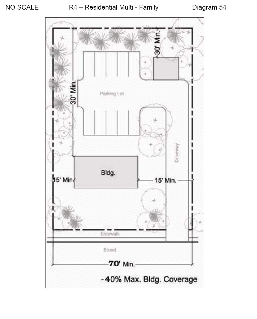
377 XX-372
378 NO SCALE R5 - RESIDENTIAL DIAGRAM 55 XX-373

379 NO SCALE R5 - RESIDENTIAL DIAGRAM 56 XX-374
Midwest City, Oklahoma Zoning Ordinance
 2010 Midwest City, Oklahoma Zoning Ordinance 9/2/2010 Table of Contents Section 1. General Provisions... 5 1.1. Citation... 5 1.2. Authority... 5 1.3. Purpose... 5 1.4. Nature and Application... 5 1.5.
May 12, Chapter RH HILLSIDE RESIDENTIAL ZONES REGULATIONS Sections:
 May 12, 2017 Chapter 17.13 RH HILLSIDE RESIDENTIAL ZONES REGULATIONS Sections: 17.13.010 Title, intent, and description. 17.13.020 Required design review process. 17.13.030 Permitted and conditionally
17.13 RH HILLSIDE RESIDENTIAL ZONES REGULATIONS SECTIONS:
 Effective April 14, 2011 Chapter 17.13 RH HILLSIDE RESIDENTIAL ZONES REGULATIONS SECTIONS: 17.13.010 Title, Intent, and Description 17.13.020 Required Design Review Process 17.13.030 Permitted and Conditionally
DIVISION 1 PURPOSE OF DISTRICTS
 ARTICLE 2 ZONING DISTRICTS AND MAP DIVISION 1 PURPOSE OF DISTRICTS Section 2.101 Zoning Districts. For the purpose of this Ordinance, the City of Richmond is hereby divided into districts as follows: DISTRICT
Title 6 - Local Government Provisions Applicable to Special Purpose Districts and Other Political Subdivisions
 Title 6 - Local Government Provisions Applicable to Special Purpose Districts and Other Political Subdivisions CHAPTER 29. SOUTH CAROLINA LOCAL GOVERNMENT COMPREHENSIVE PLANNING ENABLING ACT OF 1994 1994
ZONING
 130.10. R3 Medium Density Residential District. 130.10.1. Purpose. To preserve existing medium density single-family neighborhoods; provide the opportunity for TWO-FAMILY DWELLINGS in PLANNED RESIDENTIAL
PERMITTED USES: Within the MX-1 Mixed Use Neighborhood District the following uses are permitted:
 6.25 MX-1 - MIXED USE NEIGHBORHOOD 6.25.1 INTENT: The purpose of the MX-1 Mixed Use Neighborhood District is to accommodate the development of a wide-range of residential and compatible non-residential
Chapter 8 The Residential District Requirements
 Chapter 8 The Residential District Requirements ECTION: 9-8-1 General Purpose tatement 9-8-2 General Cross-reference Guide for Additional Regulations. 9-8-3 Residential District Regulations 9-8-4 E-1 Estate
ZONING ORDINANCE CITY OF GRANDVIEW
 ZONING ORDINANCE CITY OF GRANDVIEW TABLE OF CONTENTS SECTION 1 TITLE SECTION 2 PURPOSE SECTION 3 ZONING DISTRICTS ESTABLISHED 3.1 Zoning Districts Identified 3.2 Description and Purpose of Zoning Districts
Chapter 1107: Zoning Districts
 Chapter 1107: Zoning Districts 1107.01 Establishment of Zoning Districts (a) Districts Established In order to carry out the purpose of this code, the City is hereby divided into the zoning districts established
SECTION 827 "R-2" AND "R-2-A" - LOW DENSITY MULTIPLE FAMILY RESIDENTIAL DISTRICTS
 SECTION 827 "R-2" AND "R-2-A" - LOW DENSITY MULTIPLE FAMILY RESIDENTIAL DISTRICTS The "R-2" and "R-2-A" Districts are intended to provide for the development of low density multiple family residential
ARTICLE 7 R-1 ONE FAMILY RESIDENTIAL DISTRICT
 ARTICLE 7 R-1 ONE FAMILY RESIDENTIAL DISTRICT SECTION 700 STATEMENT OF PURPOSE This district classification is designed to be the most restrictive of the residential districts intended to encourage an
ARTICLE III ZONING DISTRICTS AND GENERAL REGULATIONS
 ARTICLE III ZONING DISTRICTS AND GENERAL REGULATIONS 3.1 Districts. The City of Wheaton, Illinois, is hereby divided into the following zoning districts. The following are general descriptions, but not
a. To insure compatible relationships between land use activities;
 PART B SECTION VIII INSTITUTIONAL DISTRICTS Article 1 Planned Institutional District 1. Purpose and Intent: It is the purpose and intent of this district to permit and encourage the orderly, cooperative
COMMERCIAL ZONING DISTRICTS (Amended 11/13/14) Part I. C-1 Restricted Commercial District
 Part I. C-1 Restricted Commercial District") ARTICLE XI. COMMERCIAL ZONING DISTRICTS (Amended 11/13/14) Part I. C-1 Restricted Commercial District Section 152: Purpose This district is designed to accommodate commercial uses which act as a transition
ARTICLE XI. COMMERCIAL ZONING DISTRICTS (Amended 11/13/14) Part I. C-1 Restricted Commercial District Section 152: Purpose This district is designed to accommodate commercial uses which act as a transition
Article. Table of Contents City of Birmingham Zoning Ordinance. 2006, Bradley E. Johnson, AICP
 00 Table of Contents City of Birmingham Zoning Ordinance 2006, Bradley E. Johnson, AICP Table of Contents One: Zoning Ordinance Foundation Page # 1.01 Title... 1-2 1.02 Defined Words... 1-2 1.03 Authority...
ARTICLE III District Regulations. A map entitled "Franklin Zoning Map" is hereby adopted as part of this chapter 1.
 ARTICLE III District Regulations ~ 305-8. Adoption of Zoning Map. A map entitled "Franklin Zoning Map" is hereby adopted as part of this chapter 1. ~ 305-9. Official Zoning Map; amendments. Regardless
VOLUME II - APPENDIX B - BASIC ZONING ORDINANCE ARTICLE V. DISTRICT REGULATIONS
 Sec. 5.1000. Multiple-family Residential (R-5). (Ord. No. 4005, 1(Res. No. 8947, Exh. A, 55), 4-3-12) Sec. 5.1001. Purpose. This district is intended to provide for development of multiple-family residential
Town of Windham Land Use Ordinance Sec. 400 Zoning Districts SECTION 400 ZONING DISTRICTS
 Town of Windham Land Use Ordinance Sec. 400 Zoning Districts Sections SECTION 400 ZONING DISTRICTS SECTION 400 ZONING DISTRICTS 4-1 401 Districts Enumerated 4-2 402 Location of districts; Zoning Map 4-2
SECTION 10.7 R-PUD (RESIDENTIAL PLANNED UNIT DEVELOPMENT) ZONE
 ZONE") Article X Zones 10-20 SECTION 10.7 R-PUD (RESIDENTIAL PLANNED UNIT DEVELOPMENT) ZONE A. PURPOSE AND INTENT: The R-PUD Residential PUD Zone is intended to provide alternative, voluntary zoning procedures
Article X Zones 10-20 SECTION 10.7 R-PUD (RESIDENTIAL PLANNED UNIT DEVELOPMENT) ZONE A. PURPOSE AND INTENT: The R-PUD Residential PUD Zone is intended to provide alternative, voluntary zoning procedures
SECTION 822 "R-1-A" AND "R-1-AH" - SINGLE FAMILY RESIDENTIAL DISTRICTS
 SECTION 822 "R-1-A" AND "R-1-AH" - SINGLE FAMILY RESIDENTIAL DISTRICTS The "R-1-A" and "R-1-AH" Districts are intended to provide for the development of single family residential homes at urban standards
Boyertown Borough and Colebrookdale and Pike Townships Joint Zoning Ordinance
 Boyertown Borough and Colebrookdale and Pike Townships Joint Zoning Ordinance Berks County, Pennsylvania Effective Date - November 7, 2010 This Ordinance was prepared under the direction of the Boyertown
ARTICLE 5.0 SCHEDULE OF REGULATIONS
 ARTICLE 5.0 SCHEDULE OF REGULATIONS Section 5.101 Table of Dimensional Standards by District. Dimensional Standards AG AG with sewer Districts Rural Residential Business Other SF SF with sewer R-1 R-1
ARTICLE IV DISTRICT REGULATIONS
 PART 1. RESIDENTIAL DISTRICTS 4-101. RS. Single-Family Residential Suburban District. The RS District is designed for single-family dwellings, and compatible uses, at a density no greater than one dwelling
ARTICLE III: LAND USE DISTRICTS 304 R 9 DISTRICT
 ARTICLE III: LAND USE DISTRICTS III 23 304 R 9 DISTRICT (RESIDENTIAL 9 UNITS PER ACRE) 304 1 Intent and Purpose The R 9 District is intended to implement the policies of the Comprehensive Plan for areas
R3 (MULTIPLE-FAMILY RESIDENCE)
") Planning and Building Agency Planning Division 20 Civic Center Plaza P.O. Box 1988 (M-20) Santa Ana, CA 92702 (714) 647-5804 R3 (MULTIPLE-FAMILY RESIDENCE) Sec. 41-258. Sec. 41-258.5. Sec. 41-259. Purpose.
Planning and Building Agency Planning Division 20 Civic Center Plaza P.O. Box 1988 (M-20) Santa Ana, CA 92702 (714) 647-5804 R3 (MULTIPLE-FAMILY RESIDENCE) Sec. 41-258. Sec. 41-258.5. Sec. 41-259. Purpose.
2-1 TITLE 4 ZONING CODE 2-2
 2-1 TITLE 4 ZONING CODE 2-2 Chapter 2 RESIDENTIAL ZONING DISTRICTS Sec. 2-1: Sec. 2-2: Sec. 2-3: Sec. 2-4: Sec. 2-5: Sec. 2-6: Sec. 2-7: Sec. 2-8: Purpose Agriculture/Forestry Zoning District (AF) Farm,
RP-2, RP-3, RP-4, AND RP-5 PLANNED RESIDENTIAL DISTRICTS
 6.10 - RP-2, RP-3, RP-4, AND RP-5 PLANNED RESIDENTIAL DISTRICTS 6.10.1 GENERAL DESCRIPTION: 6.10.1.1 The regulations established in this Section are intended to provide optional methods of land development
MAJOR & ARROLL, LLC C O M M E R C I A L R E A L E S T A T E
 FOR SALE-34 DEVELOPED TOWNHOME LOTS F AIRINGTON TOWNSHIP D EK ALB COUNTY, GEORGIA COMMENTS: This opportunity consists of 34 developed townhome lots located within the Fairington Township community in DeKalb
CHAPTER 2 RELATIONSHIP WITH OTHER LAWS.
 CHAPTER 2 General Provisions 12-2-1 Minimum Requirements 12-2-2 Relationship with Other Laws 12-2-3 Effect on Existing Agreements 12-2-4 Scope of Regulations 12-2-5 Building Permit 12-2-6 Nonconforming
ARTICLE VII. NONCONFORMITIES. Section 700. Purpose.
 ARTICLE VII. NONCONFORMITIES. Section 700. Purpose. The purpose of this chapter is to regulate and limit the development and continued existence of legal uses, structures, lots, and signs established either
CHAPTER 3 REGULATIONS INSIDE THE COASTAL ZONE
 CHAPTER 3 REGULATIONS INSIDE THE COASTAL ZONE Organization. Chapter 3 contains the regulations which apply exclusively within the California Coastal Zone in Humboldt County and is organized as follows:
4.2 RESIDENTIAL ZONING DISTRICTS
 4.2 RESIDENTIAL ZONING DISTRICTS A. Purpose: To define regulations and standards for each residential zoning district in the City. The following sections identify uses, regulations, and performance standards
ARTICLE III. DISTRICT REGULATIONS
 ARTICLE III. DISTRICT REGULATIONS SECTION 301. FOREST RECREATION (FR) A. Intended Purposes The regulations for this District are intended to preserve mountains and woodlands in their natural state, while
City of Fraser Residential Zoning District
 City of Fraser Residential Zoning District The one-family districts are established to provide principally for one-family dwellings at varying densities. The specific interest of these districts is to
ARTICLE VII - RESIDENTIAL DISTRICT R-2. be for one or more of the following uses:
 ARTICLE VII - RESIDENTIAL DISTRICT R-2 7-1 USE REGULATIONS In Residential District R-2, structures to be erected or land to be used shall be for one or more of the following uses: 7-1.1 Single-family dwellings.
Coding For Places People Love Main Street Corridor District
 Coding For Places People Love Main Street Corridor District 1) Scope a) District boundaries are assigned according to the District Boundary Map. b) The Primary Retail Corridor is assigned according to
City of Valdosta Land Development Regulations
 Title 2 Land Use and Zoning Chapter 202 Section 202-1 General Provisions Purpose Title 2 is intended to implement the purposes set forth in Section 102-2, and further is enacted for the purposes of promoting
ARTICLE III: LAND USE DISTRICTS 302 R 5 DISTRICT
 ARTICLE III: LAND USE DISTRICTS III 7 302 R 5 DISTRICT (RESIDENTIAL 5 UNITS PER ACRE) 302 1 Intent and Purpose The R 5 District is intended to implement the policies of the Comprehensive Plan for areas
ARTICLE VII-A - RESIDENTIAL DISTRICT R-2 FH 9. be for one or more of the following uses:
 ARTICLE VII-A - RESIDENTIAL DISTRICT R-2 FH 9 7-1A USE REGULATIONS In Residential District R-2 F, structures to be erected or land to be used shall be for one or more of the following uses: 7-1.1A Single-family
 Page 1 of 8 Laguna Beach Municipal Code Up Previous Next Main Collapse Search Print No Frames Title 25 ZONING Chapter 25.10 R-1 RESIDENTIAL LOW DENSITY ZONE 25.10.002 Intent and purpose. This zone is intended
GC General Commercial District
 Section 712. GC General Commercial District 712.1 Intent of District. It is the intent of this section that the GC Zoning District be developed and reserved for general business purposes. The regulations
ARTICLE 9 C-B - COMMERCIAL-BUSINESS DISTRICT
 Section 901. PURPOSE ARTICLE 9 C-B - COMMERCIAL-BUSINESS DISTRICT The Commercial-Business (C-B) District is established to provide development opportunities for mixed use business and highway oriented
City of Smithville Code of Ordinances
 City of Smithville Code of Ordinances Chapter 14 - Zoning Smithville Zoning Ordinance_v9_10-16-18_FINAL TABLE OF CONTENTS 1. PROVISIONS... 3 1.1. Title... 3 1.2. Effective Date... 3 1.3. Previous Zoning
Cluster Development Princeton Township, Mercer County
 Cluster Development Princeton Township, Mercer County Division 9 Residential Clusters Section 10B-189 Statement of purposes. The township committee to implement the goals and objectives of the Princeton
6A. In ALL Residence zones, no building or land shall be used and no building or structure shall be erected or altered except for the following uses:
 SECTION 6 - RESIDENCE ZONES 6A. In ALL Residence zones, no building or land shall be used and no building or structure shall be erected or altered except for the following uses: 6A.1 Single family detached
ARTICLE 8 R-2 MULTIPLE FAMILY RESIDENTIAL DISTRICT
 ARTICLE 8 R-2 MULTIPLE FAMILY RESIDENTIAL DISTRICT SECTION 800 STATEMENT OF PURPOSE This district classification is designed to permit the greatest density of residential uses allowed within the Township,
For the purpose of this Zoning Ordinance, the Village is hereby divided into five classes of zoning districts known as:
 Chapter 3 District Regulations SECTION 301. VILLAGE ZONING DISTRICTS. For the purpose of this Zoning Ordinance, the Village is hereby divided into five classes of zoning districts known as: R-1 Low-Density
WHEREAS, the direction from the Study is to amend the Land Use Code in the following particulars:
 ORDINANCE NO. 033, 2013 OF THE COUNCIL OF THE CITY OF FORT COLLINS MAKING AMENDMENTS TO THE CITY OF FORT COLLINS LAND USE CODE PERTAINING TO IMPLEMENTATION OF THE EASTSIDE AND WESTSIDE NEIGHBORHOODS CHARACTER
ARTICLE 2 ZONING DISTRICTS AND MAPS
 ARTICLE 2 ZONING DISTRICTS AND MAPS SECTION 2.100 PURPOSE OF DISTRICTS Section 2.101. For the purpose of this Ordinance, Billings Township is hereby divided into districts as follows: DISTRICT NAME SYMBOL
ARTICLE B ZONING DISTRICTS
 ARTICLE B ZONING DISTRICTS Sec. 8-3021 Established. In order to protect the character of existing neighborhoods; to prevent excessive density of population in areas which are not adequately served with
SECTION 821 "R-A" - SINGLE FAMILY RESIDENTIAL-AGRICULTURAL DISTRICT
 SECTION 821 "R-A" - SINGLE FAMILY RESIDENTIAL-AGRICULTURAL DISTRICT The "R-A" District is intended to provide for the development of single family residential estate homes in a semi-rural environment on
R-1 SINGLE FAMILY RESIDENCE DISTRICT
 1001.12 R-1 SINGLE FAMILY RESIDENCE DISTRICT Subd 1. Purpose. The purpose of the R-1, Single Family Residence District is for low density single family dwelling development as an extension of existing
City of Lynden Title 19 ZONING
 City of Lynden Title 19 ZONING Chapters Page Number 19.03 Comprehensive Plan 2 19.05 General Provisions 3 19.09 Maps and District Boundaries 4 19.11 Districts Established 5 19.13 Agricultural Zone 6 19.15
ARTICLE III: LAND USE DISTRICTS 348 AGRICULTURE AND FOREST DISTRICT (AF 5)
") ARTICLE III: LAND USE DISTRICTS III 159 348 AGRICULTURE AND FOREST DISTRICT (AF 5) 348 1 Intent and Purpose The AF 5 District is intended to retain an area s rural character and conserve the natural resources
ARTICLE III: LAND USE DISTRICTS III 159 348 AGRICULTURE AND FOREST DISTRICT (AF 5) 348 1 Intent and Purpose The AF 5 District is intended to retain an area s rural character and conserve the natural resources
HUERFANO COUNTY SIGN REGULATIONS SECTION 14.00
 TABLE OF CONTENTS Section Title Page 14.01 SIGN CODE... 14-1 14.01.01 Intent and Purpose... 14-1 14.02 GENERAL PROVISIONS... 14-1 14.02.01 Title... 14-1 14.02.02 Repeal... 14-1 14.02.03 Scope and Applicability
SECTION 848 "R-E" - RECREATIONAL DISTRICT
 SECTION 848 "R-E" - RECREATIONAL DISTRICT The "R-E" District is intended to provide for the proper development of recreational areas of the County of Fresno. All regulations for this District are deemed
SECTION 7. RESIDENTIAL DISTRICTS
 SECTION 7. RESIDENTIAL DISTRICTS 7.1 RESIDENTIAL DISTRICTS PURPOSE 7.2 PERMITTED AND SPECIAL USES 7.3 YARD AND BULK REGULATIONS 7.4 GENERAL STANDARDS OF APPLICABILITY 7.5 FLOOR AREA RATIO MEASUREMENT AND
ZONING ORDINANCE. for the. City of Rainbow City, Alabama. Ordinance #360 Adopted June 28, 1999
 ZONING ORDINANCE for the City of Rainbow City, Alabama Ordinance #360 Adopted June 28, 1999 Amended by Ordinance # 361 on July 12, 1999 Amended by Ordinance #386 on November 13, 2000 Amended by Ordinance
Box Elder County Land Use Management & Development Code Article 3: Zoning Districts
 Chapter 3-6 Mobile Homes, Mobile Home Subdivisions, & Recreational Vehicle Parks Box Elder Zoning Ordinance as Adopted October 2007 Sections. 3-6-010. Purpose and Intent. 3-6-020. Conditional Use Permit
ORDINANCE NO to amend subsection A to add subsection (15) which shall read as follows: (15) Attached dwelling units such as townhouses.
 which shall read as follows: (15) Attached dwelling units such as townhouses.") ORDINANCE NO. 01-16 AN ORDINANCE OF THE TOWNSHIP OF JACKSON, COUNTY OF OCEAN, STATE OF NEW JERSEY, AMENDING CHAPTER 244 OF THE TOWNSHIP CODE OF THE TOWNSHIP OF JACKSON, ENTITLED LAND USE AND DEVELOPMENT
ORDINANCE NO. 01-16 AN ORDINANCE OF THE TOWNSHIP OF JACKSON, COUNTY OF OCEAN, STATE OF NEW JERSEY, AMENDING CHAPTER 244 OF THE TOWNSHIP CODE OF THE TOWNSHIP OF JACKSON, ENTITLED LAND USE AND DEVELOPMENT
ARTICLE III: LAND USE DISTRICTS AGRICULTURE AND FOREST DISTRICT (AF-10)
") ARTICLE III: LAND USE DISTRICTS III-153 346 AGRICULTURE AND FOREST DISTRICT (AF-10) 346-1 Intent and Purpose The AF-10 District is intended to retain an area s rural character and conserve the natural
ARTICLE III: LAND USE DISTRICTS III-153 346 AGRICULTURE AND FOREST DISTRICT (AF-10) 346-1 Intent and Purpose The AF-10 District is intended to retain an area s rural character and conserve the natural
CHAPTER 14 PLANNED UNIT DEVELOPMENTS
 9-14-1 9-14-1 CHAPTER 14 PLANNED UNIT DEVELOPMENTS SECTION: 9-14-1: Purpose 9-14-2: Governing Provisions 9-14-3: Minimum Area 9-14-4: Uses Permitted 9-14-5: Common Open Space 9-14-6: Utility Requirements
general residential district shall be used only for the following purposes: Any use permitted in an R-1 low density residential district.
 Page 1 of 5 - R-2 general residential district. A. B. General description. This is a residential district to provide for medium population density. The principal uses of land may range from houses to low
Prince Edward County Zoning Ordinance. Effective October 1, 2007
 Prince Edward County Zoning Ordinance Effective October 1, 2007 ARTICLE I GENERAL PROVISIONS...6 SEC. 1-100 TITLE AND AUTHORITY...6 SEC. 1-102 JURISDICTION...6 SEC. 1-104 PURPOSE...6 SEC. 1-106 EFFECTIVE
ARTICLE 3 ZONING. Division 1: Introduction establishes the regulatory authority for the Township to create zoning districts.
 ARTICLE 3 ZONING SECTION 300 PURPOSE This article establishes zoning districts and describes the use and design regulations that apply to each district. This article includes the following divisions: Division
The following uses may be allowed in the CL zone with administrative approval, subject to section of this ordinance:
 Sec. 4-100 - CL/Commercial low zone. 4-101 - Purpose. The CL zone is intended to provide for small scale retail and service uses offering pedestrian oriented shopping and services for individual consumers
DIVISION 7. R-6 AND R-6A RESIDENTIAL ZONES* The purpose of the R-6 residential zone is:
 Date of Draft: March 6, 2015 DIVISION 7. R-6 AND R-6A RESIDENTIAL ZONES* Sec. 14-135. Purpose. The purpose of the R-6 residential zone is: (a) To set aside areas on the peninsula for housing characterized
Charter Township of Plymouth Zoning Ordinance No. 99 Page 200 Article 20: Schedule of Regulations
 Charter Township of Plymouth Zoning Ordinance No. 99 Page 200 ARTICLE XX SCHEDULE OF REGULATIONS SEC. 20.1 HEIGHT, AREA, LOT COVERAGE, YARD REQUIREMENTS AND FLOOR AREA (as amended /25/07) ZONG DISTRICT
The following regulations shall apply in the R-E District:
 "R-E" RESIDENTIAL ESTATE DISTRICT (8/06) The following regulations shall apply in the R-E District: 1. Uses Permitted: The following uses are permitted. A Zoning Certificate may be required as provided
CHAPTER 10: AGRICULTURAL-RESIDENTIAL LAND USE ZONES
 CHAPTER 10: AGRICULTURAL-RESIDENTIAL LAND USE ZONES ARTICLE 1: GENERAL PURPOSES 210-01. Purpose The Agricultural-Residential Land Use Zones established in this Chapter are designed to promote and protect
SECTION 7. RESIDENTIAL ZONING DISTRICTS
 SECTION 7. RESIDENTIAL ZONING DISTRICTS 7.1 RESIDENTIAL ZONING DISTRICTS PURPOSE STATEMENTS 7.2 PERMITTED AND SPECIAL USES 7.3 BULK AND SETBACK REGULATIONS 7.4 BUILDING HEIGHT SETBACK PLANE 7.5 GENERAL
Jefferson Morgan Multi-Municipal Zoning Ordinance
 Jefferson Morgan Multi-Municipal Zoning Ordinance Clarksville Borough, Jefferson Borough, Jefferson Township, Morgan Township Greene County, Pennsylvania Enacted August 12, 2008 TABLE OF CONTENTS CHAPTER
DT Downtown. a) Intent. The "downtown (DT) district" is designed for the commercial core of Lake Worth, primarily along Lake and Lucerne Avenues from
 Intent. The downtown (DT) district is designed for the commercial core of Lake Worth, primarily along Lake and Lucerne Avenues from") DT Downtown. a) Intent. The "downtown (DT) district" is designed for the commercial core of Lake Worth, primarily along Lake and Lucerne Avenues from Golfview to the Florida East Coast Railroad right-of-way.
DT Downtown. a) Intent. The "downtown (DT) district" is designed for the commercial core of Lake Worth, primarily along Lake and Lucerne Avenues from Golfview to the Florida East Coast Railroad right-of-way.
Chapter Residential Mixed Density Zone
 Chapter 19.16 Residential Mixed Density Zone 19.16.010 Purpose and Intent 19.16.020 Permitted Uses 19.16.030 Accessory Permitted Uses 19.16.040 Secondary Permitted Uses 19.16.050 Conditional Uses 19.16.060
ARTICLE VIII DEVELOPMENT STANDARDS
 ARTICLE VIII Section 1. Section 2. COMPLIANCE WITH REGULATIONS MATRIX Section 3. FOOTNOTES TO MATRIX Section 1. COMPLIANCE WITH REGULATIONS Except as hereinafter provided: 1. No building or land shall
Article 50: Business Zones
 ARTICLE 50, Use Regulations Controlling Business Zones [Added effective 7-25-1955] 118-500. East Avenue Village District. [Amended effective 7-25-1955; 9-13-1955; 11-10-1966; 12-11-1975; 7-15-1976; 5-16-1980;
Code of Ordinances, Town of Chincoteague, VA Abstracted March CHAPTER 2.
 Code of Ordinances, Town of Chincoteague, VA Abstracted March 2016 http://www.chincoteague-va.gov/pdf/town-code2010.pdf CHAPTER 2. POWERS OF TOWN Sec. 1. Generally. 15. To acquire, establish, enter, open,
CHAPTER 6 RESIDENTIAL DISTRICTS LOW DENSITY RESIDENTIAL DISTRICT (R-1)
") TYPE OF DISTRICT: TRADITIONAL CHAPTER 6 RESIDENTIAL DISTRICTS LOW DENSITY RESIDENTIAL DISTRICT (R-1) ARTICLE 1: LOW DENSITY RESIDENTIAL DISTRICT (R-1) SECTION 6-1.01: PURPOSE The regulations of the R-1
TYPE OF DISTRICT: TRADITIONAL CHAPTER 6 RESIDENTIAL DISTRICTS LOW DENSITY RESIDENTIAL DISTRICT (R-1) ARTICLE 1: LOW DENSITY RESIDENTIAL DISTRICT (R-1) SECTION 6-1.01: PURPOSE The regulations of the R-1
City of Taylor Zoning Ordinance
 City of Taylor Zoning Ordinance Adopted January 25, 2009 Effective February 1, 2009 (Updated September 2014) Table of Contents Article 00 00 Table of Contents Part I Introduction Article 1 Purpose and
ARTICLE VI. SPECIAL EXCEPTION REGULATIONS
 ARTICLE VI. SPECIAL EXCEPTION REGULATIONS SECTION 601. GENERAL DESCRIPTION Special exceptions are deemed to be permitted uses in their respective districts, subject to the satisfaction of the requirements
ARTICLE C. ZONING TEXT, DISTRICT CLASSIFICATIONS AND BOUNDARIES
 ARTICLE C. ZONING TEXT, DISTRICT CLASSIFICATIONS AND BOUNDARIES Sec. 10-2054. ZONING TEXT, DISTRICT CLASSIFICATIONS AND BOUNDARIES. In order to regulate the location of structures, the height and bulk
PART 3 RESIDENTIAL ZONING DISTRICTS. Designation of Residential Zoning Districts and Purpose Statements.
 PART 3 S Section 301. Designation of and Purpose Statements. See Table 3-1 herein this Section for the designations and purpose statements of the respective Residential Zoning Districts which are shown
ML-4 MULTIFAMILY RESIDENTIAL ZONE. [Added by Ord. No ]
![ML-4 MULTIFAMILY RESIDENTIAL ZONE. [Added by Ord. No ]](/thumbs/90/103301433.jpg "ML-4 MULTIFAMILY RESIDENTIAL ZONE. [Added by Ord. No ]") 55-26. ML-4 MULTIFAMILY RESIDENTIAL ZONE. [Added 2-2-98 by Ord. No. 1998-1 2] The following regulations apply in the ML-4 Zone. A. Permitted Uses. (1) Garden apartments, together with accessory structures
55-26. ML-4 MULTIFAMILY RESIDENTIAL ZONE. [Added 2-2-98 by Ord. No. 1998-1 2] The following regulations apply in the ML-4 Zone. A. Permitted Uses. (1) Garden apartments, together with accessory structures
DISCUSSION DRAFT 1 INTRODUCTORY PROVISIONS
 1 INTRODUCTORY PROVISIONS 1.1 GENERAL...3 Title 3 Authority 3 Applicability 3 Purpose 3 Regulatory Scope 4 Compliance 4 Fines and Penalties 4 Conflicting Provisions 5 Meaning & Intent 5 Text & Graphics
301. Zoning Districts. C-D A-1 R-1 R-V B-1 I-1
 301. Zoning Districts. The Township is divided into the districts set forth by this chapter and as shown by the district boundaries on the Official Zoning District Map. The zoning districts are: C-D Conservation
Buffalo Township Zoning Ordinance Table of Contents
 Buffalo Township Zoning Ordinance Table of Contents Page Article One General Provisions Section 100 Title, Authority, and Purpose 1 Section 101 Community Development Goals and Objectives 2 Section 102
Chapter CC COMMUNITY COMMERCIAL ZONES REGULATIONS
 Effective April 14, 2011 Chapter 17.35 CC COMMUNITY COMMERCIAL ZONES REGULATIONS SECTIONS: 17.35.010 Title, Intent, and Description 17.35.020 Required Design Review Process 17.35.030 Permitted and Conditionally
SECTION CLASSIFICATION OF ZONES For the purpose of this Code the following primary land use zoning districts are hereby established:
 ARTICLE 4 ZONING DISTRICTS SECTION 4.010 CLASSIFICATION OF ZONES For the purpose of this Code the following primary land use zoning districts are hereby established: Primary Zones Abbreviated Designation
Appendix A: Guide to Zoning Categories Prince George's County, Maryland
 Appendix A: Guide to Zoning Categories Prince George's County, Maryland RESIDENTIAL ZONES 1 Updated November 2010 R-O-S: Reserved Open Space - Provides for permanent maintenance of certain areas of land
CHAPTER 5A A-1 AGRICULTURAL CONSERVATION DISTRICT
 CHAPTER 5A A-1 AGRICULTURAL CONSERVATION DISTRICT SECTION 5A.01 DESCRIPTION AND PURPOSE. It is recognized that the public health and welfare of the citizens of Salem Township, Allegan County, the state
SECTION 6. RESIDENTIAL DISTRICTS
 SECTION 6. RESIDENTIAL DISTRICTS 6.1 RESIDENTIAL DISTRICTS PURPOSE 6.2 PERMITTED AND CONDITIONAL USES 6.3 LOT AND BUILDING BULK REGULATIONS 6.4 GENERAL STANDARDS OF APPLICABILITY 6.1 RESIDENTIAL DISTRICTS
this page left intentionally blank DENVER ZONING CODE
 Article 1. GENERAL PROVISIONS this page left intentionally blank Contents ARTICLE 1. GENERAL PROVISIONS DIVISION 1.1 GENERAL...1.1-1 Section 1.1.1 Purpose...1.1-1 Section 1.1.2 Intent...1.1-1 Section 1.1.3
Article 30: Residence Zones
 ARTICLE 30, Use Regulations Controlling Residence Zones 118-300. Island Conservation Zone. [Added effective 1-22-1974] A. Declaration of necessity and purpose. Article 30: Residence Zones (1) It is declared
City of Valdosta Land Development Regulations
 Chapter 206 Section 206-1 Base Zoning Districts Standards for Uses, Structures, and Property Development (B) (C) Principal Uses and Structures. Principal uses and structures permitted in each base zoning
CITY OF HENDERSON TABLE OF CONTENTS. Section 101: Purpose... 1 Section 102: Authority... 1 GENERAL REGULATIONS APPLIED TO ALL DISTRICTS
 TABLE OF CONTENTS ARTICLE 100: PURPOSE AND AUTHORITY Section 101: Purpose... 1 Section 102: Authority... 1 ARTICLE 200: GENERAL REGULATIONS APPLIED TO ALL DISTRICTS Section 201: Jurisdiction and Zoning
Northampton County Zoning Code
 Northampton County Zoning Code Adopted December 8, 2015 NORTHAMPTON COUNTY CODE OF ORDINANCES TITLE XV: LAND USAGE CHAPTER 154.1: ZONING 1 TABLE OF CONTENTS ARTICLE I GENERAL PROVISIONS... 5 154.1-101
ORDINANCE NO. 208 BE IT ORDAINED BY THE CITY COUNCIL OF THE CITY OF UNIVERSITY HEIGHTS, JOHNSON COUNTY, IOWA:
 ORDINANCE NO. 208 AN ORDINANCE AMENDING ORDINANCE NO. 79 (ZONING) TO CREATE A COMMERCIAL HOTEL ZONE AND PERMIT DEVELOPMENT PURSUANT TO A COMMERCIAL HOTEL PUD BE IT ORDAINED BY THE CITY COUNCIL OF THE CITY
City of Sacramento Zoning Code - Zoning Descriptions Excerpt from website on April 5, 2010
 City of Sacramento Zoning Code - Zoning Descriptions Excerpt from website on April 5, 2010 RE Rural Estates Zone. This is a very low density residential zone. It is intended to be applied primarily to
ZONING CLASSIFICATION SUMMARY SHEET
 Growth and Resource Management Planning and Development Services 123 West Indiana Avenue Room 202 DeLand, Florida 32720-4253 Telephone (386) 943-7059 Fax (386) 626-6570 www.volusia.org ZONING CLASSIFICATION