1098 ROUTE 46 EAST RIDGEFIELD, NEW JERSEY /- ACRES
|
|
|
- Angelica Nichols
- 6 years ago
- Views:
Transcription


1 1098 ROUTE 46 EAST RIDGEFIELD, NEW JERSEY /- ACRES


2 PRIME /- ACRES DEVELOPMENT SITE 1098 ROUTE 46 EAST RIDGEFIELD, NEW JERSEY CALL FOR NEW INFORMATION 825 of major highway frontage with access plus additional side street access 1,250 feet of river frontage High traffic volume location Broad zoning as revised during the Fall of 2013 Engaged and motivated town, eager for developing Ongoing, focused remediation investigation that has resulted in a shovel-ready cleanup package. Property can be raised (3 to 5 ) and leveled to meet new FEMA flooding standards All city utilities with abundant Brownfield benefits in low tax municipality Location: Half-mile east of NJ Turnpike Easy access to Routes 46, 1&9 and the Garden State Parkway 5 minutes to Manhattan via the George Washington Bridge +/- 20 minutes to Newark Airport Third access available at south end of property with traffic light Adjacent to a planned Hudson-Bergen Light Rail extension Sale Price: $15,000,000
3 Table of Contents I. Executive Summary II. III. IV. The Property A. Aerial Photographs and Maps B. Property Highlights C. Property Details Market Overview A. Profile: Borough of Ridgefield B. Profile: Bergen County Certain Terms of Sale A. Purchase Price B. Due Diligence Period C. Deposit D. Sale Closing E. Background F. Payment APPENDIX
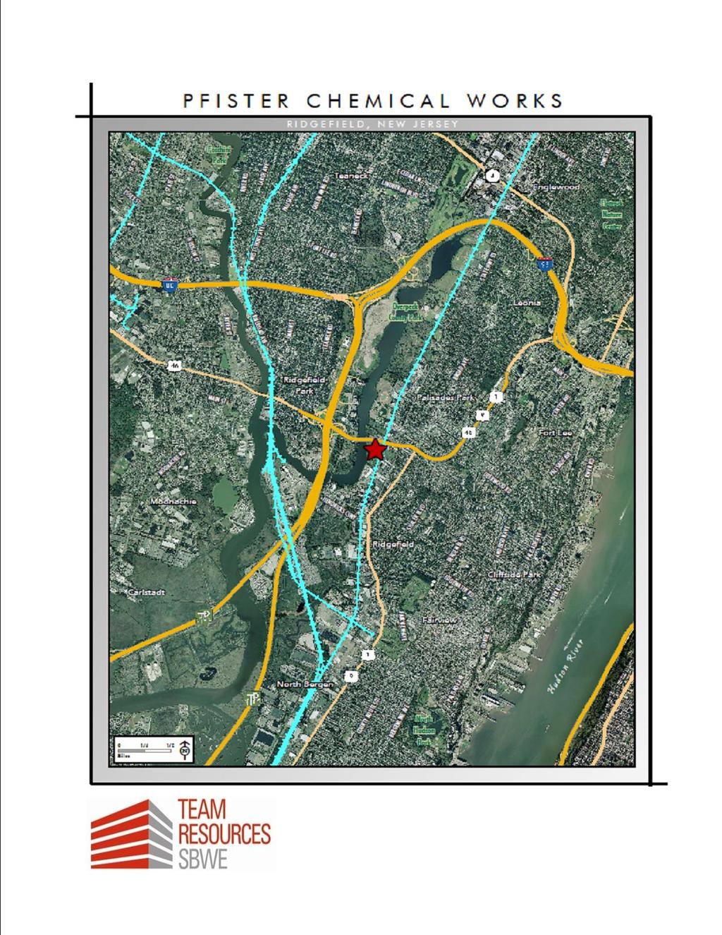
4 SECTION l: EXECUTIVE SUMMARY EXCEPTIONAL REDEVELOPMENT OPPORTUNITY PROJECT PFISTER CHEMICAL, INC. (AKA: PCI) 1098 Route 46 East Ridgefield, New Jersey Bergen County, New Jersey We are pleased to present a unique industrial land offering for sale in Ridgefield, New Jersey. The Pfister Chemical, Inc. site represents one of the most strategic redevelopment opportunities in the New Jersey market and the only one of its size available to the Korean community. The 19.2 acre property represents an excellent opportunity to achieve the highest quality of mixed-use redevelopment while adhering to New Jersey s Smart Growth guidelines. As the key site in the municipality s revitalization program this site is open to a wide range of uses including retail, office, hotel, and commercial with residential above, and better than market standard development yields for the acreage. The site is located in a low tax municipality. All utilities, including major sewer access, are readily available with adequate capacities for redevelopment. Brownfields benefits are available to interested developers. DESCRIPTION, LOCATION, AND ACCESS The property is located on the Overpeck Creek just south of the 811 acre Overpeck County Park and has 1,250 feet of river frontage. The property is centered in Koreatown in Bergen County. Forty percent (40%) of Koreans in the New York, New Jersey, Connecticut area live within five miles of the site. Ridgefield, Palisades Park, Fort Lee, Englewood Cliffs, Closter, Edgewater, Leonia, and Norwood PFISTER CHEMICAL, INC.
5 SECTION l: EXECUTIVE SUMMARY Make up eight of the United States top ten Korean populations by percentage. Of the top twenty Korean communities, sixteen are located very near to the site. Koreans make up 21.5% of Ridgefield s population, 36.38% of Palisade Park, 17.18% of Fort Lee, and 17.24% of Leonia. New York City is a 10-minute drive time via The George Washington Bridge and 20-minutes via The Lincoln Tunnel. Port Newark-Elizabeth and Newark Liberty Airport are both 30- minutes away. RAIL SERVICE New Jersey Transit revealed their plans to invest $800 Million to $900 Million to develop the Hudson-Bergen Light Rai l Line utilizing the right of way of the CSXNorthern Branch which runs along the easterly Boundary of the PCI property. Once built, the Northern Branch Light Rail will provide 10 to 15 minute service to Secaucus and Hoboken which have easy access to New York City. Government officials have indicated that the project will break ground when economy improves. PFISTER CHEMICAL, INC. BROWNFIELDS A significant area of the property has already been remediated. The owner has obtained three fixed price proposals from experienced remediation contractors that provide an excellent bracketing of the remaining remediation costs. If the purchaser wishes to take advantage of Brownfields redevelopment, PCI has assembled an industry leading team of professionals to help guide and process the critical environmental data for the site. All the data is in hand and sizable savings can benefit the buyer.
6 SECTION l: EXECUTIVE SUMMARY REZONING - REDEVELOPMENT The Borough of Ridgefield is actively engaged in planning to restructure the physical and social landscape of the area to make the borough more economically competitive and socially stimulating. As part of this effort the Planning Board has been directed to undertake a redevelopment study of the community and particularly properties (including PCI) located along the shoreline of the Overbrook Creek. The Overpeck Creek Area Revitalization Plan is the next step in the Borough s efforts and is intended to provide a long-range comprehensive framework for the physical, economic, social and environmental revitalization of the Overpeck Creek Area. PFISTER CHEMICAL, INC. IN CONVERSATION WITH OFFICIALS WE HAVE FOUND THAT, ALTHOUGH THEIR STUDY RESULTED IN SIX CONCEPTUAL PLANS, THEY ARE OPEN MINDED TO PROPOSALS FOR MIXED USE DEVELOPMENT OF THIS AREA. THIS SITE IS OPEN TO A WIDE RANGE OF USES INCLUDING RETAIL, OFFICE, HOTEL, COMMERCIAL AND RESIDENTIAL USES.

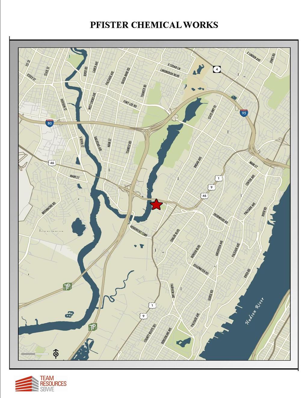
7 SECTION Il: THE PROPERTY A. AERIAL PHOTOGRAPHS AND MAPS PFISTER CHEMICAL, INC.

8 SECTION Il: THE PROPERTY PFISTER CHEMICAL, INC.

9 SECTION Il: THE PROPERTY

10 SECTION Il: THE PROPERTY

11 SECTION Il: THE PROPERTY

12 SECTION Il: THE PROPERTY

13 SECTION Il: THE PROPERTY
14
15 SECTION II: THE PROPERTY B. PROPERTY HIGHLIGHTS The Pfister site is located alongside US Highway Route 46 at the foot of Linden Avenue, in the town Ridgefield, Bergen County, New Jersey. A site location map and a site layout map are presented in Appendix A. Pfister operated a chemical manufacturing facility on the site from approximately 1936 through the summer of 2002, at which time the plant operations were terminated. The facility consists of approximately 19.2 acres of land. The property is bordered to the north by Highway Route 46, on the east and south by commercial and industrial properties, and on the west by Overpeck Creek. The main entrance to the facility is located on the north side of the facility along highway Route 46 and the secondary access is located on the east. Topographically the ground surface is relatively flat across the facility and varies just a few feet. The north, east and central portions of the property are topographically highest, and vary in elevation from approximately 6.5 to 10 feet. The ground surface slopes gradually to the south and west, but it drops steeply at the banks of Overpeck Creek bordering the western boundary and at the banks of the surface water body bordering the southern property boundary. The property consists of two distinct areas: the northern two- thirds, which formerly contained the plant manufacturing facilities (the Plant Area); and the southern third, which contains the former wastewater lagoon that is now closed with a perimeter barrier wall and lowpermeability cap (see Figure 1-2 in Appendix A). The former wastewater lagoon in the southern end of the property received wastewater from 1949 to 1979, and ultimately discharged into a sewer inlet at the end of the wastewater lagoon, which is operated by the Bergen County Utility Authority (BCUA). In 1979, the discharge of wastewater into the lagoon was ceased, and re-routed into the sewer. The inactive lagoon was contained by a soil-bentonite barrier wall and impermeable cap in 1997, and a No Further Action letter for the impacted soils was PFISTER CHEMICAL, INC.
16 SECTION II: THE PROPERTY received from the New Jersey Department of Environmental Protection (NJDEP) in April C. PROPERTY DETAILS The plant manufacturing facilities were constructed beginning in 1936, with additions and modifications continuing through The plant buildings had housed a variety of chemical manufacturing processes used in the production of dyes and pigment intermediaries. Plant operations ceased during the summer of 2002, at which time all process equipment was decontaminated and decommissioned, and the former cooling water pond was removed from service. As of January 2006, all buildings and structures at the site had been completely demolished, including the tanks and containment walls associated with the northern and southern tank farms. Some of the building foundations and floor slabs are still in place. The facility is not traversed by any surface water systems; although a former cooling water pond is located in the northwestern corner of the property. This pond was used to store non-contact cooling water that was re-circulated between the pond and the facility operations. Make-up water was pumped from Overpeck Creek into the cooling pond, although the pond is now out of service. A drainage ditch is present along the northern property boundary, and a surface water body (unnamed tidal creek) is present along the southern property boundary. The northern ditch is located along the toe of the slope for Route 46; this ditch handles the overflow from a drainage swale that parallels the railroad tracks to the east of the site. The southern surface water body collects sheet flow runoff from the southern sections of the property and the industrial properties to the east and south. The northern drainage ditch discharges into Overpeck Creek upstream of the plant area. The southern surface water body discharges into Overpeck Creek downstream of the plant area. PFISTER CHEMICAL, INC.
17 SECTION II: THE PROPERTY The plant historically received its water supply for production operations from two on-site wells. The wells are believed to have been installed in the 1950 s, and were in regular operation until the summer of 2002, when the wells were taken off-line. Since that time, water levels in the production wells were recorded, and rising water levels were observed following shut-down of the wells. The production wells have since been closed, and additional bedrock wells were installed at the site for groundwater monitoring purposes. Other site features are summarized as follows: MONITORING WELLS A number of monitoring wells were installed as part of the site investigation activities. The monitoring wells that are present at the site are shown on Figure 1-2 in Appendix A. UTILITIES/EASEMENTS The site is served by public water, public sewer, electricity and telephone, although the on-site utilities have been disconnected and are inactive. The Bergen County Utility Authority (BCUA) has a small easement along the sewer main that crosses the northeast corner of the property and runs along the eastern property boundary. UNDERGROUND STORAGE TANKS (USTS) There are no USTs at the site at all. Three small unleaded gasoline UST s used to exist at the site, but they were removed between 1975 and WETLANDS Based on a wetland survey conducted in September 2005, and as verified by the NJDEP in a Letter of Interpretation dated June 2006, approximately 0.36 acres of ordinary value wetlands are located at the northern portion of the former cooling pond. The delineated wetland boundary is shown on Figure 1-2 in Appendix A. Based on the previous investigation activities, the shallow overburden geology of the site generally consists of the following, from the ground surface down:
18 SECTION II: THE PROPERTY fill material consisting of boulders, cobbles, gravel, sand, silt, clay, cinders and debris (approximately 5 to 10 feet thick); peat, sometimes interbedded with sand, silt and clay or gravel (approximately 2 to 7 feet thick); clay interbedded with silt (approximately 15 to 25 feet thick); and silt and silty sand with some areas of sand or silty sand (approximately 15 to 30 feet thick). The subsurface geology is generally as depicted on the geologic cross- sections presented in Appendix B. Groundwater at the site occurs within two separate zones in the overburden materials, and also within the underlying bedrock. Perched groundwater is present within the fill/peat unit, overlying the continuous, confining clay layer. Beneath the clay layer is a saturated zone of silt and silty sand that has been referred to as the Lower Aquifer. Previous investigations have artificially divided the Lower Aquifer into two different zones, referred to as the Medium Aquifer and the Deep Aquifer. Like the upper clay unit, the Lower Aquifer is laterally extensive throughout the site. Underlying the silts and sands of the Lower Aquifer is the Brunswick Formation, which is comprised locally of mudstones, siltstones, sandstones and conglomerate members. The Brunswick Formation has been referred to as the Bedrock Aquifer for purposes of the Pfister site characterization. PFISTER CHEMICAL, INC.
19 SECTION III: MARKET OVERVIEW A. PROFILE: BOROUGH OF RIDGEFIELD The Borough of Ridgefield is a small suburban community located in the southeastern section of Bergen County. It is bordered by North Bergen (Hudson County) and Fairview to the south; Ridgefield Park and Palisades Park to the north; Cliffside Park to the east; and Little Ferry and Carlstadt to the west. The borough has a total land area of 2.6 square miles. Ridgefield is unofficially divided into three sections because of the geographical contour of the land. The first section is known as Ridgefield, and lies partly in the valley on both the east and west sides and partly on the first hill. The second section is known as Morsemere, and is located in the northern part of the Borough. The third section is Ridgefield Heights, on the second hill at the extreme eastern part of the Borough, running north and south. According to the 2010 census, Ridgefield had a total population of 11,104 persons, which represents an increase of 2.5% over the 2000 population of 10,830. The 2000 population density is 4,270 persons per square mile. PFISTER CHEMICAL, INC.
20 SECTION III: MARKET OVERVIEW The borough is primarily residential in character. According to the 2000 Census, Ridgefield contained 4,120 housing units of which 4,020 units (97.6%) are occupied. Based on the 2008 total property assessment for Ridgefield, the borough is primarily residential with 82.7% being classified as residential and apartments. Commercial and industrial properties account for 10.3% of the properties; however they represent 23.1% of the total assessed value. The commercial and industrial uses are primarily located along Grand Ave. (near the subject property) & Broad Ave. (Route 1 & 9), which are the main north-south roads in Ridgefield. The municipality is within close proximity to the New Jersey Turnpike (I-95), Route 80 and Route 46, which affords it convenient access to Northern New Jersey and New York City. The borough is approximately 3 miles west of the George Washington Bridge. In addition, Ridgefield is located approximately 15 miles north of Newark International Airport. According to information provided by SRC, LLC ( the following table summarizes population, household and income estimates for Ridgefield for 2008 and a five year projection for PFISTER CHEMICAL, INC.
21 SECTION III: MARKET OVERVIEW ITEMS 2008 EST PROJECTION % CHANGE Total Population 11,006 11, % Housing Units 4,208 4, % Average Household Income $92,644 $102, % Median Household Income $67,291 $74, % The following table summarizes the Tax rate for County Municipal School Open Space TOTAL Ratio for 2008: Ratio for 2009: The following table displays the utilities. Gas Electric Water Sewer PSE&G PSE&G United Water Bergen County Utilities Authority B. PROFILE: BERGEN COUNTY Bergen County, located in the northeast corner of New Jersey, is considered part of the northern region, which encompasses six counties. These counties - Bergen, Essex, PFISTER CHEMICAL, INC.
22 SECTION III: MARKET OVERVIEW Hudson, Morris, Passaic and Union - accounted for 44.79% of the population of the entire state in the 2000 Census. Although Bergen County comprises only 3% of the total land of the state (239 square miles), it leads all other counties in number of residents, workers, jobs and is fourth in per capita income (2006 estimate). The County is bordered on the north by Rockland County in New York State, on the west by Passaic County, on the south by Essex and Hudson Counties and on the east by the Hudson River. It lies directly west of New York City and is linked to the nation's most vital urban center by the George Washington Bridge. There are 70 autonomous municipalities in Bergen County; the County Seat is Hackensack. TRANSPORTATION Bergen County has access to the extensive transportation network within northern New Jersey. The New Jersey Turnpike (I-95) and Interstate 80 provide direct access to the George Washington Bridge and Lincoln Tunnel. The Garden State Parkway and New Jersey Route 17 provide north-south connections from Interstate 287 in Rockland County, New York to Routes 3, 46 and I- 80 which transverse the county in an east-west direction. Route 208 serves northwest Bergen and Route 9W parallels the Hudson River north of the George Washington Bridge. Two commuter rail lines serve the County providing daily access to PATH trains to midtown and lower Manhattan. Extensive bus service is provided by a network of over 129 routes with at least 102 providing commuter service to New York City. Public Transit currently serves thousands of commuters daily, and Bergen accounts for 10% of all bus ridership in the State. The County is close to Port of New York, Port Newark and Port Elizabeth. The Teterboro Air Terminal is a major corporate air facility and air express terminal operated by the Port Authority of New York and New Jersey. Hackensack, the County Seat, is only 35 minutes from Newark International Airport, a major national and international facility serving the New Jersey-New York region. PFISTER CHEMICAL, INC.
23 SECTION III: MARKET OVERVIEW POPULATION, HOUSEHOLDS, AND INCOME Population: According to the 2000 Census, Bergen County has the largest population in the state with 884,118 residents. Out of 70 municipalities, 35 have more than 10,000 residents; and of these 8 have more than 25,000 residents. They are; Bergenfield with 26,247, Englewood with 26,203, Fair Lawn with 31,637, Fort Lee with 35,461, Garfield with 29,786, Hackensack with 42,677, Paramus with 25,737 and Teaneck with 39,260 residents. BERGEN COUNTY POPULATION YEAR POPULATION % CHANGE , , , , , , *The 2008 population is an estimate by the U.S. Bureau of the Census, Population Division as of July 1, HOUSING UNITS Bergen County housing units increased 10.02% from 308,880 in 1990 to 339,820 in According to a July 1, 2007 estimate by the Population Division, U.S. Census Bureau, the total housing units increased to 349,488. Bergen County is ranked 1 st out of the 21 New Jersey Counties in amount of housing units. INCOME According the U.S. Department of Commerce Bureau of Economic Analysis, Bergen County per capita income increased 3.74% from $52,143 in 2001 to $54,095 in It increased another 11.7% from 2004 to $61,264 PFISTER CHEMICAL, INC.
24 SECTION III: MARKET OVERVIEW in The 2006 per capita income ranks it fourth among all other counties in the state of New Jersey and it is above the 2006 New Jersey per capita income of $46,763. POPULATION, HOUSING & INCOME Based on information provided by the following table summarizes population, household and income estimates for Bergen County for 2008 and a five year projection to ITEMS 2008 ESTIMATE 2013 PROJECTION % CHANGE Total Population 909, , % Housing Units 351, , % Average $107,451 $122, % Household Income Median Household $81,411 $90, % Income
25 S E C T IO N I V: CERTAIN TERMS OF SALE A. P U R C H A S E P R I C E Please present your offer as an amount for entire acre tract. PCI is interested in receiving proposals from investors/developers who have an interest in the purchase of the site subject to the restrictions and conditions set forth herein. PCI will consider selling the site to a party who can demonstrate an ability to cooperate with PCI with the completion of the environmental remediation. The selected Purchaser must cooperate with PCI in its efforts to maintain an acceptable schedule for completion of all remaining remedial actions. Purchaser should document any experience it has with acquiring brownfield redevelopment sites and note any experience specifically in New Jersey. B. D U E DILIGE NCE PE R I OD C. D E P O S I T Please specify Purchaser s required due diligence period. Please specify Purchaser s deposit which shall be placed into escrow upon execution of a purchase and sale contract, and which shall be fully refundable during Purchaser s due diligence period. Should Purchaser elect to proceed with the purchase after the due diligence period has ended, please specify an additional deposit Purchaser will put forward which shall be completely non-refundable except in the event of Seller s default, but fully applicable to the purchase price upon close. D. S A L E C L O S I N G E. BACKGROUND Please specify the period required to close following the completion of Purchaser s due diligence period. Purchaser should provide background information related to its qualifications, experience and financial capability in PFISTER CHEMICAL, INC.
26 S E C T IO N I V: CERTAIN TERMS OF SALE F. PAYMENT order to successfully close the transaction. All cash settlement. Property will be delivered free and clear of debt, supported by insurable title. P O S T - C L O S I N G D E F A U L T B Y P U R C H A S E R Any final contract will provide PCI with various alternative remedies in the event the Purchaser does not meet its post-closing obligations regarding all Deed Notices, Deed Restrictions, cooperation with PCI regarding the operation and maintenance of ground water remediation systems. Those remedies will include, but may not be limited to, PCI (or its assignee s) right to repurchase the Property at the prior sale price or market value, whichever is less, and any other right deemed prudent or advisable by PCI, in PCI s sole discretion, in order to promptly effectuate the procurement of any future No Further Action Letter from the NJDEP, or to enforce the terms and conditions of any
27 S E C T IO N I V: CERTAIN TERMS OF SALE Deed Notice. This Offering Memorandum is not to be construed in any manner as an obligation on the part of PCI to enter into a contract or result in any claim for reimbursement of costs incurred to respond to this solicitation. This Offering Memorandum is not meant to be binding, and no commitment is made by either party hereto until such time that corporate approval has been received, all business points have been mutually agreed to by PCI and the selected Purchaser, and mutually agreeable purchase and sale documents are fully executed by both parties. NO OBLIGATION ASSUMED BY PCI The submission of this Offering Memorandum creates no obligation on the part of PCI, rather, it is being submitted for discussion purposes only. PCI reserves all rights to revoke this Offering Memorandum at any time, to decline to proceed with the selection of a prospective Purchaser, (even if after selection), or otherwise to abandon the process at any time prior to the full execution of a final contract. All prospective purchasers thus proceed entirely at their own risk. PFISTER CHEMICAL, INC.

28 APPENDIX: A. GENERAL SITE MAPS
29
30
Monthly Indicators. November Monthly Snapshot % % + 9.5%
 Monthly Indicators For residential real estate activity in Alpine, Bergenfield, Bogota, Carlstadt, Cliffside Park, Closter, Cresskill, Demarest, Dumont, East Rutherford, Edgewater, Englewood, Englewood
Northern Branch Corridor DEIS December Appendix D: Local Tax Base
 Appendix D: Local Tax Base D. LOCAL TAX BASE D.1 Existing Conditions The local tax base is under the jurisdiction of each municipality. Assessed value of property varies based on a number of factors,
Existing Land Use. Typical densities for single-family detached residential development in Cumberland County: 1
 Existing Land Use A description of existing land use in Cumberland County is fundamental to understanding the character of the County and its development related issues. Economic factors, development trends,
Monthly Indicators. Monthly Snapshot. March % + 9.3% %
 Monthly Indicators For residential real estate activity in Alpine, Bergenfield, Bogota, Carlstadt, Cliffside Park, Closter, Cresskill, Demarest, Dumont, East Rutherford, Edgewater, Englewood, Englewood
North Walnut Street
 OFFERING MEMORADUM Howard Boyar Associate Broker Cell: 917 414 1599 Office: 201 742 6168 Howard.Boyar@marcusmillichap.com 200-214 East NORTH Orange NJ WALNUT 07017 200 N Walnut St East Orange, NJ 07017
5. Land Acquisition and Displacement
 Northern Branch Corridor SDEIS March 2017 5. Land Acquisition and Displacement 5.1. Chapter Overview 5.1.1. Introduction Implementation of the Preferred Alternative would require the acquisition of property
C. 271 POLITICAL CONTRIBUTION DISCLOSURE FORM
 C. 271 POLITICAL CONTRIBUTION DISCLOSURE FORM Contractor Instructions Business entities (contractors) receiving contracts from a public agency that are NOT awarded pursuant to a "fair and open" process
REVISED REQUEST FOR REDEVELOPMENT PROPOSALS (RFP) 62 nd STREET INDUSTRIAL PARK IN THE UPPER LAWRENCEVILLE NEIGHBORHOOD OF THE CITY OF PITTSBURGH
 62 nd STREET INDUSTRIAL PARK IN THE UPPER LAWRENCEVILLE NEIGHBORHOOD OF THE CITY OF PITTSBURGH") REVISED REQUEST FOR REDEVELOPMENT PROPOSALS (RFP) 62 nd STREET INDUSTRIAL PARK IN THE UPPER LAWRENCEVILLE NEIGHBORHOOD OF THE CITY OF PITTSBURGH Proposal Due Date: Accepting Proposals on a Rolling Basis
REVISED REQUEST FOR REDEVELOPMENT PROPOSALS (RFP) 62 nd STREET INDUSTRIAL PARK IN THE UPPER LAWRENCEVILLE NEIGHBORHOOD OF THE CITY OF PITTSBURGH Proposal Due Date: Accepting Proposals on a Rolling Basis
FOR SALE $1,150,000 SEE INSIDE FOR MORE INFORMATION! RARITY OAKS OAK RIDGE TN
 $1,150,000 BANK OWNED & PRICED TO SELL! Bulk sale of 70 lots plus additional acreage in high-end Rarity Oaks subdivision, an exclusive residential development adjacent to the Oak Ridge Country club in
Owned by: Tim Greiner David Stifelman
 Owned by: Tim Greiner +1 973 8294734 tim.greiner@am.jll.com David Stifelman +1 973 829 4723 david.stifelman@am.jll.com New Ownership, Management, Improvements, Commons Areas, Cafe, Lobby, Elevators,
 Planning Report INTRODUCTION Sycamore Developers, LLC (hereafter Sycamore) is an affiliate of Premier Development, a leader in the construction and management of residential communities and affordable
Ken Yanni x123
 THE SHOPPES AT AMC 199-225 Sloan Avenue, Hamilton Township, Mercer County, NJ 08619 +/-1,600 SF AVAILABLE FOR LEASE View Aerial Tour Bart Delfiner 610.645.7700 x117 bdelfiner@equityretailbrokers.com Ken
CHECKLIST FOR DEVELOPMENT REVIEW
 CHECKLIST FOR DEVELOPMENT REVIEW Petitions and related documents and plans for land development or other proposals regulated by Title 16 of the Municipal Code (Development Ordinance) and Title 17 of the
8Land Use. The Land Use Plan consists of the following elements:
 8Land Use 1. Introduction The Land Use Plan consists of the following elements: 1. Introduction 2. Existing Conditions 3. Opportunities for Redevelopment 4. Land Use Projections 5. Future Land Use Policies
TOWNSHIP OF GLOUCESTER CAMDEN COUNTY NEW JERSEY MANAGED SENIOR HOUSING
 TOWNSHIP OF GLOUCESTER CAMDEN COUNTY NEW JERSEY MANAGED SENIOR HOUSING REQUEST FOR REDEVELOPER/DEVELOPER QUALIFICATIONS/PROPOSALS FOR MANAGED SENIOR HOUSING AND PURCHASE OF PREMISES BLOCK 12301, PROPOSED
CHAPTER 15 SOIL DRAINAGE MANAGEMENT PLAN DESIGN STATE HEALTH DEPARTMENT SEWAGE HANDLING AND DISPOSAL REGULATIONS. Article 5
 CHAPTER 15 SOIL DRAINAGE MANAGEMENT PLAN DESIGN STATE HEALTH DEPARTMENT SEWAGE HANDLING AND DISPOSAL REGULATIONS Article 5 Installation of Residential Sewage Disposal Systems in Political Subdivisions
TOWNSHIP OF EGG HARBOR ZONING BOARD ADJUSTMENT CHECK LIST
 TOWNSHIP OF EGG HARBOR ZONING BOARD ADJUSTMENT CHECK LIST Schedule A - General Requirements 1. Where the application involves only a variance one (1) original and nineteen (19) copies of the appropriate
WEST BEND CORPORATE CENTER
 WISCONSIN ECONOMIC DEVELOPMENT CORPORATION WEST BEND CORPORATE CENTER COMMUNITY OVERVIEW The City of West Bend is located in Washington County, the heart of the Kettle Moraine in Southeastern Wisconsin.
City of Grande Prairie Development Services Department
 City of Grande Prairie Development Services Department COUNTRYSIDE SOUTH OUTLINE PLAN Prepared by: GPEC Consulting Ltd. #202, 10712-100th Street Grande Prairie, AB Council Resolution of August 20, 2001
380 US 46, SOUTH HACKENSACK, NJ
 380 US 46, SOUTH HACKENSACK, NJ Retail Redevelopment Opportunity ~ 1 Acre Land with 127 SF of Frontage on US 46 FOR SALE OR GROUND LEASE PROPERTY FEATURES Cushman & Wakefield, is pleased to present 380
MAJOR SUBDIVISION PRELIMINARY PLAT CHECKLIST
 TOWNSHIP OF EGG HARBOR PLANNING BOARD/ZONING BOARD OF ADJUSTMENT 3515 BARGAINTOWN ROAD EGG HARBOR TOWNSHIP, NJ 08234 MAJOR SUBDIVISION PRELIMINARY PLAT CHECKLIST The following checklist is designed to
138 19th Street Union City, NJ
 138 19th Street Union City, NJ 07087 201.780.7884 Executive Summary LOCATION: BUILDING/ UNITS: 138 19th Street between Palisade Avenue and Mountain Road, Union City, NJ 07087 Eight (8) Large Apartments
CHAPTER 3 PRELIMINARY PLAT
 10-3-1 10-3-3 SECTION: CHAPTER 3 PRELIMINARY PLAT 10-3-1: Consultation 10-3-2: Filing 10-3-3: Requirements 10-3-4: Approval 10-3-5: Time Limitation 10-3-6: Grading Limitation 10-3-1: CONSULTATION: Each
Robert Street Gateway, West St. Paul, Minnesota. A Premier Development Opportunity at the Gateway to West St. Paul and Dakota County
 Robert Street Gateway, West St. Paul, Minnesota A Premier Development Opportunity at the Gateway to West St. Paul and Dakota County Robert Street Gateway, West St. Paul, Minnesota A Premier Development
EXCLUSIVE INVESTMENT SUMMARY 328 ELIZABETH AVENUE ELIZABETH, NEW JERSEY
 EXCLUSIVE INVESTMENT SUMMARY 328 ELIZABETH AVENUE ELIZABETH, NEW JERSEY EXCLUSIVE MARKETING ADVISORS MARC MANDEL STEVE SCHRENK MATT PIZZOLATO Managing Director Director Director 484.532.4212 484.532.4213
DRAINAGE CLASSIFICATION & RECLASSIFICATION
 DRAINAGE CLASSIFICATION & RECLASSIFICATION December 9, 2016 ARCHITECTURE + ENGINEERING + ENVIRONMENTAL + PLANNING PRESENTATION OUTLINE What is Classification & Reclassification? When and Why Reclassification?
FINAL SUBDIVISION AND LAND DEVELOPMENT PLAN CHECKLIST. Plan Name. Applicant's Name:
 TOWNSHIP OF UPPER ST. CLAIR FINAL SUBDIVISION AND LAND DEVELOPMENT PLAN CHECKLIST Date Filed Plan Name PLC Applicant's Name: Phone Filing Date for Final Application Final Plat 114.22. FINAL APPLICATION
PLANNED UNIT DEVELOPMENTS (Ordinance No.: 3036, 12/3/07; Repealed & Replaced by Ordinance No.: 4166, 10/15/12)
") 159.62 PLANNED UNIT DEVELOPMENTS (Ordinance No.: 3036, 12/3/07; Repealed & Replaced by Ordinance No.: 4166, 10/15/12) A. PURPOSE 1. General. The Planned Unit Development (PUD) approach provides the flexibility
159.62 PLANNED UNIT DEVELOPMENTS (Ordinance No.: 3036, 12/3/07; Repealed & Replaced by Ordinance No.: 4166, 10/15/12) A. PURPOSE 1. General. The Planned Unit Development (PUD) approach provides the flexibility
CONCEPTUAL MASTER PLAN CHECKLIST Major Land Development Project
 CONCEPTUAL MASTER PLAN CHECKLIST Major Land Development Project To initiate the application, the applicant shall submit to the Administrative Officer: 1. The application review fee, as established by the
NET LEASE INVESTMENT OFFERING. 7-ELEVEN (Corporate) 8211 Old Centreville Road Manassas, VA (Washington, D.C. MSA)
 8211 Old Centreville Road Manassas, VA (Washington, D.C. MSA)") 7-ELEVEN (Corporate) 8211 Old Centreville Road Manassas, VA 20111 (Washington, D.C. MSA) TABLE OF CONTENTS TABLE OF CONTENTS I. Executive Profile Executive Summary Investment Highlights Property Overview
7-ELEVEN (Corporate) 8211 Old Centreville Road Manassas, VA 20111 (Washington, D.C. MSA) TABLE OF CONTENTS TABLE OF CONTENTS I. Executive Profile Executive Summary Investment Highlights Property Overview
Request for Qualifications Construction of Multi-Family Housing at the Mill Avenue and State Street Intersection Union Grove, Wisconsin 5/20/15
 Request for Qualifications Construction of Multi-Family Housing at the Mill Avenue and State Street Intersection Union Grove, Wisconsin 5/20/15 The Village of Union Grove is seeking an experienced developer
SECTION WATER SYSTEM EXTENSION
 SECTION 10.00 WATER SYSTEM EXTENSION 10.01 General Statement: The Board shall make or cause to be made such extension, or replacements, to the water transmission and distribution system of the Board as
EXPRESS LANES NORTHERN EXTENSION TECHNICAL REPORT SEPTEMBER 2016
 I N T E R S TAT E 3 9 5 EXPRESS LANES NORTHERN EXTENSION R I G H T O F W AY TECHNICAL REPORT SEPTEMBER 2016 INTERSTATE 395 EXPRESS LANES NORTHERN EXTENSION Right of Way Technical Report City of Alexandria,
236 Lexington Avenue Jersey City, NJ
 236 Lexington Avenue Jersey City, NJ 07304 201.780.7884 Executive Summary LOCATION: BUILDING/ UNITS: 236 Lexington Ave between Mallory Ave and Marcy Ave, Jersey City, NJ 07304 Six (6) Apartments PROPERTY
FOR SALE $1,599,000 SEE INSIDE FOR MORE INFORMATION! RARITY OAKS OAK RIDGE TN
 $1,599,000 BANK OWNED & PRICED TO SELL! Bulk sale of 70 lots plus additional acreage in high-end Rarity Oaks subdivision, an exclusive residential development adjacent to the Oak Ridge Country club in
ONEIDA MOLDED PLASTICS
 FILE PHOTO ONEIDA MOLDED PLASTICS 104 SOUTH WARNER STREET ONEIDA, NEW YORK 13421 OFFERING MEMORANDUM 2 PARCEL OVERVIEW 80,000 SF Manufacturing 3 INVESTMENT OVERVIEW INVESTMENT OVERVIEW Marcus & Millichap
REPORT TO THE SHELBY COUNTY PLANNING COMMISSION From the Department of Development Services Planning Services. February 4, 2019
 REPORT TO THE SHELBY COUNTY PLANNING COMMISSION From the Department of Development Services Planning Services February 4, 2019 Case No. Request for Rezoning Approval From E-1 to E-2 SD This is a request
Marketing Package S Main Street Concord NH
 Marketing Package Looking North Towards N Main St 32-34 S Main Street Concord NH Judy Niles-Simmons 603.657.1926 judy@nainorwoodgroup.com Chris Norwood 603.657.1928 cnorwood@nainorwoodgroup.com 116 South
BLACK RIVER FALLS INDUSTRIAL SITE
 WISCONSIN ECONOMIC DEVELOPMENT CORPORATION BLACK RIVER FALLS INDUSTRIAL SITE COMMUNITY OVERVIEW Black River Falls is located on the Black River in Jackson County, strategically located along I-94 between
Design and Construction of Foundation in Schedule Area No 2 (North-western New Territories) with vibration performance consideration
 with vibration performance consideration") Design and Construction of Foundation in Schedule Area No 2 (North-western New Territories) with vibration performance consideration Presented by Ir. Adam Choy (Director Meinhardt (C&S) Ltd) Ir. Alex Lai
Design and Construction of Foundation in Schedule Area No 2 (North-western New Territories) with vibration performance consideration Presented by Ir. Adam Choy (Director Meinhardt (C&S) Ltd) Ir. Alex Lai
BRIDGETON SUBDIVISION APPLICATION CHECKLIST
 APPLICATION NAME AND # CHECKLIST COMPLETED BY: DATE: Signature and printed name BRIDGETON SUBDIVISION APPLICATION CHECKLIST TO SUBDIVISION APPLICANTS: The attached checklist is to assist you in the submission
SECTION 10: FLOOD HAZARD EVALUATION 10-1
 10) SECTION 10: FLOOD HAZARD EVALUATION A. General. Land subject to being flooded by a Flood of 100-Year Frequency as defined by Title 76, Chapter 5, MCA, or land subject to flooding pursuant to these
nyinvestmentsales.com Boulevard East WEEHAWKEN, NJ Views of NYC from the property
 911 nyinvestmentsales.com Boulevard East WEEHAWKEN, NJ Views of NYC from the property Confidentiality & Conditions This Offering was prepared by Cushman & Wakefield and has been reviewed by the Owner.
SECTION 4: PRELIMINARY PLAT
 SECTION 4: PRELIMINARY PLAT After the completion of the sketch plan process, if submitted, the owner or developer shall file with the City an application for preliminary plat. The preliminary plat stage
Investment Opportunity Rupley Site
 Investment Opportunity Rupley Site Site size 5.28 acres Location Northwest corner of exit 48 off of South Huntington Access I-5 freeway, street access directly from South Huntington (on truck route), BNSF
-MENDOCINO COUNTY PLANNING AND BUILDING SERVICES- DIVISION OF LAND REGULATIONS TITLE 17
 ARTICLE VI -- GENERAL REGULATIONS AND PROVISIONS Sec. 17-50. Sec. 17-51 General Plan. Sec. 17-52 Lot and Block Design and Configuration. Sec. 17-53 Lot Access. Sec. 17-54 Private Roads. Sec. 17-55 Water
Staff Report: Date: Applicant: Property Identification: Acreage of Request: Current Zoning of Requested Area: Requested Action: Attached:
 Staff Report: Completed by Jeff Palmer Director of Planning & Zoning Date: November 7, 2018, Updated November 20, 2018 Applicant: Greg Smith, Oberer Land Developer agent for Ronald Montgomery ET AL Property
Reexamination Report Jersey City Master Plan and Regulations February 16, 2016
 Reexamination Report Jersey City Master Plan and Regulations February 16, 2016 Prepared by: Robert D. Cotter, FAICP, PP, Director of City Planning Tanya R. Marione, AICP, PP The City of Jersey City adopted
The Haveson Assemblage Elizabeth, NJ 07208
 The Haveson Assemblage Elizabeth, NJ 07208 The Haveson Assemblage, Elizabeth, NJ 07208 Page 1 As Exclusive Sales Agents We Are Pleased To Present The Sale Of: The Haveson Assemblage Elizabeth, NJ 07208
City of Astoria Comprehensive Plan URBAN GROWTH
 URBAN GROWTH CP.110 CP.110. Background Summary. Astoria has a population of 9,477 (2010 US Census). The total land area within the Urban Growth Boundary (UGB) is 3,474.2 acres with total land area of 4,450
Planning Commission Preliminary Plan Hidden Lakes Estates Medina Township EXECUTIVE SUMMARY
 Planning Commission Preliminary Plan Hidden Lakes Estates Medina Township Meeting: January 2, 2019 App. No.: 105-2018-PP Applicant: Hidden Lake Medina, LLC Engineer: Cunningham & Associates, LLC Parcel
2015 Downtown Parking Study
 2015 Downtown Parking Study City of Linden Genesee County, Michigan November 2015 Prepared by: City of Linden Downtown Development Authority 132 E. Broad Street Linden, MI 48451 www.lindenmi.us Table of
Hiawatha Drain Informational Open House
 May 10, 2017 Open House Times: 12:00 3:00 p.m. 6:00 8:00 p.m. Hiawatha Drain Informational Open House Ottawa County Water Resources Commissioner Why are we here? The last public meeting was in 2010. Property
Z-MAX BLVD HARRISBURG, NC OFFERING MEMORANDUM
 Z-MAX BLVD HARRISBURG, NC OFFERING MEMORANDUM INVESTMENT HIGHLIGHTS List Price: $2,445,500 Location: Southeast quadrant of NC Hwy 49 and I-485 at the southern terminus of Z-Max Boulevard extending south
3 Property Portfolio College Ave New Brunswick Campus
 3 Property Portfolio College Ave New Brunswick Campus Umang Swali of KWC - Power Moves Team is proud to present an opportunity to purchase a portfolio of 3 cash cow properties housing a total of 31 students
ADMINISTRATIVE GUIDANCE
 11 ADMINISTRATIVE GUIDANCE ON CONTAMINATED SITES Effective date: April 1, 2013 Version 1.1 May 2013 Expectations and Requirements for Contaminant Migration Introduction This guidance focusses on the ministry
Former Fresenius Dialysis Center
 Former Fresenius Dialysis Center FOR LEASE 141 Gateway Dr. Brandon, MS 39042 Offering Rental Rate $15/Sq. Ft. 3,153 sq. ft.* professional office space available Remodel/Addition in 2007 7,314* total sq
REQUEST FOR PROPOSAL FOR ENGINEERING DESIGN SERVICES. Channel Reconstruction at Short Hills Garden Apartments Site Millburn, New Jersey
 REQUEST FOR PROPOSAL FOR ENGINEERING DESIGN SERVICES Channel Reconstruction at Short Hills Garden Apartments Site Millburn, New Jersey Diane Thall-Eglow, Mayor Issue Date: March 21, 2019 Jackie Benjamin
Appendix F - Earth Materials Extraction, Processing and Site Reclamation
 Appendix F - Earth Materials Extraction, Processing and Site Reclamation Intent It is the purpose of this Article to establish regulations and standards for surface mining operations and to provide for
STEVENS POINT EAST PARK COMMERCE CENTER
 WISCONSIN ECONOMIC DEVELOPMENT CORPORATION STEVENS POINT EAST PARK COMMERCE CENTER COMMUNITY OVERVIEW Stevens Point is centrally located in Wisconsin on the Wisconsin River encompassing the intersection
410 Land Use Trends Comprehensive Plan Section 410
 411 410 Comprehensive Plan Section 410 In order to plan future land use, we must know how the land is used today. This section includes the following: Definition of analyzed land-use categories Summary
MEMORANDUM. Mr. Sean Tabibian, Esq. Dana A. Sayles, AICP, three6ixty Olivia Joncich, three6ixty. DATE May 26, 2017
 MEMORANDUM TO FROM Dana A. Sayles, AICP, three6ixty Olivia Joncich, three6ixty DATE VIA Email RE 3409 W. Temple Street, Los Angeles, CA 90026 Zoning Analysis and Entitlement Strategy three6ixty (the Consultant
ARTICLE III: LAND USE DISTRICTS 302 R 5 DISTRICT
 ARTICLE III: LAND USE DISTRICTS III 7 302 R 5 DISTRICT (RESIDENTIAL 5 UNITS PER ACRE) 302 1 Intent and Purpose The R 5 District is intended to implement the policies of the Comprehensive Plan for areas
ANNUAL REMEDIATION FEE REPORTING FORM INSTRUCTIONS
 New Jersey Department of Environmental Protection Site Program ANNUAL REMEDIATION FEE REPORTING FORM INSTRUCTIONS General Instructions 1. Applicability. Use this form to submit the applicable annual remediation
COUNTY OF EL DORADO DEVELOPMENT SERVICES PLANNING COMMISSION STAFF REPORT TENTATIVE MAP
 COUNTY OF EL DORADO DEVELOPMENT SERVICES PLANNING COMMISSION STAFF REPORT Agenda of: June 27, 2013 Item No.: 9.a Staff: Mel Pabalinas TENTATIVE MAP FILE NUMBER: APPLICANT: REQUEST: LOCATION: TM10-1501/West
DEVELOPMENT OPPORTUNITY FOUNDATION HOUSE, ICKNIELD WAY, LETCHWORTH GARDEN CITY, SG6 1GD
 DEVELOPMENT OPPORTUNITY FOUNDATION HOUSE, ICKNIELD WAY, LETCHWORTH GARDEN CITY, SG6 1GD Site Plan - Not to scale An excellent opportunity to acquire a prime residential development opportunity within close
Section 4 Master Plan Framework
 Section 4 Master Plan Framework 4.1 PURPOSE The Master Plan, as an implementation tool of the SPC District, establishes the primary framework for the overall development of the Property. Detailed site
Purpose: Regulations:
 Administrative Procedures for the Designation and Refinement Of Chesapeake Bay Preservation Area Boundaries Guidance on the Chesapeake Bay Preservation Area Designation and Management Regulations September,
EDGEWATER ESTATES 214 Chapman Road Castle Rock, Washington
 EDGEWATER ESTATES 214 Chapman Road Castle Rock, Washington A Beautiful 43-Space, All Ages, Manufactured Home Community April 2009 For further information contact: Commonwealth Commercial Brokerage Company
LYON COUNTY COMMUNITY DEVELOPMENT DEPARTMENT
 LYON COUNTY COMMUNITY DEVELOPMENT DEPARTMENT B UILDING D EVELOPMENT E NGINEERING P LANNING 27 S. MAIN S TREET Y ERINGTON, NEVADA 89447 (775) 463-6591 F AX: (775) 463-5305 34 LAKES B OULEVARD D AYTON, NEVADA
CHAPTER Committee Substitute for Committee Substitute for Senate Bill No. 2188
 CHAPTER 2004-372 Committee Substitute for Committee Substitute for Senate Bill No. 2188 An act relating to land development; amending s. 197.502, F.S.; providing for the issuance of an escheatment tax
Staff Report: Date: Applicant: Property Identification: Acreage of Request: Current Zoning of Requested Area: Requested Action: Attached:
 Staff Report: Completed by Jeff Palmer Director of Planning & Zoning Date: November 7, 2018 Applicant: Greg Smith, Oberer Land Developer agent for Ronald Montgomery ET AL Property Identification: Frontage
Ohlone College Mission Blvd Mixed-Use Project OFFERING MEMORANDUM
 Mission Blvd Mixed-Use Project OFFERING MEMORANDUM TABLE OF CONTENTS TABLE OF CONTENTS THE DEVELOPMENT OFFERING THE PROPERTY DEVELOPMENT CONCEPT DEVELOPMENT APPROACH FREMONT OVERVIEW MAPS AND PHOTOS P.
Lee County Site Selection Website
 Lee County Site Selection Website http://leegis.leegov.com/siteselection Businesses: Businesses: 2012 Occupational Licenses Based on information from Lee County Tax Collector, City of Cape Coral and City
Appendix J - Planned Unit Development (PUD)
") Appendix J - Planned Unit Development (PUD) Intent and Purpose The purpose of the PUD is: 1. To provide development that is consistent with the Comprehensive Land Use Plan and promote the goals and objectives
Appendix J - Planned Unit Development (PUD) Intent and Purpose The purpose of the PUD is: 1. To provide development that is consistent with the Comprehensive Land Use Plan and promote the goals and objectives
City of Leavenworth DEPARTMENT OF DEVELOPMENT SERVICES MAJOR SUBDIVISION APPLICATION 1
 Proposed Name of Subdivision: City of Leavenworth DEPARTMENT OF DEVELOPMENT SERVICES MAJOR SUBDIVISION APPLICATION 1 FOR PRELIMINARY SUBDIVISION APPROVAL This application must be filled out legibly, in
STRATEGIC COMMERCIAL PROPERTY IH-10 AT HIGHWAY 87 COMFORT, TEXAS
 STRATEGIC COMMERCIAL PROPERTY IH-10 AT HIGHWAY 87 COMFORT, TEXAS LOCATION: SIZE: FRONTAGE: The property is located at the northeast quadrant of IH-10 and Highway 87 in Comfort, Texas. Acres: Lot 1 Approximately
Buyout Area in Wayne, NJ. Photo by author. Wayne, New Jersey
 Buyout Area in Wayne, NJ. Photo by author Wayne, New Jersey Background Wayne is a mid-sized township of just under 55,000 inhabitants located in Passaic County, in northern New Jersey (see Figure 1). The
ORDINANCE NO. 208 BE IT ORDAINED BY THE CITY COUNCIL OF THE CITY OF UNIVERSITY HEIGHTS, JOHNSON COUNTY, IOWA:
 ORDINANCE NO. 208 AN ORDINANCE AMENDING ORDINANCE NO. 79 (ZONING) TO CREATE A COMMERCIAL HOTEL ZONE AND PERMIT DEVELOPMENT PURSUANT TO A COMMERCIAL HOTEL PUD BE IT ORDAINED BY THE CITY COUNCIL OF THE CITY
Condominium Unit Requirements.
 ARTICLE 19 CONDOMINIUM REGULATIONS Section 19.01 Purpose. The purpose of this Article is to regulate projects that divide real property under a contractual arrangement known as a condominium. New and conversion
DRAFT PROPERTY TRANSFER OR CLOSURE STATUTES
 DRAFT PROPERTY TRANSFER OR CLOSURE STATUTES Private parties usually invest resources prior to any transfer of industrial property in a process of due diligence, aimed at evaluating whether the parcel contains
1. an RSF-R, RSF-1, RSF-2, RSF-4, RMF-5, or RMF-8 zoning district; or
 Chapter 9 INCENTIVES 9.1 General 9.1.1 Review and Approval Procedure Projects requesting bonuses under this chapter for land that has not been platted, or for land that is being voluntarily replatted,
Tonawanda Brownfield Opportunity Area
 Tonawanda Brownfield Opportunity Area Pre-Nomination Study Agenda What is a Brownfield & the Brownfield Opportunity Area (BOA) Program Characteristics Demographic/Economic Land Characteristics Environmental
EXHIBIT D. Planned Unit Development Written Description April 13, 2016 Rouen Cove Phase II PUD
 1 EXHIBIT D Planned Unit Development Written Description April 13, 2016 Rouen Cove Phase II PUD Development # 8986.001 Developer: Curtis L. Hart Hart Resources LLC 8051 Tara Lane Jacksonville, Florida
FOR SALE 605 Industry Ave DISTRIBUTION WAREHOUSE FACILITY Asking $395,000
 FOR SALE 605 Industry Ave DISTRIBUTION WAREHOUSE FACILITY Asking $395,000 For Additional Information and To View the Property Please Contact Sandy Hoff - Office Phone 218-722-5556 shoff@fisalter.com AREA
MARKET WATCH. Market Highlights. Select Sitar Transactions 3Q Economic Indicators. Third Quarter
 MARKET WATCH Third Quarter 2015 Market Highlights Office Total Inventory 362,117,388 SF Total Vacancy Rate 14.20% Average Rate $23.84 PSF YTD Net Absorption 2,217,424 SF Industrial Total Inventory 804,336,981
SEPTEMBER 7, 2017 FINAL AGENDA SENIOR CITIZEN AND DISABLED RESIDENT TRANSPORTATION ADVISORY COMMITTEE REPORT (NEXT SCHEDULED REPORT DECEMBER 2017)
") NEW JERSEY TRANSIT CORPORATION NJ TRANSIT BUS OPERATIONS, INC. NJ TRANSIT RAIL OPERATIONS, INC. NJ TRANSIT MERCER, INC. NJ TRANSIT MORRIS, INC. REGULARLY SCHEDULED BOARD OF DIRECTORS MEETINGS SEPTEMBER
NEW JERSEY TRANSIT CORPORATION NJ TRANSIT BUS OPERATIONS, INC. NJ TRANSIT RAIL OPERATIONS, INC. NJ TRANSIT MERCER, INC. NJ TRANSIT MORRIS, INC. REGULARLY SCHEDULED BOARD OF DIRECTORS MEETINGS SEPTEMBER
MIKE PEñA
 OFFERING MEMORANDUM 1075 KUNA RD Kuna Rd & Meridian Rd Kuna, ID 100% Leased New Construction Retail Building in America s Fastest Growing Metro MIKE PEñA 208 472 1666 mike.pena@colliers.com BRYANT JONES
CITY OF OCOEE LAND DEVELOPMENT CODE SUFFICIENCY TABLE WITH NOTES
 CITY OF OCOEE LAND DEVELOPMENT CODE SUFFICIENCY TABLE WITH NOTES The Sufficiency Table is a checklist to help identify the types of information and documentation needed for various types of projects. The
Bayfield County Business Park Information
 Bayfield County Business Park Information 1) Site Location The Bayfield County Business Park is strategically located on US Highway 2 and State Highway 137. This 160 +/- acre site is 50 minutes from US
Project File #: SF Project Name: Meadowbrook Crossing Filing No. 1 Final Plat Parcel No.:
 COMMISSIONERS: DARRYL GLENN (PRESIDENT) MARK WALLER (PRESIDENT PRO TEMPORE) STAN VANDERWERF LONGINOS GONZALEZ PEGGY LITTLETON PLANNING AND COMMUNITY DEVELOPMENT DEPARTMENT CRAIG DOSSEY, EXECUTIVE DIRECTOR
Phase I Environmental Site Assessment Update Memorandum Vacant Property 1585 Santa Clara Avenue Santa Ana, California 92507
 March 1, 2011 Mr. Vincent C. Fregoso, AICP City of Santa Ana 20 Civic Center Plaza Santa Ana, CA 92702 Re: Phase I Environmental Site Assessment Update Memorandum Vacant Property 1585 Santa Clara Avenue
Arthur R. Kondrup, Chairman (609) Alexander Road CN 813 Trenton, N.J 'June 29, 1987 \ JUL- I...
 Alexander Road CN 813 Trenton, N.J 'June 29, 1987 \ JUL- I...") STATE OF NEW JERSEY COUNCIL ON AFFORDABLE HOUSING Arthur R. Kondrup, Chairman (609) 987-2186 707 Alexander Road CN 813 Trenton, N.J. 08625-0813 'June 29, 1987 \ JUL- I Mayor, Township of Monroe Municipal
STATE OF NEW JERSEY COUNCIL ON AFFORDABLE HOUSING Arthur R. Kondrup, Chairman (609) 987-2186 707 Alexander Road CN 813 Trenton, N.J. 08625-0813 'June 29, 1987 \ JUL- I Mayor, Township of Monroe Municipal
WASCO COUNTY PRELIMINARY SUBDIVISION APPLICATION
 WASCO COUNTY PRELIMINARY SUBDIVISION APPLICATION DETAILED SPECIFIC WRITTEN REQUEST File Number: SDV- Number of Proposed Lots & their Dimensions: PRELIMINARY SUBDIVISION PLAN REQUIREMENTS The approval of
Planning Justification Report
 Planning Justification Report Kellogg s Lands City of London E&E McLaughlin Ltd. June 14, 2017 Zelinka Priamo Ltd. Page i TABLE OF CONTENTS Page No. 1.0 2.0 2.1 2.2 3.0 4.0 5.0 5.1 5.2 5.3 5.4 5.5 5.6
Ontario Ministry of the Environment and Climate Change - Record of Site Condition #
 Ontario Ministry of the Environment and Climate Change - Record of Site Condition # 218489 Record of Site Condition Under Part XV.1 of the Environment Protection Act Summary Record of Site Condition Number
Memorandum To: From: CC: Date: Re:
 Memorandum To: Paul Singer From: Craig M. Bonenberger, SEO/ Jason P. Shaner, PE CC: File 090026 Date: 4/20/2009 Re: 1550 Pottstown Pike Feasibility Study The site under investigation is an 18 acre tract
RC ; Reclassification The Garrison at Stafford Proffer Amendment (formerly Stafford Village Center)
") Board of Supervisors Robert Bob Thomas, Jr., Chairman Laura A. Sellers, Vice Chairman Meg Bohmke Jack R. Cavalier Wendy E. Maurer Paul V. Milde, III Gary F. Snellings Anthony J. Romanello, ICMA CM County
Board of Supervisors Robert Bob Thomas, Jr., Chairman Laura A. Sellers, Vice Chairman Meg Bohmke Jack R. Cavalier Wendy E. Maurer Paul V. Milde, III Gary F. Snellings Anthony J. Romanello, ICMA CM County
PRELIMINARY PLAN CHECKLIST Major Land Development Projects. To initiate the application, the applicant shall submit to the Administrative Officer:
 PRELIMINARY PLAN CHECKLIST Major Land Development Projects To initiate the application, the applicant shall submit to the Administrative Officer: 1. The application review fee, as established by the South