Preliminary Caledonia-Lewiston Levee Analysis Conducted by the Levee Working Group
|
|
|
- Myron Elmer Neal
- 6 years ago
- Views:
Transcription
1 Preliminary Caledonia-Lewiston Levee Analysis Conducted by the Levee Working Group Analysis Content Overview History of the Levees Current Levee Management and Costs Flood Event Analysis Methodology Brief Synopsis of Each Event Management Alternatives Attachments Overview The Wisconsin Department of Natural Resources (WDNR) in cooperation with the local units of government of Columbia and Sauk Counties, including local townships, cities and villages situated along the Wisconsin River formed a working group to investigate questions concerning the long term sustainability and practicality of maintaining the existing Caledonia- Lewiston Levee System. The WDNR and others have had a longstanding concern about what level of flood protection the levees actually provide and how cost effective from a public expenditure standpoint is it to maintain them in their current state. In addition, WDNR would like to identify what eventually is a sustainable approach to managing this floodplain area from a long term sustainability perspective. This basic and initial analysis was conducted to serve several purposes and to address the following issues: 1. Define the level of protection that the existing levees actually provide to properties from flooding events. 2. For the level of protection afforded by the levees; is this worth the amount of expenditure in public dollars on a sustained basis? 3. Identify which properties in the flood plain are actually protected or not protected by the levees under different flooding scenarios. 4. Provide information on the financial impacts from flooding and how the levees influence these costs or property impacts. It should be noted that the term levee is used throughout this document when in fact these structures should be more appropriately be referred to as dikes since they are not built to any engineering design standards.
2
3
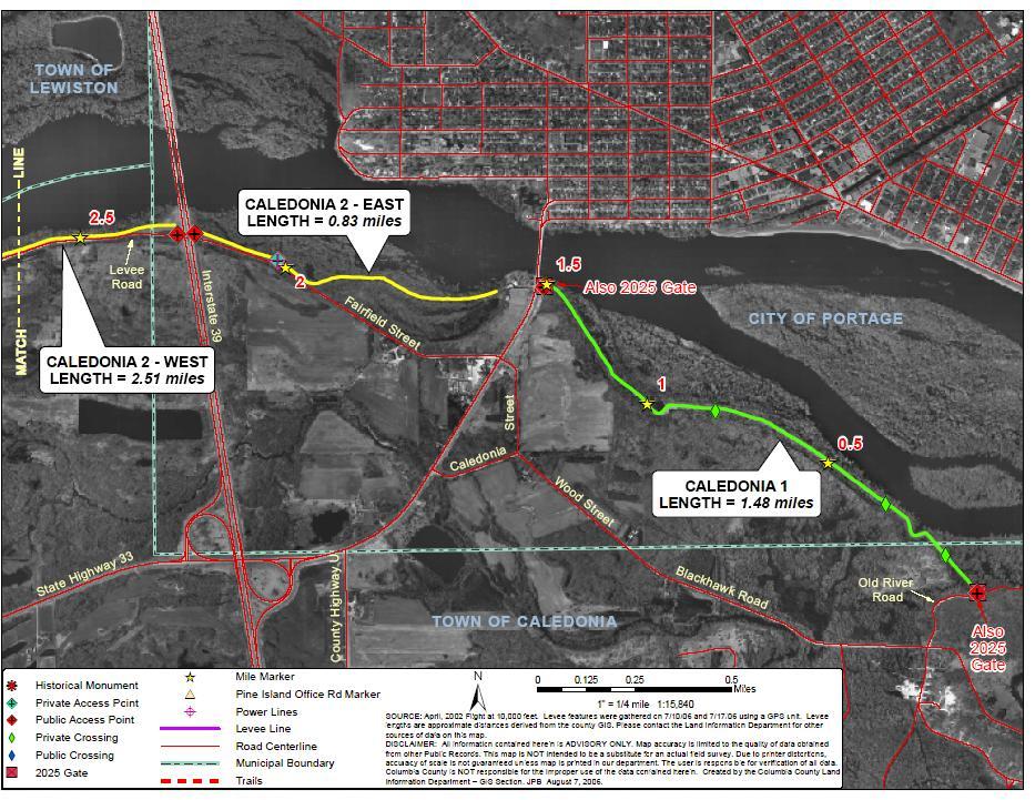
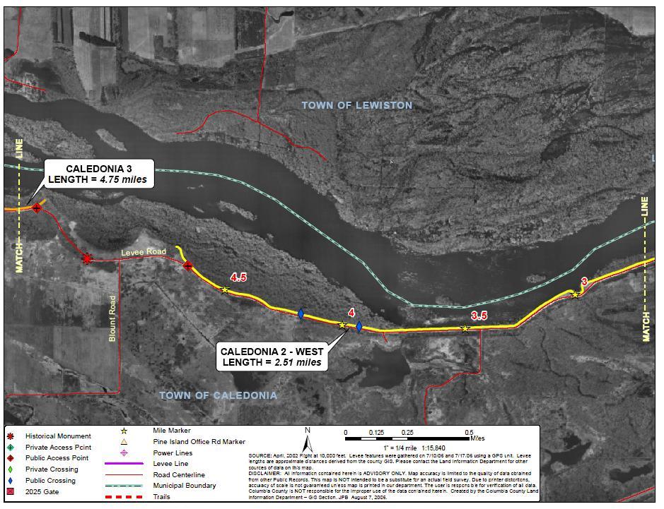
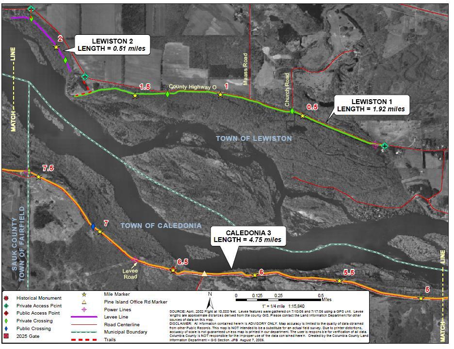
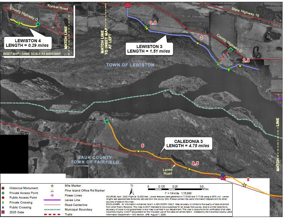
4 History of the Levees The Caledonia-Lewiston Levee System consists of 13.8 miles of discontinious sand dikes that were constructed along the Wisconsin River by various groups of landowners that lived adjacent to the Wisconsin River. Most of the levees were constructed during the 1890 s. The Caledonia Levee consists of two segments totaling 9.57 miles along the south side of the Wisconsin River, and the Lewiston Levee consists of four segments totaling 4.23 miles on the north side of the river. The height of the levees is typically 8 to 12 feet above the ground surface on the landward toe of the levee. Slopes vary from 6:1 to 3:1 The Levees were built from locally available materials without any engineering design or adherence to any design standards. These levees were intended to protect adjacent lands from periodic flood events of Wisconsin River. Despite their shortcomings the levees have, in fact, withstood frequent floods. A failure occurred in 1938, but since that time the levees have remained relatively intact. However, this is due primarily to the direct result of substantial and timely flood emergency action by the local governments and the WDNR. It should be noted that despite substantial maintenance and emergency actions by local government and WDNR, the continued integrity of the levees has survived because there have been no major flood events that would have damaged them or require major repairs to be undertaken. In short, it could be said that the integrity of these levees has not been tested by any significant flood events. In their present condition the Caledonia-Lewiston Levees do not and should not be expected to provide any meaningful protection from the Wisconsin River flooding with or without human intervention during flood events. With ever increasing development in the flood prone areas along the Wisconsin River, reliance on these levees for providing flood protection elevates the risk of putting lives and properties in harm s way. On numerous occasions local units of government have been strongly advised not to rely on these levees to protect human life, health and property and that any attempts to repair or operate these levees during flood events were extremely dangerous and might result in loss of human life. Responsibility for the levees was vested in the Portage Levee Commission through Chapter 282, Laws of In 1961, this commission was abolished (Chapter 191, Section 108, Laws of 1961) and its duties were reassigned to the Water Regulatory Board. However, the Board was eliminated and the Public Service Commission was vested with the responsibility of maintaining the levee system. Finally through state government reorganization, the Department of Natural Resources inherited the mandate of the Portage Levee Commission. (see WI Statutes Chapter (2) (a) (b). Current Levee Management and Costs Within the Department of Natural Resources oversight and maintenance of the Levees is performed by Southern Region staff assigned to the Lower Wisconsin Riverway Work Unit.
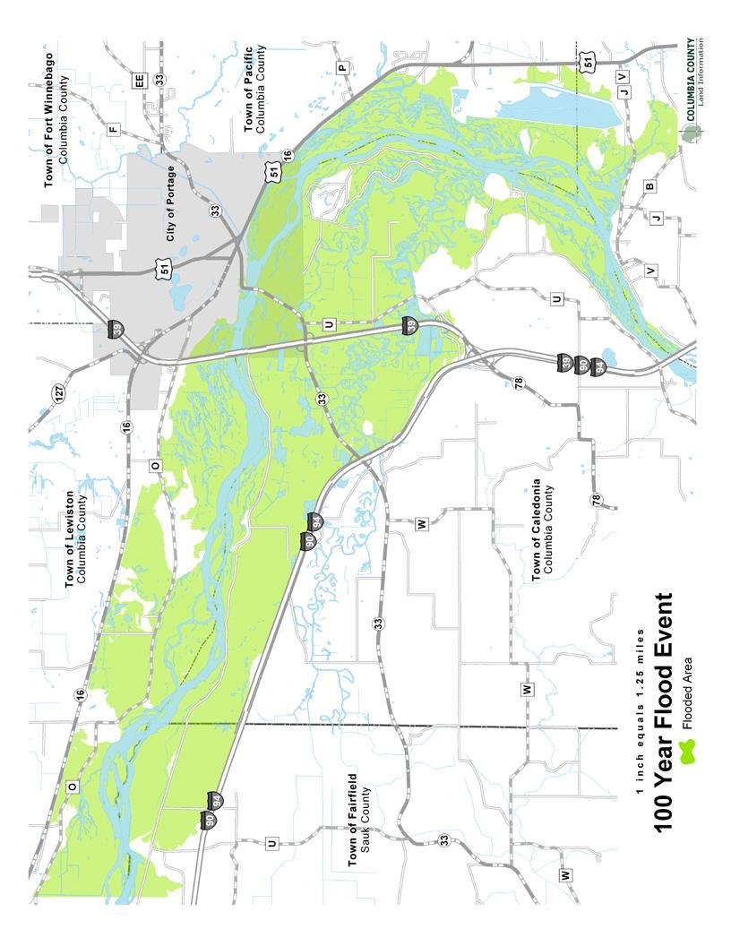
5 Budgeting for the Levees is provided through the Bureau of Facilities and Lands in DNR s central office. Levee management is supervised by the Program Supervisor for the Lower Wisconsin Riverway who is stationed in Dodgeville. A levee management plan has been prepared which describes the short and long term levee management needs. There is also an emergency management plan that describes actions to be taken in the event of a flood or failure of the levee. This supervisory position generally utilizes two Limited Term Employees (LTE s) who perform maintenance activities such as of routine dike inspections, dike mowing, filling any slumping areas or animal burrows and tree removal from within 25 feet of the toe of the dikes. This work occurs generally between spring and fall. Expenditures for annual levee maintenance for fiscal years were as follows. The costs include LTE labor, supplies and equipment operation costs. FY $42,635 FY $42,768 FY $50,110 FY $63,275 FY $47,787 In addition to annual maintenance, the following additional work was also done on the levees between 1991 and Rip-rapping -- $230,350 Tree removal -- $ 72,200 Levee repairs -- $ 36,671 Emergency Levee Protection $ 24,491 (response to 1993 flood event) Flood Event Analysis Methodology. Floodplain delineations for 10-year, 50-year and 100-year flood events were prepared based on the floodplain study of the Wisconsin River developed by the US Army CORPS of Engineers St. Paul District (USCOE) in 2003 as part of the Portage, Wisconsin Flood Control Certification project. This study was approved by the DNR and is now included by The Federal Emergency Management Agency (FEMA) into the preliminary Flood Insurance Study of Wisconsin River for Columbia and Sauk counties. The study reach extends from I-90 on the downstream end to near cross section BA of the new FIS on the upstream end (station ). This reach corresponds with the availability of 2-foot contour data from the COE. The following GIS layers were developed: 10-year flood event with levee failure polygon layer shows where the water would go when failure of levee at a10-year flood event occurs 10-year levees fail smoothed line layer similar to above but the line indicating the 10- year flood level was smoothed to better confirm with the existing topography
6 10-year flood event with levees holding polygon layer shows where the water would go when levees hold at a10-year flood event 10-year levees hold smoothed line layer similar to above but the line indicating the 10-year flood level was smoothed to better confirm with the existing topography 50-year levees fail polygon layer shows where the water would go when failure of levee at a 50-year flood event occurs 50-year levees fail smoothed line layer similar to above but the line indicating the 50- year flood level was smoothed to better confirm with the existing topography 50-year levees hold polygon layer shows where the water would go when levees hold at a 50-year flood event 50-year levees hold smoothed line layer similar to above but the line indicating the 50 year flood level was smoothed to better confirm with the existing topography 100-year levees hold polygon layer where water would go when the levees hold at a 100 year event 100-year levees hold smoothed line layer shows were water would go at a 100 year event with smoothing to better confirm with the existing topography All delineations were performed using the custom GeoRAS extension in ArcView 3.x called WDNR-Floodplain Mapping Tool. Delineations are based on a rasterization cell size of 2 meters. All line and polygon editing was done in ArcMap 9. Lines were smoothed using the PAEK method and a 10-meter smoothing tolerance. The line work was then cleaned up, leaving any islands roughly 10 feet across and larger. All mapping was adjusted to account for the construction of the new Portage Levee, which was not reflected in 2-foot contours (shows old levee). Contours of the new levee were provided by the COE. The following assumptions (not relevant for the scoop of this project) were made for all profiles: Assumed water could get north of CTH O and RR near section Mapping does not extend north of the RR near Big Slough area Mapping does not extend south of I-90 or backwater into the Baraboo River Mapping does not extend into backwater past the railroad on Rocky Run Mapping does not extend into backwater on Duck Creek past USH 51 Mapping does not extend into areas behind the Portage Levee or the Portage Canal Columbia County Land Information Department then overlaid the developed floodplain polygons referenced above with GIS layers containing property boundaries and their assessment values for the 2006 final assessments and prepared summary tables demonstrating
7 land, improvement and total assessed values for each flood frequency and levees hold/fail scenarios. Following FEMA guidelines on determining feasibility of levees, only assessed values of improvements were compared for different flood scenarios. That is in making comparisons between the different flood events to determine which properties were impacted and how much they were impacted, we did not include the value of the land itself in totaling up the cost of a flood event but used the improvements that were installed on the property. The rationale behind this assumes that a structure would be the property damaged by high water and not the land itself. It should be remembered that the levee itself is a topographical feature and therefore is an obstruction to the flowing waters and results in increased water surface elevations, thus impacting more lands during the given flood event. The mass of the levee will thus displace water and result in flood waters reaching higher elevations on the land if the levee structure were absent. Brief Synopsis for Each Event For each flooding scenario, the results of the GIS layer comparison will be discussed. 10-year flood event The parcels impacted or inundated to some degree by flood waters with the levee holding number 1205; while the parcels impacted by the levee failing number 1281 a difference of only 76 properties. The total value of these properties in terms of assessed value would be $1,381,100---out of a value of approximately $50,000,000 for the total value of assessed properties. However, the Caledonia-Lewiston Levee System actually causes additional flooding for dwellings in Dekorra Township and the City of Portage Columbia County and in Fairfield Township Sauk County ($2,662,800 total assessed improvements value) due to increased flood elevations. This is likely because the levee displaces water and will create high water in another part of the floodplain. 50-year flood event Under this scenario, more properties are impacted by the levees holding ( property values of $62, 788,900) versus the levees failing (1345 property values of $54,638,900). The Caledonia-Lewiston Levees System causes additional flooding for dwellings in Caledonia, Dekorra, Lewiston, Pacific Townships and the City of Portage Columbia County ($7,211,900 total assessed value of property improvements) due to increased flood elevations. This again is explained by the displacement effect of the levee in that flood waters have less opportunity to dissipate and thus inundate additional floodplain areas in the townships mentioned above during this event. 100-year flood event Even though no specific flood profile was developed for the levees fail scenario during the regional flood events, the engineering analysis shows that the Caledonia- Lewiston Levees System would contribute to additional increases of the regional flood elevations because of the displacement of floodwater as explained above, thus impacting additional properties in both counties.
8 Management Alternatives One of the charges of the Levee Working group is to develop a set of management alternatives for local elected officials, decisions makers and managers to consider. In developing alternatives the Working Group utilized the following findings and considerations. 1.) The current levees are actually earthen dikes that were never constructed according to any engineering design for flood control. They provide minimal flood protection for relatively small flood events (approximately a 4.2 year event). 2.) The floodplain area where the levees are now located should be managed in a way that is sustainable over the long run. The floodplain is highly susceptible to flooding and damage to property will occur. The expenditure of maintaining the levees is not without real costs and over the long term these annual maintenance costs do not produce the flood protection that these levees are assumed to provide. 3.) From an emergency management perspective it would not appear cost effective to maintain the levees and provide emergency services to those areas that have flood protection but in fact do not. At some point, it is more cost effective to provide alternatives so that people can relocate with economic incentives than to provide emergency services into areas that are in reality not protected by the levees. 4.) In the long term, what is the best eventual use of the property protected by the levees. When first constructed, the intent was to protect farm land from flooding. That is not the general case now and it would not appear prudent to continue to expend public funds protecting large expanses of undeveloped land. Based on these considerations, the Working Group offers the following range of management alternatives for future consideration. Each alternative has its costs and implications and the details of each would need further development. Based on the flood event analyses and the above considerations, the Working Group would favor selection and further development of Alternative 6. 1) Maintain the status quo under this scenario the WDNR would continue to do annual maintenance that would afford some protection from relatively small flood events (approximately 4.2 year event), but the levees would not provide flood protection from larger events. A large scale flood event could have very devastating impacts. 2.) Transfer existing levee management to a different entity - WDNR does not feel its state conservation and recreation program responsibilities benefit from the levee or its management. WDNR feels if others feel they benefit from the levee then they should assume its management.
9 3.) Rebuild the levees up to USCOE standards this scenario has already been discussed and evaluated in the Portage Flood Control Project and was deemed not to be cost effective based on the value of the property protected and the cost of bringing the levees up to standards. 4.) Stopping Maintaining the Levees this scenario would leave the levees in place and they would eventually degrade. This would require a change in State Statutes to allow the Department to abandon the levees. This would likely not be publicly acceptable. 5.) Decommission and partially remove the levees this scenario may result in removal of certain properties from the now designated floodplain areas in both counties. This will remove properties from the floodplain designation for some residents in Sauk and Columbia Counties (including the City of Portage). 6.) Disable the levees and provide for flood plain restoration in a managed sequence Allow for levee maintenance for smaller flood events in the short term, but begin a program of property buyout and other programs that would enhance movement of residents from the area behind the levee. Partnerships could be formed so that residents could be made whole financially and groups that have an interest in natural restoration of the area could form contribute to the floodplain restoration. Creation of a floodplain management district may help to facilitate this effort. In time the levees would no longer need to be maintained.
10 COLUMBIA COUNTY LAND INFORMATION DEPARTMENT 2007 Current Tax Parcels 2006 Assessment Values COLUMBIA COUNTY Land Information Department April 10 Year Event -Levee Hold Town of Caledonia 646 9,621,900 12,662,800 22,284, Town of Dekorra 98 3,774,500 4,575,600 8,350, Town of Lewiston 280 4,595,400 4,819,200 9,414, Town of Pacific , ,100 1,238, City of Portage 135 1,619,100 9,357,900 10,977,000 1,205 20,153,600 32,111,600 52,265, Year Event -Levee Fail Town of Caledonia ,301,800 13,112,800 23,414, Town of Dekorra 92 3,644,700 4,265,500 7,910, Town of Lewiston 319 5,687,800 4,985,000 10,672, Town of Pacific , ,100 1,238, City of Portage 106 1,148,100 6,499,600 7,647,700 1,281 21,325,100 29,559,000 50,884, Year Event -Levee Hold Town of Caledonia ,453,200 13,547,100 24,000, Town of Dekorra 112 4,138,600 5,674,200 9,812, Town of Lewiston 346 5,796,100 6,794,900 12,591, Town of Pacific , ,400 1,507, City of Portage 167 2,065,400 12,802,200 14,867,600 1,373 23,138,100 39,640,800 62,778, Year Event -Levee Fail Town of Caledonia ,378,800 13,302,800 23,681, Town of Dekorra 106 3,970,200 5,244,100 9,214, Town of Lewiston 357 6,091,800 6,487,000 12,578, Town of Pacific , ,700 1,371, City of Portage 107 1,169,500 6,623,300 7,792,800 1,345 22,210,000 32,428,900 54,638, Year Event Town of Caledonia ,468,800 13,641,600 24,110, Town of Dekorra 122 4,378,800 6,358,600 10,737, Town of Lewiston 361 6,183,800 6,994,500 13,178, Town of Pacific , ,400 1,507, City of Portage 176 2,171,000 13,607,200 15,778,200 1,443 23,887,200 41,424,300 65,311,500
11 SAUK COUNTY MAPPING DEPARTMENT April Tax Parcels 2005 Assessment Values Sauk County data generously provided by the Sauk County Mapping COLUMBIA COUNTY Land Information Department 10 Year Event -Levee Hold 012 Town Of Fairfield ,300 2,507,700 3,262, 10 Year Event -Levee Fail 012 Town Of Fairfield ,600 2,397,500 3,343, 50 Year Event -Levee Hold 012 Town Of Fairfield ,400 2,862,100 3,665, 50 Year Event -Levee Fail 012 Town Of Fairfield 105 1,388,800 2,921,900 4,310, 100 Year Event 012 Town Of Fairfield 115 1,492,900 3,430,900 4,923,
12
13
14
CONDITIONAL USE PERMIT Application Packet
 CONDITIONAL USE PERMIT Application Packet Community Development Department 1020 East Pioneer Road, Draper, UT 84020 (801) 576-6539 Fax (801) 576-6526 Dear Applicant, This application packet has been developed
Criteria for Appeals of Flood Insurance Rate Maps. November 30, 201 1
 Criteria for Appeals of Flood Insurance Rate Maps November 30, 201 1 This document outlines the criteria for appealing proposed changes in flood hazard information on Flood Insurance Rate Maps (FIRMS)
VI. SAFETY ELEMENT I. INTRODUCTION A. PURPOSE B. AUTHORITY. 1. Safety
 AB 162 and SB 1241 Amendment to the Safety Element New sections are underlined, deleted sections are shown as strikethrough and the denotes text remaining in place. VI. SAFETY ELEMENT I. INTRODUCTION A.
Walworth County Farmland Preservation Plan Update, Chapter 1 Plan Summary (Cover Document)
") Background Walworth County Farmland Preservation Plan Update, 2012 Chapter 1 Plan Summary (Cover Document) For over 30-years, the Wisconsin Farmland Preservation Program has served to preserve Walworth
Background Walworth County Farmland Preservation Plan Update, 2012 Chapter 1 Plan Summary (Cover Document) For over 30-years, the Wisconsin Farmland Preservation Program has served to preserve Walworth
Chapter 5. Floodplain Management. 5.0 Introduction. 5.1 Floodplain Management and Regulation
 5.0 Introduction This chapter summarizes the Town s rules and regulations regarding floodplain management and development. The requirements presented in this chapter should be used by the design engineer
FLOOD HAZARD AREA LAND USE MANAGEMENT
 FLOOD HAZARD AREA LAND USE MANAGEMENT Introduction Guidance For Selection of Qualified Professionals and Preparation of Flood Hazard Assessment Reports This document is intended to provide guidance for
Mingo County, WV Community Coordination Preliminary Flood Insurance Study and Flood Insurance Rate Map. Thursday, September 25, 2014
 Mingo County, WV Community Coordination Preliminary Flood Insurance Study and Flood Insurance Rate Map Thursday, September 25, 2014 Overview Preliminary Materials Preliminary FIS Report Digital Flood Insurance
Burleigh County Water Resource District 1811 East Thayer Avenue Bismarck, North Dakota (701)
") Burleigh County Water Resource District 1811 East Thayer Avenue Bismarck, North Dakota 58501 (701) 222-3499 www.bcwrd.org Fox Island Flood Control Project Public Hearing Summary September 7, 2016 General
Burleigh County Water Resource District 1811 East Thayer Avenue Bismarck, North Dakota 58501 (701) 222-3499 www.bcwrd.org Fox Island Flood Control Project Public Hearing Summary September 7, 2016 General
HEC Software and FEMA Submittals
 HEC Software and FEMA Submittals EWRI Workshop HEC Users Conference Larry Voice Risk Analysis FEMA Region VI April 12, 2010 Overview Flood Hazard Analysis Overview of Map Changes Accepted Model List Guidance
Absent: Major Chris Hanson, Volk Field John Ross, Jackson County Emergency Management; Paul Wydeven, Wisconsin Department of Transportation
 Monroe County/Fort McCoy Joint Land Use Study (JLUS) Technical Advisory Group (TAG) December 8, 2011, 2:00 4:00 p.m. Angelo Town Hall, 14123 Co. Hwy. I, Sparta, WI Meeting Minutes Attendance: Bryan Law,
Chapter 5. Floodplain Management. 5.0 Introduction. 5.1 Douglas County Comprehensive Master Plan. 5.2 Floodplain Management and Regulation
 5.0 Introduction This chapter summarizes the County s rules and regulations regarding floodplain management and development. The requirements presented in this chapter should be used by the design engineer
Land Use Application
 Land Use Application Check all permits you are applying for in the boxes provided. Submit this application form, the applicable materials listed in the corresponding permit application packet(s) and application
X. The Roles of Federal, State, and Local Governments
 X. The Roles of Federal, State, and Local Governments This chapter is a brief review of the Federal system s established and potentially useful future roles in flood hazards management in relation to its
2016 Fredericksburg Area Floodplain Management Workshop Tuesday, October 25, 2016
 2016 Fredericksburg Area Floodplain Management Workshop Tuesday, October 25, 2016 Charley Banks, CFM Department of Conservation And Recreation Division of Dam Safety & Floodplain Management Some Soapbox
(Ord. No. 743, )
") CHAPTER 330. - FLOODPLAIN MANAGEMENT Section 330-1. - Purpose. (a) (b) (c) (d) It is hereby determined that the flood hazard areas of the City of Chamblee are subject to periodic inundation which may result
CHAPTER 330. - FLOODPLAIN MANAGEMENT Section 330-1. - Purpose. (a) (b) (c) (d) It is hereby determined that the flood hazard areas of the City of Chamblee are subject to periodic inundation which may result
Draft Continuing Authorities Program Section 1135 Detailed Project Report and Integrated Environmental Assessment
 Appendix G Real Estate Shorty s Island / Meander Reach Ecosystem Restoration Kootenai River, Idaho Draft Continuing Authorities Program Section 1135 Detailed Project Report and Integrated Environmental
NOTICE OF LAND USE DECISION BY THE COOS COUNTY PLANNING DIRECTOR
 NOTICE OF LAND USE DECISION BY THE COOS COUNTY PLANNING DIRECTOR Coos County Planning 225 N. Adams St. Coquille, OR 97423 http://www.co.coos.or.us/ Phone: 541-396-7770 Fax: 541-396-1022 This notice is
Attached is a Clinton Township Zoning Permit Application and requirements for issuance of a permit.
 To Whom It May Concern: Attached is a Clinton Township Zoning Permit Application and requirements for issuance of a permit. The fee for the permit application is $75.00, which shall be made payable to
Legal Description Part of the Western Half of the Eastern Half of the Northwest Quarter of Section 30, Le Ray Township
 Owner and Applicant s 20448 State Highway 83 Mankato, MN 56001 Request and Location Request for review and approval of a Conditional Use Permit to allow an Elder Care Residential Unit to be constructed
CONTRA COSTA LOCAL AGENCY FORMATION COMMISSION EXECUTIVE OFFICER'S REPORT. May 12, 2010 (Agenda)
") CONTRA COSTA LOCAL AGENCY FORMATION COMMISSION EXECUTIVE OFFICER'S REPORT LAFCO 10-01: Annexation 174 to Central Contra Costa Sanitary District (CCCSD) PROPONENT: CCCSD by Resolution No. 2009-027 adopted
CONTRA COSTA LOCAL AGENCY FORMATION COMMISSION EXECUTIVE OFFICER'S REPORT LAFCO 10-01: Annexation 174 to Central Contra Costa Sanitary District (CCCSD) PROPONENT: CCCSD by Resolution No. 2009-027 adopted
Analysis of Infill Development Potential Under the Green Line TOD Ordinance
 Analysis of Infill Development Potential Under the Green Line TOD Ordinance Prepared for the Los Angeles County Second Supervisorial District Office and the Department of Regional Planning Solimar Research
8Land Use. The Land Use Plan consists of the following elements:
 8Land Use 1. Introduction The Land Use Plan consists of the following elements: 1. Introduction 2. Existing Conditions 3. Opportunities for Redevelopment 4. Land Use Projections 5. Future Land Use Policies
Office of the County Auditor. Broward County Property Appraiser Report on Transition Review Services
 Office of the County Auditor Broward County Property Appraiser Report on Transition Review Services January 14, 2005 Table of Contents BACKGROUND AND SCOPE...3 FINDINGS AND RECOMMENDATIONS...3 1. Financial
7. IMPLEMENTATION STRATEGIES
 7. IMPLEMENTATION STRATEGIES A. GENERAL APPROACH FOR IMPLEMENTATION Implementing the plan will engage many players, including the Municipality of Anchorage (MOA), the Government Hill Community Council,
SECTION 10: FLOOD HAZARD EVALUATION 10-1
 10) SECTION 10: FLOOD HAZARD EVALUATION A. General. Land subject to being flooded by a Flood of 100-Year Frequency as defined by Title 76, Chapter 5, MCA, or land subject to flooding pursuant to these
RESPONSIBILITY AND PROCEDURE FOR IMPROVEMENT AND MAINTENANCE OF DRAINS, DITCHES AND WATERCOURSES
 RESPONSIBILITY AND PROCEDURE FOR IMPROVEMENT AND MAINTENANCE OF DRAINS, DITCHES AND WATERCOURSES FORWARD The Offices of the County Engineer and County Commissioners of Greene County are inundated yearly
BACKGROUND There are 23 flood control structures in the Upper Brushy Creek Water Control and Improvement District (District). See attached map.
. See attached map.") BACKGROUND There are 23 flood control structures in the Upper Brushy Creek Water Control and Improvement District (District). See attached map. The U.S Department of Agriculture - Natural Resources Conservation
BACKGROUND There are 23 flood control structures in the Upper Brushy Creek Water Control and Improvement District (District). See attached map. The U.S Department of Agriculture - Natural Resources Conservation
Brief Summary of Drainage Law. November 2011
 Brief Summary of Drainage Law November 2011 This document is general information distributed by the State of South Dakota. Nothing in this document should be considered legal advice as to any specific
Prepared by and to be returned to Linn County Planning & Development nd Street S.W., Cedar Rapids, Iowa (319)
") Prepared by and to be returned to Linn County Planning & Development 935 2 nd Street S.W., Cedar Rapids, Iowa 52404-2161 (319) 892-5130 LINN COUNTY, IOWA ZONING BOARD OF ADJUSTMENT IN THE MATTER OF THE
Prepared by and to be returned to Linn County Planning & Development 935 2 nd Street S.W., Cedar Rapids, Iowa 52404-2161 (319) 892-5130 LINN COUNTY, IOWA ZONING BOARD OF ADJUSTMENT IN THE MATTER OF THE
Alberta Flood Hazard Identification Program
 Alberta Flood Hazard Identification Program Peter Onyshko, P.Eng., CFM River Forecast Section Alberta Environment and Parks November 5, 2015 Flood Hazard Identification Program Presentation Outline Introduction
REGIONAL DISTRICT OF NANAIMO BYLAW NO. 1469
 REGIONAL DISTRICT OF NANAIMO BYLAW NO. 1469 A BYLAW TO ESTABLISH FLOODPLAINS, CONSTRUCTION LEVELS IN FLOODPLAINS, AND SETBACKS FOR LANDFILL AND STRUCTURES IN FLOODPLAINS WHEREAS Section 910 of the Local
Surabaya River Improvement Project (II-1)
") Indonesia 1. Project Profile and Japan s ODA Loan (1) Background Surabaya River Improvement Project (II1) Report Date: June 2 Field Survey: February 2 When this project was planned in 199, the city of
Indonesia 1. Project Profile and Japan s ODA Loan (1) Background Surabaya River Improvement Project (II1) Report Date: June 2 Field Survey: February 2 When this project was planned in 199, the city of
BUILD-OUT ANALYSIS GRANTHAM, NEW HAMPSHIRE
 BUILD-OUT ANALYSIS GRANTHAM, NEW HAMPSHIRE A Determination of the Maximum Amount of Future Residential Development Possible Under Current Land Use Regulations Prepared for the Town of Grantham by Upper
PRELIMINARY PLAT Application Packet
 PRELIMINARY PLAT Application Packet Community Development Department 1020 East Pioneer Road, Draper, UT 84020 (801) 576-6539 Fax (801) 576-6526 Dear Applicant, This application packet has been developed
The City s current capital charge program funding mechanisms consist of
 Executive Summary The City of Ann Arbor (City) utilizes a capital charge program that attempts to provide adequate cost recovery for the initial capital investment in its water and sanitary sewer systems.
City of Palo Alto (ID # 4882) City Council Staff Report
 City Council Staff Report") City of Palo Alto (ID # 4882) City Council Staff Report Report Type: Consent Calendar Meeting Date: 12/15/2014 Summary Title: Easements for San Francisquito Creek Joint Powers Authority Initial Flood Protection
City of Palo Alto (ID # 4882) City Council Staff Report Report Type: Consent Calendar Meeting Date: 12/15/2014 Summary Title: Easements for San Francisquito Creek Joint Powers Authority Initial Flood Protection
M-43 CORRIDOR OVERLAY ZONE
 ARTICLE 26.00 M-43 CORRIDOR OVERLAY ZONE Section 26.01 Findings A primary function of the M-43 state highway is to move traffic through the Township and to points beyond. As the primary east-west arterial
A. Maintenance. All legally established, nonconforming structures can be maintained (e.g., painting and repairs);
;") Chapter 24.50 NONCONFORMING USES, STRUCTURES AND LOTS Sections: 24.50.010 Nonconforming uses, structures, and lots Purpose. 24.50.020 Nonconforming uses, structures, and lots Alteration or expansion of
Chapter 24.50 NONCONFORMING USES, STRUCTURES AND LOTS Sections: 24.50.010 Nonconforming uses, structures, and lots Purpose. 24.50.020 Nonconforming uses, structures, and lots Alteration or expansion of
OUTLINE OF THE CDBG-DR FEDERAL REGISTER NOTICE (February 23, 2018)
") OUTLINE OF THE CDBG-DR FEDERAL REGISTER NOTICE (February 23, 2018) INTRODUCTION When Congress makes a special appropriation of Community Development Block Grant funds for disaster recovery (CDBG-DR), HUD
OUTLINE OF THE CDBG-DR FEDERAL REGISTER NOTICE (February 23, 2018) INTRODUCTION When Congress makes a special appropriation of Community Development Block Grant funds for disaster recovery (CDBG-DR), HUD
Overview of Federal and State Floodplain Management Programs
 Overview of Federal and State Floodplain Management Programs Peter DeMeo, PE Supervising Environmental Engineer New Jersey Department of Environmental Protection Division of Land Use Regulation October
Date of Review: 11/6/2015 Reviewer: RCQ/LMC STATE
 FINAL Florida Review Checklist: NFIP & FBC & Revised Model Ordinance (January 15, 2013d) Ordinance Citation: Model FPM regulations and 5 th Edition FBC : All Zones Date of Review: 11/6/2015 Reviewer: RCQ/LMC
MODEL FLOODPLAIN MANAGEMENT / FLOOD DAMAGE PREVENTION ORDINANCE
 MODEL FLOODPLAIN MANAGEMENT / FLOOD DAMAGE PREVENTION ORDINANCE Description: Floodplain management involves the designation of flood-prone areas and the managing of their uses. It is also aimed at minimizing
Item 7.1, June 29, 2004 ACQUISITION OF THE GLOBAL PHOTON PROPERTY FOR THE GUADALUPE RIVER PARK
 Item 7.1, June 29, 2004 SUBJECT: ACQUISITION OF THE GLOBAL PHOTON PROPERTY FOR THE GUADALUPE RIVER PARK RECOMMENDATION (a) (b) It is recommended that the City Council and Redevelopment Agency Board approve
Buyout Area in Wayne, NJ. Photo by author. Wayne, New Jersey
 Buyout Area in Wayne, NJ. Photo by author Wayne, New Jersey Background Wayne is a mid-sized township of just under 55,000 inhabitants located in Passaic County, in northern New Jersey (see Figure 1). The
FILE: EFFECTIVE DATE: May 15, 2013 AMENDMENT: 1
 APPROVED AMENDMENTS: Effective Date Briefing Note /Approval Summary of Changes: June 1, 2011 BN 175892 Policy and Procedure update to reflect reorganization of resource ministries April 2011 May 15, 2013
ENACTMENT AND EXECUTION OF THE PRELIMINARY AGREEMENT BETWEEN NT VALDOS UAB AND KARALIENĖS MORTOS MOKYKLA UAB ON 11 SEPTEMBER 2015
 Executive summary of the public audit report ENACTMENT AND EXECUTION OF THE PRELIMINARY AGREEMENT BETWEEN NT VALDOS UAB AND KARALIENĖS MORTOS MOKYKLA UAB ON 11 SEPTEMBER 2015 01 June 2016, No. VA-P-60-1-9
Planning & Zoning Department GENERAL APPLICATION 400 DeWitt Street - Portage, WI Phone: Fax:
 Planning & Zoning Department GENERAL APPLICATION 400 DeWitt Street - Portage, WI 53901 Phone: 608-742-9660 Fax: 608-742-9817 www.@co.columbia.wi.us The applicant hereby authorizes access to the property
A NOMINAL ASSET VALUE-BASED APPROACH FOR LAND READJUSTMENT AND ITS IMPLEMENTATION USING GEOGRAPHICAL INFORMATION SYSTEMS
 A NOMINAL ASSET VALUE-BASED APPROACH FOR LAND READJUSTMENT AND ITS IMPLEMENTATION USING GEOGRAPHICAL INFORMATION SYSTEMS by Tahsin YOMRALIOGLU B.Sc., M.Sc. A thesis submitted for the Degree of Doctor of
Public Improvement District (PID) Policy
 Policy") Public Improvement District (PID) Policy OVERVIEW Public Improvement Districts ( PIDs ), per the Texas Local Government Code Chapter 372 ( the code or PID Act ), provide the City of Marble Falls ( the
Public Improvement District (PID) Policy OVERVIEW Public Improvement Districts ( PIDs ), per the Texas Local Government Code Chapter 372 ( the code or PID Act ), provide the City of Marble Falls ( the
Chapter 5: Testing the Vision. Where is residential growth most likely to occur in the District? Chapter 5: Testing the Vision
 Chapter 5: Testing the Vision The East Anchorage Vision, and the subsequent strategies and actions set forth by the Plan are not merely conceptual. They are based on critical analyses that considered how
DIVISION 1. - GENERAL PROVISIONS
 Sec. 90-708. - Statutory authorization and purpose. Sec. 90-709. - Applicability. Sec. 90-710. - Compliance and liability. Sec. 90-711. - Records. Sec. 90-712. - Abrogation and greater restrictions. Sec.
40 +/- Acres Cornerstone Group- Colonial Boulevard 40 Acres Section 32, Township 44, Range 25. For Cornerstone Group. Prepared by
 DUE DILIGENCE REPORT 40 +/- Acres Cornerstone Group- Colonial Boulevard 40 Acres Section 32, Township 44, Range 25 For Cornerstone Group Prepared by David Douglas Associates, Inc. 2037 West First Street
4.13 Population and Housing
 Environmental Impact Analysis Population and Housing 4.13 Population and Housing 4.13.1 Setting This section evaluates the impacts to the regional housing supply and population growth associated with implementation
2. Our community wants to demolish some blighted properties. How can we meet a CDBG national objective with this activity?
 ENTITLEMENT CDBG PROGRAM FAQs ON MEETING A NATIONAL OBJECTIVE WITH ACQUISITION, DEMOLITION, AND DISPOSITION 1. What are the basic principles to meet eligibility and national objective requirements? As
Data Verification. Professional Excellence Bulletin [PP-14-E] February 1995
![Data Verification. Professional Excellence Bulletin [PP-14-E] February 1995](/thumbs/90/101597168.jpg "Data Verification. Professional Excellence Bulletin [PP-14-E] February 1995") Professional Excellence Bulletin [PP-14-E] February 1995 Although obviously a cornerstone of appraisal practice, data verification has not been considered a major problem to real estate appraisers in the
Professional Excellence Bulletin [PP-14-E] February 1995 Although obviously a cornerstone of appraisal practice, data verification has not been considered a major problem to real estate appraisers in the
Article 12.5 Exemptions for Agricultural Housing, Affordable Housing, and Residential Infill Projects
 Title 14. California Code of Regulations Chapter 3. Guidelines for Implementation of the California Environmental Quality Act Article 12.5 Exemptions for Agricultural Housing, Affordable Housing, and Residential
CITY OF AUSTELL DESIGN AND CONSTRUCTION STANDARDS LAND DEVELOPMENT ORDINANCES
 CITY OF AUSTELL DESIGN AND CONSTRUCTION STANDARDS LAND DEVELOPMENT ORDINANCES Land Development Ordinances Section 8 CITY OF AUSTELL DESIGN AND CONSTRUCTION STANDARDS LAND DEVELOPMENT ORDINANCES Article
INITIAL SUMMARY OF HIGHLIGHTS IN 2018 FEDERAL REGISTER NOTICE FOR $7.4 BILLION Revised Wednesday, February 7 Introduction
 INITIAL SUMMARY OF HIGHLIGHTS IN 2018 FEDERAL REGISTER NOTICE FOR $7.4 BILLION Revised Wednesday, February 7 Introduction I ve read the notice (skipping some parts such as pages 13-19 about Evaluation
Revaluation process ongoing in Norwalk
 Revaluation process ongoing in Norwalk Property owners will have the opportunity to appeal assessment beginning December 5 (Norwalk, Conn.) The City of Norwalk is in the final phase of its revaluation
Revenue Summary Chart - Sewer Service Fees
 ATTACHMENT NO. 3 Revenue Summary Chart - Sewer Service Fees FY 16-17 Sanitation Zone or FY 15-16 FY 16-17 FY 16-17 Rate Rate Revenue Incr. County Sanitation Rate Per Rate Per Projected Dollar Percent due
The survey also examines the underlying causes of FVM and impairment audit
 Acuitas, Inc. s Survey of Fair Value Audit April 20122 Executive Summary Public Company Accounting Oversight Board (PCAOB) inspections have noted a dramatic increase in the number of fair value measurement
White Paper of Manuel Jahn, Head of Real Estate Consulting GfK GeoMarketing. Hamburg, March page 1 of 6
 White Paper of Manuel Jahn, Head of Real Estate Consulting GfK GeoMarketing Hamburg, March 2012 page 1 of 6 The misunderstanding Despite a very robust 2011 in terms of investment transaction volume and
CITRUS HEIGHTS COMMUNITY SPECIAL PLANNING AREA
 CITRUS HEIGHTS COMMUNITY SPECIAL PLANNING AREA 501-90. INTENT. It is the intent of the Board of Supervisors in adopting this Special Planning Area Ordinance to allow development on the property described
CONTRA COSTA LOCAL AGENCY FORMATION COMMISSION EXECUTIVE OFFICER'S REPORT. September 15, 2010 (Agenda)
") CONTRA COSTA LOCAL AGENCY FORMATION COMMISSION EXECUTIVE OFFICER'S REPORT : Northeast Area Annexation to Delta Diablo Sanitation District (DDSD) PROPONENT: City of Pittsburg Resolution No. 09-11357 adopted
CONTRA COSTA LOCAL AGENCY FORMATION COMMISSION EXECUTIVE OFFICER'S REPORT : Northeast Area Annexation to Delta Diablo Sanitation District (DDSD) PROPONENT: City of Pittsburg Resolution No. 09-11357 adopted
ORDINANCE NO. 14 C2-) AN ORDINANCE OF THE COUNTY OF VENTURA REPEALING AND REENACTING THE VENTURA COUNTY FLOODPLAIN MANAGEMENT ORDINANCE SECTION 1
 AN ORDINANCE OF THE COUNTY OF VENTURA REPEALING AND REENACTING THE VENTURA COUNTY FLOODPLAIN MANAGEMENT ORDINANCE SECTION 1") ORDINANCE NO. 14 C2-) AN ORDINANCE OF THE COUNTY OF VENTURA REPEALING AND REENACTING THE VENTURA COUNTY FLOODPLAIN MANAGEMENT ORDINANCE The Board of Supervisors of the County of Ventura ordains as follows:
ORDINANCE NO. 14 C2-) AN ORDINANCE OF THE COUNTY OF VENTURA REPEALING AND REENACTING THE VENTURA COUNTY FLOODPLAIN MANAGEMENT ORDINANCE The Board of Supervisors of the County of Ventura ordains as follows:
ASSESSORS ANSWER FREQUENTLY ASKED QUESTIONS ABOUT REAL PROPERTY Assessors Office, 37 Main Street
 A. THE ASSESSMENT PROCESS: ASSESSORS ANSWER FREQUENTLY ASKED QUESTIONS ABOUT REAL PROPERTY Assessors Office, 37 Main Street What is mass appraisal? Assessors must value all real and personal property in
Sea-Level Rise and Flooding: Legal, Fiscal, & Regulatory Challenges for Local Governments, Part I
 Sea-Level Rise and Flooding: Legal, Fiscal, & Regulatory Challenges for Local Governments, Part I Click to edit Master title style Click to edit Master subtitle style Thomas Ruppert Coastal Planning Specialist
PROJECT SCOPE OF WORK CITY OF TOWN AND COUNTRY STORMWATER PROGRAM
 PROJECT SCOPE OF WORK CITY OF TOWN AND COUNTRY STORMWATER PROGRAM Project ID Number: 2-2 Problem: The backyards at 962, 97, and 978 Delvin Drive are located in a low area of shallow ponding that takes
 ,J. 1 ~t
 EXHIBIT A. City of Corpus Christi Annexation Guidelines
 City of Corpus Christi Annexation Guidelines Purpose: The purpose of this document is to describe the City of Corpus Christi s Annexation Guidelines. The Annexation Guidelines provide the guidance and
Town of Alexandria. Floodplain Management Ordinance
 1 of 7 8/8/2009 4:56 PM Town of Alexandria Floodplain Management Ordinance SECTION 1 PURPOSE Certain areas of the Town of Alexandria, New Hampshire are subject to periodic flooding, causing serious damages
Chapter 100 Planned Unit Development in Corvallis Urban Fringe
 100.100 Scope and Purpose. Chapter 100 Planned Unit Development in Corvallis Urban Fringe (1) All applications for land divisions in the Urban Residential (UR) and Flood Plain Agriculture (FPA) zones within
IN THE COMMONWEALTH COURT OF PENNSYLVANIA
 IN THE COMMONWEALTH COURT OF PENNSYLVANIA Gregory J. Rubino and : Lisa M. Rubino, : Appellants : : v. : No. 1015 C.D. 2013 : Argued: December 9, 2013 Millcreek Township Board : of Supervisors : BEFORE:
Open Space Model Ordinance
 Open Space Model Ordinance Section I. Background Open space development has numerous environmental and community benefits, including: 1) Reduces the impervious cover in a development. Impervious cover
SEPTEMBER 7, 2017 FINAL AGENDA SENIOR CITIZEN AND DISABLED RESIDENT TRANSPORTATION ADVISORY COMMITTEE REPORT (NEXT SCHEDULED REPORT DECEMBER 2017)
") NEW JERSEY TRANSIT CORPORATION NJ TRANSIT BUS OPERATIONS, INC. NJ TRANSIT RAIL OPERATIONS, INC. NJ TRANSIT MERCER, INC. NJ TRANSIT MORRIS, INC. REGULARLY SCHEDULED BOARD OF DIRECTORS MEETINGS SEPTEMBER
NEW JERSEY TRANSIT CORPORATION NJ TRANSIT BUS OPERATIONS, INC. NJ TRANSIT RAIL OPERATIONS, INC. NJ TRANSIT MERCER, INC. NJ TRANSIT MORRIS, INC. REGULARLY SCHEDULED BOARD OF DIRECTORS MEETINGS SEPTEMBER
Town of Falmouth s Four Step Design Process for Subdivisions in the Resource Conservation Zoning Overlay District
 Town of Falmouth s Four Step Design Process for Subdivisions in the Resource Conservation Zoning Overlay District All subdivisions shall be designed in accordance with the following four-step process.
The Strategic Plan can be viewed by clicking this link.
 What is the purpose of the Land Information Office? Many of Brown County's most basic services rely on accurate and up-to-date land information. Emergency response, resource conservation, infrastructure
CITY OF DEL RIO PLANNING & ZONING COMMISSION COUNCIL CHAMBERS - CITY HALL 109 WEST BROADWAY ST. WEDNESDAY, MAY 20, :30 P.M.
 CITY OF DEL RIO PLANNING & ZONING COMMISSION COUNCIL CHAMBERS - CITY HALL 109 WEST BROADWAY ST. WEDNESDAY, MAY 20, 2015 5:30 P.M. AGENDA 1. CALL TO ORDER 2. ROLL CALL 3. APPROVAL OF MINUTES a. Approve
CHAPTER 18 SUBDIVISION AND PLATTING ORDINANCE OF THE TOWN OF OSCEOLA CODE OF ORDINANCES
 TOWN OF OSCEOLA POLK COUNTY WISCONSIN ORDINANCE # 18-03-03 CHAPTER 18 SUBDIVISION AND PLATTING ORDINANCE OF THE TOWN OF OSCEOLA CODE OF ORDINANCES 18.01 Purpose Adopted 3/08/99, Amended 5/12/03, 7/9/07,
Marin County Agricultural Land Conservation Program March 1, 2014
 Marin County Agricultural Land Conservation Program March 1, 2014 I. Purpose of this Document This document describes the Marin County Agricultural Land Conservation Program (County Program). The Marin
CHAPTER NONCONFORMITIES.
 - i CHAPTER. - NONCONFORMITIES. Sec. -. - Intent. Sec. -2. - Development as a matter of right. Sec. -3. - Nonconforming development. Sec. -. - Vested rights. Sec. -. - Hardship relief; Variances. 2 3 admin.
New Proposed Regulations Regarding Lead-based Paint Requirements
 New Proposed Regulations Regarding Lead-based Paint Requirements June 7, 1996 For CPD Newsbrief... June 1996 NEW PROPOSED REGULATIONS REGARDING LEAD-BASED PAINT REQUIREMENTS On June 7, 1996, HUD published
Residential Subdivision Preliminary Plat Application
 WATER MODELING FEES Major : $650 or Minor : $550 # of lots x $35 per lot Residential Preliminary Plat Application Lots: 1-9 10-19 20-49 50-99 100-199 $300 $400 $475 $625 $825 200-349 350-499 500-499 700-999
DEPARTMENT OF THE ARMY OFFICE OF THE CHIEF OF ENGINEERS WASHINGTON, D.C
 DEPARTMENT OF THE ARMY OFFICE OF THE CHIEF OF ENGINEERS WASHINGTON, D.C. 20314-1000 REPLY TO ATTENTION OF: CECW-PM (10-1-7a) THE SECRETARY OF THE ARMY 1. I submit for transmission to Congress my report
FOR DEP USE ONLY ATS ID: Seq: DEP ID: Received by DEP: Bureau: S Type of Application: WF Activity: N Fees Paid: Project Analyst: Check No.
 DEPARTMENT OF ENVIRONMENTAL PROTECTION Solid Waste Program, Attn: Geraldine Travers 17 State House Station Augusta, Maine 04333-0017 Telephone: (207) 287-7688 FOR DEP USE ONLY ATS ID: Seq: DEP ID: Received
Subdivision - Application
 Planning and Development Services, 2001 Sherwood Drive, Sherwood Park, AB T8A 3W7 Phone 780-464-8080 Fax 780-464-8109 Email: Landuse&policyplanning@strathcona.ca (Page 1 of 5) This form is to be completed
Environment and Natural Resources Trust Fund Request for Proposals (RFP)
") Environment and Natural Resources Trust Fund 2012-2013 Request for Proposals (RFP) Project Title: Southeast Minnesota Sensitive Habitat Protection Program (SHPP) ENRTF ID: 067-D Topic Area: D. Land Acquisition
Environment and Natural Resources Trust Fund 2012-2013 Request for Proposals (RFP) Project Title: Southeast Minnesota Sensitive Habitat Protection Program (SHPP) ENRTF ID: 067-D Topic Area: D. Land Acquisition
OPEN-SPACE CONVERSION REQUEST
 OPEN-SPACE CONVERSION REQUEST Applicant: Board Meeting: February 9, 2017 Landowner: Normandy Capital, LLC VOF Easement: BAT-03678 Table of Contents: Cover Page 1 Table of Contents 2 Application Overview
Cedar Hammock Fire Control District
 Cedar Hammock Fire Control District FY 2015 Fire/Rescue Impact Fee Study February 24, 2016 Prepared by: February 24, 2016 Mr. Jeff Hoyle Fire Chief 5200 26 th St W Bradenton, FL 34207 Re: FY 2015 Impact
MONTGOMERY COUNTY PLANNING DEPARTMENT
 MONTGOMERY COUNTY PLANNING DEPARTMENT THE MARYLAND-NATIONAL CAPITAL PARK AND PLANNING COMMISSION Forest Conservation Law Amendments - Modifications MCPB Item No. 7 Date: 5/24/2018 SUMMARY Mark Pfefferle,
CHAPTER 5 FLOOD DAMAGE PREVENTION. Statutory Authorization, Findings of Fact, Purpose, Methods, and Definitions
 CHAPTER 5 FLOOD DAMAGE PREVENTION Article A. Section 5.1 Section 5.2 Section 5.3 Section 5.4 Section 5.5 Article B. Statutory Authorization, Findings of Fact, Purpose, Methods, and Definitions Statutory
General Development Plan Background Report on Agricultural Land Preservation
 General Development Plan 2008 Background Report on Agricultural Land Preservation February 2008 I. Introduction Anne Arundel County has been an agricultural community for over 350 years, beginning with
Planning Rationale in Support of an Application for Plan of Subdivision and Zoning By-Law Amendment
 Planning Rationale in Support of an Application for Plan of Subdivision and Zoning By-Law Amendment The Kilmorie Development 21 Withrow Avenue City of Ottawa Prepared by: Holzman Consultants Inc. Land
Residential Evaluation Report (RER) April, 2016
 April, 2016") Residential Evaluation Report (RER) ensuring compliance with the Interagency Guidelines (IAG) and USPAP April, 2016 Definitions RER shall mean a Residential Evaluation Report and is deemed to be a restricted
Residential Evaluation Report (RER) ensuring compliance with the Interagency Guidelines (IAG) and USPAP April, 2016 Definitions RER shall mean a Residential Evaluation Report and is deemed to be a restricted
9. REZONING NO Vicinity of the northwest corner of 143 rd Street and Metcalf Avenue
 9. REZONING NO. 2002-15 Vicinity of the northwest corner of 143 rd Street and Metcalf Avenue 1. APPLICANT: Andrew Schlagel is the applicant for this request. 2. REQUESTED ACTION: The applicant is requesting
Understanding Texas TIRZ Statute Chapter 311 Texas Tax Code
 CDFA/TEDC TIRZ SEMINAR Understanding Texas TIRZ Statute Chapter 311 Texas Tax Code Clark Stockton Lord Constitutional Authority The legislature by general law may authorize an incorporated city or town
CHAPTER 15: ENVIRONMENTAL REVIEW
 CHAPTER 15: ENVIRONMENTAL REVIEW CHAPTER PURPOSE & CONTENTS This chapter provides grantees with general information on environmental review. The chapter will provide an overview of the applicable regulations,
R E Q U E S T F O R P R O P O S A L S REQUEST FOR PROPOSAL TO DEVELOP A LAND HOLDING AND RELEASE STRATEGY FOR THE HOUSING DEVELOPMENT AGENCY
 P.O. Box 3209, Houghton, 2041 Block A, Riviera Office Park, 6-10 Riviera Road, Riviera R E Q U E S T F O R P R O P O S A L S REQUEST FOR PROPOSAL TO DEVELOP A LAND HOLDING AND RELEASE STRATEGY FOR THE
Facts on Metro Nashville s Development of a Hazard Mitigation Home Buyout Program in Response to the May 2010 Flood June 3, 2010
 Facts on Metro Nashville s Development of a Hazard Mitigation Home Buyout Program in Response to the May 2010 Flood June 3, 2010 Summary: The Metropolitan Government of Nashville is currently working to
CHAPTER 109 NATURAL RESOURCES AND ENVIRONMENTAL PROTECTION. ARTICLE I. Flood Damage Prevention In General
 Sec. 109-1. - Authorization. CHAPTER 109 NATURAL RESOURCES AND ENVIRONMENTAL PROTECTION ARTICLE I. Flood Damage Prevention In General Article IX, Section II of the Constitution of the State of Georgia