Mitigation Banking Instrument Outline For Proposed Mitigation Banks Within the State of Missouri (February 2015)
|
|
|
- Ethel Chapman
- 6 years ago
- Views:
Transcription
1 Mitigation Banking Instrument Outline For Proposed Mitigation Banks Within the State of Missouri (February 2015) The U.S. Army Corps of Engineers (Corps) and U.S. Environmental Protection Agency joint regulation for Compensatory Mitigation for Losses of Aquatic Resources, (33 CFR, Part 332 and 40 CFR 230) herein referred to as the Mitigation Rule, improves planning, implementation, and management of permittee-responsible and third party compensatory mitigation projects. The purpose of this document is to explain how the Corps Districts whose regulatory boundaries fall within the State of Missouri and the Interagency Review Team (IRT) members interpret the required content for mitigation banking documentation. As outlined in the Mitigation Rule, the approval process for the mitigation banking instrument occurs in four phases. The Compensatory Mitigation Rule Timeline for Bank or ILF Instrument Approval, is included in Appendix D of this document. Prospective bank sponsors shall submit the information contained in the following outline to the Corps and to the IRT members in order to initiate the review process; Phase I of the review process is recommended, however, it is not required. This phase is the preliminary review of the proposed mitigation site and is intended to allow the Corps and the IRT an opportunity to identify potential issues early in the review process so that the sponsor may attempt to address those issues, or locate an alternative site if recommended, prior to the start of the formal review process. A draft prospectus is recommended at this stage in order to assist with the review of the site. Following the preliminary review and the acceptance by the Corps and the IRT that the site is conducive to aquatic resource improvements, the draft prospectus shall be revised in order to incorporate the comments of the IRT that result from the preliminary review. The submittal of the complete prospectus, to the Corps, initiates phase II of the review process. Phase II involves the submittal of the complete prospectus that must describe the items included in Section I (A H) below. The complete prospectus will be placed on Public Notice (PN) for a 30-day public comment period. After the bank sponsor considers the comments from the Corps, the IRT, and the public, and if the sponsor chooses to proceed with the establishment of the mitigation bank, the sponsor shall incorporate all substantive comments into a draft banking instrument and submit the draft instrument to the Corps to initiate phase III of the approval process. Phase III involves the submittal of the draft banking instrument that describes, in detail, the physical and the legal characteristics of the mitigation bank including how it will be established, operated, and managed. It is from the draft instrument that a final instrument (Phase IV) is prepared. The final instrument is the document by which the Corps determines whether to approve or deny the establishment of the proposed mitigation bank.
2 2 Phase IV of the approval process begins after the bank sponsor submits the final instrument to the Corps and to the members of the IRT. The final instrument must incorporate all comments provided by the Corps and the IRT in phase III and include supporting documentation that explains how the final instrument addresses the comments provided by the Corps and the IRT. After review of the final instrument the Corps will notify the IRT of intent to approve/not approve the final instrument. If the banking instrument is approved by the Corps District(s), signatures of the IRT agencies will be requested. If the Corps denies the final instrument the bank sponsor will be notified and the final instrument may be modified until an agreement is reached. A graphic depiction of the review process is included as Appendix D of this document. Two outlines are provided below and are intended to assist the prospective bank sponsor in preparing and providing the phased approach documentation required by the Corps and IRT. The first outline lists the requirements for a complete prospectus as outlined in the Mitigation Rule. However, the primary emphasis of this document is placed on the draft banking instrument outline. The outline consolidates four sections of the Mitigation Rule into the arrangement and content to be addressed in the draft banking instrument and provides prospective bank sponsors with a predictable and transparent rationale for submitting the required documentation. I. Requirements for a Complete Prospectus A. The objectives of the proposed mitigation bank. B. How the mitigation bank will be established and operated. The following provision must be included in this section of the Prospectus and must also be included in the Draft and Final Instrument. The bold font must be maintained in the Instrument. The U.S. Army Corps of Engineers (USACE) approval of this Instrument constitutes the regulatory approval required for the [INSERT NAME OF THE MITIGATION BANK] to be used to provide compensatory mitigation for Department of the Army permits pursuant to 33 C.F.R (a)(1). This Instrument is not a contract between the Sponsor or the Property Owner and the USACE or any other agency of the federal government. Any dispute arising under the Instrument will not give rise to any claim by the Sponsor or the Property Owner for monetary damages. This provision is controlling notwithstanding any other provision or statement in the Instrument to the contrary. C. The proposed service area (See Section II (3) below). D. The general need for and technical feasibility of the proposed mitigation bank. E. The proposed ownership arrangements and long-term management strategy
3 3 F. The qualifications of the sponsor to successfully complete the type(s) of mitigation project(s) proposed, including information describing any past such activities by the sponsor. G. The ecological suitability of the site to achieve the objectives of the proposed mitigation bank, including the physical, chemical, and biological characteristics of the bank site and how that site will support the planned types of aquatic resources and functions; In addition, include a description of all real estate encumbrances on the proposed property; and H. Assurance of a sufficient water source to support the long-term sustainability of the mitigation bank and disclose any split estate mineral rights or other existing real estate encumbrances on the proposed property. II. Requirements for the Draft/Final Banking Instrument 1) Introduction of the Mitigation Bank Site A. Describe the location, including map(s), of the proposed bank site. 1. Provide a shape file with metadata for the project site boundary, Section, Township and Range and the Latitude and Longitude (decimal degrees) of the center point of the bank site B. Describe how the bank will be established and operated. C. Describe the current and the long-term ownership arrangements including the long-term management strategy for the bank. D. Describe the qualifications of the sponsor to successfully complete the construction of the mitigation bank site. Provide information on past experience regarding the construction of wetland restoration/creation projects and/or stream restoration projects. E. Provision stating that legal responsibility for providing the compensatory mitigation is with the sponsor once a permittee secures credits from the sponsor. 2) Watershed Approach to Mitigation Bank A. Define your watershed boundary and incorporate the watershed approach (items 1 through 5 below) to address how the mitigation proposal will benefit wetland habitats, water quality, hydrologic conditions, and species needs within the identified watershed boundary. 1. Identify and briefly discuss historic losses and current trends of losses of wetland and wildlife habitats within the watershed based on current and historic land use. 2. Identify and briefly discuss water quality issues present within the watershed. 3. Describe the immediate and the long-term needs of the watershed to improve both the wildlife habitats and the water quality and describe the suitability (technical feasibility) of the site to meet the needs of the watershed. 4. Describe the historic and the current state of the bank site and the adjacent lands. In addition, describe the ecological suitability (physical, chemical and biological
4 characteristics) of the site to achieve the objectives of the bank and to improve the conditions within the identified watershed Identify and discuss the short-term and the long-term off-site threats (including water rights) within the watershed that may affect the wetland and the water quality services constructed at the bank site. Discuss how these threats are addressed in order to assure longevity of services at the site. 3) Service Area for the Mitigation Bank Site A. The service area for a bank should be defined as an appropriately sized watershed or part of a watershed where aquatic resource functions and services can be mitigated. Smaller watersheds are more appropriate when the aquatic functions and services are needed at a lesser scale or where these are found to vary at a larger scale when applying the watershed approach. 1. Large service areas will have to be justified by the watershed approach and the overall suitability of the proposed bank site to provide flood attenuation, water quality benefits, habitat for wildlife, and resource type replacement for wetlands and streams that are most likely to be impacted or are in need of restoration or establishment in the proposed service area. 2. The Corps Districts and the IRT have agreed that the Ecological Drainage Unit (EDU) is the largest service area unit that will be considered for mitigation banks (see Appendix A). 3. The following are examples when the EDU concept for geographic service area may not be practicable: an EDU containing a river with an expansive geomorphic floodplain (i.e. Mississippi River), or a densely populated area exists within an EDU that also contains large non-urbanized areas. B. Provide a map outlining the proposed service area along with a shape file of the service area boundary. The Shapefile for the service area must in the: Geographic Coordinate System North American Datum 1983 with units in degrees The Shapefile should only contain the Service Area for the particular bank 4) Mitigation Plan Requirements for the Bank Site A. Objectives 1. Specific objectives must identify: a. The resources to be provided (e.g., forested or emergent wetlands with species composition matching reference aquatic resources of similar type and landscape position in the service area, stream type, order, classification such as Rosgen, and channel-floodplain connectivity) b. The final goal to be provided by the resource for: amount (e.g., acres, linear feet); function (e.g., channel stability, shading of riverine system, vegetative structure, reconnect stream to floodplain); and/or services (e.g., filtering nutrients from agricultural runoff, provide quality habitat for a specific species of concern, provide flood water capacity, improve aquatic species passage), c. The method of compensation (i.e., restoration, enhancement, establishment, preservation), and
5 d. The feasibility of establishing the desired resource Briefly describe how the resources provided will address the needs of the watershed and the proposed service area. B. Site Selection 1. Compensatory mitigation projects shall use a watershed approach in order to be appropriately sited and designed to ensure that natural hydrology and landscape position will support long-term sustainability and function as a self-sustaining system. Discuss how the bank site is ecologically suitable for providing the desired aquatic resource functions by describing: a. The hydrological conditions, soil properties, native seed source, and other physical and chemical characteristics. b. The watershed-scale features such as aquatic habitat diversity, habitat connectivity, the existence of threatened or endangered species related to prior habitat loss, and other landscape scale functions. c. The size and the location of the bank site relative to hydrologic sources (including the availability of water rights) and other ecological features. d. The compatibility with adjacent land uses and any existing watershed management plans. e. The reasonably foreseeable effects the compensatory mitigation project will have on ecologically important aquatic or terrestrial resources, cultural resources, or habitat for federally or state listed threatened and endangered species. f. Other information as available including potential chemical contamination, impacts from land use changes including residential and/or commercial development within the watershed, and the proximity to the location of other mitigation banks, in-lieu fee mitigation project sites, or protected conservation areas within the watershed. C. Site Protection Instrument 1. Describe the ownership, legal arrangements and instrument that will be used to ensure the long-term protection of the proposed mitigation bank site. Include the draft real estate instrument as an appendix to the draft banking instrument. a. For long-term protection of non-government property other than transfer of title, the use of conservation easements and/or deed restrictions are deemed sufficient site protection measures. A conservation easement, deed restriction, or restrictive covenant should, where practicable, establish an appropriate third party (e.g., governmental or non-profit resource management agency) the right to enforce site protections and provide the third party the resources necessary to monitor and enforce the site protections. b. The long-term protection mechanism must contain a provision requiring 60-day advance notification to the district engineer before any action is taken to void or modify the instrument, management plan, or long-term protection mechanism, including transfer of title to, or establishment of any other legal claims over, the compensatory mitigation bank site. c. For government property, long-term protection may be provided through federal facility management plans or integrated natural resources management plans as
6 long as those plans are compatible with restrictive covenants specified on nongovernment property. 6 D. Baseline Information 1. Describe the ecological characteristics of the proposed bank site. 2. Describe the historic and the existing plant communities, historic and existing hydrology, and existing soil conditions. 3. Include map(s) identifying the boundary of the proposed bank site with coordinates (Latitude and Longitude in decimal degrees). Include a shape file with metadata of the delineated boundary. 4. Conduct a wetland delineation using appropriate Regional Supplement or if a supplement is not implemented in a geographic area of the State use the routine delineation methods as described in the Corps of Engineers 1987 Wetland Delineation Manual. 5. Describe the existing hydro-system connectivity between wetlands and other waters including tributaries connection to receiving waters. E. Determination of Credits 1. Describe the number of and the type of proposed credits to be provided at the bank including a brief explanation of the rationale for this determination. a. Wetland credit types shall be identified to the Cowardin class (e.g., PFOs, PSS, PEM). In the absence of a condition or functional assessment method, wetland credits will be determined based on a combination of land area and the method of compensation (restoration, enhancement, establishment, and/or preservation), with a maximum credit value given not to exceed 1 credit for each 1 acre gain in wetland area. Upon implementation of a functional or condition assessment method in the State of Missouri the approved methodology will be used to assess wetland credits. b. Upland buffers next to wetlands that provide habitat connectivity and other ecological functions may also generate compensatory mitigation credits because of their contribution to the ecological functions of the overall mitigation bank. The Corps in consultation with the IRT will determine on a case-by-case basis when buffers are essential to maintaining the ecological viability of adjoining aquatic resources, and thus eligible to produce compensatory mitigation credits. Credits will be determined on a percentage of land area, habitat connectivity, and ecological functions to be included as buffer until a condition or functional assessment methodology is approved for the State. c. The amount of stream mitigation credit, created at the site, is determined by stream type (ephemeral, intermittent, perennial), the location, the condition, instream improvements and linear feet of stream included in the bank. These factors are determined using the State of Missouri Stream Mitigation Method which derives a value expressed in credit. d. Riparian areas are critical components of stream ecosystems that provide important ecological functions, and directly influence the functions of streams, especially in terms of habitat quality and water quality. Therefore, it is important for mitigation banks containing streams and other open waters to include riparian areas as part of the overall compensatory mitigation project. In such cases,
7 compensatory mitigation credits should also be awarded to riparian areas in accordance with the State of Missouri Stream Mitigation Method. 7 F. Mitigation Work Plan 1. Describe in detail the specifications and work descriptions of the compensatory mitigation project, including, but not limited to the geographic boundaries of the project; construction methods; timing; and sequence. 2. Describe the sources of water, including connections to existing waters and uplands, and anticipated seasonal water depths in the wetland (water budget). 3. Describe the methods for establishing the desired plant community and plans to control undesirable plant species, including species composition and type of plantings (i.e. seeding, propagules, seedlings, saplings, etc.) and height of saplings. If trees are being planted, include a plan for how to control for wildlife damage. 4. Include any grading plan identifying the location and the elevation of the constructed features proposed. 5. For stream projects include existing channel cross-sections, proposed alterations to the stream channel and/or stream banks, a description of in-stream structures including materials used for improvements, dimensions and elevations, and riparian plantings. G. Operation and Maintenance Plan 1. A description and a schedule of maintenance required to maintain the viability of the bank site once the initial construction is completed [e.g. mowing timing and frequency, herbicide (application method, timing, type, and frequency), invasive species management plan, irrigation plan, passive water control structures, supplemental irrigation source, in-stream structures]. H. Ecological Performance Standards 1. Describe the ecological, administrative, and adaptive management standards that will be used to determine whether the compensatory mitigation project is achieving its objectives. The standards must be based on attributes that are objective and verifiable. They must be based on the best available science that can be measured or assessed in a practicable manner. The standards should take into account the expected stages of the aquatic resource development process in order to allow early detection of potential problems and appropriate adaptive management. The use of reference aquatic resources (least disturbed and exhibiting the highest levels of functions in the service area) is encouraged to establish performance standards. This approach can help ensure that the performance standards are reasonably achievable, by reflecting the range of variability exhibited by the regional class of aquatic resources as a result of natural processes and anthropogenic disturbances. 2. The performance standards should relate to the objectives of the mitigation bank site, so that the project can be quantitatively and/or qualitatively evaluated to determine if it is developing into the desired resource type, providing the expected functions and/or services, and attaining any other applicable metrics. Examples include: a. Structural Measures: Description-size, classification (HGM, Cowardin, Rosgen) of aquatic resource(s). Hydrology-duration, periodicity, Soils-hydric indicators, redoximorphic features,
8 Vegetation-dominants, species composition, density, coverage, 8 Stream status of structures and structural integrity, sinuosity, cross-section, bank full width, particle size (e.g. no significant change in D50 size particle silt, sand, gravel, cobble), longitudinal profile. b. Indicators of attainment or condition: snag density, foliage height, diversity, basal area, degree of shading, channel profile, c. Composite measures FQI, HSIs, IBI, FCI/FCU, etc. I. Monitoring Requirements 1. Monitoring reports (see Appendix E) must be submitted by the bank sponsor or their authorized agent in order to determine if the compensatory mitigation project is on track to meet performance standards and used as a measure to determine if adaptive management is needed. 2. The bank site must be monitored for a period not less than five years after final construction and planting. Extending the monitoring period beyond the five year minimum may be required depending on: a. Resource type (e.g., forested wetlands, riparian corridors, bottomland hardwood forests, wet prairie). b. Adaptive management measures occurring after initial site work (e.g., planting of additional trees, adjustments/re-building of in-stream structures to address stream stability). 3. The instrument must include: the parameters to be monitored, monitoring methods and procedures, a schedule for monitoring; the party responsible for conducting the monitoring and, if separate, the party responsible for submitting the monitoring report; and permission for the IRT members to participate in the monitoring process if requested. 4. Upon a determination by the Corps and IRT that performance standards have not been met or the compensatory mitigation project is not on track to meet them, the monitoring period may be extended. The IRT may also revise monitoring requirements when remediation and/or when an adaptive management plan is required. J. Long-term Management Plan 1. Describe how the bank will be managed after performance standards have been achieved to ensure the long-term sustainability of the resources, including a description of long-term management needs, annual cost estimates for these needs, identify the funding mechanism that will be used to meet those needs and the party responsible for carrying out the long-term management activities. 2. The sponsor is encouraged to transfer the long-term management responsibilities for the bank to a land stewardship entity, such as a public agency, non-governmental organization, or private land manager, as long as the entity is approved by the IRT. If the entity is identified in the instrument they shall be signatory to the instrument. 3. In cases where the long-term management entity is a public authority or government agency, that entity shall provide a plan or give an indication how long-term financing will be established, and include a written stewardship commitment specifying commitment to long-term management and maintenance and a plan for financing.
9 4. Non-governmental organizations shall demonstrate that long-term financing mechanisms will be implemented. In cases where long-term financing for long-term 9 management of compensatory mitigation projects is necessary, district commanders should consider the need to make inflationary adjustments and certain financial assumptions such as total return assumptions and capitalization rates (e.g. endowments, or Consumer Price Index adjustments in the case of annual payments). 5. The Corps and IRT prefer that the land stewardship entity be identified in the instrument however the Mitigation Rule provides the prospective sponsor flexibility to identify the entity at a later time. In this instance, the sponsor will be responsible for long-term management until the sponsor identifies a long-term stewardship entity and that entity is approved by the Corps and IRT. K. Adaptive Management Plan 1. Describe the strategy to address unforeseen changes in site conditions or other components that adversely affect the bank s success, including the party or parties responsible for the development and the implementation of the adaptive management measures and the timeline for the development and the implementation of the plan. 2. Circumstances that may qualify for adaptive management include an inability to construct the bank in accordance with the approved mitigation work plans, monitoring or other information reveals the bank is not progressing towards meeting its performance standards, possible remedial measures that result in site modifications, design changes, revisions to maintenance requirements, revised monitoring requirements. L. Financial Assurances 1. Describe the financial assurances that will be provided and how they are sufficient to ensure a high level of confidence that the compensatory mitigation bank will be successfully completed in accordance with the proposed performance standards. 2. The amount of financial assurances, approved by the district engineer, will be determined by the size and the complexity of the bank site, the degree of completion of the project at the time of bank approval, the likelihood of success, the past performance of the bank sponsor, and any other factors the Corps deems appropriate. a. The rationale for determining the amount of the required financial assurances must be documented in the instrument and may include; costs for land acquisition, planning and engineering, legal fees, mobilization, construction, monitoring, and maintenance. An alternative to providing an itemized cost analysis, would be to provide the cost of replacement mitigation through the purchase of credits from an approved mitigation bank or in-lieu-fee arrangement whose service area boundaries overlap with the proposed mitigation bank. 3. The financial assurances may be in the form of performance bonds, escrow accounts, casualty insurance, letters of credit, or other appropriate instruments approved by the district engineer. The financial assurances must be in the form that ensures the district engineer will receive notification at least 120 days in advance of any termination or revocation. 4. For performance bonds or letters of credit a standby trust account must be established. All amounts paid by the financial assurance provider must be paid directly to the
10 standby account for distribution by the account trustee in accordance with the Corps instructions Financial assurances may be phased out once the bank has been determined by the Corps to be successful in accordance with its performance standards. Otherwise, the assurance shall remain in place until the Corps in consultation with the IRT determines performance standards have been achieved. 6. The instrument must clearly specify the conditions under which the financial assurances are to be released to the sponsor, and/or other financial assurance provider. 5) Credit Release Schedule for the Mitigation Bank Site A. All credit releases must be approved by the Corps, in consultation with the IRT, based on a determination that required milestones have been achieved. B. Release of credits must be tied to performance based milestones (i.e. construction, planting, establishment of specified plant communities, bank full events, etc.). C. Up to 20 percent of the total credits projected may be debited from the bank upon instrument approval, appropriate financial assurances have been established and funded, and any other requirements determined to be necessary by the IRT have been fulfilled. D. The credit release schedule should reserve no less than 20 percent of the total credits for release only after full achievement of ecological performance standards. E. In order for credits to be released, the sponsor must submit documentation (i.e. via monitoring report) to the Corps demonstrating that the appropriate milestones for credit release have been achieved and requesting the release. The Corps will provide copies of this documentation to the IRT members for review. IRT members must provide any comments to the Corps within 15 days of receiving this documentation. However, if the Corps determines that a site visit is necessary, IRT members must provide any comments to the Corps within 15 days of the site visit. The Corps must schedule the site visit so that it occurs as soon as it is practicable, but the site visit may be delayed by seasonal considerations that affect the ability of the Corps and the IRT to assess whether the applicable credit release milestones have been achieved. After full consideration of any comments received, the Corps will determine whether the milestones have been achieved and the credits can be released. The Corps shall make a decision within 30 days of the end of that comment period, and notify the sponsor and the IRT. F. The Corps, in consultation with the IRT, may modify the credit release schedule, reduce the number of available credits or suspend credit sales or transfers altogether, when deficiencies in the performance standards have been observed or specific requirements of the instrument have not been met. 6) Accounting Procedures for the Mitigation Bank Site A. Use of Credits 1. At the discretion of the Corps, all activities authorized by Department of the Army permits are eligible, to use the mitigation bank to fulfill compensatory mitigation requirements for DA permits, including compensatory mitigation associated with unauthorized activities or non-compliance actions. 2. The Corps will determine the number and type(s) of credits required to compensate for the authorized impacts.
11 B. Ledger 1. The instrument must contain a provision requiring the sponsor to establish and maintain a ledger to account for all credit transactions. The sponsor must notify the 11 Corps each time a credit transaction occurs and the sponsor must provide an updated ledger. 7) Reporting for the Mitigation Bank Site A. Monitoring Reports 1. Monitoring reports must be submitted (a minimum of one annually) to the Interagency Review Team (IRT) for a period not less than five years after final construction and planting. 2. The monitoring report must be provided in the format cited in Regulatory Guidance Letter and be of sufficient content for the district engineer, in consultation with the IRT, to determine that the bank site is progressing towards meeting the performance standards as outlined in the instrument. 3. The monitoring report must include as-built drawings, maps, and ground photography illustrating the site conditions and interpretation of the current site conditions. If available, approved wetland and/or stream assessment methods that provide qualitative measures of the functions of the resource can be submitted. B. Ledger Accounting Reports. 1. The sponsor must compile an annual ledger report showing the beginning and ending balance of available credits and permitted impacts for each resource type, including types of credits debited, all additions and subtractions of credits, and any other changes in credit availability (e.g., additional credits released, credit sales suspended). 2. The ledger report must be submitted to the Corps and IRT on an annual basis. The ledger report will serve as part of the administrative record for the mitigation bank. C. Financial Assurances Reports 1. The sponsor must provide an annual report showing beginning and ending balances, including deposits into and any withdrawals from, the accounts providing funds for financial assurances. 2. The report shall include information on the amount of required financial assurances and the status of those assurances, including their potential expiration. 8) Default and Closure Provisions A. Default Provisions 1. If the Corps determines that the mitigation bank is not meeting performance standards or complying with the terms of the instrument, appropriate action will be taken. Such actions may include, but are not limited to, suspending credit sales, adaptive management, decreasing available credits, utilizing financial assurances, and/or terminating the instrument. B. Closure Provisions 1. Bank closure will occur when the terms and conditions of an instrument have been determined by the Corps, in consultation with the IRT, to be fully satisfied or until all credits have been debited, whichever is later. Subsequent to bank closure, management will remain the responsibility of the sponsor unless a Long-Term
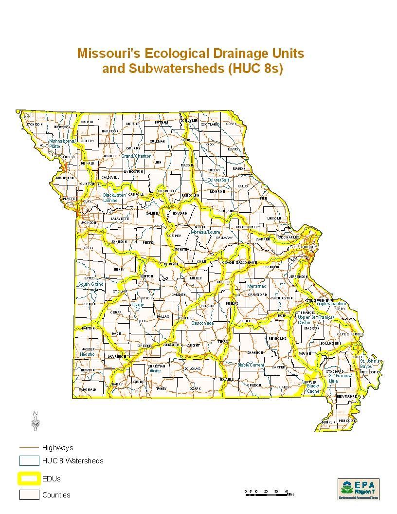
12 Management entity is identified in the Long-Term Management Section of the instrument If adaptive management strategies are unsuccessful and performance standards are unattainable, the sponsor may request early closure of a bank and forfeiture of remaining anticipated credits if it is determined that the performance standards are unattainable. 9) Approval of the Final Instrument and the Incorporation of the IRT s Comments A. The bank sponsor must submit, for approval, a final bank instrument to the Corps that adequately addresses the main topics and subtopics contained within this bank instrument guidance document. The final instrument must also include supporting documentation outlining how the final instrument addresses the comments provided by the IRT. Mitigation credit cannot be sold at the bank prior to the approval of the final bank instrument by the Corps in consultation with the IRT. Appendices Appendix A Ecological Drainage Unit (EDU) Map Appendix B District Specific Site Protection Example(s) (e.g. Conservation Easement, Deed Restriction, etc.) Appendix C District Specific Financial Assurance Example(s) (e.g. performance bond, letter of credit, etc.) Appendix D Compensatory Mitigation Rule Timeline for Bank or ILF Approval Appendix E Regulatory Guidance Letter 08-03
13 Appendix A Ecological Drainage Unit (EDU) Map (See Map on Following Page) Additional Map Available at:
14
15 Appendix B District Specific Site Protection Example(s) (See Conservation Easement and Deed Restriction Templates for Kansas and Missouri on the Following Pages)
16 CONSERVATION EASEMENT THIS DEED OF CONSERVATION EASEMENT is given this day of, 20, by, having an address of ("Grantor") to, having an address of ("Grantee"). As used herein, the term "Grantor" shall include any and all heirs, successors, or assigns of the Grantor, and all subsequent owners of the Property (as hereinafter defined), and the term "Grantee" shall include any successor or assignee of Grantee. WITNESSETH: WHEREAS, Grantor is the sole owner in fee simple title of certain lands situated in County, Missouri, more particularly described in Exhibit A, attached hereto and incorporated herein ("Property"); and WHEREAS, Department Permit No. of the U.S. Army Corps of Engineers ("Corps") (hereinafter referred to as the "Permit") authorizes certain activities which affect waters of the United States; and WHEREAS, the Permit requires that Grantor preserve, enhance, restore, or mitigate wetlands or uplands located on the Property; and WHEREAS, Grantor, in consideration of the issuance of the Permit to construct and operate the permitted activity, and as an inducement to the issuance of the Permit, is willing to grant a perpetual Conservation Easement over the Property; and NOW THEREFORE, in consideration of the above and mutual covenants, terms conditions, and restrictions contained herein, together with other good and valuable consideration, the adequacy and receipt of which is hereby acknowledged, Grantor hereby voluntarily grants and conveys a perpetual Conservation Easement for and in favor of Grantee upon the property, which shall run with the land and be binding upon the Grantor, and shall remain in full force and effect forever. The scope, nature, and character of this Conservation Easement shall be as follows: 1. Purpose: The purpose of this Conservation Easement is to retain and maintain land or water areas on the Property in their natural, vegetative, hydrologic, scenic, open, or wooded condition and to retain such areas as suitable habitat for fish, plants, or wildlife. Those wetland or upland areas that are to be restored, enhanced, created, or preserved on the Property shall be retained and maintained in the restored, enhanced, created, or preserved condition as described in the Permit and/or in the associated compensatory mitigation plan for the Property. 2. Rights of Grantee: The following rights are conveyed to the Grantee and to the Corps by this easement: Property; and a. The right to take action to preserve and protect the environmental value of the
17 b. The right to prevent any activity on or use of the Property that is inconsistent with the purpose of this Conservation Easement, and to require the restoration of areas or features of the Property that may be damaged by any inconsistent activity or use; c. The right to enter upon and inspect the Property in a reasonable manner and at reasonable times to determine if Grantor is complying with the covenants and prohibitions contained in this Conservation Easement; and d. The right to proceed at law or in equity to enforce the provisions of this Conservation Easement, and to prevent the occurrence of any of the prohibited activities hereinafter set forth. 3. Prohibited Uses: Except for restoration, creation, enhancement, preservation, maintenance, and monitoring activities, or surface water management improvements, required by the Permit, or required by the compensatory mitigation plan, or are otherwise approved by the Corps, the following activities are prohibited on the Property: a. Construction of any structure or object (i.e., buildings, roads, above or below ground utilities, signs, billboards etc.) without written approval from the Corps of Engineers prior to construction; b. Dumping or placing of soil or other substance or material as landfill, or dumping or placing of trash, waste, or unsightly or offensive materials; c. Removal or destruction of trees, shrubs, or other vegetation, except for the removal of nuisance, exotic, or non-native vegetation in accordance with a maintenance plan approved by Corps; Missouri; d. Planting of nuisance, exotic, or non-native plants as listed by the State of e. Exploration for, or extraction of, oil or gas in such a manner as to affect the surface, or excavation, dredging, or removal of coal, loam, peat, gravel, soil, rock, or other material substance; f. Use of motorized and non-motorized vehicles, the keeping or riding of horses, grazing, livestock confinement, or other surface use that may affect the natural condition of the Property, except for vehicle use for purposes of maintenance and upkeep; g. Tilling, plowing, planting of crops, digging, mining, or other activities that are or may be detrimental to drainage, flood control, water conservation, water quality, erosion control, soil conservation, or fish and wildlife habitat preservation, including but not limited to ditching, diking, and fencing; 2
18 h. The extraction of water from the Property or the impoundment of water on the Property so as to affect the hydrology of the Property; i. Acts or uses detrimental to the aforementioned retention and maintenance of land or water areas; j. Acts or uses detrimental to the preservation of the structural integrity or physical appearance of sites or properties of historical, architectural, archaeological, or cultural significance. 4. Reserved Rights: Grantor reserves all rights as owner of the Property, including the right to engage in uses of the Property that are not prohibited herein, and that are not inconsistent with the intent and purposes of this Conservation Easement. 5. Taxes: Grantor shall pay any and all applicable real property taxes and assessments levied by competent taxing authority on the Property. 6. Maintenance: Grantor shall, at Grantor's sole expense, operate, maintain and keep up the Property consistent with the purpose of this Conservation Easement. Grantor shall remove from the Property any nuisance, exotic, or non-native plants as listed by the State of Missouri and shall maintain the hydrology of the Property as it currently exists or as otherwise required by the Permit or as required by the compensatory mitigation plan or as required by the Corps approved final mitigation banking instrument. 7. Hazardous Waste: Grantor covenants that if any hazardous substances or toxic waste exist or has been generated, treated, stored, used, disposed of, or deposited in or on the Property, or there are or have been any underground storage tanks on the Property, Grantor shall be responsible for any and all necessary costs of remediation. 8. Public Access: No right of access by the general public to any portion of the Property is conveyed by this Conservation Easement. 9. Liability: Grantor shall continue to retain all liability for any injury or damage to the person or property of third parties that may occur on the Property arising from ownership of the Property. Neither Grantor, nor any person claiming by or through Grantor, shall hold Grantee liable for any damage or injury that may occur on the Property. 10. Recording Requirements: Grantor must record this Conservation Easement in the official records of County, Missouri, and shall re-record it at any time Grantee or the Corps may require to preserve their rights. Grantor shall pay all recording costs, fees and taxes necessary at any time to record this Conservation Easement in the public records. Grantor shall thereafter insert the terms and restrictions of this Conservation Easement in any subsequent deed or other legal instrument by which Grantor divests himself/herself/itself of any interest in the Property, and shall provide a photocopy of the recorded Conservation Easement to the new owner(s). 3
19 11. Enforcement: The terms and conditions of this Conservation Easement may be enforced in an action at law or equity by the Grantee or the Corps against the Grantor violating or attempting to violate these Restrictions. Venue for any such action shall be in County, Missouri. Enforcement of this Conservation Easement shall be at the reasonable discretion of the Grantee or the Corps, and any forbearance on behalf of Grantee or the Corps to exercise its or their rights hereunder in the event of any breach by Grantor shall not be deemed or construed to be a waiver of rights. Any costs incurred in enforcing, judicially or otherwise, the terms, provisions, and restrictions of this Conservation Easement, including without limitation, the costs of suit, and attorney's fees, shall be borne by and recoverable against the non-prevailing party in such proceedings, except that such costs shall not be recoverable against the Corps. In addition, if the Grantee or the Corps shall prevail in an enforcement action, such party shall also be entitled to recover that party's cost of restoring the land to the natural vegetative and hydrologic condition existing at the time of execution of these Restrictions or to the vegetative and hydrologic condition required by the Permit and/or as required by the associated compensatory mitigation plan. 12. Assignment of Rights: Grantee shall hold this Conservation Easement exclusively for conservation purposes. Grantee will not assign its rights and obligations under this Conservation Easement, except to another legal entity qualified to hold such interests under applicable state and federal laws and committed to holding this Conservation Easement exclusively for the purposes stated herein. Grantee shall notify the Corps in writing of any intention to reassign this Conservation Easement to a new grantee at least sixty (60) days in advance thereof, and the Corps must accept the assignment in writing. The new grantee shall then deliver a written acceptance to the Corps. The assignment instrument must then be recorded and indexed in the same manner as any other instrument affecting title to real property and a copy of the assignment instrument shall be furnished to the Corps. Failure to comply with the assignment procedure herein stated shall result in invalidity of the assignment. In the event of dissolution of the Grantee or any successor, or failure for 60 days or more to execute the obligations of this Conservation Easement, the Grantee shall transfer this Conservation Easement to a qualified and willing grantee. Upon failure of the Grantee or any successor to so transfer the Conservation Easement, the Corps shall have the right to sue to force such an assignment to a grantee to be identified by the Court. 13. Successors: The covenants, terms, conditions, and restrictions of this Conservation Easement shall be binding upon, and inure to the benefit of the parties hereto and their respective personal representatives, heirs, successors, and assigns, and shall continue as a servitude running in perpetuity with the Property. 14. Notices: All notices, consents, approvals, or other communications hereunder shall be in writing and shall be deemed properly given if sent by United States certified mail, return receipt requested, addressed to the appropriate party or successor-in-interest. 4
20 15. Severability: If any provision of this Conservation Easement or the application thereof to any person or circumstances is found to be invalid, the remainder of the provisions of this Conservation Easement shall not be affected thereby, as long as the purpose of the Conservation Easement is preserved. 16. Alteration or Revocation: This Conservation Easement, granted in perpetuity, may be amended, altered, released, canceled, or revoked only by written agreement between the parties hereto or their heirs, assigns, or successors in interest, which shall be filed in the public records of County, Missouri. No action shall be taken, however, without advance written approval thereof by the Corps. Corps approval shall be by letter attached as an exhibit to the document amending, altering, canceling, or revoking the Conservation Easement, and said letter shall be informal and shall not require notarization. It is understood and agreed that Corps approval requires a minimum of sixty (60) days written notice, and that the Corps may require substitute or additional mitigation, a separate conservation easement or alternate deed restrictions, or other requirements as a condition of approval. Any amendment, alteration, release, cancellation, or revocation together with written Corps approval thereof shall then be filed in the public records of County, Missouri, within 30 days thereafter. 17. Controlling Law: The interpretation and performance of this Conservation Easement shall be governed by the laws of the State of Missouri. GRANTOR FURTHER COVENANTS that Grantor is lawfully seised of said Property in fee simple; that the Property is free and clear of all encumbrances that are inconsistent with the terms of this Conservation Easement and that no mortgages or other liens exist; that Grantor has good right and lawful authority to convey this Conservation Easement, and that it hereby fully warrants and defends the title to the Conservation Easement hereby conveyed against the lawful claims of all persons whomsoever. TO HAVE AND TO HOLD, the Grantor covenants that he, she, or they are vested with good title to the easement area and will warrant and defend the same on behalf of the Grantee against all claims and demands. The Grantor covenants to comply with the terms and conditions enumerated in this document for the use of the easement area and adjacent lands for access, and to refrain from any activity not specifically allowed or that is inconsistent with the purposes of this easement deed. The covenants, terms, conditions, restrictions, and purpose imposed with this Conservation Easement shall be binding upon Grantor, and shall continue as a servitude running in perpetuity with the Property. Dated this day of, 20 Grantor(s): Print Name Signature Print Name Signature 5
21 STATE OF COUNTY OF ACKNOWLEDGEMENT On this day of, 20, before me, the undersigned, a Notary Public in and for said State personally appeared, know or proved to me to be the person{s) described in and who executed the foregoing instrument, and acknowledged that executed the same as free act and deed. IN TESTIMONY WHEREOF, I have hereunto set my hand and official seal the day and year first above written. Notary Public for the State of Residing at My Commission Expires ACCEPTANCE BY GRANTEE: I (print name), (title), being the duly authorized representative of the Grantee, do hereby accept this Conservation Easement Deed with respect to the rights and duties of the, Grantee. Dated this day of, 20. Signature Title 6
22 DECLARATION OF RESTRICTIVE COVENANTS The Declarant,, is the fee simple owner of the certain real property located in County, Missouri, as described on Exhibit A, which is attached hereto and incorporated herein by reference (the "Development"). Declarant has applied for and received Permit No. from the United States Army Corps of Engineers (the "Corps") to fill certain wetlands in waters of the United States (the "Permit"). In consideration of the issuance of the Permit and in compliance with the terms thereof, and for other good and valuable consideration, the Declarant hereby declares that that the portion of the Development described in Exhibit B ("the Property") shall henceforth be subject to the following restrictive covenants (the "Restrictions"). As used herein, the term "Declarant" includes and shall be binding upon and his/her/its successors, heirs, and assigns. 1. Purpose: The purpose of these Restrictions is to retain and maintain land or water areas on the Property in their natural, vegetative, hydrologic, scenic, open, agricultural, or wooded condition, and to retain such areas as suitable habitat for fish, plants, or wildlife. Those wetland or upland areas that are to be restored, enhanced, or created pursuant to the Permit shall be retained and maintained in the restored, enhanced, or created condition required by the Permit. 2. Rights of Corps and Owners in the Development: The following rights are conveyed to the Corps and any Owner of any parcel of real estate in the Development (the "Owner" or "Owners"): Property; and a. The right to take action to preserve and protect the environmental value of the b. The right to prevent any activity on or use of the Property that is inconsistent with the purpose of these Restrictions, and to require the restoration of areas or features of the Property that may be damaged by any inconsistent activity or use; c. The right to enter upon and inspect the Property in a reasonable manner and at reasonable times to determine if the Declarant is complying with the covenants and prohibitions contained in these Restrictions; and d. The right to proceed at law or in equity to enforce the provisions of these Restrictions, and to prevent the occurrence of any of the prohibited activities hereinafter set forth. 3. Prohibited Uses: Except for restoration, creation, enhancement, maintenance, and monitoring activities, or surface water management improvements, which are permitted or required by the Permit, the following activities are prohibited on the Property: a. Construction of any structure or object (i.e., buildings, roads, above or below ground utilities, signs, billboards etc.) without written approval from the Corps of Engineers prior to construction;
DECLARATION OF RESTRICTIVE COVENANTS
 DECLARATION OF RESTRICTIVE COVENANTS The Declarant,, is the fee simple owner of the certain real property located in County, Kansas, as described on Exhibit A, which is attached hereto and incorporated
Mitigation Banking Instrument Outline For Proposed Mitigation Banks Within the State of Kansas (February 2015)
") Mitigation Banking Instrument Outline For Proposed Mitigation Banks Within the State of Kansas (February 2015) The U.S. Army Corps of Engineers (Corps) and U.S. Environmental Protection Agency joint regulation
Mitigation Banking Instrument Outline For Proposed Mitigation Banks Within the State of Kansas (February 2015) The U.S. Army Corps of Engineers (Corps) and U.S. Environmental Protection Agency joint regulation
AMENDED DEED OF CONSERVATION EASEMENT
 Prepared by: Wayne E. Flowers Lewis, Longman & Walker, P.A. 245 Riverside Ave. Suite 150 Jacksonville, FL 32202 Return recorded original to: Mitigation Marketing 1091 W. Morse Blvd. Suite 101 Winter Park,
DECLARATION OF RESTRICTIVE COVENANTS
 STATE OF MARYLAND COUNTY OF DECLARATION OF RESTRICTIVE COVENANTS THIS DECLARATION OF RESTRICTIVE COVENANTS is made this day of, 20, by ( Declarant(s) ). RECITALS WHEREAS, Declarant(s) is/are the owner(s)
CONSERVATION EASEMENT INCLUDING MITIGATION
 After recording return to: GRANTOR: GRANTEE: GRANTEE (Trustee): LEGAL DESCRIPTION: TAX PARCEL I.D. #: REFERENCE # s: WHATCOM COUNTY N/A CONSERVATION EASEMENT INCLUDING MITIGATION This grant of a conservation
MODEL DEED RESTRICTION FOR THE PENNSYLVANIA STATE PROGRAMMATIC GENERAL PERMIT-3 (PASPGP-3) DECLARATION OF RESTRICTIVE COVENANTS FOR CONSERVATION
 DECLARATION OF RESTRICTIVE COVENANTS FOR CONSERVATION") MODEL DEED RESTRICTION FOR THE PENNSYLVANIA STATE PROGRAMMATIC GENERAL PERMIT-3 (PASPGP-3) DECLARATION OF RESTRICTIVE COVENANTS FOR CONSERVATION THIS DECLARATION OF RESTRICTIVE COVENANTS FOR CONSERVATION
MODEL DEED RESTRICTION FOR THE PENNSYLVANIA STATE PROGRAMMATIC GENERAL PERMIT-3 (PASPGP-3) DECLARATION OF RESTRICTIVE COVENANTS FOR CONSERVATION THIS DECLARATION OF RESTRICTIVE COVENANTS FOR CONSERVATION
Stormwater Ordinance Appendix APPENDIX K EXAMPLE TAR-PAM CONVERSATION EASEMENT
 APPENDIX K EXAMPLE TAR-PAM CONVERSATION EASEMENT Tax Parcel ID # NORTH CAROLINA FRANKLIN COUNTY CONSERVATION EASEMENT Franklin County, North Carolina THIS CONSERVATION EASEMENT (this "Conservation Easement")
THIS DECLARATION OF RESTRICTIVE COVENANTS is made this day of, 20, by ("Covenantor"). RECITALS
. RECITALS") Model for Use with Permits Without Mitigation Plans STATE OF COUNTY OF DECLARATION OF RESTRICTIVE COVENANTS THIS DECLARATION OF RESTRICTIVE COVENANTS is made this day of, 20, by ("Covenantor"). RECITALS
Model for Use with Permits Without Mitigation Plans STATE OF COUNTY OF DECLARATION OF RESTRICTIVE COVENANTS THIS DECLARATION OF RESTRICTIVE COVENANTS is made this day of, 20, by ("Covenantor"). RECITALS
CONSERVATION EASEMENT AND RESTRICTION
 CONSERVATION EASEMENT AND RESTRICTION The purpose of a Conservation Easement is to protect in perpetuity significant natural features and to minimize the environmental impact of activities associated with
DECLARATION OF RESTRICTIVE COVENANTS. THIS DECLARATION OF RESTRICTIVE COVENANTS made this day of, 200_, by ( Declarant ). RECITALS
. RECITALS") DECLARATION OF RESTRICTIVE COVENANTS THIS DECLARATION OF RESTRICTIVE COVENANTS made this day of, 200_, by ( Declarant ). RECITALS WHEREAS, Declarant is the owner of the surface of certain real property
DECLARATION OF RESTRICTIVE COVENANTS THIS DECLARATION OF RESTRICTIVE COVENANTS made this day of, 200_, by ( Declarant ). RECITALS WHEREAS, Declarant is the owner of the surface of certain real property
GRANT OF CONSERVATION RESTRICTION (Wetland Mitigation/Riparian Zone Mitigation) WITNESSETH:
 WITNESSETH:") NJDEP File No.: Prepared by: GRANT OF CONSERVATION RESTRICTION (Wetland Mitigation/Riparian Zone Mitigation) THIS GRANT OF CONSERVATION RESTRICTION is made this day of 20, by, its heirs, successors and
NJDEP File No.: Prepared by: GRANT OF CONSERVATION RESTRICTION (Wetland Mitigation/Riparian Zone Mitigation) THIS GRANT OF CONSERVATION RESTRICTION is made this day of 20, by, its heirs, successors and
RESTRICTED USE EASEMENT
 RESTRICTED USE EASEMENT THIS CONSERVATION EASEMENT ("Easement") is made this day of, 2014, by, Individually and Trustee of the Trust (the "Grantor"), and the Compatible Lands Foundation, 1305 East 15 th
THIS DEED OF CONSERVATION EASEMENT
 NOTICE TO TITLE EXAMINERS: THIS DEED OF CONSERVATION EASEMENT CONTAINS COVENANTS THAT INCLUDE RESTRICTIONS ON THE USE, SUBDIVISION AND OFF-CONVEYANCE OF LAND. THIS DEED OF CONSERVATION EASEMENT ("Conservation
DEED OF CONSERVATION EASEMENT WITNESS THAT:
 DEED OF CONSERVATION EASEMENT THIS DEED OF CONSERVATION EASEMENT is made on this day of, 20, by, having an address of, ( Grantor ), and Compatible Lands Foundation. an Oklahoma nonprofit public benefit
MODEL DEED RESTRICTION
 MODEL DEED RESTRICTION This type of Protective Covenant is the most commonly used. It is a legal agreement between the grantor, typically the property owner or applicant, and the Corps. Please view instructions
To achieve the conservation purposes, the following conditions and restrictions are set forth:
 DEED OF CONSERVATION EASEMENT (Conservation Subdivision District) STATE OF GEORGIA COUNTY OF COBB THIS DEED OF CONSERVATION EASEMENT (herein "Conservation Easement") is made this day of, 20, by and between
WEST VIRGINIA DIVISION OF FORESTRY Cooperative Forest Legacy Program. Sample Conservation Easement
 WEST VIRGINIA DIVISION OF FORESTRY Cooperative Forest Legacy Program Sample Conservation Easement This document is included in the forest legacy kit as an example for information and possible guidance
CONSERVATION EASEMENT AGREEMENT
 CONSERVATION EASEMENT AGREEMENT THIS INDENTURE made this day of, 20, by and between of the Town of, County of, and State of ( Grantor ), and the Town of Coventry, a municipal corporation having its territorial
Stormwater Treatment Facility Maintenance Agreement
 Stormwater Treatment Facility Maintenance Agreement This Agreement made and entered into this day of, 20, by, (hereinafter referred to as Property Owner") RECITALS: WHEREAS, the Property Owner is the owner
IN-LIEU FEE ENABLING INSTRUMENT
 IN-LIEU FEE ENABLING INSTRUMENT RIVERSIDE-CORONA RESOURCE CONSERVATION DISTRICT RCRCD In-Lieu Fee Program IN-LIEU FEE PROGRAM This In-Lieu Fee Enabling Instrument ( Instrument ), dated this day of, 2012
DEED OF AGRICULTURAL CONSERVATION EASEMENT TO THE COMMONWEALTH OF PENNSYLVANIA IN PERPETUITY
 Prepared By: Return To: UPI# DPERSF (6-2006) EXHIBIT C DEED OF AGRICULTURAL CONSERVATION EASEMENT TO THE COMMONWEALTH OF PENNSYLVANIA IN PERPETUITY THIS DEED OF AGRICULTURAL CONSERVATION EASEMENT, made
Easement Grant of Easement for Habitat Protection
 Date: Grantor(s): XXXXXXXXXX Grantee: Tri-Basin Natural Resources District, (hereinafter referred to as Tri-Basin NRD)1308 2 nd St., Holdrege NE 68949 Protected Property: See Exhibit A attached for legal
TRANSFER OF DEVELOPMENT RIGHTS CONSERVATION EASEMENT
 After Recording Return to: Kitsap County Department of Community Development TDR Program Manager 614 Division St., MS-36 Port Orchard, Washington 98366 TRANSFER OF DEVELOPMENT RIGHTS CONSERVATION EASEMENT
EXHIBIT "A" THE PRESERVE AT WILDERNESS LAKE COMMUNITY DEVELOPMENT DISTRICT 5844 Old Pasco Road, Suite 100, Wesley Chapel, Florida 33544
 EXHIBIT "A" THE PRESERVE AT WILDERNESS LAKE COMMUNITY DEVELOPMENT DISTRICT 5844 Old Pasco Road, Suite 100, Wesley Chapel, Florida 33544 NATURAL AREAS POLICY STATEMENT The following is the policy statement
IN-LIEU FEE ENABLING INSTRUMENT
 IN-LIEU FEE ENABLING INSTRUMENT MOUNTAINS RESTORATION TRUST IN-LIEU FEE PROGRAM This In-Lieu Fee Enabling Instrument ( Instrument ), dated this day of, 2013 ( Execution Date ), is made by and between Mountains
SPECIAL PUBLIC NOTICE
 SPECIAL PUBLIC NOTICE U.S. ARMY CORPS OF ENGINEERS BUILDING STRONG LOS ANGELES DISTRICT APPLICATION FOR PERMIT Coachella Valley In-Lieu Fee Program Public Notice/Application No.: SPL-2013-00324-TOB Project:
Establishing a Wetland Bank in Minnesota
 Establishing a Wetland Bank in Minnesota Updated February 1, 2018 This document provides a general summary of the key steps in establishing an individual wetland bank site within the state wetland banking
WAKE COUNTY STORMWATER CONTROL STRUCTURE AND ACCESS EASEMENT AND AGREEMENT (Corporate)
") Return to: Matthew Flynn Stormwater Field Services Administrator Water Resources Department Town of Cary PO Box 8005, Cary, NC 27512 NORTH CAROLINA WAKE COUNTY STORMWATER CONTROL STRUCTURE AND ACCESS EASEMENT
Return to: Matthew Flynn Stormwater Field Services Administrator Water Resources Department Town of Cary PO Box 8005, Cary, NC 27512 NORTH CAROLINA WAKE COUNTY STORMWATER CONTROL STRUCTURE AND ACCESS EASEMENT
TRANSFER OF DEVELOPMENT RIGHTS CONSERVATION EASEMENT
 After Recording Return to: Snohomish County Planning and Development Services TDR Program Manager 3000 Rockefeller Ave. M/S #604 Everett, WA 98201 Tax Parcel Numbers: TRANSFER OF DEVELOPMENT RIGHTS CONSERVATION
CITY OF FORT COLLINS NATURAL AREAS AND CONSERVED LANDS EASEMENT POLICY
 CITY OF FORT COLLINS NATURAL AREAS AND CONSERVED LANDS EASEMENT POLICY Adopted January 3, 2012 PURPOSE: The purpose of the policy statement is to clarify the policies and procedures of the City of Fort
FEE SIMPLE OPTION AGREEMENT Ecosystem Enhancement Program SPO File Number
 STATE OF NORTH CAROLINA COUNTY OF Prepared by State Property Office Return after recording to: Blane Rice, State Property Office 1321 Mail Service Center Raleigh, NC 27699-1321 FEE SIMPLE OPTION AGREEMENT
Climate Change and Conservation Easement Clause Databank
 Photograph by Alice Kubler of the Archer Taylor Preserve Climate Change and Conservation Easement Clause Databank (May 15, 2009, last edited June 3, 2009) This Databank is a work in progress assembled
DECLARATION OF DEED RESTRICTIONS
 Drawn by and Mail to: { Attorney or law firm) DECLARATION OF DEED RESTRICTIONS THIS DECLARATION OF DEED RESTRICTIONS (the Declaration ), made and entered into this the day of, 2014 by and between NAME
Submittal of the Minutes from the March 9, 2011, April 5, 2011, and April 19, 2011 Cabinet Meetings.
 AGENDA BOARD OF TRUSTEES OF THE INTERNAL IMPROVEMENT TRUST FUND JUNE 16, 2011 Attachments to the items below can be viewed at the following link: http://www.dep.state.fl.us/secretary/cab/public_notices.htm
Validation Checklist. Date submitted: How to use this check-list. Ecosystem Credit Accounting System. Version 1.1&2. Project Information
 Ecosystem Credit Accounting System Version 1.1&2 Last updated April 21, 2017 Validation Checklist Date submitted: Project Information Project Name Trading Area Name Trading Area Type (e.g., TMDL, TNC Ecoregion)
Wilmington District Process for Preservation of Mitigation Property
 November 25, 2003 Wilmington District Process for Preservation of Mitigation Property The Wilmington District Regulatory Branch (District), consistent with Corps of Engineers guidance, often accepts or
APPLICATION. Telephone Fax Address. Telephone Fax Address FOR MARTIN COUNTY USE ONLY
 APPLICATION PRESERVE AREA MANAGEMENT PLAN/ ABBREVIATED PRESERVE AREA MANAGEMENT PLAN Growth Management Department Environmental Division PART 1: Applicant Information A. Land Owner(s) Name Title and Company
RIGHT-OF-WAY MAINTENANCE AGREEMENT
 RIGHT-OF-WAY MAINTENANCE AGREEMENT This Agreement made and entered into the day of, 20, by and between, its successors and assigns ( Owner ), and the City of Overland Park, Kansas ( City ). WITNESSETH:
ARIZONA DEPARTMENT OF TRANSPORTATION RIGHT OF WAY GROUP/PROPERTY MANAGEMENT SECTION EXCESS LAND PURCHASE AGREEMENT AND RECEIPT FOR DEPOSIT
 ARIZONA DEPARTMENT OF TRANSPORTATION RIGHT OF WAY GROUP/PROPERTY MANAGEMENT SECTION EXCESS LAND PURCHASE AGREEMENT AND RECEIPT FOR DEPOSIT Project No.: 010 MA 151 H7441 Date: Month Day, Year Sale No. L-C-047
DEVELOPMENT AGREEMENT
 STATE OF NORTH CAROLINA COUNTY OF CHATHAM DEVELOPMENT AGREEMENT This Development Agreement (this Agreement ) is made and entered into as of the day of, 2009 (the Effective Date ), by and between the COUNTY
STORMWATER BEST MANAGEMENT PRACTICES OPERATIONS AND MAINTENANCE AGREEMENT
 STORMWATER BEST MANAGEMENT PRACTICES OPERATIONS AND MAINTENANCE AGREEMENT THIS AGREEMENT, made and entered into this day of, 20, by and between, (hereinafter the Landowner ), and the TOWNSHIP OF HEMPFIELD,
EXHIBIT A ENVIRONMENTAL COVENANT AND ACCESS AGREEMENT
 ENVIRONMENTAL COVENANT AND ACCESS AGREEMENT AFTER RECORDING RETURN TO: Laura Wishik, Esq. Director, Environmental Protection Section P. O. Box 94769 Seattle, WA 98124-4769 GRANTOR AND OWNER: City of Seattle
Application Procedures for Easements or Rights of Way on City of Fort Collins Natural Areas and Conserved Lands March 2012
 Application Procedures for Easements or Rights of Way on City of Fort Collins Natural Areas and Conserved Lands March 2012 IMPORTANT NOTE: This document was created to accompany the City of Fort Collins
WATER CONSERVATION EASEMENT
 WHEN RECORDED RETURN TO: Washington County Water Conservancy District 533 East Waterworks Dr. St. George, Utah 84770 Space Above This Line for Recorder s Use Serial No. WATER CONSERVATION EASEMENT THIS
Forested Buffer Water Resource Easement Carroll County, Maryland
 Forested Buffer Water Resource Easement Carroll County, Maryland FORESTED BUFFER WATER RESOURCE EASEMENT THIS DEED OF EASEMENT, made this day of, in the year nineteen hundred and ninety-five, by and between,
CONTRACT TO BUY AND SELL REAL ESTATE
 CONTRACT TO BUY AND SELL REAL ESTATE THIS CONTRACT TO BUY AND SELL REAL ESTATE ( Contract ) is made and entered into as of April 9, 2018 (the Effective Date ) by and between the City of Pueblo, Colorado,
LAND INSTALLMENT CONTRACT
 RECORDER S STAMP: This document must be executed in duplicate, and original executed documents must be provided to each party. The Seller must cause this document to be recorded within 20 days after it
Conservation Easement Stewardship
 Conservation Easements are effective tools to preserve significant natural, historical or cultural resources. Conservation Easement Stewardship Level of Service Standards March 2013 The mission of the
Sample Baseline Documentation Report (BDR) Annotated Template for Environmentally Important Land
 Annotated Template for Environmentally Important Land") Sample Baseline Documentation Report (BDR) Annotated Template for Environmentally Important Land The baseline documentation report (BDR) provides a snap shot of the biophysical condition of a property
Sample Baseline Documentation Report (BDR) Annotated Template for Environmentally Important Land The baseline documentation report (BDR) provides a snap shot of the biophysical condition of a property
RESIDENTIAL ACCESS AGREEMENT. ( Owner ) and Butte-Silver Bow County ( BSB ) enter into this Residential Access Agreement ( Agreement ) this day of.
 and Butte-Silver Bow County ( BSB ) enter into this Residential Access Agreement ( Agreement ) this day of.") RESIDENTIAL ACCESS AGREEMENT ( Owner ) and Butte-Silver Bow County ( BSB ) enter into this Residential Access Agreement ( Agreement ) this day of. RECITALS A. BSB has received funding to conduct certain
RESIDENTIAL ACCESS AGREEMENT ( Owner ) and Butte-Silver Bow County ( BSB ) enter into this Residential Access Agreement ( Agreement ) this day of. RECITALS A. BSB has received funding to conduct certain
GRANT OF TRAIL ACCESS EASEMENT, COVENANTS AND RESTRICTIONS
 This is a sample easement provided for discussion and illustrative purposes only. Easements for each property will be customized based upon the needs of each landowner and the Path. GRANT OF TRAIL ACCESS
AGREEMENT FOR TEMPORARY CONSTRUCTION EASEMENT AND PERMANENT SEWER UTILITY EASEMENT
 AGREEMENT FOR TEMPORARY CONSTRUCTION EASEMENT AND PERMANENT SEWER UTILITY EASEMENT This Agreement for Temporary Construction Easement and Permanent Sewer Utility Easement (hereinafter the "Agreement")
MODEL CONSERVATION EASEMENT. January 18, 2001 Rev d October 16, 2002 Rev d August, 2003
 MODEL CONSERVATION EASEMENT January 18, 2001 Rev d October 16, 2002 Rev d August, 2003 Model Conservation Easement for use in preserving mitigation property. Language in italics is instructional, and should
DEED OF EASEMENT AND AGREEMENT Forest Conservation Easement
 DEED OF EASEMENT AND AGREEMENT Forest Conservation Easement THIS DEED OF EASEMENT AND AGREEMENT, made this day of, 20, between ( Property Owner ), and Anne Arundel County, Maryland, a body corporate and
DRAFT FOR PUBLIC HEARING (rev. March, 2016)
") Chapter 200. ZONING Article VI. Conservation/Cluster Subdivisions 200-45. Intent and Purpose These provisions are intended to: A. Guide the future growth and development of the community consistent with
Chapter 200. ZONING Article VI. Conservation/Cluster Subdivisions 200-45. Intent and Purpose These provisions are intended to: A. Guide the future growth and development of the community consistent with
CONSERVATION EASEMENT
 When recorded return to: City of Milton Attn: City Clerk 13000 Deerfield Parkway, Suite 107-F Milton, GA 30004 CONSERVATION EASEMENT THIS DEED OF CONSERVATION EASEMENT ("Easement") is made by having an
Florida Gulf Coast University Board of Trustees April 18, 2006
 ITEM: 14 Florida Gulf Coast University Board of Trustees April 18, 2006 SUBJECT: Student Housing Rental Rates PROPOSED BOARD ACTION Approve student housing semester rental rates of $2,355 for single bedroom
APPENDIX D. Sample Easements
 APPENDIX D Sample Easements APPENDIX D1 Sample Conservation Easement APPENDIX D1 Sample Conservation Easement Recording requested, and when recorded, return to: South Sacramento Conservation Agency Street
RECITALS. B. WHEREAS, Ranch, its successors and assigns, are referred to in the Easement as the Grantor ; and
 Basic Components of Management Plans Associated with Conservation Easement Acquisitions Where A Land Trust Or other third party Is the Grantee April 17, 2012 Key: Text in normal font, without highlight,
EASEMENT AGREEMENT (Distributor Performance Non-Exclusive)
") EASEMENT AGREEMENT (Distributor Performance Non-Exclusive) THIS EASEMENT AGREEMENT, effective the day of, 20, is made between WITNESSETH:, hereafter called Grantor, (whether grammatically singular or plural)
EASEMENT AGREEMENT (Distributor Performance Non-Exclusive) THIS EASEMENT AGREEMENT, effective the day of, 20, is made between WITNESSETH:, hereafter called Grantor, (whether grammatically singular or plural)
City of Melissa, Texas Plat Dedication Language
 City of Melissa, Texas Plat Dedication Language [INCLUDE THE FOLLOWING DEDICATION LANGUAGE FOR INDIVIDUALS (MODIFY APPROPRIATELY TO REFLECT EXACTLY AS SHOWN ON PROPERTY DEED)]: NOW THEREFORE, KNOW ALL
SAMPLE Deed of Conservation Easement and Development Rights
 RECORDING REQUESTED BY: MAIL TO: Department of Water Resources Division of Land and Right of Way Real Estate Branch 1416 9 th Street, Room 425 Sacramento, CA 95814 MAIL TO: [Easement Grantor] SAMPLE Deed
FALCON FIELD AIRPORT AIRCRAFT TIEDOWN STORAGE AGREEMENT
 FALCON FIELD AIRPORT AIRCRAFT TIEDOWN STORAGE AGREEMENT This AIRCRAFT TIEDOWN STORAGE AGREEMENT ( Agreement ) is by and between the CITY OF MESA, a Municipal Corporation, hereinafter referred to as the
CONSERVATION EASEMENT GRANT AND AGREEMENT. ( the "Grantor") - and - Strathcona County ( the "Grantee")
 - and - Strathcona County ( the Grantee)") CONSERVATION EASEMENT GRANT AND AGREEMENT BETWEEN: ( the "Grantor" - and - Strathcona County ( the "Grantee" (the Grantor and the County sometimes referred to jointly as the "Parties" IN CONSIDERATION
CONSERVATION EASEMENT GRANT AND AGREEMENT BETWEEN: ( the "Grantor" - and - Strathcona County ( the "Grantee" (the Grantor and the County sometimes referred to jointly as the "Parties" IN CONSIDERATION
GRANT OF CONSERVATION EASEMENT
 Prepared by: Return to: Mississippi Land Trust Mississippi Land Trust Attn: Brian W. Ballinger Attn: Brian W. Ballinger Post Office Box 23 Post Office Box 23 Stoneville, MS 38776 Stoneville, MS 38776 (662)
REGULATORY AND RESTRICTIVE COVENANTS FOR LAND USE AGREEMENT
 LIHTCP-8 WVHDF (7/14/05) REGULATORY AND RESTRICTIVE COVENANTS FOR LAND USE AGREEMENT Low-Income Housing Tax Credit Program West Virginia Housing Development Fund APPENDIX F THIS REGULATORY AND RESTRICTIVE
Chapter HABITAT CONSERVATION PLAN / NATURAL COMMUNITY CONSERVATION PLAN IMPLEMENTATION ORDINANCE
 Chapter 15.108 HABITAT CONSERVATION PLAN / NATURAL COMMUNITY CONSERVATION PLAN IMPLEMENTATION ORDINANCE Sections: 15.108.010 Purpose. 15.108.020 Definitions. 15.108.030 Applicability 15.108.040 Responsibility
SITE LEASE. between. CITY OF WESTWOOD, KANSAS, as Site Lessor. and. SECURITY BANK OF KANSAS CITY, as Site Lessee
 Gilmore & Bell, P.C. Draft #2 March 7, 2014 SITE LEASE between CITY OF WESTWOOD, KANSAS, as Site Lessor and SECURITY BANK OF KANSAS CITY, as Site Lessee After Recording, return to: Nancy Midden Gilmore
UTILITY EASEMENT AGREEMENT
 THIS INSTRUMENT PREPARED BY AND RETURN TO: Roy K. Payne, Esq. Chief Assistant City Attorney 400 S. Orange Avenue Orlando, FL 32801 Roy.Payne@CityofOrlando.Net UTILITY EASEMENT AGREEMENT THIS UTILITY EASEMENT
THIS COMMUNITY LAND TRUST GROUND LEASE RIDER (the Rider ) is made this day of,, and amends and supplements a certain ground lease (the CLT Ground
 is made this day of,, and amends and supplements a certain ground lease (the CLT Ground") Form 490 Community Land Trust Ground Lease Rider THIS COMMUNITY LAND TRUST GROUND LEASE RIDER (the Rider ) is made this day of,, and amends and supplements a certain ground lease (the CLT Ground Lease
Form 490 Community Land Trust Ground Lease Rider THIS COMMUNITY LAND TRUST GROUND LEASE RIDER (the Rider ) is made this day of,, and amends and supplements a certain ground lease (the CLT Ground Lease
HIGHLANDS TRANSFER OF DEVELOPMENT RIGHTS PROGRAM DEED OF EASEMENT (For Non-Agricultural Property with Bonus Highlands Development Credit Allocation)
") SAMPLE DRAFT EASEMENT PREPARED BY Signature Typed or Printed Name HIGHLANDS TRANSFER OF DEVELOPMENT RIGHTS PROGRAM DEED OF EASEMENT (For Non-Agricultural Property with Bonus Highlands Development Credit
SAMPLE DRAFT EASEMENT PREPARED BY Signature Typed or Printed Name HIGHLANDS TRANSFER OF DEVELOPMENT RIGHTS PROGRAM DEED OF EASEMENT (For Non-Agricultural Property with Bonus Highlands Development Credit
REQUEST FOR LETTERS OF INTENT. Maine Natural Resource Conservation Program Letter of Intent Package. June The Nature Conservancy in Maine
 REQUEST FOR LETTERS OF INTENT Maine Natural Resource Conservation Program Letter of Intent Package June 2018 The Nature Conservancy in Maine Maine Department of Environmental Protection US Army Corps of
PRE-ANNEXATION AGREEMENT
 City of Commerce City 7887 East 60th Avenue Commerce City, Colorado 80022 p: 303.289.3683 f: 303.289.3731 c3gov.com PRE-ANNEXATION AGREEMENT PRE-ANNEXATION AGREEMENT THIS PRE-ANNEXATION AGREEMENT ( Agreement
ROAD USE AGREEMENT RELATING TO THE DEVELOPMENT OF (WIND FARM NAME) WIND FARM
 WIND FARM") ROAD USE AGREEMENT RELATING TO THE DEVELOPMENT OF (WIND FARM NAME) WIND FARM THIS ROAD USE AGREEMENT (this Agreement ), dated this day of, 20, between the BOARD OF COUNTY SUPERVISORS OF UNION COUNTY, IOWA,
ROAD USE AGREEMENT RELATING TO THE DEVELOPMENT OF (WIND FARM NAME) WIND FARM THIS ROAD USE AGREEMENT (this Agreement ), dated this day of, 20, between the BOARD OF COUNTY SUPERVISORS OF UNION COUNTY, IOWA,
CONSERVATION EASEMENT DEED
 Return to: CONSERVATION EASEMENT DEED (Riparian Buffer/Wildlife Habitat Model) WHEREAS,, with a mailing address of (hereinafter referred to as the Grantor, which word where the context requires includes
DECLARATION OF LAND USE RESTRICTIVE COVENANTS FOR LOW-INCOME HOUSING TAX CREDITS 2019 ALLOCATION YEAR
 DECLARATION OF LAND USE RESTRICTIVE COVENANTS FOR LOW-INCOME HOUSING TAX CREDITS 2019 ALLOCATION YEAR THIS DECLARATION OF LAND USE RESTRICTIVE COVENANTS ( AGREEMENT or LURA ) dated as of, by, a, and its
WATER QUALITY TRADING CONTRACT
 WATER QUALITY TRADING CONTRACT 1. Buyer/Permittee Information Buyer (Permittee) Name: Contact person name and telephone number Receiving Water (for permittees): NPDES Permit Number, if applicable: Buyer
MEMORANDUM. Michael D. Minton, Esq., Brad R. Gould, Esq. and Richard I. Withers, Esq.
 Dean, Mead, Minton & Zwemer 1903 South 25th Street, Suite 200 P.O. Box 2757 (ZIP 34954) Fort Pierce, Florida 34947 772-464-7700 772-464-7877 Fax www.deanmead.com Orlando Fort Pierce Viera MICHAEL MINTON
NORTH CAROLINA DEED OF TRUST NORTH CAROLINA HOUSING FINANCE AGENCY $15,000 DPA Program Only
 NORTH CAROLINA DEED OF TRUST NORTH CAROLINA HOUSING FINANCE AGENCY $15,000 DPA Program Only After recording, return the executed document back to the Originating Lender (not NCHFA) within 24 hours of closing.
ARTICLE XI - CONSERVATION SUBDIVISIONS
 ARTICLE XI - CONSERVATION SUBDIVISIONS Section 1101: Purpose and Intent. This Article is intended to provide for residential subdivisions that are designed based first and foremost on the preservation
ESCROW AGREEMENT - MAINTENANCE
 ESCROW AGREEMENT - MAINTENANCE This ESCROW AGREEMENT (the Agreement ) is made and entered into this day of,, by and between the City of O Fallon, Missouri, a Missouri municipal corporation (hereinafter
LEASE-LEASEBACK SUBLEASE AGREEMENT. Dated as of April 1, Between. Newark Unified School District. and. Environmental Systems, Inc.
 LEASE-LEASEBACK SUBLEASE AGREEMENT Dated as of April 1, 2014 Between Newark Unified School District and Environmental Systems, Inc., Phase 1 District-Wide {SR134676.DOC} LEASE-LEASEBACK SUBLEASE AGREEMENT
MEMORANDUM OF AGREEMENT FOR THE TRANSFER OF TITLE TO REAL PROPERTY City of Lompoc & Lompoc Healthcare District. Recitals
 MEMORANDUM OF AGREEMENT FOR THE TRANSFER OF TITLE TO REAL PROPERTY City of Lompoc & Lompoc Healthcare District Recitals A. Lompoc Healthcare District (hereinafter "LHD") is the owner of that land in Lompoc,
STATE OF SOUTH CAROLINA ) AGREEMENT ) OF COUNTY OF RICHLAND ) PURCHASE AND SALE
 AGREEMENT ) OF COUNTY OF RICHLAND ) PURCHASE AND SALE") STATE OF SOUTH CAROLINA ) AGREEMENT ) OF COUNTY OF RICHLAND ) PURCHASE AND SALE THIS AGREEMENT (the Agreement ) executed the day of, 2010 (the Effective Date ), by and between COLUMBIA VENTURE, LLC, a
STATE OF SOUTH CAROLINA ) AGREEMENT ) OF COUNTY OF RICHLAND ) PURCHASE AND SALE THIS AGREEMENT (the Agreement ) executed the day of, 2010 (the Effective Date ), by and between COLUMBIA VENTURE, LLC, a
MAINTENANCE AND INDEMNITY AGREEMENT PURSUANT TO SEAGATE VILLAGE COMMUNITY ASSOCIAITON S DECLARATION OF COVENANTS, CONDITIONS AND RESTRICTIONS
 RECORDING REQUESTED BY AND WHEN RECORDED RETURN TO: Jeffrey A. French, Esq. (SBN 174968) GREEN BRYANT & FRENCH, LLP 402 W. Broadway, Suite 1950 San Diego, CA 92101 Telephone: (619) 239-7900 Fax No.: (619)
This document was prepared by: Albemarle County Attorney County of Albemarle 401 McIntire Road Charlottesville, Virginia 22902
 This document was prepared by: Albemarle County Attorney County of Albemarle 401 McIntire Road Charlottesville, Virginia 22902 Tax Map and Parcel Number This deed is exempt from taxation under Virginia
ARTICLE III GENERAL PROCEDURES, MINOR PLANS AND FEE SCHEDULES
 ARTICLE III GENERAL PROCEDURES, MINOR PLANS AND FEE SCHEDULES 301. Prior to Submission a. Copies of this Ordinance shall be available on request, at cost, for the use of any person who desires information
CONSENT TO ASSIGNMENT OF LEASE
 CONSENT TO ASSIGNMENT OF LEASE TO: AND TO: AND TO: AND TO: * ("Assignor" * ("Assignee" * ("Indemnifier" * ("Landlord" DATE: * WHEREAS A. By a lease dated the ** day of **, ** (the "Lease", the Landlord
DECLARATION OF DECLARANT SEPTEMBER 2007
 DECLARATION OF COVENANTS, CONDITIONS AND RESTRICTIONS EPHRAIM INDUSTRIAL PARK II DECLARANT EPHRAIM CITY, UTAH SEPTEMBER 2007 - Ind. Park II.DOC 0895805/HCH/msp (2126677) THIS DECLARATION is made as of
MEMORANDUM OF UNDERSTANDING TO CONVEY LAND
 MEMORANDUM OF UNDERSTANDING TO CONVEY LAND This Memorandum of Understanding to Convey Land ("MOU") is made as of this day of December, 2016, by and between Pueblo West Metropolitan District, a Colorado
MODOT STATEWIDE UMBRELLA WETLAND AND STREAM MITIGATION BANKING INSTRUMENT THE MISSOURI HIGHWAYS AND TRANSPORTATION COMMISSION
 MODOT STATEWIDE UMBRELLA WETLAND AND STREAM MITIGATION BANKING INSTRUMENT By agreement between THE MISSOURI HIGHWAYS AND TRANSPORTATION COMMISSION Acting for its subordinate THE MISSOURI DEPARTMENT OF
Sketch & Legal Description of Mitigation Bank and Ingress/Egress Access Easements
 Appendix H: Sketch & Legal Description of Mitigation Bank and Ingress/Egress Access Easements Tippen Bay Wetland Mitigation Bank DeSoto County, Florida Prepared by: September, 2017 Original file
Donation of Circle Pine Farm, Rural and Family Lands Protection Easement
 AGENDA BOARD OF TRUSTEES DEPARTMENT OF AGRICULTURE & CONSUMER SERVICES JANUARY 19, 2011 Attachments to the items below can be viewed at the following link: http://www.dep.state.fl.us/secretary/cab/public_notices.htm
Chapter 136. SOIL EROSION
 1 of 8 12/19/2011 4:17 PM Township of Andover, NJ Monday, December 19, 2011 Chapter 136. SOIL EROSION [HISTORY: Adopted by the Township Committee of the Township of Andover by Ord. No. 77-11 (Ch. XVII
THIS CONVEYANCE IS SUBJECT TO
 Page 1 of 10 Return signed document to: Property Agent Real Property Section 115 S. Andrews Avenue, Room 326 Fort Lauderdale, FL 33301 Formatted: Top: 1.19" Field Code Changed This instrument prepared
DECLARATION OF EASEMENTS AND COST SHARING AGREEMENT
 PREPARED BY AND AFTER RECORDING RETURN TO: James Johnston, Esq. Shutts & Bowen LLP 300 S. Orange Avenue Suite 1000 Orlando, Florida 32801 Tax Parcel I.D.s: 25-21-29-0000-00-032 25-21-29-4432-00-001 DECLARATION
CERTIFICATE OF APPROVAL OF COUNTY COMMISSION
 STATE OF FLORIDA COUNTY OF PINELLAS CERTIFICATE OF APPROVAL OF COUNTY COMMISSION It is hereby certified that this plat has been officially approved for record by the Board of County Commissioners of the
ARTICLE 1 GENERAL PROVISIONS
 ARTICLE 1 GENERAL PROVISIONS SECTION 100 TITLE This Ordinance shall be known and cited as the "Rice Township Subdivision and Land Development Ordinance." SECTION 101 AUTHORITY Rice Township is empowered
LEASE OF GROUNDWATER
 LEASE OF GROUNDWATER This Lease of Groundwater ("Lease") is entered into to be effective this day of, 20 the Effective Date ), by and between (hereinafter referred to as Lessor whether one or more) and
DECLARATION OF PARTY WALL RIGHTS, COVENANTS, CONDITIONS, RESTRICTIONS AND EASEMENTS
 DECLARATION OF PARTY WALL RIGHTS, COVENANTS, CONDITIONS, RESTRICTIONS AND EASEMENTS This Declaration of Party Wall Rights, Covenants, Conditions, Restrictions and Easements (the Declaration) is made this