3D DIGITAL CADASTRE JOURNEY IN VICTORIA, AUSTRALIA. Dr Davood Shojaei, Land Use Victoria
|
|
|
- Roderick Stevenson
- 6 years ago
- Views:
Transcription


1 3D DIGITAL CADASTRE JOURNEY IN VICTORIA, AUSTRALIA Dr Davood Shojaei, Land Use Victoria

2 Cadastral System in Victoria Land Use Victoria More than 3.5 million land parcels Population: more than 6.2 million (ABS, 2017) Monument based cadastre


3 Victorian Cadastral Data (Paper à Digital) The first sales of land in VIC Vicmap Property dataset creation PDF Plans through SPEAR eplan investigation commenced eplan as a supplementary document in SPEAR SPEAR fully eplan enabled The 3D Digital cadastre investigation commenced Mapbase upgrade pilot project commenced Title information migrated to VOTS eplan Paper-based plans PDF-based plans BIM? 3D eplan?
 Complex")
4 (Ref: pixabay.com) Complex Cities

5 (Little Projects, 2012)

")
6 Cadastre: Current Practice in Victoria q 56 Sheets to Represent Ownership Boundaries, Entitlements and Liabilities (Ref: AAM Group, 2013) (AAM Group, 2012)

7 7 (AAM Group, 2012)
8
9 3D DIGITAL CADASTRE INVESTIGATION IN VICTORIA CURRENT STATUS & RESEARCH OUTCOMES
")
 LandInfra")
10 3D Data Modelling eplan Data Model (LandXML) Building Information Modelling (IFC) LandInfra (InfraGML)


11 3D Data Modelling (Shojaei, Olfat, Rajabifard, Darvill, Briffa (2016) Assessment of the Australian digital cadastre protocol (eplan) in terms of supporting 3D building subdivisions)
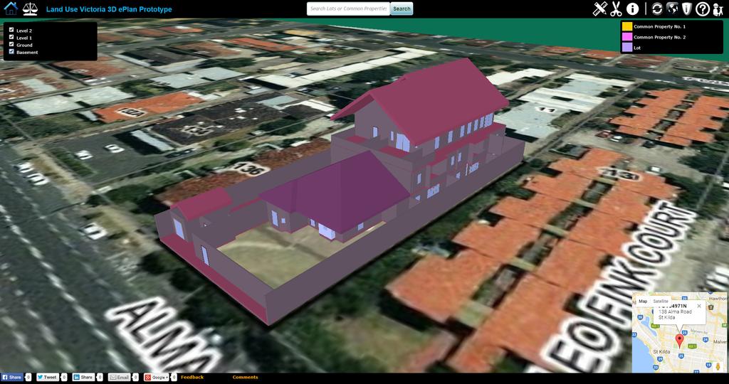
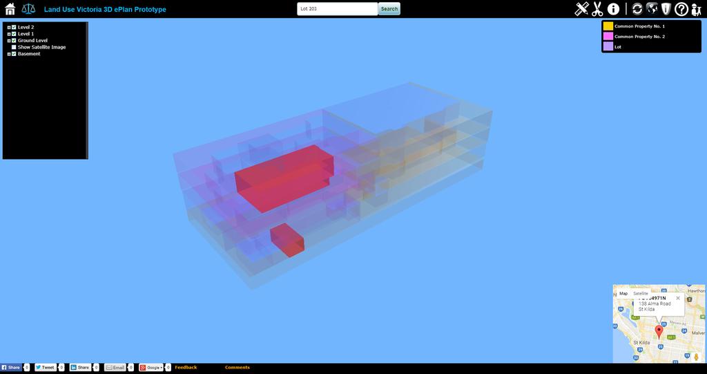
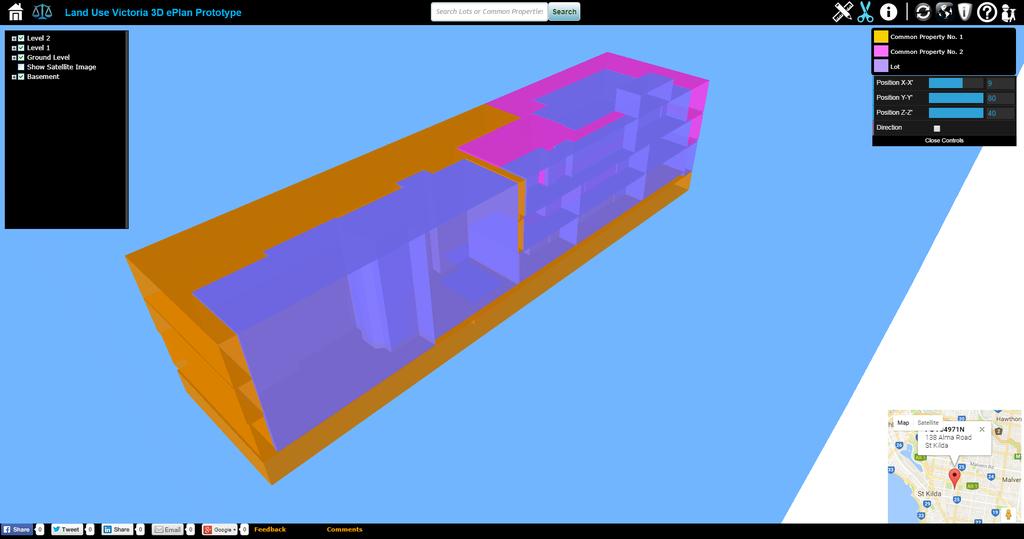
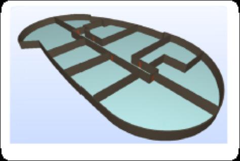
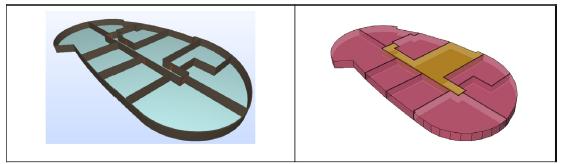
12 3D Data Visualisation


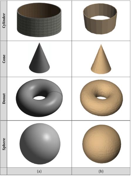
13 3D Data Validation

 (Shojaei, Olfat, Faundez, Kalantari,")

14 3D Validation Rules 1 - Created Parcels for Cancelled Parcels 2 - All Faces must be Flat 3 - Parcel Geometry Closure 4 - Parcel Collision (Clash) (Shojaei, Olfat, Faundez, Kalantari, Rajabifard, Briffa (2017), Geometrical Data Validation in 3D Digital Cadastre A Case Study for Victoria, Australia)
15 FUTURE DIRECTIONS


16 3D Data Model and Data Format for 3D Cadastre

17 3D Digital Registration of Infrastructures Utility Networks Easements Other Infrastructures Bridges Tunnels

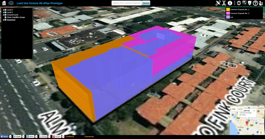
18 Enhancing the 3D eplan Visualisation Prototype Enhancing the prototype according to the feedback received from stakeholders

19 Improving 3D Data Visualisation Using new techniques in visualisation such as Augmented Reality and Virtual Reality to develop applications for 3D digital cadastre purpose (Ref: macfunamizu.com/2009/09/04/red-dot-design-concept-award-2009/)
 validation rules for supporting building")
20 3D Data Validation Extending the current 2D digital cadastre (eplan) validation rules for supporting building subdivisions


21 3D Data Storage
22 Investigating Legal Aspect What would be the legal point of truth for registration of ownership rights? 3D model or 2D plans (PDF/TIFF)? What should be included to the contract of sale as part of transferring ownership, and marketing? Can all stakeholders and courts use 3D legal models for their decision-making process? Do 3D models intend to replace or supplement 2D plans? What are the required changes to the existing regulations to move to 3D? What are the main industry bodies for driving this change and to facilitate its implementation? How should 3D legal disputes be handled? How to raise awareness of 3D legal disputes among professions, e.g. land surveyors, developers, planners?
23 Investigating Institutional Aspect The institutional aspect looks at what processes and roles should change to facilitate the implementation. An institutional framework is required Apply the framework in institutional operations of land and property registration

24 Road Map
25 Collaboration with Universities ARC Linkage Projects: Land and Property Information in 3D 3D Property Ownership Map Base for Smart Urban Land Administration PhD student s research projects: 3D cadastral data modelling 3D cadastral visualisation: understanding users requirements Towards 3D-enabled urban land administration: invisible constraints and strategic choices Building information modelling for urban land administration
26 Collaboration with Universities (Cont.) BSc student s research projects: eplan the challenges and opportunities in creating plans of subdivision in Victoria A comparative study of SPEAR eplan and NZ e-survey Investigating the benefits of eplan for small firms Supporting building subdivision plans in eplan Investigating BIM to provide information for 3D cadastre

27 Thanks! Dr Davood Shojaei eplan Senior Project Officer Electronic Subdivisions Unit Land Use Victoria Department of Environment, Land, Water and Planning T: E: W:
Moving Towards a Fully Operational 3D Digital Cadastre: Victoria, Australia
 Moving Towards a Fully Operational 3D Digital Cadastre: Victoria, Australia Davood Shojaei, Hamed Olfat, Mohsen Kalantari, Mark Briffa, Abbas Rajabifard The University of Melbourne www.mcg.org.au Limitations
3D DIGITAL CADASTRE JOURNEY IN VICTORIA, AUSTRALIA
 3D DIGITAL CADASTRE JOURNEY IN VICTORIA, AUSTRALIA D. Shojaei a, *, H. Olfat a, M. Briffa a, A. Rajabifard b a Land Use Victoria, Department of Environment, Land, Water & Planning, Level 18, 570 Bourke
The Current Status and Ongoing Investigations of 2D and 3D Digital Cadastre (eplan) in Victoria, Australia
 in Victoria, Australia") The Current Status and Ongoing Investigations of 2D and 3D Digital Cadastre (eplan) in Victoria, Hamed Olfat Electronic Subdivisions Unit, Land Use Victoria, DELWP, Victoria, hamed.olfat@delwp.vic. gov.au
The Current Status and Ongoing Investigations of 2D and 3D Digital Cadastre (eplan) in Victoria, Hamed Olfat Electronic Subdivisions Unit, Land Use Victoria, DELWP, Victoria, hamed.olfat@delwp.vic. gov.au
An Overview of the eplan Journey with a Focus on the Victorian eplan 2025 Roadmap Dr Hamed Olfat
 An Overview of the eplan Journey with a Focus on the n eplan 2025 Roadmap Dr Hamed Olfat eplan Coordinator Land Use Chairman of Technical Committee ICSM eplan Working Group Outline eplan Overview ICSM
TOWARDS E-LAND ADMINISTRATION - ELECTRONIC PLANS OF SUBDIVISIONS IN VICTORIA
 TOWARDS E-LAND ADMINISTRATION - ELECTRONIC PLANS OF SUBDIVISIONS IN VICTORIA Mohsen Kalantari 1, Chris Lester 2, David R Boyle 3, Neil Coupar 4 1 eplan Coordinator 2 SPEAR Manager 3 Deputy Surveyor General
Land Administration and Spatial Enablement Victoria s Experience. Chris McRae, Executive Director Land Victoria
 Land Administration and Spatial Enablement Victoria s Experience Chris McRae, Executive Director Land Victoria 4 th UN Land Administration Forum, October 2011 Outline About Land Victoria Land Victoria
Chapter 9: 3D Visualisation as a Tool to Facilitate Managing Land and Properties
 Chapter 9: 3D Visualisation as a Tool to Facilitate Managing Land and Properties Davood Shojaei Overview The rapid population growth and decrease of natural resources have concerned decision makers about
Advanced Principles of 3D Cadastral Data Modelling. 2 nd International Workshop on 3D Cadastres 16 th 18 th November 2011
 Advanced Principles of 3D Cadastral Data Modelling 2 nd International Workshop on 3D Cadastres 16 th 18 th November 2011 Agenda Introduction to the project Drivers for land and property information in
Towards LADM Victoria country profile modelling the spatial information
 Towards LADM Victoria country profile modelling the spatial information Mohsen KALANTARI, Australia and Eftychia KALOGIANNI, Greece Key words: LADM, eplan, Australia, Victoria, Cadastre, Vicmap SUMMARY
THE 2030 AGENDA, CITIES AND URBAN GOVERNANCE A CENTRAL ROLE FOR LAND AND GEOSPATIAL INFORMATION
 THE 2030 AGENDA, CITIES AND URBAN GOVERNANCE A CENTRAL ROLE FOR LAND AND GEOSPATIAL INFORMATION Abbas Rajabifard Immediate Past President and Executive Board Member, GSDI Association Director, Centre for
Land and Property Information in 3D
 Land and Property Information in 3D Abbas Rajabifard Ian Williamson Mohsen Kalantari Brian Marwick Serene Ho Davood Shojaei Complex structures Complex structures UTS Sydney - Dr Chau Chak Wing Building
Land and Property Information in 3D
 Abbas RAJABIFARD, Mohsen KALANTARI and Ian WILLIAMSON, AUSTRALIA Key words: 3D Cadastre; Legislation; Land Administration, Land Development; Property SUMMARY People increasingly live in high density urban,
Cadastre a role model for Private-Public-People-Partnership
 Cadastre 4.0 - a role model for Private-Public-People-Partnership Gerda Schennach, Austria Chair of FIG Commission 7 1 Who owns... buildings? the mountains? land? forests? the sea? infrastructure? 2 From
Land Administration And Spatial Data Infrastructures
 Land Administration And Spatial Data Infrastructures Ian WILLIAMSON, Donald GRANT and Abbas RAJABIFARD Centre for SDIs and Land Administration Department of Geomatics University of Melbourne, Australia
The Survey Data Model Technology A practical survey solution to generate all levels of spatial and e-governance outcomes.
 Land Governance in a Rapidly Changing Environment Annual World Bank Conference on Land and Poverty April 24 & 25, 2012 The Survey Data Model Technology A practical survey solution to generate all levels
The Cadastral Modelling Future and The Land Surveyors Role
 The Cadastral Modelling Future and The Land Surveyors Role Ian Harper Geodata Australia ESRI Survey Summit July 2013 The Land Surveyors Future Role From Custodians of the Cadastre to Custodians of the
PROJECT INFORMATION DOCUMENT (PID) CONCEPT STAGE Report No.: AB3229 Project Name. Land Registry and Cadastre Modernization Project Region
 CONCEPT STAGE Report No.: AB3229 Project Name. Land Registry and Cadastre Modernization Project Region") PROJECT INFORMATION DOCUMENT (PID) CONCEPT STAGE Report No.: AB3229 Project Name Land Registry and Cadastre Modernization Project Region EUROPE AND CENTRAL ASIA Sector Central government administration
PROJECT INFORMATION DOCUMENT (PID) CONCEPT STAGE Report No.: AB3229 Project Name Land Registry and Cadastre Modernization Project Region EUROPE AND CENTRAL ASIA Sector Central government administration
Smart Infrastructure Benefits and Key Players from a Global Perspective
 Smart Infrastructure Benefits and Key Players from a Global Perspective Spatial@gov 2010 October 5-7 Canberra Jude Wallace and Abbas Rajabifard Centre for Spatial Data Infrastructures and Land Administration
CADASTRE 2014: New Challenges and Direction
 CADASTRE 2014: New Challenges and Direction Anna KRELLE and Abbas RAJABIFARD, Australia Key words: Cadastre, Cadastre 2014, Land Administration SUMMARY Land and land related activities form part of the
LAUNCH OF CADASTRAL TEMPLATE 2.0
 LAUNCH OF CADASTRAL TEMPLATE 2.0 Dr. Daniel Steudler Scientific Associate, swisstopo Prof. Abbas Rajabifard Director Centre for SDIs and Land Administration, Melbourne University FIG-Commission 7, Annual
Standardization in the Cadastral Domain. Sub Working Group 1: Legal Aspects
 Standardization in the Cadastral Domain Sub Working Group 1: Legal Aspects Framework 10 participants 8 countries 2 sessions Updates from the different countries (mainly as to the legal aspects of cadastre)
The Cadastral Template 2.0, From Design to Implementation
 Abbas RAJABIFARD (Australia), Daniel Steudler (Switzerland), Ali AIEN, and Mohsen KALANTARI, Australia Key words: Cadastral Template 2.0, Cadastral Template Project, Land Administration, PCGIAP SUMMARY
The Land Information System
 Country report News from the Cadastre in Finland Ari Tella 24.10.2016 FIG Commission 7 Annual Meeting, Coimbra Portugal The Land Information System NLS 2010 Land 2013 Maintenance Information Service Customers
The New Technology of a Survey Data Model and Cadastral Fabric as the Foundation for a Future Land Administration System.
 The New Technology of a Survey Data Model and Cadastral Fabric as the Foundation for a Future Land Ian HARPER, Australia Key words: cadastral modelling, survey data model, Survey Accuracy, Cadastre 2014
Chapter 3: A Framework for a National Land Information Infrastructure
 Chapter 3: A Framework for a National Land Information Infrastructure Brian Marwick Overview As a federated county, Australia s land administration systems are state and territory based. These systems,
PREPARING SURVEY TENDER GIS DATABASE OUTCOMES
 PREPARING SURVEY TENDER SPECIFICATIONS FOR PROJECT GIS DATABASE OUTCOMES Presentation by Ian Harper GEODATA AUSTRALIA ESRI User Conference 2009 24 st July 2009 BACKGROUND GIS databases now provide a more
Section I General Information
 General Information Table of Contents A. Introduction... I-2 1. Purpose... I-2 2. Scope... I-2 3. Maintenance... I-3 4. Units... I-3 B. Public Relations... I-3 1. General Public... I-3 2. Property Owners...
A New Vision on Cadastral Data Model
 Mohsen KALANTARI, Abbas RAJABIFARD, Jude WALLACE and Ian P. WILLIAMSON, Australia Key words: Land administration, cadastre, land parcel, legal property object, interoperability SUMMARY Land administration
Centre for SDIs and Land Administration Department of Geomatics Spatial systems to support sustainable development
 Centre for SDIs and Land Administration Department of Geomatics MODERN CADASTER and LAND ADMINISTRATION تهران-مرداد 1386 2014 ..... 2 ماه Centre for SDIs and Land Administration Department of Geomatics
A Geocoded Cadastral Fabric as a Precondition for a Sustainable Land Management System
 A Geocoded Fabric as a Precondition for a Sustainable Land Management System Gottfried KONECNY, Germany; J.P. LAUZON, Canada; Abdul Salam MOHAMMED, India Key words: SDI,, Parcel Boundaries, GPS-GNSS, Land
EXPLORING OPTIONS FOR STANDARDISATION OF PROCESSES AND TRANSACTIONS IN LAND ADMINISTRATION
 EXPLORING OPTIONS FOR STANDARDISATION OF PROCESSES AND TRANSACTIONS IN LAND ADMINISTRATION CHRISTIAAN LEMMEN (1),(2), EVA-MARIA UNGER (2), PETER VAN OOSTEROM (3), MOHSEN KALANTARI (4) AND KEES DE ZEEUW
A Vision for a Fully Digital Cadastral Survey System
 A Vision for a Fully Digital Cadastral Survey System Anselm HAANEN, Trent GULLIVER, New Zealand Key words: cadastral survey system, digital cadastre, survey plans SUMMARY Surveyors have traditionally prepared
OGC Land Administration Domain Working Group
 Land Administration Domain Working Group Denise McKenzie Open Geospatial Consortium dmckenzie@opengeospatial.org Functions of a Domain Working Group Provide a forum for discussion Develop Change Requests
-the Swedish approach
 Bridging the capacity gap -the Swedish approach Kristin Land Lantmäteriet (The Swedish mapping, cadastral and land registration authority) FIG Commission 7, Bergen, Norway, 25 September 2018 Key players
STATUS REPORT
 Working Group 3 Land Administration STATUS REPORT 2006-2009 2009 Prof Ian Williamson (Chair) Mr Ahmad Fauzi Nordin (Vice Chair) Assoc. Prof Abbas Rajabifard (Vice Chair) 18th UNRCC-AP Conference Bangkok
RAPID ANALYTICS INTERACTIVE SCENARIO EXPLORER (RAISE) A tool for analysing and visualising land valuation in different development scenarios
 A tool for analysing and visualising land valuation in different development scenarios") RAPID ANALYTICS INTERACTIVE SCENARIO EXPLORER (RAISE) A tool for analysing and visualising land valuation in different development scenarios RAISE PROJECT COLLABORATION RAISE DATA DRIVEN APPROACH Rapid
RAPID ANALYTICS INTERACTIVE SCENARIO EXPLORER (RAISE) A tool for analysing and visualising land valuation in different development scenarios RAISE PROJECT COLLABORATION RAISE DATA DRIVEN APPROACH Rapid
From 2D representation of the buildings into cadastral maps towards 3D GIS applications and BIM a case study for Prishtina
 From 2D representation of the buildings into cadastral maps towards 3D GIS applications and BIM a case study for Prishtina This is a Peer Reviewed Paper Fisnik LOSHI, Kosovo Keywords: 3D cadastre, property
Digitalisation of the Real Property Rights Towards Spatially enabled E-Government
 Digitalisation of the Real Property Rights Towards Spatially enabled E-Government Lise Schroeder, Bent Hulegaard Jensen, Esben Munk Soerensen & Line Hvingel Istanbul, Turkey 25 june 201 Overview Introduction
The Journey to 100% Electronic Survey. Land Information New Zealand. August 2009
 The Journey to 100% Electronic Survey and Title Lodgement Land Information New Zealand August 2009 Land Information New Zealand Established 1996 Titles, Survey, Geodetic, Electoral 12 locations 500 staff
Paperless e-surveying with Mr Laptop Surveyor
 Paperless e-surveying with Mr Laptop Surveyor RICHARD ABBOTT Bachelor of Technology (surveying) University Adelaide Licensed surveyor Consulting cadastral surveyor Presented on eve of 32nd year attaining
BIM and 3D property visualisation
 BIM and 3D property visualisation Martin ANDRÉE, Jesper M. PAASCH, Jenny PAULSSON and Stefan SEIPEL, Sweden Key words: 3D Real Property, Property Formation, BIM, Cadastre, standardization, Sweden SUMMARY
Designing for transparency and participation in the Hellenic Cadastral Project
 Designing for transparency and participation in the Hellenic Cadastral Project Dr. Dimitris Rokos Director of Planning and Investments, Hellenic National Cadastre and Mapping Agency S.A. Table of Contents
Securing Land Rights for Broadband Land Acquisition for Utilities in Sweden
 Securing Land Rights for Broadband Land Acquisition for Utilities in Sweden Marija JURIC and Kristin LAND, Sweden Key words: broadband, land acquisition, cadastral procedure, Sweden SUMMARY The European
University of Nairobi LAND INFORMATION SYSTEM FOR LAND MANAGEMENT IN KENYA. CASE STUDY: NAIROBI COUNTY, BURUBURU PHASE I ESTATE
 University of Nairobi LAND INFORMATION SYSTEM FOR LAND MANAGEMENT IN KENYA. CASE STUDY: NAIROBI COUNTY, BURUBURU PHASE I ESTATE BY Justus Amdavi F56/69371/2013 Supervisor: Mr Jasper Mwenda CONTENTS Introduction
Spatial Data Warehouse Ltd. Cadastral Mapping INITIATIVE 1: CADASTRAL MAPPING. Version Spatial Data Warehouse Ltd. & AltaLIS Ltd.
 Spatial Data Warehouse Ltd. Initiative 1: Cadastral Mapping INITIATIVE 1: CADASTRAL MAPPING 29 P3 The SDW/AltaLIS Model Background The Government of Alberta started a mapping program, the Municipal Integrated
COORDINATED CADASTRES - A KEY TO BUILDING FUTURE GIS
 Proceedings of the Regional Conference on Managing Geographic Information Systems for Success, Melbourne, 3-4 July, pp.60-69 (1996). COORDINATED CADASTRES - A KEY TO BUILDING FUTURE GIS Ian P.Williamson
Rights Responsibilities Restrictions (RRRs)
") 37 th Australasian Conference of Registrars of Title 26-29 October 2010, Perth WA Rights Responsibilities Restrictions (RRRs) Any factor which affects the use of public or private land below, or on, or
37 th Australasian Conference of Registrars of Title 26-29 October 2010, Perth WA Rights Responsibilities Restrictions (RRRs) Any factor which affects the use of public or private land below, or on, or
The Site 485 Dohertys Road Truganina
 Cadastral Examples Examples of cadastral surveys carried out over the years, incorporating some re-establishment issues and surveying (and thought) processes, conflicts and agreements with adjoining surveys,
3D Cadastres and Beyond
 Abbas RAJABIFARD, Australia Key words: 3D Cadastres, Land Administration, Building Information Models, Urbanisation SUMMARY How does the cadastre deal with an urban environment that is increasingly populated
Seventh Session of the United Nations Committee of Experts on Global Geospatial Information Management
 Report of the Forum P a g e 1 Seventh Session of the United Nations Committee of Experts on Global Geospatial Information Management Report of the Forum Secure Land Rights and Smart Cities - Making It
Lessons for federated countries that have state land registries the Australian experience
 Lessons for federated countries that have state land registries the Australian experience Ian Williamson Centre for SDI and Land Administration Department Infrastructure Engineering University of Melbourne
Preprint.
 http://www.diva-portal.org Preprint This is the submitted version of a paper presented at 10th EC GI & GIS Workshop, ESDI State of the Art, Warsaw, Poland, 23-25 June 2004. Citation for the original published
Rethinking social housing (e 6 ) efficiency - effectiveness - equity - economy - environment - evaluation
 efficiency - effectiveness - equity - economy - environment - evaluation") Australian Housing Researcher s Conference 18-20 February 2015, Hobart, Australia Rethinking social housing (e 6 ) efficiency - effectiveness - equity - economy - environment - evaluation Dr Judy A Kraatz,
Australian Housing Researcher s Conference 18-20 February 2015, Hobart, Australia Rethinking social housing (e 6 ) efficiency - effectiveness - equity - economy - environment - evaluation Dr Judy A Kraatz,
REGISTRATION OF PROPERTIES IN STRATA
 REGISTRATION OF PROPERTIES IN STRATA REPORT ON THE WORKING SESSIONS INTRODUCTION A cadastre is usually, and in most countries, a parcel-based, and up-to-date land information system containing records
The Digital Lodgement. of Cadastral Survey Data. in Victoria
 The Digital Lodgement of Cadastral Survey Data in Victoria by Katie Maree Falzon A thesis submitted in fulfillment of the requirements for the degree of Master of Geomatics Science December, 1998 Department
Key Registers in Finland and some views of Cadastre 2035
 Presented at the FIG Working Week 2016, May 2-6, 2016 in Christchurch, New Zealand Key Registers in Finland and some views of Cadastre 2035 FIG Working Week, Christchurch New Zealand May, the 3rd, 2016
Surveyors Qualifications
 Surveyors Qualifications Præludium Surveyors Qualifications Lars Jansson, Director Lantmäteriet Henning Elmstrøm, President DdL 1 Agenda 1. Introduction 2. Basic framework conditions for cadastral systems
Cadastre and Land Registration in Europe
 Annex A: Questionnaire 2007 for Information Resource Cadastre and Land Registration in Europe Introduction This questionnaire is based on the EuroGeographics vision document 'Cadastre and Land Registration
New Developments in the Hellenic Cadastre
 New Developments in the Hellenic Cadastre Prof. M. Kavouras Vice-president Ktimatologio S.A. (Hellenic Cadastre) The Hellenic Cadastre Background The Hellenic National Cadastre Organizational and institutional
Strata Titles Act Reform Consultation Summary
 Strata Titles Act Reform Consultation Summary landgate.wa.gov.au Strata Titles Act Reform - Consultation Summary Overview The State Government has set strata reform as a key priority and Landgate has been
Working with our industry partners to bring PEXA to the market
 Working with our industry partners to bring PEXA to the market Key reference terms e-conveyancing The facilitation of electronic settlements NECDL National e-conveyancing Development Limited PEXA Property
VESTED PROPERTY RIGHTS APPLICATION
 The is here to assist you with your development application pursuant to the Community Development Code (CDC). This publication outlines the Vested Property Rights Development Application process of the
Initial Design to Develop a Cadastral System that Supports Digital Cadastre, 3D and Provenance for Singapore
 Initial Design to Develop a Cadastral System that Supports Digital Cadastre, 3D and Provenance for Singapore Kean Huat SOON, Derick TAN and Victor KHOO, Singapore Key words: SG LandXML, SG LADM, 3D, Provenance
Informal Intergovernmental Relations in Land Administration Systems
 Informal Intergovernmental Relations in Administration Systems Christian Clausen M.Sc., PhD-student Aalborg University & the National Survey and Cadastre, Denmark The trigger e - Title registration system
PROPERTY ASSESSMENT KNOWLEDGE
 A P E N DE UM NOUN A COLLECTION OF CONCISE BUT DETAILED INFORMATION ABOUT APPRAISAL AND APPRAISAL MANAGEMENT, ESPECIALLY IN THE PROPERTY ASSESSMENT INDUSTRY. PROPERTY ASSESSMENT KNOWLEDGE KNOWLEDGE AREAS
The Register of the Domain of the State, Cadastre 2014 and LADM
 The Register of the Domain of the State, Cadastre 2014 and LADM Bruno Gilbert, Christian Lord, Daniel Roberge Foncier Québec 29 e réunion ISO/TC 211 Québec, 4 novembre 2009 Presentation plan Context Modernization
Exhibition: Environmental Planning and Assessment Amendment (eplanning) Regulation SydneyNSW2000
 Regulation SydneyNSW2000") Exhibition: Environmental Planning and Assessment Amendment (eplanning) Regulation 2017 Date submission received: 14/03/2017 Name: Veronica Bondarew Location: Submission form content: SydneyNSW2000 N/A
Exhibition: Environmental Planning and Assessment Amendment (eplanning) Regulation 2017 Date submission received: 14/03/2017 Name: Veronica Bondarew Location: Submission form content: SydneyNSW2000 N/A
The phased 3D Cadastre implementation in the Netherlands
 The phased 3D Cadastre implementation in the Netherlands 27-10-2012 Jantien Stoter 1,2, and Peter van Oosterom 1 and Hendrik Ploeger 1 1 OTB TU Delft 2 Kadaster, Apeldoorn Delft University of Technology
Parcel Boundaries in the Czech Republic
 Parcel Boundaries in the Czech Republic CZECH REPUBLIC Jiri Rydval, Libor Tomandl Czech Office for Surveying, Mapping and Cadastre inhabitants - 10.3 million territory 78,865 km 2 2 Contents: 1. A parcel
Marine Spatial Data Infrastructure (MSDI) & The Marine Cadastre Application. April 10, 2018
 & The Marine Cadastre Application. April 10, 2018") Marine Spatial Data Infrastructure (MSDI) & The Marine Cadastre Application April 10, 2018 A Collaborative Pilot Project Vision of CHS: A framework of geographic data, metadata, users and tools Intent
Marine Spatial Data Infrastructure (MSDI) & The Marine Cadastre Application April 10, 2018 A Collaborative Pilot Project Vision of CHS: A framework of geographic data, metadata, users and tools Intent
Subdivisions and Permit Conditions for Electricity Supplies. A guide to our requirements
 Subdivisions and Permit Conditions for Electricity Supplies A guide to our requirements Subdivisions and Permit Conditions for Electricity Supplies... 1 Definitions... 3 Introduction... 5 Making an Electricity
Overview of PCGIAP-WG3 and Spatially Enabled Government
 Working Group 3 3 rd Land Administration Forum Overview of and Spatially Enabled Government Abbas Rajabifard Vice Chair, Established in 2000 based on a Resolution from the 15th UNRCC-AP in Malaysia. With
INVESTIGATION INTO DELAYS IN ISSUING TITLE DEEDS TO BENEFICIARIES OF HOUSING PROJECTS FUNDED BY THE CAPITAL SUBSIDY. 13 April 2012
 INVESTIGATION INTO DELAYS IN ISSUING TITLE DEEDS TO BENEFICIARIES OF HOUSING PROJECTS FUNDED BY THE CAPITAL SUBSIDY 13 April 2012 Contents Introduction Process of registering land in South Africa Factors
LADM-based Crowdsourced 3D Cadastral Surveying Potential and Perspectives
 National Technical University Of Athens School of Rural and Surveying Engineering LADM-based Crowdsourced 3D Cadastral Surveying Potential and Perspectives Maria Gkeli, Surveying Engineer, PhD student
A 3D Digital Cadastre for New Zealand by 2021: Leveraging the Current System and Modern Technology
 A 3D Digital Cadastre for New Zealand by 2021: Leveraging the Current System and Modern Technology Trent GULLIVER, Anselm HAANEN and Mark GOODIN, New Zealand Key words: 3D Cadastral System, 3D Cadastre,
Cadastral Workshops for NSW BoSSI Candidates
 Cadastral Workshops for NSW BoSSI Candidates Registration in NSW History ISNSW Workshops 2006 2014 What s happening in other Australian States Is it worth It? What s next? Registration in NSW Can be by
Land and Geographic Information, an Important Part of the Infrastructure in Sweden
 Land and Geographical Information Land and Geographic Information, an Important Part of the Infrastructure in Sweden Land and Geographic Information, an Important Part of the Infrastructure In Sweden Bo
Developing a Performance Review Questionnaire for Hong Kong Cadastral Survey System
 Developing a Performance Review Questionnaire for Hong Kong Cadastral Survey System Haodong ZHANG and Conrad TANG, Hong Kong SAR, CHINA Key words: Fit-for-Purpose, Cadastral Surveying, Land Administration,
Building Integrated Land Information Systems and Development of NSDI
 Stig JÖNSSON, Sweden Key words: Land administration, land information systems, property formation, spatial data infrastructure, Inspire, institutional cooperation SUMMARY Lantmäteriet the Swedish agency
Promoting Socio Economic Inclusion through CBD Developments : Infrastructure and the economic case for investment in affordable housing.
 Promoting Socio Economic Inclusion through CBD Developments : Infrastructure and the economic case for investment in affordable housing October 2016 The point of the presentation Institutional investment
ANNOUNCEMENT OF PHASE 2 REQUIREMENTS TO FILE LAND TITLE FORMS ELECTRONICALLY
 ANNOUNCEMENT OF PHASE 2 REQUIREMENTS TO FILE LAND TITLE FORMS ELECTRONICALLY October 31, 2011 Pursuant to s. 168.111 of the Land Title Act, I am announcing the second phase of requirements to file certain
Produce survey data for a cadastral dataset
 Page 1 of 5 Produce survey data for a cadastral dataset Level 6 Credits 10 Purpose This unit standard is for people who are working, in the surveying profession as a survey technician. People credited
RAPID ANALYTICS INTERACTIVE SCENARIO EXPLORER (RAISE) A tool for analysing and visualising land valuation in different development scenarios
 A tool for analysing and visualising land valuation in different development scenarios") RAPID ANALYTICS INTERACTIVE SCENARIO EXPLORER (RAISE) A tool for analysing and visualising land valuation in different development scenarios RAISE PROJECT COLLABORATION RAISE DATA DRIVEN APPROACH Rapid
RAPID ANALYTICS INTERACTIVE SCENARIO EXPLORER (RAISE) A tool for analysing and visualising land valuation in different development scenarios RAISE PROJECT COLLABORATION RAISE DATA DRIVEN APPROACH Rapid
Installation Boundary Mapping and the DoD Real Property Inventory Program
 Installation Boundary Mapping and the DoD Real Property Inventory Program 11 October 2007 SAME Mid-Atlantic Regional Conference Jeff Swallow Real Property History Real Property data reported to the Office
How open is Open BIM? Pantelis Ioannidis. Digital Construction Week London, 19 October 2017
 How open is Open BIM? Pantelis Ioannidis Digital Construction Week London, 19 October 2017 Me! About Us 104 staff in London, UK and Lodz, Poland 5 Directors 12 Project Directors 16 Associates 24 Architects
Delivering 3D Land and Property Management: A Consideration of Institutional Challenges in an Australian Context
 Delivering 3D Land and Property Management: A Consideration of Institutional in an Australian Context Serene HO and Abbas RAJABIFARD, Australia Key words: institutions, 3D, land and property, information,
Amalia Velasco Carlos Alonso Luis Virgos Fernando Serrano
 Inspire services of the Spanish Directorate General for Cadastre and its use to resolve an old problem of coordination between Spanish Cadastre and Land Registry. Amalia Velasco Carlos Alonso Luis Virgos
Field surveying inspection using tablets
 Field surveying inspection using tablets Rami Farraj, Ahmad Sghyyer Survey of Israel, Lincoln 1, Tel-Aviv, Israel rami@mapi.gov.il ahmad@mapi.gov.il Key words: Field Surveying, Cadastre, Mapping Procedures
An Overview of 3d Cadastre from a Physical Land Parcel and a Legal Property Object Perspective
 An Overview of 3d Cadastre from a Physical Land Parcel and a Legal Property Object Perspective Sudarshan KARKI, Kevin MCDOUGALL, Rod THOMPSON, Australia Key words: 3D Cadastre, property object, land parcel
DWGM and Victorian Gas FRC Final budget and Fees June Australian Energy Market Operator Limited
 DWGM and Victorian Gas FRC Final budget and Fees 2018-19 June 2018 Australian Energy Market Operator Limited $/GJ Introduction AEMO operates on a cost recovery basis as a company limited by guarantee under
PROGRAM PRINCIPLES. Page 1 of 20
 PROGRAM PRINCIPLES Page 1 of 20 DEVELOPMENT OF THE PROGRAM PRINCIPLES The Program Development Project The Program Principles have been developed as part of the Planning Our Future Program Development Project
Land Information System as new instrument for Land Administration: Case Examples. Mike Cheremshynskyi Consultant, Land Administration Expert
 Land Information System as new instrument for Land Administration: Case Examples Mike Cheremshynskyi Consultant, Land Administration Expert Background Growth of population and fast urbanization in many
Trip Rate and Parking Databases in New Zealand and Australia
 Trip Rate and Parking Databases in New Zealand and Australia IAN CLARK Director Flow Transportation Specialists Ltd ian@flownz.com KEYWORDS: Trip rates, databases, New Zealand developments, common practices
TCP PROJECT AGREEMENT SUPPORT GOVERNMENT IN FORMULATION OF A NATIONAL AND GENDER SENSITIVE LAND POLICY GUIDED BY THE VGGT PRINCIPLES
 TCP PROJECT AGREEMENT SUPPORT GOVERNMENT IN FORMULATION OF A NATIONAL AND GENDER SENSITIVE LAND POLICY GUIDED BY THE VGGT PRINCIPLES THE PROBLEM Insecure tenure rights Property rights contestation Poor
E fficient L and A dministr ation E ncour ages P r oper ty M ar k ets. surveying companies at Project commencement. Key Messages
 Secur ing Pr oper ty R ights and I ncr easing R eal E state Pr oductivity in F Y R M acedonia Victoria Stanley, Denis Boskovski and Samantha De Martino Key Messages Before 2005, FYR Macedonia did not have
Agenda Project Overview Project Objectives Registration Service Re-Engineering System Overview
 Agenda Project Overview Project Objectives Registration Service Re-Engineering System Overview Sydney, Australia, 11 16 April 2010 1 Project Overview Future Vision There is a vision within senior levels
APPLICATION FOR MAJOR SUBDIVISION APPROVAL (FINAL PLAT)
") 209 S. Main Street Marysville, Ohio 43040 Phone: (937) 645-7350 Fax: (937) 645-7351 www.marysvilleohio.org APPLICATION FOR MAJOR SUBDIVISION APPROVAL (FINAL PLAT) *** IMPORTANT INFORMATION ~ Please read
209 S. Main Street Marysville, Ohio 43040 Phone: (937) 645-7350 Fax: (937) 645-7351 www.marysvilleohio.org APPLICATION FOR MAJOR SUBDIVISION APPROVAL (FINAL PLAT) *** IMPORTANT INFORMATION ~ Please read
BBOP-EU NNL WORKSHOP. Biodiversity offsets and the credit market Victoria, Australia. Michael Crowe. May 2013
 BBOP-EU NNL WORKSHOP Biodiversity offsets and the credit market Victoria, Australia Michael Crowe May 2013 Outline 1. Biodiversity offsetting in Victoria 2. Implementation of offsets the credit market
Supporting Capacity Development for Sustainable Land Administration Infrastructures
 THE EIGHTH UNITED NATIONS REGIONAL CARTOGRAPHIC CONFERENCE FOR THE AMARICAS (UNRCCA) 27 June 1 July 2005, United Nations Headquarters, New York Supporting Capacity Development for Sustainable Land Administration
FINAL MPUD APPLICATION
 The Department is here to assist you with your development application pursuant to the Community Development Code (CDC). This publication outlines the Final MPUD Development Application process of the