City of Sanibel. Planning Department STAFF REPORT
|
|
|
- Brett Wright
- 5 years ago
- Views:
Transcription

1 City of Sanibel Planning Department STAFF REPORT Planning Commission Meeting: July 29, 2014 Planning Commission Agenda Item: No. 6c Application Number: DP Applicant Name: Attorney Beverly Grady on behalf of the property owner and developer, Sanibel Bayous Development Corporation RE: Consideration of a request for development permit and preliminary plat approval, in lieu of a 35 single-family lots and dwelling units subdivision approved in 2004, allowing for the Major Subdivision of a 76.2 acre parcel of land, herein referred to as Wulfert Pointe Estates, into a unified residential (cluster) development, to occur in three (3) separate and designated phases, consisting of 34 single-family lots and dwelling units, a tract for private roadways with drainage and utility easements, several tracts for conservation, and the dedication of additional public right-of way along Sanibel-Captiva and Wulfert Roads. The subject property is adjacent to the southernmost extension of Wulfert Road and is formerly known as Phase III of Sanibel Bayous Subdivision- North of Sanibel-Captiva Road. The subject property consists of lands designated by the following tax parcel numbers: T ; T ; and T ISSUES 1. Does the subject development permit application, submitted for preliminary plat approval, satisfy all applicable requirements of Chapter 114 Subdivision - of the Land Development Code? 2. Does the subject development permit application meet the subdivision standards of Land Development Code Section ? K: planning: PLANNING COMMISSION: 2014 PC Mtgs: PC Mtg Page 1 of 23
2 3. How will the active bald eagle nest be protected and monitored during the development of the proposed subdivision? 4. How will the historical Oliver F. Bowen Grave Site be protected and preserved and the public provided access to view this historical landmark? 5. What appropriate conditions shall be attached to the approval of this request to ensure, in perpetuity, the implementation of the best management practices and plan for the conservation and preservation of existing natural resources including the protection of existing wildlife and wildlife habitat and wetlands? BACKGROUND Sanibel Bayous Development Corporation is the developer and owner of the subject property. The subject property has also been referred to as Phase III of Sanibel Bayous. In 2002, the Planning Commission adopted Resolution No , which established the residential density for Phase III of Sanibel Bayous at 35 dwelling units. On April 09, 2004, Development Permit Application No was submitted for preliminary plat approval as a Major Subdivision. The application was scheduled for a public hearing before the Planning Commission in July of The hearing, however, was continued to allow the applicant the opportunity to address additional review issues and insufficiencies associated with the request that were identified in the Planning Department s Staff Report dated July 16, After the cancellation of the next hearing scheduled for October 25, 2005, due to an evacuation order for Hurricane Wilma and the continuation of the rescheduled public hearing held on November 22, 2005, the Planning Commission, on December 13, 2005, adopted Resolution approving application DP for a Major Subdivision for 35 residential lots and dwelling units. The preliminary plat approval became effective on this date and was valid for a period of two years. On February 7, 2006, City Council adopted Resolution approving the dedications of right-of-way, public recreation area, maintenance easements, conservation easements and preservation easements; and the formal acceptance of such dedications to occur as part of the final plat approval. K: planning: PLANNING COMMISSION: 2014 PC Mtgs: PC Mtg Page 2 of 23
3 On August 14, 2007, Sanibel Bayous Development Corporation requested to amend Planning Commission Resolution No to provide for an additional two-year extension of the Preliminary Plat approval for Development Permit No The Planning Commission adopted Resolution No , which allowed for a one time, two year extension while the applicant waited to receive permitting approval from the South Florida Water Management District. In December 2007, the property owner was put on notice by the City that a pair of bald eagles was observed actively nesting on the subject property. A permit application was submitted to Florida Fish and Wildlife Conservation Commission. Based upon the Commission s 2007 Bald Eagle Nesting Guidelines a 660 feet buffer was required around the nest for all construction activities occurring during nesting season, between October 1 st and May 15 th, and a 330 feet buffer around nest during non-nesting season. During the economic downturn deteriorating conditions within the real estate market seem to have impeded the progress of the subdivision. Over the last several years permits have been issued, under the initial preliminary plat approval, to allow the property owner to perform some limited site alteration, relocate impacted native vegetation elsewhere on site and to remove invasive exotic vegetation. The property owner met with City Staff in February of this year to submit a revised preliminary plat. The revised preliminary plat changed the arrangement and configuration of the lots to accommodate and preserve wildlife and wildlife habitat. It also reduced the total number of residential lots and dwelling units from 35 to 34. PROPOSAL The subject request is for the preliminary plat approval of a Major Subdivision application to subdivide a 76-acre parcel of land into a unified residential development. The proposed Wulfert Pointe Estates subdivision will consist of: Thirty-four (34) single-family lots ranging in size from 27,000 S.F. to 59,000 S.F; A Tract A to accommodate proposed infrastructure improvements, including a private paved roadway with utility and drainage features; A Tract B for a dedicated public park; and The dedication of 22 of additional public right-of-way along Sanibel- Captiva Road and the dedication of 15 of additional public right-of-way along both sides of Wulfert Road to the City of Sanibel; K: planning: PLANNING COMMISSION: 2014 PC Mtgs: PC Mtg Page 3 of 23
4 Four (4) elevated boardwalks and one (1) grade level walkway are proposed for purposes of providing access to the water bodies adjacent to the subject property for passive recreational use. Four preserve areas A through E The construction, completion and recording of the subdivision will occur in three (3) separate phases. As proposed Phase I will include lots 24-34, Phase II will include Lots and Phase III will include Lots 1-10, and Lot 22 and 23. A narrative prepared for and submitted with the application is included with this report as Attachment A. ANALYSIS Pursuant to Land Development Code Section , Planning Commission approval of the proposed preliminary plat may only be granted when each lot or parcel of the proposed subdivision and the entire parcel being subdivided is in compliance with all requirements of the Land Development Code and the Sanibel Plan. The following analysis will address certain compliance requirements including any issues or concerns identified by staff during the review of this application. According to the survey, the subject property consists of 76.2 acres. The following table provides the various components of the revised preliminary plat and their acreage. Site Data Total Acreage Lots 1 thru Preserves A thru E Tract A Road and Drainage 4.41 Open Space 1.20 Tract B.27 Total *Note The preserve area calculations contain open bodies of water that must be excluded when determining the net size of the subject parcel of land. Impervious Surface Coverage, Vegetation Removal and Developed Area Land Development Code Section Subdivision Standards (3) states that limitations on vegetation removal, developed area and coverage with impermeable surfaces. Limitations on vegetation removal, developed area, and impermeable surfaces shall apply to such individual lots in the following manner: K: planning: PLANNING COMMISSION: 2014 PC Mtgs: PC Mtg Page 4 of 23
5 a. The maximum permitted vegetation removal, developed area and impermeable surfaces for the entire parcel shall be calculated. This total shall not be exceeded in apportionment of the total to individual lots and tracts. b. Appropriate limitations on vegetation clearance, developed areas and coverage with impermeable surfaces shall be allocated to preservation and common area tracts. These areas shall then be subtracted from the maximums permitted. c. The remaining permitted vegetation clearance, developed area and coverage with impermeable surfaces shall be apportioned to the individual lots in proportion to the size of the lot and the number of dwelling units permitted thereon. d. However, no individual lot larger than 5,000 square feet and designated for a dwelling unit shall be apportioned: 1. More than 50 percent of the land area of the individual lot or less than 2,000 square feet of area for developed area; 2. More than 50 percent of the land area of the individual lot or less than 2,000 square feet of area for vegetation clearance; and 3. More than 45 percent of the land area of the individual lot, or less than 1,800 square feet of area for coverage with impermeable surfaces. According to the revised Wulfert Pointe Estates preliminary plat, consisting of sheets 1-3 and prepared by Barraco and Associates, Inc., the net size of the subject property, existing roadways and 5.97 acres of open bodies of water, is acres. The various ecological zones on the site consist of Mangrove Forest (C), Lowland Wetlands (D-1), Upland Wetlands (D-2), and Mid-Island (F). The following table identifies the various ecological zones in acreage and square footage. Ecological Zones Acreage Square Footage Mangrove Forest C ,485 Lowland Wetlands D ,936 Upland Wetlands D ,855 Mid-Island Ridge F ,044,617 Based upon the limitations of Land Development Code Section Subdivision Standards (3), the proposed preliminary plat sufficiently demonstrates compliance with the maximum allowed 45% coverage with impermeable surfaces and 50% K: planning: PLANNING COMMISSION: 2014 PC Mtgs: PC Mtg Page 5 of 23
6 developed area and vegetation clearance. Sheet 3 of the revised preliminary plat contains the apportionment for each of the 34 residential lots. A copy of the revised preliminary plat is included with this report as Attachment B. Preliminary Plat Information Land Development Code Section Preliminary Plat, states that the preliminary plat shall be clearly and legibly drawn or reproduced at a scale of not less than one inch equals 100 feet. The preliminary plat shall be designed and drawn by a licensed and registered land surveyor or professional engineer and shall show or be accompanied by the following information: (1) A key map showing the entire subdivision and its relation to surrounding areas. (2) The tract name, tax strap number, date, reference meridian, graphic scale and the following names and addresses: a. Name and address of record owner. b. Name and address of developer and authorization from owner. c. Names and addresses of persons who prepared the map. (3) Acreage of the tract to be subdivided to the nearest tenth of an acre. (4) Existing and proposed contours at one-foot vertical intervals for lands of lesser slope. Datum of all elevations shall be that of the United States Geodetic Survey. (5) Location of existing and proposed property lines, street rights-of-way within the subdivision and within 200 feet of its boundaries, street names, location and width of right-of-way and pavement, and type of pavement, structures, watercourses, bridges and culverts, drain facilities, and any prominent natural feature, such as vegetated areas and wetlands. (6) Plans for proposed utility layouts (sewers, storm drains, water, gas and electricity) showing feasible connections to existing or any proposed utility system. When individual water supply or sewage disposal systems are proposed, the plans for such systems shall be approved by the appropriate local and state agencies. When a public sewer system is not available, the developer shall have percolation tests made and submit the results with the construction plans. (7) A note or statement that the property is located in a special flood hazard area on the National Flood Insurance Program's flood insurance rate maps. K: planning: PLANNING COMMISSION: 2014 PC Mtgs: PC Mtg Page 6 of 23
7 (8) A copy of any restrictive covenants or deed restrictions applying to the land being subdivided shall be submitted with the preliminary plat. (9) The preliminary plat shall be accompanied by a written summary of the proposal giving information as to the overall development plan with preliminary data on the planned number of dwelling units or other permitted uses contemplated, so that the effects of the development can be determined to ensure that the development is in accordance with the Sanibel Plan and this land development code. (10) Any and all other information that the developer may wish to integrate on his or hers preliminary plans as otherwise required for development permit approval. (11) A preliminary plat may be approved by the planning commission for development to occur in separate, designated phases where an application includes a request for a phased plat approval and the planning commission finds that the number of lots to be approved or the facilities or improvements to be located within the platted area warrant construction, completion and recording in separate phases, or alternatively finds that a phased preliminary plat is in the best interests of the City of Sanibel. For a phased preliminary plat approval, the time periods for the completion and recording of a final plat as set forth in this section shall be applicable to each phase individually and the commencement of the initial two-year time period for each subsequent phase shall commence: (1) Upon approval and recording of the final plat for the prior phase; or (2) Upon the issuance of any development permit for improvements or development authorized by such subsequent preliminary plat phase. A condition of a phased preliminary plat approval shall be that any and all dedications or contributions of land or other rights or resources for the entire plat shall be made, dedicated or provided, as applicable, as a condition of the first approved phase. As submitted the proposed application substantially complies with the above informational requirements of Land Development Code Section Preliminary Plats. Bowen Gravesite The subject property contains a historical landmark known as the Oliver F. Bowen gravesite. This ten-foot square gravesite was placed on the City s local Register of Historic Landmarks on May 21, The location of the gravesite is depicted on K: planning: PLANNING COMMISSION: 2014 PC Mtgs: PC Mtg Page 7 of 23
8 the revised preliminary plat as a 25 x 30 viewing tract along the road frontage of one of the subdivision s private streets and is situated between Lots 1 and 3 of Phase III. The applicant will need to dedicate this Tract of land to the City, along with an easement that preserves the historic landmark, provides public access and off-street parking for one car at the proposed community park on Tract B. In addition, it should also be required that there are no alteration, construction, relocation or demolition activities within the location of this historic landmark tract. Wetlands, Wildlife and Wildlife Habitat Management and Preservation Included with this report as Attachment C is a copy of a memorandum from James Evans, Director of Natural Resources dated July 21, In this memorandum Director Evans addresses the following natural resources issues associated with the proposed development and preliminary plat application, which includes: 1. The presence of an active American bald eagle (Haliaeetus leucocephalus) nest; 2. Extensive gopher tortoise habitat and the presence of a relatively large number of active gopher tortoise (Gopherus polyphemus) burrows; 3. Several acres of rare barrier island coastal scrub habitat; and 4. Extensive mangrove and buttonwood wetlands. The Florida Fish and Wildlife Conservation Commission (FWC) regulate and permits activities adjacent to eagle nests, which may have the potential of disturbing an active nest. The FWC permit, held by the applicant, includes various conditions that must be followed during each phase of the subdivision s construction. One of the conditions states that at no time are construction vehicles permitted to get closer than 100 feet from the eagle nest; this includes nesting and non-nesting periods. Exterior construction activities within 330 feet of the nest tree are prohibited during nesting season from October 1 through May 15, or when eagles are nesting prior to October 1 or after May 15. All efforts must be made by the applicant to mitigate potential impacts that would result in a taking of the nest. This includes adhering to area buffer zones specified in the FWC permit, enhancing vegetation buffers around the nest tree, noise abatement, habitat conservation and mitigation requirements, monitoring requirements, and the phasing of development so that Phase III, where the eagle nest is located, is developed last. The site contains a relatively large number of gopher tortoises. There are 26 active burrows and 41 abandoned burrows that have been identified by the applicant s environmental consultants. To protect the quality coastal scrub habitat on the site and to protect the greatest number of active gopher tortoise burrows the applicant should: K: planning: PLANNING COMMISSION: 2014 PC Mtgs: PC Mtg Page 8 of 23
9 1. Install at-grade wildlife crossings under the roadway between lots 24 and 1 and between preserve areas D and E. 2. Incorporate within the community bylaws requirements for maintaining appropriate tortoise crossing signage and other educational materials for the homeowners about living with tortoises including, but not limited to, a Gopher Tortoise Community Management Plan and an annual gopher tortoise survey and report on the single-family lots only. 3. Install split rail fence on all three sides of preserve areas D and E, with no fencing required between the roadway buffer of Preserve Area D, and between the boundary of Preserve Areas E and B. For the boundaries between the Preserve Areas A, B, and C and all of the residential lots, incorporate within the community by-laws that split rail fencing shall be installed by the individual lot owners when they develop their lots. In addition, temporary split rail fence or other similar elevated barrier shall be placed between the active and inactive phases of the development. The site contains approximately 5.78 acres of rare barrier island coastal scrub habitat. The revised preliminary plat will preserve approximately 3.9 acres of the 5.78 acres or 68% of existing coastal scrub onsite. All efforts should be made to protect these trees and other protected species in-place and they should only be transplanted as a last resort. The applicant proposes five separate ten foot wide drainage & boardwalk easements to access adjacent bodies of water. These easements are proposed within the wetland preserve areas. To minimize impacts on the adjacent buttonwood and mangrove wetlands, the following conditions should be considered by the Planning Commission: 1. The elevated boardwalk structures should not exceed 6 feet in total width, as measured at the widest point of the boardwalk; 2. All efforts shall be made to avoid larger trees (>4 DBH), and all trees impacted must either be relocated or mitigated in accordance with the City s Vegetation Standards (Sanibel LDC Section ) and Mangrove Trimming and Preservation Ordinance (Sanibel LDC Section 38-71); 3. Adjacent property owners do not have riparian rights and are not entitled to views of the water bodies, trimming of vegetation in preserve areas is strictly prohibited; and K: planning: PLANNING COMMISSION: 2014 PC Mtgs: PC Mtg Page 9 of 23
10 4. Trimming of mangroves or other vegetation within the drainage and boardwalk easements or preserve areas is strictly prohibited, except to maintain safe ingress and egress to lawfully constructed boardwalks or other approved structures. The 50 foot easement for City access to the Clam Bayou box culvert has been included in the new preliminary plat and should be included the final approved plat. All Brazilian pepper in all three phases of the project must be removed immediately and the site maintained free of pepper in perpetuity. All work should be performed by hand without the use of heavy equipment. All zones within the City s Brazilian Pepper Eradication Program are now mandatory. The presence of Brazilian pepper on any property on Sanibel constitutes a violation of Sanibel LDC Section The approved Management Plan for Gopher Tortoise, prepared by Boylan Environmental Consultants, Inc. dated Revised December 6, 2005 shall be applicable to the revised plat and shall reference the updated tortoise survey maps provided by Eco Planz, Inc. dated April 6, PROCEDURES Land Development Code Section , Procedures, states in part that an Application for approval of a major subdivision shall be as for a long-form development permit pursuant to the terms of Chapter 82. Under Land Development Code Section , the procedures for preliminary plat approval are as follows: (1) The development permit application shall be accompanied by a preliminary plat prepared in conformance with the requirements of section (2) If the proposed subdivision includes, or if the Planning Commission requires as a condition of approval, that the subdivider dedicates land or contribute funds toward public facilities, preliminary plat approval shall not be complete unless and until such required dedication or contribution is reviewed and approved by the City Council. (3) No development permit shall be issued for the land subdivision unless and until the remaining requirements of this chapter relating to required improvements, construction plans, and submission, approval, and recording of final plat, are completed in accordance herewith. K: planning: PLANNING COMMISSION: 2014 PC Mtgs: PC Mtg Page 10 of 23
11 (4) Preliminary plat approval shall be effective and valid for a period of two years. The planning commission may, however, extend this effective period for an additional two years, provided that, at the time such extension is granted, the preliminary plat continues in compliance with all requirements of this land development code and the Sanibel Plan. If all requirements for approval of a final subdivision plat, and the recording of such plat, are not completed within the time period for which preliminary approval is valid and effective, such preliminary approval and all rights conferred thereby shall be terminated and expire. (5) Preliminary plat approval may be extended by City council for an additional period of time beyond the two-year effective time period and the two-year extension that may be approved by the planning commission due to the necessity of achieving compliance with federal, state or local regulations pertaining to endangered or protected species and respective habitat or due to other unforeseen environmental conditions. An application for such an extension may be filed with the City manager, or designee, for consideration by City council. Such application will be filed in a form prescribed by the City manager, or designee, and will demonstrate that such an extension is warranted for a period of time necessary to comply with federal, state or local regulations. City council's consideration of such an application will include a report and recommendations from the planning commission determining that the subject preliminary plat continues to be in compliance with all requirements of the Land Development Code and the Sanibel Plan. Any such extension may be subject to conditions and/or restrictions deemed necessary or appropriate by City council based upon the application, recommendations of the planning commission or any other factors considered relevant by City council. Preliminary plat approval gives the applicant the right to proceed with the subdivision based upon the general terms and conditions of the preliminary plat approval. It does not allow the applicant to change permitted uses or residential density, layout and design standards for lots, streets and other improvements, minimum lot sizes, yard dimensions and required improvements. Preliminary plat approval is valid for two years subject to the above stated procedures. The proposed preliminary subdivision plat is appropriate for the subject property. The plat identifies all appropriate easements that have been dedicated and are already established for purposes of ingress and egress, drainage and stormwater management, potable water, Sanitary Sewer, electric, telephone, cable, gas and recreation uses. K: planning: PLANNING COMMISSION: 2014 PC Mtgs: PC Mtg Page 11 of 23
12 In addition to the standards in Land Development Code Chapter 114, unified residential cluster developments must comply with additional subdivision standards set forth in Land Development Code Section Pursuant to Land Development Code Section , final engineered construction plans and specifications for all subdivision infrastructure improvements shall be submitted to the City for technical review following preliminary plat approval. The final subdivision plat must be reviewed and approved by City Council and may only be considered after the completion of all related plat and document corrections. For the consideration of the final subdivision plat the applicant shall also verify by an as-built survey all existing onsite improvements. SUMMARY The Planning Department concludes that, pursuant to Land Development Code Chapter 114, Article II, the revised preliminary plat for Wulfert Pointe Estates, can be accomplished in conformance with requirements of the Land Development Code and the Sanibel Plan. In order to grant preliminary plat approval, the Planning Commission must also reach the same conclusion RECOMMENDATION If the Planning Commission finds that the application meets the requirement for Preliminary Plat approval, the Planning Department recommends the following conditions are attached to this request: 1. The approved preliminary plat, which consists of Phases I, II, and III, shall have no more than 34 residential lots and no single family dwelling unit shall be permitted or used as resort housing. The allocation of density shown on the final plat shall assign: One dwelling unit to each of the lots within Phases I, II and III; and No dwelling units to Tract A, or Preserves A, B, C, D, and E. The owner, or successor and assigns of the subject property shall execute and record in the public records of Lee County, a declaration that the residential density allocation for the property has been fully utilized. This declaration shall appear on the final plat of each phase, as well as the recorded restrictive covenants. (Ref. LDC Sec ) 2. Because the proposed subdivision includes, and the Planning Commission requires as a condition of approval, that the subdivider dedicate land toward public facilities, preliminary plat approval shall not be complete unless and until K: planning: PLANNING COMMISSION: 2014 PC Mtgs: PC Mtg Page 12 of 23
13 such proposed required dedication is reviewed and approved by the City Council. The required dedication shall be approved by the City Council as part of the final plat approval. (Ref. LDC Sec ) The following lands are being identified for dedication to the City of Sanibel as part of the approval of the preliminary plat. A. Dedication of additional public right-of-way to City of Sanibel on: The southerly 22 strip of the parcel boundary parallel to the north side of Sanibel Captiva Road; and southeasterly 25 wide strip of the parcel boundary parallel to the westerly side of Wulfert Road; and the 50 Wulfert Road right-of-way and a 15 wide strip on both sides of Wulfert Road that bisects the 76.2 acres subject parcel. B. Dedication of a 13,600 sf Public Park/Recreation Area to the City of Sanibel. C. Dedication of a 50 wide maintenance easement abutting the western boundary of the property (between Sanibel Captiva Road and Mud Pond) to City of Sanibel for access to the Clam Bayou box culvert. D. Dedication to the City of Sanibel of an easement for viewing and preservation of the historical Oliver F Bowen gravesite. 3. Prior to commencement of any site work or issuance of any City vegetation permits or construction plan approval, the Applicant shall provide to the City a written agreement between the Applicant and the Sanibel Captiva Conservation Foundation (or other appropriate governmental body or conservation organization that specializes in the ownership and management of conservation lands), indicating the terms and conditions under which the agency will accept ownership and management responsibilities of Preserve Parcels A, B, C, and D and E, including compliance with the long range management activities prescribed in the approved Management Plan for Gopher Tortoise. The terms and conditions shall include reservation of easements for the boardwalk areas. An easement for access to and use of the lake for passive recreational use shall permit kayaks and restrict the use from motorized boats, boat lifts and motorized boat launches. The easement for boardwalks in the preserve parcels shall not exceed ten feet (10 ) in total width and the elevated boardwalk structures in the preserve areas shall not exceed a width of six feet (6 ), as measured at the widest point of the boardwalk. 4. Prior to final plat approval, a fully executed copy of the binding agreement regarding the Preserve parcels, preferably fee simple property transfer, conveying ownership of the Preserve Parcels A, B, C, and D, and E to the Sanibel Captiva Conservation Foundation (or other appropriate K: planning: PLANNING COMMISSION: 2014 PC Mtgs: PC Mtg Page 13 of 23
14 governmental body or conservation organization that specializes in ownership and management of conservation lands), as approved by the City, shall be provided to the City and will provide for a conveyance upon completion of the South Florida Water Management District monitoring period. The conveyance document(s) shall also include the long-term management plan for the preserves, as well as a long-term plan for gopher tortoise habitat management, as approved by the Director of Natural Resources. The binding agreement shall be recorded by the Applicant in the public record, with recorded copies provided to the City prior to issuance of the development permit (completion certificate) for the land subdivision. 5. Preliminary plat approval for Phase 1 shall be effective and valid for a period of four years (2 years plus a 2 year extension). The time period to obtain final plat approval for Phase II shall commence upon final plat approval of Phase I and shall be effective and valid for a period of two (2) years. The time period to obtain final plat approval for Phase III shall commence upon final plat approval of Phase II and shall be effective and valid for a period of two (2) years. The Planning Commission may, however, extend the time to obtain final approval for Phases II and III for an additional two (2) years, provided that, at the time such extension is granted, the preliminary plat continues in compliance with all requirements of the Land Development Code and the Sanibel Plan. The City Council may also grant additional extensions of all phases. If all requirements for approval of a final subdivision plat, and the recording of such plat, are not completed within the time period for which preliminary approval is valid and effective, such preliminary approval and all rights conferred thereby shall be terminated and expire but such termination or expiration will not affect the vested rights to the number of permitted dwelling units set forth in condition 1 of these conditions. 6. Preliminary plat approval shall confer upon the Applicant the following rights during the period of which such approval is valid and effective: A. The general terms and conditions upon which the preliminary plat approval was granted shall not be changed by the City of Sanibel as applied to the subdivision, including permitted use and residential density limitation; layout and design standards for lots, streets and other improvements; minimum lot sizes; yard dimensions and required improvements; except that nothing herein shall be construed as preventing the City from modifying, by ordinance, such terms and conditions as they relate to public health and safety. Phase III permits the creation of a developable lot (Lot 10) in the location of the eagle nest if confirmed by the City and FWC that the eagle has abandoned the eagle lot. If the eagle has not abandoned this site at the time of final plat approval, then a covenant shall be recorded that provides that the eagle nest parcel (Lot 10) shall not be developed unless K: planning: PLANNING COMMISSION: 2014 PC Mtgs: PC Mtg Page 14 of 23
15 and until the eagle abandons said lot as approved by the City and FWC. Upon approval by the City and FWC that the eagle has abandoned this site, Lot 10 shall be entitled to one (1) dwelling unit. Applicant will adhere to State s Bald Eagle Management Guidelines. B. The Applicant may commence such site work as is approved by the Planning Commission in preparation for the installation of improvements as required by Section , but shall not commence the actual installation of such improvements until construction plans are approved by the City and other applicable agencies, and a bond or other security is provided in accordance with Land Development Code Section C. The Applicant may submit for final approval, a final subdivision plat for each phase in accordance with the requirements of Land Development Code Section (Ref. LDC Sec ) 7. The following requirements pertain to site preparation and preservation and treatment of gopher tortoises located on the parcel: A. The approved Management Plan For Gopher Tortoise, Prepared by Boylan Environmental Consultants Inc., dated Revised December 6, 2005, shall be applicable to this development in perpetuity. B. Prior to commencement of any site work, the site shall be prepared for each phase in accordance with the procedures for Pre-Construction Activities as described in the approved Management Plan For Gopher Tortoises dated Revised December 6, 2005, and the site shall be inspected by the City s Natural Resources Department to verify compliance. C. Prior to construction the limits of the road right-of-way and impacted construction areas will be staked in the field and gopher tortoise protective fencing consisting of filtered fabric (silt fencing) or other comparable fencing buried eight inches (8 ) deep will be installed around the gopher tortoise areas that abuts the construction areas. D. Any tortoises found within the construction area will be relocated to the northern gopher tortoise preserve area in compliance with applicable FWC rules and regulations. E. During Construction activities, the site shall be monitored by the City to ensure ongoing compliance with the approved Management Plan For Gopher Tortoises. K: planning: PLANNING COMMISSION: 2014 PC Mtgs: PC Mtg Page 15 of 23
16 F. Install at-grade wildlife crossings under the roadway between lots 24 and 1 and between preserve areas D and E. G. Individual lots where the rear lot line abuts Preserve Parcels A, B, or C shall require temporary silt fencing during construction of the single family home to be installed by the lot owner. Prior to Certificate of Occupancy for an individual lot, a split rail boundary fence delineating boundaries of the Preserve along the rear of the lot shall be installed by the owner of the said lot and maintained by the owner of said lot. The design, location and construction of the split rail boundary fence shall be approved by the Natural Resources Director; however such approval shall not be unreasonably withheld. H. As each lot is developed, it will be re-surveyed for gopher tortoises and each lot owner shall be provided with educational information regarding conservation and protection of gopher tortoises. Incorporate within the community bylaws requirements for maintaining appropriate tortoise crossing signage and other educational materials for the homeowners about living with tortoises including, but not limited to, a Gopher Tortoise Community Management Plan and an annual gopher tortoise survey and report on the single-family lots only. I. Prior to final plat approval for said phase, the Applicant, or assigns and successors, will install a split-rail fence on all four (4) sides of Preserve D and install a split-rail fence on three (3) sides of Preserve E (no fence required on the wetlands side). 8. The following requirements pertain to site preparation and the preservation and treatment of both native and exotic vegetation: A. Prior to commencement of any site work or issuance of any permits, the Applicant shall provide a detailed vegetation inventory and plan for the areas to be impacted by installation and construction of subdivision infrastructure. The vegetation inventory and plan is subject to review and approval by the Planning Department and the Natural Resources Department. (Ref. LDC Sec ) B. Prior to commencement of any site work or issuance of any permits, all areas to be impacted by installation and construction of subdivision infrastructure shall be identified in the field by the Applicant with stakes and surveyor s tape. (Ref. LDC ) An on-site inspection by the Planning Department/Natural Resources Department shall be conducted to verify the vegetation inventory and plan. (Ref. LDC Sec K: planning: PLANNING COMMISSION: 2014 PC Mtgs: PC Mtg Page 16 of 23
17 C. Prior to construction plan approval of the infrastructure for each phase where applicable, the Applicant shall provide a vegetation buffer plan for the subdivision as required by Land Development code Chapter 122 Vegetation, Division 3. Residential Development along Arterial and Collector Roads. The plan shall provide sufficient detail to demonstrate compliance with the Land Development Code, including location and size of buffer and types/varieties and numbers of plants. The plan is subject to review and approval by the Planning Department, Natural Resources Department and the City Engineer. D. Prior to final plat approval, the approved subdivision vegetation buffer for each phase shall be installed in accordance with Land Development Code Section Installation Requirements. A final inspection of the installed vegetation buffer shall be conducted by the Planning Department/Natural Resources Department. E. All plants used to meet the requirements for the vegetation buffer shall be permitted to mature to their natural height and growth pattern; and all plants shall be permitted to produce their natural fruit and provide cover for wildlife by emulating their natural growth pattern. In accordance with Land Development Code Section maintenance Standards, all plants required for conformance with vegetation buffer requirements shall be inspected by the City Manager six months after installation to ensure the vegetation in maintained and surviving in a healthy condition. F. Prior to final plat approval for each phase, the developer Applicant is required to remove all invasive exotic vegetation (as prescribed by the City) from Tract A (roads) and the park site (Tract B ). The requirement for removal of invasive exotic vegetation from Preserve A, Preserve B, Preserve C, and Preserve D, and Preserve D shall be in accordance with the management plan for removal of such vegetation. (Ref. LDC Sec (b)). G. All future development of lots in this subdivision shall comply with applicable sections of Land Development Code Article XIII. Environmental Performance Standards Division 3. Upland Wetlands and Lowland Wetlands Zones and Division 4. Mid-Island Ridge Zone, including (but not limited to) the requirement that, at least 75%, by count, of all in-ground trees, including landscaping, will involve only the use of native species. K: planning: PLANNING COMMISSION: 2014 PC Mtgs: PC Mtg Page 17 of 23
18 at least 75%, by count, of all in-ground shrubs, including landscaping, will involve only the use of native species. at least 75%, by count, of all groundcover vegetation, including landscaping, will involve only the use of native species. that the use of St. Augustine, Bahia, Bermuda of Zoysia or other nonnative sod or grasses is limited to no more than 10% of the land area of the lot or parcel being developed, but no more than 400sf. H. Any and all remaining Australian pines on any of the remaining lots shall be removed at the time that the lot is developed by the lot owner. This condition does not apply to Lot 10, unless the eagle abandons its nest. 9. The Applicant shall establish a legal entity (a homeowner s association), hereinafter referred to as the Association, with responsibility for complying with the requirements of this development permit and maintaining the private road, the drainage system, utilities and other facilities required as conditions of approval for the preliminary plat and construction plans. The restrictive covenants for the subdivision are to include the following provisions: A. A provision that requires compliance with the conditions of the development order approved by the Planning Commission. B. A provision that prohibits any dwelling unit in the subdivision from use as resort housing. C. A provision that requires the owner of the lot to build and maintain the split rail boundary fence delineating boundaries of the rear of the lot from Preserve Parcels A, B, and C (as indicated on the approved Preliminary Subdivision Plan). D. A provision requiring the Association to maintain the private street, stormwater management system, utilities, and other facilities required as conditions of approval for the preliminary plat and construction plans. If the lot owner fails to maintain said fencing, then the Association shall maintain said fencing pursuant to condition 9C. The Association shall have the authority to make assessments and enforce liens to cover the costs and assessments. (Ref. LDC Sec (4) b). E. A provision giving the City of Sanibel the right to enforce the Association s obligations to maintain the private street, the stormwater management system, utilities and other facilities required as conditions of approval for the preliminary plat and construction plans. (Ref. LDC Sec (4) b.) K: planning: PLANNING COMMISSION: 2014 PC Mtgs: PC Mtg Page 18 of 23
19 F. A provision authorizing the City of Sanibel to make repairs and perform maintenance on required facilities, if not done by the Association, and giving the City the right to make assessments and enforce liens for costs of repairs and maintenance. (Ref. LDC Sec (4) b.) G. A provision providing a notice to lot or unit purchasers that the street within the subdivision is not a public street, is to be maintained by the owners at their expense, and is intended to remain a private street in perpetuity. (Ref LDC Sec ). H. A provision that specifies as to each lot how many dwelling units are permitted thereon, including the amount of developed area assigned to each single family lot and Tract or Parcel. (Ref. LDC Sec (1)). I. A provision notifying all property owners that each home site shall be resurveyed for gopher tortoises prior to site planning and the development shall be situated in a manner to conserve gopher tortoise habitat to the greatest extent practical. The documents shall emphasize preservation of gopher tortoise habitat, installation of native plants for landscaping and the minimization of sod and irrigation installed on each lot. J. A provision requiring the developer Applicant to provide each property purchase/owner with information about the conservation and protection of gopher tortoises. K. A provision in the amendment section of the documents prohibiting amendments to the preceding provisions without the written joiner or consent of the City of Sanibel. (Ref. LDC Sec ) In accordance with Land Development Code Section , the Applicant shall submit a draft copy of the restrictive covenant documents containing these provisions to the City for final review and approval prior to final plat approval. Then, the approved documents shall be recorded in the public record by the Applicant and a copy of the recorded documents shall be submitted to the City prior to issuance of the development permit (completion certificate) for the land subdivision. 10. Following preliminary plat approval, and prior to construction plan approval of the infrastructure, the Applicant shall submit detailed construction plans and specifications for review and approval by the City of Sanibel (i.e., Planning Department, Natural Resources, City Engineer, Utilities Director, etc.) and other applicable agencies (i.e. Sanibel Fire Control District, Island Water Association, etc.), in accordance with specifications set forth in Land Development Code Section Construction Plans (1) a. through e. All electric distribution lines shall be underground. K: planning: PLANNING COMMISSION: 2014 PC Mtgs: PC Mtg Page 19 of 23
20 11. The developer Applicant may not begin construction of required improvements until construction plans are approved by the City Manager and a construction bond with good and sufficient surety, an irrevocable letter of credit, or equivalent security is provided to the City in an amount equal to the cost of all required improvements pertaining to each phase, and in a form approved by the City Attorney, conditioned upon satisfactory completion of required improvements in accordance with the approved construction plans during the effective period of the preliminary plat approval. (Ref. LDC Sec (2)) 12. No facility installed underground may be covered over until the facility has been inspected by the City Manager. Other periodic inspections may be required. Construction of required improvements shall not be complete unless and until all the improvements have been finally inspected and approved by the City Manager. (Ref. LDC Sec (1) (e)) 13. Preliminary plat approval shall not relieve the Applicant from the requirement of obtaining permits from and complying with lawful requirements imposed by the Florida Department of Environmental Protection, the South Florida Water Management District, the State of Florida Fish and Wildlife Conservation and any other applicable local, State and Federal law. Valid permits or exemptions shall be submitted to the Planning Department prior to construction plan approval for installation of subdivision infrastructure. 14. Prior to final plat approval for each phase, the Applicant shall submit final calculations providing limitations on impermeable coverage and developed area for each single-family lot, Tract A (roads), Preserve A, Preserve B and Preserve C. Final calculations shall be reviewed and approved by the Planning Department. Impermeable coverage and developed area assignments for each single family lot and common Tract A (roads) shall appear on the final plat, for each phase as well as the recorded restrictive covenants. 15. In accordance with Land Development Code Section , this preliminary plat approval is conditioned upon the Applicant installing all monuments for each phase as required by Florida Statutes Ch. 177 and constructing or installing all streets, street signs, stormwater management facilities, sewage treatment facilities, and other improvements as are necessary to bring the proposed subdivision into full compliance with all requirements of the Land Development Code and the Sanibel Plan, as per the following requirements and provisions: K: planning: PLANNING COMMISSION: 2014 PC Mtgs: PC Mtg Page 20 of 23
21 A. All streets and other improvements in the proposed subdivision shall be constructed in accordance with all specification of Land Development Code Chapter 114, as well as City of Sanibel Subdivision Improvement Construction Requirements (adopted by City Council Resolution No ); B. The private road shall be constructed in accordance with all applicable specifications of City of Sanibel Standards For Parking Areas and Driveways(City Council Resolution 86-07), subject to City Engineer approval. C. All necessary street signs shall be installed by the Applicant in accordance with the prevailing scheme of identifying public and private streets in the City; D. All necessary stormwater management and sewage collection facilities shall be constructed as required and approved by the City of Sanibel so as to meet the requirements of the Land Development Code and as to accomplish the intent and purpose of the code. E. It is recognized that there are no developer Applicant obligations regarding construction or maintenance of Wulfert Road. 16. In accordance with Land Development Code Section Final Plat Review and Approval prior to final plat approval by Sanibel City Council, the final plat shall be drawn at a scale of not less than one inch equals 100 feet and shall be prepared in strict compliance with all requirements of Florida Statutes 177. The final plat shall also contain a note or statement that the property is located in a special flood hazard area on the National Flood Insurance Program s flood insurance rate maps. (Ref. LDC Sec ). Final Plat approval shall be in accordance with the following procedure: A. The final plat shall be prepared in accordance with the requirements of Land Development code Section and accompanied by: A letter from the Applicant identifying all required improvements constructed pursuant to Section , the cost of each such improvement, and the total cost of all improvements. As as-built survey identifying the location of all road and drainage improvements and underground utility facilities located in proposed public rights-of-way. A letter from a state registered engineer certifying that the final plat conforms to the approved preliminary plat and that the required improvements conform to the approved construction plans. A surety bond, irrevocable letter of credit, or equivalent security, in the amount of 50 percent for the first year and 25 percent for the second year of the total cost of all required improvements constructed for K: planning: PLANNING COMMISSION: 2014 PC Mtgs: PC Mtg Page 21 of 23
22 each phase pursuant to Section , in a form approved by the City Attorney, conditioned upon the satisfactory repair, replacement and maintenance of all required improvements for a period of two years following the completion and approval thereof by the City Manager. B. Upon receipt of a sufficient final plat and all required documents to accompany such final plat, the City Manager shall place the final plat on the agenda of a City Council Meeting for acceptance and approval by the City Council. C. The development permit for land subdivision shall not be issued by the City until the Applicant provides certification to the City that the plat, easements and deeds to appropriate utilities and agencies for each phase, the Declaration of Density and the subdivision s Restrictive Covenants have been recorded on the public records of the county and the plat book and page number where the plat and documents have been recorded. 17. Following the final plat approval by the City Council, a development permit for the land subdivision will be issued upon receipt of the following recorded documents: A. Final Subdivision Plat B. Utility Easements C. Other Agency Easements (as required) D. Declaration of Density E. Subdivision Deed Restrictions, By-Laws and Articles of Incorporation 18. Except for improvements required to be constructed or installed by the developer Applicant, including community structures, no building permit may be issued for the erection of any structure on any part of the lands included in each phase of the proposed subdivision after approval of the preliminary plat and before the approval of the final plat and issuance of the development permit (completion certificate) for the land subdivision. (Ref. LDC Sec ). Community structures shall include, but not be limited to, boardwalks. 19. The Applicant shall obtain formal approval of the proposed subdivision for each phase and street names from the City in accordance with Ordinance No and City Council Resolution No prior to final plat approval. K: planning: PLANNING COMMISSION: 2014 PC Mtgs: PC Mtg Page 22 of 23
23 20. The Applicant shall obtain and maintain a current occupational license as developer in accordance with the Sanibel Code of Ordinances Section 62-45, prior to issuance of construction plan approval of the subdivision infrastructure. 21. Applicant shall reserve an appropriate easement over the lake and preserve areas for construction, repair and maintenance for the community boardwalks and the private boardwalks depicted on each phase of the preliminary plat approval and depicted on each phase of the final plat. The use of the adjacent water bodies is limited to non-motorized, passive recreational use only. Motorize watercrafts, docks and similar marine structure are strictly prohibited and shall be included as such within the deed restrictions for the Wulfert Pointe Estates Subdivision. 22. Any reference to approval shall be applicable to each Phase as appropriate. 23. All efforts shall be made to avoid larger trees (>4 DBH), and all trees impacted must either be relocated or mitigated in accordance with the City s Vegetation Standards (Sanibel LDC Section ) and Mangrove Trimming and Preservation Ordinance (Sanibel LDC Section 38-71); 24. Adjacent property owners do not have riparian rights and are not entitled to views of the water bodies, trimming of vegetation in preserve areas is strictly prohibited; and the trimming of mangroves or other vegetation within the drainage and boardwalk easements or preserve areas is strictly prohibited, except to maintain safe ingress and egress to lawfully constructed boardwalks or other approved structures. Attachments: Attachment A: Attachment B: Attachment C: Application Narrative Revised Preliminary Plat Natural Resources Memo K: planning: PLANNING COMMISSION: 2014 PC Mtgs: PC Mtg Page 23 of 23
24 MAJOR SUBDIVISION APPLICATION FOR REVISED PRELIMINARY PLAT NARRATIVE This a request for a development permit for a preliminary plat for a Major Subdivision to subdivide a 76-acre parcel of land into a unified residential development that consists of 34 lots for 34 single-family dwelling units, a tract for private roadways with drainage and utility easements, several tracts for preservation and dedication of a portion of the road for Wulfert Road and Sanibel-Captiva Road. The subject property is located along the southern extent of Wulfert Road and is also known as Phase III of Sanibel Bayous Subdivision. The subject property has an allocation of 35 dwelling units. The subject property includes the following property parcel numbers: T T T BACKGROUND The owner began the permitting of the subject property for residential development in From after many meetings with City departments, the owner agreed to reduce the density from 39 units to 35 units and allocate a substantial portion of the subject property to preservation. In April 2004, an application for preliminary plat approval was submitted to the City for a Major Subdivision. On December 13, 2005 the Planning Commission adopted PC Resolution approving application DP for a Major Subdivision for 35 lots finding the application consistent with the Sanibel Plan and Sanibel Land Development Code. On February 7, 2006 the City Council adopted Resolution approving the preliminary plat with certain dedications although formal acceptance of dedications to occur as part of final plat approval. The owner retained a professional engineering firm and after extensive consultation with City departments, the owner filed an application for an Environment Resource Permit (ERP) with the South Florida Water Management District (SFWMD) on January 3, Due to conflicts between the SFWMD rules and the City of Sanibel Plan extensive work was required to reach resolution. The ERP was issued on February 26, However, in December 2007, the owner received a letter from the City of Sanibel that eagles were observed building a nest in the approved subdivision and directed that all work halt until May 15, 2008 (the end of nesting season). An environmental consulting firm was retained by the owner and the consultants prepared a report and application which was submitted to Florida Fish and Wildlife Conservation _1
25 Commission (FWC). The necessary survey was delayed until June An approval of the Permitted Site Plan with Eagle Buffers was issued by FWC. The owner submitted the engineering plans (surface water management, roads, utilities, environmental plans) for the preliminary plat in March 2008 to the City. The approved construction plans were approved but not released to the owner until May, The current submittal was filed on February 21, 2014 and revises the preliminary plat to recognize the eagle nest and proposes to phase the subdivision into 3 phases providing 33 developable lots. Phase 3 provides for a 34th developable lot in the location of the eagle s nest if confirmed by the City that the eagle has abandoned the site. There were extensive meetings with the staff prior to the filing on February 21, 2014 and since receipt of the staff s Request for Additional Information. Phase 3 permits the creation of a developable lot in the location of the eagle nest if confirmed by the City that the eagle has abandoned the eagle lot. If the eagle has not abandoned this site at the time of final plat approval for Phase 3, then a covenant shall be prepared and recorded that provides that the eagle nest, Lot 10, shall not be developed unless and until the eagle abandons said lot as approved by the City. Upon approval by the City that the eagle has abandoned this site, Lot 10 shall be entitled to one (1) dwelling unit. Applicant will adhere to the state s Bald Eagle Management Guidelines. The City has amended the Land Development Code ( LDC ) regarding phasing and timing of phases. The proposed phasing is consistent with the LDC. The proposed phases consist of the following: Phase 1 Lots and required infrastructure Phase 2- Lots and required infrastructure Phase 3- Lots 1 10, 22, 23 and required infrastructure It is appropriate to phase a major subdivision of 34 lots based upon anticipated timeframe for actual development of the subdivision into a thriving community of families. Certain infrastructure to serve the community is required to be constructed as part of Phase 1. The remainder of the infrastructure will be constructed only when needed and related to that phase. Another revision is that the access points onto Wulfert Road have been reduced as the current approved preliminary plan provides direct access to Wulfert Road for 3 individual lots and 2 subdivision entrances. The revised plat submitted with this application eliminates the individual accesses for 3 lots which requires a minor modification of the internal road system. The reduction of 3 access points has a significant positive impact. To maintain the appropriate line of site for an entrance per Public Works guidelines for 5 accesses means that 1,040 lineal feet would have lost its vegetation to provide that line of site. This would have disturbed the rural nature of Wulfert Road. With the elimination of access points, the natural vegetation along that 1,040 lineal feet can remain as well as be enhanced. The density of 35 units has been reduced to 34 units on the subject property in this application _1 2
26 The gopher tortoise report submitted to the City with current tortoise locations with this application has supplemented the information previously reviewed by the City. The preserve areas boundaries at the southern end based upon the supplemental gopher tortoise information has been revised. Proposed conditions with appropriate revisions have been filed as a supplement to this application as an exhibit. There have been extensive and productive meetings with the staff prior to submittal of this application on February 21, 2014 and thereafter as part of the resubmittal of this information to build the foundation for approval and for creation of a community which will be a positive asset to the City of Sanibel _1 3
27 ATTACHMENT B Revised Preliminary Plat Wulfert Pointe Estates Preliminary Plat WULFERT POINT ESTATES Application No DP Planning Commission Hearing PRELIMINARY PLAT VICINITY MAP NOT TO SCALE N KEY MAP W E S NOT TO SCALE N W E S THE SANCTUARY AT WULFERT POINT P.B. 50 PG.46 CASTAWAY ESTATES UNRECORDED CALOOSA SHORES UNRECORDED PUNTA CALOOSA CT SA N-C OF ME X AP RD IC O T N PO R A BA Y KL IWIN PER IND IAN AY N ER THE SANCTUARY AT WULFERT POINT P.B. 50 PG.46 E DINK BA. CT YO SANIBEL BAYOUS DEVELOPMENT CORPORATION st. STREET, SUITE 303 MIAMI BEACH, FLORIDA TELEPHONE (305) RD Y OU NS B A U SA B NI EL BA U YO RD RW EA SH PARCEL A STRAP: T TI V A RO AD PARCEL B STRAP: T PARCEL C STRAP: T PARCEL C ROA D ER D UL F DR UM BR E LL LAK L-C A PT I VA SANIBEL BAYOUS PH.1 UNRECORDED W ER AT ING ER AD RO PARCEL A AC. S AN I BE LAD YF CALOOSA SHORES UNRECORDED T ER RD NI BE LCA P PARCEL B SANIBEL BAYOUS DEVELOPMENT CORPORATION st. STREET, SUITE 303 MIAMI BEACH, FLORIDA TELEPHONE (305) F UL SA YO U E S W BA CASTAWAY ESTATES UNRECORDED OWNER OF RECORD: RD BO W EN W DEVELOPER: RD Y RE SP NA AI BR O W UL F SANIBEL BAYOUS PH.1 UNRECORDED HERON'S LANDING PH 1. P.B. 40 PG. 89 HERON'S LANDING PH II. P.B. 44 PG. 6 EW CT TR D. SITE AC. GU LF. RD AR OA D RT FE UL L-C AP T IV W SA NI B E CALOOSA END LN TR D.. RD SAN CARLOS BAY ER RT FE UL ED R. N CT. T ROO W P IN ET RE AREA OF KEY MAP AP OO LR D HERON'S LANDING PH 1. P.B. 40 PG. 89 CIVIL ENGINEERING - LAND SURVEYING - LAND PLANNING - LANDSCAPE DESIGN 2271 McGREGOR BLVD., POST OFFICE DRAWER 2800, FORT MYERS, FLORIDA PHONE (239) FAX (239) FLORIDA CERTIFICATES OF AUTHORIZATION - ENGINEERING SURVEYING LB-6940
28 N NOTE: ELECTRIC, TELEPHONE, AND TELEVISION SHALL BE DESIGNED AND INSTALLED IN THE P.U.E. PROVIDED W E SITE AREAS: N 00 18'21" E ' PROPOSED 50' MAINTENANCE EASEMENT (TO THE CITY OF SANIBEL) PROPOSED WALKWAY N42 55'25"W 7.75' N31 43'01"W 17.64' N74 56'43"W 11.39' S61 04'03"W 12.33' S77 15'34"W 8.90' N48 48'42"W 20.94' N27 48'55"E ' ECOLOGICAL ZONE "D1" : 222,936 S.F. OR 5.12 AC. ECOLOGICAL ZONE "D2" : 437,855 S.F. OR AC. ECOLOGICAL ZONE "C" : 353,485 S.F. OR 8.12 AC. ECOLOGICAL ZONE "F" : 2,044,617 S.F. OR AC. WATER BODIES : 260,066 S.F. OR 5.97 AC. PROPOSED IMPERVIOUS AREA (PAVEMENT) : 98,748 S.F. PROPOSED DEVELOPED AREA (ALL TRACT "A") :189,253 S.F. N62 11'05"W ' OVERALL SITE ALLOWABLE COVERAGE: ALLOWABLE ZONE "D1" : IMPERVIOUS : = 15% OF ZONE "D1" = 15% x 222,936 S.F. = 33,440 S.F. DEVELOPED : = 20% OF ZONE "D1" = 20% x 222,936 S.F. = 44,587 S.F. ALLOWABLE ZONE "D2" : IMPERVIOUS : = 25% OF ZONE "D2" = 25% x 437,855 S.F. = 109,464 S.F. DEVELOPED : = 30% OF ZONE "D2" = 30% x 437,855 S.F. = 131,357 S.F. ALLOWABLE ZONE "C" : IMPERVIOUS : = 1% OF ZONE "C" = 1% x 353,485 S.F. = 3,535 S.F. DEVELOPED : = 2% OF ZONE "C" = 2% x 353,485 S.F. = 7,070 S.F. ALLOWABLE ZONE "F" : IMPERVIOUS : = 30% OF ZONE "F" = 30% x 2,044,617 S.F. = 613,385 S.F. DEVELOPED : = 35% OF ZONE "F" = 35% x 2,044,617 S.F. = 715,616 S.F. ALLOWABLE WATER BODIES : IMPERVIOUS AND DEVELOPED : = 0% OF WATER BODIES = 0% x 260,066 S.F. = 0 S.F. TOTAL ALLOWABLE FOR SITE : IMPERVIOUS = 759,824 S.F. DEVELOPED = 898,630 S.F. (SEE SHEET 3 FOR AREA LOCATIONS) 55,283± SF S21 37'43"W 35.00' (C) 174' N44 26'53"W 40.14' N37 57'45"W 19.11' MUD POND N66 44'04"W 19.84' N71 50'43"W 36.91' N53 31'49"W 11.28' R= ' =7 40'48" L=324.74' CH=S66 01'29"E ' 10' WALKWAY EASEMENT 56' 35' 28,795± SF SITE DATA 49' S 89 39'49" E ' S 89 39'11" E ' S 89 39'11" E ' 23' 108' 129' PROPOSED 22' RIGHT OF WAY DEDICATION (TO THE CITY OF SANIBEL) N68 22'17"W ' (C) R=187.00' =30 11'10" L=98.52' CH=N83 27'52"W 97.38'(C) SINGLE LOT ALLOWABLE COVERAGE: LOT AREA AC PRESERVE AC TRACT "A" ROADWAY AND DRAINAGE 4.41 AC TRACT "B" PUBLIC PARK 0.27 AC OPEN SPACE 1.20 AC TOTAL AREA AC TRACT "A" ROADWAY AND DRAINAGE TRACT "A" ROAD RIGHT OF WAY 4.41 AC PAVEMENT 2.30 AC PERVIOUS AREA 2.11 AC 18' S18 08'40"W ' IN ACCORDANCE WITH SEC (3) OF THE CITY OF SANIBEL LAND DEVELOPMENT CODE, THE TOTAL ALLOWABLE IMPERMEABLE AND DEVELOPMENT AREAS SHALL BE APPORTIONED AMONG THE INDIVIDUAL LOTS IN PROPORTION TO THE SIZE OF THE LOT. HOWEVER, NO INDIVIDUAL LOT SHALL BE APPORTIONED ALLOWABLE IMPERMEABLE OR DEVELOPMENT AREAS LARGER THAN 45% AND 50% OF THE LOT AREA, RESPECTIVELY. SEE SHEET 3 FOR INDIVIDUAL IMPERMEABLE AND DEVELOPMENT AREA APPORTIONMENTS. TRACT "B" PUBLIC PARK 34,718± SF PUBLIC PARK 0.27 AC MAXIMUM DENSITY 34 LOTS PROPOSED WITH A MAXIMUM OF ONE DWELLING UNIT PER LOT PHASING PHASE 1 INCLUDES LOTS AND REQUIRED INFRASTRUCTURE. PHASE 2 INCLUDES LOTS AND REQUIRED INFRASTRUCTURE. PHASE 3 INCLUDES LOTS 1-10, 22, 23 AND REQUIRED INFRASTRUCTURE. 92' 62' 229' 16' 93' PHASE 2 37,891± SF 241' 76' R=142.00' =41 43'12" L=103.40' CH=N42 13'10"W '(C) DIRECTIONAL BORE 8" HDPE WATERMAIN 37,784± SF 8" SDR-26 SANITARY SEWER (TYP.) N61 33'58"W ' EXISTING WATER PLANT FLOOD ZONE 97' R=148.00' =77 11'53" L=199.41' CH=N59 57'30"W '(C) 118' PRESERVE "A" 57' 47' 89' N18 08'40"E ' 9.04 AC. 393,984 SF 167' 188' N 63 04'46" W 221' ' 199' 121' 37,319± SF 8" DR-18 PVC WATERMAIN (TYP.) N71 51'20"W ' 20' EOP 10' DRAINAGE / UTILITY EASEMENT (TYP.) R= ' =10 07'30" L=247.35' CH=N76 55'05"W ' ACCORDING TO F.I.R.M. COMMUNITY PANEL 12071C 0506F,THE SUBJECT PARCEL IS IN FLOOD ZONE AE (EL. 10) 142' 17' 42,711± SF 10' DRAINAGE EASEMENT (TYP.) GOPHERS CROSSING DRIVE 193' WULFERT ROAD 190' TRACT "A" 15' SWALE FIRE HYDRANT ASSEMBLY (TYP.) 46,161± SF 15' SWALE 10' PUE 40,665± SF EX. 12" WATERMAIN R=315.00' =22 36'13" L=124.27' CH=N74 22'52"W '(C) 221' PRESERVE "B" AC. 1,002,263 SF 287' 39' 401' N85 40'59"W 19.54' (C) R=145.00' =17 21'08" L=43.91' CH=S85 38'28"W 43.75'(C) N81 58'50"W 92.84' S30 37'49"W 35.00' (C) CONTROL STRUCTURE NO.2 R=122.73' =56 57'03" L=121.99' CH=N74 33'34"W '(C) 52,780± SF CONTROL STRUCTURE NO.1 10' PUE 46,527± SF LOCATION OF EAGLES NEST LOT EX. FIRE HYDRANT ASSEMBLY 100'R R=145.00' =13 28'21" L=34.09' CH=N52 49'13"W 34.02'(C) PROPOSED 22' RIGHT OF WAY DEDICATION (TO THE CITY OF SANIBEL) 15' SWALE 10' PUE R=212.00' =42 31'59" L=157.38' CH=N80 49'23"W '(C) 15' DRAINAGE & BOARDWALK EASEMENT LEGEND 20' ROAD EX. 8" RAW WASTEWATER FORCE MAIN 278' 220' 116' 66' 132' 59,750± SF 274' 268' 50' 17' 24' 5' 117' 42' 292' 36' 83' PHASE 1 41,480± SF 105' 59,384± SF 40,794± SF 109' 92' 275' TRACT "A" ROAD RIGHT OF WAY 15' SWALE LIFT STATION WETLAND PRESERVE UPLAND PRESERVE LAKE / MUD POND TYPICAL ROAD SECTION 20' 180' 35' 42' 280' GRAPE TREE LANE 34' 39' 86' 10' DRAINAGE EASEMENT (TYP.) 10' DRAINAGE EASEMENT (TYP.) 15' SWALE S59 22'11"E ' (C) 10' PUE R=100.00' =2 17'15" L=3.99' CH=N58 13'34"W 3.99'(C) R=72.00' =55 43'15" L=70.02' CH=S50 03'00"W 67.29'(C) S77 54'38"W 43.26' (C) 45,846± SF 10' DRAINAGE AND BOARDWALK (ACCESS) EASEMENT (TYP.) PROPOSED BOARDWALK 20' EOP R= ' =9 40'00" L=419.88' CH=N77 08'50"W ' 15' SWALE 10' PUE 49,436± SF 7' 138' 147' 134' 153' 350' 236' LOT EX. EX. 10" EFFLUENT FORCE MAIN 15' ROW DEDICATION TO THE CITY OF SANIBEL 30,261± SF 13' S57 04'57"E 48.35' (C) 83' 10' PUE TRACT "A" 102' S22 11'23"W ' (C) 29' PHASE 3 251' 31,566± SF 17' 130' 329' 101' 202' 215' 51,703± SF 179' 43' 51' 30' 146' 272' R=425.00' =16 11'15" L=120.07' CH=N68 29'34"W '(C) 41,395± SF 10' DRAINAGE & ACCESS EASEMENT ASPHALT PAVEMENT 1-1/2" TYPE S-III * 6" LIMEROCK BASE (MIN. LBR 100) 12" STABILIZED TYPE B SUBGRADE LBR 40 57' 63' 114' 230' N 35 45'46" W ' S 35 45'46" E ' R=250.00' =31 48'35" L=138.80' CH=S38 05'40"W '(C) N41 34'33"W 9.28' (C) R=35.00' =26 29'21" L=16.18' CH=N54 49'13"W 16.04'(C) N68 03'53"W 59.45' (C) R=125.00' =10 50'21" L=23.65' CH=N66 03'01"W 23.61'(C) R=188.00' =15 15'00" L=50.04' CH=N53 00'21"W 49.89'(C) PROPOSED BOARDWALK N 72 18'50" W ' SANIBEL - CAPTIVA ROAD EX. FIRE HYDRANT ASSEMBLY TRACT "B" PARK (PUBLIC) PHASE 1 221' 45' 0.27 AC. 11,578 SF 53' GOPHERS CROSSING DRIVE 43,687± SF TRACT "A" 12' 12' 53' 36' 221' 47' 3' 74' 15' DRAINAGE & BOARDWALK EASEMENT 15' ROW DEDICATION TO THE CITY OF SANIBEL 20' 40' 14' ' 178' 43' 39,429± SF 16' 86' 46' 126' 52' 5' TRACT "A" 38,455± SF 14' 12' 51' 261' 52,476± SF 5' 91' S53 59'58"W347.38' (C) R=625.00' =7 39'57" L=83.62' CH=N64 13'55"W 83.56'(C) 43' 36' 198' 38,155± SF 12' 8" DR-18 PVC WATERMAIN (TYP.) LAKE 25' VIEWING TRACT OF THE BOWEN GRAVE SITE NOT PART OF LOT 1 & 3 R= ' =10 49'32" L=331.05' CH=N66 54'04"W ' 5' 128' 40' 75' 50,825± SF 8" SDR-26 SANITARY SEWER (TYP.) R=425.00' =5 07'01" L=37.95' CH=N74 01'41"W 37.94'(C) 8' 300' 45' CONTROL STRUCTURE NO.3 173' TRACT "A" 39,582± SF 34,551± SF FIRE HYDRANT ASSEMBLY (TYP.) PROPOSED BOARDWALK 187' N35 54'55"W ' (C) 187' 32,124± SF N45 22'51"W CONTROL STRUCTURE NO.4 WULFERT ROAD 15' DRAINAGE & BOARDWALK EASEMENT 10' DRAINAGE EASEMENT (TYP.) 10' CONSERVATION AND DRAINAGE EASEMENT (TYP.) PRESERVE "D" 147' 0.64 AC 27,712 SF PRESERVE "E" 0.74 AC 32,289 SF PRESERVE "C" 147' 10' DRAINAGE & ACCESS EASEMENT 1.44 AC 62,941 SF 35,545± SF 195' 391' 239' 173' 168' 27' 5' 92' 55' 36' 13' 116' 6' 20' 13' 12' 145' 24'16' UTILITY CONNECTIONS TO EXISTING CITY OF SANIBEL UTILITIES MINOLA WAY 172' 176' 16' 32' 85' 104' AUDUBON COURT 145' 40' 30' 31' 140' 64' 31' 140' 40' 56,776± SF 27,082± SF 40' 10' CONSERVATION AND DRAINAGE EASEMENT (TYP.) 42' 126' 64' S 00 15'42" W ' 44' S54 05'05"W 35.00' (C) 126' 128' 83' 93' 10' S00 15'42"W ' PROPOSED BOARDWALK 15' DRAINAGE & BOARDWALK EASEMENT BOWEN BAYOU EX. 8" RAW WASTEWATER FORCE MAIN 25' ACCESS BIKE PATH EASEMENT TO THE CITY OF SANIBEL 43,106± SF S89 32'17"E ' S31 00'00"W ' EX. 12" WATERMAIN EX. EX. 10" EFFLUENT FORCE MAIN 173' 291' EX. 12" WATERMAIN R=25.00' =87 30'42" L=38.18' CH=N74 45'21"E 34.58' S SCALE IN FEET CIVIL ENGINEERING - LAND SURVEYING - LAND PLANNING - LANDSCAPE DESIGN 2271 McGREGOR BLVD., POST OFFICE DRAWER 2800, FORT MYERS, FLORIDA PHONE (239) FAX (239) FLORIDA CERTIFICATES OF AUTHORIZATION - ENGINEERING SURVEYING LB-6940
29 N W E WULFERT ROAD S SCALE IN FEET C D2 PRESERVE "A" D2 PARK (PUBLIC) D2 C PRESERVE "C" BOWEN BAYOU D1 D1 D2 F F AUDUBON COURT GRAPE TREE LANE GOPHERS CROSSING DRIVE F MUD POND C GOPHERS CROSSING DRIVE WULFERT ROAD D2 F D2 PRESERVE "D" MINOLA WAY EXISTING WATER PLANT F D2 PRESERVE "B" LOT AREA (SF) % TOTAL ALLOWABLE IMPERVIOUS (SF) ALLOWABLE DEVELOPED (SF) MAX. ALLOWABLE VEGETATION REMOVAL (SF) 1 39, % 17, , , , % 17, , , , % 17, , , , % 12, , , , % 19, , , , % 15, , , , % 17, , , , % 18, , , , % 20, , , , % 26, , , , % 20, , , , % 18, , , , % 16, , , , % 17, , , , % 17, , , , % 15, , , , % 12, , , , % 24, , , , % 19, , , , % 20, , , , % 23, , , , % 18, , , , % 13, , , , % 14, , , , % 26, , , , % 18, , , , % 22, , , , % 23, , , , % 19, , , , % 23, , , , % 22, , , , % 15, , , , % 14, , , , % 25, , , TOTAL 1,444, % 649, , , NOTE: SOURCE OF ALL TOPOGRAPHY IS FROM BEAN, WHITAKER, LUTZ & KAREH, INC. BOUNDARY AND TOPOGRAPHIC SURVEY DATED , WITH THE EXCEPTION OF THE MUD POND WHICH IS FROM LEE COUNTY 2007 LIDAR TOPOGRAPHY. ALL TOPOGRAPHY IS IN NAVD 88. D1 D2 F D1 SANIBEL - CAPTIVA ROAD LAKE D1 D2 PRESERVE "E" D2 - Allowable Impervious Coverage Limit established at 45% of Lot Area - Allowable Development Coverage Limit established at 50% of Lot Area CIVIL ENGINEERING - LAND SURVEYING - LAND PLANNING - LANDSCAPE DESIGN 2271 McGREGOR BLVD., POST OFFICE DRAWER 2800, FORT MYERS, FLORIDA PHONE (239) FAX (239) FLORIDA CERTIFICATES OF AUTHORIZATION - ENGINEERING SURVEYING LB-6940
30 City of Sanibel Natural Resources Department Memorandum To: Jim Jordan, Director of Planning From: James Evans, Director of Natural Resources Subject: Wulfert Point Estates SD Proposed Plat Date: July 21, 2014 I have reviewed the documents associated with the proposed plat for the Wulfert Pointe Estates Sub-Division dated June, 4, I have been either indirectly or directly involved in the planning of this sub-division since There are several natural resources-related issues associated with this acre property and the proposed preliminary plat. These issues include: 1) the presence of an active American bald eagle (Haliaeetus leucocephalus) nest; 2) extensive gopher tortoise habitat and the presence of a relatively large number of active gopher tortoise (Gopherus polyphemus) burrows; 3) several acres of rare barrier island coastal scrub habitat; and 4) extensive mangrove and buttonwood wetlands. Over the past several years, Natural Resources Department staff has worked closely with the City s Planning Department and the applicant to ensure that all efforts have been made to minimize impacts on the ecological resources of the site, while still allowing for responsible development. Overall, the proposed preliminary plat preserves approximately acres of combined upland and wetland habitat on the site. Preserve areas make up approximately 49% of the total land area of the proposed plat. The previously approved preliminary plat preserved approximately acres (54.6% of the total land area) of upland and wetland habitat. This was based on the 10/20/05 FLUCCS Map provided by Boylan Environmental Consultants, Inc. Based on estimates provided by Boylan, this is a net loss of approximately 4.44 acres of preserve area (5.6%). The reasons for the additional impacts are described in detail below, but in summary they are related to tradeoffs associated with an active eagle nest located on lot 10; to accommodate a road to connect lots 4 and 5 to the main entry road; and easements to construct five elevated boardwalks for community access to adjacent waterbodies. Bald Eagle Management An active bald eagle (Haliaeetus leucocephalus) nest is currently present on the site. The nest tree is located near the center of lot 10 of the preliminary plat. The nest was first discovered in December On December 27, 2007, a letter was mailed from Dr. Robert Loflin to the applicant s Attorney, Mr. Howard Freidin, informing him of the presence of the eagle nest. The nest has been active since 2007, with fledglings recorded in 2007, 2008, Page 1
31 2009, 2010, 2011, 2012, 2013, and Presence of the eagle nest made development of the approved preliminary plat challenging, since the approved roadway along the southern portion of the site was located less than 100 feet from the nest tree. This is well within the 330 foot buffer zone required by the State and Federal bald eagle management guidelines during non-nesting season. This required the applicant to seek a permit from the U.S. Fish and Wildlife Service (USFWS) and Florida Fish and Wildlife Commission (FWC) to move forward with the project, but is still limited to developing no closer than 100 feet from the nest. Bald eagles are no longer listed as a Federal or State-listed imperiled species. Following a remarkable recovery in the bald eagle population over the past 35 years, the USFWS removed the bald eagle from the endangered species list in August In 2005, the bald eagle was removed from the State s imperiled species list. In 2008, the State adopted the Bald Eagle Management Plan to protect bald eagles and their habitat in Florida. 1 Any activities occurring around bald eagle nests that have the potential to disturb nesting activities are regulated by the FWC and permits are required for development activities adjacent to bald eagle nesting areas. The applicant has obtained an Eagle Disturbance Permit from the FWC for the site (copy of Permit No.: LSED attached). This permit authorizes the incidental take of the nest associated with development activities on the site. Since the FWC is responsible for managing bald eagles in Florida, the City must default to their management recommendations. The Eagle Nest Disturbance Permit will allow the applicant to work within 100 feet of the nest tree and if a disturbance causes the nest to fail the applicant will not be liable or prosecuted by the State pursuant to Rules 68A-5 and 68A , F.A.C., and the FWC Bald Eagle Management Plan (April 2008). The FWC permit conditions must be followed throughout the various phases of this project. At no time are construction vehicles permitted to get closer than 100 feet from the eagle nest; this includes nesting and non-nesting periods. Exterior construction activities within 330 feet of the nest tree are prohibited during nesting season from October 1 through May 15, or when eagles are nesting prior to October 1 or after May 15. See attached FWC Permit No.: LSED for a complete list of special conditions. Reference to these conditions should be incorporated into the Development Permit Conditions. All efforts must be made by the applicant to mitigate potential impacts that would result in a taking of the nest. This includes adhering to area buffer zones specified in the FWC permit, enhancing vegetation buffers around the nest tree, noise abatement, habitat conservation and mitigation requirements, monitoring requirements, and the phasing of development so that Phase III, where the eagle nest is located, is developed last. Over the past seven years, Natural Resources staff has worked closely with the applicant to minimize potential impacts to the bald eagle nest, while still allowing the removal of exotic vegetation and relocation of native plants in accordance with the FWC s Eagle Disturbance Permit and the approved preliminary plat. 1 Breault, Timothy A., et al. Bald Eagle Management Plan Florida Fish and Wildlife Conservation Commission. Tallahassee, FL. Page 2
32 Gopher Tortoise Management The site contains a relatively large number of gopher tortoises (Gopherus polyphemus), with 26 active burrows and 41 abandoned burrows documented in an updated survey dated 4/6/14 by Eco Planz, Inc. The proposed plat will impact approximately 1.1 acres of additional gopher tortoise habitat compared to the previously approved preliminary plat. The additional impacts are related to tradeoffs associated with the active eagle nest located on lot 10, to shift the east-west road along the southern portion of the proposed plat to the north to accommodate the 100 foot buffer required by the FWC Eagle Disturbance Permit; and to accommodate a road to connect lots 4 and 5 to the main entry road. The road extension is being proposed to avoid impacts to the Wulfert vegetation buffer and to eliminate two additional driveways along the eastern end of Wulfert Road. The proposed roadway will bisect the gopher tortoise preserve designated in the previous preliminary plat (included as part of Preserve Area B ) and will reduce the overall area of available tortoise habitat on the site. Natural Resources staff has worked diligently with the applicant to protect the highest quality coastal scrub habitat on the site and to protect the greatest number of active gopher tortoise burrows. The applicant is proposing to create two new preserve areas, referred to as preserve areas D and E. As described above, these preserve areas will be separated by the new proposed roadway. To provide connectivity between the gopher tortoise preserves on the site, the applicant has agreed to install at-grade wildlife crossings under the roadway between lots 24 and 1 and between preserve areas D and E. This will provide tortoises and other wildlife the ability to cross under the roadway and to avoid potential impacts by motor vehicles. These wildlife crossings should be clearly identified on all construction drawings and should be reviewed and approved by the Natural Resources Department prior to construction. Due to the large number of tortoises in the area, the community bylaws should also contain requirements for maintaining appropriate tortoise crossing signage and other educational materials for the homeowners about living with tortoises. We also request that a condition be included that will require language in the community bylaws mandating a Gopher Tortoise Community Management Plan and an annual gopher tortoise survey and report. The report will include only the community tortoise habitat that exists on the single family lots, not to include the dedicated preserve areas. This will allow the City to track gopher tortoise movements and protection efforts throughout the community and respond to problems that may be directly or indirectly impacting tortoises or their habitat. To further protect the preserved gopher tortoise habitat from encroachment by development, split rail fence is required to be installed by the applicant on all three sides of preserve areas D and E, with no fencing required between the roadway buffer of Preserve Area D and the between the boundary of Preserve Areas E and B. For the boundaries between the Preserve Areas A, B, and C and all of the residential lots, split rail fencing should be required to be installed by the individual lot owners as the properties are developed. This will establish a visible boundary between the residential lots and the preserve areas to reduce encroachment by homeowners. Prior to the start of any site work the individual property owners should be required to install split rail fencing in accordance with the communities bylaws. It should be a condition of the preliminary plat approval that language is included in the community s bylaws that speaks to this requirement. In addition, we also request that a temporary split rail fence or other elevated barrier be placed between the active and inactive phases of the development. This will prevent construction workers from inadvertently Page 3
33 impacting natural resources in the area of the subsequent phases, but will still allow tortoises and other wildlife the ability to move freely between the various preserve areas. Coastal Scrub Habitat Management The site contains approximately 5.78 acres of rare barrier island coastal scrub habitat. Due to its relatively high elevation and abundance of native forage plants, this is the preferred habitat of gopher tortoises on Sanibel. Coastal scrub habitat also contains a number of unique and endangered plant species such as the joewood (Jacquinia keyensis), which along with being the official City tree is also a State-threatened species. A large number of joewoods have been identified on the site. All efforts should be made to protect these trees and other protected species in-place and they should only be transplanted as a last resort. The proposed preliminary plat will preserve approximately 3.9 acres of the 5.78 acres of coastal scrub on the site (68%). The previously approved preliminary plat preserved approximately 4.32 acres of the 5.78 acres of coastal scrub habitat on the site (74.7%). The proposed plat will result in an additional loss of 0.42 acres of coastal scrub habitat compared to the previously approved preliminary plat. As described above in the Gopher Tortoise Management section, the additional impacts to the coastal scrub habitat are related to tradeoffs associated with the active eagle nest located on lot 10; and to accommodate a road to connect lots 4 and 5 to the main entry road. Mangrove and Buttonwood Wetland Habitat Management The site contains approximately acres of wetland habitat, including mangrove swamp forest and mixed wetland hardwoods. The applicant is proposing to preserve all of the wetlands on the site, except for the areas impacted by the construction of five elevated boardwalks, six feet in width, to provide community access to adjacent waterbodies. Impacts of the proposed boardwalks are estimated (by DNR staff) at 0.20 acres. These boardwalks and the additional wetland impacts were not included in the previously approved preliminary plat. Additional details about the drainage and boardwalk easements are described below. Drainage and Boardwalk Easements The applicant is proposing five separate ten foot wide drainage & boardwalk easements to access adjacent waterbodies. These easements are proposed within the wetland preserve areas that will be dedicated to SCCF; however, the community will retain ownership and responsibility of the proposed boardwalks. One easement is proposed adjacent to lot number 18 and Preserve Area A ; three are located on Preserve Area B, with one between lots 9 and 10, one between lots 7 and 8, and one between Preserve Area E and lot 5; and one is located on Preserve Area C. On each of these easements a 6 foot wide elevated boardwalk is proposed. The boardwalks will be accessible to the community, City staff, and SCCF staff to conduct periodic inspections of the preserve areas. These boardwalks are strictly to provide community access to the adjacent waterbodies for water viewing, fishing, canoeing, kayaking, or other passive recreational uses. The use of motorized boats from these boardwalks should be prohibited and no accessory structures should be authorized in conjunction with these facilities. The applicant provided the City with an environmental assessment prepared by Boylan Environmental Consultants, dated 4/17/13, that provides an assessment of the wildlife and Page 4
34 vegetative impacts of the proposed boardwalks. Natural Resources staff walked the locations of each of the proposed boardwalks with the applicant, except for the northern boardwalk along Preserve Area C, to verify the impacts. As a result, the location of at least one of the boardwalks was changed or eliminated altogether. The resulting locations minimized the impacts to the mangroves and other wetland and upland vegetation to the extent possible, while still allowing community access to the adjacent waterbodies. To minimize impacts on the adjacent buttonwood and mangrove wetlands, the following conditions should be considered by the Planning Commission: 1) the elevated boardwalk structures should not exceed 6 feet in total width, as measured at the widest point of the boardwalk; 2) all efforts should be made to avoid larger trees (>4 DBH), and all trees impacted must either be relocated or mitigated in accordance with the City s Vegetation Standards (Sanibel LDC Section ) and Mangrove Trimming and Preservation Ordinance (Sanibel LDC Section 38-71); 3) adjacent property owners do not have riparian rights and are not entitled to views of the waterbodies, trimming of vegetation in preserve areas is strictly prohibited; and 4) trimming of mangroves or other vegetation within the drainage and boardwalk easements or preserve areas is strictly prohibited, except to maintain safe ingress and egress to lawfully constructed boardwalks or other approved structures. Other Items Not Addressed Above The following items have been carried over from the previously approved preliminary plat and are described in the Major Subdivision Application for Revised Preliminary Plat Narrative and the Proposed Preliminary Plat Conditions 2014 documents submitted by the applicant: The 50 foot easement for City access to the Clam Bayou box culvert has been included in the new preliminary plat and should be included the final approved plat. All Brazilian pepper in all three phases of the project must be removed immediately and the site maintained free of pepper in perpetuity. At this point, all work should be done by hand without the use of heavy equipment. All zones within the City s Brazilian Pepper Eradication Program are now mandatory. The presence of Brazilian pepper on any property on Sanibel constitutes a violation of Sanibel LDC Section The approved Management Plan for Gopher Tortoise, prepared by Boylan Environmental Consultants, Inc. dated Revised December 6, 2005 shall be applicable to the revised plat and should reference the updated tortoise survey maps provided by Eco Planz, Inc. dated April 6, Attachments: 1.) Copy of Eagle Disturbance Permit (reissue) No.: LSED provided by the applicant. 2.) Natural Resources staff drawing with approximate location of at-grade gopher tortoise/wildlife crossings located between lots 24 and 1 and between Preserve Area D and E superimposed on preliminary plat. Page 5
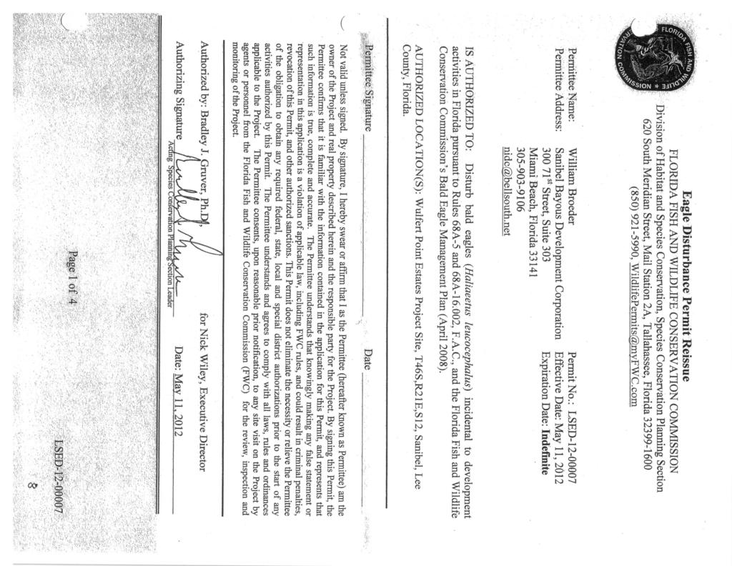
35
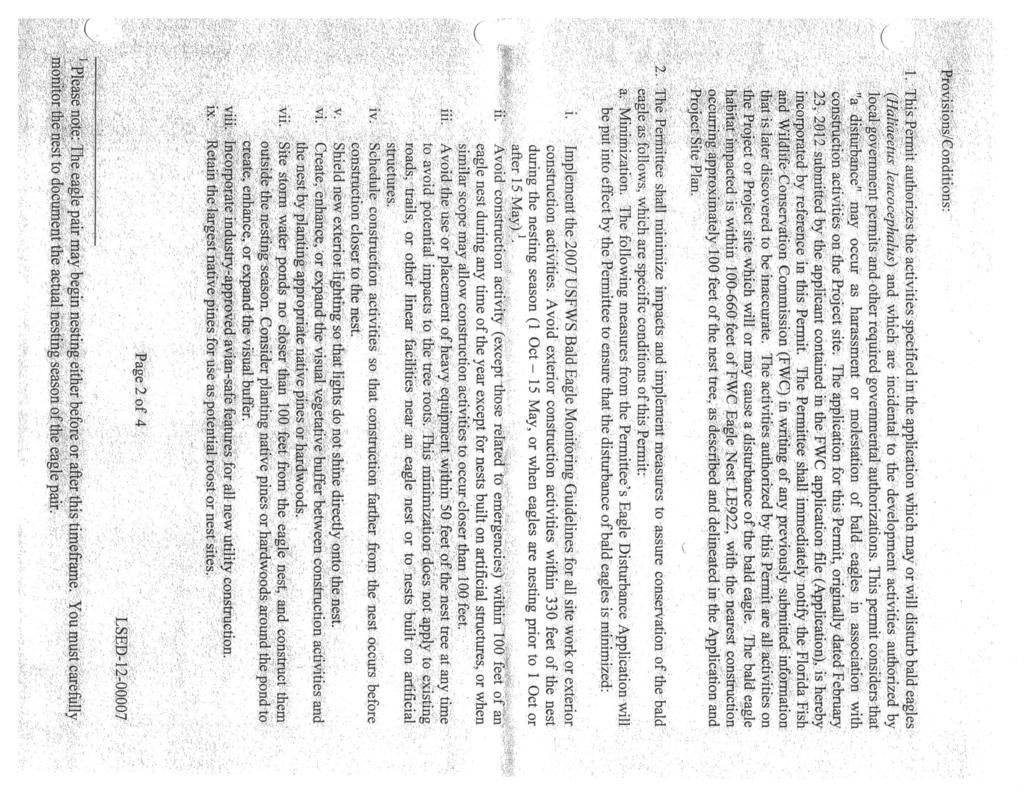
36
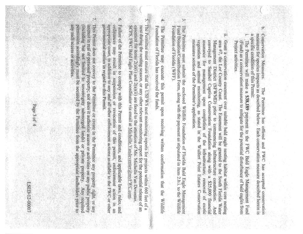
37
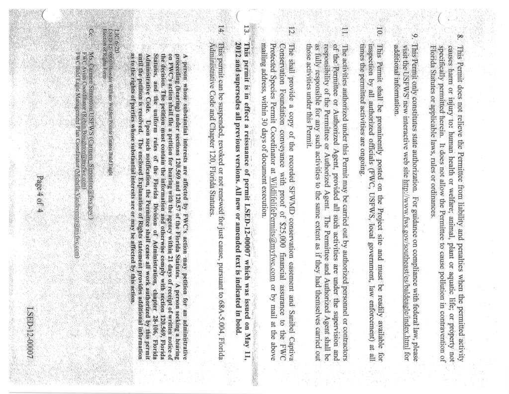
38
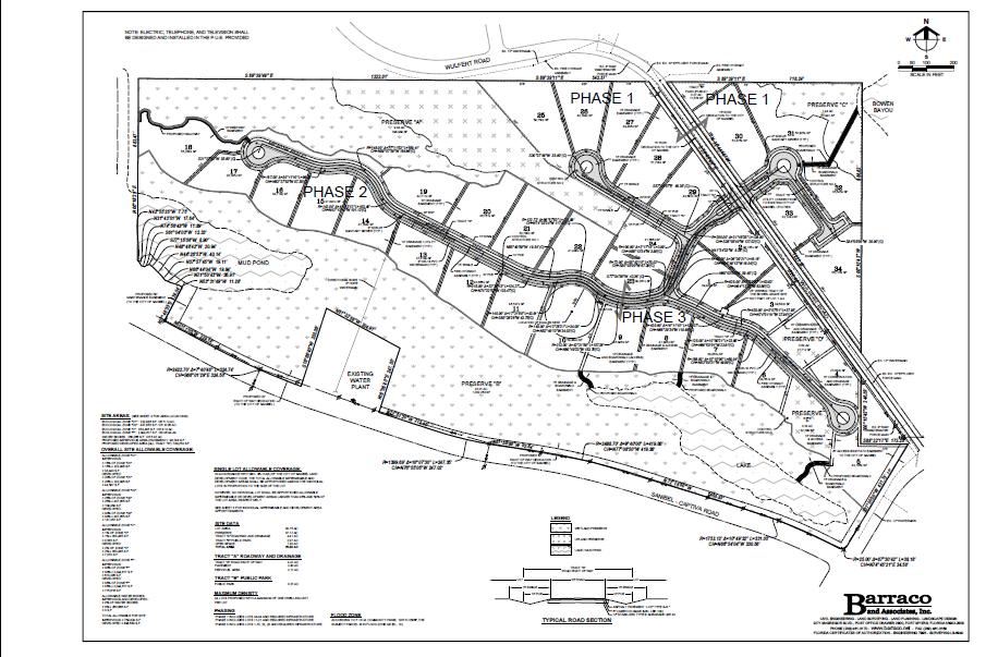
39
City of Sanibel. Planning Department STAFF REPORT
 City of Sanibel Planning Department STAFF REPORT Planning Commission Meeting: July 23, 2013 Planning Commission Agenda Item: No 7b. Application Number: 13-7438DP Applicant Name: Attorney Beverly Grady
Chapter 100 Planned Unit Development in Corvallis Urban Fringe
 100.100 Scope and Purpose. Chapter 100 Planned Unit Development in Corvallis Urban Fringe (1) All applications for land divisions in the Urban Residential (UR) and Flood Plain Agriculture (FPA) zones within
GWINNETT COUNTY CSO CONSERVATION SUBDIVISION OVERLAY DISTRICT REQUIREMENTS
 GWINNETT COUNTY CSO CONSERVATION SUBDIVISION OVERLAY DISTRICT REQUIREMENTS Section 1316. CSO Conservation Subdivision Overlay District. 1. Purposes. The purposes of this overlay district are as follows:
Plans shall be drawn at a readable scale, signed, and sealed by a Florida Registered Engineer. The application package shall include:
 CHAPTER 400. SECTION 403. PERMIT TYPES AND APPLICATIONS SITE DEVELOPMENT 403.3. Preliminary Site Plans (PSP) A. Intent and Purpose PSPs are used to identify existing site conditions and demonstrate general
DRAFT FOR PUBLIC HEARING (rev. March, 2016)
") Chapter 200. ZONING Article VI. Conservation/Cluster Subdivisions 200-45. Intent and Purpose These provisions are intended to: A. Guide the future growth and development of the community consistent with
Chapter 200. ZONING Article VI. Conservation/Cluster Subdivisions 200-45. Intent and Purpose These provisions are intended to: A. Guide the future growth and development of the community consistent with
ARTICLE 5 MINOR SUBDIVISION/LAND DEVELOPMENT
 ARTICLE 5 MINOR SUBDIVISION/LAND DEVELOPMENT SECTION 501 ONLY FINAL PLAN REQUIRED The classification of a proposed subdivision as a "Minor Subdivision" shall only require the submission, review and approval
ARTICLE 8C SITE CONDOMINIUM DEVELOPMENT ORDINANCE
 ARTICLE 8C SITE CONDOMINIUM DEVELOPMENT ORDINANCE SECTION 8C.01 PURPOSE It is the purpose of this Ordinance to insure that plans for development within Oceola Township proposed under the provisions of
Residential Major Subdivision Review Checklist
 Residential Major Subdivision Review Checklist Plan Submittal Requirements: 2 full sets of stamped plans Electric submittal - all plans contained in a single PDF 3 full sets if commercial kitchen or dining
CHAPTER 3 PRELIMINARY PLAT
 10-3-1 10-3-3 SECTION: CHAPTER 3 PRELIMINARY PLAT 10-3-1: Consultation 10-3-2: Filing 10-3-3: Requirements 10-3-4: Approval 10-3-5: Time Limitation 10-3-6: Grading Limitation 10-3-1: CONSULTATION: Each
SUBDIVISION APPLICATION CHECKLIST SKETCH PLAN PRELIMINARY PLAT FINAL PLAT
 RECEIVED STAMP SUBDIVISION APPLICATION CHECKLIST SKETCH PLAN PRELIMINARY PLAT FINAL PLAT A checklist of background information and submission requirements for processing of a sketch plan, preliminary plat
1105 SUBDIVISIONS, PARTITIONS, REPLATS, CONDOMINIUM PLATS, AND VACATIONS OF RECORDED PLATS
 1105 SUBDIVISIONS, PARTITIONS, REPLATS, CONDOMINIUM PLATS, AND VACATIONS OF RECORDED PLATS 1105.01 PURPOSE AND APPLICABILITY Section 1105 is adopted to provide standards, criteria, and procedures under
A.3. ARTICLE 7 PLAN REQUIREMENTS FOR MINOR SUBDIVISION AND/OR LAND DEVELOPMENT
 700. 701.A.3. ARTICLE 7 PLAN REQUIREMENTS FOR MINOR SUBDIVISION AND/OR LAND DEVELOPMENT SECTION 700 PURPOSE The purpose of this Article is to set forth a streamlined set of Plan Requirements for minor
I. Requirements for All Applications. C D W
 108-16.1. Application checklists. Checklist for Required Submissions to the Planning Board or Zoning Board of Adjustment of Monroe Township All required submissions are to be made to the Administrative
ARTICLE XVI SUBDIVISION DEVELOPMENT
 ARTICLE XVI SUBDIVISION DEVELOPMENT 16.0 The division of land into 4 or more lots that will require the construction or extension of public streets, water or sanitary sewerage (other than the direct connection
Article 2 Application Type and Standards Requirements
 Article 1 Article 2 Division 1 Application Type and Standards Requirements General Provisions Sec. 2.1.1 Division 2 Division 3 Division 4 Division 5 Division 6 Division 7 Division 8 Division 9 Sec. 2.9.1
Initial Subdivision Applications Shall Include the Following:
 Initial Subdivision Applications Shall Include the Following: 1) Subdivision Application Form: completely filled out (12 copies) 2) Plat: The Plat must adhere to the requirements set forth in the Town
ELK RAPIDS TOWNSHIP ANTRIM COUNTY, MICHIGAN ORDINANCE NO
 ELK RAPIDS TOWNSHIP ANTRIM COUNTY, MICHIGAN ORDINANCE NO. 3-2011 AN ORDINANCE TO REPLACE THE SUBDIVISION CONTROL ORDINANCE WITH A NEW SUBDIVISION DEVELOPMENT ORDINANCE, IN ACCORD WITH THE LAND DIVISION
FINAL DRAFT 12/1/16, Rev. to 7/18/17
 FINAL DRAFT 12/1/16, Rev. to 7/18/17 (As Adopted 8/8/17 Effective 9/1/17) SHELTON PLANNING AND ZONING COMMISSION Proposed Amendments to Zoning Regulations I. Amend Section 23 PERMITTED USES by inserting
SUBMITTAL REQUIREMENTS: The number indicates the number of copies for submittal (if applicable).
.") Office Use Only Preliminary Long Plat Long Subdivision Applicant Checklist PLANNING, COMMUNITY, & ECONOMIC DEVELOPMENT DEPARTMENT PRELIMINARY LONG PLAT LONG SUBDIVISION CHECKLIST Mailing Address: P.O.
Office Use Only Preliminary Long Plat Long Subdivision Applicant Checklist PLANNING, COMMUNITY, & ECONOMIC DEVELOPMENT DEPARTMENT PRELIMINARY LONG PLAT LONG SUBDIVISION CHECKLIST Mailing Address: P.O.
Preliminary Subdivision Application (Minor) (Three (3) lots or less)
 (Three (3) lots or less)") Gunnison City Offices www.gunnisoncity.org 38 West Center Gunnison, Utah 84634 (435) 528 7969 Date of Application: Preliminary Subdivision Application (Minor) (Three (3) lots or less) APPLICANT INFORMATION
Gunnison City Offices www.gunnisoncity.org 38 West Center Gunnison, Utah 84634 (435) 528 7969 Date of Application: Preliminary Subdivision Application (Minor) (Three (3) lots or less) APPLICANT INFORMATION
TOWN OF LEWISTON PLANNING BOARD APPLICATION
 TOWN OF LEWISTON PLANNING BOARD APPLICATION DESCRIPTION OF PROPOSED REQUEST: Name of Property Owner: Phone #: Name of Applicant:Phone #: Address or Location of Proposal:_SBL# Size of Parcel or Structure:Existing
Preliminary Subdivision Application (Major) (Four (4) lots or more)
 (Four (4) lots or more)") Gunnison City Offices www.gunnisoncity.org 38 West Center Gunnison, Utah 84634 (435) 528 7969 Date of Application: Preliminary Subdivision Application (Major) (Four (4) lots or more) APPLICANT INFORMATION
Gunnison City Offices www.gunnisoncity.org 38 West Center Gunnison, Utah 84634 (435) 528 7969 Date of Application: Preliminary Subdivision Application (Major) (Four (4) lots or more) APPLICANT INFORMATION
ARTICLE SINGLE FAMILY SITE CONDOMINIUM DEVELOPMENT STANDARDS
 ARTICLE 28.00 SINGLE FAMILY SITE CONDOMINIUM DEVELOPMENT STANDARDS Section 28.01 PURPOSE The purpose of this Article is to recognize that conventional single family developments, traditionally developed
THE COUNTY BOARD OF SUPERVISORS OF THE COUNTY OF DOUGLAS DOES ORDAIN AS FOLLOWS:
 8.1 SUBDIVISION CONTROL ORDINANCE THE COUNTY BOARD OF SUPERVISORS OF THE COUNTY OF DOUGLAS DOES ORDAIN AS FOLLOWS: SECTION I. GENERAL INTERPRETATION This ordinance shall not repeal, impair or modify private
SITE DEVELOPMENT PLAN REQUIREMENTS CHECKLIST
 SITE DEVELOPMENT PLAN REQUIREMENTS CHECKLIST Completed DRC Application for Review Required for Application Process DRC Processing Fee 1 Commercial $2,500.00 Fire Department Review Fee 150.00 Total $2,650.00
ARTICLE 15. RULES, REGULATIONS AND DEFINITIONS
 ARTICLE 15. RULES, REGULATIONS AND DEFINITIONS Section 1. Interpretation and Construction: The following rules and regulations regarding interpretation and construction of the Ulysses-Grant County, Kansas,
MAJOR SUBDIVISION PRELIMINARY PLAT CHECKLIST
 TOWNSHIP OF EGG HARBOR PLANNING BOARD/ZONING BOARD OF ADJUSTMENT 3515 BARGAINTOWN ROAD EGG HARBOR TOWNSHIP, NJ 08234 MAJOR SUBDIVISION PRELIMINARY PLAT CHECKLIST The following checklist is designed to
CHAPTER34 PRUD - PLANNED RESIDENTIAL UNIT DEVELOPMENT
 CHAPTER34 PRUD - PLANNED RESIDENTIAL UNIT DEVELOPMENT 17-34-1 17-34-2 17-34-3 17-34-4 17-34-5 17-34-6 17-34-7 17-34-8 17-34-9 Purpose Planned Residential Unit Development Defined Planned Residential Unit
TOWNSHIP OF BORDENTOWN LAND DEVELOPMENT APPLICATION CHECKLIST. General Requirements for all Applications
 TOWNSHIP OF BORDENTOWN LAND DEVELOPMENT APPLICATION CHECKLIST This CHECKLIST has been adopted in accordance with Section 25:807 of the Land Development Ordinance of the Township of Bordentown and will
SUBMITTAL REQUIREMENTS: The number indicates the number of copies for submittal (if applicable).
.") Office Use Only Preliminary Long Plat Long Subdivision Applicant Checklist PLANNING, COMMUNITY, & ECONOMIC DEVELOPMENT DEPARTMENT FINAL LONG PLAT LONG SUBDIVISION CHECKLIST Mailing Address: P.O. Box 547,
Office Use Only Preliminary Long Plat Long Subdivision Applicant Checklist PLANNING, COMMUNITY, & ECONOMIC DEVELOPMENT DEPARTMENT FINAL LONG PLAT LONG SUBDIVISION CHECKLIST Mailing Address: P.O. Box 547,
LAND USE APPLICATION
 LAND USE APPLICATION File Name: File No(s).: Receipt No.: Receipt Date: Received By: Amount.: $ Instructions for Applicants Please read and follow all instructions on your application carefully. If you
E L M E R B O R O U G H L A N D U S E B O A R D APPLICATION COVER SHEET (to be completed for all applications and appeals)
") E L M E R B O R O U G H L A N D U S E B O A R D APPLICATION COVER SHEET (to be completed for all applications and appeals) 1. Name(s): 2. Address: 3. Telephone Number(s): 4. E-mail: 5. Owner Name(s) (if
E L M E R B O R O U G H L A N D U S E B O A R D APPLICATION COVER SHEET (to be completed for all applications and appeals) 1. Name(s): 2. Address: 3. Telephone Number(s): 4. E-mail: 5. Owner Name(s) (if
ARTICLE III GENERAL PROCEDURES, MINOR PLANS AND FEE SCHEDULES
 ARTICLE III GENERAL PROCEDURES, MINOR PLANS AND FEE SCHEDULES 301. Prior to Submission a. Copies of this Ordinance shall be available on request, at cost, for the use of any person who desires information
ARTICLE 5 GENERAL REQUIREMENTS
 5.1 SUITABILITY OF THE LAND ARTICLE 5 GENERAL REQUIREMENTS 5.1.1 Land subject to flooding, improper drainage or erosion, and land deemed to be unsuitable for development due to steep slope, unsuitable
Guide to Preliminary Plans
 Guide to Preliminary Plans Introduction The Douglas County is committed to providing open, transparent application processes to the public. This Guide is provided to assist anyone interested in the procedures
-MENDOCINO COUNTY PLANNING AND BUILDING SERVICES- DIVISION OF LAND REGULATIONS TITLE 17
 ARTICLE VI -- GENERAL REGULATIONS AND PROVISIONS Sec. 17-50. Sec. 17-51 General Plan. Sec. 17-52 Lot and Block Design and Configuration. Sec. 17-53 Lot Access. Sec. 17-54 Private Roads. Sec. 17-55 Water
CONDOMINIUM REGULATIONS
 ARTICLE 37 CONDOMINIUM REGULATIONS SECTION 37.01. Purpose The purpose of this Article is to regulate projects that divide real property under a contractual arrangement known as a condominium. New and conversion
BY THE CITY COMMISSION ORDINANCE NO.:
 BY THE CITY COMMISSION ORDINANCE NO.: 2005-0868 AN ORDINANCE BY THE CITY COMMISSION OF THE CITY OF DADE CITY, FLORIDA CREATING A DEVELOPMENT REVIEW PROCEDURES ORDINANCE; PROVIDING FOR INTENT, PURPOSE,
Section SKETCH PLAN REVIEW
 Section 210 - SKETCH PLAN REVIEW 1. Within 30 days of receiving a complete application for a subdivision involving three or more lots, the Zoning Administrator shall refer the matter to the first available
BRIDGETON SUBDIVISION APPLICATION CHECKLIST
 APPLICATION NAME AND # CHECKLIST COMPLETED BY: DATE: Signature and printed name BRIDGETON SUBDIVISION APPLICATION CHECKLIST TO SUBDIVISION APPLICANTS: The attached checklist is to assist you in the submission
5. That the Owner shall agree that all development Blocks shown within the Draft Plan will be connected to full municipal services.
 Conditions Relating to Draft Plan of Subdivision Approval East Fonthill 26T 01014 (Draft Plan dated December 1, 2013, and revised August 28, 2014), the Town of Pelham 1. This approval applies to the Draft
ARTICLE V PRELIMINARY PLAN SUBMISSION
 ARTICLE V PRELIMINARY PLAN SUBMISSION 501. Plan Requirements a. On or before the 25 th day of the month prior to a regularly scheduled meeting of the Planning Commission, the applicant shall submit two
UPPER MOUNT BETHEL TOWNSHIP NORTHAMPTON COUNTY, PENNSYLVANIA
 UPPER MOUNT BETHEL TOWNSHIP NORTHAMPTON COUNTY, PENNSYLVANIA JOINDER DEED / LOT CONSOLIDATION TOWNSHIP REVIEW PROCESS When accepting proposed Joinder Deeds / Lot Consolidations, review the Joinder Deed
STATE OF MICHIGAN COUNTY OF MARQUETTE, TOWNSHIP OF NEGAUNEE LAND DIVISION, SUBDIVISION AND CONDOMINIUM ORDINANCE
 STATE OF MICHIGAN COUNTY OF MARQUETTE, TOWNSHIP OF NEGAUNEE LAND DIVISION, SUBDIVISION AND CONDOMINIUM ORDINANCE Adopted: August 8 th, 2008 Effective: August 28 th, 2008 Sec.100. Title ARTICLE I GENERAL
City of Midland Application for Site Plan Review
 City of Midland Application for Site Plan Review Submission Date: Property Owner: Mailing Address: Phone number: ( ) Cell phone: ( ) Email address: Fax: ( ) Owner s Signature: Applicant Name (if not owner):
PRELMINARY PLAT CHECKLIST
 PRELMINARY PLAT CHECKLIST A. All preliminary plat submitted for approval shall be prepared by a Registered Professional Land Surveyor. B. Preliminary plats must be drawn to a scale of XXX with such accuracy
A. Preserve natural resources as identified in the Comprehensive Plan.
 1370.08 Conservation Residential Overlay District. Subd. 1 Findings. The City finds that the lands and resources within the Conservation Residential Overlay District are a unique and valuable resource
TOWN OF OCEAN ISLE BEACH
 TOWN OF OCEAN ISLE BEACH PLANNED UNIT DEVELOPMENT ORDINANCE ADOPTED IN EFFECT FEBRUARY 13, 2001 This ordinance has been prepared by the Ocean Isle Beach Planning & Inspections Department. Section 66-55.
APPLICATION. Telephone Fax Address. Telephone Fax Address FOR MARTIN COUNTY USE ONLY
 APPLICATION PRESERVE AREA MANAGEMENT PLAN/ ABBREVIATED PRESERVE AREA MANAGEMENT PLAN Growth Management Department Environmental Division PART 1: Applicant Information A. Land Owner(s) Name Title and Company
Article 7: Residential Land Use and Development Requirements
 Article 7: Residential Land Use and Section 701: Statement of Intent (A) (B) (C) The intent of Article 7 is to develop certain land use and development requirements for the residential uses within Cumru
TENTATIVE PARCEL MAP APPLICATION GUIDE TENTATIVE PARCEL MAP APPLICATION REQUIREMENTS
 TENTATIVE PARCEL MAP APPLICATION GUIDE SISKIYOU COUNTY PLANNING DIVISION 806 South Main Street, Yreka CA 96097 Phone: (530) 841-2100 / Fax: (530) 841-4076 TENTATIVE PARCEL MAP APPLICATION REQUIREMENTS
TOWNSHIP OF SPRINGBROOK SUBDIVISION AND LAND DEVELOPMENT
 TOWNSHIP OF SPRINGBROOK SUBDIVISION AND LAND DEVELOPMENT ORDINANCE JULY, 1995 with Revisions to January, 2001 SUBDIVISION AND LAND DEVELOPMENT ORDINANCE TOWNSHIP OF SPRINGBROOK LACKAWANNA COUNTY, PENNSYLVANIA
Parkland-Spanaway-Midland LUAC - Agenda
 1. 6:30 P.M. Parkland-Spanaway-Midland LUAC - Agenda Documents: 8 2 17 PSMAC Agenda.pdf 2. Parkland-Spanaway-Midland LUAC Initial Project Review Documents: Lincoln Court PP IPR PSMAC-RJ.pdf Department
A. Appropriate agency responsible for transportation review for the subject property.
 7.8.10 Procedure Any person desiring to create a minor subdivision shall submit to the Commission for approval an application on forms provided by the Division, and a record plat in conformance with the
Condominium Unit Requirements.
 ARTICLE 19 CONDOMINIUM REGULATIONS Section 19.01 Purpose. The purpose of this Article is to regulate projects that divide real property under a contractual arrangement known as a condominium. New and conversion
SUBDIVISION PROCEDURES AND REGULATIONS. for the Town of Stratford, New Hampshire
 SUBDIVISION PROCEDURES AND REGULATIONS for the Town of Stratford, New Hampshire TABLE OF CONTENTS Page A. PRE-APPLICATION 2 B. PRELIMINARY PLAN REQUIREMENTS 3 C. PRELIMINARY PLAN REVIEW 5 Site Plan Review
SUBDIVISION BY-LAW MUNICIPALITY OF THE COUNTY OF INVERNESS
 SUBDIVISION BY-LAW MUNICIPALITY OF THE COUNTY OF INVERNESS APPROVED BY COUNCIL: JUNE 15, 1998 EFFECTIVE DATE: SEPTEMBER 23, 1998 Page 2 TABLE OF CONTENTS PART 1: SHORT TITLE... 5 PART 2: INTERPRETATION...
ARTICLE 15 - PLANNED UNIT DEVELOPMENT
 Section 15.1 - Intent. ARTICLE 15 - PLANNED UNIT DEVELOPMENT A PUD, or Planned Unit Development, is not a District per se, but rather a set of standards that may be applied to a development type. The Planned
CITY OF OCOEE LAND DEVELOPMENT CODE SUFFICIENCY TABLE WITH NOTES
 CITY OF OCOEE LAND DEVELOPMENT CODE SUFFICIENCY TABLE WITH NOTES The Sufficiency Table is a checklist to help identify the types of information and documentation needed for various types of projects. The
Residential Minor Subdivision Review Checklist
 Residential Minor Subdivision Review Checklist Plan Submittal Requirements: 2 full sets of stamped plans Electric submittal - all plans contained in a single PDF 3 full sets if commercial kitchen or dining
Subdivision (Plat) Checklist
 Checklist") Subdivision (Plat) Checklist This Checklist is intended to assist you in preparing a complete application for submittal. Occasionally, additional items may be required to complete the review. Incomplete
Subdivision (Plat) Checklist This Checklist is intended to assist you in preparing a complete application for submittal. Occasionally, additional items may be required to complete the review. Incomplete
13-2 SUBDIVISION PLANS AND PLATS REQUIRED EXCEPTIONS Subdivision Plats Required To be Recorded
 ARTICLE XIII SUBDIVISIONS 13-1 INTENT AND PURPOSE 13-1-1 Intent: It is the intent of the County Commission through the adoption of this Article to more fully avail itself of the power granted under 17-27-601
MINOR PLAT AMENDMENT APPLICATION CHECK APPLICABLE PERMIT ATTACHMENT:
 240 East Gammon Road Vineyard, Utah 84058 (801) 226-1929 MINOR PLAT AMMENDMENT APPLICATION Please Note: Attachment of request specific documents is required prior to processing your application. APPLICATION
ARTICLE FIVE FINAL DRAFT
 ARTICLE FIVE 021218 FINAL DRAFT Sec. 503.6 Open Space Preservation Option Open Space Preservation Option Open Space Preservation developments may be approved in the AR, R-1, R-2 and R-3 zoning districts,
DOUGLAS COUNTY SUBDIVISION RESOLUTION Article 4 Preliminary Plan 10/13/2015
 ARTICLE 4 PRELIMINARY PLAN 401 Intent An in-depth analysis of the proposed subdivision, including a review of the design considering the ability to obtain water and sanitation, identified geologic hazards,
610 LAND DIVISIONS AND PROPERTY LINE ADJUSTMENTS OUTSIDE A UGB
 ARTICLE VI: LAND DIVISIONS AND PROPERTY LINE ADJUSTMENTS VI-21 610 LAND DIVISIONS AND PROPERTY LINE ADJUSTMENTS OUTSIDE A UGB 610-1 Property Line Adjustments (Property Line Relocation) A property line
CHARLES CITY COUNTY SITE PLAN ORDINANCE. This Ordinance shall be known as the Charles City County Site Plan Ordinance.
 CHARLES CITY COUNTY SITE PLAN ORDINANCE Section 1. Title This Ordinance shall be known as the Charles City County Site Plan Ordinance. Section 2. Authority. This Ordinance is enacted pursuant to the authority
TENTATIVE MAP INFORMATION SHEET
 TENTATIVE MAP INFORMATION SHEET GENERAL INFORMATION This information sheet explains how your Tentative Map application will be processed, what fees you must pay, and what plans you must submit. If you
MANDATORY HOA DISCLOSURE SUMMARY FOR LONE STAR RANCH SINGLE FAMILY HOMES
 MANDATORY HOA DISCLOSURE SUMMARY FOR LONE STAR RANCH SINGLE FAMILY HOMES The following notice is required by Florida Statue 720.401: 1. AS A PURCHASER OF PROPERTY IN THIS COMMUNITY, YOU WILL BE OBLIGATED
WASCO COUNTY PRELIMINARY SUBDIVISION APPLICATION
 WASCO COUNTY PRELIMINARY SUBDIVISION APPLICATION DETAILED SPECIFIC WRITTEN REQUEST File Number: SDV- Number of Proposed Lots & their Dimensions: PRELIMINARY SUBDIVISION PLAN REQUIREMENTS The approval of
Guide to Combined Preliminary and Final Plats
 Guide to Combined Preliminary and Final Plats Introduction The Douglas County is committed to providing open, transparent application processes to the public. This Guide is provided to assist anyone interested
SUBJECT: Inter- and Intra-connectivity Guidelines and Ordinance
 City of Sanibel Planning Department MEMORANDUM DATE: March 11, 2014 TO: Sanibel Planning Commission FROM: James C. Jordan, Jr., Director of Planning SUBJECT: Inter- and Intra-connectivity Guidelines and
géãç Éy VtÇtÇwt zât 5440 Routes 5 & 20 West Canandaigua, NY Phone: (585) / Fax: (585)
 / Fax: (585)") géãç Éy VtÇtÇwt zât 5440 Routes 5 & 20 West Canandaigua, NY 14424 Phone: (585) 394-1120 / Fax: (585) 394-9476 APPLICATION FOR LOT-LINE ADJUSTMENT The applicant is responsible for the completeness of all
géãç Éy VtÇtÇwt zât 5440 Routes 5 & 20 West Canandaigua, NY 14424 Phone: (585) 394-1120 / Fax: (585) 394-9476 APPLICATION FOR LOT-LINE ADJUSTMENT The applicant is responsible for the completeness of all
ARTICLE XXI GENERAL SITE DEVELOPMENT PLAN REQUIREMENTS
 1 2 3 4 5 6 7 8 9 10 11 12 13 14 15 16 17 18 19 20 21 22 23 24 25 ARTICLE XXI GENERAL SITE DEVELOPMENT PLAN REQUIREMENTS Section 21.1 Purpose and Intent... 2 Section 21.2 Administrative Site Plan Review
Town of Lisbon, Maine SUBDIVISION REVIEW APPLICATION
 Date Received: Fee Paid (amount): Applicant: Town of Lisbon, Maine SUBDIVISION REVIEW APPLICATION Subdivision Name/Title: This application must be received at the Town Office by close of business on the
CHAPTER 18 SITE CONDOMINIUM PROJECTS
 15.1800 CHAPTER 18 SITE CONDOMINIUM PROJECTS 15.1801 SECTION 18.01 PURPOSE AND SCOPE GRAND HAVEN CHARTER TOWNSHIP Site condominium projects are condominium developments in which each condominium unit consists
ARTICLE 14 PLANNED UNIT DEVELOPMENT (PUD) DISTRICT
 DISTRICT") ARTICLE 14 PLANNED UNIT DEVELOPMENT (PUD) DISTRICT Section 14.01 Intent. It is the intent of this Article to allow the use of the planned unit development (PUD) process, as authorized by the Michigan Zoning
ARTICLE 14 PLANNED UNIT DEVELOPMENT (PUD) DISTRICT Section 14.01 Intent. It is the intent of this Article to allow the use of the planned unit development (PUD) process, as authorized by the Michigan Zoning
CITY OF SANIBEL Planning Department SUBDIVISION MINOR (WITH INSTRUCTIONS)
") STAFF USE ONLY APPLICATION No: FILING DATE: ACCEPTED BY: FEE: OTHER APPLICATIONS FILED WITH THIS REQUEST: _ PART I. PARCEL IDENTIFICATION TAX STRAP NUMBER: - 46 - - T -. STREET ADDRESS OF PROPERTY: _ PART
STAFF USE ONLY APPLICATION No: FILING DATE: ACCEPTED BY: FEE: OTHER APPLICATIONS FILED WITH THIS REQUEST: _ PART I. PARCEL IDENTIFICATION TAX STRAP NUMBER: - 46 - - T -. STREET ADDRESS OF PROPERTY: _ PART
ORDINANCE NOW THEREFORE, BE IT ENACTED BY THE CITY COMMISSION OF THE CITY OF WINTER GARDEN, FLORIDA, AS FOLLOWS:
 ORDINANCE 12-02 AN ORDINANCE OF THE CITY OF WINTER GARDEN, FLORIDA, AMENDING ARTICLE V OF CHAPTER 118 OF THE WINTER GARDEN CODE OF ORDINANCES ENTITLED PLANNED UNIT DEVELOPMENTS CREATING URBAN VILLAGE PLANNED
City of Leavenworth DEPARTMENT OF DEVELOPMENT SERVICES MAJOR SUBDIVISION APPLICATION 1
 Proposed Name of Subdivision: City of Leavenworth DEPARTMENT OF DEVELOPMENT SERVICES MAJOR SUBDIVISION APPLICATION 1 FOR PRELIMINARY SUBDIVISION APPROVAL This application must be filled out legibly, in
CITY OF SANIBEL Planning Department
 INSTRUCTIONS FOR PERMITS AND OTHER APPLICATIONS OF THE SANIBEL LAND DEVELOPMENT CODE EXPLANATION OF CHECKLIST ATTACHMENTS TO BE PROVIDED WITH APPLICATION FORMS FOR RESIDENTIAL STRUCTURES AND NON-RESIDENTIAL
Memorandum: October 13, 2008 REVISED To: Trowbridge Township Planning Commission From: P. Hudson, AICP Re: Suggested New Ordinance
 1 Memorandum: October 13, 2008 REVISED 2-11-09 To: Trowbridge Township Planning Commission From: P. Hudson, AICP Re: Suggested New Ordinance Because of changes in both the Michigan Planning Enabling Act
ARTICLE 900 PLAT AND PLAN REQUIREMENTS
 ARTICLE 900 PLAT AND PLAN REQUIREMENTS SEC. 900.1 ITEMS TO BE SHOWN ON PLAT OR PLAN General (1) Property lines of all property owners adjacent to the exterior boundaries of the project shall be located
(a) Commercial uses on Laurel Avenue, abutting the TRO District to the
 Commercial uses on Laurel Avenue, abutting the TRO District to the") 32X Zoning Code 150.36 TRANSITIONAL RESIDENTIAL OVERLAY DISTRICT. (A) Intent and purpose. (1) It is the intent of the Transitional Residential Overlay District (hereinafter referred to as the "TRO District")
32X Zoning Code 150.36 TRANSITIONAL RESIDENTIAL OVERLAY DISTRICT. (A) Intent and purpose. (1) It is the intent of the Transitional Residential Overlay District (hereinafter referred to as the "TRO District")
ARTICLE V. PRELIMINARY PLAT
 ARTICLE V. PRELIMINARY PLAT PAGE 13 SECTION A. PURPOSE. The purpose of the preliminary plat is to allow the Planning and Zoning Commission to review overall platting of the tract and street patterns within
MUNICIPALITY OF THE COUNTY OF PICTOU SUBDIVISION BY-LAW. Act means the Municipal Government Act, Stats. N.S., 1998, c. 18 and amendments thereto;
 MUNICIPALITY OF THE COUNTY OF PICTOU SUBDIVISION BY-LAW SHORT TITLE 1. This by-law may be cited as the Pictou County Subdivision By-Law and shall apply to all lands within the Municipality of the County
FINAL PLAT CHECKLIST
 FINAL PLAT CHECKLIST Project Name: Tax ID #: Project Number: Date: _ Reviewed By: Telephone: Please address all items marked with an "X" Please return redline comments with corrected plan, original mylar,
Amendment to the Zoning and Subdivision Ordinances; Consider Repeal Cluster Development Standards
 2 Board of Supervisors Meg Bohmke, Chairman Gary F. Snellings, Vice Chairman Jack R. Cavalier Thomas C. Coen L. Mark Dudenhefer Wendy E. Maurer Cindy C. Shelton February 28, 2018 Thomas C. Foley County
ARTICLE 24 SITE PLAN REVIEW
 ARTICLE 24 SITE PLAN REVIEW 24.1 PURPOSE: The intent of these Ordinance provisions is to provide for consultation and cooperation between the land developer and the Township Planning Commission in order
SITE PLAN REVIEW PROCEDURES SECTION DEVELOPMENTS REQUIRING SITE PLAN APPROVAL
 SECTION 22.01 PURPOSE ARTICLE XXII PROCEDURES The purpose of this Article is to establish uniform requirements of procedure for all developments in the Township. Certain specific types of minor development
SECTION 7000 LAND DEVELOPMENT REQUIREMENTS
 SECTION 7000 LAND DEVELOPMENT REQUIREMENTS 7000 LAND DEVELOPMENT REQUIREMENTS... 1 7001 LEGISLATIVE AUTHORITY... 1 7001.1 LAND DEVELOPMENT... 1 7001.1.1 Title 40, Idaho Code... 1 7001.1.2 Idaho Code 40-1415
MUNICIPALITY OF THE DISTRICT OF CLARE SUBDIVISION BY-LAW
 MUNICIPALITY OF THE DISTRICT OF CLARE SUBDIVISION BY-LAW 1 Table of Contents PART 1 - TITLE... 4 PART 2 - INTERPRETATION... 4 PART 3 - DEFINITIONS... 4 PART 4 - PROCEDURE FOR APPROVAL OF PLANS OR INSTRUMENTS
EXCERPT Planned Residential Development (PRD)
") LAND DEVELOPMENT CODE ESTABLISHING ZONING DISTRICTS AND REGULATIONS FOR LAND DEVELOPMENT AND SUBDIVISION IN THE CITY OF HATTIESBURG, MISSISSIPPI ORDINANCE NO. 2330 ADOPTED DECEMBER 05, 1989 EXCERPT Planned
LAND DEVELOPMENT CODE ESTABLISHING ZONING DISTRICTS AND REGULATIONS FOR LAND DEVELOPMENT AND SUBDIVISION IN THE CITY OF HATTIESBURG, MISSISSIPPI ORDINANCE NO. 2330 ADOPTED DECEMBER 05, 1989 EXCERPT Planned
MINOR SUBDIVISION FINAL PLAT APPLICATION Town of Apex, North Carolina
 MINOR SUBDIVISION FINAL PLAT APPLICATION Town of Apex, North Carolina This document is a public record under the North Carolina Public Records Act and may be published on the Town s website or disclosed
ARTICLE 7: PLOT PLANS AND SITE PLAN REQUIREMENTS AND REVIEW
 ARTICLE 7: PLOT PLANS AND SITE PLAN REQUIREMENTS AND REVIEW Section 7.0 - Purpose The purpose of this article is to specify the documents and/or drawings required for a Site Plan Review or a Plot Plan
PLANNED DEVELOPMENT DISTRICT STANDARDS. Cadence Site
 PLANNED DEVELOPMENT DISTRICT STANDARDS Cadence Site A Planned Development District 1. Statement of General Facts, Conditions and Objectives Property Size: Approximately 57.51 Acres York County Tax Map
Town of Canandaigua 5440 Routes 5 & 20 West Canandaigua, NY Phone: (585) / Fax: (585)
 / Fax: (585)") Town of Canandaigua 5440 Routes 5 & 20 West Canandaigua, NY 14424 Phone: (585) 394-1120 / Fax: (585) 394-9476 NOTICE TO ALL PLANNING BOARD APPLICANTS FOR SINGLE STAGE PRELIMINARY/FINAL SUBDIVISION PLAT
Town of Canandaigua 5440 Routes 5 & 20 West Canandaigua, NY 14424 Phone: (585) 394-1120 / Fax: (585) 394-9476 NOTICE TO ALL PLANNING BOARD APPLICANTS FOR SINGLE STAGE PRELIMINARY/FINAL SUBDIVISION PLAT
CHAPTER XVIII SITE PLAN REVIEW
 CHAPTER XVIII SITE PLAN REVIEW Section 18.1 Section 18.2 Description and Purpose. The purpose of this chapter is to provide standards and procedures under which applicants would submit, and the Township
Planned Residential Development Zone
 SECTION 55 Planned Residential Development Zone 55.0 [Reserved] 55.1 General The Planned Residential Development (PRD) Zone is a class of zone in addition to and overlapping a portion or portions of the
SUBDIVISION AND LAND DEVELOPMENT ORDINANCE. For ENACTED: DECEMBER 12, 1991
 SUBDIVISION AND LAND DEVELOPMENT ORDINANCE For COLUMBIA COUNTY PENNSYLVANIA ENACTED: DECEMBER 12, 1991 EFFECTIVE: JANUARY 1, 1992 Prepared by COLUMBIA COUNTY PLANNING COMMISSION COLUMBIA COUNTY PLANNING