STAFF REVIEW MARCH 13, Preliminary Consent - Major Subdivision. Showfield, LLC Davis, Bowen & Friedel, Inc. R-2, Residential Low Density
|
|
|
- Phebe Mason
- 5 years ago
- Views:
Transcription

1 STAFF REVIEW MARCH 13, 2019 Application Title Application Type Owner Engineer Showfield City Preliminary Consent - Major Subdivision Showfield, LLC Davis, Bowen & Friedel, Inc. Tax Map and Parcel & Size and Location Comprehensive Plan Designation Zoning District Present Use Proposed Use Online application material acres Residential R-2, Residential Low Density agriculture residential dwellings and permanent open space I. BACKGROUND INFORMATION: Showfield City is a proposed residential development that would contain eighty-six (86) single-family home lots on a tract located off of Freeman Highway. An application, including a site plan prepared by Davis, Bowen & Friedel, Inc. dated December 5, 2018, was submitted to the City of Lewes on December 6, 2018 for preliminary consent review. 1

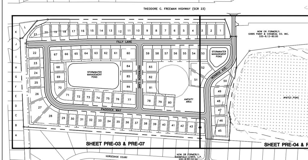
2 1 - To view full size open 2
3 The lots range in size from 10,125 sq. ft. to 23,067 sq. ft., the typical lots are 130 deep and 80 wide. In addition to the building lots the proposed plan indicates that 8.86 acres will be used as open space for buffers, stormwater management facilities, and resident amenities. More details on the lots and open space are discussed later in the review. The site also contains 5.78 acres for proposed streets and ROW. The property is bordered to the east by existing residential Showfield properties that are within Sussex County. South of the property is another existing residential development and to the northeast are additional planned developments. II. PLAN APPLICATION In April 2018, the applicant submitted a proposal to develop 129 single-family detached houses on an 80.6 acre assemblage of parcels to the state for PLUS Review. An official application package was submitted to the City on December 6, On January 31, 2019 the Applicant s Engineer, City staff, representatives from the Delaware River Bay Authority, and DelDOT staff met to review the status of the plan and define the scope of a Traffic Operational Analysis (TOA) for the City portion of the development. As part of the submission the following information was provided as part of the initial application: Written documentation identifying the applicants; A conceptual plat plan; A letter from the Lewes Board of Public Works certifying that utilities are existing and available; Payment of major subdivision application fee; Documentation of Public Notification; An Applicant Engineer s Report; A Soils Report; An Economic Impact Report; A copy of Plats and Deeds of Record. III. Compliance with adopted policies: Based upon the information presented, the City of Lewes Code and the Comprehensive Plan, staff submits the following regarding the application for Subdivision Preliminary Consent approval: A. State Designation 1 Prior to the official submission the applicants met to discuss the project with City staff in June and August At that meeting they discussed their subdivision plans in both the County and City and the associated Traffic Impact Study (TIS.) 3

4 All of the project area for this portion of Showfield (Lewes) is classified as Level 1 by the Office of State Planning Coordination. Investment Level 1 Areas are often municipalities, towns, or urban/urbanizing places in counties. Density is generally higher than in the surrounding areas. There are a variety of transportation opportunities available. B. City Comprehensive Plan a. Use designation - The proposed residential lots are consistent with the use designation Residential for this area as defined in the City of Lewes Comprehensive Plan, Future Land Use Map (see Map 10 at b. Several portions of the City Comprehensive Plan address concerns with development on properties containing wetlands or within the floodplain. As mentioned in the Comprehensive Plan strict attention will be placed on ensuring that any future development meets or exceeds floodplain requirements contained in the City s zoning ordinance and building code. These issues will be addressed more fully in latter sections of this review. C. City Zoning Ordinance a. Permitted Uses The proposed use, single family detached dwelling, is permitted by right and are in compliance with the R-2 Residential Low-Density zone. b. Lot Dimensional Regulations - The proposed lots comply with the lot area and bulk regulations, as listed below, for development in the R-2 zone. From Section 197, Attachment 2 of the City of Lewes Zoning Code. Lot area (square feet) 10,000 Lot width (feet) 75 Lot depth (feet) 100 Setbacks (feet) Front yard 30 or EBL * Side yard 8 4
5 Rear yard 15 * EBL means established building line. See Article XVI, Definitions. Based on the submitted plan a number of lots (ex. 67, 22, 77 and others) would be considered corner lots. Any corner lot, not exempted by Section (A), would need to have 2 front yards and 2 side yards. The setbacks for all corner lots should be revised to be in compliance with the Yard Area requirements, as defined below LOT, CORNER A lot or parcel of land abutting upon two or more streets at their intersection or upon two parts of the same street forming an interior angle of less than (A) In the case of a corner lot, a front yard, as provided for in each district, shall be required on each street on which a corner lot abuts, provided that, when one front lot line of said corner lot measures less than 65 feet and said corner lot is located in one of the following districts: the Residential Low-Density, Residential Low-Density (Historic) [R-2 and R-2(H)], Residential Beach, Residential Beach (Historic) [R-3 and R-3(H)], Residential Medium-Density, Residential Medium-Density (Historic) [R-4 and R-4(H)], Limited Commercial, and Limited Commercial (Historic) [LC and LC(H)], the front yard on the side of the corner lot with a front lot line measuring longer than 65 feet may be decreased to not less than the minimum side yard requirements. The applicant should indicate front yard setbacks on their final plan submission. c. Floodplain regulations This site is not located within the floodplain. D. City Subdivision Ordinance a. Process Requirements - The submittal for Preliminary Consent approval has complied with all of the required provisions for Initial Application under A, making it a complete application. b. The Planning Commission preliminary consent review evaluates the proposed application to criteria listed under E of the City Code. c. Other Subdivision Ordinance considerations: i. Water, Sewer, Electric and Stormwater systems Planning Commission review requires evaluation of compliance to ordinance provisions. Refer to City Engineer s Report for details and recommendations on these requirements. E. City Agency Reviews a. Parks and Recreation Commission (PRC) review The application for Preliminary Consent has been reviewed and submitted for consideration by the Planning Commission (see attachment). As noted in of the City Code applicants are responsible for the street tree plantings. The applicant is advised to coordinate the 5
6 placement and type of street trees as well as the review of long-range landscape projections and plans with the Lewes Parks and Recreation Commission prior to final plan approval. b. City Engineer and Board of Public Works report The report for Preliminary Consent has been completed and submitted for consideration by the Planning Commission. c. Reports from other agencies Copies of reports that have been created by other agencies, that are required as part of the subdivision approval, must be submitted to the City of Lewes. IV. Considerations In addition to review for consistency with current policies and regulations a number of considerations are evaluated as part of the review for preliminary consent. Some require evaluations conducted by City agencies, others are overseen by external agencies. Some can be addressed completely as part of the preliminary consent review whereas others require detailed assessments that are typically addressed during final plan review. A. Site Access The proposed development has planned entrances on Monroe Avenue at the intersection with Freeman Highway and at the intersection of Battlemiser Drive in the existing Showfield development outside City limits. There is a proposed stub street at the end of Filly Lane which ends at the existing Junction and Breakwater Pathway. The applicant is proposing to build the new roads to City standards using a 52 ROW comprised of 2 travel lanes (14 lanes), with curbs/gutters and 5 sidewalks on each side along with 2.5 plant strip between the sidewalks and curbs (see typical roadway section below). As indicated on the site plan, 6
7 subdivision streets constructed within the right-of-way are public and are to be maintained by the City of Lewes. DelDOT, DRBA and the developer discussed the need for a signal at the intersection of Theodore C. Freeman Memorial Highway and Monroe Avenue, where the site is proposed to have access. DelDOT is amenable to the Consultant s examining whether a traffic signal control would be warranted at the site entrance. Upon submission of the TOA, DelDOT will determine whether a Two- Way Stop Control (TWSC) or signalized intersection would be appropriate when the proposed development opens. The study shall evaluate the weekday morning, weekday evening, and summer Saturday midday peak hours for the following situations: 1) Existing (2019); 2) 2025 without development; and 3) 2025 with development. Counts will include both pedestrians and vehicles. Furthermore the applicant must secure approval from Delaware River & Bay Authority to utilize Monroe Access as an entrance. In April 2018, the applicant submitted a proposal to develop 129 single-family detached houses on an 80.6 acre assemblage of parcels to the state for PLUS Review. This review is only for a portion of those homes, but DelDOT still submitted a number of comments that are pertinent to this review, including: The proposed site access is acceptable to DelDOT in that it would be by way of Monroe Avenue, which is a City-maintained Street, and privately maintained subdivision streets. DelDOT would not permit direct access on Freeman Highway (US Route 9)... If the City requires a DelDOT Letter of No Objection to Recordation (LONOR), DelDOT will review the subdivision plan for the site in accordance with Section P.3 of the Development Coordination Manual. As Monroe Avenue and Inlet Place are City maintained streets and the streets in the County portion of Showfield are privately maintained, DelDOT will not participate in the City s entrance permitting process. Given that a TIS was completed in 2008 (and DelDOT considers it still pertinent), and a Traffic Operational Analysis (TOA) is currently being conducted for the intersection of Monroe Avenue and Freeman Highway, the City of Lewes does not see the need for an additional TIS. However, the City sees exceptional value for pedestrian facilities to be located at the intersection of Monroe Avenue and Freeman Highway. The City recommends that the applicant work with DelDOT and DRBA to identify a solution for a safe bicycle and pedestrian crossing across Freeman Highway. B. Sedimentation and Erosion Control A detailed sediment and stormwater plan will be required prior to any land disturbing activity taking place on the site. The plan review and approval as well as construction inspection will be coordinated through the Sussex Conservation District. Contact Jessica Watson at the Sussex Conservation District at (302) for details regarding submittal requirements and fees. 7

8 C. Floodplain As noted in the applicant s submittal letter, the proposed development is outside of the Zone X (500 year) floodplain. D. Wetlands Wetlands are mapped as present on parcel as depicted below. However, the site plan submitted to the Planning Commission will not be disturbing land within 500 feet of this area. Per the applicant s letter, The wetlands and Whites Pond are contained within parcel and will remain completely undisturbed per this application. While true, a note on the plan indicates that a Wetland Delineation was conducted by Environmental Resources, Inc. in March, The results of that delineation should be submitted with Final Plan. Source: DNREC 2007 Wetlands Map E. Utilities The submitted application contains information on water supply, sewage collection and stormwater collection. A report provided by the City Engineer of behalf of the Lewes Board of Public Works contains additional details regarding the systems and compliance with the City Code. The City Engineer s report addresses the operation and placement of proposed stormwater management systems. The applicant should incorporate the suggestions outlined in the City Engineer s report before submitting final site plans. F. Historic Structure 8
9 The Historic Structure located at 223 Monroe Avenue has been catalogued by the Delaware State Historic Preservation Office. In PLUS review letter from April 2018 the State Historic Preservation office suggested that the applicant consider hiring the professional services of a qualified architect to exam the area for unmarked graces graves or burial sites, and examine the parcel for potential historic or cultural resources. The office further recommends that the developer include sufficient landscaping protection or barrier between the proposed development and the surviving house. To the City s knowledge, the applicant plans to has already demolished the structure in question. G. Other: In order to be complete and accurate for recordation, the Final plan should not include lots and their associated streets as they are not being assessed or endorsed the Lewes Planning Commission at this time. It is the City s understanding that the circulation of that lot may be changing before submittal. 9
Article 7: Residential Land Use and Development Requirements
 Article 7: Residential Land Use and Section 701: Statement of Intent (A) (B) (C) The intent of Article 7 is to develop certain land use and development requirements for the residential uses within Cumru
Staff Report: Date: Applicant: Property Identification: Acreage of Request: Current Zoning of Requested Area: Requested Action: Attached:
 Staff Report: Completed by Jeff Palmer Director of Planning & Zoning Date: November 7, 2018, Updated November 20, 2018 Applicant: Greg Smith, Oberer Land Developer agent for Ronald Montgomery ET AL Property
Staff Report: Date: Applicant: Property Identification: Acreage of Request: Current Zoning of Requested Area: Requested Action: Attached:
 Staff Report: Completed by Jeff Palmer Director of Planning & Zoning Date: November 7, 2018 Applicant: Greg Smith, Oberer Land Developer agent for Ronald Montgomery ET AL Property Identification: Frontage
Washington County, Minnesota Ordinances
 Washington County, Minnesota Ordinances Ordinance No. 153 Text Amendment to the Washington County Development Code - Chapter One, Section 2 and Chapter Two, Part 1, Part 2, Part 3, of the Development Code
Department of Planning Services Division of Planning SARAH E. KEIFER, AICP Phone: 302/ Director of Planning Services FAX: 302/
 Kent County Department of Planning Services Division of Planning SARAH E. KEIFER, AICP Phone: 302/744-2471 Director of Planning Services FAX: 302/736-2128 KRISTOPHER S. CONNELLY, AICP Assistant Director
MONTGOMERY COUNTY PLANNING DEPARTMENT THE MARYLAND-NATIONAL CAPITAL PARK AND PLANNING COMMISSION
 MONTGOMERY COUNTY PLANNING DEPARTMENT THE MARYLAND-NATIONAL CAPITAL PARK AND PLANNING COMMISSION MCPB Item No.: Date: 06-21-12 The Plantations, Preliminary Plan -120090240 Benjamin Berbert, Senior Planner,
SUBDIVISION APPLICATION CHECKLIST SKETCH PLAN PRELIMINARY PLAT FINAL PLAT
 RECEIVED STAMP SUBDIVISION APPLICATION CHECKLIST SKETCH PLAN PRELIMINARY PLAT FINAL PLAT A checklist of background information and submission requirements for processing of a sketch plan, preliminary plat
PRELIMINARY PLAN CHECKLIST Major Land Development Projects. To initiate the application, the applicant shall submit to the Administrative Officer:
 PRELIMINARY PLAN CHECKLIST Major Land Development Projects To initiate the application, the applicant shall submit to the Administrative Officer: 1. The application review fee, as established by the South
REPORT TO THE SHELBY COUNTY PLANNING COMMISSION From the Department of Development Services Planning Services. February 4, 2019
 REPORT TO THE SHELBY COUNTY PLANNING COMMISSION From the Department of Development Services Planning Services February 4, 2019 Case No. Request for Rezoning Approval From E-1 to E-2 SD This is a request
RIVER VALE MASTER PLAN PZ CITY COUNCIL PUBLIC HEARING JULY 19, 2017 CITY OF BEND
 RIVER VALE MASTER PLAN PZ-16-0954 CITY COUNCIL PUBLIC HEARING JULY 19, 2017 RIVER VALE MASTER PLAN Master Plan process Required for developments over 20 acres Application submitted under old Master Plan
PLANNED DEVELOPMENT DISTRICT STANDARDS. Cadence Site
 PLANNED DEVELOPMENT DISTRICT STANDARDS Cadence Site A Planned Development District 1. Statement of General Facts, Conditions and Objectives Property Size: Approximately 57.51 Acres York County Tax Map
ARTICLE 5 MINOR SUBDIVISION/LAND DEVELOPMENT
 ARTICLE 5 MINOR SUBDIVISION/LAND DEVELOPMENT SECTION 501 ONLY FINAL PLAN REQUIRED The classification of a proposed subdivision as a "Minor Subdivision" shall only require the submission, review and approval
I. Requirements for All Applications. C D W
 108-16.1. Application checklists. Checklist for Required Submissions to the Planning Board or Zoning Board of Adjustment of Monroe Township All required submissions are to be made to the Administrative
PLANNED UNIT DEVELOPMENT & SUBDIVISION STAFF REPORT Date: November 17, 2016
 PLANNED UNIT DEVELOPMENT & SUBDIVISION STAFF REPORT Date: November 17, 2016 DEVELOPMENT NAME SUBDIVISION NAME LOCATION Autonation Ford of Mobile Autonation Ford of Mobile Subdivision 901, 909, and 925
O-I (Office-Institutional) and AG-1(Agricultural)
 and AG-1(Agricultural)") PROPERTY INFORMATION ADDRESS 3503 and 3505 Bethany Bend DISTRICT, LAND LOTS 2/1 973 and 974 OVERLAY DISTRICT State Route 9 PETITION NUMBERS EXISTING ZONING O-I (Office-Institutional) and AG-1(Agricultural)
PROPERTY INFORMATION ADDRESS 3503 and 3505 Bethany Bend DISTRICT, LAND LOTS 2/1 973 and 974 OVERLAY DISTRICT State Route 9 PETITION NUMBERS EXISTING ZONING O-I (Office-Institutional) and AG-1(Agricultural)
Final Plats for Major Residential and Commercial Subdivisions Checklist
 Project Name: : This form is a checklist of Zoning Ordinance requirements for major residential and commercial subdivision plats to assist the applicant in their submittal. It is not intended to be a comprehensive
TULSA PARK ESTATES SUBDIVISION, RESUBDIVISION OF LOT 6
 TULSA PARK ESTATES SUBDIVISION, RESUBDIVISION OF LOT 6 Engineering Comments: FINAL PLAT COMMENTS (should be addressed prior to submitting the FINAL PLAT for review and/or signature by the City Engineer):
Staff Report for Council Public Meeting
 Agenda Item 3.3 Staff Report for Council Public Meeting Date of Meeting: September 27, 2017 Report Number: SRPRS.17.134 Department: Division: Subject: Planning and Regulatory Services Development Planning
Review of Land Divisions in Open Space and Residential Zones 660
 Title 33, Planning and Zoning Chapter 33.660 5/24/18 Review of Land Divisions in Open Space and Residential Zones 33.660 Review of Land Divisions in Open Space and Residential Zones 660 Sections: General
SUBJECT PARCEL(S) Property Owner(s) TMS Number Approximate Acreage Carolina Park Development, LLC
 Property Owner(s) TMS Number Approximate Acreage Carolina Park Development, LLC") Staff Report Special Planning Commission Meeting November 19, 2014 For reference, the Zoning Code and Land Development Regulations are available online. AGENDA ITEM 5c. SKETCH PLAN APPROVAL REQUEST: Request
Staff Report Special Planning Commission Meeting November 19, 2014 For reference, the Zoning Code and Land Development Regulations are available online. AGENDA ITEM 5c. SKETCH PLAN APPROVAL REQUEST: Request
Community Development Department 333 Broadalbin Street SW, P.O. Box 490 Albany, OR 97321
 SUMMARY Community Development Department 333 Broadalbin Street SW, P.O. Box 490 Albany, OR 97321 STAFF REPORT Application for Tentative Partition Plat Review Planning File PA-06-17 Phone: 541-917-7550
PLANNED UNIT DEVELOPMENT & SUBDIVISION STAFF REPORT Date: April 18, 2019
 PLANNED UNIT DEVELOPMENT & SUBDIVISION STAFF REPORT Date: April 18, 2019 DEVELOPMENT NAME SUBDIVISION NAME Springhill Village Subdivision Springhill Village Subdivision LOCATION 4350, 4354, 4356, 4358,
Open Space Model Ordinance
 Open Space Model Ordinance Section I. Background Open space development has numerous environmental and community benefits, including: 1) Reduces the impervious cover in a development. Impervious cover
Town of Lisbon, Maine SUBDIVISION REVIEW APPLICATION
 Date Received: Fee Paid (amount): Applicant: Town of Lisbon, Maine SUBDIVISION REVIEW APPLICATION Subdivision Name/Title: This application must be received at the Town Office by close of business on the
Medical Marijuana Special Exception Use Information
 Medical Marijuana Special Exception Use Information The Special Exception Use information below is a modified version of the Unified Development Code. It clarifies the current section 5:104 Special Exceptions
CITY OF OAK HARBOR Development Services Department
 CITY OF OAK HARBOR Development Services Department Shortt Subdiiviisiions Shorrtt Pllatt Reviiew Prrocess IIII What is a Short Plat, and when is it necessary? A short plat is a map that represents a short
APPLICATION PROCEDURE
 ANTRIM PLANNING BOARD P. O. Box 517 Antrim, New Hampshire 03440 Phone: 603-588-6785 FAX: 603-588-2969 APPLICATION FORM AND CHECKLIST FOR MINOR OR MAJOR SITE PLAN REVIEW File Date Received By APPLICATION
Manor Township Zoning Permit Application (Section 702) Application Number Application Date / /
 Application Number Application Date / /") Manor Township Zoning Permit Application (Section 702) Application Number Application Date / / 1. General Information Name of Applicant Address City State Zip Telephone # ( ) Cell # ( ) Fax # Name of Landowner
Manor Township Zoning Permit Application (Section 702) Application Number Application Date / / 1. General Information Name of Applicant Address City State Zip Telephone # ( ) Cell # ( ) Fax # Name of Landowner
Major Subdivision Application Packet. Revised June 2018
 Major Subdivision Application Packet Revised June 2018 Caroline County Department of Planning and Community Development 233 West Broaddus Avenue Bowling Green, VA 22427 www.co.caroline.va.us Phone: 804-633-4303
MAJOR SUBDIVISION PRELIMINARY PLAT CHECKLIST
 TOWNSHIP OF EGG HARBOR PLANNING BOARD/ZONING BOARD OF ADJUSTMENT 3515 BARGAINTOWN ROAD EGG HARBOR TOWNSHIP, NJ 08234 MAJOR SUBDIVISION PRELIMINARY PLAT CHECKLIST The following checklist is designed to
City of Ferndale CITY COUNCIL STAFF REPORT
 SUBJECT: Final Plat Approval DATE: January 19, 2016 FROM: Haylie Miller, Assistant Planner PRESENTATION BY: Haylie Miller City of Ferndale CITY COUNCIL STAFF REPORT MEETING DATE: January 19, 2016 AGENDA
ZONING COMMISSION 125 EAST AVENUE P.O. BOX 5125 NORWALK, CONNECTICUT Revised January 1, 2018
 ZONING COMMISSION 125 EAST AVENUE P.O. BOX 5125 NORWALK, CONNECTICUT 06856-5125 Revised January 1, 2018 SECTION 118-1451 SITE PLAN REVIEW APPLICATION INSTRUCTION A. APPLICATION INFORMATION (11 copies of
ARTICLE V AGRICULTURAL PRESERVATION AND RURAL RESIDENTIAL DISTRICT
 ARTICLE V AP AGRICULTURAL PRESERVATION AND RURAL RESIDENTIAL DISTRICT Section 500. PURPOSE It is the purpose of the AP, Agricultural Preservation and Rural Residential District, to foster the preservation
Condominium Unit Requirements.
 ARTICLE 19 CONDOMINIUM REGULATIONS Section 19.01 Purpose. The purpose of this Article is to regulate projects that divide real property under a contractual arrangement known as a condominium. New and conversion
ZONING COMMISSION 125 EAST AVENUE - CITY HALL P.O. BOX 5125 NORWALK, CONNECTICUT Revised Januar y 1, 2018
 ZONING COMMISSION 125 EAST AVENUE - CITY HALL P.O. BOX 5125 NORWALK, CONNECTICUT 06856-5125 Revised Januar y 1, 2018 SECTION 118-1450 SPECIAL PERMIT APPLICATION INSTRUCTIONS A. APPLICATION INFORMATION
ARTICLE 23 CONDOMINIUM STANDARDS
 ARTICLE 23 CONDOMINIUM STANDARDS Section 23.01 Intent. The intent of this Article is to provide regulatory standards for condominiums and site condominiums similar to those required for projects developed
DAUPHIN CREEK ESTATES SUBDIVISION
 # 12 SUB-000076-2017 DAUPHIN CREEK ESTATES SUBDIVISION Engineering Comments: FINAL PLAT COMMENTS (should be addressed prior to submitting the FINAL PLAT for review and/or signature by the City Engineer):
E L M E R B O R O U G H L A N D U S E B O A R D APPLICATION COVER SHEET (to be completed for all applications and appeals)
") E L M E R B O R O U G H L A N D U S E B O A R D APPLICATION COVER SHEET (to be completed for all applications and appeals) 1. Name(s): 2. Address: 3. Telephone Number(s): 4. E-mail: 5. Owner Name(s) (if
E L M E R B O R O U G H L A N D U S E B O A R D APPLICATION COVER SHEET (to be completed for all applications and appeals) 1. Name(s): 2. Address: 3. Telephone Number(s): 4. E-mail: 5. Owner Name(s) (if
PLANNING COMMISSION REPORT Regular Agenda Non Public Hearing Item
 PC Staff Report 3/23/15 FDP-14-00551 Item No. 2-1 PLANNING COMMISSION REPORT Regular Agenda Non Public Hearing Item PC Staff Report 3/23/15 ITEM NO. 2: FINAL DEVELOPMENT PLAN FOR HUTTON FARMS WEST PHASE
SECTION 10 STANDARD PLATS
 SECTION 10 - STANDARD PLATS Subdivision 1: Purpose Standard Plats allow the subdivision of land into lots smaller than the minimum metes and bounds size in the zoning district, and control road development
ARTICLE 9 SPECIFICATIONS FOR DOCUMENTS TO BE SUBMITTED
 ARTICLE 9 SPECIFICATIONS FOR DOCUMENTS TO BE SUBMITTED SECTION 950 GENERALLY All applications shall be properly signed and filed by the owner or, with the owner s specific written consent, a contract purchaser
Town of Cary, North Carolina Rezoning Staff Report 14-REZ-24 Indian Wells Road Properties Town Council Meeting November 20, 2014
 Town of Cary, North Carolina Rezoning Staff Report 14-REZ-24 Indian Wells Road Properties Town Council Meeting November 20, 2014 REQUEST To amend the Town of Cary Official Zoning Map by revising a condition
BOSSIER CITY PARISH METROPOLITAN PLANNING COMMISSION 620 Benton Rd. Bossier City, LA Phone: Fax: PRELIMINARY PLAT
 (OFFICE USE ONLY) Application Fee: Paid: Date: CASE # Project Information BOSSIER CITY PARISH METROPOLITAN PLANNING COMMISSION 620 Benton Rd. Bossier City, LA 71111 Phone: 318-741-8824 Fax: 318-741-8827
ZONING AMENDMENT & SUBDIVISION STAFF REPORT Date: July 9, 2015
 ZONING AMENDMENT & SUBDIVISION STAFF REPORT Date: July 9, 2015 APPLICANT NAME 2513 Dauphin Street, Inc. SUBDIVISION NAME Audubon Place Extension No. 3, Resubdivision of Lots 1-5 LOCATION 2513 Dauphin Street
CHAPTER 1268 R-1-F (SINGLE FAMILY RESIDENTIAL, GOLF COURSE COMMUNITY)
") CHAPTER 1268 R-1-F (SINGLE FAMILY RESIDENTIAL, GOLF COURSE COMMUNITY) 1268.01 PURPOSE: The R-1-F (Single Family Residential - Golf Course Community) zoning district has been established to permit residential
CHAPTER 1268 R-1-F (SINGLE FAMILY RESIDENTIAL, GOLF COURSE COMMUNITY) 1268.01 PURPOSE: The R-1-F (Single Family Residential - Golf Course Community) zoning district has been established to permit residential
DEVELOPMENT PLAN REVIEW CHECKLIST. To initiate the application, the applicant shall submit to the Administrative Officer:
 DEVELOPMENT PLAN REVIEW CHECKLIST To initiate the application, the applicant shall submit to the Administrative Officer: 1. Sixteen (16) copies of the Project Review Application Form, printed double-sided;
RECOMMENDATION: Approval subject to the following conditions:
 RECOMMENDATION: Approval subject to the following conditions: 1) Approval under this preliminary plan is limited to 2 lots for 2 dwelling units 2) The record plat must note that the preliminary plan is
Section Intent
 Section 246. 1. Intent 2. Authority a. It is the intent of these Transfer of Development Rights (TDR s) regulations to encourage the preservation of natural resources and facilitate orderly growth in the
ZONING AMENDMENT & SUBDIVISION STAFF REPORT Date: March 1, 2018
 #13 SUB-000406-2018 & ZON-000407-2018 ZONING AMENDMENT & SUBDIVISION STAFF REPORT Date: March 1, 2018 NAME SUBDIVISION NAME LOCATION Creekside @ Kooiman Dairy Creekside @ Kooiman Dairy Subdivision (South
Town of Cary, North Carolina Rezoning Staff Report 12-REZ-27 Morris Branch Town Council Public Hearing January 24, 2013
 Town of Cary, North Carolina Rezoning Staff Report 12-REZ-27 Morris Branch Town Council Public Hearing January 24, 2013 REQUEST To amend the Town of Cary Official Zoning Map to rezone approximately 9.0
PLANNED UNIT DEVELOPMENT & SUBDIVISION STAFF REPORT August 18, 2016
 PLANNED UNIT DEVELOPMENT & SUBDIVISION STAFF REPORT August 18, 2016 DEVELOPMENT NAME SUBDIVISION NAME Mullinax Ford Subdivision Mullinax Ford Subdivision LOCATION CITY COUNCIL DISTRICT District 6 Southeast
SUBDIVISION DESIGN PRINCIPLES AND STANDARDS
 SECTION 15-200 SUBDIVISION DESIGN PRINCIPLES AND STANDARDS 15-201 STREET DESIGN PRINCIPLES 15-201.01 Streets shall generally conform to the collector and major street plan adopted by the Planning Commission
ARTICLE 14 PLANNED UNIT DEVELOPMENT (PUD) DISTRICT
 DISTRICT") ARTICLE 14 PLANNED UNIT DEVELOPMENT (PUD) DISTRICT Section 14.01 Intent. It is the intent of this Article to allow the use of the planned unit development (PUD) process, as authorized by the Michigan Zoning
ARTICLE 14 PLANNED UNIT DEVELOPMENT (PUD) DISTRICT Section 14.01 Intent. It is the intent of this Article to allow the use of the planned unit development (PUD) process, as authorized by the Michigan Zoning
Residential Major Subdivision Review Checklist
 Residential Major Subdivision Review Checklist Plan Submittal Requirements: 2 full sets of stamped plans Electric submittal - all plans contained in a single PDF 3 full sets if commercial kitchen or dining
Special Use Permit - Planned Unit Development Checklist. Property Address:
 Special Use Permit - Planned Unit Development Checklist Special Use Permit Number. Parcel Code/s #28-11- - - Property Address: Applicant: ARTICLE VIII Ordinance Reference - Section 8.1.2 Permit Procedures:
SUBDIVISION AND LAND DEVELOPMENT. 185 Attachment 20
 185 Attachment 20 APPENDIX S Plat No. Date of Submission Twp. Fee $ Dauphin Co. Fee $ TOWNSHIP OF DERRY SUBDIVISION OR LAND DEVELOPMENT PLAN SUBMISSION APPLICATION This block for Twp. use only 1. Title
May 21, ACHD Board of Commissioners Stacey Yarrington, Planner II DRH /DRH
 Development Services Department May 21, 2013 TO: FROM: SUBJECT: ACHD Board of Commissioners Stacey Yarrington, Planner II DRH13-00106/DRH13-00108 Executive Summary: This is a design review application
MONTGOMERY COUNTY PLANNING DEPARTMENT THE MARYLAND-NATIONAL CAPITAL PARK AND PLANNING COMMISSION
 MONTGOMERY COUNTY PLANNING DEPARTMENT THE MARYLAND-NATIONAL CAPITAL PARK AND PLANNING COMMISSION MCPB Item No. Date: 12/4/14 Preliminary Plan No. 120140200, Northwood Knolls Description Patrick Butler,
ARTICLE 13 CONDOMINIUM REGULATIONS
 ARTICLE 13 CONDOMINIUM REGULATIONS Section 13.01 Purpose. The purpose of this Article is to regulate projects that divide real property under a contractual arrangement known as a condominium. New and conversion
ARTICLE 12 PLANNED UNIT DEVELOPMENT DISTRICTS (PUDS) Sec Intent CHARTER TOWNSHIP OF BRIGHTON ZONING ORDINANCE
 Sec Intent CHARTER TOWNSHIP OF BRIGHTON ZONING ORDINANCE") ARTICLE 12 PLANNED UNIT DEVELOPMENT DISTRICTS (PUDS) Sec. 12-01 Intent 1 2 (a) The intent of this Article is to permit the coordinated development on larger sites, protect significant natural features
ARTICLE 12 PLANNED UNIT DEVELOPMENT DISTRICTS (PUDS) Sec. 12-01 Intent 1 2 (a) The intent of this Article is to permit the coordinated development on larger sites, protect significant natural features
PGCPB No File No R E S O L U T I O N
 R E S O L U T I O N WHEREAS, Jemal s Calvert II, LLC is the owner of a 1.69-acre parcel of land known as Greenhorne & O Mara s Addition to Riverdale Gardens, Parcel 1, said property being in the 19th Election
Parkland-Spanaway-Midland LUAC - Agenda
 1. 6:30 P.M. Parkland-Spanaway-Midland LUAC - Agenda Documents: 8 2 17 PSMAC Agenda.pdf 2. Parkland-Spanaway-Midland LUAC Initial Project Review Documents: Lincoln Court PP IPR PSMAC-RJ.pdf Department
Proposed Overland Park Kansas Ordinance RE-1 Residential Estates Community
 18.171 RE-1 Residential Estate Community 18.171.010 Statement of intent. The zoning of property as RE-1, (Residential Estates Community, 1 dwelling unit per Gross acre density), is intended to provide
MONTGOMERY COUNTY PLANNING DEPARTMENT THE MARYLAND-NATIONAL CAPITAL PARK AND PLANNING COMMISSION
 MONTGOMERY COUNTY PLANNING DEPARTMENT THE MARYLAND-NATIONAL CAPITAL PARK AND PLANNING COMMISSION MCPB Item No. 8 Date: 03-07-13 Sonoma, Preliminary Plan, 120130040 Melissa Williams, Senior Planner, Melissa.williams@montgomeryplanning.org,
UPPER MOUNT BETHEL TOWNSHIP NORTHAMPTON COUNTY, PENNSYLVANIA
 UPPER MOUNT BETHEL TOWNSHIP NORTHAMPTON COUNTY, PENNSYLVANIA JOINDER DEED / LOT CONSOLIDATION TOWNSHIP REVIEW PROCESS When accepting proposed Joinder Deeds / Lot Consolidations, review the Joinder Deed
4. facilitate the construction of streets, utilities and public services in a more economical and efficient manner;
 PVPC MODEL BYLAW BY-RIGHT CLUSTER ZONING BYLAW Prepared by Pioneer Valley Planning Commission Revised: October 2001 1.00 Development 1.01 Development Allowed By Right Development in accordance with this
Town of Cary, North Carolina Rezoning Staff Report 14-REZ-31 Cary Park PDD Amendment (Waterford II) Town Council Meeting January 15, 2015
 Town Council Meeting January 15, 2015") Town of Cary, North Carolina Rezoning Staff Report 14-REZ-31 Cary Park PDD Amendment (Waterford II) Town Council Meeting January 15, 2015 REQUEST To amend the Town of Cary Official Zoning Map by amending
Town of Cary, North Carolina Rezoning Staff Report 14-REZ-31 Cary Park PDD Amendment (Waterford II) Town Council Meeting January 15, 2015 REQUEST To amend the Town of Cary Official Zoning Map by amending
a. It is the intent of these regulations to encourage the preservation of natural resources and facilitate orderly growth in the County.
 Part V Transfer of Development Rights Section 246. 1. Intent a. It is the intent of these regulations to encourage the preservation of natural resources and facilitate orderly growth in the County. b.
Planned Unit Development (PUD). Sections:
. Sections:") Chapter 19.07. Planned Unit Development (PUD). Sections: 19.07.01. Purpose. 19.07.02. PUD Definition and Design Compatibility. 19.07.03. General PUD Standards. 19.07.04. Underlying Zones. 19.07.05. Permitted
Chapter 19.07. Planned Unit Development (PUD). Sections: 19.07.01. Purpose. 19.07.02. PUD Definition and Design Compatibility. 19.07.03. General PUD Standards. 19.07.04. Underlying Zones. 19.07.05. Permitted
Plans shall be drawn at a readable scale, signed, and sealed by a Florida Registered Engineer. The application package shall include:
 CHAPTER 400. SECTION 403. PERMIT TYPES AND APPLICATIONS SITE DEVELOPMENT 403.3. Preliminary Site Plans (PSP) A. Intent and Purpose PSPs are used to identify existing site conditions and demonstrate general
SECTION 4: PRELIMINARY PLAT
 SECTION 4: PRELIMINARY PLAT After the completion of the sketch plan process, if submitted, the owner or developer shall file with the City an application for preliminary plat. The preliminary plat stage
ZONING AMENDMENT & SUBDIVISION STAFF REPORT Date: November 3, 2016
 ZONING AMENDMENT & SUBDIVISION STAFF REPORT Date: November 3, 2016 APPLICANT NAME SUBDIVISION NAME David Shumer 5955 Airport Subdivision CITY COUNCIL DISTRICT District 6 5955 Airport Boulevard, 754 Linlen
FINAL DRAFT 10/23/06 ARTICLE VI
 FINAL DRAFT 10/23/06 ARTICLE VI 185-41.1. Planned Residential Development A. Purpose and Intent. The purposes of the Planned Residential Development (PRD) bylaw are to maintain the rural character of Dover,
MINUTES CITY OF SUWANEE, GEORGIA PLANNING AND ZONING COMMISSION. February 2, 2016
 MINUTES CITY OF SUWANEE, GEORGIA PLANNING AND ZONING COMMISSION PLANNING AND ZONING MEMBERS: Present: Pete Charpentier, Anthony Manners, Lila Adams, Michelle Budd and Glenn Weyant. Staff members present:
Guide to Preliminary Plans
 Guide to Preliminary Plans Introduction The Douglas County is committed to providing open, transparent application processes to the public. This Guide is provided to assist anyone interested in the procedures
APPENDIX B. SUBMISSION REQUIREMENTS
 Master Major Site Minor Site Landscape Section B.1 Table of /Plat Requirements Proposed or approved name of development, project, subdivision, and/or phase. Location, including township, county, and state.
FINAL SUBDIVISION AND LAND DEVELOPMENT PLAN CHECKLIST. Plan Name. Applicant's Name:
 TOWNSHIP OF UPPER ST. CLAIR FINAL SUBDIVISION AND LAND DEVELOPMENT PLAN CHECKLIST Date Filed Plan Name PLC Applicant's Name: Phone Filing Date for Final Application Final Plat 114.22. FINAL APPLICATION
Section Preliminary Plat Checklist and Application Forms
 Section 201 - Preliminary Plat Checklist and Application Forms PRELIMINARY SUBDIVISION PLAT REVIEW PROCESS CHART PRELIMINARY SUBDIVISION PLAT APPLICATION PRELIMINARY PLAT REVIEW CHECKLIST CITY OF NAMPA
Residential Minor Subdivision Review Checklist
 Residential Minor Subdivision Review Checklist Plan Submittal Requirements: 2 full sets of stamped plans Electric submittal - all plans contained in a single PDF 3 full sets if commercial kitchen or dining
THE SUBDIVISION AND LAND DEVELOPMENT REVIEW PROCESS
 THE SUBDIVISION AND LAND DEVELOPMENT REVIEW PROCESS INTRODUCTION: Howard County Subdivision and Land Development Regulations are intended to promote the health, safety and general welfare of County residents.
Use permitted by: Right Special Exemption
 CENTER TOWNSHIP 150 Henricks Road Butler, PA 16001-8472 Phone (724) 282-7805 Fax (724) 282-6550 Application Number: FEE COLLECTED: Application for: Preliminary Final Land Development Location: Map and
FINAL PLAT APPLICATION
 FINAL PLAT APPLICATION (Page 1 of 3) LEGAL OWNER(s): NAME: STREET ADDRESS OWNER(s): CITY, STATE, ZIP CODE: PHONE NUMBER: BILLING ADDRESS: NAME OF ENGINEER/SURVEYOR: Engineer/Surveyor Address, Phone: PROPERTY
MONTGOMERY COUNTY PLANNING DEPARTMENT THE MARYLAND-NATIONAL CAPITAL PARK AND PLANNING COMMISSION
 MONTGOMERY COUNTY PLANNING DEPARTMENT THE MARYLAND-NATIONAL CAPITAL PARK AND PLANNING COMMISSION MCPB Item No. 3 Date: 01-31-13 Preliminary Plan 120090300, Boyds Highlands Calvin Nelson, Jr. Planner Coordinator,
In order to permit maximum applicability of the PUD District, PUD-1 and PUD-2 Districts are hereby created.
 ARTICLE III. PUD ned Unit Development Overlay District 205-128. Purpose. The PUD ned Unit Development Overlay District is intended to provide flexibility in the design of planned projects; to encourage
Sterling Meadow Subdivision
 Sterling Meadow Subdivision Proposal: A pre-application conference was held on November 7, 2017, with the applicant and City staff to discuss the development. The applicant took staff s recommendations
Chapter Planned Residential Development Overlay
 Chapter 19.29 Planned Residential Development Overlay Sections 010 Purpose 020 Scope 030 Definitions 030 Minimum Size 040 Allowable Uses 050 Minimum Development Standards 060 Density Bonus 070 Open Space
SECTION 7000 LAND DEVELOPMENT REQUIREMENTS
 SECTION 7000 LAND DEVELOPMENT REQUIREMENTS 7000 LAND DEVELOPMENT REQUIREMENTS... 1 7001 LEGISLATIVE AUTHORITY... 1 7001.1 LAND DEVELOPMENT... 1 7001.1.1 Title 40, Idaho Code... 1 7001.1.2 Idaho Code 40-1415
Charter Township of Plymouth Zoning Ordinance No. 99 Page 208 Article 21: Residential Unit Developments Amendments: ARTICLE XXI
 Charter Township of Plymouth Zoning Ordinance No. 99 Page 208 ARTICLE XXI RESIDENTIAL UNIT DEVELOPMENTS PURPOSE The purpose of the Residential Unit Development (RUD) is to permit two (2) optional methods
Draft Zoning Changes for the 2nd Planning Board Public Hearing, January 22, 2018.
 Draft Zoning Changes for the 2nd Planning Board Public Hearing, January 22, 2018. No changes were made at the 1st Public Hearing. Proposed wording for the 1 st Public Hearing in red, eliminated text in
Town of Cary, North Carolina Rezoning Staff Report 14-REZ-20 Habitat for Humanity Evans Road Town Council Meeting October 16, 2014
 Town of Cary, North Carolina Rezoning Staff Report 14-REZ-20 Habitat for Humanity Evans Road Town Council Meeting October 16, 2014 REQUEST To amend the Town of Cary Official Zoning Map by rezoning 0.53
Glades County Staff Report and Recommendation Unified Staff Report for Small Scale Plan Amendment and Rezoning
 Glades County Staff Report and Recommendation Unified Staff Report for Small Scale Plan Amendment and Rezoning CASE NUMBERS: COMP17-02 and RZ17-02 DATE of STAFF REPORT: May 1, 2017 CASE TYPE: Application
WHEREAS, the staff of The Maryland-National Capital Park and Planning Commission recommended APPROVAL of the application with conditions; and
 R E S O L U T I O N WHEREAS, Redeemed Christian Church of God is the owner of a 2.83-acre parcel of land known as Lot 9, Lot 19, P/O Lot 1 and P/O Lot 18, Block B, Plat Book A, Plat 5, said property being
Township of Collier 2418 Hilltop Road Presto, PA 15142
 Township of Collier 2418 Hilltop Road Presto, PA 15142 Fees: Major: 2 checks $600 + $50 per lot & $1700 Escrow) APPLICATION FOR SUBDIVISION major FINAL only Plans must be folded Rolled plans will not be
BRIDGETON SUBDIVISION APPLICATION CHECKLIST
 APPLICATION NAME AND # CHECKLIST COMPLETED BY: DATE: Signature and printed name BRIDGETON SUBDIVISION APPLICATION CHECKLIST TO SUBDIVISION APPLICANTS: The attached checklist is to assist you in the submission
MASTER SUBDIVISION FINAL PLAT APPLICATION Town of Apex, North Carolina
 MASTER SUBDIVISION FINAL PLAT APPLICATION Town of Apex, North Carolina This document is a public record under the North Carolina Public Records Act and may be published to the Town s website or disclosed
COMMUNITY DEVELOPMENT DEPARTMENT 333 Broadalbin Street SW, P.O. Box 490 Albany, OR 97321
 COMMUNITY DEVELOPMENT DEPARTMENT 333 Broadalbin Street SW, P.O. Box 490 Albany, OR 97321 STAFF REPORT Application for Site Plan Review (SP-02-18) Residential Accessory Building Ph: 541-917-7550 Fax: 541-917-7598
MINOR SUBDIVISION FINAL PLAT APPLICATION Town of Apex, North Carolina
 MINOR SUBDIVISION FINAL PLAT APPLICATION Town of Apex, North Carolina This document is a public record under the North Carolina Public Records Act and may be published on the Town s website or disclosed
Initial Subdivision Applications Shall Include the Following:
 Initial Subdivision Applications Shall Include the Following: 1) Subdivision Application Form: completely filled out (12 copies) 2) Plat: The Plat must adhere to the requirements set forth in the Town
Meeting Minutes New Prague Planning Commission Wednesday, June 27, 2018
 Meeting Minutes New Prague Planning Commission Wednesday, 1. Call Meeting to Order The meeting was called to order at 6:30 p.m. by Member Bob Gilman with the following members present: Amy Jirik, Matt
this page left intentionally blank DENVER ZONING CODE
 Article 1. GENERAL PROVISIONS this page left intentionally blank Contents ARTICLE 1. GENERAL PROVISIONS DIVISION 1.1 GENERAL...1.1-1 Section 1.1.1 Purpose...1.1-1 Section 1.1.2 Intent...1.1-1 Section 1.1.3