Exhibit A PROPERTY: LEGAL DESCRIPTION AND MAP. (Included on following pages)
|
|
|
- Jessica Hoover
- 5 years ago
- Views:
Transcription
1 Exhibit A PROPERTY: LEGAL DESCRIPTION AND MAP (Included on following pages) Exhibit A A-1 The Dow Chemical Company Trust Lands Lease
2 RBF CONSULTING, a Company of Michael Baker International 500 Ygnacio Valley Road, Suite 300 Walnut Creek, California June 24, 2014 JN Page 1 of 2 EXHIBIT A LEGAL DESCRIPTION DOW CHEMICAL COMPANY TRUST LAND LEASE INDUSTRIAL AREA That certain parcel of land situated in the City of Pittsburg, County of Contra Costa County, State of California, being portions of the tide and submerged lands in the Sacramento River and New York Slough, more particular described as follows: COMMENCING at the southerly terminus of that certain northwesterly boundary line as shown on that certain Record of Survey, filed on April 18, 1947 in Book 11 of Land Survey Maps at Page 37 at Contra Costa County Recorder s Office, being N17 11 E feet ; Thence, northerly along said boundary line, North East feet to the TRUE POINT OF BEGINNING, said point also being on the Southerly Grant Line as shown on that certain Record of Survey, RS#, filed on, 2014, in Book of Land Survey Maps at Pages at said Recorder s Office; Thence, continuing along the prolongation of said boundary line into the New York Slough, North East feet; Thence, North West feet; Thence, North West feet; Thence, South West feet to the northerly prolongation of the westerly boundary line as shown on that certain Record of Survey, filed on May 8, 1991, in Book 98 of Land Survey Maps at Pages 6-7 at said Recorder s Office, being S W feet ; Thence, southerly along said prolongation of the westerly boundary line, South West feet to a point on the said Grant Line, said point being a distant thereon North East feet from the southerly terminus of that said westerly boundary line, being S W feet ; H:\PDATA\ \Admin\legals\1179leg001 - Dow Chemical Trust Land Lease - Industrial Area.doc
3 RBF CONSULTING June 24, 2012 Dow Chemical Company Trust Land Lease JN Industrial Area Page 2 of 2 EXHIBIT A Thence along said Grant Line, the following (22) courses: 1) South East feet, 2) South East feet, 3) South East feet, 4) North East feet, 5) South East feet, 6) North East feet, 7) North East feet, 8) North East feet, 9) North East feet, 10) North East feet, 11) North East feet, 12) North East feet, 13) North East feet, 14) North East feet, 15) North East feet to a beginning of a non-tangent curve, concave southwesterly and having a radius of , a radial line to said curve bears North East, 16) Southeasterly along said curve, feet and through a central angle of , 17) Leaving said curve, South East feet, 18) South East feet, 19) South East feet, 20) South East feet, 21) South East feet, 22) South East feet to the TRUE POINT OF BEGINNING. The BASIS OF BEARINGS for this legal description is that certain Record of Survey RS 3219, filed in Book 137 of Land Survey Maps at Page 48 in the said Office of the County Recorder. CONTAINING Acres, more or less. SUBJECT TO all Covenants, Rights, Rights-of-Way and Easements of Records. EXHIBIT B attached and by this reference made a part hereof. Daniel W. Bustamante, P.L.S License Expires September 30, 2014 H:\PDATA\ \Admin\legals\1179leg001 - Dow Chemical Trust Land Lease - Industrial Area.doc
4 CONSULTING
5 RBF CONSULTING, a Company of Michael Baker International 500 Ygnacio Valley Road, Suite 300 Walnut Creek, California June 24, 2014 JN Page 1 of 2 EXHIBIT A LEGAL DESCRIPTION DOW CHEMICAL COMPANY TRUST LAND LEASE UNDEVELOPED AREAS Those certain parcels of land situated in the City of Pittsburg, County of Contra Costa County, State of California, being portions of the tide and submerged lands in the Sacramento River and New York Slough, more particular described as follows: Parcel A COMMENCING at the southerly terminus of that certain northwesterly boundary line as shown on that certain Record of Survey, filed on April 18, 1947 in Book 11 of Land Survey Maps at Page 37 at Contra Costa County Recorder s Office, being N17 11 E feet ; Thence, northerly along said boundary line, North East feet to the TRUE POINT OF BEGINNING, said point also being on the Southerly Grant Line as shown on that certain Record of Survey, RS#, filed on, 2014, in Book of Land Survey Maps at Pages at said Recorder s Office; Thence, continuing along the prolongation of said boundary line into the New York Slough, North East feet; Thence, South 57 09'04" East feet; Thence, South 85 26'12" East feet to a point hereinafter referred to as Point A, said point also being on the northerly prolongation of the westerly boundary line of Winter Island Farms, as shown on that certain Record of Survey, filed on December 16, 1987, in Book 85 of Land Survey Maps at Page 47 at said Recorder s Office; Thence, southerly along said northerly prolongation of the westerly boundary line of Winter Island Farms, South 01 10'58" West feet to said Southerly Grant Line; Thence, along said Grant Line, the following (3) courses: 1) North 78 04'24" West feet, 2) North 70 22'24" West feet 3) North 53 49'24" West feet to the TRUE POINT OF BEGINNING. CONTAINING 9.30 Acres, more or less. (Parcel A) H:\PDATA\ \Admin\legals\1179leg001 - Dow Chemical Trust Land Lease - Undeveloped Areas.doc
6 RBF CONSULTING June 24, 2012 Dow Chemical Company Trust Land Lease JN Undeveloped Areas Page 2 of 2 PARCEL B EXHIBIT A COMMENCING at the previously described Point A, thence South East feet to the TRUE POINT OF BEGINNING, said point also being on the northerly prolongation of the easterly boundary line of said Winter Island, as shown on said Record of Survey (85 LSM 47) Thence, South 85 26'12" East feet; Thence, South 78 22'57" East feet; Thence, South 02 13'20" West feet to the intersection of said Grant Line and the easterly boundary line of Dow Chemical, as shown on said Record of Survey (85 LSM 47) Thence, along said Grant Line, the following (4) courses: 1) North 39 02'24" West feet, 2) North 04 41'24" West feet, 3) North 53 17'24" West feet, 4) North 78 04'24" West feet to said easterly boundary line of said Winter Island; Thence, northerly along said northerly prologation of said easterly boundary line into said New York Slough and leaving said Grant Line, North 01 20'55" East feet to the TRUE POINT OF BEGINNING. CONTAINING Acres, more or less. (Parcel B) The BASIS OF BEARINGS for this legal description is that certain Record of Survey RS 3219, filed in Book 137 of Land Surveyor Maps at Page 48 in the said Office of the County Recorder. SUBJECT TO all Covenants, Rights, Rights-of-Way and Easements of Records. EXHIBIT B attached and by this reference made a part hereof. Daniel W. Bustamante, P.L.S License Expires September 30, 2014 H:\PDATA\ \Admin\legals\1179leg001 - Dow Chemical Trust Land Lease - Undeveloped Areas.doc
7 CONSULTING
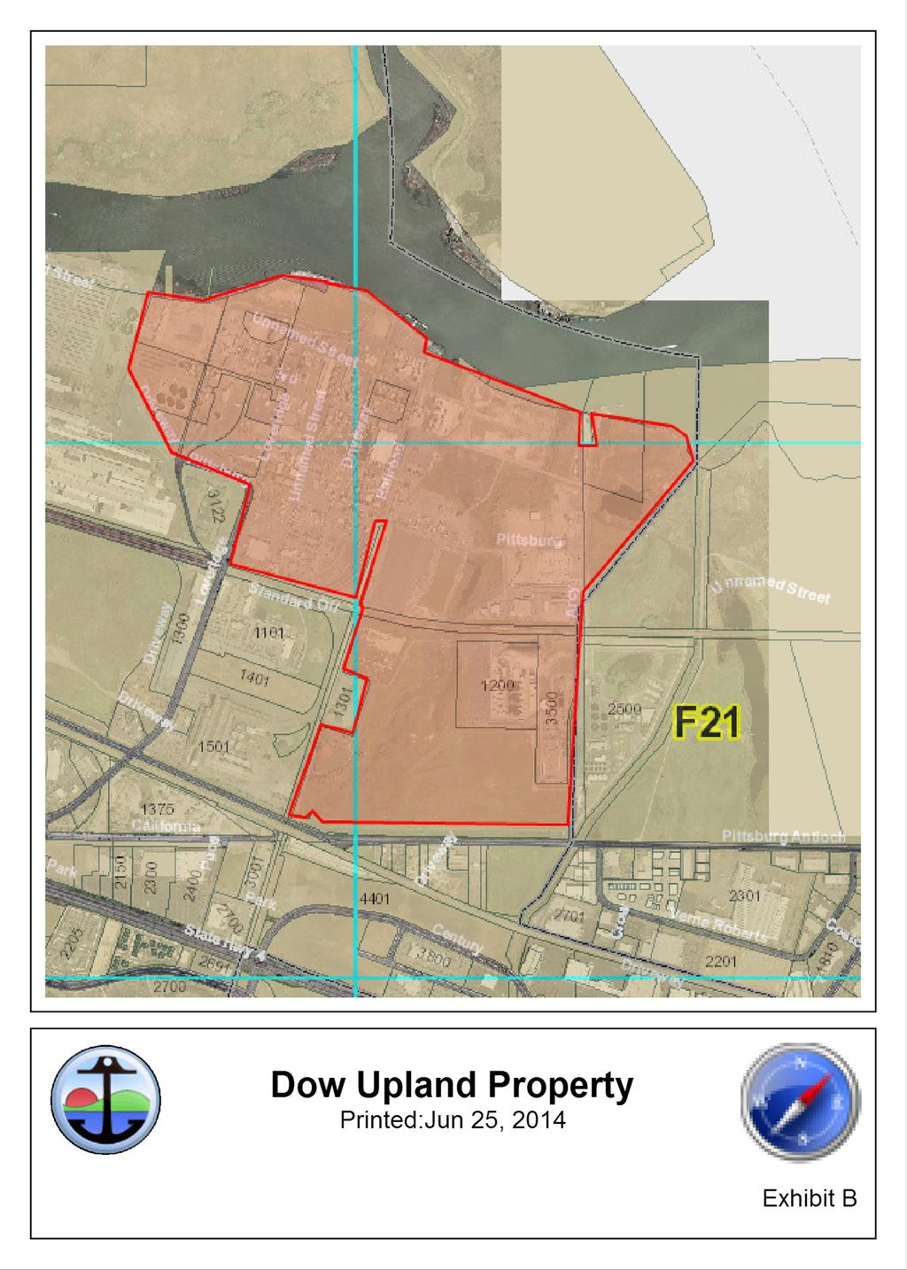
8 Exhibit B UPLAND PROPERTY (Included on following pages) Exhibit B B-1 The Dow Chemical Company Trust Lands Lease
9
10 RECORDING REQUESTED BY AND WHEN RECORDED MAIL TO: City of Pittsburg 65 Civic Dr. Pittsburg, CA Attn: City Clerk Exhibit C FORM OF MEMORANDUM OF LEASE EXEMPT FROM RECORDING FEES PER GOVERNMENT CODE 6103, MEMORANDUM OF LEASE Space above this line for Recorder s use. This Memorandum of Lease (this Memorandum ), dated for reference purposes as of July 1, 2014, is executed by and between the City of Pittsburg, a municipal corporation (the City ) and The DOW Chemical Company, a private company (the Tenant ), in reference to and consideration of that certain Lease dated as of July 1, 2014, by and between City and Tenant (the Lease ). 1. The purpose of this Memorandum is to provide notice of the existence of the Lease which is incorporated herein by this reference. This Memorandum incorporates all of the terms and provisions of the Lease as though fully set forth herein. 2. The City is trustee of acres of tideland situated in New York Sough, located in the City of Pittsburg (the Property ), as more particularly described in Exhibit A attached hereto and incorporated herein by this reference. 3. The Property is subject to that certain tidelands trust plan adopted by the City on January 20, 2009 in accordance with Public Resources Code Sections 6361 through (as may be amended from time to time, the Trust Plan ). 4. Pursuant to the Lease, the City leases to the Tenant, and the Tenant leases from the City, the Property subject to all of the terms and conditions set forth in the Lease. 6. The Lease term is Forty-Nine (49) years commencing on July 1, Exhibit C C-1 The Dow Chemical Company Trust Lands Lease
11 7. This Memorandum may be executed in counterparts, each of which shall be an original, and all of which together shall constitute one fully-executed agreement. IN WITNESS WHEREOF, the parties have executed this Memorandum as of the date first set forth above. CITY: TENANT: CITY OF PITTSBURG DOW CHEMICAL CORPORATION By: City Manager By: President Attest: City Clerk Approved as to form: City Attorney SIGNATURES MUST BE NOTARIZED C-2 The Dow Chemical Company Trust Lands Lease
RESOLUTION NO
 RESOLUTION NO. 2009 233 A RESOLUTION OF THE CITY COUNCIL OF THE CITY OF ELK GROVE QUITCLAIMING A PORTION OF ABANDONED EAST STOCKTON BOULEVARD TO ELK GROVE V PARTNERS, LLC PURSUANT TO AN AGREEMENT WHEREAS,
DISTRICT. Huntington Beach. FIM 40-40C-3 APN and
 RECORDING REQUESTED BY W HEN RECORDED MAIL TO SOUTHERN CALIFORNIA EDISON COMPANY 2131 WALNUT GROVE AVENUE 2 ND FLOOR GO3 ROSEMEAD, CA 91770 Attn: Title and Real Estate Services SPACE ABOVE THIS LINE FOR
FOR LEGAL DESCRIPTION, SEE EXHIBIT "A" ATTACHED HERETO AND MADE APART HEREOF.
 RECORDING REQUESTED BY SOUTHERN CALIFORNIA EDISON WHEN RECORDED MAIL TO SOUTHERN CALIFORNIA EDISON COMPANY Real Properties 2131 Walnut Grove Avenue, 2nd Floor Rosemead, CA 91770 Attn: Distribution/TRES
RESOLUTION NO. BE IT RESOLVED BY THE COUNCIL OF THE CITY OF SAN JOSE THAT:
 RESOLUTION NO. A RESOLUTION OF THE COUNCIL OF THE CITY OF SAN JOSE SETTING A PUBLIC HEARING TO CONSIDER WHETHER TO CONDITIONALLY VACATE A 12,903 SQUARE FOOT PORTION OF OLD WEST JULIAN STREET BETWEEN NORTH
;:ft{n Siegel, City Manager
 5/17/2016 03 City of San Juan Capistrano Agenda Report TO: FROM: Honorable Mayor and Members of the City Council ;:ft{n Siegel, City Manager SUBMITTED BY: Steve May, Public Works and Utilities Director
MASTER SITE LEASE. by and between THE CITY OF SAN DIEGO. and the PUBLIC FACILITIES FINANCING AUTHORITY OF THE CITY OF SAN DIEGO.
 RECORDING REQUESTED BY AND ) WHEN RECORDED MAIL TO: ) ) Attn: Robert H. Olson, Esq. ) Squire, Sanders & Dempsey L.L.P. ) One Maritime Plaza, Suite 300 ) San Francisco, CA 94111 ) ) (Space above for Recorder
GeoPoint 213 Hobbs Street Tampa, Florida
 AIRPORT ROAD PINELAND P.R.D. SUBDIVISION - PHASES 2 & 3 DESCRIPTION: A parcel of land lying in Sections 13 and 24, Township 14 South, Range 31 East, Volusia County, Florida, and being more particularly
ATTACHMENT B GRANT DEED. This deed is in satisfaction of the Eminent Domain Action Case No. GRANT DEED
 GRANT DEED RECORDING REQUESTED BY AND WHEN RECORDED MAIL TO: County of Orange County Executive Office CEO Real Estate 333 W. Santa Ana Blvd. Bldg. 10 Santa Ana, California 92701 AND MAIL TAX STATEMENTS
EASEMENT DEED. 2) Thence N 60º12 36 W through said Parcel 1 a distance of Two Hundred Ninety- Five and 97/100 (295.97) feet to a point;
 Thence N 60º12 36 W through said Parcel 1 a distance of Two Hundred Ninety- Five and 97/100 (295.97) feet to a point;") EASEMENT DEED TALL TREES CONSTRUCTION CORP., a Maine corporation having a mailing address of 30 Preservation Drive, Falmouth, Maine 04105 (the "Grantor") for consideration paid, grants to the TOWN OF FALMOUTH,
EASEMENT DEED TALL TREES CONSTRUCTION CORP., a Maine corporation having a mailing address of 30 Preservation Drive, Falmouth, Maine 04105 (the "Grantor") for consideration paid, grants to the TOWN OF FALMOUTH,
LANDSCAPE AND MAINTENANCE EASEMENT. THIS LANDSCAPE AND MAINTENANCE EASEMENT, (hereinafter Easement )
") Prepared by and return to: Parcel ID # LANDSCAPE AND MAINTENANCE EASEMENT THIS LANDSCAPE AND MAINTENANCE EASEMENT, (hereinafter Easement ) is made and entered into this day of, 2009, by and between THIRD
Prepared by and return to: Parcel ID # LANDSCAPE AND MAINTENANCE EASEMENT THIS LANDSCAPE AND MAINTENANCE EASEMENT, (hereinafter Easement ) is made and entered into this day of, 2009, by and between THIRD
AGENDA UPDATE ECONOMIC DEVELOPMENT & FINANCE STANDING COMMITTEE MEETING MONDAY, AUGUST 10, 2015 III. COMMITTEE AGENDA
 AGENDA UPDATE ECONOMIC DEVELOPMENT & FINANCE STANDING COMMITTEE MEETING MONDAY, AUGUST 10, 2015 III. COMMITTEE AGENDA REVISED ITEM NO. 4 150217.ORDINANCE: VACATION VILLAGE AREAS 1 AND 2A Synopsis: A revised
DRAINAGE AND UTILITY EASEMENT. That Bruce Conrad, a single adult, hereinafter referred to as Grantor for good and
 DRAINAGE AND UTILITY EASEMENT KNOW ALL PERSONS BY THESE PRESENTS: That Bruce Conrad, a single adult, hereinafter referred to as Grantor for good and valuable consideration, the receipt and sufficiency
RESOLUTION NO. RD:EEH:LCP
 RESOLUTION NO. A RESOLUTION OF THE COUNCIL OF THE CITY OF SAN JOSE CONDITIONALLY VACATING A PORTION OF MERIDIAN AVENUE, SOUTH OF FRUITDALE AVENUE, AND RESERVING A PUBLIC SERVICE EASEMENT OVER THE VACATED
GeoPoint 1403 E. 5th Avenue Tampa, Florida
 AIRPORT ROAD PINELAND P.R.D. SUBDIVISION - PHASE 1 DEDICATION: CERTIFICATE OF REVIEW BY SURVEYOR, CITY OF ORMOND BEACH DEDICATION: THIS IS TO CERTIFY THAT FORESTAR (USA) REAL ESTATE GROUP INC., A DELAWARE
ES ONDID4 City of Choice r
 ES ONDID4 City of Choice r Agenda Item No.: tc'' Date : June 9, 2010 TO: Honorable Mayor and Members of the City Council FROM : Edward N. Domingue, Director of Engineering Services Jo Ann Case, Economic
Sketch & Legal Description of Mitigation Bank and Ingress/Egress Access Easements
 Appendix H: Sketch & Legal Description of Mitigation Bank and Ingress/Egress Access Easements Tippen Bay Wetland Mitigation Bank DeSoto County, Florida Prepared by: September, 2017 Original file
RESOLUTION NO. NOW, THEREFORE, BE IT RESOLVED BY THE COUNCIL OF THE CITY OF SAN JOSE THAT:
 RD:EH 2/11/16 RESOLUTION NO. A RESOLUTION OF THE COUNCIL OF THE CITY OF SAN JOSE SUMMARILY VACATING A PEDESTRIAN ACCESS EASMENT LOCATED BETWEEN CASSELINO DRIVE AND MULLINIX WAY AND RESERVING AND EXCEPTING
CITY OF OCALA CITY COUNCIL REPORT Council Meeting Date: 06/06/17
 CITY OF OCALA CITY COUNCIL REPORT Council Meeting Date: 06/06/17 Subject: Large Scale Land Use Map Amendment Submitted By: David Boston Department: Growth Management STAFF RECOMMENDATION (Motion Ready):
APPLICATION TO REGISTER NOTICE OF AN AGREEMENT THE LAND TITLES ACT SECTION 74
 26 th May 1981 Campeau - City of Kanata 40% Open Space Agreement APPLICATION TO REGISTER NOTICE OF AN AGREEMENT THE LAND TITLES ACT SECTION 74 TO: THE LAND REGISTRAR FOR THE LAND TITLES DIVISION OF OTTAWA-CARLETON
LEGAL DESCRIPTION (continued)
") LEGAL DESCRIPTION PARCEL G: (TWELFTH STREET) A PARCEL OF LAND, IN THE CITY OF LOS ANGELES, COUNTY OF LOS ANGELES, STATE OF CALIFORNIA, BEING THAT PORTION OF TWELFTH STREET, AS SHOWN ON THE MAP OF TRACT
LEGAL DESCRIPTION PARCEL G: (TWELFTH STREET) A PARCEL OF LAND, IN THE CITY OF LOS ANGELES, COUNTY OF LOS ANGELES, STATE OF CALIFORNIA, BEING THAT PORTION OF TWELFTH STREET, AS SHOWN ON THE MAP OF TRACT
PROPERTY EXCHANGE & CONVEYANCE AGREEMENT RECITALS
 PROPERTY EXCHANGE & CONVEYANCE AGREEMENT This Property Exchange and Conveyance Agreement ( Agreement ) is entered into as of the date of execution by and between Laramie Church of Christ, Inc., a Wyoming
COUNTY OF LOS ANGELES
 JAMES A. NOYES, Director COUNTY OF LOS ANGELES DEPARTMENT OF PUBLIC WORKS 900 SOUTH FREMONT AVENUE ALHAMBRA, CALIFORNIA 91803-1331 Telephone: (626) 458-5100 ADDRESS ALL CORRESPONDENCE TO: P.O. BOX 1460
UNOPPOSED ORDER GRANTING RECEIVER'S MOTION TO APPROVE THE SALE OF REAL PROPERTY OWNED BY MAMC EMERALD CAY, LLC
 IN THE CIRCUIT COURT OF THE ELEVENTH JUDICIAL CIRCUIT IN AND FOR MIAMI-DADE COUNTY, FLORIDA STATE OF FLORIDA, OFFICE OF FINANCIAL REGULATION, Plaintiff, v. BERMAN MORTGAGE CORPORATION, a Florida corporation,
Village of Mantua, Ohio ORDINANCE
 AN ORDINANCE AUTHORIZING THE MAYOR TO EXECUTE A LEASE / OPTION TO PURCHASE AGREEMENT WITH THE PORTAGE PARK DISTRICT FOR THE HEADWATERS TRAIL WEST OF STATE ROUTE 44, AND DECLARING AN EMERGENCY. WHEREAS,
CONVEYANCE - COMMONWEALTH PROPERTY IN THE BOROUGH OF EAST STROUDSBURG, MONROE COUNTY Act of Jul. 1, 2016, P.L., No. 65 Cl.
 CONVEYANCE - COMMONWEALTH PROPERTY IN THE BOROUGH OF EAST STROUDSBURG, MONROE COUNTY Act of Jul. 1, 2016, P.L., No. 65 Cl. 85 An Act Authorizing the Department of General Services, with the approval of
BILL NO (Emergency Measure) ORDINANCE NO. 5072
 ORDINANCE NO. 5072") BILL NO. 5210 (Emergency Measure) ORDINANCE NO. 5072 AN ORDINANCE AUTHORIZING THE MAYOR TO EXECUTE WITH MICHELSON-HADLEY HEIGHTS DEVELOPMENT, LLC, A CONTRACT AND QUIT CLAIM DEED CONVEYING CERTAIN PROPERTIES
BILL NO. 5210 (Emergency Measure) ORDINANCE NO. 5072 AN ORDINANCE AUTHORIZING THE MAYOR TO EXECUTE WITH MICHELSON-HADLEY HEIGHTS DEVELOPMENT, LLC, A CONTRACT AND QUIT CLAIM DEED CONVEYING CERTAIN PROPERTIES
AN ACT. The General Assembly of the Commonwealth of Pennsylvania hereby enacts as follows:
 CONVEYANCES - COMMONWEALTH PROPERTY IN LIGONIER BOROUGH, WEST MORELAND COUNTY; CITY OF CONNELLSVILLE, FAYETTE COUNTY; CITY OF ALLENTOWN, LEHIGH COUNTY; BENSALEM TOWNSHIP, BUCKS COUNTY, AND SUSQUEHANNA
Business Item No xxx
 Business Item No. 2015-xxx Metropolitan Parks and Open Space Commission Meeting date: October 6, 2015 For the Community Development Committee meeting of October 19, 2015 For the Metropolitan Council meeting
AGENDA REPORT. Meeting Date: August 16, 2011 Item Number: H 7
 9 Meeting Date: August 16, 2011 Item Number: H 7 To: From: Subject: AGENDA REPORT Honorable Mayor & City Council Jeffrey Kolin, City Manager Scott G. Miller, Ph.D., Director of Administrative Services/CFO
ARTICLES OF INCORPORATION
 Cherry Creek Vista Homeowners Association June, 2009 The following pages were retyped from copies of the original documents. The original documents are available through the Arapahoe County, Colorado,
E' ONDIDO CITY COUNCIL. Agenda Item No.: 5 Date: February 3, TO: Honorable Mayor and Members of the City Council
 E' ONDIDO City of Choice 4000^ CITY COUNCIL For City Clerk's Use: APPROVED F-1 DENIED Reso No. File No. Ord No. TO: Honorable Mayor and Members of the City Council Agenda Item No.: 5 Date: February 3,
QUITCLAIM OF EASEMENT DEED R/WNo APN: &
 City of Los Angeles When recorded mail To: Los Angeles County Metropolitan Transportation Authority Attn: Roger Mohere, Chief Real Property Management & Development One Gateway Plaza Los Angeles, CA 90012
DOCUMENT VET SHEET for Karen McConnaughay Chairman, Kane County Board
 DOCUMENT VET SHEET for Karen McConnaughay Chairman, Kane County Board Name of Document: Temporary Construction Easement for Grading Purposes between Geneva School District and Counzy of Kane Submitted
ESTOPPEL CERTIFICATE
 Symetra Life Insurance Company Attn: Mortgage Loan Department PO Box 84066 Seattle, WA 98124-8466.Loan # SLAN2051 ESTOPPEL CERTIFICATE This Estoppel Certificate is made with respect to the Amended and
City Council Information Form
 City Council Information Form DATE: 08/13/2014 ASSIGNED STAFF: Robert McKay DEPARTMENT: Planning&Development TYPE OF FORM: Ordinances Form No.: 4490 APPROVALS: None ISSUE/REQUEST: AN ORDINANCE VACATING
ORDINANCE WHEREAS, the Planning and Zoning Board of the City of Belleview has been designated as the Local Planning Agency; and
 Page 1 of 9 ORDINANCE 2019-03 AN ORDINANCE OF THE CITY OF BELLEVIEW, FLORIDA RELATING TO AN AMENDMENT OF 8.87 +/- ACRES OF LAND TO THE CITY OF BELLEVIEW COMPREHENSIVE PLAN; AMENDING THE FUTURE LAND USE
RATE AND METHOD OF APPORTIONMENT FOR COMMUNITY FACILITIES DISTRICT NO. 4 - MAINTENANCE OF THE CITY OF MORENO VALLEY
 CFD No. 4 Maintenance Page 1 RATE AND METHOD OF APPORTIONMENT FOR COMMUNITY FACILITIES DISTRICT NO. 4 - MAINTENANCE OF THE CITY OF MORENO VALLEY A Special Tax as hereinafter defined shall be levied on
RD:JVP:JMD 01/10//2017 RESOLUTION NO.
 01/10//2017 RESOLUTION NO. A RESOLUTION OF THE COUNCIL OF THE CITY OF SAN JOSE INITIATING REORGANIZATION PROCEEDINGS FOR THE ANNEXATION AND DETACHMENT OF CERTAIN UNINHABITED TERRITORY DESIGNATED AS STORY
AMENDED AND RESTATED BARGAIN SALE AGREEMENT
 AMENDED AND RESTATED BARGAIN SALE AGREEMENT THIS AMENDED AND RESTATED BARGAIN SALE AGREEMENT ( Agreement ) is made and executed as of the 17th day of May, 2016, by and between The District Board of Trustees
DRAFT RESOLUTION NO
 DRAFT RESOLUTION NO 07 084 A RESOLUTION OF THE CITY COUNCIL OF THE CITY OF CUPERTINO ACCEPTING GRANT OF EASEMENT FOR ROADWAY PURPOSES FROM LEONA SY AN UNMARRIED WOMAN AND FREDERICK TY AN UNMARRIED MAN
AMENDMENT TO POWER PURCHASE AGREEMENT
 AMENDMENT TO POWER PURCHASE AGREEMENT This Amendment Power Purchase and Agreement ( Amendment ) is entered into as of, 2012, by and between, (hereinafter RMW ) a Nevada limited liability company, and The
CONSENT ACTION BY THE BOARD OF DIRECTORS OF VENETO IN MIRAMAR CONDOMINIUM ASSOCIATION, INC.
 CONSENT ACTION BY THE BOARD OF DIRECTORS OF VENETO IN MIRAMAR CONDOMINIUM ASSOCIATION, INC. The undersigned, being all of the members of the Board of Directors of Veneto in Miramar Condominium Association,
RESOLUTION NO. WHEREAS, a map showing the location of such territory is attached hereto as Exhibit "B" and incorporated herein by this reference; and
 RD:VMT :JMD RESOLUTION NO. A RESOLUTION OF THE COUNCIL OF THE CITY OF SAN JOSE ORDERING THE REORGANIZATION OF CERTAIN UNINHABITED AND UNINCORPORATED TERRITORY DESIGNATED AS STORY NO. 66, SUBJECT TO LIABILITY
City Council Agenda Item #13_ Meeting of March 6, 2017
 City Council Agenda Item #13_ Meeting of March 6, 2017 Description Recommendation Resolution vacating a sump easement and drainage and utility easements located at 1555 Linner Road. Hold the public hearing
ORDINANCE NO AN ORDINANCE To Be Entitled:
 3808 AN ORDINANCE To Be Entitled: AN ORDINANCE OF THE CITY COUNCIL OF THE CITY OF FORT MYERS, FLORIDA, REZONING FROM COMMERCIAL GENERAL TO PLANNED UNIT DEVELOPMENT AND APPROVING THE DEVELOPMENT PLAN FOR
Old Republic National Title Insurance Company
 Old Republic National Title Insurance Company COMMITMENT FOR TITLE INSURANCE SCHEDULE A File No: 59425 Upper River Area Parcels Supplemental No. 2 1. Effective Date: June 02, 2013, 7:00 a.m. Issue Date:
Clerk-Recorder Sacramento, CA FIFTH AMENDMENT TO MASTER SITE LEASE. by and between the CITY OF SACRAMENTO. and the
 When Recorded Return to: ORIGINAL Accepted for Recording COPY-NOT CERTIFIED Sean B. Mick, Project Manager 'JUN 14 208 Orrick, Herrington & Sutcliffe LLP 400 Capitol Mail Sacramento County Suite 3000 Clerk-Recorder
CITY OF LARKSPUR Staff Report
 DATE: August 29, 2011 CITY OF LARKSPUR Staff Report September 7, 2011 City Council Meeting TO: FROM: SUBJECT: Larkspur City Council Hamid Shamsapour, Director of Public Works A Resolution of the City Council
Memorandum /14/17. FROM: Harry Freitas TO: HONORABLE MAYOR AND CITY COUNCIL. DATE: February 9, 2017 SUBJECT: SEE BELOW. Date.
 ---------3/14/17 COUNCIL AGENDA: 02/28/17 ITEM: -------- 3 4.1 CITY OF SAN JOSE CAPITAL OF SILICON VALLEY TO: HONORABLE MAYOR AND CITY COUNCIL SUBJECT: SEE BELOW Memorandum FROM: Harry Freitas DATE: February
REVIEWED BY: Administrator Counsel Program Mgr.: Tiffany Schaufler Board Committee Engineer Other
 Minnehaha Creek Watershed District REQUEST FOR BOARD ACTION MEETING DATE: May 11, 2017 TITLE: Authorization to Grant a Temporary Easement to the City of Minnetrista RESOLUTION NUMBER: 17-034 PREPARED BY:
City Council Agenda Item #13_ Meeting of October 10, 2016
 City Council Agenda Item #13_ Meeting of October 10, 2016 Brief Description Recommendation Resolution approving vacation of existing drainage and utility easements located at 4301 Highview Place and an
COMMONWEALTH OF MASSACHUSETTS
 SPECIAL TOWN MEETING October 1, 2018 COMMONWEALTH OF MASSACHUSETTS HAMPDEN, SS To Ms. Kim Batista, Town Clerk of the Town of Ludlow in said County: GREETINGS: In the name of the Commonwealth of Massachusetts,
AGENDA # May 24, 2011
 AGENDA # May 24, 2011 ALAMEDA COUNTY FLOOD CONTROL AND WATER CONSERVATION DISTRICT. ZONE 7 100 NORTH CANYONS PARKWAY. LIVERMORE. CA 94551-9486' PHONE (925) 454-5000 MayIO,2DIl Honorable Board of Supervisors
IIIlIIIIII IllIllhllIllIllIll III Ill Sacramento County Recorder David Villanueva,-Clerk/Recorder
 Record for the Benefit of the City of Sacramento - Fee Exempt Pursuant to Government Code Section 6103 and 27383. Transfer Tax exempt under Revenue and Taxation Code 11921, When Recorded, Mail to: Office
CORPORATE SPECIAL WARRANTY DEED FOR RIGHT OF WAY
 CORPORATE SPECIAL WARRANTY DEED FOR RIGHT OF WAY THIS INDENTURE WITNESSETH that ELI LILLY AND COMPANY, an Indiana corporation, ( Grantor ), as a gift and for no other consideration, CONVEYS ANDSPECIALLY
WATERFORD LANDING COMMUNITY DEVELOPMENT DISTRICT REGULAR MEETING AGENDA
 WATERFORD LANDING COMMUNITY DEVELOPMENT DISTRICT REGULAR MEETING AGENDA January 31, 2019 Waterford Landing Community Development District OFFICE OF THE DISTRICT MANAGER 2300 Glades Road, Suite 410W Boca
MEMORANDUM. Michael Smith, Director of Public Works. Discussion of Temporary Aerial Easement for KDC
 MEMORANDUM To: From: Mayor and City Council Michael Smith, Director of Public Works Date: August 11, 2014 Subject: Discussion of Temporary Aerial Easement for KDC ITEM DESCRIPTION Discussion of an aerial
IRREVOCABLE OFFER OF DEDICATION AND GRANT DEED (Well 15/Parcel L, McCormack Road, Liberty Island Road)
") RECORDING REQUESTED BY AND WHEN RECORDED MAIL TO, AND MAIL TAX STATEMENTS TO: City of Rio Vista Attn: City Manager 1 Main Street Rio Vista, CA 94571 (Above Space for Recorder s Use Only) THE UNDERSIGNED
RECORDING REQUESTED BY AND WHEN RECORDED MAIL TO, AND MAIL TAX STATEMENTS TO: City of Rio Vista Attn: City Manager 1 Main Street Rio Vista, CA 94571 (Above Space for Recorder s Use Only) THE UNDERSIGNED
County of Santa Cruz
 Ou GOS87 County of Santa Cruz DEPARTMENT OF PUBLIC WORKS - REAL PROPERTY DIVISION THOMAS L. BOLICH DIRECTOR OF PUBLIC WORKS 701 OCEAN STREET, ROOM 410, SANTA CRUZ, CA 95060-4070 (831) 454-2331 FAX (831)
RESOLUTION NO. FILE NO. T15-058
 RESOLUTION NO. A RESOLUTION OF THE COUNCIL OF THE CITY OF SAN JOSE APPROVING A VESTING TENTATIVE MAP, SUBJECT TO CONDITIONS, TO MERGE FOUR PARCELS INTO ONE PARCEL AND RESUBDIVIDE THE ONE PARCEL INTO NO
TRANSBAY JOINT POWERS AUTHORITY
 STAFF REPORT FOR CALENDAR ITEM NO.: 8.3 FOR THE MEETING OF: December 13, 2018 BRIEF DESCRIPTION: TRANSBAY JOINT POWERS AUTHORITY Approve an easement agreement, granting Pacific Gas & Electric Company (PG&E)
Voluntary Merger. Updated March 13, 2017
 Voluntary Merger Updated March 13, 2017 What is a Voluntary Merger? A Voluntary Merger is a process by which two or more parcels of land are merged into a single legal parcel. Pay special attention to
GRANT OF AN OPEN SPACE EASEMENT; LANDS OF HENG AND PAREIGIS; LA RENA LANE; FILE # ZP-SD-GD.
 AGENDA ITEM #4.N TOWN OF LOS ALTOS HILLS Staff Report to the City Council September 21, 2017 SUBJECT: FROM: GRANT OF AN OPEN SPACE EASEMENT; LANDS OF HENG AND PAREIGIS; 25383 LA RENA LANE; FILE #258-16-ZP-SD-GD.
Exhibit A: REAL ESTATE TRANSFER AGREEMENT
 Exhibit A: REAL ESTATE TRANSFER AGREEMENT This agreement is made between the City of Urbana, Illinois, a municipal corporation of the State of Illinois (the Seller ), and Homestead Corporation of Champaign-Urbana,
COUNTY OF LOS ANGELES
 JAMES A. NOYES, Director COUNTY OF LOS ANGELES DEPARTMENT OF PUBLIC WORKS 900 SOUTH FREMONT AVENUE ALHAMBRA, CALIFORNIA 91803-1331 Telephone: (626) 458-5100 www.ladpw.org ADDRESS ALL CORRESPONDENCE TO:
CITY OF HIAWATHA, IOWA TOWN VILLAGE CENTER URBAN REVITALIZATION PLAN. for the TOWN VILLAGE CENTER URBAN REVITALIZATION AREA
 CITY OF HIAWATHA, IOWA TOWN VILLAGE CENTER URBAN REVITALIZATION PLAN for the TOWN VILLAGE CENTER URBAN REVITALIZATION AREA 2018 1 INTRODUCTION The Urban Revitalization Act, Chapter 404 of the Code of Iowa,
RESOLUTION NO. 16- A RESOLUTION OF THE CITY COUNCIL OF THE CITY OF WEST HOLLYWOOD ACCEPTING THE GRANT OF AN EASEMENT AND RIGHT OF WAY
 ATTACHMET 2 RESOLUTO O. 16- A RESOLUTO OF THE CTY COUCL OF THE CTY OF WEST HOLLYWOOD ACCEPTG THE GRAT OF A EASEMET AD RGHT OF WAY FOR PUBLC STREET AD SDEWALK PURPOSES AT 8945 ASHCROFT AVEUE THE CTY OF
OFFICIAL SUMMARY OF AN ORDINANCE TO CONVEY CERTAIN RAMSEY COUNTY PARK AND OPEN SPACE LANDS TO THE CITY OF MAPLEWOOD.
 OFFICIAL SUMMARY OF AN ORDINANCE TO CONVEY CERTAIN RAMSEY COUNTY PARK AND OPEN SPACE LANDS TO THE CITY OF MAPLEWOOD. This ordinance authorizes the conveyance of park and open space land owned by Ramsey
AGENDA ITEM #4.G. TOWN OF LOS ALTOS HILLS Staff Report to the City Council. August 18, 2016
 AGENDA ITEM #4.G TOWN OF LOS ALTOS HILLS Staff Report to the City Council August 18, 2016 SUBJECT: FROM: DEDICATION OF RIGHT-OF-WAY EASEMENT LANDSOFBANATAO 26810 ORTEGA DRIVE Richard Chiu, City Engineer/Public
JOINT RESOLUTION OF THE CITY OF PORT JERVIS, ORANGE COUNTY, NEW YORK AND THE TOWN OF DEERPARK, ORANGE COUNTY, NEW YORK
 JOINT RESOLUTION OF THE CITY OF PORT JERVIS, ORANGE COUNTY, NEW YORK AND THE TOWN OF DEERPARK, ORANGE COUNTY, NEW YORK WHEREAS, the City of Port Jervis, in conjunction with the Town of Deerpark seeks to
Development Program Report for the Alamo Area of Benefit
 Julia R. Bueren, Director Deputy Directors Brian M. Balbas, Chief Mike Carlson Stephen Kowalewski Carrie Ricci Joe Yee ADOPTED BY BOARD OF SUPERVISORS ON Development Program Report for the Alamo October,
L DOWNSTATE AT LICH HOLDINGS COMPANY, INC. Lessor. and THE STATE UNIVERSITY OF NEW YORK. Lessee FIRST AMENDMENT TO LEASE. Dated June 30, 2014
 00166 EXECUTION VERSION L120020 28100 DOWNSTATE AT LICH HOLDINGS COMPANY, INC. Lessor and THE STATE UNIVERSITY OF NEW YORK Lessee FIRST AMENDMENT TO LEASE Dated June 30, 2014 The Properties affected by
Board of Trustees Meeting - Agenda
 Board of Trustees Meeting - Agenda Office of the President University of Central Florida Board of Trustees Meeting Agenda June 20, 2018 Millican Hall, 3 rd floor, Provost s Conference Room 10:00 a.m. 800-442-5794,
Planning Commission Staff Report September 15, 2016
 Planning Commission Staff Report September 15, 2016 PROJECT: FILE: REQUEST: The Outlet Collection at Elk Grove EG-14-012A Development Agreement Amendment, Mall Agreement Amendment 10465 Promenade Parkway
MUNICIPAL QUITCLAIM DEED
 DRAFT MUNICIPAL QUITCLAIM DEED The INHABITANTS OF THE TOWN OF WARREN, a body corporate and politic, located at Warren, Knox County, Maine, for consideration paid, Release to, whose mailing address is,
=r..-()~s...,t_o_n~j:.,...[e-~ w:7":-_e.,..b-:,._ v-=e=s=-:,... ; ~"C"!!i,-.N";-;;O'" "
~s...,t_o_n~j:.,...[e-~ w:7:-_e.,..b-:,._ v-=e=s=-:,... ; ~C!!i,-.N;-;;O'") COUNTY OF KANE Christopher J. Lauzen Kane County Board Chairman Kane County Government Center 719 South Batavia A venue Geneva, JL 60134 P: (630) 232-5930 F: (630) 232-9188 clauzen@kanecoboard.org www.countyofkane.org
COUNTY OF KANE Christopher J. Lauzen Kane County Board Chairman Kane County Government Center 719 South Batavia A venue Geneva, JL 60134 P: (630) 232-5930 F: (630) 232-9188 clauzen@kanecoboard.org www.countyofkane.org
INTERGOVERNMENTAL AGREEMENT
 INTERGOVERNMENTAL AGREEMENT This Intergovernmental Agreement (this Agreement) is made and entered into as of December 1, 2010, by and between the VILLAGE OF BIG ROCK, an Illinois municipal corporation
Dact= Bk:31661 Ps: 116
 Dact= 33591 Bk:31661 Ps: 116 AMENDMENT TO THE MASTER DECLARATION OF COVENANTS, CONDITIONS AND RESTRICTIONS FOR DUNSTAN CROSSING [Submission of Project Phase IIIl CHAMBERLAIN CONSTRUCTION, INC., a Maine
ORDINANCE NO
 DRAFT NO. 09-90 ORDINANCE NO. 2009-81 AN ORDINANCE ACCEPTING FOR DEDICATION PURPOSES, A SANITARY SEWER EASEMENT FROM THE STATE OF OHIO FOR THE GREEK VILLAGE ON KENT STATE UNIVERSITY PROPERTY AND DECLARING
LEASE. by and between COUNTY OF MONTEREY. and MONTEREY PUBLIC IMPROVEMENT CORPORATION. Dated as of, 2010 WHEN RECORDED RETURN TO:
 WHEN RECORDED RETURN TO: Orrick, Herrington & Sutcliffe LLP 777 S. Figueroa St., Suite 3200 Los Angeles, California 90017 Attn: Greg Harrington, Esq. THIS DOCUMENT IS RECORDED FOR THE BENEFIT OF THE COUNTY
FILED: NEW YORK COUNTY CLERK 12/15/ :54 PM
 Rosenthal Affidavit Exhibit 1 NYC DEPARTMENT OF FINANCE OFFICE OF THE CITY REGISTER This page is part of the instrument. The City Register will rely on the information provided by you on this page for
AGENDA SCARBOROUGH TOWN COUNCIL REGULAR MEETING 7:00 P.M. WEDNESDAY JUNE 17, 2009
 AGENDA SCARBOROUGH TOWN COUNCIL REGULAR MEETING 7:00 P.M. WEDNESDAY JUNE 17, 2009 Order No. 09-88. Move to approve the acceptance of the fee of the land identified on Scarborough Tax Map 22, Lot 109-A
MEMORANDUM. Mayor and City Council. Warren Hutmacher, City Manager. Date: February 11, 2013
 MEMORANDUM To: From: Mayor and City Council Warren Hutmacher, City Manager Date: February 11, 2013 Subject: Approval of an Intergovernmental agreement by and between the City of Dunwoody and DeKalb County
Settlement A.qreement and General Release. This Settlement Agreement and General Release ("Agreement") is made
 is made") Settlement A.qreement and General Release This Settlement Agreement and General Release ("Agreement") is made and entered into as of... 2009, by and between George Rich dba Caravan Lounge, ("Tenant") and.by
Settlement A.qreement and General Release This Settlement Agreement and General Release ("Agreement") is made and entered into as of... 2009, by and between George Rich dba Caravan Lounge, ("Tenant") and.by
ORDINANCE NO. Z REZONING NO
 ORDINANCE NO. Z- 3960 REZONING NO. 2018-00014 AN ORDINANCE RELATING TO ZONING: AMENDING CERTAIN ZONING REGULATIONS SHOWN ON SHEET NO. 15 OF THE ZONING DISTRICT MAP INCORPORATED BY REFERENCE BY OVERLAND
JUN by and between the - SACRAMENTO CITY FINANCING AUTHORITY CITY OF SACRAMENTO. ORIGINAL Accepted for Recording COPY-NOT CERTIFIED
 When Recorded Return to: Sean B. Mick, Project Manager Orrick, Herrington & Sutcliffe LLP 400 Capitol Mall Suite 3000 Sacramento, CA 95814 NO FEE DOCUMENT per Government Code 6103, 27383 ORIGINAL Accepted
TOWN OF WOODBURY NOTICE AND WARNING OF SPECIAL TOWN MEETING MARCH 16, 2016
 TOWN OF WOODBURY NOTICE AND WARNING OF SPECIAL TOWN MEETING MARCH 16, 2016 Pursuant to Sections 203 and 204 of the Woodbury Charter, all electors and citizens qualified to vote in town meetings of the
FIFTH AMENDMENT OF DECLARATION OF DEED RESTRICTIONS AND DEDICATIONS FOR PINEHURST ESTATES (A Clatsop County, Oregon Subdivision)
") After Recording Return To: W. Louis Larson 990 Astor Street Astoria, OR 97103 FIFTH AMENDMENT OF DECLARATION OF DEED RESTRICTIONS AND DEDICATIONS FOR PINEHURST ESTATES (A Clatsop County, Oregon Subdivision)
After Recording Return To: W. Louis Larson 990 Astor Street Astoria, OR 97103 FIFTH AMENDMENT OF DECLARATION OF DEED RESTRICTIONS AND DEDICATIONS FOR PINEHURST ESTATES (A Clatsop County, Oregon Subdivision)
PURCHASE AND SALE AGREEMENT AND ESCROW INSTRUCTIONS [292 STOCKTON AVENUE]
![PURCHASE AND SALE AGREEMENT AND ESCROW INSTRUCTIONS [292 STOCKTON AVENUE]](/thumbs/79/79090901.jpg "PURCHASE AND SALE AGREEMENT AND ESCROW INSTRUCTIONS [292 STOCKTON AVENUE]") PURCHASE AND SALE AGREEMENT AND ESCROW INSTRUCTIONS [292 STOCKTON AVENUE] This Purchase and Sale Agreement and Escrow Instructions ( Agreement ) is entered into as of this day of, 2017, by and between
PURCHASE AND SALE AGREEMENT AND ESCROW INSTRUCTIONS [292 STOCKTON AVENUE] This Purchase and Sale Agreement and Escrow Instructions ( Agreement ) is entered into as of this day of, 2017, by and between
IN THE DISTRICT COURT OF McPHERSON COUNTY, KANSAS
 IN THE DISTRICT COURT OF McPHERSON COUNTY, KANSAS THE BOARD OF COUNTY COMMISSIONERS ) OF MCPHERSON COUNTY, KANSAS ) PLAINTIFF ) VS. ) CASE NO. 2014 CV 84 ) THE DALE L. BAIR LIVING TRUST ) DATED FEBRUARY
DOUGLAS S. STACK, DIRECTOR OF PUBLIC WORKS/ CITY ENGINEER SUBJECT: SOUTHERN CALIFORNIA GAS COMPANY OVER A PORTION OF THE
 Agenda Item AGENDA REPORT Reviewed: City Manager A Finance Director / MEETING DATE: APRIL 17, 2018 TO: JEFFREY C. PARKER, CITY MANAGER FROM: DOUGLAS S. STACK, DIRECTOR OF PUBLIC WORKS/ CITY ENGINEER SUBJECT:
CITY OF LOS ANGELES CALIFORNIA
 HOLLY L. WOLCOTT CITY CLERK SHANNON HOPPES EXECUTIVE OFFICER When making inquiries relative to this matter, please refer to the Council file No. 17-0409 CITY OF LOS ANGELES CALIFORNIA 3 SVOEDjJ ERIC GARCETTI
JOEL ROJAS, COMMUNITY DE'WPfiENT DIRECTOR ACCEPTANCE OF A SEWER EASEMENT DEED TO PROVIDE ADDITIONAL EASEMENT AREA TO ALLOW
 CITY OF RANCHO PALOS VERDES COMMUNITY DEVELOPMENT DEPARTMENT MEMORANDUM TO: FROM: DATE: SUBJECT: HONORABLE MAYOR & CITY COUNCIL MEMBERS u - JOEL ROJAS, COMMUNITY DE'WPfiENT DIRECTOR JUNE 3, 2014 ACCEPTANCE
COACHELLA VALLEY WATER DISTRICT STANDARDS FOR LEGAL DESCRIPTIONS AND PLATS
 COACHELLA VALLEY WATER DISTRICT STANDARDS FOR LEGAL DESCRIPTIONS AND PLATS The following is the procedure for processing legal descriptions and plats (exhibits) for grants of easements, grant deeds, quitclaim
REAL ESTATE PURCHASE AGREEMENT
 HOLASEK FARMS, L.P. REAL ESTATE PURCHASE AGREEMENT This Real Estate Purchase Agreement (the Agreement ) is made effective as of March, 2017, between the City of Chaska, a Minnesota municipal corporation
Stenberg Annexation Legal Diagram Exhibit "B" W Subject Property Annexed to the City of Red Bluff VICINITY MAP "1:3:
 Stenberg Annexation Legal Diagram Exhibit "B" W Subject Property Annexed to the City of Red Bluff VICINITY MAP "1:3: ORDINANCE NO. 991 REZONE NO. 210 AN ORDINANCE AMENDING SECTION 25.13 OF THE RED BLUFF
AMENDMENT TO QUITCLAIM DEED AND GRANT OF EASEMENT RECITALS
 RECORDED REQUESTED BY AND WHEN RECORDED MAIL TO: Clerk of the Board of Supervisors County of San Luis Obispo 1055 Monterey Street San Luis Obispo, CA 93408 APN 076-213-009 AND 076-215-012 SPACE ABOVE THIS
RESOLUTION NO. ZR
 RESOLUTION NO. ZR-2015-004 RESOLUTION APPROVING ZONING APPLICATION SV/ZV/Z-2014-01624 (CONTROL NO. 2009-02465) TYPE II VARIANCE (CONCURRENT) APPLICATION OF MPC 3 LLC BY CPH, Inc, Baker & Hostetler LLP,
Adopt the attached resolution accepting the grant of pathway easement.
 AGENDA TEM #4.M TOWN OF LOS ALTOS HLLS Staff Report to the City Council September 21, 2017 SUBJECT: FROM: GRANT OF PATHWAY EASEMENT LANDS OF HENG AND P AREGS 25383 LA RENA LANE Allen Chen, Public Works
VICINITY MAP SCALE 1'' = 2000'
 CITY CREEK ANNEXATION TO THE CITY OF THORNTON LOCATED IN THE SOUTHWEST QUARTER OF SECTION 11 AND THE WEST HALF OF SECTION 14, TOWNSHIP 1 SOUTH, RANGE 68 WEST OF THE 6TH PRINCIPAL MERIDIAN, COUNTY OF ADAMS,