Auckland Unitary Plan Operative in part
|
|
|
- Esther McKenzie
- 5 years ago
- Views:
Transcription
 Drury West Operative in part 7 December")
1 Auckland Unitary Plan Operative in part Plan Change 6 Auranga (B1) Drury West Operative in part 7 December 2018
2 Auckland Unitary Plan - Plan Change 6 operative in part Resource Management Act 1991 (the Act) Plan Change 6 (Auranga B1 Drury West) to the Auckland Unitary Plan (Operative in part) At its Planning Committee meeting on 27 November 2018 the council resolved to approve in part Plan Change 6 to the Auckland Unitary Plan, under clause 17(2) of Schedule 1 of the RMA. The council also resolved to direct staff to complete the necessary statutory processes to publicly notify the date on which Plan Change 6 becomes operative in part. Plan Change 6 will be made operative in part on 7 December The updated district plan and background information may be viewed at the following unitaryplanmodifications Dated 30 November 2018 Find out more: phone or visit aucklandcouncil.govt.nz
3
4 Auckland Unitary Plan Operative in part Plan Change 6 Auranga (B1) Drury West Operative in part 7 December 2018
5 PC6 Changes to text Note: - The changes are shown in strikethrough and underline - Provisions subject to appeal identified by way of comment boxes 6.35 Drury 1 Precinct description The precinct has an area of ha and is bordered by Drury Creek in the north, southern motorway to the east SH22(Karaka road) to the south and Jesmond road to the west. The site is gently rolling terrain, with coastal frontage to the upper estuary reach of Drury Creek. Two permanent watercourses run through the land, both originating within the site and flowing north towards the coastal edge. The Precinct Plan 1 area applies to the original ha of the Precinct. The Precinct Plan 2 area applies to an extension of ha. It incorporates the provisions of the precinct plan and includes the development of a local centre with opportunities for intensive residential development. Policy 14 allows for consideration of biodiversity offsets and ecological compensation for unavoidable impacts arising from development on natural resources, where this is directed to the Drury Creek Islands Recreation Reserve (DCIRR). The matters in Policy 14 can provide subsequent considerations to the provisions of E3, E1, E15 and Appendix 8 of the Auckland Unitary Plan, which address the circumstances in which residual adverse effects on natural resources that cannot be avoided, remedied or mitigated may be offset. PC 6 [ENV AKL :Elly S Pan] The transport provisions for Precinct Plan 2 recognise that Auckland Transport and the NZ Transport Agency have not yet completed planning the strategic transport network for the wider Drury area including the Future Urban zones to the west and south of the Drury 1 Precinct. The precinct provisions recognise and support future strategic transport connections which may be required to and through the precinct - in particular Jesmond Road and the new east-west road (Future Collector Road (New)). The Jesmond Road / SH 22 intersection upgrade is required prior to development in Precinct Plan 2. Other transport infrastructure upgrades outside of the precinct have not been prescribed in the same manner. However the Precinct recognises the potential for adverse traffic effects at five identified intersections and the Norrie Road one way bridge. Those effects will be assessed at the time of subdivision applications and required upgrades or other mitigation determined at that time. Refer to planning maps for the location and extent of the precinct. The following underlying zones apply to the precinct: Residential - Mixed Housing Suburban Residential - Mixed Housing Urban Residential - Terrace Housing and Apartment Buildings Business - Local Centre Objectives The objectives are as listed in the relevant underlying zones and Auckland wide provisions, except as specified below: 1. An integrated, more intensive residential environment which has high levels of amenity, allows for a range of housing densities and typologies and incorporates opportunities for a local centre.
6 2. A well connected roading layout that supports a range of travel modes, provides a strong definition of public spaces, legible and safe urban road pattern and clear differentiation between the private and public realm. 3. Ecology is maintained and enhanced through riparian margin re-planting at the time of development, building set-backs and landscaping. 4. Buildings are developed in an intensive manner, reflecting an urban character and amenity with clear definition of public fronts where buildings are massed, and private back yards that are predominantly open (excluding rear lane accessed garaging). 5. Stormwater runoff is managed to enable the maintenance and enhancement of natural waterways and water quality. 6. Subdivision, land use and development in the precinct will not adversely impact on the safe and efficient operation of the National Grid. 7. To promote availability of affordable housing to first home buyers and/or Community Housing Providers. Precinct Plan 2 8. Subdivision and development is coordinated with the delivery of infrastructure required to service the Precinct, connect it to the wider network and manage its effects, including transport, wastewater, stormwater and water services. 9. Infrastructure serving the Precinct is funded and implemented in an integrated and coordinated manner. 10. Subdivision and development occurs in way that does not compromise the ability to provide efficient and effective strategic transport connections to and through the precinct to serve future urban growth in the wider Drury area. Policies The policies are as listed in the relevant underlying zones and Auckland wide provisions except as specified below: 1. Enable and support an intensive urban form and character defined by: a. establishing a local centre within a walkable pedestrian focused environment and focus retail and commercial development in this centre b. providing a clear definition between public and private spaces, including roads and public open space. c. opportunities for convenient, comfortable and safe interaction at the public / private road boundary interface through the enablement of low-height, visually open porch structures extending into the front yard setback. d. an urban built form that encourages higher density, intensive and massing towards the road frontage and side boundaries of sites, with less development within the rear yards. e. provision of a medium density built form along the northern coastal edge of the precinct. f. a reliance on high quality and safe interconnected roads and public open spaces in preference to larger private outdoor spaces 2. Enable high density residential development (including smaller vacant sites and integrated residential developments), particularly in close proximity to the local centre, collector roads and public open spaces. 3. Maximise vehicular, cycling and pedestrian connectivity and permeability of the road network wherever possible. 4. Encourage roads to form urban blocks and to front public open spaces. 5. Require residential development within urban blocks to:
7 a. conform to a perimeter block pattern of development where buildings are massed towards the road and provide front building façades to the road b. generally provide vacant site that have narrower frontages than their depth c. ensure there is sufficient space between the rear of opposing dwellings to provide privacy and back yards for outdoor living d. maintain reasonable solar access to rear yards e. avoid driveway crossings to shared paths and dedicated cycle lanes, utilising access from side roads, access lots or rear lanes f. generally avoid rear lots 6. Control road façade elements to ensure dwellings relate to the road, including presence of a front door, sufficient glazing, ability to establish verandas / porches, landscaping provision, fencing heights and the control of garage in proportion to the façade. 7. Enable the development of rear lanes, including opportunities for rear garaging and habitable areas above the garage, especially where lot or dwelling frontage widths are narrow. 8. Require on-site management, or for higher density development private communal management of stormwater runoff from impervious areas. Stormwater from roads should generally be managed within the road corridors. 9. Require native riparian planting along waterways. 10. Avoid adverse effects of subdivision, land use and development on the National Grid line by ensuring that: a. appropriate buffer distances for managing subdivision, land use and development are provided b. sensitive activities, buildings and most structures are excluded from establishing within 12m of the centreline of a National Grid transmission line and within 12m of a National Grid support structure; and c. subdivision, landuse and development is managed around the National Grid line to ensure that future activities, buildings and development do not restrict the operation, maintenance, upgrading and development of the National Grid line. 11. Utilise the National Grid corridor for road or open space networks where practicable, provided that they are designed and located to avoid adverse effects on the operation, maintenance, upgrading and development of the National Grid lines. 12. For new residential developments containing 15 or more dwellings, or involving the creation of 15 or more vacant sites, require either: a. 10 percent of new dwellings to be relative affordable, with the purchase price to be set relative to the median house price in the Auckland region and sold to first home buyers and owned for at least three years; or b. 5 percent to be retained affordable, with the purchase price to be set relative to the median household income in Auckland region and sold to Community Housing providers or Housing New Zealand and owned for long term retention. 13. New residential developments containing 15 or more dwellings/sites provide for affordable housing that is distributed throughout the development. 14. Following assessment under the provisions of E1, E3, E15 and Appendix 8, where offsets or compensation are proposed to address residual adverse effects on natural resources that cannot be avoided, remedied or mitigated, consideration may be given to the local restoration opportunity and the multiple ecosystem benefits which could be achieved by directing the offsets or compensation to the Drury Creek Islands Recreation Reserve. Where any such offset or compensation is proposed, it should contain an assessment of the ecosystem values lost or degraded within the precinct and gained on the Drury Creek Islands Recreation Reserve. Precinct Plan Require subdivision and development to coordinate infrastructure design, funding and implementation. 16. Ensure subdivision and development is designed and implemented to meet the foreseeable transportation needs of residents within the Precinct by providing and upgrading infrastructure.
8 17.Manage the adverse traffic effects of subdivision and development on the following parts of the transport network: intersection of State Highway 22 and Jesmond Road intersection of Great South Road / Firth Street, intersection of Firth Street / Norrie Road, intersection of Great South Road / Norrie Road / Waihoehoe Road, intersection of Great South Road / Karaka Road (SH22), intersection of Victoria Street / SH22, and the Norrie Road One-Way Bridge. PC 6 [ENV AKL :Elly S Pan] 18. Require subdivision to implement the collector roads and provide for the strategic transport connections by means of the Future Collector Road (New) and Collector Road (Possible Future Arterial Road) shown on Precinct Plan 2 Precinct rules The activities, controls and assessment criteria in the underlying Residential - Mixed Housing Suburban zone, Residential - Mixed Housing Urban zone, Residential - Terrace Housing and Apartment Buildings zone, Business - Local Centre zone, and Auckland-wide rules and overlays apply in the precinct unless otherwise specified below. Refer to the Precinct Planning Map for the location and extent of the underlying zones. The provisions of Appendix apply in relation to the National Grid until the Unitary Plan becomes operative, at which time the operative provisions of the Electricity Transmission (National Grid) Corridor overlay in Chapter J will apply (and Appendix will cease to have effect). 1. Activity Table The activities in the relevant underlying zones apply in the precinct except as specified in the activity tables below and that in Appendix All relevant overlay, Auckland-wide and zone activity tables apply unless the activity is specifically provided for by a rule in Activity Tables A1.1, 1.1, 1.2, and 1.3. A1.1 All Zones Table A1.1 Activity table: All zones Activity (A1) Residential activities that do not comply with any clause within Standard 2.2 Affordable Housing Activity status D 1.1 Residential Zones Table 1.1 Activity table: Residential zones ACTIVITY TABLE: RESIDENTIAL ZONES ACTIVITY Activity ACTIVITY STATUS Activity status Residential (A2) Integrated Residential Developments RD (A2A) Integrated Residential Developments that do not comply D with Standard 6.3.1(d) (A3) Dwellings that do not comply with Standard 2.1 Density D (A4) Activities that do not comply with Standard 4.12 or 5.12: D Commerce (A5) Show home P (A6) Retail in the Terrace Housing and Apartment Buildings NC zone Infrastructure (A7) Overhead electricity lines (a single circuit) up to and P including 110kV. Within areas of the Road and Unformed
9 Road this activity shall have the same status as the adjacent Residential zone On-site stormwater management (dwellings and impervious areas excluding roads) (A8) Impervious areas (excluding roads) of less than or equal P to 50m2 within a site (A9) Impervious areas (excluding roads) greater than 50m2 P within a site that meet hydrology mitigation requirements in the relevant precinct rules below (A10) Communal stormwater device(s) located within common C land serving two or more dwellings that meet hydrology mitigation requirements in the relevant precinct rules below (A11) Impervious areas unable to comply with the activity RD controls 1.2 Local Centre Zone Table 1.2 Activity table: Local Centre Zone ACTIVITY TABLE: LOCAL CENTRE ZONE ACTIVITY Activity ACTIVITY STATUS Activity Status On-site stormwater management (dwellings and impervious areas excluding roads) (A12) Impervious areas (excluding roads) of less than or equal P to 50m2 within a site (A13) Impervious areas (excluding roads) greater than 50m² P within a site that meet hydrology mitigation requirements in the relevant precinct rules below (A14) Impervious areas unable to comply with the activity RD controls (A15) Communal stormwater device(s) located within common land serving two or more buildings that meet hydrology mitigation requirements in the relevant precinct rules below C 1.3 Subdivision The Activity Table 1 General, and Activity Table 2 Residential zones, and Table 4 Standards for vacant site subdivision in the City Centre and Business zones in H5 Subdivision, and related controls, apply within the precinct, except as specified in Activity Table below. Table 1.3 Activity table: Subdivision Activity Table Subdivision Activity Activity Status (A16) Subdivision in accordance with the precinct plan RD (A17) Subdivision not in accordance with the D precinct plan (A18) Subdivision of sites in accordance with an RD approved land use consent or a concurrent subdivision and land-use consent (A19) Subdivision not complying with Standards , or 6.8 D (A20) Subdivision creating a rear site or sites NC (A21) Subdivision creating a cul-de-sac, except staged road construction as part of a staged subdivision or balance site NC 2. Land use controls residential zones The land use controls in the relevant underlying zones apply in the precinct, except as specified below.
10 The relevant overlay, Auckland-wide and zone standards apply in the precinct, except as specified below. 2.1 Density 1. The number of dwellings on a site must not exceed the limits specified below in Table : Table Density TABLE 1: DENSITY ZONE Zone Residential - Mixed Housing Suburban Residential - Mixed Housing Urban Residential - Terrace Housing and Apartment Buildings DENSITY Density Maximum allowable average density of 200m 2 per dwelling where the requirements of rule below are met No density limits apply where four or more dwellings are proposed and the requirements of rule below are met No density limits apply 2. Within the Residential - Mixed Housing Suburban zone the site: a. has a minimum net parent site area of 1000m2 b. is at least 20m wide at the frontage of the site. 3. Within the Residential - Mixed Housing Urban zone the site: a. has a minimum net parent site area of 1000m² b. is at least 20m wide at the frontage of the site. 4. Development that does not comply with clauses 1-3 above is a discretionary activity. 2.2 Affordable Housing Purpose: To ensure that the precinct contains affordable housing to help address Auckland s housing affordability needs. A. General Controls 1. New residential developments containing 15 or more dwellings/vacant sites must provide for affordable dwellings/ vacant sites that are either (B) relative affordable or (C) retained affordable that will meet the requirements of clauses 2-8 below. 2. All resource consent applications requiring the provision of affordable dwellings/vacant sites must be accompanied by details of the location, number and percentage of relative and/or retained affordable dwellings/vacant sites. 3. Affordable dwellings/vacant sites must be spread throughout the development, with no more than six in any one cluster. 4. For staged developments, a proportionate number of affordable dwellings and/or vacant sites must be provided at each respective stage on a pro rata basis and spread throughout the development in accordance with clause 3 above. 5. For apartments, no more than one-third of the total number of identified affordable dwellings shall be located on a single building level/storey, unless the development is two levels, in which case no more than half of the identified affordable dwellings shall be located on a single building level. 6. If the calculation of the percentage of dwellings (and/or vacant sites) that must be affordable dwellings (and/or vacant sites) results in a fractional dwelling (or vacant site) of one-half or more, that fraction is counted as 1 dwelling (or vacant site), and any lesser fraction may be disregarded. 7. For avoidance of doubt, the land use rules do not apply to resource consent applications processed under the Housing Accords and Special Housing Areas Act 2013 (HASHAA) as the provisions specified within the relevant Order in Council amendment to that Act apply. The above provisions apply to consents that are not processed under HASHAA. 8. Provision of relative and retained affordable dwellings not in accordance with the Land Use Controls below is a Discretionary Activity.
11 B. Relative Affordable Number of Relative Affordable Dwellings or Sites Purpose: To ensure that the precinct contains price relative affordable housing available to first home buyers to help address Auckland s housing affordability needs. 1. For new residential developments containing 15 or more dwellings or involving the creation of 15 or more vacant sites, (or a mixture of both with the total cumulative number of dwellings and/or vacant sites being 15 or more), at least 10 percent of the total number of dwellings/vacant sites must be relative affordable and meet the following criteria: a. the price at which a dwelling may be sold does not exceed 75 percent of the Auckland region median house price (calculated as an average of three calendar months previous to the date the application for resource consent is approved or the date on which all appeals on the resource consent application are finally resolved, whichever is the later) that is published by the Real Estate Institute of New Zealand. b. if the application is for a subdivision consent, the applicant must identify the sites of the subdivision allocated for the building of relative affordable dwellings and must specify the mechanism (consent notice for example) for ensuring that the combined value of the building and the land upon completion will meet that criterion or is a building associated with such a dwelling. c. Dwellings must be sold to first home buyers who must reside in the dwelling and retain ownership for three years from the date of first transfer. Any dwellings built on vacant sites identified for affordable housing must be sold to first home buyers who must reside in the dwelling and retain ownership for three years from the date of transfer. Eligibility for Relative Affordable Housing Purpose: To ensure relative affordable housing is purchased by appropriate persons 1. Prior to the first transfer of affordable dwellings (including new dwellings that have never been occupied and are built on vacant sites that are identified for affordable dwellings), the consent holder must provide to council a statutory declaration that confirms the sale complies with the following eligibility requirements: a. the purchaser has a gross household income, as at the date of the statutory declaration, that does not exceed 120 percent of the Auckland median household income as set at the date of signing the unconditional sale and purchase agreement. b. the consent holder has sold the dwelling (and any associated parking that is required by resource consent and storage) at a price which is not more than that defined by the 75 percent median price in accordance with clause 1(a) above. c. the purchaser is a first home buyer and has never owned any other real property. d. the purchaser is a natural person purchasing the affordable dwelling in their own name and not in the name of any other person or entity. 2. Prior to the transfer of a vacant site identified for affordable dwellings, the purchaser must be made aware of the consent notice mechanism required to ensure any building built on the site is a dwelling that will meet the relative affordable criteria in 1 above or is a building associated with such a dwelling. 3. Prior to the transfer of a vacant site identified for an affordable dwelling to a purchaser that intends to develop, own and occupy the affordable dwelling themselves, the consent holder must provide to council a statutory declaration executed by the intended purchaser that confirms the sale complies with the following eligibility requirements: a. the purchaser has a gross household income, as at the date of the statutory declaration, that does not exceed 120 percent of the Auckland median household income as set at the date of signing the unconditional sale and purchase agreement. b. any development of the site must be such that the combined value of the dwelling and the land upon completion, as confirmed by a valuation carried out by a registered valuer, must be no more than that defined by the 75 percent median price in accordance with clause 1(a) above.
12 c. the purchaser intends to own and occupy the affordable dwelling exclusively as their residence for no less than three years from the date of purchase. d. the purchaser is a first home buyer and has never owned any other real property. e. the purchaser is a natural person purchasing the affordable dwelling in their own name and not in the name of any other person or entity. 4. A consent notice must be placed on the computer freehold register for the respective affordable dwellings/vacant sites requiring the above eligibility criteria be met for three years from the date of the transfer to the eligible purchaser. 5. Relative affordable housing that does not comply with clauses 1-4 above is a discretionary activity. C. Retained Affordable Eligibility for Retained Affordable Housing Purpose: To ensure that the precinct contains income related retained affordable housing to help address Auckland s housing affordability needs and to ensure retained housing is appropriately managed by Community Housing Providers to achieve ongoing provision and availability where required. 1. Purchasers in respect of retained affordable housing must be a registered community housing provider or Housing New Zealand Corporation. 2. Retained affordable housing that does not comply with clause 1 above is a discretionary activity. Number of Retained Affordable Dwellings or Sites 1. For new residential developments containing 15 or more dwellings or involving the creation of 15 or more vacant sites, (or a mixture of both with the total cumulative number of dwellings and/or vacant sites being 15 or more), at least 5 percent of the total number of dwellings, or vacant sites, in any development must be retained affordable and meet the following criteria. a. the price at which a dwelling may be sold would mean that the monthly mortgage payments for a household receiving the Auckland median household income (as published by Statistics New Zealand for the most recent June quarter before the date the application for resource consent is approved or the date on which all appeals on the resource consent application are finally resolved, whichever is the later) would not exceed 30 percent of the household s gross monthly income, based on the assumptions that: i. the dwelling is purchased with a 10 percent deposit; and ii. the balance of the purchase price is financed by a 30-year reducing loan, secured by a single mortgage over the property, at a mortgage interest rate equal to the most recent average two-year fixed rate. This interest rate used is that published most recently by the Reserve Bank of New Zealand, in relation to the date application for resource consent is made. 2. As part of the resource consent application evidence must be provided to demonstrate a community housing provider will purchase the dwellings/sites. Prior to the transfer of the retained affordable dwellings/sites a council approved statutory declaration must be returned by the consent holder to demonstrate the dwellings/sites are sold at the price point outlined in clause 1 above. 3. Retained affordable housing that does not comply with clauses 1-2 above is a discretionary activity. Where the following definitions apply: Retained affordable Housing that is: a. built by a registered community housing provider or Housing New Zealand Corporation; or b. sold to a registered community housing provider or Housing New Zealand Corporation; and c. sold at a price defined by the Auckland median household income as published by Statistics New Zealand for the most recent June quarter before the date the application for resource consent is approved or the date on which all appeals on the resource consent application are finally resolved, whichever is the later. Relative Affordable Housing that is:
13 a. bought by first home buyers and remains in the same ownership for three years from the date of first transfer, where the purchaser has a gross household income that does not exceed 120 percent of the Auckland median household income as set at the date of signing the unconditional sale and purchase agreement. b. sold at a price that does not exceed 75 percent of the Auckland region median house price published by the Real Estate Institute of New Zealand and calculated as an average of three calendar months previous to the date the application for resource consent is approved or the date on which all appeals on the resource consent application are finally resolved, whichever is the later Community Housing Provider means a housing provider (other than Housing New Zealand Corporation) that has, as one of its objectives, the provision of one or both of the following types of housing: a. social rental housing: b. affordable rental housing c. rent to own (ie. as provided by New Zealand Housing Foundation) Household Income Household income shall include all taxable income as defined by the New Zealand Inland Revenue Department. Show home A house on a newly built subdivision which is furnished and decorated to be shown to prospective buyers 3. Development Controls All Zones On-site stormwater management (dwellings and onsite impervious areas, excludes roads) The following development controls apply to all activities (A8) (A15) listed in Activity Tables 1.1 and 1.2 above. 3.1 On-site stormwater management (dwellings and onsite impervious areas, excludes roads) Purpose: ensure appropriate stormwater retention and detention associated with site development. 1. Within catchments draining to streams all new impervious surfaces of 50m 2 and over must be designed to achieve the following: Except as provided by c. the following (a. and b.) applies. a. provide retention (volume reduction) of at least 5mm of runoff depth for the impervious area for which hydrology mitigation is required; and b. provide detention (temporary storage) and a drain down period of 24 hours for the difference between the pre-development and post -development runoff volumes from the 95th percentile, 24 hour rainfall event minus the 5mm retention volume or any greater retention volume that is achieved, over the impervious area for which hydrology mitigation is required. c. Where: i. a suitably qualified person has confirmed that soil infiltration rates are less than 2mm/hr or there are no areas on the site of sufficient size to accommodate all required infiltration that is free of geotechnical limitations (including slope, setback from infrastructure, building structures or boundaries and water table depth); and ii. rainfall reuse is not available because: The quality of the stormwater runoff is not suitable for on-site reuse (i.e. for non-potable water supply, garden irrigation or toilet (flushing); or There are no activities occurring on the site that can re-use the full 5mm retention volume of water; the retention volume can be taken up by providing detention (temporary storage) and a drain down period of 24 hours for the difference between the pre-development and post-development runoff
14 volumes from the 95th percentile, 24 hour rainfall event over the impervious area for which hydrological mitigation is required (minus any designed retention volume that is achieved). 2. The stormwater device/s: a. must be maintained by the site owner(s) in perpetuity. A consent notice will be registered on the certificate of title to that effect at time of subdivision. b. if rainwater tanks are proposed to achieve the retention requirements above, the rainwater tank must be dual plumbed to non-potable uses such as toilet and washing machine in the dwelling. 3. Compliance shall be demonstrated to the council in conjunction with any application for building consent, or by way of certificate of compliance or at the time of subdivision. 4. Stormwater devices within the National Grid Yard must comply with the New Zealand Electrical Code of Practice for Electrical Safe Distances NZECP34:2001, including their ongoing operation and maintenance. 5. Compliance with the above land use controls will be deemed to satisfy the permitted and controlled activity controls in H4.14. Stormwater Management and the overlay rules for Stormwater Management Area Flow. 4. Development Controls Residential Mixed Housing Suburban Zone The following development controls apply in the precinct instead of all the development controls identified in the underlying Mixed Housing Suburban zone (Rule I1.7). The following development controls apply to activities listed in Activity Table 1.1 of this precinct and Activity Table H4.4.1 of the Residential Mixed Housing Suburban Zone instead of the development standards listed in Standard H4.6, with the exception of the following standards: a) H4.6.2 Home occupations b) H4.6.3 The conversion of a principal dwelling existing as at 30 September 2013 into a maximum of two dwellings 4.1 Building Height Purpose: manage the height of buildings to: Achieved the planned built character of predominantly one and two storeys Provide some flexibility to enable variety in roof forms. 1. Buildings must not exceed 8m in height except that 50 percent of a building s roof elevation, measure vertically from the junction between wall and roof, may exceed this height by 1m, where the entire roof slopes 15 degrees or more (as shown on figure 1 below). Figure 1: Building height
15 4.2 Height in relation to boundary Purpose: manage the bulk and scale of buildings and maintain a reasonable level of sunlight access and minimise adverse visual dominance effects to immediate neighbours. 1. The following height in relation to boundary controls apply: a. for all lots, the height in relation to boundary control does not apply to the street boundary. In the case of front lots (not being a corner lot or adjacent to a corner lot) a building height in relation to boundary of 5m and 45 degrees must apply on side boundaries adjoining other front lots, up to a maximum distance of 8m from the rear boundary. A height in relation to boundary of 2.5m and either 45 degrees (for east or west boundaries), 55 degrees (for north boundaries), 35 degrees (for southern boundaries) must apply to the remaining part of any side boundary that is within 8m from the rear boundary and to all rear boundaries. In the case of front lots which adjoin a corner lot the following apply: On side boundaries that adjoin the shortest side boundary of the corner lot, a height in relation to boundary of 2.5m and either 45 degrees (for east or west boundaries), 55 degrees (for north boundaries), 35 degrees (for southern boundaries) must apply to the whole length of the boundary including where that side boundary extends beyond the corner lot. On side boundaries that adjoin the longest side boundary of the corner lot, a building height in relation to boundary of 5m and 45 degrees must apply up to a maximum distance of 8m from the rear boundary. Rule 1c above must apply to the remaining part of the side boundary that is within 8m from the rear boundary. In relation to the shortest side boundary of a corner lot (including where that side boundary extends beyond the corner lot) all windows above the ground floor level facing the corner lot (or facing a lot adjoining the corner lot) must have a window sill level at least 1.6m above the floor level or be fitted with opaque glass A height in relation to boundary of 2.5m and either 45 degrees (for east or west boundaries), 55 degrees (for north boundaries), 35 degrees (for southern boundaries) must apply to any rear boundary. In the case of corner lots the following apply: On the shortest side boundary of the corner lot, a height in relation to boundary of 2.5m and either 45 degrees (for east or west boundaries), 55 degrees (for north boundaries), 35 degrees (for southern boundaries) must apply On the longest side boundary of the corner lot, a building height in relation to boundary of 5m and 45 degrees must apply up to a maximum distance of 8m from the rear boundary. A height in relation to boundary of 2.5m and either 45 degrees (for east or west boundaries), 55 degrees (for north boundaries), 35 degrees (for southern boundaries) must apply to the remaining part of the side boundary that is beyond 8 m from the rear boundary. All buildings within 6m of the shortest side boundary must be limited to a single storey and a 5m maximum height. For all rear boundaries a height in relation to boundary of 2.5m and either 45 degrees (for east or west boundaries), 55 degrees (for north boundaries), 35 degrees (for southern boundaries) apply. This control does not apply to a boundary adjoining sites within the public open space zones or vested reserves exceeding 2000m². Where the boundary adjoins a rear lane (access lot) the control applies from the farthest boundary of the rear lane (access lot). A gable end, dormer or roof may project beyond the recession plane where that portion beyond the recession plane is: a. no greater than 1.5m2 in area and no greater than 1m in height
16 b. no greater than 2.5m cumulatively in length measured along the edge of the roof. No more than two gable end, dormer or roof projections are allowed for every 6m length of site boundary. The height in relation to boundary rule does not apply to existing or proposed internal site boundaries within an application area. The height in relation to boundary control does not apply to site boundaries where there is an existing common wall between two buildings on adjacent sites or where a common wall is proposed. Figure 2: exceptions for gable ends and dormer 4.3 Yards Purpose: Maintain the built character of the streetscape and provide sufficient space for landscaping in the front yard Maintain a reasonable standard of residential amenity Ensure dwellings are adequately set back from streams and the coast Provide a reasonable standard of visual and acoustic privacy between different dwellings, including their outdoor living space, on the same or adjacent sites 1. The minimum yards must be those in Table Table Yards Yard Front Side Rear Riparian Coastal Minimum depth 4m 1m 8m, except that a single storey building (or part of a building) up to a maximum height of 5m, is permitted within the rear yard provided that it is no closer than 3m from the rear boundary. 10m from the edge of all permanent and intermittent streams 10m 2. The rear yard in Table does not apply to a building up to a height of 7m where the site adjoins a rear lane (access lot). 3. The side yard control does not apply to site boundaries where there is an existing common wall between two buildings on adjacent sites or where a common wall is proposed.
17 4. A single storey unenclosed verandah / porch space attached to the building is exempt from the front yard setback provided it must not be located within 2m of the front boundary. 5. Rule H e.(i) does not apply. 4.4 Outlook Purpose: ensure a reasonable standard of amenity for dwellings and encourage building windows to face the road, rear yard and/or rear lane 1. Where the principal glazing from the principal living room or dining room of a dwelling does not face a road or a rear lane (access lot), an outlook space must be provided as follows: a. a depth of 4m within the site measured at right angles to and horizontal from the window to which it applies b. a width of 4m measured within the site from the centre point of the largest window on the building face to which it applies c. the height of the outlook space is the same as the floor height, measures from floor to ceiling, of the building face to which the control applies. d. be clear and unobstructed by buildings. 4.5 Impervious Area Purpose: manage the amount of stormwater runoff generated by a development. 1. The maximum impervious area of the site area must be 70 percent. 4.6 Building Coverage Purpose: manage the extent of buildings on the site to achieve the planned built character. 1. Maximum building coverage shall comply with Table below: Table Maximum Building Coverage TABLE 3: Maximum Building Coverage Site Area or Activity Sites over 400 net site area Sites under 400 net site area Integrated Residential Developments Maximum Building Coverage 40 percent 50 percent 50 percent 4.7 Landscaping Purpose: Provide for on-site amenity and an attractive streetscape character Improve stormwater absorption on-site. 1. The minimum landscaped area shall be 30 percent of the net site area. 2. At least 50 percent of the front yard must comprise landscaped area. 4.8 Outdoor Living Purpose: provide dwellings with outdoor living space that is of a functional size and dimension and is accessible from the principal living room, dining room, kitchen and is separated from vehicle access and maneuvering areas. 1. A dwelling at ground floor level must have an outdoor living space that is at least 20m 2 that comprises ground floor space that: a. has no dimension less than 4m and has a gradient not exceeding 1 in 20; b. is directly accessible from the principal living room, kitchen or dining room; c. is free of buildings, parking spaces, servicing and maneuvering areas;
18 2. Where an entire dwelling is located above ground level, it must have an outdoor living space in the form of a balcony or roof terrace that is at least 5m 2 for studio and one bedroom dwellings and 8m 2 for two or more bedroom dwellings and has a minimum dimension of 1.8m. 4.9 Dwellings Fronting the Road Purpose: ensure dwellings are orientated to provide for passive surveillance of the road and contribute to streetscape amenity. 1. The front façade of a dwelling on a site must contain: a. glazing that is cumulatively at least 20 percent of the area of the front façade measured on the basis of a storey height of 2.4m per storey (excluding garage door). b. a main entrance door that is visible from the road Fences Purpose: enhance passive surveillance over the road and maintain the open character of front yards. 1. Fences in a front yard must not exceed 1.2m in height Garages Purpose: Minimise the dominance of garages as viewed from the road Avoid parked cars over-hanging the footpath. 1. A garage door facing a road: a. must be no greater than 50 percent of the width of the front façade of the dwelling to which the garage relates. b. must not project forward of the front façade of a dwelling. c. must be set back at least 5m from the site s frontage. 2. If the site is served by a rear lane (access lot) there must not be a garage on the site s road frontage Vehicle Access Purpose: maintain a safe road frontage and shared space footpath uninterrupted by vehicle crossings 1. Sites fronting a road with a 3m shared footpath on the site s frontage must not have direct vehicle access to that road frontages. 2. Where the site is served by a rear lane (access lot) there must not be direct vehicle access from the road. 3. Development that does not comply with clause 1 or 2 above is a discretionary activity Minimum dwelling size Purpose: Dwellings are functional and of a sufficient size to provide for the day-to-day needs of residents, based on the number of occupants the dwelling is designed to accommodate. 1. Dwellings must have a minimum net internal floor area as follows: a. 30 m 2 for studio dwellings b. 45 m 2 for one bedroom dwellings 5. Development Controls Residential Mixed Housing Urban Zone The following development controls apply in the precinct instead of all the development controls identified in the underlying Mixed Housing Urban zone (Rule I1.8).
19 The following development controls apply to activities listed in Activity Table 1.1 of this precinct and Activity Table H5.4.1 of the Residential Mixed Housing Urban Zone instead of the development standards listed in Standard H5.6, with the exception of the following standards: a) H5.6.2 Home occupations b) H5.6.3 The conversion of a principal dwelling existing as at 30 September 2013 into a maximum of two dwellings 5.1 Building Height Purpose: manage the height of buildings to: Be consistent with an urban residential character Maintain a reasonable standard of amenity for adjacent sites Support intensification of residential density and intensity Provide some flexibility to enable variety in roof forms 1. Buildings must not exceed 11.5m in height. 5.2 Height in relation to boundary Purpose: Enable building height and intensity to be located in the front of the site to provide a built character and streetscape consistent with the planned urban environment and its density Manage height in the rear yard of the site to minimise adverse visual dominance, allow the establishment of spacious rear yards, solar access to rear yards, and reasonable outlook and privacy (subject to rear lane-accessed housing) Enable the passive surveillance of the rear lanes by providing for minor dwelling or habitable space above the garage 1. The following height in relation to boundary controls shall apply. a. no height in relation to boundary control shall apply to the road boundary or a boundary with a rear lane (access lot). b. no height in relation to boundary control shall apply to the side boundaries located outside the 8m rear yard. c. A height in relation to boundary of 2.5m and either 45 degrees (for east or west boundaries), 55 degrees (for north boundaries), 35 degrees (for southern boundaries) shall apply to the side boundaries located within the 8m rear yard. 2. A gable end, dormer or roof may project beyond the recession plane where that portion beyond the recession plane is: d. no greater than 1.5m 2 in area and no greater than 1m in height e. no greater than 2.5m cumulatively in length measured along the edge of the roof. 3. No more than two gable end, dormer or roof projections are allowed for every 6m length of site boundary. 4. The height in relation to boundary rule does not apply to existing or proposed internal site boundaries within an application area. 5. The height in relation to boundary control does not apply to site boundaries where there is an existing common wall between two buildings on adjacent sites or where a common wall is proposed. 5.3 Yards Purpose: Maintain the built character of the streetscape, enable more intensive development adjoining the road and interaction with the road, and provide reasonable transitional space for landscaping in the front yard Maintain a reasonable standard of residential amenity Ensure buildings are adequately set back from streams and the coastal edge to maintain water quality and provide protection from natural hazards
20 Provide a reasonable standard of visual and acoustic privacy between different buildings, including their outdoor living space, on the same or adjacent sites Provide an additional setback along Jesmond Road 1. The minimum yards must be those in Table Table Yards PC 6 [ENV AKL :Elly S Pan] Yard Front Side Rear Riparian Coastal Minimum depth 2.5m, except that a 8.5m front yard applies to the length of Jesmond Road identified as Collector Road (Possible Future Arterial Road) on Precinct Plan 2, subject to 5. below. 1m One side yard can be reduced to 0m provided that legal provision is made for access for maintenance of the structure or it is a common / party wall. 8m, except that a single storey building (or part of a building) up to a maximum height of 5m, is permitted within the rear yard provided that it is no closer than 3m from the rear boundary. 10m from the edge of all permanent and intermittent streams 10m 2. The rear yard in Table does not apply to a building up to a height of 7m where the site adjoins a rear lane (access lot). 3. The side yard control does not apply to site boundaries where there is an existing common wall between two buildings on adjacent sites or where a common wall is proposed. 4. A single storey unenclosed verandah / porch space attached to the building is exempt from the front yard setback provided it must not be located within 1m of the front boundary. PC 6 [ENV AKL :Elly S Pan] 5. The 8.5m front yard required in Table shall lapse two years after it becomes operative unless a plan change is notified prior to that date, seeking to have Jesmond Road classified as an Arterial Road under the Auckland Unitary Plan. If a plan change has not been notified, the 2.5m yard shall apply thereafter. 5. Rule H e.(i) does not apply. Note: Additional yard setbacks may be required to meet compliance with Appendix and/or the requirements of the Chapter D26 National Grid Electricity Transmission Corridor Overlay. 5.4 Outlook Purpose: ensure a reasonable standard of amenity for dwellings and encourage building windows to face the road, rear yard and/or rear lane 1. Where the principal glazing from the principal living room or dining room of a dwelling does not face a road or a rear lane (access lot), an outlook space must be provided as follows: a. a depth of 4m within the site measured at right angles to and horizontal from the window to which it applies b. a width of 4m measured within the site from the centre point of the largest window on the building face to which it applies c.the height of the outlook space is the same as the floor height, measures from floor to ceiling, of the building face to which the control applies. d. be clear and unobstructed by buildings. 5.5 Impervious Area Purpose: manage the amount of stormwater runoff generated by a development. 1. The maximum impervious area of the site area must be 70 percent.
21 5.6 Building Coverage Purpose: manage the density of buildings on the site consistent with the urban residential character. 1. Maximum building coverage shall comply with Table below: Table Maximum Building Coverage TABLE 3: Maximum Building Coverage Site Area or Activity Sites over 400 net site area Sites under 400 net site area Integrated Residential Developments Maximum Building Coverage 40 percent 50 percent 50 percent 5.7 Landscaping Purpose: Provide for on-site amenity and an attractive streetscape character Improve stormwater absorption on-site. 1. The minimum landscaped area shall be 30 percent of the net site area. 2. At least 50 percent of the front yard must comprise landscaped area (excluding the area of an unenclosed verandah space from rule above). 5.8 Outdoor Living Purpose: provide dwellings with outdoor living space that is of a functional size and dimension and is accessible from the principal living room, dining room, kitchen and is separated from vehicle access and maneuvering areas. 1. A dwelling at ground floor level must have an outdoor living space that is at least 20m 2 that comprises ground floor space that: a. has no dimension less than 4m and has a finished gradient not exceeding 1 in 20; b. is directly accessible from the principal living room, kitchen or dining room; c. is free of buildings, parking spaces, servicing and manoeuvring areas; 2. Where an entire dwelling is located above ground level, it must have an outdoor living space in the form of a balcony or roof terrace that is at least 5m 2 for studio and one bedroom dwelling and 8m 2 for two or more bedroom dwelling and has a minimum dimension of 1.8m. 5.9 Dwellings Fronting the Road Purpose: ensure dwellings are orientated to provide for passive surveillance of the road and contribute to streetscape amenity. 1. The front façade of a dwelling on a site must contain: a. glazing that is cumulatively at least 20 percent of the area of the front façade measured on the basis of a storey height of 2.4m per storey (excluding garage door). b. a main entrance door that is visible from the road. 2. A habitable room fronting a rear lane (access lot) must have a façade that contains glazing that is cumulatively at least 20 percent of that storey s façade to the rear lane Fences Purpose: enhance passive surveillance over the road and maintain the open character of front yards. 1. Fences in a front yard must not exceed 1.2m in height Garage Purpose:
22 Minimise the dominance of garages as viewed from the road Avoid parked cars over-hanging the footpath. 1. A garage door facing a road: a. must be no greater than 50 percent of the width of the front façade of the dwelling to which the garage relates. b. must not project forward of the front façade of a dwelling. c. must be set back at least 5m from the site s frontage. 2. If the site is served by a rear lane (access lot) there must not be a garage on the site s road frontage Vehicle Access Purpose: maintain a safe road frontage and shared space footpath uninterrupted by vehicle crossings PC 6 [ENV AKL :Elly S Pan] 1. Sites fronting a Future Collector road (New), Collector road (New), Collector road (Existing), Collector Road (possible future arterial), and a Collector road Protected Cycleway identified on the precinct plan 1 or 2 or a road with a 3m shared footpath on the site s frontage (which includes the Collector Road (New)) must not have direct vehicle access to that road frontages. 2. Where the site is served by a rear lane (access lot) there must not be direct vehicle access from the road. 3. Development that does not comply with clause 1 or 2 above is a discretionary activity Minimum dwelling size Purpose: Dwellings are functional and of a sufficient size to provide for the day-to-day needs of residents, based on the number of occupants the dwelling is designed to accommodate. 1. Dwellings must have a minimum net internal floor area as follows: a. 30 m 2 for studio dwellings b. 45 m 2 for one bedroom dwellings 6. Subdivision Controls The subdivision controls in the Precinct are those listed in the Auckland-wide rules subdivision except as specified below and in Appendix Unless specified below, the standards applicable to the overlays, zones and Auckland-wide provisions apply to all activities listed in Activity Table 1.3. The following standards do not apply to activities listed in Activity Table 1.3: (1) Chapter E38 Subdivision Urban: E Vacant sites subdivisions involving parent sites of less than 1 hectare 6.1 Minimum Site Sizes for Vacant Sites Residential Zones 1. Minimum vacant site sizes shall comply with Table below: Table Minimum Site Sizes for Proposed Vacant Sites Residential Zone TABLE 6: Minimum Site sizes for proposed vacant sites Residential Zone Site Width Minimum Site Size Minimum site size where the minimum front site 325m² width is 12.5m or greater Minimum site size where the minimum front site 260m² width is between 10m and 12.49m and Table 7 (Alternative Front Site) is complied with and the site s frontage is not to a road on the north-west to north-east boundary 2. Rule (b) Part 3, Chapter G, Section 5 does not apply.
23 32. There are no minimum site sizes where subdivision is proposed as part of an integrated land use consent or to subdivide around an approved land use consent for a residential development. 4. Subdivision that does not comply with clause 1 above is a discretionary activity. 6.2 Minimum Site Dimensions for Vacant Sites 1. Minimum site dimensions for vacant sites shall comply with Table below: Table Minimum Site Dimensions for Proposed Vacant Sites Residential zones TABLE 7: Minimum site dimensions for proposed vacant sites Residential zones Site Type or Measurement Dimension Front site: Minimum Width in metres 12.5m Alternative Front Site: Width in metres where a legal mechanism restricts the width of a garage and vehicle crossing for any subsequent building development to a single car width or where a rear lane provides legal access 10m to 12.49m Front Site: Minimum Depth in meters 26m Minimum Legal Width of Rear Lanes in meters 7m 2. There are no minimum site dimensions where subdivision is proposed as part of an integrated land use and subdivision consent or to subdivide an approved land use consent for a residential development. 3. Subdivision that does not comply with clause 1 above is a discretionary activity. 4. Rear sites are a non-complying activity. 6.3 Movement Network 1. All subdivision must comply with the following controls: a. all new subdivisions, roads and lots shall comply with the following: i. maximum Block Length: 250m ii. maximum Block Perimeter: 750m For clarity the measurements above may be curvilinear. b. cul de sac roads are a non-complying activity. This rule does not apply to staged road construction as part of a staged subdivision or balance site. cb. collector roads must be provided in accordance with the alignments in precinct plan 1 and 2. dc. roads must be constructed to the standards illustrated in Figures 3 to 9 11 below (with reference to precinct plan 1 and 2) or where not contained in the figures below, the relevant Auckland Wide rules shall apply. Except that: PC 6 [ENV AKL :Elly S Pan] i ii where a road is located beneath the National Grid Subdivision Corridor within the National Grid Corridor Overlay, the road will be constructed with a design specific to the accommodation of the Corridor. The design will be determined as part of the resource consent required within the National Grid Subdivision Corridor by Chapter D26 National Grid Corridor Overlay. The future collector road (new) is required to be: a. formed to a Local Road standard only as set out in Figure 11 Road 1 Future Collector Road (New) Interim Local Road formation. b. Vested to enable the future construction of the Future Collector Road (New) as set out in Figure 10. d. Prior to the occupation of any new dwelling or unit in the Precinct Plan 2 area, the intersection of SH22 and Jesmond Road must be upgraded with a double lane roundabout with approach lanes, or
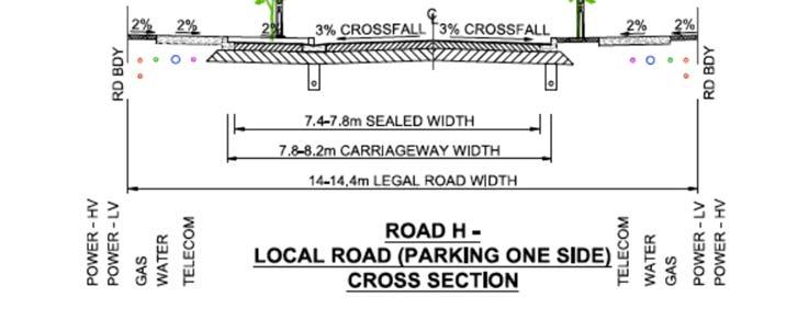
24 traffic signals (including approach lanes) where the posted speed limit supports their implementation to provide a safety and capacity solution, unless an interim traffic safety solution has been approved by the New Zealand Transport Agency as the requiring authority for State Highway 22. This rule: Also applies to integrated residential developments sought as a land use consent application; and Continues to apply to each application for subdivision or development within the Precinct Plan 2 area until such time as the intersection of State Highway 22 and Jesmond Road has been upgraded with a double lane roundabout or traffic signals. Note 1: If an interim traffic safety solution has been implemented at the SH22/Jesmond Road intersection under this rule, applicants are advised that they are required to consult with the New Zealand Transport Agency and Auckland Transport to determine whether this interim solution needs to be upgraded to a roundabout or traffic signals to address safety and capacity matters, prior to any further subdivision or development proceeding within the Precinct Plan 2 area. PC 6 [ENV AKL :Elly S Pan] e. Sites fronting the Collector Road (possible future arterial) shall provide for a 8.5m front yard setback along the boundary with the Collector Road (possible future arterial) at the time of subdivision. This rule shall lapse two years after it becomes operative unless a plan change is notified prior to that date, seeking to have Jesmond Road classified as an Arterial Road under the Auckland Unitary Plan. 2. Subdivision that does not comply with clause 1(a), (c) and (d) above is a discretionary activity. Figures 3 to 911 Road Cross Sections
25 Figures 3 and 4
26 Figures 5 and 6

27 Figures 7 and 8
28 Figure 9 PC 6 [ENV AKL :Elly S Pan] Figure 10 Road H - Future Collector Road (New) Final 28m formation.
29 PC 6 [ENV AKL :Elly S Pan] Figure 11 Road I Future Collector Road (New) Interim Local Road formation. Notes: 1. stormwater device width to be confirmed subject to width of device used. 6.4 Park Edge Roads 1. Where subdivision adjoins an Public Open Space Zone or Future Esplanade Reserve on precinct plan 1 and 2, or a recreation reserve to vest then park edge roads must be provided. 2. Subdivision that does not comply with clause 1 above is a discretionary activity. 6.5 Site Access PC 6 [ENV AKL :Elly S Pan] 1. Where subdivision adjoins a Future Collector Road (New), Collector Road (New), Collector Road (Existing), Collector Road (possible future arterial) or a Collector Road Protected Cycleway identified on the Precinct Plan 1 and 2 or a road with a 3m shared footpath on the site s frontage (which includes the Collector Road (New)), rear lanes (access lot) or access from side roads must be provided so that no vehicle access occurs directly from the site's frontage to the 3m shared footpath or the road frontage. 2. Subdivision that does not comply with clause 1 above is a discretionary activity. 6.6 Riparian Margin 1. Riparian margins must be planted either side to a minimum width of 10m measured from the bank of the stream. This rule shall not apply to road crossings over streams. 2. Any planting required, will be implemented in accordance with a council approved landscape plan and must be use eco-sourced native vegetation, be consistent with local biodiversity and planted at a density of 10,000 plants per hectare. 3. Subdivision that does not comply with clauses 1 or 2 above is a discretionary activity.
30 6.7 Stormwater Management 1. Within catchments draining to streams, stormwater runoff from impervious surfaces within roads (and future roads)of 50 m 2 and over must be directed to a stormwater device(s) designed and sized to achieve the following stormwater hydrology mitigation requirements: Except as provided by c. the following (a. and b.) applies. a. provide retention (volume reduction) of at least 5mm of runoff depth for the impervious area for which hydrology mitigation is required; and b. provide detention (temporary storage) and a drain down period of 24 hours for the difference between the pre-development and post -development runoff volumes from the 95 th percentile, 24 hour rainfall event minus the 5mm retention volume or any greater retention volume that is achieved, over the impervious area for which hydrology mitigation is required. c. where: i. a suitably qualified person has confirmed that soil infiltration rates are less than 2mm/hr or there are no areas on the site of sufficient size to accommodate all required infiltration that is free of geotechnical limitations (including slope, setback from infrastructure, building structures or boundaries and water table depth); and ii. rainfall reuse is not available because: The quality of the stormwater runoff is not suitable for on-site reuse (i.e. for non-potable water supply, garden irrigation or toilet (flushing); or There are no activities occurring on the site that can re-use the full 5mm retention volume of water; the retention volume can be taken up by providing detention (temporary storage) and a drain down period of 24 hours for the difference between the pre-development and post-development runoff volumes from the 95 th percentile, 24 hour rainfall event over the impervious area for which hydrological mitigation is required (minus any designed retention volume that is achieved). 2. Within catchments draining to the coast, stormwater runoff from impervious surfaces within roads (and future roads) must achieve water quality treatment to all impervious surfaces based on rain gardens (or the equivalent) with a surface area sized to 2 percent of the contributing catchment. 3. Stormwater devices within the National Grid Yard must be designed to comply with the New Zealand Electrical Code of Practice for Electrical Safe Distances NZECP34:2001, including their ongoing operation and maintenance. 4. Compliance with the above land use controls will be deemed to satisfy the permitted and controlled activity controls in H4.14. Stormwater Management and the overlay rules for Stormwater Management Area Flow. 6.8 Affordable Housing 1. Rule 2.2 shall apply to subdivision applications containing 15 or more vacant sites. 7. Assessment Land Use Control Infringements 7.1 Matters of Discretion In addition to the general matters set out in clause G2.3 of the General Provisions standard C1.9(3) and the specific matters set out for infringements in the relevant underlying zones and Auckland-wide rules, the council will restrict its discretion to the matters below for the relevant land use control infringement.
31 1. Stormwater Management a. the council will restrict its discretion to i. items (a) - (d) listed under Stormwater Management Flow in the Auckland-wide rules and i. the matters set out in E10.8.1(1) of the Stormwater management area - Flow 1 and Flow 2 chapter ii. whether the non-compliance occurs on sites/lots intended for affordable housing or higher density development. 2. Development Control Infringements a. the council will restrict its discretion to those matters listed in Part 3 I 1.11, and Part 3, G2 ; and b. urban design outcomes and density enabled by infringements to building coverage a. For development control infringements within the Residential Mixed Housing Suburban Zone, the council will restrict its discretion to those matters listed in H4.8.1(4), and the following matters: i. For infringements to 4.9 Dwellings fronting the road, 4.11 Garages and 4.12 Vehicle access, the any policy which is relevant to the standard; the purpose of the standard; and the effects of the infringement of the standard ii. urban design outcomes and density enabled by infringements to building coverage b. For development control infringements within the Residential Mixed Housing Urban Zone, the council will restrict its discretion to those matters listed in H5.8.1(4), and the following matters: i. For infringements to 5.9 Dwellings fronting the road, 5.11 Garages and 5.12 Vehicle access, the any policy which is relevant to the standard; the purpose of the standard; and the effects of the infringement of the standard ii. urban design outcomes and density enabled by infringements to building coverage. 3. Integrated Residential Development a. the council will restrict its discretion to those matters listed under four or more dwellings in the Residential zones. a. Within the Residential Mixed Housing Suburban Zone, the council will restrict its discretion to those matters listed in H4.8.1(3) b. Within the Residential Mixed Housing Urban Zone, the council will restrict its discretion to those matters listed in H5.8.1(3) 7.2 Assessment Criteria In addition to the general assessment criteria in clause G2.3 of the General Provisions and the specific assessment criteria for the infringement in the relevant underlying zones and Auckland-wide rules, the council will consider the relevant assessment criteria below for the development control infringement. 1. On-site stormwater management a. the council will consider assessment criteria (a) - (d) listed under Stormwater Management Flow in the Auckland-wide rules. the assessment criteria set out in E10.8.2(1) of the Stormwater management area Flow 1 and Flow 2 chapter. b. where the non-compliance occurs on sites/lots intended for affordable housing or higher density development applicants may demonstrate that runoff from the impervious surfaces can be accommodated within the public stormwater system/network. 2. Development control Infringements a. the council will consider assessment criteria listed in Part 3 I 1.11, and Part 3 G 2.3. a. For development control infringements within the Residential Mixed Housing Suburban Zone, the council will consider the criteria listed in H4.8.2, and the following matters: i. For infringements to 4.9 Dwellings fronting the road; and 4.11 Garages, refer to Policy 6 of this precinct ii. For infringements to 4.12 Vehicle access, refer to Policy 5(e) of this precinct. ii. urban design outcomes and density enabled by infringements to building coverage
32 a. For development control infringements within the Residential Mixed Housing Urban Zone, the council will consider the criteria listed in H5.8.2, and the following matters: i. For infringements to 5.9 Dwellings fronting the road; and 5.11 Garages, refer to Policy 6 of this precinct ii. For infringements to 5.12 Vehicle access, refer to Policy 5(e) of this precinct. ii. urban design outcomes and density enabled by infringements to building coverage b. the extent that any infringement of building coverage enables quality urban design outcomes and higher density development. 3. Integrated Residential Development a. the council will consider the assessment criteria applying to four or more dwellings in the Residential zones. a. Within the Residential Mixed Housing Suburban Zone, the council will consider the criteria listed in H4.8.2(3) b. Within the Residential Mixed Housing Urban Zone, the council will consider the criteria listed in H5.8.2(3) 8. Assessment Subdivision 8.1 Matters of Discretion 1. Subdivision a. the council will restrict its discretion to those matters listed in E within Chapter E38 Subdivision Urban for subdivision under the Auckland wide rules, and the following matters: i. consistency with precinct plan 1 and 2 ii. stormwater management iii. the matters for discretion outlined in Part 3 H5.4, Table 13 iii for subdivision within the National Grid Corridor Overlay, the matters listed in D26.8.1(1) and (1A) within Chapter D26 National Grid Corridor Overlay.the discretions for subdivision within the National Grid Subdivision Corridor in Appendix , and the design and layout of subdivision within the National Grid Subdivision Corridor. iv. transportation management v. effects of additional traffic on the intersections identified in Assessment Criteria 8.2(3)(a) and the Norrie Road one way bridge and mitigation proposals for those effects. vi. effects associated with the intersection of Burberry Road and SH22 and mitigation for those effects, prior to forming a physical connection to Burberry Road. 8.2 Assessment Criteria 1. For development that is a restricted discretionary activity, the following assessment criteria apply in addition to the criteria specified for the relevant restricted discretionary activities in the zone and Auckland Wide Rules: a. the structural elements of precinct plan 1 and 2 are incorporated into the subdivision design. b. the approach to stormwater management for roads, lanes (access lots) and sites addresses the recommendations of the Stormwater Management Plans (May 2016 for sites located within Precinct Plan 1 or March 2018 for sites located within Precinct Plan 2) (including those relating to the catchments discharging to both the streams and estuary), and that the hydrology mitigation requirements outlined in the relevant rules can be met. Consent Notices may be required on the titles of all new sites to ensure compliance with the onsite stormwater management requirements contained in the rules of this Precinct and where recommended with the subdivision application to implement the Stormwater Management Plans (May 2016 for sites located within Precinct Plan 1 or March 2018 for sites located within Precinct Plan 2). c. the design of low impact outfalls as lengths of manmade channels with a natural form (materials and planting) to dissipate energy and minimise erosion for outfalls to streams and the coast.

33 d. the assessment criteria listed in E within Chapter E38 Subdivision Urban outlined in Part 3 H5.4. e. the assessment criteria for subdivision within the National Grid Subdivision Corridor in Appendix , and the design and layout of subdivision within the National Grid Subdivision Corridor. 2. The implementation of relevant upgrades to the roading network Development of up to 50 households should occur when the following transport requirements are met: Bremner road approach to the Ngakoroa Stream Bridge to a two lane urban road (as required by the consented development) including separated cycle lanes (including a shared path on one side of the Ngakoroa Stream Bridge) Footpaths to link the Drury 1 precinct to Drury Township, as per Drawing Reference A1,1013- Qd1EX022 by McKenzie and Co Consulting SH22/Victoria Street intersection changes to the intersection refer diagram below Pedestrian Improvements at Norrie road/great South road Intersection, as illustrated at Figure 5-4 of the ITA Pedestrian upgrade (one side only) of Bremner road motorway overbridge, including safety improvements to the footpath and handrail structures.
34 Great South road/firth street intersection priority changes to the intersection a. prior to the development of 100 cumulative dwellings being constructed across the Drury 1 precinct, the Firth street/great South road intersection improvements, including markings and curve realignment as per Drawing 1, Revision A, dated 20 June should be implemented b. prior to the development of 400 cumulative dwellings being constructed across the Drury 1 precinct, a dedicated cycle facility should to be constructed across State Highway 1, alongside Bremner road. 3. Effects of additional traffic on the intersections identified in (a) below and the Norrie Road one way bridge and mitigation proposed for those effects a. Whether the proposal avoids, remedies, or mitigates adverse traffic effects to maintain the safe and efficient operation of the transport network at the following locations: intersection of Great South Road / Firth Street, intersection of Firth Street / Norrie Road, intersection of Great South Road / Norrie Road / Waihoehoe Road, intersection of Great South Road / Karaka Road (SH22), intersection of Victoria Street / SH22 and the Norrie Road One-Way Bridge. Assessment of these adverse effects and mitigation proposed will be based on the transport assessment required to be provided with any subdivision application as outlined in Special Information Requirement 2. b. The extent to which the road network within Precinct Plan 2 integrates with and takes into account information and outcomes associated with NZTA projects, and Auckland Council s structure planning for Drury / Opaheke. c. The extent to which there is evidence of consultation regarding the proposal with Auckland Transport and NZTA. 4. Effects associated with the intersection of Burberry Road and SH22 and mitigation for those effects, prior to forming a physical connection to Burberry Road. a. The extent to which, prior to the forming of a physical connection to Burberry Road, upgrading work has been undertaken to the intersection of Burberry Road and SH22 to ensure there are safe and appropriate connections. Special Information requirement: 1. For Integrated Residential Development, the Special Information Requirements applying to four or more dwellings in the underlying residential zones apply 1. All subdivision consent applications for development within Precinct Plan 2, must include a traffic assessment undertaken by a suitably qualified and experienced traffic engineer that addresses whether the proposal complies with (a) and (b) below. The assessment must utilise traffic data no older than two years at the time that a subdivision resource consent application is lodged. The baseline scenario for the assessment is the operation of the road network at the time, plus development enabled in Precinct Plan 1 and activities that have already been consented in Precinct Plan 2. a. Road Intersection Performance i. All-day: No individual traffic movement shall have a LOS worse than LOS E, or have a degree of saturation higher than 95%. If the baseline scenario is already at LOS F, then: degrees of saturation shall be no more than the baseline scenario; or delay shall not increase beyond the baseline scenario by more than 10%.
 Victoria Street / SH22 b. Norrie Road One-Way Bridge i.")
35 ii. The overall intersection LOS shall be no worse than LOS D For the purposes of this standard, the relevant road intersections are: Great South Road / Firth Street Firth Street / Norrie Road Great South Road / Norrie Road / Waihoehoe Road Great South Road / Karaka Road (SH22) Victoria Street / SH22 b. Norrie Road One-Way Bridge i. All-day: No individual traffic movement from upstream and downstream intersection shall have 85 th percentile queues reaching or crossing the one-way bridge ii. Queues at the approaches to the one-way bridge shall not extend to and through the upstream intersection iii. Delays on the bridge shall not have LOS worse than LOS D. 9. PRECINCT PLAN 1

36 PC 6 [ENV AKL :Elly S Pan] 10. PRECINCT PLAN 2
 1 National Grid Definitions The following definitions are applicable: Activities sensitive to National Grid lines Any dwellings, papakāinga,")
37 Appendix ELECTRICITY TRANSMISSION CORRIDOR (NATIONAL GRID) 1 National Grid Definitions The following definitions are applicable: Activities sensitive to National Grid lines Any dwellings, papakāinga, visitor accommodation, boarding houses, retirement villages, supported residential care, education facilities, hospitals and healthcare facilities and care centres. National Grid lines Parts of the National Grid of transmission lines and cables (aerial, underground and undersea), stations and substations and other works used to connect grid injection points and grid exit points to convey electricity within and beyond the district and region. National Grid subdivision corridor Means the area measured either side of the centreline of an above ground National Grid line as follows: - 32m for the 110kV National Grid lines. - 37m for the 220kV National Grid lines. National Grid support structure A tower or pole comprising part of the National Grid that supports conductors as part of a transmission line. For the purpose of defining the National Grid Yard and the rules in this Appendix, measurements are taken horizontally from the outer visible edge of the base of the support structure at existing ground level. National Grid Yard (shown in red in diagram below) means: - - the area located 12 metres in any direction from the outer edge of a National Grid support structure; and - the area located 12 metres either side of the centreline of any overhead National Grid line.
38 2 National Grid Rules 1. The location of the electricity transmission corridor must be updated if any National Grid support structure or line is relocated, replaced or removed. 2. Compliance with the NZECP34:2001 is mandatory under the Electricity Act All activities regulated by NZECP34:2001, including any activities that are otherwise permitted by the Unitary Plan, must comply with this regulation. Compliance with the permitted activity status in this plan does not ensure compliance with NZECP34:2001. The following table specifies the development activities within the National Grid Subdivision Corridor and National Grid Yard. Activities Activity Status Within the National Grid Subdivision Corridor Subdivision for a network utility or electricity transmission Creation of lots involving the location of a building platform within the National Grid Yard All other subdivision P NC RD Within the National Grid Yard Any building or structure unless it is otherwise provided for below. Network utilities and transmission lines between electricity generation facilities and the National Grid Fences less than 2.5m high and no closer than 5m from a National Grid support structure Alterations to existing buildings that do not increase the building envelope or footprint Establishing activities sensitive to National Grid lines in an existing building Increasing* the intensity or scale of existing activities sensitive to National Grid lines in an existing building Earthworks that comply with Development Control Earthworks that do not comply with Development Control Earthworks that do not comply with Development Control or Development Control NC P P P NC NC P RD NC * For the purposes of this Rule, Increasing the intensity or scale of existing activities sensitive to transmission lines means any increase in the actual or potential capacity for people to be accommodated. 3 Development Controls
39 3.1 Permitted Activities 1. Earthworks within the National Grid Yard All Earthworks with the National Grid Yard must comply with the following controls: a. be no deeper than 300mm within 12m of any National Grid support structure Except that: Vertical holes not exceeding 500mm in diameter beyond 1.5 from the outer edge of pole support structure or stay wire are exempt. 2. Not create an unstable batter that will affect a National Grid support structure; and 3. Not result in a reduction in the ground to conductor clearance distances below what is required by Table 4 of NZECP34:2001 Provided that the following are exempt from points (1) above: Earthworks for Network Utilities; or Earthworks undertaken as part of domestic or other cultivation, or repair, sealing or resealing of a road, footpath or driveway. 4 Notification 1. The council will consider the restricted discretionary activities listed in the activity table without the need for public or limited notification. However, limited notification will be given to Transpower New Zealand Ltd unless written approval from Transpower is provided at the time the application is lodged. 5 Assessment - Restricted discretionary activities subdivision 5.1.Matters of discretion The council will restrict its discretion to the matters below for the activities listed as restricted discretionary in the activity table: 1. Subdivision within the National Grid Subdivision Corridor a. impacts on the operation, maintenance, upgrade and development of the National Grid, including reverse sensitivity effects. b. compliance with NZECP34:2001. c. the ability of the applicant to provide a complying building platform. d. location, design and use of the proposed building platform or structure as it relates to the National Grid line. e. the risk of electrical hazards affecting public or individual safety, and the risk of property damage. f. the nature and location of any vegetation to be planted within the vicinity of the National Grid Yard. g. the design and layout of roads. 2. Earthworks within the National Grid Yard a. impacts on the operation, maintenance, upgrade and development of the National Grid. b. compliance with NZECP34:2001. c. the risk to the structural integrity of the National Grid.
40 d. any impact on the ability of the National Grid owner (Transpower) to access the transmission lines. e. the risk of electrical hazards affecting public or individual safety, and the risk of property damage. 6 Assessment Criteria The council will consider the relevant assessment criteria below for the restricted discretionary activities listed above. 1. Subdivision a. the effects on the ability of the National Grid owner (Transpower) to operate, maintain, upgrade and develop the National Grid, including access to the line. b. the extent to which the design and construction of the subdivision allows for earthworks, building and structures to comply with NZECP34:2001. c. the ability to provide a complying building platform. d. location, height, scale, orientation and use of the proposed building platform or structure, or vegetation, as it relates to the National Grid line. e. the extent to which the subdivision design and consequential development will minimise potential reverse sensitivity and nuisance effects of the National Grid. 2. Earthworks a. the effects on the ability of the National Grid owner (Transpower) to operate, maintain, upgrade and develop the transmission network, including access to the line. b. compliance with NZECP34:2001. c. the risk to the structural integrity of the National Grid. d. the risk of electrical hazards affecting public or individual safety, and the risk of property damage. 7. Special information requirements In addition to the general information requirements for a resource consent application an electrical engineering assessment prepared by a suitably qualified person may also be required to demonstrate compliance with NZECP34:2001.

41 BEFORE Hingaia 1 sub-precinct D Hingaia 1 sub-precinct D Great South Road ± Murray Street Miro Street Southern Motorway Cross Street York Street Sutton Road Young Cresc Bremner Road Drury 1 Creek Street Firth Street Oira Road Jesmond Road Victoria Street Great South Road Off Ramp Great South Road On Ramp Norrie Road Burberry Road Swift Street Mercer Street Flanagan Road AFTER Hingaia 1 sub-precinct D Hingaia 1 sub-precinct D Cross Street Murray Street Miro Street York Street Great South Road Sutton Road Young Crescen Oira Road Appeals seeking changes to zones or management layers Precincts Residential - Mixed House Urban Residential - Mixed House Suburban Parcel boundary Jesmond Road Bremner Road Drury 1 Seeking changes to zones or management layers, Private Plan Change 6, ENV-2018-AKL , Precincts, View PDF Burberry Road Swift Street Mercer Street Southern Motorway Victoria Street Great South Road On Ramp Creek Street Great South Road Off Ramp Firth Street Norrie Road Flanagan Road Cameron Place Metres Plan Change 6 - Drury 1 Precinct Whilst due care has been taken, Auckland Council gives no warranty as to the accuracy and completeness of any information on this map/plan and accepts no liability for any error, omission or use of the information. Date: 29/11/2018 Plans and Places
Objectives The objectives are as listed in the relevant underlying zones and Auckland wide provisions, except as specified below:
 6.35 Drury 1 Precinct description The precinct has an area of 84.62 ha and is bordered by Drury Creek in the north, southern motorway to the east SH22(Karaka road) to the south and Jesmond road to the
H5. Residential Mixed Housing Urban Zone
 H5. Residential Mixed Housing Urban Zone [ENV-2016-AKL-000197: Robert Adams] Addition sought H5.1. Zone description The Residential Mixed Housing Urban Zone is a reasonably high-intensity zone enabling
The underlying zones and Auckland-wide objectives apply in this precinct, in addition to those specified below.
 I454 Opaheke 1 I454.1 Precinct description The Opaheke 1 precinct comprises some 27 hectares of land between Bellfield Road and Opaheke Park, approximately 1.5km south of the Papakura Metropolitan Centre.
H5. Residential Mixed Housing Urban Zone
 H5. Residential Mixed Housing Urban Zone H5.1. Zone description The Residential Mixed Housing Urban Zone is a reasonably high-intensity zone enabling a greater intensity of development than previously
H4. Residential Mixed Housing Suburban Zone
 H4. Residential Mixed Housing Suburban Zone H4.1. Zone description The Residential Mixed Housing Suburban Zone is the most widespread residential zone covering many established suburbs and some greenfields
H6 Residential Terrace Housing and Apartment Buildings Zone
 H6. Residential Terrace Housing and Apartment Buildings Zone [CIV-2016-404-002333: Franco Belgiorno-Nettis]-Note: The properties affected by this appeal are identified on the Auckland Unitary Plan viewer.
H4. Residential Mixed Housing Suburban Zone
 H4. Residential Mixed Housing Suburban Zone H4.1. Zone description The Residential Mixed Housing Suburban Zone is the most widespread residential zone covering many established suburbs and some greenfields
Auckland Unitary Plan Operative in part 1
 5.63 Huapai 2 The objectives and policies of the underlying Mixed Housing Suburban zone apply in the following precinct unless otherwise specified below. Refer to planning maps for the location and extent
Objectives The objectives are as listed in the underlying Single House and Mixed Housing Suburban zones except as specified below:
 7.12 Birdwood 2 Precinct Description The Birdwood 2 precinct comprises 26.1 hectares of land approximately 15 km west of Auckland s CBD, 4 km south-west of the Westgate town centre and 1km north of the
Residential - Mixed Housing Urban and Suburban zones
 Residential - Mixed Housing Urban and Suburban zones Proposed Auckland Unitary Plan: Fact Sheet BC2555 The Proposed Auckland Unitary Plan sets out six main residential zones. In feedback on the draft plan,
Unitary Plan zones Sub-Precincts Areas Mixed Housing Suburban Mixed Housing Urban Neighbourhood Centre. Flat Bush Residential Sub- Precinct C
 6.6 Flat Bush Flat Bush Sub-precinct C Precinct description Table 1 Unitary Plan zones Sub-Precincts Areas Mixed Housing Suburban Mixed Housing Urban Neighbourhood Centre Flat Bush Residential Sub- Precinct
Requirements for accepted development and assessment benchmarks for assessable development
 9.3.10 Small Lot Housing Design Code 9.3.10.1 Application (1) This code applies to development identified as requiring assessment against the Small Lot Housing Design Code by the categories of development
Multi-unit residential uses code
 9.3.11 Multi-unit residential uses code 9.3.11.1 Application (1) This code applies to assessable development identified as requiring assessment against the Multi-unit residential uses code by the tables
SCHEDULE 32 TO CLAUSE DESIGN AND DEVELOPMENT OVERLAY
 --/--/20-- Proposed GC81 SCHEDULE 32 TO CLAUSE 43.02 DESIGN AND DEVELOPMENT OVERLAY Shown on the planning scheme map as DDO32. FISHERMANS BEND WIRRAWAY PRECINCT 1.0 Design objectives --/--/20-- Proposed
Part 9 Specific Land Uses - Dual Occupancy
 6 DUAL OCCUPANCY This section of the DCP only provides Council s specific requirements for Dual Occupancy developments. Other requirements are contained in Part 3 Development within Residential Zones as
H30. Special Purpose Tertiary Education Zone
 H30. Special Purpose Tertiary Education Zone H30.1. Description The Special Purpose Tertiary Education Zone applies to tertiary education facilities in locations where the surrounding zoning will not appropriately
Part 9 Specific Land Uses - Multi Dwelling Housing
 11 MULTI DWELLING HOUSING This section of the DCP only provides Council s specific requirements for Multi Dwelling Housing developments. Other requirements that must be addressed are contained in the relevant
Presentation to the Real Estate Institute of New Zealand 28 October 2016
 Presentation to the Real Estate Institute of New Zealand 28 October 2016 Disclaimer This presentation provides a high level overview of specific parts of the Proposed Auckland Unitary Plan Decisions Version
RURAL SETTLEMENT ZONE - RULES
 Chapter 38 RURAL SETTLEMENT ZONE - RULES INTRODUCTION This Chapter contains rules managing land uses in the. The boundaries of this zone are shown on the planning maps. There is limited opportunity for
Draft Auckland Unitary Plan - March 2013
 Part 4 Rules»4.3 Zone rules» 4.3.3 Business zones The following provisions form part of the district plan. 1. Activity tables 1. The following table specifies the activity status of activities in the centres
E38. Subdivision - Urban
 E38. Subdivision - Urban E38.1. Introduction Subdivision is the process of dividing a site or a building into one or more additional sites or units, or changing an existing boundary location. Objectives,
of the Resource Management Act 1991 of the Local Government (Auckland Transitional Provisions) Act 2010 AND
 Act 2010 AND") jbefore THE ENVIRONMENT COURT I MUA I TE KOOTI TAIAO 0 AOTEAROA Decision No. [2018] NZEnvC 38 IN THE MATTER AND AND BETWEEN of the Resource Management Act 1991 of the Local Government (Auckland Transitional
jbefore THE ENVIRONMENT COURT I MUA I TE KOOTI TAIAO 0 AOTEAROA Decision No. [2018] NZEnvC 38 IN THE MATTER AND AND BETWEEN of the Resource Management Act 1991 of the Local Government (Auckland Transitional
Ku-ring-gai Local Environmental Plan No 194
 New South Wales Ku-ring-gai Local Environmental Plan No 194 under the Environmental Planning and Assessment Act 1979 I, the Minister Assisting the Minister for Infrastructure and Planning (Planning Administration),
SCHEDULE 31 TO CLAUSE DESIGN AND DEVELOPMENT OVERLAY
 --/--/20-- Proposed GC81 SCHEDULE 31 TO CLAUSE 43.02 DESIGN AND DEVELOPMENT OVERLAY Shown on the planning scheme map as DDO31. FISHERMANS BEND SANDRIDGE PRECINCT 1.0 Design objectives --/--/20-- Proposed
9.3.5 Dual occupancy code
 9.3.5 Dual occupancy code 9.3.5.1 Application (1) This code applies to accepted development and assessable development identified as requiring assessment against the Dual occupancy 1 code by the tables
15.1 Introduction. Waipa District Plan. Section 15 - Infrastructure, Hazards, Development and Subdivision. Page Version - 1 November 2016 Page 1 of 56
 15.1 Introduction 15.1.1 How and where development and subdivision occurs is critical to the sustainable management of the District s natural and physical resources. This section of the Plan focuses on
DRAFT PROPOSED CHAPTER 21 SPECIFIC PURPOSE - FLAT LAND RECOVERY ZONE
 DRAFT PROPOSED CHAPTER 21 SPECIFIC PURPOSE - FLAT LAND RECOVERY ZONE Note: The Specific Purpose (Flat Land Recovery) Zone is a "holding" zone that will be subject to a later plan change to confirm the
Explanation The policies ensure that land is suitable for subdivision and will not increase risks to people, the environment and property.
 23 Subdivision 23.1 Purpose a) Subdivision is essentially the process of dividing a parcel of land or a building into one or more further parcels, or changing an existing boundary location. Subdivision
RM-7, RM-7N and RM-7AN Districts Schedules
 1 Intent Districts Schedules The intent of this schedule is to encourage development of ground-oriented stacked townhouses or rowhouses, while continuing to permit lower intensity development. In RM-7AN,
RM-8 and RM-8N Districts Schedule
 Districts Schedule 1 Intent The intent of this schedule is to encourage development of ground-oriented stacked townhouses or rowhouses, including courtyard rowhouses, while continuing to permit lower intensity
Article 3. SUBURBAN (S-) NEIGHBORHOOD CONTEXT
 NEIGHBORHOOD CONTEXT") Article 3. SUBURBAN (S-) NEIGHBORHOOD CONTEXT this page left intentionally blank Contents ARTICLE 3. SUBURBAN (S-) NEIGHBORHOOD CONTEXT DIVISION 3.1 NEIGHBORHOOD CONTEXT DESCRIPTION...3.1-1 Section 3.1.1
Article 3. SUBURBAN (S-) NEIGHBORHOOD CONTEXT this page left intentionally blank Contents ARTICLE 3. SUBURBAN (S-) NEIGHBORHOOD CONTEXT DIVISION 3.1 NEIGHBORHOOD CONTEXT DESCRIPTION...3.1-1 Section 3.1.1
DEVELOPMENT STANDARDS FOR RESIDENTIAL PROJECTS RESIDENTIAL BUILDING TYPES: APPROPRIATE ZONES AND DENSITIES 2-1
 2 DEVELOPMENT STANDARDS FOR RESIDENTIAL PROJECTS RESIDENTIAL BUILDING TYPES: APPROPRIATE ZONES AND DENSITIES 2-1 This Chapter presents the development standards for residential projects. Section 2.1 discusses
3.1. OBJECTIVES FOR RESIDENTIAL LAND USE DESIGNATIONS GENERAL OBJECTIVES FOR ALL RESIDENTIAL DESIGNATIONS
 3. RESIDENTIAL LAND USE DESIGNATIONS INTRODUCTION The Residential land use designations provide for housing and other land uses that are integral to, and supportive of, a residential environment. Housing
Activities which do not satisfy the General Rules and are not provided for as Restricted Discretionary activities... 9
 16.0 PAPAKAINGA AND MARAE SETTLEMENTS... 1 16.1 INTRODUCTION... 1 16.2 ISSUES... 1 16.3 OBJECTIVE (PAPAKAINGA)... 2 16.4 POLICIES (PAPAKAINGA)... 2 16.5 OBJECTIVE (SURROUNDING ENVIRONMENT)... 2 16.6 POLICIES
9.3.6 Dwelling house code
 9.3.6 Dwelling house code 9.3.6.1 Application (1) This code applies to accepted development assessable development identified as requiring assessment against the Dwelling house 3 code by the tables of
ARTICLE I ZONE BASED REGULATIONS
 ARTICLE I ZONE BASED REGULATIONS RZC 21.08 RESIDENTIAL REGULATIONS 21.08.290 Cottage Housing Developments A. Purpose. The purpose of the cottage housing requirements is to: 1. Provide a housing type that
6. RESIDENTIAL ZONE REGULATIONS
 6. RESIDENTIAL ZONE REGULATIONS PART 6A PURPOSE OF CHAPTER (1) The purpose of this Chapter is to provide detailed regulations and requirements that are relevant only to residential zones and specific residential
SCHEDULE 8 TO THE DESIGN AND DEVELOPMENT OVERLAY RESIDENTIAL AREAS SURROUNDING ACTIVITY CENTRES AND ALONG MAIN ROADS
 23/07/2009 C74 SCHEDULE 8 TO THE DESIGN AND DEVELOPMENT OVERLAY Shown on the planning scheme map as DDO8 RESIDENTIAL AREAS SURROUNDING ACTIVITY CENTRES AND ALONG MAIN ROADS 1.0 Design objectives 08/03/2007
Composition of traditional residential corridors.
 Page 1 of 7 St. Petersburg, Florida, Code of Ordinances >> PART II - ST. PETERSBURG CITY CODE >> Chapter 16 - LAND DEVELOPMENT REGULATIONS >> SECTION 16.20.060. CORRIDOR RESIDENTIAL TRADITIONAL DISTRICTS
RM-11 and RM-11N Districts Schedule
 Districts Schedule 1 Intent The intent of this Schedule is to permit medium density residential development primarily in the form of four-storey T -shaped apartments, and to foster compact, sustainable,
Section Three, Part 9 - Subdivision
 PART 9 SUBDIVISION SUBDIVISION AND DEVELOPMENT OF LAND 9.1 INTRODUCTION This part of the District Plan sets out the provisions in respect of the subdivision and development of land in the urban part of
Appendix1,Page1. Urban Design Guidelines. Back to Back and Stacked Townhouses. DRAFT September 2017
 Appendix1,Page1 Urban Design Guidelines DRAFT September 2017 Back to Back and Stacked Townhouses Appendix1,Page2 Table of Contents 1 Introduction 1 1.1 Purpose 1 1.2 Urban Design Objectives 1 1.3 Building
LITTLE MOUNTAIN ADJACENT AREA REZONING POLICY
 LITTLE MOUNTAIN ADJACENT AREA REZONING POLICY JANUARY 2013 CONTENTS 1.0 INTENT & PRINCIPLES...1 2.0 APPLICATION...2 3.0 HOUSING TYPES, HEIGHT & DENSITY POLICIES...3 3.1 LOW TO MID-RISE APARTMENT POLICIES...4
8.14 Single Detached with Granny Flat or Coach House Edgemere
 8.14 Single Detached with Granny Flat or Coach House Edgemere [Bylaw 8922, Nov 19/12] (RE1) 8.14.1 Purpose The zone applies to the Edgemere (RE1) neighbourhood and provides for single detached housing
RT-3 District Schedule
 District Schedule 1 Intent The intent of this Schedule is to encourage the retention of neighbourhood and streetscape character, particularly through the retention, renovation and restoration of existing
50 and 52 Finch Avenue East - Official Plan and Zoning By-law Amendment Applications - Preliminary Report
 STAFF REPORT ACTION REQUIRED 50 and 52 Finch Avenue East - Official Plan and Zoning By-law Amendment Applications - Preliminary Report Date: August 16, 2016 To: From: Wards: Reference Number: North York
Small Lot Housing Code (June 2013):
:") Small Lot Housing Code (June 2013): Standards that establish a building envelope for a single Class 1a building and associated Class 10 buildings on an allotment. If an adjoining allotment is not subject
Small Lot Housing Code (June 2013): Standards that establish a building envelope for a single Class 1a building and associated Class 10 buildings on an allotment. If an adjoining allotment is not subject
Small Lot Housing Code
 Small Lot Housing Code AUGUST 2014 SMALL LOT HOUSING CODE Level 29, 35 Collins Street Melbourne Victoria 3000 Telephone: 03 9651 9600 Facsimile: 03 9651 9623 Email: Info@mpa.vic.gov.au www.mpa.vic.gov.au
8.5.1 R1, Single Detached Residential District
 8.5.1 R1, Single Detached Residential District The purpose of this district is to provide for residential development in the form of single detached dwellings. Dwelling, Single Detached Home Business,
CASTLES OF CALEDON URBAN DESIGN REPORT
 CASTLES OF CALEDON URBAN DESIGN REPORT PROPOSED RESIDENTIAL DEVELOPMENT CALEDON, ONTARIO 10 JULY, 2015 TABLE CONTENTS: 1.0 DEVELOPMENT 4.0 CONCLUSION 1.1 Introduction 1.2 Castles of Caledon- Urban Design
H18. Future Urban Zone
 H18. Future Urban Zone H18.1. Zone description The Future Urban Zone is applied to greenfield land that has been identified as suitable for urbanisation. The Future Urban Zone is a transitional zone. Land
Accessory Coach House
 Updated July 2018 Accessory Coach House Development Permit Guidelines 1 Accessory Coach House Development Permit Guidelines Zoning Bylaw, 1995 DIVISION VII C. Contents Part I General Reglations 1 Introduction
Part 4.0 DEVELOPMENT REGULATIONS
 M A I N S T R E E T N O R T H Part 4.0 DEVELOPMENT REGULATIONS 4.1 Districts 4.2 Permitted and Prohibited Uses, Standards and Standard Specific Criteria and Other General Provisions 4.3 DPS REGULATIONS
RT-11 and RT-11N Districts Schedules
 Districts Schedules 1 Intent The intent of this schedule is to allow a variety of housing options by encouraging development of multiple small houses and duplexes on larger lots and assembled sites, while
A By-law to amend Zoning and Development By-law No regarding Laneway Houses
 Zoning & Development By-law Amendments regarding Laneway Houses Draft for Public Hearing A By-law to amend Zoning and Development By-law No. 3575 regarding Laneway Houses 1. This By-law amends or adds
RM-1 and RM-1N Districts Schedule
 Districts Schedule 1 Intent The intent of this Schedule is to encourage development of courtyard rowhouses on larger sites while continuing to permit lower intensity development on smaller sites. Siting
Residential Design Guide Appendices
 Residential Design Guide Appendices Appendix 1 Thorndon Appendix 2 Mt Victoria Appendix 3 Aro Valley Appendix 4 Southern Inner Residential Areas Appendix 5 Oriental Bay Appendix 6 Residential Coastal Edge
Planning Department Oconee County, Georgia
 Planning Department Oconee County, Georgia STAFF REPORT REZONE CASE #: 6985 DATE: October 31, 2016 STAFF REPORT BY: Andrew C. Stern, Planner APPLICANT NAME: Williams & Associates, Land Planners PC PROPERTY
PAPAKAINGA DISTRICT WIDE ACTIVITY
 SECTION 13.1 PAPAKAINGA DISTRICT WIDE ACTIVITY 13.1.1 INTRODUCTION The Resource Management Act 1991 introduced specific and new obligations for those exercising functions and powers under the Act to provide
CHAPTER MFR 22 Multi-Family Residential
 CHAPTER 19.28 MFR 22 Multi-Family Residential Sections: 19.28.010 PURPOSE 19.28.020 PERMITTED USES 19.28.030 USES SUBJECT TO A CONDITIONAL USE PERMIT 19.28.040 PERMITTED ACCESSORY USES 19.28.050 PROHIBITED
Gisborne District Council
 12.0 SUBDIVISION... 1 12.1 INTRODUCTION... 1 12.2 ISSUE... 1 12.3 OBJECTIVE (SUBDIVISION)... 1 12.4 POLICIES (SUBDIVISION)... 2 12.5 METHODS OF IMPLEMENTATION... 4 12.5.1 REGULATION... 4 12.6 RULES FOR
Appendix J - Planned Unit Development (PUD)
") Appendix J - Planned Unit Development (PUD) Intent and Purpose The purpose of the PUD is: 1. To provide development that is consistent with the Comprehensive Land Use Plan and promote the goals and objectives
Appendix J - Planned Unit Development (PUD) Intent and Purpose The purpose of the PUD is: 1. To provide development that is consistent with the Comprehensive Land Use Plan and promote the goals and objectives
Zoning Regulations of the Town of Redding Connecticut
 Zoning Regulations of the Town of Redding Connecticut Statutory zoning authority was adopted for the Town of Redding, and a Zoning Commission established as provided by law, at a Town Meeting held May
Article 7: Residential Land Use and Development Requirements
 Article 7: Residential Land Use and Section 701: Statement of Intent (A) (B) (C) The intent of Article 7 is to develop certain land use and development requirements for the residential uses within Cumru
CITY OF MERCED SMALL LOT SINGLE-FAMILY HOME DESIGN GUIDELINES
 CITY OF MERCED SMALL LOT SINGLE-FAMILY HOME DESIGN GUIDELINES Development Services Department Planning and Permitting Adopted August 15, 2005 SMALL LOT SINGLE FAMILY HOME GUIDELINES A. Purpose and Applicability.
PART SIXTEEN - SUBDIVISION AND DEVELOPMENT
 16.1 24 July 2010 PART SIXTEEN - SUBDIVISION AND DEVELOPMENT 1. INTRODUCTION Council has the statutory responsibility to control subdivision of land and the effects of land use throughout the District.
Division 8 General Urban (T4) Zone: Assessment Criteria and Assessment Tables
 Zone: Assessment Criteria and Assessment Tables") Division 8 General Urban (T4) Zone: Assessment Criteria and Assessment Tables 15.8.1 General Urban (T4) Zone The provisions in this division relate to the General Urban (T4) Zone as follows overall outcomes
Division 8 General Urban (T4) Zone: Assessment Criteria and Assessment Tables 15.8.1 General Urban (T4) Zone The provisions in this division relate to the General Urban (T4) Zone as follows overall outcomes
ARTICLE 4: SCHEDULE OF DISTRICT, USE AND SETBACK REGULATIONS
 Page 1 of 48 City of Hollywood Zoning and Land Development Regulations 4.6.I Beach Community Redevelopment Districts. 1. Purpose. To establish development standards for the Beach Community Redevelopment
Open Space Model Ordinance
 Open Space Model Ordinance Section I. Background Open space development has numerous environmental and community benefits, including: 1) Reduces the impervious cover in a development. Impervious cover
RM-5, RM-5A, RM-5B, RM-5C and RM-5D Districts Schedule
 Districts Schedule 1 Intent The intent of this Schedule is to permit a variety of residential developments and some compatible retail, office, service and institutional uses. Emphasis is placed on achieving
COMMISSION ACTION FORM SUBJECT: ZONING TEXT AMENDMENT FOR LINCOLN WAY CORRIDOR PLAN DOWNTOWN GATEWAY COMMERCIAL ZONING DISTRICT STANDARDS
 ITEM #: 7 DATE: _02-07-18 COMMISSION ACTION FORM SUBJECT: ZONING TEXT AMENDMENT FOR LINCOLN WAY CORRIDOR PLAN DOWNTOWN GATEWAY COMMERCIAL ZONING DISTRICT STANDARDS BACKGROUND: The Downtown Gateway area
SECTION 822 "R-1-A" AND "R-1-AH" - SINGLE FAMILY RESIDENTIAL DISTRICTS
 SECTION 822 "R-1-A" AND "R-1-AH" - SINGLE FAMILY RESIDENTIAL DISTRICTS The "R-1-A" and "R-1-AH" Districts are intended to provide for the development of single family residential homes at urban standards
Moonee Valley Moreland Port Phillip Stonnington Whitehorse Wyndham Yarra
 3 4 In May 2015, the Minister for Planning released Better Apartments A Discussion Paper for public input and stated that the right mechanisms must be put in place to promote high quality apartment living
PART 4 - GENERAL PROVISIONS AND PROCEDURES
 CONTENTS... PAGE 4.1 CONTENT AND STRUCTURE OF PARTS 4, 4A, AND 4B...3 4.2 ACTIVITIES...3 4.3 RESOURCE CONSENTS...4 4.4 FINANCIAL CONTRIBUTIONS...16 4.5 SIGNS...16 4.6 ARTIFICIAL LIGHTING...17 Plan change
UPPER HUTT CITY COUNCIL HEARING ON PROPOSED (PRIVATE) PLAN CHANGE 40: WALLACEVILLE. IN THE MATTER of the Resource Management Act 1991 AND
 PLAN CHANGE 40: WALLACEVILLE. IN THE MATTER of the Resource Management Act 1991 AND") UPPER HUTT CITY COUNCIL HEARING ON PROPOSED (PRIVATE) PLAN CHANGE 40: WALLACEVILLE IN THE MATTER of the Resource Management Act 1991 AND IN THE MATTER a private plan change request ( Proposed (Private)
UPPER HUTT CITY COUNCIL HEARING ON PROPOSED (PRIVATE) PLAN CHANGE 40: WALLACEVILLE IN THE MATTER of the Resource Management Act 1991 AND IN THE MATTER a private plan change request ( Proposed (Private)
PLANNING COMMISSION REPORT Regular Agenda -Public Hearing Item
 PDP-13-00518 Item No. 3B- 1 PLANNING COMMISSION REPORT Regular Agenda -Public Hearing Item PC Staff Report 2/24/14 ITEM NO. 3B PRELIMINARY DEVELOPMENT PLAN FOR HERE @ KANSAS; 1101 INDIANA ST (SLD) PDP-13-00518:
This section updated December urban design rules
 This section updated December 2012 Effects of Activities on Water, Vegetation, Native Vegetation and Fauna Habitat, Land, Air Quality, Mauri, Outstanding Landscapes and Amenity Values RULE 1 RULES ASSESSMENT
CCC XXX Rural Neighborhood Conservation (NC)
") CCC 33.10.XXX Rural Neighborhood Conservation (NC) Purpose: Maintain low density rural residential areas and associated uses commonly found in rural areas consistent with the local character of the distinctive
CCC 33.10.XXX Rural Neighborhood Conservation (NC) Purpose: Maintain low density rural residential areas and associated uses commonly found in rural areas consistent with the local character of the distinctive
Community Development Department 333 Broadalbin Street SW, P.O. Box 490 Albany, OR 97321
 SUMMARY Community Development Department 333 Broadalbin Street SW, P.O. Box 490 Albany, OR 97321 STAFF REPORT Application for Tentative Partition Plat Review Planning File PA-06-17 Phone: 541-917-7550
Chapter Planned Residential Development Overlay
 Chapter 19.29 Planned Residential Development Overlay Sections 010 Purpose 020 Scope 030 Definitions 030 Minimum Size 040 Allowable Uses 050 Minimum Development Standards 060 Density Bonus 070 Open Space
LOT AREA AND FRONTAGE
 LOT AREA AND FRONTAGE Lot Area & Frontage for the R2.1 Zone Lot Area & Frontage for the R2.4 Zone Minimum Lot Minimum Lot Zone Area Width R2.1 700 sq m 18 m R2.4 600 sq m 16 m Lot Area means the total
City of Reno October 30, 2012 Draft Midtown Zoning Text Amendments 1
 Section 18.08.405 Regional Center and Transit Corridor Overlay Districts (i) SVTC South Virginia Street Transit Corridor Overlay Zoning District. (1) Applicability. This Section 18.08.405(l)'s standards
Accessory Dwelling Units PJR-032
 Accessory Dwelling Units PJR-032 Purpose: This handout summarizes the regulations of the Sonoma County Zoning Ordinance for accessory dwelling units. The text of the ordinance is located in Attachment
SCHEDULE 12 TO THE URBAN GROWTH ZONE. Shown on the planning scheme map as UGZ12. Kororoit Precinct Structure Plan
 SCHEDULE 12 TO THE URBAN GROWTH ZONE Shown on the planning scheme map as UGZ12. Kororoit Precinct Structure Plan 1.0 The plan Map 1 below shows the future urban structure proposed in the Kororoit Precinct
Plan Dutch Village Road
 Plan Dutch Village Road Objective: The lands around Dutch Village Road are a minor commercial area that services the larger Fairview community. Maintaining the vibrancy of the area by planning for redevelopment
Chapter SPECIAL USE ZONING DISTRICTS
 Chapter 20.20 Sections: 20.20.010 Urban Transition (U-T) Zoning District 20.20.020 Planned Development (P-D) Zoning Districts 20.20.010 Urban Transition (U-T) Zoning District A. Purpose. The purpose of
Cluster Development Princeton Township, Mercer County
 Cluster Development Princeton Township, Mercer County Division 9 Residential Clusters Section 10B-189 Statement of purposes. The township committee to implement the goals and objectives of the Princeton
AN ORDINANCE OF THE CITY OF MINNEAPOLIS. By Palmisano
 AN ORDINANCE OF THE CITY OF MINNEAPOLIS By Palmisano Amending Title 20, Chapter 520 of the Minneapolis Code of Ordinances relating to Zoning Code: Introductory Provisions. The City Council of the City
ALL ORDINANCES IN CONFLICT HEREWITH; PROVIDING FOR AN EFFECTIVE DATE.
 ORDINANCE 2013-07 AN ORDINANCE AMENDING THE CODE OF ORDINANCES OF THE TOWN OF LONGBOAT KEY, FLORIDA, BY AMENDING THE ZONING CODE, DIVISION 3, COMMERCIAL REVITALIZATION, CHAPTER 158.180, DISTRIBUTION OF
ACCESSORY DWELLING UNITS IN THE SOUTHEAST SECTOR
 February 19, 2019 Staff Report to the Municipal Planning Board LDC2018-10020 Item #11 S U M M A R Y Applicant The City of Orlando ACCESSORY DWELLING UNITS IN THE SOUTHEAST SECTOR Applicant s Request Update
PROPOSED APARTMENT DEVELOPMENT 32 & 34 TENNYSON AVE TAKAPUNA INTEGRATED TRANSPORT ASSESSMENT
 PROPOSED APARTMENT DEVELOPMENT 32 & 34 TENNYSON AVE TAKAPUNA INTEGRATED TRANSPORT ASSESSMENT Prepared by E.R Hebner 30 th November 2016 Z:\2015_Projects\15155-34 Tennyson Ave\doc\34 Tennyson Ave - Traffic
PIN , Part 1, Plan SR-713 in Lot 2, Concession 5, Township of McKim (1096 Dublin Street, Sudbury)
") STAFF REPORT Applicant: Dalron Construction Limited Location: PIN 02124-0103, Part 1, Plan SR-713 in Lot 2, Concession 5, Township of McKim (1096 Dublin Street, Sudbury) Official Plan and Zoning By-law:
STAFF REPORT Applicant: Dalron Construction Limited Location: PIN 02124-0103, Part 1, Plan SR-713 in Lot 2, Concession 5, Township of McKim (1096 Dublin Street, Sudbury) Official Plan and Zoning By-law:
PROVIDENCE (BOLLARD BULRUSH SOUTH) LOCAL DEVELOPMENT PLAN. 2263Rep146E
 LOCAL DEVELOPMENT PLAN. 2263Rep146E") 1 PROVIDENCE (BOLLARD BULRUSH SOUTH) Prepared by: PO Box 796 Subiaco WA 6904 t: 9382 1233 f: 9382 1127 www.cleplan.com.au October 2013 This Local Development Plan has been approved by Council under the
1 PROVIDENCE (BOLLARD BULRUSH SOUTH) Prepared by: PO Box 796 Subiaco WA 6904 t: 9382 1233 f: 9382 1127 www.cleplan.com.au October 2013 This Local Development Plan has been approved by Council under the
Downtown District LDRs as adopted
 Downtown District LDRs as adopted REVISION: 04-30-15 Sec. 101-3. Definitions. Building Mass. The three-dimensional bulk of a building: height, width, and depth. Impervious surface. Any surface or material
SUBDIVISION, DEVELOPMENT AND EARTHWORKS
 PROPOSED CHAPTER 8 SUBDIVISION, DEVELOPMENT AND EARTHWORKS Chapter 8 Subdivisions - Proposed Changes to delete all draft provisions under the Residential Established New Neighbourhood Zone and replace
APPENDIX E PAGE 1 of 25 NOTE: ITALICS INDICATE ADDITIONS OR ALTERATIONS RM-9, RM-9A, RM-9N AND RM-9AN GUIDELINES DRAFT
 PAGE 1 of 25 NOTE: ITALICS INDICATE ADDITIONS OR ALTERATIONS RM-9, RM-9A, RM-9N AND RM-9AN GUIDELINES DRAFT PAGE 2 of 25 Contents Page 1 Application and Intent... 4 1.1 Intent... 4 1.2 Application... 5
SECTION 9 RESIDENTIAL R5 ZONE
 SECTION 9 RESIDENTIAL R5 ZONE 9.1 GENERAL PURPOSE OF THE R5 ZONE This R5 Zone provides for and regulates medium density residential development in the form of cluster townhouses. Different intensities
250, 252, 254 and 256 Royal York Road and 8 and 10 Drummond Street - Zoning By-law Amendment Application - Preliminary Report
 STAFF REPORT ACTION REQUIRED 250, 252, 254 and 256 Royal York Road and 8 and 10 Drummond Street - Zoning By-law Amendment Application - Preliminary Report Date: May 28, 2013 To: From: Wards: Reference
Policy and Standards for Public Local Residential Streets And Private Streets
 Appendix A City of Toronto Development Infrastructure Policy & Standards Policy and Standards for Public Local Residential Streets And Private Streets November 2005 Policy and Standards For Public Local
RM-10 and RM-10N Districts Schedule
 Districts Schedule 1 Intent The intent of this Schedule is to permit medium density residential development primarily in the form of 6-storey apartments, and to foster compact, sustainable, multi-family