CITY OF LONG BEACH September 12, 2018
|
|
|
- Imogene Marshall
- 5 years ago
- Views:
Transcription

1 CITY OF LONG BEACH ZONING MEETING PACKET FOR
2 1. Call to Order 2. Roll Call CITY OF LONG BEACH AGENDA BOARD OF ADJUSTMENT / PLANNING AND ZONING COMMISSION 3. Additions or Deletions to the Agenda 4. Public Hearings 6:30 PM a. Conditional use permit and variances related to the creation of a 35-unit recreational vehicle campsite commercial planned unit development. Variances required include the creation of 35 RV campsites (max. allowed is 25), allowance for a 35-slip common docking area on Lake Minnewaska (max allowed is 8 slips), and exceeding of the maximum allowed impervious coverage. i. Applicant: Dave Schroeder. ii. Property Owner: DMZ Properties LLC. iii. Partial Legal Description: Subd of Govt Lot 6, Part of Government Lots 1 and 6 as recorded on Doc# and Doc# Sections 10 and 11, Township 125, Range 38. iv. Property Address: North Lakeshore Drive. v. Parcel number(s): , and b. Variance to construct a 24 x54 covered patio, addition to structure approx. 30 ft from Lake Minnewaska (min. 75 ft required). i. Applicant: Kenneth Moe ii. Property Owner: Moe & Gerdes Properties iii. Legal Description: Lot 1, Block One, Torguson Addition iv. Property Address: North Lakeshore Drive v. Parcel number(s): c. Various amendments to the City of Long Beach Zoning Ordinance. The purpose of the amendments are to clarify and remove inconsistencies in regulations relating to the setbacks applicable to shoreland properties, allowable RV usage and other updates relating to the ordinance and to update the City's zoning map. Applicant: City of Long Beach Planning Commission 5. Zoning Administrator's Report a. Permits b. Correspondence c. Enforcement Actions 6. Other Business a. Recap meeting with DNR ( ) b. Upcoming meetings with campground resort property owners.
3 c. Discuss usage, dock requirements for city hall property. d. Home vacation rental ordinance (examples) 7. Adjournment This agenda is not exclusive. Other business may be discussed as deemed necessary.
4 STAFF REPORT Application: Conditional use permit and variances related to the creation of a 35-unit recreational vehicle campsite commercial planned unit development. Variances required include the creation of 35 RV campsites (max. allowed is 25), allowance for a 35-slip common docking area on Lake Minnewaska (max allowed is 8 slips), and exceeding of the maximum allowed impervious coverage. Applicant: Dave Schroeder Property Owner: DMZ Properties LLC. Agenda Item: 4(a) Background Information: Proposal: The applicants are proposing to create a new RV Resort Commercial Planned Unit Development (PUD) to include 35 recreational campsites. A proposal for campsite development from Mr. Schroeder was previously brought to the City of Long Beach in March At that time, a decision was tabled by the City Council with a requirement that the applicant also complete a PUD application which would allow for review of all aspects of the proposed development. The current PUD application is in response to this request. Some modifications were made to the original request as shown in the revised PUD site plan and related documentation attached. Primarily, this was to reduce the number of proposed RV sites from 45 to 35. Further, they provided more detailed survey, impervious and PUD calculation information. Standards for the Shoreland Management Overlay District apply as the property proposed for development is both within 1000 feet of Shallow Pond to the north and Lake Minnewaska to the south. Required elevations for the RV sites are met. Standard setback requirements from both lakes are also met, but not the increased setbacks required for a PUD "density bonus" (see discussion below). Several variances are to be considered with the current proposal. The total number of campsites proposed is 35 which is fewer than 45 sites initially proposed but still beyond the maximum allowed by ordinance (25 campsites). Among the requirements imposed by the City Council in March was that the number of marina slips not exceed what would be allowed for the number of RV units proposed which is 8 slips. The applicant has requested a docking area on Lake Minnewaska with 35 slips. While the current proposal would reduce the amount of impervious coverage from 38 percent to 31 percent, this still exceeds the maximum required by ordinance of 25 percent. Additionally, in order to be eligible for the "density bonus" that would allow an increase from 25 to 32 allowable units, the setback required from Shallow Pond and Lake Minnewaska needs to increase to either 125% or 150% of the normal required setback (depending on whether other measures are taken to reduce the impact to the lake). While these increased setbacks would occur from Lake Minnewaska, they would not from Shallow Pond. City of Long Beach 4(a) - 1
5 Location: o Property address: North Lakeshore Drive o Sec/Twp/Range: o Parcel number(s): , , Zoning: RC - Residential/Commerical, Shallow Pond (Recreational Development lake) and Lake Minnewaska (General Development lake) Lot size: Approx. 8 acres according to Pope County parcel data (9 acres when including parts of Shallow Pond that are within the parcel boundaries). Septic System Status: The campsites would need to be served by public sewer. The City of Glenwood would need to approve accepting the additional sewage. There is no city water service, so private wells would be necessary to provide water. Natural Features: o Floodplain: The proposed RV sites are not within an identified floodplain. o Bluff/Steep Slopes: The lot does contain steep slopes near the shorelines. The area of the proposed campsites is relatively flat. o Wetlands: There do not appear to be any wetlands that would impact this proposal. There are wetlands near the shoreline of both Shallow Pond and Lake Minnewaska. o Current Shoreline Conditions: The parcels to be developed abut the shoreland of Shallow Pond to the north and Lake Minnewaska to the south. The Shallow Pond shoreline has a heavy band of bulrushes/cattails. The Lake Minnewaska shoreline is a narrow strip of land between the road and the lake and has some aquatic vegetation. Applicable Statutes/Ordinances: Minnesota Statutes (2016) OFFICIAL CONTROLS: ZONING ORDINANCE. Subd. 6. Appeals and adjustments. Appeals to the board of appeals and adjustments may be taken by any affected person upon compliance with any reasonable conditions imposed by the zoning ordinance. The board of appeals and adjustments has the following powers with respect to the zoning ordinance: (1) To hear and decide appeals where it is alleged that there is an error in any order, requirement, decision, or determination made by an administrative officer in the enforcement of the zoning ordinance. (2) To hear requests for variances from the requirements of the zoning ordinance including restrictions placed on nonconformities. Variances shall only be permitted when they are in harmony with the general purposes and intent of the ordinance and when the variances are consistent with the comprehensive plan. Variances may be granted when the applicant for the variance establishes that City of Long Beach 4(a) - 2
6 there are practical difficulties in complying with the zoning ordinance. "Practical difficulties," as used in connection with the granting of a variance, means that the property owner proposes to use the property in a reasonable manner not permitted by the zoning ordinance; the plight of the landowner is due to circumstances unique to the property not created by the landowner; and the variance, if granted, will not alter the essential character of the locality. Economic considerations alone do not constitute practical difficulties. Practical difficulties include, but are not limited to, inadequate access to direct sunlight for solar energy systems. Variances shall be granted for earth sheltered construction as defined in section 216C.06, subdivision 14, when in harmony with the ordinance. The board of appeals and adjustments or the governing body as the case may be, may not permit as a variance any use that is not allowed under the zoning ordinance for property in the zone where the affected person's land is located. The board or governing body as the case may be, may permit as a variance the temporary use of a one family dwelling as a two family dwelling. The board or governing body as the case may be may impose conditions in the granting of variances. A condition must be directly related to and must bear a rough proportionality to the impact created by the variance. City of Long Beach Zoning Ordinance 9.03: CONDITIONAL USES. Subject to applicable provisions of this Ordinance, the following are conditional uses in the RC District and are governed by Section 19 of this Ordinance: L. Campground facilities and incidental commercial services in connection with and incidental to the operation of a campground activity. New campground facilities and expansions shall be processed as commercial Planned Unit Developments and adhere to applicable Shoreland District requirements provided that: 10. Campground facilities shall be licensed by and meet the standards prescribed by the Minnesota Department of Health except where the provisions of this Ordinance are more restrictive, upon which the most restrictive provisions shall prevail. 11. Each campsite shall have at least 2,000 square feet in area for primitive or dependent campsites and shall have at least 3,000 square feet in area for independent campsites. 12. Campsites designed to provide water hook-up shall also provide hook-up to a central sewage disposal system which meets the standards, criteria, rules and regulations of the Minnesota Department of Health and of this Ordinance. 13. A Campground which allows camping units with self contained sewage systems shall provide some acceptable form of on-site sewage disposal for these units. City of Long Beach 4(a) - 3
7 14. Vegetative screening is installed to screening any residential uses adjacent to the campground. 15. Adequate and safe ingress and egress access shall be provided to a public road. M. Marinas 28.08: PLANNED UNIT DEVELOPMENTS (PUD'S). A. Types of PUD s Permissible. Planned unit developments (PUD s) are allowed for new projects on undeveloped land, redevelopment of previously built sites, or conversions of existing buildings and land. The land use districts in which they are an allowable use are identified in the land use district descriptions in Section Letter B of this Chapter and the Zoning Map of Long Beach. B. Processing of PUD s. Planned unit developments must be processed as a conditional use, except that an expansion to an existing commercial PUD involving six (6) or less new dwelling units or sites since the date this section was adopted is permissible as a permitted use provided the total project density does not exceed the allowable densities calculated in the project density evaluation procedures in Section Letter E of this Chapter. Approval cannot occur until the environmental review process (EAW/EIS) is complete. D. Site "Suitable Area" Evaluation. Proposed new or expansions to existing planned unit developments must be evaluated using the following procedures and standards to determine the suitable area for the dwelling unit/dwelling site density evaluation in Section Letter E of this Chapter. 1. The project parcel must be divided into tiers by locating one or more lines approximately parallel to a line that identifies the ordinary high water level at the following intervals, proceeding landward. Shoreland Tier Dimensions Unsewered Sewered General development lakes first tier (feet) 200 (feet) 200 General development lakes second & additional tiers 267 Recreational development lakes Natural environment lakes All river classes The suitable area within each tier is next calculated by excluding from the tier area all wetlands, bluffs, or land below the ordinary high water level of public waters. This suitable area and the proposed project are then subjected to either the residential or commercial planned unit development City of Long Beach 4(a) - 4
8 density evaluation steps to arrive at an allowable number of dwelling units or sites. E. Residential and Commercial PUD Density Evaluation. The procedures for determining the base density of a PUD and density increase multipliers are as follows. Allowable densities may be transferred from any tier to any other tier further from the waterbody, but must not be transferred to any other tier closer. 2. Commercial PUD Base Density Evaluation: a. Determine the average inside living area size of dwelling units or sites within each tier, including both existing and proposed units and sites. Computation of inside living area sizes need not include decks, patios, stoops, steps, garages, or porches and basements, unless they are habitable space.b. Select the appropriate floor area ratio from the following table. Commercial Planned Unit Development Floor Area Ratios* Public waters classes Sewered general Second and development additional tiers lakes; first on unsewered tier on general unsewered development general lakes; development recreational lakes; urban, development Natural *Average agricultural, lakes; environment unit floor tributary transition and lakes area (sq. ft.) river and forested river Remote river segments segments segments , City of Long Beach 4(a) - 5
9 1, , , , , *For average unit floor areas less than shown, use the floor area ratios listed for 200 square feet. For areas greater than shown, use the ratios listed for 1,500 square feet. For recreational camping areas, use the ratios listed at 400 square feet. Manufactured home sites in recreational camping areas shall use a ratio equal to the size of the manufactured home, or if unknown, the ratio listed for 1,000 square feet. c. Multiply the suitable area within each tier by the floor area ratio to yield total floor area for each tier allowed to be used for dwelling units or sites. d. Divide the total floor area by tier computed in subsection c above by the average inside living area size determined in subsection a above. This yields a base number of dwelling units and sites for each tier. e. Proposed locations and numbers of dwelling units or sites for the commercial planned unit development are then compared with the tier, density and suitability analyses herein and the design criteria in Section Letter F of this Chapter. 3. Density Increase Multipliers: a. Increases to the dwelling unit or dwelling site base densities previously determined are allowable if the dimensional standards in Section of this Chapter are met or exceeded and the design criteria in Section Letter F of this Chapter are satisfied. b. The allowable density increases in Item b. below will only be allowed if structure setbacks from the ordinary high water level are increased to at least fifty percent (50%) greater than the minimum setback, or the impact on the waterbody is reduced an equivalent amount through vegetative management, topography, or additional means acceptable to the local unit of government and the setback is at least twenty-five percent (25%) greater than the minimum setback. b. Allowable Dwelling Unit or Dwelling Site Density Increases for Residential or Commercial Planned Unit Developments. Density evaluation tiers Maximum density increase within each tier (percent) First 25 City of Long Beach 4(a) - 6
10 Second 50 Third 100 Fourth 100 Fifth 100 F. Maintenance and Design Criteria. 1. Maintenance and Administration Requirements. a. Before final approval of a planned unit development, adequate provisions must be developed for preservation and maintenance in perpetuity of open spaces and for the continued existence and functioning of the development. b. Open space preservation. Deed restrictions, covenants, permanent easements, public dedication and acceptance, or other equally effective and permanent means must be provided to ensure long-term preservation and maintenance of open space. The instruments must include all of the following protections: (1) Commercial uses prohibited (for residential PUD s). (2) Vegetation and topographic alterations other than routine maintenance prohibited. (3) Construction of additional buildings or storage of vehicles and other materials prohibited. (4) Uncontrolled beaching of watercraft prohibited. c. Development organization and functioning. Unless an equally effective alternative community framework is established, when applicable, all residential planned unit developments must use an owners association with the following features. (1) Membership must be mandatory for each dwelling unit or site purchaser and any successive purchasers. (2) Each member must pay a pro rata share of the association s expenses, and unpaid assessments can become liens on units or sites. (3) Assessments must be adjustable to accommodate changing conditions. (4) The association must be responsible for insurance, taxes, and maintenance of all commonly owned property and facilities. 2. Open Space Requirements. Planned unit developments must contain open space meeting all of the following criteria: City of Long Beach 4(a) - 7
11 a. At least fifty percent (50%) of the total project area must be preserved as open space. b. Dwelling units or sites, road rights-of-way, or land covered by road surfaces, parking areas, or structures, except water-oriented accessory structures or facilities, are developed areas and shall not be included in the computation of minimum open space. c. Open space must include areas with physical characteristics unsuitable for development in their natural state, and areas containing significant historic sites or unplatted cemeteries. d. Open space may include outdoor recreational facilities for use by owners of dwelling units or sites, by guests staying in commercial dwelling units or sites, and by the general public. e. Open space may include subsurface sewage treatment systems if the use of the space is restricted to avoid adverse impacts on the systems. f. Open space must not include commercial facilities or uses, but may contain water oriented accessory structures or facilities. g. The appearance of open space areas, including topography, vegetation, and allowable uses, must be preserved by use of restrictive deed covenants, permanent easements, public dedication and acceptance, or other equally effective and permanent means. h. The shore impact zone, based on normal structure setbacks, must be included as open space. For residential PUD s, at least fifty percent (50%) of the shore impact zone area of existing developments or at least seventy percent (70%) of the shore impact zone area of new developments must be preserved in its natural or existing state. For commercial PUD s, at least fifty percent (50%) of the shore impact zone must be preserved in its natural state. 3. Erosion Control and Stormwater Management. Erosion control and stormwater management plans must be developed and the PUD must include the following. a. Be designed and the construction managed, to minimize the likelihood of serious erosion occurring either during or after construction. This must be accomplished by limiting the amount and length of time of bare ground exposure. Temporary ground covers, sediment entrapment facilities, vegetated buffer strips, or other appropriate techniques must be used to minimize erosion impacts on surface water features. Erosion control plans approved by a soil and water conservation district may be required if project size and site physical characteristics warrant. City of Long Beach 4(a) - 8
12 b. Be designed and constructed to effectively manage reasonably expected quantities and qualities of stormwater runoff. Impervious surface coverage within any tier must not exceed twenty-five percent (25%) of the tier area, except that for commercial PUD s thirty-five percent (35%) impervious surface coverage may be allowed in the first tier of general development lakes with an approved stormwater management plan and consistency with Section Letter C of this Chapter. 4. Centralization and Design of Facilities. Centralization and design of facilities and structures must be done according to the following standards. a. Planned unit developments must be connected to publicly owned water supply and sewer systems, if available. On-site water supply and sewage treatment systems must be centralized and designed and installed to meet or exceed applicable standards or rules of the Minnesota Department of Health and Section Letter B and Letter H of this Chapter. On-site sewage treatment systems must be located on the most suitable areas of the development, and sufficient lawn area free of limiting factors must be provided for a replacement soil treatment system for each sewage system. b. Dwelling units or sites must be clustered into one or more groups and located on suitable areas of the development. They must be designed and located to meet or exceed the following dimensional standards for the relevant shoreland classification: setback from the ordinary high water level, elevation above the surface water features, and maximum height. Setbacks from the ordinary high water level must be increased in accordance with Section Letter E Number 3 of this Chapter for developments with density increases. c. Shore recreation facilities, including but not limited to swimming areas, docks, and watercraft mooring areas and launching ramps, must be centralized and located in areas suitable for them. Evaluation of suitability must include consideration of land slope, water depth, vegetation, soils, depth to groundwater and bedrock, or other relevant factors. The number of spaces provided for continuous beaching, mooring, or docking of watercraft must not exceed one for each allowable dwelling unit or site in the first tier, notwithstanding existing mooring sites in an existing commercially used harbor. Launching ramp facilities, including a small dock for loading and unloading equipment, may be provided for use by occupants of dwelling units or sites located in other tiers. d. Structures, parking areas, and other facilities must be treated to reduce visibility as viewed from public waters and adjacent shorelands by vegetation, topography, increased setbacks, color, or other means acceptable to the local unit of government, assuming summer, leaf-on City of Long Beach 4(a) - 9
13 conditions. Vegetative and topographic screening must be preserved, if existing, or may be required to be provided. e. Accessory structures and facilities, except water oriented accessory structures, must meet the required principal structure setback and must be centralized. f. Water-oriented accessory structures and facilities may be allowed if they meet or exceed design standards contained in Section Letter B of this Chapter and are centralized : ZONING, WATER SUPPLY AND SANITARY SEWER PROVISIONS. A. Lot Area and Width Standards. The lot area and lot width standards for single, duplex, triplex and quad residential lots created after the date of enactment of this section for the lake and river/stream classifications are the following: 2. Sewered Lakes. b. Recreational Development. Riparian Lots Nonriparian Lots Area Width Area Width Single Family Dwelling 20, , Two Family Dwelling 35, , Multiple Family or Townhouse (3 dwelling units) 50, , Multiple Family or Townhouse (4 dwelling units 65, , c. General Development. Riparian Lots Nonriparian Lots Area Width Area Width Single Family Dwelling 15, , Two Family Dwelling 26, , Multiple Family or Townhouse City of Long Beach 4(a) - 10
14 (3 dwelling units) 38, , Multiple Family or Townhouse (4 dwelling units , , Additional Special Provisions. a. Residential subdivisions with dwelling unit densities exceeding those in the tables in Section Letter A Number 2-3 of this Chapter can only be allowed if designed and approved as residential planned unit developments under Section of this Chapter. Only land above the ordinary high water level of public waters can be used to meet lot area standards, and lot width standards must be met at both the ordinary high water level and at the building line. The sewer lot area dimensions in Section Letter A Number 2 of this Chapter can only be used if publicly owned sewer system service is available to the property. B. Placement, Design, and Height of Structures. 1. Placement of Structures on Lots. When more than one setback applies to a site, structures and facilities must be located to meet all setbacks. a. Structure and On-site Sewage System Setbacks from Ordinary High Water Level*. Setbacks (in feet)* Classes of Public Structures Sewage Treatment Waters System Unsewered Sewered Lakes Natural Environment Recreational Development General Development b. Additional Structure and On-site Sewage System Setbacks. The following additional setbacks apply, regardless of the classification of the waterbody: Setback From: Structure Setback On-site Sewage System (1) Top of bluff. 30 feet 50 feet c. Bluff Impact Zones. Structures, impervious surfaces and accessory facilities, except stairways and landings, must not be placed within bluff impact zones. City of Long Beach 4(a) - 11
15 Findings of Fact: The following findings of fact are presented by Staff for consideration by the Board of Adjustment: 1. Will the granting of the variances be in harmony with the general purposes and intent of the City of Long Beach Land Use (Zoning) and/or Subdivision Ordinance? The zoning ordinance would allow for a RV campground through an appropriate PUD design, however the spirit and intent of the ordinance (maximum development density) is to create uniformity in the number of RV units or sites on a lot (in a ratio to its lot size). Staff reviewed the site plan to determine whether conditions for a "density bonus" were met. The applicant does not meet the requirements for a density bonus (increased setbacks from Shallow Pond beyond what is normally required) and as such the applicant is only allowed 25 units total. The applicant's request is to increase the number of units by an additional 10 to a total of 35 units. As there is no provision in the ordinance to go this high, they are requesting a variance. What has been proposed would violate the intent of the ordinance to impose limits on the development of shoreland areas. The applicant has noted that they are intentionally limiting any RV sites from being located in Tier 1 or part of Tier 2 as measured from Lake Minnewaska as a "trade off" for the increased number of RV units beyond what is allowed and the lack of increased setback from Shallow Pond. 2. Will the granting of the variances be consistent with the City of Long Beach Comprehensive Plan? The Comprehensive Plan states that within the Recreational Commercial Land Use and Zoning the City will allow space for resort areas and commercial properties including new or expanded commercial activities. In this respect, the proposal is consistent with the Plan. However, the Land Use Plan also states that the minimum standards from overlay districts are appropriate and applicable. Shoreland development standards are exceeded with the proposal provided and in this respect it would be inconsistent with the Plan. 3. Is the proposed use of the property reasonable? An RV resort is an allowable use for a PUD in this area provided it is within the maximum allowable development density. The design proposed does not meet the density requirement for a PUD without a variance. It would appear the site could be put to reasonable use and meet the ordinance requirements with fewer camping units. The applicant indicates that it would not be financially feasible to have an RV campground, given the costs of installing utilities, etc., without the additional units allowed. 4. Is the plight of the landowner due to circumstances unique to the property not created by the landowner? The need for the variance appears to be due to the applicants desire to more fully develop the site with additional camping units, many more than are allowable. City of Long Beach 4(a) - 12
16 They also indicate the cost of providing sewer and other utilities to the site. The owner proposes a trade-off, that in exchange for allowing for the variance as proposed with this PUD, he would give up all building rights in Tier 1 of Lake Minnewaska. 5. Will the variances, if granted, alter the essential character of the locality? The essential character of the area is residential while allowing for resorts and other transitional uses as appropriate through the conditional use/pud process. This proposed use providing RV campsites seems consistent with nearby land uses and the overall plan for this transitional lake area. The high number of units, however, compared to what is allowed could be considered out of character with the area. 6. Are economic considerations the only reason the applicant cannot meet the strict requirements of the ordinance? The applicant has indicated that the costs of providing sewer and other utilities necessitate the additional revenue that 45 sites would provide. They also indicate that the site would be a better use than what has been there in the past and an overall benefit to the City. 7. Could the practical difficulty be alleviated by a feasible method other than a variance (taking into account economic considerations)? The development could proceed without exceeding the maximum allowable units. The practical difficulty for the applicant in presenting a proposal that would include fewer units is unclear, but relates to the cost of providing sewer and other utilities and indicating they feel the use would be of a benefit to the City. 8. Will the granting of the variance adversely affect the environmental quality of the area? A stormwater management plan with drainage areas, a plan to protect the wetland area with a double silt fence and erosion control details were submitted with the preliminary PUD proposal. If the site is managed properly, environmental impacts should be minimal. This depends largely on how the site is used by people leasing sites and the overall management of the site. While the applicant does not anticipate further erosion and runoff, the proposal would place more camping sites with potential for full seasonal usage in close proximity to the lake. Exceeding the density standard would arguably result in more risk of environmental impacts to sensitive shorelands and lakes. Board of Adjustment Direction: The Board of Adjustment may approve the variance request, deny the request(s), or table the request(s) if the Board should need additional information from the applicant. If the Board should approve or deny the request, the Board should state the findings which support either of these actions. Staff Recommendation: Based on the findings of fact noted above, Staff cannot recommend approval of the requested variances as presente. The applicant has the City of Long Beach 4(a) - 13
17 option of creating an RV campground that does not go beyond the maximum allowable units for the area defined. Increasing the campsite density beyond what is allowed does not appear reasonable or in keeping with the spirit of the ordinance and would set a precedent for applicants in other similar situations that would be difficult to step back from. If the Council is to approve any one or more of these variances, it would need to establish findings of fact that support a practical difficulty justifying a variance. If a variance is approved, Staff would recommend consideration of the following conditions of approval: 1. That the variance will not be valid unless the City of Glenwood accepts the sewage generated by the development, or another plan for sewage treatment acceptable to the City Council is approved (this shall be addressed prior to any approval of the planned unit development). 2. That the applicant provides a stormwater management plan, prepared by a qualified professional or professional engineer, to show that the stormwater from the site will be adequately treated prior to entering either Shallow Pond or Lake Minnewaska, consistent with best management practices and related state or local regulations. 3. That the applicant submits a screening plan acceptable to the City Council to ensure that the development does not create an unusual negative visual impact as viewed from the lake or neighboring properties. 4. That the applicant provides a wetland delineation of all wetlands on the site that may be impacted by the proposed RV sites or other improvements on the lot. No filling of wetlands shall be permitted without approval of the appropriate regulatory agency. 5. That the number of slips allowed at any marina shall not be increased beyond what would be allowed for the number of allowable RV units within the planned unit development. 6. That no RV units shall be allowed, now or in the future, within the 1 st Tier of Lake Minnewaska. City of Long Beach 4(a) - 14

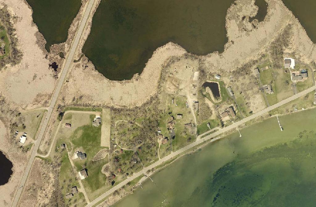
18 04/21/2017 Schroeder PUD site & area
19
20
21
22
23
24

25
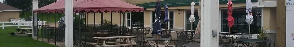
26 STAFF REPORT Application: Variance to construct a 24 x54 covered patio, addition to structure approx. 30 ft from Lake Minnewaska (min. 75 ft required). Applicant: Kenneth Moe Property Owner: Moe & Gerdes Properties Background Information: Proposal: The applicant is proposing to extend the south facing roofline of Captain s Resort to provide a 24 x 54 cover for a concrete deck that has existed on the parcel for some time. This is separate from the patio addition which was submitted as a variance request from a 50 foot setback and was approved by the City Council in November The details and conditions of that variance approval were: Variance(s) approved: Variance to construct an approx. 16' x 20' storage building approx. 16 ft from Lake Minnewaska (min. 75 ft required) and a patio addition (for future conversion to an enclosed structure) with associated grading/fill approx. 18 ft from Lake Minnewaska (min. 75 ft required) on a lot that exceeds impervious coverage limits. *Note: Some documentation of the above variance included "for future conversion to an enclosed structure" after the phrase "patio addition". That was an error, as while it was the applicant's original request to eventually enclose the structure, it is not what was approved see condition #2 below. Conditions of approval: 1. That a stormwater management plan be implemented on the property, as designed by a professional, to manage at least a 1" rain from impervious surfaces on the lot equal to at least 2 times the square footage being added. 2. That the lakeside addition to the building be limited to an open patio or deck, and not be allowed to be roofed (except for the use of temporary awnings or pergolatype structures). 3. That the storage building be located no closer than 37.5 feet from the lake (i.e. out of the "shore impact zone" as defined by DNR regulations). 4. That the applicant provide an agreement with the electric power utility regarding the location of the proposed shed. Should the utility company not agree to the location of the shed as proposed, the applicant may still proceed with the patio construction. The current requested roof addition to the structure for the existing patio would be approximately 30 feet from Lake Minnewaska. There are differing descriptions in the current zoning ordinance as to the setback from the OHW mark of the Minnewaska lakeshore. Either 50 feet or 75 feet is required, depending on the applicable provision of the ordinance. Typically, if there are conflicting standards in the ordinance, the more restrictive provision City of Long Beach Public Hearing #4(b)-1
27 prevails. The City Council will determine the applicable standard. With either provision, the covered patio proposal requires a variance. The site is already over its impervious limit of 25% with the current coverage at about 55-60% (not including the pervious paver patio). The proposed roof that is over the existing patio would not create any additional impervious beyond what already exists, however it will have a two-foot overhang that extends beyond the concrete patio area. The City's ordinance does not clearly indicate whether overhangs count toward impervious coverage. Staff knows of some communities that do not count overhangs provided they are 2 ft or less in width while others do count overhangs. Location: o Applicant: Kenneth Moe o Property Owner: Moe & Gerdes Properties o Legal Description: Lot 1, Block One, Torguson Addition o Property Address: North Lakeshore Drive o Parcel number(s): Zoning: RC Residential/Commercial Lake Designation: General Development (Lake Minnewaska) Parcel size: Approximately 1.8 acres (from survey) approx. 1.2 acres is located outside of the County Road right of way. Applicable Statutes/Ordinances: Minnesota Statutes OFFICIAL CONTROLS: ZONING ORDINANCE. Subd. 6. Appeals and adjustments. Appeals to the board of appeals and adjustments may be taken by any affected person upon compliance with any reasonable conditions imposed by the zoning ordinance. The board of appeals and adjustments has the following powers with respect to the zoning ordinance: (1) To hear and decide appeals where it is alleged that there is an error in any order, requirement, decision, or determination made by an administrative officer in the enforcement of the zoning ordinance. (2) To hear requests for variances from the requirements of the zoning ordinance including restrictions placed on nonconformities. Variances shall only be permitted when they are in harmony with the general purposes and intent of the ordinance and when the variances are consistent with the comprehensive plan. Variances may be granted when the applicant for the variance establishes that there are practical difficulties in complying with the zoning ordinance. "Practical difficulties," as used in connection with the granting of a variance, means that the property owner proposes to use the property in a reasonable manner not permitted by the zoning ordinance; the plight of the landowner is due to circumstances unique to the property not created by the landowner; and the variance, if granted, will not alter the essential character of the locality. Economic considerations alone do not constitute practical difficulties. Practical difficulties include, but are not City of Long Beach Public Hearing #4(b)-2
28 limited to, inadequate access to direct sunlight for solar energy systems. Variances shall be granted for earth sheltered construction as defined in section 216C.06, subdivision 14, when in harmony with the ordinance. The board of appeals and adjustments or the governing body as the case may be, may not permit as a variance any use that is not allowed under the zoning ordinance for property in the zone where the affected person's land is located. The board or governing body as the case may be, may permit as a variance the temporary use of a one family dwelling as a two family dwelling. The board or governing body as the case may be may impose conditions in the granting of variances. A condition must be directly related to and must bear a rough proportionality to the impact created by the variance. Subd. 1e.Nonconformities. (f) In evaluating all variances, zoning and building permit applications, or conditional use requests, the zoning authority shall require the property owner to address, when appropriate, storm water runoff management, reducing impervious surfaces, increasing setback, restoration of wetlands, vegetative buffers, sewage treatment and water supply capabilities, and other conservation-designed actions. City of Long Beach Zoning Ordinance 2.02: DEFINITIONS. 1. Impervious Surface: A constructed hard surface that prevents or retards entry of water into the soil and causes water to run off the surface in greater quantities and at an increased rate of flow than prior to development, including rooftops; decks; sidewalks; patios; parking lots; storage areas; concrete, asphalt, or gravel driveways; and other similar surfaces. (Ordinance approved for Section 2.02 Definitions June 8, 2016.) SECTION 9 RC RESIDENTIAL & COMMERCIAL TRANSITION DISTRICT 9.06: LOT AREA AND SETBACK REQUIREMENTS. The following minimum requirements shall be observed in the RC District subject to additional requirements, exceptions and modifications set forth in this Ordinance. B. Principal Structure Setbacks: 7. Minimum Structure Setback from Ordinary High Water (OHW) mark: Seventy-five (75) feet. 9.07: LOT COVERAGE AND HEIGHT. The following requirements shall be observed in the RC District: A. The ground area of single family detached dwellings, including detached garages, and single- family attached dwellings not exceeding four housing units shall not exceed twenty-five (25) percent lot coverage. City of Long Beach Public Hearing #4(b)-3
29 B. The total ground area of all other permitted residential buildings excluding single family detached dwellings and single-family attached dwellings not exceeding four housing units shall not exceed forty-five (45) percent lot coverage. C. The total ground area of a commercial structure, including accessory buildings, shall not exceed seventy-five (75) percent lot coverage. SECTION 28 SHORELAND MANAGEMENT OVERLAY DISTRICT 28.05: ZONING, WATER SUPPLY AND SANITARY SEWER PROVISIONS. B. Placement, Design, and Height of Structures. 1. Placement of Structures on Lots. When more than one setback applies to a site, structures and facilities must be located to meet all setbacks. a. Structure and On-site Sewage System Setbacks from Ordinary High Water Level*. Classes of Setbacks (in feet)* Public Structures Sewage Treatment Waters Unsewered Sewered System Lakes Natural Environment Recreational Development General Development *One water-oriented accessory structure designed in accordance with Section Letter B Number 2 of this Chapter may be set back a minimum distance of ten (10) feet from the ordinary high water level. d. Uses Without Water Oriented Needs. Uses without water-oriented needs must be located on lots or parcels without public waters frontage, or, if located on lots or parcels with public waters frontage, must either be set back double the normal ordinary high water level setback or be substantially screened from view from the water by vegetation or topography, assuming summer, leaf-on conditions. 2. Design Criteria For Structures. a. High Water Elevations. Structures must be placed in accordance with any floodplain regulations applicable to the site. Where these controls do not exist, the elevation to which the lowest floor, including basement, is placed or flood-proofed must be determined as follows. (1) For lakes, by placing the lowest floor at a level at least three feet (3') above the highest known water level, or three feet (3') above the ordinary high water level, whichever is higher. City of Long Beach Public Hearing #4(b)-4
30 (3) Water oriented accessory structures may have the lowest floor placed lower than the elevation determined in this item if the structure is constructed of flood resistant materials to the elevation, electrical and mechanical equipment is placed above the elevation and, if long duration flooding is anticipated, the structure is built to withstand ice action and wind-driven waves and debris. b. Water Oriented Accessory Structures. Each lot may have one water-oriented accessory structure not meeting the normal structure setback in Section Letter B Number 1 of this Chapter if this water-oriented accessory structure complies with the following provisions. (1) The structure or facility must not exceed ten feet (10') in height, exclusive of safety rails, and cannot occupy an area greater than two hundred and fifty (250) square feet. Detached decks must not exceed eight feet (8') above grade at any point. (2) The setback of the structure or facility from the ordinary high water level must be at least ten feet (10') and not in the bluff impact zone. (3) The structure or facility must be treated to reduce visibility as viewed from public waters and adjacent shorelands by vegetation, topography, increased setbacks or color, assuming summer, leaf-on conditions. (4) The roof may be used as a deck with safety rails, but must not be enclosed or used as a storage area. (5) The structure or facility must not be designed or used for human habitation and must not contain water supply or sewage treatment facilities. (6) As an alternative for general development and recreational development waterbodies, water-oriented accessory structures used solely for watercraft storage, and including storage of related boating and wateroriented sporting equipment, may occupy an area up to four hundred (400) square feet provided the maximum width of the structure is twenty feet (20') as measured parallel to the configuration of the shoreline. 3. Height of Structures. All structures in residential districts, except churches and nonresidential agricultural structures, must not exceed thirty-five feet (35') in height. E. Stormwater Management. The following general and specific standards shall apply. 2. Specific Standards: a. Impervious surface coverage of lots must not exceed twenty-five percent (25%) of the lot area. Findings of Fact: The following findings of fact are presented by Staff for consideration by the Planning Commission: City of Long Beach Public Hearing #4(b)-5
31 1) Current Zoning: o Subject Property: RC Residential/Commercial o Surrounding Properties: 2) Current Land Use: North: RC Residential/Commercial South: LD Low-Density Residential West: CD Conservation, Parks and Open Space East: None (Lake Minnewaska) o Subject Property: Bar/Restaurant o Surrounding Properties: North: Resort South: Residential PUD West: Lake (Shallow Pond) East: Lake (Lake Minnewaska) 3) Lot size: Approx. 1.8 acres total (approx. 1.2 acres not including the County Road) o Existing impervious surface: Approx % (estimated from aerial photo) o Proposed impervious surface: Approx % (more than existing) 4) Sewer/Water: The property is served with City sewer and private water. 5) Natural Features: o Floodplain: There are no mapped floodplains in the City of Long Beach. DNR regulations indicate that the lowest floor of structures be at least three (3) feet above the highest known water level of the lake. In this case, the lowest floor would need to be at an elevation of ( ft). o Bluff/Steep Slopes: The property does not contain any bluffs or steep slopes. o Wetlands: There do not appear to be any wetlands on the property except those associated with the shoreline or lake itself. 6) Will the granting of the variance be in harmony with the general purposes and intent of the Zoning and/or Subdivision Ordinance? The general intent of the 75 ft lake setback is to preserve more natural views from the lake, to allow for management of stormwater running off buildings and to protect buildings from damage to near-shore areas from ice pushes or wave action. The intent of the 25% impervious surface limit is to protect water quality by allowing space for water to infiltrate into the ground or be filtered through vegetation before it enters the lake. 1 1 The City s ordinance identifies a 75 ft minimum setback from the ordinary high water level of the lake in the RC district and a 75% limit for impervious coverage for commercial uses. Section 28.05, however, relates to the shoreland districts and allows for a 50 ft lake setback when the lake is sewered and a maximum 25% impervious coverage City of Long Beach Public Hearing #4(b)-6
32 The proposed setback of 30 feet from the lake for the covered patio would not seem to meet the intent of the ordinance in that it would place structures very close to the lake. However, the existing bar/restaurant structure is also very close and has been grandfathered in. There is also very limited space on the property that would meet the setback requirement and serve the desired function. As such, the proposed uses would not have much additional impact on the view of the buildings/property from the lake. However, stormwater management would need to be implemented to achieve the intent of the ordinance for larger setbacks. The proposed increase in impervious coverage with the roof overhang is inconsistent with the ordinance in that the existing coverage already greatly exceeds the maximum allowed. While the recently installed patio has been considered existing impervious coverage and a legal nonconformity in that it pre-existed the ordinance requirements, it may be possible to argue that adding additional impervious would be consistent with the ordinance provided that an equal amount of impervious that is being added is reduced elsewhere on the lot. The applicant has not proposed this trading of impervious coverage however. Still, it may be possible to find some reductions. 7) Will the granting of the variance be consistent with the City of Long Beach s Comprehensive Plan? The Comprehensive Plan does not directly address applications such as these. 8) Is the proposed use of the property reasonable? The requested variance is reasonable in that it is not unusual for a owner of a lakeshoreoriented restaurant/bar to seek additional outdoor seating areas related to the business. However, the site already greatly exceeds the impervious limits allowed as well as the minimum setback requirements and any worsening of these situations could be deemed unreasonable. Any mitigation efforts he can make in terms of stormwater management may help make the application more reasonable. 9) Is the plight of the landowner due to circumstances unique to the property not created by the landowner? The need for the variance would appear to primarily be related to the shape of the lot, and the pre-existing nature of the business and buildings on the property. However, the applicant is also asking for more roof coverage and closer setbacks to the lake than has historically existed. 10) Will the variance, if granted, alter the essential character of the locality? The use of the property would remain very similar in character to what already exists. It would place more structure within the lake setback and further increase impervious coverage, however, which could be deemed a change in character to some degree. regardless of the use being commercial or residential. Staff has adhered to the more restrictive of the standards in each case (75 ft lake setback, 25% impervious limit) in the writing of this staff report. Generally, when there is conflict, the more restrictive of the standards applies (Section 1.02.A of the Ordinance states Where the conditions imposed by any provision of this Ordinance are either more or less restrictive than comparable conditions imposed by other ordinance, rule or regulation of the City, the Ordinance, rule or regulation which imposes the more restrictive condition, standard, or requirements shall prevail. ). Arguably however, the 50 ft lake setback could be what applies, but regardless, the proposal does not meet either a 50 or 75 ft lake setback. City of Long Beach Public Hearing #4(b)-7
33 11) Are economic considerations the only reason the applicant cannot meet the strict requirements of the ordinance? Economic considerations do not appear to play a significant factor in the requested variance, except in relation to the potential for increased business if the bar/restaurant addition is allowed. They have more to do with the location of the existing building, the size/shape of the lot and the historical use of the property prior to zoning requirements. 12) Could the practical difficulty be alleviated by a feasible method other than a variance (taking into account economic considerations)? In order to avoid the need for the variance, the applicant would need, at a minimum, to have no net increase in impervious coverage. The lake setback variance appears to be unavoidable if it is to achieve its intended purposes. Planning Commission/City Council Direction: The Commission/Council may approve the request, deny the request, or table the request if it should need additional information from the applicant. If the Commission/Council should approve or deny the request, it should state the findings which support either of these actions. Staff Recommendation: Based on the findings noted above, Staff would generally recommend denial of the request given that it is making an already nonconforming situation even more nonconforming. Staff would also recommend that the ordinance be revised (as has been suggested under another agenda item) to remove the ambiguity from the setback standards. If the application is approved, Staff would recommend the following conditions of approval: 1. That the rainwater running off the proposed roof be directed to an area that will allow for infiltration before it enters Lake Minnewaska. This may include directing of the water to the pervious paver patio approved in 2017 by variance, provided that evidence from the applicant's engineer is provided that it can accommodate the additional water consistent with the conditions of the 2017 variance approval, or directing to another area that would contain a rainwater garden or other best management practice designed to accommodate a 1" rainfall from the area of the roof. City of Long Beach Public Hearing #4(b)-8

34 04/29/2017 Captain's Bar & Grill


35
STAFF REPORT. Arthur and Kathleen Quiggle 4(b)
") STAFF REPORT Application: Requests related to the construction of a 28' x 41' dwelling and 6' wrap-around open deck to replace an existing 24' x 32' cabin and wrap-around open deck and the installation
STAFF REPORT Application: Requests related to the construction of a 28' x 41' dwelling and 6' wrap-around open deck to replace an existing 24' x 32' cabin and wrap-around open deck and the installation
CITY OF LONG BEACH March 14, 2018
 CITY OF LONG BEACH ZONING MEETING PACKET FOR 1. Call to Order 2. Roll Call CITY OF LONG BEACH AGENDA BOARD OF ADJUSTMENT / PLANNING AND ZONING COMMISSION 3. Additions or Deletions to the Agenda 4. Public
Article 11. Special Purpose Districts
 Article 11. Special Purpose Districts 11.1 MEDICAL SERVICE DISTRICT 11.2 PLANNED UNIT DEVELOPMENT DISTRICT 11.1 MEDICAL SERVICE DISTRICT A. Purpose The purpose of the MD Medical Service District is to
STAFF REPORT. Gary and Kathleen Miron. Background Information:
 STAFF REPORT Application: Variance to add a second story addition approximately 7-8 feet from a side property line (min. required 15 feet). Existing building coverage is 20.3% (max. 15% allowed). Existing
4.2 RESIDENTIAL ZONING DISTRICTS
 4.2 RESIDENTIAL ZONING DISTRICTS A. Purpose: To define regulations and standards for each residential zoning district in the City. The following sections identify uses, regulations, and performance standards
PLEASE READ THIS IMPORTANT INFORMATION REGARDING VARIANCE APPLICATIONS
 PLEASE READ THIS IMPORTANT INFORMATION REGARDING VARIANCE APPLICATIONS I. APPLICATION Complete the Variance Application. The Environmental Services staff will provide assistance in filling out forms and
City of Independence
 City of Independence Request for a Variance from the Side Yard Setbacks for the Property Located at 4618 South Lake Sarah Drive To: From: Planning Commission Mark Kaltsas, City Planner Meeting Date: May
# , Lecy Bros. o/b/o Charlie & Nora Daum, 1920 Fagerness Point Road - Variances (Lot area, hardcover, setbacks) - Public Hearing
 - Public Hearing") Item 9 Item #09 - PC Agenda - 03/20/2017 Date Application Received: 2/22/17 Date Application Considered as Complete: 2/22/17 60-Day Review Period Expires: 4/23/17 To: From: Chair Thiesse and Planning Commission
Item 9 Item #09 - PC Agenda - 03/20/2017 Date Application Received: 2/22/17 Date Application Considered as Complete: 2/22/17 60-Day Review Period Expires: 4/23/17 To: From: Chair Thiesse and Planning Commission
Washington County, Minnesota Ordinances
 Washington County, Minnesota Ordinances Ordinance No. 153 Text Amendment to the Washington County Development Code - Chapter One, Section 2 and Chapter Two, Part 1, Part 2, Part 3, of the Development Code
** If your lot does not meet the requirements above, please read Sec below
 Sec. 13-1-60 Zoning District Dimensional Requirements. For the Zoning Dept To Issue a Land Use Permit The Following Dimensions are Required. Minimum Side and Rear Yards s Lakes Classification Minimum Class
Chapter 100 Planned Unit Development in Corvallis Urban Fringe
 100.100 Scope and Purpose. Chapter 100 Planned Unit Development in Corvallis Urban Fringe (1) All applications for land divisions in the Urban Residential (UR) and Flood Plain Agriculture (FPA) zones within
Chair Thiesse and Planning Commission Members Doug Reeder, Interim City Administrator
 Item 10 Date Application Received: 02/22/17 Date Application Considered as Complete: 03/06/17 60-Day Review Period Expires: 05/05/17 To: From: Chair Thiesse and Planning Commission Members Doug Reeder,
AGENDA STATEMENT NO BUSINESS OF THE PLANNING COMMISSION City of Victoria, Minnesota STAFF REPORT. Casco Ventures (Developer)
") AGENDA STATEMENT NO. 17-1 BUSINESS OF THE PLANNING COMMISSION City of Victoria, Minnesota STAFF REPORT TO: Planning Commission PREPARED BY: Erin Smith, Senior Planner RE: Waterford Landing Project Rezoning
AGENDA STATEMENT NO. 17-1 BUSINESS OF THE PLANNING COMMISSION City of Victoria, Minnesota STAFF REPORT TO: Planning Commission PREPARED BY: Erin Smith, Senior Planner RE: Waterford Landing Project Rezoning
CHECKLIST INFORMATION NECESSARY FOR ZONING PERMITS
 Information for Zoning Permits (Updated: 2016.11.04 Itasca County Environmental Services 123 NE 4 th Street Grand Rapids, MN 55744 Phone: (218) 327-2857 Fax: (218) 327-7331 TDD: (218) 327-2806 Fax: (218)
STAFF REPORT. Applicable Statutes/Ordinances: Corinna Township Subdivision Ordinance
 STAFF REPORT Application: Preliminary plat application to subdivide an approximate 6.47 acre parcel into two lots (2.81 and 3.42 acres) with a 0.24 acre remainder to be attached to an existing nonconforming
ARTICLE V AGRICULTURAL PRESERVATION AND RURAL RESIDENTIAL DISTRICT
 ARTICLE V AP AGRICULTURAL PRESERVATION AND RURAL RESIDENTIAL DISTRICT Section 500. PURPOSE It is the purpose of the AP, Agricultural Preservation and Rural Residential District, to foster the preservation
A. Maintenance. All legally established, nonconforming structures can be maintained (e.g., painting and repairs);
;") Chapter 24.50 NONCONFORMING USES, STRUCTURES AND LOTS Sections: 24.50.010 Nonconforming uses, structures, and lots Purpose. 24.50.020 Nonconforming uses, structures, and lots Alteration or expansion of
Chapter 24.50 NONCONFORMING USES, STRUCTURES AND LOTS Sections: 24.50.010 Nonconforming uses, structures, and lots Purpose. 24.50.020 Nonconforming uses, structures, and lots Alteration or expansion of
To: Stillwater Town Board Reference: Horst Variance Request Stillwater Township, Minnesota Copies To: Town Board Kathy Schmoekel, Town Clerk
 MEMORANDUM To: Stillwater Town Board Reference: Horst Variance Request Copies To: Town Board Kathy Schmoekel, Town Clerk From: Soren Mattick, Attorney Daniel and Karla Horst, Applicants Ann Pung-Terwedo,
SECTION 1041 GENERAL LOT AND YARD REQUIREMENTS
 SECTION 1041 GENERAL LOT AND YARD REQUIREMENTS SECTION 1041.01: Purpose 1041.02: Platting Required 1041.03: Unsewered Uses and Lots 1041.04: General Yard Requirements 1041.05: Permitted Encroachments 1041.06:
TOWN OF LINWOOD ANOKA COUNTY STATE OF MINNESOTA ORDINANCE NO. 169
 TOWN OF LINWOOD ANOKA COUNTY STATE OF MINNESOTA ORDINANCE NO. 169 ORDINANCE AMENDING CHAPTER 8, PART 7, SECTION 2, AND SECTION 3 OF THE TOWN CODE FIFTH REVISION ADDING DEFINITIONS, REPEALING AND REPLACING
CHAPTER XVIII SITE PLAN REVIEW
 CHAPTER XVIII SITE PLAN REVIEW Section 18.1 Section 18.2 Description and Purpose. The purpose of this chapter is to provide standards and procedures under which applicants would submit, and the Township
PROPOSED AMENDMENTS TO THE DERBY ZONING REGULATIONS AUGUST 12, 2008
 ARTICLE II Definitions and word usage 195-7. Definitions and word usage. Modify the following: HOUSING FOR THE ELDERLY OLDER PERSONS Housing in accordance with and as defined in the United States Fair
Special Use Permit - Planned Unit Development Checklist. Property Address:
 Special Use Permit - Planned Unit Development Checklist Special Use Permit Number. Parcel Code/s #28-11- - - Property Address: Applicant: ARTICLE VIII Ordinance Reference - Section 8.1.2 Permit Procedures:
Staff Report: Date: Applicant: Property Identification: Acreage of Request: Current Zoning of Requested Area: Requested Action: Attached:
 Staff Report: Completed by Jeff Palmer Director of Planning & Zoning Date: November 7, 2018, Updated November 20, 2018 Applicant: Greg Smith, Oberer Land Developer agent for Ronald Montgomery ET AL Property
{{t:t;r:n;o:"signer 2";l:"Date";}}
 Application/File # Date Application Rec'd: Oct 13 2017 Fee Collected $ (for office use only) CONDITIONAL USE APPLICATION MOTLEY MN Site Address (E-911#): 164 MORRISON STREET WEST 410095000 Lake/River Name:
Instructions to the Applicant
 CONDITIONAL USE PERMIT APPLICATION Lake of the Woods County Land and Water Planning Office 206 8 th Avenue Southeast, Suite #290 Baudette MN 56623-2867 www.co.lake-of-the-woods.mn.us Phone: (218) 634-1945
Salem Township Zoning Ordinance Page 50-1 ARTICLE 50.0: PUD PLANNED UNIT DEVELOPMENT
 Salem Township Zoning Ordinance Page 50-1 ARTICLE 50.0 PLANNED UNIT DEVELOPMENT Section 50.01 Purpose The provisions of this Article provide enabling authority and standards for the submission, review,
Staff Report: Date: Applicant: Property Identification: Acreage of Request: Current Zoning of Requested Area: Requested Action: Attached:
 Staff Report: Completed by Jeff Palmer Director of Planning & Zoning Date: November 7, 2018 Applicant: Greg Smith, Oberer Land Developer agent for Ronald Montgomery ET AL Property Identification: Frontage
Article 7: Residential Land Use and Development Requirements
 Article 7: Residential Land Use and Section 701: Statement of Intent (A) (B) (C) The intent of Article 7 is to develop certain land use and development requirements for the residential uses within Cumru
A. Preserve natural resources as identified in the Comprehensive Plan.
 1370.08 Conservation Residential Overlay District. Subd. 1 Findings. The City finds that the lands and resources within the Conservation Residential Overlay District are a unique and valuable resource
WASCO COUNTY PRELIMINARY SUBDIVISION APPLICATION
 WASCO COUNTY PRELIMINARY SUBDIVISION APPLICATION DETAILED SPECIFIC WRITTEN REQUEST File Number: SDV- Number of Proposed Lots & their Dimensions: PRELIMINARY SUBDIVISION PLAN REQUIREMENTS The approval of
ARTICLE 5.0 SCHEDULE OF REGULATIONS
 ARTICLE 5.0 SCHEDULE OF REGULATIONS Section 5.101 Table of Dimensional Standards by District. Dimensional Standards AG AG with sewer Districts Rural Residential Business Other SF SF with sewer R-1 R-1
TABLE OF CONTENTS CHAPTER 1 INTRODUCTORY PROVISIONS Section 1 Purposes. 6. Section 2 Statutory Authorization. 7.
 An Ordinance requiring permits for buildings, structures and the uses thereof; for land uses and for water supply and sewage treatment facilities; establishing minimum lot sizes, setbacks and side yards,
ARTICLE 9 SPECIFICATIONS FOR DOCUMENTS TO BE SUBMITTED
 ARTICLE 9 SPECIFICATIONS FOR DOCUMENTS TO BE SUBMITTED SECTION 950 GENERALLY All applications shall be properly signed and filed by the owner or, with the owner s specific written consent, a contract purchaser
CHAPTER 14 PLANNED UNIT DEVELOPMENTS
 9-14-1 9-14-1 CHAPTER 14 PLANNED UNIT DEVELOPMENTS SECTION: 9-14-1: Purpose 9-14-2: Governing Provisions 9-14-3: Minimum Area 9-14-4: Uses Permitted 9-14-5: Common Open Space 9-14-6: Utility Requirements
PLANNED RESIDENTIAL DEVELOPMENT (PRD)
") PLANNED RESIDENTIAL DEVELOPMENT SECTION 10. PLANNED RESIDENTIAL DEVELOPMENT (PRD) 10.1 Purpose Planned Residential Development allows by special permit from the Board an alternative pattern of residential
PLANNED RESIDENTIAL DEVELOPMENT SECTION 10. PLANNED RESIDENTIAL DEVELOPMENT (PRD) 10.1 Purpose Planned Residential Development allows by special permit from the Board an alternative pattern of residential
AN ORDINANCE AMENDING THE CITY ZONING ORDINANCE AND THE OFFICIAL CODE OF THE CITY OF CLARKSVILLE RELATIVE TO CLUSTER OPTION DEVELOPMENTS
 ORDINANCE 74-2012-13 AN ORDINANCE AMENDING THE CITY ZONING ORDINANCE AND THE OFFICIAL CODE OF THE CITY OF CLARKSVILLE RELATIVE TO CLUSTER OPTION DEVELOPMENTS BE IT ORDAINED BY THE CITY COUNCIL OF THE CITY
SITE PLAN REVIEW PROCEDURES SECTION DEVELOPMENTS REQUIRING SITE PLAN APPROVAL
 SECTION 22.01 PURPOSE ARTICLE XXII PROCEDURES The purpose of this Article is to establish uniform requirements of procedure for all developments in the Township. Certain specific types of minor development
Deb Grube Walworth County Land Use and Resource Management
 Deb Grube dgrube@co.walworth.wi.us 262-741-7907 Walworth County Land Use and Resource Management www.co.walworth.wi.us County Zoning Contacts: Deb Grube (262) 741-7907 Board of Adjustment, Mobile Towers
SECTION 500 RURAL RESIDENTIAL DISTRICTS VERY LOW DENSITY RESIDENTIAL DISTRICTS (VLDR-5, VLDR-2 ½, VLDR-1) [Last Amended 5/24/12; Ord.
 [Last Amended 5/24/12; Ord.") This section and related information is available at www.co.yamhill.or.us/plan/planning/ordinance/zoning_toc.asp SECTION 500 RURAL RESIDENTIAL DISTRICTS 502. VERY LOW DENSITY RESIDENTIAL DISTRICTS (VLDR-5,
This section and related information is available at www.co.yamhill.or.us/plan/planning/ordinance/zoning_toc.asp SECTION 500 RURAL RESIDENTIAL DISTRICTS 502. VERY LOW DENSITY RESIDENTIAL DISTRICTS (VLDR-5,
Article Optional Method Requirements
 Article 59-6. Optional Method Requirements [DIV. 6.1. MPDU DEVELOPMENT IN RURAL RESIDENTIAL AND RESIDENTIAL ZONES Sec. 6.1.1. General Requirements... 6 2 Sec. 6.1.2. General Site and Building Type Mix...
Approved 58 Unit Residential Condo Development for Sale. For Sale: Price Upon Request
 Approved 58 Unit Residential Condo Development for Sale 185 Thorpe Street Fairfield, 06824 For Sale: Price Upon Request u u u u Approved 58 Unit Residential Condo Development For Sale on 6.7 Acres in Fairfield
Box Elder County Land Use Management & Development Code Article 3: Zoning Districts
 Chapter 3-6 Mobile Homes, Mobile Home Subdivisions, & Recreational Vehicle Parks Box Elder Zoning Ordinance as Adopted October 2007 Sections. 3-6-010. Purpose and Intent. 3-6-020. Conditional Use Permit
City of Fraser Residential Zoning District
 City of Fraser Residential Zoning District The one-family districts are established to provide principally for one-family dwellings at varying densities. The specific interest of these districts is to
ARTICLE 7. SPECIFIC USE STANDARDS
 ARTICLE 7. SPECIFIC USE STANDARDS Section 7.1 Applicability The following standards apply to specified uses in all zoning districts in which such uses are allowed. Section 7.2 Accessory Apartments (A)
Article XII. R-1 Agricultural-Low Density Residential District
 Article XII R-1 Agricultural-Low Density Residential District Section 1200. Declaration of Legislative Intent In expansion of the Declaration of Legislative Intent and Statement of Community Development
APPLICATION PROCEDURE
 ANTRIM PLANNING BOARD P. O. Box 517 Antrim, New Hampshire 03440 Phone: 603-588-6785 FAX: 603-588-2969 APPLICATION FORM AND CHECKLIST FOR MINOR OR MAJOR SITE PLAN REVIEW File Date Received By APPLICATION
1. Call to Order 2. Roll Call 3. Approval of Minutes: a. November 15, 2016 Planning Commission Meeting
 PLANNING COMMISSION MEETING AGENDA REGULAR MEETING TUESDAY, JANUARY 17, 2017 6:30 PM Regular Meeting 1. Call to Order 2. Roll Call 3. Approval of Minutes: a. November 15, 2016 Planning Commission Meeting
ARTICLE IV: DEVELOPMENT STANDARDS
 ARTICLE IV: DEVELOPMENT STANDARDS IV-53 409 PRIVATE STREETS A private street means any way that provides ingress to, or egress from, property by means of vehicles or other means, or that provides travel
MAPLE GROVE PLANNING COMMISSION May 26, 2015
 MAPLE GROVE PLANNING COMMISSION CALL TO ORDER A meeting of the Maple Grove Planning Commission was held at 7:00 p.m. on at the Maple Grove City Hall, Hennepin County, Minnesota. Chair Colson called the
SECTION 16. "PUD" PLANNED UNIT DEVELOPMENT OVERLAY DISTRICT
 SECTION 6. "PUD" PLANNED UNIT DEVELOPMENT OVERLAY DISTRICT Subsection. Purpose. This district is established to achieve the coordinated integration of land parcels and large commercial and retail establishments
4. facilitate the construction of streets, utilities and public services in a more economical and efficient manner;
 PVPC MODEL BYLAW BY-RIGHT CLUSTER ZONING BYLAW Prepared by Pioneer Valley Planning Commission Revised: October 2001 1.00 Development 1.01 Development Allowed By Right Development in accordance with this
Chair Thiesse and Planning Commission Members Jessica Loftus, City Administrator
 Date Application Received: 12/14/16 Date Application Considered as Complete: 12/14/16 60-Day Review Period Extension Expires: 04/13/17 Item 5 To: From: Chair Thiesse and Planning Commission Members Jessica
The following regulations shall apply in the R-E District:
 "R-E" RESIDENTIAL ESTATE DISTRICT (8/06) The following regulations shall apply in the R-E District: 1. Uses Permitted: The following uses are permitted. A Zoning Certificate may be required as provided
FREQUENTLY USED PLANNING & ZONING TERMS
 City Of Mustang FREQUENTLY USED PLANNING & ZONING TERMS Abut: Having property lines, street lines, or zoning district lines in common. Accessory Structure: A structure of secondary importance or function
May 12, Chapter RH HILLSIDE RESIDENTIAL ZONES REGULATIONS Sections:
 May 12, 2017 Chapter 17.13 RH HILLSIDE RESIDENTIAL ZONES REGULATIONS Sections: 17.13.010 Title, intent, and description. 17.13.020 Required design review process. 17.13.030 Permitted and conditionally
CITY OF EMILY VARIANCE APPLICATION
 CITY OF EMILY VARIANCE APPLICATION Please read the Variance Application in its entirety before submitting the application. Applications must be submitted 30 days before the Planning Commission meeting.
6.1 SCHEDULE OF AREA, FRONTAGE, YARD AND HEIGHT REQUIREMENTS
 SECTION 6.0 6.1 SCHEDULE OF AREA, FRONTAGE, YARD AND HEIGHT REQUIREMENTS Minimum Minimum Minimum Minimum Minimum Maximum Maximum Lot Lot Front Side Rear Height Lot District Area Front Yard Yard Yard Coverage
Draft Zoning Changes for the 2nd Planning Board Public Hearing, January 22, 2018.
 Draft Zoning Changes for the 2nd Planning Board Public Hearing, January 22, 2018. No changes were made at the 1st Public Hearing. Proposed wording for the 1 st Public Hearing in red, eliminated text in
ARTICLE 24 SITE PLAN REVIEW
 ARTICLE 24 SITE PLAN REVIEW 24.1 PURPOSE: The intent of these Ordinance provisions is to provide for consultation and cooperation between the land developer and the Township Planning Commission in order
Castle Danger Subordinate Service District Phase I Land Use Ordinance #1
 Castle Danger Subordinate Service District Phase I Land Use Ordinance #1 Effective February 2, 2010 Castle Danger Subordinate Service District Phase I Land Use Ordinance SECTION I PURPOSE The purpose of
A. Location. A MRD District may be permitted throughout the County provided it meets the standards established herein.
 752. Multi-Residential District (MRD) The Multi-Residential (MRD) District is intended to provide opportunities for rural, suburban and urban density mixed-residential developments consistent with the
Cluster Development Princeton Township, Mercer County
 Cluster Development Princeton Township, Mercer County Division 9 Residential Clusters Section 10B-189 Statement of purposes. The township committee to implement the goals and objectives of the Princeton
ARTICLE I ZONE BASED REGULATIONS
 ARTICLE I ZONE BASED REGULATIONS RZC 21.08 RESIDENTIAL REGULATIONS 21.08.290 Cottage Housing Developments A. Purpose. The purpose of the cottage housing requirements is to: 1. Provide a housing type that
ARTICLE 15 - PLANNED UNIT DEVELOPMENT
 Section 15.1 - Intent. ARTICLE 15 - PLANNED UNIT DEVELOPMENT A PUD, or Planned Unit Development, is not a District per se, but rather a set of standards that may be applied to a development type. The Planned
Charter Township of Garfield Grand Traverse County
 Charter Township of Garfield Grand Traverse County 3848 VETERANS DRIVE TRAVERSE CITY, MICHIGAN 49684 PH: (231) 941-1620 FAX: (231) 941-1588 GUIDE FOR THE SUBMISSION OF AN APPLICATION FOR SITE PLAN REVIEW
NOTICE OF MEETING The City of Lake Elmo Planning Commission will conduct a meeting on Monday July 24, 2017 at 7:00 p.m. AGENDA
 3800 Laverne Avenue North Lake Elmo, MN 55042 (651) 747-3900 www.lakeelmo.org NOTICE OF MEETING The City of Lake Elmo Planning Commission will conduct a meeting on Monday July 24, 2017 at 7:00 p.m. AGENDA
Article 04 Single Family Residential Districts
 Article 04 Article 04 Section 04.01 Intent (a) R1A Residence District. The R1A Single Family Residential District is established to include areas of low density single-family residences and limited agricultural
Residential Project Convenience Facilities
 Standards for Specific Land Uses 35.42.220 E. Findings. The review authority shall approve a Land Use Permit in compliance with Subsection 35.82.110.E (Findings required for approval) or a Conditional
VARIANCE PROCEDURE The City Council will consider the request and either grant or deny the variance.
 VARIANCE PROCEDURE 1 The Minnetrista City Code was established to protect both current and future residents from the negative impacts of improper development and to ensure a positive future for the city.
CHAPTER34 PRUD - PLANNED RESIDENTIAL UNIT DEVELOPMENT
 CHAPTER34 PRUD - PLANNED RESIDENTIAL UNIT DEVELOPMENT 17-34-1 17-34-2 17-34-3 17-34-4 17-34-5 17-34-6 17-34-7 17-34-8 17-34-9 Purpose Planned Residential Unit Development Defined Planned Residential Unit
610 LAND DIVISIONS AND PROPERTY LINE ADJUSTMENTS OUTSIDE A UGB
 ARTICLE VI: LAND DIVISIONS AND PROPERTY LINE ADJUSTMENTS VI-21 610 LAND DIVISIONS AND PROPERTY LINE ADJUSTMENTS OUTSIDE A UGB 610-1 Property Line Adjustments (Property Line Relocation) A property line
New Zoning Ordinance Program
 City of Goleta New Zoning Ordinance Program Module 3: Regulations Applying to Multiple Districts General Site Regulations Landscaping Parking and Loading June 09, 2014 New Zoning Ordinance Program By:
DEVELOPMENT DEPARTMENT STAFF REPORT THE PARK AT 5 TH
 DEVELOPMENT DEPARTMENT STAFF REPORT ARB Meeting Date: July 3, 2018 Item #: _PZ2018-293_ THE PARK AT 5 TH Request: Site Address: Project Name: Parcel Number: Applicant: Proposed Development: Current Zoning:
SECTION 10.7 R-PUD (RESIDENTIAL PLANNED UNIT DEVELOPMENT) ZONE
 ZONE") Article X Zones 10-20 SECTION 10.7 R-PUD (RESIDENTIAL PLANNED UNIT DEVELOPMENT) ZONE A. PURPOSE AND INTENT: The R-PUD Residential PUD Zone is intended to provide alternative, voluntary zoning procedures
Article X Zones 10-20 SECTION 10.7 R-PUD (RESIDENTIAL PLANNED UNIT DEVELOPMENT) ZONE A. PURPOSE AND INTENT: The R-PUD Residential PUD Zone is intended to provide alternative, voluntary zoning procedures
A. ARTICLE 16 - STEEP SLOPE CONSERVATION DISTRICT
 1600. 1601.A. ARTICLE 16 - STEEP SLOPE CONSERVATION DISTRICT SECTION 1600 PURPOSE The purpose of this Article is to expand upon the Community Development Objectives associated with environmental protection
VICINITY MAP. Board of Adjustment File No.: VAR & VAR January 9, 2014 Page 2 of 11 ATTACHMENTS
 Board of Adjustment File No.: VAR2013 0024 & VAR2013 0025 January 9, 2014 Page 2 of 11 VICINITY MAP ATTACHMENTS Attachment A Applicant s Letter Attachment B Site Plan Attachment C Elevation Drawings Board
SUBDIVISION APPLICATION
 SUBDIVISION APPLICATION Community Planning and Economic Development Development Services Division 250 South 4 th Street, Room 300 Minneapolis MN 55415-1316 612-673-3000 This application packet is used
Appendix J: Stormwater Utility Ordinance Guidance
 Appendix J: Stormwater Utility Ordinance Guidance 1. City of Marquette (MI) Stormwater Utility Ordinance 2. Guidance on Establishing Stormwater Utility Fees 169 City of Marquette (MI) Stormwater Utility
WALWORTH COUNTY RESOURCE MANAGEMENT/CONSERVATION (262) Land Disturbance/Erosion Control Fay Amerson, Urban Program Specialist
 Land Disturbance/Erosion Control Fay Amerson, Urban Program Specialist") WALWORTH COUNTY LAND USE AND RESOURCE MANAGEMENT SHORELAND ZONING Michael Cotter, Director Lou Olson, Deputy Director WALWORTH COUNTY LAND USE Ph # (262) 741-4972 Fax (262) 741-4974 Deb Grube, Sr. Zoning
WALWORTH COUNTY LAND USE AND RESOURCE MANAGEMENT SHORELAND ZONING Michael Cotter, Director Lou Olson, Deputy Director WALWORTH COUNTY LAND USE Ph # (262) 741-4972 Fax (262) 741-4974 Deb Grube, Sr. Zoning
CHAPTER 6 CHESAPEAKE BAY PRESERVATION AREAS AND STREAM PROTECTION AREAS
 CHAPTER 6 CHESAPEAKE BAY PRESERVATION AREAS AND STREAM PROTECTION AREAS 6.1 INTRODUCTION Virginia s Chesapeake Bay Preservation Area (CBPA) Designation and Management Regulations (9VAC10-20 et seq.) require
STAFF REPORT. Permit History:
 STAFF REPORT Application: Request to rezone property from General Agriculture (AG) to Suburban Residential (a) (R-2a) Applicant: Perry Puncochar Agenda Item: 4(g) Background Information: Proposal: The
-MENDOCINO COUNTY PLANNING AND BUILDING SERVICES- DIVISION OF LAND REGULATIONS TITLE 17
 ARTICLE VI -- GENERAL REGULATIONS AND PROVISIONS Sec. 17-50. Sec. 17-51 General Plan. Sec. 17-52 Lot and Block Design and Configuration. Sec. 17-53 Lot Access. Sec. 17-54 Private Roads. Sec. 17-55 Water
the conditions contained in their respective Orders until January 1, 2025, at the discretion of the Director of Planning, Property and Development.
 Part 4: Use Regulations Temporary Uses and Structures Purpose the conditions contained in their respective Orders until January 1, 2025, at the discretion of the Director of Planning, Property and Development.
Midwest City, Oklahoma Zoning Ordinance
 2010 Midwest City, Oklahoma Zoning Ordinance 9/2/2010 Table of Contents Section 1. General Provisions... 5 1.1. Citation... 5 1.2. Authority... 5 1.3. Purpose... 5 1.4. Nature and Application... 5 1.5.
CHARLES CITY COUNTY SITE PLAN ORDINANCE. This Ordinance shall be known as the Charles City County Site Plan Ordinance.
 CHARLES CITY COUNTY SITE PLAN ORDINANCE Section 1. Title This Ordinance shall be known as the Charles City County Site Plan Ordinance. Section 2. Authority. This Ordinance is enacted pursuant to the authority
ARTICLE 14 PLANNED UNIT DEVELOPMENT (PUD) DISTRICT
 DISTRICT") ARTICLE 14 PLANNED UNIT DEVELOPMENT (PUD) DISTRICT Section 14.01 Intent. It is the intent of this Article to allow the use of the planned unit development (PUD) process, as authorized by the Michigan Zoning
ARTICLE 14 PLANNED UNIT DEVELOPMENT (PUD) DISTRICT Section 14.01 Intent. It is the intent of this Article to allow the use of the planned unit development (PUD) process, as authorized by the Michigan Zoning
PLANNING & DEVELOPMENT SERVICES 1800 Continental Place Mount Vernon, WA Inspections Office Fax 360.
 PLANNING & DEVELOPMENT SERVICES 1800 Continental Place Mount Vernon, WA 98273 Inspections 360.416.1330 Office 360.416-1320 Fax 360.416-1340 Date Received: Administrative Setback Reduction Checklist Pursuant
Department of Planning and Development
 COUNTY OF KENOSHA Department of Planning and Development December 2012 VARIANCE APPLICATION Owner: Mailing Address: Phone Number(s): To the Kenosha County Board of Adjustment: Please take notice that the
ARTICLE 5 GENERAL REQUIREMENTS
 5.1 SUITABILITY OF THE LAND ARTICLE 5 GENERAL REQUIREMENTS 5.1.1 Land subject to flooding, improper drainage or erosion, and land deemed to be unsuitable for development due to steep slope, unsuitable
MULTI-FAMILY DWELLING UNIT SUBDIVISION ORDINANCE TOWN OF SIDNEY, MAINE
 MULTI-FAMILY DWELLING UNIT SUBDIVISION ORDINANCE TOWN OF SIDNEY, MAINE I. GENERAL A. Title B. Purpose C. Administration D. Scope II. DEFINITIONS A. Building Height B. Dwelling Unit C. Family D. Multi-Unit
AN ORDINANCE OF THE CITY OF MINNEAPOLIS. By Palmisano
 AN ORDINANCE OF THE CITY OF MINNEAPOLIS By Palmisano Amending Title 20, Chapter 520 of the Minneapolis Code of Ordinances relating to Zoning Code: Introductory Provisions. The City Council of the City
ARTICLE III District Regulations. A map entitled "Franklin Zoning Map" is hereby adopted as part of this chapter 1.
 ARTICLE III District Regulations ~ 305-8. Adoption of Zoning Map. A map entitled "Franklin Zoning Map" is hereby adopted as part of this chapter 1. ~ 305-9. Official Zoning Map; amendments. Regardless
FINAL DRAFT 10/23/06 ARTICLE VI
 FINAL DRAFT 10/23/06 ARTICLE VI 185-41.1. Planned Residential Development A. Purpose and Intent. The purposes of the Planned Residential Development (PRD) bylaw are to maintain the rural character of Dover,
ALEXANDRIA TOWNSHIP Land Use/Building Permit Application
 Application # Date Application Rec d / / Fee Collected $ (for office use only) ALEXANDRIA TOWNSHIP Land Use/Building Permit Application Site Address (E-911#): Parcel Number (9 digits): - - Legal Description
MINUTE ORDER. BONNER COUNTY PLANNING and ZONING COMMISSION PUBLIC HEARING MINUTES APRIL 7, 2016
 MINUTE ORDER BONNER COUNTY PLANNING and ZONING COMMISSION PUBLIC HEARING MINUTES APRIL 7, 2016 CALL TO ORDER: Acting Chair Hall called the Bonner County Planning and Zoning Commission hearing to order
Change 6, September 1, TITLE 18 WATER AND SEWERS 1
 Change 6, September 1, 2011 18-1 TITLE 18 WATER AND SEWERS 1 CHAPTER 1. MISCELLANEOUS. 2. CITY WASTEWATER SYSTEM. 3. WASTEWATER TREATMENT (SEWER) SYSTEM. 4. WATER. 5. CONNECTIONS WITH PUBLIC WATER SUPPLY.
EAST GOSHEN TOWNSHIP CHESTER COUNTY, PENNSYLVANIA ORDINANCE NO.
 EAST GOSHEN TOWNSHIP CHESTER COUNTY, PENNSYLVANIA ORDINANCE NO. AN ORDINANCE AMENDING THE EAST GOSHEN TOWNSHIP ZONING ORDINANCE OF 1997, AS AMENDED, WHICH IS CODIFIED IN CHAPTER 240 OF THE EAST GOSHEN
1105 SUBDIVISIONS, PARTITIONS, REPLATS, CONDOMINIUM PLATS, AND VACATIONS OF RECORDED PLATS
 1105 SUBDIVISIONS, PARTITIONS, REPLATS, CONDOMINIUM PLATS, AND VACATIONS OF RECORDED PLATS 1105.01 PURPOSE AND APPLICABILITY Section 1105 is adopted to provide standards, criteria, and procedures under
Combined Zoning/Minor Variance and Boulevard Parking Agreement Exception
 Residential Front Yard and Boulevard Parking Policy Name: Residential Front Yard and Boulevard Parking Legislative History: Enacted September 19, 2017 (By-law No. CPOL.-223-475); Amended June 26, 2018