CITY OF NORTH LAS VEGAS MEMORANDUM
|
|
|
- Mabel Hampton
- 5 years ago
- Views:
Transcription
1 CITY OF NORTH LAS VEGAS MEMORANDUM TO: FROM: SUBJECT: Planning Commission Community Development and Compliance Department # 28 ) AMP-03-15; Coleman Airpark II & III - Comprehensive Plan Amendment (Public Hearing) # 29 ) ZN-07-15; Coleman Airpark II & III - Reclassification (Public Hearing) DATE: December 9, 2015 These items were continued from the September 9, 2015, and October 14, 2015, Planning Commission meetings at the request of the applicant. ATTACHMENT: Staff Report dated September 9, 2015, with attachments
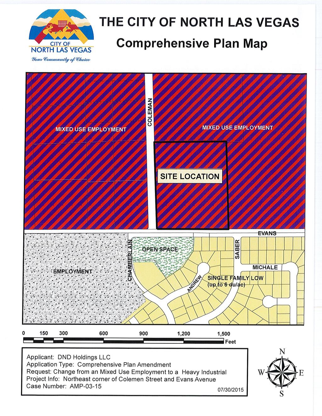
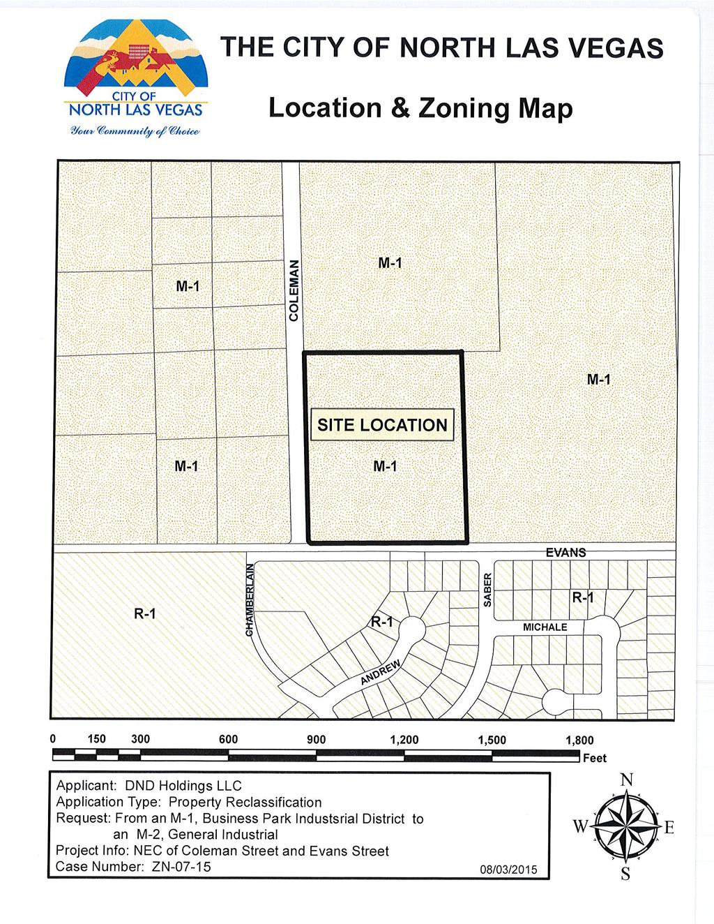
2 # 19 ) AMP COLEMAN AIRPARK II & III MIXED-USE EMPLOYMENT TO HEAVY INDUSTRIAL PUBLIC HEARING # 20 ) ZN COLEMAN AIRPARK II & III M-1, BUSINESS PARK INDUSTRIAL DISTRICT TO M-2, GENERAL INDUSTRIAL DISTRICT PUBLIC HEARING STAFF REPORT To: Planning Commission Meeting date: September 9, 2015 Item: AMP and ZN Prepared by: Marc Jordan GENERAL INFORMATION: Applicant: Property Owner(s): Requested Action: DND Holdings, LLC DND Holdings, LLC Amend the Comprehensive Plan Land Use Map from Mixed-Use Employment to Heavy Industrial Reclassification from an M-1, Business Park Industrial District to an M-2, General Industrial District Purpose: Location: To amend the land use plan and zoning map to a commercial designation Northeast corner of Coleman Street and Evans Avenue Parcel Number(s) Lot Area: Comprehensive Plan: Existing land use and zoning: acres Mixed-Use Employment Undeveloped, M-1, Business Park Industrial District
3 Surrounding land use and zoning: North: Chelten House Products; M-1, Business Park Industrial District West: Office/Warehouse; M-1, Business Park Industrial District East: Undeveloped; M-1, Business Park Industrial District South: Annie L. Walker Park and Single-Family Residential; R-1, Single-Family Low Density District BACKGROUND INFORMATION: The applicant is requesting Planning Commission consideration to amend the Comprehensive Land Use Map from Mixed-Use Employment to Heavy Industrial and reclassify the subject site from the M-1, Business Park Industrial District to the M-2, General Industrial District. The subject site is located at the northeast corner of Coleman Street and Evans Avenue. According to the applicant s letter of intent, the proposed amendments to both the Land Use Plan and Zoning would allow development of the site with approximately 103,000 square feet of warehouse space and approximately 83,000 square feet of outdoor storage in multiple tenant buildings and storage areas. The applicant has also submitted a request (WAV-04-15) to waive parking and landscaping for the proposed development. That application is also on this agenda for Planning Commission consideration. The applicant has indicated that a neighborhood meeting was held on July 23, 2015, at 6:30 p.m. at the Centennial Hills YMCA. According to the applicant, no neighbors attended the meeting. (Note: Title 17 requires neighborhood meetings to be held at a place that is convenient and generally accessible to neighbors that reside in proximity to the land subject to the application. The location of the neighborhood meeting was approximately seven miles from the subject site and located within the City of Las Vegas.) DEPARTMENT COMMENTS: Public Works: Fire Prevention Division: Clark County Department of Aviation: No comment. No comment. Please see the attached letter. 3
4 ANALYSIS: According to the City of North Las Vegas 2006 Comprehensive Master Plan the characteristics and location for Mixed-Use Employment (the current land use) should be located near collector or arterial streets or transit facilities. The intent is to create an employment center environment that also offers convenient opportunities for access to goods and services, restaurants, places to live, parks, open space and civic uses. Mixed- Use Employment areas are predominantly employment areas (light industrial, professional services, and office uses). Secondary uses may also include a variety of retail and service uses, medium and higher density residential uses and live-work units, open space, parks, plazas, and other public or quasi-public uses. The characteristics and location for Heavy Industrial (proposed land use) land use are generally located within close proximity of the major transportation infrastructure of I-15 and the Union-Pacific rail line. These uses are heavier in traffic, noise, processes, or some other factor which requires adequate separation of use from residential areas. The primary uses are higher-intensity industrial activities including manufacturing, processing, warehousing, storage, and shipping. Secondary uses include supporting uses, including offices, and commercial uses supporting industrial development. The purpose of the M-1, Business Park Industrial District (current zoning) is to accommodate light industrial uses, offices, and warehousing in a comprehensively planned and attractive setting while minimizing the amount of non-industrial uses. The purpose of the M-2, General Industrial District (proposed zoning) is to provide for the development of uses that, because of the nature of their operation, appearance, traffic generation, or emission, would not be compatible with land uses in most other zone districts, but which, nevertheless, are necessary and desirable activities in the City. Approval Criteria: (Comprehensive Plan Amendments) Recommendations and decisions on comprehensive master plan amendments may be approved if the City Council finds the proposed amendment will not diminish the supply of essential land uses in the City, including industrial zones that provide a critical employment base for the City, and that the proposed amendment meets at least one of the following: (1) The proposed amendment is based on a change in projections or assumptions from those on which the comprehensive master plan is based; (2) The proposed amendment is based on identification of new issues, needs, or opportunities that are not adequately addressed in the comprehensive master plan; (3) The proposed amendment is based on a change in the policies, objectives, principles, or standards governing the physical development of the City; 4
5 (4) The proposed amendment may result in unique development opportunities that will offer substantial benefits to the City; or (5) The proposed amendment is based on an identification of errors or omissions in the comprehensive master plan. The Master Plan of Streets and Highways designates both Coleman Street and Evans Avenue as 60-foot rights-of-way. These two streets are defined as local streets and by definition are designed to provide vehicular access to abutting properties and to discourage through traffic. The streets are not designated as industrial corridors for heavy industrial uses. The surrounding land uses to the north, east, and west are Mixed-Use Commercial. The land uses to the south are Open Space and Single Family Low. The proposed amendment to the Comprehensive Plan does not warrant a change as the criteria and objectives used during the creation of the current Comprehensive Plan, to protect the land uses to the south and to create compatible land uses, have not changed. The applicant has not identified any new issues in the area or to the subject site, and there have not been any changes in policies, objectives, principles or standards that would support an amendment. The applicant still has the opportunity to develop the subject site with light industrial uses, including office-warehouses uses with the exception of the outside storage yards. The addition of outside storage is not unique as there are several areas available for business within the City that have the need for outside storage. Lastly, staff is not aware of any errors or omissions to the Comprehensive Plan that need to be addressed with this application. The existing land use of Mixed-Use Employment is consistent with the surrounding land uses, including the Employment land uses that continue further south to Carey Avenue. Approval Criteria: (Zoning Map Amendments) The City Council may approve zoning map amendments, and the Planning Commission may recommend approval, if the zoning map amendment meets all of the following criteria: (1) The rezoning will promote the public health, safety, and general welfare; (2) The rezoning is consistent with the comprehensive master plan and the purposes of this Code; (3) The rezoning is consistent with the stated purpose of the proposed zoning district(s); (4) Facilities and services (including roads and transportation, water, gas, electricity, police and fire protection, and sewage and waste disposal, as applicable) will be 5
6 available to serve the subject property while maintaining adequate levels of service to existing development; (5) The rezoning is not likely to result in significant adverse impacts upon the natural environment, including air, water, noise, storm water management, wildlife, and vegetation, or such impacts will be substantially mitigated; (6) The rezoning is not likely to result in significant adverse impacts upon other property in the vicinity of the subject tract; and (7) Future uses on the subject tract will be compatible in scale with uses on other properties in the vicinity of the subject tract. Staff is not supporting the amendment to the Comprehensive Plan. As a result, the proposed reclassification (rezoning) is not supported by the current land use designation. In addition, the proposed zoning may have an adverse impact, creating incompatible uses, traffic, noise, and appearance to the surrounding land uses. The surrounding land uses include office/warehouse uses without outside storage, and a park and residential. The area is currently supported by the Comprehensive Plan or current zoning to contain a mix of employment related uses contained either in office/warehouse buildings or office buildings. The addition of storage yards is not consistent with the character of the area or surrounding land uses. Furthermore, the proposed request would be considered as spot zoning. Spot Zoning can be defined as the process of singling out a small parcel of land for a use classification totally different from that of the surrounding area for the benefit of the owner and to the detriment of other owners. Essentially spot zoning is the antithesis of planned zoning and good development practices. One of the purposes in adopting a Comprehensive Plan is to identify the long term planning objectives and addressing community needs for the City. The plan ensures orderly development that is compatible with the built environment without negatively impacting surrounding properties. The applicant has not indicated how the proposed amendments to the Comprehensive Plan and Zoning would have a beneficial impact. Rather, the proposed amendments would create an island containing a different land use which could set a precedent that would impact the properties further south, and possibly impacting additional developed residential properties. RECOMMENDATIONS: The Community Development and Compliance Department recommends that AMP and ZN be denied. (Note: The amendment to the Comprehensive Plan is automatically forwarded to the City Council for final consideration. The rezoning request is only forwarded if recommended for approval by the Planning Commission.) 6
7 ATTACHMENTS: Clark County Department of Aviation Letter Letter of Intent Boundary Map Neighborhood Meeting Summary Clark County Assessor s Map Location and Comprehensive Plan Map Location and Zoning Map 7
8
9
10
11
12
13
14
15
16
STAFF REPORT. To: Planning Commission Meeting date: February 8, 2017 Item: ZN Prepared by: Johanna Murphy
 # 7 ) ZN-04-17 VILLAGES AT TULE SPRINGS, VILLAGE 3 PCD, PLANNED COMMUNITY DISTRICT TO R-CL / PCD; MEDIUM DENSITY RESIDENTIAL / PLANNED COMMUNITY DISTRICT PUBLIC HEARING STAFF REPORT To: Planning Commission
# 4 ) ZN VILLAGES AT TULE SPRINGS (VILLAGE 3) MPC, MASTER PLANNED COMMUNITY DISTRICT TO PCD, PLANNED COMMUNITY DISTRICT PUBLIC HEARING
 ZN VILLAGES AT TULE SPRINGS (VILLAGE 3) MPC, MASTER PLANNED COMMUNITY DISTRICT TO PCD, PLANNED COMMUNITY DISTRICT PUBLIC HEARING") # 4 ) ZN-02-16 VILLAGES AT TULE SPRINGS (VILLAGE 3) MPC, MASTER PLANNED COMMUNITY DISTRICT TO PCD, PLANNED COMMUNITY DISTRICT PUBLIC HEARING STAFF REPORT To: Planning Commission Meeting date: January 13,
# 4 ) ZN-02-16 VILLAGES AT TULE SPRINGS (VILLAGE 3) MPC, MASTER PLANNED COMMUNITY DISTRICT TO PCD, PLANNED COMMUNITY DISTRICT PUBLIC HEARING STAFF REPORT To: Planning Commission Meeting date: January 13,
STAFF REPORT. To: Planning Commission Meeting date: May 11, 2016 Item: ZN Prepared by: Robert Eastman
 # 4 ) ZN-05-16 PARK HIGHLANDS - WEST MPC / R-1, MASTER PLANNED COMMUNITY / SINGLE-FAMILY RESIDENTIAL DISTRICT TO MPC / PSP, PLANNED COMMUNITY DISTRICT / PUBLIC SEMI-PUBLIC DISTRICT PUBLIC HEARING STAFF
STAFF REPORT. To: Planning Commission Meeting date: February 8, 2017 Item: UN Prepared by: Marc Jordan
 # 5 ) UN-08-17 GREAT AMERICAN AUTO SALES SPECIAL USE PERMIT VEHICLE SALES PUBLIC HEARING STAFF REPORT To: Planning Commission Meeting date: February 8, 2017 Item: UN-08-17 Prepared by: Marc Jordan GENERAL
STAFF REPORT. To: Planning Commission Meeting date: August 10, 2016 Item: UN Prepared by: Marc Jordan. To allow a massage establishment
 # 11 ) UN-48-16 LILAC MASSAGE SPECIAL USE PERMIT MASSAGE ESTABLISHMENT PUBLIC HEARING STAFF REPORT To: Planning Commission Meeting date: August 10, 2016 Item: UN-48-16 Prepared by: Marc Jordan GENERAL
# 5 ) UN NORTH LAS VEGAS DISPENSARY SPECIAL USE PERMIT EXTENSION OF TIME PUBLIC HEARING
 UN NORTH LAS VEGAS DISPENSARY SPECIAL USE PERMIT EXTENSION OF TIME PUBLIC HEARING") STAFF REPORT # 5 ) UN-47-14 NORTH LAS VEGAS DISPENSARY SPECIAL USE PERMIT EXTENSION OF TIME PUBLIC HEARING To: Planning Commission Meeting date: December 9, 2015 Item: UN-47-14 Prepared by: Marc Jordan
STAFF REPORT # 5 ) UN-47-14 NORTH LAS VEGAS DISPENSARY SPECIAL USE PERMIT EXTENSION OF TIME PUBLIC HEARING To: Planning Commission Meeting date: December 9, 2015 Item: UN-47-14 Prepared by: Marc Jordan
STAFF REPORT. To allow the On Sale of beer, wine, and spirit based products in conjunction with a restaurant. District
 # 16 ) UN-25-17 MARISCOS LA LOMITA DE CULIACAN SPECIAL USE PERMIT ON SALE OF BEER, WINE, AND SPIRIT BASED PRODUCTS PUBLIC HEARING STAFF REPORT To: Planning Commission Meeting date: June 14, 2017 Item:
STAFF REPORT. To: Planning Commission Meeting date: May 11, 2016 Item: VN Prepared by: Marc Jordan
 # 12 ) VN-02-16 K & G ENTERPRISES VARIANCE PUBLIC HEARING STAFF REPORT To: Planning Commission Meeting date: May 11, 2016 Item: VN-02-16 Prepared by: Marc Jordan GENERAL INFORMATION: Applicant: Property
STAFF REPORT. To: Planning Commission Meeting date: October 12, 2016 Item: UN Prepared by: Marc Jordan
 # 8 ) UN-61-16 LUXE SALON STUDIOS SPECIAL USE PERMIT MASSAGE ESTABLISHMENT PUBLIC HEARING STAFF REPORT To: Planning Commission Meeting date: October 12, 2016 Item: UN-61-16 Prepared by: Marc Jordan GENERAL
# 13 ) UN MARAPHARM LV LLC - CULTIVATION SPECIAL USE PERMIT PUBLIC HEARING
 UN MARAPHARM LV LLC - CULTIVATION SPECIAL USE PERMIT PUBLIC HEARING") # 13 ) UN-38-16 MARAPHARM LV LLC - CULTIVATION SPECIAL USE PERMIT PUBLIC HEARING STAFF REPORT To: Planning Commission Meeting date: June 8, 2016 Item: UN-38-16 Prepared by: Marc Jordan GENERAL INFORMATION:
# 13 ) UN-38-16 MARAPHARM LV LLC - CULTIVATION SPECIAL USE PERMIT PUBLIC HEARING STAFF REPORT To: Planning Commission Meeting date: June 8, 2016 Item: UN-38-16 Prepared by: Marc Jordan GENERAL INFORMATION:
STAFF REPORT. Medical Training Center Ltd. To allow Business, Technical, Trade, or Vocational School
 # 10 ) UN-34-16 EMS TRAINING CENTER SPECIAL USE PERMIT PUBLIC HEARING STAFF REPORT To: Planning Commission Meeting date: June 8, 2016 Item: UN-34-16 Prepared by: Marc Jordan GENERAL INFORMATION: Applicant:
The Planning Commission. DATE: July 19, 2016
 TO: FROM: The Planning Commission MPC Staff DATE: SUBJECT: Petition of Chatham Savannah Authority for the Homeless Cindy Kelley, Agent Saffold Properties L.P. (John Saffold), Owner Aldermanic District:
PLANNING COMMISSION STAFF REPORT
 PLANNING COMMISSION STAFF REPORT West Capitol Hill Zoning Map Amendment Petition No. PLNPCM2011-00665 Located approximately at 548 W 300 North Street, 543 W 400 North Street, and 375 N 500 West Street
MPC STAFF REPORT REZONING MAP AMENDMENT ALDERMANIC DISTRICT 1 COUNTY COMMISSION DISTRICT 5 April 3, 2013 MPC FILE NUMBER.
 MPC STAFF REPORT REZONING MAP AMENDMENT ALDERMANIC DISTRICT 1 COUNTY COMMISSION DISTRICT 5 April 3, 2013 MPC FILE NUMBER. 13-000929-ZA REZONING SUMMARY Report Status Initial Report Petitioner/Property
Metropolitan Planning Commission. DATE: April 5, 2016
 TO: FROM: Metropolitan Planning Commission MPC Staff DATE: April 5, 2016 SUBJECT: Petition of Nine Line Inc. Robert McCorkle, Agent PIN: 2-1034-01-002 380.5 Acres Aldermanic District: 5 (Shabazz) County
City of Valdosta Land Development Regulations
 Chapter 206 Section 206-1 Base Zoning Districts Standards for Uses, Structures, and Property Development (B) (C) Principal Uses and Structures. Principal uses and structures permitted in each base zoning
Planning and Zoning Commission STAFF REPORT REQUEST. DSA : Zone Change from R-3 (Multi-Family Residential) to B-4 (Community Services).
 to B-4 (Community Services).") Planning and Zoning Commission STAFF REPORT AGENDA # TO: FROM: PLANNING AND ZONING COMMISSION Joseph Horn, City Planner MEETING DATES: August 4, 2016 SUBJECT: Gino Tarantini zone change requests REQUEST
Planning and Zoning Commission STAFF REPORT AGENDA # TO: FROM: PLANNING AND ZONING COMMISSION Joseph Horn, City Planner MEETING DATES: August 4, 2016 SUBJECT: Gino Tarantini zone change requests REQUEST
STAFF REPORT. To: Planning Commission Meeting date: January 11, 2017 Item: UN Prepared by: Marc Jordan. Schoolhouse Development, LLC
 STAFF REPORT # 9 ) UN-05-17 AMERICAN LEADERSHIP ACADEMY SPECIAL USE PERMIT CHARTER SCHOOL PUBLIC HEARING To: Planning Commission Meeting date: January 11, 2017 Item: UN-05-17 Prepared by: Marc Jordan GENERAL
Planning Department Oconee County, Georgia
 Planning Department Oconee County, Georgia STAFF REPORT REZONE CASE #: 6985 DATE: October 31, 2016 STAFF REPORT BY: Andrew C. Stern, Planner APPLICANT NAME: Williams & Associates, Land Planners PC PROPERTY
Conditional Use Permit case no. CU 14-06: Bristol Village Partners, LLC
 PLANNING AND ZONING COMMISSION STAFF REPORT August 7, 2014 Conditional Use Permit case no. CU 14-06: Bristol Village Partners, LLC CASE DESCRIPTION: LOCATION: LEGAL DESCRIPTION: EXISTING LAND USE: ZONING:
Glades County Staff Report and Recommendation Unified Staff Report for Small Scale Plan Amendment and Rezoning
 Glades County Staff Report and Recommendation Unified Staff Report for Small Scale Plan Amendment and Rezoning CASE NUMBERS: COMP17-02 and RZ17-02 DATE of STAFF REPORT: May 1, 2017 CASE TYPE: Application
DIVISION 1 PURPOSE OF DISTRICTS
 ARTICLE 2 ZONING DISTRICTS AND MAP DIVISION 1 PURPOSE OF DISTRICTS Section 2.101 Zoning Districts. For the purpose of this Ordinance, the City of Richmond is hereby divided into districts as follows: DISTRICT
ARTICLE 2 ZONING DISTRICTS AND MAPS
 ARTICLE 2 ZONING DISTRICTS AND MAPS SECTION 2.100 PURPOSE OF DISTRICTS Section 2.101. For the purpose of this Ordinance, Billings Township is hereby divided into districts as follows: DISTRICT NAME SYMBOL
Zoning Districts Agriculture Low Density Rural Residential Moderate Density Rural Residential High Density Rural Residential Manufactured Home Park
 Zoning 201 Zoning Districts Agriculture Low Density Rural Residential Moderate Density Rural Residential High Density Rural Residential Manufactured Home Park Commercial Lakeside Commercial Rural Transitional
ARTICLE 3: Zone Districts
 ARTICLE 3: Zone Districts... 3-1 17.3.1: General...3-1 17.3.1.1: Purpose and Intent... 3-1 17.3.2: Districts and Maps...3-1 17.3.2.1: Applicability... 3-1 17.3.2.2: Creation of Districts... 3-1 17.3.2.3:
Chapter 1107: Zoning Districts
 Chapter 1107: Zoning Districts 1107.01 Establishment of Zoning Districts (a) Districts Established In order to carry out the purpose of this code, the City is hereby divided into the zoning districts established
A Affordable Storage CUP Amendment, in Section 20, T35N R2W NMPM, at 4340B US Hwy 160W and 122 Meadows Dr.
 Archuleta County Development Services Planning Department 1122 HWY 84 P. O. Box 1507 Pagosa Springs, Colorado 81147 970-264-1390 Fax 970-264-3338 MEMORANDUM TO: Archuleta County Planning Commission FROM:
ACTION REPORT CITY OF NORTH LAS VEGAS PLANNING COMMISSION
 ACTION REPORT CITY OF NORTH LAS VEGAS PLANNING COMMISSION September 9, 2015 All Staff Reports and attachments are available on the City s Website http://www.cityofnorthlasvegas.com The North Las Vegas
FEC The purpose of the Flexible Use Employment Center classification is to provide for areas of employment uses situated on individual sites or in
 FEC The purpose of the Flexible Use Employment Center classification is to provide for areas of employment uses situated on individual sites or in campus-style parks. Primary uses in the FEC classification
CITY PLANNING COMMISSION AGENDA ITEMS: J & K STAFF: NATALIE BECKER FILE NOS: CPC ZC QUASI-JUDICIAL CPC DP QUASI-JUDICIAL
 Page 92 CITY PLANNING COMMISSION AGENDA ITEMS: J & K STAFF: NATALIE BECKER FILE NOS: CPC ZC 05-00151 - QUASI-JUDICIAL CPC DP 05-00152 - QUASI-JUDICIAL PROJECT: APPLICANT: OWNER: MERCURY CAR WASH SCOTT
AGENDA ITEM SUMMARY GLADES COUNTY BOARD OF COUNTY COMMISSIONERS
 AGENDA ITEM SUMMARY GLADES COUNTY BOARD OF COUNTY COMMISSIONERS SUBJECT: Case Number COMP17-01, Legend Moto LLC This is a Legislative Hearing. DEPARTMENT REQUEST: The Community Development Department requests
SECTION 4 ZONING DISTRICTS
 SECTION 4 ZONING DISTRICTS Sec. 4-1 Establishment of Districts. In order to protect the character of existing neighborhoods, to prevent excessive density of population in areas which are not adequately
3.1. OBJECTIVES FOR RESIDENTIAL LAND USE DESIGNATIONS GENERAL OBJECTIVES FOR ALL RESIDENTIAL DESIGNATIONS
 3. RESIDENTIAL LAND USE DESIGNATIONS INTRODUCTION The Residential land use designations provide for housing and other land uses that are integral to, and supportive of, a residential environment. Housing
RC ; Reclassification The Garrison at Stafford Proffer Amendment (formerly Stafford Village Center)
") Board of Supervisors Robert Bob Thomas, Jr., Chairman Laura A. Sellers, Vice Chairman Meg Bohmke Jack R. Cavalier Wendy E. Maurer Paul V. Milde, III Gary F. Snellings Anthony J. Romanello, ICMA CM County
Board of Supervisors Robert Bob Thomas, Jr., Chairman Laura A. Sellers, Vice Chairman Meg Bohmke Jack R. Cavalier Wendy E. Maurer Paul V. Milde, III Gary F. Snellings Anthony J. Romanello, ICMA CM County
THE AREA PLAN COMMISSION OF ST. JOSEPH COUNTY, IN AGENDA
 THE AREA PLAN COMMISSION OF ST. JOSEPH COUNTY, IN AGENDA Tuesday, January 17, 2017 Fourth-Floor Council Chambers 3:30 p.m. County-City Building, South Bend, IN EXECUTIVE SESSION: A. Election of Officers
REVISED # Federal Drive Milestones Therapy Project Review for Planning and Zoning Commission
 REVISED #2012-111 394 Federal Drive Milestones Therapy Project Review for Planning and Zoning Commission Meeting Date: November 7, 2012 and November 19, 2012 Request: Location: Acreage: Existing Zoning:
Town of Cary, North Carolina Rezoning Staff Report. 956 W. Chatham Street. Town Council Meeting January 9, 2014
 Town of Cary, North Carolina Rezoning Staff Report 13-REZ-22 956 W. Chatham Street Town Council Meeting January 9, 2014 REQUEST To amend the Town of Cary Official Zoning Map by rezoning 0.85 acres located
LAND USE AND ZONING OVERVIEW
 OVERVIEW OF PLANNING POLICIES LAND USE AND ZONING OVERVIEW The Minneapolis Plan for Sustainable Growth and Other Adopted Plans Community Planning and Economic Development Development Services Division
City of Tacoma Zoning Reference Guide
 City of Tacoma Zoning Reference Guide Planning and Development Services 747 Market Street, Room 345 Tacoma, WA 98402 (253) 591-5577 This document should not be used as a substitute for codes and regulations.
STAFF REPORT. Permit Number: Unlimited. Kitsap County Board of Commissioners; Kitsap County Planning Commission
 STAFF REPORT Permit Number: 15 00550 Unlimited DATE: March 2, 2016 TO: FROM: Kitsap County Board of Commissioners; Kitsap County Planning Commission Katrina Knutson, AICP, Senior Planner, DCD and Jeff
ZONING AMENDMENT, & SUBDIVISION STAFF REPORT Date: July 24, 2008
 ZONING AMENDMENT, & SUBDIVISION STAFF REPORT Date: July 24, 2008 APPLICANT NAME SUBDIVISION NAME Remax Realty Professionals Star Motel Subdivision LOCATION 2005 and 2009 Douglas Lane (Southwest corner
Town of Cary, North Carolina Rezoning Staff Report 14-REZ-24 Indian Wells Road Properties Town Council Meeting November 20, 2014
 Town of Cary, North Carolina Rezoning Staff Report 14-REZ-24 Indian Wells Road Properties Town Council Meeting November 20, 2014 REQUEST To amend the Town of Cary Official Zoning Map by revising a condition
Mohave County General Plan
 63 64 65 66 67 68 69 70 71 The Land Use Diagram is not the County's zoning map. 13 It is a guide to future land use patterns. Zoning and area plan designations may be more restrictive than the land use
Corman Park - Saskatoon Planning District Official Community Plan
 1 Corman Park - Saskatoon Planning District Official Community Plan CONSOLIDATED: October, 2017 2 Table of Contents Bylaw Amendments... 3 Section 1: Foundations... 4 Section 2: Future Growth Sector Objectives
KNOXVILLE/KNOX COUNTY METROPOLITAN PLANNING COMMISSION PLAN AMENDMENT/REZONING REPORT
 KNOXVILLE/KNOX COUNTY METROPOLITAN PLANNING COMMISSION PLAN AMENDMENT/REZONING REPORT FILE #: 4-G-12-RZ 4-C-12-SP AGENDA ITEM #: 27 AGENDA DATE: 5/10/2012 POSTPONEMENT(S): 4/12/12 APPLICANT: OWNER(S):
Special Exception Use Order Application
 Development Services Department Planning Division CITY OF OVIEDO 400 Alexandria Boulevard Oviedo, Florida 32765 Application No. Date Received Pre-application Meeting Date Phone: (407) 971-5775 (407)971-5819
PROPOSED FINDINGS OF FACT SUBMITTED TO THE ZONING BOARD OF APPEALS. In the Matter of a Special Use Application. for Address: Board Calendar No.
 PROPOSED FINDINGS OF FACT SUBMITTED TO THE ZONING BOARD OF APPEALS In the Matter of a Special Use Application for Address: Board Calendar No. Submitted by:, [check one] Applicant or Applicant s Attorney
United States Post Office and Multi-Family Residential; and, Single- Family Residence with an Apartment
 Planning Commission File No.: AME2013 0009 January 9, 2014 Page 2 of 9 Existing Land Use: United States Post Office and Multi-Family Residential; and, Single- Family Residence with an Apartment Surrounding
# Coventry Rezoning, Variation and Preliminary/Final PUD Project Review for Planning and Zoning Commission
 #2018-21 460 Coventry Rezoning, Variation and Preliminary/Final PUD Project Review for Planning and Zoning Commission Meeting Date: May 2, 2018 public intro meeting and May 16, 2018 public hearing Requests:
Village WASHINGTON TOWNSHIP MASTER PLAN SYNTHESIS. Page 197
 Village P l a n WASHINGTON TOWNSHIP MASTER PLAN SYNTHESIS Page 197 SECTION 11.0 MASTER PLAN SYNTHESIS INTRODUCTION The proposals presented in the various plans result in a graphic synthesis: The Land Use
Town of Cary, North Carolina Rezoning Staff Report 12-REZ-27 Morris Branch Town Council Public Hearing January 24, 2013
 Town of Cary, North Carolina Rezoning Staff Report 12-REZ-27 Morris Branch Town Council Public Hearing January 24, 2013 REQUEST To amend the Town of Cary Official Zoning Map to rezone approximately 9.0
Town of Scarborough, Maine
 Town of Scarborough, Maine Miscellaneous Appeal INFORMATION REQUIRED FOR ALL APPEALS Before any appeal can be processed, the following material must be submitted to the Code Enforcement Office: 1. A fee
8/17/16 PC Meeting 1
 1 GENERAL INFORMATION OWNER/APPLICANT: Thomas Corff & Terry Moberly (1943 13 th St.) 19328 Towercrest Dr. Oregon City, OR 97045 Michael & Jill Parker (1983 13 th St.) 1708 Oak St. Lake Oswego, OR 97034
CITY OF PALM BEACH GARDENS CITY COUNCIL Agenda Cover Memorandum Meeting Date: November 1, 2018 Ordinance 24, 2018 / *Ordinance 25, 2018
 CITY OF PALM BEACH GARDENS CITY COUNCIL Agenda Cover Memorandum Meeting Date: November 1, 2018 Subject/Agenda Item: 11940 U.S. Highway One Small-Scale Comprehensive Plan Future Land Use Map Amendment and
ZONING AMENDMENT, SUBDIVISION & SIDEWALK WAIVER REQUEST STAFF REPORT Date: November 16, 2006
 ZONING AMENDMENT, SUBDIVISION & SIDEWALK WAIVER REQUEST STAFF REPORT Date: November 16, 2006 NAME SUBDIVISION NAME Terhaar & Cronley Investment Partnership P & E Subdivision LOCATION 4210 and 4218 Halls
Infrastructure, Development and Enterprise Services
 Staff Report To Service Area City Council Infrastructure, Development and Enterprise Services Date Monday, April 9, 2018 Subject Report Number Statutory Public Meeting 671 Victoria Road North Proposed
891941, , : COMPREHENSIVE PLAN AMENDMENT, COMMUNITY PLAN AMENDMENT, AND AREA-WIDE MAP AMENDMENT
 Application Nos. 891941, 891909, 891940: COMPREHENSIVE PLAN AMENDMENT, COMMUNITY PLAN AMENDMENT, AND AREA-WIDE MAP AMENDMENT Amendments to designate five parcels as Rural Industrial Center in the Alderton
Urban Planning and Land Use
 Urban Planning and Land Use 701 North 7th Street, Room 423 Kansas City, Kansas 66101 Email: planninginfo@wycokck.org Phone: (913) 573-5750 Fax: (913) 573-5796 www.wycokck.org/planning To: City Planning
ARTICLE B ZONING DISTRICTS
 ARTICLE B ZONING DISTRICTS Sec. 8-3021 Established. In order to protect the character of existing neighborhoods; to prevent excessive density of population in areas which are not adequately served with
SUBJECT: CUP ; Conditional Use Permit - Telegraph Road Vehicle Sales / Storage
 2 Board of Supervisors Robert Bob Thomas, Jr., Chairman Laura A. Sellers, Vice Chairman Meg Bohmke Jack R. Cavalier Wendy E. Maurer Paul V. Milde, III Gary F. Snellings August 24, 2016 Anthony J. Romanello,
PALM BEACH COUNTY PLANNING, ZONING AND BUILDING DEPARTMENT ZONING DIVISION
 PALM BEACH COUNTY PLANNING, ZONING AND BUILDING DEPARTMENT ZONING DIVISION Application No.: Z-2014-01627 Application Name: Dazco Center Control No.: 2003-00040 Applicant: 4730 Hypoluxo LLC Owners: 4730
DEPARTMENT OF PLANNING JEFFERSON PARISH, LOUISIANA
 DEPARTMENT OF PLANNING JEFFERSON PARISH, LOUISIANA ZONING AND FUTURE LAND USE AREA STUDY REPORT Waggaman Area Existing Zoning, Overlay, and Future Land Use to Most Appropriate DOCKET NO. ASW-1-16 ADVERTISING
ARTICLE 3 ZONING DISTRICTS AND ZONING MAP. Table of Contents
 ARTICLE 3 ZONING DISTRICTS AND ZONING MAP Table of Contents 3-1 Establishment of Zoning Districts... 1 A. General Use Zoning Districts... 1 B. Conditional Zoning Districts... 3 C. Overlay Zoning Districts...
ACTION REPORT CITY OF NORTH LAS VEGAS PLANNING COMMISSION. January 13, 2016
 ACTION REPORT CITY OF NORTH LAS VEGAS PLANNING COMMISSION January 13, 2016 All Staff Reports and attachments are available on the City s Website http://www.cityofnorthlasvegas.com The North Las Vegas City
Mount Airy Planning Commission March 26, Staff Report
 Mount Airy Planning Commission March 26, 2018 Staff Report Special Exception Request Mixed Use Development in CC District Recommendation to Board of Appeals CASE MA-A-18-01 Applicant: Location: Zoning:
Chapter SPECIAL USE ZONING DISTRICTS
 Chapter 20.20 Sections: 20.20.010 Urban Transition (U-T) Zoning District 20.20.020 Planned Development (P-D) Zoning Districts 20.20.010 Urban Transition (U-T) Zoning District A. Purpose. The purpose of
CITY OF BOISE FROM: LLC.
 CITY OF BOISE To: FROM: Mayor and Council Hal Simons, Planning Director DATE: February 22,2008 SUBJECT: Adoption of the Ordinance for CAR07-00063/Paradigm Development, LLC. ACTION REQUIRED: Adoption by
CHAPTER 14 PLANNED UNIT DEVELOPMENTS
 9-14-1 9-14-1 CHAPTER 14 PLANNED UNIT DEVELOPMENTS SECTION: 9-14-1: Purpose 9-14-2: Governing Provisions 9-14-3: Minimum Area 9-14-4: Uses Permitted 9-14-5: Common Open Space 9-14-6: Utility Requirements
Ordinance No SECTION SIX: Chapter of the City of Zanesville' s Planning and Zoning Code is amended to read as follows:
 SECTION SIX: Chapter 1115.02 of the City of Zanesville' s Planning and Zoning Code is 1115.02 APPROVAL PROCESS. Variances shall be approved only in conformance with the approval process provided in Chapter
Planning Commission Application Summary
 Planning Commission Application Summary Project Name: Ballard Property Rezone Address: 12773 & 12775 South 300 East, 415 East Pheasant View Dr. Current Zoning: RA1 (Residential 40,000 sq. ft. minimum)
ZONING AMENDMENT STAFF REPORT Date: September 15, 2016
 ZONING AMENDMENT STAFF REPORT Date: September 15, 2016 NAME LOCATION Clear Water, LLC 3490 Hurricane Bay Road (Northeast corner of Hurricane Bay Road and Hurricane Bay Lane) CITY COUNCIL DISTRICT District
CITY OF BRIGHTON. Community Development/Planning Department SPECIAL LAND USE APPLICATION
 Date Check # Amount Site Plan # SPECIAL LAND USE APPLICATION Project Address: Petitioner: Petitioner Address: General Information: Property Address: Parcel(s) tax ID number(s): Lot Dimensions: N, E, S,
Town of Cary, North Carolina Rezoning Staff Report 14-REZ-31 Cary Park PDD Amendment (Waterford II) Town Council Meeting January 15, 2015
 Town Council Meeting January 15, 2015") Town of Cary, North Carolina Rezoning Staff Report 14-REZ-31 Cary Park PDD Amendment (Waterford II) Town Council Meeting January 15, 2015 REQUEST To amend the Town of Cary Official Zoning Map by amending
Town of Cary, North Carolina Rezoning Staff Report 14-REZ-31 Cary Park PDD Amendment (Waterford II) Town Council Meeting January 15, 2015 REQUEST To amend the Town of Cary Official Zoning Map by amending
PALM BEACH COUNTY PLANNING, ZONING AND BUILDING DEPARTMENT ZONING DIVISION
 PALM BEACH COUNTY PLANNING, ZONING AND BUILDING DEPARTMENT ZONING DIVISION Application No.: Z/CA-2013-00493 Application Name: Trails Charter School Control No.: 2013-00085 Applicant: MG3 ALF Military LLC
TABLE OF CONTENTS SECTION TITLE PAGE. 1.0 Introduction Residential Industrial 4
 TABLE OF CONTENTS SECTION TITLE PAGE 1.0 Introduction 2 2.0 Residential 3 3.0 Industrial 4 4.0 Outdoor Storage, Yards Lot Area, Frontage and Fencing 5 5.0 Implementation 6 2 1.0 INTRODUCTION On May 25,
COUNTY OF SANTA BARBARA PLANNING AND DEVELOPMENT MEMORANDUM. Santa Barbara County Planning Commission
 COUNTY OF SANTA BARBARA PLANNING AND DEVELOPMENT MEMORANDUM TO: FROM: HEARING DATE: RE: Santa Barbara County Planning Commission Florence Trotter-Cadena, Planner III North County Development Review October
Chapter 100 Planned Unit Development in Corvallis Urban Fringe
 100.100 Scope and Purpose. Chapter 100 Planned Unit Development in Corvallis Urban Fringe (1) All applications for land divisions in the Urban Residential (UR) and Flood Plain Agriculture (FPA) zones within
PLANNING COMMISSION REPORT Regular Agenda Public Hearing Item
 PC Staff Report 06/21/10 Item No. 4-1 PLANNING COMMISSION REPORT Regular Agenda Public Hearing Item ITEM NO. 4: PD-[TANGER PCD-1] TO CS; 1025 N. 3 rd STREET (SLD) : Consider a request to rezone approximately
APPLICANT NAME SUBDIVISION NAME DEVELOPMENT NAME LOCATION. CITY COUNCIL DISTRICT Council District 4 PRESENT ZONING PROPOSED ZONING
 SUBDIVISION, PLANNED UNIT DEVELOPMENT, PLANNING APPROVAL, ZONING AMENDMENT, & SIDEWALK WAIVER REQUEST STAFF REPORT Date: February 17, 2010 APPLICANT NAME SUBDIVISION NAME DEVELOPMENT NAME LOCATION David
Article 4. Zoning Districts
 Section 4.1: Establishment of Districts Article 4. Zoning Districts 4.1 Establishment of Districts For the purpose of this UDO, portions of the City as specified on the Official Zoning Map of the City
CITY OF SANTA ROSA DEPARTMENT OF COMMUNITY DEVELOPMENT STAFF REPORT FOR PLANNING COMMISSION February 26, 2015 APPLICANT. Citywide FILE NUMBER
 CITY OF SANTA ROSA DEPARTMENT OF COMMUNITY DEVELOPMENT STAFF REPORT FOR PLANNING COMMISSION February 26, 2015 PROJECT TITLE Extended Hours of Operation Zoning Code Text Amendment ADDRESS/LOCATION Citywide
STAFF REPORT. Permit Number: Garland. Kitsap County Board of Commissioners; Kitsap County Planning Commission
 STAFF REPORT Permit Number: 15 00686 Garland DATE: February 25, 2016 TO: FROM: Kitsap County Board of Commissioners; Kitsap County Planning Commission Katrina Knutson, AICP, Senior Planner, DCD and Jeff
REPORT TO PLANNING & ZONING COMMISSION - CITY OF MARYLAND HEIGHTS
 APPLICATION NUMBER APPLICATION (PROJECT) NAME APPLICANT NAME PROPERTY OWNER NAME CUP16-0003 CENTRAL POWER SYSTEMS & SERVICES, INC. Central Power Systems & Services, Inc. 900 Liberty Drive, Liberty, MO
Chapter 2: Existing Land Use
 Chapter 2: Existing Land Use Existing Land Use An inventory of existing land use describes existing patterns of development. The inventory provides useful information to calculate the ultimate population
STAFF REPORT. Permit Number: Lee. Kitsap County Board of Commissioners; Kitsap County Planning Commission
 STAFF REPORT Permit Number: 15 00689 Lee DATE: March 2, 2016 TO: FROM: Kitsap County Board of Commissioners; Kitsap County Planning Commission Katrina Knutson, AICP, Senior Planner, DCD and Jeff Arango,
NOTICE TO THE PUBLIC. Introduction of the Yellowstone County Zoning Commission Members and Planning Department Staff.
 COUNTY OF YELLOWSTONE ZONING COMMISSION AGENDA-Friday, February 12, 2016 (Continued from February 8, 2016) 11:00 a.m. Billings Library Community Meeting Room 510 North Broadway, 1st Floor, Billings, Montana
ADMINISTRATIVE REPORT
 ADMINISTRATIVE REPORT TO: FROM: Advisory Planning Commission B. Newell, Chief Administrative Officer DATE: October 11, 2016 RE: Temporary Use Permit Application Electoral Area D Purpose: Owners: To allow
VILLAGE OF DOWNERS GROVE PLAN COMMISSION VILLAGE HALL COUNCIL CHAMBERS 801 BURLINGTON AVENUE. June 2, :00 p.m. AGENDA
 VILLAGE OF DOWNERS GROVE PLAN COMMISSION VILLAGE HALL COUNCIL CHAMBERS 801 BURLINGTON AVENUE June 2, 2014 7:00 p.m. AGENDA 1. Call to Order 2. Roll Call a. Pledge of Allegiance 3. Approval of Minutes April
CITY OF PORT ORCHARD
 CITY OF PORT ORCHARD ZONING DESIGNATIONS (Adapted from POMC Chapter 20.34 Zoning Districts, as adopted 6/13/2017) 20.34.110 Greenbelt zone (Gb). (1) Purpose. It is the purpose of the greenbelt zone to
TREASURE COAST REGIONAL PLANNING COUNCIL M E M O R A N D U M. February 19, 2010 Regional Planning Council Meeting
 TREASURE COAST REGIONAL PLANNING COUNCIL M E M O R A N D U M To: Council Members AGENDA ITEM 5G From: Date: Subject: Staff February 19, 2010 Regional Planning Council Meeting Local Government Comprehensive
** If your lot does not meet the requirements above, please read Sec below
 Sec. 13-1-60 Zoning District Dimensional Requirements. For the Zoning Dept To Issue a Land Use Permit The Following Dimensions are Required. Minimum Side and Rear Yards s Lakes Classification Minimum Class
Staff Report to the Clallam County Planning Commission March 2, 2004 Page 1
 March 2, 2004 Page 1 Comprehensive Plan and Zoning Map Amendment REZ2003-00001, Staff Report Clallam County Department of Community Development January 27, 2004 Prepared by the Clallam County Department
Glades County Staff Report and Recommendation REZONING
 Glades County Staff Report and Recommendation REZONING CASE NUMBER: RZ15-01 DATE: October 2, 2015 CASE TYPE: Application for Rezoning REQUEST: J.J. Wiggins Memorial Trust is requesting a rezoning of 22.1±
INDIAN RIVER COUNTY, FLORIDA. The Honorable Members of the Planning and Zoning Commission DEPARTMENT HEAD CONCURRENCE
 Public Hearing Legislative INDIAN RIVER COUNTY, FLORIDA M E M O R A N D U M TO: The Honorable Members of the Planning and Zoning Commission DEPARTMENT HEAD CONCURRENCE Robert M. Keating, AICP; Community
ZONING AMENDMENT & SUBDIVISION STAFF REPORT Date: July 3, 2014
 ZONING AMENDMENT & SUBDIVISION STAFF REPORT Date: July 3, 2014 APPLICANT NAME SUBDIVISION NAME LOCATION Georgia Crown Distributing Subdivision Georgia Crown Distributing Subdivision Southwest corner of
CITY OF TYLER PLANNING AND ZONING COMMISSION STAFF COMMENTS
 CITY OF TYLER PLANNING AND ZONING COMMISSION STAFF COMMENTS Date: September 4, 2018 Subject: PD18-019 ZB3 PROPERTIES, LLC (2469 EARL CAMPBELL PARKWAY) Request that the Planning and Zoning Commission consider
RE: CAR / 4280 N.
 MEMORANDUM TO: FROM: Mayor and Boise City Council Hal Simmons - Planning Director Boise City Planning and Development Services DATE: April 29, 2009 RE: CAR09-00006 / 4280 N. Eagle Road The following application
Planning Justification Report
 Planning Justification Report Kellogg s Lands City of London E&E McLaughlin Ltd. June 14, 2017 Zelinka Priamo Ltd. Page i TABLE OF CONTENTS Page No. 1.0 2.0 2.1 2.2 3.0 4.0 5.0 5.1 5.2 5.3 5.4 5.5 5.6
UPPER MOUNT BETHEL TOWNSHIP NORTHAMPTON COUNTY, PENNSYLVANIA
 UPPER MOUNT BETHEL TOWNSHIP NORTHAMPTON COUNTY, PENNSYLVANIA JOINDER DEED / LOT CONSOLIDATION TOWNSHIP REVIEW PROCESS When accepting proposed Joinder Deeds / Lot Consolidations, review the Joinder Deed
DEPARTMENT OF PLANNING AND COMMUNITY DEVELOPMENT STAFF REPORT
 DEPARTMENT OF PLANNING AND COMMUNITY DEVELOPMENT STAFF REPORT PLANNING COMMISSION AGENDA ITEM # 5: Project Name: Star Dance Zoning Map Amendment, ZMA-13-02 Prepared By: Toby Stauffer, AICP City Planner