COASTAL CONSERVANCY. Staff Recommendation April 24, 2008 MINDEGO HILL ACQUISITION. File No Project Manager: Janet Diehl
|
|
|
- Michael Hall
- 5 years ago
- Views:
Transcription
1 COASTAL CONSERVANCY Staff Recommendation April 24, 2008 MINDEGO HILL ACQUISITION File No Project Manager: Janet Diehl RECOMMENDED ACTION: Authorization to disburse up to $7,500,000 to the Midpeninsula Regional Open Space District to acquire the Mindego Hill property in San Mateo County for habitat preservation, open space protection and public access. LOCATION: Near the town of La Honda in unincorporated San Mateo County (Exhibit 1) PROGRAM CATEGORY: San Francisco Bay Area EXHIBITS Exhibit 1: Project Location Map Exhibit 3: Aerial Photographs Exhibit 4: Site Photographs Exhibit 5: Letters of Support RESOLUTION AND FINDINGS: Staff recommends that the State Coastal Conservancy adopt the following resolution pursuant to Sections of the Public Resources Code: The State Coastal Conservancy hereby authorizes disbursement of an amount not to exceed seven million five hundred thousand dollars ($7,500,000) to the Midpeninsula Regional Open Space District ( the District ) for the purpose of acquiring the Mindego Hill property (San Mateo County Assessor Parcel Numbers , and ) consisting of approximately 1,047 acres for habitat preservation, open space protection and public access, subject to the following conditions: 1. Prior to the disbursement of funds for the acquisition, the District shall submit for the review and approval of the Executive Officer of the Conservancy: Page 1 of 13
2 MINDEGO HILL ACQUISITION a. All relevant acquisition documents, including, without limitation, the appraisal, purchase agreement, escrow instructions, environmental or hazardous materials assessment and title report. b. Evidence that sufficient funds are available to complete the acquisition. 2. The District shall pay no more than fair market value for the property, as approved by the Conservancy, based on an appraisal of the property. 3. In carrying out the project, the District shall comply with all applicable mitigation and monitoring measures of the project that are included in the Mitigated Negative Declaration and the Mitigation Monitoring and Reporting Program attached to the accompanying staff recommendation as Exhibit 2, and with all mitigation, monitoring and other measures that are required by permit or approval for this project. 4. The District shall permanently dedicate the property for habitat preservation, open space protection, public access and compatible agricultural use through an irrevocable offer to dedicate the property or other instrument approved by the Executive Officer of the Conservancy. 5. Conservancy funding shall be acknowledged by erecting and maintaining a sign on the property, the design and location of which to be approved by the Executive Officer. Staff further recommends that the Conservancy adopt the following findings: Based on the accompanying staff report and attached exhibits, the State Coastal Conservancy hereby finds that: 1. The proposed project is consistent with the current Project Selection Criteria and Guidelines. 2. The proposed authorization is consistent with the purposes and objectives of Chapter 4.5 of Division 21 of the Public Resources Code Sections , regarding the San Francisco Bay Area Conservancy Program. 3. The Conservancy has independently reviewed and considered the Mitigated Negative Declaration and Mitigation and Monitoring Program adopted by the District under the California Environmental Quality Act and attached to the accompanying staff recommendation as Exhibit 2, and finds that there is no substantial evidence that the project as mitigated will have a significant effect on the environment, as defined in 14 California Code of Regulations Sections and PROJECT SUMMARY: With this proposed grant of $7,500,000, the Midpeninsula Regional Open Space District will acquire more than a thousand acres of spectacular open lands known as Mindego Hill in the Santa Cruz Mountains near the town of La Honda. Its ridge-to-ocean views, four miles of creek corridors, and excellent trail connections to the adjacent Russian Ridge Open Space Preserve make the Mindego Hill property a critical addition to the District s Page 2 of 13
3 MINDEGO HILL ACQUISITION network of parks along Skyline Ridge (Exhibit 3). The District has committed $15 million of its own funds to this purchase, but needs Conservancy assistance to complete the $22.5 million purchase. The Peninsula Open Space Trust (POST) acquired the property six months ago, having identified Mindego Hill as one of its top five priorities for almost 30 years. Both POST and the District had been very concerned that the property would be lost to private development, once the family that owned it for more than 50 years was ready to sell. There are 27 density credits on the land that could have been subdivided and sold on the private market, according to a density analysis prepared by the county planning department. A more likely outcome of a private sale would have been a single buyer building a luxury estate and permanently closing off access to the land. To preclude such a scenario, POST communicated with the owners over the years, working toward a conservation purchase. This past October, POST was successful in acquiring the property, having raised private funds to help cover the costs of property acquisition and management until the land can be transferred to public ownership. The District took the first step in acquiring the property from POST on March 25, when it authorized spending $15 million toward the purchase. This authorization was contingent on the District finding matching funds to reach the $22.5 million purchase price, which is its appraised value. With the proposed Conservancy grant, the District will be able to close escrow by the end of June. Although POST and the District originally intended to open the property to public use soon after buying it, the presence of a debris landfill on the property necessitates that the property remain closed until the landfill is either removed or remediated on site, as prescribed by the appropriate regulatory agencies. The District will assume the landfill removal agreement negotiated by POST with the former owners, the True family. Chris True will continue to lease the property for cattle grazing through October To evaluate the environmental effects of the proposed acquisition, property clean-up and landfill removal, the District prepared an Initial Study and a Mitigated Negative Declaration (MND) under the California Environmental Quality Act (see CEQA section, below). Staff has reviewed the MND, adopted by the District on March 25, 2008, and concurs that there is no substantial evidence that the project as mitigated will have a significant effect on the environment. A preliminary use and management plan will take effect upon the close of escrow, and remain effective until the District develops a comprehensive site management plan for the property. The preliminary plan prescribes a status quo approach to the continued use and management of the property for livestock grazing and open space purposes. Until a comprehensive plan is completed, the District may hold docent-led public hikes in limited non-sensitive areas. Page 3 of 13
4 MINDEGO HILL ACQUISITION The goal is to open Mindego Hill s miles of ranch roads and potential trails to the public as soon as possible, while providing for protection of its spring-fed lakes, streams and seasonal wetlands. Few private properties are better situated for public enjoyment, as the existing Mindego Hill ranch road begins exactly where the hiking trail running through the Russian Ridge Open Space Preserve currently ends. Once the property is acquired, hikers will be able to continue on for miles, from Skyline Ridge to the 2,000-plus-foot summit of Mindego Hill, to gain a view of the Pacific and surrounding foothills that is truly awe-inspiring (Exhibit 4). Site Description: The Mindego Hill property lies near the town of La Honda in unincorporated San Mateo County, about nine miles inland from the Pacific Ocean. Close to Silicon Valley, the ranch is accessed via a right-of-way across the adjacent Russian Ridge Open Space Preserve off Alpine Road. The property consists of three contiguous parcels of land, totaling 1,047 acres. Elevations at the site range from about 800 feet to about 2,100 feet above sea level. The property is largely defined by the scenic promontory known as Mindego Hill. The terrain is mostly hills and valley, ridges and canyons, with few flat areas. Mixed evergreen forests extend up the ravines in long, dark fingers into the grasslands. The interface between different plant communities in these edge zones provide diverse habitat that is particularly rich in wildlife. Springs can be found at the head of many ravines, supplying a dependable water source to the creeks below. These creeks feed into the greater San Gregorio Creek system, which supports endangered coho salmon, threatened steelhead trout and other fish. The property is the prime watershed for Mindego Creek and Alpine Creek, and includes two lakes, Mindego Lake and Knuedler Lake. Though currently degraded by cattle overuse, Mindego Lake is classified as an interior wetland that is habitat for such species as the endangered San Francisco garter snake and the threatened California red-legged frog, both of which have been positively identified on the property during recent wildlife surveys. Game trails crisscross the property, with evidence of such predators as mountain lion, coyote and bobcat. Raptors using this property include sharp-shinned hawk, golden eagle, Cooper s hawk, white-tailed kite, northern harrier and peregrine falcon all statelisted threatened or special-status species. The property s current and historic use is residential and cattle grazing. Development on the property is confined to about a 10-acre area situated in a bowl below Mindego Hill, in the vicinity of Mindego Lake. Improvements include two older houses, a small cabin and various older farm structures relating to the owner s cattle operation. A household refuse disposal site lies in this 10-acre area (see CEQA section). The remainder of the site is undeveloped. Page 4 of 13
5 MINDEGO HILL ACQUISITION Other improvements include a spring-fed water system, piping, water storage tanks, a stock watering trough, several spring boxes, corrals, a riding ring, and pasture fencing. Several miles of improved ranch roads traverse the property, with more miles of allterrain-vehicle routes that access the remote portions of the property. At 1,047 acres, Mindego Hill is one of the few remaining large tracts of land currently available for purchase along the Mid-Peninsula. The Skyline Ridge Corridor, of which Mindego Hill is an integral part, represents one of the largest accumulations of publicly owned recreational areas and connected habitat in the Bay Area. It is a key conservation priority for both the District and POST. Project History: Mindego Hill is named after Juan Mendico, a Basque farmer who established a homestead and cattle ranch there in Nearly a century later, in 1954, Admiral Arnold True and his wife, Corinne, purchased Mindego Hill. The True family has continued the tradition of ranching on the land since that time. Since the founding of POST 31 years ago, Mindego Hill has been a Top Five protection priority for the organization. The District also has held Mindego Hill as a high-priority acquisition prospect, but has been unable to enter into negotiations for the property s protection. POST first contacted the elder Mrs. True in the early 1980s about preserving historic Mindego Hill, and she expressed interest in seeing the property protected. Following various contacts over the years, the True heirs contacted POST in late 2005 to discuss options for the ranch. Prior to the POST contact, the True heirs had explored the possibility of developing the ranch with an up-to-27-lot residential subdivision. A density analysis was prepared by the San Mateo County Planning Department indicating that a major subdivision could possibly be approved, based on density considerations. A purchase and sale agreement was signed between POST and the True heirs on June 28, 2007, and the property closed escrow on October 11, The District authorized acquisition of the property on March 25, 2008, and committed $15 million of its funds ($564,000 of which came from the per capita grant program under the Clean Water, Clean Air, Safe Neighborhood Parks and Coastal Protection Act of 2002, Proposition 40). It is seeking matching funds to complete the acquisition by the end of June. PROJECT FINANCING: Coastal Conservancy $7,500,000 Midpeninsula Regional Open Space District 15,000,000 Total Project Cost $22,500,000 Page 5 of 13
6 MINDEGO HILL ACQUISITION The anticipated source of funds will be the fiscal year 07/08 appropriation of the Safe Drinking Water, Water Quality and Supply, Flood Control, River and Coastal Protection Bond Act of 2006 (Proposition 84) for Coastal Conservancy state-wide acquisitions, which can be used for the acquisition and protection of land and water resources consistent with Chapter 4.5 of Division 21 of the Public Resources Code. Pursuant to Section 31162(b) of Chapter 4.5 of Division 21, this project furthers the San Francisco Bay Area Conservancy Program s goal to protect, restore, and enhance natural habitats, as discussed below. Consistent with Proposition 84 requirements, in evaluating proposed projects that involve acquisition for the purpose of natural resource protection, the Conservancy gave priority to this project because it demonstrates the following characteristics: (1) The property provides a link to existing large blocks of protected habitat; the property is adjacent to an existing open space preserve and will connect protected areas and allow for the movement of wildlife across an approximately 3,000- acre area, which will increase the sustainability of this and surrounding properties; and (2) The project funding includes a non-state matching contribution toward the acquisition costs (See Public Resources Code Sec ). Finally, as required by Section 75071, Conservancy staff has submitted to the Resources Agency and has posted on the Conservancy s website an explanation as to how the proposed acquisition meets the criteria for Proposition 84 funding. CONSISTENCY WITH CONSERVANCY S ENABLING LEGISLATION: This project is undertaken pursuant to Chapter 4.5 of the Conservancy s enabling legislation, Public Resources Code Sections , to address resource and recreational goals in the San Francisco Bay Area. The Mindego Hill property is located in San Mateo County, one of the nine San Francisco Bay Area counties in which the Conservancy is authorized, under Sections and of the Public Resources Code, to undertake projects and award grants to address resource and recreational goals for the region. Under Section 31162(b), the Conservancy may act to protect, restore, and enhance natural habitats and connecting corridors, watersheds, scenic areas, and other open-space resources of regional significance. The proposed project will protect 1,047 acres of riparian, woodland, and grassland habitat, as well as a highly scenic open space resource that connects to an existing open space preserve. Consistent with Section 31162(d), the project will provide open space and a natural area that is accessible to the urban population of the San Francisco Bay Area for recreational purposes. Finally, the Mindego Hill acquisition satisfies all of the criteria for determining project priority under Section 31163, as follows: 1. It is supported by adopted regional plans. Page 6 of 13
7 MINDEGO HILL ACQUISITION This acquisition would meet the goals and objectives of the Midpeninsula Regional Open Space District s Master Plan and Regional Open Space Study. The Master Plan sets forth guidelines for District acquisitions and shows the relative desirability of potential open space preservation without establishing a priority for land acquisition. The Regional Open Space Study shows the general extent of lands and public access improvements existing and under consideration by the District and other park and open space agencies to complete the District's mission. The Mindego Hill property is considered to have outstanding overall conservation values by both documents. The Master Plan classifies the property as desirable for purchase, with high interest in three habitat areas: the ridgeline area, which received the highest rating, and the creek and meadow/forest area of the property. The Regional Open Space Study also identifies the property as potential open space preservation land, being an important piece of a possible regional trail connection between La Honda Creek Open Space Preserve and Russian Ridge Open Space Preserve, as well as Sam McDonald County Park and Pescadero Creek County Park to the south. The acquisition also is supported by the District s Service Plan for the San Mateo Coastal Annexation Area, approved by the District s Board of Directors on June 6, 2003 and by the San Mateo County Local Agency Formation Commission on April 7, The Service Plan sets District policy for the roughly 140,000-acre Coastside Protection Area in San Mateo County. The District s mission for the Coastal Protection Area is to acquire and preserve in perpetuity open space land and agricultural land of regional significance, protect and restore the natural environment, preserve rural character, encourage viable agricultural use of land resources, and provide opportunities for ecologically sensitive public enjoyment and education. The Service Plan provides that the District will accomplish this mission as a cooperative endeavor with public agencies, nonprofit organizations and individual with similar goals. The project is consistent with the Implementation Strategy of the San Francisco Bay Joint Venture Acquisition Goals, which prioritizes acquisition of wetland, grassland, and stream habitats. The Upland Habitat Goals Project of the Bay Area Open Space Council identifies the property as part of an area that is essential for biodiversity. The Upland Habitat Goals Project aims to protect biological diversity by drafting a sciencebased conservation plan for the San Francisco Bay Area, identifying core areas, linkages and compatible use lands to guide protection and restoration activities of public agencies and conservation nonprofits. The project meets the goals and objectives of the San Mateo County General Plan, including but not limited to its natural resource, visual quality, parks and recreation, and rural land use elements. 2. The project serves a regional constituency, in that the project will help preserve habitat and provide public access for the benefit of the population for the San Francisco Bay Area. 3. The project can be implemented immediately. Page 7 of 13
8 MINDEGO HILL ACQUISITION 4. The project provides benefits that would be lost if the project is not quickly implemented, as discussed in the project selection criteria below. 5. The Conservancy s funds leverage additional funding by two dollars for every one dollar contributed by the Conservancy. CONSISTENCY WITH CONSERVANCY S 2007 STRATEGIC PLAN GOALS & OBJECTIVES: The Mindego Hill acquisition will achieve strategic plan goals for both the San Francisco Bay Area Conservancy Program and the Coastal Program, due to the fact that the property includes creeks that drain to the Pacific and is therefore a coastal project as well as a Bay Area project. San Francisco Bay Area Conservancy Goals: Consistent with Goal 10, Objective D of the Conservancy s 2007 Strategic Plan, the proposed project will result in the acquisition of 1,047 acres of upland wildlife habitat and other significant open space in the Bay Area. Consistent with Goal 11, Objective C, the proposed project will increase the amount of land accessible to the public and provide a corridor for trails. Consistent with Goal 12, Objective B, approximately 1,000 acres of the proposed acquisition are used as rangeland, and will continue to be grazed under District ownership. Coastal Program Goals: Consistent with Goal 1, Objective G, the proposed project will secure real estate for parks and connections to existing parks. Consistent with Goal 4, Objective A, the proposed project will protect a significant resource property totaling 1,047 acres. Consistent with Goal 5, Objective C, the proposed project will permanently protect wildlife corridors along the property s creeks and between this property and adjacent parkland. Consistent with Goal 7, Objective A, approximately 1,000 acres of the proposed acquisition are used as rangeland, and will continue to be grazed under District ownership. Page 8 of 13
9 MINDEGO HILL ACQUISITION CONSISTENCY WITH CONSERVANCY S PROJECT SELECTION CRITERIA & GUIDELINES: The proposed project is consistent with the Conservancy s Project Selection Criteria and Guidelines, last updated on September 20, 2007, in the following respects: Required Criteria 1. Promotion of the Conservancy s statutory programs and purposes: See the Consistency with Conservancy s Enabling Legislation section above. 2. Consistency with purposes of the funding source: See the Project Financing section above. 3. Support of the public: The project is supported by Senator Simitian, Assemblymember Mullin, Supervisor Richard Gordon, the San Mateo County Parks Department, the Bay Area Open Space Council, the Greenbelt Alliance, the Committee for Green Foothills, the Peninsula Open Space Trust and others. Letters of Support are attached as Exhibit Location: The Mindego Hill property is located in San Mateo County, within the jurisdiction of the San Francisco Bay Area Conservancy. The property includes creeks that drain to the Pacific and is therefore a coastal project as well as a Bay Area project. 5. Need: The District has made a very substantial contribution to the Mindego Hill purchase, but additional funds are needed to complete the acquisition. 6. Greater-than-local interest: Acquisition of this property will protect species of national and state-wide concern, while providing significant recreational opportunities for residents of the greater Bay Area. The property will become part of 33,000-acre complex of connected preserves. Additional Criteria 7. Urgency: Mindego Hill is one of the few remaining large tracts of land currently available for purchase along the Mid-Peninsula. With its potential to be subdivided for up to 27 homes or sold as a trophy home site, this property would be especially attractive on the private market, if it is not acquired for public purposes. 8. Resolution of more than one issue: The project will offer opportunities to protect riparian zones, oak woodlands and grasslands located at Mindego Hill. Acquisition of the property also will expand the Russian Ridge Open Space Preserve and enlarge its wildlife corridor. Finally, acquisition of the property will eliminate threats of development, and will allow for public access. 9. Leverage: Conservancy funds are matched two to one with a local funding source. See the Project Financing section above. 10. Conflict resolution: Acquisition of the ranch for conservation purposes will resolve any potential future conflict over development of the property. Page 9 of 13
10 MINDEGO HILL ACQUISITION 12. Readiness: The District has approved $15 million toward the purchase, and all due diligence has been completed. If the Conservancy approves the proposed $7.5 million grant, the District will be ready to close the acquisition by the end of June. 15. Cooperation: The project is the result of cooperation among the private sector, the local agency and the Conservancy. POST has led the effort to acquire the property, and has enlisted private support to cover its initial acquisition and management expenses. The District will develop the property and manage it, with support from the Conservancy for the acquisition. COMPLIANCE WITH CEQA: The Midpeninsula Regional Open Space District (District) is the lead agency for purposes of the California Environmental Quality Act (CEQA) for this acquisition project. The proposed project consists of the purchase of the 1,047-acre Mindego Ranch property by the District, including the assignment of an existing lease, a landfill removal agreement, and an escrow agreement, as well as the concurrent adoption by the District of a Preliminary Use and Management Plan that prescribes a status quo approach to the continued use and management of the property for livestock grazing and open space purposes. CEQA requires consideration of potential environmental effects of agency actions and approvals, unless exempt. The District prepared a Mitigated Negative Declaration (MND) and a Mitigation Monitoring and Reporting Program (MMRP) for the project (Exhibit 2). On February 14, 2008, the District posted a Notice of Intent to Adopt the MND at the County Planning Department and with the State Clearinghouse. The District received comments from two parties; copies of those comments and the District s responses are included in Exhibit 2 to this report. On March 25, 2008, the District approved the project, adopted the MND and MMRP, and determined that there was no substantial evidence before it that the project, as mitigated, will have a significant effect on the environment. On March 27, 2008, the District filed its Notice of Determination with the County Clerk of San Mateo County. The project is being carried out pursuant to the District s Service Plan for the San Mateo Coastal Annexation Area (Service Plan). The Service Plan sets forth specific policies, guiding principles, and implementation actions governing land purchase, use and management in the coastal protection area in furtherance of the District s mission. Projects such as the purchase of the Mindego Hill are envisioned in the Plan. Prior to adopting the Service Plan on June 6, 2003, the District prepared a Program Environmental Impact Report (EIR) that considered the potential environmental effects of implementing the Service Plan through programs such as land purchase, providing public access to open space lands, and protecting natural resources and agricultural lands in the coastal protection area. The District certified the EIR and its Mitigation and Monitoring Plan when it adopted the Service Plan at its June 6, 2003 meeting. The Page 10 of 13
11 MINDEGO HILL ACQUISITION Service Plan and the EIR are available at Where a project is consistent with a plan for which an EIR has already been prepared, CEQA provides that agencies are to focus environmental review on issues that were not addressed in the original EIR or where there are new opportunities to mitigate significant impacts that were not mitigated in connection with the plan adoption. Consistent with this direction, the District prepared an Initial Study (IS) and its MND to evaluate the Mindego Hill acquisition project. The IS and MND first considered the extent to which potential environmental effects of this project were adequately analyzed and mitigated in the EIR. The analysis then focused on effects that were not evaluated as significant effects in the EIR or for which substantial reduction or avoidance may be possible due to circumstances specific to this project. Where effects were found to be significant or susceptible to further mitigation, additional mitigation measures were proposed. Findings and Basis for Negative Declaration Based upon substantial evidence in the record, the District found that: 1. The project will have no impact on aesthetics, agricultural resources, mineral resources, noise, population and housing, and recreation because such impacts do not arise from the proposed project, given its nature, the rural, forested setting, and the lowintensity agricultural uses that are associated with the project. 2. The project may have some limited effect on geology and soils, land use and planning, public services, transportation/traffic, and utilities and service systems, but these effects will be minor and not significant given the project s minor nature, the rural, forested setting and the low-intensity agricultural uses that are associated with the project. 3. The project will not have a significant effect with respect to air quality, biological resources, cultural resources, hazards and hazardous materials, or hydrology and water quality because of mitigation measures that have been made a part of the project as proposed by the District. These measures will reduce impacts to a less than significant level. 4. The project will not: Create impacts that degrade the quality of the environment, substantially reduce the habitat of a fish or wildlife species, cause a fish or wildlife population to drop below self-sustaining levels, threaten to eliminate a plant or animal community, reduce the number or restrict the range of a rare or endangered plant or animal, or eliminate important examples of the major periods of California history or prehistory, due to the project s small scale and localized nature. Page 11 of 13
12 MINDEGO HILL ACQUISITION Create impacts that are individually limited, but cumulatively considerable, based on project specific mitigations that reduce these impacts to a less than significant level. Create environmental effects that would cause substantial adverse effects on human beings, either directly or indirectly, based on project-specific mitigations that reduce these impacts to a less than significant level. The District incorporated the following four Mitigation Measures into the project, in addition to the previously adopted EIR Mitigation Measures included as Attachment A to the MND (Exhibit 2 to this staff report): Mitigation AIR-1: The District shall adhere to existing regulations requiring abatement of lead and asbestos hazards and worker health and safety procedures during demolition of any structures. Mitigation BIO-1: The District shall conduct pre-demolition surveys of building structures proposed for removal, and if special-status bats are present, safely exclude the bats from the building before proceeding with the work, and time the demolition to avoid the maternity season. Mitigation HAZ-1a: The District shall restrict access and disturbance to the areas containing hazardous materials. Mitigation HAZ-1b: The District shall prepare a Site Management Plan. The latter two mitigation measures address areas of potential environmental concern on the property that were identified in a Phase I Environmental Site Assessment and Phase II Investigations Report commissioned by POST in The primary site of concern is the corral area, where spraying of cattle with chemicals to control pests may have occurred. The other identified area of concern is an unpermitted residential debris landfill located near the True residential structure (which itself is proposed for demolition). The investigations indicate that residual chemicals consistent with organochlorine pesticides are present in the soil at the corral at levels exceeding current California Regional Water Quality Control Board, Region 2 ( RWQCB ), Environmental Screening Levels ( ESLs ) and California Environmental Protection Agency, Department of Toxic Substances Control, California Human Health Screening Level. Lead and petroleum hydrocarbon-impacted soils are present in the landfill at levels exceeding current RWQCB ESLs. In addition to the contaminants discussed above, numerous buildings and structures exist on the site which, given the ages of the various structures, suggest that a potential exists for the presence of asbestos and lead paint associated with these structures. Remediation to concentrations below target health risk levels is not part of this acquisition project. The District will assume a landfill-removal agreement negotiated by POST with the True family. Although this document anticipates removal of the landfill from the site unless an alternative treatment is agreed upon by separate letter, alternative methods may be considered to adequately treat the landfill, in compliance with applicable Page 12 of 13
13 MINDEGO HILL ACQUISITION regulations to avoid any significant environmental effects, including treatment and remedation of the landfill in-place (without removing material from the site.) Specific remediation plans cannot be developed until the District has completed additional investigations and agency consultations. It is not possible to evaluate the environmental effects of remediation at this time, since a number of remediation options are feasible, and to select a particular option for analysis would be speculative. Furthermore, additional approvals both by the District Board and the appropriate regulatory agencies are required before selecting a treatment option. All remediation will be conducted in accordance with the Service Plan and applicable local, state, and federal laws, including further environmental review under CEQA. Until the contaminated areas are remediated to levels below target health risk levels or further investigations show that no exposure pathways exist, the District will restrict access to contaminated areas through the use of site access controls. These will include: Securing the site with fencing or other barriers of sufficient height and structural integrity to prevent unauthorized pedestrian, vehicular, or stock animal access. Posting no trespassing and area closed signs. Providing on-site meetings with site workers to inform them about security measures and reporting/contingency procedures. Prohibiting digging, excavating, or otherwise disturbing areas of known contamination. Finally, prior to the remediation of property contamination, the District will prepare a Site Management Plan (SMP) for any proposed construction activities in areas identified as containing hazardous materials. The SMP shall provide site-specific information for contractors (and others) to improve their management of environmental, health and safety contingencies. Conclusion After reviewing the MND and MMRP, as well as the Program EIR, Conservancy staff concurs with the District s finding that the acquisition project, as mitigated, will not have a significant effect on the environment, and recommends that the Conservancy, as a responsible agency under CEQA, also make this finding. Upon approval, staff will file a Notice of Determination. Page 13 of 13


14 Exhibit 1: Project Location Map San Francisco Watershed San Mateo Hillsborough s 101 Foster City San Francisco Bay Belmont Half Moon Bay Ä 2 9 Æ Ä 5 3 Æ San Carlos Redwood City Atherton Menlo Park East Palo Alto Palo Alto Purisma Creek Redwoods OSP Pacific Ocean Ä 1 Æ El Corte Madera OSP 280 Portola Valley Los Altos Hills Ä 4 8 Æ La Honda Creek OSP Russian Ridge Preserve Pescadero Pescadero Creek Park Mindego Hill (approximately 1047 acres) Mindego Hill Property Boundary POST Owned POST Conservation Easement Other Protected Miles - Map date: 11/9/06 Scale: 1:200,000 Photo Date: December 2003 Sources: USGS, Airphoto USA, San Mateo County, POST Derived from data that is Copyright 2005, San Mateo County, all rights reserved
15 MITIGATED NEGATIVE DECLARATION POST Mindego Ranch Addition to Russian Ridge Open Space Preserve San Mateo County, CA February 15, 2008 Midpeninsula Regional Open Space District 330 Distel Circle Los Altos, CA
16 TABLE OF CONTENTS PROPOSED MITIGATED NEGATIVE DECLARATION...1 PROJECT DESCRIPTION SUMMARY...1 FINDINGS AND BASIS FOR NEGATIVE DECLARATION...1 MITIGATION MEASURES INCORPORATED INTO THE PROJECT...2 RESPONSIBLE AGENCY CONSULTATION...2 INITIAL STUDY...2 REVIEW PERIOD...2 CONTACT PERSON...2 INITIAL STUDY...3 PROJECT DESCRIPTION...5 PROJECT SUMMARY...5 PROJECT LOCATION AND SETTING...5 EXISTING OWNERSHIP AND HISTORICAL BACKGROUND...5 EXISTING SETTING...7 PROPOSED PROJECT...9 Preliminary Use and Management Plan...9 BACKGROUND...10 METHODOLOGY...11 SUBSEQUENT ACTIONS AND APPROVALS...12 ENVIRONMENTAL FACTORS POTENTIALLY AFFECTED...13 DETERMINATION...13 ENVIRONMENTAL IMPACTS:...14 I. AESTHETICS...14 II. AGRICULTURE RESOURCES...15 III. AIR QUALITY...16 IV. BIOLOGICAL RESOURCES...18 V. CULTURAL RESOURCES...21 VI. GEOLOGY AND SOILS...22 VII. HAZARDS AND HAZARDOUS MATERIALS...24 VIII. HYDROLOGY AND WATER QUALITY...28 IX. LAND USE AND PLANNING...31 X. MINERAL RESOURCES...32 XI. NOISE...33 XII. POPULATION AND HOUSING...34 XIII. PUBLIC SERVICES...35 XIV. RECREATION...36 XV. TRANSPORTATION / TRAFFIC...37 XVI. UTILITIES AND SERVICE SYSTEMS...38 XVII. MANDATORY FINDINGS OF SIGNIFICANCE...40 REFERENCES...41 ATTACHMENTS...42 i
17 Midpeninsula Regional Open Space District PROPOSED MITIGATED NEGATIVE DECLARATION Based on the attached initial study, the District proposes to issue the following: A notice, pursuant to the California Environmental Quality Act of 1970, as amended (Public Resources Code 21,000, et seq.) that the following project: POST Mindego Ranch Addition to Russian Ridge Open Space Preserve, when implemented, will not have a significant impact on the environment. PROJECT DESCRIPTION SUMMARY The proposed project consists of the purchase of the 1,047-acre POST Mindego Ranch property by the Midpeninsula Regional Open Space District, including the assignment of existing lease, landfill removal agreement, and escrow agreement, and the concurrent adoption of a Preliminary Use and Management Plan that prescribes a status quo approach to the continued use and management of the property for livestock grazing and open space purposes. FINDINGS AND BASIS FOR NEGATIVE DECLARATION The Senior Real Property Planner of the Real Property Department of the Midpeninsula Regional Open Space District, based upon substantial evidence in the record, finds that: 1. The project will have no impact on aesthetics, agricultural resources, mineral resources, noise, population and housing, and recreation because such impacts simply do not arise from the proposed project, given its nature, the rural, forested setting, and the low-intensity agricultural uses that are associated with the project. 2. The project may have some limited effect on geology and soils, land use and planning, public services, transportation/traffic, and utilities and service systems but these effects will be minor and not significant given the project s minor nature, the rural, forested setting and the low-intensity agricultural uses that are associated with the project. 3. The project will not have a significant effect with respect to air quality, biological resources, cultural resources, hazards and hazardous materials, or hydrology and water quality because of mitigation measures that have been made a part of the project as proposed by the District. These measures will reduce impacts to a less than significant level. 4. The project will not: Create impacts that degrade the quality of the environment, substantially reduce the habitat of a fish or wildlife species, cause a fish or wildlife population to drop below self-sustaining levels, threaten to eliminate a plant or animal community, reduce the number or restrict the range of a rare or endangered plant or animal, or eliminate important examples of the major periods of California history or prehistory, due to the project s small scale and localized nature. Create impacts that are individually limited, but cumulatively considerable, based on projectspecific mitigations that reduce these impacts to a less than significant level. POST Mindego Ranch Addition to Russian Ridge Open Space Preserve -1- Midpeninsula Regional Open Space District, February 2008 Initial Study
18 Create environmental effects that would cause substantial adverse effects on human beings, either directly or indirectly, based on project-specific mitigations that reduce these impacts to a less than significant level. Therefore, the Midpeninsula Regional Open Space District has determined that the project will have no significant effect on the environment. MITIGATION MEASURES INCORPORATED INTO THE PROJECT In addition to the previously adopted Mitigation Measures, included as Attachment A and incorporated by reference, the following mitigations measures are incorporated into the project: Mitigation in Section III (d): Mitigation in Section IV(a): Mitigation AIR-1: The District shall adhere to existing regulations requiring abatement of lead and asbestos hazards and worker health and safety procedures during demolition activities. Mitigation BIO-1: Conduct pre-demolition surveys of building structures proposed for removal, and if special-status bats are present, safely exclude the bats from the building before proceeding with the work, and time the demolition to avoid the maternity season. Mitigation in Section VII(b): Mitigation HAZ-1a: The District shall restrict access and disturbance to the areas containing hazardous materials. Mitigation HAZ-1b: Preparation of a Site Management Plan RESPONSIBLE AGENCY CONSULTATION San Mateo County. INITIAL STUDY A copy of the initial study is attached. REVIEW PERIOD The Review Period is February 19, 2008 through March 19, If you have any comments about the proposed Mitigated Negative Declaration or Initial Study, have information that should be included, and/or disagree with the findings of our study as set forth in the proposed Negative Declaration, please submit your comments in writing no later than 5 p.m. on March 19, 2008 to Midpeninsula Regional Open Space District, 330 Distel Circle, Los Altos, CA CONTACT PERSON Sandra Sommer, Senior Real Property Planner, Sandra Sommer, Senior Real Property Planner Midpeninsula Regional Open Space District POST Mindego Ranch Addition to Russian Ridge Open Space Preserve -2- Midpeninsula Regional Open Space District, February 2008 Initial Study
19 MIDPENINSULA REGIONAL OPEN SPACE DISTRICT INITIAL STUDY AND PROPOSED MITIGATED NEGATIVE DECLARATION PROPOSED ADDITION TO RUSSIAN RIDGE OPEN SPACE PRESERVE 1. Project Title: POST Mindego Ranch Addition to Russian Ridge Open Space Preserve 2. Lead agency name and address: Midpeninsula Regional Open Space District 330 Distel Circle Los Altos, CA Contact person and phone number: Sandra Sommer, Senior Real Property Planner Telephone: (650) Project location: 1,047 acres near State Highway 35 in unincorporated San Mateo County; accessed via Alpine Road. 5. Project sponsor s name and address: Midpeninsula Regional Open Space District 330 Distel Circle Los Altos, CA General plan designation: General Open Space and Timber Production (San Mateo County General Plan) 7. Zoning: RM (Resource Management) TPZ (Timber Preserve Zone) 8. Description of project: See Project Description, p Surrounding land uses and setting. See Project Description, p Other public agencies whose approval is required. none POST Mindego Ranch Addition to Russian Ridge Open Space Preserve -3- Midpeninsula Regional Open Space District, February 2008 Initial Study
20 11. Document Availability: All documents referenced in the Initial Study and Mitigated Negative Declaration are available for review on weekdays from 8:30 a.m. to 5:00 p.m. at the Midpeninsula Regional Open Space District office at the address listed above. A copy of the Initial Study and Mitigated Negative Declaration may be obtained at cost, or a CD at no charge, from the District Office. The project is being carried out pursuant to the Service Plan for the San Mateo County Coastal Annexation Area and this initial study and proposed mitigated negative declaration is tiered with the Program Environmental Impact Report ( EIR ) for that plan that was certified by the District s Board of Directors on June 6, The documents are posted online at Copies of the Initial Study, proposed Mitigated Negative Declaration, and EIR are also available for review at the: Half Moon Bay Public Library, 620 Correas St., Half Moon Bay Woodside Public Library, 3140 Woodside Road, Woodside POST Mindego Ranch Addition to Russian Ridge Open Space Preserve -4- Midpeninsula Regional Open Space District, February 2008 Initial Study
21 PROJECT DESCRIPTION PROJECT SUMMARY The proposed project consists of purchase of the POST Mindego Ranch property by the Midpeninsula Regional Open Space District ( the District ). The property is comprised of three contiguous parcels (Assessor Parcel Numbers , , ) located in unincorporated San Mateo County, totaling approximately 1,047 acres. The District would add the property to the adjacent 1,978-acre Russian Ridge Open Space Preserve to expand the Preserve to a total of 3,025 acres. The property falls within the District s Coastside Protection Area and would be subject to all of the environmental and agricultural protection policies and guidelines described in the District s Service Plan for the San Mateo Coastal Annexation Area. A Preliminary Use and Management Plan will take effect upon the close of escrow, and remain effective until a Comprehensive Use and Management Plan (Comprehensive Plan) for the property is developed. The Preliminary Use and Management Plan represents a status quo approach to management and includes continuing grazing under an interim grazing lease. The Preliminary Use and Management Plan also includes securing, posting, patrolling and cleaning up the property (which includes minor demolition of a residence, two trailers, and agricultural structures that are not necessary for ongoing grazing operations), as well as maintaining the property as closed to public use except for infrequent docent-led hikes. PROJECT LOCATION AND SETTING The 1,047-acre POST Mindego Ranch property is located in the Santa Cruz Mountains northwest of the town of La Honda in unincorporated San Mateo County, about nine miles inland from the Pacific Ocean. The property is accessed from Alpine Road and is bounded by Russian Ridge Open Space Preserve to the east. The 1,978-acre existing preserve is managed for resource protection and low-intensity public recreation, offering a 10.4 mile trail system and parking located at the intersection of Alpine Road and Skyline Boulevard (Highway 35). The majority of the existing open space preserve is open to the public for hiking, bicycling, and equestrian use. Private properties lying to the north, west and south of Mindego Ranch are generally large parcels with agricultural and rural residential land uses. The Log Cabin Ranch, operated by the San Francisco Juvenile Probation Department, is located adjacent to the southwest corner of the property. To the northwest lies the watershed lands of the Cuesta La Honda Guild, a common interest development of several hundred homes, incorporated in 1936 to provide water, recreational facilities and roads to the community. EXISTING OWNERSHIP AND HISTORICAL BACKGROUND The project site is currently owned by the Peninsula Open Space Trust (POST), a Palo Alto based 501c(3) non-profit land trust. POST purchased the property in 2007 with funding from supporters, including a $3 million grant from the Gordon and Betty Moore Foundation. Prior to POST s purchase of the ranch, the property was owned by the True family who had occupied the property since Mr. Chris True and his family currently lease the property back from POST through October 2008, continuing year-round grazing, residential, and related uses of the property. Mindego Hill has been the site of cattle ranching since 1859, when Juan Mindecoa settled in the area. Native Americans originally occupied much of the Santa Cruz Mountains. Due to its gentle terrain, easy access to coastal habitats, year-round streams and lakes, and diverse vegetation, the project site could possibly have been occupied by the Costanoan people. Several rock mortars and rough tools have been found on the property over the years, showing that the site was at least occasionally occupied. POST Mindego Ranch Addition to Russian Ridge Open Space Preserve -5- Midpeninsula Regional Open Space District, February 2008 Initial Study

22 Figure 1. Project Location Map POST Mindego Ranch Addition to Russian Ridge Open Space Preserve -6- Midpeninsula Regional Open Space District, February 2008 Initial Study
23 Figure 2. Project Site Map EXISTING SETTING The current San Mateo County General Plan designation for Mindego Ranch s eastern 887 acres is General Open Space, and the designation for the westerly 160 acres is Timber Production. The eastern 887 acres is zoned RM (Resource Management), and the westerly 160 acres of the property is zoned TPZ (Timber Preserve Zone). The easterly 887 acres is also part of an agricultural preserve established by Land Conservation (Williamson Act) Agreement between the County of San Mateo and the former landowner. Adjacent private properties to the north, west, and south of Mindego Ranch are zoned RM. The property to the southeast is zoned TPZ. The project site occupies 1½ square miles of mountainous terrain covered by rolling grasslands, oak woodlands, and mixed evergreen forests supporting stands of second-growth redwoods. A prominent landmark, Mindego Hill, which rises 2,143 feet above sea level and is visible for miles, characterizes the terrain. Two perennial streams (Mindego and Alpine Creeks) and one intermittent stream (Rodgers Gulch) traverse the property, eventually draining into San Gregorio Creek and then out to the Pacific Ocean. One large and several small seasonal ponds are found on the property, and Kneudler and Mindego Lakes provide year-round water. Numerous seeps and springs are present. The two perennial creeks potentially provide important habitat for steelhead trout, a species listed as federally threatened under the Endangered Species Act. California red-legged frog, also listed as POST Mindego Ranch Addition to Russian Ridge Open Space Preserve -7- Midpeninsula Regional Open Space District, February 2008 Initial Study
24 threatened, is potentially present in several of the ponds. Habitat also exists for the San Francisco garter snake, a species listed as endangered under the Act, although the species has not been observed on the site. The diverse mosaic of vegetation communities and water resources present on the property provide potential habitat for a wide variety of plants and animals. San Gregorio Creek Adjudication Decree No dated 1993 allots adjudicated water rights to the Mindego Ranch property. The property has three diversion points indicated on the State Water Resources Control Board map: #82 and #91 (in Kneudler and Mindego Lakes for stock watering use), and #90 (for domestic, stock watering, and irrigation use). The property s water systems currently collect water from springs above Mindego Lake and store it on-site in tanks for further use. Existing routine ranching activities at the Mindego Ranch are typical of a coastal San Mateo County grazing operation, and include regular use of the roads by trucks and other vehicles, and ATV activity off the roads; minor road grading, maintenance, and repair; erosion and erosion control; fence installation and repair; vegetation management, including burning and mowing; predator control; equestrian traffic; supplemental feeding; and cattle roundup and movement throughout the pastures. Cattle have access to the existing lakes and ponds. The shoreline of Mindego Lake in particular shows varying influences from cattle traffic: trampling and removal of emergent and shoreline vegetation, animal impact in the shallow margins, and increased turbidity and nutrient loading. Scrublands, woodlands, and the riparian habitat along the drainages are in general only utilized by the cattle along the grassland perimeter or roadway margins, due largely to dense vegetation and steep, inaccessible slopes. The current grazing operation relies on vegetation barriers and some fencing to restrict cattle access to streams. In 2007, as a part of the purchase due diligence process for the Mindego Ranch property, the former owner reported to POST the presence of a 10,000 to 15,000 cubic yard solid waste and debris landfill on the property. POST then hired a professional engineering consultant to prepare a Phase I Environmental Site Assessment and Phase II Investigations Report ( Phase I / Phase II Report ). 1 The Phase I / Phase II efforts characterized the landfill materials by trenching, and identified and investigated several additional areas of residual contamination on the property. In the Landfill Removal Agreement between POST and the former owner, POST, and the District as its successor, is obligated to remove the landfill from the site, unless an alternative treatment is agreed upon. A Landfill Removal Work Plan 2 was prepared by POST s engineering consultant to provide a description of general landfill removal and closure procedures that would be compliant with the agreement between POST and the former owner absent amendment. By separate letter, POST s engineering consultant also indicated that there are alternative methods to treat the landfill in compliance with applicable regulations, including treatment of the landfill in-place 3 (i.e. not remove from the property) or pursue other treatment options. The Landfill Removal Plan does not limit alternative approaches to the logistics, process, timing, or methods of landfill removal, and was not prepared in consultation with the regulatory agencies responsible for oversight. A number of existing structures and improvements are found on the property. These include the former Giandrea, Old True, and True ranch houses, and associated barns and outbuildings. Mr. True s family and employees, who currently maintain the property and manage the year-round grazing operation, currently occupy these former ranch houses, under the lease scheduled to terminate in October Two trailer residences are currently occupied. Other improvements include the spring-fed water system, piping, water storage tanks, a stock watering trough, several spring boxes, corrals, a riding ring, and pasture fencing. Several miles of improved ranch roads traverse the property, with more miles of All 1 Phase I Environmental Site Assessment and Phase II Investigations Report: Mindego Ranch Property, 300 Alpine Road, La Honda, California. Erler & Kalinowski, Inc., October 3, Landfill Removal Work Plan, Mindego Ranch, 300 Alpine Road, San Mateo County, CA. Erler & Kalinowski, Inc., September 18, Letter dated February 14, 2008 regarding Possible Options for Addressing Landfill, Erler and Kalinowski, Inc. POST Mindego Ranch Addition to Russian Ridge Open Space Preserve -8- Midpeninsula Regional Open Space District, February 2008 Initial Study
25 Terrain Vehicle (ATV) routes that access the remote portions of the property. Under the terms of the existing lease, which will be assigned to the District prior to termination in October 2008, the tenant is obligated to repair and maintain all roads used for the grazing operation and to prevent and control erosion resulting from their use. PROPOSED PROJECT The proposed project consists of: Adopting a resolution approving the Purchase Agreement for the POST Mindego Ranch property, and approving the related documents including but not limited to: o Purchase and Sale Agreement o Assignment to the District of the True Lease, Landfill Removal Agreement, and Escrow Agreement. Adopting the Preliminary Use and Management Plan detailed below. Preliminary Use and Management Plan The Preliminary Use and Management Plan will take effect upon the close of escrow, and remain effective until a Comprehensive Use and Management Plan (Comprehensive Plan) or Master Plan is developed for the property as an addition to the adjacent Russian Ridge Open Space Preserve. The Preliminary Use and Management Plan represents a status quo approach to management, including continuation of grazing under the provisions of a grazing lease, resource management, posting signs, securing the site, and removing structures that are not necessary for on-going grazing operations, as described more fully below. Public Access: Designate the property as closed to public access, except for District docent-led hiking use in limited non-sensitive areas. Upon request, the Peninsula Open Space Trust may obtain a license or permit to enter the property on a limited basis in non-sensitive areas for donor recognition purposes. Docent parking shall occur only in a designated, temporary 3- to 4- car parking area on a grassy flat near the property entrance gate. Roads and Trails: Maintain existing roads to the ranch compound in serviceable, year-round condition, and maintain the remaining existing roads for seasonal use. Implement maintenance and minor erosion and sediment control measures for the primary and secondary access roads as outlined in Attachment C. Winterize roads annually, and conduct maintenance in accordance with the road and trail maintenance practices set out in the Coastal Protection Area Service Plan. Fences and Gates: Install, maintain, and repair existing gates and fences as necessary to prevent livestock movement onto adjacent private property and the balance of Russian Ridge Open Space Preserve. Install new gates as necessary to prevent unauthorized vehicular entry at the property and access easement boundaries. Signs: Install Closed Area signs and District boundary plaques where appropriate. Install signage acknowledging California Coastal Conservancy grant and POST contribution. Patrol: Regularly patrol the property utilizing existing roads. Rangeland Management: Continue year-round grazing under the existing grazing lease until the lease terminates in October After that, initiate seasonal grazing of the property s grasslands by implementing the Interim Rangeland Management Plan as detailed in Attachment B, and entering into an interim grazing lease with a qualified grazing tenant. POST Mindego Ranch Addition to Russian Ridge Open Space Preserve -9- Midpeninsula Regional Open Space District, February 2008 Initial Study
26 Resource Management: Use conservation grazing, consistent with the Interim Rangeland Management Plan, as a vegetation management tool to reduce invasive weeds and encourage native grasses within the property s grasslands. Conduct other interim invasive plant and animal management activities consistent with the District s accepted policies and practices. Williamson Act: Nonrenew the Williamson Act contract. Comply with the existing Williamson Act contract during the nonrenewal period. Fuel Management: Conduct conservation grazing per the Interim Rangeland Management Plan, as well as other current District-wide fuel management practices. Landfill Treatment: Contract with a qualified environmental engineering professional to assist the District regarding the appropriate treatments for the landfill found on the property. Contact and obtain review by appropriate state and local regulatory agencies regarding landfill treatment alternatives. Perform additional testing of the landfill contents in accordance with applicable laws and regulations as needed to make this determination. Prepare a Landfill Removal Implementation Plan and subsequent environmental review for the Board s future consideration and approval. Structures: Continue leasing the structures and premises as specified in the existing lease, until the lease terminates in October Demolish and remove the True residence, two trailers, outbuildings that are not necessary for on-going grazing operations, debris, and equipment in a state of disrepair. Retain the old True and Giandrea residences pending further assessment. POST Donor Recognition: Allow POST to build a small, visually harmonious donor recognition landscape feature near the existing barns and outbuildings, subject to District Board review and final approval. Service Plan: Operate and manage the property in conformity with the provisions of the Service Plan for the Coastside Protection Program. BACKGROUND The District s enabling legislation (California Public Resources Code sec. 5500) allows it to acquire land, or rights in land, to operate and maintain a system of public ecological and open space preserves, trails, and other facilities for the use, education, and enjoyment of all the inhabitants of the District. The property falls within the District s Coastside Protection Area and would be subject to all of the environmental and agricultural protection policies and guidelines described in the District s Service Plan for the San Mateo Coastal Annexation Area 4 (Service Plan), approved by the Board of Directors on June 6, 2003 and by the San Mateo County Local Agency Formation Commission on April 7, The Service Plan sets District policy for the roughly 140,000-acre Coastside Protection Area in San Mateo County. The District's mission for the Coastal Protection Area is to acquire and preserve in perpetuity open space land and agricultural land of regional significance, protect and restore the natural environment, preserve rural character, encourage viable agricultural use of land resources, and provide opportunities for ecologically sensitive public enjoyment and education. The Service Plan provides that the District will accomplish this mission as a cooperative endeavor with public agencies, non-profit organizations, and individuals with similar goals. 4 Service Plan for the San Mateo Coastal Annexation Area, Midpeninsula Regional Open Space District, June 6, Available on-line: POST Mindego Ranch Addition to Russian Ridge Open Space Preserve -10- Midpeninsula Regional Open Space District, February 2008 Initial Study
27 The Service Plan directs the District to focus its efforts in the Coastside Protection Area on the preservation and management of open space resources of its own lands or lands of other public or nonprofit entities that request management assistance from the District in order to: protect watershed integrity and water quality; protect sensitive resources such as habitats for special-status species; provide key links to existing District and other public open space lands; provide visitor-serving facilities for low-intensity recreation; support development of an integrated regional trail system coordinated with the San Mateo County Trails Plan; provide opportunities for scientific research, resource conservation demonstration projects, outdoor environmental education programs, and interpretive programs; and preserve existing and potential agricultural operations in order to keep the maximum amount of prime agricultural land and other lands suitable for agriculture in agricultural production. The Service Plan sets forth specific policies, guiding principles, and implementation actions governing land purchase, use, and management in the coastal protection area in furtherance of this mission. Prior to adopting the Service Plan the District prepared a Program Environmental Impact Report (EIR) that considered the potential environmental effects of implementing the Service Plan through programs such as land purchase, providing public access to open space lands, and protecting natural resources and agricultural lands in the coastal protection area. The EIR evaluated each effect and proposed mitigation measures to avoid or substantially reduce each of the potentially significant impacts. Each of these mitigation measures was incorporated into the Service Plan adopted by the District. METHODOLOGY The project is being carried out pursuant to the District s Service Plan. The District Board of Directors certified the EIR for the Service Plan on June 6, The Mitigation Monitoring Plan is located at the end of this document and incorporated by reference as Attachment A. In order to eliminate repetitive discussions of issues addressed in the EIR, this initial study and the proposed mitigated negative declaration are tiered off the EIR and focus on issues specific to this project. This environmental review considers potential effects that were not examined as significant effects in the EIR or which are susceptible to substantial reduction or avoidance based on feasible mitigation strategies specific to this project. The proposed project is being carried out pursuant to the Service Plan. The plan contemplated purchase of lands such as the POST Mindego Ranch. As discussed in the Land Use section of this Initial Study, the proposed purchase and Preliminary Use and Management Plan are consistent with the Service Plan and with the San Mateo County General Plan and zoning ordinance. Where a project is consistent with a plan for which an EIR has already been prepared, the California Environmental Quality Act provides that agencies are to focus environmental review on issues that were not addressed in the original EIR or where there are new opportunities to mitigate significant impacts that were not mitigated in connection with the plan adoption. Consistent with this direction, this environmental review document first considers the extent to which potential environmental effects of this project were adequately analyzed and mitigated in the EIR. The analysis then focuses on effects that were not evaluated as significant effects in the EIR or for which substantial reduction or avoidance may be possible due to circumstances specific to this project. Where effects are found to be significant or susceptible to further mitigation, additional mitigation measures are proposed. For this project, each of the mitigation measures identified in this document has been made a part of the proposed project. POST Mindego Ranch Addition to Russian Ridge Open Space Preserve -11- Midpeninsula Regional Open Space District, February 2008 Initial Study
28 SUBSEQUENT ACTIONS AND APPROVALS The property purchase and adoption of the Preliminary Use and Management Plan requires the approval of the District Board of Directors. The California Coastal Conservancy will take action on the grant application. The District will close escrow on the property. The District will enter into an interim grazing lease with a qualified grazing tenant. POST Mindego Ranch Addition to Russian Ridge Open Space Preserve -12- Midpeninsula Regional Open Space District, February 2008 Initial Study
29 ENVIRONMENTAL FACTORS POTENTIALLY AFFECTED The environmental factors checked below would be potentially affected by this project, involving at least one impact that is a Potentially Significant Impact as indicated by the checklist on the following pages. Aesthetics Agriculture Resources Air Quality Biological Resources Cultural Resources Geology / Soils Hazards & Hazardous Materials Hydrology / Water Quality Land Use / Planning Mineral Resources Noise Population / Housing Public Services Recreation Transportation / Traffic Utilities / Service Systems Mandatory Findings of Significance DETERMINATION On the basis of this initial evaluation: I find that the proposed project COULD NOT have a significant effect on the environment, and a NEGATIVE DECLARATION will be prepared. I find that although the proposed project could have a significant effect on the environment, there will not be a significant effect in this case because revisions in the project have been made by or agreed to by the project proponent. A MITIGATED NEGATIVE DECLARATION will be prepared. I find that the proposed project MAY have a significant effect on the environment, and an ENVIRONMENTAL IMPACT REPORT is required. I find that the proposed project may have a potentially significant impact or potentially significant unless mitigated impact on the environment, but all such potential impacts 1) have been adequately analyzed in an earlier document pursuant to applicable legal standards, and 2) have been addressed by mitigation measures based on the earlier analysis as described on the attached sheets. This Initial Study analyzes only the effects that remain to be addressed. Although these effects could have a significant effect on the environment, there will not be a significant effect in this case because revisions in the project have been made and incorporated into the project so as to avoid or mitigate such impacts to insignificance. A MITIGATED NEGATIVE DECLARATION will be prepared. I find that although the proposed project could have a significant effect on the environment, because all potentially significant effects (a) have been analyzed adequately in an earlier EIR pursuant to applicable standards, and (b) have been avoided or mitigated pursuant to that earlier EIR, including revisions or mitigation measures that are imposed upon the proposed project, nothing further is required. Signature Sandra Sommer, Senior Real Property Planner Printed Name February 15, 2008 Date Midpeninsula Regional Open Space District For POST Mindego Ranch Addition to Russian Ridge Open Space Preserve -13- Midpeninsula Regional Open Space District, February 2008 Initial Study
30 ENVIRONMENTAL IMPACTS: I. AESTHETICS Would the project: a) Have a substantial adverse effect on a scenic vista? Less Than Significant Potentially With Less Than Significant Mitigation Significant No Impact Incorporation Impact Impact Discussion: b) Substantially damage scenic resources, including, but not limited to, trees, rock outcroppings, and historic buildings within a state scenic highway? c) Substantially degrade the existing visual character or quality of the site and its surroundings? d) Create a new source of substantial light or glare which would adversely affect day or nighttime views in the area? The aesthetic impacts of the District s Service Plan were considered in the Program Environmental Impact Report for the Service Plan for the San Mateo County Coastal Annexation Area certified by the District Board of Directors on June 6, 2003 ( EIR ). 5 These impacts were discussed on pages DEIR-IV- G-1-4 and 5, and are summarized in the Mitigation Monitoring Plan on pages FEIR-VII (These Mitigation Measures and the associated Mitigation Monitoring Plan are incorporated by reference into this Mitigated Negative Declaration as Attachment A.) The EIR concluded that there would be no significant impacts to aesthetics if all Mitigation Measures were adopted. The Mitigation Measures were adopted as Service Plan guidelines G.6.10 through G Although these previously adopted Mitigations apply to the project, given the project-specific factors discussed below, the project already has no impact on aesthetics even without the Mitigations. a), b) and c): Mindego Hill can be viewed from trails in the District s Russian Ridge Open Space Preserve, Skyline Ridge Open Space Preserve, and viewpoints throughout the La Honda area. The Mindego Ranch property does not lie within the Skyline State Scenic Highway Corridor or within the Alpine Road County Scenic Corridor. Except for minimal signs, gates, and fencing, no improvements are planned as part of the project, and no trees are slated for removal. Because it would maintain the visual environment as it currently exists on the property, the proposed project would avoid impacts to scenic resources and scenic vistas. d) The proposed project does not include construction of new structures or light sources, and therefore would not create a new source of light or glare. 5 The EIR consists of the Draft Program Environmental Impact Report and the Final Environmental Impact Report/Response to Comments. Page references to the Draft Program Environmental Impact Report are in the format DEIR-Page Number (e.g., DEIR- IV-G-1-4). Page references to the Final Program Environmental Impact Report are in the format FEIR-Page Number (e.g., FEIR-VII-G-17-18). Both documents are available on-line: POST Mindego Ranch Addition to Russian Ridge Open Space Preserve -14- Midpeninsula Regional Open Space District, February 2008 Initial Study
31 Less Than Significant Potentially With Less Than Significant Mitigation Significant No Impact Incorporation Impact Impact II. AGRICULTURE RESOURCES In determining whether impacts to agricultural resources are significant environmental effects, lead agencies may refer to the California Agricultural Land Evaluation and Site Assessment Model prepared by the California Department of Conservation as an optional model to use in assessing impacts on agriculture and farmland. Would the project: a) Convert Prime Farmland, Unique Farmland, or Farmland of Statewide Importance (Farmland), as shown on the maps prepared pursuant to the Farmland Mapping and Monitoring Program of the California Resources Agency, to non-agricultural use? b) Conflict with existing zoning for agricultural use, or a Williamson Act contract? c) Involve other changes in the existing environment which, due to their location or nature, could result in conversion of Farmland to non-agricultural use? Discussion: The impacts of the District s Service Plan on agriculture were considered in the EIR. These impacts were discussed on pages DEIR-IV-B-1 through 6, FEIR-II-10 through 28, and are summarized in the Mitigation Monitoring Plan on pages FEIR-VII-4 through 12. The EIR concluded that there would be no significant impacts to agriculture if all recommended Mitigation Measures were adopted. The proposed Mitigation Measures were adopted as Service Plan policies PA.1 through PA.3, and as Service Plan guidelines G.3.1 through G.3.10 and G.6.3, and as Service Plan implementation actions G.3.A(i) and G.3.B(i). Although these previously adopted Mitigations apply to the project, given the project-specific factors discussed below, the project already has no impact on agriculture resources even without the Mitigations. The property has historically been used as dry pasture (non-irrigated) grazing for beef cattle, and the project would continue this use under the interim rangeland management prescriptions that are part of the proposed Preliminary Use and Management Plan. The Interim Rangeland Management Plan will take effect upon the termination of the current leaseback grazing operation in October 2008 and the selection of a qualified interim grazing operator under the terms of a new short-term interim lease. The grazing prescriptions contained in the plan set conservative livestock stocking rates, and would shift the current year-round grazing operation to a seasonal operation under a short-term interim grazing lease as part of the project. The project does not include a long-term rangeland plan or a long-term lease, although these may be prepared during the interim period following further resource studies and public input, subject to District Board approval. a) Livestock grazing on the project site would continue under the proposed project, and would not result in conversion of farmland to non-agricultural uses. The project site does not contain Prime Farmland, Unique Farmland, or Farmland of Statewide Importance. POST Mindego Ranch Addition to Russian Ridge Open Space Preserve -15- Midpeninsula Regional Open Space District, February 2008 Initial Study
32 b) The property is zoned RM (Resource Management). This zoning designation provides for park, open space, and recreational uses. The project therefore does not conflict with existing zoning. The eastern 887 acres of the project site is subject to a Williamson Act contract between the former property owner and San Mateo County. The contract specifies that the contracted land shall be primarily used for the production of agricultural commodities for commercial purposes. The Williamson Act is a voluntary agreement between a landowner and the County to retain agricultural use in exchange for property tax reduction. As a government agency the District is already not subject to property taxation. The proposed project continues agricultural use, and the contract imposes an undue administrative burden upon the District without affording any benefit. The California Department of Conservation has recommended in previous instances in which the District has purchased property subject to a Williamson Act contract that the District consider filing for contract nonrenewal. Nonrenewal is the standard administrative procedure for terminating a Williamson Act contract. The project includes compliance with the existing contract during the ten-year nonrenewal period. There will therefore be not project impacts related to conflict with the existing Williamson Act contract. c) See response to (a) above. Less Than Significant Potentially With Less Than Significant Mitigation Significant No Impact Incorporation Impact Impact III. AIR QUALITY Where available, the significance criteria established by the applicable air quality management or air pollution control district may be relied upon to make the following determinations. Would the project: a) Conflict with or obstruct implementation of the applicable air quality plan? Discussion: b) Violate any air quality standard or contribute to an existing or projected air quality violation? c) Result in a cumulatively considerable net increase of any criteria pollutant for which the project region is non-attainment under an applicable federal or state ambient air quality standard (including releasing emissions which exceed quantitative thresholds for ozone precursors)? d) Expose sensitive receptors to substantial pollutant concentrations? e) Create objectionable odors affecting a substantial number of people? The impacts of the project on air quality were considered in the EIR. These impacts were discussed on pages DEIR-IV-F-1 through 3, and are summarized in the Mitigation Monitoring Plan on page FEIR-VII- 17. The EIR concluded that there would be no significant impacts to air quality if all recommended Mitigation Measures were adopted. The proposed Mitigation Measures were adopted as Service Plan POST Mindego Ranch Addition to Russian Ridge Open Space Preserve -16- Midpeninsula Regional Open Space District, February 2008 Initial Study
33 guideline G.6J(i), and are therefore incorporated into the project. The discussion below considers specific information concerning this project not considered in the EIR that could have the potential to cause a significant air quality impact. a), b), c), & e) The project does not include construction of any major improvements. The property would remain closed to public use, except for docent led hikes. Maintenance of existing roads would occur as part of the project, but not at levels in excess of the existing baseline. Fugitive dust would be sufficiently controlled per the previously adopted Mitigation Measures. d) As part of the site clean-up process, the project proposes to demolish True residence, two trailers, outbuildings that are not necessary for on-going agricultural operations, debris, and equipment is a state of disrepair. Given the ages of the various structures, a potential exists for the presence of asbestos-containing materials and lead paint associated with these structures. During demolition or removal of these structures, lead dust and asbestos fibers could be released into the air, potentially affecting site workers at the site. (Demolition activities will not occur until after the current tenant no longer resides on the property and therefore they will not be impacted by these activities.) The following potential impact and mitigation is intended to address the potential impact that may occur. Impact AIR-1: Demolition of existing buildings or removal of asbestos-containing materials could release lead dust and asbestos fibers, potentially affecting site workers. As discussed above, lead paint and asbestos-containing materials are presumed to be present in buildings in the Project area. If these materials are present in the buildings proposed for demolition, then any disturbance to the building materials could release lead dust and asbestos fibers, potentially affecting site workers. Mitigation AIR-1: The District shall adhere to existing regulations requiring abatement of lead and asbestos hazards and worker health and safety procedures during demolition activities. State and Federal regulations require the abatement of all asbestos-containing materials prior to demolition or renovation activities that would disturb them. State regulations (Title 8, California Code of Regulations, Section 1529) protect construction worker safety where asbestos-containing materials are present. Loose and peeling lead-based paints would require removal prior to demolition activities. Paints that are adhering to their surfaces do not require abatement and can be disposed of as regular construction debris regardless of their lead content. State regulations require that air monitoring be performed during and following renovation or demolition activities at sites containing leadbased paint to prevent persons from exposure to lead-based paint pollutants (Title 8, California Code of Regulations, Section ). Asbestos and lead-based paint abatement procedures are designed to contain these materials to the immediate vicinity. The incorporation of this measure is adequate to reduce the effect on the air quality associated with the project to a less than significant level. POST Mindego Ranch Addition to Russian Ridge Open Space Preserve -17- Midpeninsula Regional Open Space District, February 2008 Initial Study
34 IV. BIOLOGICAL RESOURCES Would the project: a) Have a substantial adverse effect, either directly or through habitat modifications, on any species identified as a candidate, sensitive, or specialstatus species in local or regional plans, policies, or regulations, or by the California Department of Fish and Game or U.S. Fish and Wildlife Service? Less Than Significant Potentially With Less Than Significant Mitigation Significant No Impact Incorporation Impact Impact Discussion: b) Have a substantial adverse effect on any riparian habitat or other sensitive natural community identified in local or regional plans, policies, regulations or by the California Department of Fish and Game or U.S. Fish and Wildlife Service? c) Have a substantial adverse effect on federally protected wetlands as defined by Section 404 of the Clean Water Act (including, but not limited to, marsh, vernal pool, coastal, etc.) through direct removal, filling, hydrological interruption, or other means? d) Interfere substantially with the movement of any native resident or migratory fish or wildlife corridors, or impede the use of native wildlife nursery sites? e) Conflict with any local policies or ordinances protecting biological resources, such as a tree preservation policy or ordinance? f) Conflict with the provisions of an adopted Habitat Conservation Plan, Natural Conservation Community Plan, or other approved local, regional, or state habitat conservation plan? The biological resources impacts of the District s Service Plan were considered in the EIR. These impacts were discussed on pages DEIR-IV-I-1 through 24, FEIR-II-40 through 43, and are summarized in the Mitigation Monitoring Plan on pages FEIR-VII-23 through 27. In addition, Mitigation Measure AGR-3e is relevant to biological resources. The EIR concluded that there would be no significant impacts to biological resources if all Mitigation Measures were adopted. The Mitigation Measures were adopted as Service Plan guidelines G.6.3, and G.6.20 through G.6.30, and as Service Plan implementation actions G.6L(i) through G.6P(i) and are therefore incorporated into the project. The discussion below considers specific information concerning this project not considered in the EIR that could have the potential to cause a significant biological resources impact. POST Mindego Ranch Addition to Russian Ridge Open Space Preserve -18- Midpeninsula Regional Open Space District, February 2008 Initial Study
35 As noted in the Project Description, the diverse mosaic of vegetation communities and water resources present on the property provide potential habitat for a wide variety of plants and animals. The project site occupies mountainous terrain covered by non-native grassland, scrub, chaparral, oak woodlands, and mixed evergreen forests supporting stands of second-growth redwoods and Douglas fir. Two perennial streams (Mindego and Alpine Creeks) and one intermittent stream (Rodgers Gulch) traverse the property. One large and several small seasonal ponds are found on the property, and Kneudler and Mindego Lakes provide year-round water. Numerous seeps and springs are present. a), b) and c): The project site has been the subject of a preliminary resource assessment 6 and a biological reconnaissance. Special-status plant and animal species potentially present on the project site include steelhead trout, California red-legged frog, western pond turtle, bats, and western leatherwood. Habitat exists for the San Francisco garter snake, although the species has not been confirmed to be present on the project site. No public access improvements are proposed as part of the project, and the property will be closed to recreational use except for limited docent-led hikes in non-sensitive areas. The project, as detailed in the Interim Range Management Plan, calls for a sustainable level of conservation grazing with quantifiable standards and a responsible monitoring program, and the grazing lease prioritizes resource conservation values over grazing. As compared to the existing baseline of year-round heavy grazing with supplemental livestock feeding, stocking levels will be substantially reduced. Implementation of the Interim Range Management Plan prescriptions will ensure that impacts from the continuation of the livestock grazing operation will not result in substantial adverse impacts to local, state or federally-listed species, habitats, or wetlands. The weed management prescriptions contained in the Interim Range Management Plan could involve the use of small quantities of common, approved herbicides. Previously adopted Mitigation Measure AGR-3e, which is incorporated into the project by reference, requires herbicides to be used according to regulatory restrictions, as well as proper handling and application. Use of pesticides will be de minimis in nature, and will not create any significant impact to biological resources. Some of the areas found to contain surficial soil contamination above regulatory thresholds for recreational use, which are discussed in more detail in the Hazards and Hazardous Materials section, are also areas that potentially provide upland habitat for California red-legged frog, San Francisco garter snake, and/or other special status species. Access to and soil disturbance in the areas containing contamination will be restricted as a result of the mitigation measure contained in the Hazards and Hazardous Materials section, which also avoids any impacts to special status species. Implementation of remedial actions on these sites is not part of the project. After property purchase, further assessment and investigation of these limited sites will be undertaken and will be subject to further environmental review for the District Board s approval prior to undertaking such measures if needed. The following potential impacts and mitigations are intended to address potential impacts that may occur prior to as a result of the structure removal proposed as part of the project. 6 Resource Assessment, Mindego Hill (True Ranch), LSA Associates, December 27, 2002 POST Mindego Ranch Addition to Russian Ridge Open Space Preserve -19- Midpeninsula Regional Open Space District, February 2008 Initial Study
36 Impact BIO-1: The project proposes to remove building structures potentially inhabited by special-status bats. The project proposes to demolish the True residence, remove the two trailers, and remove outbuildings that are not necessary for on-going grazing operations, debris, and equipment in a state of disrepair. Prior surveys of other District properties have identified special-status bats utilizing buildings similar to those proposed for demolition as part of the project 7. Bats use roosts for three different purposes, including day roosting, night roosting, and maternity roosting. Focused surveys for roosting or nesting bats have not been conducted within the project area. If building structures inhabited by bats are removed, depending on the timing, this action could result in the disturbance of roosting bat species during the maternity season (typically between April 15 July 29). Mitigation BIO-1: Conduct pre-demolition surveys of building structures proposed for removal, and if special-status bats are present, safely exclude the bats from the building before proceeding with the work, and time the demolition to avoid the maternity season. The following measures are incorporated into the project to prevent impacts to special-status bat species: A bat survey will be conducted before any performing work involving demolition of building structures suitable for bat occupancy. This survey will determine presence or absence of a roost supporting either a maternity colony (a groups of all females and their young) or a group of non-reproductive bats. If no special-status bats are found, demolition work must be conducted within one month of the survey. If non-reproductive bats are present, safely exclude the bats from the building before proceeding with the work. If a maternity colony is observed during the surveys, the demolition of the batoccupied building shall not be conducted during the maternity season. Demolition shall occur between October 15 and February 1 to avoid impacts to maternity colonies. These project aspects, the incorporation of the previously adopted Mitigation Measures, Service Plan guidelines, and incorporation of the mitigation measure listed above is adequate to reduce the effect on the biological resources associated with the project to a less than significant level. d) The project will not result in construction of barriers that impede fish passage or movement of wildlife. e) The project does not conflict with local policies or ordinances. f) The project site is not subject to a Habitat Conservation Plan, Natural Conservation Community Plan or other habitat conservation plan. 7 Bat Inventory Survey, Heady, Paul and Frick, Winifred POST Mindego Ranch Addition to Russian Ridge Open Space Preserve -20- Midpeninsula Regional Open Space District, February 2008 Initial Study
37 V. CULTURAL RESOURCES Would the project: a) Cause a substantial adverse change in the significance of a historical resource? Less Than Significant Potentially With Less Than Significant Mitigation Significant No Impact Incorporation Impact Impact Discussion: b) Cause a substantial adverse change in the significance of a unique archaeological resources (i.e., an artifact, object, or site about which it can be clearly demonstrated that, without merely adding to the current body of knowledge, there is a high probability that it contains information needed to answer important scientific research questions, has a special and particular quality such as being the oldest or best available example of its type, or is directly associated with a scientifically recognized important prehistoric or historic event or person)? c) Directly or indirectly destroy a unique paleontological resource or site or unique geologic feature? d) Disturb any human remains, including those interred outside of formal cemeteries? The cultural resources impacts of the project were considered in the EIR. These impacts were discussed on pages DEIR-IV-J-1 through 10, and are summarized in the Mitigation Monitoring Plan on pages FEIR-VII-28 and 29. These Measures incorporate the Standard Protocol for Unexpected Discovery of Archaeological and Paleontological Cultural Materials contained in the DEIR. They also incorporate application of the Native American Burial Plan contained in the DEIR. The EIR concluded that there would be no significant impacts to cultural resources if all recommended Mitigation Measures were adopted. The proposed Mitigation Measures were adopted as Service Plan guideline G.6.30 and as Service Plan implementation actions G.6Q(i) through G.6S(i). Incorporation of these previously adopted Measures ensures that potential impacts to cultural resources associated with this project are reduced to a less than significant level. This conclusion is supported by the project-specific factors discussed below. a) The project includes the demolition and removal of the True residence, two trailers, outbuildings that are not necessary for on-going grazing operations, debris, and equipment in a state of disrepair, all originating in the last thirty years, a time frame not considered to be historic. Local, state, and federal inventories list no historic properties on the project site 8. There is no evidence that historically significant events occurred on the site, or historically significant persons inhabited the site. 8 California Historic Resources Information System, Northwest Information Center, Sonoma State University, February 7, POST Mindego Ranch Addition to Russian Ridge Open Space Preserve -21- Midpeninsula Regional Open Space District, February 2008 Initial Study
38 b) & c) The project area contains one reported Native American prehistoric habitation site, CA-SMA The primary source of risk to this site is through vandalism. Pursuant to District practice, the site will not be shown on public maps or otherwise disclosed. No actions will result from this project that would impact this site. It is unlikely that routine ranger patrol or continuation of the livestock grazing operation will result in the discovery of other sites. In the event that discovery did occur, the protocols contained in the previously adopted Mitigation Measures would reduce the potential impact to a less-than-significant level. d) It is unlikely that the project, comprised of routine ranger patrol and continuation of the livestock grazing operation, will result in the discovery of human remains. VI. GEOLOGY AND SOILS Would the project: a) Expose people or structures to potential substantial adverse effects, including the risk of loss, injury, or death involving: i) Rupture of a known earthquake fault, as delineated on the most recent Alquist-Priolo Earthquake Fault Zoning Map issued by the State Geologist for the area or based on other substantial evidence of a known fault? Refer to Division of Mines and Geology Special Publication 42. ii) Strong seismic ground shaking? iii) Seismic-related ground failure, including liquefaction? iv) Landslides? Less Than Significant Potentially With Less Than Significant Mitigation Significant No Impact Incorporation Impact Impact b) Result in substantial soil erosion or the loss of topsoil? c) Be located on strata or soil that is unstable, or that would become unstable as a result of the project, and potentially result in on- or off-site landslide, lateral spreading, subsidence, liquefaction, or collapse? d) Be located on expansive soil, as defined in Table 18-1-B of the Uniform Building Code, creating substantial risks to life or property? 9 California Historic Resources Information System, Northwest Information Center, Sonoma State University, February 7, POST Mindego Ranch Addition to Russian Ridge Open Space Preserve -22- Midpeninsula Regional Open Space District, February 2008 Initial Study
39 Discussion: e) Have soils incapable of adequately supporting the use of septic tanks or alternative wastewater disposal systems where sewers are not available for the disposal of wastewater? The geology and soils impacts of the project were considered in the EIR. These impacts were discussed on pages DEIR-IV-K-1 and 2, and are summarized in the Mitigation Monitoring Plan on page FEIR-VII- 30. The EIR concluded that there would be no significant impacts related to geology and soils if all recommended mitigation measures were adopted. The proposed Mitigation Measures were adopted as Service Plan implementation actions G.6T(i), G.6U(i), and G.6U9i). Although these previously adopted Mitigations apply to the project, given the project-specific factors discussed below, the potential impacts to geology and soils associated with this project are already reduced to a less than significant level even without the Mitigations. a) i) The major active faults in the vicinity of the project site are the San Andreas and San Gregorio faults, which are located approximately 4 miles northeast and 5 miles southwest, respectively 10, 11. The La Honda fault passes approximately one mile to the southwest of the project site, trending from the northwest to the southeast. There is potential for on-site fault rupture or severe ground shaking during a large-magnitude earthquake. Such an event could affect roads, utilities, and structures, temporarily disrupting service and potentially rendering the existing residences uninhabitable. The project would not result in the construction of new facilities that would expose people or structures to impacts from existing geologic conditions. In some areas, the existing temporary tenant and docent-led trail users could be subject to small landslides or falling trees during severe seismic events. These risks are considered negligible and highly unlikely in an open space area. ii) iii) Portions of the project site are considered areas of high landslide susceptibility by San Mateo County 12. Portions of numerous deep-seated landslides underlie the property as shown on USGS maps. The project will result in the preservation of the site as permanently protected open space, and will not result in construction of new facilities or other actions that could increase public expose to geologic hazards. In some areas, the existing tenant and docent-led trail users could be subject to small landslides or falling trees during severe seismic events. These risks are considered negligible and highly unlikely in an open space area. Earthquake-induced ground failure can result in liquefaction, densification, lurching, and lateral spreading of soils. These hazards are usually associated with unconsolidated alluvial soils. The project site is largely underlain with Mindego basalt, and Monterey and Lambert shales. Potential for these hazards to occur on the project site is minimal given the nature of these deposits. 10 Digital Images of Official Maps of Alquist-Priolo Earthquake Fault Zones of California, Central Coast Region. California Department of Conservation, Division of Mines and Geology, Brabb, Graymer, Jones. Geologic map and map database of the Palo Alto 30 X 60 quadrangle, California. US Department of the Interior, US Geologic Survey, Natural Hazards Map (Map 15.1M), General Plan, County of San Mateo, POST Mindego Ranch Addition to Russian Ridge Open Space Preserve -23- Midpeninsula Regional Open Space District, February 2008 Initial Study
40 iv) See response to (ii) above. VII. b) The soils on the property are primarily loams and clay loams on moderately steep to very steep slopes. Erosion hazard ratings for these soils are characterized as moderate to high, based largely on slope 13. The project would continue grazing use of the property, which has potential to increase soil erosion if livestock are allowed to overgraze and create areas denuded of vegetation. The Interim Rangeland Management Plan establishes conservative livestock stocking rates for the property to ensure adequate vegetative cover and to prevent overgrazing. Fences, dense vegetation, and steep, rugged slopes prevent livestock access to most of the perennial streams, reducing the potential for sedimentation into watercourses. Potential impacts to streams and other water resources are further described in the Hydrology section of this document. In general, the existing ranch roads and trails that access the property are in good condition and do not show signs of substantial soil erosion. The roads have been well maintained by the former landowner and will continue to be maintained in a similar fashion, with the addition of minor erosion and sediment control maintenance as outline in Attachment C. These features, which include road outsloping, drain dips, and gravel resurfacing, would have a beneficial effect by reducing soil erosion below the baseline level. c) The project site is underlain by portions of numerous landslides as depicted on USGS geology maps 14. The project would not result in the construction of new facilities or changes in land use, thus the underlying strata would not become unstable as a result of project-related activities. d) The project will not result in the construction of new facilities that could be damaged as a result of expansive soils. e) The project will not result in the construction of new facilities requiring septic tanks or other wastewater facilities. HAZARDS AND HAZARDOUS MATERIALS Would the project: a) Create a significant hazard to the public or the environment through the routine transport, use, or disposal of hazardous materials? b) Create a significant hazard to the public or the environment through reasonably foreseeable upset and accident conditions involving the release of hazardous materials into the environment? c) Emit hazardous emissions or handle hazardous or acutely hazardous materials, substances, or waste Less Than Significant Potentially With Less Than Significant Mitigation Significant No Impact Incorporation Impact Impact 13 Soil Survey, San Mateo County, California. U.S.D.A. Soil Conservation Service, Brabb, E.E., Graymer, R.W., and Jones, D.L. Geologic map and map database of the Palo Alto 30 X 60 quadrangle, California. US Department of the Interior, US Geologic Survey, POST Mindego Ranch Addition to Russian Ridge Open Space Preserve -24- Midpeninsula Regional Open Space District, February 2008 Initial Study
41 Discussion: within one-quarter mile of an existing or proposed school? d) Be located on a site which is included on a list of hazardous materials sites compiled pursuant to Government Code Section and, as a result, would it create a significant hazard to the public or the environment? e) For a project located within an airport land use plan or, where such a plan has not been adopted, within two miles of a public airport or public use airport, would the project result in a safety hazard for people residing or working in the project area? f) For a project within the vicinity of a private airstrip, would the project result in a safety hazard for people residing or working in the project area? g) Impair implementation of or physically interfere with an adopted emergency response plan or emergency evacuation plan? h) Expose people or structures to a significant risk of loss, injury or death involving wildland fires, including where wildlands are adjacent to urbanized areas or where residences are intermixed with wildlands? The impacts of the project on hazards and hazardous materials were considered in the EIR. These impacts were discussed on pages DEIR-IV-D-1 through 7, and are summarized in the Mitigation Monitoring Plan on pages FEIR-VII-14 through 16. The EIR concluded that there would be no significant impacts associated with hazards and hazardous materials if all recommended Mitigation Measures were adopted. The proposed Mitigation Measures were adopted as Service Plan guidelines G.6.7 through G.6.9 and as Service Plan implementation actions G.6.F, G.6.G, G.6.H, and G.6.L, and are therefore incorporated into the project. The discussion below considers specific information concerning this project not considered in the EIR that could have the potential to cause a significant impact associated with hazards and hazardous materials. a) The proposed project does not include the routine transport, use, or disposal of hazardous materials that would result in a significant hazard. Small quantities of common pesticides used in grazing operations will be occasionally applied. Applications will be in compliance with all applicable regulations, will be de minimis in nature, and will not create any significant hazard. b) During the purchase of the property, POST, the current property owner, contracted with an environmental firm to prepare a Phase I Environmental Site Assessment and Phase II Investigations POST Mindego Ranch Addition to Russian Ridge Open Space Preserve -25- Midpeninsula Regional Open Space District, February 2008 Initial Study
42 Report ( Phase I / Phase II Report ). 15 The Phase I / Phase II Report identified several areas of potential environmental concern on the property, the primary site being the corral area where spraying of cattle with chemicals to control pests may have occurred. The other identified area of concern is an unpermitted landfill located near the True residential structure (which itself is proposed for demolition). The investigations indicate that residual chemicals consistent with organochlorine pesticides are present in the soil at the corral at levels exceeding current California Regional Water Quality Control Board, Region 2 ( RWQCB ), Environmental Screening Levels ( ESLs ) and California Environmental Protection Agency, Department of Toxic Substances Control, California Human Health Screening Level. Lead and petroleum hydrocarbon impacted soils are present in the landfill at levels exceeding current RWQCB ESLs. In addition to the contaminants discussed above, numerous buildings and structures exist on the site which, given the ages of the various structures, suggest that a potential exists for the presence of asbestoscontaining materials and lead paint associated with these structures. Hazardous materials and waste are present on the project site at levels exceeding regulatory guidelines. Remediation to concentrations below target health risk levels is not part of this project. Although the purchase documentation anticipates removal of the landfill from the site unless an alternative treatment is agreed upon, by separate letter, POST s engineering consultant also indicated that there are alternative methods to adequately treat the landfill in compliance with applicable regulations to avoid any significant environmental effects, including treatment and remediation of the landfill in-place 16 (i.e. not remove from the site.) Specific remediation plans cannot be developed until considerable additional investigation and agency consultation has been completed. It is not possible to evaluate the environmental effects of remediation at this time, since a number of remediation options are feasible, and to select a particular option for analysis would be speculative. Furthermore, additional approvals both by the District Board and the appropriate regulatory agency are required before selecting a treatment option. All remediation would be conducted in accordance with the Service Plan and applicable local, state, federal laws, including further environmental review under CEQA. The following potential impacts and mitigations are intended to address potential impacts that may occur prior to site remediation actions taking place. Impact HAZ-1: Ongoing use of the property could create a health hazard to site workers and the environment due to exposure of hazardous materials prior to complete remediation of the site. As discussed above, several contaminants are known to occur in levels exceeding state regulatory guidelines within the soils on the project site as well as potentially in various structures on the project site. The current grazing lease includes the areas identified as containing contaminated soils on the site. Neither cattle nor site workers are currently excluded from these areas. Ongoing activities in these areas could expose site workers to unremediated areas during routine site use. Unless properly managed, human exposure to contaminants in the soil could occur through inhalation of soil particles or dust containing elevated concentrations of metals, petroleum products or other volatile compounds, organochlorine pesticides, or asbestos; or from direct contact with contaminants, posing a human health risk. 15 Erler & Kalinowski, Inc., Phase I Environmental Site Assessment and Phase II Investigations Report: Mindego Ranch Property, 300 Alpine Road, La Honda, California, October 3, Letter dated February 14, 2008 regarding Possible Options for Addressing Landfill, Erler and Kalinowski, Inc. POST Mindego Ranch Addition to Russian Ridge Open Space Preserve -26- Midpeninsula Regional Open Space District, February 2008 Initial Study
43 Mitigation HAZ-1a: The District shall restrict access and disturbance to the areas containing hazardous materials. Until such a time as the contaminated areas are remediated to levels below target health risk levels or further investigations show that no exposure pathways exist, access to contaminated areas will be restricted through the use of site access controls. These will include the following: Securing the site with fencing or other barriers of sufficient height and structural integrity to prevent unauthorized pedestrian, vehicular, or stock animal access. Posting no trespassing and area closed signs. Providing on-site meetings with site workers to inform them about security measures and reporting/contingency procedures. Prohibiting digging, excavating, or otherwise disturbing areas of known contamination. Mitigation HAZ-1b: Preparation of a Site Management Plan Prior to the remediation of property contamination, prepare of a Site Management Plan (SMP) for any proposed construction activities in areas identified as containing hazardous materials. The SMP shall provide site-specific information for contractors (and others) to improve their management of environmental and health and safety contingencies. Topics covered by the SMP shall include, but not be limited to: Land use history, including known hazardous material use, storage, disposal, and spillage, for specific areas within the Project site. The nature and extent of previous environmental investigation and remediation at the Project site. The nature and extent of ongoing remedial activities and the nature and extent of unremediated areas of the Project site. A listing and description of institutional controls, such as the County s grading ordinance and other local, State, and Federal laws and regulations, that will apply to development of the Project site. Requirements for site-specific Health and Safety Plans (HASPs) to be prepared by all contractors at the Project site. The HASPs should be prepared by a Certified Industrial Hygienist and would protect construction workers and interim site users adjacent to construction activities by including engineering controls, monitoring, and security measures to prevent unauthorized entry to the construction site and to reduce hazards outside the construction site. The HASPs would address the possibility of encountering subsurface hazards and include procedures to protect workers and the public. If prescribed exposure levels were exceeded, personal protective equipment would be required for workers in accordance with applicable regulations. A description of protocols for the investigation and evaluation of previously unidentified hazardous materials that may potentially be encountered, including engineering controls that may be required to reduce exposure to construction workers and future users of the Project site. These two mitigation measures are adequate to reduce the impact associated with the hazardous materials found on the property to a less than significant level. Impact HAZ-2: Demolition or renovation of existing buildings or removal of asbestos-containing materials could release lead dust and asbestos fibers, potentially affecting site workers. POST Mindego Ranch Addition to Russian Ridge Open Space Preserve -27- Midpeninsula Regional Open Space District, February 2008 Initial Study
44 Impact HAZ-2 is identical to impact AIR-1 and the impact is discussed in the Air Quality section of the document. Incorporation of Mitigation AIR-1 is sufficient to reduce the impact associated with the removal of asbestos and lead paint as part of the project to a less than significant level. c) The nearest school is the La Honda Elementary School, located at the end of Sears Ranch Road in the town of La Honda, approximately 3.0 miles west of the nearest area of contamination on the project site. The San Francisco Log Cabin Boy s Ranch, a facility of the San Francisco Juvenile Corrections Department located off of Alpine Road, is about 1.75 miles west of the nearest area of contamination. The San Mateo County Honor Camp, also located off of Alpine Road, is about 2 miles west 17. All are well separated by topographic barriers. d) The site of the proposed project is not included on a list of hazardous materials sites compiled pursuant to Government Code Section e) The proposed project would not be located within an airport land use plan area, or within two miles of an airport. 19 f) A private airstrip is located approximately 1.25 miles northwest of the Mindego Ranch property, off of Langley Hill Road. The runway approach angles at a northeast/southwest direction, with Langley Hill impeding low altitude air traffic toward the property. The proposed project essentially maintains the existing environment for open space and agricultural purposes in a manner similar to the existing baseline, and consequently would not result in a safety hazard to residents or workers 20. g) Refer to discussion of emergency access under Public Services. The project would not interfere with an adopted emergency response plan. h) The Project site is located within an area characterized by CDF as a wildland area that may contain substantial forest fire risks and hazards. This classification requires that property owners, including the District, maintain a firebreak along property lines, and adjacent to all buildings and structures. The ongoing grazing operation on the Project site reduces the fire risk through reduction in wildland fire fuels. The District actively participates in a cooperative relationship with the California Department of Forestry (CDF), San Mateo County, and other agencies and volunteer fire companies in order to ensure that the agencies and organizations work closely to respond to fire incidents and medical emergencies. District staff supplement and assist other public service providers, which is discussed in the Final EIR/Response to Comments for the Service Plan. VIII. HYDROLOGY AND WATER QUALITY Would the project: Less Than Significant Potentially With Less Than Significant Mitigation Significant No Impact Incorporation Impact Impact 17 USGS 7.5 La Honda quadrangle. 18 Department of Toxic Substances Control. DTSC s Hazardous Waste and Substances Site List (Cortese List), San Mateo County San Mateo County General Plan, Google Earth, viewed 2/13/2008. POST Mindego Ranch Addition to Russian Ridge Open Space Preserve -28- Midpeninsula Regional Open Space District, February 2008 Initial Study
45 Discussion: a) Violate any water quality standards or waste discharge requirements? b) Substantially deplete groundwater supplies or interfere substantially with groundwater recharge such that there should be a net deficit in aquifer volume or a lowering of the local groundwater table level (e.g., the production rate of pre-existing nearby wells would drop to a level which would not support existing land uses or planned uses for which permits have been granted)? c) Substantially alter the existing drainage pattern of the site or area, including through the alteration of the course of a stream or river, in a manner which would result in substantial erosion or siltation onor off-site? d) Substantially alter the existing drainage pattern of the site or area, including through the alteration of the course of a stream or river, or substantially increase the rate or amount of surface runoff in a manner which would result in flooding on- or offsite? e) Create or contribute runoff water which would exceed the capacity of existing or planned storm water drainage systems? f) Otherwise substantially degrade water quality? g) Place housing within a 100-year flood hazard area as mapped on a federal Flood Hazard Boundary or Flood Insurance Rate Map or other flood hazard delineation map? h) Place within a 100-year flood hazard area structures which would impede or redirect flood flows? i) Expose people or structures to a significant risk of loss, injury or death involving flooding, including flooding as a result of the failure of a levee or dam? j) Inundation of seiche, tsunami, or mudflow? The impacts of the District s Service Plan on hydrology and water quality were considered in the EIR. These impacts were discussed on pages DEIR-IV-H-1 through 8, and are summarized in the Mitigation POST Mindego Ranch Addition to Russian Ridge Open Space Preserve -29- Midpeninsula Regional Open Space District, February 2008 Initial Study
46 Monitoring Plan on pages FEIR-VII-20 through 22. The EIR concluded that there would be no significant impacts to hydrology and water quality if all recommended Mitigation Measures were adopted. The proposed Mitigation Measures were adopted as Service Plan guidelines G.6.16 through G.6.19 and as Service Plan implementation action G.6k. Incorporation of these previously adopted Measures ensures that potential impacts to hydrology and water quality associated with this project are reduced to a less than significant level. This conclusion is supported by the project-specific factors discussed below. a), c), & f) No actions are planned as part of the project that could violate water quality standards or waste discharge requirements, would result in substantial erosion or siltation on- or off-site, or otherwise substantially degrade water quality. Nutrient and pathogen pollution from livestock animal waste can result from rangeland grazing, but most often occurs when livestock are confined and animal waste is concentrated as, for example, is often the case with dairy operations. As discussed in the Agricultural Resources section, the grazing prescriptions contained in the Interim Rangeland Management Plan set conservative livestock stocking rates, and would shift the current year-round grazing operation to a seasonal operation. The current grazing operation relies upon natural vegetation barriers and some fencing to keep livestock out of the two major streams that cross the property. The District would monitor livestock behavior to determine locations where cattle frequent for watering, assessing any natural resource impacts at these sites, including any water quality impacts. To avoid such impacts the District would install watering troughs at alternate locations and control cattle access to lakes, ponds, and creeks using gates and fencing as needed. The project site is located within the Santa Cruz Mountains, where characteristically heavy rainfall in the winter season can result in large volume flows through creeks and drainages. Roads and trails that are not properly designed and maintained could cause substantial erosion or siltation on- or off-site. As stated in the Geology and Soils section of this document, in general ranch roads and trails are in good condition and do not show signs of significant soil erosion. The proposed Preliminary Use and Management Plan calls for maintaining existing roads to the ranch compound in serviceable, year-round condition, and maintaining the remaining existing roads for seasonal use. This would include winterizing roads on an annual basis, and conducting maintenance in accordance with the road and trail maintenance practices set forth in the Service Plan and accepted rural road maintenance practices within the Santa Cruz Mountains range. Overall, the project should be beneficial to water quality through protection of the watersheds within the project area as permanent open space, and through application of Service Plan guidelines and improved rangeland management practices. These project aspects, together with the incorporation of the previously adopted Mitigation Measures, are adequate to reduce the potential effects on the water quality of the project area to a less than significant level. b) There are no wells serving the project site, and the project would not involve the pumping of groundwater. Water is currently supplied to the residences from a series of improved springs. Domestic water use will likely be reduced from the baseline with the departure of the existing year-round occupants of the two houses and two trailers. Cattle stocking levels will be reduced as well. d) & h) The project would not substantially alter the existing drainage pattern of the area in a manner that would result in flooding on- or off-site. Existing trails, roads and parking areas would not be covered in impervious surfaces such as asphalt. Gravel would be used as needed to resurface POST Mindego Ranch Addition to Russian Ridge Open Space Preserve -30- Midpeninsula Regional Open Space District, February 2008 Initial Study
47 or maintain existing roads and parking areas. The project would not place any structures within a 100-year floodplain that might impede or redirect flood flows, however culverts or other drainage structures may be installed to minimize erosion or restore riparian and aquatic habitat. Culverts shall be designed so that they do not limit the ability of debris to pass. Drainage structures over watercourses shall be placed to minimize disturbance. Maintenance of culverts and drainage structures would be performed as needed to ensure proper functioning. These project aspects, together with the incorporation of the previously adopted Mitigation Measures and the application of Service Plan guidelines are adequate to reduce the potential effects on the hydrology of the project area to a less than significant level. e) No existing or planned storm water drainage systems occur on or near the project site. No actions are planned as part of this project that would create or contribute runoff water in excess of the baseline condition. g) No new housing is proposed as part of this project. i) The project would not create any conditions that would increase the exposure of people to flooding risks. j) The project would not create any conditions that would increase the exposure of people or structures to inundation of seiche, tsunami, or mudflow. IX. LAND USE AND PLANNING Would the project: a) Physically divide an established community? Less Than Significant Potentially With Less Than Significant Mitigation Significant No Impact Incorporation Impact Impact Discussion: b) Conflict with any applicable land use plan, policy, or regulation of an agency with jurisdiction over the project (including, but not limited to the general plan, specific plan, local coastal program, or zoning ordinance) adopted for the purpose of avoiding or mitigating an environmental effect? c) Conflict with any applicable habitat conservation plan or natural communities conservation plan? The impacts of the District s Service Plan on land use and planning were considered in the EIR. These impacts were discussed on pages DEIR-IV-A-1 through 13, FEIR-II-9 and 10, and are summarized in the Mitigation Monitoring Plan on pages FEIR-VII-2 and 3. In addition, Mitigation Measure AGR-3f is relevant to land use and planning. The EIR concluded that there would be no significant impacts related to land use and planning if all Mitigation Measures were adopted. The Mitigation Measures were adopted as Service Plan policy P.2 and Service Plan guideline G.6.4. These previously adopted Measures ensures that potential impacts to land use and planning associated with this project are reduced to a less than significant level. This conclusion is supported by the project-specific factors discussed below. POST Mindego Ranch Addition to Russian Ridge Open Space Preserve -31- Midpeninsula Regional Open Space District, February 2008 Initial Study
48 a) The community of La Honda is located approximately one mile to the west of the project site. Because the proposed project would be an extension of an existing open space preserve, and is located in an rural area used primarily for agriculture, timber production, grazing, and open space uses, the proposed project would not divide an established community. b) The proposed project site is designated as General Open Space and Timber Protection by the San Mateo County General Plan. The purpose of the General Open Space land use designation is to ensure maintenance of open space character and protection of natural resources, and generally to direct new development to existing rural service centers. The purpose of the Timber Production designation is to protect productive timber resources. The proposed project will result in permanent protection of the site for open space, compatible agriculture, and natural resource management, which is consistent with these General Plan designations. Use and management of the site as an open space preserve with on-going livestock grazing operations is also consistent with the County s Resource Management (RM) and Timber Preserve Zone (TPZ) zoning designations. The project proposes to use the property for habitat and watershed management, livestock raising and grazing, and docent-led low intensity recreation, all compatible uses within the RM and TPZ Zoning Districts 21. The project includes operating and managing the property in conformity with the provisions of the Service Plan for the Coastside Protection Program. The San Mateo Coastal Annexation Area Service Plan, adopted by the District in June 2003 and approved by the San Mateo County Local Agency Formation Commission in 2004, sets forth guidelines to help inform the District s decision-making and delivery of District services within the coastal annexation area in which the subject parcel is located. c) The proposed project does not contain areas subject to a habitat conservation plan or natural communities conservation plan. X. MINERAL RESOURCES Would the project: a) Result in the loss of availability of a known mineral resource classified MRZ-2 by the State Geologist that would be of value to the region and the residents of the state? Less Than Significant Potentially With Less Than Significant Mitigation Significant No Impact Incorporation Impact Impact Discussion: b) Result in the loss of availability of a locally important mineral resource recovery site delineated on a local general plan, specific plan, or other land use plan? 21 San Mateo County Zoning Regulations, Environmental Services Agency, Planning and Building Division, San Mateo, California, POST Mindego Ranch Addition to Russian Ridge Open Space Preserve -32- Midpeninsula Regional Open Space District, February 2008 Initial Study
49 The impacts of the project on mineral resources were considered in the EIR. As described on page DEIR- I-3, the project was found not to have potential environmental impacts on mineral resources. Given the project-specific factors discussed below, this conclusion is also applicable to the proposed project. a) Mineral Resource Zone-2 (MRZ-2) indicates the existence of a deposit that meets certain criteria for value and marketability. The project site is not located in a designated MRZ-2 area. 22 b) The San Mateo County General Plan identifies the occurrence of limestone within the southeastern corner of the property. 23 The area is not currently used as a mineral resource recovery site. No other mineral resources are identified on the property. XI. NOISE Would the project result in: a) Exposure of persons to or generation of noise levels in excess of standards established in the local general plan or noise ordinance, or applicable standards of other agencies? Less Than Significant Potentially With Less Than Significant Mitigation Significant No Impact Incorporation Impact Impact b) Exposure of persons to or generation of excessive groundborne vibration or groundborne noise levels? c) A substantial permanent increase in ambient noise levels in the project vicinity above levels existing without the project? d) A substantial temporary or periodic increase in ambient noise levels in the project vicinity above levels existing without the project? e) For a project located within an airport land use plan or, where such a plan has not been adopted, within two miles of a public airport of public use airport, would the project expose people residing or working in the project area to excessive noise levels? f) For a project within the vicinity of a private airstrip, would the project expose people residing or working in the project area to excessive noise levels? 22 MC Stinson, MW Manson, and JJ Plappert. Mineral Resource Zones and Resource Sectors: San Francisco and San Mateo Counties. SR-146, Plate 2.3. California Geological Survey, San Mateo County General Plan, Environmental Services Agency, Planning and Building Division, San Mateo County, CA, POST Mindego Ranch Addition to Russian Ridge Open Space Preserve -33- Midpeninsula Regional Open Space District, February 2008 Initial Study
50 Discussion: The potential noise impacts of the District s Service Plan, and the impact of noise on the District s delivery of services, were considered in the EIR. As described on pages DEIR-IV-E-1 through 4, the EIR concluded that there would be no noise impacts on the environment, and no impacts from exposure of persons to noise. Given the project-specific factors discussed below, this conclusion is also applicable to the proposed project. a), c), The nature of the proposed project avoids changes to the noise setting. The project site is and d) not located within a noise impact area as designated by San Mateo County 24. b) The project would not expose persons to excessive groundborne vibration or groundborne noise levels. e) The proposed project is not located within an airport land use plan or an area with two miles of a public use airport 25. f) The proposed project is not located within the vicinity of a private airstrip 26. XII. POPULATION AND HOUSING Would the project: a) Induce substantial population growth in an area, either directly (for example, by proposing new homes and businesses) or indirectly (for example, through extension of roads or other infrastructure)? Less Than Significant Potentially With Less Than Significant Mitigation Significant No Impact Incorporation Impact Impact Discussion: b) Displace substantial numbers of existing housing, necessitating the construction of replacement housing elsewhere? c) Displace substantial numbers of people necessitating the construction of replacement housing elsewhere? The impacts of the District s Service Plan on population and housing were considered in the EIR. As described on page DEIR-I-3, the EIR concluded that there would be no population and housing impacts. Given the project-specific factors discussed below, this conclusion is also applicable to the proposed project. 24 San Mateo County General Plan, Community Noise Map, 16.1M 25 San Mateo County General Plan, Environmental Services Agency, Planning and Building Division, San Mateo County, CA, Google Earth, viewed February 5, POST Mindego Ranch Addition to Russian Ridge Open Space Preserve -34- Midpeninsula Regional Open Space District, February 2008 Initial Study
51 a) The project consists of the permanent preservation of open space and the continuation of existing livestock grazing operations. No actions will result from the project that would induce significant population growth in the area. b) & c) The proposed project would not displace substantial numbers of existing housing units or persons, given that it is situated in a rural area. The True lease will expire on its own terms in October 2008, whether or not this project is approved. Therefore, the project will not displace substantial numbers of housing units or persons. XIII. PUBLIC SERVICES Would the project: a) Result in substantial adverse physical impacts associated with the provision of new or physically altered governmental facilities, need for new or physically altered governmental facilities, the construction of which could cause significant environmental impacts, in order to maintain acceptable service ratios, response times, or other performance objectives for any of the public services: Fire protection? Police protection? Schools? Parks? Other public facilities? Less Than Significant Potentially With Less Than Significant Mitigation Significant No Impact Incorporation Impact Impact Discussion: The impacts of the District s Service Plan on public services were considered in the EIR. These impacts were discussed on pages DEIR-IV-C-1 through 11, FEIR-II-28 through 38, and are summarized in the Mitigation Monitoring Plan on page FEIR-VII-13. The EIR concluded that there would be no significant impacts related to public services if all recommended Mitigation Measures were adopted. The proposed Mitigation Measures were adopted as Service Plan guidelines G.6.5 and G.6.6 and as Service Plan implementation action G.6.E(i). These previously adopted measures ensure that potential impacts to public services associated with this project are reduced to a less than significant level. This conclusion is supported by the project-specific factors discussed below. Fire Protection and Emergency Access: The project is expected to decrease fire hazards and increase fire protection services on the project site both through patrol and maintenance by District staff equipped and trained for wildlife fire suppression, and through implementation of Service Plan policies and Mitigation Measures. The project s interim conservation grazing program will also serve fuel management purposes. Per the Service Plan, the District has purchased a 2,000-gallon water tender truck for road and trail maintenance and fire suppression. The road system on the property would be maintained POST Mindego Ranch Addition to Russian Ridge Open Space Preserve -35- Midpeninsula Regional Open Space District, February 2008 Initial Study
52 by District staff, providing fire and emergency vehicle access. The project site will remain closed to the public until a Comprehensive Plan is prepared. The project site is located in the Coastside Protection Area and is subject to the existing Agreement Between San Mateo County and the Midpeninsula Regional Open Space District (Regarding Fire Services). As part of this agreement, the District pays to San Mateo County Fire Department an annual fee for fire services that are not currently provided within the State Responsibility Area of CalFire. Police Protection: District rangers are licensed peace officers, and will routinely patrol the property. Because the project site will remain closed to the public until a Comprehensive Plan is approved, the project is not expected to result in additional need for police protection services. Schools: The proposed project would permanently protect the Mindego Ranch property for open space and agriculture, and therefore would not directly or indirectly generate any residents above the current baseline level. The proposed project would therefore not impact nearby schools or create a need for new school facilities. The project site is located within the Coastside Protection Area and the La Honda-Pescadero Unified School District (LHPUSD) and is therefore subject to an agreement between the District and the LHPUSD. The purpose of the agreement is to further the District s support of environmental education and to ensure that LHPUSD will be compensated for the potential loss of any property tax revenue associated with District land purchases within the School District boundary. Parks: The proposed project would permanently protect the property for open space and agriculture, and therefore would not directly or indirectly generate any residents above the current baseline level. Therefore, the project would not result in impacts to other park facilities or park service providers. Other Public Facilities: The proposed project would permanently protect the property for open space and agriculture, and therefore would not directly or indirectly generate any other public facility needs above the current baseline level. The agricultural operation anticipated as part of the project would be substantially the same as the baseline condition. Water use would be conducted in accordance with existing water rights. XIV. RECREATION a) Would the project increase the use of existing neighborhood and regional parks or other recreational facilities such that substantial physical deterioration of the facility would occur or be accelerated? Less Than Significant Potentially With Less Than Significant Mitigation Significant No Impact Incorporation Impact Impact b) Does the project include recreational facilities or require the construction or expansion of recreational facilities which might have an adverse physical effect on the environment? Discussion: POST Mindego Ranch Addition to Russian Ridge Open Space Preserve -36- Midpeninsula Regional Open Space District, February 2008 Initial Study
53 The impacts of the District s Service Plan on recreation were considered in the EIR. As described on page DEIR-IV-A-12, the EIR concluded that no impact or less than significant impacts to recreational resources. Given the project-specific factors discussed below, this conclusion is also applicable to the proposed project. a) and b) The project site would become an addition to the adjacent Russian Ridge Open Space Preserve, and does not include construction or expansion of recreational facilities. The site would remain closed to the public excepting limited docent-led hikes and very limited POST donor recognition visits. XV. TRANSPORTATION / TRAFFIC Would the project: a) Cause an increase in traffic which is substantial in relation to the existing traffic load and capacity of the street system (i.e., result in a substantial increase in either the number of vehicle trips, the volume-to-capacity ratio on roads, or congestion at intersections? Less Than Significant Potentially With Less Than Significant Mitigation Significant No Impact Incorporation Impact Impact Discussion: b) Exceed, either individually or cumulatively, a level of service standard established by the county congestion management agency for designated roads or highways? c) Result in a change in air traffic patterns, including either an increase in traffic levels or a change in location that results in substantial safety risks? d) Substantially increase hazards to a design feature (e.g., sharp curves or dangerous intersections) or incompatible uses (e.g., farm equipment)? e) Result in inadequate emergency access? f) Result in inadequate parking capacity? g) Conflict with adopted policies supporting alternative transportation (e.g., bus turnouts, bicycle racks)? The impacts of the District s Service Plan on traffic were considered in the EIR. These impacts were discussed on pages DEIR-IV-C-1 through 11, FEIR-II-34 through 36, and are summarized in the Mitigation Monitoring Plan on page FEIR-VII-13. The EIR concluded that there would be no significant impacts related to traffic if all recommended mitigation measures were adopted. The proposed Mitigation POST Mindego Ranch Addition to Russian Ridge Open Space Preserve -37- Midpeninsula Regional Open Space District, February 2008 Initial Study
54 Measures were adopted as Service Plan guidelines G.6.5 and G.6.6 and as Service Plan implementation action G.6.E(i). Although these previously adopted Mitigations apply to the project, given the projectspecific factors discussed below, the potential impacts to transportation and traffic associated with this project are already reduced to a less than significant level even without the Mitigations. a) The project site will remain closed to the general public per the proposed Preliminary Use and Management Plan. Routine ranger patrol and District maintenance crews traveling to and from the project site will not generate significant traffic impacts beyond the existing baseline level which accounts for two residences and two trailers occupied year round. The project will therefore not result in conditions that will cause a substantial increase in traffic. b) No actions are proposed as part of this project that would result in traffic exceeding the level of service standard identified in the San Mateo County Congestion Management Plan. c) The project will not result in changes to air traffic patterns. d) No actions are proposed as part of this project that would result in substantially increased hazards to a design feature beyond the existing baseline level. e) The existing ranch roads that access the project site are more than sufficient to allow for emergency vehicle access to all but the most remote portions of the property. f) No actions are proposed as part of this project that would require additional parking capacity onsite. Sufficient level area exists to safely accommodate vehicles and equipment that would be associated with a livestock grazing lease operation, District resource management activities, and occasional small group hikes lead by District staff and volunteer docents, and very limited POST donor recognition visits. The parking needs for this low level of use will be met by the 3-4 car temporary parking area on the Mindego Trail as discussed in the Project Description. f) The project will not conflict with adopted policies supporting alternative transportation. XVI. UTILITIES AND SERVICE SYSTEMS Would the project: a) Exceed wastewater treatment requirements of the applicable Regional Water Quality Control Board? Less Than Significant Potentially With Less Than Significant Mitigation Significant No Impact Incorporation Impact Impact b) Require or result in the construction of new water or wastewater treatment facilities or expansion of existing facilities, the construction of which could cause significant environmental effects? c) Require or result in the construction of new storm water drainage facilities or expansion of existing facilities, the construction of which could cause significant environmental effects? POST Mindego Ranch Addition to Russian Ridge Open Space Preserve -38- Midpeninsula Regional Open Space District, February 2008 Initial Study
55 Discussion: d) Are sufficient water supplies available to serve the project from existing entitlements and resources, or are new or expanded entitlements needed? e) Has the wastewater treatment provider which serves or may serve the project determined that it has adequate capacity to serve the project s projected demand in addition to the provider s existing commitments? f) Is the project served by a landfill with sufficient permitted capacity to accommodate the project s solid waste disposal needs? g) Comply with federal, state, and local statutes and regulations related to solid waste? The impacts of the District s Service Plan on utilities and service systems were considered in the EIR. These impacts were discussed on pages DEIR-IV-C-1 through 11, FEIR-II-28 through 33, and are summarized in the Mitigation Monitoring Plan on page FEIR-VII-13. The EIR concluded that there would be no significant impacts related to utilities and service systems if all recommended Mitigation Measures were adopted. The proposed Mitigation Measures were adopted as Service Plan guidelines G.6.5 and G.6.6 and as Service Plan implementation action G.6.E(i). Although these previously adopted Mitigations apply to the project, given the project-specific factors discussed below, the potential impacts to utilities and service systems associated with this project are already reduced to a less than significant level even without the Mitigations. a) The residences on site rely on septic systems to handle wastewater. The septic system associated with the True residence, slated for demolition, will be removed. For those buildings to remain (the old True Residence and the Giandrea cabin) the septic system will be retained and maintained. The project will not result in the generation of new sources of wastewater. b) The project does not include construction or development of new facilities that would require new water or wastewater treatment facilities. Existing spring water supplies are sufficient to provide drinking water for the livestock. c) The project would not require construction of new storm water drainage facilities. Implementation of roadway erosion and sediment control measures identified in Attachment C (part of the proposed Preliminary Use and Management Plan) will reduce and avoid sources of erosion and sedimentation on the project site. d) Existing water supplies are sufficient to meet the needs of a livestock grazing operation and domestic water use. No additional entitlements or water rights are necessary. e) The project would not require a wastewater treatment provider. f) The project would continue livestock grazing operations and at most de minimis residential use, and will not result in creation of additional sources of waste that require disposal at a landfill. POST Mindego Ranch Addition to Russian Ridge Open Space Preserve -39- Midpeninsula Regional Open Space District, February 2008 Initial Study
56 g) The project would not generate new sources of waste beyond the baseline condition. XVII. MANDATORY FINDINGS OF SIGNIFICANCE a) Does the project have the potential to degrade the quality of the environment, substantially reduce the habitat of a fish or wildlife species, cause a fish or wildlife population to drop below selfsustaining levels, threaten to eliminate a plant or animal community, reduce the number or restrict the range of a rare or endangered plant or animal or eliminate important examples of the major periods of California history or prehistory? Discussion: b) Does the project have impacts that are individually limited, but cumulative considerable? ( Cumulative considerable means that the incremental effects of a project are considerable when viewed in connection with the effects of past projects, the effects of other current projects, and the effects of probable future projects)? c) Does the project have environmental effects which will cause substantial adverse effects on human beings, either directly or indirectly? a) See Section IV, Biological Resources. Less Than Significant Potentially With Less Than Significant Mitigation Significant No Impact Incorporation Impact Impact b) The project will not result in significant cumulative impacts to the environment. c) See Sections III, Air Quality; VI., Geology and Soils; VII, Hazards and Hazardous Materials; VIII, Hydrology and Water Quality; XI, Noise; XIII, Public Services; XV, Transportation/Traffic; and XVI, Public Utilities and Services. POST Mindego Ranch Addition to Russian Ridge Open Space Preserve -40- Midpeninsula Regional Open Space District, February 2008 Initial Study
57 REFERENCES Bay Area Air Quality Management, BAAQMD CEQA Guidelines, Assessing the Air Quality Impacts of Projects and Plans, April Brabb, E.E., Graymer, R.W., and Jones, D.L. Geologic map and map database of the Palo Alto 30 X 60 quadrangle, California. US Department of the Interior, US Geologic Survey, California Historic Resources Information System, Northwest Information Center, Sonoma State University, February 7, Department of Conservation, State of California, Alquist-Priolo Earthquake Fault Zoning Act. Department of Toxic Substances Control, DTSC s Hazardous Waste and Substances Site List (Cortese List), printed 2/4/08. Erler & Kalinowski, Inc. Phase I Environmental Site Assessment and Phase II Investigations Report, Mindego Ranch, 300 Alpine Road, La Honda, California. October 3, Federal Emergency Management Agency, Q3 Flood Data, San Mateo County, Available on-line at: Firewise 2000, Inc. Expert Opinions and Wildland Fire Analysis Midpeninsula Regional Open Space District, Service Plan for the San Mateo Coastal Annexation Area, June 6, Midpeninsula Regional Open Space District, San Mateo Coastal Annexation Final Environmental Impact Report / Response to Comments, May San Mateo County General Plan, Environmental Services Agency, Planning and Building Division, San Mateo County, CA, Soil Survey, San Mateo County, California. U.S.D.A. Soil Conservation Service, Stinson, MC, MW Manson, and JJ Plappert. Mineral Resource Zones and Resource Sectors: San Francisco and San Mateo Counties. SR-146, Plate 2.3. California Geological Survey, POST Mindego Ranch Addition to Russian Ridge Open Space Preserve -41- Midpeninsula Regional Open Space District, February 2008 Initial Study
58 ATTACHMENTS ATTACHMENT A ATTACHMENT B ATTACHMENT C Mitigation Monitoring Plan, San Mateo Coastal Annexation Final Environmental Impact Report, Midpeninsula Regional Open Space District, May Interim Rangeland Management Plan and Template Grazing Lease Mindego Ranch Road Erosion and Sediment Assessment POST Mindego Ranch Addition to Russian Ridge Open Space Preserve -42- Midpeninsula Regional Open Space District, February 2008 Initial Study
59 Attachment A Mitigation Monitoring Plan, San Mateo Coastal Annexation Final Environmental Impact Report, Midpeninsula Regional Open Space District, May 2003
60
61 Responses to Comments and Final Environmental Impact Report Page VII-1 VII. Mitigation Monitoring Plan In accordance with Section 15097(a) and (c) of the CEQA Guidelines, in order to ensure that the mitigation measures and project revisions identified in the EIR are implemented, the Midpeninsula Regional Open Space District shall adopt a program for monitoring or reporting on the revisions which it has required in the project and the measures it has imposed to mitigate or avoid significant environmental effects. The District will monitor all mitigation measures contained in the Mitigation Monitoring Plan. Monitoring is generally an ongoing or periodic process of project oversight. All mitigation measures will be implemented by appropriate District personnel or Department. All mitigation measures will be incorporated into the Final Service Plan. The following table lists the Impacts, Mitigation Measures, Timing of the Mitigation Measure (when the measure will be implemented), and the Department responsibility for ensuring that the mitigation measure will be implemented. Changes to DEIR text is shown as either underline where new or strikeout where deleted. Midpeninsula Regional Open Space District Final EIR/Responses to Comments San Mateo Coastal Area Annexation May 2003
62 Responses to Comments and Final Environmental Impact Report Page VII-2 Table V-1 Mitigation Monitoring Plan LAND USE Impact Measure Timing Impact LU-1: Land uses and users Mitigation LU-1a: In areas where trails would pass potentially hazardous adjacent to any property that the District adjacent land uses (e.g., timber operations), trail structures such as fences, may acquire within the Coastal barriers, and signs shall be used to deter trail users from leaving the trail and Annexation Area could pose significant encountering unsafe conditions. Temporary trail closures shall be employed health hazards to future preserve users. during intermittent operations, such as agricultural spraying, that would For example, timber harvesting could jeopardize the safety of an otherwise safe trail. occur adjacent to future preserves, thereby causing potential hazards from falling trees, limbs and/or debris. Impact LU-1: Land uses and users adjacent to any property that the District may acquire within the Coastal Annexation Area could pose significant health hazards to future preserve users. For example, timber harvesting could occur adjacent to future preserves, thereby causing potential hazards from falling trees, limbs and/or debris. Mitigation LU-1b: The following measures will be included in every future Use and Management Plan for parcels within the Coastal Annexation Area: 1. In areas where trail routes are immediately adjacent to private property, fencing shall be employed as necessary to deter users from leaving the trail. Specific fence, gate, and crossing designs will be determined in consultations with adjacent affected property owner(s) at the Use and Management Plan stage. 2. All new trails/facilities will be sited away from the edges of new preserves. 3. All new trails/facilities will be designed to preserve existing vegetation within new preserves and at the property lines so that preserve users will not be able to view land uses in adjacent properties. 4. Trail uses will be consolidated where safe within the same trail way, depending on the steepness, available right-of-way, safety, user frequencies, and other conditions. A type of use on a trail may be prohibited for safety or environmental reasons, such as erosion and water quality. Where a trail is restricted to a particular type of user, the trail shall be clearly designated as such and shall be equipped with use signs and appropriate barriers to discourage unauthorized use. Prior to opening trails for public access; ongoing project oversight thereafter. Trail design and siting prior to Board approval of Use and Management Plan 1, and prior to opening trails for public access; ongoing project oversight thereafter. Monitoring Responsibility District Department Operations Planning (design and siting) and Operations (closures, construction supervision, and ongoing oversight) 1 The term Use and Management Plan here refers to any site Use and Management Plan, excepting the Preliminary Use and Management Plan, which is adopted at the time of acquisition and normally preserves the status quo site conditions pending adoption of a more detailed site Use and Management Plan for the property. Midpeninsula Regional Open Space District Final EIR/Responses to Comments San Mateo Coastal Area Annexation May 2003
63 Responses to Comments and Final Environmental Impact Report Page VII-3 Impact Measure Timing 5. Trails shall be sited a minimum distance of 300 feet from occupied dwellings unless site-specific circumstances make this infeasible. Where a 300-foot setback is not feasible, trails shall be set back a minimum distance of 50 feet. Potential noise and privacy impacts must be evaluated for any subsequent District action and shall be reduced by use of berms, fencing, landscaping, and other feasible and compatible means, if necessary. Impact LU-2: Permanent Policy 2 from Mitigation LU-2: Permanent Policy 2 in the Draft Service Plan shall be the Draft Service Plan contains modified to state: provisions for only the Coastal Area and does not include the Skyline Area. Within the Coastal Annexation Area, Coastal Zone, the District will not initiate any activities that would require a General Plan amendment or zoning change. Prior to Board approval of Final Service Plan Monitoring Responsibility District Department Planning Midpeninsula Regional Open Space District Final EIR/Responses to Comments San Mateo Coastal Area Annexation May 2003
64 Responses to Comments and Final Environmental Impact Report Page VII-4 AGRICULTURE Impact Measure Timing Impact AGR-1: The Coastal Annexation Area contains Prime Farmland, Unique Farmland, and Farmland of Statewide Importance. Some parcels acquired by the District would likely contain lands with one or more of these designations. Acquisition of these lands by the District would not in and itself convert the lands to non-agriculture use. Impact AGR-1: The Coastal Annexation Area contains Prime Farmland, Unique Farmland, and Farmland of Statewide Importance. Some parcels acquired by the District would likely contain lands with one or more of these designations. Acquisition of these lands by the District would not in and itself convert the lands to non-agriculture use. Impact AGR-1: The Coastal Annexation Area contains Prime Farmland, Unique Farmland, and Farmland of Statewide Importance. Some parcels acquired by the District would likely contain lands with one or Mitigation AGR-1a: No new buildings or staging areas shall be located on prime agricultural lands or on Unique Farmlands or Farmlands of Statewide Importance as shown on Farmland Mapping and Monitoring Program of the California Resources Agency that are being used for agricultural purposes. To implement this Mitigation Measure, In order to avoid conversion of Farmland to non-agricultural use, the Draft Service Plan should be revised to provide that the ranger office/maintenance facility and the staging areas may not be located on prime agricultural lands or on Unique Farmlands or Farmlands of Statewide Importance as shown on Farmland Mapping and Monitoring Program of the California Resources Agency Farmland in agricultural use. Mitigation AGR-1b: Trails and habitat preservation areas shall either be located to avoid prime agricultural lands and Unique Farmlands or Farmlands of Statewide Importance as shown on Farmland Mapping and Monitoring Program of the California Resources Agency or traverse such lands in a manner that does not result in interference with agricultural activities or substantially reduce the agricultural potential of those lands. Owners and operators of active agricultural activities lands shall be consulted to identify appropriate routes on those lands they cultivate. The agricultural activities and the agricultural potential of traversed lands shall be protected and buffered from trail user impacts by means of distance, physical barriers (i.e., sturdy fences), or other non-disruptive methods. Mitigation AGR-1c: The District shall adopt Draft Service Plan Policy P.1 by ordinance. This policy reads as follows: Within the Coastal Annexation Area, the District shall only acquire lands or interests in lands from willing sellers. The power of eminent domain will not be exercised by the District within the Coastal Annexation Area. This policy is a Basic Policy for the Coastal Annexation Area. more of these designations. Midpeninsula Regional Open Space District Final EIR/Responses to Comments San Mateo Coastal Area Annexation May 2003 As to siting of facilities, prior to Board approval of Use and Management Plan and prior to preparation of any project design. As to Service Plan revision prior to Board approval of Final Service Plan As to siting and design prior to Board approval of Use and Management Plan and prior to opening any trails to public access; project oversight thereafter Prior to Final Service Plan approval Monitoring Responsibility District Department Planning Planning (siting and design) Operations (construction supervision and ongoing oversight) Planning
65 Responses to Comments and Final Environmental Impact Report Page VII-5 Impact Measure Timing Acquisition of these lands by the District would not in and itself convert the lands to non-agriculture use. Impact AGR-1: The Coastal Annexation Area contains Prime Farmland, Unique Farmland, and Farmland of Statewide Importance. Some parcels acquired by the District would likely contain lands with one or more of these designations. Acquisition of these lands by the District would not in and itself convert the lands to non-agriculture use. Mitigation AGR-1d: Amend the Draft Service Plan to include the following: The term prime agricultural land as used in this Plan means: a) All land which qualifies for rating as Class I or Class II in the U.S. Department of Agriculture Soil Conservation Service Land Use Capability Classification, as well as all Class III lands capable of growing artichokes or Brussels sprouts. b) All land which qualifies for rating in the Storie Index Rating. c) Land which supports livestock for the production of food and fiber and which has an annual carrying capacity equivalent to at least one animal unit per acre as defined by the U.S. Department of Agriculture. d) Land planted with fruit or nut bearing trees, vines, bushes, or crops which have a non-bearing period of less than five years and which normally return during the commercial bearing period, on an annual basis, from the production of unprocessed agricultural plant production not less than $200 per acre. e) Land which has returned from the production of an unprocessed agricultural plant product an annual value that is not less than $200 per acre within three of the five previous years. The $200 per acre amount in subsections d) and e) shall be adjusted regularly for inflation, using 1965 as the base year, according to a recognized consumer price index. Prior to Board approval of the Final Service Plan Monitoring Responsibility District Department Planning Impact AGR-2: Subsequent to annexation, the District would likely acquire some parcels subject to Williamson Act contracts. Under the The term prime agricultural land as used in this Plan shall also include Unique Farmland and Farmland of Statewide Importance as shown on the Farmland Mapping and Monitoring Program of the California Resources Agency. Mitigation AGR-2: See Mitigation LU-2 Midpeninsula Regional Open Space District Final EIR/Responses to Comments San Mateo Coastal Area Annexation May 2003 Prior to Board approval of Service Plan Planning
66 Responses to Comments and Final Environmental Impact Report Page VII-6 Impact Measure Timing Williamson Act, recreational and open space uses are allowable uses on lands subject to contract. District acquisition of Williamson Act lands for such uses would thus not conflict with the contract or related agricultural preserve designation. Impact AGR-3: Notwithstanding the foregoing policies that are a part of the project, future public recreation at new preserves within the Coastal Annexation Area may conflict with existing agricultural and timber uses on and adjacent to District lands if trails and other recreation areas are not designed and managed in a manner that avoids such conflicts whenever feasible. Impact AGR-3: Notwithstanding the foregoing policies that are a part of the project, future public recreation at new preserves within the Coastal Annexation Area may conflict with existing agricultural and timber uses on and adjacent to District lands if trails and other recreation areas are not designed and managed in a manner that avoids such conflicts whenever feasible. Mitigation AGR-3a: Guideline 3.2 in the Draft Service Plan should be modified to state: Improvements or public uses located upon open space lands other than agriculture...shall be located away from existing prime agricultural lands and Unique Farmlands or Farmlands of Statewide Importance as shown on Farmland Mapping and Monitoring Program of the California Resources Agency toward areas containing non-prime agricultural lands, unless such location would not promote the planned, orderly, efficient use of an area. To the extent feasible, all All trails and other public facilities should be located so as not to fragment agricultural operations unless no feasible alternative is available. While trails that bisect grazing lands would not be likely to fragment grazing operations, trails that bisect cultivated crops could adversely affect the vitality of agricultural operations and should be avoided where feasible. If trails must traverse cultivated lands then they shall be permitted only if adequate buffers, signs, and other measures necessary to ensure that trail use does not interfere with the agricultural operations shall be are implemented. Mitigation AGR-3b: The District shall provide private property signs where appropriate and provide trail users information regarding private property rights to minimize public/private use conflicts and trespassing. The District shall clearly sign trails adjacent to active agriculture and provide trail users with information regarding property rights to minimize trespassing and conflicts with agricultural users. Midpeninsula Regional Open Space District Final EIR/Responses to Comments San Mateo Coastal Area Annexation May 2003 Prior to Board approval of Final Service Plan; as to siting and design, prior to approval of Use and Management Plan; ongoing project oversight thereafter. 1. Install private property signs immediately after acquisition. 2. Install other signs prior to opening trails for public use. Monitoring Responsibility District Department Planning (siting and design) Operations (ongoing project oversight) Operations Impact AGR-3: Notwithstanding the Mitigation AGL-3c: Trails shall either be located to avoid prime agricultural Prior to Board Planning (siting
67 Responses to Comments and Final Environmental Impact Report Page VII-7 Impact Measure Timing foregoing policies that are a part of the project, future public recreation at new preserves within the Coastal Annexation Area may conflict with existing agricultural and timber uses on and adjacent to District lands if trails and other recreation areas are not designed and managed in a manner that avoids such conflicts whenever feasible. Impact AGR-3: Notwithstanding the foregoing policies that are a part of the project, future public recreation at new preserves within the Coastal Annexation Area may conflict with existing agricultural and timber uses on and adjacent to District lands if trails and other recreation areas are not designed and managed in a manner that avoids such conflicts whenever feasible. lands and Unique Farmlands or Farmlands of Statewide Importance as shown on Farmland Mapping and Monitoring Program of the California Resources Agency or traverse such lands in a manner that does not result in interference with agricultural activities or substantially reduce the agricultural potential of those lands. Operators of active agricultural activities on lands owned by or under easement to the District shall be consulted to identify appropriate routes on lands they cultivate. Owners and operators of active agricultural activities on lands adjacent to District lands used for non-agricultural purposes shall be consulted to identify routes that will avoid adverse effects on agricultural operations. The agricultural activities and the agricultural potential of traversed lands shall be protected and buffered from trail user impacts by means of distance, physical barriers (i.e., sturdy fences), or other non-disruptive methods. Mitigation AGL-3d: The District lands or easements that comprise the trail setting upon which trails are sited shall provide width sufficient for management and/or buffer space from adjacent uses so as not to preclude the viability of those uses. Buffers established to separate recreation and other open space uses from agricultural operations shall be designed and managed in accordance with the following standards: a) Buffers shall be designed in relation to the nature of the adjoining land use, potential land uses and proposed public access; b) Buffers shall be designed in relation to the topography and other physical characteristics of the buffer area; c) Buffers shall be designed with consideration of biological, soil, and other site conditions in order to limit the potential spread of non-native invasive species or pathogens onto agricultural lands; d) Buffers shall be of sufficient width to allow agricultural use of adjoining agricultural lands including application of pesticides and other agricultural chemicals on all lands needing treatment taking into account the likelihood and extent of potential pesticide drift;. e) All lands used for buffers should be on land or interests in land owned by the District; adjoining landowners shall not be required to provide land for buffers. f) The District shall be responsible for the management and maintenance of all lands used as buffers. g) If a specific buffer fails to resolve conflicts between a recreational use and Midpeninsula Regional Open Space District Final EIR/Responses to Comments San Mateo Coastal Area Annexation May 2003 approval of Use and Management Plan, and prior to opening any trails to public access Prior to Board approval of Use and Management Plan, and prior to opening any trails to public access Monitoring Responsibility District Department and design) Operations (construction, supervision, and ongoing project oversight) Planning (siting and design) Operations (ongoing project oversight)
68 Responses to Comments and Final Environmental Impact Report Page VII-8 Impact Measure Timing Impact AGR-3: Notwithstanding the foregoing policies that are a part of the project, future public recreation at new preserves within the Coastal Annexation Area may conflict with existing agricultural and timber uses on and adjacent to District lands if trails and other recreation areas are not designed and managed in a manner that avoids such conflicts whenever feasible. Impact AGR-3: Notwithstanding the foregoing policies that are a part of the project, future public recreation at new preserves within the Coastal Annexation Area may conflict with existing agricultural and timber uses on and adjacent to District lands if trails and other recreation areas are not designed and managed in a manner that avoids such conflicts whenever feasible. Impact AGR-3: Notwithstanding the foregoing policies that are a part of the project, future public recreation at new preserves within the Coastal Annexation Area may conflict with existing agricultural and timber uses on and adjacent to District lands if trails and other recreation areas are not designed and managed in a manner adjacent agricultural uses the recreational use shall be moved to a different location. All buffers shall be developed in consultation with the owners and operators of adjoining agricultural lands. Mitigation AGR-3e: Where pesticides are used, including pesticides for control of noxious weeds, they must be handled, applied, and disposed of in such a manner that they do not adversely affect adjacent agriculture, including organic agriculture. Pesticide use shall be guided by label restrictions and any advisories published by the California Department of Pesticide Regulation (CDPR) or the County Agricultural Commission. These chemicals shall only be applied by a person who is properly trained in their application. Mitigation AGR-3f: The District shall conduct its land management practices such that they do not have an adverse significant impact on the physical and economic integrity of timberland preserves on or contiguous to properties owned or managed by the District and so that the safety of visitors to District preserves is not compromised by timber harvesting (e.g., establishing appropriate buffers on District lands). Mitigation AGR-3g: When acquiring lands in agricultural use, the acquisition shall be subject to continued use by the owner or operator until such time as it is sold or leased pursuant to the use and management plan adopted for the property. All agricultural land which is not needed for recreation or for the protection and vital functioning of a sensitive habitat will be permanently protected for agriculture and, whenever legally feasible, the District will offer for sale or lease the maximum amount of agricultural land to active farm operators on terms compatible with the recreational and habitat use. Lands that do not have significant recreation or sensitive habitat values and which Midpeninsula Regional Open Space District Final EIR/Responses to Comments San Mateo Coastal Area Annexation May 2003 Immediately upon acquisition; ongoing project oversight thereafter. Upon acquisition; ongoing project oversight thereafter Monitoring Responsibility District Department Operations Planning (siting and design) Operations (ongoing project oversight) Include Acquisition and continuation of Planning agricultural use in Preliminary Use and Management Plan; evaluate agricultural and recreational use prior to Board
69 Responses to Comments and Final Environmental Impact Report Page VII-9 Impact Measure Timing that avoids such conflicts whenever feasible. Impact AGR-3: Notwithstanding the foregoing policies that are a part of the project, future public recreation at new preserves within the Coastal Annexation Area may conflict with existing agricultural and timber uses on and adjacent to District lands if trails and other recreation areas are not designed and managed in a manner that avoids such conflicts whenever feasible. can clearly support productive agricultural operations will generally be offered for sale while other agricultural lands will generally be offered for lease. Mitigation Measure AGR-3h: Revise Draft Service Plan Guideline G.6.3 as follows: GUIDELINE G.6.3 Inherent in the preservation of open space resources in the Coastal Annexation Area is the protection of: rare, threatened and endangered plant and animal species; ecological systems; agricultural resources, water quality; visual resources; unique biological resources, including heritage and significant trees; and the unique cultural resources in the Coastal Annexation Area, including historic, archaeological and paleontological resources. Therefore, prior to making any lands available to low-intensity public recreational access, the District shall prepare and adopt a use and management plan, which, includes site-specific resource management and public access components plan for any lands acquired by the District or managed through contract for other public or private nonprofit property owners. All lands acquired by the District within the Coastal Annexation Area will be inventoried to identify and prioritize resource management issues. Where there are critical issues, such as the presence of non-native invasive species which threaten the habitat of endangered species or the economic viability of an adjacent agricultural operation, resource management plans will be prepared for these areas even if they remain closed to the public. The use and management plan shall include an agricultural production plan for District-owned agricultural lands or District lands adjacent to agricultural lands. For district-owned lands, the plan shall describe the crop and/or livestock potential for the property together with the management actions required to protect existing agricultural production Midpeninsula Regional Open Space District Final EIR/Responses to Comments San Mateo Coastal Area Annexation May 2003 Monitoring Responsibility District Department approval of Use and Management Plan; offer for sale or lease accordingly. Upon Board approval of Use and Management Plan Prior to Board approval of Final Service Plan. Planning
70 Responses to Comments and Final Environmental Impact Report Page VII-10 Impact Measure Timing (e.g., growing seasons, water requirements, pesticide, manure, and waste management) and the agricultural potential of the land. The plan shall consider the following factors: Monitoring Responsibility District Department a) Availability of labor, including farm labor housing; b) Availability of farm support services and goods; c) Necessary capital improvements (e.g. water storage, fencing, land leveling) d) Farm operations, including erosion control, the season(s) and times of pesticide or herbicide usage, manure and waste management; e) Water use and availability; f) Access to transportation and markets; and g) Promoting agricultural production on District-owned land. In the case of District lands adjacent to agricultural production, the agricultural production plan shall develop site-specific measures to prevent activities on District lands from interfering with adjacent agricultural production. The development of use and management plans will include consultation with the current owner or operator of any agricultural operations on the land, adjoining landowners, the San Mateo County Environmental Services Agency in addition to other include opportunities for public involvement. Impact AGR-3: Notwithstanding the foregoing policies that are a part of the project, future public recreation at new preserves within the Coastal Annexation Area may conflict with existing agricultural and timber uses on and adjacent to District lands if trails and other recreation areas are not designed and managed in a manner that avoids such conflicts whenever feasible. Mitigation Measure AGR-3i: Amend Draft Service Plan Guideline G.2 as follows: Prior to making any lands available to public access for low-intensity recreation in the Coastal Annexation Area, the District shall have personnel and equipment available to manage public access such that: there would be no significant negative impact on existing services; and adequate stewardship to protect natural and agricultural resources will be provided. Prior to Board approval of Final Service Plan Planning Midpeninsula Regional Open Space District Final EIR/Responses to Comments San Mateo Coastal Area Annexation May 2003
71 Responses to Comments and Final Environmental Impact Report Page VII-11 Impact Measure Timing Impact AGR-3: Notwithstanding the foregoing policies that are a part of the project, future public recreation at new preserves within the Coastal Annexation Area may conflict with existing agricultural and timber uses on and adjacent to District lands if trails and other recreation areas are not designed and managed in a manner that avoids such conflicts whenever feasible. Impact AGR-3: Notwithstanding the foregoing policies that are a part of the project, future public recreation at new preserves within the Coastal Annexation Area may conflict with existing agricultural and timber uses on and adjacent to District lands if trails and other recreation areas are not designed and managed in a manner that avoids such conflicts whenever feasible. Mitigation Measure AGR-3j: Amend the Draft Service Plan to include the following policy: The District shall actively work with lessees of District lands and with the owners of land in which the District has an agricultural easement interest to: a. Facilitate the provision of farm worker housing on District-owned lands by providing technical assistance in obtaining permits for such housing from the County of San Mateo. b. Seek grant funding for the continuation or establishment of viable agriculture through the California Farmland Conservancy Program and other agriculture grant programs. c. Provide technical assistance to secure water rights for the continuation or establishment of viable agriculture consistent with protection of sensitive habitats. Mitigation Measure AGR-3k: Amend the Draft Service Plan to include the following policy: The District shall actively pursue opportunities to enter agricultural easements and leases with interested farmers and ranchers. All agricultural easements and agricultural leases in the Coastal Annexation Area shall: a. Be tailored to meet individual farmers and ranchers needs while respecting the unique characteristics of the property; b. Specify uses that are unconditionally permitted pursuant to the easement or lease to provide certainty to the farmer or rancher entering the lease or easement with the District; c. Include terms that allow farmers and ranchers to adapt and expand their operations and farming practices to adjust to changing economic conditions; d. Include terms that ensure farmers or ranchers may provide farm labor housing as defined and approved by San Mateo County; e. Ensure compatibility of resource protection and management, low-intensity public recreation and viable agricultural operations; and f. In the case of leases, be for a sufficient period of time to gain a return on the investment in the agricultural operation. Monitoring Responsibility District Department Prior to Board Planning approval of Final Service Plan; ongoing project oversight thereafter Prior to Board approval of Final Service Plan; ongoing project oversight thereafter. Planning and Acquisition (development of conforming easements and lease terms; seeking opportunities for such transactions) Midpeninsula Regional Open Space District Final EIR/Responses to Comments San Mateo Coastal Area Annexation May 2003
72 Responses to Comments and Final Environmental Impact Report Page VII-12 Impact Measure Timing PUBLIC SERVICES & INFRASTRUCTURE Impact PSI-1: Annexation and subsequent acquisition of land, absent further land use changes, would not affect traffic safety. Access to preserves eventually acquired after annexation could slightly increase use of winding, steep roads that could become hazardous depending on the amount and type (trucks, cars, motorcycles, etc.) of traffic. Impact PSI-1: Significant hazards to pedestrians and equestrians could occur as a result of excessive speed of cyclists on trails. Mitigation PSI-1a: The District will not permit access in places where the access would create a hazard due to a design feature such as a sharp curve or dangerous intersection. Mitigation PSI-1b: A maximum speed limit of 15 miles per hour shall be placed on all trails that permit cyclists and other trail users (e.g., pedestrian, equestrian). Signs shall be located at trail entrances that indicate that a speed limit is in effect. Prior to opening lands for public access Prior to opening trails for public access Monitoring Responsibility District Department Planning Operations Impact PSI-2: The lack of adequate emergency access would be a significant impact because it may preclude adequate response time by public safety agencies. Mitigation PSI-2: The Implementation Action G.6.E(i) shall be added to the Draft Service Plan to ensure adequate emergency access. Prior to Board approval of Final Service Plan Planning (design), Public Affairs (maps), Operations (ongoing project oversight) Midpeninsula Regional Open Space District Final EIR/Responses to Comments San Mateo Coastal Area Annexation May 2003
73 Responses to Comments and Final Environmental Impact Report Page VII-13 Impact Measure Timing Monitoring Responsibility District Department HAZARDS AND HAZARDOUS MATERIALS Impact HAZ-1: Acquired lands may contain hazardous materials, such as leaking fuel storage tanks, agricultural chemicals, asbestos, or abandoned oil or gas wells. If such a site is not properly remediated, the public, including students at nearby schools, and the environment could be exposed to hazardous materials. Under certain circumstances, this exposure would be a significant impact. Impact HAZ-2: When open space areas are opened to the public, users could potentially be exposed to the risk of a wildland fire. There is also the concern that allowing public recreation access to an area carries an increased likelihood of human caused fire and hence increases the risk of wildland fire in the area as a whole. Impact HAZ-2: When open space areas are opened to the public, users could potentially be exposed to the risk Mitigation HAZ-1: The District shall also review local, state, or federal government hazardous sites lists prior to acquiring a property to determine if the area is a hazardous materials site. The following resources and agencies can be consulted: Federal and state database information Water Quality Control Board (San Francisco Bay Region) San Mateo County Health Services Agency If a parcel is found to contain a hazardous materials site, trails, staging areas, or other facilities will not be constructed on the parcel until plans can be developed and implemented to either remediate the hazard or ensure that the public will not have access to hazardous areas. Mitigation HAZ-2a: During preparation of plans for specific facilities, the District shall: a) Review, in conjunction with the local fire protection services, available water resources. In consultation with the County of San Mateo Environmental Services Department and the California Department of Forestry, the District shall determine whether the construction of dry hydrants (as defined in the Final EIR on page II-32) on specific lands acquired is feasible in order to provide additional remote area water supplies for fire suppression activities. The District shall purchase a 1,500-2,000-gallon maintenance -style water truck. The District-owned water truck shall be available for mutual aid calls during fire suppression activities. b) Select indigenous plant materials and/or seed mixes utilized at staging areas or along trails for their low maintenance and drought and fire resistant characteristics to minimize additional fuel available to wildland fires to the extent feasible. Mitigation HAZ-2b: Where compatible with other trail characteristics, planners shall locate trial alignments and access points to allow trails to also serve as emergency access routes for patrol or emergency medical transport. Midpeninsula Regional Open Space District Final EIR/Responses to Comments San Mateo Coastal Area Annexation May 2003 Prior to Board approval of Preliminary Use and Management Plan Acquisition (preacquisition assessment), Planning (remediation and siting) Prior to Board Planning approval of Use (design), and Management Operations Plan; ongoing (equipment project oversight purchase and thereafter ongoing project oversight) Prior to Board Planning approval of Use and Management
74 Responses to Comments and Final Environmental Impact Report Page VII-14 Impact Measure Timing of a wildland fire. There is also the concern that allowing public recreation access to an area carries an increased likelihood of human caused fire and hence increases the risk of wildland fire in the area as a whole. Impact HAZ-2: When open space areas are opened to the public, users could potentially be exposed to the risk of a wildland fire. There is also the concern that allowing public recreation access to an area carries an increased likelihood of human caused fire and hence increases the risk of wildland fire in the area as a whole. Impact HAZ-2: When open space areas are opened to the public, users could potentially be exposed to the risk of a wildland fire. There is also the concern that allowing public recreation access to an area carries an increased likelihood of human caused fire and hence increases the risk of wildland fire in the area as a whole. Impact HAZ-2: When open space areas are opened to the public, users could potentially be exposed to the risk of a wildland fire. There is also the concern that allowing public recreation access to an area carries an increased likelihood of human caused fire and hence increases the risk of wildland fire in the area as a whole. Where feasible for more remote areas, emergency helicopter landing sites shall be provided. Mitigation HAZ-2c: The District shall coordinate with appropriate agencies, such as the County and the California Department of Forestry to formalize mutual aid agreements. Mitigation HAZ-2d: In addition to continuing its current fuel management practices, as new lands are acquired, the District shall consult with the San Mateo County Fire Department and the California Department of Forestry in developing site-specific fuel modification and management programs for specific lands acquired, as part of its Use and Management planning process. Mitigation HAZ-2e: The District shall limit trail use to low-intensity hiking, bird watching, bicycling, equestrian use, environmental education and other similar low hazard uses, and prohibit smoking, camping, picnic areas, fireworks and off-road vehicle use. Impact HAZ-2: When open space Mitigation HAZ-2f: The District shall develop and maintain staging areas and areas are opened to the public, users trail heads to incorporate: Midpeninsula Regional Open Space District Final EIR/Responses to Comments San Mateo Coastal Area Annexation May 2003 Plan Prior to opening land to public access Prior to Board approval of Use and Management Plan; ongoing project oversight thereafter. Prior to opening trails to public use; ongoing project oversight thereafter. Prior to opening facilities for Monitoring Responsibility District Department Administration and Operations Planning (development of Use and Management Plan), Operations (ongoing project oversight) Operations Planning (design, siting, and
75 Responses to Comments and Final Environmental Impact Report Page VII-15 Impact Measure Timing could potentially be exposed to the risk of a wildland fire. There is also the concern that allowing public recreation access to an area carries an increased likelihood of human caused fire and hence increases the risk of wildland fire in the area as a whole. Impact HAZ-3: District acquisition or management of land alone would not increase public exposure to other significant health or safety hazards. However, use of future District facilities, including trails, could adversely affect trail users. Impact HAZ-3: District acquisition or management of land alone would not increase public exposure to other significant health or safety hazards. However, use of future District facilities, including trails, could adversely affect trail users. a. Fenced parking areas paved with gravel or asphalt in a narrow configuration to discourage irresponsible vehicle use. b. Entrance and road shoulders designed to discourage parking during closure and to facilitate emergency access. c. Gates that are at least 12 feet wide constructed of heavy materials with a protected locking system for District and fire access. d. 10-foot radiuses paved with gravel around trailheads. e. Signage that describes prohibited uses and warns against fire hazards. f. Low ignition fuels, such as grasses, will be planted adjacent to trail heads and staging areas, and will be mowed annually as soon as 30 per cent of the light ground fuel is cured. g. Close trail access points on all predicted high fire response level days (Burn Index of 41, or higher) and post such closures on the District website. h. Periodic patrols by District staff. Mitigation HAZ-3a: The District shall routinely monitor trails and provide regular maintenance to avoid public exposure to hazardous conditions. Trails or other facilities shall be closed for construction or repair, or when another hazardous condition exists (e.g. landslide during flooding or extremely wet weather) that renders trail use especially hazardous, or where adjacent land uses may present unsafe conditions that could affect open space users. Where use limitations or closures are in place, the area shall be clearly designated and shall be equipped with use signs and appropriate barriers to discourage unauthorized use. Missing or damaged signs, gates, fences, and barriers shall be shall be repaired or replaced as soon as possible. Closure notices shall include the reason(s) for the closure, an estimate of how long the facility will be closed, and a telephone number to call for further information. Mitigation HAZ-3b: District preserve maps for the public shall be kept up-todate to the extent feasible. Trail maps shall also provide trail use rules, emergency information, trail accessibility, other pertinent safety information and shall be available at all staging areas. Midpeninsula Regional Open Space District Final EIR/Responses to Comments San Mateo Coastal Area Annexation May 2003 public access; ongoing thereafter Prior to opening trails to public access; ongoing project oversight thereafter Upon opening lands for public access; ongoing thereafter Monitoring Responsibility District Department construction), Operations (ongoing project oversight) Operations Public Affairs (map preparation), Operations (placement of maps and ongoing project oversight)
76 Responses to Comments and Final Environmental Impact Report Page VII-16 AIR QUALITY Impact Measure Timing Impact AIR-1: Any future project within the Coastal Annexation Area could produce significant localized air emissions, both during project construction and operation. These projects could generate fugitive dust, including PM10. Mitigation: AIR-1: The District shall insure that the following measures are included in all future construction contracts to control fugitive dust emissions: Water all active construction areas at least twice daily and more often during windy periods. Active areas adjacent to existing land uses shall be kept damp at all times, of shall be treated with non-toxic stabilizers or dust palliatives; Cover all trucks hauling soil, sand and other loose materials and/or require all trucks to maintain at least two feet of freeboard; Pave, apply water three times daily, or apply (non-toxic) soil stabilizers on all unpaved access roads, parking areas and staging areas for construction sites; Sweep daily (preferably with water sweepers) all paved access roads, parking areas and staging areas at construction sites; Sweep streets daily (preferably with water sweepers) if visible soil material is carried onto adjacent public streets; Hydroseed or apply non-toxic soil stabilizers to inactive construction areas; Enclose, cover, water twice daily or apply non-toxic soil binders to any exposed stockpiles (dirt, sand, etc.); Limit traffic speeds on unpaved roads to 15 mph.; Install sandbags or other erosion control measures to prevent silt runoff to public roadways; Replant vegetation in disturbed areas as quickly as possible; Suspend excavation and grading activity whenever the wind is so high that it results in visible dust plumes despite control efforts. Prior to bid and prior to start of construction; ongoing project oversight thereafter Monitoring Responsibility District Department Planning (inclusion in construction documents), Operations (ongoing project oversight) Midpeninsula Regional Open Space District Final EIR/Responses to Comments San Mateo Coastal Area Annexation May 2003
77 Responses to Comments and Final Environmental Impact Report Page VII-17 AESTHETICS Impact Measure Timing Impact AES-1: Limited improvement of open space areas for recreational use after the proposed annexation project is approved could include trails, parking areas, portable sanitary facilities, fencing, signs, and access roads. The District may also develop a field office and maintenance facilities. These developments could create a significant effect on scenic vistas. Impact AES-1: Limited improvement of open space areas for recreational use after the proposed annexation project is approved could include trails, parking areas, portable sanitary facilities, fencing, signs, and access roads. The District may also develop a field office and maintenance facilities. These developments could create a significant effect on scenic vistas. Impact AES-1: Limited improvement of open space areas for recreational use after the proposed annexation project is approved could include trails, parking areas, portable sanitary facilities, fencing, signs, and access roads. The District may also develop a field office and maintenance facilities. These developments could create a significant effect on scenic vistas. Impact AES-1: Limited improvement of open space areas for recreational use Mitigation AES-1a: Trail alignments and their associated facilities shall be sited and designed to be in harmony with surrounding natural and cultural settings and to retain natural appearances and values. Mitigation AES-1b: Trail alignments across the face of open hillsides and near the top of ridgelines shall be sited to avoid creating new, permanent, noticeably visible lines on the existing landscape when viewed from points looking up at or perpendicular to the trail. Conditions to be considered when siting trails include, but are not limited to, avoiding excessive cuts in slopes that could not be effectively revegetated, and presence of native soil to support revegetation. Mitigation AES-1c: Screening berms, perimeter planting, and parking area trees that provide a canopy shall be used at major staging areas to visually buffer views into the staging area from sensitive view points. Mitigation AES-1d: All structures proposed that are located in scenic corridors shall be screened using native landscaping with plants indigenous to Midpeninsula Regional Open Space District Final EIR/Responses to Comments San Mateo Coastal Area Annexation May 2003 Monitoring Responsibility District Department Prior to Board Planning approval of Use and Management Plan Prior to Board Planning approval of Use and Management Plan Prior to completion of construction and opening staging area Prior to completion of Planning (design and siting) Planning
78 Responses to Comments and Final Environmental Impact Report Page VII-18 Impact Measure Timing after the proposed annexation project is approved could include trails, parking areas, portable sanitary facilities, fencing, signs, and access roads. The District may also develop a field office and maintenance facilities. These developments could create a significant effect on scenic vistas. the localized area. Impact AES-1: Limited improvement of Mitigation AES-1e: Any utilities constructed within a State scenic corridor for open space areas for recreational use District facilities shall be underground. after the proposed annexation project is approved could include trails, parking areas, portable sanitary facilities, fencing, signs, and access roads. The District may also develop a field office and maintenance facilities. These developments could create a significant effect on scenic vistas. Impact AES-2: The field office or maintenance facilities may require lighting for security or safety. Lights from these facilities could affect nighttime views in the area. Mitigation AES-2: Any new lighting as part of the proposed project will have light shields and other devices to ensure that no new light or glare will impact sensitive receptors. construction Prior to completion of construction Prior to completion of construction Monitoring Responsibility District Department Planning Planning Midpeninsula Regional Open Space District Final EIR/Responses to Comments San Mateo Coastal Area Annexation May 2003
79 Responses to Comments and Final Environmental Impact Report Page VII-19 HYDROLOGY Impact Measure Timing Impact HYD-1: The Santa Cruz Mountains are known for intense rainfall with large volume flows through creeks and drainage. The annexation area is windward of incoming storms and would receive intense rainfall capable of eroding and destabilizing project area trails. No effluent waste would be discharged due to the proposed annexation project. Future toilet facilities would be self-contained at preserves, or connected to existing sewer systems, as in the case of the District developing a field office and maintenance facilities in the Coastal Annexation Area. Overall, the project should be beneficial due to protection of watersheds and associated water quality. Impact HYD-1: The Santa Cruz Mountains are known for intense rainfall with large volume flows through creeks and drainage. The annexation area is windward of incoming storms and would receive intense rainfall capable of eroding and destabilizing project area trails. No effluent waste would be discharged due to the proposed annexation project. Future toilet facilities would be self-contained at preserves, or connected to existing sewer systems, as in the case of the District developing a field office and Mitigation HYD-1a: Trails shall be sited to minimize potential water pollution and stream bank erosion. Equestrian trails shall not be sited parallel to blue line streams (as mapped on USGS 7.5 minute quadrangle maps) and major drainages (determined during the preparation of individual trail design) within 150 feet of the streambank in such watersheds. Where equestrian trails must cross streams or major drainages in water supply watersheds, the trail shall be sited perpendicular to the stream (to the extent allowed by topography and vegetation) through the 300-foot buffer zone (150 feet on each side). Equestrian trails shall not be located within 150 feet of the high water line of a drinking water reservoir. These measures may be modified on a case-by-case basis upon the advice of a qualified biologist or water quality specialist and the concurrence of the applicable water agency. Mitigation HYD-1b: Storm water quality Best Management Practices (BMPs) as listed in this section shall be implemented to reduce potential water quality impacts. BMPs include: 1. Flow of runoff from drainage structures will be directed to vegetated areas, away from creeks and drainages as is practical. 2. Conduct any trail maintenance work during low flow periods 3. Use erosion and sediment control measures to minimize water quality impacts and ensure no sediment at heavily traveled trails flows into creeks. These measures include: Silt Fences Straw Bale Barriers Brush or Rock Filters Storm Drain Inlet Protection Midpeninsula Regional Open Space District Final EIR/Responses to Comments San Mateo Coastal Area Annexation May 2003 Prior to Board approval of Use and Management Plan; ongoing project oversight thereafter Prior to and during construction and ongoing project oversight thereafter Monitoring Responsibility District Department Planning (design and siting), Operations (ongoing project management) Planning (siting and design), Operations (ongoing maintenance and project oversight)
80 Responses to Comments and Final Environmental Impact Report Page VII-20 Impact Measure Timing maintenance facilities in the Coastal Sediment Traps Annexation Area. Overall, the project Sediment Basins should be beneficial due to protection of Erosion Control Blankets and Mats watersheds and associated water The District shall prevent erosion on steep slopes by using erosion quality. control material according to manufacturer s specifications. 4. If soil is to be stockpiled for any reason at creeksides, no run-off will be allowed to flow back to the creek. Impact HYD-1: The Santa Cruz Mountains are known for intense rainfall with large volume flows through creeks and drainage. The annexation area is windward of incoming storms and would receive intense rainfall capable of eroding and destabilizing project area trails. No effluent waste would be discharged due to the proposed annexation project. Future toilet facilities would be self-contained at preserves, or connected to existing sewer systems, as in the case of the District developing a field office and maintenance facilities in the Coastal Annexation Area. Overall, the project should be beneficial due to protection of watersheds and associated water quality. Mitigation HYD-1c: When acquiring new property, the District shall carefully evaluate existing roads and trails before adopting a Preliminary Use and Management Plan and opening them to the public to ensure that their design is compatible with resource protection and recreational uses. In some cases, the District may close and restore poorly designed roads and trails to restore the land to its natural conditions. Where roads exist in area of geologic sensitivity (areas prone to landslides or earth movement), the District may conduct a roads assessment to identify corrective actions necessary to reduce sediment input into streams. Trail surfaces appropriate to intended use shall be selected so as to minimize runoff and erosion problems. Trail designs shall conform to the County Surface Runoff Management Plan, County Excavating, Grading, Filling, and Clearing Regulations Ordinance, and the County Topsoil Ordinance, as defined in this chapter. Surface water shall be diverted from trails by out sloping the trail tread 3% where feasible. Where necessary, shallow ditches or water bars shall be used to divert water on running slopes greater than 5%. Other trail drainage techniques may include rolling dips, culverts, or ditches on sides of trails. Erosion control plans shall comply with erosion control policies in the County General Plan and Local Coastal Program. Impact HYD-1: The Santa Cruz Mitigation HYD-1d: No large-scale grading shall be used for trail Mountains are known for intense rainfall construction. The degree of cut allowed on a slope depends on the soil type, with large volume flows through creeks hardness, and surrounding natural resources. Ultimate cuts shall be and drainage. The annexation area is contoured to blend with the natural slope. Steep areas shall be handled by windward of incoming storms and would limited terracing to avoid large-scale grading. Surface soil disturbance shall be receive intense rainfall capable of kept to a minimum to reduce erosion and maintenance problems. Only those eroding and destabilizing project area rocks, stumps, and roots that interfere with safe passage shall be removed. trails. No effluent waste would be discharged due to the proposed Midpeninsula Regional Open Space District Final EIR/Responses to Comments San Mateo Coastal Area Annexation May 2003 Evaluation prior to Board approval of Preliminary Use and Management Plan; trail surfaces selection and design prior to construction; ongoing project oversight thereafter Prepare grading plans or details prior to bid and construction; implement grading practices during construction. Monitoring Responsibility District Department Acquisition (preparation of Preliminary Use and Management Plan), Planning (siting and design) Planning (siting and design), Operations (ongoing project oversight)
81 Responses to Comments and Final Environmental Impact Report Page VII-21 Impact Measure Timing annexation project. Future toilet facilities would be self-contained at preserves, or connected to existing sewer systems, as in the case of the District developing a field office and maintenance facilities in the Coastal Annexation Area. Overall, the project should be beneficial due to protection of watersheds and associated water quality. Impact HYD-2: The annexation project Mitigation HYD-2: Culverts shall be designed so that they do not limit the would not substantially alter the existing ability of debris to pass. Structures over water courses shall be carefully drainage pattern of the area. placed to minimize disturbance and should be located 2 feet above the 100- year flood elevation or 2 feet above the Flood Hazard Flood Insurance Rate Map flood elevation. Maintenance of culverts and drainage structures shall be performed as needed to ensure proper functioning. Prepare plans or details prior to bid and construction; Implement installation practices during construction Monitoring Responsibility District Department Planning (design and siting), Operations (maintenance and ongoing project oversight) Midpeninsula Regional Open Space District Final EIR/Responses to Comments San Mateo Coastal Area Annexation May 2003
82 Responses to Comments and Final Environmental Impact Report Page VII-22 BIOLOGY Impact Measure Timing Impact BIO-1: Constructing improvements and introducing recreational uses into areas that are currently closed to public use could adversely affect sensitive species and or/natural communities. Impact BIO-1: Constructing improvements and introducing recreational uses into areas that are currently closed to public use could adversely affects sensitive species and or/natural communities. Mitigation BIO-1a: Biological resource assessments shall be conducted during preparation of Use and Management Plans. Assessments shall be conducted by a qualified biologist and will include surveys for sensitive habitats and special-status species in the appropriate seasons. These assessments will include recommendations to align potential trails to avoid impacts to sensitive habitats, special-status species, and heritage and significant trees. If any trail alignment may affect such resources, the District will consult with the appropriate agencies (e.g., CDFG, USFWS, NMFS) to ensure that impacts will be avoided or mitigation is adequate. Mitigation BIO-1b: The District shall protect sensitive habitat areas and other areas where special-status species may be adversely affected when planning trails and other facilities. To the maximum extent feasible, trail alignments and other improvements shall avoid impacts to sensitive habitats, including habitats for special-status plants and animals. All improvements shall be evaluated on a case-by-case basis by a qualified biologist to identify impact avoidance measures or mitigation measures for biotic impacts. Consideration shall be given to: Relocating trails or other improvements Periodic closures Revegetation prescriptions Buffer plantings Discrete barrier fencing that accommodates wildlife passage Other appropriate measures Removal of native vegetation shall be avoided as much as possible. The appropriate resource agencies shall be contacted regarding any trail alignments or other improvements that may impact sensitive habitats, specialstatus species, or their habitat. Plant replacement shall be native to the area and suitable for the site conditions. Monitoring Responsibility District Department Prior to Board Planning approval of Use and Management Plan Prior to Board Planning approval of Use and Management Plan Impact BIO-1: Constructing improvements and introducing recreational uses into areas that are Mitigation BIO-1c: In special-status species habitat areas, trail use levels shall be limited as appropriate to ensure protection of resources. Techniques for limiting use may include, but are not limited to: Midpeninsula Regional Open Space District Final EIR/Responses to Comments San Mateo Coastal Area Annexation May 2003 Determine trail use level prior to Board approval Planning (design),
83 Responses to Comments and Final Environmental Impact Report Page VII-23 Impact Measure Timing currently closed to public use could adversely affect sensitive species and or/natural communities. Physical access controls Seasonal or intermittent closures of Use and Management Plan; ongoing project oversight thereafter Monitoring Responsibility District Department Operations (ongoing project oversight) Impact BIO-1: Constructing improvements and introducing recreational uses into areas that are currently closed to public use could adversely affect sensitive species and or/natural communities. Mitigation BIO-1d: Existing access routes shall be used wherever suitable to minimize impacts of new construction in special-status species habitats. Realignments will be implemented where necessary to avoid adverse impacts on resources. Prior to and during construction Planning Impact BIO-1: Constructing improvements and introducing recreational uses into areas that are currently closed to public use could adversely affect sensitive species and or/natural communities. Mitigation BIO-1e: Trail design shall include barriers to control trail use and prevent environmental damage. Barriers may include fences, vegetation, stiles, and/or fallen trees or branches. Prior to construction Planning (design), Operations (ongoing project oversight) Impact BIO-1: Constructing improvements and introducing recreational uses into areas that are currently closed to public use could adversely affect sensitive species and or/natural communities. Mitigation BIO-1f: A particular trail or other facility may need to be closed Ongoing project during seasonal periods critical to special-status species, where overuse oversight threatens resource values, or for other reasons to protect biological resources. Where a trail or surrounding habitat warrants special notice limiting trail use, the trail shall be clearly designated and should be equipped with use signs and appropriate barriers to discourage unauthorized use. Missing or damaged signs, gates, fences, and barriers shall be shall be repaired or replaced as soon as possible. Closure notices shall include the reason(s) for the closure, an estimate of how long the facility will be closed, and a telephone number to call for further information. Planning (assessment of closure), Operations (ongoing project oversight) Impact BIO-1: Constructing improvements and introducing recreational uses into areas that are currently closed to public use could adversely affect sensitive species and or/natural communities. Mitigation BIO-1g: When parallel to a stream or riparian zone, trails shall generally be set back from the top of bank or from the outside edge of the riparian zone, whichever is greater, except where topographic, resource management, or other constraints or management objectives make such a setback not feasible or undesirable. Riparian setbacks may be adjusted on a case-by-case basis based upon advice of a qualified biologist and with the concurrence of reviewing agencies, where applicable. Prior to Board Planning (siting approval of Use and design) and Management Plan Midpeninsula Regional Open Space District Final EIR/Responses to Comments San Mateo Coastal Area Annexation May 2003
84 Responses to Comments and Final Environmental Impact Report Page VII-24 Impact Measure Timing Impact BIO-1: Constructing improvements and introducing recreational uses into areas that are currently closed to public use could adversely affect sensitive species and or/natural communities. Impact BIO-1: Constructing improvements and introducing recreational uses into areas that are currently closed to public use could adversely affect sensitive species and or/natural communities. Impact BIO-1: Constructing improvements and introducing recreational uses into areas that are currently closed to public use could adversely affect sensitive species and or/natural communities. Mitigation BIO-1h: Trail crossings of streams and drainages shall be designed to minimize disturbance through the use of bridges, fords, or culverts, whichever is least environmentally damaging. Bridges and culverts shall be designed so that they visually and functionally blend with the environment and do not substantially interfere with the movement of native fish. Sufficient depth and velocity of water through the culvert shall exist in fish-bearing streams for passage of native fish and other native aquatic species during high and low flow conditions. All trail stream crossings shall be restricted at fish-bearing streams during critical times, such as during spawning, unless bridges and culverts are provided. Mitigation BIO-1i: Trails and other improvements shall avoid wetlands and other jurisdictional waters, including seasonal wetlands, seeps, springs, and farm ponds, wherever possible. A wetlands biologist will conduct reconnaissance-level surveys of all proposed improvements in areas with potential wetlands. Any improvements adjacent to wetland areas will be constructed so that fills avoid wetland impacts and minimum setbacks are allowed. Where feasible, setbacks from wetlands and other jurisdictional waters shall be a minimum of 50 feet for trails and 100 feet for staging areas and other improvements. A formal wetland delineation will be required for any improvements that may directly impact wetlands. Midpeninsula Regional Open Space District Final EIR/Responses to Comments San Mateo Coastal Area Annexation May 2003 Prior to construction; ongoing project oversight thereafter Monitoring Responsibility District Department Planning (siting and design) Prior to Board Planning approval of Use and Management Plan; ongoing project oversight thereafter Mitigation BIO-1j: Revegetation and/or enhancement shall be undertaken Prior to where any sensitive habitat or special-status species habitat will be disturbed construction; or destroyed by facility construction. Revegetation work shall be implemented ongoing project prior to or concurrently with the development. The design of an appropriate oversight revegetation program shall fully compensate for the lost habitat, with no net thereafter loss of habitat functions and values. Riparian and wetland habitat impacts will typically be mitigated at a 3:1 ratio for high quality habitat areas and at lower ratios where lower habitat quality justifies a lower ratio. A lower ratio may also be justified if habitat mitigation is implemented and verified as successful prior to the occurrence of impacts. Mitigation shall be based on in-kind replacement of impacted habitat with habitat of equal or better biotic value. The revegetation program shall be designed by a qualified biologist or ecologist and submitted to the appropriate regulatory or trustee agency for approval. At a minimum, the revegetation program shall include a description of project impacts, mitigation calculations, the mitigation site, revegetation techniques, Planning
85 Responses to Comments and Final Environmental Impact Report Page VII-25 Impact Measure Timing maintenance measures, a long-term monitoring program, and contingency measures. Native plant materials suited to the site will be utilized in all mitigation work. Monitoring Responsibility District Department Impact BIO-1: Constructing improvements and introducing recreational uses into areas that are currently closed to public use could adversely affect sensitive species and or/natural communities. Mitigation BIO-1k: Periodic monitoring of known sensitive habitats adjacent to trails or other facilities shall be conducted to determine if unacceptable soil compaction or other adverse impacts are occurring. If monitoring reveals that undesirable soil compaction or impact to a sensitive habitat is occurring, barriers or other appropriate measures (such as trail rerouting) shall be employed as needed to discourage off-trail use. Brush or other aesthetically acceptable barriers can be used to cover illegal trails, abandoned trails, or shortcuts to discourage use until natural vegetation returns. Mitigation BIO-1l: Should sensitive habitat be impacted such that it necessitates permanently closing a trail or staging area, a management program to rehabilitate the area will be developed. Such a program shall include discing and replanting or other techniques appropriate to the habitat type to return the site to a natural condition and sufficiently blocking the trail with barriers to effectively prohibit use. Management shall include monitoring the site to ensure that it returns to a natural condition without the intrusion of invasive exotic plants. Management shall also include design elements, maintenance, and monitoring to ensure that erosion is minimized. Ongoing project oversight Planning (monitoring), Operations (ongoing project oversight) Impact BIO-1: Constructing improvements and introducing recreational uses into areas that are currently closed to public use could adversely affect sensitive species and or/natural communities. Ongoing project oversight Planning (design of management program), Operations (monitoring, maintenance and ongoing project oversight) Construction and maintenance of trails will require the trimming and/or removal of vegetation along the trail route and staging areas. Impact BIO-1: Constructing improvements and introducing recreational uses into areas that are currently closed to public use could adversely affect sensitive species and or/natural communities. Mitigation BIO-1m: Existing native vegetation shall only be removed as necessary to accommodate the trail clearing width. The minimum horizontal clearing width from physical obstructions varies based on the type of trail but should be no less than two feet from the outer limits of the trail tread and shall be determined on a case by case basis to protect special natural features. Maximum vertical distance from overhanging branches shall be 12 feet on trails open to equestrian or bicycle use. Maximum vertical distance from overhanging branches shall be eight feet on hiking trails. Clearing shall be determined on a case-by-case basis to protect special natural features. Ongoing project oversight Operations Impact BIO-1: Constructing improvements and introducing recreational uses into areas that are Mitigation BIO-1n: Good pruning practices should be followed when vegetation growth must be cleared. Ground cover plants and low shrubs should not be cleared beyond the original construction standard. The Midpeninsula Regional Open Space District Final EIR/Responses to Comments San Mateo Coastal Area Annexation May 2003 Ongoing project oversight Operations
86 Responses to Comments and Final Environmental Impact Report Page VII-26 Impact Measure Timing currently closed to public use could adversely affect sensitive species and or/natural communities. Impact BIO-2: The construction of new fences on lands acquired or managed by the District could restrict wildlife movement within open space areas. construction standard shall be defined as the trail tread width plus 1-2 feet from each side of the edge of the trail tread. Noxious plants (e.g., yellow starthistle) shall be controlled along trails and the edges of staging areas in a timely manner. Potential adverse impacts on biological resources would also be mitigated by Hyd-1 through Hyd-2. Mitigation BIO-2: The District shall minimize fragmentation of interior habitat, reduce barriers to wildlife movement within preserves, identify and protect established wildlife crossings to allow movement across existing roads, remove unnecessary fences and barbed wire from preserves, and seek to reduce barriers to wildlife movement on a more regional basis. The construction of new fences constructed on District owned or managed lands shall not restrict wildlife movement. Fence rails shall be designed with openings large enough for native mammals to pass through. Evaluation and recommendations prior to Board approval of Use and Management Plan Monitoring Responsibility District Department Planning (siting and design), Operations (ongoing project oversight) Impact BIO-3: Construction of District improvements on open space lands could result in the removal or trimming of heritage and/or significant trees in compliance with of the San Mateo County Ordinance. Mitigation BIO-3: See Mitigation AGR-3(h) Prior to Board approval of Final Service Plan and prior to opening trails to public access Planning Midpeninsula Regional Open Space District Final EIR/Responses to Comments San Mateo Coastal Area Annexation May 2003
87 Responses to Comments and Final Environmental Impact Report Page VII-27 CULTURAL RESOURCES Impact Measure Timing Impact CUL-1: Specific lands to be acquired by the District have not been identified, but lands acquired may contain historical resources. Due to public safety concerns, historical structures may need to be removed. At a minimum, treatment of a building and/or structure to be affected should provide for mitigation options and procedures for both the building to be affected by the project and any adjacent buildings with the potential to be affected by either direct or indirect impacts. Mitigation Measures CUL-1a and 1b will mitigate all impacts to historic structures to less than significant levels. Impact CUL-1: Specific lands to be acquired by the District have not been identified, but lands acquired may contain historical resources. Due to public safety concerns, historical structures may need to be removed. At a minimum, treatment of a building and/or structure to be affected should Mitigation CUL-1a: The protocol for determining if structures are of historic value is as follows: 1. The property and building types will be identified and evaluated by a qualified cultural consultant; 2. The cultural consultant will determine if the structures in question are currently included in a local register of historic resources, on the California Register of Historic Resources or on the National Register of Historic Places; 3. If it is determined that the structures in question are not currently included in a local register of historic resources, on the California Register of Historic Resources or on the National Register of Historic Places, a DPR 523 form issued by the California Department of Parks and Recreation (DPR) will be completed by the cultural consultant and the structural and building data sent to a qualified architectural historian; 4. If it is determined that the structures in question are currently on the California Register of Historic Resources or if the building has been determined to be of historic value, there are two options that would mitigate any impact to the historic values: a) Retain and rehabilitate the building according to the Secretary of the Interior's Standards and Guidelines for Rehabilitating Historic Buildings (U.S. Department of Interior 1990). New construction near this building should be consistent with its historic character; or b) Move the building to a different location on its current parcel or to a different parcel appropriate to its historic character. Mitigation Cul-1b: Short-Term/Construction activities may impact nearby historic properties. These impacts may include dust accumulation on building facades, and increased noise and vibration from construction equipment. Construction period impacts could be mitigated to a less-than-significant level by implementing the following mitigation measures: 1. Project specifications should shall require the contractor(s) and any subcontractors to conform to the County s noise control requirements. Midpeninsula Regional Open Space District Final EIR/Responses to Comments San Mateo Coastal Area Annexation May 2003 Monitoring Responsibility District Department Prior to Board Planning approval of Use and Management Plan Prior to and during construction Planning (development of project specifications), Operations (ongoing project oversight)
88 Responses to Comments and Final Environmental Impact Report Page VII-28 Impact Measure Timing provide for mitigation options and procedures for both the building to be affected by the project and any adjacent buildings with the potential to be affected by either direct or indirect impacts. Mitigation Measures CUL-1a and 1b will mitigate all impacts to historic structures to less than significant levels. Impact CUL-2: Removal or other substantial changes to not yet identified archaeological or paleontological resources may be significant. Impact CUL-3: Ground excavation or other ground disturbance during development of improvements, such as trails, could disturb human remains, including those interred outside of formal cemeteries. 2. Project specifications should shall require the general contractor and any subcontractors to control dust and exhaust emissions of particulate through water sprinkling during demolition and excavation activities; covering of stockpiles of soil, sand and other such materials; covering trucks hauling debris, soil, sand and other such materials; street sweeping of the streets surrounding excavation and construction sites; equipment maintenance to reduce emissions; and, prohibitions on idling engines when not in use. 3. Cleaning of the adjacent historic buildings may be necessary after construction activities to prevent long-term damage to the building fabric. The need for cleaning shall be determined by a qualified Historic Architect, shall follow the standards set by the Secretary of the Interior, and shall be completed in consultation with the Historic Architect. 4. A structural engineer should inspect the buildings prior to construction to determine if the noise and vibration anticipated during construction will affect the buildings framework and fabric. The report, with any recommendations and mitigation measures, should be reviewed by a qualified Historic Architect. Mitigation Cul-2: Application of the Standard Protocol for Unexpected Discovery of Archaeological and Paleontological Cultural Materials will be applied. See DEIR, page IV-J-12 for a complete description of this Plan. Mitigation Cul-43 Application of the Native American Burial Plan (NABP) will Prior to and be applied. See DEIR, page IV-J for a complete description of this Plan. during construction Monitoring Responsibility District Department Planning (development of Action Plan)Operations (construction oversight) Planning (implementation of Plan) Operations (construction oversight) Midpeninsula Regional Open Space District Final EIR/Responses to Comments San Mateo Coastal Area Annexation May 2003
89 Responses to Comments and Final Environmental Impact Report Page VII-29 GEOLOGY Impact Measure Timing Impact GEO-1: Future District facilities such as a field office or maintenance building could be constructed in an area subject to geologic hazards such as seismic shaking or liquefaction. When open space areas are opened to the public, users could potentially be exposed to geologic hazards such as unstable slopes in landslide areas. Mitigation GEO-1a: Surveys shall be conducted as part of trail route site planning to identify the occurrence of any potentially hazardous geologic conditions such as unstable slopes in landslide areas. Such areas shall be avoided or necessary construction design measures shall be incorporated into the trail design to assure that: Users will not be exposed to the identified hazard Trails would not contribute to increasing the degree or extent of instability Drainage from the trail would be routed away from the instability In no event shall a trail be routed across an instability that is actively supplying sediment directly into a channel within a watershed known to support anadromous fish species, unless the instability is stabilized. Impact GEO-1: Future District facilities Mitigation GEO-1b: The District shall routinely monitor trails and provide such as a field office or maintenance regular maintenance to avoid public exposure to hazardous conditions. building could be constructed in an area subject to geologic hazards such as seismic shaking or liquefaction. When open space areas are opened to the public, users could potentially be exposed to geologic hazards such as unstable slopes in landslide areas. Impact GEO-1: Future District facilities Mitigation GEO-1c: Where structures are proposed, a geotechnical such as a field office or maintenance evaluation shall be conducted to identify engineering methods to reduce the building could be constructed in an area potential for structural failure due to geological hazards. All buildings shall be subject to geologic hazards such as designed in a manner that reflects the geologic hazards on the site, and shall seismic shaking or liquefaction. When be consistent with local and Uniform Building Codes. open space areas are opened to the public, users could potentially be exposed to geologic hazards such as unstable slopes in landslide areas. Prior to Board approval of Use and Management Plan; ongoing project oversight thereafter Ongoing project oversight Prior to bid and construction Monitoring Responsibility District Department Planning (siting and design) Operations (ongoing project oversight) Operations Planning Midpeninsula Regional Open Space District Final EIR/Responses to Comments San Mateo Coastal Area Annexation May 2003
90
91 Attachment B Interim Rangeland Management Plan and Template Grazing Lease
92
93 Interim Rangeland Management Plan Mindego Ranch property Introduction The Mindego Ranch property encompasses 1,047 acres between Skyline and Alpine Roads, including all of Mindego Hill. The ranch, owned by the True family for the past 50 years, is currently owned by Peninsula Open Space Trust (POST), with purchase by Midpeninsula Regional Open Space District (District) tentatively planned for June The site contains numerous natural resource values that are in the District s interest to preserve and protect. The majority of the property is undeveloped. The developed portion consists of a farm complex near Mindego Lake, in the shadow of the peak s northern flank. Cattle graze on about 330 acres of grasslands on the hillsides of the property. Mindego Creek flows along the northern and western sides of the property. Oak woodlands and forests line the streams and creek. Mindego Hill can be viewed from trails in the District s Russian Ridge Open Space Preserve (OSP), Skyline Ridge Open Space Preserve, and viewpoints throughout the La Honda area. History and Current Use Mindego Hill has been the site of cattle ranching since 1859, when Juan Mindecoa settled in the area. The sites developed for ranching over the past 150 years have been centered in the natural bowl on the northwest flank of the peak and gentle slopes above Mindego Creek. In earlier history, the bowl area was utilized by the Ramaytush Costanoan group of native Californians. Today, Chris and Veronica True raise Brahman, Angus and crosses on the ranch under a one-year after-purchase lease agreement with POST. The Trues have operated the ranch with about 120 cow/calf pairs year round for the last 30 years horses and 10 rodeo bulls also pasture on the property year-round. Apart from fencing near the pasture boundaries at the east and south ends of the property, grazing areas are contiguous, using only natural boundaries to separate pastures. Two holding pens near the house (50 and 20 acres) are the sole exception. Topography and vegetation, as well as fencing in the main ranch compound, limit livestock movement to a few routes between the northern pastures, including Mindego Lake, and the southern pastures, which include Knuedler Lake and the south facing slopes of Mindego Hill. Although the easternmost grasslands on the San Francisco Boy s Ranch property is currently used by the True family for livestock grazing, no written agreements regarding this use have ever been developed. All livestock currently on the property will leave the site in summer Range Facilities and Conditions Mindego Ranch has an array of developments stemming from generations of use as a homestead and ranch. Multiple small residences, barns, outbuildings, and water developments are present. The corrals and barn area are plumbed from a tank uphill of the Giandrea cabin. A second, connected tank network serves the True residence, horse holding pens, and trailer sites. Page 1 February 13, 2008
94 Cattle water primarily from natural springs, which feed easily accessible intermittent surface flows, small creeks and ponds, and the two perennial lakes. Only one trough, located near the cabin, is known to be in use. No other troughs are utilized outside those in the corral area and horse stalls. While water is abundant and widespread during winter and spring, cattle frequent the lakes and streams in late summer and fall. The lakes margins are gently sloping, and emergent vegetation is heavily browsed. The slopes north of Mindego Lake are densely populated with purple star thistle and milk thistle. Natural Resources and Sensitive Species The central feature of the ranch is Mindego Hill, a peak that rises to 2,143 feet. The flanks of this hill form the majority of the 1,047 acres on the property. Drainages on Mindego Ranch include Alpine Creek and Rodgers Gulch, and perennial Mindego Creek, all within the San Gregorio Creek watershed. Mindego Lake is a prominent feature on the north side of the hill, and Knuedler Lake lies across a portion of the southwest property boundary. Habitat for a wide variety of wildlife is present throughout the grasslands, woodlands, and aquatic habitats on site. Sensitive wildlife species that may utilize the grasslands and water features include the California red-legged frog, a federally threatened species, and San Francisco garter snake, a federally endangered species. Further details on the habitat types present and species likely to occur can be found in the Resource Assessment prepared by LSA Associates, December Interim Rangeland Management Plan The District anticipates assuming ownership in June 2008 and full management of the property in October With regard to rangeland resources, the District s primary objectives during the 1-2 year interim period following purchase are: 1) Uninterrupted use of livestock grazing under a short-term lease as a vegetation and fuel management tool, 2) Control of noxious and agricultural weeds, 3) Improvement of the facilities to suit operation by a grazing tenant, and 4) Selection of a long-term grazing tenant for Mindego Ranch. An assessment of infrastructure improvements necessary to include an additional 120 acres of grasslands in adjacent Russian Ridge OSP within the grazing operation will also be of interest during this term. Eventually, retrofit or replacement of some gates and fences will likely be necessary to accommodate future public access routes once they are selected and approved by the District Board. 1. Ensure Uninterrupted Grazing The success of livestock grazing as a resource management tool is dependent upon a regular cycle of vegetation growth and herbivory. Rapid changes in vegetation composition, as well as deterioration of grazing infrastructure, may occur if a prolonged hiatus from grazing were to occur. Additionally, the District is committed to ongoing support of the local agricultural economy in the Page 2 February 13, 2008
95 Coastside region; continued grazing on Mindego Ranch is an important element of this support. Given these and other operational considerations, grazing should be continued during the interim period with minimum interruption, except for the expected grazing off-season. The District should enter into a short-term grazing lease with a qualified grazing operator to accomplish this objective, for the interim period starting after the termination of the existing True lease. 2. Perform Weed Management Some locations on the Mindego Ranch, particularly those with a history of heavy livestock use, have dense populations of agricultural weeds including yellow star thistle, purple star thistle, milk thistle, and Harding grass. Due to their aggressive habit, these populations are likely to spread if not treated. Of particular concern is that populations may sharply increase if released from frequent grazing pressure. Depending on factors including plant species, reproductive phase, and proximity to amphibian habitat, management methods may include grazing, mowing, or use of approved herbicides. 3. Upgrade Critical Ranch Infrastructure Some equipment and infrastructure, while sufficient for the former owner s operation, is not suitable for a potential tenant to repair or maintain. The critical infrastructure that needs repair or reconfiguration in the interim period includes the chutes and corral arrangement, key ranch road waterway crossings, and boundary fencing. 4. Select Long-term Grazing Operator In order to continue use of grazing as a vegetation management tool on the Mindego Ranch, the District should seek a qualified lessee for the interim period starting after the termination of the existing lease. At the same time, the District should also develop a long-term rangeland management plan for the property, and seek a long-term grazing lessee. The grazing lease is anticipated to be for a term of five or more years, and will operate under a prescription established through the subsequent rangeland management plan. Grazing Operation Details This plan takes effect upon termination of the True Lease arrangement, in October The rangeland management for the interim period will be conducted according to the Preliminary Use and Management Plan, of which this Rangeland Management Plan is a part. Lessees will operate under the Rangeland Management Plan and Grazing Lease, attached. Grazing practices shall conform to the Grazing Lease, University of California Cooperative Extension guidelines for Moderate forage utilization (residual dry matter at lbs/acre), District Resource Management policies, and the animal units specified herein. These policies and practices not only guide vegetation management by livestock, but also ensure the protection of the biological resources of Mindego Ranch, including Page 3 February 13, 2008
96 preservation of potential aquatic and upland habitats for California red-legged frog and San Francisco garter snake. Interim Rangeland Management Prescriptions: Graze cattle at 300 total Animal Unit Months (AUM), preferably distributed as AUM from February/range preparedness through June/forage decay. Cow/calf pairs are suited to the property (i.e pair), though stockers may also be practical, given the site s history of predation (65-70 stockers). If a cow/calf operation is selected for the interim period, a resident rancher will most likely be needed to supervise and monitor the cattle. Conduct all predator control according to District, local, and state regulations. Problem animals interfering with livestock operations shall be handled through the District s Operations Department in cooperation with County Animal Control or the California Department of Fish and Game. Treat roadside and ranch compound areas with appropriate herbicides, targeting purple star thistle and yellow star thistle, and in compliance with all herbicide application regulations. Prioritize containment of populations in the bowl area north of Mindego Lake and at previous hay feeding sites. Further determine locations where cattle frequent waterways, and assess natural resource impacts at these sites. As necessary, develop wildlife friendly off-course water troughs and control cattle traffic using gates/fencing in these areas to avoid adverse impacts to lakes, ponds, and creeks. Reconfigure corral area for use by grazing lessee, ensuring ease of use, watershed health, and avoidance of residual pesticide contamination, which may necessitate relocation of entire corral site. Study potential addition of southwest Russian Ridge pasture area (120 acres); identify necessary upgrades, costs, and benefits. Install minor public access improvements such as self-closing gates and signage as may be desirable in the interim period. Further infrastructure modifications needed for compatibility with public access should be addressed in the future Comprehensive Plan process. Page 4 February 13, 2008
97 Interim Rangeland Management Plan Mindego Ranch property Appendix A: Template Grazing Lease for Seasonal Operation Page 5 February 13, 2008
98 GRAZING LEASE GRAZING UNIT OPEN SPACE PRESERVE 1. GRAZING MANAGEMENT PLAN PREMISES TERM RENT TAXES ANNUAL GRAZING CAPACITY DETERMINATION ANNUAL STOCKING AND WORK PROGRAM USE OF PREMISES ENTRY AND INSPECTION BY DISTRICT MAINTENANCE OF IMPROVEMENTS ALTERATIONS TERMINATION FOR BREACH OR DEFAULT SURRENDER OF PREMISES ASSIGNMENT AND SUBLETTING INDEMNIFICATION INSURANCE ABANDONMENT WAIVER OF RELOCATION BENEFITS UTILITIES NO RIGHT TO REPAIR AND DEDUCT GENERAL PROVISIONS...15
99 SUMMARY OF GRAZING LEASE TERMS This is a summary ( Summary ) of the principal terms and conditions of the Grazing Lease. Each item below shall be deemed to incorporate all of the terms and conditions set forth in the Grazing Lease pertaining to such item. In the event of any conflict between the information in this Summary and any more specific provision of the Grazing Lease, the more specific Grazing Lease provision shall control. Landlord: Tenant: Term: Grazing Season: First Year Grazing Capacity: Use: First Year Rent: Rent Payment Date: Midpeninsula Regional Open Space District February 1 st to June 30 th AUMs authorized (annual adjustments thereafter) Cattle grazing and authorized adjunct activities $ (annual adjustments thereafter) January 2 nd of each lease year District Contact Information: Primary Contact: Real Property Manager Tel: (650) Alternate: Skyline Area Superintendent Tel: (650) Tenant Contact Information: Primary Contact: Tel: Alternate Contact: Tel: Notice Addresses of District: Notice Address of Tenant: Midpeninsula Regional Open Space District Attn: Real Property Manager 330 Distel Circle Los Altos, CA With a copy to: MROSD Skyline Field Office Attn: Area Superintendent Skyline Boulevard La Honda, CA
100 GRAZING LEASE THIS GRAZING LEASE ( LEASE ) IS MADE BY AND BETWEEN THE MIDPENINSULA REGIONAL OPEN SPACE DISTRICT ( DISTRICT ) AND THE UNDERSIGNED GRAZING TENANT ( TENANT ) UPON THE FOLLOWING TERMS AND CONDITIONS: 1. GRAZING MANAGEMENT PLAN District has prepared a grazing management plan for the Premises ( Grazing Plan ), incorporated herein by this reference as Exhibit A, and has provided Tenant with a copy of said Grazing Plan. Tenant hereby acknowledges receipt thereof. Tenant shall manage and use the Premises throughout the Term in a good and proper manner, according to approved methods of range management and grazing practice as more specifically set forth in the Grazing Plan, and as may be established and modified from time to time by District. The Grazing Plan serves this Lease as a management tool for developing and implementing range activities in accordance with and complementary to the District s overall land management, resource administration, public use, and other open space policies, guidelines and goals. The Grazing Plan may be amended by District from time to time, with Tenant s input, and any such amendment by District shall be effective upon thirty (30) days written notice to Tenant thereof. 2. PREMISES (a) Premises. District leases to Tenant, and Tenant leases from District, upon the terms and conditions herein, those certain tracts of land specifically defined and delineated in the Grazing Plan (the Premises ). (b) Reserved Rights. Tenant's use of the Premises is subject to all existing easements, servitudes, leases and rights of way for ditches, levees, roads, public utilities, pipelines and any other purposes, whether of record or not, and including the right of District to authorize its directors, officers, employees, agents, and volunteers to use the Premises for District purposes. District reserves the right to use the Premises for all public open space purposes, including but not limited to natural resource restoration and management, natural resource monitoring, road grading, mowing, plowing, seeding, fertilizing, prescribed burning and performing any other appropriate or customary seasonal work. District further specifically reserves the right to make use of all roads and trails on the Premises for patrol, maintenance and such other uses as District may reasonably desire to make of such roads or trails. District also reserves the right to make the Premises open to the general public for low intensity open space recreation, subject to reasonable restrictions as determined by District, and including the right to construct trails, public trailhead facilities, and other facilities for such public use purposes. (c) As Is Condition of Premises. District makes no warranties or representations to Tenant concerning the suitability of the Premises for grazing purposes. Tenant represents and warrants that Tenant has conducted a thorough and diligent inspection and investigation of the Premises and the suitability of the Premises for Tenant s intended use. Tenant is fully aware of the needs of its grazing operations and has determined, based solely on its own inspection, that the Premises are suitable for its operations and intended use. Tenant acknowledges, agrees to, and hereby accepts, the Premises in their present condition, AS IS, WITH ALL FAULTS, without representation or warranty of any kind, and subject to all 3
101 applicable laws, statutes, ordinances, rules and regulations governing the use, occupancy, management, operation and possession of the Premises. Without limiting the foregoing, this Lease is made subject to any and all covenants, conditions, restrictions, easements and other title matters affecting the Premises, or any portion thereof, whether or not of record. Tenant acknowledges and agrees that District, including without limitation its directors, officers, employees and agents, has not made, and District hereby disclaims making, any representations or warranties, express or implied, concerning (i) any title or survey matters affecting the Premises; (ii) the physical, geological or environmental condition of the Premises; (iii) the present or future capacity or suitability of the Premises for livestock grazing; (iv) the feasibility, cost or legality of constructing any improvements on the Premises if required for Tenant s use and permitted under this Lease; (v) the condition of any fences, roads, gates or range improvements; or (vi) any other matter whatsoever relating to the Premises or its use, including, without limitation, any implied warranties of fitness for a particular purpose. (d) Withdrawal of Premises. Pursuant to Public Resources Code 5563, District hereby reserves the right, at any time, to reduce the size of the Premises leased hereunder, in whole or by any portion thereof, should the District Board of Directors ( Board ) by ordinance determine to use such lands for park, open space or other District purpose inconsistent with Tenant s use, in which case the Lease shall terminate as to those lands so identified. District will notify Tenant of the tentative scheduling of any agenda item for Board consideration to act under Section 5563, as to the Premises, no less than ninety (90) days in advance of the meeting proposed for consideration of such an item. Should less than the entire Premises be removed from the Lease pursuant to this Section, the animal unit months ( AUM ), as hereinafter defined, and as permitted hereunder, and the corresponding rental amount, shall be reduced proportionate to the reduction in the area, based on acreage, subject to the Lease. In the alternative, Tenant may elect to terminate the Lease in its entirety and shall have no further obligation hereunder except as to those matters specifically identified as surviving such termination. 3. TERM (a) Term. The Premises are leased for an initial five (5) year term ( Initial Term ) beginning ( Commencement Date ) and expiring on the last day of the Grazing Season on the final year of the Initial Term, unless extended as provided for herein. Provided Tenant is in compliance with the terms, covenants, and provisions of this Lease (including the Grazing Plan), District may elect to extend the Lease for one additional year period ( Subsequent Term ), for a maximum total Term of no more than years, unless the Lease is terminated by District as otherwise provided for herein. The Subsequent Term shall expire on the last day of the Grazing Season on the final year of the Subsequent Term. Collectively, the Initial Term and Subsequent Term are referred to herein as the Lease Term. (b) Grazing Capacity and Grazing Season. The definition of the Grazing Capacity and the Grazing Season for all purposes of this Lease is that set forth in the Summary. Tenant will graze the Premises only during the Grazing Season and in compliance at all times with the authorized Grazing Capacity. Tenant may go on to the Premises during other times of the year (the Off-Season ) to conduct activities reasonably related to permitted grazing, including infrastructure maintenance and repair and related to such new leasehold 4
102 improvements as may be authorized in writing by District. (c) Termination of Lease at End of Term. District or Tenant may terminate this Lease at the end of the Initial Term, or at the end of any Subsequent Term, if District or Tenant gives written notice to the other party at least ninety (90) days prior to the Expiration Date of the then effective Term. (d) Possession. Tenant agrees that in the event of the inability of District to deliver possession of the Premises at the Commencement Date, District shall not be liable for any damage caused thereby nor shall this Lease be void or voidable, but Tenant shall not be liable for Rent (as described hereunder) until such time as District offers to deliver possession of the Premises to Tenant. The Term of the Lease shall not be extended by any such delay. 4. RENT (a) Lease Year Rent. Each year during the Term, Tenant shall pay to District annual rent ( Rent ) as payment for grazing on the Premises. Rent for the first year of the Initial Term is the amount set forth in the Summary. Rent shall be adjusted each lease year thereafter ( Annual Adjustment of Rent ) as set forth below. Annual Rent shall payable in one lump sum payment, and shall be paid on or before the date set forth in the Summary ( Rent Payment Date ) at the address shown for District in the Summary. Rent shall be paid in advance without demand, deduction, offset or counterclaim whatsoever except as may otherwise be specifically permitted herein. Rent shall be paid in full when due and payable regardless of whether or not any livestock are grazed upon the Premises, or whether or not the Premises are grazed at the Grazing Capacity authorized for any lease year. (b) Annual Adjustment of Rent. Rent shall be adjusted upward or downward for each lease year depending upon the Grazing Capacity of the Premises, as determined by District prior to the beginning of the Grazing Season, and on whether the average selling price of beef cattle is higher or lower than the corresponding average selling price for the preceding lease year ( Rent Adjustment ). Rent Adjustments will be calculated pursuant to the formula set forth in the Calculation of Annual Grazing Rent, attached hereto and incorporated herein as Exhibit B of this Lease. (c) Rent Credit for Performance of Work. Tenant may request permission from District to substitute performance of work ( Work ) on the Premises, and only such matters for which Tenant is not otherwise obligated or responsible, in lieu of all or a portion of cash rental payments by the following procedure and subject to the following conditions: 1) Prior to commencing any such Work, Tenant shall submit a written proposal to District for approval of specific Work and shall provide an estimate of the value of such Work. 2) District shall review such Tenant proposal and value estimate, and may elect, in its sole discretion, to authorize the performance of such Work, or may counter the offer of Tenant, either as to the scope of Work or valuation thereof. If acceptable to Tenant, District may authorize the performance of such Work in lieu of all or a portion of Rent in the agreed upon amount. Any such authorization shall be in writing and signed by a duly authorized District representative or shall be of no force and effect. 3) In the event District approves specific Work to be performed by Tenant in lieu of all or a portion of Rent, all such Work shall be performed in a timely and professional manner, to the reasonable satisfaction of District. 4) Tenant shall notify District upon completion of the authorized Work and shall arrange for inspection of such Work by District. If District, after inspection, accepts the Work as 5
103 fully and correctly performed, it shall authorize, in writing, that such Work be substituted for all or a portion of Tenant s Rent obligations in the agreed upon amount. If District determines that the Work has not been fully or correctly performed, it shall notify Tenant of the deficiencies and Tenant shall have a reasonable period of time to correct the identified deficiencies. Tenant shall thereafter notify District and request further inspection. 5) Tenant may thereafter apply the credit authorized herein to Rent accruing under this Lease. 6) In no event shall credit for Work performed in lieu of Rent exceed the amount of Rent due for the remainder of the then current Term and any excess claimed may not be carried over or otherwise applied to rental obligations arising thereafter. Should District terminate this Lease for any reason permitted hereunder, District shall, prior to the full application of any such credit to Rent due, reimburse Tenant for Work that was approved by District and correctly performed by Tenant, provided that District s termination of this Lease is not due to a material default or breach of Tenant that results in a determination by a court of competent jurisdiction that any such credit accrues to the benefit of the District. 7) Nothing contained herein shall be construed to make Tenant an employee or agent of District and Tenant shall be and remain an independent contractor. (d) Late Charge. Any Rent received by District five (5) or more days past the Payment Date on which such amount was due, shall be subject to a penalty of 10% of the amount due to District, and Tenant shall pay such additional sum concurrently with the late payment. (e) Livestock Lien. Tenant hereby acknowledges that all Rent not paid on a Payment Date set herein shall become a lien on any and all livestock located on the Premises as authorized by California Civil Code 3080, et seq., and District shall have the right to take possession and retain all such livestock, without resort to additional legal proceeding, until all unpaid amounts are satisfied in full. 5. TAXES Tenant agrees to be responsible for, and to pay promptly when due, all possessory interest taxes and any other such taxes that are assessed on the basis of this Lease or the grazing operations permitted hereunder. Tenant shall pay any such possessory tax prior to delinquency thereof, and shall not be entitled to offset the amount of such tax against Rent payable under this Lease. Taxes assessed on any personal property of Tenant shall be solely the obligation of Tenant. 6. ANNUAL GRAZING CAPACITY DETERMINATION (a) Definition of Grazing Capacity. Grazing capacity, for all purposes herein, is the level of livestock use allowed on the Premises consistent with forage production, resource conservation, and open space preservation objectives (the Grazing Capacity ). The unit of measure of Grazing Capacity shall be the animal unit month ( AUM ), defined herein as the amount of forage, equivalent to 1,000 pounds of dry, herbaceous plant material, necessary to sustain a mature cow for a period of one month. District shall regulate the kind and number of livestock, and the amount of time the Premises are grazed by same, to assure conformity to Grazing Capacity estimates. (b) Procedure for Establishing Annual Grazing Capacity. The Grazing Capacity for the Premises for the first lease year is that set forth in the Summary. The procedure for 6
104 establishing Grazing Capacity thereafter shall be: 1) District shall conduct an annual range assessment of the Premises to identify areas District considers suitable for grazing and to estimate the available forage production for the forthcoming lease year. Tenant will be provided an opportunity to participate in this annual range assessment. 2) Residual Dry Matter (RDM) targets described in Section 6(g) herein shall be subtracted from the estimated total amount of available forage within the Premises to determine how much forage is available for livestock to consume in an average year, a wet year, and a dry year. The District s determination of Grazing Capacity for the Premises shall be based upon the estimated forage production in an average rainfall year and may be subject to change by District. 3) Prior to December 1 st of each year, District shall notify Tenant in writing of the authorized Grazing Capacity for the Premises for the forthcoming lease year. The notice shall set forth any required changes to Tenant s range management methods or grazing practices in accordance with the Grazing Plan, and shall also list any natural resource management or other range or open space management activities appropriate for the Premises during the forthcoming lease year from which Tenant may propose to do Work, as defined in Section 4(c). 4) Subject to the provisions of Section 6(c) through 6(g) below, the authorized Grazing Capacity for the Premises shall remain the same throughout the lease year. (c) District as Sole Judge of Grazing Capacity. At all times District shall be the sole judge as to the Grazing Capacity of the Premises and any pasture thereof. In determining the Grazing Capacity of the Premises or any pasture thereof, District may take into account, by way of example only and without limitation thereby, such factors as erosion control, re-forestation, native and invasive vegetation, water quality, fisheries, wildlife, recreation or any other conditions that may affect the use, operation, and conservation of the District s lands for open space purposes. (d) Change in Grazing Capacity and/or Length of Grazing Season by Mutual Consent. During the course of any lease year, the authorized Grazing Capacity and length of the Grazing Season may be modified by mutual consent of District and Tenant. Under such mutual agreement, Rent for the Premises shall be revised upward or downward to reflect, pro rata, any change in authorized Grazing Capacity. In the event of an increase in authorized Grazing Capacity, Rent to cover such increase shall be due and payable upon the next installment payment due following execution of the modification; in the event of a decrease in authorized Grazing Capacity, the Rent covered by said decrease shall be credited against the next installment payment of Rent due from Tenant following execution of the modification. (e) Emergency Reduction of Grazing Capacity. At any time and from time to time, District may reduce the authorized Grazing Capacity or impose a full or partial grazing moratorium in the District s discretion when such action is necessary or appropriate due to an emergency that poses a threat to the physical or environmental condition of the Premises. Written notice of any such reduction will be given by District to Tenant, who shall have ten (10) days in which to implement the reduction. In implementing such reduction, Tenant may either (i) reduce animal numbers, or (ii) feed weed-free hay of good quality at the equivalent of three (3) AUMs per ton fed. In the event Tenant desires to use option (ii), Tenant shall first obtain District s written approval. In giving such approval, District may require Tenant to 7
105 concentrate all or part of the livestock into selected areas for feeding and control. In the event of such reduction, the Rent shall be adjusted pursuant to Section 4(b) hereof. (f) Exceeding Grazing Capacity Without Authorization. Tenant shall limit the number of livestock to be grazed upon the Premises and the period of use so that the authorized number of AUMs is not exceeded. Should the Premises, or any portion thereof, unintentionally be grazed in excess of the authorized number of AUMs, Tenant shall immediately remove all or such number of livestock as are necessary to comply with the Grazing Capacity authorized by District. In addition to all other rights which District may have or exercise under this Lease, in the event that Tenant grazes the Premises in excess of the authorized Grazing Capacity, the charge per AUM shall be three (3) times the annual Rent provided for in this Lease for each AUM or portion thereof grazed in excess of said authorized number, for any length of time, such amount being hereby agreed upon as the liquidated minimum damages to District from such excess usage and District shall be entitled to prove and be awarded any greater damage amount, or other relief sought, by a court of competent jurisdiction. Tenant shall pay such amount to District promptly upon demand. (g) Minimum Residual Dry Matter (RDM) Requirements. Residual dry matter ( RDM ), as used herein, is a measure of the amount of dry vegetation left on the ground, typically measured at the end of summer or in the fall, prior to rainfall. The height in inches of standing vegetation remaining on the ground is a general indicator of RDM levels, however the pounds per acre measurement shall be used for the purposes of monitoring and enforcing minimum RDM requirements. The District has set the following minimum RDM requirements for the Premises depending upon average slope: 1) On 0% to 30% slopes, the average minimum RDM shall be 800 1,000 pounds per acre, or approximately 2 to 3 inches of standing vegetation. 2) On slopes greater than 30%, the average minimum RDM shall be 1,200 pounds per acre, or approximately 3 to 4 inches of standing vegetation. A layer of RDM shall be maintained by Tenant throughout the Grazing Season to minimize soil erosion and enhance both the quality and quantity of forage produced. Tenant and District acknowledge that localized over-utilization will occur adjacent to watering facilities, corrals, and salting areas. As such, these areas will not be used to determine the RDM levels of a pasture. If the RDM levels drop below the amounts specified above, District shall notify Tenant, and Tenant shall immediately remove all livestock from the affected pasture(s) until such time as District determines that such pasture(s) have recovered sufficiently for restocking. 7. ANNUAL STOCKING AND WORK PROGRAM Tenant shall prepare an annual stocking and work plan ( Stocking and Work Program ) prior to the beginning of each Grazing Season. No later than January 7th of each year, Tenant shall deliver to District a proposed Stocking and Work Program, in a form substantially similar to the example thereof contained in the Grazing Plan, that shall include information on the number and type of all livestock proposed to be grazed upon the Premises during the forthcoming Grazing Season. The Stocking and Work Program shall set forth the number of AUMs to be stocked on each pasture, based on current forage conditions and the Grazing Capacity established by District for the forthcoming Grazing Season, and shall specify all proposed management activities related to herd 8
106 health, pest control, infrastructure maintenance, and/or the development of range resources that may be warranted for the conditions and circumstances on the Premises. The range management work proposed by Tenant shall be in full conformance with the Grazing Plan. Within fifteen (15) working days of receipt of the Stocking and Work Program, District shall notify Tenant in writing whether it is acceptable. If unacceptable, District shall state in its notice all changes to be made to the Stocking and Work Program. Tenant shall incorporate all changes into the Stocking and Work Program and resubmit it to District for approval. 8. USE OF PREMISES (a) Tenant s Permitted Use. Tenant may use the Premises for the uses specified in the Grazing Plan, and for no other purpose or use without the prior written consent of District, the exercise of which shall be in its sole discretion. Livestock grazed on the Premises must be either owned by the Tenant or grazed under the direct supervision of Tenant. (b) Land Management and Forage Utilization. Tenant shall distribute or rotate livestock throughout the Premises as specified in the Grazing Plan and Tenant s annual Stocking and Work Program approved by District. Tenant shall maintain optimum distribution of livestock over the Premises by distributing or rotating livestock among the pastures to obtain uniform range utilization, minimize overgrazed areas and reduce the overall fire hazard. Tenant shall maintain in good condition and repair all cross-fences and gates that define any pasture, and shall distribute salt blocks uniformly throughout the Premises. Tenant shall maintain any developed livestock watering system in good condition and repair. Tenant shall conduct grazing activities, and use the Premises in accordance with, sound rangeland management practices, including, but not limited to, those standards and practices set forth or referenced in the Grazing Plan, and shall otherwise conduct livestock grazing operations in a safe, responsible, professional and environmentally protective manner. (c) Grazing Within Premises. Tenant shall, at all times, prevent livestock from trespassing onto lands owned or managed by District on which Tenant is not authorized to graze, into areas within the Premises excluded from the authorized grazing areas, or upon any adjacent third-party lands, whether private or public. Notwithstanding the foregoing, nothing in this subsection (c) shall be construed to require Tenant to install additional fencing on the Premises beyond that required elsewhere in this Lease or by the Grazing Plan. (d) Supplemental Feeding. Subject to verbal authorization from the District s Area Superintendent or other authorized District representative, Tenant may provide supplemental feed to maintain the health and vitality of permitted livestock. Tenant may not conduct supplemental feeding on the Premises to prolong grazing use in areas where the forage levels specified in the approved annual Stocking and Work Program have been reached or exceeded. Any supplemental feed shall be free of non-native, invasive plant materials, commonly known as weed free feed or forage. To minimize introduction of weed species not already common in the area, supplemental feed of local origin is preferred. (e) Health of Livestock. Tenant covenants and warrants that all livestock on the Premises shall be in general good health and physical condition and that they have been inoculated with all appropriate vaccinations according to good husbandry practice. Tenant will cull the grazing herd of all diseased or otherwise unhealthy livestock in a prompt and responsible manner. (f) Disposal of Livestock Carcasses. Tenant shall remove from the Premises, or bury on the Premises in a manner and location satisfactory to District, any and all livestock that may die on the Premises. Tenant shall immediately notify District upon discovering any dead 9
107 livestock on or near the Premises. Tenant s notification shall state the proposed method and location for disposing of the dead livestock. The proposed method and location shall be subject to approval by District and may include permission to discharge firearms on the Premises in furtherance of the disposal. (g) Motorized Vehicles and Heavy Equipment. Tenant acknowledges that use of roads and vehicle accessible trails and areas of the Premises, both during and immediately following wet weather, carries the potential for serious degradation of road and ground surfaces, including but not limited to, rutting and erosion. Tenant shall refrain, to the maximum extent feasible consistent with reasonable grazing practices, from using motorized vehicles on the Premises during wet conditions. All motorized vehicle use by Tenant during wet conditions is restricted to the use of balloon-tired, all-terrain vehicles. All motorized vehicles and equipment used by Tenant on the Premises must be outfitted with appropriate spark arrestors and mufflers. No heavy equipment, including, but not limited to bulldozers, backhoes, excavators, or trenchers is allowed to cross or operate on the Premises without District s prior written consent. District may, in its sole discretion, close any or all roads, or promulgate and enforce use restrictions on road use for resource management, erosion control, law enforcement purposes, or other purposes necessary or appropriate for the sound management of the Premises, by providing Tenant with prior written notice thereof. (h) Weed and Pest Control. Except as set forth in Section 8(d) above, District will have the right, but not the obligation, at its sole cost and expense, and in its sole discretion as to the manner, time or extent of such efforts, for the control of noxious weeds and animal pests on the Premises. Tenant shall fully cooperate with District in any programs designed to control or eradicate weed and pest populations, including relocation of livestock if necessary. District shall provide Tenant with at least 48 hours notice, verbal or written, prior to the commencement of such control programs. Tenant shall not introduce any noxious vegetation onto or about the Premises. In no event shall District be liable to Tenant for the presence or introduction of noxious vegetation or animal pests on the Premises. (i) Hazardous Substances. Tenant is absolutely prohibited from transporting, mixing, generating, applying, storing, or disposing of herbicides, pesticides, rodenticides or any hazardous substances, except for equipment and vehicle fuel and fueling operations typical for use in grazing operations, upon the Premises without the prior express written consent of District. Fuel will be kept in properly sealed containers, suitable for the substance, and all fuel transfer operations will be conducted with sufficient care and diligence to prevent contamination of or on the Premises. (j) Compliance with Law. Tenant will comply with all applicable laws, permits, statutes, ordinances, rules, governmental orders, regulations, and requirements pertaining to the occupancy and use of the Premises, including without limitation, District Land Use Regulations. Tenant shall not use, nor permit others to use, the Premises for any unlawful or prohibited purpose or purposes except as may otherwise be specifically authorized hereunder. 9. ENTRY AND INSPECTION BY DISTRICT Tenant agrees that District and its directors, officers, employees, agents and authorized volunteers may enter the Premises at any time to inspect the Premises, or to make any changes, alterations or repairs which District in its sole discretion considers appropriate for the protection, improvement or preservation of the Premises, and to post any notice provided for by law or 10
108 otherwise to protect the rights of District. Nothing herein contained shall be construed to obligate District to make any changes, alterations or repairs to the Premises. 10. MAINTENANCE OF IMPROVEMENTS (a) Routine Maintenance. Except as otherwise specifically set forth herein, Tenant shall, at Tenant s sole cost and expense, in a timely manner, maintain and repair all improvements related to grazing use, whether existing at commencement of the Lease or newly constructed, including roads, fences, gates, livestock guards, barns, buildings, structures, corrals, wells, pumps and pressure systems, spring boxes, pipelines, and water troughs, without any alterations or additions except as approved in writing by District. Tenant may maintain improvements and appurtenances that need replacement at a minimal operational level pending their replacement or reconstruction with prior written approval of District. Tenant shall not be responsible for maintenance of the Premises during the Off-season(s). (b) Emergency Road Repairs. Tenant may perform limited emergency repairs to any road that is impassable for uses authorized hereunder. Tenant must make a reasonable, good faith effort to notify District prior to commencing emergency work undertaken pursuant to this section. Emergency for purposes of this section shall mean imminent danger to the health or safety of humans, the natural resource values of the Premises, water bodies or structures, or to livestock permitted on the Premises hereunder. All emergency work undertaken pursuant to this section shall be performed, to the maximum extent feasible, in a manner consistent with District road repair standards. No material may be permitted to enter waterways. Tenant shall be responsible for remediation of any emergency road repair work, as such may be ordered by District or by lawful regulatory authority, including proper permitting, associate fees and charges and for any fines levied. Tenant shall not be entitled to reimbursement or rent credit for any such emergency repairs. 11. ALTERATIONS Tenant agrees to obtain and fully comply with all applicable permits, authorizations, laws, ordinances, and regulations, and to obtain the prior written consent of District before making any alterations of, changes in, or additions to the Premises. All alterations, additions and improvements made in, to, or on the Premises, except unattached, movable fixtures, are the property of the District and will remain upon, and be surrendered with, the Premises upon termination of this Lease. 12. TERMINATION FOR BREACH OR DEFAULT (a) District Right to Terminate for Default. District shall have the right to terminate this Lease at any time upon default of this Lease by Tenant. In the event of such earlier termination by District, Tenant shall be allowed thirty (30) days following the giving by District of written notice of termination to Tenant in which to vacate the Premises. In the event of such early termination, Tenant s sole claim against District shall be to a pro-rata refund of grazing rent actually paid in advance. (b) Default. The occurrence of any of the following shall constitute a material default under and breach of this Lease by Tenant: 1) Any failure by Tenant to pay the Rent or any other monetary sums required to be paid hereunder (where such failure continues for three (3) business days after written notice to quit or pay rent by District to Tenant). 11
109 2) The abandonment of the Premises by Tenant. 3) A failure by Tenant to observe and perform any other provision of this Lease to be observed or performed by Tenant, where such failure continues for thirty (30) days after written notice thereof by District to Tenant; provided, however, that if the nature of the default is such that the same cannot reasonably be cured within said thirty (30) day period, Tenant shall not be deemed to be in default if Tenant shall within such period commence such cure and thereafter diligently prosecute the same to completion. 4) The making by Tenant of any general assignment or general arrangement for the benefit of creditors; the filing by or against Tenant of a petition to have Tenant adjudged a bankrupt or of a petition for reorganization or arrangement under any law relating to bankruptcy (unless, in the case of a petition filed against Tenant, the same is dismissed within sixty (60) days); the appointment of trustee or receiver to take possession of substantially all of Tenant's assets located at the Premises or of Tenant's interest in this Lease, where possession is not restored to Tenant within thirty (30) days; or, the attachment, execution or other judicial seizure of substantially all of Tenant's assets located at the Premises or of Tenant's interest in this Lease, where such seizure is not discharged within thirty (30) days. Tenant agrees that in the event of the occurrence of any of the above-specified circumstances, then this Lease, or any interest in or to the Premises, shall not become an asset in any of such proceedings. (c) Remedies. In the event of any material default or breach by Tenant, District may, at any time thereafter, and without thereby limiting District in the exercise of any right or remedy, at law or in equity, that District may have by reason of such default or breach: 1) Maintain this Lease in full force and effect and recover the Rent and other monetary charges as they become due, without terminating Tenant's right to possession irrespective of whether or not Tenant has abandoned the Premises. In the event District elects not to terminate the Lease, District shall have the right to attempt to re-let the Premises at such rent and upon such conditions and for such a term, and to do all acts necessary to maintain or preserve the Premises as District deems reasonable and necessary without being deemed to have elected to terminate the Lease, including removal of all persons and property from the Premises. Such property may be removed and stored in a public warehouse or elsewhere at the cost of and for the account of Tenant. In the event any such re-letting occurs, this Lease shall terminate automatically upon the new Tenant taking possession of the Premises, notwithstanding failure by District to elect to terminate the Lease initially. District at any time during the Term of this Lease may elect to terminate this Lease by virtue of such previous default of Tenant. 2) Terminate Tenant's right to possession by any lawful means, in which case this Lease shall terminate and Tenant shall immediately surrender possession of the Premises to District. In such event District shall be entitled to recover from Tenant all damages incurred by District by reason of Tenant's default, including without limitation thereto, the following: (a) the worth at the time of award of any unpaid Rent which has been earned at the time of such termination; plus (b) the worth at the time of award of the amount by which the unpaid Rent which would have been earned after termination until the time of award exceeds the amount of such rental loss that is proved could have been reasonably avoided; plus (c) any other amount necessary to compensate District for all the detriment proximately caused by Tenant's failure to perform any obligations under this Lease or which in the ordinary course of events would be likely to result therefrom; plus (d) at District's election, such other 12
110 amounts in addition to or in lieu of the foregoing as may be permitted from time to time by applicable State law. Upon any such re-entry District shall have the right to make any reasonable repairs, alterations or modifications to the Premises, which District, in its sole discretion, deems reasonable and necessary. As used in (a) above, the "worth at the time of award" is computed by allowing interest at the rate of ten percent (10%) per annum from the date of default. As used in (b), the "worth at the time of award" is computed by discounting such amount at the discount rate of the U.S. Federal Reserve Bank at the time of award plus one percent (1%). The term "Rent," as used in this Section, shall be deemed to be and to mean the Rent to be paid pursuant to Section 4 hereof and all other monetary sums required to be paid by Tenant pursuant to the terms of this Lease. (d) Cumulative Rights. All rights, options and remedies of District contained in this Lease shall be construed and held to be cumulative, and no one of them shall be exclusive of the other, and District shall have the right to pursue any one or all of such remedies and any other remedy or relief which may be provided for by law or in equity, whether or not stated in this Lease. No waiver of any default of Tenant hereunder shall be implied from any acceptance by District of any Rent or other payments due hereunder or any omission by District to take any action on account of such default if such default persists or is repeated, and no express waiver shall affect defaults other than as specified in said waiver. The consent or approval of District to or of any act by Tenant requiring District's consent or approval shall not be deemed to waive or render unnecessary District's consent or approval to or of any subsequent similar acts by Tenant. 13. SURRENDER OF PREMISES Tenant agrees that upon termination of this Lease to promptly surrender the Premises and all appurtenances to District in the same condition as when received, reasonable use, wear and tear, damage by fire, acts of God or nature excepted, and to remove all of Tenant's livestock and personal property from the Premises. 14. ASSIGNMENT AND SUBLETTING Pursuant to the provisions of Civil Code , this Lease is personal to Tenant and may not be assigned, sublet or otherwise transferred by Tenant, in whole or in part, in any manner whatsoever without first obtaining the express written consent of District which may approve or disapprove such assignment, sublease or other transfer in its sole discretion based on its review and assessment of the proposed transferee s experience with grazing, especially on public lands, general business experience and financial stability on a level comparable to that of Tenant, and proposed transferee s ability to competently and timely perform all aspects of the Grazing Plan. 15. INDEMNIFICATION Tenant agrees to indemnify, protect, defend, and hold District harmless from and against any and all claims, losses, damages, demands, liabilities, suits, penalties, costs, expenses (including, without limitation, attorneys' fees), causes of action, claims and/or judgments arising out of or arising in connection with any injury or damage to any person or property including, without limitation, District and its directors, officers, employees, agents volunteers, and guests from any cause or causes whatsoever while in, upon or in any way connected with this Lease, the Premises, or its appurtenances during the Term of the Lease. 13
111 16. INSURANCE Tenant agrees to obtain, and keep in force during the term of the Lease, all at Tenant's own cost and expense, a policy or policies of Commercial General Liability Insurance and Business Auto Coverage insurance, each in an amount of not less than $1,000, aggregate and per occurrence or accident for all covered losses. Such policy or policies shall name District as an additional insured, and evidence of such endorsement, by a duly executed Certificate of Insurance (ACORD 25-S, or a successor or comparable form, subject to prior approval by District) shall be provided District within ten (10) days of execution hereof and shall be updated thereafter as necessary. Each of the policies must contain a provision that such policy will not be cancelled or materially changed without thirty (30) days prior written notice to District. Tenant shall also comply with all applicable statutory worker compensation requirements. Upon request by District, Tenant shall direct his insurer or insurance agent to furnish District with a copy of any policy required by this Lease, certified to be a true and complete copy of the original. 17. ABANDONMENT Tenant shall be deemed to have abandoned the Premises if Tenant fails to pay any rental amount due District at the times or in the manner provided, fails to observe and perform any of the other covenants or conditions of this Lease, where such failure to observe or perform continues for a period of fifteen (15) days after written notice by District to Tenant, or ceases active grazing use of the Premises for a continuous period of sixty (60) days during a Grazing Season. In the event Tenant is deemed to have abandoned the Premises, any prepaid Rent shall belong entirely to District and shall not be refunded, in whole or in part, to Tenant. 18. WAIVER OF RELOCATION BENEFITS Tenant specifically waives any and all rights to relocation benefits or assistance that might otherwise be available to Tenant upon termination of this Lease (for any reason or under any circumstances) including, but not limited to, those authorized under California Government Code 7260 et seq. or otherwise. 19. UTILITIES District shall have no responsibility or liability of any kind with respect to any utilities that may be on or about the Premises. Tenant shall have the sole responsibility to locate such utilities and to protect them from damage. Tenant shall make all arrangements directly with utility companies for delivery, and shall timely pay for any and all utilities and services furnished to or used by Tenant, including without limitation, gas, electric, water and telephone service for all deposits, connection, installation and usage charges. 20. NO RIGHT TO REPAIR AND DEDUCT No residential tenancy is created by or permitted hereunder, and Tenant expressly waives the benefit of any existing, or subsequently enacted or set out, law, judicial or administrative decision, that might otherwise permit Tenant to make repairs or replacements at District s expense, or to terminate this Lease because of District s failure to keep the Premises, improvements, or any part thereof, in good order, condition and repair, or to abate or reduce any of Tenant s obligations hereunder on account of the Premises or improvements or any part thereof being in need of repair or replacement except as is specifically authorized pursuant to Section 4 (c) hereof. Without limiting the foregoing, Tenant expressly waives the provisions of California Civil Code 1932 or any similar laws with 14
112 respect to the right of Tenant to terminate this Lease. 21. GENERAL PROVISIONS (a) Amendments; Entire Agreement. Neither this Lease nor any term or provision hereof may be changed, waived, discharged or terminated except by a written instrument signed by the Parties hereto or as otherwise permitted hereunder. This Lease, including the Exhibits hereto, contains the entire agreement between the Parties and supersedes all prior written or oral negotiations, discussions, understandings and agreements. The Parties further intend that this Lease shall constitute the complete and exclusive statement of its terms and that no extrinsic evidence whatsoever (including prior drafts of this Lease or the Grazing Plan and any changes therefrom) may be introduced in any judicial, administrative or other legal proceedings involving this Lease. Tenant hereby acknowledges that neither District, nor District s directors, officers, employees or agents, have made any representations or warranties with respect to the Premises or this Lease except as expressly set forth herein, and no rights, easements or licenses are or shall be acquired by Tenant by implication or otherwise unless expressly set forth herein. (b) Severability. If any provision of this Lease or the application thereof to any person, entity or circumstance shall, to any extent, be invalid or unenforceable, the remainder of this Lease, or the application of such provision to persons, entities or circumstances other than those as to which it is invalid or unenforceable, shall no be affected thereby, and each other provision of this Lease shall be valid and enforceable to the fullest extent permitted by law. (c) Time. Time is of the essence to every term and condition hereof to which time is a material factor. (d) Governing Law and Venue. This Lease shall be construed pursuant to California law and proper venue for all purposes shall be in the County of Santa Clara. (e) Attorneys Fees; Costs of Suit. If legal action shall be brought by either of the parties, the party prevailing in said action shall be entitled to recover from the party not prevailing the costs of the suit and reasonable attorney's fees. For purposes of this Lease, reasonable fees of attorneys employed by District shall be based on the fees regularly charged by private attorneys with an equivalent number of years of experience in the subject matter area of the law and actively practicing within the jurisdiction of District. (f) Holding Over. Tenant specifically waives the provisions of Code of Civil Procedure 1161(2). Any holding over after expiration of the Term with the express written consent of District shall be construed to automatically extend the Term of this Lease only on a monthto-month basis. All other terms, conditions and covenants of the Lease shall remain in effect during the hold over period so far as applicable. (g) Notices. Wherever this Lease provides for notices between the parties, or wherever the law requires or gives the right of serving a notice, the same shall be in writing and either served personally or sent by registered or certified mail, postage prepaid and addressed to the appropriate party as shown in the Summary. District and Tenant may at any time, in the manner provided herein, change the place or person designated for receiving notice. IN WITNESS WHEREOF the parties hereto subscribe their names. DISTRICT: TENANT: 15
113 Craig Britton, General Manager Date: Date: Attest: Gregory Sam District Clerk Approved as to form and procedure: Susan Schectman, General Counsel 16
114 EXHIBIT A TO GRAZING LEASE Grazing Management Plan (under separate cover) 17
115 EXHIBIT B TO GRAZING LEASE CALCULATION OF ANNUAL GRAZING RENT The Lease Summary specifies the Rent to be paid by Tenant during the first lease year. For each lease year thereafter, annual Rent shall be adjusted upward or downward based upon two factors: 1) The Grazing Capacity in AUMs authorized by District for the upcoming lease year. 2) An increase or decrease in the per AUM rental rate based upon whether the average selling price of beef cattle is higher or lower than the average selling price for the preceding year. The per AUM rental rate shall be adjusted upward or downward by 50% of the percentage change in beef cattle prices. For the purpose of calculating the per AUM rental rate, the average selling price of beef cattle shall be taken as the average selling price of Medium Frame No.1 Muscling Steers and Heifers, lbs., as reported by the Cattle Marketing Information Service, Inc. (Cattle-Fax) for the month of June prior to the start of the new lease year. In the event that the average sales price of beef cattle is not obtainable in any year from Cattle-Fax as now constituted, then the average sales price to be used in determining the rental rate shall be obtained from some other authentic source to be selected by District as providing a comparable price for this purpose. EXAMPLE: Assume the Grazing Capacity authorized by the District for the first lease year was 144 AUMs, and the Rent for the first lease year was $2,000.00, or $13.89 per AUM. For the upcoming lease year, assume the District has authorized an increase in Grazing Capacity to 160 AUMs. Assume that the average selling price of beef cattle from June to June decreased by 2.2%, equal to a 1.1% decrease in the per AUM rental rate per the above formula. Rent for the upcoming lease year would be calculated as follows: Grazing Capacity = 160 AUM Per AUM Rent = $ % = $13.74 Rent for upcoming lease year = 160 AUM X $13.74 = $2, The total authorized AUMs for each upcoming lease year shall be established by the District on the basis of the Grazing Capacity of the Premises as determined by District, and stocking levels 18
116 shall be computed by calculating the relative forage requirements of each of the kind or kinds of livestock intended to be grazed on the Premises in any one grazing year, as expressed by the following conversion factors: Type of Livestock Animal Unit Months (AUMs) Adult Cow with Calf up to 6 months old 1.00 Heifer or Steer, 2 years & older (1,000 lbs. or more) 1.00 Yearling to 2-year-old (750 to 1,000 lbs.) 0.75 Weaned Calf to Short Yearling (up to 750 1bs.) 0.50 Bull 1.00 Horse 1.25 Sheep 0.20 Goats 0.20 Tenant shall use the Premises only for grazing the type of livestock permitted by District under the terms of the Lease. 19
117 Attachment C Mindego Ranch Road Erosion and Sediment Assessment
118
119 MIDPENINSULA REGIONAL OPEN SPACE DISTRICT MEMORANDUM TO: Cc: Sandy Sommer, Senior Real Property Planner Matt Freeman, Planning Manager Craig Beckman, Skyline Area Maintenance and Construction Supervisor FROM: Matt Baldzikowski, Resource Planner, CPESC DATE: February 11, 2008 RE: Mindego Ranch Road Erosion and Sediment Assessment On January 31 st a team of MROSD staff, including yourself, Craig Beckman (Skyline Maintenance and Construction Supervisor) Brian Malone (Skyline Area Superintendent), and myself completed a reconnaissance of the Mindego Ranch property. The purpose of this reconnaissance was to evaluate the erosion potential of the existing road network, including the Mindego Ridge Trail access to the Mindego Ranch. I have also had the benefit of observing the roads during the dry season, while previously out with POST. This has enabled me to view the road network during the wet and dry seasons, and has provided me adequate observation to assess the potential erosion and sediment issues associated with the roads. The Mindego Ranch is located in the upper reaches of the Alpine Creek and Mindego Creek subwatersheds of San Gregorio Creek. The San Gregorio Creek Watershed has been listed as sediment impaired under the Clean Water Act section 303(d) by the State Water Resources Control Board. Additionally, numerous aquatic or semi-aquatic species have been Federally or State Listed as endangered, threatened, or species of special concern are known to occur within the San Gregorio Creek watershed including: steelhead trout, coho salmon, California Redlegged frog, San Francisco garter snake, southwestern pond turtle, Pacific lamprey, and tidewater goby. Human induced erosion and sediment impacts from within the watershed have been identified as significant contributors to the decline of water quality and aquatic species populations. For these reasons it is essential that erosion and sediment is controlled within the watershed, including the Mindego Ranch. PRIMARY ACCESS ROAD MAINTENANCE The existing road network on the Mindego Ranch is currently in reasonable shape. The roads are well established, and all-weather vehicular use by standard vehicles is limited to the ridgetop section between the property gate and the lower residences. The primary ridge-top access known as the Mindego Ridge Trail includes some substantial road bench cuts, and fairly steep grades of 15-20% in the upper portion, dropping down from Alpine Road (on the easement across the Silva property). There are few drainage breaks along the road, and water is concentrated on the road surface for considerable lengths. The remainder of the Mindego Ridge Trail is primarily located on the top of the ridge. Long-term use and maintenance has dropped the road grade below the ridge surface in a number of places, creating a condition where draining the road has become 330 Distel Circle Los Altos, CA Phone: Fax: info@openspace.org Web site:
120 difficult, leading to more areas of concentrated drainage. Concentrated drainage erodes the road surface, and can cause failures of slopes when large volumes of water are finally released. This road will also serve as a year-round access to the property for patrol, cattle operations, and possibly residential access. The road surface has been surfaced with a variety of gravels in the past. Vehicular use during the winter period has the potential to damage the road surface and create new sources of erosion and drainage problems with chronic disturbance. It is anticipated that current tenant (the prior owner) will need to utilize the road quite heavily this year while removing the existing cattle operation and personal property. The road surface will suffer from this more intensive use. Following this more intensive period of use, the road should be maintained by re-shaping and resurfacing with gravel to appropriately maintain for year-round use and reduce erosion potential. In addition, the number of drainage structures needs to be increased along the entire access easement section of the Mindego Ridge Trail (including that portion already within Russian Ridge Open Space Preserve). The majority of new road drainage structures can be installed as rolling dips and outsloping that would be easily constructed by reshaping the road. There are also a few culverts that will need to be maintained and/or replaced, and additional new adequately sized culverts may also need to be installed. These maintenance-type improvements would substantially reduce the potential for erosion and sedimentation impacts from the steeper sections of the primary access road immediately and over the long-term. The end of the main access road between the old True residence and the Gianandrea cabin has two small culverted stream crossings that carry spring-flow under the road. The road itself is boggy. If these structures are to be maintained, both culverts should be replaced with larger culverts, and the road surface raised with crushed aggregate. SECONDARY RANCH ROAD MAINTENANCE During the dry season, four-wheel drive vehicles, with little impact, utilize the remaining seasonal roads. The primary generation of fine sediment observed appeared to be from cattle use of the roads. Winter cattle use, in addition to infrequent road drainage, had created numerous, very muddy, sections of road. Runoff during periods of rain from these muddy road sections has the potential to carry sediment to watercourses and water bodies. The installation of consistent outsloping, numerous water bars, and/ or rolling dips would improve the drainage from the road surface. These structures may need to be constructed of compacted rock materials to withstand cattle traffic, and will need annual evaluation before the winter period, and maintenance as necessary. Additionally, some of the muddy sections of road should be graveled, as necessary, to harden the road surface. The Interim Rangeland Management measures alone will substantially reduce the amount of sediment currently generated from the seasonal roads by reducing the winter period cattle operations on the property, and by reducing the number of cattle grazing on the property. The reduction of winter period operations will provide a critical rest period for the roads, during the fall and early winter, where plant growth and leaf drop will quickly establish ground cover, that would not occur with year round grazing. This will also substantially lessen the duration of wetseason cattle disturbance to approximately one-half the time of the current operation. 2
121 OTHER PRIORITY CORRECTIVE MEASURES NEEDING FURTHER INVESTIGATION Based upon the site reconnaissance to date, a few obvious priority locations on the seasonal road network require additional investigation in the interim, and corrective measures following subsequent environmental review. These additional investigations will need to consider the longterm rangeland management objectives on the property, including an evaluation of alternative access, and will also require the consideration of long-term recreational access, and connectivity between the Mindego Ranch and Russian Ridge Open Space Preserve. Short Term Investigation Needed Perhaps the most prominent erosion site is a plugged and failing stream crossing of Rodgers Creek on the south side of the property. This road crossing currently dams the creek, with creek flow crossing the road surface, and eroding the road fill face. The channel downstream is also down-cutting, with bank erosion evident. The material backed up behind the road consists of gravels and small cobble that originated from the south side of Mindego Hill. These gravels appear to be an ideal source of high quality spawning gravel that should continue through the stream system, and downstream to the anadromous reaches of Alpine Creek. Since this crossing is entraining a substantial volume of high quality gravel, and is actively eroding, the crossing should be redesigned and replaced, or abandoned if alternative access can be negotiated with adjoining properties to the south. An investigation of this situation should include developing several alternative redesign scenarios, and should be prepared with the advice of a qualified biologist. To reach the Rodgers Creek crossing the road segment leading down to Kneudler Lake was very steep, rocky and eroded. Further assessment might be needed to determine whether this route is needed as a road, if there are alternative routes that might meet District needs or whether additional water bars, dips, and rock surfacing would be enough to reduce damage along this section. Another prominent erosion site is located immediately west of the barns near the old True residence at the beginning of the seasonal road network that accesses the remainder of the property. The site is a small road crossing of a small spring seep that flows into Mindego Lake. The crossing is currently very narrow, and appears recently replaced. The culvert was placed high in the fill to impound water upslope, and the outlet is also high in the fill and will continue to erode the fill, and gully the native soil. There is an adjacent gully that appears to have eroded from the prior culvert location. A substantial erosion gully has also formed between the culvert outlet and Mindego Lake. Sediment eroded from the gully is carried directly into Mindego Lake. The crossing should be upgraded or abandoned. The holding pond above the crossing should be assessed for its benefit to the grazing operation, and potential use by sensitive species. If it is necessary to maintain the small pond this can could completed by replacing and extending the existing culvert, increasing the road width by placing additional fill on the up-slope side of the crossing or by lowering the fill height, providing adequate energy dissipation at the culvert outlet, and rocking the road with gravel between the pasture gate and crossing. The eroded gully will need to be reshaped, with the steep slopes laid back to a more gentle angle, and the gully headcut stabilized with 6-12 rock. The slopes should be planted with willow cuttings, and the restored area fenced to exclude cattle. If the holding pond is to be abandoned, the dam fill material could be pushed back into the holding pond and the entire slope returned to natural contours. The road could be relocated in the 3
122 vicinity of the re-contoured pond. It is anticipated that this section of road will encounter surface or ground water, so the road surface should be graveled to reduce rutting and erosion. Investigation and decision making about this location should also be done with the advice of a qualified biologist, given the proximity to Mindego Lake. Medium Term Investigation Needed The first location consists of two culverts on a seasonal road that leads to an old stream ford crossing of Mindego Creek leading to the former Rapley property portion of Russian Ridge Open Space Preserve. The old stream ford crossing is in good shape, is well vegetated and stable. However, the road leading down to Mindego Creek crosses two ephemeral drainages that are deeply incised. Both culverts have failed, blown out by large storms of the past. The majority of the failed crossing fill material has already been evacuated down the stream channels. These are high priority sites for treatment, but are not currently judged to contribute significant sediment into the stream system, and are fairly well vegetated. The road approaches to the crossings have perched fill material and some channel fill. Future removal and the recontouring of the channel slopes would be an appropriate treatment. These two crossings may provide recreational access between the existing Russian Ridge OSP in the area of the Rapley/Quam properties and the Mindego Ranch addition. There is also the potential for other trail alignments, though these have yet to be scouted. If this existing road is found to be the preferred trail alternative, perched fill should be removed, narrowing the road to trail width, and pedestrian/ equestrian bridges should be installed. If another alignment is found, then the road and crossings would be appropriately abandoned and stabilized. A single project, with associated level of disturbance, would be preferred to complete all desired trail work and road remediation at the same time, and should be addressed in subsequent stages as part of a more comprehensive plan for the Preserve, preferably within the next five years. Long Term Efforts Additional road cuts were observed in the distance while traveling on these primary roads but were not yet explored fully. Some may provide partial access around the southwest face of Mindego Hill. Future property surveys may identify routes that could be used or could require efforts to restore to prevent further damage. 4

 Mindego Hill Property Boundary")

123 Exhibit 3: Aerial Photos El Corte de Madera Open Space Preserve La Honda Creek Open Space Preserve DRAP CE Windy Hill Open Space Preserve Foothills Park 35 ÿ Redgate Ranch CE Coal Creek Open Space Preserve Driscoll Ranch Rapley Ranch Russian Ridge Open Space Preserve 84 ÿ Sam MacDonald County Park Skyline Ridge Open Space Preserve Memorial County Park Pescadero Creek County Park Portola Redwoods State Park Michelson CE Mindego Hill (approximately 1047 acres) Mindego Hill Property Boundary POST Owned POST Conservation Easement Other Protected Land Miles Map date: 4/3/06 Scale: 1:70,000 Photo Date: December 2003 Sources: USGS, Airphoto USA, San Mateo County, POST Derived from data that is Copyright 2005, San Mateo County, all rights reserved

124 Exhibit 3: Aerial Photos

125 Exhibit 4: Photographs
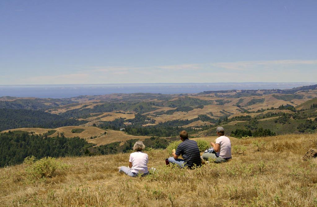
126 Exhibit 4: Photographs
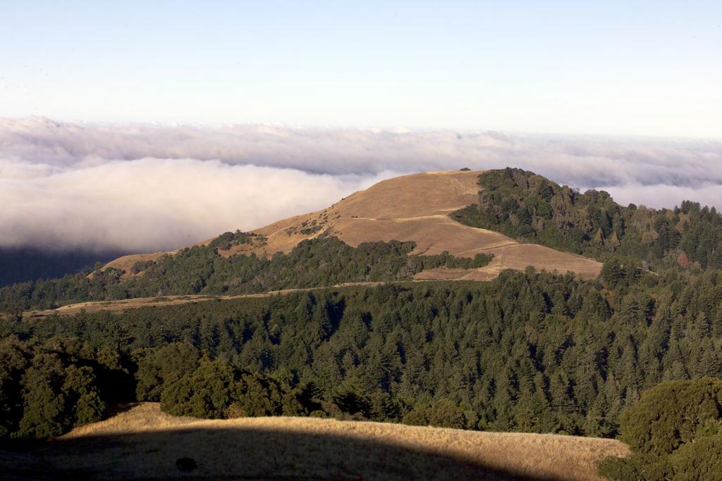
127 Exhibit 4: Photographs
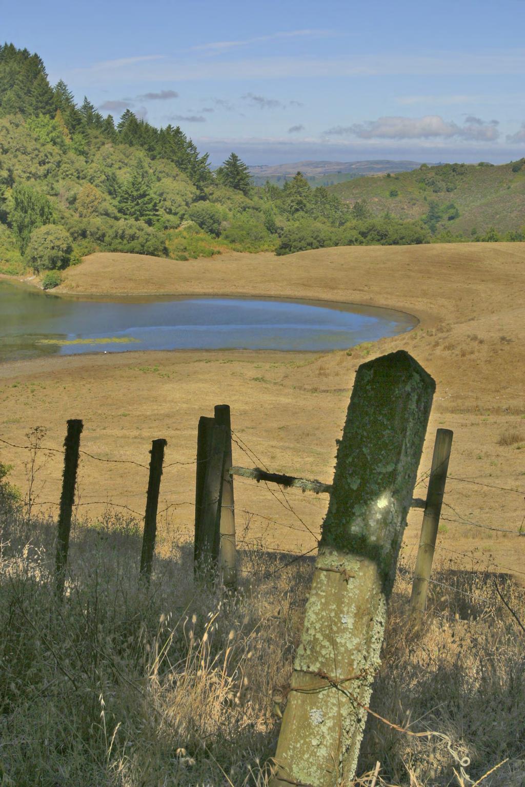
128 Exhibit 4: Photographs
COASTAL CONSERVANCY. Staff Recommendation November 10, 2011 PEDRO POINT COASTAL TRAIL ACQUISITION. Project No Project Manager: Janet Diehl
 COASTAL CONSERVANCY Staff Recommendation November 10, 2011 PEDRO POINT COASTAL TRAIL ACQUISITION Project No. 11-053-01 Project Manager: Janet Diehl RECOMMENDED ACTION: Disbursement of up to $250,000 to
COASTAL CONSERVANCY. Staff Recommendation January 18, Carmel River Parkway Acquisitions. File No Project Manager: Trish Chapman
 COASTAL CONSERVANCY Staff Recommendation January 18, 2006 Carmel River Parkway Acquisitions File No. 06-104 Project Manager: Trish Chapman RECOMMENDED ACTION: Authorization to disburse up to $3,500,000
COASTAL CONSERVANCY. Staff Recommendation August 2, 2012 HARE CREEK BEACH COASTAL ACCESS TRAIL. Project No Project Manager: Lisa Ames
 COASTAL CONSERVANCY Staff Recommendation August 2, 2012 HARE CREEK BEACH COASTAL ACCESS TRAIL Project No. 08-001-02 Project Manager: Lisa Ames RECOMMENDED ACTION: Authorization to disburse up to $60,000
Land Trust of Santa Cruz County. Strategic Plan. July 2012 to June This is a public version of a more detailed internal plan.
 Land Trust of Santa Cruz County Strategic Plan July 2012 to June 2015 This is a public version of a more detailed internal plan. Over the next three years the Land Trust will pursue four critical strategies.
IRS FORM 8283 SUPPLEMENTAL STATEMENT DONATION OF CONSERVATION EASEMENT
 Name(s) shown on income tax return Identifying Number Robert T. Landowner 021-34-1234 Susan B. Landowner 083-23-5555 IRS FORM 8283 SUPPLEMENTAL STATEMENT DONATION OF CONSERVATION EASEMENT On November 12,
Central Pennsylvania Conservancy Project Selection Criteria Form
 Central Pennsylvania Conservancy Project Selection Criteria Form The following criteria guide the actions of the Central Pennsylvania Conservancy s Land Protection Committee and Board of Directors in selecting
COASTAL CONSERVANCY. Staff Recommendation June 30, 2004 PILLAR POINT BLUFF ACQUISITION AND TRAIL PLANNING
 COASTAL CONSERVANCY Staff Recommendation June 30, 2004 PILLAR POINT BLUFF ACQUISITION AND TRAIL PLANNING File No. 04-026 Project Manager: Marina Cazorla RECOMMENDED ACTION: Authorize disbursement to the
AGENDA ITEM 3. R Meeting May 14, 2014 AGENDA ITEM
 R-14-75 Meeting 14-12 May 14, 2014 AGENDA ITEM AGENDA ITEM 3 Approval of Grant of Access Easement and Quitclaim Deed between James F. Wickett et al. (San Mateo County Assessor s Parcel Numbers 081-120-060
1. Determine that the recommended actions are categorically exempt from the California Environmental Quality Act (CEQA) as set out in this report.
 as set out in this report.") R-11-73 Meeting 11-19 July 13, 2011 AGENDA ITEM 6 AGENDA ITEM Proposed Purchase of the Stanton Trust (Crites) Property as an Addition to the Mount Umunhum Area of Sierra Azul Open Space Preserve (Santa
R-11-73 Meeting 11-19 July 13, 2011 AGENDA ITEM 6 AGENDA ITEM Proposed Purchase of the Stanton Trust (Crites) Property as an Addition to the Mount Umunhum Area of Sierra Azul Open Space Preserve (Santa
County of Sonoma Agenda Item Summary Report
 County of Sonoma Agenda Item Summary Report Agenda Item Number: 32 (This Section for use by Cler of the Board Only. Cler of the Board 575 Administration Drive Santa Rosa, CA 95403 To: The Sonoma County
AGENDA ITEM Public Utilities Commission City and County of San Francisco
 WATER WASTEWATER POWER AGENDA ITEM Public Utilities Commission City and County of San Francisco MEETING DATE May 11, 2010 Approve Project - Mitigated Negative Declaration: Regular Calendar Bureau Manager:
That the Planning Commission finds and advises EBMUD that the proposed disposal of property is in conformance with the County General Plan.
 STAFF ANALYSIS JUNE 19, 2006 GPC 2006-02 DISPOSAL OF PROPERTY EAST BAY MUNICIPAL UTILITY DISTRICT PROPOSED SALE OF EAST BAY MUNICIPAL UTILITY DISTRICT S SYDNEY RESERVOIR PROPERTY: Request by the Real Estate
AGENDA ITEM 6. R Meeting No November 13, 2013 AGENDA ITEM. Grazing Tenant Selection for Driscoll and McDonald Ranches
 R-13-103 Meeting No. 13-32 November 13, 2013 AGENDA ITEM AGENDA ITEM 6 Grazing Tenant Selection for Driscoll and McDonald Ranches GENERAL MANAGER S RECOMMENDATION Authorize General Manager to select tenants
Claudia Stuart, Williamson Act Program Manager and Nick Hernandez, Planning Intern
 Land Conservation (Williamson) Act Advisory Committee STAFF REPORT September 15, 2014 Prepared by: Claudia Stuart, Williamson Act Program Manager and Nick Hernandez, Planning Intern Subject: Discussion:
Chapter SWAINSON S HAWK IMPACT MITIGATION FEES
 The Swainson s Hawk ordinance can also be viewed online at: http://qcode.us/codes/sacramentocounty/ Once at the website, click on Title 16 BUILDINGS AND CONSTRUCTION, then Chapter 16.130 SWAINSON S HAWK
COASTAL CONSERVANCY. Staff Recommendation October 18, 2012 MOUNT MADONNA COUNTY PARK AREA PROPERTY ACQUISITION
 COASTAL CONSERVANCY Staff Recommendation October 18, 2012 MOUNT MADONNA COUNTY PARK AREA PROPERTY ACQUISITION Project No. 12-033-01 Project Manager: Jeff Melby RECOMMENDED ACTION: Authorization to disburse
Regional Open Space Study
 Regional Open Space Study Midpeninsula Regional Open Space District 330 Distel Circle Los Altos, California 94022-1404 Phone: (650) 691-1200 Fax: (650) 691-0485 E-mail: mrosd@openspace.org Web Site: www.openspace.org
COASTAL CONSERVANCY. Staff Recommendation October 18, 2012 UVAS RESERVOIR COUNTY PARK AREA PROPERTY ACQUISITION
 COASTAL CONSERVANCY Staff Recommendation October 18, 2012 UVAS RESERVOIR COUNTY PARK AREA PROPERTY ACQUISITION Project No. 12-032-01 Project Manager: Jeff Melby RECOMMENDED ACTION: Authorization to disburse
NSW Travelling Stock Reserves Review Public consultation paper
 NSW Travelling Stock Reserves Review Public consultation paper A collaborative project between: Local Land Services Department of Industry Lands Contents Executive summary 2 1. About TSRs 3 What are TSR
Central Lathrop Specific Plan
 Addendum to the Draft Environmental Impact Report for the Central Lathrop Specific Plan SCH# 2003072132 Prepared for City of Lathrop Prepared by December 2005 Addendum to the Draft Environmental Impact
Article 12.5 Exemptions for Agricultural Housing, Affordable Housing, and Residential Infill Projects
 Title 14. California Code of Regulations Chapter 3. Guidelines for Implementation of the California Environmental Quality Act Article 12.5 Exemptions for Agricultural Housing, Affordable Housing, and Residential
PENINSULA TOWNSHIP DONATION of DEVELOPMENT RIGHTS ORDINANCE (DDR, No. 45)
") PENINSULA TOWNSHIP DONATION of DEVELOPMENT RIGHTS ORDINANCE (DDR, No. 45) THE TOWNSHIP OF PENINSULA, GRAND TRAVERSE COUNTY, MICHIGAN ORDAINS: Section 101 General Provisions A. Title: This Ordinance shall
PENINSULA TOWNSHIP DONATION of DEVELOPMENT RIGHTS ORDINANCE (DDR, No. 45) THE TOWNSHIP OF PENINSULA, GRAND TRAVERSE COUNTY, MICHIGAN ORDAINS: Section 101 General Provisions A. Title: This Ordinance shall
4.2 LAND USE INTRODUCTION
 4.2 LAND USE INTRODUCTION This section of the EIR addresses potential impacts from the Fresno County General Plan Update on land use in two general areas: land use compatibility and plan consistency. Under
PROJECT SCORING GUIDANCE. Introduction: National Proiect Selection:
 FOREST LEGACY PROGRAM PROJECT SCORING GUIDANCE Introduction: This document provides guidance to the National Review Panel on how to score individual Forest Legacy Program (FLP) projects, including additional
Wildlife Habitat Conservation and Management Program
 EXHIBIT 1 PC-2015-4106 ODFW Guide Wildlife Habitat Conservation and Management Program Manual for Counties and Cities Oregon Department of Fish and Wildlife March 2006 Table of Contents 1. Introduction
WILLIAMSON ACT CONTRACTS GUIDELINES
 NEVADA COUNTY COMMUNITY DEVELOPMENT AGENCY PLANNING DEPARTMENT ERIC ROOD ADMINISTRATION BUILDING 950 Maidu Avenue Nevada City, California 95959-8617 Phone: (530) 265-1222 FAX : (530) 265-9851 WILLIAMSON
IMPLEMENTING AGREEMENT. for the EAST CONTRA COSTA COUNTY HABITAT CONSERVATION PLAN/ NATURAL COMMUNITY CONSERVATION PLAN.
 IMPLEMENTING AGREEMENT for the EAST CONTRA COSTA COUNTY HABITAT CONSERVATION PLAN/ NATURAL COMMUNITY CONSERVATION PLAN by and between EAST CONTRA COSTA COUNTY HABITAT CONSERVANCY, COUNTY OF CONTRA COSTA,
Board of Supervisors' Agenda Items
 A. Roll Call B. Closed Session COUNTY OF SAN DIEGO BOARD OF SUPERVISORS REGULAR MEETING MEETING AGENDA WEDNESDAY, SEPTEMBER 14, 2016, 9:00 A.M. BOARD OF SUPERVISORS NORTH CHAMBER 1600 PACIFIC HIGHWAY,
3. Adopt the Preliminary Use and Management Plan for the property granted to the District.
 R-13-119 Meeting 13-34 December 11, 2013 AGENDA ITEM AGENDA ITEM 8 Approval of an Agreement to Exchange Real Property Interests with Santa Clara County (County) Roads & Airports concerning County property
COASTAL CONSERVANCY. Staff Recommendation September HARE CREEK BEACH ACQUISITION. File No Project Manager: Liza Riddle
 COASTAL CONSERVANCY Staff Recommendation September 25. 2008 HARE CREEK BEACH ACQUISITION File No. 08-001-01 Project Manager: Liza Riddle RECOMMENDED ACTION: Authorization to disburse up to $370,500 to
Grand Mesa, Uncompahgre and Gunnison National Forests Region 2, USDA Forest Service
 Decision Memo Taylor River Land Exchange Under the General Exchange Act of March 20, 1922 as Amended, The Federal Land Policy and Management Act of 1976 as Amended and the Federal Land Exchange Facilitation
APPENDIX B COMPLIANCE WITH THE GOVERNMENT CODE
 APPENDIX B COMPLIANCE WITH THE GOVERNMENT CODE A. GENERAL PLAN AMENDMENT PROCEDURE In general, local governments may not amend any of the mandatory elements of the General Plan (e.g. Land Use, Open Space,
RECITALS. B. WHEREAS, Ranch, its successors and assigns, are referred to in the Easement as the Grantor ; and
 Basic Components of Management Plans Associated with Conservation Easement Acquisitions Where A Land Trust Or other third party Is the Grantee April 17, 2012 Key: Text in normal font, without highlight,
City of Brandon Brownfield Strategy
 City of Brandon Brownfield Strategy 2017 Executive Summary A brownfield is a property, the expansion, redevelopment, or reuse of which may be complicated by the presence or potential presence of a hazardous
COUNTY OF SONOMA PERMIT AND RESOURCE MANAGEMENT DEPARTMENT 2550 Ventura Avenue, Santa Rosa, CA (707) FAX (707)
 FAX (707)") COUNTY OF SONOMA PERMIT AND RESOURCE MANAGEMENT DEPARTMENT 2550 Ventura Avenue, Santa Rosa, CA 95403 (707) 565-1900 FAX (707) 565-1103 DATE: TO: FROM: December 15, 2009 at 2:05 p.m. Board of Supervisors
COUNTY OF SONOMA PERMIT AND RESOURCE MANAGEMENT DEPARTMENT 2550 Ventura Avenue, Santa Rosa, CA 95403 (707) 565-1900 FAX (707) 565-1103 DATE: TO: FROM: December 15, 2009 at 2:05 p.m. Board of Supervisors
From Policy to Reality
 From Policy to Reality Updated ^ Model Ordinances for Sustainable Development 2000 Environmental Quality Board 2008 Minnesota Pollution Control Agency Funded by a Minnesota Pollution Control Agency Sustainable
CITY OF FORT COLLINS NATURAL AREAS AND CONSERVED LANDS EASEMENT POLICY
 CITY OF FORT COLLINS NATURAL AREAS AND CONSERVED LANDS EASEMENT POLICY Adopted January 3, 2012 PURPOSE: The purpose of the policy statement is to clarify the policies and procedures of the City of Fort
Sample Baseline Documentation Report (BDR) Annotated Template for Environmentally Important Land
 Annotated Template for Environmentally Important Land") Sample Baseline Documentation Report (BDR) Annotated Template for Environmentally Important Land The baseline documentation report (BDR) provides a snap shot of the biophysical condition of a property
Sample Baseline Documentation Report (BDR) Annotated Template for Environmentally Important Land The baseline documentation report (BDR) provides a snap shot of the biophysical condition of a property
CITY OF RIALTO PLANNING DIVISION
 ENTITLEMENT APPLICATION LEGAL OWNER PROPERTY INFORMATION: I hereby certify that I am (we are) the record owner(s) for property tax assessment purposes of the property encompassed by this application. I
Chapter 10 Local Protection Measures
 The DPC fully supports the protection of private property rights and the DPC will work to ensure that there will be no negative impacts stemming from NHA activities on private property, should the designation
Neds Corner Station. What is a Conservation Covenant?
 Neds Corner Station What is a Conservation Covenant? www.trustfornature.org.au What is a conservation covenant? A conservation covenant (deed of covenant) is a voluntary, legal agreement made between a
LLC & MLLC Property Bismark Meadows Bonner County, Idaho
 Vital Ground Property Management Plan LLC & MLLC Property Bismark Meadows Bonner County, Idaho December 10, 2009 (updated 2/12/13) Ryan Lutey The Vital Ground Foundation Building T-2, Fort Missoula Road
Torch Lake Township Antrim County, Michigan
 Torch Lake Township Antrim County, Michigan Farmland and Open Space Development Rights Ordinance Ordinance No. 04-01 Effective September 3, 2004 AN ORDINANCE creating a farmland and open space protection
ATTACHMENT A: FINDINGS
 ATTACHMENT A: FINDINGS 1.0 CEQA FINDINGS 1.1 ENVIRONMENTAL IMPACT REPORTS Findings pursuant to public resources code Section 21081 and the California Environmental Quality Act Guidelines Sections 15090
Marin County Agricultural Land Conservation Program March 1, 2014
 Marin County Agricultural Land Conservation Program March 1, 2014 I. Purpose of this Document This document describes the Marin County Agricultural Land Conservation Program (County Program). The Marin
Community Development Department Planning Division 1600 First Street + P.O. Box 660 Napa, CA Napa (707)
") Community Development Department Planning Division 1600 First Street + P.O. Box 660 Napa, CA 94559-0660 Napa (707) 257-9530 PLANNING COMMISSION STAFF REPORT JUNE 16, 2016 AGENDA ITEM # 6.B. 16-0056-EXT;
Community Development Department Planning Division 1600 First Street + P.O. Box 660 Napa, CA 94559-0660 Napa (707) 257-9530 PLANNING COMMISSION STAFF REPORT JUNE 16, 2016 AGENDA ITEM # 6.B. 16-0056-EXT;
CITY OF RIALTO PLANNING DIVISION ENTITLEMENT APPLICATION
 ENTITLEMENT APPLICATION LEGAL OWNER INFORMATION: I hereby certify that I am (we are) the record owner(s) for property tax assessment purposes of the property encompassed by this application. I understand
Board of Supervisors' Agenda Items
 A. Roll Call COUNTY OF SAN DIEGO BOARD OF SUPERVISORS REGULAR MEETING MEETING AGENDA WEDNESDAY, OCTOBER 23, 2013, 09:00 A.M. BOARD OF SUPERVISORS NORTH CHAMBER 1600 PACIFIC HIGHWAY, ROOM 310, SAN DIEGO,
DRAFT FOR PUBLIC HEARING (rev. March, 2016)
") Chapter 200. ZONING Article VI. Conservation/Cluster Subdivisions 200-45. Intent and Purpose These provisions are intended to: A. Guide the future growth and development of the community consistent with
Chapter 200. ZONING Article VI. Conservation/Cluster Subdivisions 200-45. Intent and Purpose These provisions are intended to: A. Guide the future growth and development of the community consistent with
STAFF REPORT. Permit Number: Porter. Kitsap County Board of Commissioners; Kitsap County Planning Commission
 STAFF REPORT Permit Number: 15 00461 Porter DATE: November 9, 2015 TO: FROM: Kitsap County Board of Commissioners; Kitsap County Planning Commission Katrina Knutson, AICP, Senior Planner, DCD and Jeff
FOR OFFICE USE ONLY Date Submitted Received By Fees Paid $ Receipt No. Received By Application No. Application Complete Final Action Date
 COMMERCIAL, INDUSTRIAL, & MANUFACTURING SITE PLAN (CIM) APPLICATION Mariposa County Planning Department 5100 Bullion Street, P.O. Box 2039 Mariposa, CA 95338 Telephone (209) 966-5151 FAX (209) 742-5024
Environment and Natural Resources Trust Fund Request for Proposals (RFP)
") Environment and Natural Resources Trust Fund 2012-2013 Request for Proposals (RFP) Project Title: Southeast Minnesota Sensitive Habitat Protection Program (SHPP) ENRTF ID: 067-D Topic Area: D. Land Acquisition
Environment and Natural Resources Trust Fund 2012-2013 Request for Proposals (RFP) Project Title: Southeast Minnesota Sensitive Habitat Protection Program (SHPP) ENRTF ID: 067-D Topic Area: D. Land Acquisition
Interpretation of Conservation Purpose INTERNAL REVENUE GUIDANCE AS TO WHAT CONSTITUES A CONSERVATION PURPOSE
 Interpretation of Conservation Purpose INTERNAL REVENUE GUIDANCE AS TO WHAT CONSTITUES A CONSERVATION PURPOSE 170(h)(4)(A) of Title 26, Internal Revenue Code, Subtitle A of the United States Code gives
78th OREGON LEGISLATIVE ASSEMBLY Regular Session. House Bill 2510 SUMMARY
 th OREGON LEGISLATIVE ASSEMBLY--0 Regular Session Sponsored by Representative CLEM (Presession filed.) House Bill 0 SUMMARY The following summary is not prepared by the sponsors of the measure and is not
Napa County Planning Commission Board Agenda Letter
 Agenda Date: 3/18/2009 Agenda Placement: 9A Napa County Planning Commission Board Agenda Letter TO: FROM: Napa County Planning Commission John McDowell for Hillary Gitelman - Director Conservation, Development
COUNTY OF SANTA BARBARA PLANNING AND DEVELOPMENT MEMORANDUM. Santa Barbara County Planning Commission
 COUNTY OF SANTA BARBARA PLANNING AND DEVELOPMENT MEMORANDUM TO: FROM: HEARING DATE: RE: Santa Barbara County Planning Commission Florence Trotter-Cadena, Planner III North County Development Review October
Open the public hearing, receive public testimony, close the public hearing; and,
 9/15/2015 01 TO: FROM: Honorable Mayor and Members of the City Council Sergio Klotz, Acting Development Services Directo~ Prepared by: Charlie View, Project Manager Ayako Rauterkus, Senior Management Analyst
COASTAL CONSERVANCY. Staff Recommendation May 19, 2011 RANCHERO MARK WEST ACQUISITION. Project No Project Manager: Amy Hutzel
 COASTAL CONSERVANCY Staff Recommendation May 19, 2011 RANCHERO MARK WEST ACQUISITION Project No. 11-011-01 Project Manager: Amy Hutzel RECOMMENDED ACTION: Authorization to disburse up to $750,000 to LandPaths
Conservation Easement Stewardship
 Conservation Easements are effective tools to preserve significant natural, historical or cultural resources. Conservation Easement Stewardship Level of Service Standards March 2013 The mission of the
Residential Project Convenience Facilities
 Standards for Specific Land Uses 35.42.220 E. Findings. The review authority shall approve a Land Use Permit in compliance with Subsection 35.82.110.E (Findings required for approval) or a Conditional
4. If any perennial surface water passes through or along the property lines of the acreage, a minimum of 200 feet or frontage should be required.
 b. Provide adequate acreage for appropriate productive use of rural residential land, such as small numbers of livestock, large gardens, etc. 3. Minimum of 200 feet of frontage on an improved county or
Implementation Tools for Local Government
 Information Note #5: Implementation Tools for Local Government This Information Note is a guide only. It is not a substitute for the federal Fisheries Act, the provincial Riparian Areas Regulation, or
Submittal of the Minutes from the April 28, 2009 and June 9, 2009 Cabinet Meetings.
 AGENDA BOARD OF TRUSTEES DEPARTMENT OF AGRICULTURE & CONSUMER SERVICES JULY 28, 2009 Attachments to the items below can be viewed at the following link: http://www.fl-dof.com/calendar/public_notices.html
MITIGATION POLICY FOR DISTRICT-PROTECTED LANDS
 MITIGATION POLICY FOR DISTRICT-PROTECTED LANDS Approved by the District Board of Directors on July 18, 2017 The following Mitigation Policy is intended to inform the evaluation of environmental mitigation-related
Strategic Growth Council: Identifying Infill Barriers
 Streamlining Infill in the CEQA Guidelines (SB 226) Strategic Growth Council: Identifying Infill Barriers Looking within state agencies to reduce conflicts and promote successful programs Working with
General Development Plan Background Report on Agricultural Land Preservation
 General Development Plan 2008 Background Report on Agricultural Land Preservation February 2008 I. Introduction Anne Arundel County has been an agricultural community for over 350 years, beginning with
OPEN SPACE & RECREATION PLAN
 OPEN SPACE & RECREATION PLAN HOPEWELL TOWNSHIP Cumberland County, New Jersey Prepared by: Hopewell Township Environmental Commission Final October 2011 (THIS PAGE INTENTIONALLY LEFT BLANK) PUBLIC MEETINGS
Submittal of the Minutes from the March 9, 2011, April 5, 2011, and April 19, 2011 Cabinet Meetings.
 AGENDA BOARD OF TRUSTEES OF THE INTERNAL IMPROVEMENT TRUST FUND JUNE 16, 2011 Attachments to the items below can be viewed at the following link: http://www.dep.state.fl.us/secretary/cab/public_notices.htm
Chapter 100 Planned Unit Development in Corvallis Urban Fringe
 100.100 Scope and Purpose. Chapter 100 Planned Unit Development in Corvallis Urban Fringe (1) All applications for land divisions in the Urban Residential (UR) and Flood Plain Agriculture (FPA) zones within
Corte Madera Marsh Restoration Project Update
 Corte Madera Marsh Restoration Project Update Building and Operating Committee Agenda Item No. 5 August 25, 2016 Photo credit: WRA Background of Site 1. 72 acre parcel carved out of larger property acquired
COUNTY OF SAN MATEO PLANNING AND BUILDING DEPARTMENT
 COUNTY OF SAN MATEO PLANNING AND BUILDING DEPARTMENT DATE: April 16, 2015 TO: FROM: Zoning Hearing Officer Planning Staff SUBJECT: Consideration of a Coastal Development Permit and Planned Agricultural
ORDINANCE NO. 875 (AS AMENDED THROUGH 875
 ORDINANCE NO. 875 (AS AMENDED THROUGH 875.1) AN ORDINANCE OF THE COUNTY OF RIVERSIDE TO ESTABLISH A LOCAL DEVELOPMENT MITIGATION FEE FOR FUNDING THE PRESERVATION OF NATURAL ECOSYSTEMS IN ACCORDANCE WITH
MARIN COUNTY BOARD OF SUPERVISORS RESOLUTION
 MARIN COUNTY BOARD OF SUPERVISORS RESOLUTION A RESOLUTION DENYING THE LUCAS VALLEY ESTATES HOMEOWNERS ASSOCIATION APPEAL AND SUSTAINING THE PLANNING COMMISSION S DECISION TO CERTIFY THE GRADY RANCH PRECISE
Jack & Eileen Feather (PLN030436)
") MIKE NOVO ZONING ADMINISTRATOR COUNTY OF MONTEREY STATE OF CALIFORNIA RESOLUTION NO. 030436 A. P. # 008-462-008-000 In the matter of the application of Jack & Eileen Feather (PLN030436) FINDINGS & DECISION
MIKE NOVO ZONING ADMINISTRATOR COUNTY OF MONTEREY STATE OF CALIFORNIA RESOLUTION NO. 030436 A. P. # 008-462-008-000 In the matter of the application of Jack & Eileen Feather (PLN030436) FINDINGS & DECISION
MONTEREY COUNTY STANDARD SUBDIVISION COMMITTEE
 MONTEREY COUNTY STANDARD SUBDIVISION COMMITTEE Meeting: May 11, 2006 Agenda Item: 1 Project Description: Standard Subdivision Amendment of recorded Markham Ranch Subdivision Map to relocate building envelope
Tejon Ranch Conservation and Land Use Agreement Executive Summary
 Tejon Ranch Conservation and Land Use Agreement Executive Summary The Tejon Ranch Company (TRC) and Audubon California, the Endangered Habitats League, Natural Resources Defense Council, Planning and Conservation
CITY OF SANTA ROSA COMMUNITY DEVELOPMENT DEPARTMENT STAFF REPORT FOR PLANNING COMMISSION SEPTEMBER 10, 2015 APPLICANT FILE NUMBER MJP
 ITEM NO. 9 CITY OF SANTA ROSA COMMUNITY DEVELOPMENT DEPARTMENT STAFF REPORT FOR PLANNING COMMISSION SEPTEMBER 10, 2015 PROJECT TITLE Yogurt Time Center ADDRESS/LOCATION 3093 Marlow Road ASSESSOR S PARCEL
Nez Perce (Nee-Me-Poo) National Historic Trail. Land and Water Conservation Fund FY2015 Request
 National Historic Trail. Land and Water Conservation Fund FY2015 Request") Nez Perce (Nee-Me-Poo) FY2015 Request National Trails System FY2015 Nez Perce Henry s Lake, Idaho Project Details LWCF Request: $3,000,000 Congressional District: ID-2, Representative Michael Simpson Acres:
Nez Perce (Nee-Me-Poo) FY2015 Request National Trails System FY2015 Nez Perce Henry s Lake, Idaho Project Details LWCF Request: $3,000,000 Congressional District: ID-2, Representative Michael Simpson Acres:
DRAFT PROPOSED CHAPTER 21 SPECIFIC PURPOSE - FLAT LAND RECOVERY ZONE
 DRAFT PROPOSED CHAPTER 21 SPECIFIC PURPOSE - FLAT LAND RECOVERY ZONE Note: The Specific Purpose (Flat Land Recovery) Zone is a "holding" zone that will be subject to a later plan change to confirm the
Summary of the Tejon Ranch Conservation and Land Use Agreement
 Summary of the Tejon Ranch Conservation and Land Use Agreement EXECUTIVE SUMMARY The Tejon Ranch Company (TRC) and Audubon California, the Endangered Habitats League, Natural Resources Defense Council,
MUNICIPALITY OF ANCHORAGE PLANNING AND ZONING COMMISSION RESOLUTION NO
 MUNICIPALITY OF ANCHORAGE PLANNING AND ZONING COMMISSION RESOLUTION NO. 0-07 A RESOLUTION SUPPORTING THE APPROVAL AND ADOPTION OF THE ANCHORAGE WETLANDS MANAGEMENT PLAN. (Case 0-09) WHEREAS, the Anchorage
ARTICLE XI - CONSERVATION SUBDIVISIONS
 ARTICLE XI - CONSERVATION SUBDIVISIONS Section 1101: Purpose and Intent. This Article is intended to provide for residential subdivisions that are designed based first and foremost on the preservation
Chapter 210 CONDITIONAL USES
 Chapter 210 CONDITIONAL USES 210.01 Purpose 210.02 Authorization 210.03 Process Type 210.04 Determination of Major or Minor Conditional Use Review 210.05 Approval Criteria 210.06 Conditions of Approval
Forest Service Role CHAPTER 2
 CHAPTER 2 Forest Service Role Implementation of the Management Plan charters a federal presence with an expanded focus beyond traditional Forest Service roles. In addition to administration of the National
Notice of Continuance Land Classified as Current Use or Forest Land RCW Chapter and 84.33
 When Recorded Return to: Notice of Continuance Land Classified as Current Use or Forest Land RCW Chapter 84.34 and 84.33 Grantor(s)/Sellers: Grantee(s)/Buyers: Mailing Address: City, State, Zip: Assessor
West Virginia Outdoor Heritage Conservation Fund. Grant Program TECHNICAL ASSISTANCE MANUAL
 West Virginia Outdoor Heritage Conservation Fund Grant Program TECHNICAL ASSISTANCE MANUAL Please Note: 1. All applicants are advised to read this manual prior to even starting on a grant application.
Napa County Planning Commission Board Agenda Letter
 Agenda Date: 9/20/2017 Agenda Placement: 8C Napa County Planning Commission Board Agenda Letter TO: FROM: Napa County Planning Commission Charlene Gallina for David Morrison - Director Planning, Building
CHAPTER 12. BE IT ENACTED by the Senate and General Assembly of the State of New Jersey:
 CHAPTER 12 AN ACT concerning the constitutional dedication of corporation business tax revenues for certain environmental purposes, supplementing Title 13 of the Revised Statutes, and amending P.L.1999,
The University of Texas System Systemwide Policy. Policy: UTS Title. Environmental Review for Acquisition of Real Property. 2.
 1. Title 2. Policy Environmental Review for Acquisition of Real Property Sec. 1 Sec. 2 Policy Statement. It is the policy of The University of Texas System to minimize its potential for exposure to claims
DONLON REALTY. KEVIN H. DONLON Land Broker CA License PHONE (209) FAX (209)
 FAX (209)") The Adobe Valley Ranch is a 5,781 acre ranch located in the Mount Diablo Coastal Mountain Range in Western Stanislaus County, California on the south side of Del Puerto Canyon Road. The ranch has a rolling-to-steep
The Adobe Valley Ranch is a 5,781 acre ranch located in the Mount Diablo Coastal Mountain Range in Western Stanislaus County, California on the south side of Del Puerto Canyon Road. The ranch has a rolling-to-steep
Georgia Conservation Tax Credit Program Frequently Asked Questions
 Georgia Conservation Tax Credit Program Frequently Asked Questions What are the minimum requirements for eligibility under the Georgia Conservation Tax Credit Program (GCTCP)? Individual and corporate
TransNet Environmental Mitigation Program: Land Acquisition and Restoration Process and Criteria
 TransNet Environmental Mitigation Program: Land Acquisition and Restoration Process and Criteria On September 26, 2008, the San Diego Association of Governments Board of Directors (BOD) approved the attached
UNOFFICIAL COPY OF HOUSE BILL 1272 A BILL ENTITLED
 UNOFFICIAL COPY OF HOUSE BILL 1272 M4 6lr0525 By: Delegates Smigiel, Kelley, Rosenberg, and Sossi Introduced and read first time: February 10, 2006 Assigned to: Environmental Matters 1 AN ACT concerning
Notice of Continuance Land Classified as Current Use or Forest Land Chapter and Revised Code of Washington
 When Recorded Return to: Cowlitz County Assessor s Office Attn: Forest Land / Current Use Dept 207 N 4 th Avenue Kelso WA 98626 Notice of Continuance Land Classified as Current Use or Forest Land Chapter
UNIFORM RULE 5. Administration of Williamson Act Contracts
 UNIFORM RULE 5 Administration of Williamson Act Contracts I. PROCEDURE TO ESTABLISH AN AGRICULTURAL PRESERVE AND WILLIAMSON ACT CONTRACT See Appendices 1 and 2 for the following forms: Application Form
Township of Tay Official Plan
 Township of Tay Official Plan Draft for Consultation (v.3) March 2016 Contents 1. INTRODUCTION... 1 1.1 Content, Title and Scope... 1 1.2 Basis and Purpose of this Plan... 1 1.3 Plan Structure... 2 2.
RENITA HURDSMAN BEAR RIVER STATE PARK LAND EXCHANGE PROPOSAL
 DETAILED ANALYSIS RENITA HURDSMAN BEAR RIVER STATE PARK LAND EXCHANGE PROPOSAL June 1, 2006 Prepared by the Office of State Lands and Investments Herschler Building, 3W 122 West 25 th Street Cheyenne,
THE COUCHICHING CONSERVANCY LAND STEWARDSHIP POLICY. As approved by the Board, April 30, 2007
 THE COUCHICHING CONSERVANCY LAND STEWARDSHIP POLICY As approved by the Board, April 30, 2007 When one tugs at a single thing in nature, he finds it attached to the rest of the world. John Muir This policy
SEQRA (For Land Surveyors) Purpose of this Presentation
 Purpose of this Presentation") SEQRA (For Land Surveyors) Purpose of this Presentation Understand the basics and legal requirements of SEQRA Recognize the role that Land Surveyors play in the SEQRA Identify the problems posed by SEQRA
SEQRA (For Land Surveyors) Purpose of this Presentation Understand the basics and legal requirements of SEQRA Recognize the role that Land Surveyors play in the SEQRA Identify the problems posed by SEQRA
NOTICE OF PREPARATION of a Draft Program Environmental Impact Report for the Fresno County General Plan Review and Zoning Ordinance Update
 NOTICE OF PREPARATION of a Draft Program Environmental Impact Report for the Fresno County General Plan Review and Zoning Ordinance Update Date: March 21, 2018 To: State Clearinghouse, Responsible Agencies,