August 14, 2012-Planning and Land Development Regulation Commission (PLDRC)
|
|
|
- Gerald Adams
- 5 years ago
- Views:
Transcription
1 GROWTH AND RESOURCE MANAGEMENT DEPARTMENT PLANNING AND DEVELOPMENT SERVICES DIVISION LONG RANGE PLANNING ACTIVITY 123 W. Indiana Avenue, DeLand, FL (386) PUBLIC HEARING: August 14, 2012-Planning and Land Development Regulation Commission (PLDRC) CASE NO: CPMA SUBJECT: LOCATION: APPLICANT: OWNER: STAFF: Small Scale Future Land Use Map Amendment from the Agricultural Resource designation to the Rural designation 1167 Ohio Street, DeLeon Springs Rita Cochran Elizabeth Karst, and Ralph and Brenda Fleshman Susan Jackson, AICP, Planner III I. SUMMARY OF REQUEST The applicant requests a future land use amendment from Agricultural Resource to Rural for ±7.87 acres located near DeLeon Springs, south of Spring Garden Ranch Road. The applicant has submitted a companion rezoning application to change the zoning from the Prime Agriculture (A-1) classification to Transitional Agriculture (A-4) classification. The previous owner purchased adjacent properties; 5.01 acres in 1992 and 2.86 acres in The zoning code considers these properties combined, because alone, the properties exceed the maximum density of the comprehensive plan and do not meet the minimum lot size requirement of the zoning code. To allow the two properties to stand alone, an amendment to the future land use and official zoning maps are necessary. Staff recommendation: Forward to the county council finding the amendment consistent with the comprehensive plan, and with a recommendation of approval once the Volusia Growth Management Commission (VGMC) certification has been received. Page 1 of 5
: 6006-01-20-0032 and 6006-01-20-0020 3. Property size: 7.87 acres 4. Council District: 1 5. Current Future Land Use: Agricultural Resource 6. ECO/NRMA Overlay: None 7.")
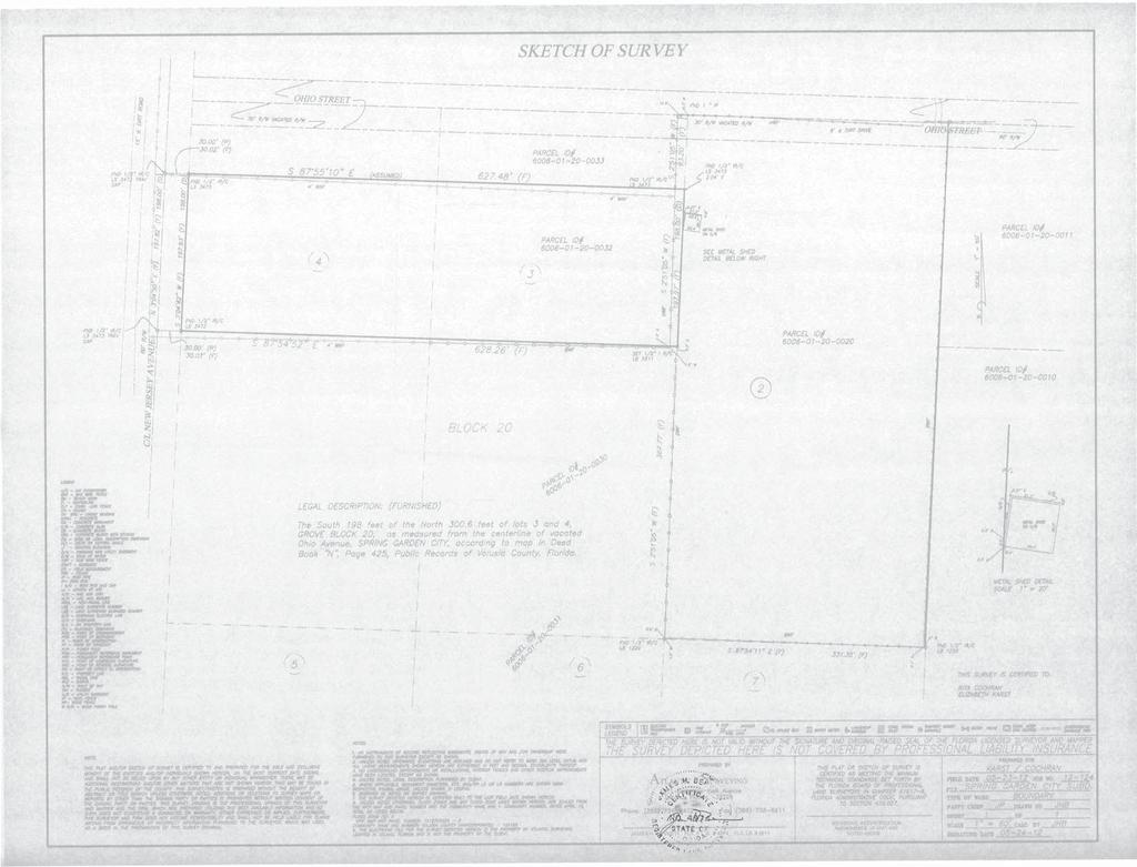
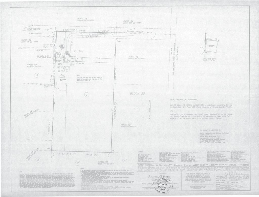
2 II. SITE INFORMATION 1. Location: The property is located in the vicinity of DeLeon Springs, approximately 1.25 miles east of U.S. Highway 17, and 1,300 feet south of Spring Garden Ranch Road, between New Jersey Avenue and East Avenue. 2. Parcel No(s): and Property size: 7.87 acres 4. Council District: 1 5. Current Future Land Use: Agricultural Resource 6. ECO/NRMA Overlay: None 7. Proposed Future Land Use: Rural III. BACKGROUND The property is comprised of a 5.01-acre parcel and a 2.86-acre parcel, which the Karsts purchased in 1992 and 1994, respectively. The larger parcel contains a single-family house, the smaller parcel is vacant. The property currently has an Agricultural Resource future land use designation, which has a maximum density of 1 dwelling unit per 10 acres, and A-1 (Prime Agriculture) zoning classification, which requires a minimum lot size of 10 acres. Before the parcels came under single ownership, each one was considered a legitimate nonconforming lot, which did not meet minimum lot size. Typically, an owner may request a variance to separate lots for purposes of maintaining nonconforming lots. However, in this case any variance to separate the lots would conflict with the maximum density requirements of the comprehensive plan. Therefore, to allow the sale and development of the vacant lot, a future land use map amendment is required. The owner of the property, Mrs. Karst, died in 2010, leaving instructions in her will to sell the property in order to close her estate. The executor of the estate did not realize the parcels are nonconforming and combined for purposes of the zoning code, and therefore, sold the larger parcel with the house to the Fleshmans, leaving the smaller parcel conveyed to a relative. To remedy the sale, the applicant is requesting a future land use amendment and rezoning that would allow smaller lot sizes so that the parcels can meet the land use and zoning requirements, and again be two separate lots. Because the conveyance of these properties occurred during the application process, the new owners are party to this application. Page 2 of 5
3 The proposed future land use designation is Rural, which generally allows a density of 1 dwelling unit per 5 acres. This density may be reduced to a maximum of 1 dwelling unit per 1 acre subject to compatibility with other properties in proximity that are similarly developed. If the proposed Rural future land use designation is approved, then the property may be rezoned to a classification that also allows smaller lot sizes. The applicant is requesting to rezone the properties to the A-4 (Transitional Agriculture) zoning classification, which allows a minimum lot size of 2.5 acres. If the future land use amendment and rezoning requests are approved, the lots would be considered legitimate conforming lots and may be separated and sold individually. Most of this general area contains lots sizes less than 10 acres, and most of the subdivisions occurred prior to the adoption of the Comprehensive Plan in 1990 utilizing the exempt subdivision process. In the immediate area, the county has approved a few small scale comprehensive map amendment requests to change the land use from Agricultural Resource to Rural. Rezoning approvals followed the land use amendments to allow lot sizes as small as 2.5 acres. In the past ten years, the county has approved a few small scale comprehensive plan amendment requests to change the land use from the Agricultural Resource designation to the Rural designation. Rezonings to a classification that allows lot sizes down to 2.5 acres have followed the land use action. IV. Land Use Analysis 1. Site Characteristics: The 5.01-acre parcel contains a house and open pasture used for grazing cows for personal use. The 2.86-acre parcel is vacant and wooded. Neither property contains wetlands or flood prone areas. Soils are sandy and well drained, classified as Astatula Fine Sand. The vegetation classification is Generalized Agriculture. The 5.01-acre parcel has direct access to Ohio Street, which intersects with East Avenue. The 2.86-acre parcel has direct access to New Jersey Avenue. 2. Land Use Compatibility: The general area contains a mix of parcel sizes. There are single-family homes on large lots, small ranchettes for personal agriculture use, and some large acreage parcels. Most of the parcels in the immediate vicinity do not meet the requirements of the Agricultural Resource future land use designation or the A-1 zoning classification of 10 acres. Some have already been redesignated to a Rural future land use designation and rezoned to an appropriate zoning classification. In the immediate vicinity of the subject property, to the north, south and east, the parcel size ranges from approximately 2 acres to 5 acres. To the west of New Jersey Avenue are a few parcels that are greater than 10 acres. North of Spring Garden Ranch Road, the parcels are less than 1 acre in size. Page 3 of 5


4 Surrounding land uses are presented in the table below: DIRECTION FUTURE LAND USE ZONING CURRENT USE Subject Property Agricultural Resource (current) Rural (proposed) A-1 (current) A-4 (proposed) Single-Family ranchette and vacant wooded lot North East South Agricultural Resource A-1 Agricultural Resource A-1 Agricultural Resource A-1 Single-Family residential Single-Family residential Single-Family ranchette West Agricultural Resource A-1 Agriculture Proposed Future Land Use Proposed Zoning 3. Impacts of Development on State Monitored Public Facilities: Staff does not anticipate any significant increase in impacts of development on concurrency monitored public facilities due to the proposed land use change. The current land use allows for residential development at a density of 1 unit per 10 acres, for a total of 1 dwelling unit. Under the Rural future land use designation, the property may develop at a density range of 1 unit per 5 acres to a maximum of 1 unit per 1 acre. The number of potential homes could range from 1 to 7. This property is not necessarily appropriate for 1 acre density and thus the proposed zoning of A-4 would limit the lot size to 2.5 aces, which would cap the number of potential dwellings at 3. The property already contains one Page 4 of 5
5 house; therefore, only 2 additional houses could be developed. The property before coming under common ownership in 1994, each parcel could have contained a house. V. Applicable Comprehensive Plan Goals, Objectives & Policies: The following goals, objectives and policies support the amendment of these parcels to a Rural designation. Objective Goal 1.3 Growth management criteria will be established to ensure that future land use patterns will maintain vital natural functions and in conjunction with the availability of public facilities and services to support that development at the appropriate level of service. Provide a variety of land uses sufficient to meet future needs while minimizing adverse impacts and disruption of existing neighborhoods. VI. Finding of Fact/Conclusion: 1. The Rural future land use designation is compatible with surrounding land uses and lot size pattern. 2. Concurrency monitored public facilities are not negatively impacted. VII. STAFF RECOMMENDATION Staff recommends that the amendment is found to be consistent with the comprehensive plan, and forwarded to county council with a recommendation of approval changing the future land use designation from the Agriculture Resource (AR) designation to the Rural (R) designation. VIII. ATTACHMENTS Ordinance 2012-XX Request and Surveys Reviewers comments Maps Page 5 of 5
6 ORDINANCE AN ORDINANCE OF THE COUNTY COUNCIL OF VOLUSIA COUNTY, FLORIDA, AMENDING THE VOLUSIA COUNTY COMPREHENSIVE PLAN ORDINANCE NO , AS PREVIOUSLY AND SUBSEQUENTLY AMENDED, BY AMENDING FIGURE 1-11, FUTURE LAND USE MAP; CHANGING FUTURE LAND USE DESIGNATION FOR APPROXIMATELY 7.87 ACRES LOCATED IN THE VICINITY OF DELEON SPRINGS, APPROXIMATELY 1.25 MILES EAST OF U.S. HIGHWAY 17, AND 1,300 FEET SOUTH OF SPRING GARDEN RANCH ROAD, BETWEEN NEW JERSEY AVENUE AND EAST AVENUE, FROM AGRICULTURAL RESOURCE TO RURAL; BY AUTHORIZING INCLUSION IN THE VOLUSIA COUNTY COMPREHENSIVE PLAN; PROVIDING FOR SEVERABILITY; PROVIDING FOR AN EFFECTIVE DATE. WHEREAS, Section , et seq., Florida Statutes, created the Community Planning Act, herein after referred to as the "Act;" and WHEREAS, Section , Florida Statutes, requires each county in the State of Florida to prepare and adopt a Comprehensive Plan; and WHEREAS, the County of Volusia has adopted the Volusia County Comprehensive Plan Ordinance No , as amended, pursuant to this Act; and WHEREAS, pursuant to Section , Florida Statutes, application has been submitted for the small scale amendment to said Comprehensive Plan; and WHEREAS, said proposed small scale amendment does not propose a text change to any goals, policies or objectives of the Volusia County Comprehensive Plan; Ordinance Small Scale Amendment CPMA Page 1 of 4
7 1 and less; and WHEREAS, said amendment is not located in areas of critical state concern; and WHEREAS, said Comprehensive Plan amendment involves a use of 10 acres or WHEREAS, the County of Volusia has complied with the required legal notices for a small scale amendment to the Comprehensive Plan; and WHEREAS, pursuant to Section , Florida Statutes, the Volusia County Code of Ordinances, chapter 72, article II, division 11, section , has designated the Volusia County Planning and Land Development Regulation Commission as a local planning agency for the unincorporated area of the County of Volusia; and WHEREAS, said Planning and Land Development Regulation Commission has held a public hearing on said Comprehensive Plan amendment; and WHEREAS, the County Council of the County of Volusia has conducted its adoption public hearing on said small scale amendment to the Comprehensive Plan. NOW, THEREFORE, BE IT ORDAINED BY THE COUNTY COUNCIL OF VOLUSIA COUNTY, FLORIDA, AS FOLLOWS: The Volusia County Comprehensive Plan Ordinance No , as amended, is further amended as follows: SECTION I: FUTURE LAND USE MAP AMENDMENT. Appendix 1: Maps and Figures, Figure 1-11, Future Land Use Map, is hereby amended to change the future land use designation of Agricultural Resource to Rural for approximately 7.87 acres Ordinance Small Scale Amendment CPMA Page 2 of 4
8 1 2 located in the vicinity of Deleon Springs, approximately 1.25 miles east of U.S. Highway 17, and 1,300 feet south of Spring Garden Ranch Road, between New Jersey Avenue 3 and East Avenue. The subject property is located as shown on Exhibit A. Said 4 Exhibit is appended hereto, and by reference, made a part hereof. 5 SECTION II: SEVERABILITY. Should any section or provision of this Ordinance, or application of any provision of this Ordinance be declared to be unconstitutional or invalid, or inconsistent with the applicable state law, such declaration shall not affect the validity of the remainder of this Ordinance. 9 SECTION III: EFFECTIVE DATE. A certified copy of this ordinance shall be filed with the Department of State by the County Manager within ten (10) days after enactment, and this ordinance shall take effect either 31 days after adoption, or upon the date of issuance of a certificate of consistency or conditional certificate of consistency by the Volusia Growth Management Commission, whichever is later. ADOPTED BY THE COUNTY COUNCIL OF THE VOLUSIA COUNTY, FLORIDA, IN OPEN MEETING DULY ASSEMBLED IN THE COUNTY CHAMBERS AT THE THOMAS C. KELLY ADMINISTRATION CENTER IN THE CITY OF DELAND, FLORIDA, THIS DAY OF, ATTEST: _ James T. Dinneen, County Manager COUNTY COUNCIL COUNTY OF VOLUSIA, FLORIDA Frank T. Bruno, Jr., County Chair Ordinance Small Scale Amendment CPMA Page 3 of 4
9 EXHIBIT A CPMA Ordinance Small Scale Amendment CPMA Page 4 of 4
10
11
12
13
14
15
16
17
18
19 REVIEW STAFF COMMENTS Cochran-Karst-Flechman CPMA COUNTY EXTENSION David Griffis June 25, 2012 Comments: As requested, I visited the site. Soils were found to be #4 Astatula fine sand, 0 to 8 percent slopes. This excessively drained, nearly level to sloping sandy soil occurs on sand hills. The water table is usually below a depth of 72 inches. This soil has a high potential for community development. Portions of the property have been developed. * * * * * * 1
20 FACILITIES SERVICES 3750 Olson Drive, Daytona Beach, Florida PHONE: 386/ FAX: 386/ School Board of Vol usia County Dr. Margaret A. Smith Superintendent of Schools Dr. AI Williams, Chairman Ms. Judy Conte, Vice-Chairman Mr. Stan Schmidt Ms. Candace Lankford Mrs. Diane Smith May 30,2012 Ms. Rita Cochran Personal Representative for the Karst Estate 5490 East Avenue Deleon Springs, Fl RE: School Planning Case# NI Karst Rezoning - VollJsia County Dear Ms. Cochran: The School District has reviewed the proposed rezoning for B± acres located on New Jersey Avenue and Ohio Street in the Deleon Springs area within unincorporated Volusia County. The subject property supports an existing residential dwelling. The proposed rezoning is from Prime Agriculture (A-1) zoning to Transitional Agriculture (A-4) zoning. The existing A-1 zoning designation would perrnit one (1) residential dwelling unit per ten (10) acres. The proposed zoning designation of A-4 could permit one dwelling unit per 2.5 acres or up to three (3) residential dwelling units. Therefore, this rezoning could result in an increase of residential density. By utilizing the School District's student generation rate for a single family unit, the proposed rezoning could generate approximately one (1) full time student. The schools impacted by this rezoning are as follows: Schools 11/12 SY Enrollment %of Permanent Capacity Planned Capacity On site Projected 5YR Capacity% Students Generated by requested zoning Mcinnis Elementary Taylor Middle/High % N 94% % N 86% 0
21 Karst Rezoning May 30,2012 Page 2 of 2 The impacted schools are currently at or below their permanent capacities and projected to remain the same for the five (5) year planning period. Based on the minimal students anticipated to be generated from this residential rezoning the school district staff has no objection to the zoning change. Please note that the School Board has the right to adjust the attendance boundaries to balance the student enrollment populations at these area schools. Consequently, students generated from this project may not attend the current assigned schools. If you should have additional questions please contact me at (386) , extension SinCereIY'~,.) ~U Helen LaVal( Planning Specialist C: Saralee L. Morrissey, Director of Site Acquisition and Intergovernmental Coordination Scott Ashley, VC Planning Mgr (via ) Project File
22 ARAGON AV FAIRPORT AV NEW JERSEY AV EAST AV ANDALUSIA AV CLARK ST REED ST SUE ST WEST ST Amendment Location CPMA HOBSON LN LAKE DIAS VISTA WAY CHEROKEE DR TEDDER LAKE RD LAKE DIAS CEMETERY RD SEMINOLE DR ARAPAHO DR BOYER AV WINONA TR CATALONIA AV OHIO ST JOHNSON LAKE RD CR 4030 (SPRING GARDEN RANCH RD) SUBJECT PROPERTY E WEST ST GOOD EARTH DR CR 4030 (ARREDONDO GRANT RD) GRAY RD US HWY 17 N SINGLETREE LN MINERAL RIGHTS RD MICHELLE DR NIGHT OWL CT SPRING GARDEN RANCH RD BAXTER ST E UPSON AV IVES AV BILLINGS AV WEBB ST DUNDEE AV RETTA ST E CR 4038 (REYNOLDS RD) COUNTRY RANCH RD PENVAN AV HIGHRIDGE AV PARK AV HARMONY WOODS TR DAVIS ST W DAVIS ST E DAVIS ST E Prepared by: Volusia County Growth & Resource Management Department I 6/6/ in = 2,000 ft
23 Amendment Location CPMA AR DO G RD NEW JERSEY AV EAST AV SPRING GARDEN RANCH RD N DO RE NT RA OHIO ST E SUBJECT PROPERTY NIGHT OWL CT MICHELLE DR MINERAL RIGHTS RD Prepared by: Volusia County Growth & Resource Management Department 6/6/2012 I 1 in = 500 ft
24 MICHELLE DR E EAST AV ECO/NRMA Overlay CPA CR 4030 (SPRING GARDEN RANCH RD) CR 4030 (ARREDONDO GRANT RD) WEST ST JANE AV VIRGINIA AV SPRING GARDEN RANCH RD CLARK ST MITCHELL ST OHIO ST NEW JERSEY AV SUBJECT PROPERTY NIGHT OWL CT DRURY LN MINERAL RIGHTS RD Prepared by: Volusia County Growth & Resource Management Department ENVIRONMENTAL CORE OVERLAY NRMA I 6/6/ in = 800 ft
25 MICHELLE DR EAST AV Current Future Land Use CPMA CR 4030 (SPRING GARDEN RANCH RD) CR 4030 (ARREDONDO GRANT RD) SPRING GARDEN RANCH RD WEST ST NEW JERSEY AV OHIO ST E SUBJECT PROPERTY NIGHT OWL CT MINERAL RIGHTS RD Prepared by: Volusia County Growth & Resource Management Department AGRICULTURE RESOURCE RURAL I 6/6/ in = 600 ft
26 MICHELLE DR EAST AV Zoning CPMA CR 4030 (SPRING GARDEN RANCH RD) A-4 SPRING GARDEN RANCH RD NEW JERSEY AV OHIO ST E A-4 A-2 SUBJECT PROPERTY A-1 Prepared by: Volusia County Growth & Resource Management Department I 6/6/2012 1" = 500'
27 MICHELLE DR EAST AV Existing Land Use CPMA SUBJECT PROPERTY E NEW JERSEY AV OHIO ST NIGHT OWL CT Prepared by: Volusia County Growth & Resource Management Department VACANT RESIDENTIAL RECREATION EXISTING RESIDENTIAL AGRICULTURE OTHER PUBLIC NOT AGRICULTURE EXEMPT I 6/6/ inch = 400 ft
28 MICHELLE DR EAST AV Flood Zone CPMA NEW JERSEY AV E OHIO ST SUBJECT PROPERTY NIGHT OWL CT Prepared by: Volusia County Growth & Resource Management Department AREAS WITHIN 100 YEAR FLOODPLAIN I 6/6/ in = 400 ft
29 MICHELLE DR EAST AV Soils CPMA CR 4030 (SPRING GARDEN RANCH RD) NEW JERSEY AV 04 E OHIO ST SUBJECT PROPERTY 05 NIGHT OWL CT 42 Prepared by: Volusia County Growth & Resource Management Department 05 I 6/6/2012 1" = 400'
30 EAST AV CR 4030 (SPRING GARDEN RANCH RD) Vegetation CPMA SPRING GARDEN RANCH RD NEW JERSEY AV OHIO ST 200 NIGHT OWL CT MICHELLE DR 413 Prepared by: Volusia County Growth & Resource Management Department I 6/6/2012 1" = 400' 200 GENERALIZED AGRICULTURE 100 GENERALIZED URBAN 427 LIVE OAK HAMMOCK 414 PINE/MESIC OAK 413 SAND PINE
31 MICHELLE DR EAST AV WALTER ST CLARK ST MITCHELL ST KENNEDY LN Wetlands Habitat CPMA ANN AV JAMES ST JANE AV CR 4030 (SPRING GARDEN RANCH RD) CR 4030 (ARREDONDO GRANT RD) WEST ST VIRGINIA AV GOOD EARTH DR NEW JERSEY AV OHIO ST E SUBJECT PROPERTY SPRING GARDEN RANCH RD NIGHT OWL CT DRURY LN MINERAL RIGHTS RD Prepared by: Volusia County Growth & Resource Management Department UP - Palustrine emergent Upland I 6/6/ in = 800 ft
April 12, Planning and Land Development Regulation Commission (PLDRC)
") Page 1 of 16 GROWTH AND RESOURCE MANAGEMENT DEPARTMENT PLANNING AND DEVELOPMENT SERVICES DIVISION CURRENT PLANNING ACTIVITY 123 W. Indiana Avenue, Room 202, DeLand, FL 32720 (386) 736-5959 PUBLIC HEARING:
Page 1 of 16 GROWTH AND RESOURCE MANAGEMENT DEPARTMENT PLANNING AND DEVELOPMENT SERVICES DIVISION CURRENT PLANNING ACTIVITY 123 W. Indiana Avenue, Room 202, DeLand, FL 32720 (386) 736-5959 PUBLIC HEARING:
May 17, 2018 Planning and Land Development Regulation Commission (PLDRC)
") GROWTH AND RESOURCE MANAGEMENT DEPARTMENT PLANNING AND DEVELOPMENT SERVICES DIVISION 123 W. Indiana Avenue, DeLand, FL 32720 (386) 736-5959 PUBLIC HEARING: CASE NO: SUBJECT: LOCATION: APPLICANT: OWNER:
GROWTH AND RESOURCE MANAGEMENT DEPARTMENT PLANNING AND DEVELOPMENT SERVICES DIVISION 123 W. Indiana Avenue, DeLand, FL 32720 (386) 736-5959 PUBLIC HEARING: CASE NO: SUBJECT: LOCATION: APPLICANT: OWNER:
April 19, Planning and Land Development Regulation Commission (PLDRC)
") Page 1 of 15 GROWTH AND RESOURCE MANAGEMENT DEPARTMENT PLANNING AND DEVELOPMENT SERVICES DIVISION 123 W. Indiana Avenue, DeLand, FL 32720 (386) 736-5959 PLDRC HEARING: CASE NO: SUBJECT: LOCATION: APPLICANT:
Page 1 of 15 GROWTH AND RESOURCE MANAGEMENT DEPARTMENT PLANNING AND DEVELOPMENT SERVICES DIVISION 123 W. Indiana Avenue, DeLand, FL 32720 (386) 736-5959 PLDRC HEARING: CASE NO: SUBJECT: LOCATION: APPLICANT:
September 10, Planning and Land Development Regulation Commission (PLDRC)
") Page 1 of 11 GROWTH AND RESOURCE MANAGEMENT DEPARTMENT PLANNING AND DEVELOPMENT SERVICES DIVISION CURRENT PLANNING ACTIVITY 123 W. Indiana Avenue, DeLand, FL 32720 (386) 736-5959 PLDRC HEARING: CASE NO:
Page 1 of 11 GROWTH AND RESOURCE MANAGEMENT DEPARTMENT PLANNING AND DEVELOPMENT SERVICES DIVISION CURRENT PLANNING ACTIVITY 123 W. Indiana Avenue, DeLand, FL 32720 (386) 736-5959 PLDRC HEARING: CASE NO:
PUBLIC HEARING: August 11, 2015 Planning and Land Development Regulation Commission (PLDRC)
") Page 1 of 15 GROWTH AND RESOURCE MANAGEMENT DEPARTMENT PLANNING AND DEVELOPMENT SERVICES DIVISION CURRENT PLANNING ACTIVITY 123 W. Indiana Avenue, DeLand, FL 32720 (386) 736-5959 PUBLIC HEARING: August
Page 1 of 15 GROWTH AND RESOURCE MANAGEMENT DEPARTMENT PLANNING AND DEVELOPMENT SERVICES DIVISION CURRENT PLANNING ACTIVITY 123 W. Indiana Avenue, DeLand, FL 32720 (386) 736-5959 PUBLIC HEARING: August
VOLUSIA COUNTY, FLORIDA LAND DEVELOPMENT FINAL MEETING AGENDA DEVELOPMENT REVIEW COMMITTEE MEETING
 VOLUSIA COUNTY, FLORIDA LAND DEVELOPMENT FINAL MEETING AGENDA DEVELOPMENT REVIEW COMMITTEE MEETING MEETING DATE: Tuesday, October 2, 2012 TIME: 9:00 a.m. PLACE: Thomas C. Kelly Administration Center 123
PUBLIC HEARING: October 14, 2014 Planning and Land Development Regulation Commission (PLDRC)
") Page 1 of 26 GROWTH AND RESOURCE MANAGEMENT DEPARTMENT PLANNING AND DEVELOPMENT SERVICES DIVISION CURRENT PLANNING ACTIVITY 123 W. Indiana Avenue, DeLand, FL 32720 (386) 943-7059 PUBLIC HEARING: October
Page 1 of 26 GROWTH AND RESOURCE MANAGEMENT DEPARTMENT PLANNING AND DEVELOPMENT SERVICES DIVISION CURRENT PLANNING ACTIVITY 123 W. Indiana Avenue, DeLand, FL 32720 (386) 943-7059 PUBLIC HEARING: October
July 19, 2018 Planning and Land Development Regulation Commission (PLDRC)
") Page 1 of 15 GROWTH AND RESOURCE MANAGEMENT DEPARTMENT PLANNING AND DEVELOPMENT SERVICES DIVISION 123 West Indiana Avenue, DeLand, Florida 32720 (386) 736-5959 PUBLIC HEARING: CASE NO: SUBJECT: LOCATION:
Page 1 of 15 GROWTH AND RESOURCE MANAGEMENT DEPARTMENT PLANNING AND DEVELOPMENT SERVICES DIVISION 123 West Indiana Avenue, DeLand, Florida 32720 (386) 736-5959 PUBLIC HEARING: CASE NO: SUBJECT: LOCATION:
850 Grouper Avenue. Michael and Beverly Johnson. Carol McFarlane, AICP, Planner II
 Page 1 of 29 GROWTH AND RESOURCE MANAGEMENT DEPARTMENT PLANNING AND DEVELOPMENT SERVICES DIVISION CURRENT PLANNING ACTIVITY 123 W. Indiana Avenue, DeLand, FL 32720 (386) 943-7059 PUBLIC HEARING: CASE NO:
April 12, Planning and Land Development Regulation Commission (PLDRC)
") Page 1 of 16 GROWTH AND RESOURCE MANAGEMENT DEPARTMENT PLANNING AND DEVELOPMENT SERVICES DIVISION CURRENT PLANNING ACTIVITY 123 W. Indiana Avenue, Room 202, DeLand, FL 32720 (386) 736-5959 PUBLIC HEARING:
Page 1 of 16 GROWTH AND RESOURCE MANAGEMENT DEPARTMENT PLANNING AND DEVELOPMENT SERVICES DIVISION CURRENT PLANNING ACTIVITY 123 W. Indiana Avenue, Room 202, DeLand, FL 32720 (386) 736-5959 PUBLIC HEARING:
Variances to setbacks for a house of worship on Rural Residential/Thoroughfare Overlay Zone (RRC) zoned property.
 zoned property.") Page 1 of 14 GROWTH AND RESOURCE MANAGEMENT DEPARTMENT PLANNING AND DEVELOPMENT SERVICES DIVISION CURRENT PLANNING ACTIVITY 123 W. Indiana Avenue, DeLand, FL 32720 (386) 736-5959 PUBLIC HEARING: CASE NO:
Page 1 of 14 GROWTH AND RESOURCE MANAGEMENT DEPARTMENT PLANNING AND DEVELOPMENT SERVICES DIVISION CURRENT PLANNING ACTIVITY 123 W. Indiana Avenue, DeLand, FL 32720 (386) 736-5959 PUBLIC HEARING: CASE NO:
Variance 1: A variance for a front yard from the required 10 feet to 4 feet for the construction of an elevator; and,
 GROWTH AND RESOURCE MANAGEMENT DEPARTMENT PLANNING AND DEVELOPMENT SERVICES DIVISION CURRENT PLANNING ACTIVITY 123 W. Indiana Avenue, DeLand, FL 32720 (386) 736-5959 PUBLIC HEARING: CASE NO: SUBJECT: LOCATION:
ORDINANCE NO OA
 ORDINANCE NO. 2013 11-OA AN ORDINANCE OF THE TOWNSHIP OF BERKELEY, COUNTY OF OCEAN, STATE OF NEW JERSEY, AMENDING THE TOWNSHIP CODE OF THE TOWNSHIP OF BERKELEY, SO AS TO CREATE ARTICLE XX, ENTITLED VOLUNTARY
April 12, Planning and Land Development Regulation Commission (PLDRC)
") Page 1 of 16 GROWTH AND RESOURCE MANAGEMENT DEPARTMENT PLANNING AND DEVELOPMENT SERVICES DIVISION CURRENT PLANNING ACTIVITY 123 W. Indiana Avenue, Room 202, DeLand, FL 32720 (386) 736-5959 PUBLIC HEARING:
Page 1 of 16 GROWTH AND RESOURCE MANAGEMENT DEPARTMENT PLANNING AND DEVELOPMENT SERVICES DIVISION CURRENT PLANNING ACTIVITY 123 W. Indiana Avenue, Room 202, DeLand, FL 32720 (386) 736-5959 PUBLIC HEARING:
City of South Daytona
 City of South Daytona Community Development Dept. Post Office Box 214960 South Daytona, FL 32121 386/322-3020 FAX 386/322-3029 MEMORANDUM To: From: Date: Re: Joseph W. Yarbrough, City Manager John Dillard,
Special exception for a garage apartment on Transitional Agriculture/Enterprise Community Overlay/Low Impact Urban (A- 3E(1)) zoned property.
) zoned property.") GROWTH AND RESOURCE MANAGEMENT DEPARTMENT PLANNING AND DEVELOPMENT SERVICES DIVISION CURRENT PLANNING ACTIVITY 123 W. Indiana Avenue, Room 202, DeLand, FL 32720 (386) 943-7059 PUBLIC HEARING: CASE NO:
GROWTH AND RESOURCE MANAGEMENT DEPARTMENT PLANNING AND DEVELOPMENT SERVICES DIVISION CURRENT PLANNING ACTIVITY 123 W. Indiana Avenue, Room 202, DeLand, FL 32720 (386) 943-7059 PUBLIC HEARING: CASE NO:
TECHNICAL REVIEW COMMITTEE AGENDA VOLUSIA COUNTY LAND DEVELOPMENT
 TECHNICAL REVIEW COMMITTEE AGENDA VOLUSIA COUNTY LAND DEVELOPMENT MEETING DATE: September 26, 2012 TIME: 9:00 a.m. PLACE: Thomas C. Kelley Administration Center 123 W. Indiana Avenue Room 202 DRC Conference
Town of Cary, North Carolina Rezoning Staff Report 14-REZ-20 Habitat for Humanity Evans Road Town Council Meeting October 16, 2014
 Town of Cary, North Carolina Rezoning Staff Report 14-REZ-20 Habitat for Humanity Evans Road Town Council Meeting October 16, 2014 REQUEST To amend the Town of Cary Official Zoning Map by rezoning 0.53
October 10, Planning and Land Development Regulation Commission (PLDRC)
") Page 1 of 25 GROWTH AND RESOURCE MANAGEMENT DEPARTMENT PLANNING AND DEVELOPMENT SERVICES DIVISION 123 West Indiana Avenue, Room 202, DeLand, Florida 32720 (386) 736-5959 PUBLIC HEARING: CASE NO: SUBJECT:
Page 1 of 25 GROWTH AND RESOURCE MANAGEMENT DEPARTMENT PLANNING AND DEVELOPMENT SERVICES DIVISION 123 West Indiana Avenue, Room 202, DeLand, Florida 32720 (386) 736-5959 PUBLIC HEARING: CASE NO: SUBJECT:
BY BOARD OF COUNTY COMMISSIONERS AN ACT TO BE ENTITLED
 BY BOARD OF COUNTY COMMISSIONERS ORDINANCE NO. AN ACT TO BE ENTITLED AN ORDINANCE AMENDING THE PASCO COUNTY LAND DEVELOPMENT CODE, ARTICLE 700, BY REPEALING EXISTING SECTION 702, ENVIRONMENTALLY SENSITIVE
August 8, 2017 Planning and Land Development Regulation Commission (PLDRC)
") Page 1 of 25 GROWTH AND RESOURCE MANAGEMENT DEPARTMENT PLANNING AND DEVELOPMENT SERVICES DIVISION 123 West Indiana Avenue, DeLand, FL 32720 (386) 736-5959 PUBLIC HEARING: CASE NO: SUBJECT: LOCATION: APPLICANT:
Page 1 of 25 GROWTH AND RESOURCE MANAGEMENT DEPARTMENT PLANNING AND DEVELOPMENT SERVICES DIVISION 123 West Indiana Avenue, DeLand, FL 32720 (386) 736-5959 PUBLIC HEARING: CASE NO: SUBJECT: LOCATION: APPLICANT:
August 13, Planning and Land Development Regulation Commission (PLDRC)
") Page 1 of 16 GROWTH AND RESOURCE MANAGEMENT DEPARTMENT PLANNING AND DEVELOPMENT SERVICES DIVISION CURRENT PLANNING ACTIVITY 123 W. Indiana Avenue, DeLand, FL 32720 (386) 736-5959 PUBLIC HEARING: CASE NO:
Page 1 of 16 GROWTH AND RESOURCE MANAGEMENT DEPARTMENT PLANNING AND DEVELOPMENT SERVICES DIVISION CURRENT PLANNING ACTIVITY 123 W. Indiana Avenue, DeLand, FL 32720 (386) 736-5959 PUBLIC HEARING: CASE NO:
LOCATION MAP: AERIAL PHOTOGRAPH, 2015:
 LOCATION MAP: AERIAL PHOTOGRAPH, 2015: ORDINANCE NO. AN ORDINANCE OF THE CITY OF BRYAN, TEXAS, AMENDING CHAPTER 130, ZONING, OF THE CITY OF BRYAN CODE OF ORDINANCES, BY CHANGING THE ZONING CLASSIFICATION
Variance to the maximum building height for a single-family residence on Urban Single-Family Residential (R-3) zoned property.
 zoned property.") Page 1 of 17 GROWTH AND RESOURCE MANAGEMENT DEPARTMENT PLANNING AND DEVELOPMENT SERVICES DIVISION CURRENT PLANNING ACTIVITY 123 W. Indiana Avenue, DeLand, FL 32720 (386) 736-5959 PUBLIC HEARING: CASE NO:
Page 1 of 17 GROWTH AND RESOURCE MANAGEMENT DEPARTMENT PLANNING AND DEVELOPMENT SERVICES DIVISION CURRENT PLANNING ACTIVITY 123 W. Indiana Avenue, DeLand, FL 32720 (386) 736-5959 PUBLIC HEARING: CASE NO:
Marion County Board of County Commissioners
 Marion County Board of County Commissioners Date: 6/4/217 P&Z: 9/25/217 BCC Transmittal: 1/17/217 BCC Adopt: TBD Amendment No: 217-L6 Type of Application Large-Scale Comp Plan Amendment Request: Change
PUBLIC HEARING: November 10, Planning and Land Development Regulation Commission (PLDRC)
") Page 1 of 20 GROWTH AND RESOURCE MANAGEMENT DEPARTMENT PLANNING AND DEVELOPMENT SERVICES DIVISION CURRENT PLANNING ACTIVITY 123 W. Indiana Avenue, Room 202, DeLand, FL 32720 (386) 736-5959 PUBLIC HEARING:
Page 1 of 20 GROWTH AND RESOURCE MANAGEMENT DEPARTMENT PLANNING AND DEVELOPMENT SERVICES DIVISION CURRENT PLANNING ACTIVITY 123 W. Indiana Avenue, Room 202, DeLand, FL 32720 (386) 736-5959 PUBLIC HEARING:
RESOLUTION NO. R
 RESOLUTION NO. R-2008-1394 RESOLUTION APPROVING ZONING APPLICATION Z2008-00294 (CONTROL NO. 1995-00044) OFFICIAL ZONING MAP AMENDMENT (REZONING) APPLICATION OF FLORIDA SEVASHRAM SANGHA INC. BY JON E. SCHMIDT
ORDINANCE NO WHEREAS, the County Council desires to amend the current Code of
 1 1 1 1 1 1 0 1 0 1 ORDINANCE NO. 00- AN ORDINANCE OF THE COUNTY COUNCIL OF VOLUSIA COUNTY, FLORIDA, AMENDING THE CODE OF ORDINANCES OF THE COUNTY OF VOLUSIA, CHAPTER, TITLED UTILITIES, ARTICLE IV, STORMWATER
PALM BEACH COUNTY PLANNING, ZONING AND BUILDING DEPARTMENT ZONING DIVISION
 PALM BEACH COUNTY PLANNING, ZONING AND BUILDING DEPARTMENT ZONING DIVISION Application No.: Z2003-094 Control No.: 2003-094 Petitioner: Mark A. & Susan L. Reinhold Owner: Mark A. & Susan L. Reinhold Agent:
NOW, THEREFORE, BE IT ORDAINED BY THE CITY COUNCIL OF THE CITY OF BRYAN, TEXAS:
 LOCATION MAP: ORDINANCE NO. AN ORDINANCE OF THE CITY OF BRYAN, TEXAS, AMENDING CHAPTER 130, ZONING, OF THE CITY OF BRYAN CODE OF ORDINANCES, BY CHANGING THE ZONING CLASSIFICATION FROM RESIDENTIAL DISTRICT
ORDINANCE City of DeBary Comprehensive Plan Amendments Page 1 of 3
 ORDINANCE 01-15 AN ORDINANCE OF THE CITY COUNCIL OF DEBARY, FLORIDA, AMENDING THE CITY S COMPREHENSIVE PLAN FUTURE LAND USE ELEMENT TEXT AMENDING COMPREHENSIVE PLAN POLICY 5.406 CONCERNING THE SOUTHEAST
13 Sectional Map Amendment
 13 Sectional Map Amendment Introduction This chapter reviews land use and zoning policies and practices in Prince George s County and presents the proposed zoning in the sectional map amendment (SMA) to
CITY OF BELLEVIEW PLANNING & ZONING BOARD AGENDA
 CITY OF BELLEVIEW PLANNING & ZONING BOARD AGENDA BELLEVIEW CITY HALL COMMISSION ROOM 5:30 PM IF A PERSON SHOULD DESIRE TO APPEAL ANY DECISION MADE BY THE BOARD, A VERBATIM RECORD OF THE PROCEEDINGS WHICH
TO ADDRESS THE PRESERVATION OF PROPERTY FORMERLY ZONED HOLDING IN
 ORDINANCE NO. 1108 AN ORDINANCE OF THE CITY OF OKEECHOBEE FLORIDA, PROVIDING FOR AMENDMENT TO PART II-CODE OF ORDINANCES, SUBPART B- LAND DEVELOPMENT REGULATIONS, CHAPTER 66-GENERAL PROVISIONS, BY ADDING
MINUTE ORDER. BONNER COUNTY PLANNING and ZONING COMMISSION PUBLIC HEARING MINUTES NOVEMBER 5, 2015
 MINUTE ORDER BONNER COUNTY PLANNING and ZONING COMMISSION PUBLIC HEARING MINUTES NOVEMBER 5, 2015 CALL TO ORDER: Chair Temple called the Bonner County Planning and Zoning Commission hearing to order at
4.2 LAND USE INTRODUCTION
 4.2 LAND USE INTRODUCTION This section of the EIR addresses potential impacts from the Fresno County General Plan Update on land use in two general areas: land use compatibility and plan consistency. Under
October 8, Section 402 Appendix A, "Land Management Code" The Code of the City of Frederick, 1966 (as amended)
") PLANNING COMMISSION THE CITY OF FREDERICK MAYOR AND BOARD OF ALDERMEN ORDINANCE NO: G-18-27 LEGISLATIVE HISTORY PUBLIC HEARING: September 11, 2018 October 8, 2018 RECOMMENDATION SUBMITTED TO MAYOR & BOARD:
PLANNING COMMISSION THE CITY OF FREDERICK MAYOR AND BOARD OF ALDERMEN ORDINANCE NO: G-18-27 LEGISLATIVE HISTORY PUBLIC HEARING: September 11, 2018 October 8, 2018 RECOMMENDATION SUBMITTED TO MAYOR & BOARD:
RICHLAND COUNTY COUNCIL ZONING PUBLIC HEARING
 RICHLAND COUNTY COUNCIL ZONING PUBLIC HEARING MAY 27, 2014 RICHLAND COUNTY COUNCIL ZONING PUBLIC HEARING MAY 27, 2014 SC 215 Joyce Dickerson 176 Bill Malinowski 21 26 Torrey Rush Julie Ann Dixon!( Jim
TREASURE COAST REGIONAL PLANNING COUNCIL M E M O R A N D U M
 TREASURE COAST REGIONAL PLANNING COUNCIL M E M O R A N D U M To: Council Members AGENDA ITEM 6A From: Date: Subject: Staff May 20, 2011 Council Meeting Local Government Comprehensive Plan Review Draft
ORDINANCE WHEREAS, this title is intended to implement and be consistent with the county comprehensive plan; and
 ORDINANCE 2005-015 AN ORDINANCE OF THE BOARD OF COUNTY COMMISSIONERS OF INDIAN RIVER COUNTY, FLORIDA, ADOPTING TITLE X, IMPACT FEES, AND AMENDING CODE SECTION 953, FAIR SHARE ROADWAY IMPROVEMENTS, OF THE
ORDINANCE NO. NOW, THEREFORE, BE IT ORDAINED BY THE CITY COUNCIL OF THE CITY OF BRYAN, TEXAS:
 LOCATION MAPS: ORDINANCE NO. AN ORDINANCE OF THE CITY OF BRYAN, TEXAS, AMENDING CHAPTER 130, ZONING, OF THE CITY OF BRYAN CODE OF ORDINANCES, BY CHANGING THE ZONING CLASSIFICATION FROM AGRICULTURAL - OPEN
AGENDA ITEM SUMMARY GLADES COUNTY BOARD OF COUNTY COMMISSIONERS
 AGENDA ITEM SUMMARY GLADES COUNTY BOARD OF COUNTY COMMISSIONERS SUBJECT: Case Number COMP17-01, Legend Moto LLC This is a Legislative Hearing. DEPARTMENT REQUEST: The Community Development Department requests
ORDINANCE NO
 ORDINANCE NO. 2015-040 AN ORDINANCE OF SARASOTA COUNTY, FLORIDA; RELATING TO THE SARASOTA COUNTY COMPREHENSIVE PLAN, AS ADOPTED BY SECTION 94-61 OF THE SARASOTA COUNTY CODE; AMENDING FLU POLICY 3.1.7 OF
CITY OF WILDOMAR PLANNING COMMISSION Agenda Item #2.3 PUBLIC HEARING Meeting Date: January 6, 2016
 CITY OF WILDOMAR PLANNING COMMISSION Agenda Item #2.3 PUBLIC HEARING Meeting Date: January 6, 2016 TO: FROM: Chairman and Members of the Planning Commission Matthew C. Bassi, Planning Director SUBJECT:
INDIAN RIVER COUNTY, FLORIDA. The Honorable Members of the Planning and Zoning Commission DEPARTMENT HEAD CONCURRENCE
 Public Hearing Legislative INDIAN RIVER COUNTY, FLORIDA M E M O R A N D U M TO: The Honorable Members of the Planning and Zoning Commission DEPARTMENT HEAD CONCURRENCE Robert M. Keating, AICP; Community
June 21, 2018 Planning and Land Development Regulation Commission (PLDRC)
") Page 1 of 13 GROWTH AND RESOURCE MANAGEMENT DEPARTMENT PLANNING AND DEVELOPMENT SERVICES DIVISION 123 W. Indiana Avenue, DeLand, FL 32720 (386) 736-5959 PUBLIC HEARING: CASE NO: SUBJECT: LOCATION: APPLICANT:
Page 1 of 13 GROWTH AND RESOURCE MANAGEMENT DEPARTMENT PLANNING AND DEVELOPMENT SERVICES DIVISION 123 W. Indiana Avenue, DeLand, FL 32720 (386) 736-5959 PUBLIC HEARING: CASE NO: SUBJECT: LOCATION: APPLICANT:
November 14, 2017 Planning and Land Development Regulation Commission (PLDRC)
") Page 1 of 38 GROWTH AND RESOURCE MANAGEMENT DEPARTMENT PLANNING AND DEVELOPMENT SERVICES DIVISION 123 West Indiana Avenue, DeLand, FL 32720 (386) 736-5959 PUBLIC HEARING: CASE NO: SUBJECT: LOCATION: APPLICANT(S):
Page 1 of 38 GROWTH AND RESOURCE MANAGEMENT DEPARTMENT PLANNING AND DEVELOPMENT SERVICES DIVISION 123 West Indiana Avenue, DeLand, FL 32720 (386) 736-5959 PUBLIC HEARING: CASE NO: SUBJECT: LOCATION: APPLICANT(S):
Marion County Board of County Commissioners
 Marion County Board of County Commissioners Date: 12/2/2015 P&Z: 11/30/2015 BCC: 12/16/2015 Amendment No: 2015-S05 Type of Application Small Scale FLUMS Amendment Request Rural Land to Rural Activity Center
1. Future Land Use FLU6.6.8 Land uses within the Rural Service Area portion of the Wekiva Study Area shall be limited to very low and low intensity
 1. Future Land Use FLU6.6.8 Land uses within the Rural Service Area portion of the Wekiva Study Area shall be limited to very low and low intensity uses to the greatest extent possible. Existing land uses
BUILDING CODE ADMINISTRATION CURRENT PLANNING
 TECHNICAL REVIEW STAFF COMMENTS BUILDING CODE ADMINISTRATION Randy Roberts, Commercial Plans Examiner September 26, 2013 No Comments. CURRENT PLANNING Carol McFarlane, AICP, Planner II October 2, 2013
Town of Cary, North Carolina Rezoning Staff Report 12-REZ-27 Morris Branch Town Council Public Hearing January 24, 2013
 Town of Cary, North Carolina Rezoning Staff Report 12-REZ-27 Morris Branch Town Council Public Hearing January 24, 2013 REQUEST To amend the Town of Cary Official Zoning Map to rezone approximately 9.0
Town of Cary, North Carolina Rezoning Staff Report 14-REZ-24 Indian Wells Road Properties Town Council Meeting November 20, 2014
 Town of Cary, North Carolina Rezoning Staff Report 14-REZ-24 Indian Wells Road Properties Town Council Meeting November 20, 2014 REQUEST To amend the Town of Cary Official Zoning Map by revising a condition
RESOLUTION NO. R
 RESOLUTION NO. R-2009-0485 RESOLUTION APPROVING ZONING APPLICATION Z-2008-01745 (CONTROL NO. 2003-00062) OFFICIAL ZONING MAP AMENDMENT (REZONING) WITH A CONDITIONAL OVERLAY ZONE (COZ) APPLICATION OF Habitat
Planning Commission Staff Report
 Planning Commission Staff Report January 5, 2017 PROJECT: Fieldstone North Tentative Subdivision Map Extension FILE: EG-13-004B REQUEST: Tentative Subdivision Map Extension LOCATION: Grantline Road at
RESOLUTION NO. ZR
 RESOLUTION NO. ZR-2016-004 RESOLUTION APPROVING ZONING APPLICATION SD-155 CONTROL NO. 2003-055 SUBDIVISION VARIANCE (STAND ALONE) APPLICATION OF FIRST AND TEN REAL ESTATE CORP. BY JON E. SCHMIDT AND ASSOCIATES,
Staff Report: Date: Applicant: Property Identification: Acreage of Request: Current Zoning of Requested Area: Requested Action: Attached:
 Staff Report: Completed by Jeff Palmer Director of Planning & Zoning Date: November 7, 2018 Applicant: Greg Smith, Oberer Land Developer agent for Ronald Montgomery ET AL Property Identification: Frontage
GENERAL PURPOSES OF ZONES
 9-7-1 9-7-2 CHAPTER 7 GENERAL PURPOSES OF ZONES SECTION: 9-7-1: Residential Agricultural Zone (RA) 9-7-2: Agricultural Residential Zone (AR) 9-7-3: Agricultural Prime Zone (AP) 9-7-4: Multiple Use Zone
STAFF REPORT. Permit History:
 STAFF REPORT Application: Request to rezone property from General Agriculture (AG) to Suburban Residential (a) (R-2a) Applicant: Perry Puncochar Agenda Item: 4(g) Background Information: Proposal: The
O-I (Office-Institutional) and AG-1(Agricultural)
 and AG-1(Agricultural)") PROPERTY INFORMATION ADDRESS 3503 and 3505 Bethany Bend DISTRICT, LAND LOTS 2/1 973 and 974 OVERLAY DISTRICT State Route 9 PETITION NUMBERS EXISTING ZONING O-I (Office-Institutional) and AG-1(Agricultural)
PROPERTY INFORMATION ADDRESS 3503 and 3505 Bethany Bend DISTRICT, LAND LOTS 2/1 973 and 974 OVERLAY DISTRICT State Route 9 PETITION NUMBERS EXISTING ZONING O-I (Office-Institutional) and AG-1(Agricultural)
ACTION FORM BRYAN CITY COUNCIL
 ACTION FORM BRYAN CITY COUNCIL DATE OF COUNCIL MEETING: July 8, 2014 DATE SUBMITTED: June 17, 2014 DEPARTMENT OF ORIGIN: Development Services SUBMITTED BY: Maggie Dalton MEETING TYPE: CLASSIFICATION: ORDINANCE:
RM18 RS9 RM12 RS9 !( S DOCKET #: W3120 PROPOSED ZONING: GB-L EXISTING ZONING: HB-S. PETITIONER: Bank of North Carolina for property owned by Same
 DELANE DR DOCKET #: W3120 RM18 BARRY ST PROPOSED ZONING: GB-L RS9 EXISTING ZONING: HB-S IP OLD GREENSBORO RD WALES ST DENVER ST GEORGE BIG REDD CT LOUISE WILSON LN RM12!(DS MOSES LUCAS CT 585' 627' HB-S
ORDINANCE NO. BE IT ORDAINED BY THE BOARD OF COUNTY COMMISSIONERS OF SARASOTA COUNTY, FLORIDA:
 ORDINANCE NO. AN ORDINANCE OF SARASOTA COUNTY, FLORIDA, (ZONING ORDINANCE AMENDMENT NO. 45) AMENDING SARASOTA COUNTY ORDINANCE NO. 2003-052 (AS AMENDED FROM TIME TO TIME) CODIFIED AS APPENDIX A OF THE
PALM BEACH COUNTY PLANNING, ZONING AND BUILDING DEPARTMENT ZONING DIVISION
 PALM BEACH COUNTY PLANNING, ZONING AND BUILDING DEPARTMENT ZONING DIVISION Petition No.: Z2002-051 Petitioner: Rene & Gina Tercilla Owner: Rene & Gina Tercilla Agent: Rene & Gina Tercilla Telephone No.:
Implementation. Approved Master Plan and SMA for Henson Creek-South Potomac 103
 Implementation Approved Master Plan and SMA for Henson Creek-South Potomac 103 104 Approved Master Plan and SMA for Henson Creek-South Potomac Sectional Map Amendment The land use recommendations in the
Staff Report: Date: Applicant: Property Identification: Acreage of Request: Current Zoning of Requested Area: Requested Action: Attached:
 Staff Report: Completed by Jeff Palmer Director of Planning & Zoning Date: November 7, 2018, Updated November 20, 2018 Applicant: Greg Smith, Oberer Land Developer agent for Ronald Montgomery ET AL Property
ST. TAMMANY PARISH COUNCIL ORDINANCE
 ST. TAMMANY PARISH COUNCIL ORDINANCE ORDINANCE CALENDAR NO: 5969 COUNCIL SPONSOR: BLANCHARD/BRISTER ORDINANCE COUNCIL SERIES NO: PROVIDED BY: LEGAL DEPARTMENT INTRODUCED BY: SECONDED BY: ON THE 5 DAY OF
CITY OF TARPON SPRINGS Staff Report May 16, 2017
 CITY OF TARPON SPRINGS Staff Report May 16, 2017 TO: FROM: HEARING DATES: SUBJECT: MAYOR & BOARD OF COMMISSIONERS PLANNING & ZONING DEPARTMENT MAY 15, 2017 (PLANNING & ZONING BOARD) JUNE 6, 2017 (BOC 1
Planning Commission Application Summary
 Planning Commission Application Summary Project Name: Ballard Property Rezone Address: 12773 & 12775 South 300 East, 415 East Pheasant View Dr. Current Zoning: RA1 (Residential 40,000 sq. ft. minimum)
Planning Department Oconee County, Georgia
 Planning Department Oconee County, Georgia STAFF REPORT REZONE CASE #: 6985 DATE: October 31, 2016 STAFF REPORT BY: Andrew C. Stern, Planner APPLICANT NAME: Williams & Associates, Land Planners PC PROPERTY
PALM BEACH COUNTY PLANNING, ZONING AND BUILDING DEPARTMENT ZONING DIVISION ZONING COMMISSION VARIANCE STAFF REPORT 07/05/2012
 PALM BEACH COUNTY PLANNING, ZONING AND BUILDING DEPARTMENT ZONING DIVISION ZONING COMMISSION VARIANCE STAFF REPORT 07/05/2012 APPLICATION NO. CODE SECTION REQUIRED PROPOSED VARIANCE ZV-2012-00690 3.D.1.A
CLASS 8-C: LAND USE CONTROLS AND PROPERTY DEVELOPMENT
 CLASS 8-C: LAND USE CONTROLS AND PROPERTY DEVELOPMENT LEARNING OBJECTIVES When you have finished reading this chapter in the text, you should be able to: Identify the various types of public and private
Planning Commission Staff Report August 4, 2016
 Planning Commission Staff Report PROJECT: Ermandarold Estates TSM Extension FILE: EG-07-128A REQUEST: Tentative Subdivision Map Extension LOCATION: 8577 Bader Road APN: 122-0230-001, 003, 004, 005, 006
CHAPTER 50 LAND USE ZONES ARTICLE 50 BASIC PROVISIONS
 CHAPTER 50 LAND USE ZONES ARTICLE 50 BASIC PROVISIONS 50.010 - PURPOSE The purposes of this chapter are to establish land use zones required to implement the goals and policies of the Klamath County Comprehensive
ZONING CLASSIFICATION SUMMARY SHEET
 Growth and Resource Management Planning and Development Services 123 West Indiana Avenue Room 202 DeLand, Florida 32720-4253 Telephone (386) 943-7059 Fax (386) 626-6570 www.volusia.org ZONING CLASSIFICATION
Larimer County Planning Dept. Procedural Guide for 1041 PERMITS
 - Larimer County Planning Dept. Procedural Guide for 1041 PERMITS PLEASE NOTE: A PRE-APPLICATION CONFERENCE IS REQUIRED PRIOR TO SUBMITTING THIS APPLICATION. PURPOSE: State Statutes allow local governments
County of Volusia Affordable Housing Advisory Committee Local Housing Incentive Strategies 2016 Final Report
 County of Volusia Affordable Housing Advisory Committee Local Housing Incentive Strategies 2016 Final Report The ( AHAC ) was initially created by an ordinance adopted by the Volusia County Council on
CITY OF WILDOMAR PLANNING COMMISSION Agenda Item #2.3 PUBLIC HEARING Meeting Date: June 6, 2018
 CITY OF WILDOMAR PLANNING COMMISSION Agenda Item #2.3 PUBLIC HEARING Meeting Date: June 6, 2018 TO: FROM: Chairman and Members of the Planning Commission Robert Kain, Senior Planner SUBJECT: Change of
CONTRA COSTA LOCAL AGENCY FORMATION COMMISSION EXECUTIVE OFFICER'S REPORT August 12, 2015 (Agenda)
") CONTRA COSTA LOCAL AGENCY FORMATION COMMISSION EXECUTIVE OFFICER'S REPORT PROPONENTS ACREAGE & LOCATION Laurel Place/Pleasant View Annexation to the City of Concord Curt Blomstrand, Lenox Homes landowner/petitioner
CONTRA COSTA LOCAL AGENCY FORMATION COMMISSION EXECUTIVE OFFICER'S REPORT PROPONENTS ACREAGE & LOCATION Laurel Place/Pleasant View Annexation to the City of Concord Curt Blomstrand, Lenox Homes landowner/petitioner
REPORT TO THE SHASTA COUNTY PLANNING COMMISSION
 REPORT TO THE SHASTA COUNTY PLANNING COMMISSION PROJECT IDENTIFICATION: REGULAR AGENDA GENERAL PLAN AMENDMENT GPA18-0003 AND ZONE AMENDMENT ZA18-0004 AREA 3 - SOUTHWEST PALO CEDRO: GILBERT DRIVE CONTINUED
2006 EVALUATION AND APPRAISAL REPORT
 1.3 EXTENT OF VACANT AND DEVELOPABLE LAND [163.3191(2)(b)] PURPOSE The intent of this section is to determine if there is enough land currently designated with urban/transitional land uses on the County
9/18/2015. September 22, Activity. Activity. Activity. FLUM Amendments. Local Plans/JPAs. State. Special Exceptions. Variances.
 September 22, 2015 500,000 people, 1,207 square miles, and 16 cities County Organizational Chart Volusia County Council Property Appraiser, Elections Supervisor, and Sheriff County Manager and County Attorney
PLANNING & DEVELOPMENT
 PLANNING & DEVELOPMENT STAFF REPORT Rezoning PETITION: APPLICANT: PROPERTY OWNER: TYPE OF REQUEST: SIZE OF TRACT: LOCATION: (#17-22) Rezone from A-PUD (Agri-Business Planned Unit Development) to A-PUD
DRAFT Subject to Modifications
 TREASURE COAST REGIONAL PLANNING COUNCIL M E M O R A N D U M DRAFT Subject to Modifications To: Council Members AGENDA ITEM 5L From: Date: Subject: Staff September 17, 2010 Council Meeting Local Government
PALM BEACH COUNTY PLANNING, ZONING AND BUILDING DEPARTMENT ZONING DIVISION
 PALM BEACH COUNTY PLANNING, ZONING AND BUILDING DEPARTMENT ZONING DIVISION Application No.: Z/CA-2013-00493 Application Name: Trails Charter School Control No.: 2013-00085 Applicant: MG3 ALF Military LLC
COUNTY OF SAN MATEO PLANNING AND BUILDING DEPARTMENT
 COUNTY OF SAN MATEO PLANNING AND BUILDING DEPARTMENT DATE: October 20, 2016 TO: FROM: Zoning Hearing Officer Planning Staff SUBJECT: Consideration of a Non-Conforming Use Permit, pursuant to Sections 6135
Chair Mark Seifert Presiding. 1. Roll Call. 2. Approval of Agenda. 3. Recognition by Planning Commission of Interested Citizens.
 If Commissioners have any comments, concerns or questions, they should contact the staff Project Manager prior to the scheduled meeting date. Also, if you are for any reason unable to attend the meeting,
Staff Report. Planning Commission Public Hearing: October 17, 2007 Staff Recommendation: Denial
 COUNTY OF PRINCE WILLIAM 5 County Complex Court, Prince William, Virginia 22192-9201 PLANNING (703) 792-6830 Metro 631-1703, Ext. 6830 FAX (703) 792-4401 OFFICE Internet www.pwcgov.org Stephen K. Griffin,
Amendments to the Subdivision and Zoning Ordinances Regarding Open Space Land in Cluster Subdivisions
 Board of Supervisors Gary F. Snellings, Chairman Laura A. Sellers, Vice Chairman Meg Bohmke Jack R. Cavalier Paul V. Milde, III Cord A. Sterling Robert Bob Thomas, Jr. 10 May 13, 2015 Anthony J. Romanello,
DEPARTMENT OF PLANNING AND COMMUNITY DEVELOPMENT STAFF REPORT
 DEPARTMENT OF PLANNING AND COMMUNITY DEVELOPMENT STAFF REPORT PLANNING COMMISSION AGENDA ITEM # 5: Project Name: Star Dance Zoning Map Amendment, ZMA-13-02 Prepared By: Toby Stauffer, AICP City Planner
Community Development Department Planning Division 1600 First Street + P.O. Box 660 Napa, CA Napa (707)
") Community Development Department Planning Division 1600 First Street + P.O. Box 660 Napa, CA 94559-0660 Napa (707) 257-9530 PLANNING COMMISSION STAFF REPORT JUNE 16, 2016 AGENDA ITEM # 6.B. 16-0056-EXT;
Community Development Department Planning Division 1600 First Street + P.O. Box 660 Napa, CA 94559-0660 Napa (707) 257-9530 PLANNING COMMISSION STAFF REPORT JUNE 16, 2016 AGENDA ITEM # 6.B. 16-0056-EXT;
Town of Holly Springs Town Council Meeting Agenda Cover Sheet
 Town of Holly Springs Town Council Meeting Agenda Cover Sheet Meeting Date: Feb. 19, 2019 Agenda Item #: 8c Agenda Placement: Public Hearing (Recognitions (awards, proclamations), Requests & Communications
November 12, Planning and Land Development Regulation Commission (PLDRC) Destination Daytona Boulevard, Ormond Beach
 Destination Daytona Boulevard, Ormond Beach") Page 1 of 28 GROWTH AND RESOURCE MANAGEMENT DEPARTMENT PLANNING AND DEVELOPMENT SERVICES DIVISION CURRENT PLANNING ACTIVITY 123 W. Indiana Avenue, DeLand, FL 32720 (386) 943-7059 PUBLIC HEARING: CASE NO:
Page 1 of 28 GROWTH AND RESOURCE MANAGEMENT DEPARTMENT PLANNING AND DEVELOPMENT SERVICES DIVISION CURRENT PLANNING ACTIVITY 123 W. Indiana Avenue, DeLand, FL 32720 (386) 943-7059 PUBLIC HEARING: CASE NO:
From Policy to Reality
 From Policy to Reality Updated ^ Model Ordinances for Sustainable Development 2000 Environmental Quality Board 2008 Minnesota Pollution Control Agency Funded by a Minnesota Pollution Control Agency Sustainable
Residential Project Convenience Facilities
 Standards for Specific Land Uses 35.42.220 E. Findings. The review authority shall approve a Land Use Permit in compliance with Subsection 35.82.110.E (Findings required for approval) or a Conditional
Council Memorandum Background: Proposal Description:
 Council Memorandum To: City Council From: Steve Glueck, Director of Community and Economic Development Through: Jason T. Slowinski, City Manager Date: August 3, 2016 Re: Contract to Sell Lots 1 and 2,
CHAPTER Committee Substitute for Committee Substitute for Senate Bill No. 2188
 CHAPTER 2004-372 Committee Substitute for Committee Substitute for Senate Bill No. 2188 An act relating to land development; amending s. 197.502, F.S.; providing for the issuance of an escheatment tax
March 26, Sutter County Planning Commission
 March 26, 2003 To: Re: Sutter County Planning Commission Agenda Item #12: Public hearing on Rezoning #03-04 to change the zoning classification of two parcels totaling 324+ acres from the AG (General Agricultural)
PLANNING COMMISSION STAFF REPORT
 PLANNING COMMISSION STAFF REPORT West Capitol Hill Zoning Map Amendment Petition No. PLNPCM2011-00665 Located approximately at 548 W 300 North Street, 543 W 400 North Street, and 375 N 500 West Street
BOARD OF COUNTY COMMISSIONERS ARCHULETA COUNTY, COLORADO RESOLUTION 2018-
 BOARD OF COUNTY COMMISSIONERS ARCHULETA COUNTY, COLORADO RESOLUTION 2018- ARCHULETA COUNTY IMPROPERLY DIVIDED PARCELS EXEMPTION INTERIM RESOLUTION - A RESOLUTION ADDRESSING PARCELS UNDER THE SIZE OF 35
RECOMMENDATION REPORT
 SARPY COUNTY PLANNING & BUILDING DEPARTMENT RECOMMENDATION REPORT CHANGE OF ZONE (CZ 18-005) PRELIMINARY PLAT (PP 18-007) FINAL PLAT (FP 18-008) SCHOLTING ESTATES APPLICANT: DIANE SCHOLTING PLANNING COMMISSION