City of Chesapeake, Virginia April 27, 2018 Parcel Number: Property Address (Primary): Parcel Class: 5000 Parcel Class Description: 1008
|
|
|
- Dustin Ward
- 5 years ago
- Views:
Transcription

1

2

3
4
5
6
7
8 City of Chesapeake, Virginia April 27, 2018 Parcel Number: Property Address (Primary): Parcel Class: 5000 Parcel Class Description: 1008 SANDERSON RD CHESAPEAKE, AGRICULTURAL 20 TO 99 ACRES - VACANT Summary Property Owner GOSMAN EDWARD O & CINDY S Owner Address Address 1040 SANDERSON RD CHESAPEAKE, VA Zoning Acreage Legal Description A1: Agricultural LT 4 RESUB PARCELS 11 & 13 SCOTLAND FARMS AC Site Information Neighborhood Number Neighborhood Description Borough: Building Name BR059 Frontage Length 685 Other Dimensions Land Use Participant WHOLE MAP 098,HEAD OF RIVER MEADOWS BUTTS ROAD XIRREGULAR Yes Assessment Information Date Fiscal Year Land Value Land Use Value Improvement Value Total Value Proposed 7/1/ $302,500 $106,400 $42,400 $344,900 7/1/ $291,700 $101,500 $42,400 $334,100 7/1/ $291,700 $103,321 $42,400 $334,100 7/1/ $291,700 $112,177 $42,400 $334,100 7/1/ $291,700 $93,621 $42,400 $334,100 7/1/ $291,700 $66,631 $42,400 $334,100 7/1/ $283,900 $42,593 $42,400 $326,300 7/1/ $291,000 $24,459 $42,400 $333,400 7/1/ $306,000 $21,086 $15,200 $321,200 7/1/ $347,800 $14,338 $15,200 $363,000 7/1/ $347,800 $11,888 $15,200 $363,000 7/1/ $350,000 $9,597 $15,200 $365,200 7/1/ $320,500 $10,361 $15,200 $335,700 7/1/ $210,900 $15,200 $226,100 Ownership Information Buyer Name Seller Name Sale Date Sale Amount Deed Book Deed Page Map Book/Page GOSMAN EDWARD O & CINDY S MEEKINS GRACE C 4/26/1991 $ MEEKINS GRACE C 6/27/1961 $ Segments Information Outbuilding Information Building Description Year Built Square Feet STORAGE SHED RES DISCLAIMER: This data is provided without warranty of any kind, either expressed or implied, including but not limited to, the implied warrangiesof merchantability and fitness for a particular purpose. Any person, firm or corporation which uses this map or any of the enclosed information assumes allrisk for the inaccuracy thereof, as City of Chesapeake expressly disclaims any liability for loss or damage arising from the use of said information by anythird party.
9 LEAN-TO OPEN SHED LEAN-TO POLE BARN STORAGE SHED RES Real Estate Tax Current Year Bill Number Year Installment Date Due Tax Billed Tax Paid Balance Due INSTALLMENT #1 10/2/2017 $ $ $1, INSTALLMENT #2 1/3/2018 $ $ $ INSTALLMENT #3 4/2/2018 $ $ $ INSTALLMENT #4 6/5/2018 $ $0.00 Please contact the Treasurer s Office at (757) if you have questions regarding Tax Paid or Balance Due. Storm Water Fees and prior balances do not show on this tab. Real Estate Notes Note 1-LEGAL CHG AC FROM DISCLAIMER: This data is provided without warranty of any kind, either expressed or implied, including but not limited to, the implied warrangiesof merchantability and fitness for a particular purpose. Any person, firm or corporation which uses this map or any of the enclosed information assumes allrisk for the inaccuracy thereof, as City of Chesapeake expressly disclaims any liability for loss or damage arising from the use of said information by anythird party.

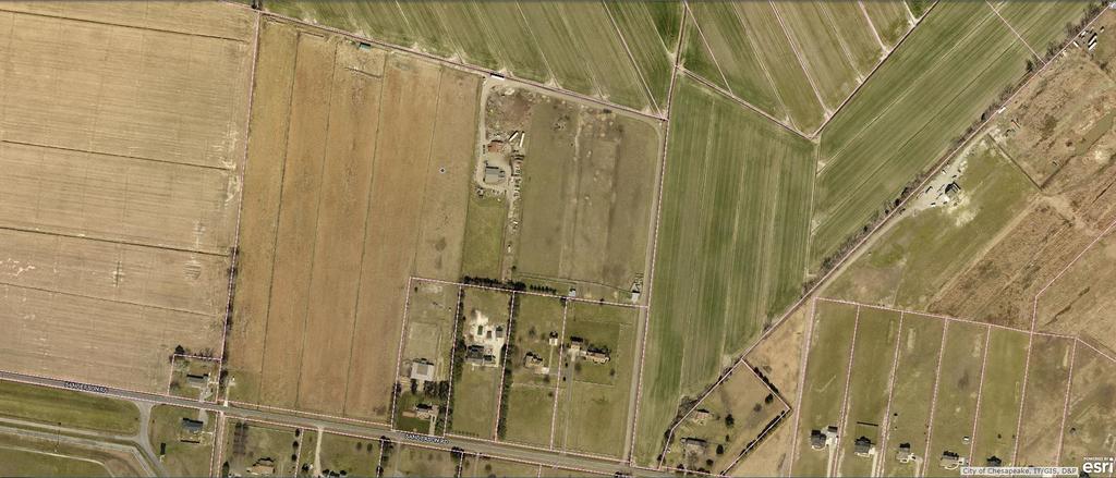
10 City of Chesapeake, Virginia Legend Parcels City Boundary Parcel Number: Date: 4/27/2018 DISCLAIMER:This drawing is neither a legally recorded map nor a survey and is not intended to be used as such. The information displayed is a compilation of records,information, and data obtained from various sources, and City of Chesapeake is not responsible for its accuracy or how current it may be.
11 City of Chesapeake, Virginia April 27, 2018 Parcel Number: Property Address (Primary): Parcel Class: 2010 Parcel Class Description: 1040 SANDERSON RD CHESAPEAKE, RESIDENTIAL - SINGLE FAMILY Summary Property Owner GOSMAN EDWARD O & CINDY S Owner Address Address 1040 SANDERSON RD CHESAPEAKE, VA Zoning Acreage 4.05 Legal Description A1: Agricultural LT 3 RESUB PARCELS 11 & 13 SCOTLAND FARMS 4.05AC Site Information Neighborhood Number Neighborhood Description Borough: Building Name BR059 Frontage Length Other Dimensions Land Use Participant WHOLE MAP 098,HEAD OF RIVER MEADOWS BUTTS ROAD X607.59X320.52X529.93X30.02X15.01 No Assessment Information Date Fiscal Year Land Value Land Use Value Improvement Value Total Value Proposed 7/1/ $141,300 $330,000 $471,300 7/1/ $140,300 $289,600 $429,900 7/1/ $140,300 $289,600 $429,900 7/1/ $140,300 $277,000 $417,300 7/1/ $140,300 $277,000 $417,300 7/1/ $140,300 $277,000 $417,300 7/1/ $140,300 $277,000 $417,300 7/1/ $155,300 $277,000 $432,300 7/1/ $170,300 $279,500 $449,800 7/1/ $200,300 $279,500 $479,800 7/1/ $200,300 $279,500 $479,800 7/1/ $200,300 $276,900 $477,200 7/1/ $170,300 $276,900 $447,200 7/1/ $125,300 $219,600 $344,900 Ownership Information Buyer Name Seller Name Sale Date Sale Amount Deed Book Deed Page Map Book/Page GOSMAN EDWARD O & CINDY S 4/26/1991 $ DISCLAIMER: This data is provided without warranty of any kind, either expressed or implied, including but not limited to, the implied warrangiesof merchantability and fitness for a particular purpose. Any person, firm or corporation which uses this map or any of the enclosed information assumes allrisk for the inaccuracy thereof, as City of Chesapeake expressly disclaims any liability for loss or damage arising from the use of said information by anythird party.
12 Residential Improvement Year Built : 1992 Foundation : Brick Wall Square Feet : 3196 Exterior Wall : Face Brick Exterior Wall 2 : Roof Type : Gable Roof Cover : Asphalt Air Conditioned : Full Air Conditioned 2 : Air Conditioned 3 : Central Heating: Forced Hot Air Central Heating 2: Central Heating 3 : Number of Stories: 1.50 Number of Rooms: 8 Number of Bedrooms: 4 Number of Full Bathrooms: 2 Number of Half Bathrooms: 1 Fire Place: 1 Attic Stairs: None Segments Information Building # 1 Segment Code Segment Description Square Feet AAC 10 - ADDITION W/AIR CONDITIONING 210 ADD 01 - ADDITION (NO AC) 238 AGF 20 - ATTACHED FINISHED GARAGE 635 FAT 100% ATTIC - 100% FINISHED 143 FFL FINISHED FIRST FLOOR 1,271 FRA 23 - FINISHED ROOM ABOVE 381 FTS FINISHED THREE QUARTER STORY 953 STP 43 - STOOP 60 WDK 36 - WOOD DECK 486 Outbuilding Information DISCLAIMER: This data is provided without warranty of any kind, either expressed or implied, including but not limited to, the implied warrangiesof merchantability and fitness for a particular purpose. Any person, firm or corporation which uses this map or any of the enclosed information assumes allrisk for the inaccuracy thereof, as City of Chesapeake expressly disclaims any liability for loss or damage arising from the use of said information by anythird party.
13 Building Description Year Built Square Feet DETACHED GARAGE Real Estate Tax Current Year Bill Number Year Installment Date Due Tax Billed Tax Paid Balance Due INSTALLMENT #1 10/2/2017 $1, $1, $3, INSTALLMENT #2 1/3/2018 $1, $1, $2, INSTALLMENT #3 4/2/2018 $1, $1, $1, INSTALLMENT #4 6/5/2018 $1, $0.00 Please contact the Treasurer s Office at (757) if you have questions regarding Tax Paid or Balance Due. Storm Water Fees and prior balances do not show on this tab. Real Estate Notes Note 1-FENCE ADDED TAX YEAR /BDA DISCLAIMER: This data is provided without warranty of any kind, either expressed or implied, including but not limited to, the implied warrangiesof merchantability and fitness for a particular purpose. Any person, firm or corporation which uses this map or any of the enclosed information assumes allrisk for the inaccuracy thereof, as City of Chesapeake expressly disclaims any liability for loss or damage arising from the use of said information by anythird party.
14 City of Chesapeake, Virginia Legend Parcels City Boundary Parcel Number: Date: 4/27/2018 DISCLAIMER:This drawing is neither a legally recorded map nor a survey and is not intended to be used as such. The information displayed is a compilation of records,information, and data obtained from various sources, and City of Chesapeake is not responsible for its accuracy or how current it may be.
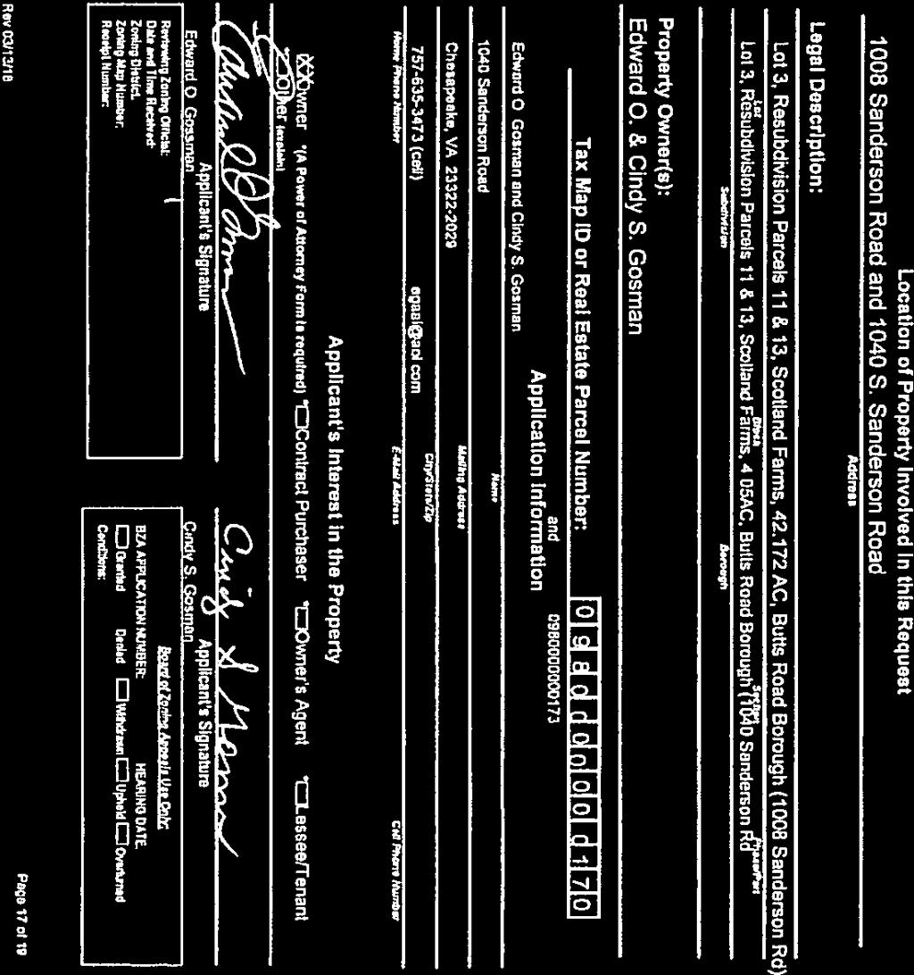
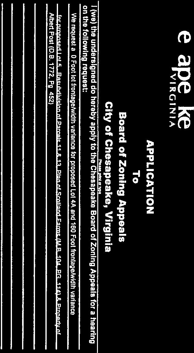
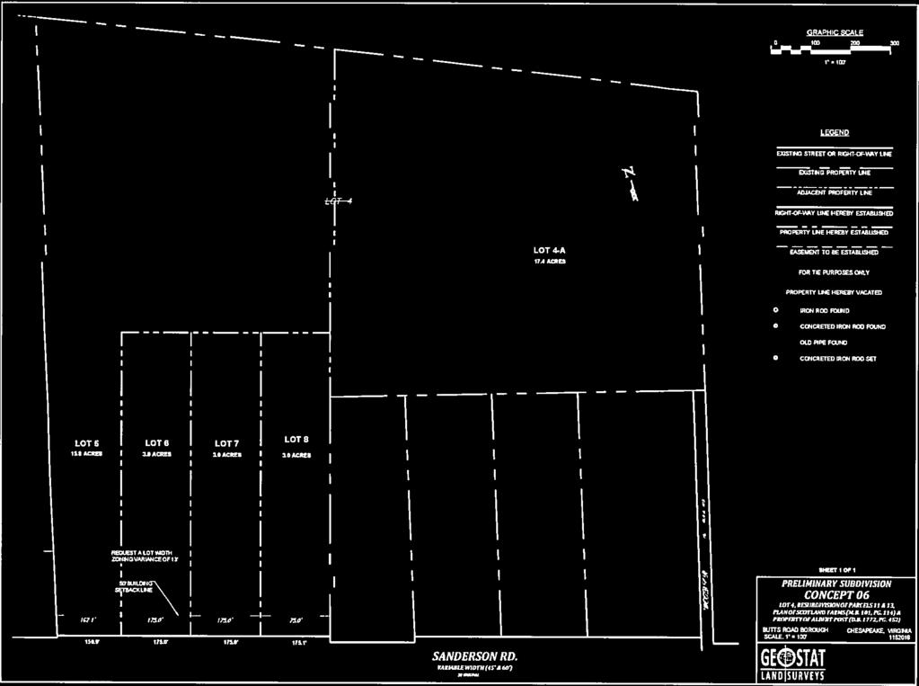
15 Staff Report TO: FROM: RE: Chesapeake Board of Zoning Appeals Dale Ware, AICP, CZA Application # ZON-BZA Sanderson Road and 1040 Sanderson Road Hearing Date: May 24, 2018 Application # ZON-BZA Edward O. & Cindy S. Gosman, property owners, 1040 Sanderson Road, requesting a variance from Sections A.2 and 3 of the Chesapeake Zoning Ordinance to reduce the minimum lot width and frontage requirements of 175 feet and 140 feet to zero (0) for proposed Lot 4A, and from Section A.2 to reduce the minimum lot width requirement of 175 feet to 162 feet for proposed for Lot 5. The property is further identified as LT 4 RESUB PARCELS 11 & 13 SCOTLAND FARMS AC; Real Estate Parcel No and LT 3 RESUB PARCELS 11 & 13 SCOTLAND FARMS 4.05 AC; Real Estate Parcel No , Zoning Classification A-1, residential. Background Information: The applicant is proposing to subdivide an existing A-1 lot into 5 lots. Residential lots in the A-1 agricultural district shall comply with the requirements set out for lots in the RE-1 residential estate district. Two proposed lots (4A & 5) after re-subdivision would not comply with current zoning requirements for the RE-1, residential zoning district. The applicant requires a variance from the RE-1 development standards for the proposed subdivision since lots being subdivided must meet the development standards for the zoning district in order to subdivide. This application was advertised in the Chesapeake Clipper section of the Virginian Pilot Newspaper and adjacent property owners were mailed notice of this request in accordance with Section of the Code of Virginia. The applicant was provided a public notice sign to be posted on the property pursuant to the requirements of Section E of the Chesapeake Zoning Ordinance. Staff Analysis and Recommendation: Sections A & B of the Chesapeake Zoning Ordinance and Section of the Code of Virginia require certain standards be met for the Board of Zoning Appeals to grant a variance. These standards are listed at the end of this report as an excerpt from Section A & B of the Zoning Ordinance. To approve the variance the Board must find, conditioned upon the applicant acquiring the property in good faith, that the applicant s situation is unique due to the particular physical surroundings, size, shape, 1
16 topographical condition or other extraordinary situation and not shared by other properties in the same zoning district and vicinity, that the denial of the variance would result in undue hardship rather than an inconvenience, that the character of the district would not be changed as a result of the granting of the variance, and that the situation is not such of a general nature that would require a text amendment to the Zoning Ordinance to achieve compliance. The applicant has not shown that the denial of the variance would effectively prohibit or otherwise unreasonably restrict the proposed use of the property. The applicant does not have a hardship as the applicant would have the ability to use the current lot configuration although not as appealing from a design standpoint. The evidence indicates that the applicant has not met all the criteria needed for the granting of a variance under state law. With this information and along with the strict construct of state law and the Zoning Ordinance requirements for the granting of the variance, staff recommends denial of this variance to the Board A-1 agricultural district. EXCERPTS FROM CHESAPEAKE ZONING ORDINANCE Residential development standards. A. With the exception of approved cluster developments residential lots in the A-1 agricultural district shall comply with the requirements set out for lots in the RE-1 residential estate district (see section 6-300); except, however, that the minimum lot size of three (3) acres may be reduced to one acre or more in the case of property immediately surrounding a residential structure that was in existence and occupied prior to July 20, 1995; provided that, where septic tanks are used, the Chesapeake Health Department certifies that adequate sewage disposal can be assured. Lots less than three (3) acres in size which qualify for residential uses in accordance with this section shall comply with the minimum lot widths, setbacks and maximum lot coverage standards set out in section (A) below for nonresidential development of A-1 agricultural districts lots. Such lots shall comply with all other development standards set out in Section for residential estates and in section for residential districts. B. Cluster developments shall comply with all requirements in section et seq. of this ordinance. (Ord. No. 95-O-112, ; Ord. No. 04-O-079, ) RE-1 residential estate district Development standards. A. General site standards. (The Chesapeake health department may require larger lots, widths and setbacks where deemed necessary for adequate sewage disposal.) 1. Minimum lot size, 3 acres. 2. Minimum lot width, 175 feet. For lots used exclusively for storm water management, open space or conservation that comply with section D.6 of this ordinance, the minimum lot width shall be 50 feet. The planning director or designee may approve a further reduction or waiver of minimum lot width equal to a reduction in minimum lot frontage approved in accordance with section D.7 of this ordinance. 2
17 3. Minimum lot frontage, 140 feet. For lots used exclusively for storm water management, open space or conservation that comply with section D.6 of this ordinance, the minimum lot frontage shall be 50 feet. The planning director or designee may approve a further reduction or waiver of minimum lot frontage in accordance with section D.7 of this ordinance. 4. Principal building setback (required yards). a. From streets (front yards), 50 feet. (Setback from streets shall be measured from the reservation line established in accordance with the city's adopted Master Transportation Plan. Where a reservation line cannot be established under the provisions of the adopted Master Transportation Plan, setbacks shall be measured as provided for in section See section C. for treatment of corner lots.) b. From lot lines. (1) Side yard. There shall be a side yard along each side of each building and the sum of the widths of the two side yards shall not be less than 25 percent of the width of the lot. The minimum width of any such side yard shall be 10 percent of the width of the lot, provided that no such side yard shall be less than 10 feet in width, and provided further, that in any case where the total required width of the two side yards is more than 45 feet, one side of such yard need not be more than 20 feet in width. (2) Rear yard, 40 feet. 5. Maximum lot coverage of all buildings and roofed structures, 35 percent. 6. Maximum building height, 35 feet. (Note: Under section , this maximum building height may be exceeded upon approval of a conditional use permit.) B. Off-street parking. The minimum off-street parking requirements for each use in the RE-1 district shall be determined from the standards set forth for the applicable parking group as defined in section and from the "parking" column on the use schedule established under section C. Other development standards. Other development standards pertaining to all residential districts are set out in section et seq. (Ord. No. 96-O-072, ; Ord. No. 05-O-015, ; Ord. No. 05-O- 071, ; Ord. No. 17-O-081, ) Standards for variances General standards; the Board of zoning appeals shall authorize a variance from the terms of this ordinance only when such authorization will not be contrary to the public interests and when, owing to special conditions, a literal enforcement of the provisions of this ordinance would unreasonably restrict the utilization of the property, provided that the spirit of the ordinance shall be observed and substantial justice done. Action and specific findings required; the board shall either: approve, deny or approve with conditions the request for a variance. A "Variance" means, in the application of a zoning ordinance, a reasonable deviation from those provisions regulating the shape, size, or area of a lot or parcel of land or the size, height, area, bulk, or location of a building or structure when the strict application of the ordinance would unreasonably restrict the utilization of the property, and such need for a variance would not be shared generally by other properties, and provided such variance is not contrary to the purpose of the ordinance. It shall not include a change in use, which change shall be accomplished by a rezoning or by a conditional zoning. 3
18 Notwithstanding any other provision of law, general or special, a variance shall be granted if the evidence shows that the strict application of the terms of the ordinance would unreasonably restrict the utilization of the property or that the granting of the variance would alleviate a hardship due to a physical condition relating to the property or improvements thereon at the time of the effective date of the ordinance, and 1. the property interest for which the variance is being requested was acquired in good faith and any hardship was not created by the applicant for the variance; 2. the granting of the variance will not be of substantial detriment to adjacent property and nearby properties in the proximity of that geographical area; 3. the condition or situation of the property concerned is not of so general or recurring a nature as to make reasonably practicable the formulation of a general regulation to be adopted as an amendment to the ordinance; 4. the granting of the variance does not result in a use that is not otherwise permitted on such property or a change in the zoning classification of the property; and 5. The relief or remedy sought by the variance application is not available through a special exception process at the time of the filing of the variance application. END OF REPORT 4
City of Chesapeake, Virginia September 19, 2018 Parcel Number: Property Address (Primary): Parcel Class: 2010 Parcel Class Description:
: Parcel Class: 2010 Parcel Class Description:") City of Chesapeake, Virginia September 19, 2018 Parcel Number: 1290000002710 Property Address (Primary): Parcel Class: 2010 Parcel Class Description: 2605 BORDER CT CHESAPEAKE, 23324 RESIDENTIAL - SINGLE
City of Chesapeake, Virginia September 19, 2018 Parcel Number: 1290000002710 Property Address (Primary): Parcel Class: 2010 Parcel Class Description: 2605 BORDER CT CHESAPEAKE, 23324 RESIDENTIAL - SINGLE
 City of Chesapeake, Virginia August 25, 2017 Parcel Number: 0360000001770 Property Address: Parcel Class: 2010 Parcel Class Description: 357 GREAT BRIDGE BLVD CHESAPEAKE, 23320 RESIDENTIAL - SINGLE FAMILY
ARLINGTON COUNTY, VIRGINIA
 ARLINGTON COUNTY, VIRGINIA Board of Zoning Appeals Agenda Item V-11354-18-VA-2: Meeting of April 16, 2018 DATE: April 13, 2018 APPLICANT: LOCATION: ZONING: LOT AREA: GLUP DESIGNATION: Roger Ramia of Rush
The County of Bedford, VA Legend
 The County of Bedford, VA Legend E911 Address Highway Blue Ridge Parkway US Primary Virginia Primary Roads Driveway Parcels - County Parcels - Town Public School Boundary Title: Parcels - County Date:
RESIDENTIAL DISTRICTS SINGLE FAMILY DWELLING DEVELOPMENT STANDARDS
 RESIDENTIAL DISTRICTS SINGLE FAMILY DWELLING DEVELOPMENT STANDARDS READ FIRST - NOTE TO DEVELOPERS & DISCLAIMER: Residential zoning districts require minimum yard distances from property lines for building
VARIANCE CASE NUMBER: PLN
 VARIANCE CASE NUMBER: PLN2011-00113 APPELLANT: Robert Dale Lynch OWNER: Robert, Anne & David Lynch PROPERTY LOCATION: 5408 Zoysia Court MAGISTERIAL DISTRICT: Gainesville ACREAGE: 0.1797 GPINs: 7299-61-8665
Applicant for Variance. Variance Procedures & Application
 COUNTY OF RICHMOND Land Use Office 101 Court Circle, P. O. Box 1000 Warsaw, Virginia 22572 Phone: (804)333-3415 Fax: (804)333-3408 Website: www.co.richmond.va.us To: From: Subject: Applicant for Variance
APPENDIX E FORMS INDEX OF ZONING FORMS
 APPENDIX E FORMS The zoning forms to follow in this appendix are used by Morrow County Zoning on behalf of their zoning resolution. There are two checklist sheets at the front of the forms that will assist
EXTRA-TERRITORIAL ZONING AUTHORITY
 EXTRA-TERRITORIAL ZONING AUTHORITY DOÑA ANA COUNTY COMMUNITY DEVELOPMENT DEPARTMENT Doña Ana County Government Complex 845 North Motel Boulevard Las Cruces, New Mexico 88007 Office: (575) 647-7237 MEETING
DRAFT FOR DISCUSSION PURPOSES ONLY SEPTEMBER 29, 2017
 DRAFT FOR DISCUSSION PURPOSES ONLY SEPTEMBER 29, 2017 AN ORDINANCE AMENDING APPENDIX A OF THE CITY CODE, ENTITLED ZONING, ARTICLE 3, SECTION 3-403; ARTICLE 6, SECTIONS 6-2101 AND 6-2102; ARTICLE 10, SECTIONS
OLD BUSINESS NEW BUSINESS
 TO: Zoning Board of Adjustment FROM: Peter Stith, AICP, Planning Department DATE: November 16, 2018 RE: Zoning Board of Adjustment OLD BUSINESS 1. 127 & 137 High Street Request for Rehearing NEW BUSINESS
BOROUGH OF MOUNT ARLINGTON ZONING PERMIT APPLICATION PROCEDURE 419 Howard Blvd., Mt. Arlington, NJ (973) ext. 14
 ext. 14") BOROUGH OF MOUNT ARLINGTON ZONING PERMIT APPLICATION PROCEDURE 419 Howard Blvd., Mt. Arlington, NJ 07856 (973) 398-6832 ext. 14 These rules shall be applicable to every development project that results
BOROUGH OF MOUNT ARLINGTON ZONING PERMIT APPLICATION PROCEDURE 419 Howard Blvd., Mt. Arlington, NJ 07856 (973) 398-6832 ext. 14 These rules shall be applicable to every development project that results
MEMORANDUM. Monday, November 19, :00 p.m. Kiawah Island BZA Meeting Packet
 MEMORANDUM TO: FROM: Town of Kiawah Island BZA Members John Taylor, Jr., Planning Director DATE: November 9, 2018 SUBJECT: Monday, November 19, 2018 4:00 p.m. Kiawah Island BZA Meeting Packet Attached
CITY AND BOROUGH OF SITKA PLANNING AND COMMUNITY DEVELOPMENT DEPARTMENT VARIANCES
 CITY AND BOROUGH OF SITKA PLANNING AND COMMUNITY DEVELOPMENT DEPARTMENT VARIANCES VARIANCES WHAT? A variance is a waiver of development standards as outlined by municipal code. Variances may be sought
ROCKY RIVER BOARD OF ZONING & BUILDING APPEALS
 ROCKY RIVER BOARD OF ZONING & BUILDING APPEALS SPECIAL INSTRUCTIONS TO APPLICANTS Your submittal must be received by the Rocky River Building Department no later than 2 weeks (14 days) prior to the scheduled
Taylor Lot Coverage Variance Petition No. PLNBOA North I Street Public Hearing: November 7, 2012
 APPEALS HEARING OFFICER STAFF REPORT Applicant: Mark Taylor, property owner Staff: Thomas Irvin (801) 535-7932 thomas.irvin@slcgov.com Tax ID: 09-32-159-006-0000 Current Zone: SR-1A Special Development
Board of Zoning Adjustments Staff Report Monthly Meeting Monday, June 13, 2016
 Board of Zoning Adjustments Staff Report Monthly Meeting Monday, June 13, 2016 Docket Number: BZA 043-16 Prepared by: Valerie McMillan Applicant or Agent: Roger Whatley Property Location: 3727 Constance
DEPARTMENT OF PLANNING JEFFERSON PARISH, LOUISIANA
 DEPARTMENT OF PLANNING JEFFERSON PARISH, LOUISIANA SUBDIVISION REPORT DOCKET NO: ES-89-15-PF SUMMARY NO: COUNCIL DISTRICT 2 Paul D. Johnston COUNCIL AT LARGE: A Chris Roberts B Elton M. Lagasse ADVERTISING
GLOUCESTER COUNTY ZONING ADMINISTRATOR S WRITTEN FINDINGS IN COMPLIANCE WITH SECTION OF THE GLOUCESTER COUNTY ZONING ORDINANCE
 GLOUCESTER COUNTY ZONING ADMINISTRATOR S WRITTEN FINDINGS IN COMPLIANCE WITH SECTION 14-12 OF THE GLOUCESTER COUNTY ZONING ORDINANCE VARIANCE APPLICATION V-18-02 TAX MAP PARCEL 51-272A Pursuant to Section
Zoning Board of Appeals Application
 Village of General Information 419 Richmond Road Phone: 847-251-1666 Kenilworth, IL 60043 Fax: 847-251-3908 E-mail: info@villageofkenilworth.org Zoning Board of Appeals Application Zoning Board of Appeals
ZONING VARIANCE APPLICATION BOARD OF ZONING ADJUSTMENT
 ZONING VARIANCE APPLICATION BOARD OF ZONING ADJUSTMENT Project Information Owner/Applicant Information Project Name Name of Owner Street Address Project Address Name of Applicant (if different) Street
ORDINANCE NO. 41. PRIVATE ROAD ORDINANCE As Amended Through April 10, 2008
 ORDINANCE NO. 41 PRIVATE ROAD ORDINANCE As Amended Through April 10, 2008 An Ordinance to protect the health, safety, and general welfare of the inhabitants of Port Sheldon Township. The Township of Port
STAFF REPORT #
 STAFF REPORT #15-6000-0001 VARIANCE PLANNING COMMISSION MEETING DATE: May 21, 2015 1. APPLICATION: An application submitted by requesting a variance to allow for a front yard setback reduction to twenty
Chesapeake Bay Critical Area Conservation Plan
 The Maryland-National Capital Park and Planning Commission Prince George s County Planning Department Development Review Division 301-952-3530 Note: Staff reports can be accessed at www.mncppc.org/pgco/planning/plan.htm.
APPLICATION FOR VARIANCE Chapter 50, Land Development Code Levy County, Florida
 Filing Date: Petition Number: Fee: $ 350.00 Validation Number: TO THE LEVY COUNTY BOARD OF ADJUSTMENT AND CODE ENFORCEMENT: A Variance is to grant relief to a person from the requirements of this Ordinance
Borough of Haddonfield New Jersey
 Borough of Haddonfield New Jersey Application Current As Of 4/16/2013 FOR OFFICE USE ONLY: (DO NOT WRITE IN THIS SPACE) APPLICATION TO: PLANNING BOARD ZONING BOARD OF ADJUSTMENT DATE APPLICATION FILED:
AMENDED AGENDA BLUFFDALE CITY BOARD OF ADJUSTMENT. January 24, 2017
 AMENDED AGENDA BLUFFDALE CITY BOARD OF ADJUSTMENT January 24, 2017 Notice is hereby given that the Bluffdale City Board of Adjustment will hold a public meeting Tuesday, January 24, 2017, at the Bluffdale
CONDITIONAL USE PERMIT APPLICATION FOR AN EXCAVATION/BORROW PIT INSTRUCTIONS
 City of Chesapeake Department of Planning Post Office Box 15225 Chesapeake, Virginia 23328-5225 (757) 382-6176 FAX (757) 382-6406 CONDITIONAL USE PERMIT APPLICATION FOR AN EXCAVATION/BORROW PIT INSTRUCTIONS
 Staff Report TO: FROM: RE: Chesapeake Board of Zoning Appeals Dale Ware, AICP, CZA Application # ZON-BZA-2016-00050 900 Battlefield Boulevard, North Hearing Date: January 26, 2017 Application # ZON-BZA-2016-00050
STAFF REPORT. To: Planning Commission Meeting date: May 11, 2016 Item: VN Prepared by: Marc Jordan
 # 12 ) VN-02-16 K & G ENTERPRISES VARIANCE PUBLIC HEARING STAFF REPORT To: Planning Commission Meeting date: May 11, 2016 Item: VN-02-16 Prepared by: Marc Jordan GENERAL INFORMATION: Applicant: Property
Department of Planning and Development
 COUNTY OF KENOSHA Department of Planning and Development December 2012 VARIANCE APPLICATION Owner: Mailing Address: Phone Number(s): To the Kenosha County Board of Adjustment: Please take notice that the
ARTICLE VII. NONCONFORMITIES. Section 700. Purpose.
 ARTICLE VII. NONCONFORMITIES. Section 700. Purpose. The purpose of this chapter is to regulate and limit the development and continued existence of legal uses, structures, lots, and signs established either
Ravenna Township. Dakota County, Minnesota. Variance Application. Please Print or Type All Information
 Variance Application Return this completed application to the office of the clerk on or before A $550.00 fee is required before a Public Hearing date is issued. For Township Use Only Case Number: Date
ARTICLE 24 SITE PLAN REVIEW
 ARTICLE 24 SITE PLAN REVIEW 24.1 PURPOSE: The intent of these Ordinance provisions is to provide for consultation and cooperation between the land developer and the Township Planning Commission in order
CHESAPEAKE BOARD OF ZONING APPEALS MINUTES OF THE REGULAR MEETING April 28, 2016
 CHESAPEAKE BOARD OF ZONING APPEALS MINUTES OF THE REGULAR MEETING April 28, 2016 306 Cedar Road, Chesapeake, VA 23322 Chesapeake City Council Chambers I. CALL TO ORDER: Vice Chair Bedois called the meeting
Staff Report. Variance
 Staff Report PLANNING DIVISION COMMUNITY & ECONOMIC DEVELOPMENT To: Appeals Hearing Officer From: Doug Dansie (801) 535-6182, doug.dansie@slcgov.com Date: June 9, 2014 Re: PLNZAD2014-00143 1680 South Main
ZONING VARIANCES - ADMINISTRATIVE
 Planning Department 200 W. Oak Street 3 rd Floor Fort Collins, CO 80521 970-498-7683 www.larimer.org/planning ZONING VARIANCES - ADMINISTRATIVE The submittal requirements listed in this packet are intended
13-2 SUBDIVISION PLANS AND PLATS REQUIRED EXCEPTIONS Subdivision Plats Required To be Recorded
 ARTICLE XIII SUBDIVISIONS 13-1 INTENT AND PURPOSE 13-1-1 Intent: It is the intent of the County Commission through the adoption of this Article to more fully avail itself of the power granted under 17-27-601
Staff Recommendation Denial. Staff Planner Jonathan Sanders
 Applicant Traditional Concepts, LLC & Victory Baptist Church of Virginia Beach, Inc. Property Owner Victory Baptist Church Public Hearing January 9, 2019 City Council Election District Princess Anne Agenda
1 August 12, 2015 Public Hearing
 1 August 12, 2015 Public Hearing APPLICANT & PROPERTY OWNER: STAFF PLANNER: Kristine Gay REQUEST: Variance to Section 4.4 (b) and 4.4(d) of the Subdivision Regulations, which require that all lots created
APPLICATION NUMBER 5416/4237/4096 A REQUEST FOR
 APPLICATION NUMBER 5416/4237/4096 A REQUEST FOR SIDE YARD SETBACK AND COMBINED SIDE YARD VARIANCE TO ALLOW A GARAGE/DEN/BREAKFAST ROOM/COVERED PORCH/BEDROOMS ADDITION TO WITHIN 2 OF A SIDE PROPERTY LINE
Request Subdivision Variance (Sections 4.4 (b) & (d) of the Subdivision Regulations) Staff Planner Jimmy McNamara
 & (d) of the Subdivision Regulations) Staff Planner Jimmy McNamara") Applicant & Property Owner Public Hearing September 14, 2016 City Council Election District Kempsville Agenda Item 7 Request Subdivision Variance (Sections 4.4 (b) & (d) of the Subdivision Regulations)
Applicant & Property Owner Public Hearing September 14, 2016 City Council Election District Kempsville Agenda Item 7 Request Subdivision Variance (Sections 4.4 (b) & (d) of the Subdivision Regulations)
ZONING AMENDMENT, SUBDIVISION & SIDEWALK WAIVER REQUEST STAFF REPORT Date: November 16, 2006
 ZONING AMENDMENT, SUBDIVISION & SIDEWALK WAIVER REQUEST STAFF REPORT Date: November 16, 2006 NAME SUBDIVISION NAME Terhaar & Cronley Investment Partnership P & E Subdivision LOCATION 4210 and 4218 Halls
BOARD OF ZONING APPEALS CITY OF PRAIRIE VILLAGE, KANSAS AGENDA July 10, 2018 **MULTI-PURPOSE ROOM 6:30 P.M.
 BOARD OF ZONING APPEALS CITY OF PRAIRIE VILLAGE, KANSAS AGENDA July 10, 2018 **MULTI-PURPOSE ROOM 6:30 P.M. I. ROLL CALL II. APPROVAL OF MINUTES - June 5, 2018 III. PUBLIC HEARINGS BZA2018-02 Variance
PLANNING BOARD APPLICATION
 Township of Bethlehem 405 Mine Road Asbury, New Jersey 08802 Date of Application: Township Application Number: An application is hereby made for: N.J.S.A. 40:55D-70(a) Appeal or (b) interpretation N.J.S.A.
Staff Report: Date: Applicant: Property Identification: Acreage of Request: Current Zoning of Requested Area: Requested Action: Attached:
 Staff Report: Completed by Jeff Palmer Director of Planning & Zoning Date: November 7, 2018, Updated November 20, 2018 Applicant: Greg Smith, Oberer Land Developer agent for Ronald Montgomery ET AL Property
MEMORANDUM. DATE: April 6, 2017 TO: Zoning Hearing Board Jackie and Jake Collas. FROM: John R. Weller, AICP, Zoning Officer
 MEMORANDUM DATE: April 6, 2017 TO: Zoning Hearing Board Jackie and Jake Collas FROM: John R. Weller, AICP, Zoning Officer SUBJECT: Zoning Hearing Board appeal of Jackie and Jake Collas Relief requested
6 February 13, 2013 Public Hearing APPLICANT/ PROPERTY OWNER: FRANK T. WILLIAMS
 6 February 13, 2013 Public Hearing APPLICANT/ PROPERTY OWNER: FRANK T. WILLIAMS STAFF PLANNER: Ray Odom REQUEST: Subdivision Variance to Section 4.4(b) of the Subdivision Ordinance that requires all newly
PLANNING & DEVELOPMENT SERVICES 1800 Continental Place Mount Vernon, WA Inspections Office Fax 360.
 PLANNING & DEVELOPMENT SERVICES 1800 Continental Place Mount Vernon, WA 98273 Inspections 360.416.1330 Office 360.416-1320 Fax 360.416-1340 Date Received: Administrative Setback Reduction Checklist Pursuant
ZONING VARIANCES ADMINISTRATIVE
 200 W. Oak Street, 3rd Floor Fort Collins, CO 80521 (970) 498-7683 / larimer.org/planning ZONING VARIANCES ADMINISTRATIVE The submittal requirements listed in this packet are intended to collect all of
BOUNDARY LINE ADJUSTMENT APPLICATION
 OFFICE 518.747.5212 --------------FAX 518.747.2493 (Clerk s Office Use Only) BOUNDARY LINE ADJUSTMENT APPLICATION APPLICATION NO: DATE : FEE PAID: Requirements, Fees and Instructions (Please use dark blue
Special Use Permit - Planned Unit Development Checklist. Property Address:
 Special Use Permit - Planned Unit Development Checklist Special Use Permit Number. Parcel Code/s #28-11- - - Property Address: Applicant: ARTICLE VIII Ordinance Reference - Section 8.1.2 Permit Procedures:
BOARD OF ZONING ADJUSTMENT STAFF REPORT Date: January 9, 2017
 # 1 HOLDOVER Revised ZON2016-02346 BOARD OF ZONING ADJUSTMENT STAFF REPORT Date: January 9, 2017 CASE NUMBER 6082 4140 1874 APPLICANT NAME LOCATION VARIANCE REQUEST ZONING ORDINANCE REQUIREMENT ZONING
NEW BUSINESS. Aerial Map. Case #11-1. Neighborhood Context
 TO: Zoning Board of Adjustment FROM: Peter Stith, AICP, Planning Department DATE: November 15, 2017 RE: Zoning Board of Adjustment NEW BUSINESS 1. 87 Lincoln Rehearing Case #11-1 Petitioners: Working Stiff
City of Independence
 City of Independence Request for a Variance from the Side Yard Setbacks for the Property Located at 4618 South Lake Sarah Drive To: From: Planning Commission Mark Kaltsas, City Planner Meeting Date: May
Board of Adjustment File No.: VAR February 24, 2014 Page 2 of 7 VICINITY MAP ATTACHMENTS
 Board of Adjustment File No.: VAR2014 0004 February 24, 2014 Page 2 of 7 VICINITY MAP ATTACHMENTS Attachment A: Variance application Attachment B: As-built Attachment C: 1999 Plat Attachment D: Front of
JOINT PLANNING BOARD APPLICATION FORM
 JOINT PLANNING BOARD APPLICATION FORM TOWNSHIP OF RIVER VALE 406 RIVERVALE ROAD RIVER VALE, NJ 07675 The application, with supporting documentation, must be filed with the Administrative Officer to the
VICINITY MAP. Board of Adjustment File No.: VAR & VAR January 9, 2014 Page 2 of 11 ATTACHMENTS
 Board of Adjustment File No.: VAR2013 0024 & VAR2013 0025 January 9, 2014 Page 2 of 11 VICINITY MAP ATTACHMENTS Attachment A Applicant s Letter Attachment B Site Plan Attachment C Elevation Drawings Board
HOW TO APPLY FOR A USE PERMIT
 HOW TO APPLY FOR A USE PERMIT MENDOCINO COUNTY PLANNING AND BUILDING SERVICES What is the purpose of a use permit? Throughout the County, people use their properties in many different ways. They build
DEVELOPMENT DEPARTMENT STAFF REPORT STAFF REPORT BOJNANGLES SIGN VARIANCES
 DEVELOPMENT DEPARTMENT STAFF REPORT Meeting Date: February 15, 2018 Item #: _PZ2018-222_ STAFF REPORT BOJNANGLES SIGN VARIANCES Request: Multiple variances for signage for a drive-through establishment
Name of applicant: please print. Subject Property Address: street address of property. Subject Property Zoning: refer to official zoning map
 VILLAGE OF RIVERSIDE, ILLINOIS APPLICATION FOR ZONING CHANGE/ APPLICATION FOR ZONING VARIATION (Section 10-2-2) Application for Zoning Variation Zoning Change (indicate application type) Name of applicant:
Supplemental Application Form Request for a Waiver of Development Standards via Density Bonus
 County of Sacramento Office of Planning and Environmental Review (PER) 827 7 th Street, Room 225 Sacramento, CA 95814 (916) 874-6141 Supplemental Application Form Request for a Waiver of Development Standards
ZONING PERMIT APPLICATION and INSTRUCTIONS
 ZONING PERMIT APPLICATION and INSTRUCTIONS INSTRUCTIONS 1. Completely fill out, sign, and date the attached form. Include a check for $35.00 payable to the Borough of Oradell or exact cash amount. Please
PUBLIC HEARING: October 14, 2014 Planning and Land Development Regulation Commission (PLDRC)
") Page 1 of 26 GROWTH AND RESOURCE MANAGEMENT DEPARTMENT PLANNING AND DEVELOPMENT SERVICES DIVISION CURRENT PLANNING ACTIVITY 123 W. Indiana Avenue, DeLand, FL 32720 (386) 943-7059 PUBLIC HEARING: October
Page 1 of 26 GROWTH AND RESOURCE MANAGEMENT DEPARTMENT PLANNING AND DEVELOPMENT SERVICES DIVISION CURRENT PLANNING ACTIVITY 123 W. Indiana Avenue, DeLand, FL 32720 (386) 943-7059 PUBLIC HEARING: October
Staff Report: Date: Applicant: Property Identification: Acreage of Request: Current Zoning of Requested Area: Requested Action: Attached:
 Staff Report: Completed by Jeff Palmer Director of Planning & Zoning Date: November 7, 2018 Applicant: Greg Smith, Oberer Land Developer agent for Ronald Montgomery ET AL Property Identification: Frontage
PRELIMINARY SUBDIVISION PLAN APPLICATION INSTRUCTIONS
 City of Chesapeake Department of Planning Post Office Box 15225 Chesapeake, Virginia 23328-5225 (757) 382-6176 FAX (757) 382-6406 PRELIMINARY SUBDIVISION PLAN APPLICATION INSTRUCTIONS PURPOSE A preliminary
CITY COUNCIL ORDINANCE CITY AND COUNTY OF HONOLULU BILL , CDI
 CITY COUNCIL ORDINANCE CITY AND COUNTY OF HONOLULU BILL 20 2015, CDI TO AMEND CHAPTER 21, REVISED ORDINANCES OF HONOLULU 1990, AS AMENDED THE LAND USE ORDINANCE, RELATING TO ACCESSORY DWELLING UNITS. BE
Georgetown Planning Department
 Georgetown Planning Department Zoning Board of Adjustment Staff Report Meeting Date: March 19, 2013 Item: 4 File No: VAR-2013-002 Project Planner: Mike Elabarger, Senior Planner Report Date: March 14,
the conditions contained in their respective Orders until January 1, 2025, at the discretion of the Director of Planning, Property and Development.
 Part 4: Use Regulations Temporary Uses and Structures Purpose the conditions contained in their respective Orders until January 1, 2025, at the discretion of the Director of Planning, Property and Development.
Major Subdivision Application Packet. Revised June 2018
 Major Subdivision Application Packet Revised June 2018 Caroline County Department of Planning and Community Development 233 West Broaddus Avenue Bowling Green, VA 22427 www.co.caroline.va.us Phone: 804-633-4303
LUC AND UNDERLYING ZONING: OCP DESIGNATION:
 City of Surrey PLANNING & DEVELOPMENT REPORT File: 7916-0581-00 Planning Report Date: February 20, 2017 PROPOSAL: Terminate Land Use Contract No. 554 to permit the existing underlying RA and RF Zones to
TOWN OF OSSIPEE ZONING BOARD OF ADJUSTMENT REQUEST FOR VARIANCE
 TOWN OF OSSIPEE ZONING BOARD OF ADJUSTMENT REQUEST FOR VARIANCE Dear Applicant: You are seeking to apply for a Variance to the Town of Ossipee Zoning Ordinance. When this application is completed and submitted
MULTI-FAMILY DWELLING UNIT SUBDIVISION ORDINANCE TOWN OF SIDNEY, MAINE
 MULTI-FAMILY DWELLING UNIT SUBDIVISION ORDINANCE TOWN OF SIDNEY, MAINE I. GENERAL A. Title B. Purpose C. Administration D. Scope II. DEFINITIONS A. Building Height B. Dwelling Unit C. Family D. Multi-Unit
STAFF REPORT VARIANCE FROM LDC CHAPTER 17, SECTION 15(d)(1)(a) CASE NO
(1)(a) CASE NO") STAFF REPORT VARIANCE FROM LDC CHAPTER 17, SECTION 15(d)(1)(a) CASE NO. 16-90000010 REQUEST: OWNER: APPLICANT: LOCATION: RECOMMENDATION: Variance from the Land Development Code (LDC) to allow a minimum
STAFF REPORT VARIANCE FROM LDC CHAPTER 17, SECTION 15(d)(1)(a) CASE NO. 16-90000010 REQUEST: OWNER: APPLICANT: LOCATION: RECOMMENDATION: Variance from the Land Development Code (LDC) to allow a minimum
Plans shall be drawn at a readable scale, signed, and sealed by a Florida Registered Engineer. The application package shall include:
 CHAPTER 400. SECTION 403. PERMIT TYPES AND APPLICATIONS SITE DEVELOPMENT 403.3. Preliminary Site Plans (PSP) A. Intent and Purpose PSPs are used to identify existing site conditions and demonstrate general
E L M E R B O R O U G H L A N D U S E B O A R D APPLICATION COVER SHEET (to be completed for all applications and appeals)
") E L M E R B O R O U G H L A N D U S E B O A R D APPLICATION COVER SHEET (to be completed for all applications and appeals) 1. Name(s): 2. Address: 3. Telephone Number(s): 4. E-mail: 5. Owner Name(s) (if
E L M E R B O R O U G H L A N D U S E B O A R D APPLICATION COVER SHEET (to be completed for all applications and appeals) 1. Name(s): 2. Address: 3. Telephone Number(s): 4. E-mail: 5. Owner Name(s) (if
City of Altamonte Springs Developer s Guide
 Section 8 WAIVERS AND VARIANCES This section contains information and applications related to filing a petition for a waiver or variance in conjunction with a site plan or development plan application.
Umatilla County Department of Land Use Planning
 Umatilla County Department of Land Use Planning 216 SE 4 th ST, Pendleton, OR 97801, (541) 278-6252 Property Line Adjustment, Type V Application & Information Packet PROCESSING THE APPLICATION The application
ARLINGTON COUNTY, VIRGINIA
 ARLINGTON COUNTY, VIRGINIA Board of Zoning Appeals Agenda Item V-11394-18-UP-1: Meeting of October 17, 2018 DATE: October 12, 2018 APPLICANT: LOCATION: ZONING: LOT AREA: GLUP DESIGNATION: Sarah Sunday
LEGAL NOTICE. If you have any questions, you may also contact Marysville Zoning Administrator at (937) or
 or") Engineering, Planning and Zoning City Hall, 209 S. Main Street Marysville, Ohio 43040-1641 (937) 645-7350 FAX (937) 645-7351 www.marysvilleohio.org LEGAL NOTICE Notice of Public Hearing for the Board of
Engineering, Planning and Zoning City Hall, 209 S. Main Street Marysville, Ohio 43040-1641 (937) 645-7350 FAX (937) 645-7351 www.marysvilleohio.org LEGAL NOTICE Notice of Public Hearing for the Board of
Town of Aurelius 1241 West Genesee St Rd Auburn, NY Ext # (fax)
") Page 1 of 8 Town of Aurelius 1241 West Genesee St Rd Auburn, NY 13021 315-255-1894 - Ext #106 315-253-5827 (fax) Howard Tanner Application No. Code Enforcement Officer 315-730-7439 Date: aureliuscode@yahoo.com
Page 1 of 8 Town of Aurelius 1241 West Genesee St Rd Auburn, NY 13021 315-255-1894 - Ext #106 315-253-5827 (fax) Howard Tanner Application No. Code Enforcement Officer 315-730-7439 Date: aureliuscode@yahoo.com
UPPER MOUNT BETHEL TOWNSHIP NORTHAMPTON COUNTY, PENNSYLVANIA
 UPPER MOUNT BETHEL TOWNSHIP NORTHAMPTON COUNTY, PENNSYLVANIA JOINDER DEED / LOT CONSOLIDATION TOWNSHIP REVIEW PROCESS When accepting proposed Joinder Deeds / Lot Consolidations, review the Joinder Deed
7.20 Article 7.20 Nonconformities
 Article Nonconformities.01 Intent It is the intent of this ordinance to permit legal nonconforming lots, structures, or uses to continue until they are removed but not to encourage their survival. For
APPLICATION FOR VARIANCE OR PERMISSION UNDER SECTION 45 OF THE PLANNING ACT
 APPLICATION FOR VARIANCE OR PERMISSION UNDER SECTION 45 OF THE PLANNING ACT THE CORPORATION OF THE CITY OF LONDON, DEVELOPMENT AND COMPLIANCE SERVICES, 300 DUFFERIN AVENUE, LONDON, ONTARIO, N6A 4L9 Updated:
ZONING BOARD OF ADJUSTMENTS (ZBOA) MEETING AGENDA
 MEETING AGENDA") ZONING BOARD OF ADJUSTMENTS (ZBOA) MEETING AGENDA Notice is hereby given of a Regular Meeting of the La Porte Zoning Board of Adjustments to be held on Thursday, April 27, 2017 at 6:00 p.m. at City Hall
ZONING BOARD OF ADJUSTMENTS (ZBOA) MEETING AGENDA Notice is hereby given of a Regular Meeting of the La Porte Zoning Board of Adjustments to be held on Thursday, April 27, 2017 at 6:00 p.m. at City Hall
BOARD OF ADJUSTMENT, PANEL A PUBLIC HEARING MINUTES DALLAS CITY HALL, COUNCIL CHAMBERS TUESDAY, JANUARY 17, 2017
 BOARD OF ADJUSTMENT, PANEL A PUBLIC HEARING MINUTES DALLAS CITY HALL, COUNCIL CHAMBERS TUESDAY, JANUARY 17, 2017 MEMBERS PRESENT AT BRIEFING: Peter Schulte, vice-chair, Michael Gibson, regular member,
School Zones. Zoning
 Parcel ID: Property Address: 74A-5-4 Tax ID #: 001721100 Summary 372 PIGEON RUN RD GLADYS, 24554 Owner: Owner(Secondary): SHREVE DAVID W EXEC Mailing Address: PO BOX 547 ALTAVISTA, VA 24517 Property Descriptions
PLANNED UNIT DEVELOPMENTS
 PLANNED UNIT DEVELOPMENTS SECTION 9.01 DESCRIPTION AND PURPOSE. A. The purpose of a planned unit development (PUD) is to permit greater flexibility in development than is generally possible under standard
ZONING BOARD OF APPEALS APPLICATION
 ZONING BOARD OF APPEALS APPLICATION Town of Westbrook ZBA Appeal No. Land Use Department Mulvey Municipal Center, 866 Boston Post Road, Connecticut 06498 (860)-399-3047 Fax (860)-399-2084 ZBA App. Fee
PLANNED UNIT DEVELOPMENT APPLICATION
 ` PLANNED UNIT DEVELOPMENT APPLICATION CHESAPEAKE PLANNING DEPARTMENT PUD Creation PUD Modification APPLICATION NUMBER: (Assigned by Chesapeake Planning Department) GENERAL INFORMATION Project 1. Applicant(s):
DEPARTMENT OF PLANNING JEFFERSON PARISH, LOUISIANA
 DEPARTMENT OF PLANNING JEFFERSON PARISH, LOUISIA SUBDIVISION REPORT DOCKET NO: SUMMARY NO: COUNCIL DISTRICT 5: Cynthia Lee-Sheng COUNCIL AT LARGE: A: Chris Roberts B: Elton M. Lagasse ADVERTISING DATES:
USE PERMIT AND VARIANCE APPLICATION
 USE PERMIT AND VARIANCE APPLICATION Case No. BOARD OF ZONING APPEALS APPLICATION FOR USE PERMITS AND VARIANCES ARLINGTON COUNTY, VIRGINIA D E P A R T M E N T O F C O M M U N I T Y P L A N N I N G, H O
Castle Danger Subordinate Service District Phase I Land Use Ordinance #1
 Castle Danger Subordinate Service District Phase I Land Use Ordinance #1 Effective February 2, 2010 Castle Danger Subordinate Service District Phase I Land Use Ordinance SECTION I PURPOSE The purpose of
Request Subdivision Variance (Section 4.4(c)(1) of the Subdivision Regulations) Staff Recommendation Approval. Staff Planner Jonathan Sanders
(1) of the Subdivision Regulations) Staff Recommendation Approval. Staff Planner Jonathan Sanders") Applicant & Owner Public Hearing February 14, 2018 City Council Election District Bayside Agenda Item 4 Request Subdivision Variance (Section 4.4(c)(1) of the Subdivision Regulations) Staff Recommendation
Applicant & Owner Public Hearing February 14, 2018 City Council Election District Bayside Agenda Item 4 Request Subdivision Variance (Section 4.4(c)(1) of the Subdivision Regulations) Staff Recommendation
Town of Scarborough, Maine
 Town of Scarborough, Maine Miscellaneous Appeal INFORMATION REQUIRED FOR ALL APPEALS Before any appeal can be processed, the following material must be submitted to the Code Enforcement Office: 1. A fee
BOARD OF ADJUSTMENT, PANEL A PUBLIC HEARING MINUTES DALLAS CITY HALL, COUNCIL CHAMBERS TUESDAY, APRIL 21, 2015
 BOARD OF ADJUSTMENT, PANEL A PUBLIC HEARING MINUTES DALLAS CITY HALL, COUNCIL CHAMBERS TUESDAY, APRIL 21, 2015 MEMBERS PRESENT AT BRIEFING: MEMBERS ABSENT FROM BRIEFING: Clint Nolen, Vice Chair, Larry
DEVELOPMENT DEPARTMENT STAFF REPORT STAFF REPORT DRESDEN DRIVE TOWNHOMES DCI
 DEVELOPMENT DEPARTMENT STAFF REPORT Meeting Date: September 13, 2018 Item #: PZ2018-319 STAFF REPORT DRESDEN DRIVE TOWNHOMES DCI Request: Project Name: Development of Community Compact (DCI) and six concurrent
Request Subdivision Variance (4.4 (b) of the Subdivision Regulations) Staff Recommendation Approval. Staff Planner Jimmy McNamara
 of the Subdivision Regulations) Staff Recommendation Approval. Staff Planner Jimmy McNamara") Applicant & Property Owner Public Hearing July 12, 2017 City Council Election District Lynnhaven Agenda Item 4 Request Subdivision Variance (4.4 (b) of the Subdivision Regulations) Staff Recommendation
Applicant & Property Owner Public Hearing July 12, 2017 City Council Election District Lynnhaven Agenda Item 4 Request Subdivision Variance (4.4 (b) of the Subdivision Regulations) Staff Recommendation
Village of Glenview Zoning Board of Appeals
 Village of Glenview Zoning Board of Appeals STAFF REPORT January 16, 2017 TO: Chairman and Zoning Board of Appeals Commissioners FROM: Community Development Department CASE #: Z2017-001 LOCATION: PROJECT
CHEBOYGAN COUNTY ZONING BOARD OF APPEALS
 CHEBOYGAN COUNTY ZONING BOARD OF APPEALS 870 SOUTH MAIN ST. PO BOX 70 CHEBOYGAN, MI 49721 PHONE: (231)627-8489 FAX: (231)627-3646 CHEBOYGAN COUNTY ZONING BOARD OF APPEALS MEETING & PUBLIC HEARING WEDNESDAY,