NOTICE OF ADOPTED CHANGE TO A COMPREHENSIVE PLAN OR LAND USE REGULATION
|
|
|
- Bryan Dennis
- 5 years ago
- Views:
Transcription
 received the attached notice of adopted amendment to a comprehensive plan or land use")
1 NOTICE OF ADOPTED CHANGE TO A COMPREHENSIVE PLAN OR LAND USE REGULATION Date: Jurisdiction: Local file no.: DLCD file no.: 12/28/2014 City of Medford CP The Department of Land Conservation and Development (DLCD) received the attached notice of adopted amendment to a comprehensive plan or land use regulation on 12/19/2014. A copy of the adopted amendment is available for review at the DLCD office in Salem and the local government office. Notice of the proposed amendment was submitted to DLCD 58 days prior to the first evidentiary hearing. Appeal Procedures Eligibility to appeal this amendment is governed by ORS , ORS , and ORS Under ORS (9), a notice of intent to appeal a land use decision to LUBA must be filed no later than 21 days after the date the decision sought to be reviewed became final. If you have questions about the date the decision became final, please contact the jurisdiction that adopted the amendment. A notice of intent to appeal must be served upon the local government and others who received written notice of the final decision from the local government. The notice of intent to appeal must be served and filed in the form and manner prescribed by LUBA, (OAR chapter 661, division 10). If the amendment is not appealed, it will be deemed acknowledged as set forth in ORS (1)(a). Please call LUBA at , if you have questions about appeal procedures. DLCD Contact If you have questions about this notice, please contact DLCD s Plan Amendment Specialist at or plan.amendments@state.or.us

2 DLCD FORM 2 NOTICE OF ADOPTED CHANGE FOR DLCD USE TO A COMPREHENSIVE PLAN OR File No.: LAND USE REGULATION Received: Local governments are required to send notice of an adopted change to a comprehensive plan or land use regulation no more than 20 days after the adoption. (See OAR ). The rules require that the notice include a completed copy of this form. This notice form is not for submittal of a completed periodic review task or a plan amendment reviewed in the manner of periodic review. Use Form 4 for an adopted urban growth boundary including over 50 acres by a city with a population greater than 2,500 within the UGB or an urban growth boundary amendment over 100 acres adopted by a metropolitan service district. Use Form 5 for an adopted urban reserve designation, or amendment to add over 50 acres, by a city with a population greater than 2,500 within the UGB. Use Form 6 with submittal of an adopted periodic review task. Jurisdiction: City of Medford Local file no.: CP Date of adoption: Date sent: Was Notice of a Proposed Change (Form 1) submitted to DLCD? Yes: Date (use the date of last revision if a revised Form 1was submitted): No Is the adopted change different from what was described in the Notice of Proposed Change? Yes No If yes, describe how the adoption differs from the proposal: This is a comprehensive plan map amendment affecting 500 acres throughout the city. This UGBA-related action is intended to increase the development capacity of the urban area per ORS (6). Original notice identified more than 800 "study area" acres. The only difference is extent. Local contact (name and title): John Adam, Senior Planner Phone: john.adam@cityofmedford.org Street address: 200 S. Ivy Street, Rm. 200 City: Medford, OR Zip: PLEASE COMPLETE ALL OF THE FOLLOWING SECTIONS THAT APPLY For a change to comprehensive plan text: Identify the sections of the plan that were added or amended and which statewide planning goals those sections implement, if any: For a change to a comprehensive plan map: Identify the former and new map designations and the area affected: Change from see attachment to acres. A goal exception was required for this change. Change from to acres. A goal exception was required for this change. Change from to acres. A goal exception was required for this change. Change from to acres. A goal exception was required for this change. Location of affected property (T, R, Sec., TL and address): See attachment The subject property is entirely within an urban growth boundary Form updated November 1, 2013
3 The subject property is partially within an urban growth boundary If the comprehensive plan map change is a UGB amendment including less than 50 acres and/or by a city with a population less than 2,500 in the urban area, indicate the number of acres of the former rural plan designation, by type, included in the boundary. Exclusive Farm Use Acres: Forest Acres: Rural Residential Acres: Non-resource Acres: Marginal Lands Acres: Rural Commercial or Industrial Acres: Other: Acres: Natural Resource/Coastal/Open Space Acres: If the comprehensive plan map change is an urban reserve amendment including less than 50 acres, or establishment or amendment of an urban reserve by a city with a population less than 2,500 in the urban area, indicate the number of acres, by plan designation, included in the boundary. Exclusive Farm Use Acres: Forest Acres: Rural Residential Acres: Non-resource Acres: Marginal Lands Acres: Rural Commercial or Industrial Acres: Other: Acres: Natural Resource/Coastal/Open Space Acres: For a change to the text of an ordinance or code: Identify the sections of the ordinance or code that were added or amended by title and number: For a change to a zoning map: Identify the former and new base zone designations and the area affected: Change from to Acres: Change from to Acres: Change from to Acres: Change from to Acres: Identify additions to or removal from an overlay zone designation and the area affected: Overlay zone designation: Acres added: Acres removed: Location of affected property (T, R, Sec., TL and address): List affected state or federal agencies, local governments and special districts: Oregon Dept. of Transportation, Rogue Valley Transit District, Jackson County, Rogue Valley Council of Governments, Medford Water Commission, Rogue Valley Sewer Services Identify supplemental information that is included because it may be useful to inform DLCD or members of the public of the effect of the actual change that has been submitted with this Notice of Adopted Change, if any. If the submittal, including supplementary materials, exceeds 100 pages, include a summary of the amendment briefly describing its purpose and requirements Form updated November 1, 2013
 amendment to the Medford Comprehensive Plan changing the general land use designation of lots in the Urban Growth Boundary to increase development")
 amendment to the Medford Comprehensive Plan changing the general land use designation of lots in the Urban Growth Boundary to increase development capacity affecting approximately")
4 ORDINANCE NO AN ORDINANCE approving a Class 'A' (major) amendment to the Medford Comprehensive Plan changing the general land use designation of lots in the Urban Growth Boundary to increase development capacity affecting approximately 500 acres. THE CITY OF MEDFORD ORDAINS AS FOLLOWS: Section 1. A Class 'A' (major) amendment to the Medford Comprehensive Plan changing the general land use designation of lots in the Urban Growth Boundary to increase development capacity affecting approximately 500 acres is hereby approved and adopted. Section 2. This major amendment to the Medford Comprehensive Plan is supported by the Findings of Fact and Conclusions of Law contained in the final dated December 5, 2014, attached as Exhibit A and incorporated herein. Section 3. This major amendment to the Medford Comprehensive Plan is shown on the "SAL map" attached as Exhibit B and incorporated herein. ~ Council and signed by me in authenticatio of I, ATTEST:~~ City Recorder APPROVED ~ 1 '2014. Ordinance No P:\JMP\ORDS\CP

5 C i t y o f M e d f o r d Planning Department Working with the community to shape a vibrant and exceptional city FINAL REPORT attachment for Ordinance no CLASS-A, LEGISLATIVE: GENERAL LAND USE PLAN MAP AMENDMENT Date: December 5, 2014 To: Mayor and City Council results of 12/4/2014 hearing From: Reviewer: John Adam, Senior Planner James E. Huber, Planning Director Subject: UGBA Phase 1: Internal GLUP Amendment file no. CPA Contents Section 1. Introduction... 2 Proposal... 2 Background... 2 Land Need... 3 Section 2. Decision... 4 PAL Background... 4 Qualitative Criteria... 4 Selection Process... 7 Maps Selected Amendment Locations SAL Table Section 3. Findings Overall Conclusions Recommendation Decision Exhibit A. Development Capacity Analysis Exhibit B. Minutes, Planning Commission, Exhibit C. Minutes, Planning Commission, Exhibit D. Minutes, Planning Commission, Exhibit E. Correspondence Received in Interim... 95
6 PROPOSAL SECTION 1. INTRODUCTION To change the General Land Use Plan designation of land in the existing urban area for the purpose of increasing its development capacity in order to accommodate some of the City s projected need for residential and employment land. BACKGROUND The Planning Commission and Planning Department staff developed a set of areas to analyze for changes in land-use designation. In some cases the potential change was from Industrial to Commercial, in others it was from Low-Density Residential to Medium- or High-Density Residential. These internal study areas (ISAs) covered about 850 acres in various locations throughout the City. Because a significant change to a land-use designation may be infeasible due to sewer, water, or transportation facility capacity constraints, the ISAs were analyzed for facility effects. It was assumed that such analyses would eliminate those areas with severe capacity problems. As it turned out, the ISAs showed minor or few facility impacts. None were eliminated at this step. The next stage was to take the ISAs to the Planning Commission for their recommendation. Two tools were employed to aid the Commission: public testimony and a set of qualitative criteria for rating the ISAs. After two hearings on January 23 and February 13, 2014, and after staff prepared a recommendation, the Planning Commission deliberated at its March 13 meeting and voted to recommend a set of proposed amendment locations (PALs) for the City Council s consideration. The Planning Commission validated the final staff report at its April 20, 2014 meeting by consent calendar. With this recommendation made, the ISAs became defunct. The PALs covered about 550 acres. The City Council held a hearing on December 4, 2014 to consider the Planning Commission s recommendation. After receiving testimony, the Council changed or eliminated a number of the PALs. In most cases the vote was unanimous. The Council s selected amendment locations (SALs) cover approximately 500 acres. The purpose of this report is to summarize the findings and the work that led to the Council s decision. Following this introductory section is a decision section, including the Planning Commission s recommendation, details on their selection process, and additional considerations that led to the Council s selections. The remainder of this introductory section will summarize the City s land need and the proposed amendment locations. The findings are in the third section. Page 2
7 LAND NEED The basis for the City s twenty-year land need is the Housing and the Economic Elements of the Comprehensive Plan. The land needs determined in those chapters were based on the adopted population forecast and market analyses. The need figures are summarized in Table 1.1. Table 1.1. Residential and Employment Land Need (in gross acres) Plan Designation Need Plan Description UR (826) Low-density Residential, 4 10 units/acre UM (75) Medium-density Residential, units/acre UH (93) High-density Residential, units/acre total Residential (996) SC (225) Service Commercial: office, services, medical GI & HI 55) General & Heavy Industrial: manufacturing CM (538) Commercial: retail, services total Employment (709) Land need overall (1,705) Refer to the findings under Criterion 2, under Section 3. Findings, below, for greater detail on the land need. Page 3
8 PAL BACKGROUND SECTION 2. DECISION After two Planning Commission hearings, staff prepared a recommendation based on the qualitative criteria that were developed with the Planning Commission in the fall of 2013 and based on some of the ideas from the January 23 and February 13 testimony. At this stage the Planning Commission selected the Proposed Amendment Locations (PALs) out of the group of internal study areas (ISAs). More than 800 acres of ISA were analyzed. There was much more than is needed in the two residential categories, but it is not possible to make selections unless there is a large pool to choose from. The commercial category could satisfy at most a third of the need. QUALITATIVE CRITERIA As noted in the original staff report, the technical analysis did not reveal any major problems in the study areas. By and large, the changes could be made without significant upgrades to sewer and water services. The unknown factor is transportation, which will have to be comprehensively addressed with the combined internal GLUP changes and external expansion. The vital transportation issues yet to be tackled are level of service (LOS) and concurrency. Concurrency is the policy of requiring sufficient transportation system capacity to be in place at the time of development instead of relying on planned or programed capacity improvements. Realizing that the ISAs could not easily be reduced to a smaller group of candidates based on the technical analyses, staff and the Planning Commission developed a set of qualitative factors in the fall of 2013 that rated residential ISAs on a scale of one to five 1 for the following: 1. Parcelization: smaller lots are less desirable than larger lots 2. Proximity to an elementary school: more desirable for young families with young children, who are likelier to be in smaller housing 3. Proximity to a grocery store: the closer the store, the greater the transportation mode choices 4. Proximity to transit: greater transportation mode choice 5. Variety of land-use types in vicinity: this was applied only to UH-designated ISAs on the premise that a greater variety of different land uses (and zoning) 1 The last factor in the list was an exception to this; its score range was 2 4 in order to weigh it less heavily than the others. Page 4
9 within a quarter-mile periphery is conducive to a vibrant mix and has a greater degree of compatibility. The greater the variety, the higher the score. These qualitative factors were not intended to be deterministic on their own, but to serve as guides for the Planning Commission in creating a recommendation. Staff s approach in coming up with a recommendation was to balance the qualitative scores with testimony, and after taking a closer look at on-the-ground conditions in the internal study areas as a feasibility check. A map of the qualitative tests results is on the following page. Page 5
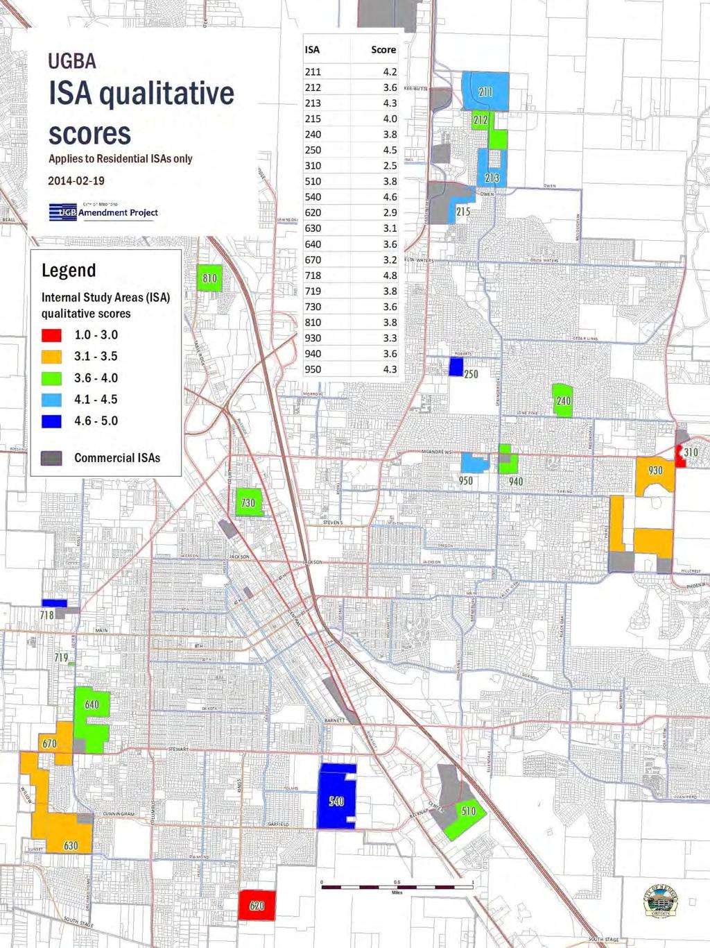
10 Page 6
11 SELECTION PROCESS Beginning with the qualitative scores, the top candidates for changes to higherdensity residential (such as ISAs 540 and 250) were retained and set aside. The bottom candidates were either dropped or pulled aside and closely examined to see if modifications made sense. The table of ISAs, their SAL equivalents, and the decision-making considerations follows below. Note that the qualitative scores pertain only to the residential parts (UM, UH) of the ISAs. There were no qualitative scoring criteria for the commercial (CM) parts. Also note that the column labeled Considerations incorporates scores, testimony, special notes, Planning Commission s recommendation, and City Council s decision. The Considerations are written in terms of the proposed amendment locations (PALs), but the identification numbers in selected amendment location (SAL) column reflect the Council s decision on the PAL recommendations. The maps of the SALs and the original ISA outlines are on pages ISA ID SAL ID Considerations scores, testimony, other analyses; final decisions a-cm 211 n/a Some lots along the eastern edge of this are already developed and some owners requested exclusion. The owner of a large part of this PAL supported the change. PC recommendation Retain as modified: delete some developed lots on eastern edge Council decision Accepted PC recommendation. A late-arriving request for the restoration of some of the excluded lots and an entirely new inclusion request was not granted. Qualitative score 4.2 This single large lot has the problem of low water pressure above a certain elevation, which on its own recommends a great reduction of the analyzed UH. In addition, the single owner is against any change, so it may be worthwhile to drop this from consideration entirely. PC recommendation delete Council decision Accepted PC recommendation a-um 212b-um Qualitative score 3.6 Finding a way to reduce the amount of UH in this area is complicated by its being on the edge of the urbanizable area, the location of Springbrook Road relative to that, a tier of single-family lots on its western edge (on Arrowhead Drive), and the shapes of the lots comprising ISA 212. Staff recommends a reduction of UH to a small area north and south of existing UR development to break up areas Page 7
12 ISA ID 213 SAL ID 213a-um 213b-um Considerations scores, testimony, other analyses; final decisions of UH, and introducing a patch of UM in the northwest remainder. PC recommendation Retain as modified: reduce area of UH and change part to UM Council decision Modified PC recommendation to change 212b to medium-density residential Qualitative score 4.3 Taking a cue from the landowner s vision for ISA 930, and testimony that supported the concept of building toward a higher-density designation, this area was reduced in extent and pulled away from direct adjacency to built UR neighborhoods. Its location on the future extension of Springbrook was retained. PC recommendation Retain as modified: reduce area of UH Council decision Modified PC recommendation to change 213a and 213b to medium-density residential. They rejected a request at the hearing to change to UM and expand the extent a-cm There was no opposition to this change. PC recommendation Retain as analyzed: CM Council decision Accepted PC recommendation a-ur 215b-cm 215c-uh Qualitative score 4.0 The UH score was high. It is located between the CM area and other UH to the east. There was no opposition to the CM change. UR is recommended at the northeast corner because the Owen Drive extension severed a lot and left a useless triangle of GI on the north side of the street. PC recommendation Retain as analyzed: CM, UR, UH Council decision Accepted PC recommendation a-cm There was no opposition to this change PC recommendation Retain as analyzed: CM Council decision Accepted PC recommendation n/a 217a-cm 217b-cm 217c-cm 217d-cm Inclusion request These four lots are largely vacant. The two north lots are UR and the south lots are GI. They lie immediately to the north of PAL 216a-cm. Their inclusion benefits the objective of this project. PC recommendation Include as proposed Page 8
13 ISA ID SAL ID Considerations scores, testimony, other analyses; final decisions Council decision Accepted PC recommendation 240 n/a a-um 310 n/a Qualitative score 3.8 Many of the property owners objected to a change from UR to UM, and the neighborhood was also opposed. Consultation with colleagues in the development division also revealed some of the problems inherent in the site that make development of any kind problematic; specifically, bridging the stream running across the southern end of the area to provide access to Lone Pine Road. Access and circulation constraints in an area already riddled with culde-sacs would not be helped by increased density. PC recommendation delete Council decision Accepted PC recommendation Qualitative score 4.5 The church that occupies the northern third of this lot may or may not develop the remainder, yet this PAL has the benefits of proximity to transit and adjacency to UH and North Medford H.S. PC recommendation Retain as analyzed: UM Special note The owner of this property has requested consideration for changing the recommendation to UH instead of UM. Council decision Adopted with designation changed to UH, Highdensity residential. Qualitative score 2.5 Analyzed for changes to UM and CM, the topographic and hydrologic constraints in this area became more apparent on closer examination. Most of the lots in this area are not very deep to begin with and are further constrained by steep slopes and canals. PC recommendation delete Council decision Accepted PC recommendation n/a 320a-cm Inclusion request Half of this lot has a CM GLUP. The proposal to is change the whole lot to CM. While its inclusion would achieve one goal increasing the amount of CM in the urban area the change would increase the deficit of UH land. The resulting conflict is of a relatively small scale. PC recommendation Include as proposed Council decision Accepted PC recommendation Page 9
14 ISA ID SAL ID 510a-cm 510b-uh 540a-cm 540b-um 540c-uh 540d-um Considerations scores, testimony, other analyses; final decisions Qualitative score 3.8 The piano-like shape of ISA 510 exactly covers a swatch of UR amid a blanket of CM, GI, and HI between the interstate and Highway 99. The construction of the new South Medford Interchange rerouted Garfield through this area. Despite its middling score due in large part to the parcelization along Charlotte Ann Road it would not do to retain this as UR. There was no opposition from this area and one letter of support. PC recommendation Retain Council decision Accepted PC recommendation Qualitative score 4.6 This area scored very well for residential. The northerly strip that was analyzed for conversion to UM from CM, however, appears to staff on reflection to be counter to the objective to find more CM land in the City. Staff therefore recommends removing it. Staff also changed its recommendation to include UH in the southern half of this area because of large reductions elsewhere. Also, an approval here would orphan some strips of UR land sandwiched between this ISA and the PS designation to the west. Staff recommends adding these to PAL (proposed amendment location) 540 with CM and UM designations. PC recommendation Retain as modified: change north UR strip to CM; remove UM from CM lot at north end; change part of UM to UH; add small lot at southwest as UM Council decision Accepted PC recommendation 620 n/a Qualitative score 2.9 The parcelization of this area, low score, and its lack of a CM component left it with little to recommend changing it to UM. Testimony highlighted the poor state of infrastructure in the area and lack of transit. PC recommendation delete Council decision Accepted PC recommendation a-uh 630b-um 630c-cm Qualitative score 3.1 Irregular parcelization and a middle-low score led staff to recommend retention only of the CM, part of the UM, and the addition of a few acres of UH on the future extension of Cunningham Willow. PC recommendation Retain as modified: reduce UM, retain CM, Page 10
15 ISA ID n/a 718 SAL ID 640a-um 640b-uh 640c-cm 670a-um 670b-uh 680a-cm 718a-uh 718b-cm Considerations scores, testimony, other analyses; final decisions add some UH Special Note The owners of most of 630a-uh and 630c-cm sent a request for exclusion in August (see Exhibit E). Council decision A property owner in 630a and 630c showed up to reverse his earlier request for exclusion and instead asked for a change to UH for the whole instead of CM on the eastern half. This eliminates 630c and extends 630a to cover the elimination. Qualitative score 3.6 A middling score and some letters of support in this area were balanced against the irregular parcelization, resulting in a recommendation to reduce some of the chopped up UM and retain the UH, although it should be noted that would put UH up against the backs of several UR lots fronting on Windward Drive. Staff also recommends extending the CM one lot eastward to capture an existing auto repair business. There were two letters of support from the vicinity. PC recommendation Retain as modified: reduction in CM and adjustment of CM Council decision Accepted PC recommendation Qualitative score 3.2 Irregular parcelization and a middle-low score led staff to recommend retention of the UH portions and reduction of the UM. Note that the addition of CM on the other corner (PAL 640c-cm) would increase the qualitative score for the UH. PC recommendation Retain as modified: reduce UM and retain UH Council decision Accepted PC recommendation Inclusion request In this request, the larger lot on the corner of Garfield Street and Kings Highway is vacant, the smaller lot has a house on it. Their inclusion would benefit the objective of this project. PC recommendation Include as proposed Council decision Accepted PC recommendation Qualitative score 4.8 The north lot scored the highest out of the ISA group. The owner requested changing the entire lot to UH instead of leaving out the panhandle. Page 11
16 ISA ID SAL ID Considerations scores, testimony, other analyses; final decisions The one negative factor here is that the property owner of the southern portion opposed the change from UR to CM. The reason staff recommended the change was so that there was not a pocket of UR trapped between CM on the south and UH on the north. PC recommendation Retain as analyzed with modification: include all of north UH lot and change south lot to CM Council decision Accepted PC recommendation 719 n/a a-um a-cm a-cm a-cm Qualitative score 3.8 This was a UM recommendation left over from the West Main TOD land-use plan. It is a single third-of-an-acre lot with two structures on it; inclusion does not appear to be logical on re-examination. PC recommendation delete Council decision Accepted PC recommendation Qualitative score 3.6 A change here would render little in the way of new UM capacity given that it is already developed, but the change may provide an incentive to redevelop aided perhaps by an urban renewal district with the power to assemble land for redevelopment. This area is too well situated to remain UR. There was one letter of support from an owner in the area. PC recommendation Retain as proposed Council decision Accepted PC recommendation The purpose of this PAL is to correct the GLUP so it matches the commercial zoning and uses. PC recommendation Retain as proposed Council decision Accepted PC recommendation The purpose of this PAL is to correct the GLUP so it matches the commercial zoning and uses. PC recommendation Retain as proposed Council decision Accepted PC recommendation The purpose of this PAL is to correct the GLUP so it matches the commercial zoning and uses. PC recommendation Retain as proposed Council decision Accepted PC recommendation Page 12
17 ISA ID SAL ID Considerations scores, testimony, other analyses; final decisions 810 n/a Qualitative score 3.8 Although parcelized, a large part of this is classified redevelopable or partially developed. Leaving select parts out would create small insinuations of UR into a solid block of UH on the north and south. Its only real deficit is the parcelization; all the other factors score very well for this area. There were no objections from this vicinity. PC recommendation Retain as proposed Council decision The Council believed this had the effect of concentrating high density in one area to its potential detriment. Deleted a-um 930b-cm 930c-um 930d-cm 940a-cm 940b-um Qualitative score 3.3 Despite a middle-low score, the opportunity for a mixed-use area of CM and UM (which would increase its score), plus the willingness of the land owners to work toward a solution, recommended this area for retention. PC recommendation recommend land owner s modified suggestion of approximately 11 acres of UM (in two spots) and approximately 13 acres of CM (in two spots) in the southeastern corner at Hillcrest and Foothill Roads. Council decision Accepted PC recommendation Qualitative score 3.6 Much of the attraction of this area stems from the opportunity to introduce CM into an area that lacks commercial within anything but automobile distance, but review of the south lot makes the slope on it less suitable for CM designation; therefore, staff proposes moving the CM to the north lot and reducing the UM on the south half to allow UR to build toward the higher density. PC recommendation Retain as modified: shift CM to north lot and reduce UM to smaller area at the northwest corner of the south lot Special Note Circumstances have changed for the lot at 940b-um since the 3/13 PC recommendation; the lot has had an ownerinitiated GLUP change to Service Commercial in June (Ord. no ; file no. CPA ). Staff cannot change the Planning Commission s recommendation, but advises that 940b-um may be better dropped from further consideration. Council decision Accepted PC recommendation as modified by the removal of 940b-um. Page 13
18 ISA ID SAL ID Considerations scores, testimony, other analyses; final decisions 950 n/a Qualitative score 4.3 This scored well, but the irregular shape of the analyzed lot would introduce UM adjacent to a number of backyards. Following the principle of building toward the higher-density designation, staff recommends reduction of the area to the northwest third. PC recommendation Retain as modified: reduce UM Council decision Deleted. n/a n/a 960a-sc 970a-cm Inclusion request Applicant requests a change on parts of two lots from UH to SC. While the loss of UH is counter to the objective of this project, the current use of this lot as a school means that it is not available for its primary purpose anyway. The resulting conflict is of relatively small scale. PC recommendation Include as proposed Council decision Accepted PC recommendation Inclusion suggestion While answering a front counter question staff discovered six lots that have discrepant GLUP and zoning. Senior Planner Kelly Akin suggested in a memo adding them as a correction PAL (see Exhibit E). Council decision Accepted staff recommendation Maps begin on the following page. They depict the City Council s final decision on each area. Page 14

.")

19 MAPS SELECTED AMENDMENT LOCATIONS Map 1 SAL 140 North The maps on this and the following pages show the adopted areas (solid colors, white-on-black ID numbers) and deleted or modified areas (hatched colors, gray-onwhite ID numbers). The paler background colors are the surrounding GLUP designations. Legend SALs Adopted GLUP CM SC UH UM UR ISAs Original ISA outlines CM UH UM UR Page 15

20 Map 2 SALs North-Northwest Legend SALs Adopted GLUP CM SC UH UM UR ISAs Original ISA outlines CM UH UM UR Page 16

21 Map 3 SALs 250, 940 East Central Legend SALs Adopted GLUP CM SC UH UM UR ISAs Original ISA outlines CM UH UM UR Page 17

22 Map 4 SALs East Central Legend SALs Adopted GLUP CM SC UH UM UR ISAs Original ISA outlines CM UH UM UR Page 18

23 Map 5 SALs 320 and 930 East Legend SALs Adopted GLUP CM SC UH UM UR ISAs Original ISA outlines CM UH UM UR Page 19

24 Map 6 SAL 510 South Central Legend SALs Adopted GLUP CM SC UH UM UR ISAs Original ISA outlines CM UH UM UR Page 20

25 Map 7 SALs 540 and 680 South-Southwest Legend SALs Adopted GLUP CM SC UH UM UR ISAs Original ISA outlines CM UH UM UR Page 21

26 Map 8 SAL 630 Southwest Legend SALs Adopted GLUP CM SC UH UM UR ISAs Original ISA outlines CM UH UM UR Page 22

27 Map 9 SALs 640 and 670 West-Southwest Legend SALs Adopted GLUP CM SC UH UM UR ISAs Original ISA outlines CM UH UM UR Page 23

28 Map 10 SAL 718 West Legend SALs Adopted GLUP CM SC UH UM UR ISAs Original ISA outlines CM UH UM UR Page 24

29 Map 11 SALs West Central Legend SALs Adopted GLUP CM SC UH UM UR ISAs Original ISA outlines CM UH UM UR Page 25

30 Map 12 SALs 730, 740, and 760 West Central Legend SALs Adopted GLUP CM SC UH UM UR ISAs Original ISA outlines CM UH UM UR Page 26

31 Map 13 PAL 810 (deleted) Northwest Legend SALs Adopted GLUP CM SC UH UM UR ISAs Original ISA outlines CM UH UM UR Page 27
32 SAL TABLE Selected Amendment Location data Note: the figures include adjacent rights-of-way, so the SALs as shown below are larger than just the lots comprising them. SAL no. Acres Existing GLUP Amended GLUP PAL no. Acres Existing GLUP Amended GLUP 140 a-cm 85.9 HI CM 640 a-um 15.7 UR UM 212 a-um 9.2 UR UM 640 b-uh 14.5 UR UH 212 b-um 5.0 UR UM 640 c-cm 7.2 UR CM 213 a-um 2.6 UR UM 670 a-um 2.2 UR UM 213 b-um 4.1 UR UM 670 b-uh 8.3 UR UH 214 a-cm 8.5 GI CM 680 a-cm 4.4 UR CM 215 a-ur 1.1 GI UR 718 a-uh 6.4 UR UH 215 b-cm 33.2 GI CM 718 b-cm 5.1 UR CM 215 c-uh 8.6 GI UH 730 a-um 19.4 UR UM 216 a-cm 11.8 GI CM 740 a-cm 1.2 UH CM 217 a-cm 3.7 UR CM 750 a-cm 11.5 HI CM 217 b-cm 2.0 UR CM 760 a-cm 4.9 HI CM 217 c-cm 6.6 GI CM 930 a-um 5.8 UR UM 217 d-cm 3.6 GI CM 930 b-cm 10.9 UR CM 250 a-uh 7.1 UR UH 930 c-um 7.9 UR UM 320 a-cm 4.9 UH CM 930 d-cm 5.2 UR CM 510 a-cm 37.9 UR CM 940 a-cm 3.0 UR CM 510 b-uh 23.1 UR UH 960 a-sc 2.9 UH SC 540 a-cm 1.3 UR CM 970 a-cm 1.3 UR CM 540 b-um 28.3 UR UM 540 c-uh 27.4 UR UH 540 d-um 2.4 UR UM 630 a-uh 8.5 UR UH 630 b-um 30.4 UR UM Page 28
33 SECTION 3. FINDINGS Authority: This action is a Class A legislative Comprehensive Plan Amendment. The Planning Commission is authorized to recommend, and the City Council to approve, amendments to the Comprehensive Plan under Medford Municipal Code, sections , , , , , and Review Criteria: Medford Municipal Code (1) refers to the criteria in the Review and Amendments section of the Comprehensive Plan for amendments to map designations. Post-City Council hearing note: These findings apply to the concept of changing the designations. Because the Council approved the concept, these findings remain unchanged from the Planning Commission s adopted recommendation. The terms proposed amendment location and PAL should be understood to apply to the selected amendment locations and SALs equivalently. APPROVAL CRITERIA COMPLIANCE Comprehensive Plan Review and Amendments section: Map designation amendments shall be based on [criteria 1 7, as follow]: Criterion 1. Strategy. A significant change in one or more Goal, Policy, or Implementation Findings There are many existing goals, policies, and implementation measures that support the concept of utilizing existing urban area more efficiently. 2 Implementation measure 1-5-b in the Economic Element of the Comprehensive Plan recommends Reduc[ing] projected deficits in employment lands by changing GLUP Map designations within the existing Urban Growth Boundary. And implementation measure 3- A in the Housing Element recommends Assess[ing] policies, regulations, and standards affecting residential development and pursue amendments as needed to meet Policy 3. Consider actions such as: (a) upzoning buildable land to medium and high density residential. The recently adopted Regional Plan Element specifically requires participating cities to increase their housing density. It contains implementation strategies (called performance indicators in the Regional Plan) that require and encourage the efficient use of existing urban area to meet 20-year land needs. Conclusions 2 This is covered in detail under Criterion no. 6, below. Page 29
34 This amendment is not based on a significant change to any goal, policy, or implementation strategy. The City of Medford, as all cities in Oregon, continues to have a goal of providing land to accommodate its 20-year land need for housing and employment, as required under Oregon Revised Statute (ORS) , and in particular subsection (6), which recommends addressing the need by expanding the urban growth boundary, by increasing the developable capacity of the urban area, or by a combination of the two. Criterion 2. Demonstrated need for the change to accommodate unpredicted population trends, to satisfy urban housing needs, or to assure adequate employment opportunities. Findings Economic Element The Economic Element 3 projects employment land need for 2008 through 2028 in the following categories and quantities: Table 2.1. Employment Land Need (adapted from Figure 28 in the Economic Element) Type Need, in gross acres 4 Service Commercial (office)... (290) Industrial ) Commercial... (278) Other... (354) Total... (709) The Other category is described in the Economic Element as overnight lodging and special uses, such as campus-type development. For the purposes of identifying land uses, however, the City has four employment designations, CM, SC, GI, and HI. Since the Other acres need to be put into a category, and since the Economic Element did not do so, it is necessary to distribute those acres. Since about 9/10 of the other category is described as campus-type development, and since that type of development would only be a permitted use in the Industrial and the Service Commercial categories, a two-way partition (126 acres each) into those would result in a redistribution. The other 31 net acres in the Other category are for overnight lodging; that can be placed in the CM category. However, the Commercial zoning districts all allow office uses in them, so the large deficit of small office site 3 Adopted December 4, Gross acreage figures were derived by staff from guidance in the paragraph following Figure 28. Page 30
35 need identified in Figure 28 of the Economic Element should be transferred into the Commercial category. These changes result in a revised table 2.1: Table 2.1. revised Employment Land Need (adapted from Figure 28 in the Economic Element) Type Need, in gross acres Service Commercial (office)... (225) Industrial... 55) Commercial... (538) Other... ) Total... (709) Although there is a 700-acre need for employment land, there is actually a 55-acre surplus of industrial land overall. Some of that surplus is under consideration for conversion to Commercial designation. However, note in Table 2.2, below, that the City will need 19 small industrial sites (ranging up to six acres, but typically about 1.5 acres) totaling 76 acres (Table 2.3) over the next 20 years. Table 2.2. Industrial Land Need demand, supply, and balance by number of sites (adapted from Figure 27 in the Economic Element) Size/type [typical acreage Large 30 Medium 6 Small 1.5] Total Demand no. of sites (4) (25) (135) (164) Supply vacant redevelopment Balance no. of sites (19) 27 Table 2.3. Industrial Land Need demand, supply, and balance by acres (adapted from Figure 28 in the Economic Element) Size/type [typical acreage Large 30 Medium 6 Small 1.5] Total Demand net acres (121) (148) (202) (471) Supply vacant redevelopment Balance net acres (61) 170 gross acres (76) 213 Page 31
36 Sixteen of the industrial-to-commercial PAL lots are less than six acres in size. If all were changed, the small-site deficit would increase to thirty-five sites and 92 net acres. As concluded below, the exchange is equitable because of greater need and because the surplus of large industrial lots can be broken into smaller lots. The fifth conclusion of the Employment Land Demand and Supply Conclusions in the Economic Element notes that the strong distinction between commercial and industrial designations has become less appropriate as the distribution of firm activities has shifted over time and a greater mix of commercial and industrial activities are found within individual firm[s ] operations, suggesting that some commercial districts can be amended to include some of what are traditionally considered manufactory activities. The Housing Element 5 projects housing land need for 2009 through 2029 in the following categories and quantities: Table 2.4. Housing Land Need Before adding capacity in extant UGB (adapted from Table 37 in the Housing Element) Type No. of new DUs Percent Density Need of need DUs/gross acre in gross acres Single-family detached (9,034) 60% 4.5 (2,002) Mfd. in parks (395) 3% 6.0 (66) Single-family attached (384) 3% 11.0 (36) Duplex (651) 4% 12.3 (54) Multi-unit (4,586) 30% 20.3 (226) Totals (15,050) (average) 6.3 (2,383) Table 2.5. Housing Land Need With capacity in extant UGB (adapted from Tables 39 and 41 in the Housing Element) Plan Designation Need Capacity Surplus/(Deficit) Need in dwelling units in dwelling units in dwelling units in gross acres UR (10,036) 7,803 (2,233) (465) UM (993) 495 (498) (39) UH (3,329) 2,435 (894) (49) CM (692) 691 (1) Group Quarters (16) Public/Semi-public land (426) 5 Adopted December 2, 2010 Page 32
37 Totals (15,050) 11,424 3,626 (996) As of 2009 the City had enough land to supply three quarters of the 20-year housing need ( ), leaving a remaining need of nearly 1,000 acres. Goal 14 states prior to expanding an urban growth boundary, local governments shall demonstrate that needs cannot reasonably be accommodated on land already inside the urban growth boundary, and Oregon Revised Statute (ORS) (6) states that when there is a need for whatever category of land-use type, a city should expand its boundaries, increase its capacity, or do a combination of both. The internal study areas were conceived as the means to increase the capacity of the existing urban area. In order to express the land need in terms of the three residential GLUP categories, the 426 acres of Public and semi-public land need to be assigned to one or more of them; a proportional distribution is appropriate: 84% to UR, 7% to UM, and 9% to UH 6. Group Quarters also need to be assigned to GLUP categories. Since the larger group quarters are allowed only in the MFR-15 through MFR-30 zoning districts, it is reasonable to distribute them largely to the UM and UH categories, which correspond to those zoning districts: 20 percent of the 16 acres was distributed to the UR category, and 40 percent to each of the other two. Table 2.6 shows the totals after the allocations. Table 2.6. Housing Land Need Distributed into the three residential GLUP designations (adapted from Table 2.5, above) Plan Designation Need in gross acres UR (826) UM (75) UH (93) Total (996) Conclusions Since there is a demonstrated need for employment land, seeking a means to increase the development capacity of the urban area by changing excess industrial land into needed commercial land is a rational response to that need. Although there is already a deficit in the small lot category of industrial land that would be increased by the industrial-to-commercial PALs, there are enough large industrial lots that can be subdivided into smaller lots as market conditions demand it. Given the greater need for commercial land, the exchange is justifiable. In addi- 6 For example, UR proportion = 465/( ) Page 33
38 tion, there are use changes that can be considered that would make small industrial uses viable in commercial zoning districts; the Economic Element contained a similar recommendation. Since there is a demonstrated need for housing land, seeking a means to increase the development capacity of the urban area by changing the designations to allow more dwelling units per acre is a rational response to that need. With a quantifiable need for both employment and residential land, ORS (6) requires the City to accommodate the need by either intensifying within the current urban area, expanding the urban area, or a combination of both. While the City has the option of expanding the urban area without intensifying to accommodate future land needs, both the State and City policies strongly support utilizing land more efficiently within the urban area (as outlined under Criterion 1). As a result, the City has chosen to consider intensification prior to expansion as a first step toward satisfying projected housing and employment land need. Criterion 3. The orderly and economic provision of key public facilities. Findings In nearly all cases water and sewer utilities are available to the sites and can handle the changes without upgrading the facilities. For some areas an upgrade is necessary. Notably, the same finding would be true if the PALs were not considered and all the land need were satisfied through an urban growth boundary expansion. Transportation is the most visible public facility because most people interact with it directly daily. A grant-funded study of impacts to the transportation system found that, if all ISAs were approved and built out, it would lead to failures of several intersections throughout the City in 2028, the analysis year for the study. It is worth noting that the analysis placed the forecasted 2028 population entirely within the existing urban area, so whether that population is inside or on new lands that have been brought into the urban growth boundary, it is the same population figure for both. Although the ISA traffic analysis shows many failures, it is a reasonable assumption that many of the same failures, or a similar number of failures, would result from a non-isa scenario; that is, some part of the future population will be located in land that is added to the urban area through a boundary expansion. It is also important to note that the various analyses were performed assuming that all the internal study areas had developed to their full potential. Since the PAL potential is less than the ISAs, the number and degree of impacts will be much less. In fact, any single PAL might be rezoned without seriously impacting any facilities; there are probably a few where that would easily be true. It remains for the full UGB Page 34
39 amendment internal plus expansion to determine the transportation facility needs. Note that the study examined the ISAs, not the PALs. The difference between the two is very large (3,400 dwelling units versus 1,600), so the results of the analysis are not valid for estimating transportation impacts. Conclusions An urban growth boundary expansion would require both extension of services and downstream upgrades to handle the additional demand. Intensification in the existing urban area would only require some upgrades. From this it is clear that utilizing existing facilities to serve a portion of the City s 20-year land need is less expensive than extending facilities to serve the same group on virgin land further out. There is also a long-term fiscal advantage in that there will be fewer miles of water and sewer lines for the City to maintain. Therefore, intensification within the current urban area is a more orderly and economical way to provide key public facilities to serve the projected population than expanding the urban area. The Transportation System Plan as well as all the other master plans for key public facilities will be updated as part of the entire UGB amendment before being acknowledged by the State or prior to annexation. Criterion 4. Maximum efficiency of land uses within the current urbanizable area Findings The purpose of this project was to find locations were the development capacity of the existing urban area 7 could be increased by changing the General Plan classification. The capacity of the current urban area is 11,400 dwelling units. If all the residential PALs were approved it could add a significant number of dwelling units to the current urban area s capacity. Additionally, converting unneeded industrial land to commercial will decrease the need to expand the urban area. Conclusions The primary purpose of this amendment is to provide maximum efficiency of land uses within the current urban area prior to considering expansion of it to meet the projected land need. Changing the GLUP designation from a surplus type to a deficit type on vacant land in the existing urban area is an increase in the efficiency of that land. 7 Urban area is defined in OAR (10) as the land within a UGB. Page 35
40 Criterion 5. Environmental, energy, economic and social consequences The general findings and conclusions for the proposed amendment locations follow. Particular considerations from which the PALs were derived from the original set of ISAs are documented above, under Recommendation & PAL Selection Process. 8 Findings Environmental The study areas, being inside the UGB, have already met the test concerning environmental impacts; change of designation does not affect suitability for urbanization. A few PALs have wetlands and floodplains. Those areas are considered presently suited for development regardless of such factors. In a no-change scenario these areas will have such protections as required by code and have such impacts as have already been accounted for by their inclusion in the urban area. Any PAL change will still have the protections required by code and have impacts similar to what would be expected under current GLUP designations. Conclusions Environmental For any of the PALs it can be concluded that there will be no adverse environmental effect because none of these study areas is new to the urban area; most have been within the urban growth boundary either since its establishment in the late 70s or the last amendment in 1990, which means the decision to urbanize was made decades ago and these areas have been legally committed to eventual development ever since. A change to the use or density is not a matter for environmental consideration after land has already been committed to development. In addition, most sensitive areas, especially those with steep slopes, were dismissed from consideration for intensification early in the selection process. Findings Energy Several PALs on their own or in combination with nearby mixed land-use areas with higher densities and commercial land could be part of intensive commercial residential nodes. This type of development encourages the use of travel modes other than driving, leading to a reduction in vehicle miles travelled. No change to the area would confer no energy benefits, and may, in fact, be more energy consumptive since the need would be placed outside the current urban area, leading to more vehicle miles travelled. Conclusions Energy The fact that many needed houses and jobs would be efficiently contained in the current urban area would have generally positive energy consequences due to the increased possibility of non-motorized travel modes between trip generators and 8 Updated reference: Recommendation & SAL Selection Process Page 36
41 decreasing overall vehicle miles travelled (VMT). Reid Ewing, a transportation planning researcher and professor at the University of Utah, looked at all the available evidence and concluded that sprawling communities that require car trips to meet most daily needs exhibit 20 40% higher VMT than more compact, mixed-used, and walkable neighborhoods. 9 And as noted in an online edition of The Atlantic magazine 10 : We [the US] continue to lead advanced economies in per-capita carbon emissions, 28 percent of which come from transportation. But even if the crunchy granola argument isn't good enough to make you see the benefits of public transit, consider that trains, trams, buses, and the like reduces traffic congestion, which is good for the life satisfaction of everybody behind the wheel, since science shows long commutes make us unhappy. 11 Findings Economic The changes would generally provide more residential density in areas that could take advantage of the proximity of jobs, shopping, and services. Likewise, the increases in commercial land are intended to take advantage of underserved areas. In conjunction with other PALs, many of the study areas could be part of intensive commercial residential nodes. Increasing the capacity of the existing urban area will help slow the extension of streets and other utilities which require maintenance expenditures over their lifetimes. No change would displace the housing and commercial needs to locations outside the current boundary, meaning longer extensions of streets and utilities and greater long-term maintenance costs. There would also be cumulative increases in trip lengths, increased congestion (with less recourse to other transportation choices), and air quality degradation. Conclusions Economic Although there are positive and negative economic effects, the overall effect is a little better than neutral. There is some potential for conflict between commercial and industrial zoning, but those are addressed by development code provisions, such as buffering. For both employment and residential study areas there will be collective benefits in reduced VMT and reduced road construction and maintenance costs. 9 Excerpt from website « (retrieved ), summarizing information from Ewing s book titled Growing Cooler: The Evidence on Urban Development and Climate Change. Chicago: Urban Land Institute, Excerpted from « utterly-entrancing-gif/281615/» (retrieved ) 11 For reference to commuting studies see « Page 37
42 Findings Social The changes would provide needed housing types within the existing urban area; many of the study areas are close to schools, other high-density residential, and transit. No change would push the needs elsewhere, which could include areas further out from goods and services, requiring further travel and a limited choice of travel modes. Many of the PALs, if approved, also would result in a greater spatial distribution of high- and medium-density areas into relatively small pockets closer to the city center. A no-change scenario would require placing the needed higher densities in the urban reserve, with little chance that high-enough densities would make it worthwhile to extend or reroute transit services. For the PALs aimed at increasing residential densities, the low-density home owners in the vicinity may perceive a threat to property values or social character, an incompatible built environment, and increased traffic. Traffic volumes and property values are mensurable, neighborhood character is not; of these factors the former are verifiable and the latter is a matter of individual taste. These will be treated individually. Traffic. That traffic volumes would be higher in the vicinity of PALs that change from low density to a greater density is undeniable. The benefits would be felt only across a larger area, where there would be a reduction in motor vehicle miles traveled. The distribution of burden always has imbalanced effects, but a fairer distribution lessens the impacts in the areas that take on more burden. Property Value. Various studies 12 indicate that medium- or high-density residential development does not inherently lower the value of low-density property nearby, and quite often a well-designed and well-managed development can revitalize a neighborhood and lead to increased property values. The City can facilitate this outcome by developing design standards geared toward better integration of a range of densities. Compatibility. Having a set of design/performance standards would make new development at higher densities more compatible with their neighborhoods. This idea is found in the Comprehensive Plan and has been advocated by some City Councillors. Impacts are sensitive to scale and location, which is why the Planning Commission and staff developed the set of qualitative screening criteria to identify which resi- 12 For example: Ellen, I. G., Schwartz, A. E., Voicu, I. and Schill, M. H. (2007), Does federally subsidized rental housing depress neighborhood property values?. J. Pol. Anal. Manage., 26: doi: /pam Page 38
43 dential ISAs have qualities that support the changes. These criteria aided in the development of the PALs: Parcelization Development projects work better when there is more area to work with. If a development lot is too small, the resulting multi-family project will consist of a building surrounded by parking lot. In order to create a project that is more pleasant for inhabitants and neighbors, a larger area is superior. Proximity to elementary schools, grocery stores, and transit routes Size and Mix These three tests measure quality-of-life factors that both relieve pressure on the transportation system and provide more choices of nearby goods and services to higher concentrations of residents. This test considers the texture of the surrounding quarter mile fringe for residential ISAs that (1) were analyzed for conversion to UH and (2) are less than 15 acres. For these UH-conversion ISA lots staff calculated the total percentage of non-ur-designated lands that are within a quarter-mile periphery of them. The idea is that a strong mix of different land use types in an ISA s vicinity is more conducive to change; therefore, the greater the percentage of different GLUPs, the higher the score was. The proximity test was not weighted as heavily as the others because spatially mixed land uses are not necessarily bad. Thus, the worst possible score for that metric is a 2 and the greatest possible score is a 4. A similar test was not needed for new UM sites since, from a density standpoint, UM is considered compatible with UR/single-family houses. Corollary to this is a recommended policy for areas that are converted to UH and are larger than 15 acres, which are not as likely to fully develop all at once and perhaps never fully develop given their size. To overcome this and to integrate them better into their surroundings, staff suggests that for sites larger than 15 acres a ratio of total multi-family acreage to total singlefamily acreage should be considered as a policy directive. The Housing Element suggests a single-family-to-multifamily ratio of 65:35, so this provides some reasonable guidance. For example, the City could require that areas over 15 acres include a mix of housing densities that aim for an overall single-family-to-multi-family ratio between 55:45 and 70:30. These tests were not intended to be conclusive, but instead be a guide for the decision makers to weigh in conjunction with all the factors. A high score for an ISA means that there are several factors favorable to the change, but a deeper understanding gained through public testimony revealed further details that diminished support for some of the areas. Page 39
44 Finally, the Housing Element describes a gap in the range of affordable home choices for working families. For those households earning less than Medford s median family income (MFI), there is a deficit of 4,456 homes in the affordable range, and even for households earning up to 140% MFI there is a deficit of 1,322 homes 13. The variety and supply of home choices can only be increased by increasing the supply of land suitable for those choices. The only GLUP designation that allows the MFR- 15 zoning district is Medium-Density Urban Residential (UM). The City currently has 66 acres with UM designation, which is about half a percent of the total Residential GLUP acreage in the City (see Table 5.1); there is very little market opportunity, therefore, for ownership of the types of homes that would help fill that affordability gap. Table 5.1. Acreages of each GLUP designation in Medford Source: Medford Geographic Information Systems (GIS), December 2013 GLUP designation Acres Percent of total Residential A Airport 731 CC City Center 165 CM Commercial 1,748 GI General Industrial 1,650 HI Heavy Industrial 1,304 PS Parks/Schools 1,078 SC Svc Commercial 396 UH Residential high density % UM Residential medium density % UR Residential low density 10, % total acres 18,074 Conclusions Social The social consequences of the changes are especially complex for PALs that propose to increase residential density. Neighborhoods near such PALs fear that traffic will increase, their property values will depress, and the density and architectural character of higher-density housing types will be incompatible with single-family homes. It is likely that traffic would be greater than if an area were to develop according to their present densities; on the other hand, traffic will increase citywide anyway within the planning horizon as the population grows. The fewer PALs that are approved, more and longer trips will be the result. 13 Calculated from Table 25, Housing Element, p. 44. Page 40
45 It is not empirically true in all instances that multi-family development will depress nearby home prices. But because the popular understanding is that this is always the case, staff suggests it would be constructive to develop ways to better ensure that multi-family development is spatial and architecturally compatible with adjacent single-family neighborhoods, such as through design standards. Additionally, the housing affordability gap is a social equity problem that can be addressed by converting more areas to higher densities. The City has a unique opportunity to expand its amount of Medium-Density Urban Residential (UM), the only GLUP designation that allows the MFR-15 zoning district. Conclusions overall On balance the environmental, economic, social, and energy consequences of the changes would be positive. Changing designations and clustering of densities and uses to utilize existing urbanizable land for a proven need is a more efficient urban form than sprawl, which necessitates a wider and more rapid extension of streets and utilities, putting a fiscal burden on the City for their continued maintenance and replacement. There are generally positive social and energy effects from increasing density and mixing uses. The environmental impact is not different from leaving the GLUP designation as it is. The economic effect is positive fiscally for the City and positive for households financially because it increases the supply of land for higherdensity housing. The economic impact is positive fiscally for the City because it increases the supply of land for commercial uses, and reduces the number of miles of street and transmission lines that need to be maintained. Criterion 6. Compatibility of the proposed change with other elements of the City Comprehensive Plan Findings Supportive. The following goals, policies, and implementation measures from the various elements of the Comprehensive Plan support the concept of intensifying land uses within the current urban area prior to expanding: Environment [Natural Resources] Air Quality Policy 3-B: The City of Medford shall continue to require a wellconnected circulation system and promote other techniques that foster alternative modes of transportation, such as pedestrian oriented mixed-use development and a linked bicycle transportation system. Soil Goal 9: To assure that future urban growth in Medford occurs in a compact manner that minimizes the consumption of land, including class I through IV agricultural land. Page 41
46 Energy Goal 10: To assure that urban land use activities are planned, located, and constructed in a manner that maximizes energy efficiency. Policy 10-A: The City of Medford shall plan and approve growth and development with consideration to energy efficient patterns of development, utilizing existing capital infrastructure whenever possible, and incorporating compact and urban centered growth concepts. Economy Policy 1-5: The City of Medford shall assure that adequate commercial and industrial lands are available to accommodate the types and amount of economic development needed to support the anticipated growth in employment in the City of Medford and the region. Implementation 1-5-b. Reduce projected deficits in employment lands by changing GLUP Map designations within the existing Urban Growth Boundary. Policy 1-8: The City shall balance the efficient use of public facilities, the conservation of limited land resources, the maintenance of air and water quality and compatibility with surrounding land uses. Housing Policy 2: The City of Medford shall designate areas for residential development that are or will be conveniently located close to pedestrian, bicycle, and transit or high capacity transportation routes, community facilities and services, and employment to ensure that the benefits of public investment in those facilities are available to as many households as possible. Implementation 2-A: Pursue amendments as needed to achieve transitsupportive density near current and future transit streets, especially where parks or schools are present. Policy 3: In planning for needed housing, the City of Medford shall strive to provide a compact urban form that allows efficient use of public facilities and protects adjacent resource lands. Implementation 3-A: Assess policies, regulations, and standards affecting residential development and pursue amendments as needed to meet Policy 3. Consider actions such as: (a) Upzoning buildable land to medium and high density residential; Transportation Public Transportation Implementation measure 3-B-4. Assure that land use planning activities promote transit service viability and accessibility, includ- Page 42
47 ing locating mixed residential-commercial, multiple-family residential, and employment land uses on or near (within ¼-mile walking distance) transit corridors. Policy 3-C: The City of Medford shall undertake efforts to increase the percentage of dwelling units in the Medford planning area located within onequarter mile walking distance of transit routes, consistent with the target benchmarks in the Alternative Measures of the Rogue Valley Regional Transportation Plan (RTP). [Transportation and land use] Goal 8: To maximize the efficiency of Medford s transportation system through effective land use planning. Policy 8-A: The City of Medford shall facilitate development or redevelopment on sites located where best supported by the overall transportation system that reduces motor vehicle dependency by promoting walking, bicycling and transit use. This includes altering land use patterns through changes to type, density, and design. Implementation Measure 8-A-1. Through revisions to the Medford Comprehensive Plan and Land Development Code, provide opportunities for increasing residential and employment density in locations that support increased use of alternative travel modes, such as along transit corridors. Policy 8-B: The City of Medford shall undertake efforts to increase the percentage of dwelling units and employment located in Medford s adopted Transit Oriented Districts (TODs), consistent with the targeted benchmarks in the Alternative Measures of the Rogue Valley Regional Transportation Plan (RTP). Implementation Measure 8-B-1. Through revisions to the Medford Comprehensive Plan and Land Development Code, pursue changes to planned land uses to concentrate employment, commercial, and high density residential land uses in Transit Oriented Districts (TODs). Regional Plan Goal 1: Manage future regional growth for the greater public good. Guiding policies: c. The Region s overall urban housing density shall be increased to provide for more efficient land utilization. [ ] Page 43
48 Performance indicators (i.e., implementation measures) 5. Committed Residential Density. Land within an urban reserve and land currently within an Urban Growth Boundary (UGB) but outside of the existing City Limit shall be built, at a minimum, to the following residential densities. This requirement can be offset by increasing the residential density in the city limit. City Dwelling units per gross acre Central Point Eagle Point Medford Phoenix Talent Mixed-Use/Pedestrian-Friendly Areas. For land within an urban reserve and for land currently within a UGB but outside of the existing City Limit, each city shall achieve the 2020 benchmark targets for the number of dwelling units (Alternative Measure no. 5) and employment (Alternative Measure no. 6) in mixed-use/pedestrian-friendly areas as established in the 2009 Regional Transportation Plan (RTP) or most recently adopted RTP. Beyond the year 2020, cities shall continue to achieve the 2020 benchmark targets, or if additional benchmark years are established, cities shall achieve the targets corresponding with the applicable benchmarks. Measurement and definition of qualified development shall be in accordance with adopted RTP methodology. The requirement is considered met if the city or the region overall is achieving the targets or minimum qualifications, whichever is greater. This requirement can be offset by increasing the percentage of dwelling units and/or employment in the City Limit. This requirement is applicable to all participating cities. Neutral. The following goals, policies, and implementation measures neither support nor oppose the PALs, but require a response: Economy, Policy 1-3: The City of Medford shall, as appropriate under the Goal above, support the retention and expansion of existing businesses. [ ] Implementation measure 1-3-b. When evaluating GLUP Map amendments, assess the potential impacts of those amendments on neighboring land uses. General but not relevant. Several goals, policies, and implementation measures appear to implicate the PALs. A few examples follow: Public Facilities Page 44
49 Conclusions Policy 1-A: The City of Medford shall provide, where feasible and as sufficient funds are available from public or private sources, the following facilities and services at levels appropriate for all land use types within the City: Water Service, Goal 1: To provide the City of Medford with high quality domestic water for consumption and fire protection, consistent with state, federal and industry standards. Sanitary Sewage Collection, Goal 1: To provide appropriate sanitary sewage collection facilities to serve the Medford Urban Growth Boundary. Sanitary Sewage Treatment, Goal 1: To provide appropriate sanitary sewage treatment facilities to serve the Medford Urban Growth Boundary. Transportation Goal 1: To provide a multi-modal transportation system for the Medford planning area that supports the safe, efficient, and accessible movement of all people and goods, and recognizes the area s role as the financial, medical, tourism, and business hub of Southern Oregon and Northern California. Numerous goals, policies, and implementation measures in the Comprehensive Plan point toward some variation on compact development: pedestrian-oriented, mixeduse development; activity centers; growth in a compact manner; incorporating compact and urban centered growth concepts. Another pervasive theme among the goals and policies is efficiency: maximiz[ing] energy efficiency; utilization of existing capital infrastructure; the efficient use of public facilities; ensuring that the benefits of public investment in those facilities are available to as many households as possible; the efficient use of public facilities. In several cases there is explicit direction to change land use designations: altering land use patterns through changes to type, density, and design; [r]educe projected deficits in employment lands by changing GLUP Map designations; increasing the residential density in the city limit; [p]ursue amendments as needed to achieve transit-supportive density near current and future transit streets; Upzoning buildable land to medium and high density residential; Through revisions to the Medford Comprehensive Plan provide opportunities for increasing residential and employment density pursue changes to planned land uses to concentrate employment, commercial, and high density residential land uses. Implementation measure 1-3-b from the Economic Element requires an analysis of the potential impacts of map changes on neighboring uses. The findings and con- Page 45
50 clusions under criterion 5, the environmental, energy, economic and social consequences of a given map amendment, serve as responses to this measure. The few examples provided of goals, policies, and implementation measures that appear to implicate the PAL project are actually general in scope and intent; or are goals, policies, and measures related to growth of any stripe, and therefore are valid with or without the PAL project. To illustrate: the goal to provide high quality domestic water for consumption and fire protection is not contingent on whether the urban area amendment is accomplished through boundary expansion, intensification of the existing urban area, or a combination of both. The same conclusion is made for any goals, policies, and implementation measures of a similar nature. Criterion 7. All applicable Statewide Planning Goals The following demonstrate conformity with the applicable Statewide Planning Goals. Goal 1 Citizen Involvement Findings Goal 1 requires the City to have a citizen involvement program that sets the procedures by which affected citizens will be involved in the land use decision process, including participation in the quasi-judicial revision of the Comprehensive Plan. Goal 1 requires provision of the opportunity to review proposed amendments prior to a public hearing, and recommendations must be retained and receive a response from policy-makers. The rationale used to reach land use decisions must be available in the written record. The City of Medford has an established citizeninvolvement program consistent with Goal 1 that includes review of proposed Comprehensive Plan amendments by the Planning Commission and City Council. Affected agencies and departments are also invited to review and comment on such proposals, and hearing notices are published in the local newspaper, and posted on the site. This process has been adhered to in this proposed amendment. The Planning Department conducted two open houses (16 and 17 May 2011) to receive comments from property owners and neighbors. In addition to the property owners, staff went beyond the normal requirement, and sent hearing notification to neighbors within 200 feet of the internal study areas. Staff prepared press releases and provided information on the City s website. Finally, this proposal was considered by the Planning Commission and the City Council during televised public hearings. Conclusions By following a supplemented notification and comment procedure, the City provided better-than-adequate opportunities for citizen input. Page 46
51 Goal 2 Land Use Planning Findings The City has a land use planning process and policy framework in the form of a Comprehensive Plan and development regulations in Chapter 10 of the Municipal Code. These are the bases for decisions and actions. Conclusions There is an adequate factual basis for the proposed designation changes. Goal 3 Agricultural Lands does not apply in this case. Goal 4 Forest Lands does not apply in this case. Goal 5 Natural Resources, Scenic & Historic Areas, and Open Spaces Findings The areas under consideration have been in the urban area for decades. A few PALs have wetlands and floodplains. No PAL contains designated open space. Conclusions Some PALs contain wetlands and floodplains, but those areas are considered presently suited for development; a designation change does not change that fact. None of the PALs threaten natural, historic, or open space resources. Goal 6 Air, Water, and Land Resources Quality Findings All types of uses industrial, commercial, and residential have waste and process discharges, either primarily, such as from smoke stacks or sewage, or secondarily, through the generation of motor vehicle trips. Converting surplus vacant or redevelopable industrial areas to commercial puts those needed areas closer to existing housing, reducing the distances workers and shoppers have to travel (see Environmental Element, p. 11). However, it is also true, as a review of ITE s Trip Generation would show, that commercial uses generate more trips per square foot than industrial uses, so more trips would be made to and from the areas that are changed. Converting low-density residential to higher densities will also put more of the housing need closer to existing jobs, goods, and services. Conclusions The change from industrial to commercial designation will have a negligible effect on the production of pollutants and may, in fact, be positive. Though commercial land is a greater trip generator, putting needed areas inside the existing urban area in place of surplus areas will result in shorter trip lengths overall, thus reducing pollutants, except in cases where the commercial use is a regional attractor. Using Page 47
52 land within the current urban area will positively affect air, water, and land resources quality. Goal 7 Areas Subject to Natural Hazards Findings Slopes: Many areas with steep slopes were eliminated in the first round of ISA selection because they could not yield utile increases in density. Flood: The following PALs are traversed by flood plains: 510, 540, and 718. Ten percent (30 out of 308) of the PAL lots intersect the so-called 100-year flood plain of various streams. Internal study areas 510 (Bear Creek), 540 (Crooked Creek), and 718 (unknown flood source) contain large proportions of flood plain. Table 7.1. Areas of PALs affected by 100-year flood plain PAL no. Area in flood plain (ac) Area of ISA in lots (ac) Percent affected % % % total % The Municipal Code allows development within flood plains provided that buildings meet certain construction standards designed to minimize damage from floods. City policies and codes do not have locational standards with respect to flood plains, but there is a recommendation in the Environmental Element that states Development and redevelopment should be highly scrutinized when located in floodplains. Conclusions The PALs are in areas that have long been considered suitable for eventual development, so the question here is whether it is appropriate to increase developable capacity in flood-prone areas. There is a presumption in flood damage prevention regulations that the risk to life and property is acceptably low when the regulations are followed. In the absence of requirements to cluster buildings outside of flood plains or a policy of purchasing land or development rights in flood plains, the City accepts that buildings will be sited within them. Regulations are and will continue to be in effect that will assure protection from natural hazards. Goal 8 Recreation Needs Findings The City of Medford Leisure Services Plan incorporates the future population of Medford and includes strategies and plans for providing adequate recreation facili- Page 48
53 ties for the present and future population. The PALs do not represent a greater population increase than what is projected. Conclusions The PALs are consistent with the strategies and plans in the Leisure Services Plan because both anticipate the same future population. Goal 9 Economic Development Findings The first section of this Goal requires Comprehensive Plans to 3. Provide for at least an adequate supply of sites of suitable sizes, types, locations, and service levels for a variety of industrial and commercial uses consistent with plan policies. The Industrial-to-Commercial PALs are intended to help address the need for commercial land as identified in the Economic Element (2008). Conclusions The changes will provide commercial land in the existing urban area. Goal 10 Housing Findings The goal requires that plans shall encourage the availability of adequate numbers of needed housing units at price ranges and rent levels which are commensurate with the financial capabilities of Oregon households and allow for flexibility of housing location, type, and density. The Housing Element concludes that it has added and balanced allocations for the Urban Medium-Density Residential [UM] plan designation (conclusion 13, p. 77), but no increase in the amount of UM land was overtly identified in the goals, policies, and implementation strategies section. However, Implementation strategy 1-C-e requires the assessment of such factors as assuring a mix of income levels and dwelling types throughout the City in the effort to meet Policy 1, which requires the assessment and determination of development priorities and specific strategies to address housing needs as identified in the Housing Element (2010). Conclusions A quarter of the nearly 500 gross PAL acres are a change from low-density residential to medium density (UR to UM), both because it is an underrepresented type and because it is more compatible with existing low densities. The residential aspect of the ISA project clearly fulfills the requirements of this Goal by providing the types of residential land determined to be necessary to meet the City s 20-year projected housing need. Page 49
54 Goal 11 Public Facilities and Services Findings and Conclusions Refer to findings and conclusions under Criterion 3, above. Goal 12 Transportation Findings The Transportation Planning Rule (OAR ) requires cities to have plans to accommodate anticipated transportation system needs. Staff secured a consultant to analyze the impacts from the internal study areas to tell us our future transportation needs. As Public Works pointed out in its memo dated 12/12/2013 (see Exhibit D of 1/15/2014 staff report), the analysis found that 36 of 79 analyzed intersections in the City would fall below Level of Service (LOS) D by 2028, the projected build-out year of the ISAs. On the question of changing LOS or increased transportation system development charges, City Council was open to the idea of changing LOS, but requested options from the consultant. The problem with the analysis was that it projected a full build out of all ISAs, requiring the use of 2028 population and employment figures; naturally, it showed a lot of failures. That is exactly what we would expect five years beyond the horizon of the City s Transportation System Plan regardless of ISAs (or PALs). In that respect the analysis was not designed to differentiate among the individual lots or ISAs themselves, only to provide a picture of a full-build-out year so as to better inform the discussion on LOS, concurrency, and systems development charges. By the time Council considers the PALs (perhaps several months after the Planning Commission hearings), staff from Public Works and Planning will have obtained a policy direction from Council on level of service. Conclusions Normally, when a GLUP change seeks to increase activity, staff would provide a list of needed transportation improvements and costs, along with an explanation of how these will be financed. In this case there are several variables that cannot be pinned down yet and so make it impossible to provide any such information. The pending issues are: How many/which PALs will be approved by Council? How much land and where will be included in the urban growth boundary expansion? What changes will be made to the level-of-service standard? Ultimately, after the PALs have been assessed and the UGB amended, the Transportation System Plan will be updated for the future urban area. Whichever PALs may Page 50
55 seek to develop in the meantime will still have to perform traffic analyses in order to obtain zoning and will face the City s concurrency requirement to have necessary offsite improvements in places at the time of development. Goal 13 Energy Conservation Findings Among this goal s guidelines is this: The allocation of land and uses permitted on the land should seek to minimize the depletion of non-renewable sources of energy. There is a need for commercial land and a surplus of industrial land. The purpose of the ISAs is to accommodate some of the land need in the existing urban area. Conclusions Maintaining shorter distances between interdependent uses (e.g., homes and shopping) results in a cumulative saving of energy from travel and infrastructure maintenance. The proposed changes comply with the directives in Goal 13. Goal 14 Urbanization Findings The second directive under the Land Need section of the goal states Prior to expanding an urban growth boundary, local governments shall demonstrate that needs cannot reasonably be accommodated on land already inside the urban growth boundary. Conclusions Staff and the Planning Commission identified and analyzed the ISAs specifically to determine if they could accommodate some of the need. The proposed changes comply with the directives in this Goal. Goals do not apply to Medford. OVERALL CONCLUSIONS The basic premises of the Housing and Economic Elements goals are that the City will provide land to accommodate its future residential and employment needs. There are a large number of City Council goals, policies, and implementation measures that support intensification and that spring from a single simple concept of urban growth: the efficient use of land resources. The underlying rationale for this affirms that utilizing existing infrastructure is a better choice in terms of longterm maintenance costs for the City. RECOMMENDATION Page 51
56 The Planning Commission recommends that the City Council approve the General Land Use Plan map amendment to change the General Land Use Plan designations on approximately 550 acres identified in this staff report, and staff recommends considering the four modifications to the proposal identified on pages of this report, including the addition of the corrective PAL 970a-cm on Crater Lake Avenue, the change from UM to UH for PAL 250a-um, the removal of PAL 940b-um because of an owner-initiated GLUP change over the summer, and removal of three lots from 630a-uh and 630c-cm. DECISION The City Council s decision is detailed in the selection process and maps on pages 6 25 of this report. EXHIBITS A. PAL capacity analysis B. Minutes, Planning Commission hearing, C. Minutes, Planning Commission hearing, D. Minutes, Planning Commission hearing, E. Correspondence received in interim between Planning Commission decision and Council hearing Page 52
57 Exhibit A SAL Capacity Analysis EXHIBIT A. DEVELOPMENT CAPACITY ANALYSIS The Planning Commission pared down the internal study areas (ISAs) into a set of proposed amendment locations (PALs). In addition, they added a few locations that had been requested for inclusion in this process. The Council further refined the areas under consideration and adopted a set of selected amendment locations (SALs). The SALs cover about 500 gross acres (including rights-of-way) throughout the City, about three percent of the whole urban area. Since every lot has factors that affect how much development can actually be realized, a lot-by-lot capacity analysis was performed to determine how much development potential existed in those acres. The effect on the City s land need will be determined for the second phase of the UGB Amendment project, the expansion of the urban area. After putting its recommendations together into the set of PALs, staff performed a development capacity analysis on the lots in the proposed areas to determine how much of the City s 20-year land need could be satisfied by the proposed changes. Those calculations have been carried forward into the SAL equivalents. The categories of buildable land and the assumptions used to determine capacity are in the table below. Classification Developed Partially Developed Residential (PDR) Redevelopable Capacity Assumptions The lot area was zeroed out, unless larger than 0.5 acres, in which case an estimate of capacity was made using aerial photos As described in the Buildable Lands Inventory, a quarter acre was removed from each lot with this designation Using the guidelines from Table 28 of the Housing Element, the redevelopable lots were reduced by their probability that they would redevelop in the planning period. The relevant features from the table are: Lot size Probability of redevelopment % Page 53
58 Exhibit A SAL Capacity Analysis Classification Capacity Assumptions % % 3.00 and greater 83% Staff stretched this assumption to the commercial lots Vacant No adjustments were made. The entire lot is considered developable. The lot-by-lot capacity calculation follows. Map/lot no. Site Address Acreage (gross) GLUP existing GLUP proposed BLI Acreage (adjusted) notes PAL no. sums per PAL 371W E VILAS RD 32.0 HI CM RED a-cm W CRATER LAKE HWY 20.6 HI CM VAC a-cm 371W CRATER LAKE HWY 30.5 HI CM VAC a-cm 371W CRATER LAKE HWY 0.9 HI CM developed a-cm 371W08BA SPRINGBROOK RD 0.8 UR UM developed a-um W08BA SPRINGBROOK RD 0.8 UR UM developed a-um 371W08BA SPRINGBROOK RD 0.8 UR UM developed a-um 371W08BA COKER BUTTE RD 0.9 UR UM developed a-um 371W08BA COKER BUTTE RD 0.9 UR UM developed a-um 371W08BA COKER BUTTE RD 1.0 UR UM developed a-um 371W08BA COKER BUTTE RD 1.2 UR UM PDR a-um 371W08BA COKER BUTTE RD 1.8 UR UM PDR a-um Page 54
59 Exhibit A SAL Capacity Analysis Map/lot no. Site Address Acreage (gross) GLUP existing GLUP proposed BLI Acreage (adjusted) notes PAL no. sums per PAL 371W08BA SPRINGBROOK RD 4.8 UR UM PDR b-um W08BD500 HONDELEAU LN 19.7 UR UM VAC 2.6 subset of the lot 213a-um W08BD500 HONDELEAU LN 0.0 UR UM VAC 4.1 subset of the lot 213b-um 371W08BC CRATER LAKE HWY 2.3 GI CM RED a-cm W08BC1801 CRATER LAKE HWY 2.0 GI CM developed a-cm 371W08BC CRATER LAKE AVE 4.2 GI CM developed a-cm 371W08C101 CRATER LAKE HWY 0.5 GI UR RED a-ur W08C202 CRATER LAKE HWY 0.6 GI UR developed a-ur 371W08BC2802 CRATER LAKE AVE 0.8 GI CM unbuildable b-cm W08BC2804 CRATER LAKE AVE 0.8 GI CM RED b-cm 371W08C HWY GI CM RED b-cm 371W08C GI CM developed b-cm 371W08C CRATER LAKE HWY 3.0 GI CM developed b-cm 371W08C301 CRATER LAKE HWY 1.5 GI CM RED b-cm 371W08C CRATER LAKE HWY 2.0 GI CM developed b-cm 371W08C401 CRATER LAKE HWY 0.1 GI CM RED b-cm 371W08C CRATER LAKE AVE 0.9 GI CM developed b-cm 371W08C CRATER LAKE AVE 6.9 GI CM RED b-cm 371W08C CRATER LAKE AVE 4.5 GI CM RED b-cm 371W08C CRATER LAKE AVE 4.5 GI UH RED c-uh W08C CRATER LAKE AVE 0.0 GI UH developed c-uh Page 55
60 Exhibit A SAL Capacity Analysis Map/lot no. Site Address Acreage (gross) GLUP existing GLUP proposed BLI Acreage (adjusted) notes PAL no. 371W08C800 CRATER LAKE AVE 0.1 GI UH developed c-uh sums per PAL 371W CRATER LAKE AVE 2.0 GI CM developed a-cm W CRATER LAKE AVE 3.1 GI CM developed a-cm 371W CRATER LAKE AVE 2.7 GI CM developed a-cm 371W COKER BUTTE RD 0.1 GI CM developed a-cm 371W CRATER LAKE AVE 3.0 UR CM PDR a-cm W CRATER LAKE AVE 1.8 UR CM PDR b-cm 371W CRATER LAKE AVE 4.6 GI CM VAC c-cm 371W CRATER LAKE AVE 3.2 GI CM VAC d-cm 371W17CB ROBERTS RD 6.3 UR UH developed a-uh W28A3300 HILLCREST RD 3.8 UH CM VAC 3.8 subset of the lot 320a-cm W32B CENTER DR 3.6 UR CM developed a-cm W32B CENTER DR 15.7 UR CM developed a-cm 371W32B3605 BELKNAP RD 0.1 UR CM developed a-cm 371W32B4708 CENTER DR 0.0 UR CM unbuildable a-cm 371W32B4802 BELKNAP RD 0.1 UR CM developed a-cm 371W32C200 SOUTH PACIFIC HWY 11.1 UR CM VAC a-cm 371W32C100 SOUTH PACIFIC HWY 6.2 UR UH VAC b-uh W32C CHARLOTTE ANN RD 0.4 UR UH developed b-uh 371W32C CHARLOTTE ANN RD 0.4 UR UH developed b-uh 371W32C CHARLOTTE ANN RD 0.4 UR UH developed b-uh Page 56
61 Exhibit A SAL Capacity Analysis Map/lot no. Site Address Acreage (gross) GLUP existing GLUP proposed BLI Acreage (adjusted) notes PAL no. sums per PAL 371W32C CHARLOTTE ANN RD 0.4 UR UH developed b-uh 371W32C CHARLOTTE ANN RD 0.4 UR UH developed b-uh 371W32C CHARLOTTE ANN RD 0.4 UR UH developed b-uh 371W32C1800 CHARLOTTE ANN RD 0.8 UR UH RED b-uh 371W32C CHARLOTTE ANN RD 0.4 UR UH developed b-uh 371W32C CHARLOTTE ANN RD 0.4 UR UH developed b-uh 371W32C CHARLOTTE ANN RD 0.8 UR UH RED b-uh 371W32C CHARLOTTE ANN RD 0.4 UR UH developed b-uh 371W32C CHARLOTTE ANN RD 0.4 UR UH developed b-uh 371W32C CHARLOTTE ANN RD 0.4 UR UH developed b-uh 371W32C CHARLOTTE ANN RD 0.3 UR UH developed b-uh 371W32C2401 CHARLOTTE ANN RD 0.7 UR UH unbuildable b-uh 371W32C2700 CHARLOTTE ANN RD 0.8 UR UH unbuildable b-uh 371W32C CHARLOTTE ANN RD 0.3 UR UH developed b-uh 371W32C CHARLOTTE ANN RD 0.3 UR UH developed b-uh 371W32C CHARLOTTE ANN RD 0.3 UR UH developed b-uh 371W32C CHARLOTTE ANN RD 0.5 UR UH developed b-uh 371W32C CHARLOTTE ANN RD 0.3 UR UH developed b-uh 371W32C CHARLOTTE ANN RD 0.4 UR UH developed b-uh 371W32C CHARLOTTE ANN RD 0.9 UR UH developed b-uh 371W32C CHARLOTTE ANN RD 0.4 UR UH developed b-uh Page 57
62 Exhibit A SAL Capacity Analysis Map/lot no. Site Address Acreage (gross) GLUP existing GLUP proposed BLI Acreage (adjusted) notes PAL no. sums per PAL 371W32C CHARLOTTE ANN RD 0.5 UR UH developed b-uh 371W32C CHARLOTTE ANN RD 0.4 UR UH developed b-uh 371W32C CHARLOTTE ANN RD 0.4 UR UH developed b-uh 371W32C CHARLOTTE ANN RD 0.4 UR UH developed b-uh 371W32C CHARLOTTE ANN RD 0.4 UR UH developed b-uh 371W32C CHARLOTTE ANN RD 0.4 UR UH VAC b-uh 371W32C CHARLOTTE ANN RD 0.4 UR UH developed b-uh 371W32C CHARLOTTE ANN RD 0.5 UR UH developed b-uh 371W31A S HOLLY ST 0.1 UR CM developed 0.0 added 540a-cm W31A S HOLLY ST 0.4 UR CM developed 0.1 added 540a-cm 371W31A S HOLLY ST 0.2 UR CM developed 0.1 added 540a-cm 371W31A S HOLLY ST 0.1 UR CM developed 0.0 added 540a-cm 371W31A S HOLLY ST 12.1 UR UM RED b-um W31D401 MYERS LN 13.0 UR UM RED b-um 371W31D500 MYERS LN 0.8 UR UM RED b-um 371W31D MYERS LN 23.3 UR UH RED c-uh W31D800 MYERS LN 1.0 UR UH RED c-uh 371W31C GARFIELD ST 1.8 UR UM PDR 1.5 added 540d-um W35DA ORCHARD HOME DR 2.3 UR UH RED a-uh W35DA1400 ORCHARD HOME DR 0.4 UR UH PDR a-uh 372W35DA ORCHARD HOME DR 2.3 UR UH PDR a-uh Page 58
63 Exhibit A SAL Capacity Analysis Map/lot no. Site Address Acreage (gross) GLUP existing GLUP proposed BLI Acreage (adjusted) notes PAL no. sums per PAL 372W35DB2501 THOMAS RD 3.3 UR UH PDR 0.8 subset of the lot 630a-uh 372W35DB801 THOMAS RD 2.7 UR UH PDR 1.4 subset of the lot 630a-uh 372W35DB2501 THOMAS RD 0.0 UR UM PDR 1.1 subset of the lot 630b-um W35DC SUNSET DR 1.9 UR UM PDR b-um 372W35DC SUNSET DR 0.9 UR UM RED b-um 372W35DC THOMAS RD 1.8 UR UM PDR 0.9 subset of the lot 630b-um 372W35DC WESTWOOD DR 0.5 UR UM developed b-um 372W35DC THOMAS RD 2.9 UR UM RED 1.4 subset of the lot 630b-um 372W35DD ORCHARD HOME DR 0.3 UR UM developed b-um 372W35DD ORCHARD HOME DR 0.6 UR UM developed b-um 372W35DD ORCHARD HOME DR 1.1 UR UM PDR b-um 372W35DD ORCHARD HOME DR 0.6 UR UM RED b-um 372W35DD ORCHARD HOME DR 0.5 UR UM developed b-um 372W35DD ORCHARD HOME DR 0.2 UR UM developed b-um 372W35DD201 ORCHARD HOME DR 0.2 UR UM developed b-um 372W35DD202 ORCHARD HOME DR 1.1 UR UM VAC b-um 372W35DD2100 SUNSET DR 0.6 UR UM VAC b-um 372W35DD SUNSET DR 1.0 UR UM RED b-um 372W35DD SUNSET DR 0.9 UR UM developed b-um 372W35DD SUNSET DR 1.5 UR UM PDR b-um 372W35DD SUNSET DR 0.2 UR UM developed b-um Page 59
64 Exhibit A SAL Capacity Analysis Map/lot no. Site Address Acreage (gross) GLUP existing GLUP proposed BLI Acreage (adjusted) notes PAL no. sums per PAL 372W35DD SUNSET DR 0.0 UR UM developed b-um 372W35DD SUNSET DR 0.0 UR UM developed b-um 372W35DD SUNSET DR 0.1 UR UM developed b-um 372W35DD SUNSET DR 1.3 UR UM PDR b-um 372W35DD WESTWOOD DR 2.0 UR UM RED b-um 372W35DD SUNSET DR 2.0 UR UM RED b-um 372W35DD WESTWOOD DR 2.4 UR UM RED b-um 372W35DD WESTWOOD DR 1.0 UR UM RED b-um 372W35DD WESTWOOD DR 1.3 UR UM PDR b-um 372W35DD WESTWOOD DR 1.1 UR UM RED b-um 372W35DD WESTWOOD DR 1.0 UR UM RED b-um 372W35DD WESTWOOD DR 0.8 UR UM developed b-um 372W26DD CHERRY ST 1.0 UR UM developed a-um W26DD CHERRY ST 1.0 UR UM developed a-um 372W26DD CHERRY ST 0.5 UR UM developed a-um 372W26DD CHERRY ST 2.5 UR UM PDR a-um 372W35AA CHERRY ST 5.1 UR UM PDR a-um 372W26DD CHERRY ST 5.0 UR UM PDR b-uh W35AA STEWART AVE 0.9 UR UH developed b-uh 372W35AA1500 STEWART AVE 0.9 UR UH RED b-uh 372W35AA1700 STEWART AVE 0.6 UR UH VAC b-uh Page 60
65 Exhibit A SAL Capacity Analysis Map/lot no. Site Address Acreage (gross) GLUP existing GLUP proposed BLI Acreage (adjusted) notes PAL no. sums per PAL 372W35AA STEWART AVE 1.0 UR UH PDR b-uh 372W35AA STEWART AVE 1.9 UR UH PDR b-uh 372W35AA LOZIER LN 1.0 UR UH developed b-uh 372W35AA LOZIER LN 1.0 UR UH RED b-uh 372W35AA LOZIER LN 0.9 UR UH developed b-uh 372W35AA LOZIER LN 0.1 UR UH developed b-uh 372W35AA LOZIER LN 1.1 UR UH PDR b-uh 372W35AA LOZIER LN 1.0 UR UH developed b-uh 372W35AA CHERRY ST 1.2 UR UH RED b-uh 372W35AA CHERRY ST 1.5 UR UH RED b-uh 372W35AA500 CHERRY ST 1.8 UR UH VAC b-uh 372W35AA600 CHERRY ST 0.3 UR UH VAC b-uh 372W35AA CHERRY ST 0.2 UR UH developed b-uh 372W35AA800 CHERRY ST 5.0 UR UH RED b-uh 372W35AD STEWART AVE 0.4 UR UH developed b-uh 372W35AA STEWART AVE 0.8 UR CM developed c-cm W35AA STEWART AVE 1.9 UR CM PDR c-cm 372W35AA LOZIER LN 1.4 UR CM PDR c-cm 372W35AA LOZIER LN 0.4 UR CM developed c-cm 372W35AB LOZIER LN 2.2 UR UM RED a-um W35AB LOZIER LN 0.6 UR UH RED b-uh 6.0 Page 61
66 Exhibit A SAL Capacity Analysis Map/lot no. Site Address Acreage (gross) GLUP existing GLUP proposed BLI Acreage (adjusted) notes PAL no. sums per PAL 372W35AB STEWART AVE 1.4 UR UH PDR b-uh 372W35AC STEWART AVE 0.7 UR UH developed b-uh 372W35AC STEWART AVE 2.9 UR UH VAC b-uh 372W35AD STEWART AVE 1.3 UR UH PDR b-uh 372W36DD KINGS HWY 2.2 UR CM RED a-cm W36DD KINGS HWY 1.0 UR CM RED a-cm 372W26AC N ROSS LN 6.4 UR UH RED a-uh W26AC N ROSS LN 2.6 UR CM PDR b-cm W26AC N ROSS LN 1.8 UR CM VAC b-cm 372W26AD N ROSS LN 0.5 UR CM VAC b-cm 372W24DA BOARDMAN ST 0.2 UR UM developed a-um W24DA EDWARDS ST 0.1 UR UM developed a-um 372W24DA EDWARDS ST 0.1 UR UM developed a-um 372W24DA BEATTY ST 0.2 UR UM developed a-um 372W24DA BEATTY ST 0.2 UR UM developed a-um 372W24DA BEATTY ST 0.6 UR UM developed a-um 372W24DA EDWARDS ST 0.2 UR UM developed a-um 372W24DA ALICE ST 0.1 UR UM developed a-um 372W24DA EDWARDS ST 0.1 UR UM developed a-um 372W24DA EDWARDS ST 0.1 UR UM developed a-um 372W24DA EDWARDS ST 0.2 UR UM developed a-um Page 62
67 Exhibit A SAL Capacity Analysis Map/lot no. Site Address Acreage (gross) GLUP existing GLUP proposed BLI Acreage (adjusted) notes PAL no. sums per PAL 372W24DA EDWARDS ST 0.2 UR UM developed a-um 372W24DA ALICE ST 0.1 UR UM developed a-um 372W24DA ALICE ST 0.1 UR UM developed a-um 372W24DA NIANTIC ST 0.2 UR UM developed a-um 372W24DA NIANTIC ST 0.2 UR UM developed a-um 372W24DA NIANTIC ST 0.2 UR UM developed a-um 372W24DA NIANTIC ST 0.2 UR UM developed a-um 372W24DA LIBERTY ST 0.1 UR UM developed a-um 372W24DA LIBERTY ST 0.1 UR UM developed a-um 372W24DA NIANTIC ST 0.2 UR UM developed a-um 372W24DA NIANTIC ST 0.2 UR UM developed a-um 372W24DA NIANTIC ST 0.2 UR UM developed a-um 372W24DA NIANTIC ST 0.2 UR UM developed a-um 372W24DA NIANTIC ST 0.1 UR UM developed a-um 372W24DA NIANTIC ST 0.2 UR UM developed a-um 372W24DA NIANTIC ST 0.4 UR UM developed a-um 372W24DA NIANTIC ST 0.3 UR UM developed a-um 372W24DA NIANTIC ST 0.2 UR UM developed a-um 372W24DA NIANTIC ST B 0.2 UR UM developed a-um 372W24DA NIANTIC ST 0.2 UR UM developed a-um 372W24DA NIANTIC ST 0.2 UR UM developed a-um Page 63
68 Exhibit A SAL Capacity Analysis Map/lot no. Site Address Acreage (gross) GLUP existing GLUP proposed BLI Acreage (adjusted) notes PAL no. sums per PAL 372W24DA NIANTIC ST 0.1 UR UM developed a-um 372W24DA NIANTIC ST 0.2 UR UM developed a-um 372W24DA NIANTIC ST 0.2 UR UM developed a-um 372W24DA ALICE ST 0.1 UR UM developed a-um 372W24DA4100 ALICE ST 0.1 UR UM developed a-um 372W24DA ALICE ST 0.1 UR UM developed a-um 372W24DA BEATTY ST 0.1 UR UM developed a-um 372W24DA BEATTY ST 0.2 UR UM developed a-um 372W24DA BEATTY ST 0.2 UR UM developed a-um 372W24DA BEATTY ST 0.2 UR UM developed a-um 372W24DA BEATTY ST 0.2 UR UM developed a-um 372W24DA LIBERTY ST 0.2 UR UM developed a-um 372W24DA BEATTY ST 0.2 UR UM developed a-um 372W24DA BEATTY ST 0.2 UR UM developed a-um 372W24DA BEATTY ST 0.2 UR UM developed a-um 372W24DA BEATTY ST 0.2 UR UM developed a-um 372W24DA BEATTY ST 0.2 UR UM developed a-um 372W24DA BEATTY ST 0.2 UR UM developed a-um 372W24DA BEATTY ST 0.2 UR UM developed a-um 372W24DA BEATTY ST 0.2 UR UM developed a-um 372W24DA BEATTY ST 0.2 UR UM developed a-um Page 64
69 Exhibit A SAL Capacity Analysis Map/lot no. Site Address Acreage (gross) GLUP existing GLUP proposed BLI Acreage (adjusted) notes PAL no. sums per PAL 372W24DA BEATTY ST 0.2 UR UM developed a-um 372W24DA BEATTY ST 0.2 UR UM developed a-um 372W24DA BEATTY ST 0.2 UR UM developed a-um 372W24DA BEATTY ST 0.2 UR UM developed a-um 372W24DA BEATTY ST 0.2 UR UM developed a-um 372W24DA BEATTY ST 0.2 UR UM developed a-um 372W24DA BEATTY ST 0.1 UR UM developed a-um 372W24DA BEATTY ST 0.2 UR UM developed a-um 372W24DA BEATTY ST 0.2 UR UM developed a-um 372W24DA ALICE ST 0.2 UR UM developed a-um 372W24DA ALICE ST 0.1 UR UM developed a-um 372W24DA ALICE ST 0.1 UR UM developed a-um 372W24DA ALICE ST 0.1 UR UM developed a-um 372W24DA ALICE ST 0.1 UR UM developed a-um 372W24DA BOARDMAN ST 0.1 UR UM developed a-um 372W24DA BOARDMAN ST 0.2 UR UM developed a-um 372W24DA BOARDMAN ST 0.2 UR UM developed a-um 372W24DA BOARDMAN ST 0.2 UR UM developed a-um 372W24DA BOARDMAN ST 0.2 UR UM developed a-um 372W24DA BOARDMAN ST 0.2 UR UM developed a-um 372W24DA LIBERTY ST 0.2 UR UM developed a-um Page 65
70 Exhibit A SAL Capacity Analysis Map/lot no. Site Address Acreage (gross) GLUP existing GLUP proposed BLI Acreage (adjusted) notes PAL no. sums per PAL 372W24DA BOARDMAN ST 0.2 UR UM developed a-um 372W24DA BOARDMAN ST 0.2 UR UM developed a-um 372W24DA BOARDMAN ST 0.2 UR UM developed a-um 372W24DA BOARDMAN ST 0.2 UR UM developed a-um 372W24DA BOARDMAN ST 0.2 UR UM developed a-um 372W24DA BOARDMAN ST 0.2 UR UM developed a-um 372W25AA W FOURTH ST 1.2 UH CM RED 0.4 correction area 740a-cm W25AA W FOURTH ST 0.3 UH CM developed 0.0 correction area 740a-cm 371W30CD S CENTRAL AVE 0.2 HI CM developed 0.0 correction area 750a-cm W30CD S CENTRAL AVE 0.4 HI CM developed 0.0 correction area 750a-cm 371W30CD S CENTRAL AVE 0.3 HI CM developed 0.0 correction area 750a-cm 371W30CD8000 S CENTRAL AVE 0.2 HI CM developed 0.0 correction area 750a-cm 371W30CD S CENTRAL AVE 0.2 HI CM developed 0.0 correction area 750a-cm 371W30CD S CENTRAL AVE 0.1 HI CM developed 0.0 correction area 750a-cm 371W30CD S CENTRAL AVE 0.7 HI CM developed 0.0 correction area 750a-cm 371W30CD S CENTRAL AVE 0.2 HI CM developed 0.0 correction area 750a-cm 371W30CD CENTRAL AVE B 0.5 HI CM developed 0.0 correction area 750a-cm 371W30CD S CENTRAL AVE 0.1 HI CM developed 0.0 correction area 750a-cm 371W30CD S CENTRAL AVE 0.7 HI CM developed 0.0 correction area 750a-cm 371W30CD S CENTRAL AVE 1.9 HI CM RED 0.0 correction area 750a-cm 371W31AB S CENTRAL AVE 0.4 HI CM developed 0.0 correction area 750a-cm Page 66
71 Exhibit A SAL Capacity Analysis Map/lot no. Site Address Acreage (gross) GLUP existing GLUP proposed BLI Acreage (adjusted) notes PAL no. sums per PAL 371W31AB S CENTRAL AVE 0.6 HI CM developed 0.0 correction area 750a-cm 371W31AB S RIVERSIDE AVE 0.8 HI CM developed 0.0 correction area 750a-cm 371W31AB S RIVERSIDE AVE 0.8 HI CM developed 0.0 correction area 750a-cm 372W24DC N CENTRAL AVE 1.2 HI CM developed 0.0 correction area 760a-cm W24DD N CENTRAL AVE 0.7 HI CM developed 0.0 correction area 760a-cm 372W24DD N CENTRAL AVE 0.4 HI CM developed 0.0 correction area 760a-cm 372W24DD N CENTRAL AVE 0.1 HI CM developed 0.0 correction area 760a-cm 372W24DD N CENTRAL AVE 0.1 HI CM developed 0.0 correction area 760a-cm 372W24DD N CENTRAL AVE 0.1 HI CM developed 0.0 correction area 760a-cm 372W24DD CLARK ST 0.2 HI CM developed 0.0 correction area 760a-cm 372W24DD CLARK ST 0.2 HI CM developed 0.0 correction area 760a-cm 371W21D /2 HILLCREST RD 72.7 UR UM RED 4.8 subset of the lot 930a-um W21D /2 HILLCREST RD 0.0 UR CM RED 9.1 subset of the lot 930b-cm W21D /2 HILLCREST RD 0.0 UR UM RED 6.6 subset of the lot 930c-um W21D /2 HILLCREST RD 0.0 UR CM RED 4.3 subset of the lot 930d-cm W20AB SPRINGBROOK RD 2.5 UR CM RED a-cm W19DB100 CRATER LAKE AVE 0.7 UH SC VAC 0.7 subset of the lot 960a-sc W19DB CRATER LAKE AVE 1.6 UH SC VAC 1.6 subset of the lot 960a-sc 371W19DC CRATER LAKE AVE 0.1 UR CM developed 0.0 correction area 970a-cm W19DC CRATER LAKE AVE 0.3 UR CM developed 0.0 correction area 970a-cm 371W19DC CRATER LAKE AVE 0.2 UR CM developed 0.0 correction area 970a-cm Page 67
72 Exhibit A SAL Capacity Analysis Map/lot no. Site Address Acreage (gross) GLUP existing GLUP proposed BLI Acreage (adjusted) notes PAL no. sums per PAL 371W19DC CRATER LAKE AVE 0.1 UR CM developed 0.0 correction area 970a-cm 371W19DC CRATER LAKE AVE 0.2 UR CM developed 0.0 correction area 970a-cm 371W19DC CRATER LAKE AVE 0.3 UR CM developed 0.0 correction area 970a-cm Page 68
73 Exhibit B PC Minutes, EXHIBIT B. MINUTES, PLANNING COMMISSION, Excerpt 50.5 CP Consideration of a General Land Use Plan Map amendment to reclassify approximately 800 vacant or redevelopable acres (Internal Study Areas ISAs) within the City s Urban Growth Boundary (UGB) for the purpose of maximizing the capacity of land within the boundary (City of Medford, Applicant). John Adam, Planner IV, pointed out that he placed at the Commissioner s seats a packet of written testimony that staff received since the agenda packet was assembled last Thursday. Since the hearing is going to stay open through February 13, 2014, anything received subsequently will also be distributed to the Commissioners before or at the meeting. Also, Mr. Adam distributed a new copy of the ISA Guidebook. There are spaces for each of the ISAs for note-taking, so that, when it comes to deliberations, the Commissioners can refer back to those notes. Mr. Adam gave a staff report. Mr. Adam reported that representatives from the Carpenter/Dunbar Farms property approached the City with an alternative scenario; reducing the areas and shifting them over. Staff has reviewed the scenario and has no objections. The public hearing was opened and the following testimony was given. a. Chris Hill, 1630 Spring Street, Medford, Oregon, Ms. Hill testified that the Rogue Valley has two pressing problems, air quality and water supply. Air quality, which is primarily a result of our natural inversion, is well-documented in the Medford Comprehensive Plan, specifically in the Environment section. Water supply, because of our present and ongoing below-normal precipitation, needs to be addressed. Climate change has not been addressed in the Comprehensive Plan. Only one effective way exists to address air quality and water supply concerns. Limit population growth. Ms. Hill requested that: 1) all proposals for increased multi-family zoning are tabled; 2) the Medford Comprehensive Plan be reviewed, with public input about the desirability of continued population increase; and 3) climate change be added as a separate category in the Comprehensive Plan. We can control population growth if we can control the availability of housing. We do not want to live in a City of 150,000 with un-breathable air and severe water rationing. Climate change needs to be part of comprehensive planning. b. David Everest, Secretary of Mining for Twin Cedar Mining District, Township an Unincorporated City in Josephine County that borders Jackson County. Mr. Everest testified on general terms of private property and the lack of this Commission respecting it. His understanding on ISA 930 is that the property owner did not request the change to high-density housing. He wants to keep it as a farm. If the property owner wants to Page 69
74 Exhibit B PC Minutes, keep it as a farm, as his property right, he has the right to do so. Climate change is the biggest fraud he has ever seen. Carbon dioxide is a fertilizer for plants and farmers know this. We have to respect property rights and sustainability about planning developments, let the free market decide this. If the developer wants to build high-density housing, he will apply for the permit to do so. Why does the City shove their highdensity housing on people that do not want it? Mr. Everest is a keeper of the Republic and he intends to keep it. c. Jim Norris, 3247 Auburn Way, Medford, Oregon, Mr. Norris stated that he is present tonight on behalf of the Rogue Valley Country Club, 2660 Hillcrest Road, Medford, Oregon. As the proposed map amendment to the ISAs makes note of the Comprehensive Plan and compatibility of those proposed changes with other elements of the City Comprehensive Plan, it was noted that there is a proposed draft of the Medford TSP that extends Murphy Road to Pierce Road. He asks that that proposed draft be eliminated, particularly Murphy Road extending to Pierce Road through the golf course. The Country Club and its officers are not aware of any plans of redevelopment in the next twenty years. If the City is aware of any plans for redevelopment, then the Country Club would love to hear from them and hear their thoughts. Secondly, the agenda packet mentions extending Country Club Drive to connect with Calla Vista. Again, this intersects the golf course of the Country Club and as noted in the event there is future redevelopment. They ask that their property be respected and any proposed draft changes that extend the roads through their property at this time be removed. d. Mark Hageman, 2680 Country Park Lane, Medford, Oregon, Mr. Hageman reported that he lives in the vicinity of ISA 930. He is present tonight to talk about the Economic Element. The growth projections in that Element were wrong before the City adopted the Plan. Despite this, the City chose to use a high-growth projection for the creation of the GLUP amendment. The projections of this Element are based on data through 2007 and do not reflect the influence of the recession on this valley. Because of this omission, the Economic Element is unrealistic and fails to demonstrate a need for additional employment land as required to meet Criterion 2. In 2007, the GDP index for Medford was 102. By 2011, the index fell by 11% to 91. In 2007, Medford employed 95,700 people. By 2013, the number of people employed dropped to approximately 87,700 an 8.3% contraction in employment. On page 19 of the Economic Element, it projects an employment growth rate of 1.5%. Compared to actual data, this projection was off by over 17,000 employees. At the time when the Economic Element projected a 10.5% expansion in the economy, Medford experienced an 8 to 11% contraction. Ample research shows the need for commercial property drops as employment drops. The Bureau of Labor Statistics data shows that the current need for commercial space is lower than the need in 2007 and approximates the need of There are currently 135 commercial properties for lease or for sale in Medford now. The staff report dated January 15, 2014 uses the Economic Element s adopted high-growth commercial land Page 70
75 Exhibit B PC Minutes, need of 568 acres. The Economic Element also contains a low-growth need projection of 266 acres. The most likely scenario is that the growth over the next twenty years of the Economic Element will be flat to slow with no additional land need above what is currently available. One can do the corrections on Figures 18 and 20 of the Economic Element and it will bear this out. Therefore, the low-growth scenario is optimistic and the high-growth scenario is simply unrealistic. The conclusions are that the information presented in the Element is incomplete and does not reflect the current economic reality. The low-growth scenario from the Economic Element is overly optimistic, and finally, using the low-growth projections with the appropriate adjustments to reflect the current economy, available land within the Urban Growth Boundary will accommodate commercial growth for the next twenty years without converting a single acre of singlefamily low-density residential land. e. William Barchet, 1221 Park Street, Ashland, Oregon, Mr. Barchet reported that he is the agent for some of the properties in ISA 240. He does not believe that the particular area is appropriate for high-density or medium-density development simply because of the neighborhood and the surrounding communities. He feels that it should remain either in its current zoning, which is SFR-4, or possibly SFR-6. Those properties are located between North Medford High School and Lone Pine Elementary School. It is ideal for families that have children. He asked the Commission to consider removing ISA 240 from the list. f. Jason Anderson, 3521 E. Barnett Road, Medford, Oregon, 97504, spoke on ISA 240. He said that some years ago, the previous owners came before the Commission regarding a zone change. The Commission unanimously voted not to change the zone. Now, City staff is suggesting a zone change that the current owners and neighbors do not want. Staff wants it so they can crunch numbers to come up with some appeasement for DLCD in Salem. That does not make a lot of sense. He said they live in these neighborhoods, their children play in these neighborhoods, and they are impacted by these neighborhoods. He called staff outstanding, but he is guessing none of them live in these neighborhoods. In fact most of them do not live in the City. They feel the impacts, they have to live with the impacts; listen to the neighbors and listen to the owners. If nobody wants it, it should not be approved. How did they come up with these parcels? Was there some scoring criteria? Was there a qualitative analysis done? Did they ask what the neighbors and owners wanted, the compatibility and the infrastructure requirements? Chair Zarosinski commented that there was a qualitative analysis done for the Internal Study Areas. g. Jason John, 1869 Canyon Avenue, Medford, Oregon, Mr. John lives several houses down from where ISA 240 is proposed. He echoed Mr. Anderson s sentiments. He does live in that neighborhood. He was actively involved the last time this issue Page 71
76 Exhibit B PC Minutes, came up. The same issues are here tonight. There is nowhere even close to that area that they have medium-density housing. It is all single-family residences. This amendment could change their property values and change the overall feel of the neighborhood. He asked the Commission to protect the integrity of his house and neighborhood. h. Tom Howard, 1851 Canyon Avenue, Medford, Oregon, Mr. Howard testified that Canyon Avenue currently terminates at the western boundary of the area indicated as ISA 240. It is about sixty paces from his property. The City is proposing to rezone the 16-acre parcel from low-density to medium-density residential. This change, if approved, would allow construction of apartments, townhouses and duplexes. Not mentioned but also included in that list is so-called low-income housing. That omission is important. This 16-acre area is virtually surrounded by existing single-family homes that are neat, clean and quiet. Access to this area would have to be over East Roberts Road, Canyon Avenue, Wilkshire Drive and Voss Drive. Traffic will have to wind through the maze of streets in those neighborhoods to reach Lone Pine, Springbrook or Cedar Links. Overcrowding in this area with any form of medium-density housing, with the impending traffic, noise and related problems will have a permanent, negative impact on all residents living in this vicinity. This is a nice livable area that deserves to remain zoned low density. He asks the City to be good stewards, respect the area and be considerate of those who have kept this neighborhood attractive. There is no upside to the proposed change. i. Don Martel, 1860 Canyon Avenue, Medford, Oregon, Mr. Martel lives across the street from the last gentleman. There is too much traffic now in this area. Crime comes with low-income housing. They live in a very nice neighborhood in East Medford and they want to keep it that way. The houses in this area will lose value with a zone change. That is a fact. Keep low-income housing in areas, and take care of it, but not in the middle of an area that has been for years, single-family homes. j. Carolyn Miller, 2945 Lone Pine, Medford, Oregon, They moved there because it is sort of a spread out single-family area, thinking they had a little piece of country in the City and they want to keep it that way. They do not want to develop it. She does not want to see the zone change because that would change the dynamics of that area. She wants to keep it low density. k. Kevin McLoughlin, 2248 Gene Cameron Way, Medford, Oregon, He is a long-time Rogue Valley resident. He has lived in his home since 2000 that they bought because it was in a nice neighborhood. He asks the Commission to reconsider the designation not only on ISA 240, but in a lot of these areas. He is concerned about what this will do to our valley. He is also concerned with the number of students in each classroom. Page 72
77 Exhibit B PC Minutes, l. Debra Bartels, 1938 Canyon Avenue, Medford, Oregon, She had wanted to live in this area her whole life and moved in last summer. It is a beautiful neighborhood. It is family friendly. To discover this may turn into a high-density, low-income apartments that will have to drive down Roberts Road, it is going to turn into a freeway out there. No longer will you be able to go out and walk around with little children without worrying about them getting run over by the cars that go rushing by because there is no other place for them to get out. Please keep ISA 240 as it is now. m. Sunny Fallis, 1225 E. 11th Street, Medford, Oregon, Ms. Fallis asked if the State required the Planning Commission to look into possibilities of properties to consider as high density. Apparently, according to the two previous agenda items, one has to jump through a lot of hoops to get anything approved. Are the owners putting this forward to develop at this time? Chair Zarosinski replied that the Planning Commission is reviewing areas in the City where they can intensify the density. Ms. Fallis asked would the City be approaching homeowners to develop a high rise? Chair Zarosinski recommended that Ms. Fallis contact the staff contact and her questions would be better resolved by that person. n. Tim Barnack, 2569 Lausanne Circle, Medford, Oregon, He is not sure what the statutory constrictions are on the Planning Commission or the requirements by the State of Oregon. He thinks the City Council should consider that where there is higher-density population it taxes law enforcement. He requested that the Planning Commission look at law enforcement and the amount of money it is going to cost to patrol that area. In his position he sees quite a bit of criminal activity in high-density areas. Nobody is suggesting that they treat people differently because of their socioeconomic status, but at the same time they have to look at the taxing of police in that particular area and what that would take away from West Medford as well. It stretches the boundary sprawl of police departments. Is this a requirement that the State is placing on the City? Ms. Cooper replied they are trying to intensify uses within the City before looking outside the City. The City Council has directed staff to go through this hearing process in order to do that. Mr. Barnack asked if this was based on projection growth rate? Ms. Cooper replied partially yes. There are other variables that need to be taken into account. There is the Economic Element, Buildable Land Inventory and Environmental aspect. It is not just population that drives this. Chair Zarosinski stated that at his point this should not be a question-and-answer period. Mr. Barnack stated that he would like the Planning Commission to look at the amount of resources that will be needed for law enforcement to patrol these particular areas because of higher density. He also echoed concerns about the inversion impact. He would like an environmental impact study in that area. o. Kathy Fennell, 1738 Dragon Tail Place, Medford, Oregon, Ms. Fennel opposes the recommendation to change areas 212 and 213 to high-density housing. If a Page 73
78 Exhibit B PC Minutes, change is needed, a change to moderate density housing should be considered since that fits in better with the existing neighborhood and with the need for more moderate density housing mentioned in the report. Also, some of the undeveloped land should be converted to open space and recreational space since there is no present plan for either in this area. She understands there are limits to the types of changes that can be made but they can be found and should be incorporated so that all property owners participate in meeting land use requirements. p. Ann Hackett, 1750 Hondeleau Lane, Medford, Oregon, Ms. Hackett reported that the proposal is to completely surround their single-family homes with highdensity apartments. She highly opposes high-density apartments surrounding her neighborhood. Springbrook cannot handle that kind of traffic. She does not want the noise level and the crime which has already increased since the HUD housing was developed on Arrowhead. This change would be devastating to her both financially and her quality of life. q. Sylvia Bossingham, 1742 Pearl Eye Lane, Medford, Oregon, Ms. Bossingham stated that eventually her neighborhood is going to be totally blocked out by HUD housing. Her and her husband absolutely disapprove and do not want these areas used for HUD housing because they were told by the builder when they bought their home, that the neighboring areas were all zoned for single-family dwellings, not multiplefamily dwellings. The concern of increased crime threatens them statistically with lower income and crime rate has gone up in her area. The already upside down, financially speaking, house they purchased is most likely and potentially going to be even more upside down because of the resale value in the future with the HUD housing nearby. The increased traffic congestion will be a threat to their families and pets. The new HUD housing has already created much more traffic zooming through the side streets with younger drivers not paying attention. The construction will potentially be non-stop for years through her neighborhood with mud, dust, noise, ground pummeling and unsightly garbage on-site. There will be danger to children playing on the sites after hours. They agree progress has to happen but why right next to the single-family dwelling homes? r. Steve Bossingham, 1742 Pearl Eye Lane, Medford, Oregon, Mr. Bossingham stated that it is heavily wooded behind his house. Since the high-density housing has gone in off of Owen Drive, there is a lot more traffic. Leave his neighborhood alone. It is already too crowded. s. Doug Schmor, 201 West Main Street, Suite 5A, Medford, Oregon, Mr. Schmor stated that he is an attorney here in Medford. He is the agent for the property owner of 211 which is Rentals LLC, Patricia Smullin. Property 211 is a 49-acre parcel consisting of the west side and top of Coker Butte and some land down below the slope of Coker Butte. The property has been owned for many years by the Smullin family. Page 74
79 Exhibit B PC Minutes, Patsy Smullin lives on top of the butte. There is a rental house there and a communication facility that the City leases for its police department. That is the extent of development on this 49-acre parcel. Patsy Smullin has absolutely no plan to annex this property to the City of Medford in her lifetime. She does not want to develop the property. She did not ask to be included in the urban growth boundary in the first place. No one has ever come to her and asked her of what her plans are for the property. There are a couple of things as noted in the staff report that started out to say that properties with extreme slopes were not included. That apparently was forgotten on this property and a good portion of this property on the northeast side has extreme slopes. There was also a statement that they have determined that the Water Commission stated that everything over 1500 feet cannot be serviced without a substantial change in the water system and they are asking no development occur above that height. Mr. Schmor has included a letter that they submitted and a topographic map so the Commission can see how much of the property would be involved. Approximately 30 to 40% of the property is above that height. This is a difficult property to build on because of the natural slopes and topography. There are three possible visions for this property. The vision that is recommended by the Planning action is to use this property and blanket it with highdensity apartments. The vision that existed prior to that was to allow all single-family residences. Even with those you would not get a large number given that kind of hill and layout. The other vision is Mrs. Smullins vision and that is that this land be preserved as open space as wildlife habitat as land that reminds people of what Medford used to look like before people got here. They are absolutely categorically opposed to any increased densification on this property. t. Paula McDermid, 1660 Husker Butte Road, Medford, Oregon, Ms. McDermid stated that she has three points. Her first point is the degradation of the neighborhood and the demands of infrastructure changes. People have already spoken to that but she wanted to say that she opposes creating high-density housing in 211, 212 and 213. Her second point is that she has questions and is just going to put them out there and get the answers later. She is wondering about Citizen involvement in the Comprehensive Plan. Her understanding is the Citizen Involvement Element of the Comprehensive Plan requires that the Citizens Planning Advisory Committee (CPAC) solicit additional citizen input on specific issues through contact with neighborhood organizations and groups; that, where appropriate, CPAC and subcommittee member meetings shall be held in neighborhoods affected by the issues under consideration. As a resident of this neighborhood she can attest that she was not contacted by CPAC nor is she aware that any meetings were held in her neighborhood which will be greatly affected by the proposed change. She has several questions in that regard. The first is CPAC is divided into four subcommittees and one of these subcommittees is for matters pertaining specifically to Comprehensive Plan updates. She would like to know does this subcommittee exist, who are the members, when do they meet on this application and specifically did they provide a recommendation for ISAs 211, 212 and 213? She re- Page 75
80 Exhibit B PC Minutes, quested that the Planning Commission denies staff s recommendation for the proposed Comprehensive Plan amendment for ISAs 211, 212 and 213. At the very least the Planning Commission should make a motion to defer any decision on ISAs 211, 212 and 213 and require that CPAC and/or the Comprehensive Plan subcommittee hold a meeting in the neighborhood to explain the decision process for changing urban residential to high density in the relevant criteria. u. Robert Morris, P. O. Box 967, Medford, Oregon, Mr. Morris stated that he is present tonight representing his family with properties in ISA 215. Part of one tax lot is undeveloped and the rest of the properties are industrial and developed. When Crater Lake realignment went through, the City degraded their zoning to I-00 which limited them to what they could do with undeveloped land and could do in future development possibilities for the current tenants. He would like the opportunity that suggests they could turn those properties into a commercial area that could support small commercial businesses and fit in a neighborhood that is growing to the east. He referred to the letter written by Kathy Fennel which spells it out quite well. Small commercial boutique kind of areas where you could walk and not worry about crossing Highway 62. v. Mike Montero, 4497 Brownridge Terrace, Suite 202, Medford, Oregon, Mr. Montero stated that he appears before the Planning Commission on behalf of his client Table Rock Holdings. They submitted to the record for the Commission s consideration unfortunately not in time for the electronic packet. Mr. Adam has provided the Commissioners with a copy of the letter dated January 15, 2014, in tonight s handout. He would like to direct the Commission s attention to ISA area 216. His client owns the properties that are immediately north of the Coker Butte boundary. Given the testimony that was provided by Mr. Adam based on the City s adopted Economic Element and on its Buildable Land Inventory it demonstrates there is a deficit of commercial properties and there is a surplus of industrial properties. They have worked with the City for some years to assist in the development and extension of the Coker Butte and Crater Lake Avenue enhancements that were built in 2010 and His client believes that the intensification that is really the objective of the ISA process could be enhanced by designating these properties as commercial. The industrial designation given the access restriction on the new portion of Coker Butte and the geometric curvature on Crater Lake Avenue does make it well suited to heavy truck traffic that could be associated with industrial. They think it is more suited to the abutting commercial designations. They ask respectfully that the Planning Commission add that to area 216 as commercial property. w. Ardene Klima, 1733 Garden Drive, Medford, Oregon, Ms. Klima stated that the numbers do not warrant all the new high-structure, high-density housing. She feels as a homeowner they are being punished by having all this HUD housing and low- Page 76
81 Exhibit B PC Minutes, cost income housing infiltrating nice neighborhoods with nice homes. The traffic pattern on Springbrook has grossly increased in the past few years; adding more traffic to save the empty lot that backs up to her house and other areas is going to be impossible. Noise has increased greatly. She would greatly appreciate that the Planning Commission does not go forward with all this high-density housing. Commissioner Tull addressed the audience reminding them of the task that the Planning Commission is engaged in. The expectation is that the population of Medford will grow. How much it will grow, how quickly it will grow, how soon we will recover from the recession that we have experienced together, they do not know that. If you look ahead twenty years he thinks it is reasonable to expect that the population of Medford will be greater than it is now. The state of Oregon asks cities that anticipate a growth in population to plan carefully to accommodate that population. If the City determines that it does not have within its current urban growth boundary enough land to accommodate the growth of population that can reasonably be expected, then it needs to plan to grow outside that urban growth boundary into what has historically been agricultural land here in this valley. The City is asking all of the audience to help your city to plan carefully for its future, recognizing that we have chosen to live here because of what this City is and what this valley is. Careful planning can help the City be as attractive of a place twenty years from now, forty years from now, as it is now. The State is not requiring the City to do any specific thing. The plans of the State are requiring cities to plan carefully for their future and that is what the Planning Commission is involved in. He is glad the audience is in attendance. x. Raul Woerner, CSA Planning, 4497 Brownridge Terrace, Suite 202, Medford, Oregon, Mr. Woerner stated that when he passed Mr. Morris (who spoke earlier) in the aisle he told him he had forgotten to mention the qualitative score of ISA area 215 s parcelization. The majority of that property is owned in a tract of common ownership. Mr. Woerner reminded the Commission that he was present last year regarding an application of a solar carport for First Baptist Church on Crater Lake Avenue. There is an opportunity site on the property that they believe would make a good S-C designation since it is near a hospital. Service commercial allows for service professional offices. There is no specific acreage requirement and the General Land Use Plan states it is appropriate against residential. An office would be a good partner on their property. It would be an additional way for them to help cover the costs of the operation of their school while also adding a tax base to the City because it is a nonprofit. He is writing a letter to that effect of that property. There is support for this in the Economy Element from the Economic Opportunity Analysis. An interesting statement that he read into the record is: The EOA Subcommittee had an excellent observation with respect to the deficit of small office sites. Small Offices are one of the few types of employment development patterns that are really capable of in-fill development. Specifically, the typical site size of 0.45 acres is actually less than the minimum acreage analyzed for employ- Page 77
82 Exhibit B PC Minutes, ment lands under the administrative rule at 0.50 acres. The church feels that they could put in a good in-fill project on their site. Mr. Woerner stated that he also represents the Carpenter family in ISA 930. They have been monitoring the ISA project and requested Mr. Woerner review the map. They wondered why all the acreage was being proposed and asked that Mr. Woerner come up with an alternative. Mr. Woerner showed a constraints map that they worked with. Trying to put medium-density in a 13 acre commercial site in the southeast corner would not be good with regard to the natural area on the property. The property owners do not ever want to see that happen. Their understanding of this proposal is that there will likely be a crossing approximately a quarter mile up from Hillcrest in the future. They are proposing to take the commercial area in the southeast corner and relocate it to the crossing area. It meets the City s identified site requirements for commercial. It would eventually be split in two with the street installation. The southwest corner seems obvious to put commercial. It is a good gateway into the area. y. Michael Miller, 1612 Dragon Tail Place, Medford, Oregon, Mr. Miller stated that up to this point he has seen a lot of crime in the area. There are a lot of services being brought to the area. Essentially he does not agree with any changes that need to be made there. z. Dr. Jeffrey Louie, 2459 Quail Run, Medford, Oregon, Mr. Louie stated that he has lived here for 25 years and was the former chief of surgery and chief of staff. Dr. Louie challenged the Planning Department to come up with a different approach to the planning. He believes he understands the goals. The challenge is for the Planning Commission to rethink the goal. He is speaking to the overall approach to planning. He urged the Commission to take a different approach to adding more people to Medford. aa. Sydnee Dreyer, 823 Alder Creek Drive, Medford, Oregon, Mr. Dreyer was representing John and Karen Daily who reside on Oak View Circle adjacent to ISA 930. The preference of her clients and most everyone they have spoken to in this neighborhood is that there is no change to the designation in ISA 930. She understands an alternative has been presented and they do feel the alternative is better than what the City currently has on the table. They request that areas CM-1 and UM-1 at the north end be removed. Those areas would run directly into the existing subdivision. They do not think this is the appropriate area to re-designate. They do not believe existing transportation or utilities could handle these sorts of improvements that would be necessary. None of the uses would be compatible. bb. Robert Graham 2442 Fox Run, Medford, Oregon, Mr. Graham stated that he feels he is at ground zero. The traffic problems that will be created by putting medium density on Pierce are going to be horrendous. He highly supports the Dunbar alternative with the exception of eliminating CM-1 and UM-1. Page 78
83 Exhibit B PC Minutes, cc. Karin Dailey, 2673 Oak View Circle, Medford, Oregon, Ms. Dailey referenced the handout placed at the Commissioners seats. The projected population growth rate should be adjusted. The growth rate because it is too high compounds it. We cannot be making these kinds of decisions based on a growth rate that is not realistic. She opposes the current proposal for ISA 930 and likes the Carpenter proposal for ISA 930 except for CM-1 and UM-1. Commissioner Tull asked Ms. Dailey that she stated the population projections are unreasonable. Is it the numbers that are unreasonable or the timeline that is unreasonable? Ms. Dailey replied that basically they have not changed the numbers to reflect the 2010 census. Therefore, the rate of growth change is much higher than it would be if you base it on actual numbers. Commissioner Tull asked if those numbers would be achieved in time? Ms. Dailey replied not at this rate. Not in the next twenty years. dd. Steve Swartsley, 174 Littrell Drive, Medford, Oregon, Mr. Swartsley referenced his letter in the agenda packet that addresses the seven criteria that he thought staff either inadequately or failed to address. Everyone refers this to rezoning but he refers it to social engineering. All the Commissioners and Ms. Cooper are familiar with Dolan. Everyone here tonight on all of the lots has talked about the decline in values that would result as medium-density and high-density housing is constructed. Dolan talks about a taking and he thinks one can stretch Dolan to have it apply to the neighborhood surrounding this particular area. There is no reason or need for the GLUP map to now be modified to reflect medium density and commercial. He does not necessarily agree with staff s recommendation to ISA 930. ee. John Dailey, 2673 Oak View Circle, Medford, Oregon, Mr. Dailey objects to the changes proposed in ISA 930. The Population Element of the Comprehensive Plan is based on estimates arrived from a 2000 census. The result of the 2010 census shows the Population Element is overstated. Making the Dunbar Farm an island of multi-family on the edge of town is a bad idea. ff. Andrea Cook (did not sign in or provide an address). Ms. Cook stated that she is a homeowner on Quail Run which is right outside Pierce Road. She will be affected by tonight s proposal of ISA 930. She requested the Commission oppose the proposal of ISA 930 and consider the new plan that has been presented tonight by the Dunbar Farm family. gg. John Thiebes, 1084 Castlewood Drive, Medford, Oregon, Mr. Thiebes is in complete opposition to the City Planning Department s proposal for ISA 930. He does support the landowners proposed alternative with the exception of the two northernmost parcels adjacent to McAndrews Road and identified as CM-1 and UM-1. He is addressing primarily the environmental consequences of the City s proposal for ISA 930. The proposal turns much of this land into multi-family and commercial development. Page 79
84 Exhibit B PC Minutes, He urged the Commission to omit ISA 930 from the proposal and support the alternative by the landowners with the exception of the northern parcels adjacent to McAndrews Road. hh. Jana Burwell, 2670 Country Park Lane, Medford, Oregon, She spoke against ISA 930. She believes the rezoning of Dunbar Carpenter Farm will hurt the charm of this unique part of Medford. ii. Kate Empasis, 2512 Greenridge Drive, Medford, Oregon, Ms. Empasis is in complete opposition of the City Planning Departments proposed ISA 930. She does support the landowners proposed alternative with the exception of CM-1 and UM-1 the two northern most parcels adjacent to McAndrews Road. As a real estate broker in Medford she foresees a decrease in property value if the zoning changes. jj. Monica Lewis, 2625 Jackson Drive, Medford, Oregon, Ms. Lewis stated that it appears in her research that the Medford School District Plan (May 2012) may have not been considered when looking at these proposals. Her biggest concern and request is that the Planning Department and the Planning Commission go back and really take a look at the school district s plan. kk. Beverly Layer, 2341 Gene Cameron Way, Medford, Oregon, Ms. Layer has heard tonight a lot about HUD housing. Increasing that would do nothing to improve the economy of our valley. There could be unintentional consequences. ll. Garth Harrington, 3291 Miller Court, Medford, Oregon, Mr. Harrington testified in opposition of the proposal. mm. Nancy Thiebes, 1084 Castlewood Drive, Medford, Oregon, Ms. Thiebes is in complete opposition to the City s Planning Department s proposed ISA 930. She does support the landowners proposed alternative with the exception of CM-1 and UM-1, the two northernmost parcels adjacent to McAndrews Road. nn. Lee Tomlin, 545 Parsons Drive, Medford, Oregon, Mr. Tomlin stated this is a commercial property. The area around the Rogue Valley Country Club is gorgeous. Why are we dumping high-density housing into pristine neighborhoods? The only thing he can think of is social engineering. There should be rethinking to this proposal. oo. Colby Olsen (did not sign in or provide an address in addressing the Commission). What you have here is a manufactured crisis. Jackson County s Housing records show that over the last ten years they have been selling all properties they own that are single-family dwellings in order to build these. These exact structures being discussed tonight. The Commission should reconsider the proposal. Page 80
85 Exhibit B PC Minutes, pp. Peter Carini, 2684 Oak View Circle, Medford, Oregon, Mr. Carini stated that he is in opposition to ISA 930. He does not think the population projections are accurate. He does not think the business projections are accurate. He does not think the lack of industrial property or commercial property is accurate. qq. Dr. Bruce Van Zee, 2668 Oak View Circle, Medford, Oregon, Dr. Van Zee reported that his house has a view of the Dunbar Farm. He has a letter that he and his wife signed and would like it submitted into the record. The alternative the Carpenters and Mostues have presented creates the high-density housing and the commercial space in an area in which people will move and make their investment when they know about it and they did not if the change takes place. rr. Kendall Ferguson, 269 Black Oak Drive, Medford, Oregon, Ms. Ferguson stated that ISA 930 will directly impact her family moving forward if anything were to happen with high-density housing or even medium-density housing. Their property value will go down. Hoover Elementary had the highest rating for an elementary school and that is one of the reasons they moved there. ss. Bob Doolen, 2510 Meadowcreek Drive, Medford, Oregon, Mr. Doolen supports what his neighbors have come forward and testified about. It is his opinion that their position has been very well stated. He reiterated the potential of property value going down. It is easy to say these are long-range plans. This will not happen for twenty more years. The day the categories of the property changes, the property will go down. It does not depend on the change being developed that way. It is based on the possibility of that happening. That is a real issue for all the people that have come forward. tt. Dan Wehage, 2462 Greenfield Court, Medford, Oregon, Mr. Wehage thinks the increased density will be mandated soon by LCDC. He thought the whole purpose of this planning was to sort of save farm and forest areas. Yet, the proposal for 930 is to take a nice farm and put high-density housing on it. Seems counterintuitive to him. uu. Dr. James Hammel, 593 Pierce Road, Medford, Oregon, Dr. Hammel stated that he and his family moved here from Portland. He is actually one of the only physicians who live in Medford. He has a beautiful view and it is very peaceful. The area along Pierce Road historically has been the quiet physician hangout for a lot of the physicians that live in Medford. A lot of them are recruited very quietly to Medford because the houses there are very peaceful. That is purely qualitative. There is no way to quantify that or to know just how large an attraction that is for physicians that come here. It seems it would be incredibly chaotic to this neighborhood if these plans were to go forward as they are being proposed. The traffic on Pierce Road because it is a narrow road is unbelievably fast. He supports the alternative that has been proposed. Page 81
86 Exhibit B PC Minutes, vv. Dr. Marie Wehage, 2462 Greenfield Court, Medford, Oregon, Dr. Wehage stated that she is a physician of this community. The reason for people to move to Medford is the livability. She knows it is long-range planning but if they rezone it, it will happen and nobody knows when. Do the best of planning this because high-density housing does not belong on the periphery of our communities. They belong inside our communities. Relook at how we restructure our community so that people can actually walk or bike. ww. Brian Hendrix, 417 Pierce Road, Medford, Oregon, Mr. Hendrix stated that he appreciates Commissioner Tull s perspective. That brought everything together for most of the people that presented testimony. He knows the Commission has a job to do and he trusts they will do the best thing. He opposes ISA 930. Mr. Adam stated that at the next meeting he will give the same presentation for the benefit of the people who were not present tonight. For the third meeting, the deliberation meeting, staff will come to the Commission with recommendations and responses to lingering questions the Commission may have. Commissioner Zarosinski asked Mr. Adam that if people with specific questions about the process in general or about a particular ISA, what should they do to get more information? Who should they contact? Mr. Adam replied that most of the calls get forwarded to him and that has been the case for the past few weeks. Any one of the planners in the Planning Department can answer questions regarding the process in general. Chair Zarosinski reported that this would be continued to the February 13, 2014, Planning Commission meeting. Chair Zarosinski thanked the audience for their input and stated that it was very helpful. Page 82
87 Exhibit C PC Minutes, EXHIBIT C. MINUTES, PLANNING COMMISSION, Excerpt 50.1 CP Consideration of a General Land Use Plan Map amendment to reclassify approximately 800 vacant or redevelopable acres (Internal Study Areas) within the City s urban growth boundary (UGB) for the purpose of maximizing the current capacity of land within the boundary. (City of Medford, Applicant). John Adam, Planner IV, gave a staff report. Mr. Adam stated that deliberations will begin at the March 13, 2014, Planning Commission meeting. The task of the Planning Commission is to develop a recommendation to the City Council on which ISAs or which portions of ISAs are suitable for a General Land Use Plan map change. Since the City Council would like to consider both, the intensification and the expansion proposal in one package, the Planning Commission s recommendation will lie dormant until the Commission has considered an expansion proposal and put together a recommendation on that one as well. It will likely not be until next fall or winter that a full recommendation on both the ISAs and expansion go to the City Council. Mr. Adam touched on ISA 930, the Carpenter property. He reported that the owners now propose to eliminate the two northernmost areas from their plan (CM-1 and UM-1) based on the testimony heard from neighbors at the last meeting. Staff supports and appreciates the family s initiative in approaching the City with their own recommendation. There is a lot of land that was analyzed and there is quite a bit of work to do to get it narrowed down to the need figures. Chair Zarosinski asked Mr. Adams to walk through the summary of analyzed land types in ISA s. It lists the types of General Land Use Plan map designations, the number or acres analyzed under each category, percent, and target needs. The public hearing was opened and the following testimony was given. a. Chris Hill, 1630 Spring Street, Medford, Oregon, Ms. Hill testified that the General Land Use Plan recommendation to increase multi-family construction sites is the latest attack on the middle class. The properties recommended for multi-family are currently zoned single family. By reducing single-family acreage, middle-class Medford citizens will have few places to build a single-family home. The rich will continue to build on the hills east of Medford. The financially challenged will be accommodated in the low-income housing projects which will most likely occupy the new high-density building sites. Owning a home is still an American dream for many middle-class citizens. Medford has been largely a middle-class community; but the "American Dream" and a middle-class citizenry will be a fond memory if the General Land Use Plan recommenda- Page 83
88 Exhibit C PC Minutes, tions are approved. Ms. Hill asked the Planning Commission to carefully consider the long-term ramifications of the Planning Department's recommendations. b. Stuart Sennat, 2797 Barclay Road, Medford, Oregon, It seems to him that the Planning Commission is making decisions that involve a lot of people that own private property. It should be the other way around. The people that own private property who are affected should be sitting where the Commissioners are sitting and the Commissioners should be coming to them with their suggestions for them to approve of it. This is not the way it is supposed to be. People that have private property are the people that make this whole thing work. It is his opinion that any Commission should not have any bearing on what happens to the people's lives, fortunes, and prospects. All this is being done on projections. Who knows how this is going to go. c. Steve McNeal, 4 East Clark Street, Medford, Oregon, Mr. McNeal read his letter that he submitted to the Planning Department on Wednesday, February 12, His concerns are the notification process and the best interest of the citizens of Medford. His ISA concerns are about the long standing existing neighborhood of East Medford, ISAs 240, 250, 930, 940, and 950. In an attempt to have the best interest of its citizens in mind, it is his opinion that the City of Medford should adopt a rule to only hire staff and employees that reside either within the boundaries of the city limits or at least within the adjacent close cities to Medford. He strongly opposes the General Land Use Plan map amendment to reclassify the above properties from the existing UR to UM. The central east side of Medford, a few blocks east of Crater Lake Avenue, is primarily zoned SFR and it is his opinion there is already enough diversity with select MFR-20 and MFR-30 high-density properties. More medium-density or high-density apartment buildings will cause significant adverse environmental and social consequences including the increase in crimes and destruction of property values. The ISA study for UM indicates that there are over 350 acres available and that only 69 acres are actually needed. Please choose these from other areas that will not greatly impact the existing neighborhoods. Other areas are also available where many existing properties are vacant or not maintained that would benefit with an upgrade. Commissioner Mansfield asked about the neighborhood alert Mr. McNeal said he received. He requested that Mr. McNeal enlarge on his comment about significant adverse environmental and social consequences. Commissioner Mansfield is particularly interested in what the social consequences mean. Mr. McNeal stated that the social consequences would be slanted towards the increase in crime and that happens any time there is large increases of population; that there would be traffic consequences, and impacts to schools. Chair Zarosinski said he did not want a debate about interpretations of social consequences; Commissioner Mansfield said he was seeking clarity. The Chair asked Mr. McNeal to make a quick list of the consequences. Mr. McNeal listed increased traffic, upgrades of public streets, upgrades of already overcrowded schools, upgrades Page 84
89 Exhibit C PC Minutes, of sewer and water systems, an increase in crime, and destruction of property values, to name just a few. d. Mark Hageman, 2680 Country Park Lane, Medford, Oregon, Mr. Hageman questions the data in the Housing Element specifically regarding Criterion 2 and Criterion 5. The data presented in the Housing Element are from 2008 and 2009 when Medford's employment was at a ten-year high and the housing values were still inflated. The Executive Summary of the Housing Element indicates that Medford's median home value rose by sixty-five percent from 2000 to The current average home value for Medford is only approximately thirty percent greater than in According to US Census Data Medford's median family income remained close to $45,000 from 2008 to Bureau of Labor Statistics data indicate a ten-year average unemployment of 9.7, a 2009 rate of 12.6, and a current rate of about 9.7. Thus, the current unemployment rate is more reflective of the norm than in The Southern Oregon Multiple Listing Services provide a housing affordability index. This index measures the ability of a median-income family to afford a median-priced home. Values over 100 reflect affordability. In 2008 the affordability index was 115. In 2013 the index was 136. This current ability to afford a home in Medford is much higher than in 2008 when the Housing Element was written. Table 25 of the Housing Element indicates a deficit of 4,456 homes in the affordable range for households earning less than $25,000. Correcting this table to reflect an approximate 25% reduction in the home values since 2008 reduces the deficit of homes to fill the affordability gap to less than 200. Look at the table and you can figure it out for yourselves. Furthermore, and before this adjustment, the Housing Element states the analysis in Table 25 probably somewhat overestimates housing needs for households below the median family income. The General Land Use Plan amendment is based on sloppy and lazy planning. Please ask questions. e. Scott Clay, 407 Park Avenue, Medford, Oregon, Mr. Clay spoke to the procedure that the Commission is following at this point. He does not believe increased density is detrimental to existing residential areas or new residential areas. When he looks at the proposal that has been provided this evening he understands that it talks about maximum efficiency of existing land within the urbanized area before one starts to study other areas. He does not see more of the study for Stewart Avenue, Crater Lake Avenue, and segments of Jackson Street. These have become linear, high transportation routes within the City for east/west, north/south transportation patterns. It seems appropriate to look at those for increased density and a mixed-use format for those particular routes. They are already part of the transportation system. They could fall within a transit-oriented development proposal as well. He hopes those would be considered. f. Greg Holmes, Box 2442, Grants Pass, Oregon, Mr. Holmes stated that he is a southern Oregon planning advocate for Friends of Oregon. He submitted written Page 85
90 Exhibit C PC Minutes, comments. The case has been made on a technical basis and none of them should be disqualified for what the proposed uses are for. What this is going to come down to is trade-offs in the end and frankly a political decision. Mr. Holmes made a couple of general comments and pointed out one specific technical issue that he believes needs to be addressed. It is important to remember the context of this. This is part of a larger look at the potential for expanding the urban growth boundary in the future to meet future needs for growth that stems from population growth. What gets changed here has a huge impact on what has to happen out in the new areas and how much development and what types of development goes on to land that is possibly now being farmed or used for other purposes. There are a number of studies and analysis that shows one wants to have the higher density and higher uses in closer to the City core on transportation routes which makes it more efficient for the City to operate. There are a number of studies, one of which he will submit into the record tonight that talks about the tax and service consequences for communities spreading out all over and not bringing in some of the more intense uses in closer where utilities and facilities already exist. Investing in that infrastructure that one has already paid for. There are good reasons to be looking at this up-zoning potential. There are also trends out there showing that the baby boomers and the Generation Y population, which together make up more than half of the U.S. population, are heavily preferring smaller units closer to facilities within neighborhoods where there are options to meet some of their needs by walking rather than getting into a car. Those can be fairly high-end but also much denser developments than what we see in a lot of these neighborhoods currently that some of these areas are proposed to be near. In those cases those types of amenities actually increase the value of the neighboring properties and that actually needs to be considered. The one technical issue is that, the total number of acres needed for meeting future needs, based on the projections, is slightly overstated. It is based on overall average density figure that came out of the Housing Element that the City adopted several years ago. That Housing Element was never approved by the State. Subsequently, the City did adopt the RPS Plan which has higher density commitments in it. Those density commitments need to be reflected in the calculations which will reduce slightly the total number of acres that are needed to meet all future needs. g. Gordon Challstrom, 943 Summit Avenue, Suite A, Medford, Oregon, Mr. Challstrom stated that he has land in ISA in 718. He is very concerned that this seems like a heavy-handed approach to the planning. In a free society a government reacts to the will and movement of the people. In a planned society you dictate to the people what to do. He asked the Commission to look closely and move very slowly in their process of planning. h. Joan Middendorff, 1252 Valley View Drive, Medford, Oregon, She wonders if staff has done a visual inspection of the ISA areas and can really understand how the people feel. She has a major concern with getting out of Valley View Drive and onto Page 86
91 Exhibit C PC Minutes, McAndrews Road. It is extremely difficult at many times during the day. If she tries to go the other route up to Gardendale and come down Springbrook, it is the same. i. Pamela Dieterichs, 2491 Greenfield Court, Medford, Oregon, She lives close to ISA 930. She has four questions: 1) How often does the City have to go through this procedure to update or satisfy the State mandate; 2) When was the last time this was done; 3) Will the property taxes on existing homes go down when the home values go down if the Commission enacts any of proposed ISAs; and 4) What will happen if the Commission does not approve any of the ISAs? Chair Zarosinski stated that he has no idea about taxes and in general the Planning Commission will not address specific questions, but he asked staff to respond to the other questions. Adam reported that urban growth boundary amendments are done to address twenty-year needs. There is no set schedule on how often it happens. A city will start looking at its need, developing a new Housing Element, doing a new Buildable Lands Inventory-finding out how much need there is; that is when it embarks on a UGB amendment. It could happen anytime between twenty and thirty years. The last time this was done in Medford was in j. Sunny Fallis, 1225 East 11th Street, Medford, Oregon, Ms. Fallis spoke at the January 23, 2014, Planning Commission public hearing. Ms. Fallis asked how much of the area around Larry's Music fills the land use need for multifamily. Chair Zarosinski stated again that the Commission will not answer specific questions. If you have a concern or rhetorical questions then proceed. Ms. Fallis asked the Commission to really look at the downtown where there are already buildings that are vacant and neighborhoods that are already adjusted to multi-unit density. Adding to the outskirts in areas that people discussed intensely at the last meeting, the City does not have the road structure for quick access in and out of a neighborhood when there are extra people living in apartments. It increases the traffic flow and that needs to be considered for emergency vehicles. k. Suzanne Messer, 2440 E. McAndrews Road, Medford, Oregon, Ms. Messer stated that she lives right by ISA 950 that is going to be zoned SFR-15. She would rather not be blocked in on all three sides and not be able to get out of her house at all. She does not want the high density in her area. l. Nancy Leever, 2470 E. McAndrews Road, Medford, Oregon, Ms. Leever stated that the medium density means that the low-income housing will probably keep on moving her way up to her property. Single-family residential would be okay; that is what they have been expecting for years. Higher-density housing should be closer to town. There are huge economic and social consequences of rezoning many of the parcels, most of them that have been pinpointed in East Medford to allow for commercial and multi-family housing. Page 87
92 Exhibit C PC Minutes, m. Michael Finley, 1520 Nottingham Circle, Medford, Oregon, He has an interest in property near Cherry Creek. Mr. Finley asked where is the vision? Where is the commitment to protect existing neighborhoods and the character of those neighborhoods? Or do we just look at vacant land as a convenient place to dump density? Those are ugly apartments on West Main by Bi-Mart on the south side of the road. It is actually shameful from color to design and the quality of residents that live there. Look at the Twin Creek development. From zero lot lines to age-friendly development. The outlets are higher, there are no steps from the garage into the house, there are no steps out to the patio and there are raised areas for washers and dryers. Those are singlefamily homes but the range in the amount of square footage, the amount of opportunity, the placing of the parks is something that gives higher-density, single-family development a different take, a different vision. It will give you a different look between either/or which is often not the base choice for any of us who believe in good public policy. n. Charlene Beaty, 2902 Fredrick Drive, Medford, Oregon, She and her husband oppose the restructuring of ISA 240. Currently it is single family, four dwellings per acre. They would not like to see it changed to medium density, fifteen structures per acre. Wilkshire Terrace is surrounded by single family homes and they wish to retain that current classification so it will be compatible with future development. Earlier this week Ms. Beaty submitted to Mr. Adam a petition signed by one hundred-forty eight residents who live on streets surrounding ISA 240. The petitioners also request to retain the current category of SFR-4. They agree with the position of William Barchet and Talbert Shelton who are the current owners of majority of ISA 240 land. In a letter dated January 9, 2014, they informed the residents of their opposition to this reclassification. The letter stated, "while increasing the density from UR to UM would presumably increase value of our property, it is not clear to us that is the best use of the land." At the meeting two weeks ago Mr. Barchet spoke about his opposition and his reasons for that. o. Christian Nelson, 2165 Kings Highway, Medford, Oregon, Mr. Nelson stated that he lives in ISA 620. His concern is that there is a creek cutting across the corner of the property and because of the riparian setback laws the actual development of that property will be fairly difficult. It seems to be a conflicting desire to have both open space and green space around a riparian right-of-way, yet trying to increase the density around it. Currently there is no public transportation on Kings Highway. It concerns him to have a large medium-density type structure in an area without public transportation. The other issue is that part of the process would be that any development would require them to improve Kings Highway. Historically as they have developed along Kings Highway they have developed immediately adjacent to it and that road is not suited for pedestrian traffic. There are no street lights or sidewalks. It is very unsafe. Page 88
93 Exhibit C PC Minutes, p. Tom Hall, 1353 Ryan Drive, Medford, Oregon, Mr. Hall stated that he owns a piece of the property in ISA 630 that has been isolated and completely surrounded by medium-density zoning, if that is what the City is going to be doing. He has been told if he develops that single-family piece of property, they have to put the road to nowhere. They are being mandated to build the road and for some oddball reason they have isolated the entire piece of property. They have the urban growth boundary as their back fence and completely surrounded by medium-density housing. They ask that the Commission not do that. If the goal is to devalue their property the City has done well. They ask that the City does not create them as an island. At least back off on some of the housing around the property and not isolate them as single-family residences with the urban growth boundary as their back fence. q. Jack Fender, 2516 W. Stewart Avenue, Medford, Oregon, Mr. Fender lives in ISA 670. He bought his property because it was in the County. He has a single-family dwelling on the property that used to be a farm. He cannot comprehend the designation change. He fought for his country and now he has to fight for his land. If you cram more people into one area, which we saw in World War II in the concentration camps, you are guaranteed to have problems. Utilize what you have to the best ability. Leave ISA 670 alone. r. Mike Montero, 4497 Brownridge Terrace, Suite 202, Medford, Oregon, Mr. Montero stated that he appears before the Commission tonight on behalf of his clients Cogswell Limited Partnership. In the packet on pages 493 and 494 they have submitted a letter and an exhibit into the record. It is clear from the testimonies from two succeeding meetings that trying to meet the desperate housing and employment needs in a built environment is a challenge. Mr. Montero referred to the parcel on the corner of Hillcrest and North Phoenix next to the Hillcrest Business Park. It is currently split zoned. It is designated both commercial and multi-family housing. His clients believe it is an opportunity to address part of the commercial need. From the record this evening, Mr. Adam referred to a deficit in the urban high density housing and commercial acreage. There is an opportunity to utilize the specific infrastructure for this property to meet one of those needs better. They believe it is the commercial. They respectfully request that the Planning Commission forward a recommendation to re-designate the General Land Use Plan map for the multi-family portion of this property to commercial. s. Jack Peebler, 1879 Gene Cameron Way, Medford, Oregon, Mr. Peebler testified that he submitted a letter in January to the Planning Department. He and his wife are strongly opposed to having any zone change on property the City has identified as ISA 240 on the General Land Use Plan map. They are a single-family residential property and they do not want apartment-type townhouses or duplexes in their neighborhood. These types of housing do not fit into their established SFR-4 neighborhood area. They are concerned about their property values and the quality of their living. Page 89
94 Exhibit C PC Minutes, t. Carolyn Miller, 2945 Lone Pine Road, Medford, Oregon, Ms. Miller has property in ISA 240. From other testimonies it sounds like everyone else in that area does not want the change. She spoke at the January 23, 2014, Planning Commission public hearing. She wants to reiterate they do not want the change and hopes the Planning Commission will take it off their consideration. They would like to keep the SFR-4 designation. She is also concerned about schools being highly impacted. u. Scott Kilgras, 1817 Stratford Avenue, Medford, Oregon, He still has some confusion with this amendment even though he spent about a half hour at the Planning Department. As a veteran of the Cherry Creek matter he knows whatever decision the Planning Commission makes will essentially make rezoning the property a slam dunk. Future litigants will have no chance to change the decisions the Planning Commission makes today no matter what the circumstances are. He is present to preserve the objection of future litigants that this is a zoning activity and there are certain codes, regulations and statutes that require notice to parties affected. He wants to preserve the objection of future litigants that the people who are proposing this change have failed to meet their notice requirements. v. Jim Hearndon, 805 Cherry Street, Medford, Oregon, He received a notice the other day that shows the City is looking at high density area on Cherry Street off of Stewart. On weekends it is a drag strip through there. The intersection at Cherry Street and Stewart is very dangerous. He does not recommend high density. There are new homes being built in that area. There is no bus service. Mr. Adam pointed out that Mr. Holmes' submittal was in fact not in the material that was passed out before the meeting (because he had overlooked and so did not print it), but the Commission would get the material soon. He explained that staff will be coming back on March 13, 2014, with a recommendation that the Commission can wrestle with, and staff will be present to help them through that process. Commissioner Miranda asked if the 200 feet in the targeted area was an optional baseline chosen to be used and not an actual requirement? Mr. Adam reported that when the City does a comprehensive action and a General Land Use Plan map like this, the people whose property would be directly affected are notified. Staff sent out notices for the 200 feet when they did their open houses a couple of years ago so they repeated that this time. It was an elective. Commissioner McFadden stated that the City Council has changed the notification on Planned Unit Development notifications. Those are the only ones that officially have a larger area of notification than the property involved. Mr. Adam confirmed Commissioner McFadden's statement. Page 90
95 Exhibit C PC Minutes, Vice Chair Tull stated that several of the people that spoke to the Commission implied that the information being discussed this evening came to the Planning Commissions awareness very recently. Does Mr. Adam remember when he began working with the Planning Commission in study sessions, in analyzing population projections and estimates? Does he remember how far back this material became a part of Planning Commission study sessions? Mr. Adam reported that the County started doing population allocations in It was completed and adopted in That was basically a starting point giving staff a projection out more than twenty years. From there you can start calculating what the housing and economic need is going to be. A Buildable Lands Inventory was done in 2007 to analyze what lands were available or what categorizations they fall into. The Economic Element was adopted in 2008 and the Housing Element was adopted in Those both derive from the data available in the Buildable Land Inventory and using the Population Element. The ISA discussions began in Planning Commission study sessions approximately three years ago. The City Council has been continually updated on the process. Commissioner Tull stated that helps in terms of where the City is in a process. This is not something that has all of a sudden sprung to life here in Medford. It is part of an ongoing projection of what we can plan to happen in our City looking ahead a generation. We have some sections of the City that have been old sections of the City for a generation or two. What is going to happen to those in the next twenty years? What needs to be done differently and re-thought? If it is true that the population of our valley could double in the next forty years and the population of our City could double in thirty-five or forty years, because a lot of us feel this is a very attractive place to live, work and raise children, how do we think ahead to the changes that will and need to take place if we are going to be a growing City and be as pleasant and accommodating place for another generation or two as we have found here? This is not something that suddenly came to the Planning Commission's attention. Hopefully, it is not the first time that those who are present tonight have heard of this. You have accepted an invitation from the City and the Planning Commission to jump in and participate in shaping decisions that we are going to live with for a long time. The public hearing was closed. Page 91
96 Exhibit D PC Minutes, EXHIBIT D. MINUTES, PLANNING COMMISSION, Excerpt 50.1 CP Consideration of a General Land Use Plan Map amendment to reclassify approximately 800 vacant or redevelopable acres (Internal Study Areas) within the City s urban growth boundary (UGB) for the purpose of maximizing the current capacity of land within the boundary. (City of Medford, Applicant). John Adam, Planner IV, gave a brief background, reviewed the qualitative criteria and the selection process. Mr. Adam stated that there were no technical analysis done on any of the request areas and no notice was provided because they came out on their own. If there any favorable of the Planning Commission to include in their recommendation notice will be sent prior to the City Council meeting so that the immediate neighbors will get noticed. Staff will try to do a technical analysis before presenting to the City Council. Chair Zarosinski asked about trip caps limiting use on properties going to commercial in the area of Highway 62. Mr. Adam replied that is a complex answer. The City Council is interested in lowering the level of service. They were going to have a study session about that today but it did not happen. Trip caps are triggered by the City that has a concurrency requirement in its Code stating that the improvements have to be built when development takes place not within the planning period. Chair Zarosinski asked what was the consideration in making revised ISAs 212 and 213 UM versus UH, particularly ISA 213 since it is right next to and SFR-4 designation? Mr. Adam reported that the east side of ISA 213 is urban growth boundary and Springbrook Road extension would go up the southwest corner of that area. Staff is pulling back one tier of single family lots. Together it is approximately seven acres. Development is more feasible as opposed to an enormous area. Chair Zarosinski stated that on ISA 640 Mr. Adam had mentioned removing a portion of UH on the north end. It looks like there is a multiple of lots that it would affect. Mr. Adam showed a map of the tier of single family residential lots that he had mentioned earlier. Commissioner Fincher asked what is the reason that staff is recommending 5 over of UM in the final results of the Capacity Analysis? Mr. Adam reported that after staff looked at the areas that they would recommend, they did the Capacity Analysis and that is how the numbers came out. The City has adopted a density target that is going to require staff to look at changing the housing mix maybe a couple of percentage points. That would give staff more requirements for UM and UH. There is some latitude in that. With the Housing Element and an Economic Element they have very precise numbers Page 92
97 Exhibit D PC Minutes, identified. It is hard to say one would hit those numbers precisely and a little fudge factor is one thing that the State will accept given if staying within the property lines. This applies mostly to an expansion proposal. If the City Council does not accept all of the recommendation staff will be looking at outside areas anyway that will have to make up any sort of difference. Staff is in the margin of error that they are comfortable with. Motion: Direct staff to prepare a revised staff report with a recommendation for approval to the City Council of the Proposed Amendment Locations (PALs) per staff memo dated March 6, 2014 and change ISA 640 asking for one more lot width to the north to make sure the single family residences along that area are buffered from the development. Moved by: Commissioner McFadden Seconded by: Commissioner Mansfield Commissioner Mansfield stated that Mr. John Adam and the rest of the staff have done an excellent job and wished to compliment them for the job they have done on this very difficult and detailed problem. He would also like to compliment the Carpenter family for the rational approach they have taken to this matter. Their approach is an intelligent approach and it is refreshing to have citizens that come forward with rational approaches like this. Commissioner Miranda wanted clarification that, does the current motion on the table Include the request areas? Chair Zarosinski replied that at this point it does not. Commissioner McFadden amended his motion: To also include staff s recommendation presented this evening on the requested areas. Staff had good reason on all of them to find them the way that they did. Chair Zarosinski asked staff if those areas were 1100, 1200, 1400, 1500 and one was neutral? Mr. Adam replied that a couple of them were neutral. One of them was 1500 that was not in the staff report. Mr. Adam stated that if the Commission makes that motion, it would be carrying forward continued neutrality. Would the Commission like to include it as a change? Commissioner McFadden replied yes and 1500 as well to his motion. Commissioner Fincher stated that the reason he asked the earlier question of under/over of UM is because it seems area ISA 950 has had its fair amount of higher density. He would like to consider not including ISA 950 in their recommendation. Chair Zarosinski deferred to Commissioner Mansfield asking, could the Commission discuss making that a friendly amendment? Commissioner Mansfield replied they could if they are unanimous in the amendment then he sees no issue. They could simply by Page 93
98 Exhibit D PC Minutes, consent agree to the amendment. If there are differences then he thinks the amendment should be voted on separately prior to the principal issue. Commissioner Fincher made a motion: To amend their recommendation by removing ISA 950a. There was no second. Commissioner Schwimmer asked that he is not sure if it is appropriate to make a discussion on a motion that there is no second but maybe an explanation? In due respect to Commissioner Fincher but when he reviewed ISA 950 he has some similar considerations and concerns. This addresses many of the public testimonies before this Commission about the decisions they are making. When looking at these properties there were single family residences backed up to areas being reviewed to increase density. In most cases staff did an excellent job of using the tiered zoning approach as they did with ISA 640 in considering not putting high density backed up to urban residential. In the case of 950 it is medium density and the concept that staff is going to create a higher density but allow the current lower density to come to it, it is his opinion, that it is a viable concept. It is a good way to approach it. He thinks that ISA 950 was the middle ground approach. This is the reason the Commission should go ahead and keep 950 in the ISA. Roll Call Vote: Motion passed, 8 0. Page 94
99 Exhibit E Correspondence EXHIBIT E. CORRESPONDENCE RECEIVED IN INTERIM Under this cover sheet is correspondence received in the interim period from the Planning Commission decision to the publication date of this staff report Page 95
100 o o RECEIVED HAY PLANNING DEPT CITY OF MEDFORD MEMORANDUM To: From: Date: John Adam, Planner IV Kelly Akin, Principal Planner te May 15, 2014 ' Subject: GLUP Revision Crater Lake Avenue - Stevens Street to Sailing Avenue Today there was a counter question regarding a property on the east side of Crater Lake Avenue between Stevens Street and Sailing Avenue. The subject block is zoned C-C (Community Commercial), but has a General Land Use Plan Map designation of UR (Urban Residential). I have not conducted the research necessary to determine why the GLUP designation is not in concert with the zoning when the development pattern and uses are clearly commercial in nature. Immediately north of the subject site the GLUP is CM (Commercial); immediately south it is SC (Service Commercial). Please include the subject block as a correction area in the recommendation on the Urban Growth Boundary Amendment to the City Council. :ka Attachment: GLUP Map "Working with the Community to Shap e a Vibrant and Exceptional City" \ Page 96


101 Page 97
.")
102 . Weiss Development Coru August 8,2014 Re: Opposition to Proposed Change ofzoning To: City of Medford Mayor, All City Council Members, Planning Director Myname is Mark Weiss, born and raised in Medford and President and owner with my brother Paul, Weiss Development Corporation. We own the property located at 1634 Orchard Home Drive, 37-2W-35DA, tax lots (1300 and 1400). We are strongly in opposition to any changes in the zoning of our property which has been proposed by the Internal Study Areas in respect to the UGB reviews. The proposed zoning change to commercial and high density residential would make our property virtually undevelopable standing on its own and almost worthless. We did receive notice of the hearings however, we were in Arizona at that time and could not attend the hearings and did not have any idea of the adverse impact. We purchased the property in 2007 for $580,000 and through the Medford Planning department received tentative plat approval for 16 lot single family unit subdivision. The tentative plat approval has expired due to the downturn in the economy. Since 2007 or seven years ago, we have waited for the economy to improve. We listed the property for $165,000 six months ago and the property was in escrow this last month for the full price cash offer. The buyer terminated the escrow due to finding out about the proposed changes to the zoning from the City of Medford's ISA proposed zoning changes from residential SFR6 to two separate zonings (URto UM) on some maps have (URto UH). The buyer further stated that if the zoning remains the same he would purchase the property. Both the buyer, his agent, my agent and myself were not aware of the proposed changes were taking place including Dan Tambolini owner of property directly to the south of us. The eastern 3/4 portion of the property from SFR6 or Low density residential to Commercial. (URTO CM) The west portion of the property from SFR6 to medium density Residential from 6 units pro acre to 15 or 20 units pro acre depending what map we have. (SFR6 to UM or UH) Tax lot 1300 is a long narrow strip of property approximately 105 feet wide by 1000 feet long. It has the 105 feet of frontage on Orchard Home Drive. The property directly to the South has three homes on the property and is similar in size and shape. The proposed changes to tax lots 1300 & 1400 from the current zoning SFR6 to (CM & UM) would virtually make the property almost impossible to develop. Medford's existing building codes for commercial property (CM) concerning ingress and egress, maneuvering, parking spaces, distance from entrance to intersection, PO Box 576 IJacksonville OR (541) I markw7326@yahoo.com Page 98

103 size of structures placed on a narrow strip of property is not cost effective or possible. Upon consultingwith Friar andassociates and Richard Stevensand Associates, to create a commercial development plan or a higher residential density plan that meets code standards, it was determined to not be practical. The ingress egress locations at major intersections and on arterial streets, or streets that currently do notexist, is notgood planning. Though I assume that these proposed zoning changes requires minimal time to look at individual properties, I request that the City of Medford's representatives who have proposed these changes evaluate our property using the City's current building codes. Their evaluation that would allow them to realize that any plan of developing this property standing on its own would be almost impossible complying with their own proposed zoning changes. In conclusion, we purchased this property with a specific zoning SFR6 in 2007 and spent several thousands of dollars on planning. Since 2007 we have paid thousands in taxes. The proposal to change the zoning SFR6 or Low density residential to Commercial and URto UM or UH depending on what map from the city is used or 15 to 20 units pro acre, (URTO CM) will take away any current value that is left in the property. We ask that you immediately remove this property from consideration of the proposed zoning changes and any further damage that has occurred to us financially. Thankyou, Mark Weiss, Dan Tambolini I am Dan Tambolini and own the property adjacent to tax lot #1400 to the south which is tax lot #1500. Myproperty has three dwellings on the property. I did not receive notice of the proposed changes in zoning on my property. I am in agreement with Mr.Weiss's letter concerning my property in all aspects that he has stated similarly apply to my property. I am strongly in opposition to any changes in the zoning of our property which has been proposed by the Internal Study Areas in re~ugbre~ews. 0~ O~ Weiss Development Corp Dan Tambolini Mark Weiss 189 Queensbranch Rd. markw7326@yahoo.com dantambo@gmail.com Po Box576 Jacksonville OR PO Box 576 IJacksonville OR (541) I Page 99
104 LIVinG VV'aTerS Fo ursq uare church RECE n Dei PLANNJNG DEPT Roberts Road Medford. OR liv ing wat ersmedford.org To the Medford City Council and Planning Department, Living Waters Church is located at 2200 Roberts Rd, Medford, OR (adjacent to North Medford high School). The property that the church currently owns is approximately 7-8 acres, and of that only half is developed, with the other half as an undeveloped field. We are currently assessing the possibility of selling the undeveloped real estate and using the revenue to purchase space closer to downtown with a vision of starting a not-for-profit public facility with the overall goal of reinvesting into local Medford nonprofits that benefit and restore the Medford area. The property that we currently own is designated UR SFR-4, and ideally we would like to see the property rezoned as UH. The current general land use map has many adjacent properties as UH and due to the proximity to public transit, North Medford High School, Crater Lake Ave, adjacent churches, commercial zones, and other UH properties, we are requesting that a UH zoning be considered. This would benefit the City ofmedford in that it provides more residential space density in order to meet future growth needs. Please consider zoning property 250a UM in the current ISAlPALs study as UH instead. As stated above, our vision is to begin the process ofrezoning and selling the undeveloped property with the hope that it can provide housing, as well as providing capital for us to begin implementing our strategy of better serving Medford. However, in our understanding, the current ISA/PAL rezoning and UaSA are being "packaged" together for consideration before the City Council. Our second request is for the City Council to separate the lsa/pals project from the remainderof the UGSA, as any future use ofthis property, or implementation ofour strategy, is being slowed down considerably while the UaSA is being formalized. A more rapid decision on the ISA/PALs would allow us to begin formalizing and implementing our projects. Please consider making a decision on the ISA/PALs as any future project we would like to commit to is being held-up by the current GLUP amendment process. Thank you very much for considering these two requests. We look forward to hearing your thoughts on these, as well as working with you in creative ways that benefit Medford in the future. Corey McQueen Director ofcommunity Projects Living Waters Foursquare Church Page 100


105 UGBA LEAR HAUL 217a 217b 217c 217d COKER BUTTE INTERNATIONAL 216a HAUL 214a CARDINAL LE L AU D BID TABLE ROCK 212b OH DC ME The "Selected Amendment Locations" (SALs) were approved for General Land Use Plan map changes by the Medford City Council on 4 December The SALs total about 500 acres. 212a 215a OWEN 215c 215b DELTA WATERS LAWNSDALE Legend LEAR BEALL GLUP Approved GLUP AN CC SC DELTA WATERS IM RR ME A CM DELTA WATERS BULLOCK SALs CM E RO GO RE HI ND NA CIF PA LONE PINE IC PS MORROW UR UM 940a MCANDREWS NT CE ROYAL L RA UH BROOKDALE UR 730a SPRING 960a EDWARDS ROSS 970a STEVENS G 320a BLACK OAK MURPHY SISKI YOU GOLF VIEW CUNNINGHAM COLUMBUS WILLOW 680a 630b SUNSET PEACH DIAM OND HOLMES GARFIELD HOLLY KINGS ELLENDALE 540a ORCHARD HOME EW VI EB UR HIGHLAND 670b SOUTH STAGE Y LE 930d BARNETT 640b 640c 630a L VA 750a OAKDALE DAKOTA HILLCREST BA RN H 8T WILLAMETTE MAIN 10TH LOZIER SUNRISE 740a COTTAGE HOLLY JACKSON H 12T 640a 930c H 4T H 4T 4TH OAK GROVE JACKSON JACKSON D 2N STEWART 930b OREGON JACKSON 670a 930a PIERCE STEVENS 760a 718a 718b cm um um um um cm ur cm uh cm cm cm cm cm uh cm cm uh cm um uh um uh um um uh cm um uh cm uh cm um cm cm cm um cm um cm cm sc cm 250a LO RA NT CE GI ROBERTS CK UM L TAB SC New GLUP SPRINGBROOK UH Capacity in acres CEDAR LINKS POPLAR BEALL 213a 213b OWEN MCLOUGHLIN INDUSTRY TABLE ROCK 140a SPRINGBROOK SAL map (Selected Amendment Locations) in GLUP context City Council decision Ord. no $ VILAS Selected Amendment Location (SAL) 140a 212a 212b 213a 213b 214a 215a 215b 215c 216a 217a 217b 217c 217d 250a 320a 510a 510b 540a 540b 540c 540d 630a 630b 640a 640b 640c 670a 670b 680a 718a 718b 730a 740a 750a 760a 930a 930b 930c 930d 940a 960a 970a 540d 540b 540c CE NT 510a ER JUANIPERO 510b Miles Map printed by Medford Planning Dept
NOTICE OF ADOPTED CHANGE TO A COMPREHENSIVE PLAN OR LAND USE REGULATION
 NOTICE OF ADOPTED CHANGE TO A COMPREHENSIVE PLAN OR LAND USE REGULATION Date: Jurisdiction: Local file no.: DLCD file no.: May 17, 2016 City of Lebanon 16-02-09 002-16 The Department of Land Conservation
CITY OF MEDFORD COMPREHENSIVE PLAN BUILDABLE LAND INVENTORY
 CITY OF MEDFORD COMPREHENSIVE PLAN PREPARED BY CITY OF MEDFORD PLANNING DEPARTMENT 200 SOUTH IVY STREET MEDFORD, OREGON 97501 BIANCA PETROU, A.I.C.P., ACTING PLANNING DIRECTOR LONG RANGE PLANNING SECTION
Department of Land Conservation and Development 635 Capitol Street, Suite 150 Salem, OR Theodore R. Kulongoski, Governor (503)
") Oregon Department of Land Conservation and Development 635 Capitol Street, Suite 150 Salem, OR 97301-2540 Theodore R. Kulongoski, Governor (503) 373-0050 AMENDED NOTICE OF ADOPTED AMENDMENT November 2,
Oregon Department of Land Conservation and Development 635 Capitol Street, Suite 150 Salem, OR 97301-2540 Theodore R. Kulongoski, Governor (503) 373-0050 AMENDED NOTICE OF ADOPTED AMENDMENT November 2,
EXHIBIT B FINDINGS OF FACT BEND DEVELOPMENT CODE (BDC) UPDATE AMENDMENT PZ
 UPDATE AMENDMENT PZ") EXHIBIT B FINDINGS OF FACT BEND DEVELOPMENT CODE (BDC) UPDATE AMENDMENT PZ 18-0524 Procedural Findings Notice of the proposed amendments was provided to the Department of Land Conservation and Development
EXHIBIT B FINDINGS OF FACT BEND DEVELOPMENT CODE (BDC) UPDATE AMENDMENT PZ 18-0524 Procedural Findings Notice of the proposed amendments was provided to the Department of Land Conservation and Development
PROPOSED FINDINGS OF FACT BENDER URBAN GROWTH BOUNDARY EXPANSION AND ANNEXATION REQUEST April 3, Background
 PROPOSED FINDINGS OF FACT BENDER URBAN GROWTH BOUNDARY EXPANSION AND ANNEXATION REQUEST April 3, 2016 Background The owners of TL300, 301, 302, 303, and 304, 3N1027BD - properties abutting the City Limits
City of Astoria Comprehensive Plan URBAN GROWTH
 URBAN GROWTH CP.110 CP.110. Background Summary. Astoria has a population of 9,477 (2010 US Census). The total land area within the Urban Growth Boundary (UGB) is 3,474.2 acres with total land area of 4,450
STAFF REPORT. Permit Number: Unlimited. Kitsap County Board of Commissioners; Kitsap County Planning Commission
 STAFF REPORT Permit Number: 15 00550 Unlimited DATE: March 2, 2016 TO: FROM: Kitsap County Board of Commissioners; Kitsap County Planning Commission Katrina Knutson, AICP, Senior Planner, DCD and Jeff
STAFF REPORT. Community Development Director PO Box 4755 Beaverton, OR 97076
 STAFF REPORT HEARING DATE: July 7, 2010 TO: Planning Commission STAFF: Jana Fox, Assistant Planner PROPOSAL: Southeast Beaverton Office Commercial Zoning Map Amendment (ZMA2010-0006) LOCATION: The subject
URBANIZATION ELEMENT. PREPARED BY CITY OF MEDFORD PLANNING DEPARTMENT 200 SOUTH IVY STREET MEDFORD, OREGON
 PREPARED BY CITY OF MEDFORD PLANNING DEPARTMENT 200 SOUTH IVY STREET MEDFORD, OREGON 97501 plnmed@ci.medford.or.us ROBERT O. SCOTT, AICP, PLANNING DIRECTOR COMPREHENSIVE PLANNING SECTION MARK GALLAGHER,
Town of Cary, North Carolina Rezoning Staff Report 12-REZ-27 Morris Branch Town Council Public Hearing January 24, 2013
 Town of Cary, North Carolina Rezoning Staff Report 12-REZ-27 Morris Branch Town Council Public Hearing January 24, 2013 REQUEST To amend the Town of Cary Official Zoning Map to rezone approximately 9.0
8/17/16 PC Meeting 1
 1 GENERAL INFORMATION OWNER/APPLICANT: Thomas Corff & Terry Moberly (1943 13 th St.) 19328 Towercrest Dr. Oregon City, OR 97045 Michael & Jill Parker (1983 13 th St.) 1708 Oak St. Lake Oswego, OR 97034
Implementation. Approved Master Plan and SMA for Henson Creek-South Potomac 103
 Implementation Approved Master Plan and SMA for Henson Creek-South Potomac 103 104 Approved Master Plan and SMA for Henson Creek-South Potomac Sectional Map Amendment The land use recommendations in the
Rezone property from RR(T)D3, D1(T)D3, and RR(T)D15 to D3 and D15 along North Douglas Highway.
D3, D1(T)D3, and RR(T)D15 to D3 and D15 along North Douglas Highway.") DATE: TO: FROM: Planning Commission Chrissy McNally, Planner Community Development Department FILE NO.: AME2013 0016 PROPOSAL: Rezone property from RR(T)D3, D1(T)D3, and RR(T)D15 to D3 and D15 along North
DATE: TO: FROM: Planning Commission Chrissy McNally, Planner Community Development Department FILE NO.: AME2013 0016 PROPOSAL: Rezone property from RR(T)D3, D1(T)D3, and RR(T)D15 to D3 and D15 along North
STAFF REPORT. Permit Number: Porter. Kitsap County Board of Commissioners; Kitsap County Planning Commission
 STAFF REPORT Permit Number: 15 00461 Porter DATE: November 9, 2015 TO: FROM: Kitsap County Board of Commissioners; Kitsap County Planning Commission Katrina Knutson, AICP, Senior Planner, DCD and Jeff
Oregon Theodore R. Kulongoski, Governor
 Oregon Theodore R. Kulongoski, Governor Department of Land Conservation and Development 635 Capitol Street NE, Suite 150 Salem, Oregon 97301-2524 Phone: (503) 373-0050 First Floor/Coastal Fax: (503) 378-6033
2005 COTTAGE GROVE BUILDABLE LANDS ANALYSIS UPDATE
 2005 COTTAGE GROVE BUILDABLE LANDS ANALYSIS UPDATE Adopted June 13, 2005 Prepared by Satre Associates, P.C. Planners, Landscape Architects and Environmental Specialists 132 East Broadway, Suite 536 Eugene,
STAFF REPORT. Permit Number: Laurier Enterprises, Inc. Kitsap County Board of Commissioners; Kitsap County Planning Commission
 STAFF REPORT Permit Number: 15 00740 Laurier Enterprises, Inc. DATE: December 18, 2015 TO: FROM: Kitsap County Board of Commissioners; Kitsap County Planning Commission Katrina Knutson, AICP, Senior Planner,
Village WASHINGTON TOWNSHIP MASTER PLAN SYNTHESIS. Page 197
 Village P l a n WASHINGTON TOWNSHIP MASTER PLAN SYNTHESIS Page 197 SECTION 11.0 MASTER PLAN SYNTHESIS INTRODUCTION The proposals presented in the various plans result in a graphic synthesis: The Land Use
Land Use Planning Analysis. Phase 2 Drayton Valley Annexation Proposal
 Land Use Planning Analysis Phase 2 Drayton Valley Annexation Proposal Prepared for Town of Drayton Valley Prepared by Mackenzie Associates Consulting Group Limited March, 2011 TABLE OF CONTENTS 1.0 INTRODUCTION...
O-I (Office-Institutional) and AG-1(Agricultural)
 and AG-1(Agricultural)") PROPERTY INFORMATION ADDRESS 3503 and 3505 Bethany Bend DISTRICT, LAND LOTS 2/1 973 and 974 OVERLAY DISTRICT State Route 9 PETITION NUMBERS EXISTING ZONING O-I (Office-Institutional) and AG-1(Agricultural)
PROPERTY INFORMATION ADDRESS 3503 and 3505 Bethany Bend DISTRICT, LAND LOTS 2/1 973 and 974 OVERLAY DISTRICT State Route 9 PETITION NUMBERS EXISTING ZONING O-I (Office-Institutional) and AG-1(Agricultural)
GENERAL DESCRIPTION STAFF RECOMMENDATION IMPLEMENTATION REQUIREMENTS
 Application No.: 891418 Applicant: AREA-WIDE MAP AMENDMENT Rezone two parcels from Moderate Density Single Family (MSF) to Neighborhood Center (NC) and Employment Center (EC). Charles Bitton GENERAL DESCRIPTION
STAFF REPORT. Permit Number: Laurier Enterprises, Inc. Kitsap County Board of Commissioners; Kitsap County Planning Commission
 STAFF REPORT Permit Number: 15 00740 Laurier Enterprises, Inc. DATE: November 9, 2015 TO: FROM: Kitsap County Board of Commissioners; Kitsap County Planning Commission Katrina Knutson, AICP, Senior Planner,
RECOMMENDATION REPORT
 DEPARTMENT OF CITY PLANNING RECOMMENDATION REPORT City Planning Commission Date: August 27, 2009 Time: After 8:30 AM Place: City Hall 200 North Spring Street Los Angeles, CA 90012 Public Hearing: Completed
STAFF REPORT. Permit Number: Lee. Kitsap County Board of Commissioners; Kitsap County Planning Commission
 STAFF REPORT Permit Number: 15 00689 Lee DATE: March 2, 2016 TO: FROM: Kitsap County Board of Commissioners; Kitsap County Planning Commission Katrina Knutson, AICP, Senior Planner, DCD and Jeff Arango,
Marion County Board of County Commissioners
 Marion County Board of County Commissioners Date: 6/4/217 P&Z: 9/25/217 BCC Transmittal: 1/17/217 BCC Adopt: TBD Amendment No: 217-L6 Type of Application Large-Scale Comp Plan Amendment Request: Change
Subject: Ordinance 1657, Annexation of 3.55 acres of land at 3015 and 3001 Parker Road.
 Agenda Report 2016-12-12-09 Date: December 8, 2016 To: From: Russ Axelrod, Mayor Members, West Linn City Council Jennifer Arnold, Planning Department Through: John Boyd, Interim Community Development Director
Town of Cary, North Carolina Rezoning Staff Report 14-REZ-31 Cary Park PDD Amendment (Waterford II) Town Council Meeting January 15, 2015
 Town Council Meeting January 15, 2015") Town of Cary, North Carolina Rezoning Staff Report 14-REZ-31 Cary Park PDD Amendment (Waterford II) Town Council Meeting January 15, 2015 REQUEST To amend the Town of Cary Official Zoning Map by amending
Town of Cary, North Carolina Rezoning Staff Report 14-REZ-31 Cary Park PDD Amendment (Waterford II) Town Council Meeting January 15, 2015 REQUEST To amend the Town of Cary Official Zoning Map by amending
9. REZONING NO Vicinity of the northwest corner of 143 rd Street and Metcalf Avenue
 9. REZONING NO. 2002-15 Vicinity of the northwest corner of 143 rd Street and Metcalf Avenue 1. APPLICANT: Andrew Schlagel is the applicant for this request. 2. REQUESTED ACTION: The applicant is requesting
CHAPTER 2 VACANT AND REDEVELOPABLE LAND INVENTORY
 CHAPTER 2 VACANT AND REDEVELOPABLE LAND INVENTORY CHAPTER 2: VACANT AND REDEVELOPABLE LAND INVENTORY INTRODUCTION One of the initial tasks of the Regional Land Use Study was to evaluate whether there is
Kitsap County Department of Community Development
 Kitsap County Department of Community Development Staff Report and Recommendation Annual Comprehensive Plan Amendment Process for 2018 George s Corner LAMIRD Boundary Adjustment Report Date 7/16/2018 Hearing
Planning. Highlights
 Planning S p e c i a l p o i n t s o f i n t e r e s t : Current Planning projects continue to increase. UGB Amendment is coming to a close. Medford responds to legalization of marijuana. I n s i d e t
ORDINANCE City of DeBary Comprehensive Plan Amendments Page 1 of 3
 ORDINANCE 01-15 AN ORDINANCE OF THE CITY COUNCIL OF DEBARY, FLORIDA, AMENDING THE CITY S COMPREHENSIVE PLAN FUTURE LAND USE ELEMENT TEXT AMENDING COMPREHENSIVE PLAN POLICY 5.406 CONCERNING THE SOUTHEAST
Comprehensive Plan /24/01
 IV The is a central component of the Comprehensive Plan. It is an extension of the general goals and policies of the community, as well as a reflection of previous development decisions and the physical
FIGURE 29: RECOMMENDED COMPETITIVE LARGE LOT INDUSTRIAL INVENTORY TOTAL SHORT TERM Number of Sites Jurisdictions 3 2 1
 MEMORANDUM DATE: MARCH 12, 2013 TO: FROM: SUBJECT: CITY OF REDMOND 716 SW Evergreen Avenue Community Development Department Redmond, OR 97756 (541) 923-7721 Fax: (541) 548-0706 www.ci.redmond.or.us CITY
NOTICE OF ADOPTED CHANGE TO A COMPREHENSIVE PLAN OR LAND USE REGULATION
 NOTCE OF ADOPTED CHANGE TO A COMPREHENSVE PLAN OR LAND USE REGULATON Date: Jurisdiction: Local file no.: DLCD file no.: April 17, 2015 City of Lebanon 15-01-03 001-15 The Department of Land Conservation
CITY OF COLD SPRING ORDINANCE NO. 304
 CITY OF COLD SPRING ORDINANCE NO. 304 AN ORDINANCE AMENDING THE CITY CODE OF COLD SPRING BY ADDING SECTIONS 555 AND 510 PERTAINING TO PAYMENT-IN-LIEU-OF-PARKING THE CITY COUNCIL OF THE CITY OF COLD SPRING,
TOWN OF ORO VALLEY PLANNING & ZONING COMMISSION MEETING DATE: December 6, 2011
 PLANNING & ZONING COMMISSION MEETING DATE: December 6, 2011 TO: FROM: SUBJECT: PLANNING & ZONING COMMISSION Matt Michels, Senior Planner mmichels@orovalleyaz.gov; tel. 229-4822 Public Hearing: Rancho de
ARTICLE 3: Zone Districts
 ARTICLE 3: Zone Districts... 3-1 17.3.1: General...3-1 17.3.1.1: Purpose and Intent... 3-1 17.3.2: Districts and Maps...3-1 17.3.2.1: Applicability... 3-1 17.3.2.2: Creation of Districts... 3-1 17.3.2.3:
Oregon Theodore R KjibngDski, Governor
 Oregon Theodore R KjibngDski, Governor Department of Land Conservation and Development 635 Capitol Street, Suite 150 Salem, OR 97301-2540 (503) 373-0050 Fax (503) 378-5518 www. lcd.state.or.us NOTICE OF
Bylaw No , being "Official Community Plan Bylaw, 2016" Schedule "A" DRAFT
 Bylaw No. 2600-2016, being "Official Community Plan Bylaw, 2016" Schedule "A" Urban Structure + Growth Plan Urban Structure Land use and growth management are among the most powerful policy tools at the
TRANSFER OF DEVELOPMENT RIGHTS
 STEPS IN ESTABLISHING A TDR PROGRAM Adopting TDR legislation is but one small piece of the effort required to put an effective TDR program in place. The success of a TDR program depends ultimately on the
Department of Land Conservation and Development O r e g ^ x x 635 Capitol Street NE, Suite 150, w ^, v ^ Salem, Oregon
 Department of Land Conservation and Development O r e g ^ x x 635 Capitol Street NE, Suite 150, w ^, v ^ Salem, Oregon 0 97301-2524 Theodore R. Kuloneoski, Governor 6 NOTICE OF ADOPTED AMENDMENT July 3,
STAFF REPORT. Permit Number: Gonzalez. Kitsap County Board of Commissioners; Kitsap County Planning Commission
 STAFF REPORT Permit Number: 15 00657 Gonzalez DATE: March 2, 2016 TO: FROM: Kitsap County Board of Commissioners; Kitsap County Planning Commission Katrina Knutson, AICP, Senior Planner, DCD and Jeff Arango,
NOTICE OF ADOPTED CHANGE TO A COMPREHENSIVE PLAN OR LAND USE REGULATION
 NOTICE OF ADOPTED CHANGE TO A COMPREHENSIVE PLAN OR LAND USE REGULATION Date: Jurisdiction: Local file no.: DLCD file no.: 08/26/2014 City of Salem CPC-ZC-14-01 001-14 The Department of Land Conservation
Town of. River Falls. Land Use Element Vierbicher Associates, Inc
 Town of River Falls 2005 Vierbicher Associates, Inc Contents Contents s. 66.1001(2)(h) Wis. Stats................................................. ii Introduction................................................................
Coburg Urbanization Study Update
 Coburg Urbanization Study Update Prepared for City of Coburg PO Box 8316 Coburg, OR 97408 www.coburgoregon.org Prepared by Lane Council of Governments 859 Willamette Street, Ste. 500 Eugene, Oregon 97401
TOWN OF BROOKLINE, NEW HAMPSHIRE
 TOWN OF BROOKLINE, NEW HAMPSHIRE BUILDOUT ANALYSIS DECEMBER, 2003 Prepared by the Nashua Regional Planning Commission TABLE OF CONTENTS Introduction... 1 I. Methodology... 1 A. PARCEL REVIEW... 1 B. DEVELOPMENT
Town of Cary, North Carolina Rezoning Staff Report 14-REZ-20 Habitat for Humanity Evans Road Town Council Meeting October 16, 2014
 Town of Cary, North Carolina Rezoning Staff Report 14-REZ-20 Habitat for Humanity Evans Road Town Council Meeting October 16, 2014 REQUEST To amend the Town of Cary Official Zoning Map by rezoning 0.53
Chapter 5: Testing the Vision. Where is residential growth most likely to occur in the District? Chapter 5: Testing the Vision
 Chapter 5: Testing the Vision The East Anchorage Vision, and the subsequent strategies and actions set forth by the Plan are not merely conceptual. They are based on critical analyses that considered how
13 Sectional Map Amendment
 13 Sectional Map Amendment Introduction This chapter reviews land use and zoning policies and practices in Prince George s County and presents the proposed zoning in the sectional map amendment (SMA) to
REZONING APPLICATION INSTRUCTIONS
 REZONING APPLICATION INSTRUCTIONS All required information, as stated on the Rezoning Application Checklist, must be included to qualify as a complete application. Upon receipt, staff will review the application
Generic Environmental Impact Statement. Build-Out Analysis. City of Buffalo, New York. Prepared by:
 Generic Environmental Impact Statement Build-Out Analysis City of Buffalo, New York 2015 Prepared by: TABLE OF CONTENTS 1.0 INTRODUCTION 1 2.0 METHODOLOGY 2 3.0 EXISTING LAND USE 3 4.0 EXISTING ZONING
PLANNING COMMISSION REPORT Regular Agenda - Public Hearing Item
 Z-14-00056 Item No. 1-1 PLANNING COMMISSION REPORT Regular Agenda - Public Hearing Item PC Staff Report 4/21/2014 ITEM NO. 1: RSO TO CN1;.126 ACRES; 512 & 514 LOCUST ST (DRG) Z-14-00056: Consider a request
Attachment A First Submittal JAZB Safety Zones A and B
 Attachment A First Submittal JAZB Safety Zones A and B Attachment B Second Submittal JAZB Safety Zones A and B Attachment C Flying Cloud Airport (FCM) Draft Airport Zoning Ordinance Social and Economic
LAND USE ASSUMPTIONS REPORT POTENTIAL FUTURE DEVELOPMENT WEST WHITELAND TOWNSHIP, CHESTER COUNTY, PA
 LAND USE ASSUMPTIONS REPORT POTENTIAL FUTURE DEVELOPMENT WEST WHITELAND TOWNSHIP, CHESTER COUNTY, PA Adopted June 17, 2015 by Township Resolution No. 2015-30 Prepared by Theurkauf Design & Planning, LLC
2014 Plan of Conservation and Development. Development Plan & Policies
 The Town of Hebron Section 3 2014 Plan of Conservation and Development Development Plan & Policies C. Residential Districts I. Residential Land Analysis This section of the plan uses the land use and vacant
Yakima County Public Services Department Planning Division
 Yakima County Public Services Department Planning Division Yakima County s 2017 Review of its UGAs and Permitted Densities (as required by the Growth Management Act) Urban Growth Area for City of Zillah
PLANNING COMMISSION REPORT Regular Agenda - Public Hearing Item
 Z-15-00469 Item No. 6A- 1 PLANNING COMMISSION REPORT Regular Agenda - Public Hearing Item PC Staff Report 11/16/15 ITEM NO. 6A GPI, RM12, & RS40 TO RM12; 14.756 ACRES; 5200 & 5300 CLINTON PKWY (SLD) Z-15-00469:
Ontario Rental Market Study:
 Ontario Rental Market Study: Renovation Investment and the Role of Vacancy Decontrol October 2017 Prepared for the Federation of Rental-housing Providers of Ontario by URBANATION Inc. Page 1 of 11 TABLE
From Policy to Reality
 From Policy to Reality Updated ^ Model Ordinances for Sustainable Development 2000 Environmental Quality Board 2008 Minnesota Pollution Control Agency Funded by a Minnesota Pollution Control Agency Sustainable
SUBJECT: CONSIDERATION OF CENTRAL PARK VILLAGE BREA ENTITLEMENT DOCUMENTS FOR A PROPOSED MIXED USE PROJECT AT W.
 City of Brea Agenda Item: 18 COUNCIL COMMUNICATION Date: July 17, 2012 TO: FROM: Honorable Mayor and City Council City Manager SUBJECT: CONSIDERATION OF CENTRAL PARK VILLAGE BREA ENTITLEMENT DOCUMENTS
LONG RANGE PLANNING ISSUE PAPER NO Updating the Standards of CDC Section (Infill)
") LONG RANGE PLANNING ISSUE PAPER NO. 2017-01 For Presentation at the January 24, 2017 Board Work Session Issue The Washington County Committee for Community Involvement (CCI) submitted a 2016 Long Range
LONG RANGE PLANNING ISSUE PAPER NO. 2017-01 For Presentation at the January 24, 2017 Board Work Session Issue The Washington County Committee for Community Involvement (CCI) submitted a 2016 Long Range
PLANNING COMMISSION REPORT Regular Agenda - Public Hearing Item
 Z-11-25-09; Z-11-26-09; Z-11-28-09 Item No. 2-1 PC Staff Report 3/28/11 PLANNING COMMISSION REPORT Regular Agenda - Public Hearing Item ITEM NO. 2A RM32 TO MU;.19 ACRES; 1340 TENNESSEE ST (MJL) Z-1-1-11:
The New Starts Grant and Affordable Housing A Roadmap for Austin s Project Connect
 The New Starts Grant and Affordable Housing A Roadmap for Austin s Project Connect Created for Housing Works by the Entrepreneurship and Community Development Clinic at the University of Texas School of
CITY OF LEBANON RUSSELL DRIVE AREA MIXED USE NEIGHBORHOOD CENTER FINAL IMPLEMENTATION PLAN
 CITY OF LEBANON RUSSELL DRIVE AREA MIXED USE NEIGHBORHOOD CENTER FINAL IMPLEMENTATION PLAN TGM Contract 2G-01 #22425 Deliverable 15.5 Prepared by: Satre Associates, P.C. Planners, Landscape Architects,
Town of Cary, North Carolina Rezoning Staff Report 13-REZ-13 An Zou Property Town Council Meeting November 21, 2013
 Town of Cary, North Carolina Rezoning Staff Report 13-REZ-13 An Zou Property Town Council Meeting November 21, 2013 REQUEST To amend the Town of Cary Official Zoning Map by rezoning 0.63 acres located
City Council Draft 08/15/03
 AN ORDINANCE AMENDING "THE HIGHLAND PARK ZONING CODE OF 1997," AS AMENDED, TO ADOPT INCLUSIONARY ZONING REGULATIONS FOR AFFORDABLE HOUSING WHEREAS, the City strives to achieve a diverse and balanced community
Gold Beach Buildable Lands Analysis
 Gold Beach Buildable Lands Analysis Final Report Submitted to: City of Gold Beach Prepared by: Community Planning Workshop Community Service Center 1209 University of Oregon Eugene, OR 97403-1209 http://darkwing.uoregon.edu/~cpw
REZONING FROM SINGLE FAMILY RESIDENTIAL (3.1 UNITS TO THE ACRE) (R-1-D) TO PLANNED MOBILITY 0.25 (PM-0.25)
 (R-1-D) TO PLANNED MOBILITY 0.25 (PM-0.25)") Page2 PM - 0.25 Zoning District Ordinance AM-12-09/12-92500009 REZONING FROM SINGLE FAMILY RESIDENTIAL (3.1 UNITS TO THE ACRE) (R-1-D) TO PLANNED MOBILITY 0.25 (PM-0.25) The Property is currently designated
Page2 PM - 0.25 Zoning District Ordinance AM-12-09/12-92500009 REZONING FROM SINGLE FAMILY RESIDENTIAL (3.1 UNITS TO THE ACRE) (R-1-D) TO PLANNED MOBILITY 0.25 (PM-0.25) The Property is currently designated
TREASURE COAST REGIONAL PLANNING COUNCIL M E M O R A N D U M. To: Council Members AGENDA ITEM 10A
 TREASURE COAST REGIONAL PLANNING COUNCIL M E M O R A N D U M To: Council Members AGENDA ITEM 10A From: Date: Subject: Staff April 20, 2007 Council Meeting Local Government Comprehensive Plan Review Draft
DRAFT Subject to Modifications
 TREASURE COAST REGIONAL PLANNING COUNCIL M E M O R A N D U M DRAFT Subject to Modifications To: Council Members AGENDA ITEM 5L From: Date: Subject: Staff September 17, 2010 Council Meeting Local Government
INDIAN RIVER COUNTY, FLORIDA. The Honorable Members of the Planning and Zoning Commission DEPARTMENT HEAD CONCURRENCE
 Public Hearing Legislative INDIAN RIVER COUNTY, FLORIDA M E M O R A N D U M TO: The Honorable Members of the Planning and Zoning Commission DEPARTMENT HEAD CONCURRENCE Robert M. Keating, AICP; Community
Permit Number: Edwards Mountain View Meadows
 Notes and comments on 2016 Comp Plan Tom Nevins - Nov 24, 2015 These notes are being prepared prior to any public comment review, public hearing input, or Planning Commission discussion. These are initial
CASE SUMMARY Conditional District Zoning Modification Planning Commission January 9, 2013 CD M1212
 CASE SUMMARY Conditional District Zoning Modification Planning Commission January 9, 2013 CD-3-109-M1212 Jim Diepenbrock, Associate Planner jim.diepenbrock@wilmingtonnc.gov 910-341-3257 Staff recommendation
PC Staff Report 11/18/2013 Z Item No. 1-1
 Z-13-00401 Item No. 1-1 PLANNING COMMISSION REPORT Regular Agenda - Public Hearing Item PC Staff Report 11/18/2013 ITEM NO. 1: Z-13-00401 IG (General Industrial) District TO CS (Strip Commercial) District;
8Land Use. The Land Use Plan consists of the following elements:
 8Land Use 1. Introduction The Land Use Plan consists of the following elements: 1. Introduction 2. Existing Conditions 3. Opportunities for Redevelopment 4. Land Use Projections 5. Future Land Use Policies
CHAPTER Committee Substitute for Committee Substitute for Senate Bill No. 2188
 CHAPTER 2004-372 Committee Substitute for Committee Substitute for Senate Bill No. 2188 An act relating to land development; amending s. 197.502, F.S.; providing for the issuance of an escheatment tax
C i t y o f M e d f o r d
 C i t y o f M e d f o r d Planning Department MEMORANDUM Working with the community to shape a vibrant and exceptional city SUBJECT FILE NO. TO FROM REVIEWED BY UGB Amendment Project CP-14-114 Planning
REZONING GUIDE. Zone Map Amendment (Rezoning) - Application. Rezoning Application Page 1 of 3. Return completed form to
 - Application. Rezoning Application Page 1 of 3. Return completed form to") Zone Map Amendment (Rezoning) - Application COMMUNITY PLANNING & DEVELOPMENT REZONING GUIDE Rezoning Application Page 1 of 3 PROPERTY OWNER INFORMATION* CHECK IF POINT OF CONTACT FOR APPLICATION Property
Zone Map Amendment (Rezoning) - Application COMMUNITY PLANNING & DEVELOPMENT REZONING GUIDE Rezoning Application Page 1 of 3 PROPERTY OWNER INFORMATION* CHECK IF POINT OF CONTACT FOR APPLICATION Property
SECTION 1 INTRODUCTION TO THE PANAMA CITY BEACH COMPREHENSIVE GROWTH DEVELOPMENT PLAN
 1. PURPOSE SECTION 1 INTRODUCTION TO THE PANAMA CITY BEACH COMPREHENSIVE GROWTH DEVELOPMENT PLAN The purpose of the City of Panama City Beach's Comprehensive Growth Development Plan is to establish goals,
Town of Cary, North Carolina Rezoning Staff Report 14-REZ-24 Indian Wells Road Properties Town Council Meeting November 20, 2014
 Town of Cary, North Carolina Rezoning Staff Report 14-REZ-24 Indian Wells Road Properties Town Council Meeting November 20, 2014 REQUEST To amend the Town of Cary Official Zoning Map by revising a condition
RS9 LB-S RSQ-S RS9 RS9 DOCKET: W2822 PROPOSED ZONING: LB EXISTING ZONING: RS-9. PETITIONER: J&J Properties of W-S, LLC, for property owned by Same
 HAYMOUNT ST RS9 IP DOCKET: W2822 PROPOSED ZONING: LB POPE RD CLEMMONSVILLE RD EXISTING ZONING: RS-9 RSQ-S LB-S OLD SALISBURY RD WINSTON-SALEM ZONING FORSYTH COUNTY ZONING PETITIONER: J&J Properties of
To achieve growth, property development, redevelopment and an improved tax base in the cities and boroughs in the Lehigh Valley.
 Most growth in property valuation is in townships. Between 1991 and 2004, the assessed valuation of the townships in the Lehigh Valley increased by more than $2.8 billion, an increase of 41%. At the same
DLCD ACKNOWLEDGMENT or DEADLINE TO APPEAL: Wednesday, December 09, 2009
 Oregon Theodore R KjibngDski, Governor Department of Land Conservation and Development 635 Capitol Street, Suite 150 Salem, OR 97301-2540 (503) 373-0050 Fax (503) 378-5518 www. lc d. s tat e. or. us NOTICE
MEMORANDUM. Mr. Sean Tabibian, Esq. Dana A. Sayles, AICP, three6ixty Olivia Joncich, three6ixty. DATE May 26, 2017
 MEMORANDUM TO FROM Dana A. Sayles, AICP, three6ixty Olivia Joncich, three6ixty DATE VIA Email RE 3409 W. Temple Street, Los Angeles, CA 90026 Zoning Analysis and Entitlement Strategy three6ixty (the Consultant
Midwest City, Oklahoma Zoning Ordinance
 2010 Midwest City, Oklahoma Zoning Ordinance 9/2/2010 Table of Contents Section 1. General Provisions... 5 1.1. Citation... 5 1.2. Authority... 5 1.3. Purpose... 5 1.4. Nature and Application... 5 1.5.
ARLINGTON COUNTY, VIRGINIA
 ARLINGTON COUNTY, VIRGINIA County Board Agenda Item Meeting December 9, 2006 DATE: November 20, 2006 SUBJECT: GP-302-05-2 Adoption of General Land Use Plan Amendments for the Clarendon Metro Station Area:
ARLINGTON COUNTY, VIRGINIA
 ARLINGTON COUNTY, VIRGINIA County Board Agenda Item Meeting of March 27, 2004 DATE: March 19, 2004 SUBJECT: SP # 376 SITE PLAN AMENDMENT, to amend Condition #26 to permit the installation of new utility
Pueblo Regional Development Plan, Addendum
 Pueblo Regional Development Plan, Addendum August 2014 Table of Contents Factual Foundation.1 Land Demand Analysis....1 Population Trends 2 Housing Trends..3 Employment Trends 4 Future Land Demand Summary.5
Corporate Services Planning and Economic Development. Memorandum
 Corporate Services Planning and Economic Development Memorandum TO: FROM: Committee of the Whole Paul Freeman, Chief Planner DATE: June 21, 2018 RE: York Region C omments on Draft Provinci al Guidance
Section Intent
 Section 246. 1. Intent 2. Authority a. It is the intent of these Transfer of Development Rights (TDR s) regulations to encourage the preservation of natural resources and facilitate orderly growth in the
Comprehensive Plan Amendment #PLN , Reserve at Cannon Branch (Coles Magisterial District)
") COUNTY OF PRINCE WILLIAM 5 County Complex Court, Prince William, Virginia 22192-9201 PLANNING (703) 792-7615 FAX (703) 792-4758 OFFICE Internet www.pwcgov.org Christopher M. Price, AICP Director of Planning
COUNTY OF PRINCE WILLIAM 5 County Complex Court, Prince William, Virginia 22192-9201 PLANNING (703) 792-7615 FAX (703) 792-4758 OFFICE Internet www.pwcgov.org Christopher M. Price, AICP Director of Planning
78th OREGON LEGISLATIVE ASSEMBLY Regular Session. House Bill 2510 SUMMARY
 th OREGON LEGISLATIVE ASSEMBLY--0 Regular Session Sponsored by Representative CLEM (Presession filed.) House Bill 0 SUMMARY The following summary is not prepared by the sponsors of the measure and is not
MEMORANDUM. Douglas Hutchens, Interim City Manag~ August 4, 2016 / Greg Rice, Director of Planning & Development
 Agenda Item: Meeting Date: PH-1 8/18/16 TO: THROUGH: DATE: FROM: SUBJECT: PRESENTER: RECOMMENDATION: BUDGET IMP ACT: PAST ACTION: NEXT ACTION: ATTACHMENTS: BACKGROUND: City Commission MEMORANDUM Douglas
Darren Wyss, Associate Planner, Community Development Department
 Agenda Bill 2019-03-11-01 Date: February 25, 2019 Meeting Date: March 11, 2019 To: From: Through: Russ Axelrod, Mayor Members, West Linn City Council Darren Wyss, Associate Planner, Community Development
City of Bellingham Urban Growth Area - Land Supply Analysis Summary
 City of Bellingham Urban Growth Area - Land Supply Analysis Summary Population & Employment Growth Forecasts APPENDIX D, ATTACHMENT 3 The ECONorthwest Whatcom County Population & Economic Forecasts report
Planning Rationale. 224 Cooper Street
 Submitted by: Robertson Martin Architects Tel 613.567.1361 Fax 613.567.9462 216 Pretoria Ave, Ottawa, Ontario, K1S 1X2 Planning Rationale 224 Cooper Street Planning Rationale Application to City of Ottawa
ARTICLE B ZONING DISTRICTS
 ARTICLE B ZONING DISTRICTS Sec. 8-3021 Established. In order to protect the character of existing neighborhoods; to prevent excessive density of population in areas which are not adequately served with
CITY OF DURHAM DURHAM COUNTY NORTH CAROLINA. Zoning Map Change Report. RR Existing Zoning. Rural Rural Density Residential Site Characteristics
 CITY OF DURHAM DURHAM COUNTY NORTH CAROLINA Zoning Map Change Report Meeting Date: February 26, 2007 Reference Name Arrowhead () Jurisdiction County Proposed Zoning RR Existing Zoning RS-20 Request Proposed
Land Use Survey Summer 2014
 Land Use Survey Summer 2014 North Ogden City, Utah Robert Scott, City Planner Travis Lund, Planning Intern Contents General Information... 1 Land Use Groups... 1 Urbanized Land Uses... 1 Residential...