CITY OF LAGUNA BEACH COMMUNITY DEVELOPMENT DEPARTMENT STAFF REPORT
|
|
|
- Gwen Jacobs
- 5 years ago
- Views:
Transcription
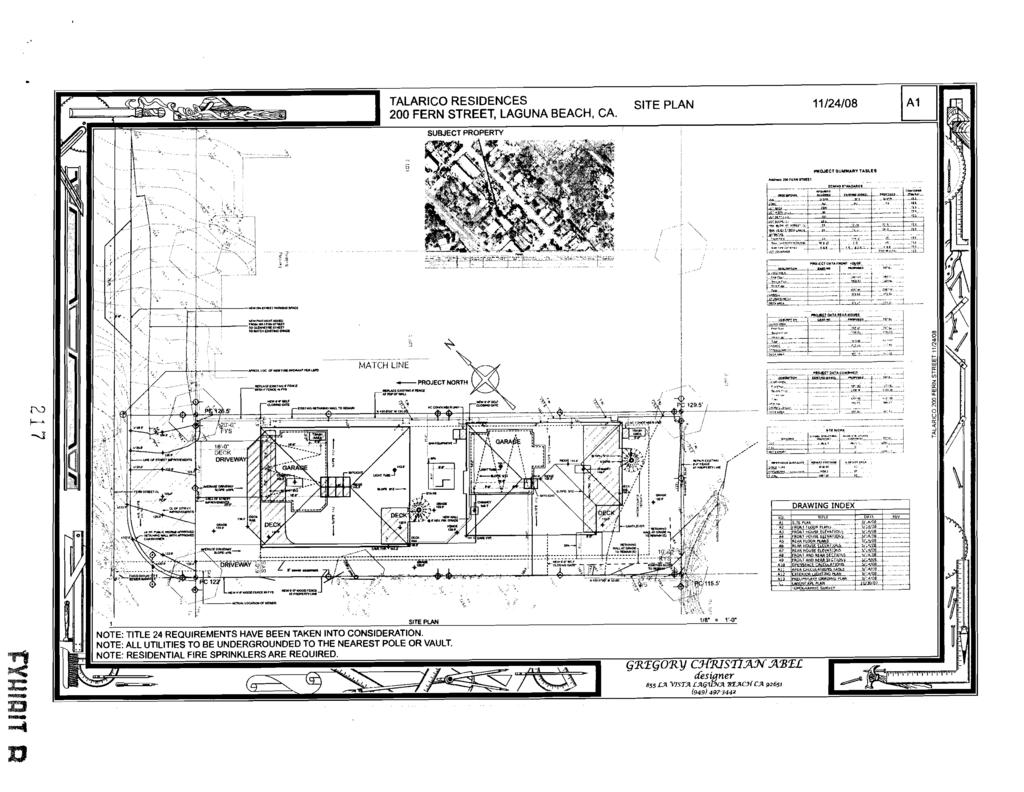
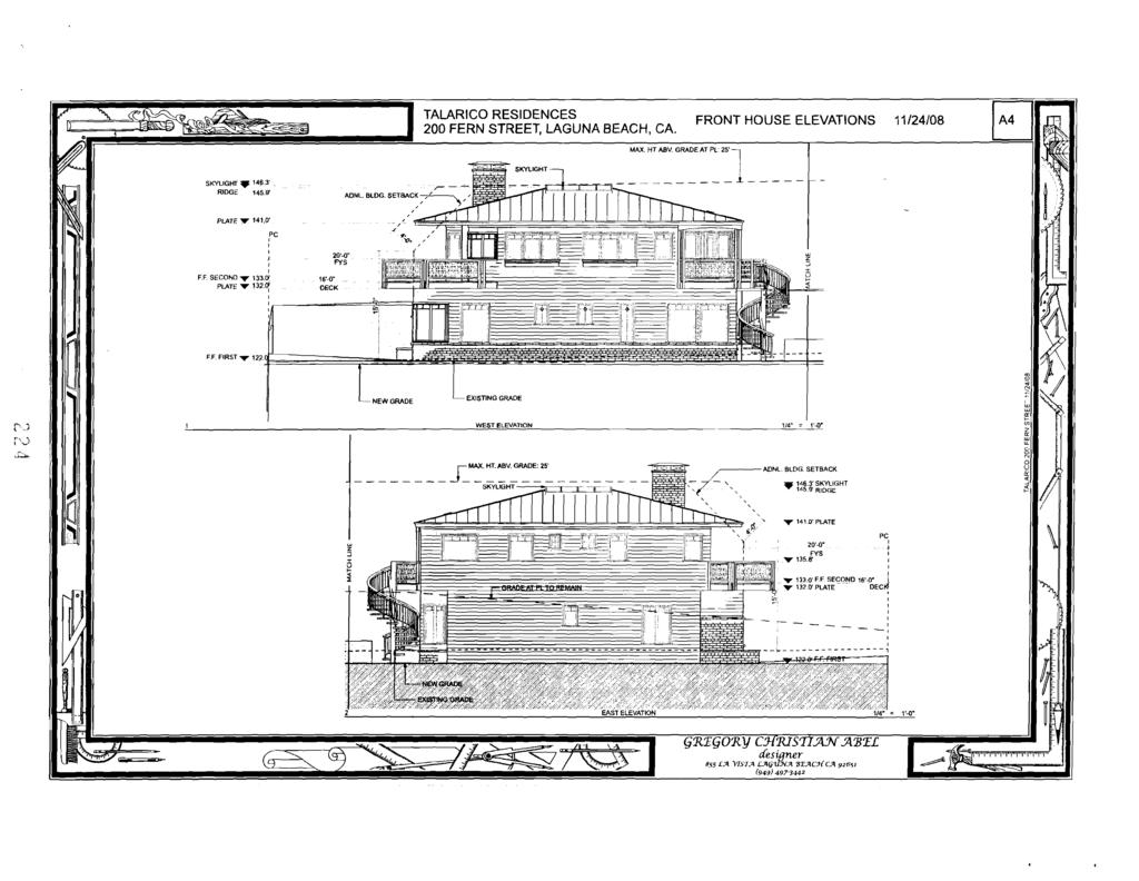
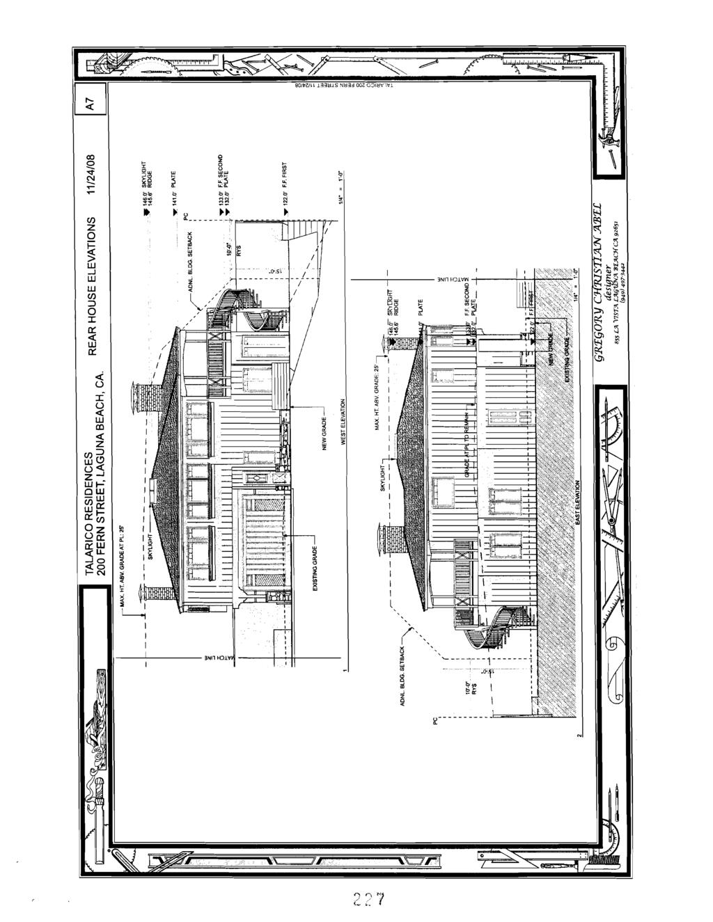
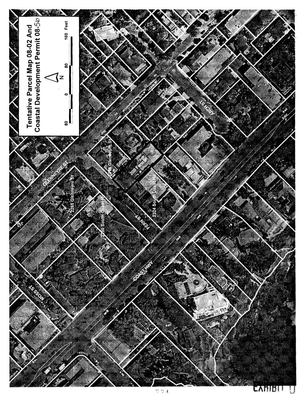
1 CITY OF LAGUNA BEACH COMMUNITY DEVELOPMENT DEPARTMENT STAFF REPORT AGENDA ITEM: No. 10 DATE: TO: 1 PLANNING CONIMISSION CASE: APPLICANT: LOCATION: ENVIRONMENTAL STATUS: PREPARED BY: Tentative Parcel Map and Coastal Development Permit Aaron Talarico (949) Fern Street (APN ) Categorical Exemption (Minor Land Divisions) Scott Drapkin, Senior Planner (949) REQUESTED ACTION: The applicant is requesting approval of Tentative Parcel Map and Coastal Development Permit to subdivide an existing building site for the purpose of creating two airspace residential condominium units. BACKGROUND: The proposed site is located within the R-2, Residential Medium Density Zoning District and has a General PlanILand Use designation of Village Medium Density (8-12 dwelling units per acre). The project site is an existing building site that is currently developed with a legal non-conforming single-family residence. (The property is not developed with the required two covered parking spaces.) Access to Fern Street is from Glenneyre Street, as Fern Street is not improved through to Coast Highway. (Only the subject property currently utilizes this segment of Fern Street for required vehicular access.) The property is located between an R- 2, Residential Medium Density property to the north (2315 Glenneyre Street) and an R-3, Residential High Density property to the south (2324 South Coast Highway). The property is influenced by a significant watercourse in the rear yard. The applicant has submitted design plans and completed Zoning Plan check for the proposed condominium duplex, associated site development and landscaping. The proposed design of the development, parking and required access has been determined to be consistent with the City's Municipal Code and will be subject to further consideration by the Design Review Board. (See the attached site plan and elevations for details of the proposed improvements, attached as Exhibit B.) The Fire Department has also reviewed the proposed development and has determined that the proposed design is consistent with required emergency access, turnaround, and fire hydrant spacing and flow. The Fire Department has required a new fire hydrant on Fern Street with the proposed development.
2 Tentative Parcel Map S. Coastal Development Permit December 10,2008 Page 2 The applicant must obtain Planning Commission and City Council approval of the proposed subdivision prior to design review of the structure and site improvements. STAFF ANALYSIS: The R-2 Zoning District requires a minimum of 2,000 square feet of net lot area for each dwelling unit, guest house or guest room. The General Plan Village Medium Density Land Use District requires that the property contain a minimum density of 8-12 dwelling units per acre (or 3,630 square feet of lot area per unit). The proposed two-unit subdivision on a 7,500 square-foot lot complies with the minimum Village Medium Density and the R-2, Zoning District density requirements. Pursuant to Municipal Code Section 25.12, the minimum allowable lot size in the R-2, Residential Medium Density Zoning District is 6,000 square feet in lot area, 70 feet in lot width and 80 feet in lot depth. The subject parcel is rectangular in shape and is 50 feet in width, 150 feet in depth and 7,500 square feet in lot area. As previously confirmed by the City Attorney, because the project is a condominium air space subdivison, with the exception of density, the proposed subdivision is not required to conform with the minimum lot Development Standards of the R-2 Zoning District. Street Improvements - Pursuant to the City's Municipal Code, the proposed development is required to improve a 10-foot wide travel lane (adjacent to the property) and an 8' x 22' on-street parking space in conjunction with the proposed property redevelopment. Because Fern Street, at this location, is less than the required Fire Department emergency access lane width, the applicant is also responsible to improve Fern Street with a minimum 20-foot pavement width, from the subject property, to the intersection of Glenneyre Street. In order to achieve the minimum required 20-foot pavement width, the applicant's engineer indicates that the development requires approximately 60 lineal feet of retaining wall in the public right-of-way. The retaining wall is proposed a maximum height of six feet and is subject to Design Review Board approval. Because this location of Fern Street (including the frontage and from the subject property to Glenneyre Street) only serves the subject property, the City Engineer has requested that this portion of Fern Street be privately maintained. Geotechnical Review - A preliminary geotechnical report has been prepared for the project and peer-reviewed by the City's geotechnical consultant. The study evaluated regional and local geologic conditions and potential seismic and liquefaction impacts. The conclusion of the study is that the site could be developed safely under specific engineering conditions and recommendations as indicated in the geotechnical evaluation. Subdivision Compliance - The application requirements for a Tentative Parcel Map are contained in Chapter of the Laguna Beach Municipal Code and the California Subdivision Map Act. Staff has reviewed the proposed Tentative Parcel Map and has found: 1. The proposed map is consistent with the Laguna Beach General Plan in that the proposed residential use and density of development meet the minimum standards.
3 Tentative Parcel Map & Coastal Development Permit December 10,2008 Page 3 2. The design and improvement of the proposed subdivision are consistent with the Laguna Beach General Plan in that the proposed design provides sufficient lot area and street access for property development. 3. The design of the subdivision and the type of improvements are not likely to cause serious public health problems. 4. The proposed map complies with the requirements of the Subdivision Map Act and the Laguna Beach Subdivision Ordinance. 5. All applicable provisions of the Laguna Beach Municipal Code pertaining to subdivisions have been satisfied or will be satisfied with the entitlement process. 6. The creation of two new condominium units will not displace low and/or moderateincome families or tenants. CALIFORNIA ENVIRONMENTAL QUALITY ACT: Pursuant to Categorical Exemption Section of the California Environmental Quality Act (CEQA), minor land divisions are exempt from the provisions of CEQA, when the project consists of four or fewer parcels located in urbanized areas zoned for residential, commercial, or industrial uses and the subdivision is in conformance with the General Plan and Zoning Code. Under this exemption, the subdivision cannot include any variances or exceptions, all services and access to the proposed parcels must be to local standards and are available, the parcel cannot have been involved in a division of a larger parcel within the previous two years and the parcel cannot have an average slope greater than 20 percent. The subject project is consistent with the aforementioned requirements; therefore, staff is recommending the project be categorically exempted from CEQA. COASTAL DEVELOPMENT PERMIT: Pursuant to the California Coastal Act, the proposed subdivision constitutes development and therefore requires the issuance of a Coastal Development Permit. The criteria and findings for granting a Coastal Development Permit are outlined below: (1) The project is in conformity with all the applicable provisions of the general plan, including the certified local coastal program and any applicable specijic plans. The proposed parcel map is in conformity with all applicable provisions of the City's General Plan. (2) Any development located between the sea and the first public road paralleling the sea is in conformity with the certzjied local coastal program and with the public access and public recreation policies of Chapter 23 of the California Coastal Act. The proposed project is not located between the sea and the first public road paralleling the sea. (3) The proposed development will not have any signflcant adverse impacts on the environment within the meaning of the California Environmental Quality Act. For the purposes of CEQA, staff is recommending a Categorical Exemption for the project.
4 Tentative Parcel Map & Coastal Development Permit December 10,2008 Page 4 CONCLUSION: The proposed subdivision is consistent with the Subdivision Map Act, Coastal Development Permit requirements, the Laguna Beach General Plan and Municipal Code and CEQA. In addition, the project has been reviewed for zoning compliance and staff has determined that the proposed structure design and setbacks comply with the minimum R-2, Residential Medium Density Zoning District development standards. The structure will also require further aesthetic consideration by the Design Review Board for neighborhood compatibility. RECOMMENDATION: Staff recommends that the Planning Commission recommend to the City Council approval of the Tentative Parcel Map and Coastal Development Permit ATTACHMENTS: Exhibit A: Application Exhibit B: Design Review Plans Exhibit C: Tentative Parcel Map Exhibit D: Location Map Resolution
 ~ fl AGENT. ADDRESS 280 Fern <- ADDRESS I CELL PHONE NO. CELL PHONE NO. EMAlL ADDRESS EMAIL ADDRESS VALUATION OF WORK $ LOT SIZE 3$?")
5 ! CITY OF LAGUNA BEACH DEPARTMENT OF COMMUNllY DEVELOPMENT 505 FOREST AVENUt LAGUNA BEACH CALIFORNIA I DEVELOPMENT REVIEW APPLICATION PROJECT LOCATIONIAD Please completely fill-in the tophalf of side one. 5 T DRESS 208 f, ~ OWNER j?v?~;~,o rb 12 n.) ~ fl AGENT. ADDRESS 280 Fern <- ADDRESS I CELL PHONE NO. CELL PHONE NO. EMAlL ADDRESS ADDRESS VALUATION OF WORK $ LOT SIZE 3$?20 ASSESSOR'S PARCEL NO. & LEGAL DESCRIPTION / i-2-2 ~~0L-m in f (24 P/ Re /rnnobkqtm~ DESCRIBE IN DETAIL SCOP OF WORK 4. 7 ~ 4 6 ~ 5 w - ' 1 GRADING CUT + FILL AMOUNTS (OUTSIDE OF BUILDING FOOTPRINT) = CUBIC YARDS COASTAL DEV~OPMENT PERMIT Development Category: - 0-r, '
6 OWNER'S CERTIFICATE 1. There are no assurances at any time, implicitly or otherwise, regarding final staff recorr~mendations to the decision-making body about this application. 2. Major changes to the project may require a new application and payment of additional or new fees. 3. If *this application is approved, the faili~re to abide by and faithfully comply with any and all conditions attached to the approval action shall constitute grounds for the revocation of said approving action by the approving authority hereby certify that to the best of my knowledge the information 1 have presented in this form and the accompanying materials is true and correct. I also understand that additional data and information may be required prior to final action on this application. I have read and understand the content contained in this certificate understand that it is the responsibility of the property owner to ensure that discrepancies do not exist between the project's description on the permit, the architectural plans and the structural plans. If discrepancies exist between the architectural plans and the structural plans, the architectural plans shall take precedence. Llhimately, the scope of work, as described on the permit that is authorizing the construction, takes precedence over the plans. If there is a discrepancy between the plans and the description on the permit, the permit governs am the record owner of the property described in this application, and hereby consent to the filing of the application., 4r /./ J Signature of Owner 30/0 7 Date AUTHORIZATION OF AGENT I' 1 am the record owner of the property described in this application and hereby designate and authorize the agent as shown on the reverse of this form to act on my behalf in all matters pertaining to processing this application through the City of Laguna ~ea6h. - Signature of Owner Date-.. -P
7
8
9
10 ;. ).,Z'*.:-" EXTERIOR LIGHTING L'p.A-
11
12 ~. ~-.,.... ~~~ LOWER FLOOR 1M' = 1'-0. 2 UPPER FLOOR -
13 M U HT. ABV. GRADE AT PL: 25' MU. HT. ARV. GRADE. 25' 148.3'SKYLIGHT 122.w F.F. FIRST 122 o'ff FIRST NORTH ELEVATION 114' = 1'4' 2
14
15
16
17
18
19
20 GREGG ABEL DESIGN 855 LA VISTA LAGUNA BEACH, CA (949) FIXED DATUM CENTER OF SEWER MANHOLE NOTE: POLES SHALL BE MARKED WITH STRING OR RIBBON TO SHOW THE BUILDING OUTLINE. 200 FERN STREET LAGUNA BEACH 511 4/08 1 STAKING PLAN 111 6" = 1 '-o~~
21
22 a: t: "! TOAL ENGINEERING, INC.. tnitrsrra L d h a Lrm- 1JSM*aorm sm chrtr em- 9m61i a ( ~9)) 41-B-86 F- (919: , V C ~, ~, ~. ~ - - W m - I a %- lf.i m -I-. TOPOGRAPHIC SURVEY UIT6hPOk lors7h8,0lcxk18.*pmk4ch LACUNA BLICH, WmRllA -w TAURICO
23
24
25 RESOLUTION NO. A RESOLUTION OF THE CITY COUNCIL OF THE CITY OF LAGUNA BEACH, CALIFORNIA, APPROVING TENTATIVE PARCEL MAP AND COASTAL DEVELOPMENT PERMIT AT 200 FERN STREET. WHEREAS, an application has been filed by the owner of property located at 200 Fern Street, requesting approval of Tentative Parcel Map and Coastal Development Permit to subdivide a 7,500 square-foot lot, located in the R-2 Residential Medium Density Zone and the Village Medium Density General PlanILand Use District, for the purpose of creating two attached residential condominium units in accordance with the provisions of the Municipal Code; WHEREAS, pursuant to Categorical Exemption (Minor Land Divisions) of the California Environmental Quality Act (CEQA), the project is exempt from the requirements of CEQA; WHEREAS, on December 10, 2008, the Planning Commission conducted a legally noticed public hearing and, after reviewing all documents and testimony, voted to recommend to the City Council approval of Tentative Parcel Map and Coastal Development Permit 08-56; WHEREAS, on, the City Council conducted a legally noticed public hearings and, after reviewing all documents and testimony, desires to approve Tentative Parcel Map and Coastal Development Permit 08-56; and WHEREAS, the proposed condominium subdivision is consistent with the criteria of the Certified Local Coastal Program Section (F)(l -9); NOW, THEREFORE, THE CITY COUNCIL OF THE CITY OF LAGUNA BEACH does RESOLVE and ORDER as follows:
26 Tentative Parcel Map Coastal Development Permit Date 1. The proposed map is consistent with the Laguna Beach General Plan in that the proposed residential use and density of development meet the minimum standards. 2. The design and improvement of the proposed subdivision are consistent with the Laguna Beach General Plan in that the design provides sufficient lot area and street access for property development. 3. The site is physically suitable for the proposed density of development in that the project is within the standards specified in the Laguna Beach Zoning Ordinance. 4. The design of the subdivision and the proposed improvements are not likely to cause substantial environmental damage or substantially and avoidably injure fish or wildlife or their habitat since the proposed subdivision is consistent with the prescribed density indicated by the General Plan and is redevelopment of an exiting developed property. 5. The design of the subdivision and the type of improvements are not likely to cause serious public health problems since the proposed development is consistent with the City's General Plan. 6. The design of the subdivision and the type of improvements will not conflict with any easements acquired by the public at large and which are recorded or established by judgment of a court of competent jurisdiction. 7. The proposed map meets the requirements of the Subdivision Map Act and the Laguna Beach Subdivision Ordinance, and has been reviewed as being consistent with those requirements.
27 Tentative Parcel Map Coastal Development Permit Date 8. All provisions of the Laguna Beach Municipal Code pertaining to subdivisions are met. 9. The creation of two new condominium units will not displace low andlor moderateincome families or tenants. 10. The Parcel Map, as conditioned, is in conformity with all applicable provisions of the City's various General Plan Elements. 11. The proposed project is not located between the sea and the first public road paralleling the sea. 12. The proposed project is categorically exempt from the requirements of CEQA and will therefore not cause any environmental impact. NOW, THEREFORE, THE CITY COUNCIL OF THE CITY OF LAGUNA BEACH does further RESOLVE and ORDER as follows: Approval of Tentative Parcel Map and Coastal Development Permit subject to the following conditions: 1. Prior to the approval of the Final Map by the City, the subdivider shall demonstrate that no dwelling unit in the subdivision shall be sold unless a homeowner's association or other legal arrangement approved by the City has been formed with the right to access all areas of the property that are jointly owned or benefited and to operate and maintain all of the mutually available features of the development. 2. Prior to the approval of the Final Map by the City, the subdivider shall demonstrate that all public utilities to serve the subdivision shall be designed and constructed in accordance
28 Tentative Parcel Map Coastal Development Permit Date with City Codes and standards and the requirements of the serving utility company, including I gas, electric, telephone, water, sewer, drainage and cable television. 3. The proposed subdivision and associated improvements shall not conflict with any existing public easements. 4. Within 24 months of the approval of the Tentative Parcel Map, or as otherwise provided by the law, a Final Map based upon a field survey shall be submitted, and deemed complete for review and approval. An incomplete or inaccurate Final Map shall not be deemed submitted pursuant to the Subdivision Map Act. Prior to the recordation of the Final Map, the surveyorlengineer preparing the map shall tie the boundary of the map in the Horizontal Control System established by the County Surveyor as described in Sections and of the Orange County Subdivision Code and Orange County Subdivision Manual, Sub-article 18, as may be amended. The surveyorlengineer shall also provide the City with a representation of the Final Map in digital DXF format and GIs Shapefile Format that is positioned in the NAD83 coordinate system for this local area. 5. The landownerlsubdivider shall defend, hold harmless and indemnify, at hislherlits expense, the City, City Council and members thereof, commissions, boards, officials, officers, employees, agents and representatives from any and all third party claims, actions or proceedings to the attack, set aside, void or annul and approval of this Tentative Parcel Map, which action is brought within the time period provided for in California Government Code Section , as same may be amended. This obligation shall encompass all costs and expenses incurred by the
29 Tentative Parcel Map Coastal Development Permit Date City in defending against any claim, action or proceeding, as well as costs or damages the City may be required by a court to pay as a result of such claim, action or proceeding. The City shall notify the landowner/developer in the defense of any claim, action or proceeding within a timely manner of receipt the same. 6. Prior to the approval of the Final Map by the City, the subdivider shall pay a park and recreation fee as required by Municipal Code Section Prior to the approval of the Final Map by the City, the subdivider shall pay a drainage fee for the Central Local Drainage Area. This fee shall conform to the required adjustments of the Engineering News Record Construction Cost Index at the time the Parcel Map is approved. 8. Prior to the approval of the Final Map by the City, a deed restriction acknowledging the potential fire, erosion, landslide, mudslide, earthquake and flooding hazards of the site and waiving liability claims against the City shall be filed and recorded with the Orange County Clerk and Recorder. 9. Twenty four (24) months from the date the map is approved by the City Council, Tentative Parcel Map shall expire. A one (1) year extension of the conditional approval may be requested by written application to the Department of Community Development for processing, if filed prior to the approved subdivision expiration. 10. Prior to the final building permit for the proposed residences, the applicant shall install a Fire Hydrant on Fern street, pursuant to the approved Fire Department hydrant location.
30 Tentative Parcel Map Coastal Development Permit Date 11. Prior to the final building permit for the proposed residences, the applicant shall install a 20-foot wide Fire Department Emergency apparatus access lane from Glenneyre Street to the westerly end of the subject property. No parking shall be allowed within the fire lane and one "No Parking" sign shall be posted on both sides of Fern Street. 12. Prior to the final building permit for the proposed residences, the applicant shall install one 8' x 22' public on-street parking space on Fern Street. 13. The applicant shall be responsible for the improvement and future maintenance of the existing and proposed Fern Street from in front of the subject property to the intersection of Glenneyre Street. The maintenance shall also include any associated retaining walls. The street maintenance responsibility shall also be identified and recorded in the properties title reports and Homeowners AssociationlCC&Rs. ADOPTED this t he day of, Mayor ATTEST: City Clerk
31 Tentative Parcel Map Coastal Development Permit Date I, MARTHA ANDERSON, City Clerk of the City of Laguna Beach, California, do herebi certify that the foregoing Resolution No. was duly adopted at a Regular Meeting of the City Council of said City held on, by the following vote: AYES: NOES COUNCILMEMBER(S): COUIVCILMEN'IBER(S): City Clerk of the City of Laguna Beach, CA
1.0 REQUEST. SANTA BARBARA COUNTY ZONING ADMINISTRATOR Coastal Zone Staff Report for Vincent New Single-Family Dwelling & Septic System
 SANTA BARBARA COUNTY ZONING ADMINISTRATOR Coastal Zone Staff Report for Vincent New Single-Family Dwelling & Septic System Hearing Date: February 26, 2007 Supervisorial District: First Staff Report Date:
APPLICATION FOR 555 Washington Street Tentative Map Red Bluff, CA Subdivision Map (530) ext Parcel Map.
 ext Parcel Map.") City of Red Bluff Community Development Department Application No. APPLICATION FOR 555 Washington Street Tentative Map Red Bluff, CA 96080 Subdivision Map (530) 527-2605 ext. 3059 Parcel Map Applicant
City of Red Bluff Community Development Department Application No. APPLICATION FOR 555 Washington Street Tentative Map Red Bluff, CA 96080 Subdivision Map (530) 527-2605 ext. 3059 Parcel Map Applicant
A GUIDE TO PROCEDURES FOR: SUBDIVISIONS & CONDOMINIUM CONVERSION
 A GUIDE TO PROCEDURES FOR: SUBDIVISIONS & CONDOMINIUM CONVERSION A GUIDE TO PROCEDURES FOR: SUBDIVISIONS (TENTATIVE MAPS) PURPOSE Definition: A subdivision is defined as the division of any improved or
City of San Juan Capistrano Agenda Report
 ITEM F2 City of San Juan Capistrano Agenda Report TO: FROM: Planning Commission Prepared & Submitted by: David Contreras~ting Assistant Development Services Director c;:::e._,~.y.. Reviewed by: Sergio
PLANNING COMMISSION STAFF REPORT June 18, 2015
 Community Development Department Planning Division 1600 First Street + P.O. Box 660 Napa, CA 94559-0660 (707) 257-9530 PLANNING COMMISSION STAFF REPORT June 18, 2015 AGENDA ITEM 7.B. PL15-0052 PM, GASSER
RESOLUTION NUMBER 4238
 RESOLUTION NUMBER 4238 A RESOLUTION OF THE CITY COUNCIL OF THE CITY OF PERRIS, COUNTY OF RIVERSIDE, STATE OF CALIFORNIA, APPROVING: (1) TENTATIVE MAP AND STREET VACATION 05-0112 (COUNTY MAP NO. 33587)
SANTA BARBARA COUNTY ZONING ADMINISTRATOR STAFF REPORT August 30, 2007
 SANTA BARBARA COUNTY ZONING ADMINISTRATOR STAFF REPORT August 30, 2007 PROJECT: Detrana Entry Gates HEARING DATE: October 22, 2007 STAFF/PHONE: Sarah Clark, (805) 568-2059 GENERAL INFORMATION Case No.:
CITY OF SANTA ANA ZONING ADMINISTRATOR AGENDA JANUARY 16, :30 A.M.
 CITY OF SANTA ANA ZONING ADMINISTRATOR AGENDA JANUARY 16, 2019 10:30 A.M. CITY HALL ROSS ANNEX Conference Room 1600 20 Civic Center Plaza, Santa Ana, California Lisa Storck Legal Counsel Verny Carvajal
TENTATIVE PARCEL MAP TIME EXTENSION
 EL DORADO COUNTY DEVELOPMENT SERVICES ZONING ADMINISTRATOR STAFF REPORT Agenda of: October 15, 2008 Item No.: Staff: 4.a. Mel Pabalinas TENTATIVE PARCEL MAP TIME EXTENSION APPLICATION FILE NO.: APPLICANT:
RESOLUTION NO xx
 Attachment 10 RESOLUTION NO. 2015-xx A RESOLUTION OF THE CITY COUNCIL OF THE CITY OF MORENO VALLEY, CALIFORNIA, APPROVING TENTATIVE PARCEL MAP 35679 (PA07-0084) FOR DEVELOPMENT OF THE 1,529,498 SQUARE
RESOLUTION OF THE BOARD OF SUPERVISORS OF ORANGE COUNTY, CALIFORNIA APPROVING VESTING TENTATIVE TRACT MAP December 13, 2016
 RESOLUTION OF THE BOARD OF SUPERVISORS OF ORANGE COUNTY, CALIFORNIA APPROVING VESTING TENTATIVE TRACT MAP 17522 December 13, 2016 WHEREAS, Yorba Linda Estates, LLC, OC 33, LLC and the Nicholas/Long Family
MEMORANDUM. TERESA McCLISH, COMMUNITY DEVELOPMENT DIRECTOR
 MEMORANDUM TO: FROM: BY: PLANNING COMMISSION TERESA McCLISH, COMMUNITY DEVELOPMENT DIRECTOR MATTHEW DOWNING, ASSISTANT PLANNER SUBJECT: CONSIDERATION OF TENTATIVE PARCEL MAP CASE NO. 14-002; SUBDIVISION
EL DORADO COUNTY DEVELOPMENT SERVICES ZONING ADMINISTRATOR STAFF REPORT VARIANCE
 EL DORADO COUNTY DEVELOPMENT SERVICES ZONING ADMINISTRATOR STAFF REPORT Agenda of: August 6, 2008 Item No.: Staff: 4.d. Robert Peters VARIANCE FILE NUMBER: V08-0004 APPLICANT: Joseph and Ingrid Herrick
CITY OF GROVER BEACH COMMUNITY DEVELOPMENT DEPARTMENT Tentative Map Checklist
 CITY OF GROVER BEACH COMMUNITY DEVELOPMENT DEPARTMENT Tentative Map Checklist The following list includes all of the items you must submit for a complete application. Some specific types of information
PC RESOLUTION NO. 15~11-10~01 CONDITIONAL USE PERMIT (CUP)
") PC RESOLUTION NO. 15~11-10~01 CONDITIONAL USE PERMIT (CUP) 15-005 A RESOLUTION OF THE PLANNING COMMISSION OF THE CITY OF SAN JUAN CAPISTRANO, CALIFORNIA APPROVING A MUSIC EDUCATION FACILITY IN EXISTING
PC RESOLUTION NO. 15~11-10~01 CONDITIONAL USE PERMIT (CUP) 15-005 A RESOLUTION OF THE PLANNING COMMISSION OF THE CITY OF SAN JUAN CAPISTRANO, CALIFORNIA APPROVING A MUSIC EDUCATION FACILITY IN EXISTING
CITY COUNCIL STAFF REPORT
 CITY COUNCIL STAFF REPORT TO: Honorable Mayor and City Council DATE: May 7, 2018 FROM: PREPARED BY: SUBJECT: Matthew Bronson, City Manager A. Rafael Castillo, AICP, Senior Planner Cassandra Mesa, Building
RESOLUTION NO. P15-07
 RESOLUTION NO. P15-07 A RESOLUTION OF THE PLANNING COMMISSION OF THE CITY OF SANTA CLARITA APPROVING MASTER CASE 15-035, CONDITIONAL USE PERMIT 15-002, TO ALLOW FOR THE SALES OF LIQUOR AND SPIRITS WITHIN
CITY OF RIO VISTA PLANNING COMMISSION STAFF REPORT
 MEETING DATE: January10, 2018 CITY OF RIO VISTA PLANNING COMMISSION STAFF REPORT AGENDA ITEM #4.2 PREPARED BY: Lamont Thompson, Planning Manager SUBJECT: Vesting Tentative Tract No. 2017-001: To consider
RESOLUTION NO. PC 18-14
 RESOLUTION NO. PC 18-14 A RESOLUTION OF THE PLANNING COMMISSION OF THE CITY OF DUARTE APPROVING CONDITIONAL USE PERMIT 18-02, FOR THE USE AND OPERATION OF AN INDOOR PLAY SPACE, LOCATED AT 1040 HUNTINGTON
292 West Beamer Street Woodland, CA (530) FAX (530)
 FAX (530)") - County of Yolo PLANNING AND PUBLIC WORKS DEPARTMENT John Bencomo DIRECTOR 292 West Beamer Street Woodland, CA 95695-2598 (530) 666-8775 FAX (530) 666-8728 www.yolocounty.org PLANNING COMMISSION STAFF
- County of Yolo PLANNING AND PUBLIC WORKS DEPARTMENT John Bencomo DIRECTOR 292 West Beamer Street Woodland, CA 95695-2598 (530) 666-8775 FAX (530) 666-8728 www.yolocounty.org PLANNING COMMISSION STAFF
City of San Juan Capistrano Supplemental Agenda Report
 City of San Juan Capistrano Supplemental Agenda Report TO: FROM: DATE: SUBJECT: Planning Commission Development Services Department... / Submitted by: Charles View, Development Services Dire ct~.. J,J._
MINOR SUBDIVISION COMMITTEE COUNTY OF MONTEREY, STATE OF CALIFORNIA
 MINOR SUBDIVISION COMMITTEE COUNTY OF MONTEREY, STATE OF CALIFORNIA RESOLUTION NO. 05010 In the matter the application GIANNINI FAMILY LIMITED PARTNERSHIP (PLN040273) APN# 113-071-006-000 FINDINGS & DECISION
AGENDA ITEM NO. 8 ORDINANCE No CITY OF HAWTHORNE CITY COUNCIL AGENDA BILL
 AGENDA ITEM NO. 8 ORDINANCE No. 2010 CITY OF HAWTHORNE CITY COUNCIL AGENDA BILL For the meeting of January 10, 2012 Originating Department: Planning & Community Development Interim City Manager Arnold
MINOR SUBDIVISION COMMITTEE COUNTY OF MONTEREY, STATE OF CALIFORNIA RESOLUTION NO A.P. #
 In the matter of the application of Steven and Elvia Goldberg (PLN040113) MINOR SUBDIVISION COMMITTEE COUNTY OF MONTEREY, STATE OF CALIFORNIA RESOLUTION NO. 04009 MINOR SUBDIVISION # 040113 A.P. # 008-392-001-000
CITY OF MANHATTAN BEACH COMMUNITY DEVELOPMENT DEPARTMENT STAFF REPORT. Richard Thompson, Director of Community Development
 CITY OF MANHATTAN BEACH COMMUNITY DEVELOPMENT DEPARTMENT STAFF REPORT TO: FROM: BY: Planning Commission Richard Thompson, Director of Community Development Eric Haaland AICP, Associate Planner DATE: February
Community Development Department Planning Division 1600 First Street + P.O. Box 660 Napa, CA (707)
") Community Development Department Planning Division 1600 First Street + P.O. Box 660 Napa, CA 94559-0660 (707) 257-9530 PLANNING COMMISSION STAFF REPORT May 7, 2015 AGENDA ITEM# 6.A. PL15-0041 UNIVERSAL
Community Development Department Planning Division 1600 First Street + P.O. Box 660 Napa, CA 94559-0660 (707) 257-9530 PLANNING COMMISSION STAFF REPORT May 7, 2015 AGENDA ITEM# 6.A. PL15-0041 UNIVERSAL
Community Development Department Planning Division 1600 First Street + P.O. Box 660 Napa, CA (707)
") Community Development Department Planning Division 1600 First Street + P.O. Box 660 Napa, CA 94559-0660 (707) 257-9530 PLANNING COMMISSION STAFF REPORT APRIL 5, 2018 AGENDA ITEM 7.A File No. PL18-0009
Community Development Department Planning Division 1600 First Street + P.O. Box 660 Napa, CA 94559-0660 (707) 257-9530 PLANNING COMMISSION STAFF REPORT APRIL 5, 2018 AGENDA ITEM 7.A File No. PL18-0009
Preliminary Subdivision Application (Minor) (Three (3) lots or less)
 (Three (3) lots or less)") Gunnison City Offices www.gunnisoncity.org 38 West Center Gunnison, Utah 84634 (435) 528 7969 Date of Application: Preliminary Subdivision Application (Minor) (Three (3) lots or less) APPLICANT INFORMATION
Gunnison City Offices www.gunnisoncity.org 38 West Center Gunnison, Utah 84634 (435) 528 7969 Date of Application: Preliminary Subdivision Application (Minor) (Three (3) lots or less) APPLICANT INFORMATION
CITY OF MERCED Planning & Permitting Division STAFF REPORT: #12-21 AGENDA ITEM: 4.1
 CITY OF MERCED Planning & Permitting Division STAFF REPORT: #12-21 AGENDA ITEM: 4.1 FROM: Kim Espinosa, PLANNING COMMISSION Planning Manager MEETING DATE: Dec. 5, 2012 PREPARED BY: Julie Nelson, Associate
CITY OF CORNING TENTATIVE MAPS
 CITY OF CORNING TENTATIVE MAPS APPLICANT S GUIDE TO PROCEDURES WHAT IS A TENTATIVE MAP? A division of land for the purpose of sale, lease, or finance requires submittal of a map for City approval showing
RESOLUTION PC NOW THEREFORE, the Planning Commission of the City of Duarte resolves as follows:
 RESOLUTION PC 18-09 A RESOLUTION OF THE PLANNING COMMISSION OF THE CITY OF DUARTE APPROVING CONDITIONAL USE PERMIT 14-02, FOR THE USE AND OPERATION OF A WIRELESS COMMUNICATION FACILITY FOR VERIZON WIRELESS,
TERESA McCLISH, COMMUNITY DEVELOPMENT DIRECTOR
 gmc MEMORANDUM TO: FROM: BY: PLANNING COMMISSION TERESA McCLISH, COMMUNITY DEVELOPMENT DIRECTOR SAM ANDERSON, PLANNING TECHNICIAN SUBJECT: CONSIDERATION OF LOT LINE ADJUSTMENT 17-002; LOCATION 570 LEMON
PLANNING & ZONING COMMISSION RESOLUTION A RESOLUTION OF THE PLANNING COMMISSION OF THE CITY OF ALBANY, COUNTY
 PLANNING & ZONING COMMISSION RESOLUTION 0-0 A RESOLUTION OF THE PLANNING COMMISSION OF THE CITY OF ALBANY, COUNTY OF ALAMEDA, STATE OF CALIFORNIA, APPROVING A TENTATIVE PARCEL MAP TO CREATE A PARCEL AT
STAFF REPORT FOR COASTAL DEVELOPMENT CDP# STANDARD PERMIT June 11, 2013 CPA-1. Victor Suarez Fern Drive Mendocino, CA 95460
 CPA-1 OWNER/APPLICANT: REQUEST: ENVIRONMENTAL DETERMINATION: RECOMMENDATION: LOCATION: APPEALABLE AREA: PERMIT TYPE: TOTAL ACREAGE: GENERAL PLAN: Victor Suarez 45130 Fern Drive Mendocino, CA 95460 Construct
Community Development Department Planning Division 1600 First Street + P.O. Box 660 Napa, CA (707)
") Community Development Department Planning Division 1600 First Street + P.O. Box 660 Napa, CA 94559-0660 (707) 257-9530 PLANNING COMMISSION STAFF REPORT July 7, 2016 AGENDA ITEM #6.C. PL16-0038 HEXA PERSONAL
Community Development Department Planning Division 1600 First Street + P.O. Box 660 Napa, CA 94559-0660 (707) 257-9530 PLANNING COMMISSION STAFF REPORT July 7, 2016 AGENDA ITEM #6.C. PL16-0038 HEXA PERSONAL
RESOLUTION NO. FILE NO. T15-058
 RESOLUTION NO. A RESOLUTION OF THE COUNCIL OF THE CITY OF SAN JOSE APPROVING A VESTING TENTATIVE MAP, SUBJECT TO CONDITIONS, TO MERGE FOUR PARCELS INTO ONE PARCEL AND RESUBDIVIDE THE ONE PARCEL INTO NO
FILING REQUIREMENTS FOR SUBMITTING APPLICATIONS
 S T A N I S L A U S L A F C O Stanislaus Local Agency Formation Commission 1010 10th Street, 3 rd Floor Modesto, CA 95354 (209) 525-7660 FAX (209) 525-7643 www.stanislauslafco.org FILING REQUIREMENTS FOR
Community Development Department Planning Division 1600 First Street + P.O. Box 660 Napa, CA Napa (707)
") Community Development Department Planning Division 1600 First Street + P.O. Box 660 Napa, CA 94559-0660 Napa (707) 257-9530 PLANNING COMMISSION STAFF REPORT JUNE 16, 2016 AGENDA ITEM # 6.B. 16-0056-EXT;
Community Development Department Planning Division 1600 First Street + P.O. Box 660 Napa, CA 94559-0660 Napa (707) 257-9530 PLANNING COMMISSION STAFF REPORT JUNE 16, 2016 AGENDA ITEM # 6.B. 16-0056-EXT;
PISMO BEACH PLANNING COMMISSION AGENDA REPORT
 PISMO BEACH PLANNING COMMISSION AGENDA REPORT SUBJECT: 1101 & 1161 Price; Rick and Terri Gambril and Tai Martin, Applicant: Project No. P14-000162. Application for a Coastal Development Permit and a Tentative
Preliminary Subdivision Application (Major) (Four (4) lots or more)
 (Four (4) lots or more)") Gunnison City Offices www.gunnisoncity.org 38 West Center Gunnison, Utah 84634 (435) 528 7969 Date of Application: Preliminary Subdivision Application (Major) (Four (4) lots or more) APPLICANT INFORMATION
Gunnison City Offices www.gunnisoncity.org 38 West Center Gunnison, Utah 84634 (435) 528 7969 Date of Application: Preliminary Subdivision Application (Major) (Four (4) lots or more) APPLICANT INFORMATION
BYRON TOWNSHIP ZONING APPLICATION
 BYRON TOWNSHIP ZONING APPLICATION Phone: (616) 878-9104 * Fax: (616) 878-3980 * Website: www.byrontownship.org This application will not be accepted if incomplete. APPLICATION FOR & REQUIRED COPIES Private
APPLICATION PROCESSING
 MAJOR SUBDIVISION 1810 E. HAZELTON AVENUE, STOCKTON CA 95205 BUSINESS PHONE: (209) 468-3121 BUSINESS HOURS: 8:00 A.M. TO 5:00 P.M..(Monday through Friday) APPLICATION PROCESSING STEPS STEP 1 STEP 2 CHECK
MINOR SUBDIVISION INFORMATION
 A. POINTS OF CONTACT: MINOR SUBDIVISION INFORMATION Surveyor: Address: Phone #: Fax # E-Mail Address: Representative (If different from applicant): Address: Phone #: Fax # E-Mail Address: B. GENERAL INFORMATION:
Planning Commission Staff Report August 6, 2015
 Commission Staff Report August 6, 2015 Project: Capital Reserve Map File: EG-14-008A Request: Tentative Parcel Map Location: 8423 Elk Grove Blvd. APN: 116-0070-014 Staff: Christopher Jordan, AICP Sarah
LAFCO APPLICATION NO LINDE CHANGE OF ORGANIZATION TO KEYES COMMUNITY SERVICES DISTRICT
 EXECUTIVE OFFICER S AGENDA REPORT MARCH 27, 2019 TO: FROM: SUBJECT: LAFCO Commissioners Javier Camarena, Assistant Executive Officer LAFCO APPLICATION NO. 2019-01 LINDE CHANGE OF ORGANIZATION TO KEYES
MEMORANDUM. TERESA McCLISH, COMMUNITY DEVELOPMENT DIRECTOR
 MEMORAND MEMORANDUM TO: FROM: BY: PLANNING COMMISSION TERESA McCLISH, COMMUNITY DEVELOPMENT DIRECTOR MATTHEW DOWNING, PLANNING MANAGER SUBJECT: CONSIDERATION OF LOT LINE ADJUSTMENT NO. 17-005; LOCATION
PLANNING COMMISSION STAFF REPORT
 PLANNING COMMISSION STAFF REPORT TO: Honorable Chair and Planning Commission DATE: March 8, 2017 FROM: PREPARED BY: SUBJECT: Bruce Buckingham, Community Development Director Cassandra Mesa, Building/Planning
ORDINANCE NUMBER WHEREAS, the regulation of development in single-family residential districts is within the police powers of the City; and,
 ORDINANCE NUMBER 1161 AN ORDINANCE OF THE CITY COUNCIL OF THE CITY OF PERRIS, COUNTY OF RIVERSIDE STATE OF CALIFORNIA, APPROVING ORDINANCE AMENDMENTS 05-0059 AND 05-0060 AMENDING CHAPTER 19 OF THE PERRIS
City of San Juan Capistrano Agenda Report
 City of San Juan Capistrano Agenda Report TO: FROM: DATE: Planning Commission Development Services Department Submitted and Reviewed by,s~r9j9 Klotz, AICP, Assistant Development Services Director ~ Prepared
ARTICLE 8C SITE CONDOMINIUM DEVELOPMENT ORDINANCE
 ARTICLE 8C SITE CONDOMINIUM DEVELOPMENT ORDINANCE SECTION 8C.01 PURPOSE It is the purpose of this Ordinance to insure that plans for development within Oceola Township proposed under the provisions of
RESOLUTION NO. FILE NO. PT14-047
 RESOLUTION NO. A RESOLUTION OF THE COUNCIL OF THE CITY OF SAN JOSE APPROVING A VESTING TENTATIVE MAP TO SUBDIVIDE ONE (1) LOT INTO NINE (9) LOTS FOR RESIDENTIAL USES, AND ONE (1) LOT FOR COMMON USES ON
CITY OF SANTA CLARITA PLANNING COMMISSION AGENDA REPORT. SUBJECT: Master Case No ; Tentative Parcel Map No
 Agenda Item: 1 CITY OF SANTA CLARITA PLANNING COMMISSION AGENDA REPORT PUBLIC HEARINGS PLANNING MANAGER APPROVAL: DATE: October 4, 2016 SUBJECT: Master Case No. 16-120; Tentative Parcel Map No. 74183 APPLICANT:
APPLICATION FOR MINOR SUBDIVISION INSTRUCTION TO APPLICANTS
 Planning Services Division 3675 Mt. Diablo Boulevard, Suite 210 Lafayette, CA 94549 Tel. (925) 284-1976 Fax (925) 284-1122 http://www.ci.lafayette.ca.us APPLICATION FOR MINOR SUBDIVISION INSTRUCTION TO
RESOLUTION NO. WHEREAS, the Signal Hill Gateway Center has been developed in phases. overtime; and
 RESOLUTION NO. A RESOLUTION OF THE CITY COUNCIL OF THE CITY OF SIGNAL HILL, CALIFORNIA, APPROVING CONDITIONAL USE PERMIT 13-05, A REQUEST TO OPERATE A RESTAURANT SERVING ALCOHOLIC BEVERAGES AT 959 E. SPRING
ORDINANCE NO
 ORDINANCE NO. 2014-160 AN ORDINANCE OF THE CITY COUNCIL OF THE CITY OF MENIFEE, CALIFORNIA, REPEALING SECTION 10.35 OF RIVERSIDE COUNTY LAND USE ORDINANCE NO. 460.152 AS ADOPTED BY THE CITY OF MENIFEE
SUBDIVISION ORDINANCE INDEX
 SUBDIVISION ORDINANCE INDEX - A - ACCESS Legal access required...16.28.190 Reserve strips for controlling access...16.28.180 Waiver direct street access...16.40.020 ACTION BY LOCAL AGENCY Advisory Agency,
Prepared by: Casey Kempenaar, Senior Planner
 CITY OF CITRUS HEIGHTS PLANNING DIVISION STAFF REPORT PLANNING COMMISSION MEETING September 13, 2017 Prepared by: Casey Kempenaar, Senior Planner REQUEST The applicant requests approval of a Tentative
RESOLUTION NO. B. The proposed amendment would not be detrimental to the public interest, health, safety, convenience, or welfare of the City; and
 RESOLUTION NO. RESOLUTION OF THE PLANNING COMMISSION OF THE CITY OF SANTA ROSA RECOMMENDING TO CITY COUNCIL REZONING TO MODIFY THE EXISTING POLICY STATEMENT AND ADOPT THE BAY VILLAGE HOMES DEVELOPMENT
CITY OF SONORA PLANNING COMMISSION SITE PLAN REVIEW APPLICATION
 CITY OF SONORA PLANNING COMMISSION SITE PLAN REVIEW APPLICATION APPLICANT: MAILING ADDRESS: PHONE: CELL#: EMAIL: OWNER S NAME: MAILING ADDRESS: PHONE: CELL#: EMAIL: ADDRESS OF PROPERTY INVOLVED: ASSESSOR
A G E N D A CITY OF BUENA PARK ZONING ADMINISTRATOR
 A G E N D A CITY OF BUENA PARK ZONING ADMINISTRATOR September 2, 2016 COMMUNITY DEVELOPMENT CONFERENCE ROOM 10:00 a.m. Members of the public who wish to discuss an item should fill out a speaker identification
APPLICATION SUBMITTAL REQUIREMENTS FOR Tentative Parcel or Subdivision Maps
 CITY OF EL CERRITO Community Development Department Planning and Building Division 10890 San Pablo Avenue, El Cerrito, CA 94530 (510) 215-4330 FA (510) 233-5401 planning@ci.el-cerrito.ca.us APPLICATION
City of San Juan Capistrano Agenda Report
 City of San Juan Capistrano Agenda Report TO: Zoning Administrator FROM: Reviewed by: Sergio Klotz, AICP, Assistant Development Services DirctJ. o ~ Prepared by: Laura Stokes, Housing Coordinator I Assistant
VARIANCE APPLICATION
 REQUIREMENTS TO THE APPLICANT: Please provide the following materials for your application. A complete application package will expedite your public hearing before the Planning and Preservation Commission.
CITY OF SACRAMENTO COMMUNITY DEVELOPMENT DEPARTMENT ZONING ADMINISTRATOR 300 Richards Blvd, 3rd Floor, Sacramento, CA 95811
 CITY OF SACRAMENTO COMMUNITY DEVELOPMENT DEPARTMENT ZONING ADMINISTRATOR 300 Richards Blvd, 3rd Floor, Sacramento, CA 95811 ACTION OF THE ZONING ADMINISTRATOR On Thursday, September 14, 2017, the Zoning
A G E N D A CITY OF BUENA PARK ZONING ADMINISTRATOR
 A G E N D A CITY OF BUENA PARK ZONING ADMINISTRATOR December 13, 2017 COMMUNITY DEVELOPMENT CONFERENCE ROOM 3:00 p.m. Members of the public who wish to discuss an item should fill out a speaker identification
CITY OF WILDOMAR PLANNING COMMISSION Agenda Item #2.3 PUBLIC HEARING Meeting Date: June 6, 2018
 CITY OF WILDOMAR PLANNING COMMISSION Agenda Item #2.3 PUBLIC HEARING Meeting Date: June 6, 2018 TO: FROM: Chairman and Members of the Planning Commission Robert Kain, Senior Planner SUBJECT: Change of
COASTAL PERMIT ADMINISTRATOR JANUARY 26, 2017
 COASTAL PERMIT ADMINISTRATOR JANUARY 26, 2017 STAFF REPORT- CDP_STANDARD CDP_2016-0025 SUMMARY OWNER/APPLICANT/AGENT: GEBB CHESTER S & ANNE J HARRIS 5245 WIKIUP BRIDGEWAY SANTA ROSA, CA 95404 REQUEST:
BRIDGETON SUBDIVISION APPLICATION CHECKLIST
 APPLICATION NAME AND # CHECKLIST COMPLETED BY: DATE: Signature and printed name BRIDGETON SUBDIVISION APPLICATION CHECKLIST TO SUBDIVISION APPLICANTS: The attached checklist is to assist you in the submission
REPORT TO PLANNING AND DESIGN COMMISSION City of Sacramento
 REPORT TO PLANNING AND DESIGN COMMISSION City of Sacramento 915 I Street, Sacramento, CA 95814-2671 www.cityofsacramento.org 9 PUBLIC HEARING December 10, 2015 To: Members of the Planning and Design Commission
CITY OF SOUTH SAN FRANCISCO PLANNING DIVISION 315 Maple Avenue, South San Francisco, CA (650)
") CITY OF SOUTH SAN FRANCISCO PLANNING DIVISION 315 Maple Avenue, South San Francisco, CA 94080 (650) 877-8535 TENTATIVE SUBDIVISION MAP Application Instructions No application shall be accepted unless it
CITY OF SOUTH SAN FRANCISCO PLANNING DIVISION 315 Maple Avenue, South San Francisco, CA 94080 (650) 877-8535 TENTATIVE SUBDIVISION MAP Application Instructions No application shall be accepted unless it
Planning Department 168 North Edwards Street Post Office Drawer L Independence, California 93526
 Planning Department 168 North Edwards Street Post Office Drawer L Independence, California 93526 Phone: (760) 878-0263 FAX: (760) 8782-2712 E-Mail: inyoplanning@inyocounty.us AGENDA ITEM NO.: 4 (Action
CITY OF MANHATTAN BEACH COMMUNITY DEVELOPMENT DEPARTMENT STAFF REPORT. Marisa Lundstedt, Director of Community Development
 CITY OF MANHATTAN BEACH COMMUNITY DEVELOPMENT DEPARTMENT STAFF REPORT TO: FROM: Planning Commission Marisa Lundstedt, Director of Community Development THROUGH: Laurie B. Jester, Planning Manager BY: Ted
ARTICLE 100 SUBDIVISION APPLICATION PROCEDURE AND APPROVAL PROCESS
 ARTICLE 100 SUBDIVISION APPLICATION PROCEDURE AND APPROVAL PROCESS 100.01 General Procedure 100.02 Exempt Subdivision 100.03 Administrative Subdivision 100.04 Major Subdivision 100.05 Signing and Recording
CITY OF ELK GROVE CITY COUNCIL STAFF REPORT
 CITY OF ELK GROVE CITY COUNCIL STAFF REPORT AGENDA ITEM NO. 9.3 AGENDA TITLE: A public hearing to consider a General Plan Amendment, Specific Plan Amendment, Rezone, Tentative Subdivision Map, Abandonment
Peter Pan Investors LLC (PLN030397)
") PLANNING COMMISSION COUNTY OF MONTEREY, STATE OF CALIFORNIA RESOLUTION NO. 04014 A. P. # 241-201-022-000 241-201-023-000 In the matter of the application of Peter Pan Investors LLC (PLN030397) FINDINGS
PLANNING COMMISSION COUNTY OF MONTEREY, STATE OF CALIFORNIA RESOLUTION NO. 04014 A. P. # 241-201-022-000 241-201-023-000 In the matter of the application of Peter Pan Investors LLC (PLN030397) FINDINGS
CITY COUNCIL AGENDA BILL
 AGENDA ITEM NO. 6 CITY OF HAWTHORNE CITY COUNCIL AGENDA BILL For the meeting of: February 23, 2016 Originating Department: Planning Department Head: Gregg McClain City Manager: Arnold Shadbehr SUBJECT:
MAJOR RESIDENTIAL AND NONRESIDENTIAL SUBDIVISIONS
 Lawrence-Douglas County MAJOR RESIDENTIAL AND NONRESIDENTIAL SUBDIVISIONS Preliminary Plats The applicant shall schedule a Pre-Application meeting with Planning Staff at least seven (7) working days prior
HOW TO APPLY FOR A USE PERMIT
 HOW TO APPLY FOR A USE PERMIT MENDOCINO COUNTY PLANNING AND BUILDING SERVICES What is the purpose of a use permit? Throughout the County, people use their properties in many different ways. They build
CITY OF WILDOMAR PLANNING COMMISSION Agenda Item #2.1 PUBLIC HEARING Meeting Date: June 6, 2018
 CITY OF WILDOMAR PLANNING COMMISSION Agenda Item #2.1 PUBLIC HEARING Meeting Date: June 6, 2018 TO: FROM: Chairman and Members of the Planning Commission Alfredo Garcia, Associate Planner SUBJECT: WPS/Mission
CITY OF PISMO BEACH PLANNING COMMISSION AGENDA REPORT
 DATE: March 22, 2016 CITY OF PISMO BEACH PLANNING COMMISSION AGENDA REPORT TO: FROM: HONORABLE CHAIR AND MEMBERS OF THE PLANNING COMMISSION Jan Di Leo, Planner (805) 773-7088 jdileo@pismobeach.org THROUGH:
City of San Juan Capistrano Agenda Report
 City of San Juan Capistrano Agenda Report TO: FROM: DATE: SUBJECT: Zoning Administrator Ll j Charles View, Development Services Directo&J Prepared by: Laura Stokes, Housing Coordinator I Assistant Planne(.;('7"
MEMORANDUM CITY COUNCIL TERESA MCCLISH, COMMUNITY DEVELOPMENT DIRECTOR ROBIN DICKERSON, CITY ENGINEER
 MEMORANDUM TO: FROM: BY: CITY COUNCIL TERESA MCCLISH, COMMUNITY DEVELOPMENT DIRECTOR ROBIN DICKERSON, CITY ENGINEER SUBJECT: CONSIDERATION TO ADOPT RESOLUTIONS ACCEPTING EASEMENTS AND PUBLIC IMPROVEMENTS;
EL DORADO COUNTY PLANNING AND BUILDING DEPARTMENT ZONING ADMINISTRATOR STAFF REPORT VARIANCE
 EL DORADO COUNTY PLANNING AND BUILDING DEPARTMENT ZONING ADMINISTRATOR STAFF REPORT Agenda of: April 18,2018 Item No.: Staff: 5.a. Emma Carrico VARIANCE FILE NUMBER: APPLICANT: REQUEST: LOCATION: V17-0003/La
Community Development Department Planning Division 1600 First Street + P.O. Box 660 Napa, CA (707)
") Community Development Department Planning Division 1600 First Street + P.O. Box 660 Napa, CA 94559-0660 (707) 257-9530 PLANNING COMMISSION STAFF REPORT AUGUST 6, 2015 AGENDA ITEM 6.A. 15-0109-UP; QVMC
Community Development Department Planning Division 1600 First Street + P.O. Box 660 Napa, CA 94559-0660 (707) 257-9530 PLANNING COMMISSION STAFF REPORT AUGUST 6, 2015 AGENDA ITEM 6.A. 15-0109-UP; QVMC
Item 10C 1 of 69
 MEETING DATE: August 17, 2016 PREPARED BY: Diane S. Langager, Principal Planner ACTING DEPT. DIRECTOR: Manjeet Ranu, AICP DEPARTMENT: Planning & Building CITY MANAGER: Karen P. Brust SUBJECT: Public Hearing
NOTICE OF A REGULAR MEETING
 NOTICE OF A REGULAR MEETING Pursuant to Section 54954.2 of the Government Code of the State of California, a Regular meeting of the City of Tracy Planning Commission is hereby called for: Date/Time: Wednesday,
TOWN OF WOODSIDE. Report to Town Council Agenda Item 6 From: Susan George, Town Manager July 26, 2011
 TOWN OF WOODSIDE Report to Town Council Agenda Item 6 From: Susan George, Town Manager July 26, 2011 SUBJECT: RESOLUTION APPROVING A HOLD HARMLESS AND INDEMNIFICATION AGREEMENT FOR THE PROPERTY LOCATED
Prepared by: Casey Kempenaar, Senior Planner
 CITY OF CITRUS HEIGHTS PLANNING DIVISION STAFF REPORT PLANNING COMMISSION MEETING January 27, 2016 Prepared by: Casey Kempenaar, Senior Planner REQUEST The applicant requests approval of a Tentative Parcel
 AS AMENDED BY THE PLANNING COMMISSION MAY 19, 2005 CONDITIONS OF APPROVAL VESTING TENTATIVE PARCEL MAP APPLICATION NO. 2005-04 SUMMIT CORPORATE CENTER Department of Public Works 1. The recorded parcel
1708 Martin Luther King Jr. Way
 November 19, 2008 Planning and Development Department Land Use Planning Division 1708 Martin Luther King Jr. Way Tentative Map #7915 to create five (5) residential condominium units and two (2) commercial
812 Page Street. Item 10 June 21, Staff Report
 Item 10 Department of Planning & Development Land Use Planning Division Staff Report 812 Page Street Tentative Map #8355 to allow condominium ownership in a five (5) unit project with four (4) residential
Trio Petroleum, Inc. (PLN010302)
") LYNNE MOUNDAY ZONING ADMINISTRATOR STATE OF CALIFORNIA COUNTY OF MONTEREY RESOLUTION NO. 010302 A.P.# 424-091-021-000 In the matter of the application of Trio Petroleum, Inc. (PLN010302) FINDINGS & DECISION
LYNNE MOUNDAY ZONING ADMINISTRATOR STATE OF CALIFORNIA COUNTY OF MONTEREY RESOLUTION NO. 010302 A.P.# 424-091-021-000 In the matter of the application of Trio Petroleum, Inc. (PLN010302) FINDINGS & DECISION
1. Adopted the required findings for the project specified in Attachment A of the staff report dated February 6, 2004, including CEQA findings;
 February 19, 2004 Joan L. Jamieson P.O. Box 741 ZONING ADMINISTRATOR Solvang, CA 93441 HEARING OF FEBRUARY 17, 2004 RE: Eubanks Lot Line Adjustment, 03LLA-00000-00013 Hearing on the request of Joan Jamieson,
820 BEL MARIN KEYS BOULEVARD, NOVATO ASSESSOR'S PARCEL * * * * * * * * * * * * * * * * * * * * * * * *
 ORDINANCE NO. ORDINANCE OF THE MARIN COUNTY BOARD OF SUPERVISORS AMENDING TITLE 22 OF THE MARIN COUNTY CODE, THEREBY APPROVING THE COUNTY-INITIATED REZONING (RZ 06-01) FOR THE BRAHMA KUMARIS WORLD SPIRITUAL
CITY OF WILDOMAR PLANNING COMMISSION Agenda Item #2.3 PUBLIC HEARING Meeting Date: January 6, 2016
 CITY OF WILDOMAR PLANNING COMMISSION Agenda Item #2.3 PUBLIC HEARING Meeting Date: January 6, 2016 TO: FROM: Chairman and Members of the Planning Commission Matthew C. Bassi, Planning Director SUBJECT:
Potrero Area Subdivision Page 1 of 21 PLN010001
 MONTEREY COUNTY SUBDIVISION COMMITTEE Meeting: April 29, 2004 @ 9:00 a.m. Agenda Item: 2 SUBJECT: Potrero Area Subdivision, - Combined Development Permit consisting of a Vesting Tentative Map to allow
RESOLUTION NO. (ANNEXATION AREA NO. 2)
") RD:EEH:LCP 4-6-16 RESOLUTION NO. A RESOLUTION OF INTENTION OF THE COUNCIL OF THE CITY OF SAN JOSE TO ANNEX TERRITORY INTO COMMUNITY FACILITIES DISTRICT NO. 8 (COMMUNICATIONS HILL) AND TO AUTHORIZE THE
RD:EEH:LCP 4-6-16 RESOLUTION NO. A RESOLUTION OF INTENTION OF THE COUNCIL OF THE CITY OF SAN JOSE TO ANNEX TERRITORY INTO COMMUNITY FACILITIES DISTRICT NO. 8 (COMMUNICATIONS HILL) AND TO AUTHORIZE THE
CITY OF MANHATTAN BEACH COMMUNITY DEVELOPMENT DEPARTMENT STAFF REPORT. Marisa Lundstedt, Director of Community Development
 CITY OF MANHATTAN BEACH COMMUNITY DEVELOPMENT DEPARTMENT STAFF REPORT TO: FROM: Planning Commission Marisa Lundstedt, Director of Community Development THROUGH: Laurie B. Jester, Planning Manager BY: Ted
TOWN OF WATERVILLE VALLEY NEW HAMPSHIRE SITE PLAN REVIEW REGULATIONS
 TOWN OF WATERVILLE VALLEY NEW HAMPSHIRE Effective date March 17, 1981 Revised March 16, 1982 Revised March 13, 1986 Revised March 10, 1987 Revised March 14, 2013 Revised March 8, 2016 TOWN OF WATERVILLE
TITLE 18 Subdivisions
 TITLE 18 Subdivisions ADMINISTRATION: 18.02 General Provisions 2 18.04 Definitions 6 18.06 Exceptions to Requirements 12 18.08 Enforcement 14 DIVISIONS OF LAND: 18.20 Tentative Parcel Maps 15 18.22 Tentative