All items include discussion and possible action to approve, modify, deny, or continue unless marked otherwise.
|
|
|
- Rosamund Lucas
- 5 years ago
- Views:
Transcription
1 Larry Prater Chairman Virgil Bucchianeri Planning Commissioner John Herrington Planning Commissioner Storey County Planning Commission Meeting Agenda Thursday September 14, :00 p.m. Storey County Courthouse, District Courtroom 26 South B Street, Virginia City, Nevada Jim Hindle Vice-Chairman Kris Thompson Planning Commissioner Laura Kekule Planning Commissioner All items include discussion and possible action to approve, modify, deny, or continue unless marked otherwise. 1. Call to Order at 6:00 p.m. 2. Roll Call 3. Pledge of Allegiance 4. Discussion/Possible Action: Approval of Agenda for September 14, Discussion/Possible Action: Approval of Minutes for April 20, 2017 (Continued from August 17, 2017 meeting due to lack of quorum to approve). 6. Discussion/Possible Action: Boundary Line Adjustment by Brett C. Staples. The applicant is requesting a boundary line adjustment between Assessor s Parcel Numbers (APNs) , , and located at 417 South D Street, 412 South E Street, and 395 South D Street, Virginia City, Storey County, Nevada. 7. Discussion/Possible Action: Special Use Permit request by applicant Asia Union Electronic Chemicals Reno, Inc. (property owner Waltham Road Industrial, LLC) to retrofit an existing property and building to allow for the production, distribution and use of hazardous and non-hazardous chemical products associated with the microelectronics industry. The subject property is located at 1400 Waltham Way, McCarran, Storey County, Nevada, Assessor s Parcel Number (APN) Discussion/Possible Action: Variance by Insurance Auto Auctions. The applicant requests a use variance allowing a previously permitted non-conforming use to remain in-place under its existing ownership conditions. The proposed use subject to the variance request is outdoor storage of inoperable motor vehicles and auctioning of those inoperable vehicles at portions of subject property located at 4086 Peru Drive, McCarran (Tahoe-Reno Industrial Center), Storey County, Nevada, APN Discussion/No Possible Action: Discussion and comments on possible amendments to Storey County Code (SCC) Title 17 Subdivisions; SCC Chapter Planned Unit Development; other provisions of SCC Title 17; and design standards for parcel maps and land subdivisions, planned unit developments, and multi-family residential complexes. 10. Discussion/Possible Action: Determination of next Planning Commission meeting. 11. Discussion/Possible Action: Approval of Claims. 12. Correspondence (no action) 13. Public Comment (no action) 14. Staff (no action) 1
2 15. Board Comments (no action) 16. Adjournment Notes: There may be a quorum of Storey County Commissioners in attendance, but no action or discussion will be taken by the Commissioners. Public comment will be allowed after each item on the agenda (this comment should be limited to the item on the agenda). Public comment will also be allowed at the end of each meeting (this comment should be limited to matters not on the agenda). Items on the agenda may be taken out of order, the public body may combine two or more agenda items for consideration, and the public body may remove an item from the agenda or delay discussion relating to an item on the agenda at any time. Additional information pertaining to any item on this agenda may be requested from the Planning Department ( ). Certification of Posting I, Lyndi Renaud, on behalf of the Storey County Planning Commission, do hereby certify that I posted, or caused to be posted, a copy of this Agenda at the following locations on or before September 5, 2017: Virginia City Post Office; Storey County Courthouse; Virginia City Fire Station 71; Virginia City RV Park; Mark Twain Community Center; Rainbow Bend Clubhouse; Lockwood Community Center; Lockwood Fire Station; Virginia City Highlands Fire Station; and the Virginia City Highlands mailbox buildings. By Lyndi Renaud, Secretary 2
3 STOREY COUNTY PLANNING COMMISSION MEETING Thursday, April 20, :00 p.m. Storey County Courthouse, District Courtroom 26 South B Street, Virginia City, Nevada MEETING MINUTES CHAIRMAN: Larry Prater VICE-CHAIRMAN: Jim Hindle COMMISSIONERS: Virgil Bucchianeri, John Herrington, Pamela Smith, Kris Thompson, Laura Kekule 1. Call to Order: The meeting was called to order by the Chair at 6:02 P.M. 2. Roll Call: Virgil Bucchianeri, John Herrington, Larry Prater, and Laura Kekule. Absent: Kris Thompson, Jim Hindle, Pamela Smith, Also Present: Planning Director Austin Osborne, Planner Kathy Canfield, and Deputy D.A. Keith Loomis, Contract Attorney Bob Morris. 3. Pledge of Allegiance: The Chairman led those present in the Pledge of Allegiance. 4. Discussion/Possible Action: Approval of Agenda for April 20, Motion: Approve Agenda for April 20, 2017 Action: Approve, Moved by Commissioner Kekule, Seconded by Commissioner Herrington, Vote: Motion carried by unanimous vote (summary: Yes=4). 5. Discussion/Possible Action: Approval of Minutes for January 19, Motion: Continue Approval of Minutes for January 19, 2017, due to lack of quorum to approve, Action: Approve, Moved by Commissioner Herrington, Seconded by Commissioner Kekule, Vote: Motion carried by unanimous vote (summary: Yes=4). 6. Discussion/Possible Action: Approval of Minutes for February 16, Motion: Approve Minutes for February 16, 2017, Action: Approve, Moved by Commissioner Herrington, Seconded by Commissioner Bucchianeri, Vote: Motion carried by unanimous vote (summary: Yes=4). 1
4 7. Discussion/Possible Action: Parcel Map request by Nancy Kruschke. The Applicant requests approval of a Parcel Map dividing one parcel into two parcels located at 20 South N Street, Virginia City, Storey County, Nevada (Assessor Parcel Number: ). Planner Canfield: Presented and summarized the parcel map request of the applicant Nancy Kruschke. The subject property is located at the southeast corner of N Street and Union Street in Virginia City; the corner lot property consists of Lots 1 and 2 of Block 114 as shown on the Official Map of Virginia City and a portion of abandoned right-of-way associated with M Street. The subject property is zoned R-1, Single Family Residential. The applicant has received a building permit to construct a single-family residence on the parcel; the proposed residence will occupy the proposed eastern corner lot, shown as Parcel B on the proposed Parcel Map. The applicant wishes to subdivide the subject parcel into two separate parcels; both parcels will be of equal size and be approximately 7,150 square feet, which is consistent with the R-1 zoning for parcel size. Surrounding land uses to this property include an existing residence to the west, an existing residence with accessory structures (garage, barn, corrals) to the north, and vacant land to the south and east. The property and all of the surrounding properties are zoned R-1. The proposed Parcel Map conforms to the goals and objectives of the Storey County Master Plan. Commissioner Herrington: Asked if this constitutes an address change for both lots. Planner Canfield: Yes. Chairman Prater: Asked if the applicant already has a building permit. Planner Canfield: Answered yes, for the easternmost parcel. Chairman Prater: Asked if anything other than grading has been done. Planner Canfield: Replied that the foundation is already in. Chairman Prater: Asked if the setbacks conform to code. Planner Canfield: Explained that the setbacks are conforming regardless of the split. Commissioner Herrington: Questioned if there has been any communications with neighbors who are opposed to the project. Planner Canfield: No. Thomas Myers, Virginia City Resident and neighbor: Asked about the orientation of the house and the setbacks. Nancy Kruschke, Applicant: Answered that the front door will face Union Street. Planning Director Osborne: Explained that the front and rear required setbacks are 20 feet, the side setback is eight feet and the other side setback is ten feet because it is on a corner. Motion: In accordance with the recommendation by Staff, the Findings under section 6.1 of this Staff Report and other Findings deemed appropriate by the Planning Commission, and in compliance with all Conditions of Approval, I, Virgil Bucchianeri, hereby motion to recommend approval with conditions, and change of condition 14. (replace wording of Variance Holder with Applicant ), for Parcel Map Application Number to approve the Applicant s request to create a Parcel Map dividing one parcel into two parcels located at 20 South N Street, Virginia City, Storey County, Nevada (Assessor Parcel Number: ), Action: Approve. Moved by Commissioner Bucchianeri, Seconded by Commissioner Kekule. Planner Canfield: Read the findings of fact into the record. The Parcel Map must comply with NRS through relating to the division of land into four or less parcels; and 2
5 6.1.2 The Parcel Map complies with all Federal, Nevada State, and County regulations pertaining to Parcel Maps and allowed land uses; and The Parcel Map will not impose substantial adverse impacts or safety hazards on the abutting properties or the surrounding vicinity; and The conditions under this Parcel Map do not conflict with the minimum requirements in Storey County Code Chapters R-1 Residential Zones or any other Federal, Nevada State, or County regulations The Parcel Map conforms to the 2016 Storey County Master Plan for the Virginia City planning area in which the subject property is located. A discussion supporting this finding for the special use permit is provided in Section 2 of this staff report. Vote: Motion carried by unanimous vote (summary: Yes=4). 8. Discussion/No Possible Action: Discussion and comments on possible amendments to Storey County Code (SCC) Title 17 Subdivisions; SCC Chapter Planned Unit Development; other provisions of SCC Title 17 pertaining to land subdivisions and planned unit developments; and design standards for parcel maps and land subdivisions, planned unit developments, and multi-family residential complexes. Planning Director Osborne: Bob Morris, Special Counsel, is working on the Title 16 Subdivision Ordinance updates. Title 17 currently contains design standards for planned unit developments (PUDs) such as landscaping, parking, open space and elevation. The design criteria will be taken out of the code and put into a resolution, which would be a design standards manual and would accompany the code making it more administrable by assisting the developer in understanding the county s requirements for development. The manual will be easier to update than the ordinance. The manual will provide standards which conform with and implement the goals, objectives, and policies of the Master Plan. The manual will address design standards for garden apartments for which there are currently none as well as how divided parcels interface with existing roads. Chairman Prater: Concerned that developers will get bogged down by too many design standards. Believes it should be up to the developer. Commissioner Kekule: Asked who makes the decision about what kind of building materials will be used. Bob Morris, Special Counsel: Explained that by having the design criteria in a manual, it will be easier for developers. It will be a suggested guideline, not must have rules. Planning Director Osborne: The design criteria is still very broad. The manual would be limited to subdivisions, PUDs (planned unit developments), garden apartment complexes, and other large-scale projects. The draft is currently 80 pages and may shrink down as it progresses along. The intention is not to create an International Building Code (ICC) type of environment. The design criteria specifies things such as materials and colors that complement each other and garages that are setback and not dominating the street. This is just one of many workshops so there will a lot of public involvement. 9. Strategic Plan Workshop/Discussion Only/No Possible Action: Discussion and comments from the planning commissioners, county staff, and the public regarding development of a Storey County strategic plan. A strategic plan is a systematic process of envisioning a desired future, and translating the vision into broadly defined goals and objectives, and a sequence of steps to achieve them in the county organization. Strategic plan elements may include, but are not limited to: vision and mission statement; core values; county s strengths, weaknesses, opportunities, and threats; short- 3
6 and long-term goals, objectives, and action plans as pertaining to the county s internal operations and quality of service to its citizens and taxpayers. Public participation is encouraged. Planning Director Osborne: Discussed changing the format of the workshop to better reach out to the different communities. More opportunity for citizen involvement is needed like what was done for the Master Plan process. Commissioner Herrington: Commented that he would prefer that over the style of the first strategic plan workshop. Commissioner Kekule: Agreed that she would like the community to be more involved. Chairman Prater: Suggested taking out the planning jargon when advertising the workshops to the community. The public participation was invaluable during the Master Plan process and would like to see the same with the strategic plan. Planning Director Osborne: One of the first workshops could be an educational workshop on budgets - where the money comes from and where it goes. Chairman Prater: Agreed this would be good. Gave an example of how the Highland residents feel they are paying a lot in property taxes but not receiving any benefits in return. It would helpful for people to understand the services they are getting such as police and fire. 10. Discussion/Possible Action: Determination of next planning commission meeting. Motion: Next planning commission meeting to be held on Thursday May 18, 2017 in Lockwood, NV at 6:00 p.m., site to be determined, Action: Approve, Moved by Commissioner Herrington, Seconded by Commissioner Kekule, Vote: Motion carried by unanimous vote (summary: Yes=4). 11. Discussion/Possible Action: Approval of claims None 12. Correspondence (No Action) - None 13. Public Comment (No Action) Thomas Zachary, Mark Twain resident: Would like to see the county recognize historic roads and access trails and identify them as public or private. Planning Director Osborne: Will add that to the list for the strategic plan workshops. The Master Plan identifies these roads already. The strategic plan would be about how to make it happen and how does staff budget for that. Almost all of the rural counties in the state are faced with the same thing. 14. Staff (No Action): Planner Canfield: Staff is working on revising the sign ordinance to make it more streamlined. Asking for public comments, suggestions and questions. Will bring wording for the planning commission to look at within the next few meetings. Planning Director Osborne: Gave Kathy credit for finding some problems with the sign ordinance and thinking of ways to simplify it. Legislative Updates: SB314: Wind energy bill. There were significant concerns in Virginia City and Gold Hill relative to commercial scale windmills in the Comstock Historic District. An amendment by Clark County stating so long as they conform to the area and environment is now in the bill. SB477: Residential care bill. This removes a county s ability to deny a special use permit in a residential zone and to define these uses as residential uses for single family use, halfway houses, drug and alcohol centers, and such. This bill is for counties of 100,000 or more. SB244: Historic digging bill. This would require providing notice and consultation with native tribes when remains and other cultural items are discovered during excavation. This bill enables the tribes to be more involved when remains are found. Currently the state agencies are the primary involved parties. A number of the water bills have died and are being morphed into other bills. Will have a better understanding by next meeting. 4
7 Chairman Prater: Asked if Pahrump is a major influence in the water bills. Planning Director Osborne: Answered yes, as well as Diamond Valley are the focus of much of the proposed water legislation. Commissioner Herrington: Commented on the progress of the courthouse parking lot. Planning Director Osborne: Explained that it is ready for striping and will be open within the week. Chairman Prater: Asked if the weather this winter delayed the opening of USA Parkway. Planning Director Osborne: Answered that the original date of August 2017 still stands. There will be a high-speed roundabout near Opal in Silver Springs. Also Fulcrum has secured the money to proceed with the building of their plant and are now submitting plans and drawings. 15. Board Comments (No Action) None Commissioner Kekule: Stated that her preference for the TRI visit is June. 16. Adjournment (No Action) - The meeting was adjourned at 7:00 P.M. Respectfully Submitted, By Lyndi Renaud 5

8 STOREY COUNTY PLANNING DEPARTMENT Storey County Courthouse 26 South B Street, PO Box 176, Virginia City, NV Phone (775) Fax (775) planning@storeycounty.org To: From: Meeting Date: Meeting Location: Staff Contact: Storey County Planning Commission Storey County Planning Department September 14, 2017 at 6:00 p.m. Storey County Courthouse, District Courtroom, Virginia City, Nevada Kathy Canfield File: Applicant: Property Owners: Property Location: Request: Brett C. Staples Brett C. Staples and Brett C. Staples Living Trust 395 S. D Street, 412 South E Street and 417 S. D Street, Virginia City, Storey County, Nevada The applicant is requesting a boundary line adjustment between Assessor s Parcel Numbers (APNS) , , and in order to facilitate additional construction on one or more parcels. Each parcel will still conform to the 5,000 square feet minimum parcel size. Property locations are 417 South D Street, 412 South E Street, and 395 South D Street, Virginia City, Storey County, Nevada. 1. Background & Analysis A. Site Location and Characteristics. The properties are located at 395 and 417 South D Street and 412 South E Street in Virginia City. All three properties are owned by the applicant. The three properties are located between D and E Streets and each property has existing structures. Two of the parcels contain a portion of a roadway that connects D and E Streets. For clarification purposes, this report identifies each lot as either Parcel A, Parcel B or Parcel C (see maps below). The parcels have the following existing conditions: 1

9 Parcel A APN : This parcel has an existing trailer residence that appears to have been installed on the property since Access to the residence is documented in a reciprocal easement agreement on Parcel B and parking for the residence is located on Parcel B and on D Street. The trailer residence does encroach into the 20-foot front yard setback, however, the rear and side yard setbacks meet Storey County requirements. The existing parcel size is 7,400 square feet. Parcel B APN : This parcel contains a single family residence constructed in The parcel shares an open area parking with Parcel A and has a reciprocal easement agreement recorded for ingress and egress for the parking area. A portion of a roadway connecting D Street and E Street crosses the property along the east side of the parcel. A previous boundary line adjustment for this parcel required the applicant to grant an easement for this roadway segment to Storey County. The residence is consistent with Storey County setback requirements. The existing parcel size is 9,441 square feet. Parcel C APN : This parcel contains a garage with a separate living quarters above, constructed in The garage portion of the structure has been completed, but the residence has not. Similar to Parcel B, a portion of a roadway connecting D Street and E Street crosses the property along the east side of the parcel. A previous boundary line adjustment for this parcel required the applicant to grant an easement for this roadway segment to Storey County. The garage/residence is consistent with Storey County setback requirements. The existing parcel size is 7,816 square feet. There are two previous boundary line adjustment applications for these parcels, the first in 2007 (File ) and the second in 2009 (File ). Both applications were approved and recorded. Vicinity map 2


10 Approximate existing parcel locations Existing parcel map B. Proposed Project. The Property Owner is proposing to adjust the boundaries of each of the parcels. The changes are proposed to facilitate future building opportunities for the parcels while still conforming to required property line setbacks. As depicted below, the properties will conform to the required Storey County setbacks with the proposed changes with the exception of Parcel A. Each proposed parcel will exceed 5,000 square feet in area. 3
11 Proposed Changes, dark lines are proposed property lines, dashed red lines are setback lines. 4
12 On Parcel A, the existing trailer residence encroaches into the 20-foot front yard setback. This trailer has been in this location since The proposed boundary line adjustment does not alter the front yard setback, or make the situation more non-conforming than currently exists. The side and rear yards comply (both existing and proposed) with required setbacks. The owner anticipates replacing the trailer with a new residence in the near future. At that time, the new construction will be required to conform to Storey County setback requirements. In 2008, Parcel C was approved to construct a garage with a residence above. The garage has been completed, however, the residence above has not. The garage is considered accessory to the residential primary use of the property, and to be consistent with zoning requirements, cannot legally exist without the primary use on the property. As a condition of this approval, the applicant will be required to obtain a current construction permit to finish the residential unit and bring the property into conformance with the Storey County zoning ordinance and post a project security to ensure the residence is completed within 12 months of filing the final map, and a non-conforming use is avoided. The security will be returned upon obtaining a certificate of occupancy for the residence. The 2009 boundary line adjustment required the applicant to dedicate a legal right-of-way easement for a portion of E Street which runs diagonally through portions of Lots 10, 11, and 12. Staff cannot find any evidence that this was completed. As a condition of this approval, prior to any recording of the new parcel map, the required dedication shall be completed. C. Application for a Parcel Map. Nevada Revised Statues (NRS) through defines requirements for a parcel map boundary lines adjustment. Storey County Code (SCC) does not specifically require an application for a Parcel Map, however, NRS states a proposed Parcel Map must comply with NRS through D. Adjacent Properties Existing Land Uses. The properties are located within Virginia City and are zoned CR. The surrounding properties are also zoned CR and include either a single family residences or are vacant land. 2. Use Compatibility and Compliance A. Compatibility with surrounding uses and zones. The following table documents land uses, zoning classification and master plan designations for the land at and surrounding the proposed project. There are no evident conflicts between the proposed project and Storey County Title 17 Zoning or the 2016 Master Plan. The proposed boundary line adjustment also consistent with the surrounding zoning and master plan designations. 5
13 B. Compliance with the Storey County Code - Section CR Commercial Residential Zone. (1) Storey County Code CR Commercial Residential Zone. The proposed Boundary Line Adjustment is compliant with the zoning outlined in Storey County Code Commercial Residential Zone. The existing and proposed land uses for the parcels are single family residential which is an allowed use. Although the property is located in the CR Commercial Residential Zone, it is not located within the Virginia City Downtown District; therefore, single-family residences are subject to standard setbacks of 20 front, 20 rear, and 8 sides. (2) Minimum Lot Size. The minimum lot area for a single family dwelling detached in the CR Zone is 5,000 square feet. The Applicant s properties exceed the minimum lot size requirements. (3) Use Density and Parcel Width Requirements. A parcel containing a detached single family dwelling must be at least 5,000 square feet. No particular parcel width is required. The existing and proposed parcels conform to this requirement. (4) Height of buildings and structures. In the Commercial Residential zoning, the structure may not exceed a height of three stories or forty-five feet, whichever is higher, except as may be allowed by a variance. The existing structures on these properties conform to this standard. No alterations to structures are proposed as a result of this application. (5) Setback Requirements. The CR zoning for residential uses outside of the Virginia City Downtown District has a minimum front set back of 20 feet, a minimum rear setback of 20 feet and a minimum side setback of 8 feet. The Applicants proposal conforms to all minimum setbacks with the exception of Parcel A. The existing trailer residence is located within the front yard setback and has been since The modification of the boundary line does not increase the existing nonconformity of the setback. C. Compliance with 2016 Storey County Master Plan As stated in the 2016 Storey County Master Plan, The area immediately east of downtown, including most of D through F streets, is composed of sporadic clusters of commercial, and single- and multi-family residential uses separated by large tracts of vacant land. Most of the buildings and uses in this area are remnants from the 19th Century which to this day 6
14 3. Findings of Fact are occupied and used much as they were a century ago. The proposed Boundary Line Adjustment will not alter the Mixed Use Commercial Residential Master Plan designation. The existing and proposed land uses will remain the same and will be consistent with the Master Plan. The Storey County Planning Commission shall cite Findings in a recommended motion for approval, approval with conditions, or denial. The recommended approval, approval with conditions or denial of the requested Boundary Line Adjustment must be based on Findings. The Findings listed in the following subsections are the minimum to be cited. The Planning Commission may include additional Findings in their decision. A. Motion for Approval. The following Findings of Fact are the minimum to be cited for a recommendation of approval or approval with conditions. The following Findings are evident with regard to the requested Boundary Line Adjustment when the recommended conditions in Section 4 are applied. At a minimum, an approval or conditional approval must be based on the following Findings: (1) The Applicant requests approval of a Boundary Line Adjustment between Assessor s Parcel Numbers (APNS) , , and in order to facilitate additional construction on one or more parcels. (2) The Boundary Line Adjustment complies with NRS through relating to the change in location of boundary line. (3) The Boundary Line Adjustment complies with all Federal, State, and County regulations pertaining to Parcel Maps, BLA and allowed land uses. (4) The Boundary Line Adjustment will not impose substantial adverse impacts or safety hazards on the abutting properties or the surrounding vicinity. (5) The conditions of approval for the requested Boundary Line Adjustment do not conflict with the minimum requirements in Storey County Code Chapters Commercial Residential Zone or any other Federal, State, or County regulations. B. Motion for Denial. Should a recommended motion be made to deny the Boundary Line Adjustment request, the following Findings with explanation of why should be included in that motion. (1) Substantial evidence shows that the Boundary Line Adjustment conflicts with the purpose, intent, and other specific requirement of Storey County Code Chapter Estate Zone or any other Federal, State, or County regulations, including NRS through (2) The Recommended Conditions of Approval for the Boundary Line Adjustment does not adequately mitigate potential adverse impacts on surrounding uses or protect against potential safety hazards for surrounding uses. 7
15 4. Recommended Conditions of Approval All conditions must be met to the satisfaction of each applicable County Department, unless otherwise stated. A. General requirements. The Parcel Map for the Boundary Line Adjustment must comply with Nevada Revised Statues (NRS) through relating to the change in location of boundary line. The Boundary Line Adjustment must comply with Federal, State, and County regulations pertaining to Boundary Line Adjustments and allowed land uses. B. Record of Survey. The Permit Holder shall submit to the Storey County Planning Department (Planning Department) a Record of Survey for review and approval before the final map is recorded. The Final Map must show all parcel boundaries, easements, and right-of-ways. Upon acceptance of the Record of Survey format, and completion of all other conditions of approval, the Final Map may be recorded. C. Access and Easements. All existing streets, easements, and utility easements, whether public or private, must remain in effect and be delineated clearly on the Final Map. D. Taxes Paid. Prior to the recording of the proposed Boundary Line Adjustment, the Applicants shall submit to the Planning Department evidence that property taxes on the land have been paid up to date. E. Duties of the Parcel Map Preparer. The preparer of the proposed Parcel Map shall meet all requirements pursuant to NRS through F. Final Map. The Final Parcel Map must meet the form and contents pursuant to NRS G. Null and Void. The Final Boundary Line Adjustment must be recorded with the Storey County Recorder within 12 months of the Board s approval. If the Final Map is not recorded by that time, this approval will become null and void. H. Indemnification. The Property Owner warrant that the future use of land will conform to requirements of Storey County, State of Nevada, and applicable federal regulatory and legal requirements; further, the Property Owners warrant that continued and future use of the land shall so conform. The Property Owners agree to hold Storey County, its officers, and representatives harmless from the costs and responsibilities associated with any damage or liability, and any/all other claims now existing or which may occur as a result of this Approval. I. Easement Recordation. The Property Owner shall demonstrate that the Condition of Approval identified in Boundary Line Adjustment File which states: The applicant shall grant Store County a legal right-of-way easement on said portion of E Street which runs diagonally through portions of Lots 10, 11, and 12 which shall be no less than 25 feet in total width has been granted and recorded. The reference and recording information shall be included on the final map in accordance with Condition 4.C of this staff report. J. Construction Permit. The Permit Holder shall demonstrate that a current construction permit to complete the residential unit on existing APN (identified as Parcel C in 8
16 this staff report) has been obtained prior to recordation of the final map. K. Project Security. The Permit Holder shall deposit with the Storey County Clerk-Treasurer s Office a project completion security of $2,000 in order to ensure the timely completion of the residential unit on existing APN The Applicant shall work with Storey County staff to determine acceptable methods to post a security and the security shall be posted prior to recordation of the Final Map. The security shall be returned upon obtaining a certificate of occupancy for the residential unit. L. Setbacks. By acceptance of this permit, the Permit Holder acknowledges that any future development located on existing APN (identified as Parcel A in this staff report) will be required to conform to Storey County setback requirements. The location of the existing trailer within the front yard setback does not permit future development to encroach within setback. This approval of the boundary line adjustment shall not be construed to be an approval for a reduction in the front yard setback. 5. Public Comment As of August 22, 2017, Staff has received one comment from the public. The comment was a general inquiry into the project and no concerns with the project were identified. 6. Power of the Board and Planning Commission At the conclusion of the hearing, the Planning Commission must take such action thereon as it deems warranted under the circumstances and announce and record its action by formal resolution, and such resolution must recite the findings of the Planning Commission upon which it bases its decision. The decision of the Planning Commission in the matter of granting the Approval is advisory only to the Board of County Commissioners and that governing body must consider the report and recommendation and must make such a decision thereon as it deems warranted. 7. Proposed Motions This Section contains two motions from which to choose. The motion for approval is recommended by Staff in accordance with the findings under Section 3.A of this report. Those findings should be made part of that motion. A motion for denial may be made and that motion should cite one or more of the findings shown in Section 3.B. Other findings of fact determined appropriate by the Planning Commission should be made part of either motion. A. Recommended Motion (motion for approval) In accordance with the recommendation by Staff and the Storey County Planning Commission, the Findings under section 3.A of the Staff Report, and in compliance with all Conditions of Approval, I [Planning Commissioner], hereby recommend approval of a boundary line adjustment between Assessor s Parcel Numbers (APNS) , , and in order to facilitate additional construction on one or more parcels. Each parcel will still conform to the 5,000 square feet minimum parcel size. Property locations are 417 South D Street, 412 South E Street, and 395 South D Street, Virginia City, Storey County, Nevada. 9
17 B. Alternative Motion (motion for denial) In accordance with the Findings under section 3.B of this report and other Findings against the recommendation for approval with conditions by Staff and the Storey County Planning Commission, I [Planning Commissioner], hereby recommend denial of a boundary line adjustment between Assessor s Parcel Numbers (APNS) , , and in order to facilitate additional construction on one or more parcels. Each parcel will still conform to the 5,000 square feet minimum parcel size. Property locations are 417 South D Street, 412 South E Street, and 395 South D Street, Virginia City, Storey County, Nevada. 10
18 APPENDIX 1 PROPOSED PARCEL MAP FOR BOUNDARY LINE ADJUSTMENT 11
19 APPENDIX 2 NRS through NRS Amended plat, survey or map to correct or amend recorded plat, survey or map if correction or amendment changes location of survey monument, property line or boundary line: Request; preparation and recordation. 1. To correct an error or omission in or to amend any recorded subdivision plat, record of survey, parcel map, map of division into large parcels or reversionary map, if the correction or amendment changes or purports to change the physical location of any survey monument, property line or boundary line, an amended plat, survey or map must be requested and recorded pursuant to this section. 2. An amended plat, survey or map may be requested by: (a) The county surveyor to make a correction or amendment which affects land located within the boundaries of an unincorporated area or Carson City; (b) The city surveyor or a professional land surveyor appointed by the governing body of the city to make a correction or amendment which affects land located within an incorporated city; (c) The planning commission if authorized by local ordinance; or (d) A professional land surveyor registered pursuant to chapter 625 of NRS. 3. Except as otherwise provided in this subsection, a surveyor who: (a) Performed the survey; or (b) Is responsible for an error or omission which is to be corrected, shall prepare and record the amended plat, survey or map within 90 days after the surveyor receives notification of the request made pursuant to subsection 2. The time within which the surveyor must prepare and record the amended plat, survey or map may be extended by the county surveyor, the city surveyor or a professional land surveyor appointed by the governing body of the city or the planning commission. If the surveyor who performed the survey or is responsible for the error or omission is no longer professionally active, the county surveyor, city surveyor or a professional land surveyor appointed by the governing body shall prepare and file the amended plat, survey or map. (Added to NRS by 1977, 1505; A 1979, 1501; 1991, 1152; 1993, 2578; 1997, 2434) NRS Amendment of recorded plat, map or survey which changes location of survey monument, property line or boundary line: Procedures and requirements. 1. In addition to the requirements of subsection 2, an amendment of a recorded subdivision plat, parcel map, map of division into large parcels or record of survey which changes or purports to change the physical location of any survey monument, property line or boundary line is subject to the following requirements: (a) If the proposed amendment is to a parcel map, map of division into large parcels or record of survey, the same procedures and requirements as in the original filing. (b) If the proposed amendment is to a subdivision plat, only those procedures for the approval and filing of a final map. 2. Any amended subdivision plat, parcel map, map of division into large parcels or record of survey required pursuant to subsection 1 must: (a) Be identical in size and scale to the document being amended, drawn in the manner and on the material provided by law; (b) Have the words Amended Plat of prominently displayed on each sheet above the title of the document amended; (c) Have a legal description that describes only the property which is to be included in the amendment; (d) Have a blank margin for the county recorder s index information; (e) Have a 3-inch square adjacent to and on the left side of the existing square for the county recorder s information and stamp; and (f) Contain a certificate of the professional land surveyor licensed pursuant to chapter 625 of NRS who prepared the amendment stating that it complies with all pertinent sections of NRS to , inclusive, and to , inclusive, and with any applicable local ordinance. 3. Any amended subdivision plat, parcel map, map of division into large parcels or record of survey that is recorded in support of an adjusted boundary must: (a) Contain or be accompanied by the report of a title company and the certificate required by NRS or an order of the district court of the county in which the land is located that the amendment may be approved without all the necessary signatures if the order is based upon a finding that: 12
20 (1) A bona fide effort was made to notify the necessary persons; (2) All persons who responded to the notice have consented to the amendment; and (3) The amendment does not adversely affect the persons who did not respond; and (b) Contain a certificate executed by the appropriate county surveyor, county engineer, city surveyor or city engineer, if he or she is registered as a professional land surveyor or civil engineer pursuant tochapter 625 of NRS, stating that he or she has examined the document and that it is technically correct. 4. Upon recording the amended document, the county recorder shall cause a proper notation to be entered upon all recorded sheets of the document being amended, if the county recorder does not maintain a cumulative index for such maps and amendments. If such an index is maintained, the county recorder shall direct an appropriate entry for the amendment. 5. A county recorder who records a plat, map or record of survey pursuant to this section shall, within 7 working days after he or she records the plat, map or record of survey, provide to the county assessor at no charge: (a) A duplicate copy of the plat, map or record of survey and any supporting documents; or (b) Access to the digital plat, map or record of survey and any digital supporting documents. The plat, map or record of survey and the supporting documents must be in a form that is acceptable to the county recorder and the county assessor. (Added to NRS by 1977, 1505; A 1979, 1501; 1987, 380; 1989, 796; 1991, 1890; 1993, 2579; 1997, 1065, 2434; 2001, 1563; 2003, 2789) 13
21 Storey County Planning Department Storey County Courthouse 26 South B Street, PO Box 176, Virginia City, Nevada Phone Fax planning@storeycounty.org To: From: Meeting Date: Meeting Location: Staff Contact: Storey County Planning Commission Storey County Planning Department September 14, 2017 at 6:00 p.m. Storey County Courthouse, 26 South B Street, Virginia City, Nevada Austin Osborne and Kathy Canfield File: Special Use Permit File Applicant: Property Owner: Property Location: Request: Asia Union Electronic Chemicals Reno, Inc. (AUECC) Waltham Road Industrial LLC 1400 Waltham Way, McCarran, Storey County, Nevada Special Use Permit request by the applicant Asia Union Electronic Chemicals Reno, Inc. (property owner Waltham Road Industrial, LLC) to retrofit an existing property and building to allow for the production, distribution and use of hazardous and non-hazardous chemical products associated with the microelectronics industry. The subject property is located at 1400 Waltham Way, McCarran, Storey County, Nevada, Assessor s Parcel Number (APN) Background & Analysis A. Site Location and Characteristics. The property is located in McCarren, Nevada. This industrial zoned property is not located within the annexed portions of the Tahoe Reno Industrial Center. The site was the previous location of the ALCOA aluminum can manufacturing plant. The site contains an existing manufacturing building, outdoor equipment area and associated parking lot. The site is relatively flat where the building is located and with a hillside located along the south and west sides of the property. 1


22 Vicinity Map Property Location 2
 hazardous and nonhazardous chemical products associated")
23 Existing Development B. Proposed Use. The applicant proposes to retrofit the existing building to construct a facility to purify, refine, process, blend, and/or dilute (produce) hazardous and nonhazardous chemical products associated with the microelectronics industry. The facility will process and package ultra high purity chemicals essential for the manufacture of microelectronic semiconductor devices used for computers, mobile communication devices, flat panel TV displays and Photovoltaic solar cells. All products will be processed and purified at or near zero pressure in closed loop systems engineered with failsafe shutdown and double containment controls and interlocks. Chemical systems with gas vapor pressure and a potential for a gas release will be engineered to include tertiary containment means that include a fog deluge system and scrubbed emergency exhaust ventilation designed for worst case scenario release mitigation. Products and systems are tagged with Radio Frequency Identity (RFID) scanning system that interfaces with the plant s process control system and will not allow incompatible chemical storage or mixing. Process plumbing double contained (pipe in a pipe) with leak detection and/or transparent outer containment to provide for immediate detection and early notification of potential leaks. An onsite laboratory, with parts per trillion detection limits, monitors each process and every product batch for any process equipment degredation evidence and will notify the facility operations if any vessel, o-ring, valve body, pump or any portion of the plumbing system is beginning to wear through the inner layer of the double contained process well before an actual breach of the closed system can occur. Gas detection sensors installed throughout the facility and grounds tie to a master shut down system in the event of chemical vapor detection. The facility shall be staffed 24/7 and 365 days per year for constant facility monitoring and emergency preparedness. All incoming and final product materials will be analytically tested in an onsite laboratory to insure purity requirements upon receipt and prior to shipment. Packaging and testing are conducted in cleanroom environments and under strict protocols. To support the above processes, the facility will be equipped to 3
24 manufacture Ultra Pure water and generate high purity utilities (such as compressed air, steam, tempered water, lab cylinder gases). Emergency response components include back-up generators, control of air emissions, treatment of wastewater, onsite hazardous materials reclamation process tied into their master onsite containment systems. A continuously present onsite emergency response team trained and equipped to Level A response, medical treatment products specific for specific chemical hazard (such as calcium gluconate for external exposure and through nebulized treatment for respiratory exposures to hydrofluoric acid) both onsite and provided to the fire district for response. To mitigate and prepare for potential release or emissions, self-contained breathing apparatus, portable and fixed air monitoring equipment and complete onsite scrubbers are installed. C. Special Use Permit. The property is zoned I2, Heavy Industrial and is regulated under the 2015 Storey County Zoning Ordinance. Section Manufacturing, reclaiming, refining, storage, distribution, and use of hazardous material is identified as a use subject to a Special Use Permit. The facility is required to have a Special Use Permit in order to operate at this location. D. Third Party Review Process. This project involves very technical design complexity which is beyond the expertise of county staff to review independently. The use also involves highly hazardous materials that require increased scrutiny in project review. The applicant and Storey County agreed to contract, at the applicant s expense, with a third party reviewer. The scope of the third party was to review the applicant s models for identified worst case scenarios and comprehensive models developed and to perform independent re-modelling and review of calculations and modelling to verify result presented by the applicant in their application to Storey County. The independent review panel included Bureau Veritas, North America, Inc.; A Nevada State certified Professional Chemical Engineer and concurrent Fire Code Plan Reviewer in Clark County; and a Nevada State certified Professional Structural Engineer/Architect. Their review include: Identification, description and selection of the worst case accident scenario(s) that are analyzed, Simulation of the associated effecting using modelling software, Extent of hazardous consequences (toxic, fire, explosion) at specific thresholds, and Discussions of the results Hazard risk assessment for building code classification and compliance Building alteration design for change of use Building fire code and occupancy compliance designs, and Risk and Emergency Management Protocols employed by the Applicant It should be noted that although these third party reviewers provided technical support to County staff, Storey County ultimately has the final decision on the project. In addition to the third-party consultants, AUECC has provided technical assistance in many forms, such as chemical engineers, medical staff experts for the treatment of 4
25 personnel that could be exposed to their products and an onsite inspection of their facility in Taiwan with both Storey County planning and community development personnel. The fire district has also met with the AUECC physician to discuss potential responses. E. Hazardous Materials. The proposed facility will utilize a variety of materials which have been identified as hazardous, or have the potential to be hazardous if not contained and managed properly. Staff, with the assistance of third party consultants, evaluated the type of material, its explosive, flammable, corrosive and/or aerosol qualities, and the proposed use and containment of such materials. Exhibit B of this staff report contains a list of the anticipated chemicals that may occur onsite at any given time. Two of the more hazardous materials that will be located at the facility are anhydrous ammonia (NH3) and anhydrous hydrogen fluoride (HF). Both chemicals are stored on site in excess of the threshold quantities set out by the Environmental Protection Agency s Chemical Accident Prevention Program (10,000 lbs for NH3 and 1,000 lbs for HF). Both substances are considered toxic gases when they are in vapor form at ambient temperature and atmospheric pressure. Both gases are stored as a liquid under pressure by equipment (a passive control) that does not require refrigeration. A worst case scenario for these substances would be a gaseous release of the total quantity. Air modeling was conducted by two independent consultants, McGinley & Associates and Bureau Veritas, and both validated that the passive and active engineered controls designed for implementation by the Applicant properly mitigate risk to the public. F. Internal Safety Issues. The applicant is proposing to utilize the existing building as a shell structure for the proposed facility. The site/facility design and layout has been specified to meet International Fire Code 2012 and International Building Code 2012 with amendments, National Fire Protection Association standards, and International Building Code 2012 requirements with amendments, as well as Federal, State and County environmental and safety requirements. This facility will have a hazardous occupancy designation. The main building will be subdivided into numerous areas to provide and comply with the required hazardous occupancy requirements and emergency egress routes defined in both above mentioned Codes. Each area is designed to be able to be sealed off from the rest of the facility in case of an incident. The Codes have descriptions for construction, quantities allowed to be stored, how products are stored in regards to compatible versus incompatible chemicals and other building features which must be complied with such as wall assembly fire ratings. Corrosive, toxic and high toxic raw materials will be stored and processed in areas specified and designed to meet H4 occupancy requirements. Proposed onsite materials that require the H4 requirements include hydrochloric acid, hydrofluoric acid, phosphoric acid, ammonium fluoride, ammonia and ammonium hydroxide. 5
26 Materials classified as oxidizers and hydrogen peroxide, class II water reactives and flammables, will be stored and processed in areas specified and designed to meet H3 Occupancy requirements. Proposed materials that require H3 requirements include: anhydrous hydrofluoric acid, sulfuric acid, acetic acid, nitric acid and solvents and flammables. Solvents and flammable materials will be stored and processed in areas separated from the main building and specified and designed to meet H3 occupancy requirements with additional electrical classification requirements. Warehousing of finished products will be separated from the office and process area by Code to allow for the segregation of packaged materials by hazard classification. Administrative offices will be located at the front of the building and segregated from the factory operations. All building occupancy classifications are equipped with independent and dedicated heating and ventilation systems and meet containment and fire separation and suppression requirements, including scrubbed exhaust ducting interlocks. All filling processes are completed in an enclosure that has air monitors and if a leak is detected, the process is shut down and the air within the enclosed section is treated through the closed system scrubbers. The plant will have multiple scrubbers: acid scrubber, alkaline scrubber, lab scrubber, packaging scrubber and emergency exhaust scrubber. Emergency response plans and protocols will be established, documented and practiced prior to operations commencing on site. All operators will be trained and certified in OSHA s 40 hour Hazwoper practical course and plant management and engineers will be trained in incident command. Multiple drills will be practiced annually and jointly with the local emergency responders. All loading/unloading of materials will occur within the enclosed structure with any access doors closed in order to contain all elements of the transition from truck to facility within a controlled environment. This will provide for water fog deluge system, containment that will control vapor pressure releases by absorbing gases in water and diluting the chemistry to lower the vapor pressure and risk. Multiple layers of engineered containment will exist and will feed back to onsite chemical mitigation equipment, including the use of chemical monitors that are interlocked to automatic isolation valves that will shut down equipment if a breach in the closed system is detected. Tertiary Air scrubbers, onsite response equipment, and trained personnel are made available for activation in the event of a release. There will also be no loading or unloading of bulk products by forklift. It will all be accomplished by a motor carrier vehicle carrying an isocontainer of the product, pulling into the facility, connecting to an onsite plumbing system, inside of the building and offloading to appropriate containers for each product. Anhydrous hydrofluoric acid shall be stored inside with two tanks always available for use. One will be used and the other will serve as redundancy to offload to when maintenance is required or if a release is encountered. AUECC utilizes gas detection for hazardous gases. Multiple detectors are placed inside process areas specific to the process hazard, in general plant areas and at property lines. Multiple technologies are used to provide redundancy in detection and minimize common mode failure potential. In addition to multiple fixed detectors throughout the 6
27 plant, operators are required to wear personal monitors when working in those areas of the plant that have potential for toxic gas release. Should a hazardous gas detection alarm be triggered, the Incident Response Plan is activated. The site is evacuated, the personnel accounted for and Incident Command established. All employees are trained as first responders. Full collaboration with Storey County and Quad County Emergency Response will occur. Multiple drills will be practiced per calendar year. In addition, AUECC s medical consultant will train emergency responders in hazards and first aid response and will evaluate emergency room facilities and collaborate with emergency room doctors on treatment for exposure to potential hazards. G. External Safety Issues. In order to ensure safety for employees and the public, the applicant has proposed safety features to protect the property from unauthorized admittance. The entrance will be gated with a security guard and admittance for authorized personnel only. The site will be fenced and security measures will be added to the fence that deter unauthorized admittance. Closed caption video monitoring with 360 degree views feeding to the command and control office shall be installed. Multiple detectors for hazardous gas will be placed along the perimeter of the exterior property lines to detect any releases of gases from the plant. The applicant is coordinating with the U.S. Department of Homeland Security to implement required safety measures. As a condition of approval (Condition GG), the applicant will be required to provide Storey County documentation of or the review, recommendations and approval of all required and proposed security measures to be implemented. No outside storage of potentially hazardous materials is permitted or proposed with this application. All materials will be housed either in the main building or in separate accessory buildings. All buildings will include appropriate safety and mitigation measures to ensure any incidents/spills are contained within the structure and internal safety measures, identified in Section 1.F. of this staff report, will be in place. Also included as a safety measure, the property owner of the parcel in question also owns adjacent properties. The property owner has agreed to deed restrict surrounding properties he owns to uses that are permissible industrial uses that are also compatible with the proposed chemical manufacturing use. The recordation of the deed restriction is included in the proposed conditions of approval for this special use permit. In addition to the external safety and mitigation measures, the Quad County Multi- Agency Coordination Group is available to Storey County at a request for assistance. The Quad County consists of personnel from Storey, Lyon, Carson and Douglas Counties to coordinate emergency response and mutual aid to situations beyond normal day to day operations. As a condition of project approval (see Condition DD), the Applicant will be required to demonstrate that Quad County will agree to respond to an all-risk incident at the subject facility. In addition to Quad County response support, Applicant 7
28 has engaged both H2O Environmental and Clean Harbors Environmental, with national infrastructure resources and familiarity with chemistries planned to be present on Applicant s premises, to ensure emergency response capabilities are present in the local area that can handle and are equipped to respond to any level of potential incident. Clean Harbor Environmental is currently contracted by United States Department of Transportation and Union Pacific Railroad for hazardous material and emergency response incidents in the area. H. Transportation. All loading and unloading of materials will be located within the building in an enclosed environment as described in the Section 1F, above. All incoming and outgoing deliveries to 1400 Waltham Way will be planned, scheduled and managed to allow efficient and safe handling of all raw materials, consumables and finished products and to minimize impact to Tahoe Reno Industrial Center traffic flow. Incoming and outgoing shipments will be planned and scheduled with properly qualified third party carriers for the materials they will carry. Hauling of any hazardous materials by a Department of Transportation (DOT) licensed driver will require the DOT licensed driver to possess a HAZMAT stamp with his license. All materials will be transported in UN/DOT approved containers. Currently all incoming and outgoing shipments will be made by over the road tractor trailers that comply with DOT regulations. No rail use is planned at this time, although that possibility may present itself in the future. I. Risk Analysis. The Applicant hired McGinley & Associates, an Environmental Engineering and Science firm, to generate alternative scenario modelling of the proposed project. Because of the technical analysis expertise need to evaluate the modelling, Storey County and the Applicant hired a third party firm, Bureau Veritas, North America, Inc., (see Section 1.D, above) to review the modelling and the analysis that went into developing the modelling that was presented to Storey County. The worst case scenarios evaluated utilized the Environmental Protection Agency s Risk Management Program Guidance for the Offsite Consequence Analysis. Each scenario used identification methodology which aims to identify the worst hazardous phenomenon for each type of effects that are to be considered, such as toxic effect, short-lasting thermal effect (such as fireball, flash fire), long-lasting thermal effect (pool fire, jet fire) and blast waves from an explosion. To simplify the analysis and allow comparability of different processes, the Environmental Protection Agency has defines the worst case scenario as the release of the largest quantity of a regulated substance from a single vessel or process line failure that results in the greatest distance to an endpoint. In broad terms, the distance to the endpoint is the distance a toxic vapor cloud, heat from a fire, or blast waves from an explosion will travel before dissipating to the point that serious injuries from shortterm exposures will no longer occur. Based on the materials to be present onsite, the concern for the worst case scenario is a release of chemical vapor into the atmosphere. The proposed materials do not present an explosive or flammable situation as a worst case scenario. 8

29 McGinley & Associates generated alternative scenario modelling. The modelling included a no safety or mitigation measures scenario, several varying degrees of safety and mitigation measures scenarios and a full safety and all mitigation measure in place scenario. The modelling used anhydrous hydrogen fluoride and anhydrous ammonia, the two chemicals proposed at the property with the greatest potential for impact to determine the worst case impact. The results of the modeling indicated that with all the mitigation and safety measures in place, the worst case would be below Environmental Protection Agency s Risk Management Program Toxic Endpoint, which EPA defines as the maximum airborne concentration below which nearly all individuals could be exposed for up to one hour without experiencing or developing irreversible or other serious health effects or symptoms which could impair an individual s ability to take protective actions. Public Utility Facilities and Corridors 2. Compatibility and Compliance A. Compatibility with surrounding uses and zones. The following table documents land uses, zoning classifications and master plan designations for the land at and surrounding the proposed project. 9
30 Although the industrial land use is compatible with the adjacent industrial zoned land, there is a concern about the actual use being proposed. The proposed project includes the presence of highly hazardous materials. The applicant has designed a project to control the environment of these hazardous materials and has included multiple levels of passive and active engineering safety measures to prevent, contain and regulate the materials and guard against accidents and/or loss of containment. However, nothing can ever be totally risk free. The concern about locating this use on this particular parcel is the location of surrounding uses and regulatory zoning allowances, as well as the setback requirements of only 50 feet that apply to the subject property and surrounding parcels. The I-80 transportation corridor, the Truckee River, the Union Pacific Railroad, the high pressure Tuscarora natural gas pipeline, the Kinder-Morgan jet fuel line to the Fallon Naval Base and the NV Energy Power Generating Plant are all located within a half mile from the proposed project. The daily use of the property is not expected to impact these utilities and corridors; however an uncontrolled incident or accident does have the potential to significantly impair the functions of the utilities and/or corridors. An unanticipated event that causes an incident that releases these materials outside of their designed safety environment has the potential to cause widespread impacts to Northern Nevada and beyond. For this reason, the project includes best known technology and mitigation devices to eliminate and/or minimize any worst case hazard scenarios and prevent any significant offsite impact. The Property Owner has also proposed to deed restrict the adjacent parcels that are under his ownership to ensure compatibility with the propose AUECC project. Two of the parcels, located north of Waltham Way, are not located within the Tahoe Reno Industrial Center, and one parcel directly to the east is located within the Tahoe Reno Industrial Center. A draft list of the land uses to be allowed is included as Exhibit C of this staff report. The Property Owner will work with Storey County staff to finalize the deed restriction language and appropriate permissible land uses. The deed restriction will be required to be recorded prior to commencement of construction at the site. 10

31 Parcels with yellow owned by Property Owner, parcels to north and east in yellow to be deed restricted. B. Compliance with required height limitations. The Storey County Zoning Ordinance Section states: A building or structure shall not exceed 6 stories or 75 feet in height, whichever is higher, except as may be allowed by a variance. These requirements do not apply to church spires, belfries, cupolas, domes, chimneys, grain silos, water towers, or flagpoles. C. Compliance with required setbacks. The 2015 Storey County Zoning Ordinance Section states The required distance between the building and the property line is 50 feet. Section C states that accessory buildings in the I2 zone which are 2,000 square feet or less, may be located up to 20 feet of the front, rear or side lot line. In addition, because of the potentially hazardous materials utilized at this site, the location on the property of such hazardous materials must be consistent with the analysis for the location of structures to house these materials. There must also be a 50 foot setback requirement for all uses, principal and accessory, on the subject property. As a condition of approval (Condition L) for this Special Use Permit, the applicant will be required to demonstrate upon submittal of a building permit that all structures meet the required setback regulations. D. General use allowances and restrictions. Storey County Code Section , Special Use Permit identifies the administration for the Board and Planning Commission for allowing special use permits. Approval of a Special Use Permit must be based on findings that indicate that the proposed use is appropriate in the location for which it is approved. These findings, and a discussion of the finding, include the following: 1. Complies with the general purpose, goals, objectives, and standards of the county master plan, this title, and any other plan, program, map, or ordinance adopted, or under consideration pursuant to official notice by the county. 11
32 The property is located in the McCarren portion of Storey County. The Master Plan and the Zoning for the property are identified for Heavy Industrial (I2). The Master Plan identifies Heavy Industrial uses should be located away from residential areas and provide special board and planning commission review for uses found in potential conflict with the heavy industrial zone. The proposed project retrofits an existing developed parcel and the proposed use is considered manufacturing, reclaiming, refining, storage, distribution, and use of hazardous material which is a use identified as a use subject to a Special Use Permit. Industrial uses are an appropriate use for this location. There are no residential land uses in the vicinity of this project. 2. The proposal location, size, height, operations, and other significant features will be compatible with and will not cause substantial negative impact on adjacent land uses, or will perform a function or provide a service that is essential to the surrounding land uses, community and neighborhood. The proposed structures are consistent with other industrial uses within the surrounding area. The project is designed to meet all the design requirements of the Storey County Code, and state and federal requirements. Developed properties to the south and west, but not directly abutting the subject property, include medical durable goods manufacturer and distributors, a can manufacturer and a steel tank manufacturer. Property to the north is a power plant and land to the east is vacant. In 2017, the Board with action by the Planning Commission, issued a Special Use Permit for a facility that converts plant based oils to diesel fuel using a hydrogen synthesis process. This fuel generation facility is located approximately 0.67 miles to the east of the proposed chemical plant. All surrounding land uses are identified as industrial uses. Because of the hazardous materials utilized by this facility, the project does have the potential to impact surrounding land uses, the community and neighborhood. The property owner has proposed to deed restrict the adjacent properties under his control to land uses that have compatibility with the proposed chemical plant (see Section 2.A, above). The applicant has evaluated several worse-case alternatives to assess the potential impact of the project (see Section 1.I of this staff report) and modeling conducted shows that risk to the surrounding areas and community can be properly mitigated with the implementation of the passive and active engineering controls planned by the Applicant. 3. Will result in no substantial or undue adverse effect on adjacent property, the character of the neighborhood, traffic conditions, parking, public improvements, public sites or right-of-way, or other matters affecting the public health, safety, and general welfare, either as they now exist or as they may be in the future be developed as a result of the implementation of the provisions and policies of the county master plan, this title, and any other plans program, map or ordinance adopted or under consideration pursuant to an official notice, by the county, or other governmental agency having jurisdiction to guide growth and development. 12
33 The applicant has evaluated worst-case scenarios of potential impacts to adjacent properties (see Section 1.I, above). These evaluations have concluded that with all the safety and mitigation measures identified and to be implemented the project is in conformance with Environmental Protection Agency regulations and potential impact to the surrounding areas and community can be properly mitigated. This point has been independently validated by McGinley and Associates and Bureau Veritas with the scenario modeling conducted. In addition, the applicant owns the adjacent properties and has proposed to record a deed restriction on the properties limiting the uses on those properties to businesses that do not conflict or would be potentially affected by the proposed Asia Union Electronic Chemicals Reno, Inc., use. The industrial use is compatible with the surrounding industrial use zoned properties and is consistent with the 2016 Storey County Master Plan. 4. The proposed use in the proposed area will be adequately served by and will impose no undue burden on any of the improvements, facilities, utilities, or services provided by the county or other governmental agency having jurisdiction in the county. Where improvements, facilities, utilities, or services are not available or adequate to service the proposed use in the proposed location, the special use permit applicant must, as part of the application and as a condition of approval of the proposed special use permit, be responsible for establishing ability, willingness, and binding commitment to provide the improvements, facilities, utilities, infrastructure, and service in sufficient time and in a manner consistent with the county master plan, this title, and all plans, programs, maps and ordinance adopted by the county to guide its growth and development. The approval of the special use permit must be conditions upon the improvements, facilities, and serviced being provided and guaranteed by the application. The property is accessed from Waltham Way, in the McCarran portion of Storey County. The property is connected to the Tahoe Reno Industrial General Improvement District sewer system and has the potential to connect with their water system. The ability to connect to a reliable water system that meets Storey County Fire District standards is dependent on the approval by the Tahoe Reno Industrial General Improvement District (TRI GID). County staff is aware that conversations are occurring between the property owner and the TRI GID; however, no confirmation has been made thus far that a connection will be granted. The property has an existing well which served the prior use on the property. As a condition of project approval (Condition Z) the applicant shall either provide a will-serve letter from the Tahoe Reno Industrial General Improvement District for water service, or shall demonstrate the existing well or future water storage onsite adequately provides for the necessary water use for the project and that required fire flows are met. E. Conformance with the 2016 Storey County Master Plan. This project is located within the McCarren area of Storey County, immediately adjacent to the Tahoe-Reno Industrial Center. The Master Plan states McCarran is home to the Tahoe-Reno 13
34 3. Findings of Fact Industrial Center and adjacent heavy industrial uses existing outside of annexed portions of the industrial park. Part of the former McCarran Ranch, it encompasses approximately 107,000 acres of land located within the northeast interior of the county and to the banks of the Truckee River. McCarran is currently home to nearly 70,000 acres of light and heavy manufacturing and distribution, renewable and nonrenewable power generation, waste-to-energy, data management, and other unique and high-intensity industries. The area is currently served by Interstate 80, the Union Pacific Railroad, the Tracy-Clark Combined Cycle Power Generating Plant, the Tuscarora natural gas pipeline, and other infrastructure located within the Interstate 80 corridor. USA Parkway and Waltham Way are the principal arterial vehicular routes connecting the industrial center to the interstate. The Master Plan goes on to state The Union Pacific transcontinental railroad and Interstate 80, five major power generation plants and natural-gas transmission and distribution systems, power and other utility transmission infrastructure, and the area s separation from residential uses makes McCarran highly suitable for highintensity and experimental industrial uses. An objective of the Master Plan for the McCarren area is To implement zoning, regulations, and practices which diversify commercial and industrial uses. One way to obtain this objective is By ensuring that uses surrounding the land subject to the development agreement do no conflict with the provisions and allowed uses in the Storey County/Tahoe-Reno Industrial Center Development Agreement. This project is adjacent to the Tahoe Reno Industrial Center, but is not within the Center and is not subject to the development agreement. The Applicant has proposed to deed restrict surrounding parcels under his control to land uses compatible with the proposed chemical plant. The proposed industrial use of the site is consistent with these land use considerations within the 2016 Storey County Master Plan. A. Motion for approval. The following Findings of Fact are evident with regard to the requested special use permit when the recommended conditions of approval in Section 4, Recommended Conditions of Approval, are applied. (1) The request is a Special Use Permit request by the applicant Asia Union Electronic Chemicals Reno, Inc. (property owner Waltham Road Industrial, LLC) to retrofit an existing property and building to allow for the production, distribution and use of hazardous and non-hazardous chemical products associated with the microelectronics industry. The subject property is located at 1400 Waltham Way, McCarran, Storey County, Nevada, Assessor s Parcel Number (APN) (2) The Special Use Permit conforms to the 2016 Storey County Master Plan for the McCarran planning area in which the subject property is located. A discussion supporting this finding for the Special Use Permit is provided in Section 2.E of 14
35 this staff report and the contents thereof are cited in an approval of this Special Use Permit. (3) The subject property is located within an existing industrial neighborhood in the McCarran area of Storey County. The zoning based on the 2015 Storey County Zoning Ordinance identifies this property as I2 Heavy Industrial. The property is adjacent to but is not a part of the Tahoe Reno Industrial Center. The proposed production, distribution and use of hazardous and non-hazardous chemical products requires a Special Use Permit. (4) Granting of the Special Use Permit, with the conditions of approval listed in Section 4 of this report, will not under the circumstances of the particular case adversely affect to a material degree the health or safety of persons/property in the neighborhood of the subject property. The project is expected to meet the safety and health requirements for the subject area. The use will also be subject to building and fire plan review in order to ensure compliance with federal, state and other codes. (5) The Special Use Permit will not impose substantial adverse impacts or safety hazards on the abutting properties or the surrounding area, and it will comply with all federal, state and county regulations. (6) The conditions under the Special Use Permit do not conflict with the minimum requirements in the 2015 Storey County Zoning Ordinance Sections I2 Heavy Industrial and Special Uses. (7) Granting of the Special Use Permit will not, under the circumstances of the particular case with the proposed design and safety mitigation measures implemented, adversely affect to a material degree the health or safety of persons working in the neighborhood or area of the subject property and will not be materially detrimental to the public welfare or materially injurious to property improvements in the neighborhood or area of the subject property. B. Motion for denial. Should a motion be made to deny the Special Use Permit request, the following findings with explanation why should be included in that motion. (1) This denial is for Special Use Permit request by the applicant Asia Union Electronic Chemicals Reno, Inc. (property owner Waltham Road Industrial, LLC) to retrofit an existing property and building to allow for the production, distribution and use of hazardous and non-hazardous chemical products associated with the microelectronics industry. The subject property is located at 1400 Waltham Way, McCarran, Storey County, Nevada, Assessor s Parcel Number (APN) (2) The conditions under the Special Use Permit conflict with the minimum requirements in the 2015 Storey County Zoning Ordinance Sections I2 Heavy Industrial, and Special Uses. 15
36 (3) The conditions under the Special Use Permit do not adequately mitigate potential adverse impacts on surrounding uses or protect against potential safety hazards for surrounding use. 4. Recommended Conditions of Approval A. Special Use Permit. This approval is for Special Use Permit request by the applicant Asia Union Electronic Chemicals Reno, Inc. (property owner Waltham Road Industrial, LLC) to retrofit an existing property and building on the subject property, or to construct a new building on the subject property, to allow for the production, distribution and use of hazardous and non-hazardous chemical products associated with the microelectronics industry as demonstrated in Special Use Permit Application No attached hereto and incorporated herewith. The subject property is located at 1400 Waltham Way, McCarran, Storey County, Nevada, Assessor s Parcel Number (APN) B. Requirements. The Permit Holder shall apply for all required permits and licenses, including building and fire permits, for the project within 24 months from the date of final approval of this Special Use Permit, and continuously maintain the validity of those permits/licenses, or this approval shall be null and void. This permit shall remain valid as long as the permit holder, its heirs, assigns, or successors remain in compliance with the terms of this permit and Storey County, Nevada State, and federal regulations. C. Substances Limitations. The chemicals and other substances allowed on the subject property are those which are included in Special Use Permit Application No (See Exhibit B of this staff report). The quantities of those materials listed therein must not be exceeded. All chemicals must be in the State Chemical Data Base and at no time should there be any chemical on site that is not in the data base. D. Allowed Modes of Transport. The facility may receive and distribute chemicals and other substances via truck and rail. All loading and unloading of liquid substances must occur in designated areas having spill containment consistent with Condition S of this approval. All loading and unloading of liquid substances must occur within an entirely enclosed structure, and all doors to the structure(s) must be closed entirely and secured during the entire time that the material is being loaded and unloaded. The structure(s) must meet the requirements of this special use permit with regard to emergency spill and containment. The Storey County Community Development Department and Fire Protection District plan review are required for any proposed rail spur facilities. E. Compliance. The use on the subject property must comply with federal, state, and county codes and regulations and the submitted plans and reports, as approved. The Permit Holder must provide the community development department plans drawn to scale prior to obtaining a building permit. The Permit Holder shall be responsible for maintaining the premises and managing operations in accordance with all conditions and stipulations set forth by this Special Use Permit and all other federal, Nevada State, and Storey County codes and regulations. Failure to comply with the requirements herein shall elicit a written warning to the Permit Holder by Storey County on the first and second offense. A third offense shall warrant Storey County to revoke the Special 16
37 Use Permit. Storey County shall reserve the right to conduct periodic reviews of the Permit Holder s compliance with all conditions and stipulations of the Special Use Permit. In the event of a life safety issue, standard stop work orders and red tags will be issued as approved within the fire and building codes. Storey County may refer this Special Use Permit to the Board of County Commissioners for show-cause hearing for revocation based on reasons listed in this section. The procedures for show-cause will be pursuant to Storey County Code (SCC) (Administrative Provisions). The continuation of uses of a revoked SUP is a violation of SCC Title 17 (Zoning) and will be punishable as provided for therein or other applicable codes. The SUP may be referred to show-cause for the following reasons: Failure to comply with the SUP conditions, or federal, state, and county regulations, without appropriate remedy; Any misrepresentation made in the application for the SUP or in other official documents, or amendments thereof, submitted to a federal, state, or local agency; Failure to provide notice to the county on violations, disasters, notice of decisions, and other such correspondence from federal, state, and local agencies as required in this SUP. F. Taxes. Before obtaining a building permit, the Permit Holder must show the building department valid evidence that all property taxes on the land are paid-to-date. G. Emergency Management Plan. The Permit Holder must submit an emergency plan to the Storey County Fire Protection District, Community Development, Emergency Management and Planning Departments for review and approval. At a minimum, the elements of the plan must include disaster management, Emergency Medical Services (EMS) and First-Aid response, transportation, and environmental protection. This plan shall include industry best practices implementation in addition to local, state and federal requirements. Specific items to be included in the plan are as follows. The following list is not exhaustive; the County may impose additional requirements as necessary. Requirements of State and federal agencies which fulfill the following may suffice when documentation thereof is submitted to the Fire District. Basic company, owner, site, and emergency contact information Plot Plan (detailed drawings) of the site and access points Site evacuation and emergency procedure Area and regional evacuation and emergency procedure for each applicable emergency situation Initial and ongoing training and education of county and fire district emergency response personnel applicable to the subject use, and at the permit holder s expense Emergency contact procedures, including for the NDEP, Dispatch 9-1-1, and Storey County Emergency Services Facility shut-down and startup procedure 17
38 Special training and identification of any payment for the Fire District and Emergency Management to address site specific hazards Wildland and structure fire prevention and suppression Emergency vehicle access, circulation, and staging Documenting and reporting of emergency situations, including spills and gas-off Post disaster management, cleanup, and material disposal Documenting and reporting of NDEP and other environmental permits and notices Stormwater drainage and detention Facility closure Risk Management Plan Industry Best Practices Plan Internal Training Syllabus for Hazwoper Complete index of MSDS Community Right to Know Plan and Information Copy of all Fire Marshall Permits for Hazardous Materials Copy of NDEP Chemical Accident Prevention Program (CAPP) review and approval demonstrating consistency with Nevada Revised Statutes (NRS) Dates, time and attendees of all drills held at facility Proof of contract with third party private clean-up and release mitigation response company to be available to this facility and properly equipped to respond to products onsite. H. Transfer of Rights. This Special Use Permit shall inure to the record owner of the Subject Property and to the Permit Holder and shall run with the land defined herein. This Special Use Permit, subject to its terms and conditions, may be transferred by the Permit Holder, its successors, heirs or assigns. Any/all transfers of Special Use Permit shall be advised in writing to Storey County Planning Department 180 days prior to assignee taking over operation of facility. The operators of the facility must sign and accept all stipulations and requirements of the Special Use Permit The operators of the facility must within 60 days of this notice contact Storey County in order to schedule a consultation with the Storey County Fire District, Emergency Management Department, and all other applicable federal, state, and local emergency response agencies (including Quad County or equivalent response agency pursuant to Condition DD), and demonstrate the ability to maintain the level of security, safety, and conformance with the requirements of this special use permit, including the codes and regulations of the applicable agencies during and after the transition to new ownership. I. Abandonment. In the event that the use authorized by this Special Use Permit is abandoned for a period of more than twenty-four (24) calendar months from the date of last producing operations, this permit shall become null and void and a new Special Use Permit shall be required. In the event of a force Majeure such as and not limited to a flood, damage or destruction of the access to the site, earthquake, or other events beyond the control of Storey County of the Permit Holder, the period of abandonment shall not be deemed to commence until such time as the permit holder may be found to 18
39 once again have reasonable access to the site. In this connection, the permit holder shall reasonably attempt to establish access to the site. J. Closure. The Permit Holder shall be responsible for the cost for the closure of this facility as permitted under Special Use Permit Complete closure shall consist of providing reclamation that would eliminate any hazardous materials or environmental damage to the existing site or adjacent areas proven to be contaminated by the Applicant s processes. K. Post-Closure Monitoring. In the event that the permit lapses or the use is discontinued or abandoned, the Permit Holder, its heirs, assigns or successors shall remain responsible for environmental monitoring and post-closure maintenance. Under no circumstances shall Storey County, its officers, or representatives bare any cost or responsibility for the deconstruction, disassembly, or removal of equipment or environmental monitoring or clean-up. L. Setbacks. Any proposed buildings and storage tanks and accessory structures containing chemical substances shall be setback a minimum 50-feet from the property line. Other accessory structures must meet the standard setback requirements for the I2 zoning. The fire district may impose more restrictive setbacks on any structure, container, or apparatus on the subject property when the need for additional separation is demonstrated. Any additional setbacks based on the use/materials contained within accessory structures and separation requirements shall be identified. M. Nuisances. As stated in Section (A), noise, smoke, odor, gases, or other noxious nuisances shall be controlled so as not to become objectionable, or adversely affect the properties in the vicinity, and shall not be detrimental to the public health, safety and welfare. N. Separate Permits Required. This Special Use Permit shall not be construed to be a permit for design or construction. A separate Storey County plan review, fire safety review, and building permit will be required. A Nevada Division of Environmental Protection Chemical Accident Prevention Program (CAPP) along with any required air quality control permit must be obtained for the project consistent with NRS requirements. A copy of the NDEP approval shall be forwarded to Storey County Planning Department for inclusion with Amended Special Use Permit. If there is a violation of NDEP permit, Storey County shall be notified of the violation, corrective action to be taken and date to be completed. O. Legal Responsibility. Issuance of this permit does not convey property rights of any sort or any exclusive privilege; nor does it authorize any injury to persons or property, any invasion of other private rights, or any infringement of state or local laws or regulations. P. Plan Submittal. This permit incorporates by reference the standards, objectives, conditions, terms and requirements of the operating plan, safety plan, training plan, waste management plan, fire suppression plan, and closure plan, to be submitted separately from this permit. The requirements of all submitted plans become part of 19
40 this Special Use Permit as ongoing, updateable working documents. Q. Indemnification. The Permit Holder warrants that the future use of land will conform to the requirements of the County of Storey, State of Nevada, and applicable federal regulatory and legal requirements for the production, refining, purification, processing, dilution, blending, distribution and use of hazardous and non-hazardous chemical products associated with the microelectronics industry; further, the Permit Holder warrants that continued and future use of the land shall so conform. The Permit Holder, its assigns, heirs or successors, agrees to hold Storey County, its officers, and representatives harmless from the costs associated with any environmental damage, environmental liability, and any/all other claims now existing or which may occur as a result of this special use permit. R. Liability Insurance. The Permit Holder, as well as its assigns, heirs or successors, shall provide proof of insurance to Storey County and maintain a satisfactory liability insurance for all aspects of this operation under Amended Special Use Permit for a minimum amount of $5,000, (five million dollars). S. Operations Safety. The facility/site design and layout must meet International Fire Code 2012 and International Building Code 2012 with amendments, National Fire Protection Association standards, and International Building Code 2012 requirements with amendments, as well as Federal, State and County environmental and safety requirements. The facility must have a hazardous occupancy designation. The main building will be subdivided into numerous areas to provide and comply with the required hazardous occupancy requirements and emergency egress routes defined in both above mentioned Codes. Each area is designed to be able to be sealed off from the rest of the facility in case of an incident. The Codes have descriptions for construction, quantities allowed to be stored, how products are stored in regards to compatible versus incompatible chemicals and other building features which must be complied with such as wall assembly fire ratings. Corrosive, toxic and high toxic materials will be stored and processed in areas specified and designed to meet H4 occupancy requirements. Proposed onsite materials that require the H4 requirements include hydrochloric acid, hydrofluoric acid, phosphoric acid, ammonium fluoride, ammonia and ammonium hydroxide. Materials classified as oxidizers, class II combustibles, class II water reactives and flammables, will be stored and processed in areas specified and designed to meet H3 Occupancy requirements. Proposed materials that require H3 requirements include: anhydrous hydrofluoric acid, sulfuric acid, acetic acid, nitric acid and solvents and flammables. Solvents and flammable materials will be stored and processed in areas separated from the main building and specified and designed to meet H3 occupancy requirements with additional electrical classification requirements. Warehousing of finished products will be separated from the office and process areas by Code to allow for the segregation of packaged materials by hazard classification. 20
41 Administrative offices will be located at the front of the building and segregated from the factory operations. All building occupancy classifications must be equipped with independent and dedicated heating and ventilation systems and meet containment and fire separation and suppression requirements, including scrubbed exhaust ducting interlocks. All filling processes must be completed in an enclosure that has air monitors, and if a leak is detected, the process must be automatically shut down and the air within the enclosed section must be automatically treated through the closed system scrubbers. Emergency response plans and protocols must be established, documented and practiced prior to operations commencing on site. All operators must be trained and certified in OSHA s 40 hour Hazwoper practical course, and plant management and engineers will be trained in incident command. Multiple drills must be practiced annually and jointly with the local emergency responders. All loading and unloading of materials must occur within the enclosed structure with any access doors closed in order to contain all elements of the transition from truck to facility within a controlled environment. This will provide for water fog deluge system, containment that will control vapor pressure releases by absorbing gases in water and diluting the chemistry to lower the vapor pressure and risk. Multiple layers of engineered containment will exist and will feed back to onsite chemical mitigation equipment, including the use of chemical monitors that are interlocked to automatic isolation valves that will shut down equipment if a breach in the closed system is detected. Tertiary Air scrubbers, onsite response equipment, and trained personnel are made available for activation in the event of a release. There will also be no loading or unloading of bulk products by forklift. Loading and unloading of bulk materials must be accomplished by a motor carrier vehicle carrying an isocontainer of the product, pulling into the facility, connecting to an onsite plumbing system, inside of the building and offloading to appropriate containers for each product. Anhydrous hydrofluoric acid shall be stored inside with two tanks always available for use. One will be used and the other will serve as redundancy to offload to when maintenance is required or if a release is encountered. T. External Safety. The following security measures must be implemented at a minimum. The main entrances of the facility will be gated, each with a security guard. Admittance will be allowed for pre-authorized personnel only. The site will be fenced with at least a six foot iron bar or chain-link fence. The fence will be topped with a minimum of three strands of barbed wire or otherwise topped to prevent climb-over. Closed caption video monitoring with 360 degree views feeding to the command and control office shall be installed. The video must record 24-7 and maintain recordings for at least 90 days. All security measures shall be consistent with U.S. Homeland Security requirements (See Condition GG). The premises must be well lit in order to maintain property security. At a minimum, all entrances, driveways, walkways and areas in which chemicals and other substances and control systems related to those systems must be well illuminated. However, the lighting plan shall be designed to provide necessary operation, but not be over obtrusive 21
42 to avoid safety hazard(s) for adjacent right-of-ways and/or light pollution, and shall comply with Chapter 8.02 of the Storey County Code. The permit holder must coordinate with the U.S. Department of Homeland Security to implement required safety measures. No outside storage of potentially hazardous materials is permitted or proposed with this application. All materials will be housed either in the main building or in separate accessory buildings designed to meet the requirements of this special use permit and any federal, state, and local regulations. U. Permit Contents. This permit incorporates by reference the standards, objectives, conditions, terms and requirements of the operating plan, safety plan, training plan, waste management plan, and closure plan, to be submitted separately from this permit. The requirements of all submitted plan, along with support material submitted with the application, become part of this Special Use Permit. V. State/Federal Taxes. Whenever Nevada law requires the payment of a sales and/or use tax, all materials and equipment purchased or rented for this project should be received in Storey County and the value reported as county-of-delivery on the Nevada Dept. of Taxation form TXR Sales/Use Tax Return. Proof of appropriate reporting is required prior to a Certificate of Occupancy being issued. Additionally, when applicable, the permit holder shall be responsible for reporting and paying all Federal Motor Fuels and Lubricants taxes. W. Emergency Training. The Permit Holder shall provide and/or pay for any and all special training and/or equipment needed for the Storey County Fire Protection District that is required due to the operation of the facility, including training to combat petroleum hydrocarbon fires, foam usage, and applicable chemical type fires. This may include plugging, diking, air monitoring, Level A response suits or any other item required to properly and safely respond to the facility. This may also include medical equipment specifically need for exposure to specific products. X. Emergency Response Training. A minimum of one full scale regional response drill will be hosted by the facility within 6 months of the start of operation and continued once every three years, or as needed as determined by Storey County, after the initial training event. Y. Fluid Containment. The Permit Holder shall construct containment systems in areas where chemicals and other types of hazardous materials are being stored or processed to prevent spills, if any, from entering the environment. The containment system shall be designed and installed to the satisfaction of the Storey County Fire Protection District and Community Development and Planning Departments. The containment system shall be capable of holding at least 100 percent of the facility s liquid containers cumulatively, including fire suppression, fog deluge system for containing releases and foam that may typically be applied during an emergency event as determined by the Storey County Fire Protection District. Before operations may commence, a plan containing detailed specifications on how the operation will adequately contain all hazardous materials 22
43 from escaping the facility shall be submitted to the Storey County Fire Protection District and Community Development Department. This plan must conform to NFPA Standards, Industry Best Management Practices, and International Fire Code. As required, the Storey County Fire Protection District may use a Licensed Fire Protection Engineer to consult, validate and review said plan. If this is done all costs shall be borne by the applicant. Community Development may use industrial hygienist, chemical engineers and other technical experts to provide review and assist in plan review, inspections and code analysis. Z. Water Connection. The Permit Holder shall provide a Will Serve letter from Tahoe- Reno Industrial Center General Improvement District to the Storey County Building Department for the necessary water to operate the facility that is above and beyond the Permit Holder s existing and/or planned resources. Alternatively, the Permit Holder shall provide documentation that the existing well on site and any additional water storage on site provides adequate water for all identified uses onsite, including fire flow. AA. BB. CC. Environmental Monitoring. Before operations commence, the Permit Holder shall submit to Storey County a copy of the environmental monitoring requirements applicable to the facility under the environmental permits issued for the facility. The Permit Holder shall include storm water management measures on its site plan which shall be submitted to Storey County Community Development Department for approval. Community Development may employ engineers to provide details of this system at the cost of said engineers being borne by AUECC. Incident Reporting. Any release of hazardous materials, regardless of quantity, shall be immediately reported via the public safety answering point (PSAP). Additionally, under Nevada State law, the incident shall be immediately reported to Storey County Emergency Management, Storey County Fire Protection District, Building and Planning Departments and the Nevada Division of Environmental Protection (NDEP) and the Local Emergency Planning Committee (LEPC). The Permit Holder shall comply with the NDEP s clean-up requirements and provide Storey County a copy of NDEP s completion of remediation. All hazardous materials incident clean-up and response costs shall be borne by the permit holder as part of the issuance of this special use permit. Incidents exceeding a standard first alarm fire will be billed to the company. If mutual aid is warranted to suppress an incident, those costs shall also be funded by the company. AUECC shall be required to maintain a 24/7/365 contract with third party private cleanup and mitigation companies that are fully equipped, trained and prepared for responses to their facility. A copy of this contract shall be submitted to the Storey County Fire Protection District, Planning Department and Emergency Management. Deed Restriction. This special use permit recognizes that the owner of the properties (APN , and ) abutting the north and west boundaries of the property subject to this special use permit has agreed with Storey County to file with the Storey County Recorder s Office a binding deed restriction limiting the future uses on those parcels to uses listed in Exhibit C, herein. Storey County is a party to the deed restriction and any future proposed modifications shall require Storey County review and approval. Filing the deed restriction with the Recorder s Office against the subject land is required prior to signing and acceptance of this special use permit. This 23
44 deed restriction shall remain in effect for as long as the use associated with this Special Use Permit remains in effect, or until complete closure of the facility as identified in Condition J, above. DD. EE. FF. GG. Quad-County Hazardous Materials Response Team. The Permit Holder must demonstrate to the fire district, community development department, and planning department valid written evidence that the Quad-County Hazardous Materials Response Team agrees to respond to all-risk incidents, including all types of Hazmat, disaster, and emergency incidents within the policies of the Quad-County group that may occur on the subject property and associated with the uses under this special use permit. This evidence must be provided to said entities before the special use permit becomes effective. If the Quad-County team at any time notices the Permit Holder, county, or the fire district that it will no longer respond to such incidents, the permit holder must contract with another equally or better qualified public or private entity that will provide such hazmat, disaster, and emergency response to a degree that meets or exceeds the satisfaction of the county and fire district, and which will be authorized to provide such services by the Storey County Board of County Commissioners. The agreement must remain in place for the duration of the subject use and throughout the facility closure period. Air Emissions. Air emissions from the facility shall meet the Nevada Division of Environmental Protection permit requirements. Copies of the annual reports of environmental quality, necessary to comply with the requirements of the permit issued by the Bureau of Air Pollution Control, Nevada Division of Environmental Protection (NDEP) shall be submitted to Storey County Planning Department. In the event that there is an air discharge in excess of the standards approved by NDEP under the construction or operating permit, the permit holder shall provide Storey Community Planning Department a copy of any notice of the event or plan to remediate the event submitted to NDEP. If the Permit Holder is required by the Bureau of Air Pollution Control, Nevada Division of Environmental Protection to prepare a report on the event, the permit holder shall submit a copy of the report to Storey County Planning Development. There shall be no obnoxious odors released into the air that are a nuisance to abutting properties. Nevada Division of Environmental Protection (NDEP). The Permit Holder shall demonstrate all required permits from the NDEP have been obtained prior to commencing the project. Security Approval. The Permit Holder shall provide to Storey County a copy of the U.S. Homeland Security review, recommendations and approval of required and proposed security measures to be implemented. The project shall comply with all required security measures at all times. 5. Public Comment As of September 1, 2017, Staff has not received any comments from the public. As required by Nevada Revised Statutes (NRS) , notice was given to all property owners within a minimum of 1,000 feet, including a minimum of 30 separately owned parcels nearest the 24
45 property in question. In addition, the project notice was published in the June 16, 2017 Comstock Chronicle newspaper. 6. Power of the Board & Planning Commission At the conclusion of the hearing, the Planning Commission must take such action thereon as it deems warranted under the circumstances and announce and record its action by formal resolution, and such resolution must recite the findings of the Planning Commission upon which it bases its decision. The decision of the Planning Commission in the matter of granting the Special Use Permit is advisory only to the Board of County Commissioners and that governing body must consider the report and recommendation and must make such a decision thereon as it deems warranted. 7. Proposed Motions This section contains two motions from which to choose. The motion for approval is recommended by staff in accordance with the Findings of Fact under Section 3.A of this report. Those findings should be made part of the approval motion. A motion for denial may be made and that motion should cite one or more of the findings shown in Section 3.B. Other findings of fact determined appropriate by the Planning Commission should be made part of either motion. A. Recommended motion for approval In accordance with the recommendation by staff, the Findings of Fact under Section 3.A of this report, and other findings deemed appropriate by the Planning Commission, and in compliance with the conditions of approval, I (planning commissioner), recommend approval of Special Use Permit request by the applicant Asia Union Electronic Chemicals Reno, Inc. (property owner Waltham Road Industrial, LLC) to retrofit an existing property and building to allow for the production, distribution and use of hazardous and non-hazardous chemical products associated with the microelectronics industry. The subject property is located at 1400 Waltham Way, McCarran, Storey County, Nevada, Assessor s Parcel Number (APN) B. Alternative motion for denial Against the recommendation by staff, but in accordance with the Findings of Fact under Section 3.B of this report, and other findings deemed appropriate by the Planning Commission, I (planning commissioner), recommend denial of Special Use Permit request by the applicant Asia Union Electronic Chemicals Reno, Inc. (property owner Waltham Road Industrial, LLC) to retrofit an existing property and building to allow for the production, distribution and use of hazardous and non-hazardous chemical products associated with the microelectronics industry. The subject property is located at 1400 Waltham Way, McCarran, Storey County, Nevada, Assessor s Parcel Number (APN)
46 Exhibit A Conceptual Site Plans 26

47 Exhibit B Chemical List 27
48 Exhibit C List of Permissible Land Use for Deed Restriction All uses shall be required to following the zoning permitted for the property. Special Use Permits may be required for some uses as identified in the Zoning Code. Any use not listed, but has the potential to be considered similar, shall be subject to a determination of similar use by the Planning Commission with approval by the Board of County Commissioners. Government Services Postal Services Safety Services Data Farm, data center Utility Services Automotive Cleaning Automotive Repair Automotive/Vehicle Sales and Rentals Building Maintenance Services Cemeteries Commercial Kennels Commercial Parking Commercial Stables Communication Facilities Construction Sales and Services Dog Training Services Equipment Repair and Sales Fabricated Housing Sales Full Service Recycle Center Gasoline Sales and Service Stations Grooming and Pet Stores Heliport Helistop Nursery Sales - Retail Nursery Nursery Sales - Wholesale Personal Storage Pet Cemeteries Storage of Operable Vehicles Taxidermy Transportation Services Undertaking Veterinary Services, Agricultural Veterinary Services, Pets Well-Drilling Operations 28
49 Corporation Yards Custom Manufacturing Energy Production General Industrial Limited Intermediate High Technology Industry Laboratories and Testing Services Laundry Services Truck and Railroad Terminals Wholesaling, Storage and Distribution Light Heavy Agricultural Processing Agricultural Research Agricultural Sales Agriculturally Related Entertainment and Commercial Uses Crop Production Game Farms Manufacturing and assembly involving the production process which uses already manufactured components to assemble, print, or package a product such as cloth, paper, plastic, leather, wood, glass, stones, or computer and electronic parts and manufacturing operations involving primary production of commodity of raw materials, except those uses listed in section as requiring a special use permit. Trade and craftsman industries, including furniture and carpentry manufacturing and refining, upholstery shops, blacksmithing, monument works, ornamental ironworks, and similar uses. Contractor services, including general contractor offices, contractor service shops, carpet cleaning, pest control, printing and publishing, and similar uses. Public facilities and offices for fire, emergency services, and sheriff. Jails are prohibited. Helipads and heliports for use only by medical evacuation transport services. These uses are prohibited for any other purpose. Laboratories and testing services. The use of live animals in laboratory testing and experimentation is prohibited. Bottling and canning plants. Building material manufacturing. Breweries, distilleries, wineries. Warehouses, warehouse complexes, distribution operations, and wholesale distribution. Storage and distribution of liquid petroleum products within a warehouse facility. Solid waste recycling collection center. 29
50 Public utility service yards, buildings, electric substations, gas transmission substations, and ancillary uses. Veterinary services for small and large animals. Storage and distribution of liquid petroleum products, except from within a warehouse facility. Manufacturing, reclaiming, refining, storage, distribution, and use of hazardous material. Brick, tile or terra cotta products manufacturing. Mining and extraction as regulated by chapter Exploration, mining, and extraction, and aggregate facilities. Milling and processing related to mining and extraction. Paper manufacturing. Saw mills. Commercial kennel. A minimum of 10 acres is required. Sewage treatment plants and facilities and other sewage or sludge processing, treatment, or storage. Blast furnaces and incinerators, of any type and used for any purpose. Watchman s dwelling, permanent or temporary as regulated by section Commercial energy production from coal, petroleum, natural gas, propane, other fossil fuels, and other non-renewable energy generation. Commercial energy production use types such as geothermal, hydrological, solar, wind, and other similar low-impact renewable energy generation systems. Open storage not directly associated with a construction project on the premises. Limited indoor manufacturing and assembly involving the production process that uses already manufactured components to assemble, print, or package a product such as cloth, paper, plastic, leather, wood, glass, stones, or computer and electronic parts, but not including such operations as paper, sawmills, milling, steel, iron or other metal works, rolling mills, or any manufacturing uses involving primary production of commodities of raw material. Trade and craftsman industries, including furniture and carpentry, manufacturing and refining, upholstery shops, monument works, welding shops, and similar uses. Contractor services, including general contractor offices, contractor service shops, carpet cleaning, pest control, printing and publishing, and similar uses. Storage and distribution of paints, shellac, turpentine, varnishes, and similar materials within a warehouse facility. Heavy equipment sales and service. Manufacturing of signs and billboards; Blast furnaces; Brick, tile or terra cotta products manufacturing; Building materials manufacture; Paints, shellac, turpentine or varnish manufacturing; Paper manufacture; 30
51 Chemical manufacture, except explosives Electric or gas power generating plants; Building material sales and storage yards Storage warehouses for industrial, agricultural, commercial or other products; Wholesale businesses and distributing operations; Welding shops; Warehouses and warehouse complexes; Limited manufacturing and assembly uses, such as electronic parts and equipment, when conducted solely within an enclosed building; 31

52 Exhibit D Floor Plans 32
53 33
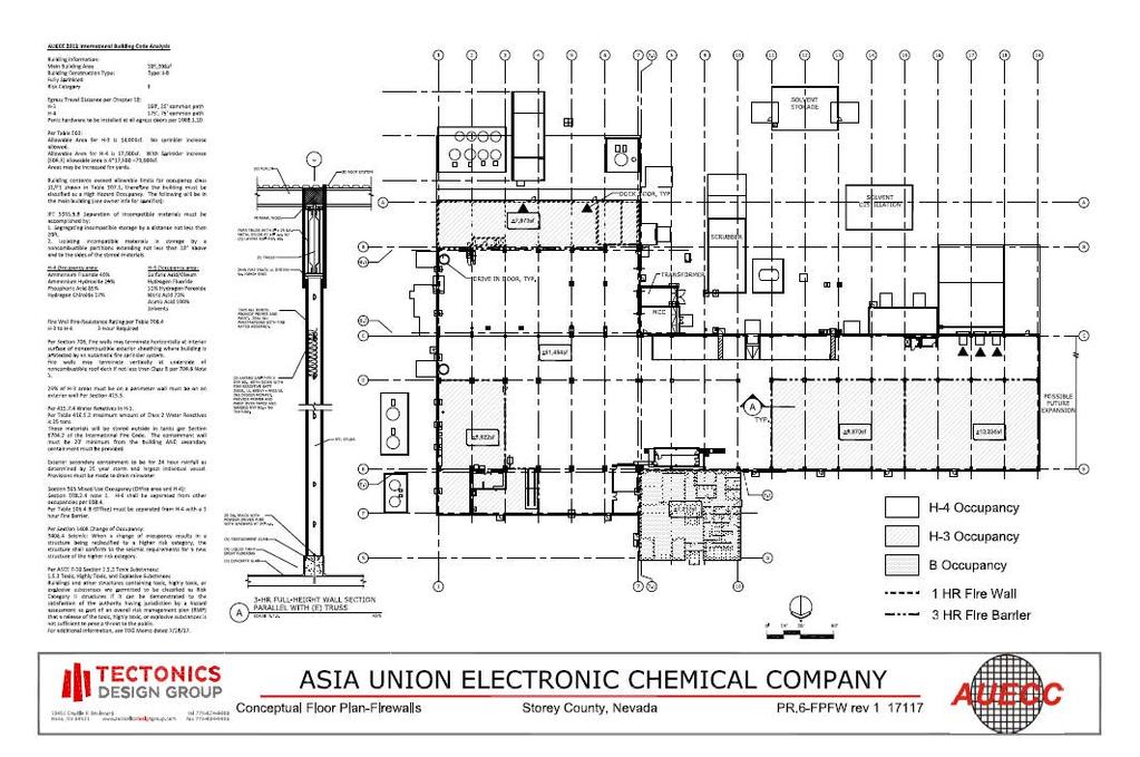
54 34

55 Exhibit E Surrounding Uses Map 35

56 Exhibit F NRS
57
58
59
60
61
62
63
64
65
66
67
68
69
70
71
72
73
74
75
76
77
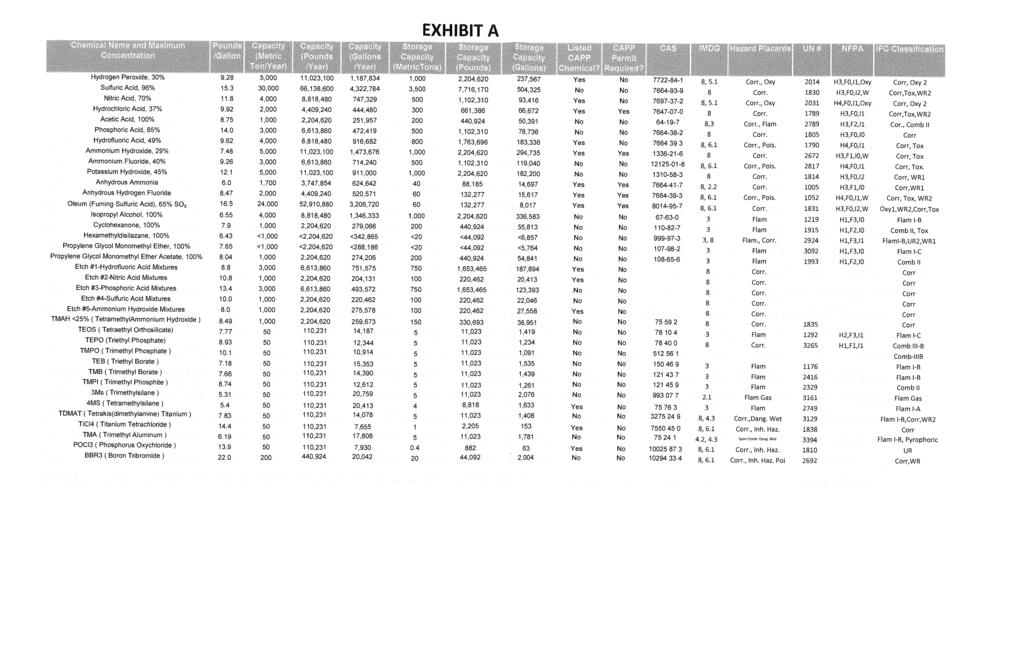
78
All items include discussion and possible action to approve, modify, deny, or continue unless marked otherwise.
 Jim Hindle Chairman Jim Collins Planning Commissioner Larry Prater Planning Commissioner Summer Pellett- Planning Commissioner Storey County Planning Commission Meeting Agenda Thursday November 1, 2018
All items include discussion and possible action to approve, modify, deny, or continue unless marked otherwise.
 Storey County Planning Commission Meeting Agenda Thursday, October 6, 2016 6:00 p.m. Storey County Courthouse, District Courtroom 26 South B Street, Virginia City, Nevada Larry Prater Chairman Virgil Bucchianeri
All items include discussion and possible action to approve, modify, deny, or continue unless marked otherwise.
 Storey County Planning Commission Meeting and Public Workshop Agenda Thursday April 18, 2019 6:00 p.m. Lockwood Senior/Community Center 800 Peri Ranch Road, Lockwood, NV Jim Hindle Chairman Jim Collins
All items include discussion and possible action to approve, modify, deny, or continue unless marked otherwise.
 Storey County Planning Commission Meeting Agenda Thursday, November 3, 2016 6:00 p.m. Storey County Courthouse, District Courtroom 26 South B Street, Virginia City, Nevada Larry Prater Chairman Virgil
STOREY COUNTY PLANNING COMMISSION MEETING Thursday, April 7, :00 p.m. 500 Sam Clemens Ave., Mark Twain Estates Mark Twain, NV 89403
 STOREY COUNTY PLANNING COMMISSION MEETING Thursday, April 7, 2016 6:00 p.m. 500 Sam Clemens Ave., Mark Twain Estates Mark Twain, NV 89403 MEETING MINUTES CHAIRMAN: Larry Prater VICE-CHAIRMAN: Jim Hindle
All items include discussion and possible action to approve, modify, deny, or continue unless marked otherwise.
 Jim Hindle Chairman Jim Collins Planning Commissioner Larry Prater Planning Commissioner Summer Pellett- Planning Commissioner Storey County Planning Commission Meeting Agenda Thursday January 17, 2019
MEETING MINUTES. COMMISSIONERS: Larry Prater, Kris Thompson, Laura Kekule, Summer Pellett, Jim Collins
 STOREY COUNTY PLANNING COMMISSION MEETING Thursday October 4, 2018 6:00 p.m. Storey County Courthouse, District Courtroom 26 South B Street, Virginia City, NV MEETING MINUTES CHAIRMAN: Jim Hindle VICE-CHAIRMAN:
All items include discussion and possible action to approve, modify, deny, or continue unless marked otherwise.
 Jim Hindle Chairman Virgil Bucchianeri Planning Commissioner Larry Prater Planning Commissioner Summer Pellett- Planning Commissioner Storey County Planning Commission Meeting Agenda Thursday June 21,
Storey County Planning Department
 Storey County Planning Department Storey County Courthouse 26 South B Street, PO Box 176, Virginia City, Nevada 89440 Phone 775-847-1144 Fax 775-847-0949 planning@storeycounty.org To: From: Meeting Date:
All items include discussion and possible action to approve, modify, deny, or continue unless marked otherwise.
 Storey County Planning Commission Meeting Agenda Thursday, July 16, 2015 6:00 p.m. Virginia City Highlands Park, 2141 Empire Rd Corner of Sazarac Rd. and Empire Rd.* Virginia City Highlands, NV Bret Tyler
All items include discussion and possible action to approve, modify, deny, or continue unless marked otherwise.
 Jim Hindle Chairman Jim Collins Planning Commissioner Larry Prater Planning Commissioner Summer Pellett- Planning Commissioner Storey County Planning Commission Meeting Agenda Thursday October 4, 2018
STOREY COUNTY PLANNING COMMISSION MEETING Thursday, May 19, :00 p.m. Rainbow Bend Clubhouse 500 Ave de la Bleu de Clair in Lockwood, Nevada
 STOREY COUNTY PLANNING COMMISSION MEETING Thursday, May 19, 2016 6:00 p.m. Rainbow Bend Clubhouse 500 Ave de la Bleu de Clair in Lockwood, Nevada MEETING MINUTES CHAIRMAN: Larry Prater VICE-CHAIRMAN: Jim
Guide to Replats. Step 1. Step 2. Step 3. Step 4. Step 5. Step 6. Step 7. Step 8. Step 9. Step 10
 Guide to Replats Introduction Douglas County is committed to providing open, transparent application processes to the public. This Guide is provided to assist anyone interested in the procedures and expectations
Guide to Combined Preliminary and Final Plats
 Guide to Combined Preliminary and Final Plats Introduction The Douglas County is committed to providing open, transparent application processes to the public. This Guide is provided to assist anyone interested
Guide to Minor Developments
 Guide to Minor Developments Introduction The Douglas County (DCD) is committed to providing open, transparent application processes to the public. This Guide is provided to assist anyone interested in
PLANNED UNIT DEVELOPMENT (PUD) AREA PLAN/REZONING REVIEW PROCEDURE
 AREA PLAN/REZONING REVIEW PROCEDURE") PLANNED UNIT DEVELOPMENT (PUD) AREA PLAN/REZONING REVIEW PROCEDURE Professional inquiries will be made to our Township Planning Consultant, Township Engineer, and Township Attorney to get their opinions
PLANNED UNIT DEVELOPMENT (PUD) AREA PLAN/REZONING REVIEW PROCEDURE Professional inquiries will be made to our Township Planning Consultant, Township Engineer, and Township Attorney to get their opinions
Town of Bristol Rhode Island
 Town of Bristol Rhode Island Subdivision & Development Review Regulations Adopted by the Planning Board September 27, 1995 (March 2017) Formatted: Highlight Formatted: Font: 12 pt Table of Contents TABLE
IV. REVIEW PROCEDURES FOR MINOR SUBDIVISIONS
 IV. REVIEW PROCEDURES FOR MINOR SUBDIVISIONS IV-A. General Minor subdivisions create five or fewer lots from a tract of record, each lot of which has legal and physical access. If the tract of record proposed
To provide for the review of the final engineering plans, the subdivision improvement agreement, public dedications, and other legal agreements.
 ARTICLE 5 FINAL PLAT 501 Intent DOUGLAS COUNTY SUBDIVISION RESOLUTION To provide for the review of the final engineering plans, the subdivision improvement agreement, public dedications, and other legal
STAFF REPORT # CONDITIONAL USE PLANNING COMMISSION MEETING DATE: July 20, 2017
 STAFF REPORT #17-4000-0005 CONDITIONAL USE PLANNING COMMISSION MEETING DATE: July 20, 2017 1. APPLICATION: An application submitted by Stephanie Moye requesting a conditional use permit to allow for a
CITY OF PISMO BEACH PLANNING COMMISSION AGENDA REPORT
 DATE: March 22, 2016 CITY OF PISMO BEACH PLANNING COMMISSION AGENDA REPORT TO: FROM: HONORABLE CHAIR AND MEMBERS OF THE PLANNING COMMISSION Jan Di Leo, Planner (805) 773-7088 jdileo@pismobeach.org THROUGH:
ROSEMEAD CITY COUNCIL STAFF REPORT
 ROSEMEAD CITY COUNCIL STAFF REPORT TO THE HONORABLE MAYOR AND CITY COUNCIL FROM JEFF ALLRED CITY MANAGER DATE JUNE 9 2015 6 SUBJECT MUNICIPAL CODE AMENDMENT 15 02 AMENDING CHAPTERS 17 04 AND 17 72 OF TITLE
DRAFT PARK COUNTY US HIGHWAY 89 SOUTH EAST RIVER ROAD OLD YELLOWSTONE TRAIL ZONING DISTRICT REGULATIONS
 Formatting: Changes recommended by the Board and accepted by the County Commission are formatted in RED: Changes made by the Park County Commission are formatted in YELLOW highlight: and changes made by
Board of Adjustment Staff Report Meeting Date: June 1, 2017
 Board of Adjustment Staff Report Meeting Date: June 1, 2017 Subject: Applicant: Agenda Item Number: Summary: Recommendation: Prepared by: Phone: E-Mail: Administrative Permit Case Number Powning Family
Preliminary Plat/Final Plat Application
 Melissa Municipal Center 3411 Barker Avenue Melissa, Texas 75454 Phone: (972) 838-2036 Applicant: Date: Address: Phone: Contact: Fax: E-mail: Propose Addition Name: Acres: Existing Zoning: Propose Zoning:
Community Dev. Coord./Deputy City Recorder
 1 2 3 4 5 6 7 8 9 10 11 12 13 14 15 16 17 18 19 20 21 22 23 24 25 26 27 28 29 30 31 32 33 34 35 36 37 38 39 40 41 42 43 44 45 46 NORTH OGDEN PLANNING COMMISSION MEETING MINUTES December 18, 2013 The North
CHAPTER SHORT SUBDIVISIONS
 CITY OF MOSES LAKE MUNICIPAL CODE CHAPTER 17.09 SHORT SUBDIVISIONS Sections: 17.09.010 Purpose 17.09.020 Scope 17.09.030 Preliminary Short Subdivision Conditions and Requirements 17.09.040 Referral to
STAFF REPORT And INFORMATION FOR THE HEARING EXAMINER
 KITSAP COUNTY DEPARTMENT OF COMMUNITY DEVELOPMENT 614 DIVISION STREET MS-36, PORT ORCHARD WASHINGTON 98366-4682 Louisa Garbo, Director (360) 337-7181 FAX (360) 337-4925 HOME PAGE - www.kitsapgov.com/dcd/
BARROW COUNTY, GEORGIA
 BARROW COUNTY, GEORGIA Application For Rezoning, Special Use, and Change in Conditions BARROW COUNTY DEPARTMENT OF PLANNING AND DEVELOPMENT 30 North Broad Street Winder, Georgia 30680 770-307-3034 APPLICATION
SUBDIVISION APPLICATION CHECKLIST SKETCH PLAN PRELIMINARY PLAT FINAL PLAT
 RECEIVED STAMP SUBDIVISION APPLICATION CHECKLIST SKETCH PLAN PRELIMINARY PLAT FINAL PLAT A checklist of background information and submission requirements for processing of a sketch plan, preliminary plat
City of Harrisburg Variance and Special Exception Application
 City of Harrisburg Variance and Special Exception Application Note: The Planning Bureau will review all applications for completeness; incomplete applications may cause a delay in processing. Contact Ben
APPLICATION PROCEDURE
 ANTRIM PLANNING BOARD P. O. Box 517 Antrim, New Hampshire 03440 Phone: 603-588-6785 FAX: 603-588-2969 APPLICATION FORM AND CHECKLIST FOR MINOR OR MAJOR SITE PLAN REVIEW File Date Received By APPLICATION
PLANNING COMMISSION STAFF REPORT
 PLANNING COMMISSION STAFF REPORT West Capitol Hill Zoning Map Amendment Petition No. PLNPCM2011-00665 Located approximately at 548 W 300 North Street, 543 W 400 North Street, and 375 N 500 West Street
2401 S. E. Monterey Road, Stuart, FL Plat Application Martin County Growth Management Department
 Martin County, Florida Growth Management Department DEVELOPMENT REVIEW DIVISION PLAT APPLICATION A. Identification of the applicant or agent: Applicant (property owner): Address: Telephone: Applicant's
TENTATIVE MAP INFORMATION SHEET
 TENTATIVE MAP INFORMATION SHEET GENERAL INFORMATION This information sheet explains how your Tentative Map application will be processed, what fees you must pay, and what plans you must submit. If you
EDGERTON CITY HALL PLANNING COMMISSION MEETING REGULAR SESSION March 12, 2019
 EDGERTON CITY HALL PLANNING COMMISSION MEETING REGULAR SESSION The met in regular session with Chair John Daley calling the meeting to order at 7:00 p.m. All present participated in the Pledge of Allegiance.
PLANNING DEPARTMENT Application for a Nonconforming Use Modification
 PLANNING DEPARTMENT Application for a Nonconforming Use Modification Dear Applicant: A nonconforming use (NCU) is a use that was lawfully established prior to the current requirements of the Pinellas County
MINOR LAND DIVISIONS APPLICATION
 APACHE COUNTY Planning and Zoning Department P.O. Box 238 St. Johns, AZ 85936 Phone: (928) 337-7527 Fax: (928) 337-7633 MINOR LAND DIVISIONS APPLICATION APPLICANT Name Mailing Address Contact Person Phone
STANDARDS GOVERNING CONVEYANCES OF REAL PROPERTY
 STANDARDS GOVERNING CONVEYANCES OF REAL PROPERTY Hancock County, Ohio Charity A. Rauschenberg, Hancock County Auditor Steven C. Wilson, Hancock County Engineer Revised: March 1, 2007 TRANSFER AND CONVEYANCE
All items include discussion and possible action to approve, modify, deny, or continue unless marked otherwise.
 Storey County Planning Commission Meeting Agenda Thursday, April 7, 2016 6:00 p.m. Mark Twain Community Center 500 Sam Clemens Ave., Mark Twain Estates Mark Twain, NV 89403 Larry Prater - Chairman Virgil
PLANNING COMMISSION STAFF REPORT June 18, 2015
 Community Development Department Planning Division 1600 First Street + P.O. Box 660 Napa, CA 94559-0660 (707) 257-9530 PLANNING COMMISSION STAFF REPORT June 18, 2015 AGENDA ITEM 7.B. PL15-0052 PM, GASSER
Guide to Preliminary Plans
 Guide to Preliminary Plans Introduction The Douglas County is committed to providing open, transparent application processes to the public. This Guide is provided to assist anyone interested in the procedures
ARTICLE III GENERAL PROCEDURES, MINOR PLANS AND FEE SCHEDULES
 ARTICLE III GENERAL PROCEDURES, MINOR PLANS AND FEE SCHEDULES 301. Prior to Submission a. Copies of this Ordinance shall be available on request, at cost, for the use of any person who desires information
COUNTY OF SACRAMENTO CALIFORNIA ZONING ADMINISTRATOR REPORT
 COUNTY OF SACRAMENTO CALIFORNIA ZONING ADMINISTRATOR REPORT For the Agenda of: May 4, 2016 To: From: Subject: Supervisorial District(s): Zoning Administrator Department of Community Development PLNP2015-00222.
Chapter 100 Planned Unit Development in Corvallis Urban Fringe
 100.100 Scope and Purpose. Chapter 100 Planned Unit Development in Corvallis Urban Fringe (1) All applications for land divisions in the Urban Residential (UR) and Flood Plain Agriculture (FPA) zones within
Parcel Map Review Committee Staff Report Meeting Date: October 13, 2016
 Subject: Applicant: Agenda Item Number: Project Summary: Recommendation: Parcel Map Review Committee Staff Report Meeting Date: October 13, 2016 Parcel Map Case Number Spanish Springs Associates Ltd. Ptsp.
CHAPTER 14 PLANNED UNIT DEVELOPMENTS
 9-14-1 9-14-1 CHAPTER 14 PLANNED UNIT DEVELOPMENTS SECTION: 9-14-1: Purpose 9-14-2: Governing Provisions 9-14-3: Minimum Area 9-14-4: Uses Permitted 9-14-5: Common Open Space 9-14-6: Utility Requirements
Town of Scarborough, Maine
 Town of Scarborough, Maine Miscellaneous Appeal INFORMATION REQUIRED FOR ALL APPEALS Before any appeal can be processed, the following material must be submitted to the Code Enforcement Office: 1. A fee
ARTICLE 2: General Provisions
 ARTICLE 2: General Provisions 2-10 Intent The basic intent of the Town of Orange s Zoning Ordinance is to implement the goals and objectives of the adopted Town of Orange Comprehensive Plan, hereafter
DRAFT. 1. Determination of Quorum Eric Young called the meeting to order at 1:31 p.m. The following members and staff were present:
 WASHOE COUNTY PARCEL MAP REVIEW COMMITTEE Meeting Minutes Parcel Map Review Committee Members Thursday, December 8, 2016 1:30 p.m. James Barnes, Planning Commission James English, Health District Tim Simpson,
HOW TO APPLY FOR A USE PERMIT
 HOW TO APPLY FOR A USE PERMIT MENDOCINO COUNTY PLANNING AND BUILDING SERVICES What is the purpose of a use permit? Throughout the County, people use their properties in many different ways. They build
Article 6: Planned Unit Developments
 LUDC 2013 GARFIELD COUNTY, COLORADO Article 6: Planned Unit Developments ARTICLE 6 PLANNED UNIT DEVELOPMENTS TABLE OF CONTENTS DIVISION 1. GENERAL.... 1 6-101. GENERAL PROVISIONS.... 1 A. Purpose....
# 13 ) UN MARAPHARM LV LLC - CULTIVATION SPECIAL USE PERMIT PUBLIC HEARING
 UN MARAPHARM LV LLC - CULTIVATION SPECIAL USE PERMIT PUBLIC HEARING") # 13 ) UN-38-16 MARAPHARM LV LLC - CULTIVATION SPECIAL USE PERMIT PUBLIC HEARING STAFF REPORT To: Planning Commission Meeting date: June 8, 2016 Item: UN-38-16 Prepared by: Marc Jordan GENERAL INFORMATION:
# 13 ) UN-38-16 MARAPHARM LV LLC - CULTIVATION SPECIAL USE PERMIT PUBLIC HEARING STAFF REPORT To: Planning Commission Meeting date: June 8, 2016 Item: UN-38-16 Prepared by: Marc Jordan GENERAL INFORMATION:
Parcel Map Review Committee Staff Report
 Parcel Map Review Committee Staff Report Meeting Date: October 11, 2018 Agenda Item: 7A TENTATIVE PARCEL MAP CASE NUMBER: (Larkins) BRIEF SUMMARY OF REQUEST: Request to divide one parcel of ±1.084-acres
APP. FEE: $ DATE & TIME LOCATION: 1/4 SECTION SECTION TOWNSHIP RANGE STREET ADDRESS AND GENERAL LOCATION OF PROPERTY CITY, STATE PHONE (DAY):
:") REVERSION TO ACREAGE PURSUANT TO N.R.S. 278.490 through 478.4965 Elko County Planning & Zoning 155 South 9th Street, Elko, NV 89801 (775) 738-6816 or 738-2266 APPLICATION MUST BE SUBMITTED WITH ALL REQUIRED
REVERSION TO ACREAGE PURSUANT TO N.R.S. 278.490 through 478.4965 Elko County Planning & Zoning 155 South 9th Street, Elko, NV 89801 (775) 738-6816 or 738-2266 APPLICATION MUST BE SUBMITTED WITH ALL REQUIRED
STAFF REPORT. To: Planning Commission Meeting date: January 11, 2017 Item: UN Prepared by: Marc Jordan. Schoolhouse Development, LLC
 STAFF REPORT # 9 ) UN-05-17 AMERICAN LEADERSHIP ACADEMY SPECIAL USE PERMIT CHARTER SCHOOL PUBLIC HEARING To: Planning Commission Meeting date: January 11, 2017 Item: UN-05-17 Prepared by: Marc Jordan GENERAL
SANTA BARBARA COUNTY ZONING ADMINISTRATOR STAFF REPORT January 11, 2008
 SANTA BARBARA COUNTY ZONING ADMINISTRATOR STAFF REPORT January 11, 2008 PROJECT: Gerrity Parking in Side Setback and Gerrity Student Housing Addition HEARINGDATE: January 28, 2008 STAFF/PHONE: J. Ritterbeck,
CITY OF TAFT PLANNING COMMISSION REGULAR MEETING WEDNESDAY, JANUARY 20, 2016 CITY HALL COUNCIL CHAMBERS 209 E. KERN ST.
 CITY OF TAFT PLANNING COMMISSION REGULAR MEETING AGENDA WEDNESDAY, JANUARY 20, 2016 CITY HALL COUNCIL CHAMBERS 209 E. KERN ST., TAFT, CA 93268 AS A COURTESY TO ALL - PLEASE TURN OFF CELL PHONES Any writings
Request for Action form is also defined as an application to be considered by the Planning Commission.
 CITY OF NORTH RIDGEVILLE INSTRUCTIONS FOR FILING REQUEST FOR ACTION APPLICATIONS WITH THE PLANNING COMMISSION (Please read the full instruction as it will help in providing a full complete application)
BOARD OF ADJUSTMENT MEETING CITY OF ST. PETE BEACH
 BOARD OF ADJUSTMENT MEETING CITY OF ST. PETE BEACH 155 Corey Avenue St. Pete Beach, Florida Wednesday, 11/15/2017 2:00 p.m. Call to Order Pledge of Allegiance Roll Call 1. Changes to the Agenda Agenda
SPECIAL USE FOR A PLANNED UNIT DEVELOPMENT (P.U.D.), REZONING, and COMPREHENSIVE PLAN AMENDMENT APPLICATION PACKET
, REZONING, and COMPREHENSIVE PLAN AMENDMENT APPLICATION PACKET") SPECIAL USE FOR A PLANNED UNIT DEVELOPMENT (P.U.D.), REZONING, and COMPREHENSIVE PLAN AMENDMENT APPLICATION PACKET VILLAGE OF HANOVER PARK DEVELOPMENT COMMISSION Village of Hanover Park Department of Community
SPECIAL USE FOR A PLANNED UNIT DEVELOPMENT (P.U.D.), REZONING, and COMPREHENSIVE PLAN AMENDMENT APPLICATION PACKET VILLAGE OF HANOVER PARK DEVELOPMENT COMMISSION Village of Hanover Park Department of Community
250 CMR: BOARD OF REGISTRATION OF PROFESSIONAL ENGINEERS AND LAND SURVEYORS DRAFT FOR DISCUSSION PURPOSES ONLY
 250 CMR 6.00: LAND SURVEYING PROCEDURES AND STANDARDS Section 6.01: Elements Common to All Survey Works 6.02: Survey Works of Lines Affecting Property Rights All land surveying work is considered work
LEMOORE PLANNING COMMISSION Regular Meeting AGENDA Lemoore Council Chamber 429 C Street. May 14, :00 p.m.
 LEMOORE PLANNING COMMISSION Regular Meeting AGENDA Lemoore Council Chamber 429 C Street May 14, 2018 7:00 p.m. 1. Pledge of Allegiance 2. Call to Order and Roll Call 3. Public Comment This time is reserved
INTERLOCAL AGREEMENT PERMITTING CONSTRUCTION OF SOUTHEAST CONNECTOR ON THE TRUCKEE MEADOWS WATER RECLAMATION FACILITY
 INTERLOCAL AGREEMENT PERMITTING CONSTRUCTION OF SOUTHEAST CONNECTOR ON THE TRUCKEE MEADOWS WATER RECLAMATION FACILITY This Agreement Permitting Construction of SouthEast Connector on the Truckee Meadows
ARTICLE 15 - PLANNED UNIT DEVELOPMENT
 Section 15.1 - Intent. ARTICLE 15 - PLANNED UNIT DEVELOPMENT A PUD, or Planned Unit Development, is not a District per se, but rather a set of standards that may be applied to a development type. The Planned
Item 10C 1 of 69
 MEETING DATE: August 17, 2016 PREPARED BY: Diane S. Langager, Principal Planner ACTING DEPT. DIRECTOR: Manjeet Ranu, AICP DEPARTMENT: Planning & Building CITY MANAGER: Karen P. Brust SUBJECT: Public Hearing
Conduct a hearing on the appeal, consider all evidence and testimony, and take one of the following actions:
 AGENDA ITEM #4.A TOWN OF LOS ALTOS HILLS Staff Report to the City Council SUBJECT: FROM: APPEAL OF PLANNING COMMISSION DENIAL OF A CONDITIONAL DEVELOPMENT PERMIT AND SITE DEVELOPMENT PERMIT FOR A NEW 3,511
II. What Type of Development Requires Site Plan Review? There are five situations where a site plan review is required:
 I. What is a Site Plan Review? Site Plan Review is a process where the construction of new buildings, new additions, and certain types of canopies and/or tax-exempt institutions are reviewed by the City
ASPEN GLEN PUD. Eighth Amended PUD Guidelines
 ASPEN GLEN PUD Eighth Amended PUD Guidelines A. Applicability Statement To carry out the purposes and provisions of the Garfield County Zoning Regulations, as amended, The Aspen Glen Club Planned Unit
CHAPTER 3 PRELIMINARY PLAT
 10-3-1 10-3-3 SECTION: CHAPTER 3 PRELIMINARY PLAT 10-3-1: Consultation 10-3-2: Filing 10-3-3: Requirements 10-3-4: Approval 10-3-5: Time Limitation 10-3-6: Grading Limitation 10-3-1: CONSULTATION: Each
Transfer and Conveyance Standards of the Athens County Auditor and the Athens County Engineer. Table of Contents
 Transfer and Conveyance Standards of the Athens County Auditor and the Athens County Engineer Table of Contents Adoption of Standards Governing Conveyances of Real Property in Athens County, Ohio... 3
2018 Requirements Manual An In-Depth Look at Changes to the Requirements
 2018 Requirements Manual An In-Depth Look at Changes to the Requirements Executive Summary The Requirements Manual helps land trusts understand how the Land Trust Accreditation Commission verifies that
PLANNING DEPARTMENT Application for a Type 2 Use through the Board of Adjustment & Appeals
 PLANNING DEPARTMENT Application for a Type 2 Use through the Board of Adjustment & Appeals Dear Applicant: Type 2 uses (formerly called Special Exceptions) are uses that may be approved if certain criteria
LYON COUNTY TITLE 15 LAND USE AND DEVELOPMENT CODE LAND DIVISION REGULATIONS CHAPTERS October 19, 2017 Ordinance Draft DRAFT
 DRAFT LYON COUNTY TITLE 15 LAND USE AND DEVELOPMENT CODE LAND DIVISION REGULATIONS CHAPTERS 15.600 15.607 October 19, 2017 Ordinance Draft This page left blank intentionally DRAFT DRAFT Lyon County Contents
Marion County Board of County Commissioners
 Marion County Board of County Commissioners Date: 12/29/2015 P&Z: 12/28/2015 BCC: 1/12/2016 Item Number 160113Z Type of Application Rezoning Request From: A-1 (General Agriculture) To: PUD (Planned Unit
SUBDIVISION APPLICATION (CHECK THE BOX THAT APPLIES)
") GARFIELD COUNTY Building & Planning Department 108 8 th Street, Suite 401 Glenwood Springs, Colorado 81601 Telephone: 970.945.8212 Facsimile: 970.384.3470 www.garfield-county.com SUBDIVISION APPLICATION
GARFIELD COUNTY Building & Planning Department 108 8 th Street, Suite 401 Glenwood Springs, Colorado 81601 Telephone: 970.945.8212 Facsimile: 970.384.3470 www.garfield-county.com SUBDIVISION APPLICATION
Secondary Dwelling Unit
 Secondary Dwelling Unit Review of Special Use Regulations (City Code Section 17.228.105) The purpose of this application is to determine whether or not your project meets the Planning and Development Code
Administrative Permit Staff Report Meeting Date: February 2, 2017
 Administrative Permit Staff Report Meeting Date: February 2, 2017 Subject: Applicant: Agenda Item Number: Summary: Recommendation: Administrative Permit Case Number WADMIN16-0001 Carlson and Associates
City of Altamonte Springs Developer s Guide
 Section 6 SUBDIVISION PLAN & PLAT REVIEW PROCESS This section contains information, applications, and checklists related to the subdivision development plan and plat review process in Altamonte Springs.
Agenda Report DATE: APRIL 30,2007 TO: CITY COUNCIL CYNTHIA J. KURTZ, CITY MANAGER FROM:
 Agenda Report DATE: APRIL 30,2007 TO: FROM: SUBJECT: CITY COUNCIL CYNTHIA J. KURTZ, CITY MANAGER APPROVAL OF THE DEVELOPMENT AGREEMENT FOR THE SMVIA NOISE WITHIN MIXED-USE PROJECT BETWEEN THE ClTY OF PASADENA
FOR OFFICE USE ONLY Date Submitted Received By Fees Paid $ Receipt No. Received By Application No. Application Complete Final Action Date
 COMMERCIAL, INDUSTRIAL, & MANUFACTURING SITE PLAN (CIM) APPLICATION Mariposa County Planning Department 5100 Bullion Street, P.O. Box 2039 Mariposa, CA 95338 Telephone (209) 966-5151 FAX (209) 742-5024
CITY OF NOVI LAND DIVISION INSTRUCTIONS
 CITY OF NOVI LAND DIVISION INSTRUCTIONS All applications for land division in the City of Novi must be in compliance with Chapter 32 of the City of Novi Code of Ordinances and with the Land Division Act,
This is a conditional use permit request to establish a commercial wind energy conversion system.
 Public Works 600 Scott Boulevard South Hutchinson, Kansas 67505 620-694-2976 Road & Bridge Planning & Zoning Noxious Weed Utilities Date: March 28, 2019 To: From: Reno County Planning Commission Russ Ewy,
The following regulations shall apply in the R-E District:
 "R-E" RESIDENTIAL ESTATE DISTRICT (8/06) The following regulations shall apply in the R-E District: 1. Uses Permitted: The following uses are permitted. A Zoning Certificate may be required as provided
FERNLEY PLANNING COMMISSION MEETING MINUTES JULY 11, 2018
 FERNLEY PLANNING COMMISSION MEETING MINUTES JULY 11, 2018 Mayor Edgington called the meeting to order at 5:02 p.m. at Fernley City Hall, 595 Silver Lace Blvd, Fernley, NV. 1. ROLL CALL Present: Chairman
ACCESSORY USE PERMIT APPLICATION
 TOWN OF CARY Submit to the Development Customer Service Center, P.O. Box 8005, Cary, NC 27512 Planning Department Planning Department Contact: (919) 469-4046 Fee: $50.00 For office use only: Method of
ORDINANCE NO.: Adopted: August 2, 2005 Amended: March 27, 2007 Amended: September 23, Fillmore County Rural Addressing Ordinance
 ORDINANCE NO.: 2005-01 Adopted: August 2, 2005 Amended: March 27, 2007 Amended: September 23, 2008 Fillmore County Rural Addressing Ordinance Section 1 Purpose, Scope and Statutory Authorization 1-1 Purpose.
DEPARTMENT OF FISH AND WILDLIFE ENVIRONMENTAL FILING FEES (Fish and Game Code 711.4)
") PARCEL MAP PROCESS DEPARTMENT OF PLANNING AND BUILDING SERVICES 707 Nevada Street, Suite 5 Susanville, CA 96130-3912 (530) 251-8269 (530) 251-8373 (fax) www.co.lassen.ca.us A subdivision is any division
PARCEL MAP PROCESS DEPARTMENT OF PLANNING AND BUILDING SERVICES 707 Nevada Street, Suite 5 Susanville, CA 96130-3912 (530) 251-8269 (530) 251-8373 (fax) www.co.lassen.ca.us A subdivision is any division
1. Consider approval of the June 13, 2017 Regular Meeting Minutes
 Board of Adjustment Regular Meeting Agenda Tuesday August 8, 2017-6:30 PM Town Hall A. Roll Call, Determination of Quorum B. Approval of Minutes of Previous Meeting 1. Consider approval of the June 13,
Planning Department 168 North Edwards Street Post Office Drawer L Independence, California 93526
 Planning Department 168 North Edwards Street Post Office Drawer L Independence, California 93526 Phone: (760) 878-0263 FAX: (760) 8782-2712 E-Mail: inyoplanning@inyocounty.us AGENDA ITEM NO.: 4 (Action
ARTICLE 24 SITE PLAN REVIEW
 ARTICLE 24 SITE PLAN REVIEW 24.1 PURPOSE: The intent of these Ordinance provisions is to provide for consultation and cooperation between the land developer and the Township Planning Commission in order
APPLICATION PACKET SUBDIVISION PLAT REVIEW TENTATIVE PRELIMINARY PLAT
 APPLICATION PACKET SUBDIVISION PLAT REVIEW TENTATIVE PRELIMINARY PLAT COMMUNITY DEVELOPMENT DEPARTMENT CHARTER TOWNSHIP OF PLYMOUTH 9955 N. Haggerty Road Plymouth, MI 48170 Fees Revised 7/01/2012 APPLICATION
SITE PLAN REVIEW ADMINISTRATIVE REVIEW. Please Note: Once submitted to the County, all application materials become a matter of public record.
 200 W. Oak Street, 3rd Floor Fort Collins, CO 80521 (970) 498-7683 / larimer.org/planning SITE PLAN REVIEW ADMINISTRATIVE REVIEW The submittal requirements listed in this packet are intended to collect
Community Services Department Planning and Development ABANDONMENT APPLICATION
 Community Services Department Planning and Development ABANDONMENT APPLICATION Community Services Department Planning and Development 1001 E. Ninth St., Bldg A Reno, NV 89520 Telephone: 775.328.3600 Washoe
DOUGLAS COUNTY SUBDIVISION RESOLUTION Article 4 Preliminary Plan 10/13/2015
 ARTICLE 4 PRELIMINARY PLAN 401 Intent An in-depth analysis of the proposed subdivision, including a review of the design considering the ability to obtain water and sanitation, identified geologic hazards,
FINAL PLAT GUIDE TO SUBDIVIDING PROPERTY. Background
 FINAL PLAT GUIDE TO SUBDIVIDING PROPERTY Background A final plat is the second step in the process of subdividing land into separate parcels for future sale or lease. Once a preliminary plat has been approved
CONDITIONAL USE PERMIT APPLICATION FOR AN EXCAVATION/BORROW PIT INSTRUCTIONS
 City of Chesapeake Department of Planning Post Office Box 15225 Chesapeake, Virginia 23328-5225 (757) 382-6176 FAX (757) 382-6406 CONDITIONAL USE PERMIT APPLICATION FOR AN EXCAVATION/BORROW PIT INSTRUCTIONS
Nassau County Single Land Split Application
 NASSAU COUNTY DEPARTMENT OF PLANNING AND ECONOMIC OPPORTUNITY FLORIDA Nassau County Single Land Split Application Taco E. Pope, AICP, Director 96161 Nassau Place Yulee, Florida 32097 (904) 530-6300 APPLICATION
Midwest City, Oklahoma Zoning Ordinance
 2010 Midwest City, Oklahoma Zoning Ordinance 9/2/2010 Table of Contents Section 1. General Provisions... 5 1.1. Citation... 5 1.2. Authority... 5 1.3. Purpose... 5 1.4. Nature and Application... 5 1.5.
SECTION 4: PRELIMINARY PLAT
 SECTION 4: PRELIMINARY PLAT After the completion of the sketch plan process, if submitted, the owner or developer shall file with the City an application for preliminary plat. The preliminary plat stage