CONTRA COSTA COUNTY PLANNING COMMISSION TUESDAY, NOVEMBER 19, :00 P.M.
|
|
|
- Imogen Adams
- 5 years ago
- Views:
Transcription
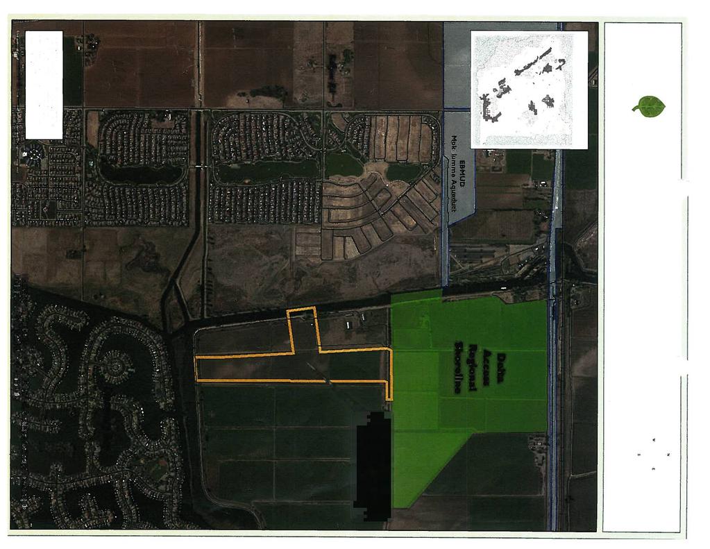
1 Conservation and Development Agenda Item # 3 Contra Costa County CONTRA COSTA COUNTY PLANNING COMMISSION TUESDAY, NOVEMBER 19, :00 P.M. MANDATORY REFERRAL ACQUISITION OF 90(+/-) ACRES OF LAND, ASSESSOR PARCEL NO ORWOOD ROAD NEAR TOWN OF DISCOVERY BAY BY THE EAST BAY REGIONAL PARK DISTRICT (CP# 13-38) STAFF REPORT This is a public hearing to consider the General Plan conformance of a proposed acquisition by the East Bay Regional Park District (EBRPD) of one parcel totaling 90 (+/-) acres located at 4571 Castro Ranch Road in an unincorporated near the Town of Discovery Bay (CT ) Section of the California Government Code requires a finding regarding the General Plan conformance of any public project that involves the acquisition or disposal of real property, or the authorization or construction of a building or structure. EBRPD proposes to acquire 90 (+/-) acres of land, known as the Aginson property, in an unincorporated area on Orwood Tract. The parcel to be acquired is Assessor Parcel Number (APN): The subject site is depicted in a map attached to the October 24, 2013 letter from EBRPD describing this property acquisition, which is listed as Exhibit "A" to this report. The subject parcel to be acquired is located south of Orwood Road and is adjacent to the south of EBRPD s existing Delta Access Property, east of Orwood Resort, and adjacent to Warner Dredge Cut. EBRPD s recently updated Master Plan identifies the Delta Access Property as the future site for a Regional Recreation Area, which is parkland intended and suited to provide a variety of outdoor recreational experiences, such as picnicking, swimming, fishing, camping and boating. The Delta Access Property, which is 276 acres and acquired by the District some years ago, is currently in what EBRPD describes as land banked status. This means that they have not yet approved a land use plan for the development of recreational facilities on this site. The addition of the 90-acre Aginson property would expand the area of this future Regional Recreational Area and would provide more direct access to the Delta waterway. 1
2 Improving the public s access to the Delta waterways has been a long standing goal of EBRPD. In the meantime, while EBRPD develops plans and funding for more specific recreation uses within the future Regional Recreation Area they will continue leasing both properties for agricultural use. CEQA STATUS The proposed project entails the acquisition of property which would be subject to a separate environmental review by EBRPD as lead agency in accordance with the California Environmental Quality Act. GENERAL PLAN The County General Plan identifies APN: , approximately 90 (+/-) acres, as Delta Recreation and Resources (DR), it is located outside the County s Urban Limit Line, and it is zoned in the A-3, Heavy Agricultural District. See attached map (listed as Exhibit "B") depicting the location of the Urban Limit Line, General Plan land use and Zoning District designations for the subject parcel. RECOMMENDATION Staff recommends the Commission find the proposed acquisition of the subject parcel, APN: , by EBRPD for parkland, trail, and open space purposes in conformance with the County General Plan. Since EBRPD is acquiring the acreage for parkland, trail, and open space purposes, the proposed acquisition would be consistent with the goals and policies of the County General Plan, in particular the Open Space Element. The Open Space Element endorses the expansion of parks and open space areas to protect the unique resources of the County. More specifically, Section 9.8 in the Open Space Element (see pages 9-12 to 9-24, online version, Contra Costa County General Plan ( ), describes several goals, policies and implementation measures aimed at supporting the development of major park and open space lands by EBRPD. Attachments (2) Exhibit A : Exhibit "B": 10/24/2013 Letter from John Bouyea, Sr. Land Acquisition Specialist, EBRPD re: APN , Aginson Property Acquisition, Maps of the Subject Property to be acquired by EBRPD in Relation to the Contra Costa County General Plan Land Use Designations and Zoning Districts 2
3 Exhibit A : 10/24/2013 Letter from John Bouyea, Sr. Land Acquisition Specialist, EBRPD re: APN , Aginson Property Acquisition 3


4


5
6 Exhibit "B": Maps of the Subject Property to be acquired by EBRPD in Relation to the Contra Costa County General Plan Land Use Designations and Zoning Districts 4
7 Fallman Rd CP#13-38 Acqusition of Parcel by EBRPD APN Number Located on Orwood Rd near Discovery Bay Orwood Rd PS (Public and Semi-Public) AL (Agricultural Lands) PR (Parks and Recreation) SH (Single-Family Residential - High Density) DR (Delta Recreation and Resources) SM (Single-Family Residential - Medium Density) apn: Oakley Brentwood Sellers Ave Delta Rd Sunset Rd Vasco Rd I 0 Byron Hwy Byron Hwy }þ 4 Vicinity Map SITE Miles ML WA (Water) Map Created 11/5/2013 by Contra Costa County Department of Conservation and Development, GIS Group 30 Muir Road, Martinez, CA :59:41.791N 122:07:03.756W OS (Open Space) Parcel For Acquisition Parcels General Plan SM (Single Family Residential - Medium) SH (Single Family Residential - High) ML (Multiple Family Residential - Low) PS (Public/Semi-Public) PR (Parks and Recreation) OS (Open Space) AL (Agricultural Lands) DR (Delta Recreation) WA (Water) This map was created by the Contra Costa County Department of Conservation and Development with data from the Contra Costa County GIS Program. Some base data, primarily City Limits, is derived from the CA State Board of Equalization's tax rate areas. While obligated to use this data the County assumes no responsibility for its accuracy. This map contains copyrighted information and may not be altered. It may be reproduced in its current state if the source is cited. Users of this map agree to read and accept the County of Contra Costa disclaimer of liability for geographic information.
 apn: 015-200-009 A-4 (Agricultural Preserve) A-3 Oakley Brentwood Sellers Ave Delta Rd Sunset Rd Vasco Rd I 0 Byron Hwy Byron Hwy }þ 4 Vicinity Map SITE 0.125 0.")
8 Fallman Rd CP#13-38 Acqusition of Parcel by EBRPD APN Number Located on Orwood Rd near Discovery Bay Orwood Rd A-2, -X A-3, -X A-2 (General Agricultural) A-3 (Heavy Agricultural) P-1 (Planned Unit) apn: A-4 (Agricultural Preserve) A-3 Oakley Brentwood Sellers Ave Delta Rd Sunset Rd Vasco Rd I 0 Byron Hwy Byron Hwy }þ 4 Vicinity Map SITE Miles M-12 P-1 F-1 Map Created 11/5/2013 by Contra Costa County Department of Conservation and Development, GIS Group 30 Muir Road, Martinez, CA :59:41.791N 122:07:03.756W Parcel For Acquisition Parcels Zoning F-1 (Water P-1 Recreational) F-1 -FH (Water Rec - Fld Haz Comb Dist) A-2 (General Agricultural) A-2 -X (General Ag - RR Corr Comb Dist) A-3 (Heavy Agricultural) A-3 -X (Heavy Ag - RR Corr Comb Dist) A-4 (Agricultural Preserve) P-1 (Planned Unit) M-12 (Multiple Family Residential) This map was created by the Contra Costa County Department of Conservation and Development with data from the Contra Costa County GIS Program. Some base data, primarily City Limits, is derived from the CA State Board of Equalization's tax rate areas. While obligated to use this data the County assumes no responsibility for its accuracy. This map contains copyrighted information and may not be altered. It may be reproduced in its current state if the source is cited. Users of this map agree to read and accept the County of Contra Costa disclaimer of liability for geographic information.
Reclamation Districts
 s Contra Costa LAFCO May 2013 Directory of Local Agencies RECLAMATION DISTRICT 799 (Hotchkiss Tract) (Special Act of California Legislature, Statutes 1911:342, California Water Code 50300 et seq.) Location
CONTRA COSTA LOCAL AGENCY FORMATION COMMISSION EXECUTIVE OFFICER'S REPORT. January 8, 2014 (Agenda)
") CONTRA COSTA LOCAL AGENCY FORMATION COMMISSION EXECUTIVE OFFICER'S REPORT : Rodeo Marina Annexation to Rodeo Sanitary District (RSD) PROPONENT: RSD by Resolution No. 2011-01 adopted April 12, 2011 ACREAGE
CONTRA COSTA LOCAL AGENCY FORMATION COMMISSION EXECUTIVE OFFICER'S REPORT : Rodeo Marina Annexation to Rodeo Sanitary District (RSD) PROPONENT: RSD by Resolution No. 2011-01 adopted April 12, 2011 ACREAGE
CONTRA COSTA LOCAL AGENCY FORMATION COMMISSION EXECUTIVE OFFICER'S REPORT August 12, 2015 (Agenda)
") CONTRA COSTA LOCAL AGENCY FORMATION COMMISSION EXECUTIVE OFFICER'S REPORT PROPONENTS ACREAGE & LOCATION Laurel Place/Pleasant View Annexation to the City of Concord Curt Blomstrand, Lenox Homes landowner/petitioner
CONTRA COSTA LOCAL AGENCY FORMATION COMMISSION EXECUTIVE OFFICER'S REPORT PROPONENTS ACREAGE & LOCATION Laurel Place/Pleasant View Annexation to the City of Concord Curt Blomstrand, Lenox Homes landowner/petitioner
CONTRA COSTA LOCAL AGENCY FORMATION COMMISSION EXECUTIVE OFFICER'S REPORT. September 15, 2010 (Agenda)
") CONTRA COSTA LOCAL AGENCY FORMATION COMMISSION EXECUTIVE OFFICER'S REPORT : Northeast Area Annexation to Delta Diablo Sanitation District (DDSD) PROPONENT: City of Pittsburg Resolution No. 09-11357 adopted
CONTRA COSTA LOCAL AGENCY FORMATION COMMISSION EXECUTIVE OFFICER'S REPORT : Northeast Area Annexation to Delta Diablo Sanitation District (DDSD) PROPONENT: City of Pittsburg Resolution No. 09-11357 adopted
CONTRA COSTA LOCAL AGENCY FORMATION COMMISSION EXECUTIVE OFFICER'S REPORT. May 12, 2010 (Agenda)
") CONTRA COSTA LOCAL AGENCY FORMATION COMMISSION EXECUTIVE OFFICER'S REPORT LAFCO 10-01: Annexation 174 to Central Contra Costa Sanitary District (CCCSD) PROPONENT: CCCSD by Resolution No. 2009-027 adopted
CONTRA COSTA LOCAL AGENCY FORMATION COMMISSION EXECUTIVE OFFICER'S REPORT LAFCO 10-01: Annexation 174 to Central Contra Costa Sanitary District (CCCSD) PROPONENT: CCCSD by Resolution No. 2009-027 adopted
CONTRA COSTA LOCAL AGENCY FORMATION COMMISSION EXECUTIVE OFFICER'S REPORT. August 9, 2017 (Agenda)
") LAFCO 17-04 CONTRA COSTA LOCAL AGENCY FORMATION COMMISSION EXECUTIVE OFFICER'S REPORT North Peak Equestrian Center Annexation to Contra Costa Water District PROPONENT Contra Costa Water District by Resolution
LAFCO 17-04 CONTRA COSTA LOCAL AGENCY FORMATION COMMISSION EXECUTIVE OFFICER'S REPORT North Peak Equestrian Center Annexation to Contra Costa Water District PROPONENT Contra Costa Water District by Resolution
Planning Department 168 North Edwards Street Post Office Drawer L Independence, California 93526
 Planning Department 168 North Edwards Street Post Office Drawer L Independence, California 93526 Phone: (760) 878-0263 FAX: (760) 872-2712 E-Mail: inyoplanning@inyocounty.us AGENDA ITEM NO.: 6 (Action
Creekside Ranch Home Site
 ! Creekside Ranch Home Site PROPERTY REPORT! ADDRESS: 22957 Tombill Rd Ramona, CA, 92065 DESCRIPTION: JUST REDUCED. 15.99 ACRE home site in the beautiful Creekside Ranch area located in Ramona, Ca. This
Planning Department 168 North Edwards Street Post Office Drawer L Independence, California 93526
 Planning Department 168 North Edwards Street Post Office Drawer L Independence, California 93526 Phone: (760) 878-0263 FAX: (760) 872-2712 E-Mail: inyoplanning @ inyocounty.us AGENDA ITEM NO.: 5 (Action
RESOLUTION NO. R2010-
 RESOLUTION NO. R2010- A RESOLUTION OF THE CITY OF MANTECA CITY COUNCIL AUTHORIZING SUBMITTAL OF APPLICATION TO THE SAN JOAQUIN LOCAL AGENCY FORMATION COMMISSION IN THE MATTER OF REORGANIZATION, INCLUDING
REPORT TO THE SHASTA COUNTY PLANNING COMMISSION
 REPORT TO THE SHASTA COUNTY PLANNING COMMISSION PROJECT IDENTIFICATION: REGULAR AGENDA GENERAL PLAN AMENDMENT GPA18-0003 AND ZONE AMENDMENT ZA18-0004 AREA 3 - SOUTHWEST PALO CEDRO: GILBERT DRIVE CONTINUED
Contra Costa County Department of Conservation & Development
 Contra Costa County Department of Conservation & Development PANTAGES BAYS COUNTY FILES: GP#99-0008, RZ#04-3146, SD#06-9010, DP#04-3062 BOARD OF SUPERVISORS PUBLIC HEARING DECEMBER 3, 2013 1 SITE LOCATION
M EMORANDUM LAND VALUE ESTIMATES
 Economic & Planning Systems Real Estate Economics Regional Economics Public Finance Land Use Policy M EMORANDUM To: From: Association Teifion Rice-Evans, Jason Tundermann Subject: Draft Land Valuation
a1-1 ASSESSOR PARCEL NUMBER San Luis Bay Planning Area Coastal, Avila Beach Specific Plan, Coastal Zone, Flood Hazard
 a1-1 COUNTY OF SAN LUIS OBISPO DEPARTMENT OF PLANNING AND BUILDING STAFF REPORT Promoting the wise use of land Helping build great communities MEETING DATE March 27, 2014 DETERMINATION DATE March 20, 2014
For Sale SW Martin Highway Palm City, FL 34990
 For Sale SW Martin Highway Palm City, FL 34990 PROPERTY OVERVIEW 200+ acres of vacant agricultural land with over 1 mile of I-95 frontage and a 25+/- acre man-made lake. Perfect for long term hold and
Oakland Berkeley Association of REALTORS Grants Program is still open till end of March click here for more information
 It's the BUZZ!! March 10, 2017 Oakland Berkeley Association of REALTORS Grants Program is still open till end of March click here for more information The Oakland Berkeley Association of REALTORS and East
GROVE and HOME SITE VALLEY CENTER PROPERTY REPORT
 VALLEY CENTER GROVE and HOME SITE PROPERTY REPORT ADDRESS: 5.56 Acres on West Lilac Road, Valley Center, CA 92082 DESCRIPTION: 5 + ACRE avocado grove and home site located in the heart of San Diego County
PLANNING COMMISSION STAFF REPORT February 19, 2015
 Community Development Department Planning Division 1600 First Street + P.O. Box 660 Napa, CA 94559-0660 (707) 257-9530 PLANNING COMMISSION STAFF REPORT February 19, 2015 AGENDA ITEM #7A PL13-0091 GENERAL
EL DORADO COUNTY DEVELOPMENT SERVICES ZONING ADMINISTRATOR STAFF REPORT VARIANCE
 EL DORADO COUNTY DEVELOPMENT SERVICES ZONING ADMINISTRATOR STAFF REPORT Agenda of: August 6, 2008 Item No.: Staff: 4.d. Robert Peters VARIANCE FILE NUMBER: V08-0004 APPLICANT: Joseph and Ingrid Herrick
APPLICATION FOR 555 Washington Street Tentative Map Red Bluff, CA Subdivision Map (530) ext Parcel Map.
 ext Parcel Map.") City of Red Bluff Community Development Department Application No. APPLICATION FOR 555 Washington Street Tentative Map Red Bluff, CA 96080 Subdivision Map (530) 527-2605 ext. 3059 Parcel Map Applicant
City of Red Bluff Community Development Department Application No. APPLICATION FOR 555 Washington Street Tentative Map Red Bluff, CA 96080 Subdivision Map (530) 527-2605 ext. 3059 Parcel Map Applicant
Mohave County General Plan
 63 64 65 66 67 68 69 70 71 The Land Use Diagram is not the County's zoning map. 13 It is a guide to future land use patterns. Zoning and area plan designations may be more restrictive than the land use
COUNTY OF SANTA BARBARA PLANNING AND DEVELOPMENT Consent Agenda. Doug Anthony, Deputy Director, Development Review - North
 COUNTY OF SANTA BARBARA PLANNING AND DEVELOPMENT Consent Agenda TO: FROM: County Planning Commission Doug Anthony, Deputy Director, Development Review - North HEARING DATE: December 5, 2011 RE: Hearing
Staff Report. Victoria Walker, Director of Community and Economic Development
 7.a Staff Report Date: July 11, 2017 To: From: Reviewed by: Prepared by: Subject: City Council Valerie J. Barone, City Manager Victoria Walker, Director of Community and Economic Development John Montagh,
PROJECTS IN THE RANCHO CALAVERAS/ LA CONTENTA AREA:
 PROJECTS IN THE RANCHO CALAVERAS/ LA CONTENTA AREA: Note: information subject to change; contact Planning Dept. or Supervisor Erickson for update/questions (information below was supplied by Calaveras
6284 SAN PABLO DAM EL SOBRANTE CALIFORNIA
 6284 SAN PABLO DAM EL SOBRANTE CALIFORNIA OFFERING MEMORANDUM Final Map Ready Single-Family Residential 7 Lots 2.57 Acres Accelerating success. DISCLAIMER STATEMENT This Offering Memorandum ( Memorandum
COUNTY OF LINCOLN, NORTH CAROLINA
 COUNTY OF LINCOLN, NORTH CAROLINA 302 NORTH ACADEMY STREET, SUITE A, LINCOLNTON, NORTH CAROLINA 28092 PLANNING AND INSPECTIONS DEPARTMENT 704-736-8440 OFFICE 704-732-9010 FAX To: Alex Patton, Board of
329 acres in Bulverde, Comal County, Texas. Approximately 12 miles to intersection of Hwy 281 North and Loop 1604
 329 acres in Bulverde, Comal County, Texas Approximately 12 miles to intersection of Hwy 281 North and Loop 1604 San Antonio Board of Realtors MLS # 830256 ++ Central Texas MLS MLS # 164152 ++ jbgoodwin.com
Chapter 2: Existing Land Use
 Chapter 2: Existing Land Use Existing Land Use An inventory of existing land use describes existing patterns of development. The inventory provides useful information to calculate the ultimate population
WILKINS & ASSOCIATES REAL ESTATE INVESTMENTS JOE WILKINS PRESENTS
 WILKINS & ASSOCIATES REAL ESTATE INVESTMENTS JOE WILKINS PRESENTS Camelot Golf Course (CURRENTLY CLOSED) Adjacent and Other Vacant Properties for Development City of Mojave-Kern County 243 Total Acres
% EAST LELAND ROAD CAP R ATE:
 PITTSBURG, CA 7.3% CAP RATE E LELAND RD TOTAL NET RENTABLE AREA: ±21,400 SF PLUS SURFACED PARKING PERCENT LEASED: 100% PURCHASE PRICE: $3,149,000 CAP R ATE: 7.3% BRIAN T. SLOCUM Vice President, CCIM Lic.
NOTICE OF PUBLIC HEARING PLANNING COMMISSION MEETING JUNE 12, 2018
 PLANNING COMMISSION MEETING JUNE 12, 2018 hearing in the Council Chambers of the Placentia City Hall, 401 East Chapman Avenue, Placentia, CA 92870 on Tuesday, June 12, 2018 at 6:30 p.m., or as soon thereafter
PLANNING COMMISSION STAFF REPORT
 PLANNING COMMISSION STAFF REPORT TO: Planning Commission DATE: November 9, 2016 FROM: PREPARED BY: SUBJECT: Bruce Buckingham, Community Development Director Bruce Buckingham, Community Development Director
NINE ENERGY SHOP/OFFICE/YARD 5819 Baldwin Ln., Williston, ND 58801
 15,150 SF SHOP/OFFICE/YARD FOR SALE OR LEASE NINE ENERGY SHOP/OFFICE/YARD AVAILABLE SF: LEASE RATE: LOT SIZE: BUILDING SIZE: +/-15,150 SF $14.00 SF/Yr (NNN) +/-7.33 Acres 15,150 SF PROPERTY OVERVIEW NEW
APPLICATION SUBMITTAL REQUIREMENTS FOR Tentative Parcel or Subdivision Maps
 CITY OF EL CERRITO Community Development Department Planning and Building Division 10890 San Pablo Avenue, El Cerrito, CA 94530 (510) 215-4330 FA (510) 233-5401 planning@ci.el-cerrito.ca.us APPLICATION
APPENDIX B COMPLIANCE WITH THE GOVERNMENT CODE
 APPENDIX B COMPLIANCE WITH THE GOVERNMENT CODE A. GENERAL PLAN AMENDMENT PROCEDURE In general, local governments may not amend any of the mandatory elements of the General Plan (e.g. Land Use, Open Space,
CONTRA COSTA LOCAL AGENCY FORMATION COMMISSION EXECUTIVE OFFICER'S REPORT. February 12, 2014 (Agenda)
") CONTRA COSTA LOCAL AGENCY FORMATION COMMISSION EXECUTIVE OFFICER'S REPORT PROPONENT Northeast Antioch Reorganization Area 2A - Annexations to the City of Antioch and Delta Diablo Sanitation District (DDSD)
CONTRA COSTA LOCAL AGENCY FORMATION COMMISSION EXECUTIVE OFFICER'S REPORT PROPONENT Northeast Antioch Reorganization Area 2A - Annexations to the City of Antioch and Delta Diablo Sanitation District (DDSD)
Existing Land Use. Typical densities for single-family detached residential development in Cumberland County: 1
 Existing Land Use A description of existing land use in Cumberland County is fundamental to understanding the character of the County and its development related issues. Economic factors, development trends,
One Orinda Way, Orinda, California 94563
 PROPERTY Offering Price: $3,250,000 Address: One Orinda Way, Orinda, CA 94563 Cross Street: Santa Maria Way & Altarinda APNs: 265-170-034-2- Lot Area: 14,244 SF /.33 Acres 265-170-037-5- Lot Area: 16,988
for Lease long beach blvd. 55,000 SF two-story commercial building
 Property located in area outside of Residential Zones and Buffer Areas for Measure MM Compliancy 1975 long beach blvd. for Lease 55,000 SF two-story commercial building Coldwell Banker Commercial BLAIR
Santa Barbara County Parks Department s Response to the Santa Barbara County Civil Grand Jury Report on: Jalama Beach County Park FINDINGS
 Santa Barbara County Parks Department s Response to the 2005-06 Santa Barbara County Civil Grand Jury Report on: Jalama Beach County Park FINDINGS Finding 1: The current concession contract is an exclusive
PUBLIC HEARING ITEM LOCAL AGENCY FORMATION COMMISSION EXECUTIVE OFFICER'S REPORT FOR MEETING OF: OCTOBER 2, 2017
 PUIC HEARING ITEM LOCAL AGENCY FORMATION COMMISSION EXECUTIVE OFFICER'S REPORT FOR MEETING OF: OCTOBER 2, 2017 8A 8B Proposals Adoption of an Amendment to the Sphere of Influence for the San iego County
AGENDA ITEM 6B. MEETING: March 21, 2018
 MEETING: March 21, 2018 TO: FROM: SUBJECT: AGENDA ITEM 6B Humboldt LAFCo Commissioners Colette Metz, Administrator Humboldt Community Services District Extension of Water and Wastewater Services Outside
County of Sonoma Agenda Item Summary Report
 County of Sonoma Agenda Item Summary Report Agenda Item Number: 32 (This Section for use by Cler of the Board Only. Cler of the Board 575 Administration Drive Santa Rosa, CA 95403 To: The Sonoma County
offered exclusively by Shawn Willis Riverbank Apartments 24 Units 33 East 7th Street Antioch, CA 94509
 24 Units 33 East 7th Street Antioch, CA 94509 Riverbank Apartments offered exclusively by Shawn Willis INCOME PROPERTY SERVICES 1343 Locust Street, Suite 204 Walnut Creek, CA 94596 925.988.0502 Shawn@IPSrealestate.com
Chapter 35 - PROTECTION OF AGRICULTURAL LAND*
 Chapter 35 - PROTECTION OF AGRICULTURAL LAND* Sections: 35-1 - Short title. 35-2 - Findings. 35-3 - Relationship to other laws. 35-4 - Schedule of fees and charges. 35-5 - Definitions. 35-6 - Nuisance
Chapter HABITAT CONSERVATION PLAN / NATURAL COMMUNITY CONSERVATION PLAN IMPLEMENTATION ORDINANCE
 Chapter 15.108 HABITAT CONSERVATION PLAN / NATURAL COMMUNITY CONSERVATION PLAN IMPLEMENTATION ORDINANCE Sections: 15.108.010 Purpose. 15.108.020 Definitions. 15.108.030 Applicability 15.108.040 Responsibility
2017_10_MIKES_SWEETMAN_OE_PC.PDF
 1. OCTOBER PLANNING COMMISSION AGENDA Documents: OCTOBER 2017.PDF 1.I. MIKES/SWEETMAN OUTRIGHT EXEMPTIONS Documents: 2017_10_MIKES_SWEETMAN_OE_PC.PDF DEPARTMENT OF PLANNING AND ZONING 308 Byers Ave P.O.
CITY OF OAKLEY PARK IMPACT FEE PROGRAM UPDATE NEXUS STUDY
 CITY OF OAKLEY PARK IMPACT FEE PROGRAM UPDATE NEXUS STUDY April 14, 2017 555)University)Ave,)Suite)280) )Sacramento,)CA)95825 Phone:)l916p)561-0890) )Fax:)l916p)561-0891 www.goodwinconsultinggroup.net
Tuesday, October 27, Hall Rd, Knoxville, TN Knox County, TN parcel#
 Property Report Tuesday, October 27, 2015 7905 Hall Rd, Knoxville, TN 37920 Knox County, TN parcel# 157 001 Property Report Location Property Address Subdivision County Current Owner Name Mailing Address
The Ranches Sketch Plan
 The Ranches Sketch Plan APPLICATION: RURAL LAND USE PROCESS (AKA CLUSTER DEVELOPMENT) HEARING DATES: Planning Commission: 12 July 2017 at 6:30 pm Board of County Commissioners: TBD APPLICANT: REQUEST:
CITY COUNCIL AGENDA ITEM NO.
 CITY COUNCIL AGENDA ITEM NO. Meeting Date: January 11, 2005 Subject/Title: Transferable Agricultural Credit transaction for Tentative Subdivision Map 8724 located generally southwest of the intersection
CITY COUNCIL SUMMARY REPORT. Agenda No. (,.J Key Words: Southwest Dixon, General Plan, Specific Plan Rezone Meeting Date: May 18, 2016
 SUMMARY REPORT Agenda No. (,.J Key Words: Southwest Dixon, General Plan, Specific Plan Rezone Meeting Date: May 18, 2016 CITY COUNCIL PREPARED BY: Kristen Maze, Community Development Director.fU"._,./.JA
Planning & Zoning Commission
 Planning & Zoning Commission Planning & Development Department August 14, 01 Zoning Map Amendment MAP-1-0001 (Bay View Section 4) Request Rezone approximately 1.19 acres from OS (Open Space) to RSF- (Residential
for SALE. E. Artesia Blvd. 29,481 SF AUTOMOTIVE/INDUSTRIAL SPACE
 Property located in area outside of Residential Zones and Buffer Areas for Measure MM Compliancy 2719-2735 E. Artesia Blvd. for SALE 29,481 SF AUTOMOTIVE/INDUSTRIAL SPACE Coldwell Banker Commercial BLAIR
City of Calimesa 908 Park Avenue Calimesa, CA (909)
") City of Calimesa 908 Park Avenue Calimesa, CA -92320 (909)795-9801 www.cityofcalimesa.net APPLICATION FOR PARCEL MERGER Request is hereby made for approval of the proposed parcel merger as indicated below.
City of Calimesa 908 Park Avenue Calimesa, CA -92320 (909)795-9801 www.cityofcalimesa.net APPLICATION FOR PARCEL MERGER Request is hereby made for approval of the proposed parcel merger as indicated below.
Brunswick Street Apartment Project Introduction
 Brunswick Street Apartment Project Introduction 1.0 INTRODCTION 1.1 PROJECT TITLE Brunswick Street Apartment Project 1.2 LEAD AGENCY City of Daly City Economic and Community Development 333 90th Street
Executive Summary. Attachments: Amendment Summary, Map Series
 Executive Summary Meeting Date: October 9, 2017 Agenda Item: Future Land Use Map Amendment North Rocky Point Basin Presenter: David A. Hey, Jr., AICP ext. 375 Action Necessary: No Summary: The Imagine
FOR SALE Land /- Acres Potential Cannabis Cultivation Opportunity $4,500,000
 FOR SALE Land - 20.04+/- Acres Potential Cannabis Cultivation Opportunity $4,500,000 27821 Dutcher Creek Rd. Cloverdale, CA 95425 Broker: William M. Severi, CCIM, CPM BRE No.: 01000344 Cell Phone: 707-291-2722
County and related Memorandum of Understanding MOU
 July 12 2016 TO Mayor and Town Council FROM Joseph Calabrigo Town Manager SUBJECT DEIR for Tassajara Parks project in unincorporated Contra Costa County and related Memorandum of Understanding MOU The
IMPLEMENTING AGREEMENT. for the EAST CONTRA COSTA COUNTY HABITAT CONSERVATION PLAN/ NATURAL COMMUNITY CONSERVATION PLAN.
 IMPLEMENTING AGREEMENT for the EAST CONTRA COSTA COUNTY HABITAT CONSERVATION PLAN/ NATURAL COMMUNITY CONSERVATION PLAN by and between EAST CONTRA COSTA COUNTY HABITAT CONSERVANCY, COUNTY OF CONTRA COSTA,
COUNTY OF SONOMA PERMIT AND RESOURCE MANAGEMENT DEPARTMENT 2550 Ventura Avenue, Santa Rosa, CA (707) FAX (707)
 FAX (707)") COUNTY OF SONOMA PERMIT AND RESOURCE MANAGEMENT DEPARTMENT 2550 Ventura Avenue, Santa Rosa, CA 95403 (707) 565-1900 FAX (707) 565-1103 DATE: TO: FROM: SUBJECT: December 15, 2009 at 2:05 p.m. Board of Supervisors
COUNTY OF SONOMA PERMIT AND RESOURCE MANAGEMENT DEPARTMENT 2550 Ventura Avenue, Santa Rosa, CA 95403 (707) 565-1900 FAX (707) 565-1103 DATE: TO: FROM: SUBJECT: December 15, 2009 at 2:05 p.m. Board of Supervisors
$ X,XXX,XXX Canal Road Orange Beach, AL. Approx. 3,500 SF Home /- Acres (Approx. 96,150 SF)
") $ X,XXX,XXX 26135 Canal Road Orange Beach, AL 36561 Approx. 3,500 SF Home 2.21 +/- Acres (Approx. 96,150 SF) 155 +/- on Wolf Bay Zoned MR: Marine Resort District Multifamily / Single Family Business /
$ X,XXX,XXX 26135 Canal Road Orange Beach, AL 36561 Approx. 3,500 SF Home 2.21 +/- Acres (Approx. 96,150 SF) 155 +/- on Wolf Bay Zoned MR: Marine Resort District Multifamily / Single Family Business /
BOARD OF SUPERVISORS
 BOARD OF SUPERVISORS Regular Meeting Thursday, April 1, 2004 COUNTY ADMINISTRATION BUILDING SCOTT HAGGERTY DISTRICT 1 SUPERVISORS CHAMBERS GAIL STEELE, PRESIDENT DISTRICT 2 1221 OAK STREET ALICE LAI-BITKER
787 ac m/l Farm Land Auction with Grain Storage Facility!
 787 ac m/l Farm Land Auction with Grain Storage Facility! Tuesday, October 24, 2017 at 10:30 am At the Dakins Community Center, 105 W Main, Zearing, IA Online Bidding Available at MissouriLandAndHome.com
COUNTY OF HUMBOLDT. To: Board of Supervisors. From: Planning and Building Department. Agenda Section: Public Hearing
 COUNTY OF HUMBOLDT For the meeting of: 12/11/2018 File #: 18-1604 To: Board of Supervisors From: Planning and Building Department Agenda Section: Public Hearing SUBJECT: 10:00 a.m. - Zoning Text Amendments
GENERAL PLAN DESIGNATIONS (Exhibit A): MDR (Medium Density Residential) Designation. SURROUNDING: MDR (Medium Density Residential) Designation
: MDR (Medium Density Residential) Designation. SURROUNDING: MDR (Medium Density Residential) Designation") STAFF REPORT March 3, 2015 PRJ #2014-007 PM #4201 CZ #2014-007 GENERAL PLAN DESIGNATIONS (Exhibit A): SITE: MDR (Medium Density Residential) Designation SURROUNDING: MDR (Medium Density Residential) Designation
STAFF REPORT March 3, 2015 PRJ #2014-007 PM #4201 CZ #2014-007 GENERAL PLAN DESIGNATIONS (Exhibit A): SITE: MDR (Medium Density Residential) Designation SURROUNDING: MDR (Medium Density Residential) Designation
Santa Susana Field Laboratory (SSFL) area Open Space Land Use Designation (General Plan) and Rural Agriculture (RA) Zone
 area Open Space Land Use Designation (General Plan) and Rural Agriculture (RA) Zone") Santa Susana Field Laboratory (SSFL) area Open Space Land Use Designation (General Plan) and Rural Agriculture (RA) Zone A] Inconsistent Zoning Summary: The entire area constituting of the Santa Susana
Santa Susana Field Laboratory (SSFL) area Open Space Land Use Designation (General Plan) and Rural Agriculture (RA) Zone A] Inconsistent Zoning Summary: The entire area constituting of the Santa Susana
MARIPOSA PLANNING COUNTY OF MARIPOSA 5100 BULLION STREET POST OFFICE BOX 2039 MARIPOSA, CALIFORNIA FAX
 MARIPOSA PLANNING COUNTY OF MARIPOSA 5100 BULLION STREET POST OFFICE BOX 2039 MARIPOSA, CALIFORNIA 95338 2039 209. 966. 5151 FAX 209. 742. 5024 Sarah Williams, Director swilliams@mariposacounty.org Steve
Staff Report. Victoria Walker, Director of Community and Economic Development
 10.c Staff Report Date: April 25, 2017 To: From: Reviewed by: Prepared by: Subject: City Council Valerie J. Barone, City Manager Victoria Walker, Director of Community and Economic Development John Montagh,
Build-Out Analysis. Methodology
 Build-Out Analysis Methodology PRINCE WILLIAM COUNTY PLANNING OFFICE 5 County Complex Court Prince William, Virginia 22192-9201 (703) 792-7615 www.pwcgov.org/planning Christopher M. Price, AICP Director
Acres on Red Bud Rd. (SR 156)
") 9624 170 Acres on Red Bud Rd. (SR 156) Land Area: County: Description: Location: Frontage: Topography: Water: Vegetation: Utilities: Current Zoning: Potential Future Use: 170.80 Acres Unincorporated Gordon
9624 170 Acres on Red Bud Rd. (SR 156) Land Area: County: Description: Location: Frontage: Topography: Water: Vegetation: Utilities: Current Zoning: Potential Future Use: 170.80 Acres Unincorporated Gordon
BUTTE LOCAL AGENCY FORMATION COMMISSION (LAFCO) EXECUTIVE OFFICER S REPORT. LAFCo File City of Chico Extension of Services 624 Oak Lawn Avenue
 EXECUTIVE OFFICER S REPORT. LAFCo File City of Chico Extension of Services 624 Oak Lawn Avenue") Agenda Item 5.2 BUTTE LOCAL AGENCY FORMATION COMMISSION (LAFCO) EXECUTIVE OFFICER S REPORT TO: FROM: SUBJECT: Local Agency Formation Commission Stephen Betts, Deputy Executive Officer LAFCo File 18-12
Agenda Item 5.2 BUTTE LOCAL AGENCY FORMATION COMMISSION (LAFCO) EXECUTIVE OFFICER S REPORT TO: FROM: SUBJECT: Local Agency Formation Commission Stephen Betts, Deputy Executive Officer LAFCo File 18-12
PINELLAS COUNTY COMPREHENSIVE PLAN
 PINELLAS COUNTY COMPREHENSIVE PLAN Future Land Use Map (FLUM) Category Descriptions and Rules Amended March 17, 2009 (Ordinance 09-17) Amended March 16, 2010 (Ordinance 10-18) Amended October 26, 2010
CHAPTER 3 REGULATIONS INSIDE THE COASTAL ZONE
 CHAPTER 3 REGULATIONS INSIDE THE COASTAL ZONE Organization. Chapter 3 contains the regulations which apply exclusively within the California Coastal Zone in Humboldt County and is organized as follows:
RIKER RANCH - APPROVED 21 LOT TENTATIVE MAP
 Rare Development Opportunity Near Lake Jennings All Environmental Permits are Expected to be Approved by End of 2016 10,000 to 16,009 SF Lot Sizes Area of New Home Prices From $550,000 to $700,000 ASKING
Tuesday, February 20, 2018
 February 02, 2018 CITY OF OAKLAND BUREAU OF PLANNING/ZONING DIVISION 250 Frank H. Ogawa Plaza, 2nd Floor Oakland, California 94612 In addition to those applications listed on the City Planning Commission
BUTTE LOCAL AGENCY FORMATION COMMISSION (LAFCO) EXECUTIVE OFFICER S REPORT. LAFCo File City of Chico Extension of Services 1212 Glenwood Avenue
 EXECUTIVE OFFICER S REPORT. LAFCo File City of Chico Extension of Services 1212 Glenwood Avenue") Agenda Item 4.3 BUTTE LOCAL AGENCY FORMATION COMMISSION (LAFCO) EXECUTIVE OFFICER S REPORT TO: FROM: SUBJECT: Local Agency Formation Commission Stephen Lucas, Executive Officer LAFCo File 19-05 City of
Agenda Item 4.3 BUTTE LOCAL AGENCY FORMATION COMMISSION (LAFCO) EXECUTIVE OFFICER S REPORT TO: FROM: SUBJECT: Local Agency Formation Commission Stephen Lucas, Executive Officer LAFCo File 19-05 City of
Article II. - Right to Farm.
 Sec. 30-20. - Short title. Sec. 30-21. - Findings. Sec. 30-22. - Relationship to other laws. Sec. 30-23. - Schedule of fees and charges. Sec. 30-24. - Definitions. Sec. 30-25. - Nuisance Agricultural operation.
LAND USE. General Plan Update Working Paper January In this Working Paper. Page
 General Plan Update Working Paper January 2008 In this Working Paper Page Introduction... LU-1 Distribution of Existing Land Uses... LU-1 Current General Plan Designations... LU-5 Westover Field Airport
COUNTY OF SAN MATEO PLANNING AND BUILDING DEPARTMENT
 COUNTY OF SAN MATEO PLANNING AND BUILDING DEPARTMENT DATE: January 10, 2018 TO: FROM: Planning Commission Planning Staff SUBJECT: Consideration of a request by the San Mateo County Real Property Division
2412 E. 26TH ST E 26th St, Minneapolis, MN 55406
 SALE PRICE: $425,000 LOT SIZE:.17 Acres BUILDING SIZE: +/-2,400 SF DRIVE-IN DOORS 1 CEILING HEIGHT: 14' YEAR BUILT: 1970 ZONING: I2 Medium Industrial District PROPERTY OVERVIEW Small shop, flexible office
Marion County Board of County Commissioners
 Marion County Board of County Commissioners Date: 12/2/2015 P&Z: 11/30/2015 BCC: 12/16/2015 Amendment No: 2015-S05 Type of Application Small Scale FLUMS Amendment Request Rural Land to Rural Activity Center
STAFF REPORT TO THE COMMISSION. April 7, Rezoning Case No
 STAFF REPORT TO THE COMMISSION April 7, 2014 REQUEST: Fridie Dickerson requests the rezoning of a parcel 5.0 gross acres in size from Rural Area-40 acre minimum (RA-40) to Rural Area-5 acre minimum (RA-5),
$425,000 BANK OWNED 8 UNIT APARTMENT BUILDING SAN PABLO AVENUE, SAN PABLO, CA SHAWN WILLIS
 BANK OWNED 8 UNIT APARTMENT BUILDING 14655 SAN PABLO AVENUE, SAN PABLO, CA 94806 $425,000 Please contact broker for showing schedule Offers due 6/1/2011 at noon INCOME PROPERTY SERVICES SHAWN WILLIS 925.988.0502
RENTAL PROPERTY $ 2, % 3.7 % SINGLE-FAMILY 1,260 8, mi. SMALLER THAN 32 % This report provides an in-depth
 RENTAL BENCHMARKS This report provides an in-depth comparison of Concord CA 94520 and other properties in the area. Powered by RentRange, this report gives you valuable insight for discerning investment
CALEDON COUNTRY CLUB 2121 OLDE BASELINE ROAD LAND SERVICES GROUP CALEDON, ONTARIO 310 ACRE GOLF CLUB POTENTIAL FOR 4 LARGE ESTATE LOTS MCLAUGHLIN RD
 LAND SERVICES GROUP CALEDON COUNTRY CLUB 2121 OLDE BASELINE ROAD CALEDON, ONTARIO BOSTON MILLS RD ALL OUTLINES ARE APPROXIMATE 310 ACRE GOLF CLUB POTENTIAL FOR 4 LARGE ESTATE LOTS THE OFFERING GOLF RELATED
Recommendation: The Public Works Director-Engineering recommends adoption of the following resolution.
 CITYol CHICO M 87 City Council Agenda Report Meeting Date: /5/5 TO: City Council FROM: Brendan Ottoboni, PWD-Engineering, 879-690 RE: CONSIDERATION OF A RESOLUTION DECLARING SURPLUS PROPERTY AND AUTHORIZING
LARAMIE COUNTY PLANNING & DEVELOPMENT DEPARTMENT
 LARAMIE COUNTY PLANNING & DEVELOPMENT DEPARTMENT Planning Building MEMORANDUM TO: FROM: Laramie County Planning Commission Nancy Trimble, Associate Planner DATE: July 13, 2017 TITLE: Review and action
Article 12.5 Exemptions for Agricultural Housing, Affordable Housing, and Residential Infill Projects
 Title 14. California Code of Regulations Chapter 3. Guidelines for Implementation of the California Environmental Quality Act Article 12.5 Exemptions for Agricultural Housing, Affordable Housing, and Residential
201 LIGHTHOUSE AVE. MONTEREY, CA A Trophy Retail Investment Opportunity with Water Credits
 201 LIGHTHOUSE AVE. MONTEREY, CA A Trophy Retail Investment Opportunity with Water Credits Rare Trophy Asset in Monterey Offered For Lease Exclusivley Listed By: JOSH JONES +1 831 647 2106 josh.jones@cushwake.com
SECOND AMENDMENT TO JOINT EXERCISE OF POWERS AGREEMENT FOR EAST CONTRA COSTA REGIONAL FEE AND FINANCING AUTHORITY
 SECOND AMENDMENT TO JOINT EXERCISE OF POWERS AGREEMENT FOR EAST CONTRA COSTA REGIONAL FEE AND FINANCING AUTHORITY 1. EFFECTIVE DATE AND PARTIES ~ Effective J ll, 2005, the CITY OF ANTIOCH, a municipal
CANNABIS APPLICATION CHECKLIST
 COUNTY OF MENDOCINO DEPARTMENT OF PLANNING AND BUILDING SERVICES 860 NORTH BUSH STREET UKIAH CALIFORNIA 95482 120 WEST FIR STREET FORT BRAGG CALIFORNIA 95437 IGNACIO GONZALEZ, INTERIM DIRECTOR PHONE: 707-234-6650
That the Planning Commission finds and advises EBMUD that the proposed disposal of property is in conformance with the County General Plan.
 STAFF ANALYSIS JUNE 19, 2006 GPC 2006-02 DISPOSAL OF PROPERTY EAST BAY MUNICIPAL UTILITY DISTRICT PROPOSED SALE OF EAST BAY MUNICIPAL UTILITY DISTRICT S SYDNEY RESERVOIR PROPERTY: Request by the Real Estate
CITY OF CORNING TENTATIVE MAPS
 CITY OF CORNING TENTATIVE MAPS APPLICANT S GUIDE TO PROCEDURES WHAT IS A TENTATIVE MAP? A division of land for the purpose of sale, lease, or finance requires submittal of a map for City approval showing
AGENDA COMMITTEE OPENING OF. use. given the. by staff. CHAIRPERSON DALLAS BAKER CITY PLANNER OFFICIAL TODD MORRIS CHIEF BUILDING
 AGENDA CITY OF EL MONTE MODIFICATION COMMITTEE CITY OF EL MONTE MODIFICATION COMMITTEE CHAIRPERSON DALLAS BAKER PLANNING COMMISSION CITY PLANNER JASON C. MIKAELIAN CHIEF BUILDING OFFICIAL TODD MORRIS TUESDAY,
DESCRIPTION OF UNINCORPORATED ISLANDS
 DESCRIPTION OF UNINCORPORATED ISLANDS The list of islands was compiled by the Contra Costa County Department of Conservation and Development at the request of LAFCO staff. The map was prepared using the
APPROVED FINAL TRACT MAP 29 LOTS FALLBROOK, CA
 APPROVED TRACT MAP 29 LOTS FALLBROOK, CA SUBMIT ALL OFFERS Final Engineering Complete 11,000 SF Minimum Lot Size 22 Acre Site Approximately $30,500 in Net Income from Lemon Grove in Last 6 Months No Affordable
Hwy 74 Site Information Riverside Co.
 Hwy 74 Site Information Riverside Co. Selected parcel(s): 349 080 070 *IMPORTANT* Maps and data are to be used for reference purposes only. Map features are approximate, and are not necessarily accurate
~320 AC. SAN DIEGO CO. OCOTILLO WELLS, CA
 ~320 AC. SAN DIEGO CO. OCOTILLO WELLS, CA Motivated Seller LOCATION: The Property is situated in the Ocotillo Wells area of eastern-unincorporated-san-diego County, about a mile south of Hwy 78, at the
EL DORADO COUNTY PLANNING SERVICES. LOT LINE ADJUSTMENT, BOUNDARY LINE AGREEMENT, & MERGE (Revised 6/16)
") EL DORADO COUNTY PLANNING SERVICES 2850 Fairlane Court, Placerville CA 95667 (530) 621-5355 http://www.edcgov.us/planning LOT LINE ADJUSTMENT, BOUNDARY LINE AGREEMENT, & MERGE (Revised 6/16) PURPOSE Lot
EL DORADO COUNTY PLANNING SERVICES 2850 Fairlane Court, Placerville CA 95667 (530) 621-5355 http://www.edcgov.us/planning LOT LINE ADJUSTMENT, BOUNDARY LINE AGREEMENT, & MERGE (Revised 6/16) PURPOSE Lot