PUBLIC HEARING* N/A. C I T Y O F T A C O M A Planning & Development Services Department 747 Market St, Rm 345 Tacoma, WA 98402
|
|
|
- Marion Ray
- 5 years ago
- Views:
Transcription
1 C I T Y O F T A C O M A Planning & Development Services Department 747 Market St, Rm 345 Tacoma, WA PUBLIC HEARING* Date of Notifcation: 10/5/2018 Application Received: 04/19/2018 Application Complete: 09/27/2018 Applicant: Location: Application No.: Proposal: Mike Musica 1305 South J Street Tacoma WA East B Street Parcel Nos: , , LU lot subdivision of 2.02 acres for twelve single family residential lots and four tracts for private roadways, utilities and site drainage. Environmental Review Comments Due: N/A For further information regarding the proposal, log on to the website at tacomapermits.org and select "Public Notices". The case file may be viewed in Planning and Development Services, 747 Market Street, Rm 345. Documents to Evaluate the Proposal: City of Tacoma Comprehensive Plan, Tacoma Municipal Code Studies Requested: None Other Required Permits: Building Permit, Site Development Permit, Work Order Applicable Regulations of the Tacoma Municipal Code: TMC 13.04, TMC 13.05, TMC 13.06, TMC Public Hearing: You may testify in person at the public hearing or you may submit comments in writing prior to the public hearing to the staff contact listed below. A complete copy of the Hearing Examiner decision will be mailed to those parties who request a copy or to those who have commented on the project. Appeal provisions will be included with the decision Date: November 15, 2018 Time: 9 a.m. Location: Council Chambers, 1st Floor, Tacoma Municipal Building 747 Market Street, Tacoma WA *You are receiving this postard because your property is located within the required noticing radius of the proposal. No action is required, but we invite your participation in the process. Staff Contact: John Harrington, Principal Planner, 747 Market St, Room 345, Tacoma WA (253) , jharring@cityoftacoma.org Environmental Review: Per SEPA, WAC and TMC Chapter 13.12, the Environmental Official has reviewed this project and determined the project is exempt from SEPA provisions.

2 Applicant: Location: Application No.: Proposal: Contour Engineering LLC P.O. Box 949 Gig HarborWA East B Street LU Environmental Review Comments Due: 16-lot plat of parcels and residential lots and 5 tracts. at 5:00 p.m. For further information regarding the proposal, log on to the website at tacomapermits.org and select "Public Notices". The case file may be viewed in Planning and Development Services, 747 Market Street, Rm 345. Documents to Evaluate the Proposal: City of Tacoma Comprehensive Plan, Tacoma Municipal Code Studies Requested: Other Required Permits: Building Permit, Site Development Permit, Work Order Applicable Regulations of the Tacoma Municipal Code: TMC 13.04, TMC 13.05, TMC 13.06, TMC Public Hearing: You may testify in person at the public hearing or you may submit comments in writing prior to the public hearing to the staff contact listed below. A complete copy of the Hearing Examiner decision will be mailed to those parties who request a copy or to those who have commented on the project. Appeal provisions will be included with the decision. Date: Time: Location: *You are receiving this postard because your property is located within the required noticing radius of the proposal. No action is required, but we invite your participation in the process. Staff Contact: John Harrington, Principal Planner, 747 Market St, Room 345, (253) , jharring@cityoftacoma.org Environmental Review: Per SEPA, WAC and TMC Chapter 13.12, the Environmental Official has reviewed this project and determined the project is exempt from SEPA provisions. To request this information in an alternative format or to request a reasonable accommodation for this event, please contact (voice) TTY or STS users please dial 711 to connect to Washington Relay Services.

3 City of Tacoma Planning & Development Services Department 747 Market St. Rm 345 Tacoma, WA NOTICE OF PUBLIC HEARING

4 0 GRAPHIC SCALE INCH = 30 FEET (22"x34") 1 INCH = 60 FEET (11"x17") SHERWOOD PLAT A PORTION OF SECTION 33, TOWNSHIP 20, RANGE 03, W.M., CITY OF TACOMA, PIERCE COUNTY, WASHINGTON PRELIMINARY SITE PLAN AND UTILITY PLAN SURVEY LEGEND CONTOURS PROPERTY LINE/RIGHT-OF-WAY RIGHT-OF-WAY DEDICATION RIGHT-OF-WAY CENTERLINE EASEMENT BUILDING SETBACK STORM DRAIN LINE SANITARY SEWER LINE ROOF DRAIN LINE SANITARY SEWER FORCE MAIN LINE PROPOSED 100 REVISION DESCRIPTION DATE BY WATER METERS FOR LOTS 2 AND 3 ASPHALT WEDGE WATER METER TO REMAIN FOR LOT 1 DRIVEWAY LOT ' 16.0' 25.0' 20.0' SHARED DRIVEWAY ACCESS EASEMENT LOTS 2 AND ' NEW 5' SIDEWALK 5.0' EST. IMP.=0.056 ACRES EST. IMP.=0.081 ACRES PARKING FOR LOT ' POND ACCESS EASEMENT CONTINUE HMA ASPHALT WEDGE CURB TO EXISTING CURB TO THE SOUTH 25.0' SFR TO REMAIN 5.0' 20.0' EST. IMP.=0.074 ACRES 25.0' DETENTION POND A EMERGENCY OVERFLOW 25.0' 10.0' STORM EASEMENT CONTROL STRUCTURE GENERAL SITE INFORMATION PARCEL #: SITE ADDRESS: SITE AREA: MIN. LOT AREA: ZONING: BLDG. SETBACK: 9025 A ST 9038 E B ST TACOMA, WA ,968 SF, 1.79 ACRES R2 - ONE FAMILY DWELLING FRONT - 20 FT REAR - 25 FT SIDE - 5 FT CORNER - 10 FT (LOT 8) DETENTION POND A MAXIMUM SLOPE: 3:1 RISER HEIGHT: 2.5' POND DEPTH: 3.5' BOTTOM AREA: 155 SF TOP AREA: 1,528 SF TOP OF POND= BOTTOM OF POND= DETENTION POND B MAXIMUM SLOPE: 3:1 RISER HEIGHT: 2.5' POND DEPTH: 3.5' BOTTOM AREA: 124 SF TOP AREA: 1,421 SF TOP OF POND= BOTTOM OF POND= WATER METER EST. IMP.=0.041 ACRES 5.0' EST. IMP.=0.045 ACRES WATER METER FOR LOT 5 & 6 EST. IMP.=0.041 ACRES 10.0' STORM EASEMENT 20.0' POND INLET EXISTING SDMH DISCHARGE LOCATION WATER QUALITY FILTER MANHOLE FOR POND A & B EMERGENCY OVERFLOW 2.0% 2.0% CONTROL STRUCTURE 60.0' PUBLIC UTILITY EASEMENT 24.0' DETENTION POND B 2.0% 3.0% EST. IMP.=0.048 ACRES 2.0% 12.0' O.C. WATER METER LOT ' O.C. 20.0' EST. IMP.=0.058 ACRES 25.0' 5.0' WATER METER LOTS 9 & ' EST. IMP.=0.048 ACRES 2.0% 25.0' 3.0% WATER METER LOT 8 EST. IMP.=0.039 ACRES 5.0' SFR TO REMAIN EST. IMP.=0.050 ACRES HMA ASPHALT WEDGE CURB 5' SIDEWALK 20.0' RELOCATE REMOVE EXISTING ACCESS WATER METER TO REMAIN FOR LOT 7 CONRETE CURB GUTTER 5' PLANTER 5' SIDEWALK NEW DRIVEWAY FOR LOT 7 REMOVE ROCKERY AS NEEDED FOR PARKING COMMON UTILITY TRENCH OVERHEAD POWER LINE UNDERGROUND POWER LINE GAS LINE WATER LINE TYPE 2 CATCHBASIN TYPE 1/TYPE 1L CATCHBASIN STORM DRAIN CLEANOUT (SDCO) SANITARY SEWER MANHOLE SANITARY SEWER CLEANOUT (SSCO) HYDRANT WATER VALVE WATER METER FIRE STAND PIPE (FSP) FIRE DEPARTMENT CONNECTION (FDC) PRESSURE RELEASE VALVE (PRV) GAS MARKING POST GAS METER (GM) GAS VALVE (GV) MONUMENT POWER POLE (PP) GUY WIRE (GW) WATER MARKING POST (WMP) LIGHT STANDARD/YARD LIGHT (LS/YL) POWER MANHOLE (PMH) POWER VAULT TRANSFORMER PAD TELEPHONE JUNCTION BOX CABLE JUNCTION BOX (CJB) SIGNAL BOX (SB) WHEEL STOP SIGN BOLLARD ASPHALT CONCRETE GRAVEL PRELIMINARY UTILITY PLAN SHEET TITLE: PRELIMINARY SHERWOOD PLAT CLIENT: CIVIL ENGINEERS ~ SURVEYORS ~ LAND PLANNERS Phone: ~ Fax: ~ info@contourpllc.com Mailing Address: P.O. Box 949, Gig Harbor, WA Physical Address: th Street NW, Suite 100, Gig Harbor, WA MICHAEL MUSICA P.O. BOX TACOMA, WA DESIGNER: ENGINEER: DRAWN: J. RAUSCH J. HAUG J. RAUSCH S 33 T 20 N R 03 E WM DATE: REVISED: PHONE: CONTACT: PROJECT: DWG NAME: C SHEET C1 1 OF 1 REV. 1

5 Not counted in lot size 5,017 w/o pipestem
6

7
8
9

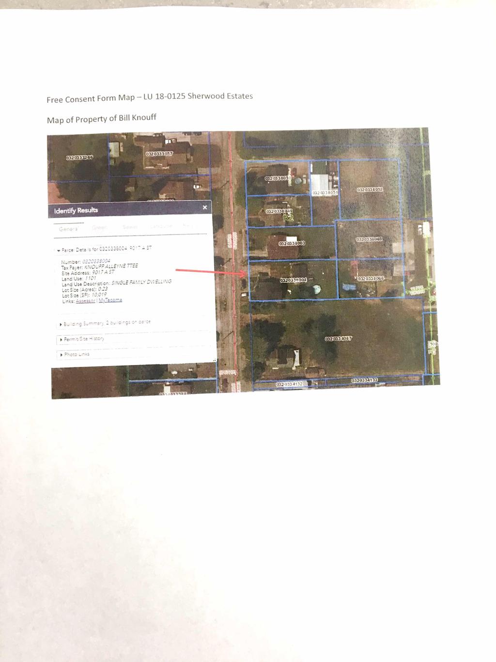
10 Free Consent Form Map LU Sherwood Estates Map of Property of Bill Knouff
11 LEGAL NOTICE City of Tacoma Public Hearing Notice Lead Agency: Applicant: Proposal: Location: File No. City of Tacoma Mike Musica 16-lot subdivision of 2.02 acres for 12 single family residential lots and four tracts for private roads, utilities and site drainage East B Street LU Preliminary Plat City of Tacoma, Planning and Development Services, is giving notice of a Public Hearing for the above proposal on November 15, 2018 at 9:00 am in the Council Chambers on the 1 st Floor of the Tacoma Municipal Building at 747 Market Street, Tacoma WA Per SEPA, WAC and TMC Chapter 13.12, the Environmental Official has reviewed this project and determined the project is exempt from SEPA provisions. This information is available to the public on or upon request. You may testify in person at the public hearing or you may submit comments in writing prior to the public hearing to the staff contact listed below. A complete copy of the final decision will be mailed to those parties who request a copy or to those who have commented on the project. Appeal provisions will be included with both the summary and the complete copy of the final decision. The City of Tacoma does not discriminate on the basis of disability in any of its programs or services. Upon request, special accommodations will be provided within five (5) business days by contacting (VOICE) or (TTY). Staff Contact: John Harrington, Planning and Development Services, 747 Market St, Rm 345, Tacoma WA 98402; jharring@cityoftacoma.org. Issue/Publication Date: Before October 5, 2918.
, guarantees the County of Pierce and any City within which said subdivision is located in a sum not exceeding $1,000.")
12 SUBDIVISION GUARANTEE ISSUED BY STEWART TITLE GUARANTY COMPANY Guarantee No.: G Fee: $ Order No.: Dated: August 02, 2018 Stewart Title Guaranty Company (the "Company"), guarantees the County of Pierce and any City within which said subdivision is located in a sum not exceeding $1, that, according to those public records which, under the recording laws, impart constructive notice of matters affecting the title to the land included within the exterior boundary shown on the map of the subdivision, the only parties having any record title interest in said land whose signatures are necessary, on the certificates consenting to the recordation of said map and offering for dedication any streets, roads, avenues and other easements offered for dedication by said map as referred to in the guarantee. Signed under seal for the Company, but this Guarantee is to be valid only when it bears an authorized countersignature. Countersigned by: Puget Sound Title Company 5350 Orchard Street W. University Place, WA Agent ID: For purposes of this form the Stewart Title logo featured above is the represented logo for the underwriter, Stewart Title Guaranty Company. In writing this company please address it at P.O. Box 2029, Houston, Texas 77252, and refer to the printed Serial Number. File No.: WA Subdivision Guarantee Page 1 of 1 of Guarantee Serial No.: G
13 WA Subdivision Guarantee SUBDIVISION GUARANTEE Prepared by: Puget Sound Title Company 5350 Orchard Street W. University Place, WA Order Number: Guarantee No.: G Effective Date: August 02, 2018 at 8:30 am Premium: $ Sales Tax: $49.50 Total: $ OWNERS: MICHAEL MUSICA, as his separate property, as to Parcels A and B and B. ALLEYNE KNOUFF AND WILLIAM A. KNOUFF, Trustees of the B. ALLEYNE KNOUFF FAMILY TRUST dated December 22, 1997, as to Parcel C Parcel A Parcel B Parcel C LEGAL DESCRIPTION: Parcel A The West 295 feet of the following: Beginning on the East line of "A" Street, being a line parallel with and 30 feet East of the West line of Lot 1, Section 33, Township 20 North, Range 3 East of the Willamette Meridian, at a point on said street line 792 feet South of the North line of said Lot 1; Thence parallel with said North line East feet to the East line of the West half of said Lot 1; Thence on said East line South 132 feet; Thence parallel said North line West feet to said East line of street; THENCE on said street line North 132 feet to Place of Beginning; Situate in the County of Pierce, State of Washington. Assessors Map Parcel B THE EAST HALF OF THE FOLLOWING DESCRIBED PROPERTY: BEGINNING ON THE EAST LINE OF A STREET, BEING A LINE PARALLEL WITH AND 30 FEET EAST OF THE WEST LINE OF LOT 1 OF SECTION 33, TOWNSHIP 20 NORTH, RANGE 3 EAST, WILLAMETTE MERIDIAN, IN PIERCE COUNTY, WASHINGTON, AT A POINT ON SAID STREET LINE 924 FEET SOUTH OF THE NORTH LINE OF SAID LOT 1; THENCE PARALLEL WITH SAID NORTH LINE EAST 623,11 FEET TO THE EAST LINE OF THE WEST HALF OF SAID LOT 1; THENCE ON SAID EAST LINE SOUTH 132 FEET; THENCE PARALLEL WITH SAID NORTH LINE WEST FEET TO SAID EAST LINE OF A STREET; THENCE ON SAID STREET LINE NORTH 132 FEET TO THE PLACE OF BEGINNING. EXCEPT 30 FEET THEREOF FOR EAST B STREET. Page 1 of 5 STEWART TITLE GUARANTY COMPANY
14 WA Subdivision Guarantee SITUATE IN THE COUNTY OF PIERCE, STATE OF WASHINGTON. Assessors Map Parcel C Lot 2, SHORT PLAT No , recorded July 12, 1977 in Volume 17 of Short Plats at Page 100, being a re-record of Short Plat No , recorded in Volume 17 of Short Plats, Page 63, records of Pierce County Auditor. Situate in the County of Pierce, State of Washington. Assessors Map SUBJECT TO: Easement and the terms and conditions thereof affecting said premises, for the purposes stated herein, and incidental purposes: Recording No.: Purpose: Utilities Affects Parcel A Easement and the terms and conditions thereof affecting said premises, for the purposes stated herein, and incidental purposes: Recording No.: Purpose: To construct and maintain utilities Affects Parcel B Covenants, Conditions, Restrictions, Easements and liability, if any, for Assessments, Liens or Charges, but omitting any covenant or restrictions if any, based upon race, color, religion, sex, handicap, familial status, or national origin unless and only to the extent that said covenant (a) is exempt under Chapter 42, Section 3607 of the United States Code or (b) relates to handicap but does not discriminate against handicapped persons, as contained on SHORT PLAT No Affects Parcel C 4. Terms and conditions of the Trust under which title is vested. (Affects Parcel C) 5. Deed of Trust and the terms and conditions thereof: Amount: $90, Dated: June 10, 2013 Recorded: June 17, 2013 Recording No.: Grantor: MICHAEL MUSICA, as his separate estate Trustee: TIMBERLAND SERVICE CORPORATION Beneficiary: TIMBERLAND BANK Affects Parcel A The amount now secured by said Deed of Trust and the terms upon which the same can be discharged or assumed should be ascertained from the holder of the indebtedness secured. Page 2 of 5 STEWART TITLE GUARANTY COMPANY
15 WA Subdivision Guarantee 6. Assignment of Leases and Rents, including the terms and conditions thereof: Assignor: MICHAEL MUSICA Assignee: TIMBERLAND BANK Recorded: June 17, 2013 Recording No.: Affects Parcel A Deed of Trust and the terms and conditions thereof: Amount: $92, Dated: June 10, 2013 Recorded: June 17, 2013 Recording No.: Grantor: MICHAEL MUSICA, as his separate estate Trustee: TIMBERLAND SERVICE CORPORATION Beneficiary: TIMBERLAND BANK Affects Parcel B The amount now secured by said Deed of Trust and the terms upon which the same can be discharged or assumed should be ascertained from the holder of the indebtedness secured. 8. Assignment of Leases and Rents, including the terms and conditions thereof: Assignor: MICHAEL MUSICA, as his separate estate Assignee: TIMBERLAND BANK Recorded: June 17, 2013 Recording No.: Affects Parcel B Notice of SEWER charge(s) levied or to be levied, by City of Tacoms, notice of which is given by instrument recorded November 1, 1978, in the Office of the Pierce County Auditor under Recording No , (or as amended). NOTE: Your attention is called to the fact that said notice will remain effective until there is recorded in the Auditor s Office a certificate of payment and release, pursuant to RCW Affects Parcel A and B General taxes: First half delinquent May 1; Second half delinquent November 1: Year: 2018 Amount Billed: $3, Amount Paid: $1, Amount Due: $1,992.07, plus interest and penalty if delinquent Tax Account No.: Levy Code: 005 Land: $89,800 Improvements: $162,400 Affects Parcel A General taxes: First half delinquent May 1; Second half delinquent November 1: Year: 2018 Amount Billed: $3, Amount Paid: $1, Amount Due: $1,650.04, plus interest and penalty if delinquent Tax Account No.: Levy Code: 005 Land: $89,500 Improvements: $119,300 Affects Parcel B Page 3 of 5 STEWART TITLE GUARANTY COMPANY
16 WA Subdivision Guarantee 12. General taxes: First half delinquent May 1; Second half delinquent November 1: Year: 2018 Amount Billed: $2, Amount Paid: $1, Amount Due: $1,465.63, plus interest and penalty if delinquent Tax Account No.: Levy Code: 005 Land: $60,700 Improvements: $124,700 Affects Parcel C ed/ed Page 4 of 5 STEWART TITLE GUARANTY COMPANY
17 WA Subdivision Guarantee SUBDIVISION GUARANTEE Order Number: Guarantee No.: G This Guarantee and the legal description given herein are based upon information supplied by the applicant as to the location and identification of the premises in question, and no liability is assumed for any discrepancies resulting therefrom. This report does not represent either a commitment to insure title, an examination of or opinion as to the sufficiency or effect of the matters shown, or opinion as to the marketability of title to the land. Page 5 of 5 STEWART TITLE GUARANTY COMPANY
18
PUBLIC NOTICE* Studies Requested: N/A. Other Required Permits: N/A
 C I T Y O F T A C O M A Planning & Development Services Department 747 Market St, Rm 345 Tacoma, WA 98402 PUBLIC NOTICE* Date of Notification: 12/21/2018 Application Received: 10/29/2018 Application Complete:12/18/2018
RIVERDALE CITY PLANNING COMMISSION APPLICATION FOR RESIDENTIAL SUBDIVISION SITE PLAN APPROVAL
 Community Development 4600 So. Weber River Drive Riverdale, Utah 84405 RIVERDALE CITY PLANNING COMMISSION APPLICATION FOR RESIDENTIAL SUBDIVISION SITE PLAN APPROVAL CASE NO: DATE SUBMITTED: APPLICANT S
COUNTY OF ADAMS, STATE OF COLORADO E. 40TH AVE. TOWER RD. E. 38TH AVE. SALIDA ST. HIGH LINE CANAL PROJECT LOCATION E. 32ND PKWY.
 LEGAL DESCRIPTION:, GATEWAY EAST AT TOWER SUBDIVISION FILING NO. 1, SAID PARCEL CONTAIN 598,154 SQUARE FEET OR MORE OR LESS GENERAL NOTES: 1. NOTICE: ACCORDING TO COLORADO LAW YOU MUST COMMENCE ANY LEGAL
FINAL SUBDIVISION AND LAND DEVELOPMENT PLAN CHECKLIST. Plan Name. Applicant's Name:
 TOWNSHIP OF UPPER ST. CLAIR FINAL SUBDIVISION AND LAND DEVELOPMENT PLAN CHECKLIST Date Filed Plan Name PLC Applicant's Name: Phone Filing Date for Final Application Final Plat 114.22. FINAL APPLICATION
SUBDIVISION APPLICATION
 SUBDIVISION APPLICATION Preliminary Plat Minor Plat Final Plat Amended Plat Applicant Name: Owner (if different from applicant) Name: Company: Company: Address: Address: City, State, Zip City, State, Zip
SECTION SITE SURVEYS
 PART 1 - GENERAL 1.1 DESCRIPTION SECTION 02 21 00 SPEC WRITER NOTES: 1. Use this section only for NCA projects. 2. Delete between //---// if not applicable to project. Also delete any other item or paragraph
I. Requirements for All Applications. C D W
 108-16.1. Application checklists. Checklist for Required Submissions to the Planning Board or Zoning Board of Adjustment of Monroe Township All required submissions are to be made to the Administrative
CHICAGO TITLE INSURANCE COMPANY a corporation, herein called the Company GUARANTEES. Western Surveying
 SUBDIVISION Issued By: Guarantee/Certificate Number: Western CHICAGO TITLE INSURANCE COMPANY a corporation, herein called the Company GUARANTEES Western Surveying herein called the Assured, against actual
SUBMITTAL REQUIREMENTS: The number indicates the number of copies for submittal (if applicable).
.") Office Use Only Preliminary Long Plat Long Subdivision Applicant Checklist PLANNING, COMMUNITY, & ECONOMIC DEVELOPMENT DEPARTMENT PRELIMINARY LONG PLAT LONG SUBDIVISION CHECKLIST Mailing Address: P.O.
Office Use Only Preliminary Long Plat Long Subdivision Applicant Checklist PLANNING, COMMUNITY, & ECONOMIC DEVELOPMENT DEPARTMENT PRELIMINARY LONG PLAT LONG SUBDIVISION CHECKLIST Mailing Address: P.O.
BOSSIER CITY PARISH METROPOLITAN PLANNING COMMISSION 620 Benton Rd. Bossier City, LA Phone: Fax: PRELIMINARY PLAT
 (OFFICE USE ONLY) Application Fee: Paid: Date: CASE # Project Information BOSSIER CITY PARISH METROPOLITAN PLANNING COMMISSION 620 Benton Rd. Bossier City, LA 71111 Phone: 318-741-8824 Fax: 318-741-8827
SUBMITTAL REQUIREMENTS: The number indicates the number of copies for submittal (if applicable).
.") Office Use Only Preliminary Long Plat Long Subdivision Applicant Checklist PLANNING, COMMUNITY, & ECONOMIC DEVELOPMENT DEPARTMENT FINAL LONG PLAT LONG SUBDIVISION CHECKLIST Mailing Address: P.O. Box 547,
Office Use Only Preliminary Long Plat Long Subdivision Applicant Checklist PLANNING, COMMUNITY, & ECONOMIC DEVELOPMENT DEPARTMENT FINAL LONG PLAT LONG SUBDIVISION CHECKLIST Mailing Address: P.O. Box 547,
ARTICLE 900 PLAT AND PLAN REQUIREMENTS
 Final SEC. 900.01 ARTICLE 900 PLAT AND PLAN REQUIREMENTS General provisions. (a) Scale. The scale of all plats and plans shall be a minimum of 1 to 100 ft. (b) Size. The minimum page size for all plats
PRELMINARY PLAT CHECKLIST
 PRELMINARY PLAT CHECKLIST A. All preliminary plat submitted for approval shall be prepared by a Registered Professional Land Surveyor. B. Preliminary plats must be drawn to a scale of XXX with such accuracy
Preliminary Subdivision Application (Major) (Four (4) lots or more)
 (Four (4) lots or more)") Gunnison City Offices www.gunnisoncity.org 38 West Center Gunnison, Utah 84634 (435) 528 7969 Date of Application: Preliminary Subdivision Application (Major) (Four (4) lots or more) APPLICANT INFORMATION
Gunnison City Offices www.gunnisoncity.org 38 West Center Gunnison, Utah 84634 (435) 528 7969 Date of Application: Preliminary Subdivision Application (Major) (Four (4) lots or more) APPLICANT INFORMATION
PLANNING COMMISSION STAFF REPORT
 PLANNING COMMISSION STAFF REPORT Alder-Robinson Subdivision Amending the Amended Plat of the Arcadia Heights Plat A Subdivision Case #PLNSUB2010-00044 2857 East 2100 South June 23, 2010 Applicant: Greg
Use permitted by: Right Special Exemption
 CENTER TOWNSHIP 150 Henricks Road Butler, PA 16001-8472 Phone (724) 282-7805 Fax (724) 282-6550 Application Number: FEE COLLECTED: Application for: Preliminary Final Land Development Location: Map and
SHORT PLAT Information
 Information This form provides information and an explanation of the procedures of a Short Plat. If you have any questions, contact the Planning and Development Services Department at (253) 566-5656. A
CHAPTER 26 PLANNING AND ZONING ARTICLE VII. MOBILE HOMES AND RECREATIONAL VEHICLE (RV) PARKS. Recreational Vehicle (RV) Park Development Standards
 PARKS. Recreational Vehicle (RV) Park Development Standards") CHAPTER 26 PLANNING AND ZONING ARTICLE VII. MOBILE HOMES AND RECREATIONAL VEHICLE (RV) PARKS. Section 26-VII-1. Section 26-VII-2. Section 26-VII-3. Section 26-VII-4. Section 26-VII-5. Purpose Permitted
CHAPTER 26 PLANNING AND ZONING ARTICLE VII. MOBILE HOMES AND RECREATIONAL VEHICLE (RV) PARKS. Section 26-VII-1. Section 26-VII-2. Section 26-VII-3. Section 26-VII-4. Section 26-VII-5. Purpose Permitted
CITY OF SARALAND FINAL SUBDIVISION PLAT REVIEW
 CITY OF SARALAND FINAL SUBDIVISION PLAT REVIEW Application Number: Date Plat Submitted: Name of Subdivision: Name of Owner: Owner Address: (Street or P.O. Box) Telephone #: (City) (State) (Zip) E-mail:
APPLICATION PACKET LAND SPLIT OR COMBINATION REVIEW
 APPLICATION PACKET LAND SPLIT OR COMBINATION REVIEW COMMUNITY DEVELOPMENT DEPARTMENT CHARTER TOWNSHIP OF PLYMOUTH 9955 N. Haggerty Road Plymouth, MI 48170 Fees Revised 9.13.2017 APPLICATION PACKET LAND
MINOR PLAT. The following documents are provided as required by the City of Conroe for use in the above titled platting submittals:
 Public Works - Engineering Division CITY OF CONROE MINOR PLAT The following documents are provided as required by the City of Conroe for use in the above titled platting submittals: Submittal Questionnaire
ARTICLE 900 PLAT AND PLAN REQUIREMENTS
 ARTICLE 900 PLAT AND PLAN REQUIREMENTS SEC. 900.1 ITEMS TO BE SHOWN ON PLAT OR PLAN General (1) Property lines of all property owners adjacent to the exterior boundaries of the project shall be located
Parkland-Spanaway-Midland LUAC - Agenda
 1. 6:30 P.M. Parkland-Spanaway-Midland LUAC - Agenda Documents: 8 2 17 PSMAC Agenda.pdf 2. Parkland-Spanaway-Midland LUAC Initial Project Review Documents: Lincoln Court PP IPR PSMAC-RJ.pdf Department
ARTICLE 5 MINOR SUBDIVISION/LAND DEVELOPMENT
 ARTICLE 5 MINOR SUBDIVISION/LAND DEVELOPMENT SECTION 501 ONLY FINAL PLAN REQUIRED The classification of a proposed subdivision as a "Minor Subdivision" shall only require the submission, review and approval
Alvarez Engineers, Inc.
 FL Certificate of Authorization No. 7538 10305 NW 41 Street Suite 103 Doral, Florida 33178 Tel. (305) 640-1345 Fax (305) 640-1346 E-Mail: Juan.Alvarez@AlvarezEng.com March 30, 2015 Ms. Gloria Perez District
LAND USE APPLICATION
 LAND USE APPLICATION File Name: File No(s).: Receipt No.: Receipt Date: Received By: Amount.: $ Instructions for Applicants Please read and follow all instructions on your application carefully. If you
STANDARDIZED LEGAL DESCRIPTIONS AND EXHIBITS
 STANDARDIZED LEGAL DESCRIPTIONS AND EXHIBITS Public Works Department, Engineering Division June 14, 2004 UNIFIED GOVERNMENT STANDARDIZED LEGAL DESCRIPTIONS AND EXHIBITS For: Roads, Bridges, Short Span
Preliminary Subdivision Application (Minor) (Three (3) lots or less)
 (Three (3) lots or less)") Gunnison City Offices www.gunnisoncity.org 38 West Center Gunnison, Utah 84634 (435) 528 7969 Date of Application: Preliminary Subdivision Application (Minor) (Three (3) lots or less) APPLICANT INFORMATION
Gunnison City Offices www.gunnisoncity.org 38 West Center Gunnison, Utah 84634 (435) 528 7969 Date of Application: Preliminary Subdivision Application (Minor) (Three (3) lots or less) APPLICANT INFORMATION
COMMITMENT FOR TITLE INSURANCE Issued by
 ALTA Commitment (6/17/06) ALTA Commitment Form COMMITMENT FOR TITLE INSURANCE Issued by STEWART TITLE GUARANTY COMPANY, a Texas Corporation ( Company ), for a valuable consideration, commits to issue its
APPLICATION PACKET LAND SPLIT OR COMBINATION REVIEW
 APPLICATION PACKET LAND SPLIT OR COMBINATION REVIEW COMMUNITY DEVELOPMENT DEPARTMENT CHARTER TOWNSHIP OF PLYMOUTH 9955 N. Haggerty Road Plymouth, MI 48170 Fees Revised 7/01/2012 APPLICATION PACKET LAND
DIVISION 2 - CONSTRUCTION PLAN AND MISCELLANEOUS REQUIREMENTS
 DIVISION 2 - CONSTRUCTION PLAN AND MISCELLANEOUS REQUIREMENTS 2.1 Required Plan Sheets 2.2 Drawing Requirements 2.3 Graphic Standards 2.4 Easements 2.5 Utility Locations 2.6 Private Facility Locations
City of Yelm. Community Development Department BOUNDARY LINE ADJUSTMENT OR LARGE LOT SUBDIVISION
 City of Yelm Community Development Department BOUNDARY LINE ADJUSTMENT OR LARGE LOT SUBDIVISION Fee Date Received By File No. FEES: Boundary Line Adjustment $100.00 LARGE LOT SUBDIVISION $250.00, + $10.00/lot
ALTA COMMITMENT FOR TITLE INSURANCE SCHEDULE A ISSUED BY FIRST AMERICAN TITLE INSURANCE COMPANY
 SCHEDULE A Transaction Identification Data for reference only: Issuing Agent: Best Homes Title Agency, LLC Issuing Office: 4949 Plainfield Avenue NE, Grand Rapids, Michigan 49525 Telephone: (616) 885-9027
City of Leavenworth DEPARTMENT OF DEVELOPMENT SERVICES MAJOR SUBDIVISION APPLICATION 1
 Proposed Name of Subdivision: City of Leavenworth DEPARTMENT OF DEVELOPMENT SERVICES MAJOR SUBDIVISION APPLICATION 1 FOR PRELIMINARY SUBDIVISION APPROVAL This application must be filled out legibly, in
CONSTRUCTION PLANS for HALCYON A RESIDENTIAL SUBDIVISION 6100 MIDNIGHT PASS ROAD, SARASOTA, FL 34242
 CONSTRUCTION PLANS for HALCYON A RESIDENTIAL SUBDIVISION 6100 MIDNIGHT PASS ROAD, SARASOTA, FL 34242 SECTION 18, TOWNSHIP 37 SOUTH, RANGE 18 EAST SARASOTA COUNTY, FLORIDA PID: 0030001 A DEVELOPMENT BY
 Litigation Guarantee (Rev. 6-92) Guarantee No.: 5015853-1399 Guarantee Form No. 1 GUARANTEE Issued by First American Title Insurance Company First American Title Litigation Guarantee (Rev. 6-92) Guarantee
DETAILED GRADING PLAN CHECKLIST (TEARDOWN/REDEVELOPMENT)
") GENERAL DETAILED GRADING PLAN CHECKLIST (TEARDOWN/REDEVELOPMENT) ADDRESS: PERMIT #: DATE: 1. Plan is signed and sealed by an Illinois registered professional engineer including date signed and license
GENERAL DETAILED GRADING PLAN CHECKLIST (TEARDOWN/REDEVELOPMENT) ADDRESS: PERMIT #: DATE: 1. Plan is signed and sealed by an Illinois registered professional engineer including date signed and license
ABBREVIATION LEGEND SITE INFORMATION:
 SITE INFORMATION: Current Zone: R-3 PUD, governed by Fox Hollow 2nd MDA Basis of Elevations: Northeast Corner of Section 13, T6S, R1W, S.L.B. & M Elevation: 4599.26 (Benchmark) ABBREVIATION LEGEND Owners:
Subdivision of existing two lots into three lots.
 PP-15-00189 Item No. 4-1 PC Staff Report 06/22/2015 PLANNING COMMISSION REPORT NON PUBLIC HEARING ITEM PUBLIC HEARING ON THE VARIANCE ONLY ITEM NO 4: PRELIMINARY PLAT FOR DEERFIELD WOODS SUBDIVISION NO.
City of Midland Application for Site Plan Review
 City of Midland Application for Site Plan Review Submission Date: Property Owner: Mailing Address: Phone number: ( ) Cell phone: ( ) Email address: Fax: ( ) Owner s Signature: Applicant Name (if not owner):
TOWNSHIP OF BORDENTOWN LAND DEVELOPMENT APPLICATION CHECKLIST. General Requirements for all Applications
 TOWNSHIP OF BORDENTOWN LAND DEVELOPMENT APPLICATION CHECKLIST This CHECKLIST has been adopted in accordance with Section 25:807 of the Land Development Ordinance of the Township of Bordentown and will
DETAILED GRADING PLAN CHECKLIST (TEARDOWN/REDEVELOPMENT) Updated: 12/12/2017
 Updated: 12/12/2017") DETAILED GRADING PLAN CHECKLIST (TEARDOWN/REDEVELOPMENT) Updated: 12/12/2017 ADDRESS: PERMIT #: DATE: Sat. Not GENERAL 1. A disposition of comments should be included in all subsequent submittals. 2. Plan
DETAILED GRADING PLAN CHECKLIST (TEARDOWN/REDEVELOPMENT) Updated: 12/12/2017 ADDRESS: PERMIT #: DATE: Sat. Not GENERAL 1. A disposition of comments should be included in all subsequent submittals. 2. Plan
MIDWAY CITY Planning Office 75 North 100 West Phone: x105 Midway, Utah Fax:
 MIDWAY CITY Planning Office 75 North 100 West Phone: 435-654-3223 x105 Midway, Utah 84049 Fax: 435-654-2830 mhenke@midwaycityut.org Preliminary/ Final Application for Small Scale Subdivision Application
APPLICATION for MINOR SUBDIVISION REVIEW for CONCEPT and FINAL PLAT within COALVILLE CITY. Project Name: Project Address or Area: Name of Owner:
 APPLICATION for MINOR SUBDIVISION REVIEW for CONCEPT and FINAL PLAT within COALVILLE CITY For Office Use Only: Application #: Application Date: PC Approval Date: CC Approval Date: Community Development
EASEMENT AGREEMENT. hereinafter called Grantor, (whether grammatically singular or plural) and the:
 and the:") EASEMENT AGREEMENT THIS EASEMENT AGREEMENT, made and entered into as of the day of,, by and between: hereinafter called Grantor, (whether grammatically singular or plural) and the: hereinafter called Distributor.
EASEMENT AGREEMENT THIS EASEMENT AGREEMENT, made and entered into as of the day of,, by and between: hereinafter called Grantor, (whether grammatically singular or plural) and the: hereinafter called Distributor.
FINAL PLAT. Community Development Department 8101 Ralston Road Arvada, Colorado 80002
 FINAL PLAT Community Development Department 8101 Ralston Road Arvada, Colorado 80002 September 2015 FINAL SUBDIVISION PLAT Final Subdivision Plat Review Applications for a Final Plat shall be submitted
CHECKLIST FOR DEVELOPMENT REVIEW
 CHECKLIST FOR DEVELOPMENT REVIEW Petitions and related documents and plans for land development or other proposals regulated by Title 16 of the Municipal Code (Development Ordinance) and Title 17 of the
Township of Little Egg Harbor Planning Board 665 Radio Road Little Egg Harbor, New Jersey Phone: ext. 221 Fax:
 BLOCK(S) LOT(S) Township of Little Egg Harbor Planning Board 665 Radio Road Little Egg Harbor, New Jersey 08087 Phone: 609-296-7241 ext. 221 Fax: 609-294-3040 Development Application Amended Development
PLAT OF SURVEY VICINITY MAP (NOT TO SCALE) N N W E SITE BENCHMARK # 2 W E N&D ON BACK OF CURB NAVD 88 S S 0' 10' 20' 40' 60' 1" = 20' TOP=106.7
 N N W E SITE BENCHMARK # 2 W E N&D ON BACK OF CURB NAVD 88 S S 0' 10' 20' 40' 60' 1 = 20' TOP=106.7") PLAT OF SURVEY VICINITY MAP (NOT TO SCALE) N N W E SITE BENCHMARK # 2 W E N&D ON BACK OF CURB 106.21 NAVD 88 S S 0' 10' 20' 40' 60' 1" = 20' TOP=106.72 N INV PVC=99.27 S INV PVC=99.32 E INV CLAY=99.39
PLAT OF SURVEY VICINITY MAP (NOT TO SCALE) N N W E SITE BENCHMARK # 2 W E N&D ON BACK OF CURB 106.21 NAVD 88 S S 0' 10' 20' 40' 60' 1" = 20' TOP=106.72 N INV PVC=99.27 S INV PVC=99.32 E INV CLAY=99.39
DEVELOPMENT POLICY INFRASTRUCTURE GUIDELINES FOR NEW DEVELOPMENT
 CITY OF HAYS SUBJECT DEVELOPMENT POLICY INFRASTRUCTURE GUIDELINES FOR NEW DEVELOPMENT ISSUED BY LAST REVISION DATE POLICY MANUAL REVISION DATE City Commission 3-13-08 10-22-09 POLICY STATEMENT: The City
ELMORE COUNTY LAND USE & BUILDING DEPARTMENT 520 E 2 nd South Mountain Home, ID (208) Preliminary Plat Application
 Preliminary Plat Application") ELMORE COUNTY LAND USE & BUILDING DEPARTMENT 520 E 2 nd South Mountain Home, ID 83647 (208) 587-2142 www.elmorecounty.org Preliminary Plat Application We are unable to accept facsimile copies. (Subdivisions
ELMORE COUNTY LAND USE & BUILDING DEPARTMENT 520 E 2 nd South Mountain Home, ID 83647 (208) 587-2142 www.elmorecounty.org Preliminary Plat Application We are unable to accept facsimile copies. (Subdivisions
MAJOR SUBDIVISION PRELIMINARY PLAT CHECKLIST
 TOWNSHIP OF EGG HARBOR PLANNING BOARD/ZONING BOARD OF ADJUSTMENT 3515 BARGAINTOWN ROAD EGG HARBOR TOWNSHIP, NJ 08234 MAJOR SUBDIVISION PRELIMINARY PLAT CHECKLIST The following checklist is designed to
ALTA COMMITMENT FOR TITLE INSURANCE SCHEDULE A ISSUED BY FIRST AMERICAN TITLE INSURANCE COMPANY
 SCHEDULE A Transaction Identification Data for reference only: Issuing Agent: Best Homes Title Agency, LLC Issuing Office: 4949 Plainfield Avenue NE, Grand Rapids, Michigan 49525 Telephone: (616) 885-9027
-MENDOCINO COUNTY PLANNING AND BUILDING SERVICES- DIVISION OF LAND REGULATIONS TITLE 17
 ARTICLE VI -- GENERAL REGULATIONS AND PROVISIONS Sec. 17-50. Sec. 17-51 General Plan. Sec. 17-52 Lot and Block Design and Configuration. Sec. 17-53 Lot Access. Sec. 17-54 Private Roads. Sec. 17-55 Water
Site Plan Application
 Site Plan Application City of St. Pete Beach Community Development Department 155 Corey Avenue St. Pete Beach, Florida 33706 (727) 367-2735 www.stpetebeach.org Case Number: PROPERTY OWNER: Name: Address:
Residential Minor Subdivision Review Checklist
 Residential Minor Subdivision Review Checklist Plan Submittal Requirements: 2 full sets of stamped plans Electric submittal - all plans contained in a single PDF 3 full sets if commercial kitchen or dining
LAND USE PERMIT APPLICATION
 LAND USE PERMIT APPLICATION Date Application No. TYPE OF PERMIT Subdivision Short Plat Conditional Use Binding Site Plan Final Plat Final Short Plat Variance Final Binding Site Plan Plat Amendment Short
THROUGH ITS AGENT. 2. Policy (or Policies) to be issued: Policy Amount
 to be issued: Policy Amount") Commitment for Title Insurance BY Schedule A First American Title Insurance Company THROUGH ITS AGENT Best Homes Title Agency, LLC 1. Commitment Date: 09/23/2016 at 8:00 AM Commitment No.: GRC-94850 2.
Commitment for Title Insurance BY Schedule A First American Title Insurance Company THROUGH ITS AGENT Best Homes Title Agency, LLC 1. Commitment Date: 09/23/2016 at 8:00 AM Commitment No.: GRC-94850 2.
2018 EASEMENT DEDICATION PACKET
 2018 EASEMENT DEDICATION PACKET (INCLUDES PARCELS OF LAND, EASEMENTS, AND RIGHTS-OF-WAY FOR PUBLIC USE) Information Packet There are various situations in which easements, rights-of-way, and parcels of
MUDDY CREEK TOWNSHIP PO BOX 239 PORTERSVILLE, PA SUBDIVISION AND LAND DEVELOPMENT APPLICATION
 MUDDY CREEK TOWNSHIP PO BOX 239 PORTERSVILLE, PA 16051 724-368-3438 SUBDIVISION AND LAND DEVELOPMENT APPLICATION NOTE TO ALL APPLICANTS: This checklist must be completed in its entirety If an item is not
SPECIAL SERVICE AREA DISCLOSURE
 SPECIAL SERVICE AREA DISCLOSURE All lots within this subdivision are included within the County of Will Special Service Area Number and are subject to an annual tax levy in accordance with the provisions
PLACER TITLE COMPANY
 Issued By: PLACER TITLE COMPANY Preliminary Report PLACER TITLE COMPANY 1450 HARBOR BLVD., STE. E WEST SACRAMENTO, CA 95691 Escrow Officer: Leslie Rivera Phone: 916-375-3130 Fax: 916-375-3135 Escrow Officer
APPLICATION PROCEDURE
 ANTRIM PLANNING BOARD P. O. Box 517 Antrim, New Hampshire 03440 Phone: 603-588-6785 FAX: 603-588-2969 APPLICATION FORM AND CHECKLIST FOR MINOR OR MAJOR SITE PLAN REVIEW File Date Received By APPLICATION
Section 6 Easements and Rights-of-Way
 Section 6 Easements and Rights-of-Way GENERAL REQUIREMENTS...6-1 I. EASEMENTS...6-1 6.1 ROADWAY EASEMENT...6-1 6.2 UTILITY EASEMENT...6-1 6.3 SEWER EASEMENT...6-1 6.4 WATER MAIN EASEMENT...6-2 6.5 CHANNEL
WRIGHT TOWNSHIP Ottawa County 1565 Jackson Street, P.O. Box 255, Marne, Michigan 49435
 WRIGHT TOWNSHIP Ottawa County 1565 Jackson Street, P.O. Box 255, Marne, Michigan 49435 SITE PLAN REVIEW APPLICATION _ Instructions For an application to be considered complete, ALL information must be
Owner's Policy of Title Insurance Schedule A
 Owner's Policy of Title Insurance Schedule A Issued by Name and Address of Title Insurance Company: Westcor Land Title Insurance Company, 201 N. New York Avenue, Suite 200, Winter Park, Florida, 32789
E L M E R B O R O U G H L A N D U S E B O A R D APPLICATION COVER SHEET (to be completed for all applications and appeals)
") E L M E R B O R O U G H L A N D U S E B O A R D APPLICATION COVER SHEET (to be completed for all applications and appeals) 1. Name(s): 2. Address: 3. Telephone Number(s): 4. E-mail: 5. Owner Name(s) (if
E L M E R B O R O U G H L A N D U S E B O A R D APPLICATION COVER SHEET (to be completed for all applications and appeals) 1. Name(s): 2. Address: 3. Telephone Number(s): 4. E-mail: 5. Owner Name(s) (if
WRIGHT TOWNSHIP Ottawa County 1565 Jackson Street, P.O. Box 255, Marne, Michigan 49435
 WRIGHT TOWNSHIP Ottawa County 1565 Jackson Street, P.O. Box 255, Marne, Michigan 49435 SPECIAL USE PERMIT APPLICATION _ Instructions For an application to be considered complete, ALL information must be
ANDOVER CODE. Checklist #5 Preliminary Site Plan Conditional Use
 ANDOVER CODE Checklist #5 Preliminary Site Plan Conditional Use Applicant: Block Lot File No. This checklist is for general reference only. Further information may be required by the reviewing authority.
BRIDGETON SUBDIVISION APPLICATION CHECKLIST
 APPLICATION NAME AND # CHECKLIST COMPLETED BY: DATE: Signature and printed name BRIDGETON SUBDIVISION APPLICATION CHECKLIST TO SUBDIVISION APPLICANTS: The attached checklist is to assist you in the submission
AGENCY/DEPARTMENTAL NOTICE OF APPLICATION
 City of Tacoma Planning & Development Services 747 Market Street, Room 345 Tacoma, WA 98402 Applicant: Laura Wahlstrom, PO Box 5137, Tacoma, WA 98415, 253-627-2070 Location: 3633 & 3635 East L Street,
Requirements for New Service
 Requirements for New Service 1- Fill out application for new service and pay membership fee and deposit. We require a copy of plat from the tax assessors office (8 ½ X 11 copy). Easement also has to be
VARIANCE PROCESS APPLICATION
 The Department is here to assist you with your development application pursuant to the Community Development Code (CDC). This publication outlines the Variance Process Development Application process of
TOWN OF LEWISTON PLANNING BOARD APPLICATION
 TOWN OF LEWISTON PLANNING BOARD APPLICATION DESCRIPTION OF PROPOSED REQUEST: Name of Property Owner: Phone #: Name of Applicant:Phone #: Address or Location of Proposal:_SBL# Size of Parcel or Structure:Existing
ARTICLE 7 UTILITIES AND EASEMENTS
 7.1 PLACEMENT OF UTILITIES ARTICLE 7 UTILITIES AND EASEMENTS 7.1.1 All authorized public underground utilities shall be located within the right-of-way of a public street or within an easement designated
CITY OF FAYETTEVILLE, ARKANSAS PROPERTY LINE ADJUSTMENT
 CITY OF FAYETTEVILLE, ARKANSAS PROPERTY LINE ADJUSTMENT FOR STAFF USE ONLY FEE: $200.00 Date Application Submitted: Date Accepted as Complete: S-T-R: Project Number: PP#: Public Hearing Zone: Please fill
BNT Escrow Services, LLC
 BNT Escrow Services, LLC American Land Title Association ALTA Commitment Form Adopted 6-17-06 CHICAGO TITLE INSURANCE COMPANY 800-943-1196 SCHEDULE A Prepared By: BNT Escrow Services, LLC Loan No.: Title
CITY OF SARALAND PRELIMINARY SUBDIVISION PLAT REVIEW
 PRELIMINARY SUBDIVISION PLAT REVIEW Application Number: Date Plat Submitted: Name of Subdivision: Name of Owner: Owner Address: (Street or P.O. Box) Telephone #: (City) (State) (Zip) E-mail: Name of Authorized
FINAL SPUD APPLICATION
 The Planning & Development Services Department is here to assist you with your development application pursuant to the Community Development Code (CDC). This publication outlines the Final SPUD Development
DATE: May 16, Honorable Mayor City Council Members. Laura Holey, Planner
 DATE: May 16, 2015 TO: FROM: Honorable Mayor City Council Members Laura Holey, Planner AGENDA ITEM: 11 C. Vacation of Easement 821 Corporate Drive REQUIRED ACTION: The City Council is asked to conduct
ELK RAPIDS TOWNSHIP ANTRIM COUNTY, MICHIGAN ORDINANCE NO
 ELK RAPIDS TOWNSHIP ANTRIM COUNTY, MICHIGAN ORDINANCE NO. 3-2011 AN ORDINANCE TO REPLACE THE SUBDIVISION CONTROL ORDINANCE WITH A NEW SUBDIVISION DEVELOPMENT ORDINANCE, IN ACCORD WITH THE LAND DIVISION
FOR SALE Acre Residential Property Cypress Lakes Subdivision (Partially Completed) 6138 Moseley Dixon Road Macon, Bibb County, GA 31220
 6138 Moseley Dixon Road Macon, Bibb County, GA 31220") FOR SALE BANK OWNED Property Video: https://youtu.be/kdeoaplz1s4 37.18 Acre Residential Property Cypress Lakes Subdivision (Partially Completed) 6138 Moseley Dixon Road Macon, Bibb County, GA 31220 SALES
FOR SALE BANK OWNED Property Video: https://youtu.be/kdeoaplz1s4 37.18 Acre Residential Property Cypress Lakes Subdivision (Partially Completed) 6138 Moseley Dixon Road Macon, Bibb County, GA 31220 SALES
Palm Ave Hialeah Building Data Palm Avenue
 400-450 Palm Ave Hialeah Building Data Address 400-450 Palm Avenue City, State Hialeah, Florida County Miami Dade parcel # 04-3118-001-1950 and 1960 Zoning Retail Commercial - BU2 Land Size 13500 Type
PRELIMINARY PLATS. The following documents are provided as required by the City of Conroe for use in the above titled platting submittals:
 Public Works Engineering Division CITY OF CONROE PRELIMINARY PLATS The following documents are provided as required by the City of Conroe for use in the above titled platting submittals: Submittal Questionnaire
LAND TITLE OF WALLA WALLA COUNTY, INC 33 E. Main St, Walla Walla WA, COMMITMENT FOR TITLE INSURANCE UNDERWRITTEN BY:
 doug@land-title.com File No: 39926 LAND TITLE OF WALLA WALLA COUNTY, INC 33 E. Main St, Walla Walla WA,99362 509-529-4600 COMMITMENT FOR TITLE INSURANCE UNDERWRITTEN BY: SCHEDULE A preliminary Title Officer:Philip
ALTA COMMITMENT FOR TITLE INSURANCE SCHEDULE A ISSUED BY FIRST AMERICAN TITLE INSURANCE COMPANY
 SCHEDULE A Transaction Identification Data for reference only: Issuing Agent: Best Homes Title Agency, LLC Issuing Office: 4949 Plainfield Avenue NE, Grand Rapids, Michigan 49525 Telephone: (616) 885-9027
Initial Project Review
 Pierce County Department of Planning and Land Services, 2401 South 35th Street, Tacoma, WA (253) 798-7037 Initial Project Review Major Amendment to Preliminary Plat: Hawks Ridge Division 1 Application
Towne Center Boulevard William Penn Highway. Lot 2. 1 Mile Population: 3,600 Median HH Income: $36,800
 Walmart Outparcel For Sale Huntingdon, PA Store #5470 6716 Towne Center Blvd Towne Center Boulevard William Penn Highway Lot 2 Raystown Road For more information about this site, contact: Lot 2: ±1.72
SUBDIVISION AND LAND DEVELOPMENT. 185 Attachment 20
 185 Attachment 20 APPENDIX S Plat No. Date of Submission Twp. Fee $ Dauphin Co. Fee $ TOWNSHIP OF DERRY SUBDIVISION OR LAND DEVELOPMENT PLAN SUBMISSION APPLICATION This block for Twp. use only 1. Title
First American Title Company
 Page Number: 1 Company Order Number: DIV-1339603 (10) Title Officer: Christe McMullen Phone: (909) 889-0311 Fax No.: (909) 384-8464 E-Mail: cmcmullen@firstam.com Escrow Officer: Mitsy Miller (MM) Phone:
CITY OF STRONGSVILLE PLANNING COMMISSION APPLICATION CLUSTER SUBDIVISION
 CITY OF STRONGSVILLE PLANNING COMMISSION APPLICATION CLUSTER SUBDIVISION After meeting with City Planner, George Smerigan (if necessary) regarding zoning requirements, submit the following: An application
Schedule A. Issued by: W. 13 Mile Road, Suite 325 Farmington Hills, MI Issue Date:
 Schedule A Agents for: Issued by: FIRST AMERICAN TITLE INSURANCE Title Connect, LLC. COMPANY 28470 W. 13 Mile Road, Suite 325 Farmington Hills, MI 48334 Issue Date: (248) 642-3256 June 23, 2016 2006 ALTA
SITE. Sheet Index. Legal Description. General Notes: Vicinity Map Scale 1" = 600'
 Quebec St. LOCATED IN THE SOHWEST QUARTER OF SECTION 8, TOWNSHIP SOH, RANE 67 WEST OF THE 6TH P.M., Case # Z 06-005 Legal Description Tract, H and J of the Filing No., a part of the Southwest quarter of
MAPLETON CITY CORPORATION. Step 7: Upon final approval and prior to plat recording the applicant shall provide the following:
 MAPLETON CITY CORPORATION Subdivision Process The City s subdivision requirements are designed to facilitate orderly, safe and efficient development and to implement the adopted General Plan. Below is
CERTIFIED SURVEY MAP
 SCONSIN STATE PLANE N:389676.12 E:2130390.15 Center of Section 23 CERTIFIED SURVEY MAP 734.06' THE (PRITCHETTE) ORIGINAL PLAT OF ALL IN THE NW 1 4 OF THE SE 1 4 OF FRACTIONAL SECTION 23, T7N, R9E, IN THE
Residential Major Subdivision Review Checklist
 Residential Major Subdivision Review Checklist Plan Submittal Requirements: 2 full sets of stamped plans Electric submittal - all plans contained in a single PDF 3 full sets if commercial kitchen or dining
JOINT PLANNING BOARD APPLICATION FORM
 JOINT PLANNING BOARD APPLICATION FORM TOWNSHIP OF RIVER VALE 406 RIVERVALE ROAD RIVER VALE, NJ 07675 The application, with supporting documentation, must be filed with the Administrative Officer to the
New Electronic Planning Commission Submittal Process
 New Electronic Planning Commission Submittal Process STANDARD OPERATING PROCEDURE Purpose: To outline the electronic submittal process for applications to the Planning Commission. Background: Procedure:
SECTION 6 - APPROVAL OF PLATS. Whenever any subdivision of land is proposed, and before any permit for the
 SECTION 6 - APPROVAL OF PLATS 6-1 APPROVAL REQUIRED BEFORE SALE Whenever any subdivision of land is proposed, and before any permit for the erection of a structure shall be granted, the subdivider or his
PRELIMINARY REPORT (No Liability Hereunder) SCHEDULE A
 SCHEDULE A") REVISED 4-4-2017 report date unchanged PRELIMINARY REPORT (No Liability Hereunder) This report (and any revisions thereto) is issued solely for the convenience of the titleholder, the titleholder's agent,
REVISED 4-4-2017 report date unchanged PRELIMINARY REPORT (No Liability Hereunder) This report (and any revisions thereto) is issued solely for the convenience of the titleholder, the titleholder's agent,