MONDAY, JANUARY 11, :30 p.m.
|
|
|
- Claribel Horton
- 5 years ago
- Views:
Transcription
1 VILLAGE OF GERMANTOWN N112 W17001 MEQUON ROAD GERMANTOWN, WI MEETING: DATE AND TIME: LOCATION: PLAN COMMISSION MONDAY, JANUARY 11, :30 p.m. Germantown Village Hall Board Room I. CALL TO ORDER: This meeting has been given public notice in accordance with Wisconsin Statutes, Section and in such form that will apprise the general public and news media of subject matter that is intended for discussion and action. II. III. ROLL CALL PUBLIC INPUT/PUBLIC APPEARANCE on items not subject to a public hearing: Please be advised per 19.84(2), information will be received from the public. It is the policy of this municipality that there be a three (3) minute time period, per person, with time extension per the Chief Presiding Officer s discretion; be further advised that there may be limited discussion on the information received, however, no action will be taken under public comments. (15 minutes) IV. APPROVAL OF MINUTES: December 14, 2015 V. NEW BUSINESS: A. Badger Lighting & Signs for Central Asset Management and Infocor W129 N10880 Washington Drive. Sign Review Application. B. Signworks of Wisconsin, Inc. for GP Investments Corp. and Northwoods N114 W18621 Clinton Drive. Sign Review Application. C. The Hiller Company for Steven Stoffel N104 W14281 Donges Bay Road. Plan Commission Consultation regarding the possible land division and development of a 7.14-acre parcel (Rs-4 Zoning District) located between Donges Bay Road and the northern terminus of Gatewood Place. VI. VII. ANNOUNCEMENTS ADJOURNMENT The next Plan Commission Meeting will be on February 8, 2016 at 6:30 p.m. UPON REASONABLE NOTICE, efforts will be made to accommodate the needs of disabled individuals through appropriate aids and services. For additional information or to request this service please contact the Village Clerk at (262) at least 2 days prior to the meeting. Notice is given that a majority of the Village Board may attend this meeting to gather information about an item over which they have decision making responsibility. This may constitute a meeting of the Village Board per State ex rel. Badke v. Greendale Village Board, even though the Village Board will not take formal action at this meeting.
2 PLAN COMMISSION MINUTES December 14, 2015 CALL TO ORDER: 6:30 pm ROLL CALL: Chairman Dean Wolter, Trustee Representative David Baum, Commissioners Bill Shadid, Tim Yokes, Mary Ellen Gray, Peter Nilles and Tony Laszewski were present. Also present were Village Planner Jeff Retzlaff, Village Engineer Brionne Bischke, Village Attorney Brian Sajdak and Planning Assistant Lori Johnson. PUBLIC INPUT: The following people spoke regarding the Saxony Village proposal on the agenda: - James Kapus, N114 W15909 Hilbert Lane, suggested removing Building #6, the surface garages, parking lot, and driveway from the southeast corner as well as the extension to Hilbert Lane. - Loren Doll, W159 N11447 Red Oak Circle, asked what will happen to the runoff if Building #6 is constructed and said he and other residents don t want to see this area developed. - Don Reinbold, N116 W16137 Main Street, Barley Pop Pub, said he supported development downtown and said the goal is to improve Germantown and help small businesses thrive. - Dick Kent, N114 W15920 Hilbert Lane, said this is an overly dense development and asked why accommodate the developer rather than the community. - Scott Pecor, Bubs Irish Pub, N116 W16218 Main Street, said he is in favor of something being done to this property and bringing people into the area. - Nicki Broetzmann, W163 N11502 Windsor Court, said residents do not want this development and additional multi-family housing. She is concerned with density, traffic and the health of residents because of the brownfield located on the property. - Dan Wing, N116 W16044 Main Street, said the Plan Commission needs to listen to the residents concerns and consider the history of the past proposals for the property. He said the density has never been proposed this high in past. - Art Zabel, N97 W Burr Oak Road said development is going to occur, but the argument is what density is allowed. He had concerns with the private driveway and said the street should be public. - Jason Otto, W156 N11810 Pilgrim Road, co-owner of the Barley Pop said residents have valid concerns but something on Main Street needs to change and development needs to happen so businesses can continue. He hopes something is done that resembles what Germantown will look like in the future. PREVIOUS MINUTES: MOTION Baum second Gray to Approve the minutes from MOTION carried unanimously. Cambridge Major Laboratories W132 N10550 Grant Drive. The applicant is seeking approval of a site development and building plan for a 15,000 gallon above ground storage tank. Planner Retzlaff summarized the proposal. MOTION Baum second Yokes to Approve the site development and building plans for the addition of one (1) 15,000 gal liquid nitrogen storage tank, vaporizer unit and associated distribution lines and equipment, security fencing and bollards at the southwest corner of the building as proposed subject to the following conditions:
3 Plan Commission December 14, 2015 Page 2 of 6 1. State approval of and a Village building permit for the concrete pad and tank installation is required. Commissioner Laszewski said if the tank was the same color as the building it wouldn t be as noticeable. He added that using Colorado blue spruce trees may be a better choice for screening the tank. Rick Roofe, Airgas, explained the tanks are white to prevent UV light from getting into the tank. Trustee Baum asked for some background on the Park. He said his understanding was the Park was supposed to be more business park than industrial. He said this building started as an office building and is now more industrial. Planner Retzlaff said over time this project has developed and production changed. The Village has been accepting and flexible to accommodate them. He said the southerly part of the Park has been more accepting to these types of uses and the northern half is more business. Trustee Baum asked why a screen wall can t be built. Mr. Roofe said the louvers won t allow sunlight in that is needed to help melt ice on the vaporizer unit. He explained if ice forms it is difficult to get in and move around and added that oxygen deficiency is also a concern. Trustee Baum confirmed that there is no additional space on the property to put the tank. MOTION carried unanimously. JBJ Development for Heritage Place Joint Venture, MC Investments and Land 15, LLC 23.7 acres on Main Street (approximately N116 W16200). Site and Sign Plan Review/Action for a 172-Unit Multi-Family Residential Development (Saxony Village). Scott Bence, JBJ Development and agent for Heritage Place Joint Venture, MCB Investments LLC and Land 15 LLC, property owners, has submitted site development, building and sign plans for a proposed 172-unit multi-family apartment community called Saxony Village on a acre parcel on Main Street. Planner Retzlaff summarized the proposal. Scott Bence, JBJ Development, said he had met with various committees and boards and thinks this is a good project saying it provides great pedestrian access, vehicle access, walk ability to Main Street and changes a Brownfield to a green field. Gene Guszkowski, AG Architecture, said the development has a modern look with amenities people are looking for and is designed to meet the needs of the potential market. MOTION Baum second Shadid to APPROVE the site development, building and sign plans for the proposed 172-unit Saxony Village development subject to the following conditions: 1. All items and requirements recommended by the Public Works Department/Village Engineer in the December 8, 2015 review memos shall be addressed as part of additional and/or revised detailed construction plans prior to commencement of construction. Final approval for all utility plans, including the need for a developer s agreement with the Village, shall be approved prior to commencement of construction. 2. Approval is subject to Village Board approval of a conditional use permit (CUP) for the proposed development within the Village s 25 wetland setback. In the event CUP approval is not granted, revised site development plans must be submitted for further review and consideration by the Plan Commission. 3. Approval is subject to the DNR and/or ACOE granting approval of the Waterway General permits necessary for the proposed culvert replacement, wetland fill, and storm water basin construction.
4 Plan Commission December 14, 2015 Page 3 of 6 4. Approval is subject to the DNR granting approval of the required soil management, vapor mitigation and any other remediation plans, measures, improvements and/or other continuing obligations required under the closure letters issued for the former Jacobus Oil Co. and CMC Heartland Partners parcels. 5. The Developer shall provide the following as required by the Fire Department: Fire protection equipment panels and FDC locations to be approved by GFD inspection; GFD-approved stand pipes in each building stairway on every floor in lieu of providing full paved road access around the buildings. 6. State-approved building plans shall be provided with all building permit applications for all of the six buildings (excluding the detached accessory maintenance building and garages that will only require Village-approved plans). A lengthy discussion followed. Commissioner Shadid asked if the project is in compliance with the current zoning or offends any policies with the Village. Planner Retzlaff confirmed the proposal is in compliance with existing Village regulations after working through various plan revisions and concerns with staff. Commissioner Shadid stated that he is here to administer the policy, not change it. Trustee Baum said he was now against this project and does not like the contemporary buildings for this location. He feels that Building #6 on the southeast corner is an appendage that doesn t tie into anything. He did not like the aluminum siding or independent parking structures and feels they are there to negotiate something else. He recommended eliminating those buildings and dropping the total number of units from 172 to 160 units to work more towards what the residents want. He has additional concerns with crossing the wetland and the road connection to Hilbert Lane. He is agreeable with the general layout but asked for the Village Attorney s legal opinion regarding connecting streets. Village Attorney Sajdak summarized the provisions of Chapter 18 that talk about certain improvements. Discussion followed. Planner Retzlaff said the plan would need to be modified to meet Village standards if a public street is required. He said a public street would appear on various maps and GPS systems thereby creating the potential for more through traffic across Hilbert Lane by linking Main Street to Hilbert Lane. Retzlaff pointed out other developments including Blackstone Creek, Riversbend and development west along Main Street that all have private streets connecting to a public street with no problems. Trustee Baum said the development is now missing things that made it a benefit to the Village. Chairman Wolter asked for clarification from the Village Attorney regarding Section 18 confirming that this development is not a subdivision so the connectivity of a private road to public road does not apply here. Attorney Sajdak said the requirements of Chapter 18 do not specifically apply because this development is not a subdivision, but this body could turn to this Section as a form of guidance. Chairman Wolter asked if the connection to Hilbert Lane would be needed if the building in the southeast corner is removed, thereby eliminating the public street connectivity and thoroughfare. He said there would be additional queuing and traffic at Main Street with Castle Drive becoming an outlet. He agreed with Planner Retzlaff saying a public street would draw people to it. Trustee Baum was concerned with all the traffic from the development using Main Street and said a new traffic study would be needed Mr. Bence said the materials on the building in the southeast corner are the same as his building on Fond du Lac Avenue. He said this building is not visible from the other 5
5 Plan Commission December 14, 2015 Page 4 of 6 buildings and is more accommodating to the buildings on Hilbert Lane. He indicated he could mimic the architecture on the other buildings but did not want to eliminate the 6 th building. He said he would be disappointed if a public street was required because that was never discussed previously. Commissioner Yokes questioned the need for the surface stalls for building #6. Mr. Bence explained the average parking allowance he uses for this type of development is 2.5 cars per unit. The additional parking allows for parties, snow storage and move in/move out parking. Commissioner Yokes said he was in favor of the road connecting to Hilbert Lane but questioned if the road design could decrease in width. He was not sold on the architecture stating he would have preferred 3-story buildings. Chairman Wolter explained the 3-story buildings were removed because the PDD was not approved. Commissioner Nilles did not care for Building #6 and asked if the developer was intent on keeping it. Mr. Bence said the land was usable and that building is part of the project. Commissioner Laszewski said there was some compelling history that this project was always approached using net density, not gross. Chairman Wolter said this project falls under the old code definition and the Plan Commission decides what to approve. He explained that some previous planners had interpreted the code differently than Planner Retzlaff. He said the Village Attorney s opinion is that because of how the code is actually written the Village has the ability to consider this project based on gross density. Planner Retzlaff said that the previous proposals for this property were submitted before the current Comprehensive Land Use Plan map and polices were adopted in 2004 and that the current 2020 Land Use Plan for the Village shows this area as mixed-use intended for development of a higher quality and higher density residential housing that would lend further support to the commercial district. He indicated that it is not appropriate to consider previous proposals for development of this property submitted before the current comprehensive plan was adopted because we now have a plan in place to guide current and future decisions. Commissioner Gray had no problem with crossing wetlands and liked the connection to Hilbert Lane. She liked the architecture and urban feel of the development but had some concerns with the clubhouse saying it didn t seem to have the same character as the other buildings. She said the landscape plan needs some shade trees. MOTION to Amend Gray second Shadid to add 6 shade trees to the landscape plan. MOTION Withdrawn. Discussion continued. MOTION to Amend Baum second Nilles that the exterior appearance on the architecture on the renderings be switched from a flat roof to a gable roof. MOTION to Amend carried (6-1 Gray). MOTION to Amend Baum second Nilles to remove all the development on southeast corner of the property, the 12 unit apartment building and the two 10 unit garages.
6 Plan Commission December 14, 2015 Page 5 of 6 Commissioner Gray said the developer has a right to develop the land and he can put an apartment building on it. Chairman Wolter explained Trustee Baum doesn t want to see a building on that end of the site plan. MOTION to Amend carried (6-1 Gray). MOTION to Amend Baum second Nilles to eliminate the connection to Hilbert Lane and a new traffic study be done showing a single way in. Trustee Baum was concerned that because of the overwhelming denial of the PDD by the Village Board, he doesn t think the permit to allow the wetland crossing will be approved and he would like to see a plan that doesn t have that connection. Planner Retzlaff asked if a revised traffic study will be needed because the original concern was how the existing street system can support this amount of development. Attorney Sajdak said if a revised traffic study is wanted, it should be included in the motion. Planner Retzlaff asked Trustee Baum if the Village Board approves the wetland crossing permit and the connection would he accept the current site plan alternative. Trustee Baum said the Village Board has final say on the wetland crossing and Hilbert Lane connection. Chairman Wolter said that review process is removed through this motion. Trustee Baum withdrew the motion to amend. MOTION to Amend Withdrawn. MOTION to Amend Baum second Shadid that the connection of the entrance drive lane to Main Street be widened up so there s a left turn lane, a right turn lane and an inbound lane. MOTION to Amend carried unanimously. Mr. Guszkowski, asked if the Plan Commission would be open to exploring a design that would have a combination of flat and pitched roofs. Trustee Baum said that design would not tie into the neighboring developments, but he s open to looking at that possibility. Attorney Sajdak clarified the motion is to approve the plan as presented with a motion to remove the flat roofs and add gable roofs. He said it doesn t mean it needs to come back to the Plan Commission for review. MOTION to Amend Wolter second Baum to lower the density to 6 units per acre, taking it off of the 7.2 making available units buildable at 142. Chairman Wolter said this body has the ability to approve up to 8 units per acre and this proposal is currently proposed at 7.2. He indicated his motion is to take it to 6 units per acre taking it under 150 and addresses some of the concerns from residents and others about density in the area. Scott Bence said looking back at the August 10th meeting minutes the biggest topic was how many connections there were and where will the connections go. He asked what changed from that meeting. He stated 172 units is his breaking point for the total number of units because the environmental costs and easements to Main Street are very expensive. He said he is willing to make a commitment and finish the project and do it right, but he needs 172
7 Plan Commission December 14, 2015 Page 6 of 6 units. He said the Comprehensive Plan tells you to put the highest number of units there and reducing the number of units is not consistent with the Plan. He said developers use the Plan as a guideline. Business owners here are looking for development and he is supplying the need. He said he has invested money and time, listened to residents and had many meetings with Village officials and staff only to have the plan picked apart at this meeting. Attorney Sajdak said this body doesn t have the benefit of holding a public hearing prior to taking action but they likely have reviewed the notes and minutes of previous meetings and received guidance as to what happened at the public hearing. So it is appropriate for them to consider those issues that have been raised. He said he didn t believe the master plan says to maximize every possible unit out of the space available. It just says to put in a high quality, high density development within the location. High density is going to be relative and this body is setting that bar to what they feel is appropriate to the area. Mr. Bence said when he started this project a year and a half ago the Village called him and asked what his plans were. He said his plan was for 172 units and in the next 6 to 7 months, through the Village s input, he changed the plan to the Village s liking. He added units, he added a regional pond, and he acquired the brownfield land all because that s what the Village was asking for. His plan didn t look like this plan. All the public hearings held were needed because of what the Village wanted and because 80 people out of 32,000 complained, the plan now needs to change. He said he is excited about the architecture and the walk ability of the project and is disappointed after all the effort he s gone through. MOTION to Amend carried (5-2 Yokes, Gray). MOTION to Amend Baum second Shadid that the parking ratio be 2.5 to 1. MOTION to Amend carried unanimously. MOTION to Amend Yokes second Shadid that both signs be design #2 as shown on sheet G230. MOTION to Amend Fails (5-2 Yokes, Shadid) MOTION to Approve as Amended carried unanimously. ANNOUNCEMENTS: None ADJOURNMENT: There being no further business, the meeting was adjourned at 9:38 p.m. Respectfully submitted, Lori Johnson Planning Assistant

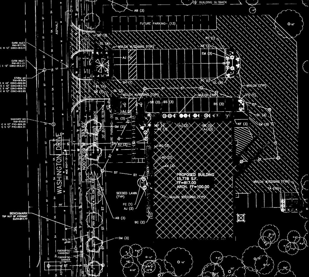
8 SIGN PERMIT REVIEW 1/11/16 Plan Commission Meeting InfoCor / Badger Lighting & Signs Village Planner Report Germantown, Wisconsin Summary Badger Lighting & Signs, agent for Central Asset Management, property owner, and InfoCor, is requesting sign approval for the recently completed facility located at W129 N10880 Washington Drive in the Germantown Business Park. Property Location: W129 N10880 Washington Drive Applicant/ Property Owner: Badger Lighting Central Asset Management New Berlin, WI Milwaukee, WI Current Zoning: M-1: Limited Industrial District Adjacent Land Uses Zoning North Industrial M-1 South Industrial M-1 East Residential Rs5/PDD West Industrial M-1 Location Map
9 Sign Review InfoCor Page 2 of 2 Proposal Badger Lighting & Signs, agent for Central Asset Management, property owner, and InfoCor, is requesting sign approval for the recently completed facility located at W129 N10880 Washington Drive in the Germantown Business Park: (1) 6 5 high x 7 wide (49 sqft per side; 98 sqft total) monument sign comprised of a double-sided non-illuminated aluminum cabinet with a Lexan plastic sign face with vinyl lettering. The cabinet is mounted on a 32 high split-faced masonry base (6 5 overall height) w/ 5 address coordinates Landscaping around the sign base was included as part of the overall landscaping plan approved with the site development and building plans in Staff Analysis/Comments The proposed monument sign meets the applicable Village requirements. However, the property owner has indicated that, although capable, the sign is not intended to be internally illuminated at this time. The specifications do not indicate the white panels are opaque, so, if the sign is internally illuminated in the future, the sign panels will need to be opaque. Village Planner Recommendation APPROVE the proposed monument sign for InfoCor located at W129 N10880 Washington Drive subject to the following conditions: 1. In the future, if the sign is internally illuminated, the sign panels with the white background shall be opaque or dark in compliance with the Village s sign regulations.


10


11


12

13 SIGN PERMIT REVIEW 1/11/16 Plan Commission Meeting Northwoods Laser & Embroidery / Signworks Village Planner Report Germantown, Wisconsin Summary Signworks, agent for GP Investments, property owner, and Northwoods Laser & Embroidery, operator, is requesting sign approval for a wall sign on the industrial building located at N114 W18621 Clinton Drive in the Germantown Industrial Park. Property Location: N114 W18621 Clinton Drive Applicant/ Property Owner: Signworks Northwoods Laser & Embroidery Hartford, WI Germantown, WI Current Zoning: M-1: Limited Industrial District Adjacent Land Uses Zoning North Industrial M-1 South Industrial M-1 East Industrial M-1 West Industrial M-1 Location Map
14 Sign Permit Northwoods Page 2 of 2 Background/Proposal Signworks, agent for GP Investments, property owner, and Northwoods Laser & Embroidery, operator, is requesting sign approval for a wall sign on the industrial building located at N114 W18621 Clinton Drive in the Germantown Industrial Park: 3 x 8' (24 sqft) wall-mounted non-illuminated aluminum sign board with vinyl lettering and logo surface mounted on the north elevation Staff Comments The proposed wall sign meets the sign requirements including the allowance for 1.5 sqft of sign area for every 1 linear foot of building frontage (24 sqft proposed vs. the maximum allowance of 80 sqft for 40 linear feet of building frontage). There is no record of a zoning permit having been issued for this new tenant in the industrial building. The operator shall obtain a Zoning Permit prior to sign installation and occupancy. Village Planner Recommendation APPROVE the proposed Northwoods wall sign for the building located at N114 W18621 Clinton Drive subject to the following conditions: 1. The owner/operator of Northwoods Laser & Embroidery shall obtain a Zoning Permit prior to sign installation and occupancy.
15

16
 land division.")
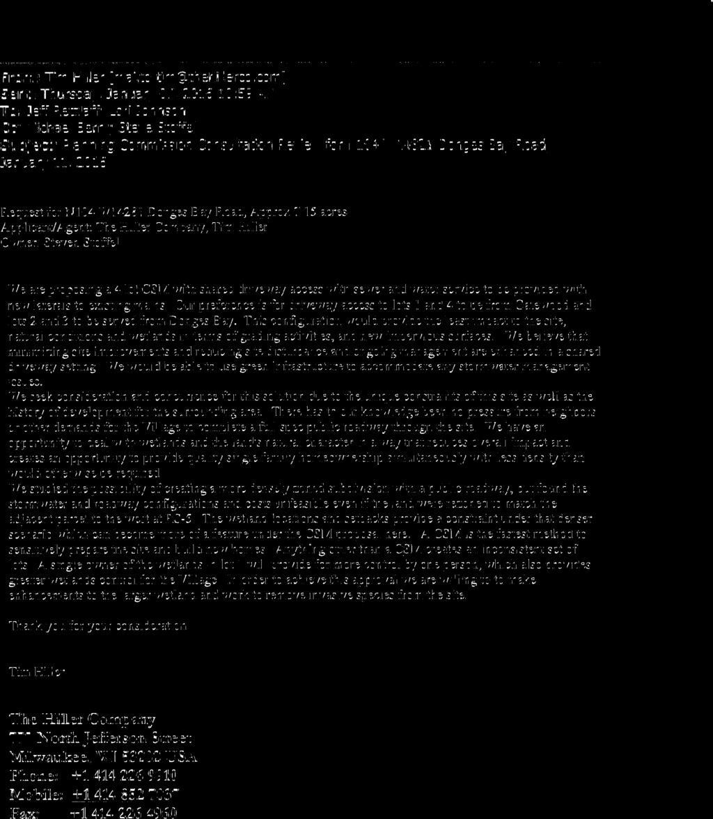
17 CERTIFIED SURVEY MAP (CSM) CONSULTATION 1/11/16 Plan Commission Meeting Steven Stoffel / Hiller Company Village Planner Report Germantown, Wisconsin Summary Tim Hiller, agent for Steven Stoffel, property owner of a 7.14-acre parcel located on Donges Bay Road has requested a consultation with the Plan Commission to discuss a potential 4-lot Certified Survey Map (CSM) land division. Location: Donges Bay Road (1/4 mile west of STH 145/Fond du Lac Ave) Property Owner/ Applicant: Tim Hiller Steve Stoffel Hiller Company Marrietta, GA Milwaukee, WI Current Zoning District: Rs-4: Single-Family (2.2 units/acre) Location Map Adjacent Land Uses Zoning North Residential Rs-6 South Residential Rs-4 East Institutional I West Residential Rs-5
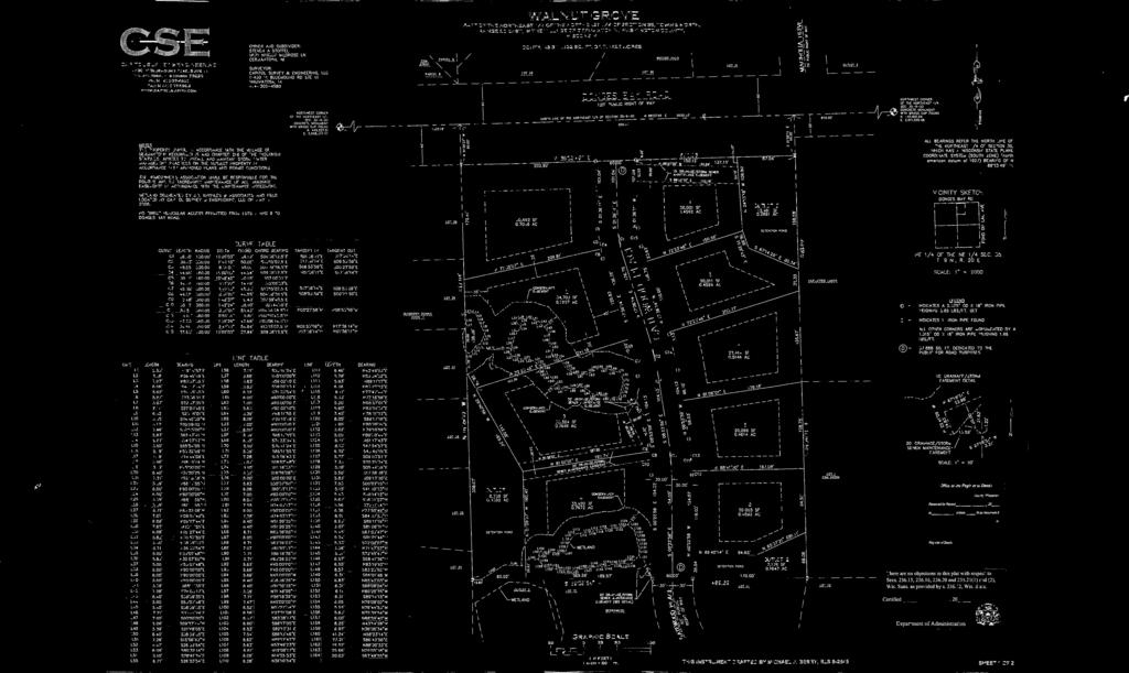
18 Certified Survey Map Consult Stoffel / Hiller Company Page 2 of 4 Background The subject parcel is classified as Low Density Residential on the Village s 2020 Future Land Use Plan map. These areas are intended to develop with single-family residential uses at a density of approximately.5 DU s per acre or a minimum lot size of 20,000 sqft. It is intended that new development in these areas should be required to develop or connect to the existing system of collector and local roads and not have direct access to arterial roads. Consistent with that classification, the parcel is located in an Rs-4: Single-family Zoning District that allows single-family lots as small as 20,000 sqft. The 7.14-acre parcel was previously approved for residential development in At that time, the Walnut Grove subdivision plat was approved for a total of nine (9) single-family lots ranging in size from 20,000 sqft (.46 acres) to 34,701 sqft (.80 acres). The proposed development included: the extension of Gatewood Place through the property from the south to Donges Bay Road (see attached plat); three (3) outlots for storm water management basins; and the extension of water and sanitary sewer to serve the development. Although a preliminary plat and Developer Agreement were approved by the Village, the Walnut Grove development never commenced with all approvals expiring in Proposal At this time, Tim Hiller, agent for the property owner has requested a consultation with the Plan Commission to discuss a potential 4-lot Certified Survey Map (CSM) land division. As shown on the attached plan (draft CSM) and explained in the narrative provided in the January 7, (copy attached), the owner is proposing to divide the parcel into four (4) single-family lots with shared driveway access. Lots 1 & 4 would be served by a shared driveway constructed from the end of Gatewood Place, and, Lots 2 & 3 served by a shared driveway from Donges Bay Road. The extension of Gatewood Place is NOT proposed under this plan. Staff Comments Consistency with Village s Land Use Plan. The existing Rs-4 zoning and 4-lot layout are arguably consistent with the general intent of the 2020 Land Use Plan map Low Density Residential classification, but not necessarily consistent with the density and lot sizes of other pre-existing development in the same low density residential area. Further, one might argue that a development plan that does not include an extension of Gatewood place does not necessarily comply with the should be required to develop or connect to the existing system of collector and local roads and not have direct access to arterial roads provision in the plan. As was included in the original plan, development of this parcel was intended to continue and/or complete the practice and pattern of constructing and extending local streets through the various residential subdivisions in the area to provide multiple means of access to/from the residents to the various collector and arterial streets in the vicinity (i.e. Donges Bay Road, Fond du Lac Avenue and County Line Road). Regardless of the owner s current plan to divide the parcel into larger lots that does not necessarily require the extension of Gatewood Place, the Village needs to decide if the
19 Certified Survey Map Consult Stoffel / Hiller Company Page 3 of 4 extension of Gatewood Place should be required (or at least the reservation or dedication of road right-of-way for such an extension if and when deemed necessary by the Village). Conformance with Zoning District Requirements. The proposed lots meet the minimum bulk requirements of the Rs-4 Zoning District. Conformance with Subdivision Requirements. With respect to utilities, all four lots will be served by water and sewer by way of existing facilities in the vicinity. Further, as summarized by the Village Engineer, at their meeting on January 5, 2016 regarding potential development of this parcel, the Village s Public Works Committee is recommending the following: 1. All connections to utilities in Donges Bay Road shall be installed before or during the Village s Donges Bay Road reconstruction project in 2016 at the developer s expense (special assessment would be acceptable); 2. Public water main shall be extended through the property from the existing public water main in Gatewood Place and connect to the public water main in Donges Bay Road at developer s expense; 3. Sanitary sewer connection from the four lots shall be to the existing stub in Gatewood Place (no determination was made whether the sanitary shall be private or public, so this could be at the developer s discretion); 4. The wastewater utility will entomb the existing sanitary lateral in Donges Bay Road during the cured-in-place pipe project presently underway upon written permission from the developer/property owner; 5. No recommendation was made regarding whether to extend Gatewood Place as a public street through the property to Donges Bay Road was made. With respect to street access, shared driveways between adjacent lots or parcels is permitted. However, when a shared driveway is proposed in a situation where the construction or extension of a public street is planned, Section of the Subdivision regulations needs to be considered. Section 18.07(1)(d) provides that shared driveways (listed as one type of a private street ) may be permitted by the Village Board provided that certain criteria and design standards are met. In this case, it s difficult for staff to find that all of the criteria can be met under the owner s 4-lot development plan.
20 Certified Survey Map Consult Stoffel / Hiller Company Page 4 of 4 Specifically, Section 18.07(1)(d)4. provides the following: Private streets shall NOT be allowed under any circumstances when: a. The proposed private street will replace or otherwise conflict with a designated public street set forth in the Village's official map, Comprehensive Plan, or other official state, regional, county, or village transportation plan; b. The Village determines that construction of a public street would be in the best interest of the Village and that a public (vs. private) street is determined to be needed for: (1) providing access to adjacent lands having the potential for future development; or (2) public circulation by way of connecting to or extending from an existing or future public street; c. The proposed private street connects 2 or more public streets or highways where the connection would further the pattern and function of the public street system; or d. The proposed street will or has the potential to provide access to more than 15 residential lots, or, has the potential to provide (or is needed for) access to future development of adjacent land. With respect to the above criteria, the extension of Gatewood Place is a planned extension. The Berrywood subdivision to the south was approved for development in 2004 with cul-de-sacs that exceed the maximum 500 length requirement. That development was only allowed to proceed given another provision in the Subdivision regulations that allows cul-de-sacs greater than 500 feet in length if the road is extended to the property line adjacent to another property such that the road can be further extended and connected to another roadway such that the resulting cul-de-sacs (once all are completed) do not exceed a length of 500 feet. The Fire Department is recommending that Gatewood Place be completed/extended through to Donges Bay Road to provide improved access to the subject parcel and to the existing residential area to the south (Berrywood and beyond). With regard to the two (2) existing wetlands on the property (8,467 sqft or.19 acres), the owner proposes to include both wetland areas (and the 25 setback) within Lot 1 in an effort to address the Land Suitability provisions of the Subdivision Code that prohibit wetlands from being included in lots less than 2 acres in area. While no formal action or recommendation to the Village Board is required at this time, the Plan Commission needs to be prepared to discuss those issues and/or concerns they feel are appropriate in order to give the owner further guidance regarding the current proposal to divide and develop this parcel.
21

22


23

24


25

26 3 4 2 Wetland 1 6,961.7 sqft 5 1 Document Path: \\rasmith.com\madison\municipal\ \gis\wetland Figures\Figure 2 - Wetland Boundary Map.mxd Data Source: RASN Washington County inch = 75 feet October 14, The Hiller Company Walnut Grove Village of Germantown Washington County, Wisconsin 6 Wetland 2 1,504 sqft 7 Map Legend Sample Plot Delineated Wetland - 8,465.7 sqft Study Area acres Figure 2 Wetland Boundary Map
27 18.07 DESIGN STANDARDS. (1) STREET ARRANGEMENT. In any new subdivision, or in any planned development, if applicable, the street layout shall conform to the arrangement, width and location indicated on the Official Map, County Jurisdictional Highway Plan, comprehensive plan or plan component, or detailed neighborhood unit development plan of the Village. In areas for which detailed neighborhood unit development plans have not been completed, the street layout shall conform to the functional classification of the various types of streets and shall be developed and located in proper relation to existing and proposed streets, to the topography, to such natural features as streams and tree growth, to public convenience and safety, to the proposed use of the land to be served by such streets, to existing or planned utilities, and to the most advantageous development of adjoining areas. The subdivision shall be designed so as to provide each lot with satisfactory access to a public street. In addition: (a) (b) (c) (d) Arterial Streets. Arterial streets, as hereafter defined, shall be arranged so as to provide ready access to centers of employment, centers of governmental activity, community shopping areas, community recreation and points beyond the boundaries of the community. They shall also be properly integrated with and related to the existing and proposed system of arterial streets and highways and shall be, insofar as practicable, continuous and in alignment with existing or planned streets with which they are to connect. Collector Streets. Collector streets, as hereafter defined, shall be arranged so as to provide for the collection of traffic from residential and other high intensity use areas and conveyance of such traffic to the arterial street and highway system and shall be properly related to the mass transportation system, to special traffic generators such as schools, churches and shopping centers and other concentrations of population and to the arterial streets to which they connect. Minor Streets. Minor streets, as hereafter defined, shall be arranged to conform to the topography, to discourage use by through traffic, to permit the design of efficient storm drainage, water supply and sanitary sewerage systems, and to require the minimum street area necessary to provide safe and convenient access to abutting property. Private Streets. (Cr. Ord. #04-08) Private streets are a type of "minor street" that shall be arranged to conform to the topography, to discourage use by through traffic, to permit the design of efficient storm drainage, water supply and sanitary sewerage systems, and provide the minimum street area necessary to provide safe and convenient access to abutting property. Private streets include shared driveways, private lanes, and private streets intended to serve 2 to 15 single-family residential lots or parcels (as well as condominium-type development) and may be allowed by the Village in accordance with all of the following: 1. Private street are intended to retain rural character, reduce construction and maintenance costs, serve relatively larger and more rural lots, and allow more control, security and sense of identity where public streets or roads are not planned or needed for public traffic circulation and
28 accessibility; 2. Private streets are only allowed at the discretion of the Village Board as approved as part of a subdivision plat, certified survey map (CSM) or condominium plat; 3. Private streets may be allowed in any single-family residential zoning district, however, the Village Board may require private streets to be developed as part of a Planned Development District (PDD); 4. Private streets shall NOT be allowed under any circumstances when: a. The proposed private street will replace or otherwise conflict with a designated public street set forth in the Village's official map, Comprehensive Plan, or other official state, regional, county, or village transportation plan; b. The Village determines that construction of a public street would be in the best interest of the Village and that a public (vs. private) street is determined to be needed for: (1) providing access to adjacent lands having the potential for future development; or (2) public circulation by way of connecting to or extending from an existing or future public street; c. The proposed private street connects 2 or more public streets or highways where the connection would further the pattern and function of the public street system; or d. The proposed street will or has the potential to provide access to more than 15 residential lots, or, has the potential to provide (or is needed for) access to future development of adjacent land. 5. Private streets shall be owned and maintained by the property owners of the lots or parcels having access to and served by such private streets and/or a legal entity (e.g., Homeowner's Association, Condominium Association, etc.) established prior to or concurrent with Village approval of the subdivision plat or Certified Survey Map. Ownership and maintenance responsibilities shall be set forth in deed restrictions or covenants reviewed and approved by the Village. The arrangement, design, and construction (including arrangements for construction inspection by qualified engineers) of private streets shall be approved by the Village as set forth in a Development Agreement with the Village as required under this section. 6. These standards and the design requirements in Table 3 are intended to be minimums that may be modified by the Village, including the requirement for a higher or different standard regardless of the private street classification, as determined on a case-by-case basis through the Planned Development District (PDD) review process or as specified in a Development Agreement required under this section. 7. The construction of private streets and the development and use of land that includes private streets shall comply with all zoning, land development and other applicable Village codes and requirements,
29 (e) (f) (g) (h) (i) (j) including but not limited to, the Village's stormwater management regulations. Proposed Streets. (Rltd. Ord. #04-08) Proposed streets shall extend to the boundary lines of the tract being subdivided or developed unless prevented by topography or other physical conditions or unless, in the opinion of the Plan Commission, such extension is not necessary or desirable for the coordination of the layout of the subdivision or development or for the advantageous development of the adjacent tracts. Where an existing dedicated or platted half street is adjacent to the tract being subdivided or developed, the other half of the street shall be dedicated by the subdivider or developer. Protection and Limited Access. (Rltd. Ord. #04-08) Whenever the proposed subdivision contains or is adjacent to an arterial street or highway, adequate protection of residential properties, limitation of access and separation of through and local traffic shall be provided by reversed frontage lots, screen planting contained in a nonaccess reservation along the rear property line, or by the use of frontage streets. Stream or Lake Shores. (Rltd. Ord. #04-08) Stream or lake shores shall have a minimum of 60 feet of public access platted to the low water mark at intervals of not more than 1/2 mile as required by (3), Wis. Stats. Reserve Strips. (Rltd. Ord. #04-08) Reserve strips shall not be provided on any plat to control access to streets or alleys, except where control of such strips is placed with the Village under conditions approved by the Plan Commission. Alleys. (Rltd. Ord. #04-08) Alleys shall be provided in commercial and industrial areas for off-street loading and service access unless otherwise required by the Plan Commission, but shall not be approved in residential districts. Dead end alleys shall not be approved and alleys shall not connect to an arterial street or highway. Street Names. (Rltd. Ord. #04-08) Street names shall not duplicate or be similar to existing street names on nonconnecting streets elsewhere in the Village and existing street names shall be extended wherever possible. (2) LIMITED ACCESS HIGHWAY AND RAILROAD RIGHT-OF-WAY TREATMENT. Whenever the proposed subdivision contains or is adjacent to a limited access highway or railroad right-of-way, the subdivision shall include the following design restrictions: (a) (b) When lots within the proposed subdivision back upon the right-of-way of an existing or proposed limited access highway or a railroad, a planting strip at least 30 feet in depth shall be provided adjacent to the highway or railroad in addition to the normal lot depth. This strip shall be a part of the platted lots, but shall have the following restriction lettered on the face of the plat: "this strip reserved for the planting of trees and shrubs; the building of structures hereon is prohibited." Commercial and industrial properties fronting on the right-of-way of an existing or proposed limited access highway or railroad shall have provided, on each side of the limited access highway or railroad, streets approximately parallel to and at a suitable distance from such highway or railroad for the appropriate use of the land between such streets and highway or railroad, but not less than 200 feet.
30 (c) (d) Streets parallel to a limited access highway or railroad right-of-way, when intersecting an arterial street, highway or collector street which crosses said railroad or highway, shall be located at a minimum distance of 250 feet from said highway or railroad right-of-way. Such distance, where desirable and practicable, shall be determined with due consideration of the minimum distance required for the future separation of grades by means of appropriate approach gradients. Minor streets immediately adjacent and parallel to railroad rights-of-way shall be avoided and location of minor streets immediately adjacent to arterial streets and highways and to railroad rights-of-way shall be avoided in residential areas. (3) PUBLIC STREET AND PUBLIC WAY DESIGN STANDARDS. (Am. Ord. #38-05; Am. Ord. #04-08) The minimum right-of-way and roadway width of all proposed public streets and alleys shall be as specified by the comprehensive plan, comprehensive plan component, official map, neighborhood development study; or the standard cross-section adopted by the Village (see Table 2 or Table 2a); or if no width is specified therein, the minimum widths shall be as set forth in Table 2. Arterial street sections are for standard arterial streets only. Cross-sections for freeways, expressways and parkways should be based upon detailed engineering studies. In addition all minor streets that are planned and designed to not be extended or connected to another street at the time of development or at any time in the future (i.e., a "dead end" street) shall include a cul-de-sac meeting the following requirements: (a) (b) (c) (d) (e) All non-cul-de-sac streets designed having one end permanently closed, shall not exceed 500 feet in length. Cul-de-sac streets not exceeding 500 feet in length are permitted as a matter of course. Where a cul-de-sac street is designed so that it's bulb right-of-way abuts the subdivision perimeter property line, making future extension of the roadway, or connection to another roadway feasible; the Plan Commission may approve a design of up to 1,200 feet in length. Other cu-de-sac roads may be approved at lengths greater than 500 feet but not exceeding 1,200 feet in length depending upon such factors as: 1. The zoning classification and resultant lot size, with larger lots abutting the cu-de-sac street justifying and permitting the approval of a proportionately longer cul-de-sac street; 2. The number, and proximity to Village arterials roads, of entry points into the subdivision, including those feasible for extension and connection in the future. Except in section of the Village, as set forth in Table 2a, all cul-de-sac streets shall terminate in a circular turnaround having a minimum right-of-way radius of 60 feet and a minimum face of curbs radius of 40 feet on urban sections and 40 feet on rural sections (see Table 2). The length of a cul-de-sac shall be defined as the distance from the nearest intersecting right-of-way from the subject cul-de-sac street along the centerline of said cul-de-sac to the point at the bulb right-of-way furthest from the connecting street.
31 TABLE 2 REQUIRED STREET CROSS SECTIONS IN THE VILLAGE OF GERMANTOWN, WASHINGTON COUNTY, WISCONSIN TABLE INSET: Type of Street or Public Way Urban Street Section Minimum Right-of-Way to be Dedicated Rural Street Section ** Minimum Dimensions Minimum Right-of-Way to be Dedicated Arterial Streets 120 feet * Dual 36-foot pavement (face of curb to face of curb) * 20-foot median * 8-foot tree banks (curb lawn) * 5-foot sidewalks * 1-foot outside sidewalks Collector Streets 80 feet * 40-foot pavement (Face of curb to face of curb) * 14-foot tree banks (curb lawn) * 5-foot sidewalks * 1-foot outside sidewalks Minor Streets 60 feet * 30-foot pavement (face of curb to face of curb) * 9-foot tree banks (curb lawn) * 5-foot sidewalks * 1-foot outside sidewalks Cul-de-Sac (Turn-around) 60 foot radius * 40-foot outside face of curb radius * 10-foot inside pavement radius * 14-foot tree banks (curb lawn) * 5-foot sidewalks (if required) * 1-foot outside sidewalks Service Alleys 30 feet * 28-foot pavement (if required) Pedestrian Ways 20 foot average * As required by the Village Engineer Minimum Dimensions 120 feet * Dual 24-foot pavement * 8-foot median * 6-foot inside shoulders * 10-foot outside shoulders * 16-foot roadside ditches NONE NONE 60 feet * 24-foot pavement * 2-foot shoulders * 14-foot roadside ditches 60 foot radius * 40-foot outside pavement radius * 17-foot Inside pavement radius * 6-foot shoulders * 13-foot roadside ditches NONE NONE 20 foot average * As required by the Village Engineer ** NOTE: Not applicable in Section of the Village. See Table 2a on next page. (Am. Ord. #31-88) TABLE 2a REQUIRED STREET CROSS SECTIONS IN THE VILLAGE OF GERMANTOWN, WASHINGTON COUNTY, WISCONSIN
32 TABLE INSET: Type of Street or Public Way Urban Street Section Minimum Right-of-Way to be Dedicated (Note: Applicable only in Section of the Village) Minimum Dimensions Arterial Streets 120 feet * Dual 36-foot pavement (face of curb to face of curb) * 20-foot median * 8-foot tree banks (curb lawn) * 5-foot sidewalks * 1-foot outside sidewalks Collector Streets 80 feet * 48-foot pavement (face of curb to face of curb) * 10-foot tree banks (curb lawn) * 5-foot sidewalks * 1-foot outside sidewalks Minor Streets 60 feet * 36-foot pavement (face of curb to face of curb) * 6-foot tree banks (curb lawn) * 5-foot sidewalks * 1-foot outside sidewalks Cul-de-sac (Turn-around) 60 foot radius * 48-foot outside face of curb radius * 12-foot inside pavement radius * 6-foot tree banks (curb lawn) * 5-foot sidewalks (if required) * 1-foot outside sidewalks Service Alleys 30 feet * 28-foot pavement (if required) Pedestrian Ways 20 foot average *As required by the Village Engineer (Cr. Ord. #31-88) TABLE 3 PRIVATE STREET DESIGN STANDARDS AND REQUIREMENTS TABLE INSET: Design Standard/ Requirement Ownership Construction, Inspection and Maintenance Responsibility Private Street Classification Shared Driveway Private Lane Private Street Private (all lot owners and/or legal association); subject to access easement agreement Private access and maintenance responsibilities established in Development Agreement and legal association covenants and deed restrictions; may also be subject to PDD Conditions and Restrictions (if required by the Village) Private (all lot owners and/or legal association); subject to access easement agreement Private access and maintenance responsibilities established in Development Agreement and legal association covenants and deed restrictions; may also be subject to PDD Conditions and Restrictions (if required by the Village) Private (all lot owners and/or legal association); subject to access easement agreement Private access and maintenance responsibilities established in Development Agreement and legal association covenants and deed restrictions; may also be subject to PDD Conditions and Restrictions (if required by the Village)
33 Design Standard/ Requirement Private Street Classification Shared Driveway Private Lane Private Street Max. # Lots Served (typical) Up to 3 lots Up to 7 lots Up to 15 lots Length (max.) >1,200 w/ Village Board approval >1,200 w/ Village Board approval >1,200 w/ Village Board approval Permanent Closure (Turnaround) Easement or Right-of-Way Width Required (min.) # Lanes and Width (min. total width) Cul-de-sac (30' to 60' min. radius to be determined by Village Board) Cul-de-sac (30' to 60' min. radius to be determined by Village Board) Cul-de-sac (30' to 60' min. radius to be determined by Village Board) 30' easement or outlot 40' outlot or private right-of-way 60' outlot or private right-of-way 1 lane 16' wide 16' total width 2 lanes 9' each 18' total width Vertical Clearance (min.) 14' 14' 14' Grade (max.) 10%; Grade to match existing shoulder (uncurbed) or intersecting street pavement (curbed) with min. 25' landing approach at grade +/- 2% 10%; Grade to match existing shoulder (uncurbed) or intersecting street pavement (curbed) with min. 25' landing approach at grade +/- 2% 2 lanes 11' each 22' total width 10%; Grade to match existing shoulder (uncurbed) or intersecting street pavement (curbed) with min. 25' landing approach at grade +/- 2% Curve Radius N/A 100' See Sec ( ') Base Course (type/thickness) Surface Course (type/thickness) Lift 1: 9" of 1.5" TB; Lift 2: 5" of.75" TB Asphalt concrete surface course is OPTIONAL as determined by the Village Board. Lift 1: 9" of 1.5" TB; Lift 2: 5" of.75" TB Asphalt concrete surface course is OPTIONAL as determined by the Village Board. Lift 1: 9" of 1.5" TB; Lift 2: 5" of.75" TB Aasphalt concrete surface course is OPTIONAL as determined by the Village Board. (Cr. Ord. #04-08) (4) STREET INTERSECTIONS. Streets shall intersect each other at as nearly right angles as topography and other limiting factors of good design permit. In addition: (a) (b) (c) (d) The number of streets converging at one intersection shall be reduced to a minimum, preferably not more than 2. The number of intersections along arterial streets and highways shall be minimized. Wherever practicable, the distance between such intersections shall not be less than 1,200 feet. On all streets where sidewalks are required, ramps or openings to accommodate handicapped individuals or vehicles shall be provided in accordance with , Wis. Stats. Minor and collector streets shall not necessarily continue across arterial streets. If the distance between the center line intersections of any street with any other intersecting street is less than 250 feet, measured along the center line of the intersecting street, then the location shall be so adjusted that the distance is increased or the adjoinment across the intersecting street is continuous and a jog is avoided. (5) BLOCKS. The widths, lengths and shapes of blocks shall be suited to the planned use of the land; zoning requirements; need for convenient access, control and safety of street traffic; and the limitations and opportunities of topography. In addition: (a) Blocks in residential areas shall not, as a general rule, be less than 600 feet nor more than 1,200 feet in length unless otherwise dictated by exceptional topography or other limiting factors of good design.
34 (b) (c) (d) Pedestrian ways of not less than 20 feet in average width may be required near the center and entirely across any block over 900 feet in length where deemed essential by the Plan Commission to provide adequate pedestrian circulation or access to schools, parks, shopping centers, churches or transportation facilities. Block widths shall be sufficient to provide for 2 tiers of lots of appropriate depth except where otherwise required to separate residential development from through traffic, railroads or natural barriers. Width of lots or parcels designated for commercial or industrial use shall be adequate to provide for off-street service and parking required by the use contemplated and the area zoning restrictions for such use. All general service electric power, telephone and cable TV lines shall be placed on mid-block easements of not less than 15 feet in width centered on rear lot lines for underground installation. (6) LOTS. The size, shape and orientation of lots shall be appropriate for the location of the subdivision and for the type of development and use contemplated. The lots should be designed to provide an aesthetically pleasing building site and a proper architectural setting for the buildings contemplated. In addition: (a) (b) (c) (d) (e) (f) (g) (h) Side lot lines shall be at right angles to straight street lines or radial to curved street lines on which the lots face. Lot lines shall follow municipal boundary lines rather than cross them. Double frontage or "through" lots shall be prohibited, except where necessary to provide separation of residential development from arterial traffic or to overcome specific disadvantages of topography and orientation. Every lot should front or abut for a distance of at least 60 feet on a public street, but may, in extenuating circumstances, be reduced to no less than 30 feet. Area and dimensions of all lots shall conform to the requirements of the Zoning Code. Those building sites not served by a public sanitary sewerage system or other approved system shall be sufficient to permit the use of an on-site soil absorption sewage disposal system designed in accordance with Wis. Adm. Code H Excessive depth of lots in relation to width shall be avoided and a proportion of 2:1 shall be considered a maximum ratio under normal conditions. Depth of lots or parcels designated for commercial or industrial use shall be adequate to provide for off-street service and parking required by the use contemplated. Four-sided rectangular lots shall be considered standard, odd shaped lots should be avoided and lots with more than 5 sides will be allowed only in extenuating circumstances. The width of lots within the interior of a block shall conform to the requirements of the Zoning Code or other applicable ordinance and in no case shall a lot have a minimum average width of less than 80 feet. Corner lots shall have an additional width of 10 feet to permit adequate building setbacks from the side streets.
35 (i) Lands lying between the meander line and the water's edge and any otherwise unplattable lands which lie between a proposed subdivision and the water's edge shall be dedicated to the public in any plat abutting a lake or stream. (7) BUILDING SETBACK LINES. Building setback lines appropriate to the location and type of development contemplated which are more restrictive than the regulation of the zoning district in which the plat is located may be required by the Plan Commission. (8) EASEMENTS. The Plan Commission may require utility easements of widths deemed adequate for the intended purpose, but not less than 7.5 feet on each side of all rear lot lines and on side lot lines or across lots where necessary or advisable for electric power and communication wires and conduits; storm and sanitary sewers; and gas, water and other utility lines. Where a subdivision is traversed by a watercourse, drainageway channel or stream, an adequate drainageway or easement shall be provided as may be required by the Plan Commission. The location, width, alignment and improvement of such drainageway or easement shall be subject to the approval of the Village Engineer; and parallel streets or parkways may be required in connection therewith. Where necessary, stormwater drainage shall be maintained by landscaped open channels of adequate size and grade to hydraulically accommodate maximum potential volumes of flow. These design details are subject to review and approval by the Village Engineer. (9) PUBLIC SITES AND OPEN SPACES. (Rep. & Recr. Ord. #43-95) In the design of the plat or planned development, due consideration shall be given to the preservation of suitable sites of adequate area for future parks, playgrounds, public school sites, drainageways and other public purposes. If designated on the comprehensive plan, comprehensive plan component, official map or detailed neighborhood unit development plan, such areas shall be made a part of the plat or planned development as stipulated in section 18.02(3) of this chapter. If not so designated, consideration shall be given in the location of such sites to the preservation of scenic, scientific and historic sites, trees, marshes, lakes and ponds, watercourses and ravines. Accordingly, each subdivider or developer of residential land in the Village shall reserve public sites and open-space lands designated on the Village comprehensive plan or plan component. The proposed public lands shall be made a part of the plat or development and reserved at the time of final plat approval or site plan approval for a period not to exceed 3 years, unless extended by mutual agreement, for acquisition at undeveloped land prices by the public agency having jurisdiction. If the land is not acquired within the 3-year period or the time extended by mutual consent, as set forth herein, the land shall be released by the Village from reservation to the owner.

36
PLAN COMMISSION MINUTES May 11, CALL TO ORDER: Chairman Wolter called the meeting to order at 6:30 p.m.
 PLAN COMMISSION MINUTES CALL TO ORDER: Chairman Wolter called the meeting to order at 6:30 p.m. ROLL CALL: Chairman Dean Wolter, Trustee Representative David Baum, Commissioners Mary Ellen Gray, Tim Yokes,
PLAN COMMISSION MINUTES February 26, 2018
 PLAN COMMISSION MINUTES CALL TO ORDER: Chairman Wolter called the meeting to order at 6:30 p.m. ROLL CALL: Chairman Dean Wolter, Trustee Rep David Baum, Commissioners Bob Williams, Peter Nilles, Tony Laszewski,
ARTICLE VI. SUBDIVISION STANDARDS, PUBLIC
 ARTICLE VI. SUBDIVISION STANDARDS, PUBLIC IMPROVEMENTS, AND DESIGN REQUIREMENTS ARTICLE VI. SUBDIVISION STANDARDS, PUBLIC IMPROVEMENTS, AND DESIGN REQUIREMENTS DIVISION 1. GENERAL PROVISIONS Sec. 21-6100.
ARTICLE 15. RULES, REGULATIONS AND DEFINITIONS
 ARTICLE 15. RULES, REGULATIONS AND DEFINITIONS Section 1. Interpretation and Construction: The following rules and regulations regarding interpretation and construction of the Ulysses-Grant County, Kansas,
SUBDIVISION DESIGN PRINCIPLES AND STANDARDS
 SECTION 15-200 SUBDIVISION DESIGN PRINCIPLES AND STANDARDS 15-201 STREET DESIGN PRINCIPLES 15-201.01 Streets shall generally conform to the collector and major street plan adopted by the Planning Commission
ELK RAPIDS TOWNSHIP ANTRIM COUNTY, MICHIGAN ORDINANCE NO
 ELK RAPIDS TOWNSHIP ANTRIM COUNTY, MICHIGAN ORDINANCE NO. 3-2011 AN ORDINANCE TO REPLACE THE SUBDIVISION CONTROL ORDINANCE WITH A NEW SUBDIVISION DEVELOPMENT ORDINANCE, IN ACCORD WITH THE LAND DIVISION
ARTICLE 23 CONDOMINIUM STANDARDS
 ARTICLE 23 CONDOMINIUM STANDARDS Section 23.01 Intent. The intent of this Article is to provide regulatory standards for condominiums and site condominiums similar to those required for projects developed
-MENDOCINO COUNTY PLANNING AND BUILDING SERVICES- DIVISION OF LAND REGULATIONS TITLE 17
 ARTICLE VI -- GENERAL REGULATIONS AND PROVISIONS Sec. 17-50. Sec. 17-51 General Plan. Sec. 17-52 Lot and Block Design and Configuration. Sec. 17-53 Lot Access. Sec. 17-54 Private Roads. Sec. 17-55 Water
Section Preliminary Plat Checklist and Application Forms
 Section 201 - Preliminary Plat Checklist and Application Forms PRELIMINARY SUBDIVISION PLAT REVIEW PROCESS CHART PRELIMINARY SUBDIVISION PLAT APPLICATION PRELIMINARY PLAT REVIEW CHECKLIST CITY OF NAMPA
ARTICLE 3 DEFINITIONS
 Sections: 3-1 Rules of Construction 3-2 Definitions ARTICLE 3 DEFINITIONS SECTION 3-1 RULES OF CONSTRUCTION 3-101. a. The language set forth in these regulations shall be interpreted in accordance with
THE COUNTY BOARD OF SUPERVISORS OF THE COUNTY OF DOUGLAS DOES ORDAIN AS FOLLOWS:
 8.1 SUBDIVISION CONTROL ORDINANCE THE COUNTY BOARD OF SUPERVISORS OF THE COUNTY OF DOUGLAS DOES ORDAIN AS FOLLOWS: SECTION I. GENERAL INTERPRETATION This ordinance shall not repeal, impair or modify private
PLAN COMMISSION MINUTES January 14, 2019
 PLAN COMMISSION MINUTES CALL TO ORDER: Chairman Wolter called the meeting to order at 6:31 p.m. ROLL CALL: Chairman Dean Wolter, Trustee Rep David Baum, Commissioners Tony Laszewski, Peter Nilles, Bill
I. Requirements for All Applications. C D W
 108-16.1. Application checklists. Checklist for Required Submissions to the Planning Board or Zoning Board of Adjustment of Monroe Township All required submissions are to be made to the Administrative
Condominium Unit Requirements.
 ARTICLE 19 CONDOMINIUM REGULATIONS Section 19.01 Purpose. The purpose of this Article is to regulate projects that divide real property under a contractual arrangement known as a condominium. New and conversion
SECTION 7000 LAND DEVELOPMENT REQUIREMENTS
 SECTION 7000 LAND DEVELOPMENT REQUIREMENTS 7000 LAND DEVELOPMENT REQUIREMENTS... 1 7001 LEGISLATIVE AUTHORITY... 1 7001.1 LAND DEVELOPMENT... 1 7001.1.1 Title 40, Idaho Code... 1 7001.1.2 Idaho Code 40-1415
a. provide for the continuation of collector streets and thoroughfare streets between adjacent subdivisions;
 Section 7.07. Intent The requirements of this Section are intended to provide for the orderly growth of the Town of Holly Springs and its extra-territorial jurisdiction by establishing guidelines for:
610 LAND DIVISIONS AND PROPERTY LINE ADJUSTMENTS OUTSIDE A UGB
 ARTICLE VI: LAND DIVISIONS AND PROPERTY LINE ADJUSTMENTS VI-21 610 LAND DIVISIONS AND PROPERTY LINE ADJUSTMENTS OUTSIDE A UGB 610-1 Property Line Adjustments (Property Line Relocation) A property line
Staff Report: Date: Applicant: Property Identification: Acreage of Request: Current Zoning of Requested Area: Requested Action: Attached:
 Staff Report: Completed by Jeff Palmer Director of Planning & Zoning Date: November 7, 2018, Updated November 20, 2018 Applicant: Greg Smith, Oberer Land Developer agent for Ronald Montgomery ET AL Property
ARTICLE 24 PRIVATE ROAD, SHARED PRIVATE DRIVEWAY AND ACCESS EASEMENT STANDARDS
 ARTICLE 24 PRIVATE ROAD, SHARED PRIVATE DRIVEWAY AND ACCESS EASEMENT STANDARDS SECTION 24.00 INTENT AND PURPOSE The standards of this Article provide for the design, construction and maintenance of private
PLANNED DEVELOPMENT DISTRICT STANDARDS. Cadence Site
 PLANNED DEVELOPMENT DISTRICT STANDARDS Cadence Site A Planned Development District 1. Statement of General Facts, Conditions and Objectives Property Size: Approximately 57.51 Acres York County Tax Map
ARTICLE 13 CONDOMINIUM REGULATIONS
 ARTICLE 13 CONDOMINIUM REGULATIONS Section 13.01 Purpose. The purpose of this Article is to regulate projects that divide real property under a contractual arrangement known as a condominium. New and conversion
AN ORDINANCE AMENDING THE CODE OF ORDINANCES OF THE TOWN OF TRYON. Chapter 156 Subdivision Ordinance
 AN ORDINANCE AMENDING THE CODE OF ORDINANCES OF THE TOWN OF TRYON Chapter 156 Subdivision Ordinance Chapter 156: Subdivision Regulations ARTICLE I GENERAL PROVISIONS Section 1.1 Title This Ordinance shall
Draft Model Access Management Overlay Ordinance
 Draft Model Access Management Overlay Ordinance This model was developed using the City of Hutchinson and the Trunk Highway 7 corridor. The basic provisions of this model may be adopted by any jurisdiction
APPLICATION PROCEDURE
 ANTRIM PLANNING BOARD P. O. Box 517 Antrim, New Hampshire 03440 Phone: 603-588-6785 FAX: 603-588-2969 APPLICATION FORM AND CHECKLIST FOR MINOR OR MAJOR SITE PLAN REVIEW File Date Received By APPLICATION
CITY OF HOBBS ORDINANCE NO..
 CITY OF HOBBS ORDINANCE NO.. AN ORDINANCE TO AMEND TITLE 16 OF THE HOBBS MUNICIPAL CODE IN ITS ENTIRETY. BE IT ORDAINED BY THE GOVERNING BODY OF THE CITY OF HOBBS, NEW MEXICO, that the following Chapter
CHAPTER 18 SUBDIVISION AND PLATTING INTRODUCTION DEFINITIONS GENERAL PROVISIONS PROCEDURE PRELIMINARY PLAT
 CHAPTER 18 SUBDIVISION AND PLATTING 18.01 Statutory Authorization 18.02 Title 18.03 Purpose and Intent 18.04 Interpretation 18.05 Validity 18.06 Conflicting Ordinances 18.07 Effective Date 18.10 Definitions
CHECKLIST FOR DEVELOPMENT REVIEW
 CHECKLIST FOR DEVELOPMENT REVIEW Petitions and related documents and plans for land development or other proposals regulated by Title 16 of the Municipal Code (Development Ordinance) and Title 17 of the
BYRON TOWNSHIP ZONING APPLICATION
 BYRON TOWNSHIP ZONING APPLICATION Phone: (616) 878-9104 * Fax: (616) 878-3980 * Website: www.byrontownship.org This application will not be accepted if incomplete. APPLICATION FOR & REQUIRED COPIES Private
CONDOMINIUM REGULATIONS
 ARTICLE 37 CONDOMINIUM REGULATIONS SECTION 37.01. Purpose The purpose of this Article is to regulate projects that divide real property under a contractual arrangement known as a condominium. New and conversion
CHAPTER 5. Subdivisions Regulations
 CHAPTER 5 Subdivisions Regulations 10-5-1 Introduction and Purpose 10-5-2 Definitions 10-5-3 General Provisions 10-5-4 Procedure for Submitting Subdivisions 10-5-5 Design Standards; Streets and Lots 10-5-6
STATE OF MICHIGAN COUNTY OF MARQUETTE, TOWNSHIP OF NEGAUNEE LAND DIVISION, SUBDIVISION AND CONDOMINIUM ORDINANCE
 STATE OF MICHIGAN COUNTY OF MARQUETTE, TOWNSHIP OF NEGAUNEE LAND DIVISION, SUBDIVISION AND CONDOMINIUM ORDINANCE Adopted: August 8 th, 2008 Effective: August 28 th, 2008 Sec.100. Title ARTICLE I GENERAL
ARTICLE 900 PLAT AND PLAN REQUIREMENTS
 ARTICLE 900 PLAT AND PLAN REQUIREMENTS SEC. 900.1 ITEMS TO BE SHOWN ON PLAT OR PLAN General (1) Property lines of all property owners adjacent to the exterior boundaries of the project shall be located
A. Appropriate agency responsible for transportation review for the subject property.
 7.8.10 Procedure Any person desiring to create a minor subdivision shall submit to the Commission for approval an application on forms provided by the Division, and a record plat in conformance with the
TOWN OF LEWISTON PLANNING BOARD APPLICATION
 TOWN OF LEWISTON PLANNING BOARD APPLICATION DESCRIPTION OF PROPOSED REQUEST: Name of Property Owner: Phone #: Name of Applicant:Phone #: Address or Location of Proposal:_SBL# Size of Parcel or Structure:Existing
Village of Bellevue Plan Commission
 Village of Bellevue Plan Commission Pursuant to Section 19.84 Wis. Stats., a scheduled regular meeting of the Village of Bellevue Plan Commission was held on Tuesday, at 7:00 p.m. at the Bellevue Village
ARTICLE 15 - PLANNED UNIT DEVELOPMENT
 Section 15.1 - Intent. ARTICLE 15 - PLANNED UNIT DEVELOPMENT A PUD, or Planned Unit Development, is not a District per se, but rather a set of standards that may be applied to a development type. The Planned
ARTICLE 24 SITE PLAN REVIEW
 ARTICLE 24 SITE PLAN REVIEW 24.1 PURPOSE: The intent of these Ordinance provisions is to provide for consultation and cooperation between the land developer and the Township Planning Commission in order
Community Development Department 333 Broadalbin Street SW, P.O. Box 490 Albany, OR 97321
 SUMMARY Community Development Department 333 Broadalbin Street SW, P.O. Box 490 Albany, OR 97321 STAFF REPORT Application for Tentative Partition Plat Review Planning File PA-06-17 Phone: 541-917-7550
STATE OF MICHIGAN COUNTY OF BERRIEN ORONOKO CHARTER TOWNSHIP PRIVATE ROAD ORDINANCE ORDINANCE NO. 65
 STATE OF MICHIGAN COUNTY OF BERRIEN ORONOKO CHARTER TOWNSHIP PRIVATE ROAD ORDINANCE ORDINANCE NO. 65 AN ORDINANCE TO REQUIRE THAT ALL LOTS OR PARCELS OF LAND WHICH DO NOT ABUT PUBLIC STREETS ABUT A PRIVATE
CITY OF ALBERT LEA PLANNING COMMISSION ADVISORY BOARD
 CITY OF ALBERT LEA PLANNING COMMISSION ADVISORY BOARD 9/1/2015, 5:30 p.m. City Council Chambers AGENDA A. CALL TO ORDER AND ROLL CALL B. APPROVAL OF THE AGENDA C. APPROVAL OF MINUTES 1. PC Minutes from
SECTION 11 PLANNING & ZONING. SUBDIVISION CONTROL Ord. No. 176 Adopted: December 10, 1969
 SUBDIVISION CONTROL Ord. No. 176 Adopted: December 10, 1969 An ordinance enacted under Act 288, Public Acts of 1967, as amended, of the State of Michigan establishing regulations governing the subdivision
ARTICLE 5. SUBDIVISION STANDARDS
 ARTICLE 5. SUBDIVISION STANDARDS 5.1. General 5.1.1. Applicability The requirements of this article shall apply to all development required to submit site plans or plats, unless expressly exempted by the
PRELIMINARY PLATS. The following documents are provided as required by the City of Conroe for use in the above titled platting submittals:
 Public Works Engineering Division CITY OF CONROE PRELIMINARY PLATS The following documents are provided as required by the City of Conroe for use in the above titled platting submittals: Submittal Questionnaire
Request for Action form is also defined as an application to be considered by the Planning Commission.
 CITY OF NORTH RIDGEVILLE INSTRUCTIONS FOR FILING REQUEST FOR ACTION APPLICATIONS WITH THE PLANNING COMMISSION (Please read the full instruction as it will help in providing a full complete application)
Chapter Plat Design (LMC)
") Chapter 18.14 Plat Design (LMC) Sections: 18.14.010 Lot width 18.14.020 Right-of-way requirements 18.14.030 Pipe stem lots 18.14.040 Division resulting in minimum lot sizes 18.14.050 Flood prone and bad
Chapter 18.14 Plat Design (LMC) Sections: 18.14.010 Lot width 18.14.020 Right-of-way requirements 18.14.030 Pipe stem lots 18.14.040 Division resulting in minimum lot sizes 18.14.050 Flood prone and bad
CITY OF EAU CLAIRE, WISCONSIN. SPECIAL ASSESSMENT POLICY (Dated: November 8, 2016)
") CITY OF EAU CLAIRE, WISCONSIN SPECIAL ASSESSMENT POLICY (Dated: November 8, 2016) (Adopted by reference by Ordinance No. 7207 adopted November 8, 2016) PURPOSE The purpose of this Policy is to assure fair
CITY OF EAU CLAIRE, WISCONSIN SPECIAL ASSESSMENT POLICY (Dated: November 8, 2016) (Adopted by reference by Ordinance No. 7207 adopted November 8, 2016) PURPOSE The purpose of this Policy is to assure fair
PART 19 SUBDIVISION DEVELOPMENT CHAPTER 1 SUBDIVISION REGULATIONS ARTICLE A GENERAL PROVISIONS ARTICLE B DESIGN STANDARDS
 19-101 Purpose and intent. 19-102 Short title. 19-103 Authority. 19-104 Jurisdiction. 19-105 Definitions. PART 19 SUBDIVISION DEVELOPMENT CHAPTER 1 SUBDIVISION REGULATIONS ARTICLE A GENERAL PROVISIONS
Staff Report: Date: Applicant: Property Identification: Acreage of Request: Current Zoning of Requested Area: Requested Action: Attached:
 Staff Report: Completed by Jeff Palmer Director of Planning & Zoning Date: November 7, 2018 Applicant: Greg Smith, Oberer Land Developer agent for Ronald Montgomery ET AL Property Identification: Frontage
This Ordinance is adopted under the authority and provisions of the General Statutes of North Carolina, Article 6, Chapter 153A 121.
 Section 74, Regulations Governing Manufactured Home Parks 1. Purpose The purpose of these regulations to be known and cited as the Madison County Manufactured Home Park Ordinance is to regulate and guide
Composition of traditional residential corridors.
 Page 1 of 7 St. Petersburg, Florida, Code of Ordinances >> PART II - ST. PETERSBURG CITY CODE >> Chapter 16 - LAND DEVELOPMENT REGULATIONS >> SECTION 16.20.060. CORRIDOR RESIDENTIAL TRADITIONAL DISTRICTS
The following information is for use by the Lincoln County Planning Board at their meeting/public hearing on February 3, 2014.
 LINCOLN COUNTY PLANNING & INSPECTIONS DEPARTMENT 302 NORTH ACADEMY STREET, SUITE A, LINCOLNTON, NORTH CAROLINA 28092 704-736-8440 OFFICE 704-736-8434 INSPECTION REQUEST LINE 704-732-9010 FAX To: Planning
JUSTIFICATION STATEMENT Minor Subdivision - Plat Raymond F. Kravis Center for the Performing Arts, Inc. Initial Submittal: September 11, 2018
 JUSTIFICATION STATEMENT Minor Subdivision - Plat Raymond F. Kravis Center for the Performing Arts, Inc. Initial Submittal: September 11, 2018 REQUEST On behalf of the Applicant, WGI is requesting a Minor
Guide to Minor Developments
 Guide to Minor Developments Introduction The Douglas County (DCD) is committed to providing open, transparent application processes to the public. This Guide is provided to assist anyone interested in
KEIZER COMMUNITY DEVELOPMENT DEPARTMENT STAFF RECOMMENDATION Subdivision Case No
 KEIZER COMMUNITY DEVELOPMENT DEPARTMENT STAFF RECOMMENDATION Subdivision Case No. 2014-14 TO: FROM: Cynthia Domas, Keizer Hearings Officer Sam Litke, Senior Planner SUBJECT: Subdivision Case No. 2014-14
Town of Cary, North Carolina Rezoning Staff Report 14-REZ-31 Cary Park PDD Amendment (Waterford II) Town Council Meeting January 15, 2015
 Town Council Meeting January 15, 2015") Town of Cary, North Carolina Rezoning Staff Report 14-REZ-31 Cary Park PDD Amendment (Waterford II) Town Council Meeting January 15, 2015 REQUEST To amend the Town of Cary Official Zoning Map by amending
Town of Cary, North Carolina Rezoning Staff Report 14-REZ-31 Cary Park PDD Amendment (Waterford II) Town Council Meeting January 15, 2015 REQUEST To amend the Town of Cary Official Zoning Map by amending
LAND DEVELOPMENT AND SUBDIVISION ORDINANCE
 LAND DEVELOPMENT AND SUBDIVISION ORDINANCE (CHAPTER 18 OF THE MUNICIPAL CODE OF ORDINANCES) TO BE IMPLEMENTED BY: THE CITY OF FLORENCE July 2007 TABLE OF CONTENTS ARTICLE I: IN GENERAL... 1 1.1 Title...
Appendix A. Definitions
 Definitions 1. Terms Defined. Words contained in this are those having a special meaning relative to the purposes of this Ordinance. Words not listed in this section shall be defined by reference to: (1)
ORDINANCE NO. Be it ordained by the City Council of the City of Abilene, Texas:
 ORDINANCE NO. An ordinance repealing Chapter 23, Subpart B of the Code of the City of Abilene, Texas, entitled Mobile Homes and Vacation Travel Trailers; stating the authority; setting forth the scope
RESIDENTIAL CLUSTER DEVELOPMENT DISTRICT SPECIAL PERMIT RULES AND REGULATIONS OF THE PLANNING BOARD OF THE TOWN OF COHASSET, MASSACHUSETTS
 RESIDENTIAL CLUSTER DEVELOPMENT DISTRICT SPECIAL PERMIT RULES AND REGULATIONS OF THE PLANNING BOARD OF THE TOWN OF COHASSET, MASSACHUSETTS Attached: Residential Cluster Development District Special Permit
SEE PAGE 4 FOR 2018 CALENDAR OF MEETINGS CITY OF BROOKFIELD PLAN COMMISSION AND PLAN REVIEW BOARD PROCEDURES AND APPLICATION CHECKLIST
 SEE PAGE 4 FOR 2018 CALENDAR OF MEETINGS CITY OF BROOKFIELD PLAN COMMISSION AND PLAN REVIEW BOARD PROCEDURES AND APPLICATION CHECKLIST Procedures Form PLN-60; Rev. 2-6-18 All individuals requesting to
Memorandum: October 13, 2008 REVISED To: Trowbridge Township Planning Commission From: P. Hudson, AICP Re: Suggested New Ordinance
 1 Memorandum: October 13, 2008 REVISED 2-11-09 To: Trowbridge Township Planning Commission From: P. Hudson, AICP Re: Suggested New Ordinance Because of changes in both the Michigan Planning Enabling Act
KEIZER COMMUNITY DEVELOPMENT DEPARTMENT STAFF RECOMMENDATION Subdivision Case No
 KEIZER COMMUNITY DEVELOPMENT DEPARTMENT STAFF RECOMMENDATION Subdivision Case No. 2014-01 TO: FROM: Cynthia Domas, Keizer Hearings Officer Sam Litke, Senior Planner SUBJECT: Subdivision Case No. 2014-01
APPLICATION FOR MAJOR SUBDIVISION APPROVAL (PRELIMINARY PLAT)
") 209 S. Main Street Marysville, Ohio 43040 Phone: (937) 645-7350 Fax: (937) 645-7351 www.marysvilleohio.org APPLICATION FOR MAJOR SUBDIVISION APPROVAL (PRELIMINARY PLAT) *** IMPORTANT INFORMATION ~ Please
209 S. Main Street Marysville, Ohio 43040 Phone: (937) 645-7350 Fax: (937) 645-7351 www.marysvilleohio.org APPLICATION FOR MAJOR SUBDIVISION APPROVAL (PRELIMINARY PLAT) *** IMPORTANT INFORMATION ~ Please
SECTION 4: PRELIMINARY PLAT
 SECTION 4: PRELIMINARY PLAT After the completion of the sketch plan process, if submitted, the owner or developer shall file with the City an application for preliminary plat. The preliminary plat stage
Chapter 34 SUBDIVISION OF LAND Last updated December 2014
 Chapter 34 SUBDIVISION OF LAND Last updated December 2014 In General Sections: 34.010 Planning Commission 34.020 Purpose of Subdivision Regulations: Approval of Plats 34.030 Definitions 34.040 Procedure
Town of Prairie du Sac Sauk County, WI. Land Division Ordinance 07-3
 Town of Prairie du Sac Sauk County, WI Land Division Ordinance 07-3 1.01 DISCLAIMER (1) Multiple Jurisdictions. All persons reviewing the provisions of this Ordinance should be aware that the Town of Prairie
SUBMITTAL REQUIREMENTS
 PRELIMINARY PLAT APPLICATION ***A PRE-APPLICATION MEETING WITH CITY STAFF IS REQUIRED FOR THIS APPLICATION*** DATE STAMP FOR CITY USE ONLY PROJECT NAME (if any): TO BE FILLED OUT BY APPLICANT PROJECT STREET
DIVISION 2 - CONSTRUCTION PLAN AND MISCELLANEOUS REQUIREMENTS
 DIVISION 2 - CONSTRUCTION PLAN AND MISCELLANEOUS REQUIREMENTS 2.1 Required Plan Sheets 2.2 Drawing Requirements 2.3 Graphic Standards 2.4 Easements 2.5 Utility Locations 2.6 Private Facility Locations
FREQUENTLY USED PLANNING & ZONING TERMS
 City Of Mustang FREQUENTLY USED PLANNING & ZONING TERMS Abut: Having property lines, street lines, or zoning district lines in common. Accessory Structure: A structure of secondary importance or function
CHAPTER 25 REVIEW AND APPROVAL OF SITE CONDOMINIUM AND CONDOMINIUM PROJECTS
 CHAPTER 25 REVIEW AND APPROVAL OF SITE CONDOMINIUM AND CONDOMINIUM PROJECTS Section 25.1. Purpose and Scope. 1. Tracts of land that are developed and sold as site condominium developments and condominium
Cover Letter with Narrative Statement
 Cover Letter with Narrative Statement March 31, 2017 rev July 27, 2017 RE: Rushton Pointe Residential Planned Unit Development Application for Public Hearing for RPUD Rezone PL2015 000 0306 Mr. Eric Johnson,
City of Midland Application for Site Plan Review
 City of Midland Application for Site Plan Review Submission Date: Property Owner: Mailing Address: Phone number: ( ) Cell phone: ( ) Email address: Fax: ( ) Owner s Signature: Applicant Name (if not owner):
Chapter 22 LAND USE* Article III. Subdivisions
 Chapter 22 LAND USE* Article III. Subdivisions Sec. 22-256. Authority to Regulate. Sec. 22-257. Scope; plat required. Sec. 22-258. Definitions. Sec. 22-259. Interpretations and Meanings. Sec. 22-260. Procedure
ADA TOWNSHIP PLANNING COMMISSION MINUTES OF THE MARCH 16, 2006 MEETING
 ADA TOWNSHIP PLANNING COMMISSION MINUTES OF THE MARCH 16, 2006 MEETING A regular meeting of the Ada Township Planning Commission was held on Thursday, March 16, 2006, at the Ada Township Offices, 7330
Open Space Model Ordinance
 Open Space Model Ordinance Section I. Background Open space development has numerous environmental and community benefits, including: 1) Reduces the impervious cover in a development. Impervious cover
Guide to Replats. Step 1. Step 2. Step 3. Step 4. Step 5. Step 6. Step 7. Step 8. Step 9. Step 10
 Guide to Replats Introduction Douglas County is committed to providing open, transparent application processes to the public. This Guide is provided to assist anyone interested in the procedures and expectations
ADA TOWNSHIP PLANNING COMMISSION MINUTES OF THE JUNE 15, 2017 MEETING
 ADA TOWNSHIP PLANNING COMMISSION MINUTES OF THE JUNE 15, 2017 MEETING A meeting of the was held on Thursday, June 15, 2017, 7:00 p.m. at the Ada Township Offices, 7330 Thornapple River Dr., Ada, MI. I.
Short Title. This title shall be known as the "subdivision ordinance" of the City of Denver, Iowa. (Ord (part), 1992)
, 1992)") Title 19 PLATS AND SUBDIVISIONS Chapters: 19.01 General Provisions 19.02 Minor Plats 19.03 Preliminary Plats 19.04 Final Plats 19.05 Standards and Specifications 19.06 Other Provisions Chapter 19.01 GENERAL
Title 19 PLATS AND SUBDIVISIONS Chapters: 19.01 General Provisions 19.02 Minor Plats 19.03 Preliminary Plats 19.04 Final Plats 19.05 Standards and Specifications 19.06 Other Provisions Chapter 19.01 GENERAL
To provide for the review of the final engineering plans, the subdivision improvement agreement, public dedications, and other legal agreements.
 ARTICLE 5 FINAL PLAT 501 Intent DOUGLAS COUNTY SUBDIVISION RESOLUTION To provide for the review of the final engineering plans, the subdivision improvement agreement, public dedications, and other legal
SUBDIVISION CODE CITY OF FORT ATKINSON
 SUBDIVISION CODE CITY OF FORT ATKINSON Adopted September 7, 1993 Amended July 21, 2015 Section 26.09 (D)(8) Storm Sewer Systems amended by Council on 09-03-96. Section 26.08(B)(1)(a),(b) and (c) Land Dedications
Chapter 21. Streets and Sidewalks
 Chapter 21 Streets and Sidewalks 21-101. Provisions 21-102. Application for Permit 21-103. Issuance of Permit 21-104. Written Notice 21-105. Inspection 21-106. Penalties 21-201. Definitions 21-202. New
Comprehensive Plan 2030
 Introduction The purpose of this chapter of the Comprehensive Plan is to accurately describe, in words and images, the goals and visions for the future of Clearfield, as determined by the people who live
ARTICLE 14 PLANNED UNIT DEVELOPMENT (PUD) DISTRICT
 DISTRICT") ARTICLE 14 PLANNED UNIT DEVELOPMENT (PUD) DISTRICT Section 14.01 Intent. It is the intent of this Article to allow the use of the planned unit development (PUD) process, as authorized by the Michigan Zoning
ARTICLE 14 PLANNED UNIT DEVELOPMENT (PUD) DISTRICT Section 14.01 Intent. It is the intent of this Article to allow the use of the planned unit development (PUD) process, as authorized by the Michigan Zoning
Dane County Planning & Development Land Division Review
 Dane County Planning & Development Land Division Review Date: June 26, 2012 To: Zoning & Land Regulation Committee From: Daniel Everson, Land Division Review Re: Revere Trails (preliminary plat) Town of
BRIDGETON SUBDIVISION APPLICATION CHECKLIST
 APPLICATION NAME AND # CHECKLIST COMPLETED BY: DATE: Signature and printed name BRIDGETON SUBDIVISION APPLICATION CHECKLIST TO SUBDIVISION APPLICANTS: The attached checklist is to assist you in the submission
AN ORDINANCE TO AMEND SECTION OF THE RAPID CITY MUNICIPAL CODE TO ALLOW FOR ADMINISTRATIVE DISSOLUTION OF PLANNED DEVELOPMENTS
 Ordinance No. 6231 AN ORDINANCE TO AMEND SECTION 17.50.050 OF THE RAPID CITY MUNICIPAL CODE TO ALLOW FOR ADMINISTRATIVE DISSOLUTION OF PLANNED DEVELOPMENTS WHEREAS, the City of Rapid City has adopted a
Guide to Preliminary Plans
 Guide to Preliminary Plans Introduction The Douglas County is committed to providing open, transparent application processes to the public. This Guide is provided to assist anyone interested in the procedures
Land and Subdivision Regulations
 Land and Subdivision Regulations Contents 5-4-1 General Provisions:... 1-1 5-4-2 Platting Procedures and Approval Process:... 2-3 5-4-3 Submittal Requirements:... 3-6 5-4-4 Required Guarantees and Assurances:...
ASPEN GLEN PUD. Eighth Amended PUD Guidelines
 ASPEN GLEN PUD Eighth Amended PUD Guidelines A. Applicability Statement To carry out the purposes and provisions of the Garfield County Zoning Regulations, as amended, The Aspen Glen Club Planned Unit
CITY OF GROVER BEACH COMMUNITY DEVELOPMENT DEPARTMENT Tentative Map Checklist
 CITY OF GROVER BEACH COMMUNITY DEVELOPMENT DEPARTMENT Tentative Map Checklist The following list includes all of the items you must submit for a complete application. Some specific types of information
PLANNED UNIT DEVELOPMENTS
 PLANNED UNIT DEVELOPMENTS SECTION 9.01 DESCRIPTION AND PURPOSE. A. The purpose of a planned unit development (PUD) is to permit greater flexibility in development than is generally possible under standard
CITY OF MERCED SMALL LOT SINGLE-FAMILY HOME DESIGN GUIDELINES
 CITY OF MERCED SMALL LOT SINGLE-FAMILY HOME DESIGN GUIDELINES Development Services Department Planning and Permitting Adopted August 15, 2005 SMALL LOT SINGLE FAMILY HOME GUIDELINES A. Purpose and Applicability.
CHAPTER SUBDIVISION MAPS
 CHAPTER 19.66 SUBDIVISION MAPS SUBDIVISION MAPS 19.66 Section Page 19.66.010 Purpose... IV-56 19.66.020 Application... IV-57 19.66.030 Exclusions... IV-57 19.66.040 Effect of Annexation... IV-57 19.66.050
SECTION 10.7 R-PUD (RESIDENTIAL PLANNED UNIT DEVELOPMENT) ZONE
 ZONE") Article X Zones 10-20 SECTION 10.7 R-PUD (RESIDENTIAL PLANNED UNIT DEVELOPMENT) ZONE A. PURPOSE AND INTENT: The R-PUD Residential PUD Zone is intended to provide alternative, voluntary zoning procedures
Article X Zones 10-20 SECTION 10.7 R-PUD (RESIDENTIAL PLANNED UNIT DEVELOPMENT) ZONE A. PURPOSE AND INTENT: The R-PUD Residential PUD Zone is intended to provide alternative, voluntary zoning procedures
(a) Commercial uses on Laurel Avenue, abutting the TRO District to the
 Commercial uses on Laurel Avenue, abutting the TRO District to the") 32X Zoning Code 150.36 TRANSITIONAL RESIDENTIAL OVERLAY DISTRICT. (A) Intent and purpose. (1) It is the intent of the Transitional Residential Overlay District (hereinafter referred to as the "TRO District")
32X Zoning Code 150.36 TRANSITIONAL RESIDENTIAL OVERLAY DISTRICT. (A) Intent and purpose. (1) It is the intent of the Transitional Residential Overlay District (hereinafter referred to as the "TRO District")
UPPER MOUNT BETHEL TOWNSHIP NORTHAMPTON COUNTY, PENNSYLVANIA
 UPPER MOUNT BETHEL TOWNSHIP NORTHAMPTON COUNTY, PENNSYLVANIA JOINDER DEED / LOT CONSOLIDATION TOWNSHIP REVIEW PROCESS When accepting proposed Joinder Deeds / Lot Consolidations, review the Joinder Deed
Residential Major Subdivision Review Checklist
 Residential Major Subdivision Review Checklist Plan Submittal Requirements: 2 full sets of stamped plans Electric submittal - all plans contained in a single PDF 3 full sets if commercial kitchen or dining
SUBDIVISION AND LAND DEVELOPMENT. 185 Attachment 20
 185 Attachment 20 APPENDIX S Plat No. Date of Submission Twp. Fee $ Dauphin Co. Fee $ TOWNSHIP OF DERRY SUBDIVISION OR LAND DEVELOPMENT PLAN SUBMISSION APPLICATION This block for Twp. use only 1. Title
PLANNED UNIT DEVELOPMENT (PUD) AREA PLAN/REZONING REVIEW PROCEDURE
 AREA PLAN/REZONING REVIEW PROCEDURE") PLANNED UNIT DEVELOPMENT (PUD) AREA PLAN/REZONING REVIEW PROCEDURE Professional inquiries will be made to our Township Planning Consultant, Township Engineer, and Township Attorney to get their opinions
PLANNED UNIT DEVELOPMENT (PUD) AREA PLAN/REZONING REVIEW PROCEDURE Professional inquiries will be made to our Township Planning Consultant, Township Engineer, and Township Attorney to get their opinions
SUBDIVISION APPLICATION CHECKLIST SKETCH PLAN PRELIMINARY PLAT FINAL PLAT
 RECEIVED STAMP SUBDIVISION APPLICATION CHECKLIST SKETCH PLAN PRELIMINARY PLAT FINAL PLAT A checklist of background information and submission requirements for processing of a sketch plan, preliminary plat