CITY OF GALESBURG Community Development Memo Operating Under Council Manager Government Since 1957
|
|
|
- Ethelbert White
- 5 years ago
- Views:
Transcription
1 CITY OF GALESBURG Community Development Memo Operating Under Council Manager Government Since 1957 TO: FROM: Planning and Zoning Commission Members Roy A. Parkin, Director of Community Development DATE: Wednesday, February 13, 2013 SUBJECT: Planning and Zoning Commission Meeting A meeting of the Galesburg Planning and Zoning Commission has been scheduled for Tuesday, February 19, 2013, at 7:00 p.m. in the City Council Chambers of the Galesburg City Hall. A G E N D A Approve Update Receive Minutes of the January 22, 2013 meeting. Past Planning and Zoning Commission items. General citizen comments. PZ Public Hearing Application for a sign variance of Section (A)(1) of the Development Ordinance to allow an additional freestanding sign at 2900 West Main Street. PZ Public Hearing Application for a front yard variance of Section (B)(3)(b) of the Development Ordinance to allow the reconstruction of a breezeway with a front yard setback of 10.5 feet instead of the required 15 feet at 887 Frank Street. PZ Review Preliminary plat of the Gale Village Subdivision. PZ Review Final plat of the Gale Village Subdivision. PZ Consider Excused absence from meeting. COMMISSION MEMBERS: PLEASE NOTIFY ME IF YOU ARE UNABLE TO ATTEND AT cc: Mayor Aldermen (7) Bill Morris, Video Media City Manager Rick Riner, Buildings & Grounds City Clerk News Media (7) City Engineer File Copy City Attorney Public Information Officer Fire Chief Associate Planners Building Inspector Page 1 of 1
2
3
4
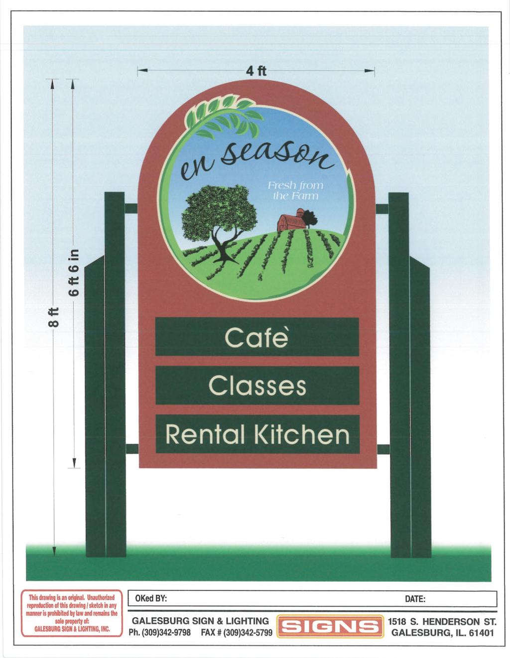
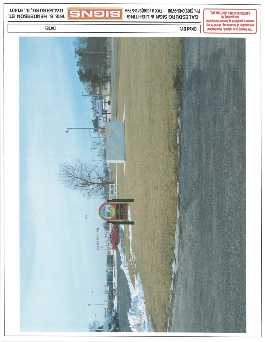
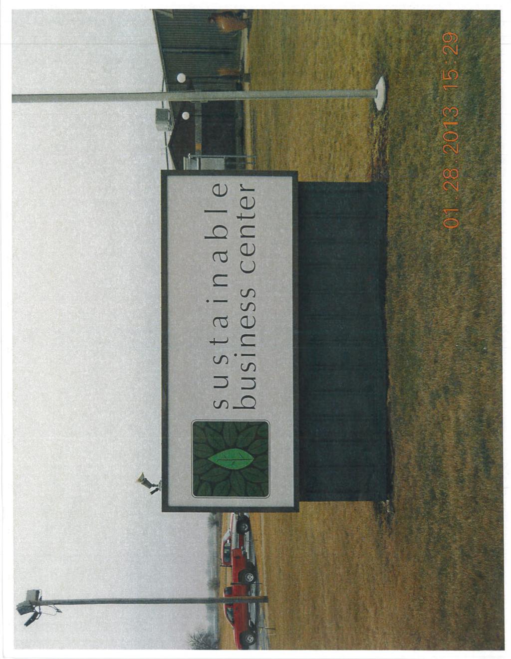
5 CITY OF GALESBURG Community Development Memo Operating Under Council Manager Government Since 1957 TO: FROM: Planning and Zoning Commission Members Roy A. Parkin, Director of Community Development DATE: Wednesday, February 13, 2013 SUBJECT: Agenda Item PZ Attached is a copy of the variance application received from EnSeason Café regarding a proposed freestanding sign to be located at 2900 West Main Street (location map attached). The property is currently zoned M-1, light industrial.the applicant is requesting a variance of Section (A)(1) of the Development Ordinance. This section indicates one freestanding sign (i.e. pole, pylon, ground or monument sign) is allowed to be located on a property zoned M-1, light industrial. The sign can contain up to 300 square feet per side. A copy of Section is also attached. EnSeason Café is proposing to install a freestanding sign measuring approximately 26 square feet on the property at 2900 West Main Street. Copies of a drawing of the sign and a picture of the proposed location of the EnSeason sign are attached. Currently there are two freestanding signs already located on the site. A site sketch is attached showing the existing locations of these two signs. EnSeasons is requesting a variance to allow the third freestanding sign. Before the Development Ordinance was adopted the Sign Code allowed one freestanding sign per 50 feet of frontage with a maximum area of 300 square feet per side. The two current signs measure a total of 58 square feet (Sustainable Business Center 40 square feet and Intellihot 18 square feet). Photographs of the two existing signs are also attached. The property at 2900 West Main Street has a frontage of feet. In discussing the EnSeason sign with the sign company, Community Development staff suggested the owner of the Sustainable Business Center consider a directory sign instead. The sign company indicated the owner did not have available funds to install a directory sign, and directed the sign company to proceed with the sign variance request. Also attached for the Commission s review are the following documents: 1. Copy of the legal notice that was published in the Register-Mail. 2. City s standards for granting a variance. Please note the Intellihot sign was issued in error of the new sign regulations in the Development Ordinance. With the fact the Intellihot sign was the second freestanding sign on the parcel and the permit was issued after the Development Ordinance became effective, a variance should have been requested prior to the installation. This error was discovered when the sign company contacted the City regarding the EnSeason sign. A letter has been sent to the company that installed the Intellihot sign requesting they submit an application for a variance. Page 1 of 2
6 CITY OF GALESBURG Community Development Memo Operating Under Council Manager Government Since 1957 The Development Review Committee members reviewed the variance request during their February 6, 2013, meeting. The Committee voted to recommend the variance request be denied. In making this decision the Committee considered the following items: 1. The property at 2900 West Main Street is zoned M-1, light industrial. 2. The owner of EnSeason Café desires to construct a 26 square foot freestanding sign on the parcel. 3. The sign requirements in the Development Ordinance allow one freestanding sign up to 300 square feet in area on properties zoned M There are already two freestanding signs totaling 58 square feet located on the parcel, which prohibits the installation of another sign without a variance. 5. Prior to the adoption of the Development Ordinance the City s Sign Code allowed one freestanding sign per 50 feet of street frontage with a maximum sign area of 300 square feet per side. 6. This requirement was eliminated and the existing regulations placed in the Development Ordinance to reduce sign clutter (i.e. avoid placement of multiple freestanding signs on a parcel). 7. There are a number of businesses already occupying the property at 2900 West Main Street and the building has the ability to hold additional businesses. 8. The Committee felt with the number of existing businesses in the building and space for additional businesses, there is a significant potential that other businesses will want to construct additional freestanding signs, thus continuing to create additional sign clutter. 9. The Committee indicated, in order to avoid the sign clutter, it makes better sense to plan for the replacement of the existing freestanding signs with a directory sign. A directory sign could provide each of the businesses in the facility a place to advertise. RAP:mjf Attachment cc: File Copy Page 2 of 2
7
8
 1 \") 40 34 «41 150 City of Galesburg General Location PICKARD RD WESLEYE AVE DOUGLAS DR DUVAL AVE HERRING AVE Legend 2900 W Main St The information included")
9 CITY OF GALESBURG Community Development Department Operating Under Council-Manager Government Since West Main Street Sign variance request to allow third freestanding sign Feet / W MAIN ST 150 « ") 1 ") « City of Galesburg General Location PICKARD RD WESLEYE AVE DOUGLAS DR DUVAL AVE HERRING AVE Legend 2900 W Main St The information included in this map is intended to be advisory only and is NOT designed or intended to be used as a substitute for an accurate field survey, as performed by a Registered Land Surveyor, to determine precise property location Imagery Date: 2010 Division 306 created: January 28, 2013
10
11
12
13
14

15
16
17
18
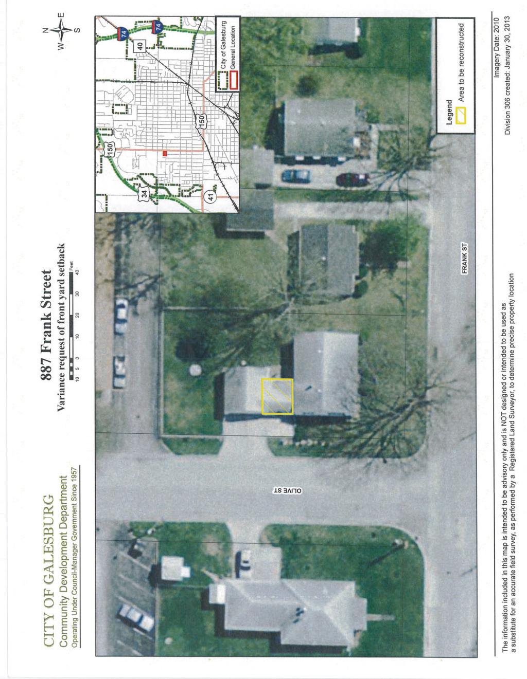
19 CITY OF GALESBURG Community Development Memo Operating Under Council Manager Government Since 1957 TO: FROM: Planning and Zoning Commission Members Roy A. Parkin, Director of Community Development DATE: Wednesday, February 13, 2013 SUBJECT: Agenda Item PZ Attached is a copy of the variance application received from Jim McLeese regarding the residence located at 887 Frank Street (see attached location map). Mr. McLeese is proposing to demolish the existing breezeway connecting the residence to the garage and then reconstruct the breezeway (see site map showing area to be reconstructed). The property owner is requesting a front yard variance along Olive Street to do this. The front yard setback along Olive Street is currently fifteen feet. This is calculated based upon the average of the setbacks for the existing buildings. The current residence is located 10 feet from the property line. The property owner would like to construct the breezeway in approximately the same location as it currently exists. The variance request is to reduce the fifteen foot setback to 10.5 feet (i.e. reduction of 4.5 feet which is the maximum of 30% allowable in the Development Ordinance). Also attached for the Commission s review are the following documents: 1. Copy of the legal notice that was published in the Register-Mail. 2. City s standards for granting a variance. The Development Review Committee reviewed the variance request during their February 6, 2013, meeting. The Committee voted to recommend the variance request be approved. In making this decision the Committee considered the following items: 1. There is an existing breezeway that attaches the residence to the garage which the owner desires to reconstruct. 2. The existing residence and breezeway sets 10 foot of the front property line located along Olive Street. 3. Due to the existence of buildings on this lot and the adjacent lot to the north, the front yard setback is the average of the existing setbacks which calculates out as 15 feet. 4. The Development Ordinance allows a variance of a required yard setback of up to 30% of the required setback or 4.5 feet in this situation. 5. The proposed reconstruction does not create an additional encroachment into the front yard setback. 6. The proposed project does not create any additional impact to the neighborhood. 7. Approval of the variance request doesn t alter the character of the neighborhood. RAP:mjf Attachment cc: File Copy Page 1 of 1
20
21

22
23
24
25
26
27 CITY OF GALESBURG Community Development Memo Operating Under Council Manager Government Since 1957 TO: FROM: Planning and Zoning Commission Members Roy A. Parkin, Director of Community Development DATE: Wednesday, February 13, 2013 SUBJECT: Agenda Item PZ Attached for your review is a copy of the preliminary plat of the Gale Village Subdivision. The subdivision is located on the west side of North Seminary Street across from Knox Square Drive. It consists of the subdivision of property into six lots and the extension of Knox Square Drive westerly from North Seminary Street approximately 440 feet. The street then turns northerly and ends in a temporary cul-de-sac at the north property line of the Delahunt property. In addition, Midwest Drive is extended northerly and tees into the Knox Square Drive Extension. The six lots are made up of the following parcels: 1. A vacant lot north of 2558 North Seminary Street. 2. Two vacant lots on the west side of Midwest Drive. 3. The Delahunt property which is located immediately north of the two parcels just referenced and extends northerly to the south side of the proposed temporary cul-de-sac. 4. The Stisser property which is located immediately north of the Delahunt property. This subdivision plat relates directly to the Raufeisen rezoning which the Planning and Zoning Commission members reviewed during their September 18, 2012, meeting. As you will recall Mr. Raufeisen proposed the development of a hotel, other commercial uses and two-family dwellings. At that time Mr. Raufeisen had shown on his site plan the extension of Knox Square Drive westerly and the construction of a north-south street from the west end of the Knox Square Drive extension northerly to near the Route 34 right-of-way. You will note the proposed subdivision layout has been revised. This is due to the fact Mr. Raufeisen has been unable to complete negotiations on the Stisser property. Mr. Raufeisen and the Stisser estate have been unable to come to an agreement on the purchase price of the Stisser property. Mr. Raufeisen wants to move forward with the three of the four lots on the south end of the proposed subdivision. He does not want to have to pay for the construction of the north-south street up to near the U.S. Route 34 right-of-way, since he does not own the Stisser property. As such, he has proposed phasing the subdivision. The City Council members will be considering Mr. Raufeisen s request to phase the project during their meeting. The final reading of an ordinance revising the original rezoning ordinance will be on the City Council s agenda. The original rezoning ordinance requires the developer to record a final plat of the entire area per his initially proposed development scheme within 180 days from the date of the rezoning approval (see attached original plan). This was done since there was no proper legal descriptions for the specific zoning parcels. With the fact Mr. Raufeisen is unable to gain control of the Stisser site, he is unable to record a proper plat within the 180 day time frame. If the proper plat is not recorded within the 180 days, the rezoning does not become effective. In order to avoid this issue, the proposed Page 1 of 3
28 CITY OF GALESBURG Community Development Memo Operating Under Council Manager Government Since 1957 ordinance being considered by the City Council would allow Mr. Raufeisen to move forward with Phase 1 being the south 4 lots in the subdivision (see attached phasing map). A plat for at least those four lots needs to be recorded within the 180 day time frame. The remaining property (i.e. north portion owned by the Stisser estate) could be developed under Phase II. This assumes Mr. Raufeisen comes to an agreement with the Stisser Estate or the Stisser Estate finds a different developer. In order for the rezoning to become effective for Phase 2, a subdivision plat needs to be recorded within three years from the date of the original zoning approval. I will advise the Commission Tuesday night of the City Council s decision regarding the proposed phasing. There are two main changes made to the subdivision plat layout. First, the proposed north-south street will not extend to near the U.S. Route 34 right-of-way. Instead, Mr. Raufeisen is proposing to construct the extension of Knox Square Drive westerly and the north-south street from the west end of the Knox Square Drive extension northerly to the south property line of the Stisser property. A temporary cul-de-sac will be located at the north end of the north-south street on the Stisser property. The Stisser estate requested the cul-de-sac be located on their property. The second change involves the layout of the lots. The portion of the current Delahunt property which will remain under the Delahunt s control has been added in as a lot. In addition, since the north-south street will not be constructed at this time on the Stisser parcels, none of the former proposed lots are shown. Instead, the subdivision shows two lots (east part and west part) on the Stisser property. You will note there is an access restriction on the temporary cul-de-sac for agricultural access only. This prohibits the Stisser estate from trying to construct a building on the site without a resubdivision. At a later date, if Mr. Raufeisen and the Stisser estate come to an agreement or another developer becomes interested, a resubdivision of the two proposed Stisser lots would be required before development can occur. The Development Review Committee members reviewed the preliminary plat during their meeting. The Committee recommended the plat be approved contingent upon the following items: 1. Submittal of drainage plan for subdivision and approval of plan by City Engineer s office. 2. Submittal of plans or written and signed statements setting out grades and profiles of streets, proposed grades and facilities for all required improvements and subdivider s proposal for accomplishing their installation and approval by City Engineer s office. 3. Submittal of signed and sealed statements by developer s engineer that all proposed public improvements have been designed in accordance with the Development Ordinance. 4. Receipt of sanitary sewer capacity certification from Galesburg Sanitary District. 5. Receipt of utility company signoff letters for the proposed easements. 6. Certified estimate of the subdivision improvements from the developer s engineer. 7. Performance bond for 110% of the City Engineer s approved cost of the subdivision improvements. Page 2 of 3
29 CITY OF GALESBURG Community Development Memo Operating Under Council Manager Government Since Submittal of intersection design for the proposed traffic control improvements at Seminary Street and Knox Square Drive and approval of design by City Engineer s office. 9. Submittal of storm sewer design computations and approval by City Engineer s office. 10. Submittal of plans for all public improvements and approval by City Engineer s office. 11. Submittal of grades and profiles of streets and approval by City Engineer s office. 12. IDOT approval of drainage plan. RAP:mjf Attachment cc: File Copy Page 3 of 3
30
31
32
33 CITY OF GALESBURG Community Development Memo Operating Under Council Manager Government Since 1957 TO: FROM: Planning and Zoning Commission Members Roy A. Parkin, Director of Community Development DATE: Wednesday, February 13, 2013 SUBJECT: Agenda Item PZ Attached is a final plat of the Gale Village Subdivision. This plat is the legal document that will be recorded with the Knox County Recorder. The subdivision should mirror the proposed layout that is shown in the preliminary plat that the Commission will also be reviewing at the February 19 th Commission meeting. The Development Review Committee met on to review the final plat. The Committee voted to recommend approval of the plat contingent upon approval of the conditions placed on the preliminary plat. RAP:mjf Attachment cc: File Copy Page 1 of 1
34 CITY OF GALESBURG Community Development Memo Operating Under Council Manager Government Since 1957 TO: FROM: Planning and Zoning Commission Members Roy A. Parkin, Director of Community Development DATE: Wednesday, February 13, 2013 SUBJECT: Agenda Item PZ Member Guenseth was absent from the Commission meeting; but called in her absence in advance of the meeting. As such, Member Guenseth is eligible for an excused absence if she requests it. RAP:mjf Attachment cc: File Copy Page 1 of 1
A G E N D A. Minutes of the September 13, 2016, special meeting.
 CITY OF GALESBURG Community Development Memo Operating Under Council Manager Government Since 1957 TO: FROM: Planning and Zoning Commission Members Steve Gugliotta, AICP, Acting Planning Manager DATE:
Staff Report to the North Ogden Planning Commission
 Staff Report to the North Ogden Planning Commission SYNOPSIS / APPLICATION INFORMATION Application Request: Consideration and action on an administrative application for final approval for the Legacy North
TOWN OF LEWISTON PLANNING BOARD APPLICATION
 TOWN OF LEWISTON PLANNING BOARD APPLICATION DESCRIPTION OF PROPOSED REQUEST: Name of Property Owner: Phone #: Name of Applicant:Phone #: Address or Location of Proposal:_SBL# Size of Parcel or Structure:Existing
Residential Major Subdivision Review Checklist
 Residential Major Subdivision Review Checklist Plan Submittal Requirements: 2 full sets of stamped plans Electric submittal - all plans contained in a single PDF 3 full sets if commercial kitchen or dining
Staff Report to the North Ogden City Council
 Staff Report to the North Ogden City Council SYNOPSIS / APPLICATION INFORMATION Application Request: Consideration and action on an administrative application to provide comments on the preliminary plan
City of East Orange. Department of Policy, Planning and Development LAND USE APPLICATION & SITE PLAN REVIEW CHECKLIST
 Department of Policy, Planning and Development LAND USE APPLICATION & SITE PLAN REVIEW CHECKLIST COMPLETE: Applicant Information: Type of Proposal: OFFICE USE ONLY: New Residential Case #: Date: New Accessory
Residential Minor Subdivision Review Checklist
 Residential Minor Subdivision Review Checklist Plan Submittal Requirements: 2 full sets of stamped plans Electric submittal - all plans contained in a single PDF 3 full sets if commercial kitchen or dining
Application for Preliminary Plat Checklist
 Application for Preliminary Plat Checklist Note: No portion of an existing parcel may be sold or transferred to another party without first legally subdividing the property according to the City of Richmond
City of Brooklyn Park Planning Commission Staff Report
 City of Brooklyn Park Planning Commission Staff Report Agenda Item: 6D Meeting Date: August 9, 2017 Originating Agenda Section: Public Hearing Department: Community Development Resolution: X Ordinance:
Lake County Planning, Building and Development Department
 SUBMISSION CHECKLIST FOR SUBDIVISION FINAL PLAT Lake County Planning, Building and Development Department 500 W. Winchester Rd. Unit 101 Libertyville, Illinois 60048-1331 Telephone (847) 377-2600 E-mail:
Planning Commission Staff Report Final Plat Approval Administrative Hearing Date: June 5, 2013 ITEM 5 Dixon Neighborhood ALTERNATIVE ACTIONS
 Planning Commission Staff Report Final Plat Approval Adminis strative Hearing Date: June 5, 2013 ITEM 5 Doug Carlson, agent for Provo City Housing, requests final plat approval for the PCHA-1, Plat `C`,
CITY OF INVER GROVE HEIGHTS 8150 Barbara Avenue Inver Grove Heights, MN (651)
") 8150 Barbara Avenue Inver Grove Heights, MN 55077 (651) 450-2545 www.invergroveheights.org FINAL PLANNED UNIT DEVELOPMENT (City Code Section 10-13A) The following must be submitted prior to review and
8150 Barbara Avenue Inver Grove Heights, MN 55077 (651) 450-2545 www.invergroveheights.org FINAL PLANNED UNIT DEVELOPMENT (City Code Section 10-13A) The following must be submitted prior to review and
BRIDGETON SUBDIVISION APPLICATION CHECKLIST
 APPLICATION NAME AND # CHECKLIST COMPLETED BY: DATE: Signature and printed name BRIDGETON SUBDIVISION APPLICATION CHECKLIST TO SUBDIVISION APPLICANTS: The attached checklist is to assist you in the submission
SHORT PLAT APPLICATION CHECKLIST City of White Salmon. Application completed with notarized signatures
 SHORT PLAT APPLICATION CHECKLIST City of White Salmon Application completed with notarized signatures Road Classification as assigned by City Public Works Director City Public Works Director Certification
APPLICATION PACKET SUBDIVISION PLAT REVIEW TENTATIVE PRELIMINARY PLAT
 APPLICATION PACKET SUBDIVISION PLAT REVIEW TENTATIVE PRELIMINARY PLAT COMMUNITY DEVELOPMENT DEPARTMENT CHARTER TOWNSHIP OF PLYMOUTH 9955 N. Haggerty Road Plymouth, MI 48170 Fees Revised 7/01/2012 APPLICATION
CLEARFIELD CITY COUNCIL AGENDA AND SUMMARY REPORT July 31, 2018 SPECIAL POLICY SESSION
 CLEARFIELD CITY COUNCIL AGENDA AND SUMMARY REPORT July 31, 2018 SPECIAL POLICY SESSION Meetings of the City Council of Clearfield City may be conducted via electronic means pursuant to Utah Code Ann. 52-4-207
ELK RAPIDS TOWNSHIP ANTRIM COUNTY, MICHIGAN ORDINANCE NO
 ELK RAPIDS TOWNSHIP ANTRIM COUNTY, MICHIGAN ORDINANCE NO. 3-2011 AN ORDINANCE TO REPLACE THE SUBDIVISION CONTROL ORDINANCE WITH A NEW SUBDIVISION DEVELOPMENT ORDINANCE, IN ACCORD WITH THE LAND DIVISION
TOWN OF ROXBURY PLANNING BOARD
 UPDATED: APRIL 2011 TOWN OF ROXBURY PLANNING BOARD Applicant s Guide for Subdivision Review The Town Planning Board administers the subdivision review process. This guide has been prepared in order to
Major Subdivision Application Packet. Revised June 2018
 Major Subdivision Application Packet Revised June 2018 Caroline County Department of Planning and Community Development 233 West Broaddus Avenue Bowling Green, VA 22427 www.co.caroline.va.us Phone: 804-633-4303
APPLICATION FOR A VARIANCE
 APPLICATION FOR A The Filing Fee for a Variance Request is $250.00 Information and actions required of the Petitioner: 1. When applicable, a building permit must be denied prior to submittal of a request
APPLICATION PROCEDURES FOR A PLAT AMENDMENT OR REVISION
 APPLICATION PROCEDURES FOR A PLAT AMENDMENT OR REVISION DEFINITION: Any revision or amendment to an approved recorded or unrecorded final plat. A revision (not recorded) does not require a public hearing
JOINT PLANNING BOARD APPLICATION FORM
 JOINT PLANNING BOARD APPLICATION FORM TOWNSHIP OF RIVER VALE 406 RIVERVALE ROAD RIVER VALE, NJ 07675 The application, with supporting documentation, must be filed with the Administrative Officer to the
ECONOMIC DEVELOPMENT & PLANNING DIVISION APPLICATION FOR ZONE CHANGE
 PZ Meeting: CC Meeting: Case # DO NOT WRITE ABOVE THIS LINE ECONOMIC DEVELOPMENT & PLANNING DIVISION APPLICATION FOR ZONE CHANGE OWNER/APPLICANT/AGENT INFORMATION SECTION (OWNER(S) MUST SIGN OR SUBMIT
SITE CONDOMINIUMS OR CONDOMINIUM SUBDIVISIONS
 Article XX SITE CONDOMINIUMS OR CONDOMINIUM SUBDIVISIONS 20.0 PURPOSE The purpose of this Section is to set forth the standards for review of the site condominiums or condominium subdivisions in all Zoning
MINUTES OF A REGULAR MEETING OF THE INDEPENDENCE CITY COUNCIL TUESDAY, FEBRUARY 10, :30 P.M.
 MINUTES OF A REGULAR MEETING OF THE INDEPENDENCE CITY COUNCIL TUESDAY, FEBRUARY 10, 2009 7:30 P.M. 1. CALL TO ORDER. Pursuant to due call and notice thereof, a regular meeting of the Independence City
Planning and Zoning AGENDA Council Chambers, Fort Dodge Municipal Building 819 1st Avenue South, Fort Dodge, Iowa July 25, 2017, 4:00 PM
 Planning and Zoning AGENDA Council Chambers, Fort Dodge Municipal Building 819 1st Avenue South, Fort Dodge, Iowa July 25, 2017, 4:00 PM I. Roll Call II. Approval of Previous Meeting Minutes a) June 27th
ARTICLE SINGLE FAMILY SITE CONDOMINIUM DEVELOPMENT STANDARDS
 ARTICLE 28.00 SINGLE FAMILY SITE CONDOMINIUM DEVELOPMENT STANDARDS Section 28.01 PURPOSE The purpose of this Article is to recognize that conventional single family developments, traditionally developed
City of Ferndale CITY COUNCIL STAFF REPORT
 SUBJECT: Final Plat Approval DATE: January 19, 2016 FROM: Haylie Miller, Assistant Planner PRESENTATION BY: Haylie Miller City of Ferndale CITY COUNCIL STAFF REPORT MEETING DATE: January 19, 2016 AGENDA
CITY OF NOVI LAND DIVISION INSTRUCTIONS
 CITY OF NOVI LAND DIVISION INSTRUCTIONS All applications for land division in the City of Novi must be in compliance with Chapter 32 of the City of Novi Code of Ordinances and with the Land Division Act,
APPLICATION for MINOR SUBDIVISION REVIEW for CONCEPT and FINAL PLAT within COALVILLE CITY. Project Name: Project Address or Area: Name of Owner:
 APPLICATION for MINOR SUBDIVISION REVIEW for CONCEPT and FINAL PLAT within COALVILLE CITY For Office Use Only: Application #: Application Date: PC Approval Date: CC Approval Date: Community Development
CHAPTER 18 SITE CONDOMINIUM PROJECTS
 15.1800 CHAPTER 18 SITE CONDOMINIUM PROJECTS 15.1801 SECTION 18.01 PURPOSE AND SCOPE GRAND HAVEN CHARTER TOWNSHIP Site condominium projects are condominium developments in which each condominium unit consists
BYRON TOWNSHIP ZONING APPLICATION
 BYRON TOWNSHIP ZONING APPLICATION Phone: (616) 878-9104 * Fax: (616) 878-3980 * Website: www.byrontownship.org This application will not be accepted if incomplete. APPLICATION FOR & REQUIRED COPIES Private
Condominium Unit Requirements.
 ARTICLE 19 CONDOMINIUM REGULATIONS Section 19.01 Purpose. The purpose of this Article is to regulate projects that divide real property under a contractual arrangement known as a condominium. New and conversion
CITY OF STRONGSVILLE PLANNING COMMISSION APPLICATION CLUSTER SUBDIVISION
 CITY OF STRONGSVILLE PLANNING COMMISSION APPLICATION CLUSTER SUBDIVISION After meeting with City Planner, George Smerigan (if necessary) regarding zoning requirements, submit the following: An application
TOWN OF EASTCHESTER BUILDING AND PLANNING DEPARTMENT PLANNING BOARD APPLICATION PACKAGE SUBDIVISIONS
 TOWN OF EASTCHESTER BUILDING AND PLANNING DEPARTMENT 40 Mill Road (914) 771-3317 building@eastchester.org Eastchester, NY 10709 (914) 771-3322 Fax www.eastchester.org TABLE OF CONTENTS PLANNING BOARD APPLICATION
WEST BOUNTIFUL PLANNING COMMISSION
 Mayor Kenneth Romney City Engineer/ Zoning Administrator Ben White City Recorder Cathy Brightwell WEST BOUNTIFUL PLANNING COMMISSION 550 North 800 West West Bountiful, Utah 84087 Phone (801) 292-4486 FAX
SUBDIVISION APPLICATION
 STAFF USE ONLY Date Submitted: Received by: Fee paid: Project # REQUIRED SUBMITTALS Application Fee: $600.00 (up to 5 lots) + $50.00 (per lot above 5) Publication Fee: $300.00 Mailing Fee: $6.00 per hearing
PLANNING COMMISSION SUBDIVISION PLAT APPLICATION
 PLANNING COMMISSION SUBDIVISION PLAT APPLICATION Economic Development Department 3468 North Fulton Avenue Hapeville, Georgia 30354 Phone - 404.669.8269 Fax 404.669.3302 Rev. 09/23/16 1 The following information
A GUIDE TO PROCEDURES FOR: SUBDIVISIONS & CONDOMINIUM CONVERSION
 A GUIDE TO PROCEDURES FOR: SUBDIVISIONS & CONDOMINIUM CONVERSION A GUIDE TO PROCEDURES FOR: SUBDIVISIONS (TENTATIVE MAPS) PURPOSE Definition: A subdivision is defined as the division of any improved or
City of Shenandoah Development Package
 Upon completion return application to Development@shenandoahtx.us City of Shenandoah Development Package Documentation includes the following: Fee Schedule Platting Development Check List & Outline Development
1 S Central Ave, PO Box 2286 Umatilla, FL (352) Fax# (352)
 Fax# (352)") Applications go through the following steps: Technical Review Committee CITY OF UMATILLA TIMETABLE FOR PLANNING & ZONING APPLICATIONS Applications can take anywhere from 60 to 90 days for approval, depending
Applications go through the following steps: Technical Review Committee CITY OF UMATILLA TIMETABLE FOR PLANNING & ZONING APPLICATIONS Applications can take anywhere from 60 to 90 days for approval, depending
SECTION 6 - APPROVAL OF PLATS. Whenever any subdivision of land is proposed, and before any permit for the
 SECTION 6 - APPROVAL OF PLATS 6-1 APPROVAL REQUIRED BEFORE SALE Whenever any subdivision of land is proposed, and before any permit for the erection of a structure shall be granted, the subdivider or his
ST. JOSEPH TOWNSHIP RESOLUTION CITY OF ST. JOSEPH RESOLUTION 2018-
 ST. JOSEPH TOWNSHIP RESOLUTION 2018- CITY OF ST. JOSEPH RESOLUTION 2018- JOINT RESOLUTION FOR DESIGNATION OF AN AREA FOR ORDERLY ANNEXATON AND FOR DESIGNATION OF AN AREA FOR IMMEDIATE ANNEXATION PURSUANT
ARTICLE 8C SITE CONDOMINIUM DEVELOPMENT ORDINANCE
 ARTICLE 8C SITE CONDOMINIUM DEVELOPMENT ORDINANCE SECTION 8C.01 PURPOSE It is the purpose of this Ordinance to insure that plans for development within Oceola Township proposed under the provisions of
Staff Report: Date: Applicant: Property Identification: Acreage of Request: Current Zoning of Requested Area: Requested Action: Attached:
 Staff Report: Completed by Jeff Palmer Director of Planning & Zoning Date: November 7, 2018, Updated November 20, 2018 Applicant: Greg Smith, Oberer Land Developer agent for Ronald Montgomery ET AL Property
Administrative Plat Application Form
 1 Administrative Plat Application Form This form shall be submitted with each application for an administrative plat. CONTACT INFORMATION Applicant Architect (if different) Property Owner (if different)
CITY OF SPRINGDALE, OHIO SPRINGDALE BUILDING DEPARTMENT SPRINGFIELD PIKE SPRINGDALE, OHIO TELEPHONE: (513)
") CITY OF SPRINGDALE, OHIO SPRINGDALE BUILDING DEPARTMENT 11700 SPRINGFIELD PIKE SPRINGDALE, OHIO 45246 TELEPHONE: (513) 346-5730 SUBMISSION REQUIREMENTS AND INSTRUCTIONS FOR FINAL PUD/TRANSITION DISTRICT
CITY OF SPRINGDALE, OHIO SPRINGDALE BUILDING DEPARTMENT 11700 SPRINGFIELD PIKE SPRINGDALE, OHIO 45246 TELEPHONE: (513) 346-5730 SUBMISSION REQUIREMENTS AND INSTRUCTIONS FOR FINAL PUD/TRANSITION DISTRICT
MOBILE CITY PLANNING COMMISSION LETTER OF DECISION. June 3, 2011
 MOBILE CITY PLANNING COMMISSION LETTER OF DECISION P.O. Box 421 Mobile, AL 36601 Re: Case #SUB2011-00029 (Subdivision) Alabama West Subdivision, Unit Four 2600 McVay Drive North (North side of McVay Drive
Preliminary Plat & Layout Plan Submittal Guidelines
 Preliminary Plat & Layout Plan Submittal Guidelines PRELIMINARY PLAT & LAYOUT PLANS is typically the first step in the platting process. The purpose of the PRELIMINARY PLAT & LAYOUT PLANS is for the Applicant
Planning Department st St SE PO Box 5006 Minot, ND (701) Acknowledgment and Signature
 Acknowledgment and Signature") Acknowledgment and Signature The undersigned applicant hereby represents upon all of the penalties of the law, for the purpose of inducing the City of Minot to take action herein requested, that all statements
Acknowledgment and Signature The undersigned applicant hereby represents upon all of the penalties of the law, for the purpose of inducing the City of Minot to take action herein requested, that all statements
PALMER WOODS SUBDIVISION, PHASE III
 PALMER WOODS SUBDIVISION, PHASE III Engineering Comments: Must comply with the Mobile County Flood Damage Prevention Ordinance. MAWSS Comments: MAWSS has NO water and sewer services available. The plat
AUTUMNDALE SUBDIVISION, RESUBDIVISION OF LOTS
 AUTUMNDALE SUBDIVISION, RESUBDIVISION OF LOTS 100-102 Engineering Comments: Road shall be constructed per City standards and according to the City s street acceptance process. Cul-de sac approval subject
FINAL PLAT GUIDE TO SUBDIVIDING PROPERTY. Background
 FINAL PLAT GUIDE TO SUBDIVIDING PROPERTY Background A final plat is the second step in the process of subdividing land into separate parcels for future sale or lease. Once a preliminary plat has been approved
TENTATIVE PARCEL MAP APPLICATION GUIDE TENTATIVE PARCEL MAP APPLICATION REQUIREMENTS
 TENTATIVE PARCEL MAP APPLICATION GUIDE SISKIYOU COUNTY PLANNING DIVISION 806 South Main Street, Yreka CA 96097 Phone: (530) 841-2100 / Fax: (530) 841-4076 TENTATIVE PARCEL MAP APPLICATION REQUIREMENTS
AGENDA. CITY OF CENTRALIA, MISSOURI Planning and Zoning Commission Thursday, April 21, :00 P.M. City Hall Council Chambers
 AGENDA CITY OF CENTRALIA, MISSOURI Planning and Zoning Commission Thursday, April 21, 2016 6:00 P.M. City Hall Council Chambers I. ROLL CALL II. III. IV. Pledge of Allegiance Approval of Minutes of Previous
City of Nogales Planning & Zoning Commission Rezoning Application
 City of Nogales Planning & Zoning Commission Rezoning Application REZONING APPLICATION PROCEDURES 1450 N. Hohokam Nogales, Arizona 85621 Office (520) 285-5747 FAX (520) 287-6946 T.D.D. (520) The following
MAJOR SUBDIVISION REPLAT/PDA INFORMATION
 2415 Wilshire Boulevard, Mound, MN 55364 Phone 952-472-0600 FAX 952-472-0620 MAJOR SUBDIVISION REPLAT/PDA INFORMATION A Major Subdivision is any division of land which does not qualify as a Minor Subdivision,
CERTIFICATION OF THE APPROVAL OF WATER AND SEWERAGE SYSTEMS
 ARTICLE 9 FORMS AND CHECK LISTS 9.100 On preliminary layout & final subdivision plat CERTIFICATION OF THE APPROVAL OF WATER AND SEWERAGE SYSTEMS I hereby certify that the (...type: private or pubic...)
Request for Recommendation
 Request for Recommendation Application for site specific rezoning in order to permit a four-storey multiple dwelling with 55 units in a C2, General Commercial zone, 6150, 6160, 6166 Highway 69 North &
MINOR PLAT AMENDMENT APPLICATION CHECK APPLICABLE PERMIT ATTACHMENT:
 240 East Gammon Road Vineyard, Utah 84058 (801) 226-1929 MINOR PLAT AMMENDMENT APPLICATION Please Note: Attachment of request specific documents is required prior to processing your application. APPLICATION
APPLICATION PACKET SINGLE FAMILY CLUSTER HOUSING OPTION REVIEW
 APPLICATION PACKET SINGLE FAMILY CLUSTER HOUSING OPTION REVIEW COMMUNITY DEVELOPMENT DEPARTMENT CHARTER TOWNSHIP OF PLYMOUTH 9955 N. Haggerty Road Plymouth, MI 48170 Fees Revised 9.13.2017 1. PURPOSE APPLICATION
CONDOMINIUM REGULATIONS
 ARTICLE 37 CONDOMINIUM REGULATIONS SECTION 37.01. Purpose The purpose of this Article is to regulate projects that divide real property under a contractual arrangement known as a condominium. New and conversion
MCGOWIN PARK EAST OF SATCHEL PAIGE SUBDIVISION, RESUBDIVISION OF
 # 14 SUB2015-00058 MCGOWIN PARK EAST OF SATCHEL PAIGE SUBDIVISION, RESUBDIVISION OF Engineering Comments: The following comments should be addressed prior to submitting the FINAL PLAT for acceptance and
ZONING AMENDMENT & SUBDIVISION STAFF REPORT Date: July 9, 2015
 ZONING AMENDMENT & SUBDIVISION STAFF REPORT Date: July 9, 2015 APPLICANT NAME 2513 Dauphin Street, Inc. SUBDIVISION NAME Audubon Place Extension No. 3, Resubdivision of Lots 1-5 LOCATION 2513 Dauphin Street
SECTION 16. "PUD" PLANNED UNIT DEVELOPMENT OVERLAY DISTRICT
 SECTION 6. "PUD" PLANNED UNIT DEVELOPMENT OVERLAY DISTRICT Subsection. Purpose. This district is established to achieve the coordinated integration of land parcels and large commercial and retail establishments
FINAL PLAT CHECKLIST
 FINAL PLAT CHECKLIST Project Name: Tax ID #: Project Number: Date: _ Reviewed By: Telephone: Please address all items marked with an "X" Please return redline comments with corrected plan, original mylar,
Section SKETCH PLAN REVIEW
 Section 210 - SKETCH PLAN REVIEW 1. Within 30 days of receiving a complete application for a subdivision involving three or more lots, the Zoning Administrator shall refer the matter to the first available
A. CONSIDERATION OF THE UNAPPROVED MINUTES OF NOVEMBER 13, 2018
 I. CALL TO ORDER OFFICIAL AGENDA PLANNING & ZONING COMMISSION CITY OF STARKVILLE, MISSISSIPPI MEETING OF TUESDAY, DECEMBER 11, 2018 1ST FLOOR CITY HALL COURT ROOM 110 WEST MAIN STREET AT 5:30 PM II. III.
Grass Lake Charter Township 373 Lakeside Drive, P.O. Box 216 Grass Lake, Michigan 49240
 Grass Lake Charter Township 373 Lakeside Drive, P.O. Box 216 Grass Lake, Michigan 49240 FEE SCHEDULE RELATING TO LAND USE DEVELOPMENT AND BUILDING PERMITS The following fees are an amendment to the resolution
Guide to Combined Preliminary and Final Plats
 Guide to Combined Preliminary and Final Plats Introduction The Douglas County is committed to providing open, transparent application processes to the public. This Guide is provided to assist anyone interested
FNSB PLANNING COMMISSION BOROUGH ASSEMBLY CHAMBERS APRIL 9, 2019 ACTION MEMO 6:00 pm
 FNSB PLANNING COMMISSION BOROUGH ASSEMBLY CHAMBERS APRIL 9, 2019 ACTION MEMO 6:00 pm Please refer to Planning Commission Rule #25: Any action taken during this meeting is subject to reconsideration during
DEPARTMENT OF PLANNING 1801 WILLIAMS BOULEVARD BUILDING B, 1ST FLOOR KENNER, LOUISIANA PHONE (504)
") CITY OF KENNER DEPARTMENT OF PLANNING 1801 WILLIAMS BOULEVARD BUILDING B, 1ST FLOOR KENNER, LOUISIANA 70062 PHONE (504) 468-7280 FENCE IN REQUIRED FRONT YARD (SCHOOL/CHURCH) APPLICATION PRE-APPLICATION
CITY OF KENNER DEPARTMENT OF PLANNING 1801 WILLIAMS BOULEVARD BUILDING B, 1ST FLOOR KENNER, LOUISIANA 70062 PHONE (504) 468-7280 FENCE IN REQUIRED FRONT YARD (SCHOOL/CHURCH) APPLICATION PRE-APPLICATION
AGENDA. 3. PC 15-02: Preliminary Plat of Hawk Hollow Addition (Shawn Christ, Land Development Manager)
") City of Moline PLAN COMMISSION Wednesday, March 25, 2015 4:00 p.m. Council Chambers, 619 16 th Street AGENDA 1. Call to order 2. Approval of minutes January 28, 2015 3. PC 15-02: Preliminary Plat of Hawk
City of Moline PLAN COMMISSION Wednesday, March 25, 2015 4:00 p.m. Council Chambers, 619 16 th Street AGENDA 1. Call to order 2. Approval of minutes January 28, 2015 3. PC 15-02: Preliminary Plat of Hawk
SUBDIVISION APPLICATION
 SUBDIVISION APPLICATION City of Horn Lake Planning Department 3101 Goodman Road, W Horn Lake, MS 38637 662-342-3559 Fax: 662-342-3485 Applications due the 1st working day of the month. Submit application
VARIANCE APPLICATION
 TOWN OF CARY Submit to the Development Customer Service Center, P.O. Box 8005, Cary, NC 27512 Planning Department Planning Department Contact: (919) 469-4046 Fee: $600.00 For office use only: Method of
DAWSON COUNTY MINOR PLAT REVIEW CHECKLIST $50.00 FEE PER PLAT REVIEW, $5.00 FEE FOR SCAN & CD FOR RECORDING
 DAWSON COUNTY MINOR PLAT REVIEW CHECKLIST $50.00 FEE PER PLAT REVIEW, $5.00 FEE FOR SCAN & CD FOR RECORDING NAME ON PLAT: CONTACT/PHONE #: NAMED STREET/ADDRESS: LAND LOT: DISTRICT: SECTION: ZONING: SETBACKS:
Boundary Line Adjustment Application
 Boundary Line Adjustment Application A COMPLETE APPLICATION is required at the time of submittal. REQUIRED SUBMITTALS: 1. Application form 2. Application Fee - $500.00. 3. Current title report 4. Three
NOTICE OF MEETING The City of Lake Elmo Planning Commission will conduct a meeting on Monday December 10, 2018 at 7:00 p.m. AGENDA
 3800 Laverne Avenue North Lake Elmo, MN 55042 (651) 747-3900 www.lakeelmo.org NOTICE OF MEETING The City of Lake Elmo Planning Commission will conduct a meeting on Monday December 10, 2018 at 7:00 p.m.
Preliminary Plat/Final Plat Application
 Melissa Municipal Center 3411 Barker Avenue Melissa, Texas 75454 Phone: (972) 838-2036 Applicant: Date: Address: Phone: Contact: Fax: E-mail: Propose Addition Name: Acres: Existing Zoning: Propose Zoning:
ARTICLE 2: General Provisions
 ARTICLE 2: General Provisions 2-10 Intent The basic intent of the Town of Orange s Zoning Ordinance is to implement the goals and objectives of the adopted Town of Orange Comprehensive Plan, hereafter
7 February 8, 2012 Public Hearing APPLICANT : 1168 ASSOCIATES, LLC, A VA LIMITED LIABILITY COMPANY
 7 February 8, 2012 Public Hearing APPLICANT : 1168 ASSOCIATES, LLC, A VA LIMITED LIABILITY COMPANY STAFF PLANNER: Leslie Bonilla REQUEST AND ADDRESS: Discontinuance, closure and abandonment of a portion
Plans shall be drawn at a readable scale, signed, and sealed by a Florida Registered Engineer. The application package shall include:
 CHAPTER 400. SECTION 403. PERMIT TYPES AND APPLICATIONS SITE DEVELOPMENT 403.3. Preliminary Site Plans (PSP) A. Intent and Purpose PSPs are used to identify existing site conditions and demonstrate general
City of Altamonte Springs Developer s Guide
 Section 6 SUBDIVISION PLAN & PLAT REVIEW PROCESS This section contains information, applications, and checklists related to the subdivision development plan and plat review process in Altamonte Springs.
SUBMITTAL REQUIREMENTS
 PRELIMINARY PLAT APPLICATION ***A PRE-APPLICATION MEETING WITH CITY STAFF IS REQUIRED FOR THIS APPLICATION*** DATE STAMP FOR CITY USE ONLY PROJECT NAME (if any): TO BE FILLED OUT BY APPLICANT PROJECT STREET
ARTICLE 13 CONDOMINIUM REGULATIONS
 ARTICLE 13 CONDOMINIUM REGULATIONS Section 13.01 Purpose. The purpose of this Article is to regulate projects that divide real property under a contractual arrangement known as a condominium. New and conversion
ZONING AMENDMENT, PLANNED UNIT DEVELOPMENT & SUBDIVISION STAFF REPORT Date: August 8, 2013
 ZONING AMENDMENT, PLANNED UNIT DEVELOPMENT & SUBDIVISION STAFF REPORT Date: August 8, 2013 NAME SUBDIVISION NAME PV-Magnolia, LLC Twelve Trees Subdivision LOCATION 2860, 2862 and 2866 Pleasant Valley Road
I. Requirements for All Applications. C D W
 108-16.1. Application checklists. Checklist for Required Submissions to the Planning Board or Zoning Board of Adjustment of Monroe Township All required submissions are to be made to the Administrative
Preliminary Subdivision Application (Major) (Four (4) lots or more)
 (Four (4) lots or more)") Gunnison City Offices www.gunnisoncity.org 38 West Center Gunnison, Utah 84634 (435) 528 7969 Date of Application: Preliminary Subdivision Application (Major) (Four (4) lots or more) APPLICANT INFORMATION
Gunnison City Offices www.gunnisoncity.org 38 West Center Gunnison, Utah 84634 (435) 528 7969 Date of Application: Preliminary Subdivision Application (Major) (Four (4) lots or more) APPLICANT INFORMATION
CITY OF DECATUR, TEXAS
 Final Plat or Amending Plat / Replat Checklist A submittal of a complete application will facilitate a timely review. Failure of the applicant to provide required information or obtain a waiver from the
DEPT. Burlington Board of Appeals DATE: Tuesday, July 17, 2018 TIME: 7:30P.M. PLACE: Town Hall Main Meeting Room, 2 nd floor
 Town of Burlington Meeting Posting DEPT. Burlington Board of Appeals DATE: Tuesday, July 17, 2018 TIME: 7:30P.M. PLACE: Town Hall Main Meeting Room, 2 nd floor Introduction of new Board Members Amendment
MAJOR RESIDENTIAL AND NONRESIDENTIAL SUBDIVISIONS
 MAJOR RESIDENTIAL AND NONRESIDENTIAL SUBDIVISIONS Final Plats The applicant shall schedule a Pre-Application meeting with Planning Staff at least seven (7) working days prior to submittal of the application.
TURTLE CREEK SUBDIVISION, PHASE THREE
 TURTLE CREEK SUBDIVISION, PHASE THREE Engineering Comments: Must comply with the Mobile County Flood Damage Prevention Ordinance. Development shall be designed to comply with the storm water detention
Complete applications are due by 2:00 p.m. on the submission cut-off date.
 CONSENT APPLICATION PLEASE READ ALL INSTRUCTIONS WHAT IS A COMPLETE APPLICATION? Your application is complete when you have: o Discussed the application with a City of St. Catharines Planner Name of Planner:
APPLICATION PACKET SINGLE FAMILY CLUSTER HOUSING OPTION REVIEW
 APPLICATION PACKET SINGLE FAMILY CLUSTER HOUSING OPTION REVIEW COMMUNITY DEVELOPMENT DEPARTMENT CHARTER TOWNSHIP OF PLYMOUTH 9955 N. Haggerty Road Plymouth, MI 48170 Fees Revised 7/01/2012 1. PURPOSE APPLICATION
ADDRESS / DESCRIPTION: Property located near the intersection of Mill Dam Court and First Colonial Road. ELECTION DISTRICT: LYNNHAVEN
 August 10, 2011 8 Public Hearing APPLICANT : 1168 ASSOCIATES, LLC, A VA LIMITED LIABILITY COMPANY STAFF PLANNER: Leslie Bonilla REQUEST: Discontinuance, closure and abandonment of a portion of right-of-way
PLANNING COMMISSION REPORT Regular Agenda Non Public Hearing Item
 PC Staff Report 3/23/15 FDP-14-00551 Item No. 2-1 PLANNING COMMISSION REPORT Regular Agenda Non Public Hearing Item PC Staff Report 3/23/15 ITEM NO. 2: FINAL DEVELOPMENT PLAN FOR HUTTON FARMS WEST PHASE
MIDWAY CITY Planning Office 75 North 100 West Phone: x105 Midway, Utah Fax:
 MIDWAY CITY Planning Office 75 North 100 West Phone: 435-654-3223 x105 Midway, Utah 84049 Fax: 435-654-2830 mhenke@midwaycityut.org Preliminary/ Final Application for Small Scale Subdivision Application
UNION COUNTY 5/17/01 Technical Design Standards Revised: 12/10/07 APPENDIX B Common Access Drive (CAD) Regulations
 Regulations") UNION COUNTY 5/17/01 Technical Design Standards Revised: 12/10/07 APPENDIX B Common Access Drive (CAD) Regulations Definition. A Common Access Drive (CAD) is a privately constructed, privately owned and
UNION COUNTY 5/17/01 Technical Design Standards Revised: 12/10/07 APPENDIX B Common Access Drive (CAD) Regulations Definition. A Common Access Drive (CAD) is a privately constructed, privately owned and
CHECKLIST FOR DEVELOPERS
 TOWN OF PERRYVILLE DEPARTMENT OF PLANNING AND ZONING Dianna M. Battaglia, Director dbattaglia@perryvillemd.org Amanda Hickman, Coordinator ahickman@perryvillemd.org 515 Broad Street P.O. Box 773 Perryville,
BARROW COUNTY, GEORGIA
 BARROW COUNTY, GEORGIA Application For Rezoning, Special Use, and Change in Conditions BARROW COUNTY DEPARTMENT OF PLANNING AND DEVELOPMENT 30 North Broad Street Winder, Georgia 30680 770-307-3034 APPLICATION