NORTHGLEN ESTATES CONCEPTUAL SCHEME. MUNICIPAL DISTRICT OF ROCKY VIEW NO. 44 Department of Planning and Development
|
|
|
- Elizabeth Nelson
- 5 years ago
- Views:
Transcription

1 NORTHGLEN ESTATES CONCEPTUAL SCHEME Bylaw C , Adopted December 14, 1999 MUNICIPAL DISTRICT OF ROCKY VIEW NO. 44 Department of Planning and Development
2 MUNICIPAL DISTRICT OF ROCKY VIEW NO. 44 BYLAW C A Bylaw of the Municipal District of Rocky View No. 44 to adopt the attached Schedule A, the Conceptual Scheme, pursuant to Divisions 7 and 12 of Part 17 of the Municipal Government Act. WHEREAS the Council of the Municipal District of Rocky View No. 44 wishes to adopt the Conceptual Scheme affecting the lands herein described as: SE ¼ W4M, and S ½ of LSD 10, NE ¼ W4M and WHEREAS a notice was published on November 30, 1999 and December 7, 1999 in the Rocky View Five Village Weekly, a newspaper circulating in the Municipal District of Rocky View No. 44 advising of the Public Hearing for December 14, 1999; and WHEREAS Council held a Public Hearing and have given consideration to the representations made to it in accordance with Section 692 of the Municipal Government Amendment Act, being Chapter 24 of the Revised Statutes of Alberta 1995, and all amendments thereto. NOW THEREFORE the Council enacts the following: 1. That the Conceptual Scheme be adopted to provide a framework for subsequent subdivision and development in the: SE ¼ W4M and S ½ of LSD 10, NE ¼ W4M and is attached hereto as Schedule A. 2. That this Bylaw shall come into effect upon third and final reading hereof. First reading passed in open Council, assembled in the City of Calgary, in the Province of Alberta, on November 23, 1999, on a motion by Councillor Schule. Second reading passed in open Council, assembled in the City of Calgary, in the Province of Alberta, on December 14, 1999, on a motion by Councillor Kent. Third and final reading passed in open Council, assembled in the City of Calgary, in the Province of Alberta, on December 14, 1999, on a motion by Councillor Stinson. REEVE OR DEPUTY REEVE MUNICIPAL SECRETARY
3 NORTHGLEN ESTATES CONCEPTUAL SCHEME OFFICE CONSOLIDATION September 2009 Note: This office consolidation includes the following amending Bylaw: Amendment Description Approval Date Bylaw C Section 2.1 delete and replace text September 8, 2009 Section 2.2 delete text Section 3.1 revise table Section 3.2 revise text Phase 3 policy revise text and map Section 4.5 delete text
4 Table of Contents 1.0 Introduction Background Purpose Context Plan Area Public Participation Questionnaire Planning Cells Public Meetings Land Use Parcel Density Phasing Servicing Water Sanitary Sewer Storm Water Reserves Transportation and Access Traffic Study Population Dynamics Existing Access Standards Estimated Increase in Network Usage Appendices... 24
5 List of Maps Location Plan... 3 Key Plan... 4 Planning Cells... 8 Existing & Land Use Phase Phase Phase 3 & Land Use Regional Transportation Network... 20
6 NORTHGLEN ESTATES CONCEPTUAL SCHEME INTRODUCTION 1.1 Background On September 29, 1998, the Council of the M.D. of Rocky View approved a motion requesting the applicants to prepare a Concept Plan for the SE 1/4 of Section W4M and the S 1/2 of LSD 10 in the NE 1/4 of Section W4M. 1.2 Purpose The purpose of the Concept Plan is as follows: to coordinate the transition of predominantly agricultural land uses to residential; to evaluate the capacity of the lands to sustain higher residential densities on rural servicing; to forecast additional traffic requirements; to anticipate the design of new developments, and to coordinate phasing of foreseeable subdivisions with the local community. This entailed an evaluation of water capacity, soil permeability and suitability for septic tanks and tile fields. And it required the identification of an internal road network to service newly created lots. Residents have all confirmed the need to maintain their ability to subdivide. All have confirmed their intention to remain on the land as they sell off parts of their parcels. And all envision in this Concept Plan a regulatory framework which will prove flexible in its application and consistent in its ability to preserve the amenities of an existing rural lifestyle. Finally, landowners have been grouped into three Joint Planning Cells to coordinate the subdivision of their parcels, share in the cost of planning and servicing, and provide a realistic sequence in phasing their subdivision. 1.3 Context Urban expansion from Calgary is creating a demand for country residential acreages which is being filled where the agricultural value of surrounding lands has fallen below subsistence levels. The farm income from the subject lands is negligible. Agricultural uses of the parcels by existing landowners have slowly deteriorated from supplemental incomes to hobby farming. Gardens and hay are grown, horses are kept and livestock is still raised, yet the real value of these lands now lies in their subdivided potential for residential purposes. A strong and increasing demand for acreages, due in part to the rapid growth of the City of Calgary, has increased the demand for redesignation and subdivision of lands within the vicinity of the Concept Plan Area. As demand for country residential living continues to grow, the Municipality must continue to effectively manage the location and form of residential development. The goals of the Municipal Development Plan (MDP) of the M.D. of Rocky View encourage developments that are complementary to the rural character of the Municipality, which contribute to an orderly settlement pattern, are compatible with the natural environment, and accommodate a range of lifestyle opportunities for Municipal residents.
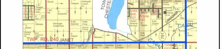
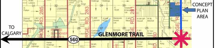
7 NORTHGLEN ESTATES CONCEPTUAL SCHEME Plan Area The Plan Area is comprised of 180 of land, which lies north of Glenmore Trail between Range Roads 275 to the East and 275A to the West. The area is generally flat and slightly higher than adjacent lands. There is little tree cover and the area has been farmed in the past. Each parcel has direct access to either Range Road 275 or 275A with the exception of properties currently accessed through Laganis Road, an internal cul-de-sac. There are currently thirteen separately titled lots. Seven lots are 20 in size, one of which has been redesignated to residential, the remaining six parcels still designated agricultural. Four lots are 4-acre residential acreages accessed by way of an internal cul-de-sac, being the only internal access - all other lots in the Concept Plan area having direct access off Range Roads 275 or 275A. Two lots designated residential were created from a pre-existing 20-acre parcel subdivided for a 4-acre separation with a 16-acre remainder lot.

8 NORTHGLEN ESTATES CONCEPTUAL SCHEME 3 Location Plan


9 NORTHGLEN ESTATES CONCEPTUAL SCHEME 4 Key Plan
10 NORTHGLEN ESTATES CONCEPTUAL SCHEME PUBLIC PARTICIPATION This Concept Plan was prepared in consultation with all landowners in the Concept Plan Area - first with a questionnaire, then with public meetings - in order to create a balance between developing at higher residential densities and maintaining the benefits of a lifestyle in the countryside. 2.1 Questionnaire In order to identify general principles of development for the quarter section, a questionnaire was prepared to ask each landowner and resident in the quarter section their requirements for servicing, land use and development. The questionnaire was delivered to each property owner in person so that other questions could be addressed while their responses to the questionnaire were recorded. The public participation has laid out three fundamental guiding principles for development. These principles are used as the objectives of this Concept Plan, and can be stated as follows. Plan Objectives: 1. maintain a density mix between larger parcels (4 and above) and smaller parcels (2 and above) higher densities fronting through roads, Range Road 275 and 275A. 2. rural character of the Concept Plan Area - tighter clusters of building and landscaping at the edge of large open space in the center of the Concept Plan Area. 2.2 Planning Cells Because the Concept Plan is made up of thirteen existing properties whose landowners have different intentions for the development of their parcels, it became important to coordinate these developments jointly over time. And because one 20-acre parcel has already been subdivided into four 4-acre acreage lots, contiguity between all parcels has been broken. As a result, the Concept Plan Area was further divided into smaller Planning Cells. Each Cell is made up of a group of adjacent parcels whose landowners are in a position to make coordinated decisions for subdivision. The Planning Cells Map (p.8) identifies three Planning Cells, where property owners can identify potential problems and solutions with respect to subdivision design, access, internal road networks, municipal reserve and other servicing issues. Without the benefit of joint planning, each landowner may seek to maximize individual lot yields, which could result in higher densities and would quickly lead to a freeze of subdivision on other neighbouring land. The Planning Cells do not include the 4-acre parcels on Laganis Bay already subdivided and accessed through an existing internal cul-de-sac. The owners of these lands do not intend to further subdivide, yet will maintain their involvement in the process through a Community Association. The internal road network does not create through traffic, so its development involves properties adjacent North to South; and the existing subdivision alongside Laganis Road effectively separates the remaining 20-acre parcels. Coordinated development is necessary in the long term to plan open spaces East to West through larger residential parcels toward the centre of the plan Area while the internal road network, which is developed North to South in the short term, will accommodate smaller parcels at the edges.
11 NORTHGLEN ESTATES CONCEPTUAL SCHEME 6 The combination of lower densities and open spaces in the center of the Plan Area with higher densities and smaller landscaped parcels along side the Range Roads will contribute to a better overall development. It will be easier to phase and coordinate, and investments will be concentrated on a smaller land area, while landowners preserve the original feel and lifestyle of the area by creating larger subdivided parcels. Landowners will jointly and actively coordinate subdivision of their parcels with adjacent neighbors, in addition to the usual referral process. Planning Cell 1 is adjacent to Planning Cell 2 to the East and North. Planning Cell 2 is expected to plan subdivisions in the longer term, while subdivision of the northern part of Planning Cell 1 will first create a short segment to access four to six lots in the short term, then further extend the cul-de-sac to the South in the medium term to further service six to eight lots. Subdivision between both Planning Cells will be articulated on the Demko property - for internal cul-de-sac development in Planning Cell 1 and for the creation of larger inside lots in Planning Cell 2. The existing Laganis Road cul-de-sac would be extended by 200 meters to the North in Planning Cell 2 to access an additional eight to ten lots. Planning Cell 1 is adjacent to Planning Cell 3 to the East and South. Initial access will be created as panhandles from Range Road 275 and then as a cul-de-sac as part of development and subdivision in Planning Cell 1 to create six to eight lots on the two southern parcels. Access in Planning Cell 3 will mirror on the western parcels access network on the east for the creation of six to ten lots Policies: Subdivision in the Concept Plan Area will be coordinated with three separate Planning Cells Planning Cell 1 will group the lands presently owned by Demko, Sweet, Spate, Schrauwen and Dubray Planning Cell 2 will group the lands presently owned by Stobbe and Primrose Planning Cell 3 will group the lands presently owned by Armstrong and Winter Landowners in Planning Cell 2 will evaluate the impact of higher densities and network development in Planning Cell 1, and coordinate subdivision with a northward extension of the Laganis Road. The proponents of the Concept Plan have already met with the landowners in Planning Cell 1 to discuss land use strategies and to design the subdivision and development of their respective parcels. They identified issues with respect to parcel sizes, access, easements, supply of water and septic disposal. The result of these discussions forms the basis of the Tentative Subdivision Plan for Cell 1 as shown on Tentative Plan Map. Landowners in Cell 2 and 3 have not met to discuss specific subdivision design, however, they have participated in general meetings where all landowners have been present. 2.3 Public Meetings Public meetings were held by the proponents of the Concept Plan on September 14, September 21 and October 13, The September 21 meeting grouped all landowners in the Concept Plan area, and a Community Association was formed to be formally registered with MD of Rockyview.
12 NORTHGLEN ESTATES CONCEPTUAL SCHEME 7 The September 14 and October 13 meeting grouped landowners in Planning Cell #1, so they could review the policies of the proposed Concept Plan, and prepare a comprehensive outline plan for their Cell that addressed the creation of new lots, an internal road network and servicing. Policies It is encouraged that a Community Association be put in place to: 1. plan for future developments; 2. inform land owners; 3. maintain a data base of land owners, well data, percolation tests; 4. Propose joint cost recovery for all testing, servicing and development; 5. Serve as a management and administrative unit for all community based systems, and to review and comment on subdivision applications within the quarter section; 6. Collect membership as necessary.


13 NORTHGLEN ESTATES CONCEPTUAL SCHEME 8 Planning Cells
14 NORTHGLEN ESTATES CONCEPTUAL SCHEME LAND USE 3.1 Parcel Density The objective of this Plan is to use a density mix between larger parcels and smaller parcels that will maintain an overall density similar to that of a 4-acre subdivision. A total of fifty lots on 180 of land will result in an average parcel size of 3.6. The land use statistics are outlined in the following tables. Existing Land Use Statistics LAND USE #of parcels Acres Ha % R AH Roads TOTAL The creation of new parcels will be pre-determined by the provisions of the Land Use map. Areas designated R1 2-acre parcel minimum have their frontage on Range Roads 275 and 275A as well as the internal network to be created. The new parcels created in the R1 areas will be smaller lots between 2 to 4 in size. There would be a maximum possible total of thirty five such lots at full development of the Concept Plan area. Land Use Statistics at Full Development LAND USE CELL 1 CELL 2 CELL 3 Total Roads R1 lots lots R2 lots lots Total lots lots Parcels created in the R2-4-acre parcel minimum will be accessed through the internal road network. They will be larger in size between 4 and 8, and will connect to the cul-de-sac with either panhandle access or direct frontage. There would be a maximum of fifteen such lots at full subdivision. The network development required to service the newly created lots would total 800 to 1200 meters of a 25-meter right-of-way at Country Residential standards with a 7 meter road top, made up of 4 separate segments each terminated as a cul-de-sac.
15 NORTHGLEN ESTATES CONCEPTUAL SCHEME Phasing All land owners within the concept plan area want to maintain the ability to subdivide their respective land. Most land owners, however, do not intend to develop in the immediate future. Therefore, the Concept Plan identifies three phases of development: immediate term, short term and long term. Recognizing the fact that there is a limit to the amount of subdivision within quarter section and the cost of servicing can be very expensive, landowners need to develop jointly. Applications for redesignation or subdivision must be coordinated with adjacent property owners within a Joint Planning Cell as outlined on the map entitled Planning Cells. This will result in the identification of servicing needs, land use compatibility, lot layout and internal subdivision roads and mutual access for landowners within the respective Planning Cells. Phasing is predicated on timing, sequencing and financing. Timing simply means the intention of landowners to subdivide. Sequencing references the distribution of rural-sized residential parcels - from 2 to 10 - around existing developments. Financing addresses the ability of landowners to match the costs of development with lot releases. As such there are three phases of development: Phase 1 - Timing, sequencing and financing are based on an early release of lots in Cell #1, with the minimum network development which will allow a maximum lot yield for an effective return in anticipation of further subdivisions. This phase will create between seven to ten additional new lots in Planning Cell #1 - most lots to measure over 4, some at 2 - and one segment of about 80 meters of paved roads in accordance with approved Municipal Standards to service a maximum of five lots. Phase 2 - Developments are completed in Cell #1 with a balance of twelve to fifteen final high density lots - most between 2 and 4 in size - created to facilitate the completion and paving of the internal road network in Cell#1. Interior lots have been kept at a larger size and still connect to internal cul-de-sac's via panhandles. Portions of the initial panhandles have been converted to road right-of-ways for a total of two segments - one paved 600 meters which services between twelve and fifteen lots and the other 80 meters unpaved which services between five and eight lots. Meanwhile, road design and subdivisions will have been initiated in Cells #2 and #3. Phase 3 - The overall scope of subdivision has reached close to fifty lots. Four Cul-de-sacs segments between 200 and 600 meters each have been developed to service between eight and fifteen lots each, and access off both Range Road 275 and 275A have been maintained between two and six points each. All 50+ landowners from the original 13 who formed the Community Association are now assessing the necessity of through-traffic by way of connecting the two southern road segments from Range Road 275 to 275A, and the validity of increasing total allowable densities. Policies Adjacent land owners will be encouraged to submit plans of subdivision jointly well in advance of subdivision to coordinate private groundwater supply systems, private and public road networks and integrated land use plans Condominium plans: (1) are not a preferred method of registration; and (2) are acceptable provided they are submitted as part of a Planning Cell and demonstrate that they provide a feasible alternative to fee simple subdivision.
16 NORTHGLEN ESTATES CONCEPTUAL SCHEME Increased density is allowed, to a minimum parcel size of 2, provided higher density lots are located on the edge of the Plan Area adjacent to either Range Road 275 or 275 A A mix of parcel sizes within a variety of land districts, including Agricultural Holding, Residential One, Residential Two or Residential Three, is allowed and subdivision proposals within Joint Planning Areas shall be designed in accordance with the following: (1) clusters of development interspersed by larger tracts of land to create better views, sense of space, and more efficient servicing; (2) identify building sites to promote more compact built forms; (3) plan tighter landscaping, better views and wind screens, to promote a sense of identity, community, a sense of place and security; (4) minimize the number of roads and connection corridors required.
17 NORTHGLEN ESTATES CONCEPTUAL SCHEME 12 Existing & Land Use NORTHGLEN ESTATES SE W4M N 1/2 OF LSD 8 page 11 Range Road 275A Laganis Road CONCEPT PLAN - PLAN OF DEVELOPMENT #1 - DEMKO SWEET SPATE SCHRAUWEN Range Road m Lot line Existing Lot line New SERVICING WELLS SEPTIC SCALE: NTS 400 m 1000 m2 1 Acre EXISTING & LAND USE 13 lots AH (20 minimum) - 6 lots: 120 R2 (4 minimum) - 7 lots: 58.7 Roads - Laganis Road 1.3 N
18 NORTHGLEN ESTATES CONCEPTUAL SCHEME 13 Phase 1 NORTHGLEN ESTATES SE W4M N 1/2 OF LSD 8 page Range Road 275A Laganis Road CONCEPT + PLAN PLAN OF DEVELOPMENT # DEMKO SWEET SPATE SCHRAUWEN (A) Range Road m Lot line Existing Lot line New SERVICING WELLS SEPTIC 25m CR M.D. Access SURFACED (7m top; <10 lots 60/50 posted speeds) SCALE: NTS 400 m 1000 m2 1 Acre EXISTING PHASE & LAND 1 USE 21 lots 13 - lots 8 additional AH AH (20 minimum) lots: 4 lots: R2 R2 AH (4 (20 (4 minimum) minimum) lots: 6 12 lots: lots: R1 R1 R2 (2 (4 (2 minimum) minimum) lots: - 7 lots: 5 lots: Roads - Laganis Road 1.3 Roads Roads - - Laganis Road Road 1.3 Internal Road Road A A N
19 NORTHGLEN ESTATES CONCEPTUAL SCHEME 14 Phase 2 NORTHGLEN ESTATES SE W4M N 1/2 OF LSD 8 page Range Road 275A Laganis Road CONCEPT + PLAN PLAN OF DEVELOPMENT # DEMKO SWEET SPATE + - SCHRAUWEN (A) (B) Range Road m Lot line Existing Lot line New SERVICING WELLS SEPTIC 25m CR M.D. Access SURFACED (7m top; <10 lots 60/50 posted speeds) SCALE: PAVED (7m top; >10 lots 60/50 posted speeds) NTS 400 m 1000 m2 1 Acre EXISTING PHASE & LAND 12 USE lots lots 10 8 additional AH AH (20 minimum) lots: 34 lots: AH (20 minimum) - 6 lots: 120 R2 R2 (4 (4 minimum) lots: 12 lots: R1 R1 R2 (2 (4 (2 minimum) minimum) lots: lots: 5 lots: Roads - Laganis Road 1.3 Roads Roads - - Laganis Road Road 1.3 Internal Road Road A A Internal Road B 1.4 N
20 NORTHGLEN ESTATES CONCEPTUAL SCHEME 15 Phase 3 & Land Use NORTHGLEN ESTATES SE W4M N 1/2 OF LSD Range Road 275A CONCEP 2 T PLA N (A (A + ) ) Lot line Existing Lot line New # Range Road 275 SERVICING WELLS SEPTIC 25m CR M.D. Access Range Road 275 SURFACED (7m top; <10 lots 60/50 posted speeds) PAVED DEMKO (B) (7m top; >10 lots 60/50 posted speeds) acre s 50 m SCALE: 400 m 1000 m2 NTS 1 Acre EXISTING PHASE PHASE 3 & LAND USE lots additional (ADDITIONAL LOT LINES TO BE DETERMINED FOR A MAXIMUM OF 50 LOTS) lots AH AH (20 AH (20 R1 - minimum) minimum) 2 minimum lots: 34 lots: 80-6 lots: parcel size R2 R2 (4 (4 minimum) lots: 12 lots: R2 (4 minimum) - 7 lots: 58.7 R1 R1 (2 (2-5 lots: Roads R2 - - minimum) 4 Laganis minimum - 16 lots: 37.8 Road parcel 1.3 size Roads Roads - - Laganis Road Road 1.3 Internal Road Network - 25m Right of Way N
21 NORTHGLEN ESTATES CONCEPTUAL SCHEME SERVICING 4.1 Water Each parcel in the Plan Area is serviced by at least one well. A groundwater evaluation report was prepared in support of the proposed redesignation of the N 1/2 of LSD 1. The report states that the well has a pump capacity of 5.25 igpm and, according to the consulting engineer, is capable of providing sufficient water for up to 31 lots. It is proposed that each new lot will be serviced by an individual well. Policies: All newly created lots within the Plan Area should be serviced by an individual well; Communal wells may be investigated where they prove feasible; New applications for subdivision within the Plan Area shall be accompanied by preliminary groundwater evaluation based on existing groundwater data within the vicinity of the subject lands. The groundwater evaluation shall be prepared by a consultant with expertise in groundwater analysis; A well shall be drilled on each new lot that is created as the result of an application for subdivision, and each new well shall be tested in accordance with Alberta Environment guidelines. If the results of the testing do not fall within these guidelines, the subdivision shall not be endorsed or registered. 4.2 Sanitary Sewer The quarter section is a rural community serviced with wells, septic systems and is accessed by Range Road. Capacity is available to develop the quarter section at higher densities. There are 11 existing wells over the quarter section, and one or more septic tanks per parcel. In support of an application for redesignation on the N 1/2 of LSD 1, a report on percolation testing was provided and was found to be in accordance with Alberta Environment guidelines. According to the report, it was determined that site soils have a moderate percolation rate and that they comply with the Alberta Environment Guidelines for the installation of normal subsurface sewage disposal fields. Assuming these conditions prevail throughout the Plan Area it is proposed that each lot will be serviced with on-site septic tank and field system. Policies: Percolation and near-surface water table testing shall be required as a condition of subdivision approval for each new lot created in the Plan Area. In the event that the results of testing do not fall within the guidelines of Alberta Environment, the subdivision shall not be endorsed or registered.
22 NORTHGLEN ESTATES CONCEPTUAL SCHEME Storm Water The lands within the Plan Area are generally flat and are on slightly higher ground than other lands in the surrounding areas. There does not appear to be any flooding issues as reported by the landowners during the questionnaire process. Policies A comprehensive stormwater management plan for the entire Plan Area may be required as a condition of approval for initial subdivision applications, in accordance with the following policies: (1) A stormwater management plan may be required as a condition of subdivision approval to identify natural drainage flows, locations of stormwater retention ponds, drainage easements and treatment of stormwater if necessary; (2) Post-development volumes of stormwater shall be designed such that it does not exceed pre-development flows. (3) Natural drainage courses shall not be altered. 4.4 Reserves Pursuant to the Municipal Government Act, Council as Subdivision Approving Authority has the opportunity to acquire up to 10% of the gross area of the subject lands as Municipal or School Reserve or require the payment of cash-in-lieu of the land that would have been dedicated as Reserve. Since the maximum size of potential parent parcels for any future subdivision applications within the Plan Area is 20, the utility of a municipal reserve parcel consisting of 2 is questionable. Consequently, cash-in-lieu payments should be taken on an individual subdivision application basis to satisfy the Municipality's reserve requirements. At the time of subdivision, however, the dedication of municipal reserve may be considered if a plan for these reserves is in place which has been prepared within their Planning Cell and reviewed by the Community Association. If lands are so reserved, they should create linear linkages to serve the needs of the whole community and they should have public access. Policies At the time of subdivision, landowners may be required to provide 10% of the gross areas of the subject lands as Municipal Reserve, subject to the following conditions: (1) in accordance with a plan of reserves where a plan of reserve has been prepared which identifies the location of the lands and the purpose for dedication; (2) where a plan of reserve has not been prepared, or where lands dedicated as part of a plan of reserve do not total 10%, reserves or the balance, as the case may be, will be provided as cash-in-lieu; (3) dedication for Municipal Reserves will not be required where such dedications have already been provided from prior subdivisions of the same lands.
23 NORTHGLEN ESTATES CONCEPTUAL SCHEME Transportation and Access Regional Traffic Range Road 275 to the East connects (connects what) to Glenmore Trail and then onto Calgary. Range Road 275A to the West is not a through road to Glenmore Trail. It is possible through the process of subdivision to create through traffic between Range Roads 275 and 275A. Existing traffic It is anticipated that there will be a 15% increase in usage of Range Roads 275 and 275A, well within existing Range Road capacity. Furthermore, additional traffic will be channelled through fewer entrance points onto Range Road 275, and, at Phase 2, an internal road network is introduced which brings through traffic to the additional lots further away from Glenmore Trail towards the North end of the site. It is the objective of the Plan to minimize direct access on to the Range Roads. In fact, at full build-out, Joint Planning Cell#1 reduces total access by one access point for a total of Proposed Internal Road Network Policies The proposed road network reflects the joint participation of all landowners. The proposed internal road network has been designed with the following objectives: Internal subdivision roads should not inhibit future subdivision; All lands shall eventually receive primary access onto internal subdivision roads; With additional lots being phased through the quarter section, access will first be channelled towards an internal system of paved cul-de-sac's.. The internal road network can be extended later by connecting the cul-de-sac to create crescent roads. Interior lots will access the cul-desac through 40 foot (12.5 metre) -meter wide panhandle where they are adjacent to another panhandle, or 25 meters where they are not Transportation Policies Access to Range Roads 275 and 275A for new parcels within the Plan Area shall be limited to internal subdivision roads such as cul-de-sacs or crescents All internal subdivision roads and approaches shall be constructed and paved to Municipal Standards Long-term Through Road Policy An internal road network with through-traffic remains a possibility for the future, and would be consistent with the MD of Rocky View policy on road linkages. Range Road 275A is not a through road to Glenmore Trail. The access to Glenmore is made through Range Road 275. However, through traffic from 275A to 275 was not desired by residents within the plan area A through-road linking Range Road 275A with Range Road 275 shall be encouraged in accordance with the long-term through traffic network delineated on the Phase 3 and Land Use map that forms part of this Concept Plan.
24 NORTHGLEN ESTATES CONCEPTUAL SCHEME Panhandle Access Policies Panhandle subdivision design may be appropriate in accordance with the following policies: (1) a panhandle lot shall be phased to connect to an internal road network; (2) the panhandle width shall be 12.5 meters in width ; (3) where the panhandle is adjacent to another panhandle, the combined widths of both panhandles shall be 25 meters.

25 NORTHGLEN ESTATES CONCEPTUAL SCHEME 20 Regional Transportation Network
26 NORTHGLEN ESTATES CONCEPTUAL SCHEME TRAFFIC STUDY 5.1 Population Dynamics Calgary and the MD of Rocky view have experienced substantial population growth over the 90Õs. Along with the demand for housing, there has been an increase in traffic and network usage. In 1999 Calgary has grown to 832,000. This is a 2.84% increase from the previous year. From 1991 to 1996 the MD of RockyView has grown by 4.22% annually from 18,939 to 23, TOTAL MD 18,939 23,326 TOWN OF AIRDRIE 15,946 TOWN OF COCHRANE 7,424 TOWN OF CHESTERMERE 1,911 VILLAGE OF IRRICANA 823 VILLAGE OF BEISEKER % per annum Population Statistics The Concept Plan area is well located in relation to the Calgary area. It is within half-an-hour drive to the downtown. Glenmore Trail is directly south of the quarter section through Range Road 275 and provides convenient and rapid access to all parts of Calgary through Barlow Trail and Deerfoot Trail. For the location alone, the area is well suited for the development of residential acreages, since it is within easy commuting distance of Calgary, and there have been ongoing subdivisions in the area around the Concept Plan. Nonetheless, the portion of Glenmore Trail which connects to Range Road 275 is still relatively little travelled. 5.2 Existing Access Existing access to the site is from Range Roads 275 and 275A. Range Road 275A does not connect though to Glenmore Trail. Glenmore Trail is accessed through Range Road 275. Range Road 275 services 5 lots in the Concept Plan area through 5 separate private access points. Range Road 275A services 8 lots through 4 separate private access points and 1 public cul-de-sac which services 4 individual lots.
27 NORTHGLEN ESTATES CONCEPTUAL SCHEME 22 PHASE TOTAL USAGE ADDITIONAL NUMBER OF LOTS Existing Phase Phase Phase 3 (Tentative ) Estimated Access Statistics RANGE ROAD 275 ACCESS POINTS 5.3 Standards 10 vehicle trips/day/lot will be used as the standard to estimate impact of development onto the road network. That is to say that each lot - existing or proposed - is expected to generate a daily average of 10 trips. With an average of 2 vehicles per lot, this is the equivalent to 1 morning and 1 evening trip, twice daily for 1 vehicle, twice daily for the other vehicle, for a total of 4 trips. The remaining 6 trips correspond to an additional 1.5 return trip per vehicle per day. This may seem higher than conventional usage in the Concept Plan Area. Local residents do not have services and amenities close-by which would cause more frequent uses of their vehicles for short distances. They will generally either commute daily, or operate out of their homes, thus reducing the likelihood of short and frequent trips. Nonetheless, for estimation purposes, 10 vehicle trips per lot per day is conservative. Range Roads 275 and 275A are built to Country Residential Standards and classified as local roads designed to service up to 1000 vehicle trips per day at maximum speeds of 60 km/h. Range Road 275 is not a paved road. 5.4 Estimated Increase in Network Usage The increase in use of the network is estimated from estimating the number of additional lots to be developed at each phase of development. There are 13 lots existing. These are expected to generate 130 vehicle trips/day. 90 trips are generated from parcels fronting onto Range Road 275A, and a large number of these trips will then continue onto Range Road 275 to access Glenmore Trail to the south. This Concept Plan does not prepare for through traffic or for an extension of Range Road 275A to connect to Glenmore Trail. These would relieve the impact of development onto Range Road 275A. Yet, the local residents preferred phasing options that connected cul-de-sac through crescents as opposed to through traffic. PHASE A B PAVING Phase 0 Phase 1 5 Phase A, 275 Phase 3 Number of Lots Served By an Internal Road System
28 NORTHGLEN ESTATES CONCEPTUAL SCHEME 23 Internal Road A is developed on the Demko property, and extended onto the Sweet property. Internal Road B is developed on the Spate/Schrauwen property line. From the provisions of Planning Cell #1, it is possible to estimate the impact of development onto the existing network. Planning Cell #1 will generate 310 vehicle trips per day at Phase 2, with a gradual increase from 210 at Phase 1. Phase 2 is the total build-out for Planning Cell #1. A tentative road network is also proposed as Phase 3 for Plans of Development #2 and #3, based on policies and guidelines for development of the quarter section which favour crescents to through traffic, and based on the provisions of Planning Cell #1. A total impact of 500 vehicle trips per day could be expected if the whole quarter section were to subdivide accordingly. These figures are well within design capacity of Range Roads 275 and 275A. Paving of Range Road 275 could be considered between Phases 2 and 3. The additional traffic created by Planning Cell #1 is channelled through progressively fewer access points onto Range Road 275. A cul-de-sac is developed onto the Demko subdivision at Phase 1. This cul-de-sac is the first component of internal road network (A). It services 5 lots, and keeps the total number of access points onto Range Road 275 at 8 while 8 new lots are being developed. 4 more lots will ultimately be created with the development of internal road network (B) and the extension of internal road (A) at Phases 2 and 3. These will actually reduce total access onto Range Road 275 to 3 access points. These internal roads channel traffic through fewer access points. With fewer access points through traffic is less disrupted. There are less stops and fewer roadside improvements. This amply makes-up for the added network use. At full-build out, Internal Road (A) will service a total of 12 lots and paving of internal Road A should be considered along with paving of Range Road 275 between Phases 2 and 3. Internal Road (B) will service 8 lots.
29 NORTHGLEN ESTATES CONCEPTUAL SCHEME 24 Appendices Public Participation Questionnaire (Under Separate Cover) Groundwater Supply Evaluation Report Percolation Testing and Near Surface Ground Water Determination
30 NORTHGLEN ESTATES CONCEPTUAL SCHEME 25
31 NORTHGLEN ESTATES CONCEPTUAL SCHEME 26
32 NORTHGLEN ESTATES CONCEPTUAL SCHEME 27
33 NORTHGLEN ESTATES CONCEPTUAL SCHEME 28
MUNICIPAL DISTRICT OF ROCKY VIEW NO. 44 ELBOW VALLEY WEST DIRECT CONTROL DISTRICT BYLAW C
 This document has been consolidated for convenience only. A current listing of any and all amendments can be obtained from the Municpal District Office Bylaw No. Date of Approval Amendment Type Bylaw C-6042-2005
Wapiti Ridge Estates Area Structure Plan SE W5M. December Prepared For:
 SE 13-20-1 W5M December 2000 Prepared For: 393494 Alberta Limited, and The Municipal District of Foothills No. 31 Prepared By: Kristi Beunder Professional Planning Services Calgary, Alberta Ph: 201-3309
LAND USE AMENDMENT SPRINGBANK HILL (WARD 6) ELMONT DRIVE SW AND 69 STREET SW BYLAW 114D2017
 ELMONT DRIVE SW AND 69 STREET SW BYLAW 114D2017") Page 1 of 8 EXECUTIVE SUMMARY This land use amendment application proposes to redesignate and subdivide 1.15 hectares of land located within the southwest community of East Springbank to accommodate 17
Page 1 of 8 EXECUTIVE SUMMARY This land use amendment application proposes to redesignate and subdivide 1.15 hectares of land located within the southwest community of East Springbank to accommodate 17
City of Grande Prairie Development Services Department
 City of Grande Prairie Development Services Department COUNTRYSIDE SOUTH OUTLINE PLAN Prepared by: GPEC Consulting Ltd. #202, 10712-100th Street Grande Prairie, AB Council Resolution of August 20, 2001
TOTTENHAM SECONDARY PLAN
 TOTTENHAM SECONDARY PLAN AMENDMENT NO. 11 TO THE OFFICIAL PLAN OF THE TOWN OF NEW TECUMSETH The following text and schedules to the Official Plan of the Town of New Tecumseth constitute Amendment No. 11
PUBLIC HEARING INFORMATION PACKAGE
 PUBLIC HEARING INFORMATION PACKAGE ADDRESS: APPLICANT: 8522 Nottman Street Analytical Consulting PLANNING FILE(S): OCP17-002 R17-015 This Public Hearing Information Package has been compiled to provide
Chapter 100 Planned Unit Development in Corvallis Urban Fringe
 100.100 Scope and Purpose. Chapter 100 Planned Unit Development in Corvallis Urban Fringe (1) All applications for land divisions in the Urban Residential (UR) and Flood Plain Agriculture (FPA) zones within
Land Use Planning Analysis. Phase 2 Drayton Valley Annexation Proposal
 Land Use Planning Analysis Phase 2 Drayton Valley Annexation Proposal Prepared for Town of Drayton Valley Prepared by Mackenzie Associates Consulting Group Limited March, 2011 TABLE OF CONTENTS 1.0 INTRODUCTION...
4. facilitate the construction of streets, utilities and public services in a more economical and efficient manner;
 PVPC MODEL BYLAW BY-RIGHT CLUSTER ZONING BYLAW Prepared by Pioneer Valley Planning Commission Revised: October 2001 1.00 Development 1.01 Development Allowed By Right Development in accordance with this
PLANNED UNIT DEVELOPMENTS
 PLANNED UNIT DEVELOPMENTS SECTION 9.01 DESCRIPTION AND PURPOSE. A. The purpose of a planned unit development (PUD) is to permit greater flexibility in development than is generally possible under standard
-MENDOCINO COUNTY PLANNING AND BUILDING SERVICES- DIVISION OF LAND REGULATIONS TITLE 17
 ARTICLE VI -- GENERAL REGULATIONS AND PROVISIONS Sec. 17-50. Sec. 17-51 General Plan. Sec. 17-52 Lot and Block Design and Configuration. Sec. 17-53 Lot Access. Sec. 17-54 Private Roads. Sec. 17-55 Water
ACCESSORY DWELLING UNITS
 ACCESSORY DWELLING UNITS LAND USE BYLAW C-4841-97 ACCESSORY DWELLING UNIT (ADU): means a subordinate dwelling unit attached to, created within or detached from the principal dwelling, single detached,
610 LAND DIVISIONS AND PROPERTY LINE ADJUSTMENTS OUTSIDE A UGB
 ARTICLE VI: LAND DIVISIONS AND PROPERTY LINE ADJUSTMENTS VI-21 610 LAND DIVISIONS AND PROPERTY LINE ADJUSTMENTS OUTSIDE A UGB 610-1 Property Line Adjustments (Property Line Relocation) A property line
Financial Impact Statement There are no immediate financial impacts associated with the adoption of this report.
 STAFF REPORT Planning and Development Department Subject: Application by RYC Property to rezone a portion of lands on John Murray Dr. and Megan Lynn Dr. from R2 to R3 and to enter into a Development Agreement
CHAPTER Committee Substitute for Committee Substitute for Senate Bill No. 2188
 CHAPTER 2004-372 Committee Substitute for Committee Substitute for Senate Bill No. 2188 An act relating to land development; amending s. 197.502, F.S.; providing for the issuance of an escheatment tax
Rule 80. Preservation of Primary Agricultural Soils Revised and approved by the Land Use Panel during its public meeting on January 31, 2006.
 Rule 80. Preservation of Primary Agricultural Soils Revised and approved by the Land Use Panel during its public meeting on January 31, 2006. (A) Purpose. In accordance with 10 V.S.A. Sections 6025(b)
ORDINANCE NO
 ORDINANCE NO. 2014-160 AN ORDINANCE OF THE CITY COUNCIL OF THE CITY OF MENIFEE, CALIFORNIA, REPEALING SECTION 10.35 OF RIVERSIDE COUNTY LAND USE ORDINANCE NO. 460.152 AS ADOPTED BY THE CITY OF MENIFEE
Belmead Neighbourhood Structure Plan
 Belmead Neighbourhood Structure Plan Office Consolidation November 2005 Prepared by: Planning and Policy Services Branch Planning and Development Department City of Edmonton Bylaw 6619 was adopted by Council
1 November 13, 2013 Public Hearing APPLICANT & PROPERTY OWNER: HOME ASSOCIATES OF VIRGINIA, INC.
 1 November 13, 2013 Public Hearing APPLICANT & PROPERTY OWNER: HOME ASSOCIATES OF VIRGINIA, INC. STAFF PLANNER: Carolyn A.K. Smith REQUEST: Conditional Change of Zoning (AG-1 & AG-2 Agricultural Districts
Prt. NE W5. Prepared for: Municipal District of Foothills #31. Prepared by:
 Prt. NE 22-22-3-W5 Prepared for: Municipal District of Foothills #31 Prepared by: Bowwood Land Services Inc. R.R. 1, Dewinton, Alberta T0L 0X0 Tel: 403-995-2225 Fax: 403-938-4787 " OFFICIAL COPY " ADOPTED
These can be obtained at the City s Engineering Department or on the City s website (
 Subdivision Application Guide This handout provides information on the requirements and processes for a subdivision of land. It is intended for general guidance only. Applicants should also refer to: Official
CHAPTER 14 PLANNED UNIT DEVELOPMENTS
 9-14-1 9-14-1 CHAPTER 14 PLANNED UNIT DEVELOPMENTS SECTION: 9-14-1: Purpose 9-14-2: Governing Provisions 9-14-3: Minimum Area 9-14-4: Uses Permitted 9-14-5: Common Open Space 9-14-6: Utility Requirements
*DO NOT REMOVE * R Sharp McRae Avenue
 *DO NOT REMOVE * R16-003 - Sharp 32385 McRae Avenue This Public Hearing Information Package has been compiled to provide information pertaining to the subject property. If you have questions regarding
MUNICIPAL DEVELOPMENT PLAN
 MUNICIPAL DEVELOPMENT PLAN Prepared by: The Council and Planning and Development Services Bylaw No. 1414-09 adopted August 12, 2009 Amending Bylaw - 1480-12 adopted June 12, 2013 Amending Bylaw 1529-14
Mount Airy Planning Commission March 26, Staff Report
 Mount Airy Planning Commission March 26, 2018 Staff Report Special Exception Request Mixed Use Development in CC District Recommendation to Board of Appeals CASE MA-A-18-01 Applicant: Location: Zoning:
TREASURE COAST REGIONAL PLANNING COUNCIL M E M O R A N D U M
 TREASURE COAST REGIONAL PLANNING COUNCIL M E M O R A N D U M To: Council Members AGENDA ITEM 6A From: Date: Subject: Staff May 20, 2011 Council Meeting Local Government Comprehensive Plan Review Draft
Appendix J - Planned Unit Development (PUD)
") Appendix J - Planned Unit Development (PUD) Intent and Purpose The purpose of the PUD is: 1. To provide development that is consistent with the Comprehensive Land Use Plan and promote the goals and objectives
Appendix J - Planned Unit Development (PUD) Intent and Purpose The purpose of the PUD is: 1. To provide development that is consistent with the Comprehensive Land Use Plan and promote the goals and objectives
MUNICIPALITY OF THE DISTRICT OF CLARE SUBDIVISION BY-LAW
 MUNICIPALITY OF THE DISTRICT OF CLARE SUBDIVISION BY-LAW 1 Table of Contents PART 1 - TITLE... 4 PART 2 - INTERPRETATION... 4 PART 3 - DEFINITIONS... 4 PART 4 - PROCEDURE FOR APPROVAL OF PLANS OR INSTRUMENTS
HOW TO APPLY FOR A USE PERMIT
 HOW TO APPLY FOR A USE PERMIT MENDOCINO COUNTY PLANNING AND BUILDING SERVICES What is the purpose of a use permit? Throughout the County, people use their properties in many different ways. They build
MUNICIPALITY OF THE COUNTY OF PICTOU SUBDIVISION BY-LAW. Act means the Municipal Government Act, Stats. N.S., 1998, c. 18 and amendments thereto;
 MUNICIPALITY OF THE COUNTY OF PICTOU SUBDIVISION BY-LAW SHORT TITLE 1. This by-law may be cited as the Pictou County Subdivision By-Law and shall apply to all lands within the Municipality of the County
Flinders Avenue, Lara Planning Scheme Amendment Combined Application for Rezoning and Multi-Lot Subdivision Reference : Decembe
 143-179 Flinders Avenue, Lara Planning Scheme Amendment Combined Application for Rezoning and Multi-Lot Subdivision Reference: 14134-03 TGM Group Geelong Melbourne Ballarat 1/27-31 Myers Street (PO Box
AGENDA 1. CALL TO ORDER :00 P.M.
 MUNICIPAL PLANNING COMMISSION REGULAR MEETING CITY HALL COUNCIL CHAMBERS SEPTEMBER 24, 2015 AGENDA 1. CALL TO ORDER ------------------------------------------------------------------------ 7:00 P.M. 2.
CHAPTER 3 PRELIMINARY PLAT
 10-3-1 10-3-3 SECTION: CHAPTER 3 PRELIMINARY PLAT 10-3-1: Consultation 10-3-2: Filing 10-3-3: Requirements 10-3-4: Approval 10-3-5: Time Limitation 10-3-6: Grading Limitation 10-3-1: CONSULTATION: Each
The Chair called the meeting to order at 9:00 a.m. with all members present with the exception of Councillor Wright and Councillor Kissel.
 Page 1 A regular meeting of Rocky View County Council was held in the Council Chambers of the County Hall, 262075 Rocky View Point, Rocky View County, Alberta on commencing at 9:00 a.m. Present: Division
5-703 Agricultural Rural (AR) District Cluster Option. (A)
 District Cluster Option. (A)") 5-703 Agricultural Rural (AR) District Cluster Option. (A) Purpose. The purpose of the Agricultural Rural (AR) District Cluster Option is to provide for residential singlefamily detached development in
5-703 Agricultural Rural (AR) District Cluster Option. (A) Purpose. The purpose of the Agricultural Rural (AR) District Cluster Option is to provide for residential singlefamily detached development in
SUBDIVISION BY-LAW MUNICIPALITY OF THE COUNTY OF INVERNESS
 SUBDIVISION BY-LAW MUNICIPALITY OF THE COUNTY OF INVERNESS APPROVED BY COUNCIL: JUNE 15, 1998 EFFECTIVE DATE: SEPTEMBER 23, 1998 Page 2 TABLE OF CONTENTS PART 1: SHORT TITLE... 5 PART 2: INTERPRETATION...
Planning Department Oconee County, Georgia
 Planning Department Oconee County, Georgia STAFF REPORT REZONE CASE #: 6985 DATE: October 31, 2016 STAFF REPORT BY: Andrew C. Stern, Planner APPLICANT NAME: Williams & Associates, Land Planners PC PROPERTY
For Office Use Only. Permit No. Fee: $ $ per proposed lot (AN ADDITIONAL 10% CODE COMPLIANCE FEE WILL BE CHARGED)
") For Office Use Only Permit No. Fee: $1600 + $560.00 per proposed lot (AN ADDITIONAL 10% CODE COMPLIANCE FEE WILL BE CHARGED) LAND PARTITION FOREST (Conditional Use) Crook County Planning Department 300
For Office Use Only Permit No. Fee: $1600 + $560.00 per proposed lot (AN ADDITIONAL 10% CODE COMPLIANCE FEE WILL BE CHARGED) LAND PARTITION FOREST (Conditional Use) Crook County Planning Department 300
CASTLES OF CALEDON URBAN DESIGN REPORT
 CASTLES OF CALEDON URBAN DESIGN REPORT PROPOSED RESIDENTIAL DEVELOPMENT CALEDON, ONTARIO 10 JULY, 2015 TABLE CONTENTS: 1.0 DEVELOPMENT 4.0 CONCLUSION 1.1 Introduction 1.2 Castles of Caledon- Urban Design
City of Surrey PLANNING & DEVELOPMENT REPORT File:
 City of Surrey PLANNING & DEVELOPMENT REPORT PROPOSAL: Planning Report Date: February 9, 2009 Development Variance Permit in order to permit a reduced lot frontage to allow subdivision into two half-acre
ARTICLE 15 - PLANNED UNIT DEVELOPMENT
 Section 15.1 - Intent. ARTICLE 15 - PLANNED UNIT DEVELOPMENT A PUD, or Planned Unit Development, is not a District per se, but rather a set of standards that may be applied to a development type. The Planned
A GUIDE TO PROCEDURES FOR: SUBDIVISIONS & CONDOMINIUM CONVERSION
 A GUIDE TO PROCEDURES FOR: SUBDIVISIONS & CONDOMINIUM CONVERSION A GUIDE TO PROCEDURES FOR: SUBDIVISIONS (TENTATIVE MAPS) PURPOSE Definition: A subdivision is defined as the division of any improved or
PROPOSED METRO JOINT DEVELOPMENT PROGRAM: POLICIES AND PROCESS July 2015 ATTACHMENT B
 PROPOSED METRO JOINT DEVELOPMENT PROGRAM: POLICIES AND PROCESS ATTACHMENT B TABLE OF CONTENTS I. INTRODUCTION / PURPOSE............................ 3 II. OBJECTIVES / GOALS..................................
ZONING ORDINANCE: OPEN SPACE COMMUNITY. Hamburg Township, MI
 ZONING ORDINANCE: OPEN SPACE COMMUNITY Hamburg Township, MI ARTICLE 14.00 OPEN SPACE COMMUNITY (Adopted 1/16/92) Section 14.1. Intent It is the intent of this Article to offer an alternative to traditional
Lorne and Leanne Read Sundance Trail Phase II Area Structure Plan Amendment
 A SPRING 2008 CO-14264 Municipal District of Foothills No. 31 Lorne and Leanne Read Sundance Trail Phase II Area Structure Plan Amendment Lorne and Leanne Read SUNDANCE TRAIL AREA STRUCTURE PLAN - AMENDMENT
Comprehensive Plan 2030
 Introduction The purpose of this chapter of the Comprehensive Plan is to accurately describe, in words and images, the goals and visions for the future of Clearfield, as determined by the people who live
OPEN SPACE RESIDENTIAL DEVELOPMENT (OSRD) MODEL SITE PLAN BYLAW
 MODEL SITE PLAN BYLAW") OPEN SPACE RESIDENTIAL DEVELOPMENT (OSRD) MODEL SITE PLAN BYLAW 1) PURPOSE AND INTENT a) The Primary Purposes for OSRD are the following: i) To allow for greater flexibility and creativity in the design
OPEN SPACE RESIDENTIAL DEVELOPMENT (OSRD) MODEL SITE PLAN BYLAW 1) PURPOSE AND INTENT a) The Primary Purposes for OSRD are the following: i) To allow for greater flexibility and creativity in the design
Town of Cary, North Carolina Rezoning Staff Report 12-REZ-27 Morris Branch Town Council Public Hearing January 24, 2013
 Town of Cary, North Carolina Rezoning Staff Report 12-REZ-27 Morris Branch Town Council Public Hearing January 24, 2013 REQUEST To amend the Town of Cary Official Zoning Map to rezone approximately 9.0
Special Use Permit - Planned Unit Development Checklist. Property Address:
 Special Use Permit - Planned Unit Development Checklist Special Use Permit Number. Parcel Code/s #28-11- - - Property Address: Applicant: ARTICLE VIII Ordinance Reference - Section 8.1.2 Permit Procedures:
Municipal Development Plan. The Village of Warburg
 Municipal Development Plan The Village of Warburg Table of Contents PART ONE: BACKGROUND AND PURPOSE 1 SECTION 1: BACKGROUND 1 SECTION 2: GOALS AND POLICIES 1 PART TWO: PHYSICAL ENVIRONMENT 2 SECTION 3:
DOWNTOWN BEAUMONT CENTRE-VILLE: PARKING MANAGEMENT REPORT
 DOWNTOWN BEAUMONT CENTRE-VILLE: PARKING MANAGEMENT REPORT Prepared for: Prepared by: Town of Beaumont Planning & Development Services WATT Consulting Group Our File: 3364.T01 Date: October 5, 2016 1.0
Staff Report: Date: Applicant: Property Identification: Acreage of Request: Current Zoning of Requested Area: Requested Action: Attached:
 Staff Report: Completed by Jeff Palmer Director of Planning & Zoning Date: November 7, 2018, Updated November 20, 2018 Applicant: Greg Smith, Oberer Land Developer agent for Ronald Montgomery ET AL Property
THE CORPORATION OF THE TOWNSHIP OF KING THE CERTIFICATE PAGE FOR AMENDMENT NO. 89 TO THE OFFICIAL PLAN OF THE TOWNSHIP OF KING
 THE CORPORATION OF THE TOWNSHIP OF KING THE CERTIFICATE PAGE FOR AMENDMENT NO. 89 TO THE OFFICIAL PLAN OF THE TOWNSHIP OF KING (KING CITY COMMUNITY PLAN) The attached text and schedules constituting Amendment
POLICY AMENDMENT AND LAND USE AMENDMENT RICHMOND (WARD 8) RICHMOND ROAD SW AND 24 STREET SW BYLAWS 10P2018 AND 52D2018
 RICHMOND ROAD SW AND 24 STREET SW BYLAWS 10P2018 AND 52D2018") Page 1 of 12 EXECUTIVE SUMMARY This land use amendment proposes to redesignate two parcels of approximately 0.30 hectares ± (0.74 acres ±) located in the community of Richmond from DC Direct Control District
Page 1 of 12 EXECUTIVE SUMMARY This land use amendment proposes to redesignate two parcels of approximately 0.30 hectares ± (0.74 acres ±) located in the community of Richmond from DC Direct Control District
FINAL DRAFT 10/23/06 ARTICLE VI
 FINAL DRAFT 10/23/06 ARTICLE VI 185-41.1. Planned Residential Development A. Purpose and Intent. The purposes of the Planned Residential Development (PRD) bylaw are to maintain the rural character of Dover,
Guide to Preliminary Plans
 Guide to Preliminary Plans Introduction The Douglas County is committed to providing open, transparent application processes to the public. This Guide is provided to assist anyone interested in the procedures
ROCKY VIEW COUNTY COUNCIL MEETING MINUTES February 24, 2015 Page 1
 Page 1 A regular meeting of the Council of Rocky View County was held in Council Chambers of the Municipal Administration Complex, 911 32 nd Avenue NE, Calgary, Alberta on commencing at 9:00 a.m. Present:
MINUTES OF THE MUNICIPAL PLANNING COMMISSION Tuesday, May 5, 2015 Red Deer County Council Chambers, Red Deer County Centre
 MINUTES OF THE MUNICIPAL PLANNING COMMISSION Tuesday, May 5, 2015 Red Deer County Council Chambers, Red Deer County Centre Present: Absent: Chairman Councillor P.J.R. Massier, Mayor J.J. Wood, Councillors
COUNCIL ACTION FORM. 1. The City Council can approve the Preliminary Plat for Menards Ames Subdivision
 ITEM #: 49 DATE: 03-27-18 COUNCIL ACTION FORM SUBJECT: PRELIMINARY PLAT FOR MENARDS BACKGROUND: Menards Ames Subdivision is a proposed 41-acre development on SE 16 th Street just west of the Skunk River.
Champagne District Area Structure Plan
 Champagne District Area Structure Plan Bylaw 9/2006 www.morinville.ca TOWN OF MORINVILLE PROVINCE OF
Highland Green Estates Neighbourhood Area Structure Plan
 Highland Green Estates Neighbourhood Area Structure Plan Original Outline Plan approved by Council: March 10, 1997 Outline Plan amended by Council: March 24, 1997 Converted to a Neighbourhood Area Structure
TOWN OF SIDNEY BYLAW 1390
 The contents of this Bylaw are produced and consolidated for convenience only. Every effort has been made to ensure the accuracy and completeness of the material, however, the Town cannot guarantee its
Draft Zoning Changes for the 2nd Planning Board Public Hearing, January 22, 2018.
 Draft Zoning Changes for the 2nd Planning Board Public Hearing, January 22, 2018. No changes were made at the 1st Public Hearing. Proposed wording for the 1 st Public Hearing in red, eliminated text in
SUBDIVISION APPLICATION
 PLANNING AND DEVELOPMENT SERVICES 38106 Rge Rd 275, Red Deer County, AB T4S-2L9 Phone: (403) 350-2170 Fax: (403) 346-9840 For Office Use Only File # Roll # Fee Submitted Date Deemed Complete Reference
THE REDEVELOPMENT PLAN
 PAGE 37 THE REDEVELOPMENT PLAN FUTURE LAND USE The Silver Terrace Redevelopment Area is currently designated as Redevelopment Area #4 on the City of Delray Beach Future Land Use Map (FLUM). This designation
BYLAW 5781 ****************
 BYLAW 5781 **************** A BYLAW OF THE CITY OF LETHBRIDGE PROVIDING FOR THE IMPOSITION OF AN OFF-SITE LEVY IN RESPECT OF LAND TO BE DEVELOPED OR SUBDIVIDED FOR THE YEARS 2013, 2014, 2015 and 2016 ************************************************************
INNOVATIVE PLANNING SOLUTIONS
 Reference Document 2 Committee of the Whole Item CCW 16-190 1 of 13 INNOVATIVE PLANNING SOLUTIONS Township of Springwater Planning Department 2231 Nursery Road Minesing, ON L0L 1Y2 Tuesday February 24
4027 and 4031 Ellesmere Road Zoning Amendment and Draft Plan of Subdivision Applications - Request for Direction Report
 STAFF REPORT ACTION REQUIRED 4027 and 4031 Ellesmere Road Zoning Amendment and Draft Plan of Subdivision Applications - Request for Direction Report Date: August 22, 2013 To: From: Wards: Reference Number:
Planning Justification Report
 Planning Justification Report, Township of Puslinch FARHI HOLDINGS CORPORATION Updated January 27, 2017 Zelinka Priamo Ltd. Page i TABLE OF CONTENTS Page No. 1.0 1.1 1.2 1.3 2.0 2.1 2.2 2.3 2.4 2.5 3.0
Conceptual Scheme SE W4
 December 2012 1. PURPOSE 1.1. The purpose of a Conceptual Scheme (CS) is as follows: a) To provide a framework for the subsequent subdivision and/or development of land within the Country Residential Policy
A BY-LAW RESPECTING THE SUBDIVISION OF LAND IN THE MUNICIPALITY OF THE DISTRICT OF LUNENBURG
 A BY-LAW RESPECTING THE SUBDIVISION OF LAND IN THE MUNICIPALITY OF THE DISTRICT OF LUNENBURG Approved by Municipal Council on May 4, 1999 CONSOLIDATED EDITION This CONSOLIDATED EDITION is prepared for
ARTICLE XI - CONSERVATION SUBDIVISIONS
 ARTICLE XI - CONSERVATION SUBDIVISIONS Section 1101: Purpose and Intent. This Article is intended to provide for residential subdivisions that are designed based first and foremost on the preservation
APPLICATION REVIEW CHECKLISTS
 APPLICATION REVIEW CHECKLISTS The following must be submitted with and are part of each application. No application is complete until all required documentation has been submitted to the Community Development
PLAINFIELD CHARTER TOWNSHIP COMMUNITY DEVELOPMENT DEPARTMENT PLANNING, ZONING & BUILDING SERVICES MEMORANDUM
 PLAINFIELD CHARTER TOWNSHIP COMMUNITY DEVELOPMENT DEPARTMENT PLANNING, ZONING & BUILDING SERVICES 6161 BELMONT AVENUE N.E. BELMONT, MI 49306 PHONE 616-364-1190 FAX: 616-364-1170 www.plainfieldchartertwp.org
TOWN OF ORO VALLEY PLANNING & ZONING COMMISSION MEETING DATE: December 6, 2011
 PLANNING & ZONING COMMISSION MEETING DATE: December 6, 2011 TO: FROM: SUBJECT: PLANNING & ZONING COMMISSION Matt Michels, Senior Planner mmichels@orovalleyaz.gov; tel. 229-4822 Public Hearing: Rancho de
PRELIMINARY PLAT CHECK LIST
 PRELIMINARY PLAT CHECK LIST Name of Proposed Subdivision: The following items must be included with the initial submittal of a Preliminary Plat: Application, filled out completely Project Narrative Pre-application
ADMINISTRATION RECOMMENDATION(S) 2014 November 06. That Calgary Planning Commission recommends APPROVAL of the proposed Land Use Amendment.
 2014 November 06. That Calgary Planning Commission recommends APPROVAL of the proposed Land Use Amendment.") Page 1 of 10 EXECUTIVE SUMMARY This land use amendment application seeks to redesignate a single residential parcel from Residential-Contextual One/Two Dwelling District (R-C2) to Multi-Residential-Contextual
Page 1 of 10 EXECUTIVE SUMMARY This land use amendment application seeks to redesignate a single residential parcel from Residential-Contextual One/Two Dwelling District (R-C2) to Multi-Residential-Contextual
Article 7: Residential Land Use and Development Requirements
 Article 7: Residential Land Use and Section 701: Statement of Intent (A) (B) (C) The intent of Article 7 is to develop certain land use and development requirements for the residential uses within Cumru
R E S O L U T I O N. B. Development Data Summary
 R E S O L U T I O N WHEREAS, the Prince George s County Planning Board has reviewed DPLS-333 requesting a Departure from Parking and Loading Standards for 19 parking spaces in accordance with Subtitle
PLANNED RESIDENTIAL DEVELOPMENT (PRD)
") PLANNED RESIDENTIAL DEVELOPMENT SECTION 10. PLANNED RESIDENTIAL DEVELOPMENT (PRD) 10.1 Purpose Planned Residential Development allows by special permit from the Board an alternative pattern of residential
PLANNED RESIDENTIAL DEVELOPMENT SECTION 10. PLANNED RESIDENTIAL DEVELOPMENT (PRD) 10.1 Purpose Planned Residential Development allows by special permit from the Board an alternative pattern of residential
Appendix A: Guide to Zoning Categories Prince George's County, Maryland
 Appendix A: Guide to Zoning Categories Prince George's County, Maryland RESIDENTIAL ZONES 1 Updated November 2010 R-O-S: Reserved Open Space - Provides for permanent maintenance of certain areas of land
SUPPLEMENTARY REQUIREMENTS SPECIFIED PENALTIES FOR OFFENCES RIPARIAN SETBACK MATRIX MODEL RURAL APPROACH STANDARDS POLICY COMMUNITY STANDARDS BYLAW
 APPENDICES APPENDIX A APPENDIX B APPENDIX C APPENDIX D APPENDIX E APPENDIX F APPENDIX G APPENDIX H APPENDIX I APPENDIX J APPENDIX K SUPPLEMENTARY REQUIREMENTS TELECOMMUNICATION TOWERS CONFINED FEEDING
OFFICE CONSOLIDATION
 OFFICE CONSOLIDATION This document has been consolidated for convenience only. A copy of the original Bylaw and all amending Bylaws can be obtained from Rocky View County. This office consolidation comprises
STAFF REPORT. Financial Impact Statement There are no immediate financial impacts associated with the adoption of this report.
 STAFF REPORT Planning and Development Department Subject: Cottage Country Unsubstantial Amendment to Development Agreement To: CAO for Planning Advisory Committee, December 13, 2016 Date Prepared: December
Strathcona County Municipal Policy Handbook. Last Review Date: May 21, 2013 Next Review Date: 05/2016
 SER-008-019 Strathcona County Municipal Policy Handbook Conceptual Schemes Date of Approval by Council: 09/28/04; 05/08/2007; 05/21/2013 Resolution No: 786/2004; 386/2007; 314/2013 Lead Role: Chief Commissioner
Appendix A. Definitions
 Definitions 1. Terms Defined. Words contained in this are those having a special meaning relative to the purposes of this Ordinance. Words not listed in this section shall be defined by reference to: (1)
CHAPTER34 PRUD - PLANNED RESIDENTIAL UNIT DEVELOPMENT
 CHAPTER34 PRUD - PLANNED RESIDENTIAL UNIT DEVELOPMENT 17-34-1 17-34-2 17-34-3 17-34-4 17-34-5 17-34-6 17-34-7 17-34-8 17-34-9 Purpose Planned Residential Unit Development Defined Planned Residential Unit
Richmond County Subdivision By-law
 Richmond County Subdivision By-law SHORT TITLE 1. This By-law may be cited as the "Subdivision By-law" and shall apply to all lands within the Municipality of the County of Richmond. INTERPRETATION 2.
ROCKY VIEW COUNTY COUNCIL MEETING MINUTES September 13, 2016 Page 1
 Page 1 A regular meeting of the Council of Rocky View County was held in Council Chambers of the Municipal Administration Complex, 911 32 nd Avenue NE, Calgary, Alberta on commencing at 9:00 a.m. Present:
FINAL DRAFT 12/1/16, Rev. to 7/18/17
 FINAL DRAFT 12/1/16, Rev. to 7/18/17 (As Adopted 8/8/17 Effective 9/1/17) SHELTON PLANNING AND ZONING COMMISSION Proposed Amendments to Zoning Regulations I. Amend Section 23 PERMITTED USES by inserting
Riverton Properties Ltd Proposed Special Housing Area
 Riverton Properties Ltd Proposed Special Housing Area Housing Accords and Special Housing Areas Act 2013 Expression of Interest 1 This Expression of Interest is made on behalf of Riverton Properties Ltd,
A. Preserve natural resources as identified in the Comprehensive Plan.
 1370.08 Conservation Residential Overlay District. Subd. 1 Findings. The City finds that the lands and resources within the Conservation Residential Overlay District are a unique and valuable resource
APPLICATION SUBMITTAL REQUIREMENTS FOR Tentative Parcel or Subdivision Maps
 CITY OF EL CERRITO Community Development Department Planning and Building Division 10890 San Pablo Avenue, El Cerrito, CA 94530 (510) 215-4330 FA (510) 233-5401 planning@ci.el-cerrito.ca.us APPLICATION
STAFF REPORT. Permit Number: Gonzalez. Kitsap County Board of Commissioners; Kitsap County Planning Commission
 STAFF REPORT Permit Number: 15 00657 Gonzalez DATE: March 2, 2016 TO: FROM: Kitsap County Board of Commissioners; Kitsap County Planning Commission Katrina Knutson, AICP, Senior Planner, DCD and Jeff Arango,
Article Optional Method Requirements
 Article 59-6. Optional Method Requirements [DIV. 6.1. MPDU DEVELOPMENT IN RURAL RESIDENTIAL AND RESIDENTIAL ZONES Sec. 6.1.1. General Requirements... 6 2 Sec. 6.1.2. General Site and Building Type Mix...
ATTENDING THE MEETING Robert Balogh, Vice-Chairman Sonia Stopperich, Supervisor Marcus Staley, Supervisor Bob Ross, Supervisor
 SPECIAL HEARING - TUESDAY, APRIL 12, 2016 PAGE 1 The North Strabane Township Board of Supervisors held a Special Meeting- Conditional Use Hearing, Tuesday, April 12, 2016, at approximately 6:30 P.M., at
TENTATIVE MAP APPLICATION GUIDE (BCC 20-1)( 20-2 to )( to 20-91)( to )
( 20-2 to )( to 20-91)( to )") Butte County Department of Development Services PERMIT CENTER 7 County Center Drive, Oroville, CA 95965 Planning Division Phone 530.552.3701 Fax 530.538.7785 Email dsplanning@buttecounty.net FORM NO PLG-05
Butte County Department of Development Services PERMIT CENTER 7 County Center Drive, Oroville, CA 95965 Planning Division Phone 530.552.3701 Fax 530.538.7785 Email dsplanning@buttecounty.net FORM NO PLG-05
PAPAKAINGA DISTRICT WIDE ACTIVITY
 SECTION 13.1 PAPAKAINGA DISTRICT WIDE ACTIVITY 13.1.1 INTRODUCTION The Resource Management Act 1991 introduced specific and new obligations for those exercising functions and powers under the Act to provide
Letter of Intent May 2017 (Revised November 2017)
") THE BEACH AT WOODMOOR LETTER OF INTENT MAY 2017 (REVISED NOVEMBER 2017) OWNER/APPLICANT: CONSULTANT: Lake Woodmoor Holdings LLC N.E.S. Inc. 1755 Telstar Drive, Suite 211 619 North Cascade Avenue Colorado
THE BEACH AT WOODMOOR LETTER OF INTENT MAY 2017 (REVISED NOVEMBER 2017) OWNER/APPLICANT: CONSULTANT: Lake Woodmoor Holdings LLC N.E.S. Inc. 1755 Telstar Drive, Suite 211 619 North Cascade Avenue Colorado
APPLICATION PROCEDURE
 ANTRIM PLANNING BOARD P. O. Box 517 Antrim, New Hampshire 03440 Phone: 603-588-6785 FAX: 603-588-2969 APPLICATION FORM AND CHECKLIST FOR MINOR OR MAJOR SITE PLAN REVIEW File Date Received By APPLICATION