CITY OF KAMLOOPS OFFICIAL COMMUNITY PLAN AND ZONING BYLAW AMENDMENTS PUBLIC HEARING NOTICE
|
|
|
- Nelson Wade
- 5 years ago
- Views:
Transcription
 to consider the following proposed amendments to KAMPLAN: The Official Community Plan (Bylaw No.")
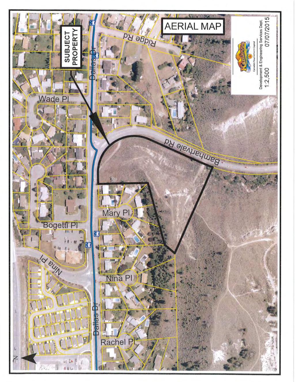
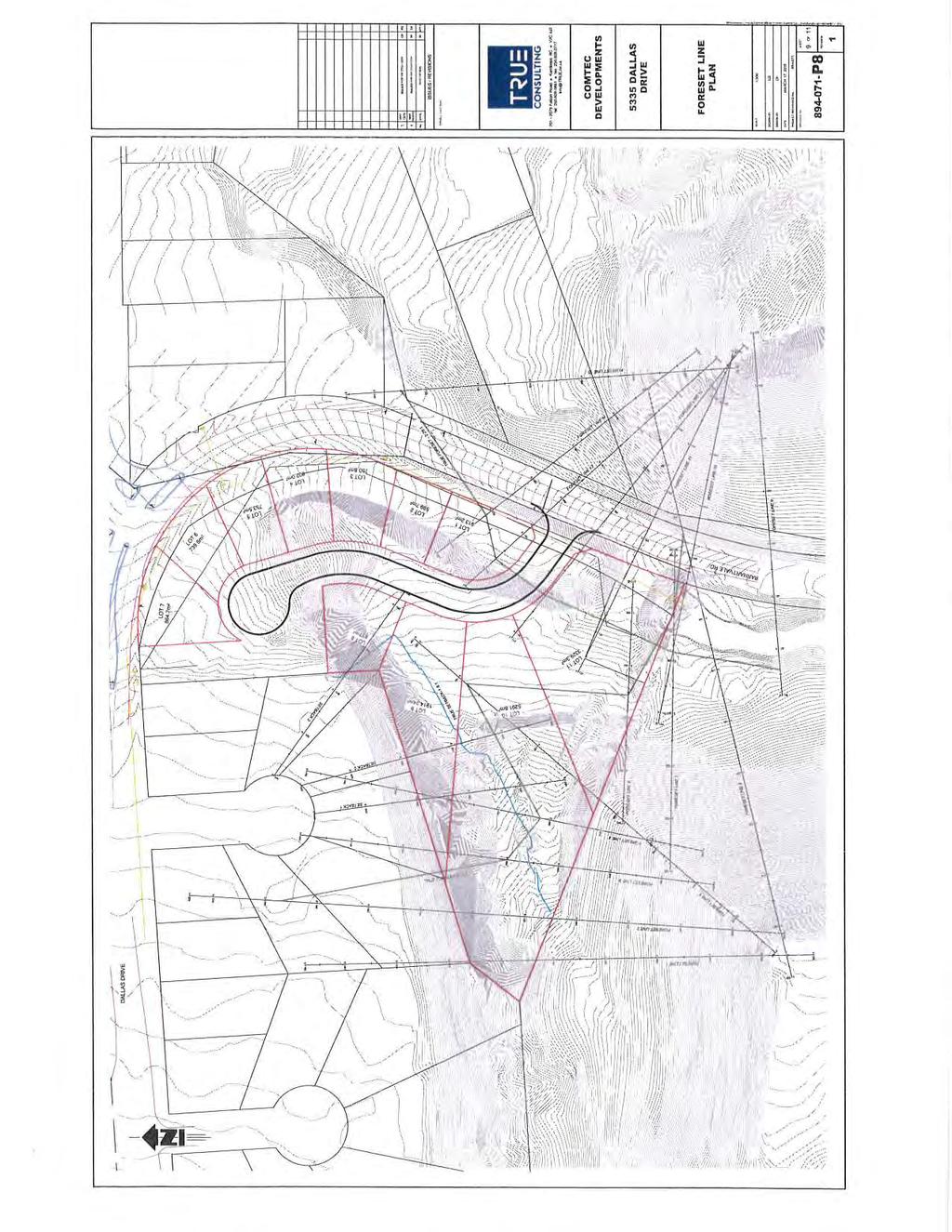
1 CITY OF KAMLOOPS OFFICIAL COMMUNITY PLAN AND ZONING BYLAW AMENDMENTS PUBLIC HEARING NOTICE The Council of the City of Kamloops hereby gives notice that it will hold a Public Hearing: TIME: PLACE: July 28, 2015, at 7:00 pm City Hall Council Chambers (7 Victoria Street West, Kamloops, BC) to consider the following proposed amendments to KAMPLAN: The Official Community Plan (Bylaw No ) (OCP) and City of Kamloops Zoning Bylaw No : 1. Location: 5335 Dallas Drive, as shown on the following map: S:\DCS\223305_PH Combined_NOT.docx 194
2 OFFICIAL COMMUNITY PLAN AMENDMENT AND ZONING BYLAW AMENDMENTS PAGE 2 Purpose: To permit an 11-lot (22-unit) subdivision by: Bylaw No Bylaw No Bylaw No Bylaw No Bylaw No Bylaw No Bylaw No a) Amending KAMPLAN: The Official Community Plan (Bylaw No ) to adjust the Red Zone boundary within the Official Community Plan South Thompson Silt Bluff Red Zone Development Permit Area map; and b) Rezoning the subject property from P-2 (Churches) and RS-2 (Single Family Residential-2) to RT-2 (Two Family Residential-2) and OS (Open Space). 2. To amend the Zoning Bylaw to limit the location of retail liquor sales within 1 km from another retail liquor sales use. 3. To amend the Zoning Bylaw to provide direction on setbacks for utility installations. 4. To amend the Zoning Bylaw to permit 15% of the required parking spaces in a townhouse and/or a bareland strata residential development to be in a stacked configuration. 5. To amend the Zoning Bylaw to remove the residential parking requirement for multiple family dwelling units in the C 1 (General Commercial) and C-6 (Arterial Commercial) zones and replace them with the general parking requirements for multiple family residential. 6. To amend the Zoning Bylaw to permit gravel-surfaced outdoor storage areas in industrial zones provided dust-control measures are applied and sediment erosion control measures are included in the design. A copy of the proposed amendments to KAMPLAN: The Official Community Plan (Bylaw No ) and City of Kamloops Zoning Bylaw No may be inspected at the Legislative Services Division, City Hall, 7 Victoria Street West, Monday to Friday (excluding statutory holidays), between 8:00 am and 4:00 pm. City Hall is located on the following transit routes: No. 1 - Tranquille, No. 2 - Parkcrest, and No. 3 - Westsyde. For schedule and route information, please visit All persons who consider themselves affected by the adoption of the proposed amendment to KAMPLAN: The Official Community Plan (Bylaw No ) and City of Kamloops Zoning Bylaw No and wish to register an opinion may do so by: 1. Appearing before Council at the said Public Hearing; and/or 2. Forwarding written submissions for Council consideration to the attention of the Legislative Services Division by mail to 7 Victoria Street West, Kamloops, BC, V2C 1A2; by fax to ; or by to legislate@kamloops.ca no later than 3:30 pm the Monday prior to the Public Hearing. For more information on this process, call S:\DCS\223305_PH Combined_NOT.docx 195
3 OFFICIAL COMMUNITY PLAN AMENDMENT AND ZONING BYLAW AMENDMENTS PAGE 3 For further information concerning the proposed amendment or for the Development and Engineering Services Department's report to Council, please contact the Planning and Development Division at or visit our website at: Dated July 15, 2015 C. M. Kennedy, CMC Corporate Officer S:\DCS\223305_PH Combined_NOT.docx 196
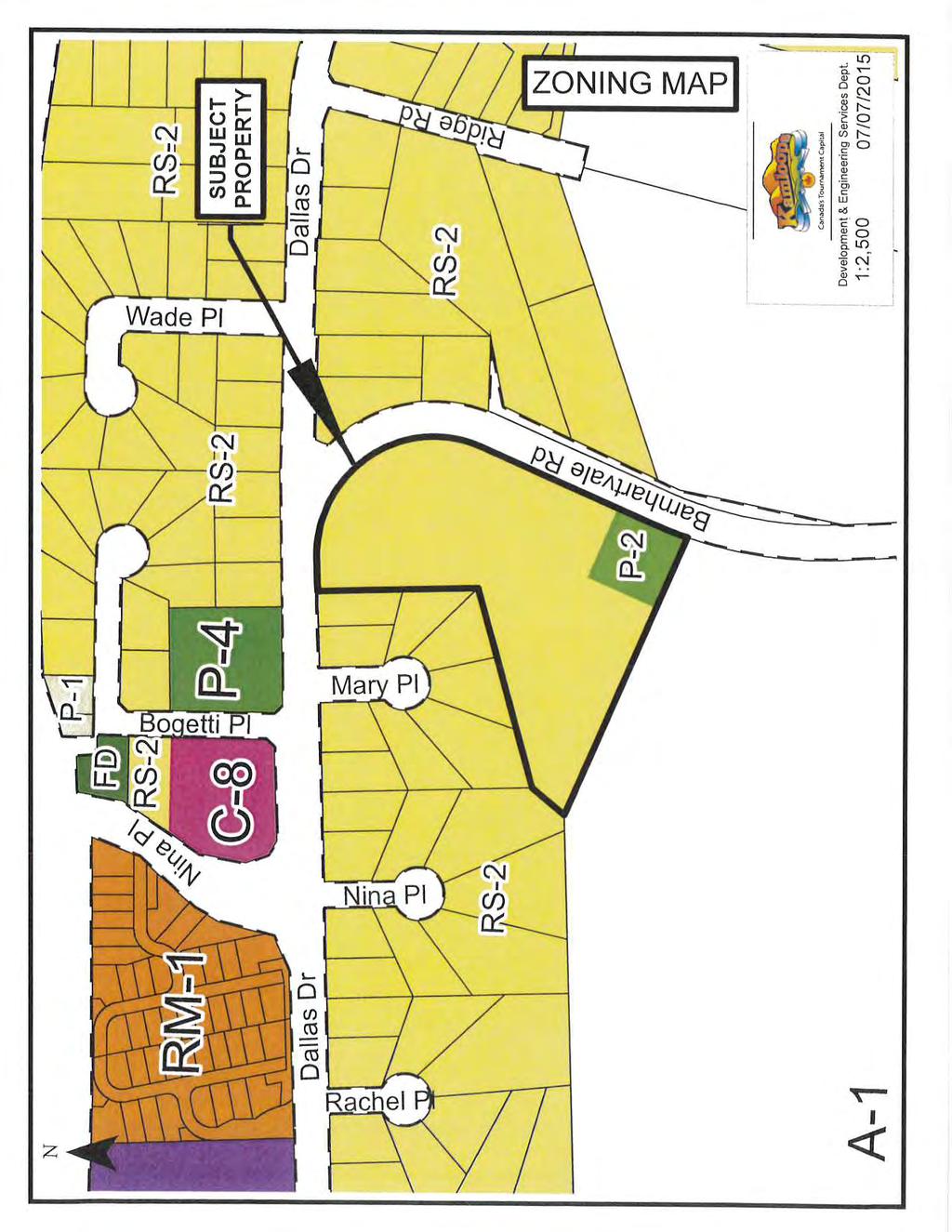
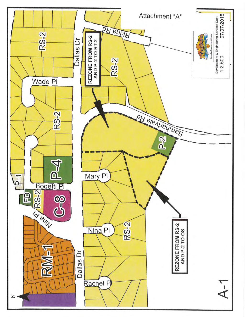
4 REPORT TO THE CHIEF ADMINISTRATIVE OFFICER FROM THE DEVELOPMENT AND ENGINEERING SERVICES DEPARTMENT ON OFFICIAL COMMUNITY PLAN AMENDMENT APPLICATION NO. OCP00102 REZONING APPLICATION NO. REZ00550 DEVELOPMENT PERMIT APPLICATION NO. DPM00519 DEVELOPMENT VARIANCE APPLICATION NO. DVP DALLAS DRIVE OWNER/APPLICANT: COMTEC DEVELOPMENT LTD. July 10, 2015 PURPOSE To rezone the subject property from P-2 (Churches) and RS-2 (Single Family Residential-2) to RT-2 (Two Family Residential-2) and OS (Open Space), amend KAMPLAN: The Official Community Plan (OCP) to adjust the boundary of the Red Zone within the South Thompson Silt Bluffs Red Zone Development Permit Area, issue a Development Permit for development in the South Thompson Silt Bluffs Red Zone Development Permit Area, and issue a Development Variance Permit to reduce minimum front yard setbacks from 6 m to 3 m (excluding garages) to allow an 11-lot (22-unit) subdivision. SUMMARY The subject property is located at the southwest corner of Barnhartvale Road and Dallas Drive in Dallas. The property is just over 2 ha in area; zoned P-2 and RS-2; and surrounded by single-family residential subdivisions to the north, east, and west, and by undeveloped hillside to the south. The property is located within the South Thompson Silt Bluffs Red Zone Development Permit Area, and is currently undeveloped. The applicant has applied to rezone the property to RT-2 and OS. The applicant has also applied for a Development Permit to allow an 11-lot (22-unit) subdivision within the silt bluffs hazard area and for a Development Variance Permit to reduce front yard setbacks within the subdivision. It should be noted that an OCP amendment is required to adjust the Red Zone boundary, as identified in the South Thompson Silt Bluffs Red Zone Development Permit Area. The property is designated Suburban in the OCP, which considers two-family residential development to be an appropriate land use in Suburban-designated areas, subject to individual evaluation that addresses issues such as municipal servicing. As the subject property is fully serviced and is located on a transit route and near amenities, staff are of the opinion that the site is an appropriate location for a duplex subdivision, provided that geotechnical concerns associated with the silt bluffs are adequately addressed. To preserve the natural aesthetic value and slope stability of the south and southwest portion of the property, staff recommend rezoning these areas to OS, while rezoning the rest of the property to RT-2 (Attachment "A"). T:\DES\PLAN & DEV\REP\2015\219119_OCP00102 REZ00550 DPM00519 DVP00455_REP\219119_OCP00102 REZ00550 DPM00519 DVP00455_REP.docx 197
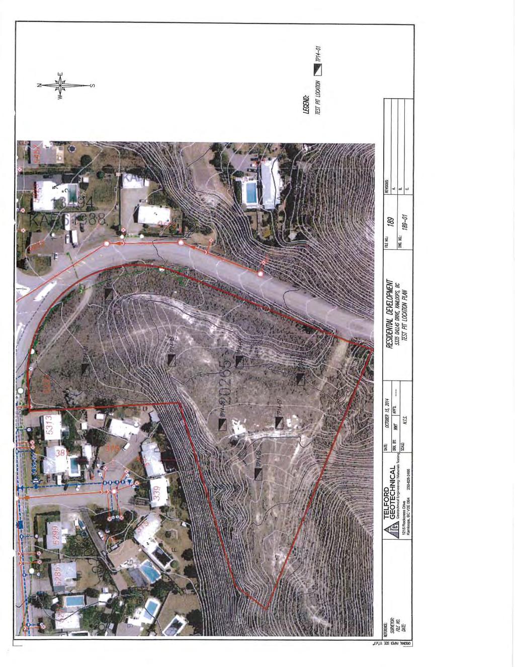
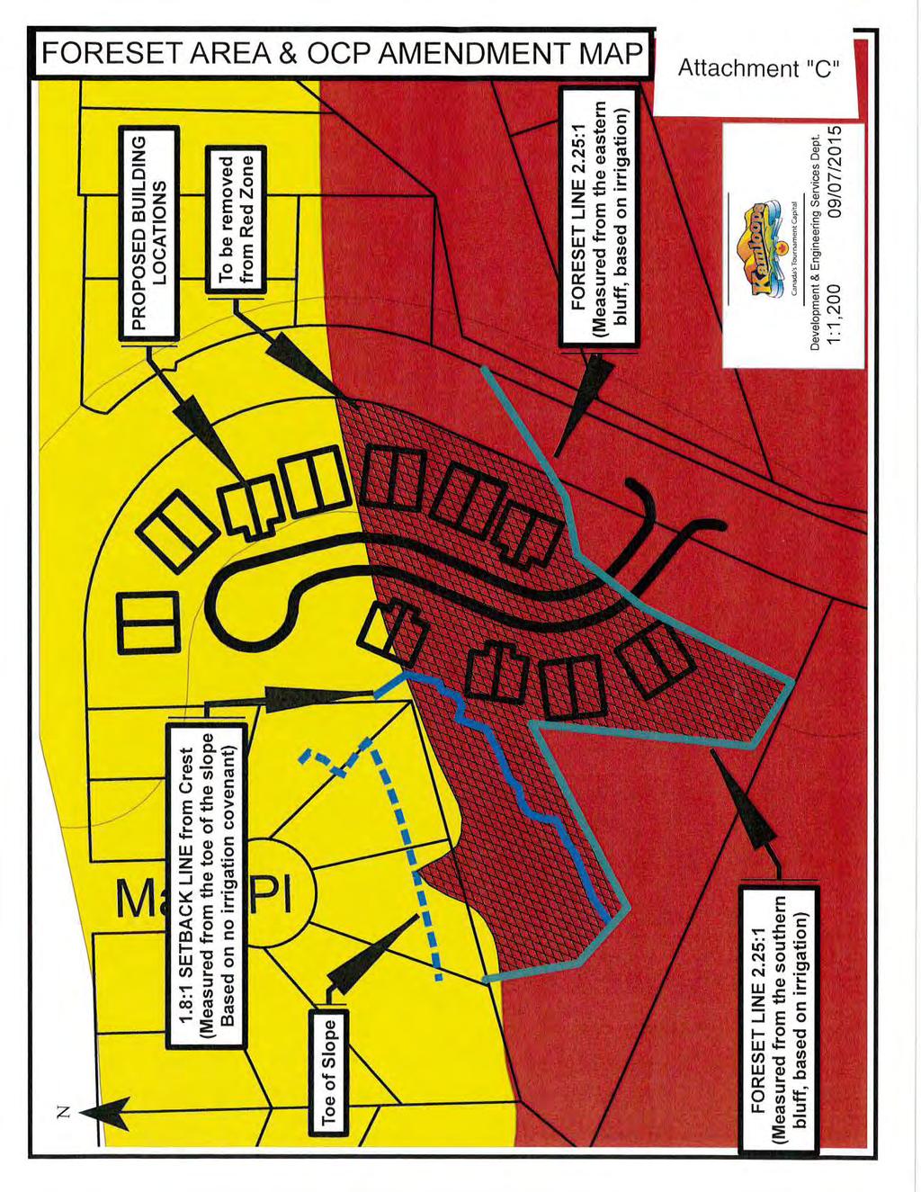
5 OFFICIAL COMMUNITY PLAN AMENDMENT APPLICATION NO. OCP00102 July 10, 2015 REZONING APPLICATION NO. REZ00550 Page 2 DEVELOPMENT PERMIT APPLICATION NO. DPM00519 DEVELOPMENT VARIANCE APPLICATION NO. DVP00455 The City's South Thompson Silt Bluffs Red Zone Development Permit Area Guidelines state that no development shall be permitted in the area designated as the Red Zone (Attachment "C" - Foreset Area and OCP Amendment Map), and any development in the foreset zone must be accompanied by a geotechnical report that addresses site conditions and recommends measures to eliminate or accommodate potential hazards. The original intent of the South Thompson Silt Bluffs Red Zone Development Permit Area Guidelines was to identify areas where there could be a hazard to development. As a result, general boundaries were established to identify these hazard areas; however, these boundaries can be adjusted when accompanied by professional geotechnical engineer report. In this case, the application is accompanied by a report and report addendum by Telford Geotechnical (Attachment "B"), which addresses these issues. While KAMPLAN designates much of the property as Red Zone, the report shows that a portion of the subject property may be removed from the Red Zone and defines a buildable area outside the defined foreset and setback areas. The report provides background information on soil and groundwater and recommends implementation of a covenant restricting irrigation use and saving the City harmless. Subject to this covenant, staff support the issuance of a Silt Bluff Development Permit in accordance with Attachment "B". In addition to the aforementioned rezoning and Silt Bluff Development Permit applications, the applicant has submitted a Development Variance Permit application to reduce front yard setbacks in the subdivision from 6 m to 3 m (except for garages). Staff support this variance, in accordance with Attachment "D", as it helps to foster a more street-oriented feel to the development and facilitates increased setback between the homes in the development and the neighbouring properties to the west. In conclusion, the rezoning, Silt Bluff Development Permit, and Development Variance Permit applications are consistent with the principles of KAMPLAN and the Sustainable Kamloops Plan (SKP). As the Public Hearing process provides an opportunity for members of the public to express their views, staff support the applications and advise Council to proceed as outlined in the recommendation. RECOMMENDATION: That Council authorize: a) A Public Hearing for Lot A, Sec. 5, Twp. 20, Rge. 16, W6M, K.D.Y.D., Plan 20625, Except Plans 20582, 22082, and (5335 Dallas Drive), to consider the following: i) amending KAMPLAN: The Official Community Plan, Schedule 1, Development Permit Areas, Section 1.6, South Thompson Silt Bluffs Red Zone Development Permit Area, Map, in accordance with Attachment "C"; and ii) rezoning the subject property from P-2 (Churches) and RS-2 (Single Family Residential-2) to RT-2 (Two Family Residential-2) and OS (Open Space), in accordance with Attachment "A"; T:\DES\PLAN & DEV\REP\2015\219119_OCP00102 REZ00550 DPM00519 DVP00455_REP\219119_OCP00102 REZ00550 DPM00519 DVP00455_REP.docx 198
6 OFFICIAL COMMUNITY PLAN AMENDMENT APPLICATION NO. OCP00102 July 10, 2015 REZONING APPLICATION NO. REZ00550 Page 3 DEVELOPMENT PERMIT APPLICATION NO. DPM00519 DEVELOPMENT VARIANCE APPLICATION NO. DVP00455 Note: The above noted rezoning application will be held at third reading pending approval of the bylaw by the Ministry of Transportation and Infrastructure. b) Subject to rezoning approval, issuance of a Silt Bluff Development Permit for Lot A, Sec. 5, Twp. 20, Rge. 16, W6M, K.D.Y.D., Plan 20625, Except Plans 20582, 22082, and (5335 Dallas Drive), in accordance with the Geotechnical Report identified as Attachment "B"; and Note: Issuance of the above noted Development Permit will be conditional on registration of a restrictive covenant defining no-build and no-irrigation areas on the subject property and saving the City harmless. c) Authorization of distribution of Notice of Intent to issue a Development Variance Permit for Lot A, Sec. 5, Twp. 20, Rge. 16, W6M, K.D.Y.D., Plan 20625, Except Plans 20582, 22082, (5335 Dallas Drive), to vary Zoning Bylaw No , Division Twenty-Five, RT-2 (Two Family Residential-2), Section 2503, Regulations, by reducing the front yard setback for the principle dwelling on all lots from 6 m to 3 m, excluding garages, in accordance with Attachment "D". Note: Approval of the above noted Development Variance Permit will be conditional on a restrictive covenant: Restricting driveway widths to 6 m per half-duplex and requiring that the remainder of front yards be treated with soft landscaping; and Requiring a minimum 9 m rear yard setback for the principal dwelling on any lots directly adjacent to existing residential zoned properties. COUNCIL POLICY KAMPLAN, Section III, Neighbourhoods, item 1.6.2, states that two-family residential development may be appropriate in Suburban designated areas, subject to municipal servicing. KAMPLAN, Section VII, Environment, item 3.3 states that the Valleyview silt bluffs (hazard lands) are subject to Development Permit guidelines. KAMPLAN Schedule 1 - Development Permit Areas contains the South Thompson Silt Bluffs Red Zone Development Permit Area Guidelines. T:\DES\PLAN & DEV\REP\2015\219119_OCP00102 REZ00550 DPM00519 DVP00455_REP\219119_OCP00102 REZ00550 DPM00519 DVP00455_REP.docx 199
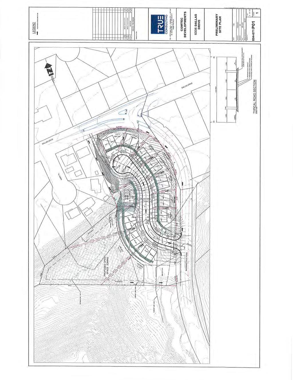
7 OFFICIAL COMMUNITY PLAN AMENDMENT APPLICATION NO. OCP00102 July 10, 2015 REZONING APPLICATION NO. REZ00550 Page 4 DEVELOPMENT PERMIT APPLICATION NO. DPM00519 DEVELOPMENT VARIANCE APPLICATION NO. DVP00455 SITE CONDITIONS AND BACKGROUND Neighbourhood - Dallas KAMPLAN Designation - Suburban Current Zoning/Use - RS-2 (Single Family Residential-2) and P-2 (Churches)/Vacant land Proposed Zoning/Use RT-2 (Two Family Residential-2) and OS (Open Space)/duplex subdivision Proposed Variance - Reduce front yard setback on all lots from 6 m to 3 m, excluding garages. Surrounding Uses - Single-family to the north, east, and west; undeveloped hillside to the south. Application Date - January 21, 2015 Restrictive Covenants - No-build, irrigation, and save harmless covenant required; rear yard setback, maximum driveway width and landscaping covenant also required. Project Evaluation Team (PET) - February 6, 2015 Parcel Size ha MOTI Referral - MOTI approval required DISCUSSION Land Use The property is designated Suburban in KAMPLAN, which considers two-family residential development to be an appropriate land use in Suburban-designated areas, subject to individual evaluation addressing issues including municipal servicing. While Suburban-designated areas are typically not fully serviced, the subject property is fully serviced by municipal water, sanitary sewer, and storm sewer services. The property is also situated on a transit route, approximately 95 m from the closest transit stop on Dallas Drive. In terms of amenities, the property is located approximately 660 m from the Dallas Town Centre, 585 m from Dallas Elementary School, and just under 1 km from Dallas Park. As the property is located in proximity to transportation options and amenities, staff are of the opinion the site is an appropriate location for a duplex subdivision, provided geotechnical concerns are adequately addressed. To preserve the natural aesthetic value and slope stability of the south and southwest portions of the property, staff recommend rezoning this area to OS, while rezoning the rest of the property to RT-2 (Attachment "A"). Traffic and Transportation Considerations The proposed subdivision will be accessed from Barnhartvale Road, near the southern end of the property. This access point is supported by a traffic analysis by DC Dean Associates Inc. as it maximizes available sight distances. The analysis demonstrates that minimum stopping distances are available to all drivers at all times, but that decision sight distance cannot be met. To mitigate the lack of decision sight distances, the report recommends erecting a sign to advise northbound traffic of the new intersection. As the access point is located at the end of a transition from a posted speed limit of 60 km/h to 50 km/h, the report also recommends relocating the 50 km/h section further south to remind motorists to reduce their speed. T:\DES\PLAN & DEV\REP\2015\219119_OCP00102 REZ00550 DPM00519 DVP00455_REP\219119_OCP00102 REZ00550 DPM00519 DVP00455_REP.docx 200
8 OFFICIAL COMMUNITY PLAN AMENDMENT APPLICATION NO. OCP00102 July 10, 2015 REZONING APPLICATION NO. REZ00550 Page 5 DEVELOPMENT PERMIT APPLICATION NO. DPM00519 DEVELOPMENT VARIANCE APPLICATION NO. DVP00455 The traffic analysis also recommends adding a pedestrian connection between the proposed cul-de-sac and Dallas Drive to facilitate access from the proposed development to the commercial areas to the west. The proposed subdivision includes a 3 m wide walkway, located east of Lot 7, which provides this pedestrian connectivity. Staff will also require additional road dedication along Dallas Drive and Barnhartvale Road through the subdivision process to accommodate a future pedestrian corridor along Barnhartvale Road. Upon referral, the Ministry of Transportation and Infrastructure (MOTI) did not identify any concerns with the amount of traffic generated from the development; however, the MOTI indicated its position that stormwater be collected by municipal infrastructure and no storm drainage shall be directed towards the Trans Canada Highway. Staff are of the opinion the development can be designed to achieve these goals. Silt Bluffs Development Permit The property is located within the South Thompson Silt Bluffs Red Zone Development Permit Area. The lower (northern) portion of the property is located within the silt bluffs foreset zone (also known as the yellow zone) and the upper (southern) portion of the property is located within the Red Zone (Attachment "C"- Foreset Area and OCP Amendment Map). The original intent of the South Thompson Silt Bluffs Red Zone Development Permit Area Guidelines was to identify areas where there could be a hazard to development. As a result, general boundaries were established to identify these hazard areas; however, these boundaries can be adjusted when accompanied by a professional geotechnical engineer report. The City's South Thompson Silt Bluffs Red Zone Development Permit Area Guidelines state that no development shall be permitted in the area designated as the Red Zone and that any development in the foreset zone must be accompanied by a geotechnical report by a qualified geotechnical engineer to address geology and groundwater, define hazard areas, and recommend specific criteria to eliminate or accommodate potential hazards. In this case, the application is accompanied by a report and addendum by Telford Geotechnical (Attachment "B"). The initial report was reviewed by the City's third-party geotechnical consultant, Golder and Associates (Golder), and staff are satisfied that the addendum provided by Telford Geotechnical effectively addresses Golder's concerns. The report defines a buildable area outside the defined foreset and setback areas and provides background information on soil and groundwater conditions. A geotechnical foreset is a no-build zone along the toe of silt benchland slope that is provided to address the escarpment landslide run-out geohazard. According to the report, the foreset area is defined by a 2.25-horizontal to 1-vertical slope projected from the benchlands located south of the property and east of Barnhartvale Road to the subject property. The 2.25:1 ratio is the standard foreset projection ratio used by the City for irrigated (or potentially irrigated) silt bluffs. By demonstrating that the proposed subdivision is outside of the 2.25:1 foreset area, the report effectively demonstrates that the boundary of the Red Zone, as defined by KAMPLAN, may be adjusted to include the proposed subdivision. Accordingly, staff support an OCP amendment to adjust the Red Zone boundary (Attachment "C"). T:\DES\PLAN & DEV\REP\2015\219119_OCP00102 REZ00550 DPM00519 DVP00455_REP\219119_OCP00102 REZ00550 DPM00519 DVP00455_REP.docx 201
9 OFFICIAL COMMUNITY PLAN AMENDMENT APPLICATION NO. OCP00102 July 10, 2015 REZONING APPLICATION NO. REZ00550 Page 6 DEVELOPMENT PERMIT APPLICATION NO. DPM00519 DEVELOPMENT VARIANCE APPLICATION NO. DVP00455 In geotechnical terms, a setback is the no-build zone along the crest of a benchland slope to help mitigate sinkhole hazards and the hazards of ground loss at slope crests in landslide events. In this instance, the report identifies a setback area projected from the toe of the slope (located at the rear of the residential properties along Mary Place) to the crest of the benchland slope located on the southwestern part of the subject property. This setback area is defined by a 1.8-horizontal to 1-vertical ratio from the toe of the slope to the crest, provided the irrigation restrictions identified are implemented (see below). According to the report, the geology of the area is defined as topsoil over colluvial silt deposits, then lacustrine silt or outwash pit run, gravel, and sand. Groundwater was not identified during the site investigation and the water table is expected to be well below proposed development grades. The report states the risk of landslide run-out hazard is low and the site may be safely used for the proposed development. Recommendations for site development identified in Attachment "B" include the following: Removal of topsoil and silts near underneath building footprints; Use of engineered fill for any grade reinstatement beneath the site; Compaction of any grading fills under floor slabs; A building setback measured as a 1.8-horizontal to 1-vertical ratio from the toe of the slope west of the property to the crest of the slope on the southwestern portion of the property; Irrigation restrictions as follows: - Proposed Lot 8 - no irrigation in the rear and side yards; - Proposed Lots 9 and 10 - xeriscaping (drip irrigation only) in rear and side yards and no irrigation in the natural ground area that is proposed to be zoned OS at the rear of these properties; and - Proposed Lot 11 - no irrigation in the natural ground area that is proposed to be zoned OS at the rear of this property. Standard irrigation practices would be acceptable on the remainder of the lot. To ensure that the property is safely developed, staff recommend the approval of the rezoning and Silt Bluff Development Permit applications be conditional upon registration of a restrictive covenant on the property mandating compliance with the setback and irrigation requirements identified in the report and saving the City harmless. Subject to this covenant, staff support issuance of a Silt Bluff Development Permit in accordance with Attachment "B". Site Layout and Development Variance Permit and Development Covenant The minimum front yard setback in the RT-2 zone is 6 m. While this setback is intended in part to provide front yard amenity space, it functions largely to provide room for vehicles to park in front yards and promote consistency with adjacent parcels with similar setbacks. In this instance, the applicant has submitted a Development Variance Permit application to reduce the front yard setback from 6 m to 3 m, except for garages, which must be set back 6 m to accommodate parked vehicles that would not project into the street (Attachment "D"). T:\DES\PLAN & DEV\REP\2015\219119_OCP00102 REZ00550 DPM00519 DVP00455_REP\219119_OCP00102 REZ00550 DPM00519 DVP00455_REP.docx 202

10 OFFICIAL COMMUNITY PLAN AMENDMENT APPLICATION NO. OCP00102 July 10, 2015 REZONING APPLICATION NO. REZ00550 Page 7 DEVELOPMENT PERMIT APPLICATION NO. DPM00519 DEVELOPMENT VARIANCE APPLICATION NO. DVP00455 Staff support this variance as it facilitates a more street-oriented look for the development, accommodates front-yard parking by maintaining a 6 m setback for garages, and does not impact the adjacent neighbourhood, since all lots will be located internally on a new road. To minimize the amount of impermeable surface in front yards, staff recommend that approval of the variance be conditional upon registration of a restrictive covenant requiring driveway widths to be restricted to a maximum of 6 m per half-duplex, with the remainder of the front yards to be soft landscaping. To reduce potential visual impacts of the development on adjacent residences on Mary Place to the west, staff recommend the covenant also require new homes to have a minimum 9 m rear yard setback from existing properties. Servicing and Technical Issues The development will be required to connect to municipal water, sanitary sewer, and storm drainage services on Dallas Drive. The developer will be responsible for providing a comprehensive servicing strategy and stormwater management plan for the development through the subdivision process. The subdivision will be built to a full urban standard, including curb and gutter, and street lights on one side of the street. The pedestrian walkway between the subdivision and Dallas Drive will be required to be fenced to City standards. SUSTAINABILITY IMPLICATIONS The SKP seeks to increase density of development by 25% by 2050 and to manage overall growth of the urban area to achieve a rate of growth that is 50% of the rate of population growth. The SKP also encourages an overall density of development in new neighbourhoods of 25 units/per ha. In this instance, the proposed density is approximately 19 units/ha once the proposed open space and right-of-way areas are excluded. While this figure is less than the recommended 25 units/ha in the SKP, staff are of the opinion the density is appropriate to accommodate sensitive integration into a suburban neighbourhood characterized by low density development on large lots. The SKP measures success with respect to the natural environment by protecting development from hazardous conditions through avoidance and/or acceptable mitigative measures. Through the use of setback restrictions, irrigation restrictions, and other measures identified in Attachment "B", the application supports this component of the SKP. M. Kwiatkowski, P.Eng. Development and Engineering Services Director Approved for Council Consideration: Author: S. Bentley, MCIP, RPP, Planner Reviewed by: E. Beach, MCIP, RPP, Planning and Development Supervisor SB/lm/ts/dla/kjm Attachments T:\DES\PLAN & DEV\REP\2015\219119_OCP00102 REZ00550 DPM00519 DVP00455_REP\219119_OCP00102 REZ00550 DPM00519 DVP00455_REP.docx 203
11 204
12 205
13 206
14 207
15 208
16 209
17 210
18 211
19 212
20 213
21 214
22 215
23 216
24 217
25 218
26 219
27 220
28 221
29 222
30 223
31 224
32 225
33 226
34 227
35 228
36 229
37 230
38 231
39 232
40 233
41 234
42 235
43 236
44 237
45 238
46 239
47 REPORT TO THE CHIEF ADMINISTRATIVE OFFICER FROM THE DEVELOPMENT AND ENGINEERING SERVICES DEPARTMENT ON ZONING BYLAW AMENDMENT NO. ZBA00083 HOUSEKEEPING AMENDMENTS TO ZONING BYLAW REGULATIONS July 9, 2015 PURPOSE To seek Council's authorization to amend Zoning Bylaw No to limit the location of retail liquor sales, provide direction on setbacks for utility installations, permit 15% of parking stalls to be in a stacked configuration in townhouse and or bareland strata developments, remove the residential parking requirement for multiple-family dwelling units in the C-1 (General Commercial) and C-6 (Arterial Commercial) zones, and permit gravel-surfaced storage areas in industrial zones. SUMMARY To address current land use planning concerns, reflect direction from Council, encourage administrative efficiency, and follow community trends, staff recommend the following amendments to Zoning Bylaw No to: Limit the location of retail liquor sales from another retail liquor sales use; Provide direction on setbacks for utility installations; Permit 15% of the required parking spaces in a townhouse and or a bareland strata residential development to be in a stacked configuration; Remove the residential parking requirement for multiple-family dwelling units in the C-1 (General Commercial) and C-6 (Arterial Commercial) zones and replace them with the general parking requirements for multiple-family residential; and Permit gravel-surfaced outdoor storage areas in industrial zones. As the Public Hearing process allows the community to provide input on the proposed amendments, staff support the noted changes and advise Council to proceed as outlined in the recommendation. T:\DES\PLAN & DEV\REP\2015\219302_ZBA00083_REP\219302_ZBA00083_REP.docx 240
48 ZONING BYLAW AMENDMENT NO. ZBA00083 July 9, 2015 HOUSEKEEPING AMENDMENTS TO ZONING BYLAW REGULATIONS Page 2 RECOMMENDATION: That Council authorize a Public Hearing to consider amending Zoning Bylaw No as follows: a) Division Three, General Regulations, by inserting: "311B RETAIL LIQUOR SALES No retail liquor sales may occur within 1 km of another retail liquor sales use (as measured in a straight line from the primary retail entrance to the primary retail entrance)." b) Division Thirty-Five, CBD (Central Business District), Section 3501, Permitted Uses, by adding the following: "- Retail liquor sales (subject to Division Three, Section 311B)"; c) Division Thirty-Six, C-1T (Tranquille Road Commercial), Section 3601, Permitted Uses, by adding the following: "- Retail liquor sales (subject to Division Three, Section 311B)"; d) Division Thirty-Seven, C-1 (General Commercial), Section 3701, Permitted Uses, by adding the following: "- Retail liquor sales (subject to Division Three, Section 311B)"; e) Division Forty-Two, C-5 (Shopping Centre Commercial), Section 4201, Permitted Uses, by adding the following: "- Retail liquor sales (subject to Division Three, Section 311B)"; f) Division Forty-Five, C-8 (Neighbourhood Pub Commercial), Section 4501, Permitted Uses, by adding the following: "- Retail liquor sales (subject to Division Three, Section 311B)"; T:\DES\PLAN & DEV\REP\2015\219302_ZBA00083_REP\219302_ZBA00083_REP.docx 241
49 ZONING BYLAW AMENDMENT NO. ZBA00083 July 9, 2015 HOUSEKEEPING AMENDMENTS TO ZONING BYLAW REGULATIONS Page 3 g) Division Three, General Regulations, Section 303, Utility Installations/Public Open Space, by deleting: "Notwithstanding the provisions of this bylaw and the Subdivision Control Bylaw, the minimum area and width of lots used for public open spaces or utility installations, such as a booster station, natural gas facility, hydroelectric outlet, transmission tower, smokestack or storm water detention pond, may be less than required in these bylaws. Utility installations shall be permitted in all zones." and replacing it with: "Utility installations shall be permitted in all zones. Notwithstanding the provisions of this bylaw and the Subdivision Control Bylaw, the minimum area and width of lots used for public open spaces or utility installations, such as a booster station, natural gas facility, hydroelectric outlet, transmission tower, smokestack, or stormwater detention pond, may be less than required in these bylaws. All utility installations setback requirements may be less than required in these bylaws unless the land the utility is located upon is directly adjacent to a residentially zoned property, and the utility is >5 m², in which case the utility must adhere to the setbacks of the adjacent residential zone."; h) Division Fifty-Two, Off-Street Parking, Section 5209, Parking Site Specifications, by deleting, "2. Every off-street parking space shall: b) be constructed so as to permit unobstructed access to and egress from each space at all times" and replacing it with: "2. Every off-street parking space shall: b) be constructed so as to permit unobstructed access to and egress from each space at all times, except in the case of townhouse and bareland strata developments, in which case not more than 15% of the required parking spaces shall be provided through a stacked parking configuration, and not more than one of the two stacked parking spaces shall be enclosed"; T:\DES\PLAN & DEV\REP\2015\219302_ZBA00083_REP\219302_ZBA00083_REP.docx 242
50 ZONING BYLAW AMENDMENT NO. ZBA00083 July 9, 2015 HOUSEKEEPING AMENDMENTS TO ZONING BYLAW REGULATIONS Page 4 i) Division Thirty-Seven, C-1 (General Commercial) Section 3704, Dwelling Units/Special Conditions, by deleting: "iii) a minimum of two parking stalls shall be provided for each dwelling unit."; j) Division Forty-Three, C-6 (Arterial Commercial) Section 4305, Dwelling Units/Special Conditions, by deleting: "iii) a minimum of two parking stalls shall be provided for each dwelling unit."; k) Division Forty-Six, I-1 (Light Industrial) Section 4606, Outdoor Storage, by deleting: "- Outdoor storage and circulation areas for vehicles, except areas for tracked industrial equipment, shall be hard surfaced with asphalt or concrete." and replacing it with: "- Circulation and required parking areas for vehicles shall be hard surfaced with asphalt or concrete. Areas for tracked industrial equipment and outdoor storage may be surfaced with compacted crushed gravel provided proper dustcontrol measures, limited to magnesium chloride or equivalent, are applied to the gravel surface. Permanent sediment erosion infrastructure, such as landscaping, settlement ponds or equivalent infrastructure, shall be included in the outdoor storage area design."; l) Division Forty-Seven, I-1S (Industrial Park), Section 4706, Outdoor Storage/Display Areas, by deleting: "- Outdoor storage areas shall be graded and hard surfaced with asphalt or concrete, except those outdoor storage areas for tracked industrial equipment." and replacing it with: "- Circulation and required parking areas for vehicles shall be hard surfaced with asphalt or concrete. Areas for tracked industrial equipment and outdoor storage may be surfaced with compacted crushed gravel provided proper dust-control measures, limited to magnesium chloride or equivalent, are applied to the gravel surface. Permanent sediment erosion infrastructure, such as landscaping, settlement ponds or equivalent, shall be included in the outdoor storage area design." T:\DES\PLAN & DEV\REP\2015\219302_ZBA00083_REP\219302_ZBA00083_REP.docx 243
51 ZONING BYLAW AMENDMENT NO. ZBA00083 July 9, 2015 HOUSEKEEPING AMENDMENTS TO ZONING BYLAW REGULATIONS Page 5 m) Division Forty-Eight, I-2 (General Industrial) Section 4805, Outdoor Storage, by deleting: "- Outdoor storage and circulation areas for vehicles, except areas for tracked industrial equipment, shall be hard surfaced with asphalt or concrete." and replacing it with: "- Circulation and required parking areas for vehicles shall be hard surfaced with asphalt or concrete. Areas for tracked industrial equipment and outdoor storage may be surfaced with compacted crushed gravel provided proper dustcontrol measures, limited to magnesium chloride or equivalent, are applied to the gravel surface. Permanent sediment erosion infrastructure, such as landscaping, settlement ponds or equivalent infrastructure, shall be included in the outdoor storage area design." DISCUSSION 1. Limit the location of retail liquor sales from another retail liquor sales use. On June 2, 2015, Council passed a motion regarding distance parameters for retail liquor sales. This motion was the result of a recent provincial legislation amendment in which the province is proposing to remove the previous 1 km restriction on wine stores. As a result, Council passed the motion "that the Zoning Bylaw be amended to institute a distance parameter of 1 km for future Liquor Licences and stores". As a result, a 1 km distance rule is required to be incorporated to regulate the location of retail liquor sales into the Zoning Bylaw. Currently, retail liquor sales are permitted in the CBD (Central Business District), C-1T (Tranquille Road Commercial), C-1 (General Commercial), C-5 (Shopping Centre Commercial), and C-8 (Neighbourhood Pub Commercial) zones. The term "retail liquor sales" is defined as: A business where the principal business is the retail sale of beer, wine, and other liquor products for consumption off site. Retail liquor sales includes provincially operated liquor stores licensed under the Liquor Distribution Act, as well as Licensee Retail Stores and off-site retail wine stores such as Vintners Quality Assurance (VQA) Stores licensed under the Liquor Control and Licensing Act and Regulations. T:\DES\PLAN & DEV\REP\2015\219302_ZBA00083_REP\219302_ZBA00083_REP.docx 244
52 ZONING BYLAW AMENDMENT NO. ZBA00083 July 9, 2015 HOUSEKEEPING AMENDMENTS TO ZONING BYLAW REGULATIONS Page 6 Incorporating the 1 km restriction requires a suitable measuring parameter. As such, staff propose measuring in a straight line from primary entrance to primary entrance rather than from property line to property line. The primary entrance location is better suited as some shopping centre parcels can be large and measuring from property lines would be seen as restrictive; therefore, staff recommend incorporating the following wording into the Zoning Bylaw: "no retail liquor sales may occur within 1 km of another retail liquor sales use (measured in a straight line from the primary retail entrance to the primary retail entrance)." 2. Provide direction on setbacks for utility installations. Utility installations, such as booster stations, transmission towers, or stormwater detention ponds, are permitted in all zones under the Zoning Bylaw. Utility installations may occur on lots that do not meet the minimum area or width of the zone. Currently, the bylaw provides no direction on the setbacks to which a utility installation must adhere; therefore, staff recommend incorporating parameters for the siting of utility installations into the Zoning Bylaw. Staff are of the opinion that all utility installations do not have to meet the zone's setback requirements unless the property is directly adjacent to residentially zoned property. Typically, most utilities are small scale, such as hydro boxes, and are not considered to have a significant impact on livability. Staff would like to ensure that if a utility installation of a larger scale, such as a booster station, is built beside a residentially zoned property, the utility must follow the setbacks of the zone adjacent to which it is located in order to create adequate separation from a residential property. In all other zoned areas, staff are recommending the utility installations do not need to meet the minimum setback requirements. 3. Permit 15% of the required parking spaces in a townhouse multiple-family residential development to be in a stacked configuration. Multiple-family developments are required to meet the Zoning Bylaw regulations for the number of parking spaces required. The Zoning Bylaw requires that every parking space be constructed so as to permit unobstructed access to and egress from each space at all times. The Development and Engineering Services Department's current 1993 departmental policy is to permit up to 15% of the required parking spaces to be provided through a stacked parking configuration for multiple-family residential developments where each unit is assigned two parking spaces immediately adjacent to the unit (e.g., a townhouse development or a bareland strata). As a result, staff have recommended a variance to Council to permit this parking configuration for a number of developments. The department's current policy indicates: Stacked parking will not be permitted for an apartment, commercial, industrial, or institutional development; Where stacked parking is permitted, not more than 15% of the required parking spaces shall be provided through stacked parking; and Not more than one of the two stacked parking spaces shall be enclosed (i.e., there can be one parking space in the garage). T:\DES\PLAN & DEV\REP\2015\219302_ZBA00083_REP\219302_ZBA00083_REP.docx 245
53 ZONING BYLAW AMENDMENT NO. ZBA00083 July 9, 2015 HOUSEKEEPING AMENDMENTS TO ZONING BYLAW REGULATIONS Page 7 This approach provides a flexible alternative to meet the required parking spaces for a development. A stacked parking configuration is typically found on all single- and two-family residential developments, where vehicles are parked in the driveway behind a garage. Similar rationale can be applied to a townhouse and or bareland strata development, which typically have driveways in front of the garage for the individual units. As a result, staff recommend that this stacked parking approach be incorporated into the Zoning Bylaw regulations for off-street parking for townhouse and bareland strata multiple-family developments only. 4. Remove the residential parking requirement for multiple-family dwelling units in the C-1 (General Commercial) and C-6 (Arterial Commercial) zones and replace them with the general parking requirements for multiple-family residential. The C-1 and C-6 zones contain a special condition that requires the permitted multiple-family dwelling units to provide a minimum of two parking stalls for each dwelling unit. This regulation is in conflict with the current multiple-family residential requirements that are based on the number of bedrooms in a dwelling unit. As a result, staff recommend eliminating this special condition in these particular zones and replacing the parking requirement with the standard bedroom count requirement for a multiple-family development (0.85 spaces per bachelor unit; 1.1 spaces per 1-bedroom unit, 1.6 spaces per 2-bedroom unit; 2.15 spaces per 3- or more bedroom units; and an additional 15% for designated visitor parking). This amendment is to provide a consistent approach on applying parking requirements for dwelling units in these zones. 5. Permit gravel surfaced outdoor storage areas in industrial zones. Under the I-1 (Light Industrial), I-1S (Industrial Park), and I-2 (General Industrial) zones, the Zoning Bylaw stipulates that outdoor storage and circulation areas for vehicles, except for tracked industrial equipment, shall be hard surfaced with asphalt or concrete. Staff have seen a number of requests from developers to vary this particular regulation due to the economic cost of surfacing large areas of land with asphalt or concrete to store non-tracked equipment or construction/building materials on site. Staff have consistently supported varying this regulation to permit outdoor storage areas to be surfaced with gravel, subject to dust-control measures such as applying magnesium chloride onto the gravel areas. Staff's rationale for supporting such variances includes the benefits of reducing urban heat islands and facilitating in-ground infiltration of stormwater. The permeable surface facilitates infiltration and absorption of the stormwater rather than increase the amount of stormwater that would otherwise be collected from these large paved outdoor storage areas and subsequently discharged into a stormwater system. Best storm water management practices for permeable surfaces areas is to add on site permanent sediment erosion infrastructure such as the use of landscaping or settlement ponds to collect and filter storm water onsite. The Sustainable Kamloops Plan (SKP) encourages the benefits of water infiltration that filters contaminants from the water, replenishes soil moisture, and recharges groundwater aquifers. As a result, implementing measures such as non-paved large outdoor storage areas, where achievable, will help promote the goals of the SKP. T:\DES\PLAN & DEV\REP\2015\219302_ZBA00083_REP\219302_ZBA00083_REP.docx 246

54 ZONING BYLAW AMENDMENT NO. ZBA00083 July 9, 2015 HOUSEKEEPING AMENDMENTS TO ZONING BYLAW REGULATIONS Page 8 Where variance requests are made, staff have required these developments to ensure that all circulation areas, required parking areas, and access points of the developments are surfaced with asphalt or equivalent. This is needed to ensure gravel is not tracked on to City streets and that dust will not impact the area from vehicle circulation. Further, from an aesthetic perspective, the paved areas create a clean-looking industrial development from the adjacent streets and provide order to the parking areas (i.e., delineated parking stalls). Typically, the storage areas occur in the rear of a development so the gravel appearance will be hidden from the public realm. Past practice has been to screen the outdoor storage area should they front a street, as this is a requirement of the Development Permit Guidelines. As a result, staff recommend that within the I-1, I-1S, and I-2 zones, outdoor storage areas may be surfaced with crushed gravel provided proper dust-control measures, limited to magnesium chloride or equivalent, are applied to the gravel-surfaced areas. Further incorporation of sediment erosion control measures shall be included in the outdoor storage area design. In conclusion, staff believe the above noted changes to the City's Zoning Bylaw adequately address current land use planning concerns, encourage administrative efficiency, and reflect Council direction. As the Public Hearing process allows the community to provide input on the proposed amendments, staff support the noted changes and advise Council to proceed as outlined in the recommendation. M. Kwiatkowski, P.Eng Development and Engineering Services Director Approved for Council Consideration: Author: E. Beach, MCIP, RPP, Planning and Development Supervisor Reviewed by: R. L. Lambright, MCIP, RPP, Planning and Development Manager EB/lm/ts/kjm T:\DES\PLAN & DEV\REP\2015\219302_ZBA00083_REP\219302_ZBA00083_REP.docx 247
CITY OF KAMLOOPS BYLAW NO A BYLAW TO AMEND THE ZONING BYLAW OF THE CITY OF KAMLOOPS
 67 68 CITY OF KAMLOOPS BYLAW NO. 5-1-2796 A BYLAW TO AMEND THE ZONING BYLAW OF THE CITY OF KAMLOOPS The Municipal Council of the City of Kamloops, in open meeting assembled, enacts as follows: 1. This
CITY OF KAMLOOPS ZONING BYLAW AMENDMENTS PUBLIC HEARING NOTICE
 CITY OF KAMLOOPS ZONING BYLAW AMENDMENTS PUBLIC HEARING NOTICE The Council of the City of Kamloops hereby gives notice that it will hold a Public Hearing: TIME: PLACE: July 29, 2014, at 7:00 pm City Hall
Property Location: 2970 Bank Road
 When? Where? Why? Tuesday, May 29, 2018, 7:00 pm Council Chambers, City Hall, 7 Victoria Street West Kamloops City Council will hold a Public Hearing to consider the following proposed amendments to City
Contact the Planning and Development Division at or access relevant background material available at
 When? Where? Why? Tuesday, January 12, 2016, 1:30 pm Council Chambers, City Hall, 7 Victoria Street West Kamloops City Council will be considering a resolution to issue a Development Variance Permit. Property
REPORT TO THE CHIEF ADMINISTRATIVE OFFICER FROM THE DEVELOPMENT AND ENGINEERING SERVICES DEPARTMENT
 November 2, 2016 REPORT TO THE CHIEF ADMINISTRATIVE OFFICER FROM THE DEVELOPMENT AND ENGINEERING SERVICES DEPARTMENT ON DEVELOPMENT PERMIT APPLICATION NO. DPM00514 2045 STAGECOACH DRIVE OWNERS: MOFFETT
Contact the Planning and Development Division at or access relevant background material available at
 When? Where? Why? Tuesday, July 17, 2018, 1:30 pm Council Chambers, City Hall, 7 Victoria Street West Kamloops City Council will be considering a resolution to issue a Development Variance Permit. Property
REPORT TO THE CHIEF ADMINISTRATIVE OFFICER FROM THE DEVELOPMENT AND ENGINEERING SERVICES DEPARTMENT
 REPORT TO THE CHIEF ADMINISTRATIVE OFFICER FROM THE DEVELOPMENT AND ENGINEERING SERVICES DEPARTMENT ON DEVELOPMENT VARIANCE PERMIT APPLICATION NO. DVP00483 5833 TODD ROAD OWNER: MICHAEL BRENT ROWE AND
Bylaw No Bylaw No
 When? Where? Why? Tuesday, December 1, 2015, 7:00 pm Council Chambers, City Hall, 7 Victoria Street West Kamloops City Council will hold a Public Hearing to consider the following proposed amendments to
REPORT TO THE CHIEF ADMINISTRATIVE OFFICER FROM THE DEVELOPMENT, ENGINEERING, AND SUSTAINABILITY DEPARTMENT
 April 19, 2018 REPORT TO THE CHIEF ADMINISTRATIVE OFFICER FROM THE DEVELOPMENT, ENGINEERING, AND SUSTAINABILITY DEPARTMENT ON REZONING APPLICATION NO. REZ00631 DEVELOPMENT PERMIT APPLICATION NO. DPM00627
REPORT TO THE CHIEF ADMINISTRATIVE OFFICER FROM THE DEVELOPMENT, ENGINEERING, AND SUSTAINABILITY DEPARTMENT
 September 25, 2018 REPORT TO THE CHIEF ADMINISTRATIVE OFFICER FROM THE DEVELOPMENT, ENGINEERING, AND SUSTAINABILITY DEPARTMENT ON REZONING APPLICATION NO. REZ00657 DEVELOPMENT VARIANCE PERMIT APPLICATION
REPORT TO THE CHIEF ADMINISTRATIVE OFFICER FROM THE DEVELOPMENT AND ENGINEERING SERVICES DEPARTMENT
 REPORT TO THE CHIEF ADMINISTRATIVE OFFICER FROM THE DEVELOPMENT AND ENGINEERING SERVICES DEPARTMENT ON REZONING APPLICATION NO. REZ00583 2815 TRANQUILLE ROAD OWNER: GOVORCIN APARTMENTS LTD. APPLICANT:
REPORT TO THE CHIEF ADMINISTRATIVE OFFICER FROM THE DEVELOPMENT AND ENGINEERING SERVICES DEPARTMENT
 REPORT TO THE CHIEF ADMINISTRATIVE OFFICER FROM THE DEVELOPMENT AND ENGINEERING SERVICES DEPARTMENT ON OFFICIAL COMMUNITY PLAN AMENDMENT APPLICATION NO. OCP00108 REZONING APPLICATION NO. REZ00578 900 MCGILL
REPORT TO THE CHIEF ADMINISTRATIVE OFFICER FROM THE DEVELOPMENT AND ENGINEERING SERVICES DEPARTMENT
 January 26, 2016 REPORT TO THE CHIEF ADMINISTRATIVE OFFICER FROM THE DEVELOPMENT AND ENGINEERING SERVICES DEPARTMENT ON AGRICULTURAL LAND RESERVE EXCLUSION APPLICATION NO. ALR00040 3801 WESTSYDE ROAD OWNER/APPLICANT:
REPORT TO THE CHIEF ADMINISTRATIVE OFFICER FROM THE DEVELOPMENT AND ENGINEERING SERVICES DEPARTMENT
 January 24, 2017 REPORT TO THE CHIEF ADMINISTRATIVE OFFICER FROM THE DEVELOPMENT AND ENGINEERING SERVICES DEPARTMENT ON DEVELOPMENT VARIANCE PERMIT APPLICATION NO. DVP00491 360 ST. PAUL STREET WEST OWNER:
REPORT TO THE CHIEF ADMINISTRATIVE OFFICER FROM THE DEVELOPMENT AND ENGINEERING SERVICES DEPARTMENT
 September 21, 2015 REPORT TO THE CHIEF ADMINISTRATIVE OFFICER FROM THE DEVELOPMENT AND ENGINEERING SERVICES DEPARTMENT ON DEVELOPMENT VARIANCE PERMIT APPLICATION NO. DVP00457 1759 TRANS CANADA HIGHWAY
CITY OF KAMLOOPS Regular Council Meeting Agenda October 24, 2017, at 1:30 pm in Council Chambers at 7 Victoria Street West, Kamloops, BC Page 1. READI
 CITY OF KAMLOOPS Regular Council Meeting Agenda October 24, 2017, at 1:30 pm in Council Chambers at 7 Victoria Street West, Kamloops, BC Page 1. READING 2. APPROVAL OF THE AGENDA 3. PUBLIC INQUIRIES 4.
Financial Impact Statement There are no immediate financial impacts associated with the adoption of this report.
 STAFF REPORT Planning and Development Department Subject: Application by RYC Property to rezone a portion of lands on John Murray Dr. and Megan Lynn Dr. from R2 to R3 and to enter into a Development Agreement
2. Rezone a portion of the lot from R2 (Small Lot Residential) to RD2 (Duplex: Housing Lane).
 to RD2 (Duplex: Housing Lane).") Public Notice September 6, 2018 Subject Property Subject Property: 337 Hastings Ave Lot 24, District Lot 1, Group 7, Similkameen Division Yale (Formerly Yale-Lytton) District, Plan 932 Application: The
Public Notice September 6, 2018 Subject Property Subject Property: 337 Hastings Ave Lot 24, District Lot 1, Group 7, Similkameen Division Yale (Formerly Yale-Lytton) District, Plan 932 Application: The
229. MINUTES OF A PUBLIC HEARING HELD IN COUNCIL CHAMBERS, 7 VICTORIA STREET WEST, KAMLOOPS, BC, ON TUESDAY, NOVEMBER 29, 2016, AT 7:00 PM
 229. MINUTES OF A PUBLIC HEARING HELD IN COUNCIL CHAMBERS, 7 VICTORIA STREET WEST, KAMLOOPS, BC, ON TUESDAY, NOVEMBER 29, 2016, AT 7:00 PM PRESENT: Deputy Mayor M. L. Spina, Councillors K. L. Christian,
LIN AVE The applicant is proposing to construct a four-unit Lot A R.P
 Public Notice June 21, 2018 Subject Property: 125 Calgary Avenue Lot 4, District Lot 250, Similkameen Division Yale District, Plan 1164, Except Plan B5473 Application: Rezone PL2018-8261 The applicant
257. MINUTES of a PUBLIC HEARING held in Council Chambers, 7 Victoria Street West, Kamloops, BC, on Tuesday, November 7, 2017, at 7:00 pm.
 257. MINUTES of a PUBLIC HEARING held in Council Chambers, 7 Victoria Street West, Kamloops, BC, on Tuesday, November 7, 2017, at 7:00 pm. PRESENT: Mayor K. L. Christian, Councillors D. M. Cavers, R. S.
Bylaw No Bylaw Nos
 When? Where? Why? Tuesday, October 20, 2015, 7:00 pm Council Chambers, City Hall, 7 Victoria Street West Kamloops City Council will hold a Public Hearing to consider the following proposed amendments to
Accessory Coach House
 Updated July 2018 Accessory Coach House Development Permit Guidelines 1 Accessory Coach House Development Permit Guidelines Zoning Bylaw, 1995 DIVISION VII C. Contents Part I General Reglations 1 Introduction
Application: Z Owner: D & S Schulz Enterprises Ltd. Address: 196 Cariboo Rd Applicant: Siegfried Schulz. RU6 - Two Dwelling Housing
 REPORT TO COUNCIL Date: October 3, 2016 RIM No. 1250-30 To: From: City Manager Community Planning Department (TY) Application: Z16-0018 Owner: D & S Schulz Enterprises Ltd Address: 196 Cariboo Rd Applicant:
Address: 2025 Agassiz Road Applicant: Cristian Anca. RM5 Medium Density Multiple Housing
 REPORT TO COUNCIL Date: February 20, 2017 RIM No. 1250-30 To: From: City Manager Community Planning Department (TB) Application: Z16-0052 Owner: Exceling Investments Inc. No. BC1062096 Address: 2025 Agassiz
RM2 Low Density Row Housing RM3 Low Density Multiple Housing
 REPORT TO COUNCIL Date: May 30, 2017 RIM No. 0940-40 To: From: City Manager Community Planning Department (LK) Application: DP16-0014 & DVP16-0144 Owner: RA Quality Homes Ltd., INC. No.BC0647947 & 1052192
Rezoning Development Permit Development Variance Permit
 City of Surrey PLANNING & DEVELOPMENT REPORT Rezoning Development Permit Development Variance Permit Proposal: Rezone from RA to RM-30 and DP to permit development of a 58-unit townhouse development. DVP
*DO NOT REMOVE * R Sharp McRae Avenue
 *DO NOT REMOVE * R16-003 - Sharp 32385 McRae Avenue This Public Hearing Information Package has been compiled to provide information pertaining to the subject property. If you have questions regarding
Non-Medical Cannabis Retail Stores Application Form
 Development Services City of West Kelowna 2760 Cameron Road West Kelowna, BC V1Z 2T6 Phone: 778-797-8830 Fax: 778-797-1001 Non-Medical Cannabis Retail Stores Application Form An application for a non-medical
Draft Zoning Changes for the 2nd Planning Board Public Hearing, January 22, 2018.
 Draft Zoning Changes for the 2nd Planning Board Public Hearing, January 22, 2018. No changes were made at the 1st Public Hearing. Proposed wording for the 1 st Public Hearing in red, eliminated text in
Planning Rationale in Support of an Application for Plan of Subdivision and Zoning By-Law Amendment
 Planning Rationale in Support of an Application for Plan of Subdivision and Zoning By-Law Amendment The Kilmorie Development 21 Withrow Avenue City of Ottawa Prepared by: Holzman Consultants Inc. Land
ARTICLE IV: DEVELOPMENT STANDARDS
 ARTICLE IV: DEVELOPMENT STANDARDS IV-53 409 PRIVATE STREETS A private street means any way that provides ingress to, or egress from, property by means of vehicles or other means, or that provides travel
Planning & Development. Background. Subject Properties
 Planning & Development APPLICATION BRIEFING Prepared For: Planning Advisory Committee Submitted by: Jason Fox, Director of Planning & Development Date: Subject: Application by Meech Holdings Limited to
P. H. Robinson Consulting Urban Planning, Consulting and Project Management
 PLANNING RATIONALE REPORT FOR SITE PLAN AND DRAFT PLAN OF CONDOMINIUM APPLICATIONS 73-75 HARVEY STREET CITY OF OTTAWA PREPARED BY: P H ROBINSON CONSULTING AUGUST 2012 1 This report has been prepared on
Washington County, Minnesota Ordinances
 Washington County, Minnesota Ordinances Ordinance No. 153 Text Amendment to the Washington County Development Code - Chapter One, Section 2 and Chapter Two, Part 1, Part 2, Part 3, of the Development Code
STAFF REPORT PLN September 11, 2017
 Page: 1 TO: SUBJECT: GENERAL COMMITTEE APPLICATIONS FOR OFFICIAL PLAN AMENDMENT AND ZONING BY-LAW AMENDMENT 37 JOHNSON STREET WARD: WARD 1 PREPARED BY AND KEY CONTACT: SUBMITTED BY: GENERAL MANAGER APPROVAL:
ADMINISTRATIVE REPORT
 ADMINISTRATIVE REPORT TO: FROM: Board of Directors B. Newell, Chief Administrative Officer DATE: April 6, 2017 RE: OCP and Zoning Bylaw Amendment Electoral Area D Administrative Recommendations: RECOMMENDATION
12, 14, 16 and 18 Marquette Avenue and 7 Carhartt Street Zoning By-law Amendment Application - Preliminary Report
 STAFF REPORT ACTION REQUIRED 12, 14, 16 and 18 Marquette Avenue and 7 Carhartt Street Zoning By-law Amendment Application - Preliminary Report Date: July 17, 2014 To: From: Wards: Reference Number: North
Lot 1 KAP Lot 1. Lot 1. Lot 4. ot 5
 Public Notice January 11, 2018 Subject Property: 237 Phoenix Avenue Lot 4, District Lot 5, Group 7 Similkameen Division Yale (Formerly Yale-Lytton) District, Plan 10974 Application: The applicant is proposing
Planning and Building Department
 Page 1 of Report PB-83-13 TO: Development and Infrastructure Committee Planning and Building Department SUBJECT: OP & Rezoning 5001 Corporate Drive Appleby Gardens LJM Developers Report Number: PB-83-13
250, 252, 254 and 256 Royal York Road and 8 and 10 Drummond Street - Zoning By-law Amendment Application - Preliminary Report
 STAFF REPORT ACTION REQUIRED 250, 252, 254 and 256 Royal York Road and 8 and 10 Drummond Street - Zoning By-law Amendment Application - Preliminary Report Date: May 28, 2013 To: From: Wards: Reference
EXCERPTS FROM HALIFAX REGIONAL MUNICIPALITY CHARTER
 EXCERPTS FROM HALIFAX REGIONAL MUNICIPALITY CHARTER Municipal planning strategy 227 The Council may adopt a municipal planning strategy for all, or part, of the Municipality and there may be separate strategies
71 RUSSELL AVENUE. PLANNING RATIONALE FOR SITE PLAN CONTROL APPLICATION (Design Brief)
") ` 71 RUSSELL AVENUE Ottawa September 14, 2018 PLANNING RATIONALE FOR SITE PLAN CONTROL APPLICATION (Design Brief) Introduction The intent of this Planning Rationale and Design Brief is to provide planning
` 71 RUSSELL AVENUE Ottawa September 14, 2018 PLANNING RATIONALE FOR SITE PLAN CONTROL APPLICATION (Design Brief) Introduction The intent of this Planning Rationale and Design Brief is to provide planning
TOTTENHAM SECONDARY PLAN
 TOTTENHAM SECONDARY PLAN AMENDMENT NO. 11 TO THE OFFICIAL PLAN OF THE TOWN OF NEW TECUMSETH The following text and schedules to the Official Plan of the Town of New Tecumseth constitute Amendment No. 11
MINTO COMMUNITIES INC. AVALON WEST STAGE 4 PLANNING RATIONALE. July Prepared for:
 MINTO COMMUNITIES INC. AVALON WEST STAGE 4 PLANNING RATIONALE July 2015 Prepared for: MINTO COMMUNITIES INC. 200 180 Kent Street Ottawa, Ontario K1P 0B6 Prepared by: J.L. RICHARDS & ASSOCIATES LIMITED
Paul D. Ralph, BES, RPP, MCIP, Commissioner, Development Services Department
 Public Report To: From: Report Number: Development Services Committee Paul D. Ralph, BES, RPP, MCIP, Commissioner, Development Services Department DS-16-50 Date of Report: April 14, 2016 Date of Meeting:
3.1. OBJECTIVES FOR RESIDENTIAL LAND USE DESIGNATIONS GENERAL OBJECTIVES FOR ALL RESIDENTIAL DESIGNATIONS
 3. RESIDENTIAL LAND USE DESIGNATIONS INTRODUCTION The Residential land use designations provide for housing and other land uses that are integral to, and supportive of, a residential environment. Housing
BALSAM AVE Lot A. Lot A. Lot 12 Lot A. Lot 11 R.P R.P R.P. R.P Lot B. Lot B. Lot A Lot B Lot 11. Lot A R.P.
 Public Notice May 24, 2018 Subject Properties: 604, 612, 620, 628 and 692 Balsam Ave and 101, 107, 115, 121, 133, 139, 145, 151, 157, 163, 169 Timberstone Pl Lots 1-11 and 13-17, District Lot 2710, Similkameen
Fraser River Escarpment Policy
 Fraser River Escarpment Policy Building Permit Requirements Page 1 of 2 This summary has been prepared by Inspections Services to assist property owners/builders in understanding the policies relating
3390, 3392, 3394, 3396 and 3398 Bayview Avenue - Official Plan Amendment, Zoning By-law Amendment Application - Preliminary Report
 STAFF REPORT ACTION REQUIRED 3390, 3392, 3394, 3396 and 3398 Bayview Avenue - Official Plan Amendment, Zoning By-law Amendment Application - Preliminary Report Date: March 14, 2016 To: From: Wards: Reference
1 November 13, 2013 Public Hearing APPLICANT & PROPERTY OWNER: HOME ASSOCIATES OF VIRGINIA, INC.
 1 November 13, 2013 Public Hearing APPLICANT & PROPERTY OWNER: HOME ASSOCIATES OF VIRGINIA, INC. STAFF PLANNER: Carolyn A.K. Smith REQUEST: Conditional Change of Zoning (AG-1 & AG-2 Agricultural Districts
LUC AND UNDERLYING ZONING: OCP DESIGNATION:
 City of Surrey PLANNING & DEVELOPMENT REPORT File: 7916-0581-00 Planning Report Date: February 20, 2017 PROPOSAL: Terminate Land Use Contract No. 554 to permit the existing underlying RA and RF Zones to
5. That the Owner shall agree that all development Blocks shown within the Draft Plan will be connected to full municipal services.
 Conditions Relating to Draft Plan of Subdivision Approval East Fonthill 26T 01014 (Draft Plan dated December 1, 2013, and revised August 28, 2014), the Town of Pelham 1. This approval applies to the Draft
AGENDA 1. CALL TO ORDER :00 P.M.
 MUNICIPAL PLANNING COMMISSION REGULAR MEETING CITY HALL COUNCIL CHAMBERS SEPTEMBER 24, 2015 AGENDA 1. CALL TO ORDER ------------------------------------------------------------------------ 7:00 P.M. 2.
Staff Report for Council Public Meeting
 Agenda Item 3.3 Staff Report for Council Public Meeting Date of Meeting: September 27, 2017 Report Number: SRPRS.17.134 Department: Division: Subject: Planning and Regulatory Services Development Planning
RM-11 and RM-11N Districts Schedule
 Districts Schedule 1 Intent The intent of this Schedule is to permit medium density residential development primarily in the form of four-storey T -shaped apartments, and to foster compact, sustainable,
CHARLES CITY COUNTY SITE PLAN ORDINANCE. This Ordinance shall be known as the Charles City County Site Plan Ordinance.
 CHARLES CITY COUNTY SITE PLAN ORDINANCE Section 1. Title This Ordinance shall be known as the Charles City County Site Plan Ordinance. Section 2. Authority. This Ordinance is enacted pursuant to the authority
PUBLIC HEARING INFORMATION PACKAGE
 PUBLIC HEARING INFORMATION PACKAGE ADDRESS: APPLICANT: PLANNING FILE(S): R16-034 33880, 33904 and 33930 Prentis Avenue J. Tiegen and G. Toor This Public Hearing Information Package has been compiled to
City of Surrey PLANNING & DEVELOPMENT REPORT File:
 City of Surrey PLANNING & DEVELOPMENT REPORT PROPOSAL: Partial LUC Discharge Planning Report Date: April 28, 2008 Rezoning from RF to RF-9 in order to allow subdivision into three small single family lots.
Public Notice. Subject Property. January 24, Subject Property: 3919 Lakeside Rd
 Public Notice January 24, 2019 Subject Property: 3919 Lakeside Rd Subject Property Amended Lot 1 (DD244320F), District Lot 190, Similkameen Division Yale District, Plan 4335, Except Plans KAP49938 and
RM-7, RM-7N and RM-7AN Districts Schedules
 1 Intent Districts Schedules The intent of this schedule is to encourage development of ground-oriented stacked townhouses or rowhouses, while continuing to permit lower intensity development. In RM-7AN,
Public Notice. June 7, Application: New Zoning Schedule: RD3 (Residential Infill)
") Public Notice June 7, 2018 Application: New Zoning Schedule: RD3 (Residential Infill) The new zoning designation RD3 (Residential Infill) can support smart growth by increasing density in areas where existing
Public Notice June 7, 2018 Application: New Zoning Schedule: RD3 (Residential Infill) The new zoning designation RD3 (Residential Infill) can support smart growth by increasing density in areas where existing
8.5.1 R1, Single Detached Residential District
 8.5.1 R1, Single Detached Residential District The purpose of this district is to provide for residential development in the form of single detached dwellings. Dwelling, Single Detached Home Business,
O-I (Office-Institutional) and AG-1(Agricultural)
 and AG-1(Agricultural)") PROPERTY INFORMATION ADDRESS 3503 and 3505 Bethany Bend DISTRICT, LAND LOTS 2/1 973 and 974 OVERLAY DISTRICT State Route 9 PETITION NUMBERS EXISTING ZONING O-I (Office-Institutional) and AG-1(Agricultural)
PROPERTY INFORMATION ADDRESS 3503 and 3505 Bethany Bend DISTRICT, LAND LOTS 2/1 973 and 974 OVERLAY DISTRICT State Route 9 PETITION NUMBERS EXISTING ZONING O-I (Office-Institutional) and AG-1(Agricultural)
-MENDOCINO COUNTY PLANNING AND BUILDING SERVICES- DIVISION OF LAND REGULATIONS TITLE 17
 ARTICLE VI -- GENERAL REGULATIONS AND PROVISIONS Sec. 17-50. Sec. 17-51 General Plan. Sec. 17-52 Lot and Block Design and Configuration. Sec. 17-53 Lot Access. Sec. 17-54 Private Roads. Sec. 17-55 Water
111 Plunkett Road (formerly part of 135 Plunkett Road) - Zoning By-law Amendment Application and Plan of Subdivision Application - Preliminary Report
 - Zoning By-law Amendment Application and Plan of Subdivision Application - Preliminary Report") STAFF REPORT ACTION REQUIRED 111 Plunkett Road (formerly part of 135 Plunkett Road) - Zoning By-law Amendment Application and Plan of Subdivision Application - Preliminary Report Date: May 27, 2013 To:
STAFF REPORT ACTION REQUIRED 111 Plunkett Road (formerly part of 135 Plunkett Road) - Zoning By-law Amendment Application and Plan of Subdivision Application - Preliminary Report Date: May 27, 2013 To:
STAFF REPORT TO COUNCIL 1100 Patricia Blvd. I Prince George, BC, Canada V2L 3V9 I
 t CITYOF PRINCE GEORGE STAFF REPORT TO COUNCIL 1100 Patricia Blvd. I Prince George, BC, Canada V2L 3V9 I www.princegeorge.ca DATE: April 17, 2018 TO: NAME AND TITLE: SUBJECT: MAYOR AND COUNCIL IAN WELLS,
Sheppard Ave East and 6, 8 and 10 Greenbriar Road - Official Plan Amendment and Zoning Amendment Applications - Preliminary Report
 STAFF REPORT ACTION REQUIRED 625-627 Sheppard Ave East and 6, 8 and 10 Greenbriar Road - Official Plan Amendment and Zoning Amendment Applications - Preliminary Report Date: April 15, 2016 To: From: Wards:
*DO NOT REMOVE * R (Redekop) Darbyshire Drive
 Darbyshire Drive") *DO NOT REMOVE * R16-022 (Redekop) 33770 Darbyshire Drive This Public Hearing Information Package has been compiled to provide information pertaining to the subject property. If you have questions regarding
*DO NOT REMOVE * R16-022 (Redekop) 33770 Darbyshire Drive This Public Hearing Information Package has been compiled to provide information pertaining to the subject property. If you have questions regarding
PLANNING RATIONALE 680 BRONSON AVENUE OTTAWA, ONTARIO PROPOSED ZONING BY-LAW AMENDMENT
 PLANNING RATIONALE 680 BRONSON AVENUE OTTAWA, ONTARIO PROPOSED ZONING BY-LAW AMENDMENT FRANK PARAVAN APRIL 2014 Planning Rationale Introduction FOTENN Consultants Inc. has been engaged by Frank and Michael
Ashcroft Homes Trim Road Development Planning Rationale
 18 Antares Drive Ottawa, ON K2E 1A9 Ashcroft Homes Trim Road Development Planning Rationale Proposed Site Plan & Zoning Amendment Applications File No: D02-02-17-0129 & D07-12-17-0175 August 2018 Planning
These can be obtained at the City s Engineering Department or on the City s website (
 Subdivision Application Guide This handout provides information on the requirements and processes for a subdivision of land. It is intended for general guidance only. Applicants should also refer to: Official
SUBJECT: Official Plan and Zoning By-law Amendment Applications for 4853 Thomas Alton Boulevard
 Page 1 of Report PB-100-16 SUBJECT: Official Plan and Zoning By-law Amendment Applications for 4853 Thomas Alton Boulevard TO: FROM: Development and Infrastructure Committee Planning and Building Department
507, 509 and 511 Kingston Road - Official Plan and Zoning By-law Amendment Applications - Preliminary Report
 STAFF REPORT ACTION REQUIRED 507, 509 and 511 Kingston Road - Official Plan and Zoning By-law Amendment Applications - Preliminary Report Date: March 9, 2017 To: From: Wards: Reference Number: Toronto
Highland Green Estates Neighbourhood Area Structure Plan
 Highland Green Estates Neighbourhood Area Structure Plan Original Outline Plan approved by Council: March 10, 1997 Outline Plan amended by Council: March 24, 1997 Converted to a Neighbourhood Area Structure
PROPOSED SUBDIVISION PRELIMINARY LAYOUT APPROVAL
 PROPOSED SUBDIVISION PRELIMINARY LAYOUT APPROVAL Our File 02-015-15367 Date (yyyy/mm/dd) 2010/12/06 Proposed Subdivision of Lot 8, Section 18, Township 23, Range 16, W6M, KDYD, Plan KAP86170 This Preliminary
REPORT TO THE CHIEF ADMINISTRATIVE OFFICER FROM THE DEVELOPMENT AND ENGINEERING SERVICES DEPARTMENT
 REPORT TO THE CHIEF ADMINISTRATIVE OFFICER FROM THE DEVELOPMENT AND ENGINEERING SERVICES DEPARTMENT ON BYLAW AMENDMENTS ZONING BYLAW NO. 5-1-2001 March 1, 2017 PURPOSE To seek Council s authorization to
2.35 BVT G Bow Valley Trail General Commercial District [ ]
![2.35 BVT G Bow Valley Trail General Commercial District [ ]](/thumbs/94/119006025.jpg "2.35 BVT G Bow Valley Trail General Commercial District [ ]") 2.35 BVT G Bow Valley Trail General Commercial District [2014 07] 2.35.1 Purpose This district is intended to form the core of Canmore s visitor accommodation outside the resorts and provide a variety
2.35 BVT G Bow Valley Trail General Commercial District [2014 07] 2.35.1 Purpose This district is intended to form the core of Canmore s visitor accommodation outside the resorts and provide a variety
Official Community Plan (OCP) LAND USE HANDBOOK
 LAND USE HANDBOOK") Official Community Plan (OCP) LAND USE HANDBOOK APRIL 2018 1 Land use designations are one of the key implementation tools for achieving the growth strategy and managing development in the city. They establish
Official Community Plan (OCP) LAND USE HANDBOOK APRIL 2018 1 Land use designations are one of the key implementation tools for achieving the growth strategy and managing development in the city. They establish
THE CORPORATION OF DELTA BYLAW NO A Bylaw to amend the Delta Zoning Bylaw No. 2750, 1977
 THE CORPORATION OF DELTA BYLAW NO. 7169 A Bylaw to amend the Delta Zoning Bylaw No. 2750, 1977 The Municipal Council of The Corporation of Delta in open meeting assembled, ENACTS AS FOLLOWS: 1. This bylaw
Cover Letter with Narrative Statement
 Cover Letter with Narrative Statement March 31, 2017 rev July 27, 2017 RE: Rushton Pointe Residential Planned Unit Development Application for Public Hearing for RPUD Rezone PL2015 000 0306 Mr. Eric Johnson,
Rezoning from IL-1 to IB-2
 City of Surrey PLANNING & DEVELOPMENT REPORT PROPOSAL: Rezoning from IL-1 to IB-2 Planning Report Date: June 27, 2011 to facilitate future industrial development in South Westminster. LOCATION: OWNER:
The following regulations shall apply in the R-E District:
 "R-E" RESIDENTIAL ESTATE DISTRICT (8/06) The following regulations shall apply in the R-E District: 1. Uses Permitted: The following uses are permitted. A Zoning Certificate may be required as provided
Belmead Neighbourhood Structure Plan
 Belmead Neighbourhood Structure Plan Office Consolidation November 2005 Prepared by: Planning and Policy Services Branch Planning and Development Department City of Edmonton Bylaw 6619 was adopted by Council
Development Variance Permit
 City of Surrey PLANNING & DEVELOPMENT REPORT 7906-0382-00 Development Variance Permit Proposal: Development Variance Permit to vary the minimum lot depth and the minimum front yard and rear yard setbacks
NO: R172 COUNCIL DATE: SEPTEMBER 9, Locational Guidelines for Private Liquor Stores (Licensee Retail Stores)
") CORPORATE REPORT NO: R172 COUNCIL DATE: SEPTEMBER 9, 2013 REGULAR COUNCIL TO: Mayor & Council DATE: September 9, 2013 FROM: General Manager, Planning and Development FILE: 0340-01 SUBJECT: Locational Guidelines
CORPORATE REPORT NO: R172 COUNCIL DATE: SEPTEMBER 9, 2013 REGULAR COUNCIL TO: Mayor & Council DATE: September 9, 2013 FROM: General Manager, Planning and Development FILE: 0340-01 SUBJECT: Locational Guidelines
PUBLIC HEARING INFORMATION PACKAGE
 PUBLIC HEARING INFORMATION PACKAGE ADDRESS: APPLICANT: 8522 Nottman Street Analytical Consulting PLANNING FILE(S): OCP17-002 R17-015 This Public Hearing Information Package has been compiled to provide
OCP Amendment Rezoning Development Permit Development Variance Permit
 City of Surrey PLANNING & DEVELOPMENT REPORT Files: 7906-0297-00 OCP Amendment Rezoning Development Permit Development Variance Permit Proposal: OCP Amendment of a portion from Commercial to Multiple Residential.
ARTICLE 24 PRIVATE ROAD, SHARED PRIVATE DRIVEWAY AND ACCESS EASEMENT STANDARDS
 ARTICLE 24 PRIVATE ROAD, SHARED PRIVATE DRIVEWAY AND ACCESS EASEMENT STANDARDS SECTION 24.00 INTENT AND PURPOSE The standards of this Article provide for the design, construction and maintenance of private
Proposed Overland Park Kansas Ordinance RE-1 Residential Estates Community
 18.171 RE-1 Residential Estate Community 18.171.010 Statement of intent. The zoning of property as RE-1, (Residential Estates Community, 1 dwelling unit per Gross acre density), is intended to provide
UPPER MOUNT BETHEL TOWNSHIP NORTHAMPTON COUNTY, PENNSYLVANIA
 UPPER MOUNT BETHEL TOWNSHIP NORTHAMPTON COUNTY, PENNSYLVANIA JOINDER DEED / LOT CONSOLIDATION TOWNSHIP REVIEW PROCESS When accepting proposed Joinder Deeds / Lot Consolidations, review the Joinder Deed
Appendix1,Page1. Urban Design Guidelines. Back to Back and Stacked Townhouses. DRAFT September 2017
 Appendix1,Page1 Urban Design Guidelines DRAFT September 2017 Back to Back and Stacked Townhouses Appendix1,Page2 Table of Contents 1 Introduction 1 1.1 Purpose 1 1.2 Urban Design Objectives 1 1.3 Building
ADMINISTRATIVE REPORT
 ADMINISTRATIVE REPORT TO: FROM: Board of Directors B. Newell, Chief Administrative Officer DATE: October 18, 2018 RE: Official Community Plan (OCP) & Zoning Bylaw Amendments Electoral Area D Okanagan Falls
Letter of Intent May 2017 (Revised November 2017)
") THE BEACH AT WOODMOOR LETTER OF INTENT MAY 2017 (REVISED NOVEMBER 2017) OWNER/APPLICANT: CONSULTANT: Lake Woodmoor Holdings LLC N.E.S. Inc. 1755 Telstar Drive, Suite 211 619 North Cascade Avenue Colorado
THE BEACH AT WOODMOOR LETTER OF INTENT MAY 2017 (REVISED NOVEMBER 2017) OWNER/APPLICANT: CONSULTANT: Lake Woodmoor Holdings LLC N.E.S. Inc. 1755 Telstar Drive, Suite 211 619 North Cascade Avenue Colorado
MUNICIPAL DISTRICT OF ROCKY VIEW NO. 44 ELBOW VALLEY WEST DIRECT CONTROL DISTRICT BYLAW C
 This document has been consolidated for convenience only. A current listing of any and all amendments can be obtained from the Municpal District Office Bylaw No. Date of Approval Amendment Type Bylaw C-6042-2005
WELCOME! TO THE UNIVERSITY ENDOWMENT LANDS BLOCK F PUBLIC OPEN HOUSE
 WELCOME! TO THE UNIVERSITY ENDOWMENT LANDS BLOCK F PUBLIC OPEN HOUSE The UEL & Block F What is the UEL? Site Location The University Endowment Lands (UEL) is a separate jurisdiction from the City of Vancouver
For Vintages of Four Mile Creek Town of Niagara on the Lake, Ontario
 Planning Impact Analysis For Vintages of Four Mile Creek Town of Niagara on the Lake, Ontario Prepared by: Upper Canada Consultants 261 Martindale Road Unit #1 St. Catharines, Ontario L2W 1A1 Prepared
a. provide for the continuation of collector streets and thoroughfare streets between adjacent subdivisions;
 Section 7.07. Intent The requirements of this Section are intended to provide for the orderly growth of the Town of Holly Springs and its extra-territorial jurisdiction by establishing guidelines for:
City of Surrey PLANNING & DEVELOPMENT REPORT File:
 City of Surrey PLANNING & DEVELOPMENT REPORT File: 7907-0215-00 Planning Report Date: October 17, 2011 PROPOSAL: Rezoning a portion from IL-1 to CHI Development Permit Development Variance Permit in order
A Guide to the Municipal Planning Process in Saskatchewan
 A Guide to the Municipal Planning Process in Saskatchewan A look at the municipal development permit and the subdivision approval process in Saskatchewan May 2008 Prepared By: Community Planning Branch