PUBLIC WORKS - COMMUNITY DEVELOPMENT. Staff Report. Land Division (Tentative Partition Plat) PA October 23, 2018
|
|
|
- Holly Oliver
- 5 years ago
- Views:
Transcription
 Property Owner: Representative: Address/Location Bill Boyd, Willow Brook Estates LLC 4922 East 3 rd Street; Long")
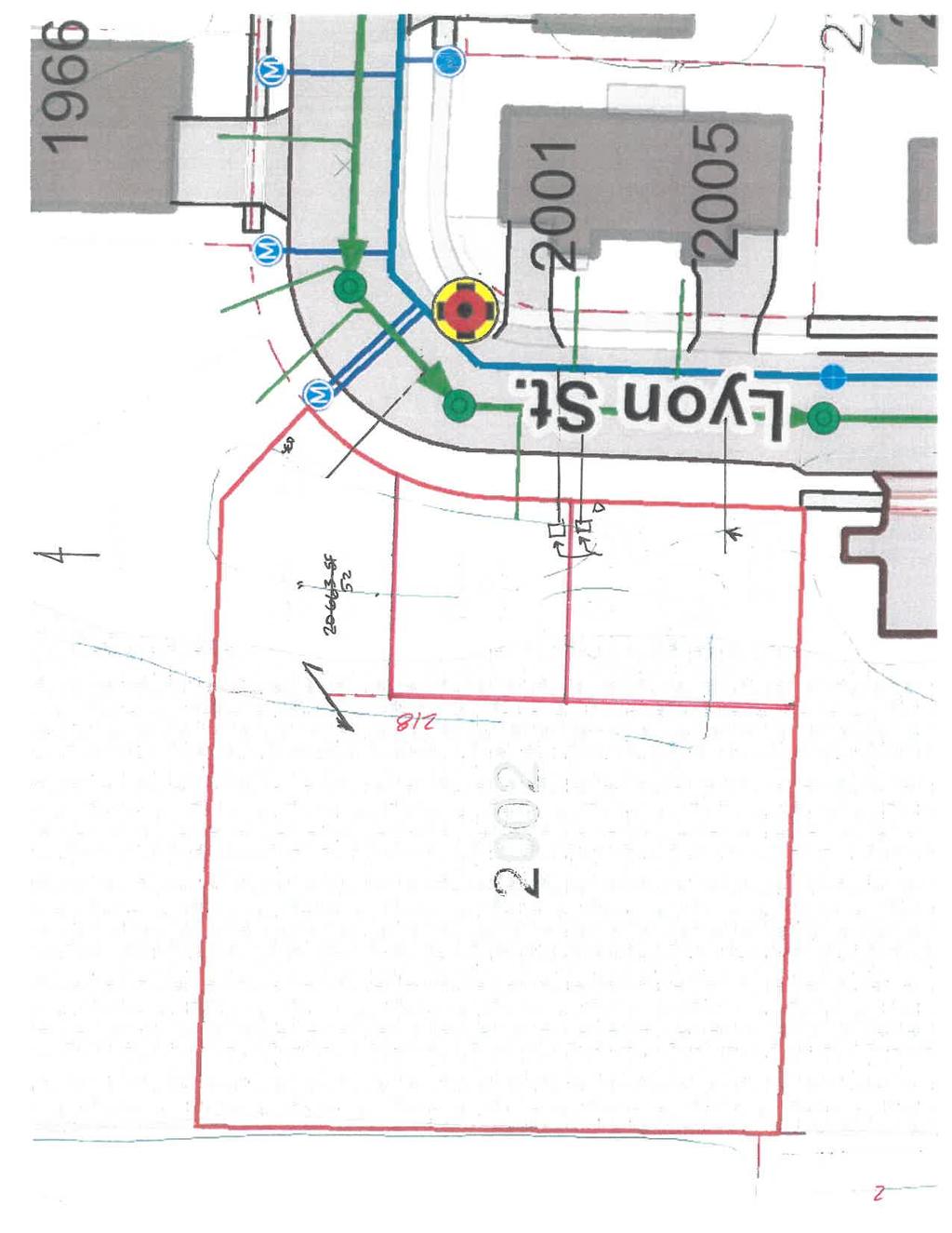
1 PUBLIC WORKS - COMMUNITY DEVELOPMENT 333 Broadalbin Street SW, PO Box 490, Albany, Oregon BUILDING PLANNING Staff Report Land Division (Tentative Partition Plat) PA October 23, 2018 Application Information Review Body: Staff (Type I-L review) Property Owner: Representative: Address/Location Bill Boyd, Willow Brook Estates LLC 4922 East 3 rd Street; Long Beach, CA Mike Lovemark, Mike Lovemark Construction PO Box 291; Albany, OR Lyon Street SW Map/Tax Lot: Linn County Assessor s Map No. 11S-03W-07CD; Tax Lot 3500 Zoning: Total Land Area Existing Land Use: Neighborhood: Surrounding Zoning: Surrounding Uses: Prior History: Residential Medium Density (RM).60 Acres Undeveloped single-family residential lot with a conservation easement Sunrise North: Residential Medium Density (RM) East: Residential Medium Density (RM) South Residential Medium Density (RM) West Light Industrial (LI) North: Vacant single-family residential lot East: Duplex (across Lyon Street SW) South Multifamily residence West Manufacturing facility and parking lot This lot (Lot 24) was created with the recorded Willow Brook Estates Subdivision (file SD-07-04). According to that staff report, the property was annexed to the City of Albany in Summary A Tentative Partition Plat is proposed for property located at 2002 Lyon Street SW, in the Residential Medium Density (RM) zoning district (Attachment A). The purpose of this Partition is to divide one 0.60-acre (26,052- square foot) parcel (Lot 24 of Willow Brook Estates) into three lots totaling 0.07 acres (3,125 square feet), 0.06 cd.cityofalbany.net
2 PA Staff Report October 23, 2018 Page 2 of 9 acres (2,461 square feet), and 0.47 acres (20,663 square feet), respectively. The existing conservation easement located on Lot 24 of Willow Brook Estates cannot be subdivided; therefore, it will remain with Parcel C in its entirety. The applicant s representative, Mike Lovemark, of Lovemark Construction, provided responses to review criteria (Attachment B), and tentative partition sketches (Attachment C). The final partition will be prepared by a licensed surveyor. The subject property borders Light Industrial zoning to the west. Abutting property located to the north is zoned RM and is not yet developed. The lot to the south is likewise zoned RM and has a multifamily dwelling. The original subdivision, Willow Brook Estates, was a 29-lot cluster subdivision on 5.83 acres (Attachment F). It was approved by the Albany Planning Commission on November 29, 2004 (Attachment D). Staff Decision The subject application referenced above is APPROVED as described in this staff report. The approval expires three years from the date of tentative plat approval. The final plat must be recorded with the Linn County Records Division (ADC ) unless an extension is approved by the City and the County Surveyor s Office. Appeals The City s decision may be appealed to the Oregon Land Use Board of Appeals (LUBA) if a person with standing files with LUBA a Notice of Intent to Appeal not later than 21 days after the Director s Notice of Decision is mailed. Notice Information A Notice of Filing was mailed to property owners identified within 100 feet of the subject property on September 12, At the time the comment period ended on September 26, 2018, no comments had been received by the Planning Division. Analysis of Development Code Criteria Section of the Albany Development Code (ADC) includes the following review criteria, which must be met for this application to be approved. Code criteria are written in bold followed by findings, conclusions, and conditions of approval where conditions are necessary to meet the review criteria. Criterion 1 The proposal meets the development standards of the underlying zoning district, and applicable lot and block standards of this Section. Findings of Fact 1.1 The underlying zoning district of the subject lots is Residential Medium Density (RM). The RM zoning district is intended primarily for medium-density residential urban development. The average minimum lot size for single-family, detached residences is 3,500 square feet and 4,800 square feet for duplexes, with a minimum lot width of 30 feet and a minimum lot depth of 60 feet. Maximum lot coverage in the RM district is 70 percent. Lot coverage for single-family detached development only includes the area of the lot covered by buildings or structures. Cluster Subdivision development standards in ADC provide relief from minimum lot area, width and depth requirements in exchange for protecting natural areas. Willow Brook Estates was a cluster subdivision.
3 PA Staff Report October 23, 2018 Page 3 of In any single-family residential land division, lots and blocks shall conform to standards listed in ADC and other applicable provisions of the Code. Standards relevant to this proposed partition are addressed below. 1.3 ADC (1) states that lots must be arranged such that there will be no foreseeable difficulties, for reasons of topography or other conditions, in securing building permits to build on all proposed lots in compliance with the requirements of the Code. There are no foreseeable difficulties in securing building permits to build on all proposed lots provided applicable development standards are followed. 1.4 According to ADC (2), when lots are more than double the minimum area designated by the zoning district, those lots must be arranged so as to allow further subdivision and the opening of future streets where it would be necessary to serve potential lots. An urban conversion plan may be required in conjunction with submittal of tentative subdivision or partition plat. Proposed Parcel C is 20,663 square feet, which is more than twice the minimum lot area; however, about 16,769 square feet lies within the conservation easement and cannot be developed. Therefore, an urban conversion plan will not be required. 1.5 ADC (3) states that double frontage lots shall be avoided except when necessary to provide separation of residential developments from streets of collector or arterial street status or to overcome specific disadvantages of topography and/or orientation. None of the proposed lots are double-frontage lots. Therefore, this standard is not applicable. 1.6 ADC (4) states that side yards of a lot shall run at right angles to the street the property faces, except that on a curved street the side property line shall be radial to the curve. The northern boundary of proposed Parcel C is radial to the curve and is pre-existing from the time Lot 24 was created; all other proposed side yards run at right angles to Lyon Street, consistent with this standard. 1.7 According to ADC (5), block dimensions shall be determined by existing street and development patterns, connectivity needs, topography, and adequate lot size. The average block length shall not exceed 600 feet unless adjacent layout or physical conditions justify a greater length. Block length is defined as the distance along a street between the centerline of two intersecting through streets. Physical conditions may include existing development, steep slopes, wetlands, creeks, and mature tree groves. The proposed Partition is not creating any new streets. Therefore, this standard is not applicable. 1.8 ADC (6) states that off-street pedestrian pathways shall be connected to the street network and used to provide pedestrian and bicycle access in situations where a public street connection is not feasible. All lots will have direct access to a public street, and no off-street pedestrian pathways are proposed or required with this partition. 1.9 ADC (9) states that flag lots are discouraged and allowed only when absolutely necessary to provide adequate access to buildable sites and only where the dedication and improvement of a public street cannot be provided. No flag lots are proposed; therefore, this criterion is not applicable The minimum lot width in the RM zone is 30 feet (for detached single-family dwellings), and the minimum lot depth is 60 feet. According to the applicant s tentative partition plat, minimum lot widths will be met, but lot depths range from about 52 feet to 58 feet. The original Willow Brook Subdivision was created using cluster subdivision standards. The applicants chose to retain some wetlands, including those on Lot 24. Because the original subdivision was a cluster subdivision, certain development standards such as minimum lot size, width and depth can be waived in exchange for protecting natural features (see Section of the October 2003 version of the Albany Development
4 PA Staff Report October 23, 2018 Page 4 of 9 Code). These same standards remain in effect today (Section of the July 11, 2018 version of the Albany Development Code). As shown on the applicant s tentative partition plat, proposed Parcel A will have 3,125 square feet of area, approximately 81 feet in width and 52 feet in depth, as measured from Lyon Street. Proposed Parcel B will have 2,461 square feet with a width of about 46 feet and a depth averaging about 55 feet; and Parcel C will have 20,663 square feet in area, with a buildable area measuring about 46 feet in width and 58 feet in depth. About 16,769 square feet will be retained in the wetland conservation easement, which will fall entirely in proposed Parcel C. Condition 5.3 from the 2004 subdivision approval (Attachment D) places the responsibility for the maintenance of the easement on the property owners on which the easement is located. It also prohibits further division of the easement. This will be retained as a condition of approval for the proposed partition The RM zone district has a minimum 10-foot front yard setback in a cluster subdivision. The minimum required interior yard setback is three feet for single-story dwellings and five feet for dwellings with two or more stories The proposed partition does not propose to create new blocks, intersections, cul-de-sacs, or double-frontage lots. Conclusions 1.1 There are no foreseeable difficulties in securing building permits to build on all proposed lots. 1.2 None of the proposed lots will be more than double the minimum area designated by the zoning district; therefore, an urban conversion plan will not be required. 1.3 No new streets or off-street pedestrian pathways are being created. All new lots will have direct access to a public street. 1.4 The proposed partition does not propose to create new blocks, intersections, cul-de-sacs, flag lots, or double-frontage lots. 1.5 This criterion is satisfied without conditions. Criterion 2 Development of any remainder of property under the same ownership can be accomplished in accordance with this Code. Findings of Fact 2.1 The tentative plat shows all the land within the subject property will be allocated into three proposed parcels. There is no development on the property currently. 2.2 ADC 3.190, Table 1, shows that the minimum lot size requirement in the RM zoning district is 3,500 square feet for detached single family uses, minimum lot width is 30 feet, and depth is 60 feet. However, under cluster development provisions, lot area, width and depth can be waived in exchange for protecting natural features, such as wetlands. 2.3 Parcel A. The area of Parcel A is shown to be 3,125 square feet (0.07 acres).
5 PA Staff Report October 23, 2018 Page 5 of Parcel B. The area of Parcel B is shown to be 2,461 square feet (0.06 acres). 2.5 Parcel C. The area of Parcel C is shown to be 20,663 square feet (0.47 acres), which includes a buildable area and the entirety of the wetland conservation easement within Lot All of the property proposed in this partition is under the same ownership. There is no remainder of land to consider. Conclusions 2.1 There is no remainder to consider. All the land area within the parent property will be allocated to the three proposed parcels. 2.2 This criterion is satisfied. Criterion 3 Adjoining land can be developed or is provided access that will allow its development in accordance with this Code. Findings of Fact 3.1 This review criterion has been interpreted by the City Council to require only that adjoining land either have access, or be provided access, to public streets. 3.2 ADC requires that development must have frontage on or approved access to a public street currently open to traffic. 3.3 ADC states that new streets may be required to be located where the City Engineer determines that additional access is needed to relieve or avoid access deficiencies on adjacent or nearby properties. 3.4 Adjoining land to the north of the subject property has access to Lyon Street SW. Properties located east and south of the subject property also have access to Lyon Street SW. The property to the west is zoned Light Industrial (Pacific Cast Technologies) and has access to Queen Avenue SW. 3.5 All of the adjoining properties have independent access to a public street, and the proposed Partition will not impact the access of adjoining properties. Conclusions 3.1 All of the adjoining land has, and will continue to have, access to public streets. 3.2 This criterion is met without conditions.
6 PA Staff Report October 23, 2018 Page 6 of 9 Criterion 4 The proposed street plan affords the best economic, safe, and efficient circulation of traffic possible under the circumstances. Findings of Fact 4.1 The development will divide a 26,052 square foot parcel of land into three parcels. All resulting parcels are vacant and can be developed with single family homes. 4.2 The development is located at 2002 Lyon Street SW. 4.3 Lyon Street is classified as local street and is, with the exception of sidewalk, constructed to city standards. Sidewalk does not currently exist along the site s frontage on Lyon Street. 4.4 All three parcels being created can be developed in the future with a single-family home. Based upon ITE trip generation rates, single family homes generate 9.55 vehicle trips per day. This development can therefore be expected to add about 29 new vehicle trips to the public street system. 4.5 Albany s Transportation System Plan does not identify any level of service or congestion issues adjacent to the proposed development. 4.6 ADC allows for deferral of sidewalk installation to individual lot development with the approval of the City Engineer. Conclusions 4.1 The proposed development will ultimately result in approximately 29 new vehicle trips on the public street system. 4.2 Albany s Transportation System Plan does not identify any level of service or congestion issues adjacent to the proposed development. 4.3 The development s frontage on Lyon Street is constructed to city standards with the exception of public sidewalk. ADC allowed sidewalk construction to be deferred to individual lot development with the approval of the city engineer. The city engineer has determined that deferral of sidewalk construction to lot development is acceptable in this case and is consistent with the construction sequence used for the other lots within the neighborhood. Criterion 5 The location and design allow development to be conveniently served by various public utilities. Findings of Fact Sanitary Sewer 5.1 City utility maps show an 8-inch public sanitary sewer main in Lyon Street along the subject property s frontage. There is one existing private sewer service lateral extended into the parcel.
7 PA Staff Report October 23, 2018 Page 7 of ADC requires all new development to extend and/or connect to the public sanitary sewer system if the property is within 300 feet of a public sewer line. 5.3 Future development on the proposed new parcels must be connected to the public sanitary sewer system. 5.4 AMC (1) states that the objective of the Albany Municipal Code requirements pertaining to public sanitary sewers is to facilitate the orderly development and extension of the wastewater collection and treatment system, and to allow the use of fees and charges to recover the costs of construction, operation, maintenance, and administration of the wastewater collection and treatment system. 5.5 New sewer service laterals will need to be installed to serve two of the new lots. Installation of private sewer service laterals must be done by the developer under an encroachment permit issued by the Public Works Department. The installation of these new services may be delayed until building permits for the new lots are obtained. Water 5.6 City utility maps show an 8-inch public water main in Lyon Street along the subject property s frontage. There is one existing private water service extended to the parcel. 5.7 ADC requires all new development to extend and/or connect to the public water system if the property is within 150 feet of an adequate public main. 5.8 Future development on the proposed new parcels must be connected to the public water system. 5.9 New water services will need to be installed to serve two of the new lots. The installation of these new services may be delayed until building permits for the new lots are obtained. Water services smaller than two inches are installed by city personnel. The applicant must obtain a water service installation permit when building permits are obtained. Storm Drainage 5.10 City utility maps show an 18-inch public storm drainage main along the subject property s frontage Single-family residences typically have their roof drains connected to the adjacent curb and gutter AMC states that a development may be exempted from the requirement of AMC when the development is for the construction of not more than three single-family or duplex dwelling(s) on an existing lot(s) of record. Conclusions 5.1 Public utilities (sanitary sewer, water, and storm drainage) are available and adequate to serve the proposed development. 5.2 Future development on the proposed parcels must be connected to city sewer and water. 5.3 This criterion is met without conditions.
8 PA Staff Report October 23, 2018 Page 8 of 9 Criterion 6 Activities and developments within special purpose districts must comply with the regulations described in Articles 4 (Airport Approach), 6 (Natural Resources), and 7 (Historic), as applicable. Findings of Fact 6.1 Article 4 Airport Approach district. According to Figure 4-1 of the Albany Development Code, the subject property is not located within the Airport Approach District. 6.2 Article 6 Steep Slopes. Comprehensive Plan Plate 7 shows that there are not areas of steep slopes on the subject property. Contours on the City s Geographic Information Systems (GIS) maps show that the elevation of the property averages about 218 feet. 6.3 Article 6 Floodplains. Comprehensive Plan Plate 5 does not show this property in a 100-year floodplain. FEMA/FIRM Community Panel No C0526G, dated September 29, 2010, shows that this property is in Zone X, an area determined to be outside any 500-year floodplain. 6.4 Article 6 Wetlands. Comprehensive Plan Plate 6: This property was included in the 1995 Ferry Street/Southeast Industrial Area Local Wetlands Inventory. The Local Wetlands Inventory shows one wetland area located on portions of the property s west side, that continues across properties to the north and south of the subject property as well as portions of the industrial properties to the west. The identified wetland is not considered locally significant; however, the wetland was set aside in a permanent conservation easement with the filing of the original 2004 Willow Brook Estates Subdivision and cannot be developed. The Department of State Lands (DSL) and the US Army Corps of Engineers have jurisdiction over the approval of delineations and mitigation of waters of the state, which include wetlands. The City notified DSL of this partition application on August 3, DSL responded on August 30, 2018 and confirmed that the local wetlands inventory shows a wetland on this property but added that partitions do not require a removal/fill permit and that the proposed tax lots are outside of the wetland. This letter was forwarded to the applicant and a copy is attached to this staff report (Attachment E). 6.5 Article 7 Historic Districts. Comprehensive Plan Plate 9 confirms none of the proposed parcels are located in a historic district. There are no known archaeological sites on the property. Conclusions 6.1 There are no regulatory floodplains on the subject property, according to FEMA/FIRM Community Panel No C-0526G, dated September 29, The Local Wetlands Inventory shows one wetland area located on portions of the property s west side. These wetlands are permanently protected through a conservation easement and cannot be developed. 6.3 The property is not located within the Airport Approach District. 6.4 There are no known historical or archaeological sites on the property. 6.5 There are no steep slopes on the property. 6.6 This criterion is satisfied without conditions.
9 PA Staff Report October 23, 2018 Page 9 of 9 Overall Conclusion This report evaluates the applicant s land division application to create a three-lot Partition. The proposal was evaluated against applicable Tentative Plat Review criteria in ADC Section In summary, analysis in this report finds that all applicable criteria for a Tentative Plat Review are satisfied. Attachments A. Location Map B. Applicant s Findings C. Tentative Partition Sketches D. Notice of Decision (file SD-07-04) dated November 30, 2004 E. Department of State Lands Correspondence dated August 30, 2018 F. Willow Brook Estates Final Plat recorded on March 12, 2007 Acronyms ADC Albany Development Code AMC Albany Municipal Code DSL Department of State Lands FEMA Federal Emergency Management Agency FIRM Flood Insurance Rate Map ITE Institute of Transportation Engineers LWI Local Wetland Inventory PA Partition File Designation RM Residential Medium Density zoning district TSP Transportation System Plan USACE U.S. Army Corps of Engineers
10 THIS PAGE LEFT INTENTIONALLY BLANK
11 Attachment A Howard Dr. NC 18th Ave. Lyon St. Subject Property 19th Ave. 20th Ave. LI RM RS-6.5 Lyon St. 21st Ave. Jackson St. 22nd Ave. Location Map: 2002 Lyon Street SW The City of Albany's Infrastructure records, drawings, and other documents have been gathered over many decades, using differing standards for quality control, documentation, and verification. All of the data provided represents current information in a readily available format. While the data provided is generally believed to be accurate, occasionally it proves to be incorrect; thus its accuracy is not warranted. Prior to making any property purchases or other investments based in full or in part upon the material provided, it is specifically advised that you independently field verify the Feet July 30, 2018 Planning Division City of Albany Broadalbin St. SW, Albany, Oregon (541)


12 Attachment B.1


13 Attachment B.2


14 Attachment B.3
15 Attachment B.4


16 Attachment B.5


17 Attachment B.6


18 Attachment C.1


19 Attachment C.2

20 Attachment D.1 COMMUNITY DEVELOPMENT DEPARTMENT 333 Broadalbin Street SW, P.O. Box 490, Albany OR Ph: (541) Fax: (541) NOTICE OF DECISION DATE OF NOTICE: November 30, 2004 FILE: SD Willow Brook Estates TYPE OF APPLICATION: Tentative Subdivision Plat to divide 5.83 acres of land into 29 residential lots using Cluster Development standards. Three lots will have a duplex and one lot will have a four-plex, for a total of 35 dwelling units constructed within the development. Tree removal also has been requested. REVIEW BODY: Planning Commission PROPERTY OWNERS: Tax Lot 400: Boyd and Marilyn Bewley; 257 Creswell Lane NW; Albany, OR Tax Lot 600: Bill Boyd/Charles Radke; 189 Quincy Avenue; Long Beach, CA Tax Lot 700: Bill Boyd/Sabrina Chin-Shefi & Ron Shefi; 1944 Marion Street SE; Albany, OR Tax Lot 800: Bill Boyd; 189 Quincy Avenue; Long Beach, CA APPLICANT: Bill Boyd; 189 Quincy Avenue; Long Beach, CA APPLICANT'S REP: Lyle Hutchins; Devco Engineering, Inc.; PO Box 1211; Corvallis, OR ADDRESS/LOCATION: Tax Lot Marion Street SE; Tax Lot Marion Street SE; Tax Lot & 1908 Marion Street SE; Tax Lot Marion Street SE MAP/TAX LOTS: Linn County Assessor s Map No. 11S-3W-7CD; Tax Lots 400, 600, 700, 800 ZONING: RM-5 (Residential Limited Multiple Family) On November 29, 2004, the City of Albany Planning Commission granted APPROVAL WITH CONDITIONS of the above referenced TENTATIVE SUBDIVISION PLAT application that included tree removal. The tentative plat approval expires three years from the date of this notice unless the final plat has been submitted to the City for approval. The Planning Commission based its decision on the project s conformance with the review criteria listed in the Albany Development Code and testimony at the hearing. The supporting documentation relied upon in making this decision is available for review at City Hall, 333 Broadalbin Street SW. A person with standing may appeal this decision to the City Council by filing a Notice of Appeal with the Planning Division not later than 5:00 p.m. on Friday, December 10, For more information, please contact Planners Janet Morris or Don Donovan at (541) Planning Commission Chair Enclosures: Conditions of Approval, Location map, Tentative Plat, and Information for the Applicant Notice of Decision SD Page 1
21 Attachment D.2 CONDITIONS OF APPROVAL - FILE SD TENTATIVE SUBDIVISION PLAT (Please refer to the staff report for background information.) TRANSPORTATION FACILITIES 3.1 The applicant shall construct to City standards all public streets in the subdivision. 3.2 The right-of-way for local streets within the subdivision must be 54 feet, with curb-to-curb widths of 30 feet. 3.3 The two 90-degree curves in Lyon Street shall have an inside curb face radius of 25 feet, and an outside curb face radius of 45 feet. The City Engineer will consider approval of other design options that provide for an adequate path for emergency vehicles 3.4 Public sidewalk construction along the frontage(s) of the lots may be deferred until occupancy is requested for a dwelling on the lot. 3.5 The applicant must install a stop sign on the new local street approach to Marion Street. 3.6 The applicant must install street lighting and street name signs on all public streets within the subdivision to City standards. PUBLIC UTILITIES 4.1 Before the City will approve the final subdivision plat, the applicant must financially assure or construct an 8-inch public sanitary sewer main extension, an 8-inch public water main extension, and a public storm sewer extension (size to be approved during plans review), generally as shown on the tentative utility plan. Final design details will be reviewed as part of the Permit for Private Construction of Public Improvements to be obtained from Public Works. Individual sanitary sewer and water services must be installed for each proposed lot at the time of public utility main construction. 4.2 All utilities must be placed underground unless specifically exempted by the Development Code. SPECIAL FEATURES OF THE SITE 5.1 A Removal-Fill Permit must be obtained form the Oregon Department of State Lands and from the U.S. Army Corps of Engineers to fill the wetlands as shown on the drawings submitted with the subdivision application. Before disturbing the wetlands, submit a copy of an approved permit to the City Engineering and Planning Divisions. 5.2 The final plat must show the boundary of the conservation easement and reference a separate recorded easement document prepared by the applicant that includes protective restrictions of the land within the easement. 5.3 Before recording the easement document it must be reviewed and approved by the Community Development Director. The covenant must include the following restrictions and obligations: a. The conservation easement is set aside for permanent open space and cannot be further subdivided. b. The conservation easement is a protected open space that contains wetlands. The regulatory authority of the wetlands is the Oregon Department of State Lands. Notice of Decision SD Page 2
22 Attachment D.3 c. Maintenance of the conservation easement is the responsibility of the property owners of the lots on which the easement is located. d. Placement of structures or impervious surfaces, alteration of the ground contours, or any other activity or use inconsistent with the purpose of the cluster development provisions is prohibited. Fences may be constructed on the property lines to enclose the protected open space within private yards. e. Maintenance activities and encroachment into the conservation areas must also be consistent with the provisions of any Fill/Removal Permit issued by the Department of State Lands and US Corps of Engineers for these areas. 5.4 Before the City signs the final plat, a final buffer landscaping plan that has been prepared or certified by a wetlands expert for the required 30-foot buffer yards must be approved by the Planning Division and also installed within the development. The buffer plan must also meet the Development Code's buffer standards. A short-term (not to exceed 3 months) security may be posted with the City if the applicant's wetland expert demonstrates it is not an appropriate time to install the plantings. Buffering, but not screening, is required between Tax Lots 700 and In this RM-5 zoned Cluster Development, the following development standards supercede the same standards in Section 3.190, Table 1. (The other standards do not change.) TREE FELLING Standard RM-5 Max. dwelling units per gross acre 20 Minimum Lot Size None Minimum Lot Width None Minimum Lot Depth None Minimum front house setback (1) 10 ft. Maximum Lot Coverage (2) 70% (1) Except, when lots are adjacent to existing development on the same side of the street, the setback shall be within 5 feet of the adjacent house(s) setback(s). (2) Except, when building envelopes are used, the maximum lot coverage may be up to 100%. 2.1 Before the City signs the final plat, a final buffer landscaping plan, which includes a minimum of 18 trees, must be approved by the Planning Division and then planted. 3.1 The following tree protection specifications must be followed during development of the subdivision to the maximum extent feasible for all trees remaining on the property. (a) (b) Within the drip line of any protected existing tree, there shall be no cut or fill over a four-inch depth unless a qualified arborist or forester has evaluated and approved the disturbance. Prior to and during construction, barriers shall be erected around all protected existing trees with such barriers to be of orange fencing a minimum of four (4) feet high, secured with metal T-posts, no closer than six (6) feet from the trunk or one-half (½) of the drip line, whichever is greater. There shall be no storage or movement of equipment, material, debris or fill within the fenced tree protection zone. Notice of Decision SD Page 3
23 Attachment E.1

24 Attachment E.2

25 Attachment F.1

26 Attachment F.2
Community Development Department 333 Broadalbin Street SW, P.O. Box 490 Albany, OR 97321
 SUMMARY Community Development Department 333 Broadalbin Street SW, P.O. Box 490 Albany, OR 97321 STAFF REPORT Application for Tentative Partition Plat Review Planning File PA-06-17 Phone: 541-917-7550
COMMUNITY DEVELOPMENT. Staff Report. Site Plan Review. SP June 19, 2018
 COMMUNITY DEVELOPMENT 333 Broadalbin Street SW, PO Box 490, Albany, Oregon 97321-0144 BUILDING 541-917-7553 PLANNING 541-917-7550 Staff Report Site Plan Review SP-18-18 June 19, 2018 Summary On May 1,
COMMUNITY DEVELOPMENT DEPARTMENT 333 Broadalbin Street SW, P.O. Box 490 Albany, OR 97321
 COMMUNITY DEVELOPMENT DEPARTMENT 333 Broadalbin Street SW, P.O. Box 490 Albany, OR 97321 STAFF REPORT Application for Site Plan Review (SP-02-18) Residential Accessory Building Ph: 541-917-7550 Fax: 541-917-7598
COMMUNITY DEVELOPMENT DEPARTMENT 333 Broadalbin Street SW, P.O. Box 490 Albany OR 97321
 COMMUNITY DEVELOPMENT DEPARTMENT 333 Broadalbin Street SW, P.O. Box 490 Albany OR 97321 NOTICE OF DECISION DATE OF NOTICE: August 16, 2016 FILE: TYPE OF APPLICATION: REVIEW BODY: SD-01-16 Ph: 541-917-7550
COMMUNITY DEVELOPMENT DEPARTMENT 333 Broadalbin Street SW, P.O. Box 490 Albany, OR 97321
 HEARING BODY COMMUNITY DEVELOPMENT DEPARTMENT 333 Broadalbin Street SW, P.O. Box 490 Albany, OR 97321 NOTICE OF PUBLIC HEARING Planning Commission HEARING DATE Monday, December 3, 2018 HEARING TIME HEARING
COMMUNITY DEVELOPMENT DEPARTMENT 333 Broadalbin Street SW, P.O. Box 490 Albany, OR 97321
 COMMUNITY DEVELOPMENT DEPARTMENT 333 Broadalbin Street SW, P.O. Box 490 Albany, OR 97321 Ph: 541-917-7550 Fax: 541-917-7598 www.cityofalbany.net STAFF REPORT Application for Site Plan Review SP-07-18 and
COMMUNITY DEVELOPMENT DEPARTMENT 333 Broadalbin Street SW, P.O. Box 490 Albany, OR 97321
 COMMUNITY DEVELOPMENT DEPARTMENT 333 Broadalbin Street SW, P.O. Box 490 Albany, OR 97321 NOTICE OF FILING Ph: 541-917-7550 Fax: 541-917-7598 www.cityofalbany.net DATE OF NOTICE: April 4, 2016 FILE: TYPE
COMMUNITY DEVELOPMENT DEPARTMENT 333 Broadalbin Street SW, P.O. Box 490 Albany, OR 97321
 COMMUNITY DEVELOPMENT DEPARTMENT 333 Broadalbin Street SW, P.O. Box 490 Albany, OR 97321 NOTICE OF FILING Ph: 541-917-7550 Fax: 541-917-7598 www.cityofalbany.net DATE OF NOTICE: May 8, 2018 FILES: SP-20-18
ARTICLE 11 LAND DIVISIONS AND PLANNED DEVELOPMENTS
 ARTICLE 11 LAND DIVISIONS AND PLANNED DEVELOPMENTS 11.000 Overview. The most permanent feature of a community is the way land is divided into parcels. This article describes the process of converting raw
COMMUNITY DEVELOPMENT DEPARTMENT 333 Broadalbin Street SW, P.O. Box 490 Albany, OR 97321
 COMMUNITY DEVELOPMENT DEPARTMENT 333 Broadalbin Street SW, P.O. Box 490 Albany, OR 97321 NOTICE OF PUBLIC HEARING Phone: 541-917-7550 Fax: 541-917-7598 www.cityofalbany.net HEARING BODY PLANNING COMMISSION
Condominium Unit Requirements.
 ARTICLE 19 CONDOMINIUM REGULATIONS Section 19.01 Purpose. The purpose of this Article is to regulate projects that divide real property under a contractual arrangement known as a condominium. New and conversion
COMMUNITY DEVELOPMENT DEPARTMENT 333 Broadalbin Street SW, P.O. Box 490 Albany, OR 97321
 COMMUNITY DEVELOPMENT DEPARTMENT 333 Broadalbin Street SW, P.O. Box 490 Albany, OR 97321 Ph: 541-917-7550 Fax: 541-917-7598 www.cityofalbany.net STAFF REPORT Adjustment (AD-01-16) Reduction of a 25-foot
Chapter 100 Planned Unit Development in Corvallis Urban Fringe
 100.100 Scope and Purpose. Chapter 100 Planned Unit Development in Corvallis Urban Fringe (1) All applications for land divisions in the Urban Residential (UR) and Flood Plain Agriculture (FPA) zones within
ARTICLE 23 CONDOMINIUM STANDARDS
 ARTICLE 23 CONDOMINIUM STANDARDS Section 23.01 Intent. The intent of this Article is to provide regulatory standards for condominiums and site condominiums similar to those required for projects developed
Chapter Plat Design (LMC)
") Chapter 18.14 Plat Design (LMC) Sections: 18.14.010 Lot width 18.14.020 Right-of-way requirements 18.14.030 Pipe stem lots 18.14.040 Division resulting in minimum lot sizes 18.14.050 Flood prone and bad
Chapter 18.14 Plat Design (LMC) Sections: 18.14.010 Lot width 18.14.020 Right-of-way requirements 18.14.030 Pipe stem lots 18.14.040 Division resulting in minimum lot sizes 18.14.050 Flood prone and bad
610 LAND DIVISIONS AND PROPERTY LINE ADJUSTMENTS OUTSIDE A UGB
 ARTICLE VI: LAND DIVISIONS AND PROPERTY LINE ADJUSTMENTS VI-21 610 LAND DIVISIONS AND PROPERTY LINE ADJUSTMENTS OUTSIDE A UGB 610-1 Property Line Adjustments (Property Line Relocation) A property line
KEIZER COMMUNITY DEVELOPMENT DEPARTMENT STAFF RECOMMENDATION Subdivision Case No
 KEIZER COMMUNITY DEVELOPMENT DEPARTMENT STAFF RECOMMENDATION Subdivision Case No. 2014-01 TO: FROM: Cynthia Domas, Keizer Hearings Officer Sam Litke, Senior Planner SUBJECT: Subdivision Case No. 2014-01
Sterling Meadow Subdivision
 Sterling Meadow Subdivision Proposal: A pre-application conference was held on November 7, 2017, with the applicant and City staff to discuss the development. The applicant took staff s recommendations
Section Preliminary Plat Checklist and Application Forms
 Section 201 - Preliminary Plat Checklist and Application Forms PRELIMINARY SUBDIVISION PLAT REVIEW PROCESS CHART PRELIMINARY SUBDIVISION PLAT APPLICATION PRELIMINARY PLAT REVIEW CHECKLIST CITY OF NAMPA
ARTICLE 13 CONDOMINIUM REGULATIONS
 ARTICLE 13 CONDOMINIUM REGULATIONS Section 13.01 Purpose. The purpose of this Article is to regulate projects that divide real property under a contractual arrangement known as a condominium. New and conversion
Initial Subdivision Applications Shall Include the Following:
 Initial Subdivision Applications Shall Include the Following: 1) Subdivision Application Form: completely filled out (12 copies) 2) Plat: The Plat must adhere to the requirements set forth in the Town
SUBDIVISION DESIGN PRINCIPLES AND STANDARDS
 SECTION 15-200 SUBDIVISION DESIGN PRINCIPLES AND STANDARDS 15-201 STREET DESIGN PRINCIPLES 15-201.01 Streets shall generally conform to the collector and major street plan adopted by the Planning Commission
ARTICLE VI. SUBDIVISION STANDARDS, PUBLIC
 ARTICLE VI. SUBDIVISION STANDARDS, PUBLIC IMPROVEMENTS, AND DESIGN REQUIREMENTS ARTICLE VI. SUBDIVISION STANDARDS, PUBLIC IMPROVEMENTS, AND DESIGN REQUIREMENTS DIVISION 1. GENERAL PROVISIONS Sec. 21-6100.
KEIZER COMMUNITY DEVELOPMENT DEPARTMENT STAFF RECOMMENDATION Subdivision Case No
 KEIZER COMMUNITY DEVELOPMENT DEPARTMENT STAFF RECOMMENDATION Subdivision Case No. 2014-14 TO: FROM: Cynthia Domas, Keizer Hearings Officer Sam Litke, Senior Planner SUBJECT: Subdivision Case No. 2014-14
CONDOMINIUM REGULATIONS
 ARTICLE 37 CONDOMINIUM REGULATIONS SECTION 37.01. Purpose The purpose of this Article is to regulate projects that divide real property under a contractual arrangement known as a condominium. New and conversion
UPPER MOUNT BETHEL TOWNSHIP NORTHAMPTON COUNTY, PENNSYLVANIA
 UPPER MOUNT BETHEL TOWNSHIP NORTHAMPTON COUNTY, PENNSYLVANIA JOINDER DEED / LOT CONSOLIDATION TOWNSHIP REVIEW PROCESS When accepting proposed Joinder Deeds / Lot Consolidations, review the Joinder Deed
Chapter Planned Residential Development Overlay
 Chapter 19.29 Planned Residential Development Overlay Sections 010 Purpose 020 Scope 030 Definitions 030 Minimum Size 040 Allowable Uses 050 Minimum Development Standards 060 Density Bonus 070 Open Space
CHAPTER34 PRUD - PLANNED RESIDENTIAL UNIT DEVELOPMENT
 CHAPTER34 PRUD - PLANNED RESIDENTIAL UNIT DEVELOPMENT 17-34-1 17-34-2 17-34-3 17-34-4 17-34-5 17-34-6 17-34-7 17-34-8 17-34-9 Purpose Planned Residential Unit Development Defined Planned Residential Unit
SECTION 4: PRELIMINARY PLAT
 SECTION 4: PRELIMINARY PLAT After the completion of the sketch plan process, if submitted, the owner or developer shall file with the City an application for preliminary plat. The preliminary plat stage
ARTICLE 15 - PLANNED UNIT DEVELOPMENT
 Section 15.1 - Intent. ARTICLE 15 - PLANNED UNIT DEVELOPMENT A PUD, or Planned Unit Development, is not a District per se, but rather a set of standards that may be applied to a development type. The Planned
ARTICLE 24 PRIVATE ROAD, SHARED PRIVATE DRIVEWAY AND ACCESS EASEMENT STANDARDS
 ARTICLE 24 PRIVATE ROAD, SHARED PRIVATE DRIVEWAY AND ACCESS EASEMENT STANDARDS SECTION 24.00 INTENT AND PURPOSE The standards of this Article provide for the design, construction and maintenance of private
NOTICE OF DECISION CITY OF CASCADE LOCKS PLANNING COMMISSION SUB 04-04
 NOTICE OF DECISION CITY OF CASCADE LOCKS PLANNING COMMISSION SUB 04-04 The City of Cascade Locks Planning Commission held a public hearing on June 10, 2004 to consider the application. The Commission s
PRELIMINARY PLATS. The following documents are provided as required by the City of Conroe for use in the above titled platting submittals:
 Public Works Engineering Division CITY OF CONROE PRELIMINARY PLATS The following documents are provided as required by the City of Conroe for use in the above titled platting submittals: Submittal Questionnaire
FINAL PLAT APPLICATION
 FINAL PLAT APPLICATION (Page 1 of 3) LEGAL OWNER(s): NAME: STREET ADDRESS OWNER(s): CITY, STATE, ZIP CODE: PHONE NUMBER: BILLING ADDRESS: NAME OF ENGINEER/SURVEYOR: Engineer/Surveyor Address, Phone: PROPERTY
MAPLETON CITY CORPORATION. Step 7: Upon final approval and prior to plat recording the applicant shall provide the following:
 MAPLETON CITY CORPORATION Subdivision Process The City s subdivision requirements are designed to facilitate orderly, safe and efficient development and to implement the adopted General Plan. Below is
Group Sewer Only** 80 Ft Frontage* 20,000 Sq. Ft. (.46 acre) Minimum** 120 Ft Frontage* 20,000 Sq. Ft. (.46acre) Minimum** 150 Ft Frontage*
 Minimum** 120 Ft Frontage* 20,000 Sq. Ft. (.46acre) Minimum** 150 Ft Frontage*") Residential Lots Minimum Chart The minimum lot size of any minor subdivision where there is no public sewers shall be as shown below or as required by township zoning and/or the Tuscarawas General Health
Residential Lots Minimum Chart The minimum lot size of any minor subdivision where there is no public sewers shall be as shown below or as required by township zoning and/or the Tuscarawas General Health
Article 7: Residential Land Use and Development Requirements
 Article 7: Residential Land Use and Section 701: Statement of Intent (A) (B) (C) The intent of Article 7 is to develop certain land use and development requirements for the residential uses within Cumru
Floodplain Development Land Use Review
 PUBLIC WORKS - COMMUNITY DEVELOPMENT 333 Broadalbin Street SW, PO Box 490, Albany, Oregon 97321-0144 BUILDING 541-917-7553 PLANNING 541-917-7550 Floodplain Development Land Use Review Application Information
Site Plan Application
 Site Plan Application City of St. Pete Beach Community Development Department 155 Corey Avenue St. Pete Beach, Florida 33706 (727) 367-2735 www.stpetebeach.org Case Number: PROPERTY OWNER: Name: Address:
LABEL PLEASE NOTE: ALL APPLICATIONS AND SITE PLANS MUST BE COMPLETED IN BLACK OR BLUE INK ONLY Intake by:
 STAFF USE ONLY Thurston County Resource Stewardship 2000 Lakeridge Dr. S.W. Olympia, WA 98502 (360)786-5490 / (360)754-2939 (Fax) TDD Line (360) 754-2933 Email: permit@co.thurston.wa.us Supplemental Application
I. Requirements for All Applications. C D W
 108-16.1. Application checklists. Checklist for Required Submissions to the Planning Board or Zoning Board of Adjustment of Monroe Township All required submissions are to be made to the Administrative
ARTICLE 6 PRELIMINARY PLAT
 ARTICLE 6 PRELIMINARY PLAT SECTION: 30-06-01: Preliminary Plat 30-06-02: Information Required for Preliminary Plat 30-06-03: Determination of Requirement for Environmental Review Documents 30-06-04: Additional
ARTICLE SINGLE FAMILY SITE CONDOMINIUM DEVELOPMENT STANDARDS
 ARTICLE 28.00 SINGLE FAMILY SITE CONDOMINIUM DEVELOPMENT STANDARDS Section 28.01 PURPOSE The purpose of this Article is to recognize that conventional single family developments, traditionally developed
Title 17. Subdivisions
 Title 17 Subdivisions Chapters: 17.05 Introductory Provisions 17.10 Ordinance Compliance 17.15 Preliminary Review 17.20 Subdivision Plat Approval Procedure 17.25 Information on Tentative Plat for Proposed
ARTICLE IV: DEVELOPMENT STANDARDS
 ARTICLE IV: DEVELOPMENT STANDARDS IV-53 409 PRIVATE STREETS A private street means any way that provides ingress to, or egress from, property by means of vehicles or other means, or that provides travel
WASCO COUNTY PRELIMINARY SUBDIVISION APPLICATION
 WASCO COUNTY PRELIMINARY SUBDIVISION APPLICATION DETAILED SPECIFIC WRITTEN REQUEST File Number: SDV- Number of Proposed Lots & their Dimensions: PRELIMINARY SUBDIVISION PLAN REQUIREMENTS The approval of
PLANNING COMMISSION REPORT REGULAR AGENDA
 PP-4-4-11 Item No. 9-1 PLANNING COMMISSION REPORT REGULAR AGENDA PC Staff Report 06/22/11 ITEM NO 9: PRELIMINARY PLAT; KASOLD WATER TOWER ADDITION; SE OF TAM O SHANTER & KASOLD DR (MKM) PP-4-4-11: Consider
REPORT TO PLANNING AND DESIGN COMMISSION City of Sacramento
 REPORT TO PLANNING AND DESIGN COMMISSION City of Sacramento 915 I Street, Sacramento, CA 95814-2671 www.cityofsacramento.org 9 PUBLIC HEARING December 10, 2015 To: Members of the Planning and Design Commission
Appendix J - Planned Unit Development (PUD)
") Appendix J - Planned Unit Development (PUD) Intent and Purpose The purpose of the PUD is: 1. To provide development that is consistent with the Comprehensive Land Use Plan and promote the goals and objectives
Appendix J - Planned Unit Development (PUD) Intent and Purpose The purpose of the PUD is: 1. To provide development that is consistent with the Comprehensive Land Use Plan and promote the goals and objectives
MAJOR SUBDIVISION PRELIMINARY PLAT CHECKLIST
 TOWNSHIP OF EGG HARBOR PLANNING BOARD/ZONING BOARD OF ADJUSTMENT 3515 BARGAINTOWN ROAD EGG HARBOR TOWNSHIP, NJ 08234 MAJOR SUBDIVISION PRELIMINARY PLAT CHECKLIST The following checklist is designed to
-MENDOCINO COUNTY PLANNING AND BUILDING SERVICES- DIVISION OF LAND REGULATIONS TITLE 17
 ARTICLE VI -- GENERAL REGULATIONS AND PROVISIONS Sec. 17-50. Sec. 17-51 General Plan. Sec. 17-52 Lot and Block Design and Configuration. Sec. 17-53 Lot Access. Sec. 17-54 Private Roads. Sec. 17-55 Water
MINOR SUBDIVISION PLAT CHECKLIST
 MINOR SUBDIVISION PLAT CHECKLIST Project Name: Tax ID #: Project Number: Date: _ Reviewed By: Telephone: NOTES: All lots on septic systems must comply with the Fulton County Health Department requirements
HERON LANDING SUBDIVISION
 HERON LANDING SUBDIVISION Engineering Comments: Per FEMA guidelines, any development greater than 5 acres in size or subdivision 50 lots in size, requires a flood study. Width of drainage easement to be
APPLICATION PROCEDURE
 ANTRIM PLANNING BOARD P. O. Box 517 Antrim, New Hampshire 03440 Phone: 603-588-6785 FAX: 603-588-2969 APPLICATION FORM AND CHECKLIST FOR MINOR OR MAJOR SITE PLAN REVIEW File Date Received By APPLICATION
BEFORE THE CITY COUNCIL FOR THE CITY OF ASHLAND STATE OF OREGON
 BEFORE THE CITY COUNCIL FOR THE CITY OF ASHLAND STATE OF OREGON IN THE MATTER OF APPLICATIONS FOR ) A 7-LOT SUBDIVISION, PRELIMINARY PLAT, ) CONDITIONAL USE PERMIT FOR AN ) ACCESSORY RESIDENTIAL UNIT,
Residential Minor Subdivision Review Checklist
 Residential Minor Subdivision Review Checklist Plan Submittal Requirements: 2 full sets of stamped plans Electric submittal - all plans contained in a single PDF 3 full sets if commercial kitchen or dining
Residential Major Subdivision Review Checklist
 Residential Major Subdivision Review Checklist Plan Submittal Requirements: 2 full sets of stamped plans Electric submittal - all plans contained in a single PDF 3 full sets if commercial kitchen or dining
ARTICLE 3 DEFINITIONS
 Sections: 3-1 Rules of Construction 3-2 Definitions ARTICLE 3 DEFINITIONS SECTION 3-1 RULES OF CONSTRUCTION 3-101. a. The language set forth in these regulations shall be interpreted in accordance with
APPLICATION FOR SUBDIVISION APPROVAL OF A SKETCH PLAN with checklist
 Prior to filing any application for SUBDIVISION approval, the applicant shall request in writing that the zoning administrator schedule a pre-submission conference. APPLICATION TO THE PLANNING BOARD TOWN
ELK RAPIDS TOWNSHIP ANTRIM COUNTY, MICHIGAN ORDINANCE NO
 ELK RAPIDS TOWNSHIP ANTRIM COUNTY, MICHIGAN ORDINANCE NO. 3-2011 AN ORDINANCE TO REPLACE THE SUBDIVISION CONTROL ORDINANCE WITH A NEW SUBDIVISION DEVELOPMENT ORDINANCE, IN ACCORD WITH THE LAND DIVISION
4.2 RESIDENTIAL ZONING DISTRICTS
 4.2 RESIDENTIAL ZONING DISTRICTS A. Purpose: To define regulations and standards for each residential zoning district in the City. The following sections identify uses, regulations, and performance standards
Preliminary Subdivision Application (Major) (Four (4) lots or more)
 (Four (4) lots or more)") Gunnison City Offices www.gunnisoncity.org 38 West Center Gunnison, Utah 84634 (435) 528 7969 Date of Application: Preliminary Subdivision Application (Major) (Four (4) lots or more) APPLICANT INFORMATION
Gunnison City Offices www.gunnisoncity.org 38 West Center Gunnison, Utah 84634 (435) 528 7969 Date of Application: Preliminary Subdivision Application (Major) (Four (4) lots or more) APPLICANT INFORMATION
Draft Model Access Management Overlay Ordinance
 Draft Model Access Management Overlay Ordinance This model was developed using the City of Hutchinson and the Trunk Highway 7 corridor. The basic provisions of this model may be adopted by any jurisdiction
Temporary Placement of a Manufactured Home
 COMMUNITY DEVELOPMENT DEPARTMENT Planning Division P.O. Box 490 333 Broadalbin Street SW Albany, OR 97321 Phone 541-917-7550 Fax 541-791-0150 www.cityofalbany.net Temporary Placement of a Manufactured
KEIZER COMMUNITY DEVELOPMENT DEPARTMENT STAFF RECOMMENDATION Subdivision Case No
 KEIZER COMMUNITY DEVELOPMENT DEPARTMENT STAFF RECOMMENDATION Subdivision Case No. 2014-19 TO: FROM: Cynthia Domas, Keizer Hearings Officer Sam Litke, Senior Planner SUBJECT: Subdivision Case No. 2014-19
SUBDIVISION APPLICATION CHECKLIST SKETCH PLAN PRELIMINARY PLAT FINAL PLAT
 RECEIVED STAMP SUBDIVISION APPLICATION CHECKLIST SKETCH PLAN PRELIMINARY PLAT FINAL PLAT A checklist of background information and submission requirements for processing of a sketch plan, preliminary plat
TOWN OF LEWISTON PLANNING BOARD APPLICATION
 TOWN OF LEWISTON PLANNING BOARD APPLICATION DESCRIPTION OF PROPOSED REQUEST: Name of Property Owner: Phone #: Name of Applicant:Phone #: Address or Location of Proposal:_SBL# Size of Parcel or Structure:Existing
SUBMITTAL REQUIREMENTS: The number indicates the number of copies for submittal (if applicable).
.") Office Use Only Preliminary Long Plat Long Subdivision Applicant Checklist PLANNING, COMMUNITY, & ECONOMIC DEVELOPMENT DEPARTMENT PRELIMINARY LONG PLAT LONG SUBDIVISION CHECKLIST Mailing Address: P.O.
Office Use Only Preliminary Long Plat Long Subdivision Applicant Checklist PLANNING, COMMUNITY, & ECONOMIC DEVELOPMENT DEPARTMENT PRELIMINARY LONG PLAT LONG SUBDIVISION CHECKLIST Mailing Address: P.O.
TENTATIVE PARCEL MAP APPLICATION GUIDE TENTATIVE PARCEL MAP APPLICATION REQUIREMENTS
 TENTATIVE PARCEL MAP APPLICATION GUIDE SISKIYOU COUNTY PLANNING DIVISION 806 South Main Street, Yreka CA 96097 Phone: (530) 841-2100 / Fax: (530) 841-4076 TENTATIVE PARCEL MAP APPLICATION REQUIREMENTS
APPLICATION for MINOR SUBDIVISION REVIEW for CONCEPT and FINAL PLAT within COALVILLE CITY. Project Name: Project Address or Area: Name of Owner:
 APPLICATION for MINOR SUBDIVISION REVIEW for CONCEPT and FINAL PLAT within COALVILLE CITY For Office Use Only: Application #: Application Date: PC Approval Date: CC Approval Date: Community Development
Planning Department Oconee County, Georgia
 Planning Department Oconee County, Georgia STAFF REPORT REZONE CASE #: 6985 DATE: October 31, 2016 STAFF REPORT BY: Andrew C. Stern, Planner APPLICANT NAME: Williams & Associates, Land Planners PC PROPERTY
DRAFT FOR PUBLIC HEARING (rev. March, 2016)
") Chapter 200. ZONING Article VI. Conservation/Cluster Subdivisions 200-45. Intent and Purpose These provisions are intended to: A. Guide the future growth and development of the community consistent with
Chapter 200. ZONING Article VI. Conservation/Cluster Subdivisions 200-45. Intent and Purpose These provisions are intended to: A. Guide the future growth and development of the community consistent with
PRELIMINARY PLAT CHECK LIST
 PRELIMINARY PLAT CHECK LIST Name of Proposed Subdivision: The following items must be included with the initial submittal of a Preliminary Plat: Application, filled out completely Project Narrative Pre-application
Community Development Department 333 Broadalbin Street SW, P.O. Box 490 Albany, OR 97321
 Community Development Department 333 Broadalbin Street SW, P.O. Box 490 Albany, OR 97321 Phone: 541-917-7550 Facsimile: 541-917-7598 www.cityofalbany.net STAFF REPORT DENVER STREET RIGHT-OF-WAY VACATION
NOTICE OF PUBLIC HEARING. CITY OF ALBANY PLANNING COMMISSION Council Chambers, 333 Broadalbin Street SW Monday, March 20, :15 p.m.
 NOTICE OF PUBLIC HEARING CITY OF ALBANY PLANNING COMMISSION Council Chambers, 333 Broadalbin Street SW Monday, March 20, 2017 5:15 p.m. AGENDA 1. CALL TO ORDER 2. PLEDGE OF ALLEGIANCE 3. ROLL CALL 4. PUBLIC
WESTMINSTER PARK SUBDIVISION
 WESTMINSTER PARK SUBDIVISION Engineering Comments: FINAL PLAT COMMENTS (should be addressed prior to submitting the FINAL PLAT for review and/or signature by the City Engineer): A. Provide all of the required
MTC ALABAMA SUBDIVISION
 # 2 SUB-000370-2017 MTC ALABAMA SUBDIVISION Engineering Comments: FINAL PLAT COMMENTS (should be addressed prior to submitting the FINAL PLAT for review and/or signature by the City Engineer): A. Provide
BYRON TOWNSHIP ZONING APPLICATION
 BYRON TOWNSHIP ZONING APPLICATION Phone: (616) 878-9104 * Fax: (616) 878-3980 * Website: www.byrontownship.org This application will not be accepted if incomplete. APPLICATION FOR & REQUIRED COPIES Private
Medical Marijuana Special Exception Use Information
 Medical Marijuana Special Exception Use Information The Special Exception Use information below is a modified version of the Unified Development Code. It clarifies the current section 5:104 Special Exceptions
CHAPTER SUBDIVISION AND PARTITION REQUIREMENTS
 CHAPTER 16.33 SUBDIVISION AND PARTITION REQUIREMENTS Section Title Page 16.33.010 Purpose 2 16.33.020 General Definitions 2 Article I. General Regulations 16.33.040 Considerations for Approval or Denial
MONTGOMERY COUNTY PLANNING DEPARTMENT THE MARYLAND-NATIONAL CAPITAL PARK AND PLANNING COMMISSION
 MONTGOMERY COUNTY PLANNING DEPARTMENT THE MARYLAND-NATIONAL CAPITAL PARK AND PLANNING COMMISSION MCPB Item No. Date: 12/4/14 Preliminary Plan No. 120140200, Northwood Knolls Description Patrick Butler,
THE COUNTY BOARD OF SUPERVISORS OF THE COUNTY OF DOUGLAS DOES ORDAIN AS FOLLOWS:
 8.1 SUBDIVISION CONTROL ORDINANCE THE COUNTY BOARD OF SUPERVISORS OF THE COUNTY OF DOUGLAS DOES ORDAIN AS FOLLOWS: SECTION I. GENERAL INTERPRETATION This ordinance shall not repeal, impair or modify private
STATE OF MICHIGAN COUNTY OF MARQUETTE, TOWNSHIP OF NEGAUNEE LAND DIVISION, SUBDIVISION AND CONDOMINIUM ORDINANCE
 STATE OF MICHIGAN COUNTY OF MARQUETTE, TOWNSHIP OF NEGAUNEE LAND DIVISION, SUBDIVISION AND CONDOMINIUM ORDINANCE Adopted: August 8 th, 2008 Effective: August 28 th, 2008 Sec.100. Title ARTICLE I GENERAL
City of Midland Application for Site Plan Review
 City of Midland Application for Site Plan Review Submission Date: Property Owner: Mailing Address: Phone number: ( ) Cell phone: ( ) Email address: Fax: ( ) Owner s Signature: Applicant Name (if not owner):
Initial Project Review
 Pierce County Department of Planning and Land Services, 2401 South 35th Street, Tacoma, WA (253) 798-7037 Initial Project Review Major Amendment to Preliminary Plat: Hawks Ridge Division 1 Application
TENTATIVE MAP APPLICATION GUIDE (BCC 20-1)( 20-2 to )( to 20-91)( to )
( 20-2 to )( to 20-91)( to )") Butte County Department of Development Services PERMIT CENTER 7 County Center Drive, Oroville, CA 95965 Planning Division Phone 530.552.3701 Fax 530.538.7785 Email dsplanning@buttecounty.net FORM NO PLG-05
Butte County Department of Development Services PERMIT CENTER 7 County Center Drive, Oroville, CA 95965 Planning Division Phone 530.552.3701 Fax 530.538.7785 Email dsplanning@buttecounty.net FORM NO PLG-05
CHAPTER IV IMPLEMENTATION
 CHAPTER IV IMPLEMENTATION Chapter Outline IV. Implementation Page A. Public Works Projects/Public Infrastructure IV-1 1. Facilities Master Plan Overview IV-1 2. Facilities Master Plan Service Standards
CITY OF FAYETTEVILLE, ARKANSAS FINAL PLAT FOR STAFF USE ONLY FINAL PLAT FEE: $ $ Date Application Submitted: Date Accepted as Complete:
 CITY OF FAYETTEVILLE, ARKANSAS FINAL PLAT FOR STAFF USE ONLY FINAL PLAT FEE: $200.00-$800.00 Date Application Submitted: Date Accepted as Complete: Project Number: Public Hearing S-T-R: PP#: Zone: Please
SUBDIVISION APPLICATION
 SUBDIVISION APPLICATION Community Planning and Economic Development Development Services Division 250 South 4 th Street, Room 300 Minneapolis MN 55415-1316 612-673-3000 This application packet is used
APPLICATION SUBMITTAL REQUIREMENTS FOR Tentative Parcel or Subdivision Maps
 CITY OF EL CERRITO Community Development Department Planning and Building Division 10890 San Pablo Avenue, El Cerrito, CA 94530 (510) 215-4330 FA (510) 233-5401 planning@ci.el-cerrito.ca.us APPLICATION
CHAPTER 25 REVIEW AND APPROVAL OF SITE CONDOMINIUM AND CONDOMINIUM PROJECTS
 CHAPTER 25 REVIEW AND APPROVAL OF SITE CONDOMINIUM AND CONDOMINIUM PROJECTS Section 25.1. Purpose and Scope. 1. Tracts of land that are developed and sold as site condominium developments and condominium
ORDINANCE NO The Town Council of the Town of Yucca Valley does ordain as follows:
 ORDINANCE NO. 141 AN ORDINANCE OF THE TOWN COUNCIL OF THE TOWN OF YUCCA VALLEY, CALIFORNIA, AMENDING TITLE 8, DIVISION 12, CHAPTER 1 RELATING TO DEFINITIONS AND TITLE 8, DIVISION 8, CHAPTER 3, RELATING
CITY OF HOBBS ORDINANCE NO..
 CITY OF HOBBS ORDINANCE NO.. AN ORDINANCE TO AMEND TITLE 16 OF THE HOBBS MUNICIPAL CODE IN ITS ENTIRETY. BE IT ORDAINED BY THE GOVERNING BODY OF THE CITY OF HOBBS, NEW MEXICO, that the following Chapter
ARTICLE FIVE FINAL DRAFT
 ARTICLE FIVE 021218 FINAL DRAFT Sec. 503.6 Open Space Preservation Option Open Space Preservation Option Open Space Preservation developments may be approved in the AR, R-1, R-2 and R-3 zoning districts,
Guide to Combined Preliminary and Final Plats
 Guide to Combined Preliminary and Final Plats Introduction The Douglas County is committed to providing open, transparent application processes to the public. This Guide is provided to assist anyone interested
CHAPTER 10 Planned Unit Development Zoning Districts
 CHAPTER 10 Planned Unit Development Zoning Districts Section 10.1 Intent and Purpose The Planned Unit Development (PUD) districts are intended to offer design flexibility for projects that further the
MINOR PLAT. The following documents are provided as required by the City of Conroe for use in the above titled platting submittals:
 Public Works - Engineering Division CITY OF CONROE MINOR PLAT The following documents are provided as required by the City of Conroe for use in the above titled platting submittals: Submittal Questionnaire
Gates County Planning and Zoning
 Gates County Planning and Zoning PO Box 411, 200 Court Street, Gatesville, NC 27938 phone: 252-357-2411 fax: 252-357-0073 Application for Technical Review Committee For Staff Use Only: Date: Application
BOSSIER CITY PARISH METROPOLITAN PLANNING COMMISSION 620 Benton Rd. Bossier City, LA Phone: Fax: PRELIMINARY PLAT
 (OFFICE USE ONLY) Application Fee: Paid: Date: CASE # Project Information BOSSIER CITY PARISH METROPOLITAN PLANNING COMMISSION 620 Benton Rd. Bossier City, LA 71111 Phone: 318-741-8824 Fax: 318-741-8827
a. provide for the continuation of collector streets and thoroughfare streets between adjacent subdivisions;
 Section 7.07. Intent The requirements of this Section are intended to provide for the orderly growth of the Town of Holly Springs and its extra-territorial jurisdiction by establishing guidelines for: