E V E RGREEN DISTRICT COMMERCIAL / MIXED-USE SALES INFORMATIO N
|
|
|
- Amberlynn Stokes
- 5 years ago
- Views:
Transcription


1 E V E RGREEN DISTRICT COMMERCIAL / MIXEDUSE SALES INFORMATIO N


2 CONTENT 3 DISTRICT COMMERCIAL/MIXEDUSE LAND FOR SALE BY PUBLIC TENDER Parcels XX, YY, ZZ & BC 3 INSTRUCTIONS TO BIDDERS Deposits and bid collusion 5 CONSISTENCY WITH COMMERCIAL/MIXEDUSE DESIGN GUIDELINES Intent and process 6 ZONING AND PARKING CREDITS B4MX District 7 SERVICES Utilities and grading 7 TRAFFIC RESTRICTIONS Site access and crossings 7 REPRESENTATION, WARRANTIES & ENVIRONMENTAL CONDITION Phase 1 ESA 8 EASEMENTS Existing utility easements 10 TERMS AND CONDITIONS Payment, agreements and possession 10 COMMISSIONS Rate and upset limit FIGURES 1 District Commercial Sales Map 2 Boulevard Types 3 OffStreet Parking Credits 4 Descriptive Plan Type II #166147D2 5 Descriptive Plan Type II To be registered 6 Registered Plan of Survey Parcels XX, YY & BC 7 Preliminary Plan of Survey Parcel ZZ 8 District Commercial Lot Grades 9 Design Contours 10 Cut/Fill Contours ATTACHMENTS 1 Tender Form 2 District Commercial/MixedUse Design Guidelines 3 B4MX District
3 DISTRICT COMMERCIAL/MIXEDUSE LAND FOR SALE BY PUBLIC 1 Civic Address To be determined Zoning District B4MX District Legal Description Parcel XX, Plan No ISC Parcel Reserve Bid $6,787,000 (sold as a pair with Parcel YY) Site Area 1.63 acres 3 Civic Address Zoning District Legal Description ISC Parcel Reserve Bid Site Area To be determined B4MX District Parcel ZZ, Plan No. to be registered To be assigned $2,772,000 (sold separately) 2.52 acres 2 Civic Address To be determined Zoning District B4MX District Legal Description Parcel YY, Plan No ISC Parcel Reserve Bid $6,787,000 (sold as a pair with Parcel XX) Site Area 4.12 acres 4 Civic Address To be determined Zoning District B4MX District Legal Description Parcel BC, Plan No ISC Parcel Reserve Bid $2,307,000 (sold separately) Site Area 2.27 acres Sealed tenders addressed to the Sales Section, Saskatoon Land, 201 Third Avenue North, Saskatoon, SK S7K 2H7, and plainly marked on the envelope Tender for Purchase of District Commercial/MixedUse Property will be received until 2:00 p.m. CST, on Wednesday, March 27, 2019, for Parcels XXYY, ZZ and BC. Please refer to Attachment 1 (Tender Form) for the full list of required information. INSTRUCTIONS TO BIDDERS Bids must be accompanied by a certified cheque or bank draft payable to the City of Saskatoon for 10% of the tendered price, and must be submitted on the attached standard tender form. Subject to the information below, should the successful bidder not purchase the property, the deposit will be forfeited. The deposit cheques received from the unsuccessful bidders will be returned. Bids must be determined independently from any other bidder, or potential bidder. If in the opinion of the City there is any appearance that a bidder has consulted another bidder or potential bidder regarding: (a) prices; (b) methods, factors or formulas used to calculate prices; (c) the intention or decision to submit, or not submit, a bid; or (d) any other indication of collusion regarding bid prices, the City may, in its discretion, take any action it considers appropriate including rejecting any bid, or disqualifying any bidder from bidding on this tender or another tender. The City may, in its discretion, take any action it considers appropriate including rejecting any bid or disqualifying any bidder from bidding on this tender or another tender. No multiple bids for a single property will be accepted. No bids less than the Reserve Bid will be accepted. No conditional bids will be accepted. The Individual name or Company submitting the bid package is who will be named on the Sale Agreement. No amendments to the original submitted bid will be accepted. DISTRICT COMMERCIAL/MIXEDUSE SALES INFORMATION 3
 54.94 2.85 73.0818.10 ZZ 1.02 ha (2.52 ac) 0.21ha (0.53ac) O Figure 1 DISTRICT COMMERCIAL SALES MAP P North s 35.")

 47.48 105.05 MixedUse Commercial 58.90 B4MX $2,307,000 58.")
4 C:\Users\isAlexaR\Pictures\Camera Roll\Shoppers Drug Mart.png LOCATION MAP ATTACHMENT 1 Combined Parcels YY & XX AREA: 2.33 ha (5.75 ac) ZZ 1.02 ha (2.52 ac) 0.21ha (0.53ac) O Figure 1 DISTRICT COMMERCIAL SALES MAP P North s YY 1.67 ha (4.12 ac) MixedUse Commercial B4MX Payne Bend MixedUse Commercial B4MX $2,772, AB Private RM3 Manor McOrmond Drive SOLD TT SOLD UU XX Baltzan Horner Crescent MixedUse Commercial B4MX 0.66 ha (1.63 ac) HI Pending $6,787, BC Orban Way 0.92 ha (2.27ac) MixedUse Commercial B4MX $2,307, CD Private Payne Bend EF Future Release GH M IJ JK Boulev VV
. The purchaser will not be able to apply for a building permit until receiving final approval from Saskatoon Land.")
5 CONSISTENCY WITH THE DISTRICT COMMERCIAL/MIXEDUSE DESIGN GUIDELINES Building plans for Parcels XXYY, ZZ and BC will be reviewed for consistency with the District Commercial/MixedUse Design Guidelines (Attachment 2). The purchaser will not be able to apply for a building permit until receiving final approval from Saskatoon Land. Once the Architectural Evaluation is completed, the purchaser may apply for a Building Permit by providing the Building Standards Division with a copy of the Sale Agreement and building plans. These plans will be cross checked to the plans which were submitted to and approved by Saskatoon Land. If the builder makes changes to its plans following approval from Saskatoon Land, a second approval will be required in order to ensure that the design still meets all architectural controls. The guidelines provide a framework for site planning and design to promote Saskatoon Land s vision for the area. It is strongly recommended that purchasers contact Saskatoon Land early in the design stage to avoid significant revisions at the building permit stage. The following information is required for the Design Guideline Evaluation: 1) A site plan to scale, showing buildings, roads, parking, loading, fences, and the landscaping concept; 2) Floor plans of all floors for each building to scale; 3) All exterior elevations of each building to scale indicating location of materials and colours; 4) Building section of each building to scale indicating building height, roof slopes, and features; and 5) Specifications and colours for all exterior building materials of each building and for site development. There will be no appeal process for purchasers who wish to challenge the decision of Saskatoon Land in its interpretation of the design guidelines. Please note that Saskatoon Land s Commercial/MixedUse Design Guidelines are independent of the City of Saskatoon s development permit review processes which include a Zoning Bylaw conformance check. Questions regarding conformance to the City of Saskatoon s development permit requirements should be directed to the appropriate civic departments. DISTRICT COMMERCIAL/MIXEDUSE SALES INFORMATION 5

6 ZONING AND PARKING CREDITS Parcels XXYY, ZZ and BC are zoned B4MX (Integrated Commercial MixedUse District) in City of Saskatoon Bylaw No (Zoning Bylaw). Refer to Attachment 3 for further information. Bidders and interested parties are advised to consult with the Planning and Development Division at as to permitted uses and other details regarding applicable zoning provisions. Parcels XX & YY benefit from the location of approximately 73 angled onstreet parking spaces (40 spaces on McOrmond Drive and 33 spaces on Baltzan Boulevard). Parcel ZZ benefits from the location of approximately 24 angled onstreet parking spaces along McOrmond Drive. The number of offstreet parking spaces required for development on this site may be reduced by the street parking spaces at the discretion of the development officer. The determination of the number of onstreet parking spaces to be credited towards development on Parcels XXYY and ZZ will also be at the discretion of the development officer. MCORMOND DRIVE XX 33 onstreet parking spaces 40 onstreet parking spaces Figure 3 OffStreet Parking Credits YY MCORMOND DRIVE 24 onstreet parking spaces ZZ O O DISTRICT COMMERCIAL/MIXEDUSE SALES INFORMATION 6

7 SERVICES These parcels are fully serviced. Services are provided adjacent to the site and are typically located in adjacent rights of way. Any costs associated with service connections or private boulevard crossings are not included in the tendered price and are the responsibility of the successful purchaser. Final site grading is the responsibility of the purchaser and must be approved by the City of Saskatoon, Transportation & Construction Department. The purchaser is also responsible for the topsoil, seeding, irrigating and maintenance of boulevards adjacent to their property to the edge of the sidewalk and between the sidewalk and the curb. See Figure 2 for boulevard types. Saskatoon Land is currently working on a design for streetscaping enhancements to the medians and boulevards along McOrmond Drive and Baltzan Boulevard. Landscaping of all other boulevards adjacent to these parcels will be the responsibility of the successful purchaser. Figure 2 Boulevard Types REPRESENTATIONS, WARRANTIES & ENVIRONMENTAL CONDITION The properties are being sold as is. A Phase 1 Environmental Assessment report for the neighbourhood area was completed in 2007 and could be provided to the successful bidder. Any further subsurface environmental investigations to evaluate for soil conditions on the site will be at the purchasers own expense. DISTRICT COMMERCIAL/MIXEDUSE SALES INFORMATION 7
8 EASEMENTS The successful purchaser is required to agree to grant the utility agencies any further easements, which may be required at no cost. Existing easements are denoted in Figure 4. Parcel YY has a 138kv powerline running overhead at the north end of the parcel and a powerpole located in the northeast corner. SaskPower requires an easement area as noted in Figure 5. Figure 4 Descriptive Plan Type II (166147D2) Figure 5 Overhead Powerline RightofWay DISTRICT COMMERCIAL/MIXEDUSE SALES INFORMATION 8
9 Please note that the Feature Plan Parcel ZZ (as shown below) is in the registration process and is yet to be registered. The projected completion date is February 2019 but is subject to change. Figure 6 Preliminary Descriptive Plan Type II (166147S) DISTRICT COMMERCIAL/MIXEDUSE SALES INFORMATION 9

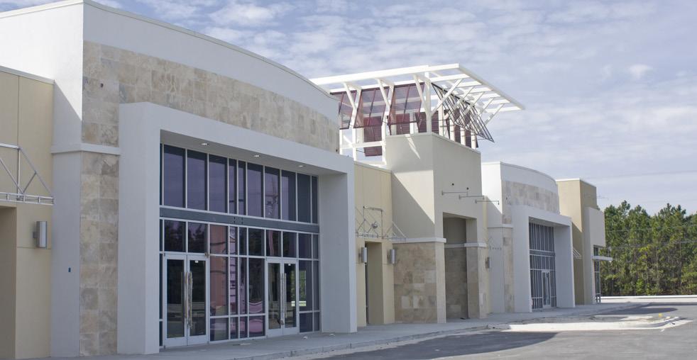
10 TERMS & CONDITIONS The successful bidder must enter into a Sale Agreement within 30 days of notification of the award of the tender. Failure to enter into the Sale Agreement within the prescribed time period will be deemed in default of the terms of the tender and the bid deposit will be forfeited. The successful bidder will be granted possession of the property after payment in full has been received. The following outlines the conditions of possession: 1. On or before the possession date, the successful bidder will deliver to the City of Saskatoon, Saskatoon Land the following: (a) (b) A certified cheque, bank draft or solicitor s trust cheque for the balance of the purchase price; and A written statement acknowledging acceptance of the environmental condition of the property. 2. Property taxes will be adjusted at the possession date. 3. Purchaser is responsible for fees to transfer Title. The Purchaser must provide the name of their solicitor who will undertake to register the Transfer Authorization on their behalf. The City of Saskatoon will provide a Transfer Authorization to the purchaser s solicitor upon receipt of the balance of the purchase price. Final payment is due no later than 120 days from the effective date of the Sale Agreement or as agreed to between the vendor and the purchaser. There will be no exceptions as to the conditions of this tender. Please consult our office or the website prior to the tender closing date for any amendments to this package. COMMISSIONS The City will pay real estate fees to a licensed realtor in accordance with Council Policy C09 015, Real Estate Commissions. For this type of land, real estate fees to be paid will be based on: 5% on the first $1 million; 3% on the second $1 million (on portion of sale price from $1 to $2 million); 1% on the balance (on portion on sale price above $2 million) to a maximum commission payment of $150,000. McOrmond Drive Baltzan Boulevard McOrmond Drive Rendering Evergreen/Aspen Ridge District Commercial Conceptual Vision DISTRICT COMMERCIAL/MIXEDUSE SALES INFORMATION 10
11 Figure 7 Registered Plan of Survey (Plan # ) DISTRICT COMMERCIAL/MIXEDUSE SALES INFORMATION 11
12 Please note that the Plan of Survey for Parcel ZZ (as shown below) is in the registration process and is yet to be registered. The projected completion date is February 2019 but is subject to change. Figure 8 Preliminary Plan of Survey (Plan # ) DISTRICT COMMERCIAL/MIXEDUSE SALES INFORMATION 12
13 Figure 9 District Village Lot Grades DISTRICT COMMERCIAL/MIXEDUSE SALES INFORMATION 13

14 Figure 10 District Village Design Contours DISTRICT COMMERCIAL/MIXEDUSE SALES INFORMATION 14


15 Figure 11 District Village Cut/Fill Map 0.25 Cut Contour 0.25 Fill Contour 0.0 Cut/Fill Contour DISTRICT COMMERCIAL/MIXEDUSE SALES INFORMATION 15
16 For more information, contact Saskatoon Land at saskatoonland.ca DISTRICT COMMERCIAL/MIXEDUSE SALES INFORMATION 16
17 Attachment 1 District Commercial/MixedUse Land Tender Form I wish to submit the following tender: Lot(s)/Parcel: Block: Plan: Civic Address: Amount Tendered: $ (before GST).* A certified cheque in the amount of $ is attached. ** Company: *All bids are subject to Goods and Services Tax. The successful bidder will be required to pay the GST when forwarding the balance of the purchase price or provide a GST Registration Number. **This amount represents exactly 10% of the amount tendered and the cheque is made out to the City of Saskatoon. GST Registration Number (if applicable): Contact Name: Address: Telephone No.: (postal code) Fax No.: Address: Solicitor: Solicitor s Address: Agent Representation (if applicable) Associate s Name and Firm: Associate s Telephone #: Associate s Address: I have read and acknowledge the conditions as set out in the attached Instructions to Bidders. Signature Date

18 Attachment 2 District Commercial/MixedUse Design Guidelines City of Saskatoon Saskatoon Land Division
 3 3.3 Purchaser Enhancements and Maintenance 4 4.")
19 District Commercial/MixedUse Design Guidelines INDEX Introduction District Commercial/MixedUse at a Glance Vision McOrmond Drive and Chief Mistawasis Bridge Benefiting Enhancements Arterial Laybys and Collector Onstreet Parking Roundabout and Median Streetscaping (Baltzan Boulevard) Purchaser Enhancements and Maintenance Site Planning Pedestrians and Parking Site Landscaping General Architectural Design Guidelines Figure 1 Desirable Building Entrance Figure 2 Undesirable Building Entrance Figure 3 Desirable Parking Lot Layout Figure 4 Undesirable Parking Lot Layout

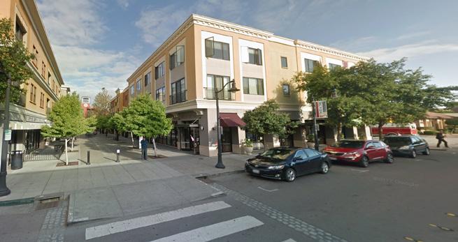
20 District Commercial/MixedUse Design Guidelines 1.0 Introduction Saskatoon Land s District Commercial/MixedUse Design Guidelines are intended to provide a guiding document to facilitate an enhanced level of commercial and mixeduse development in the District Commercial Area. These guidelines shall be used to assist in forming the basis of detailed site planning, building design and landscaping for the sites in the area. These guidelines will help achieve Saskatoon Land s objectives for the District Commercial Area, which are outlined below: Creating a highquality commercial amenity for residents of Evergreen, Aspen Ridge, and surrounding neighbourhoods. Creating an enhanced pedestrian environment both within the development sites and along the surrounding streets, which provides safe and comfortable pedestrian movement. Facilitating the development of a vibrant commercial focal point within Saskatoon s northeast growth area. These guidelines are intended to supplement the City of Saskatoon s (City) Zoning Bylaw. All developments will be governed by the City s zoning regulations. In the event there are contradictions between these two documents, the Zoning Bylaw shall take precedence. McOrmond Drive District Commercial /MixedUse Area Saskatoon Land 1
21 District Commercial/MixedUse Design Guidelines 2.0 District Commercial/MixedUse at a Glance The District Commercial/MixedUse Area is located in northeast Saskatoon. It is strategically located along McOrmond Drive and adjacent to the Evergreen neighbourhood, and one of the newest developing neighbourhoods, Aspen Ridge. 2.1 Vision The vision for the District Commercial/MixedUse Area is to accomodate a broad range of uses including medium to highdensity residential, commercial, and institutional uses in a manner that promotes retail and service based uses at grade level. This District also promotes a compact, pedestrian oriented built form that encourages densification along transit corridors, alternative modes of transportation, and better integration between neighbourhoods. 2.2 McOrmand Drive and Chief Mistawasis Bridge McOrmond Drive is a fourlane arterial road with bicycle lanes and walking paths along the service lanes (laybys) adjacent to the District Commercial Area. This arterial provides multimodal options for northeast residents. The completion of Saskatoon s newest bridge (Chief Mistawasis Bridge), and the extension of McOrmond Drive to align with this bridge, connects the residential northeast quadrant of the city with Saskatoon s thriving employment Industrial sector. The Transportation Division estimates that in 2019 (the first full year of its opening), this bridge will carry approximately 20,000 vehicles per day. As residential growth in the area continues and is highly sought after, Saskatoon Land predicts the number of vehicles using McOrmond Drive will even be greater. At full buildout of Evergreen and Aspen Ridge, there could be approximately 25,000 people living in these two neighbourhood alone. This does not take into account the Silverspring or the Willowgrove neighbourhoods (5,000 and 8,000 people respectively) which would also benefit from this District Commercial Area. District Commercial Area Northeast Quadrant District Commercial Location Saskatoon Land 2

, transit stops, and angled parking.")
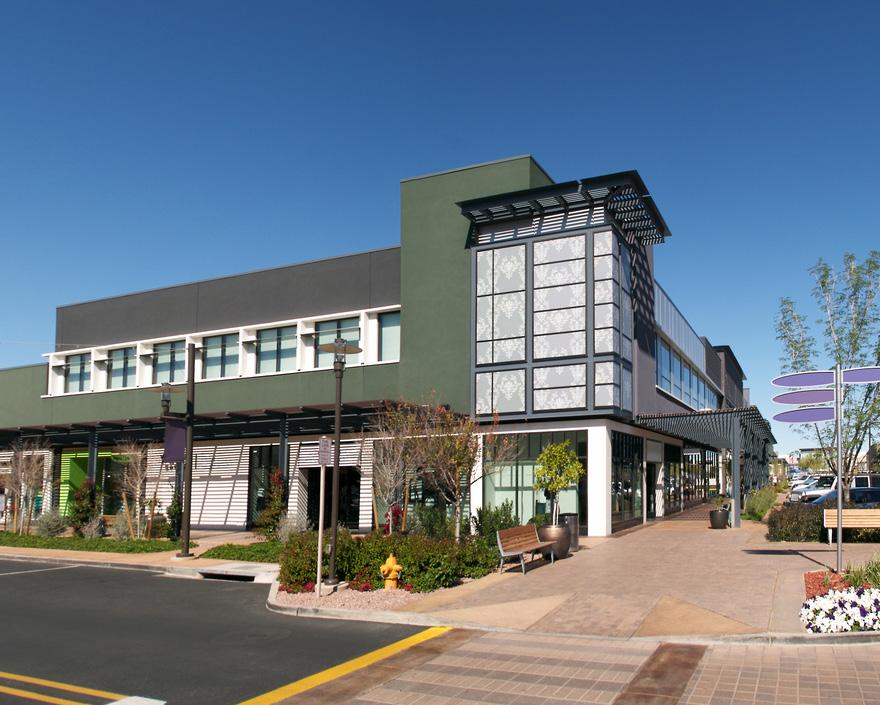
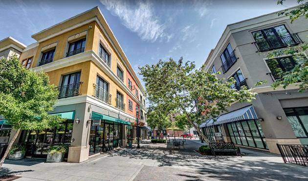
22 District Commercial/MixedUse Design Guidelines 3.0 Benefiting Enhancements The District Commercial Area includes several improvements which add value to, and contribute towards, enhancing the character and vibrancy of the area. 3.1 Arterial Laybys and Collector Onstreet Parking McOrmond Drive Multiway Boulevard was enhanced to include laybys that serve multimodel uses (pedestrians, cyclists, transit riders, and motorists). Therefore, McOrmond Drive will incorporate an offstreet cycle track (separated pedestrian and cycling pathways), transit stops, and angled parking. This area will incorporate streetscaping elements to enhance the visual and pedestrian appeal. 3.2 Roundabout and Median Streetscaping (Baltzan Boulevard) Baltzan Boulevard will include a landscaped median and roundabout, consisting of a mix of soft and hard landscaping. These enhancements will reinforce the District Commercial Area as a unique place, while adding to the pedestrian and visual appeal of the area. 3.3 Purchaser Enhancements and Maintenance For boulevard areas that are not landscaped by Saskatoon Land, the landscaping of the boulevard between the property line and the street curbing will be required by the purchaser as a condition of sale. Maintenance of the boulevard landscaping will be the responsibility of the successful purchaser. Roundabout landscaping example McOrmond Drive Saskatoon Land 3


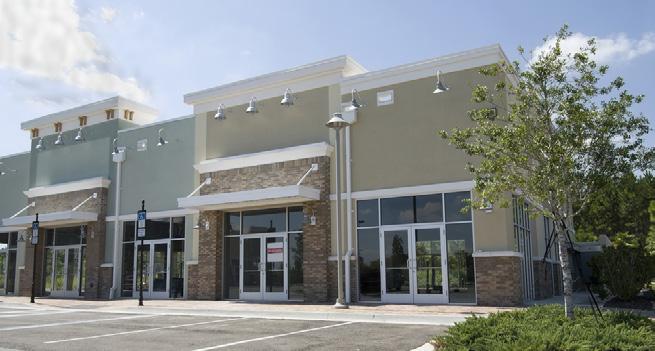
23 District Commercial/MixedUse Design Guidelines 4.0 Site Planning The following are site planning and setback guidelines for all sites: Building placement on these sites should be planned cognizant of the surrounding residential community to achieve more of a human scale along the street edge, while helping to buffer the view of the internal parking areas. Building placement is encouraged along the primary street. Loading and garbage areas must be screened from surrounding properties and public streets through mechanisms such as fencing and/or more intensive landscaping. Large format store with significant front elevation detail Site signage should be selected and designed cognizant of the area s residential context. In general, wallmounted signage is encouraged over freestanding signage. Building facades and orientation that reinforce the human scale of a pedestrian environment and enhanced walkability is encouraged. Good example of large format store with significant front elevation detail Example of screened loading area Saskatoon Land 4


24 District Commercial/MixedUse Design Guidelines 5.0 Pedestrians and Parking The following are pedestrian and parking guidelines for all sites: To take advantage of onstreet parking, buildings are encouraged to be streetoriented and include elements of an active street frontage. Offstreet parking should be internalized. Offstreet parking located along the side wall of a building may be permitted, provided that the parking area is appropriately buffered with landscaping from the fronting street. A mixture of retail and servicebased land uses are recommended at grade level to facilitate a vibrant pedestrianoriented street and to create a main street feel that is attractive and comfortable for pedestrians. The use of proactive site planning and building layouts that can adapt, and retail that facilitates pedestrian amenity areas and an animated public realm, through the use of sidewalk patios, seating areas, etc. Bicycle storage to encourage active transportation Allowances for sidewalk patios through proactive site planning Pedestrianoriented streetscape with angled street parking Buildinglined streets with angled onstreet parking Saskatoon Land 5
25 District Commercial/MixedUse Design Guidelines Figures 1 and 4 provide examples of appropriate building entrance treatments and parking lot configuration. Figure 3 Desirable Parking Lot Layout Figure 1 Desirable Building Entrance Building Entrance Parking Front Walk Figure 2 Undesirable Building Entrance Figure 4 Undesirable Parking Lot Layout Building Entrance Parking Front Walk Saskatoon Land 6


.")

26 District Commercial/MixedUse Design Guidelines 6.0 Site Landscaping The following are guidelines for landscaping and pedestrian circulation for all sites: A high degree of internal landscaping should be provided to help with pedestrian wayfinding and to provide an enhanced level of safety and comfort along internal walkways. Green spaces or amenity spaces and the public realm are encouraged throughout the site. Use of boulevardstyle landscaping within parking lot islands and linear green spaces which align with internal site pathways. Establishment of a strong tree canopy along the major pedestrian and vehicle traffic (routes). Use of curbed landscaped islands at the end of each parking aisle. Changes in parking lot paving treatment to help delineate pedestrian routes or other forms of traffic calming, including bulbing and raised or textured crosswalks. Changes in walkway entrance paving treatment to add visual appeal. Green space at walkway commercial retail unit corner Internal parking lot landscaped islands Linear green spaces aligned with pedestrian pathway Storefront walkway treatment change Saskatoon Land 7

27 District Commercial/MixedUse Design Guidelines (6.0 Site Landscaping continued) Intensive tree/shrubbery plantings should be used to help buffer the impacts of vehicles. A welllit, safe and clearly demarcated pedestrian access way must be provided to and from any rear yard offstreet parking area. Planting of species suitable for winter climate. Good Example of sidewalk texture changes Good Example of intensive landscaping clusters along the streetscape to foster pedestrian amenity areas Saskatoon Land 8


28 District Commercial/MixedUse Design Guidelines 7.0 General Architectural Design Guidelines The following information includes general architectural design guidelines which apply to all sites: Front building elevations should include changes in wall plane to provide relief and encourage development at a pedestrian scale. Building massing should avoid long, continuous, blank wall surfaces throughout the development. Building massing should create visual interest by using varied roof lines, heights and pitches. Building frontages should be constructed to define the edges of any public street or pedestrianoriented area. Architectural elements should be incorporated into front building elevations including canopies, window projections, awnings, recessed entry ways, specialty signs, etc. The use of a variety of different exterior building materials and exterior building material colours are encouraged throughout the site to facilitate a vibrant pedestrianoriented streetscape. The use of a consistent fenestration pattern along building elevations. Lighting on any site and on any portion of a building shall be full cutoff exterior lighting and should be arranged and shielded such that it does not become a hazard, annoyance or compromise the function of adjacent properties. A good example of mixeduse with vertical integration Example of the use of multiple colours A good example of varied roof heights and changes in wall plane and the use of a variety of canopies and awnings along the front elevation A good example of a consistent fenestration pattern Saskatoon Land 9


29 For more information, contact Saskatoon Land at saskatoonland.ca
30 Attachment 3 City of Saskatoon Zoning Bylaw 10.7A B4MX Integrated Commercial MixedUse District (Revised Bylaw No December 14, 2015) 10.7A.1 Purpose The purpose of the B4MX District is to facilitate mixeduse development on principal streets in this district. The B4MX District provides for a range of medium to highdensity residential uses, commercial and institutional uses in a manner that encourages retail and servicebased uses at grade level. The B4MX District promotes a compact, pedestrianoriented built form that supports transportation options, street orientated buildings and active uses at grade level. 10.7A.2 Permitted Uses The Permitted Uses and Minimum Development Standards in the B4MX District are set out in the following chart: Minimum Development Standards (in Metres) Site Site Front Side Rear Building Amenity B4MX District Width Area Yard Yard Yard Height Space Per (m 2 ) (Max.) (Max.) Unit (m 2 ) 10.7A.2 Permitted Uses (1) Bakeries (2) Boarding apartments (3) Catering halls, banquet halls and community kitchens (4) Child care centres (5) Commercial recreation uses (6) Community centres (7) Financial institutions (8) Hotels (9) Medical clinics (10) Medical, dental and optical laboratories (11) Multipleunit dwellings (12) Offices, office buildings and office complexes (13) Personal service trades and health clubs (14) Preschools (15) Private Clubs (16) Private schools (17) Public libraries (18) Residential care homes Type III (19) Restaurants and lounges (20) Retail stores (21) Shopping centres (22) Small animal grooming (23) Veterinary clinics (24) Accessory buildings3 and uses Refer to General Provisions Section
31 City of Saskatoon Zoning Bylaw 10.7A.3 Discretionary Uses The Discretionary Uses and Minimum Development Standards in a B4MX District are set out in the following chart: B4MX District 10.7A.3 Discretionary Uses Minimum Development Standards (in Metres) Site Site Front Side Rear Building Width Area Yard Yard Yard Height (m 2 ) (Max) (Max.) (1) Car wash (2) Nightclubs and taverns (3) Gas bars (4) Special care homes (5) Special needs housing A.4 Notes to Development Standards 1 For sites containing one or more principal buildings, the 3.0 metre maximum front yard setback shall apply to at least one of the principal buildings. A site plan shall be provided showing potential future phases of development. The site plan is intended to illustrate how future intensification and build out of the site may be accommodated to meet the purpose of the District. 2 Where a B4MX District abuts an R District without the intervention of a street or lane, or on a corner site along a flanking street, a side yard shall be provided of a width not less than 3.0 metres for the side yard abutting the R District or flanking street. 3 Accessory buildings must be located at least 15.0 metres from the front property line or 1.2 metres behind the rear line of the principal building and shall not be located within a required landscaping strip. 4 Dwelling units shall not be located at grade when located in the portion of a principal building adjacent to an arterial street. 5 Where the maximum building height is at least 15.0 metres, the building shall contain both a building base and a building cap as follows: (a) (b) Building Base Height: shall be a minimum of 10.0 metres and a maximum of 12.0 metres. Building Cap: shall be set back a minimum of 2.0 metres from the front façade of the building base. 1029
32 City of Saskatoon Zoning Bylaw 10.7A.5 Signs The regulations governing signs in the B4MX District are contained in Appendix A Sign Regulations. 10.7A.6 Parking (1) The regulations governing parking and loading spaces in the B4MX District are contained in Section 6.0. (2) The number of parking spaces required in the B4MX District may be reduced by the number of parking spaces provided on the street, which will primarily serve the subject property. The determination of the number of onstreet parking spaces to be credited on the subject property shall be at the discretion of the Development Officer. (3) The number of parking spaces may be reduced in the B4MX District by 0.25 spaces per dwelling unit when a multipleunit dwelling is located above nonresidential uses within the same building. (4) Bicycle Parking: (a) (b) A minimum of one bicycle parking space shall be provided for every 250 square metres of gross floor area devoted to nonresidential uses. Bicycle parking spaces shall be provided in locations that are readily visible, well lit, and in close proximity to building entrances. 10.7A.7 Gross Floor Space Ratio (1) Except as provided in clause (2), the gross floor space ratio shall not exceed 3:1. (2) The gross floor space ratio for sites containing residential uses shall not exceed 5: A.8 Landscaping (1) A landscaping strip of not less than 4.5 metres in depth throughout, lying parallel to and abutting the front site line, shall be provided on every site for that portion of the site not covered by a building and shall be used for no purpose except landscaping, necessary driveway access, outdoor patios or public seating areas. 1030
33 City of Saskatoon Zoning Bylaw (2) Where a B4MX district abuts an R District without an intervening lane, there shall be a strip of land adjacent to the abutting site line of not less than 3.0 metres throughout, which shall not be used for any purpose except landscaping. (3) On corner lots, in addition to the landscaping required in the front yard, the whole of any required side yard abutting the flanking street shall be landscaped and shall be used for no purpose except landscaping, necessary driveway access, and outdoor patios or public seating areas. (4) Curbed landscaped islands at the flanking end of every parking row shall be provided for at grade parking areas. (5) Interior sidewalks within the parking area shall be provided to link buildings. (6) Parking areas shall be adequately screened from the front site line to a height of 1.0 metres by landscaping or fencing. 10.7A.9 Outdoor Storage (1) No goods, commodities, or other form of materials shall be stored outdoors. (2) An outdoor sales area is permitted when accessory to a retail store or shopping centre provided that the outdoor sales area is fenced or partially enclosed or both. 10.7A.10 Building Orientation and Building Setback (1) Buildings located adjacent to a street shall contain elements of an active frontage, which shall create a functional pedestrianoriented relationship between the building and the street. (2) For corner sites, all street facing façades shall incorporate elements of an active building frontage. (3) Buildings fronting a street shall incorporate architectural features that provide visual interest along the streetscape and reduce the perceived massing of the building. 1031
C O MM ERCIAL & MIXED-USE LAND FOR SALE
 C O MM ERCIAL & MIXEDUSE LAND FOR SALE CONTENT 3 COMMERCIAL & MIXEDUSE LAND FOR SALE Parcels TT & UU 3 PURCHASE OPTIONS Sale Agreement & Option to Purchase Agreement 5 CONSISTENCY WITH DESIGN GUIDELINES
Marquis and Hudson Bay Industrial Tender Package - September
 Marquis and Hudson Bay Industrial Tender Package - September 2017 1 LAND FOR SALE BY PUBLIC TENDER Sealed tenders addressed to the Sales Section, Saskatoon Land, 201 Third Avenue North, Saskatoon, SK S7K
evergreen district village
 evergreen district village institutional land for sale Institutional Land for Sale Located in the popular Evergreen Neighbourhood, which is projected to be one of the densest neighbourhoods in the City.
Land For Sale By Public Tender. Instructions to Bidders
 Land For Sale By Public Tender Instructions to Bidders Sealed tenders addressed to the Sales Section, Saskatoon Land, 0 Third Avenue North, Saskatoon, SK SK H, and plainly marked on the envelope Tender
STAPt.ES $2,478,000. Walmart,. Save money. Live better. I. Saskatoon. LowE s GET IN TOUCH. City of. PROPERTY FACT SHEET City/Town: Saskatoon Type:
 RM2 Area: 2.84 ac Civic Address: 803 Hart Road $17,910 (2017 estimate) List Date: 02/06/2017 Exp. Date: 03/08/2017 Parcel AA, Plan No. 102177862 Legal 2: ISC Parcel# 203078886 Nearby Amenities: Shaw Centre,
8.5.1 R1, Single Detached Residential District
 8.5.1 R1, Single Detached Residential District The purpose of this district is to provide for residential development in the form of single detached dwellings. Dwelling, Single Detached Home Business,
Appendix1,Page1. Urban Design Guidelines. Back to Back and Stacked Townhouses. DRAFT September 2017
 Appendix1,Page1 Urban Design Guidelines DRAFT September 2017 Back to Back and Stacked Townhouses Appendix1,Page2 Table of Contents 1 Introduction 1 1.1 Purpose 1 1.2 Urban Design Objectives 1 1.3 Building
Composition of traditional residential corridors.
 Page 1 of 7 St. Petersburg, Florida, Code of Ordinances >> PART II - ST. PETERSBURG CITY CODE >> Chapter 16 - LAND DEVELOPMENT REGULATIONS >> SECTION 16.20.060. CORRIDOR RESIDENTIAL TRADITIONAL DISTRICTS
Montreal Road District Secondary Plan [Amendment #127, October 9, 2013]
![Montreal Road District Secondary Plan [Amendment #127, October 9, 2013]](/thumbs/72/66783104.jpg "Montreal Road District Secondary Plan [Amendment #127, October 9, 2013]") [Amendment #127, October 9, 2013] 1.0 General The following policies are applicable to the Montreal Road District as set out in Schedule 1. 1.1 District Objectives The objective of this Plan is to guide
[Amendment #127, October 9, 2013] 1.0 General The following policies are applicable to the Montreal Road District as set out in Schedule 1. 1.1 District Objectives The objective of this Plan is to guide
Article 3. SUBURBAN (S-) NEIGHBORHOOD CONTEXT
 NEIGHBORHOOD CONTEXT") Article 3. SUBURBAN (S-) NEIGHBORHOOD CONTEXT this page left intentionally blank Contents ARTICLE 3. SUBURBAN (S-) NEIGHBORHOOD CONTEXT DIVISION 3.1 NEIGHBORHOOD CONTEXT DESCRIPTION...3.1-1 Section 3.1.1
Article 3. SUBURBAN (S-) NEIGHBORHOOD CONTEXT this page left intentionally blank Contents ARTICLE 3. SUBURBAN (S-) NEIGHBORHOOD CONTEXT DIVISION 3.1 NEIGHBORHOOD CONTEXT DESCRIPTION...3.1-1 Section 3.1.1
BYLAW NUMBER 159D2016
 CPC2016-164 ATTACHMENT 1 BEING A BYLAW OF THE CITY OF CALGARY TO AMEND THE LAND USE BYLAW 1P2007 (LAND USE ) * * * * * * * * * * * * * * * * * * * * * * * * * * * * * * * * WHEREAS it is desirable to amend
Plan Dutch Village Road
 Plan Dutch Village Road Objective: The lands around Dutch Village Road are a minor commercial area that services the larger Fairview community. Maintaining the vibrancy of the area by planning for redevelopment
Part 4.0 DEVELOPMENT REGULATIONS
 M A I N S T R E E T N O R T H Part 4.0 DEVELOPMENT REGULATIONS 4.1 Districts 4.2 Permitted and Prohibited Uses, Standards and Standard Specific Criteria and Other General Provisions 4.3 DPS REGULATIONS
PUD Zoning Framework
 PUD Zoning Framework PUD Zoning Framework Purpose Development Review Process Site Plan Review Process Planned Unit Developments (PUD) are tools for dealing with special situations or accomplishing certain
BYLAW NO. 15/026 A BYLAW OF THE REGIONAL MUNICIPALITY OF WOOD BUFFALO TO AMEND THE LAND USE BYLAW NO. 99/059
 Attachment 2 BYLAW NO. 15/026 A BYLAW OF THE REGIONAL MUNICIPALITY OF WOOD BUFFALO TO AMEND THE LAND USE BYLAW NO. 99/059 WHEREAS Section 639 of the Municipal Government Act requires every municipality
Chapter DOWNTOWN ZONING DISTRICTS
 Chapter 20.14 Sections: 20.14.010 Purpose of the Downtown Zoning Districts 20.14.020 Land Use Regulations for Downtown Zoning Districts 20.14.030 Development Standards for Downtown Zoning Districts 20.14.010
UPPER MOUNT BETHEL TOWNSHIP NORTHAMPTON COUNTY, PENNSYLVANIA
 UPPER MOUNT BETHEL TOWNSHIP NORTHAMPTON COUNTY, PENNSYLVANIA JOINDER DEED / LOT CONSOLIDATION TOWNSHIP REVIEW PROCESS When accepting proposed Joinder Deeds / Lot Consolidations, review the Joinder Deed
Jasper 115 Street DC2 Urban Design Brief
 Jasper 115 Street DC2 Urban Design Brief Greenlong Construction Ltd. Stantec Consulting Ltd. 2017 Overview The proposed rezoning application supports the development of two mixed-use high-rise buildings
SECTION 10: COMMERCIAL AND MIXED USE ZONES
 10.5a MIXED USE MEDIUM DENSITY PEDESTRIAN FOCUS (C5a) ZONE Explanatory Note: The C5a Zone is typically located along pedestrian oriented streets where permitted commercial and residential uses create an
Direct Control District No. 1 (DCD1) for The South Downtown
 for The South Downtown") Direct Control District No. 1 (DCD1) for The South Downtown Amended to September 13, 2010 13.1.3 Policies: 13.1.3.1 Linkage and Land Use a) Use of Land Uses for the DCD1 The only permitted uses in the
Direct Control District No. 1 (DCD1) for The South Downtown Amended to September 13, 2010 13.1.3 Policies: 13.1.3.1 Linkage and Land Use a) Use of Land Uses for the DCD1 The only permitted uses in the
SECTION 10: COMMERCIAL ZONES
 10.5 MIXED USE MEDIUM DENSITY (C5) ZONE Explanatory Note: The C5 Zone is found along collector and arterial Roads where the zone permits a range of retail, service, commercial, entertainment, and residential
COMMERCIAL AND MIXED USE zones COMMERCIAL AND MIXED USE ZONES. Zoning By-law PLANNING & ECONOMIC DEVELOPMENT PLANNING DEPARTMENT DIVISION
 Zoning By-law 05-200 COMMERCIAL AND MIXED USE zones PLANNING & ECONOMIC DEVELOPMENT PLANNING DEPARTMENT DIVISION CONTENTS CONTEXT... 1 URBAN HAMILTON OFFICIAL PLAN... 2 COMMERCIAL AND MIXED USE ZONES...
Urban Design Brief (Richmond) Corp. 1631, 1635, 1639, 1643 and 1649 Richmond Street City of London
 Corp. 1631, 1635, 1639, 1643 and 1649 Richmond Street City of London") Urban Design Brief 1635 (Richmond) Corp. 1631, 1635, 1639, 1643 and 1649 Richmond Street City of London Site Plan Control Application Holding Provision Application April 1, 2015 Prepared for: Rise Real
Urban Design Brief 1635 (Richmond) Corp. 1631, 1635, 1639, 1643 and 1649 Richmond Street City of London Site Plan Control Application Holding Provision Application April 1, 2015 Prepared for: Rise Real
3.1 Existing Built Form
 3.1 Existing Built Form There is a wide variety of built form in the study area, generally comprising 2 and 3 storey buildings. This stretch of Queen Street East is somewhat atypical of Toronto's main
SALT LAKE CITY ORDINANCE No. of 2016
 SALT LAKE CITY ORDINANCE No. of 2016 (Amending the Sugar House Master Plan, amending the zoning ordinance to create the SC and SE Form Based Special Purpose Corridor districts, and amending the zoning
4 DEVELOPMENT STANDARDS FOR
 4 DEVELOPMENT STANDARDS FOR RESIDENTIAL MIXED-USE PROJECTS This chapter presents standards for residential mixed-use projects in the Ashland-Cherryland Business District and the Castro Valley Central Business
City of Reno October 30, 2012 Draft Midtown Zoning Text Amendments 1
 Section 18.08.405 Regional Center and Transit Corridor Overlay Districts (i) SVTC South Virginia Street Transit Corridor Overlay Zoning District. (1) Applicability. This Section 18.08.405(l)'s standards
Table of Contents ARTICLE 5A CHARACTER-BASED ZONING 1
 Table of Contents ARTICLE 5A CHARACTER-BASED ZONING 1 SECTION 10.5A10 GENERAL... 1 10.5A11 Purpose and Intent... 1 10.5A12 Applicability... 1 10.5A13 Compliance with Regulating Plan... 1 10.5A14 Relationship
DRAFT FOR DISCUSSION PURPOSES ONLY. Port Credit Local Area Plan Built Form Guidelines and Standards DRAFT For Discussion Purposes
 Port Credit Local Area Plan Built Form Guidelines and Standards DRAFT For Discussion Purposes 1 Local Area Plan - Project Alignment Overview Directions Report, October 2008 (General Summary Of Selected
2.35 BVT G Bow Valley Trail General Commercial District [ ]
![2.35 BVT G Bow Valley Trail General Commercial District [ ]](/thumbs/94/119006025.jpg "2.35 BVT G Bow Valley Trail General Commercial District [ ]") 2.35 BVT G Bow Valley Trail General Commercial District [2014 07] 2.35.1 Purpose This district is intended to form the core of Canmore s visitor accommodation outside the resorts and provide a variety
2.35 BVT G Bow Valley Trail General Commercial District [2014 07] 2.35.1 Purpose This district is intended to form the core of Canmore s visitor accommodation outside the resorts and provide a variety
ARTICLE 5. COMMERCIAL AND OFFICE DISTRICTS 5.1 PURPOSE STATEMENTS 5.2 USES 5.3 DIMENSIONAL STANDARDS 5.4 DESIGN STANDARDS 5.5 DK DISTRICT STANDARDS 5
 ARTICLE 5. COMMERCIAL AND OFFICE DISTRICTS 5.1 PURPOSE STATEMENTS 5.2 USES 5.3 DIMENSIONAL STANDARDS 5.4 DESIGN STANDARDS 5.5 DK DISTRICT STANDARDS 5.6 CU DISTRICT STANDARDS 5.7 SW DISTRICT STANDARDS THE
Staff Report for Council Public Meeting
 Agenda Item 3.3 Staff Report for Council Public Meeting Date of Meeting: September 27, 2017 Report Number: SRPRS.17.134 Department: Division: Subject: Planning and Regulatory Services Development Planning
Table of Contents ARTICLE 5A CHARACTER-BASED ZONING 1
 Table of Contents ARTICLE 5A CHARACTER-BASED ZONING 1 SECTION 10.5A10 GENERAL... 1 10.5A11 Purpose and Intent... 1 10.5A12 Applicability... 1 10.5A13 Compliance with Regulating Plan... 1 10.5A14 Relationship
CITY OF SURREY BY-LAW NO A by-law to amend Surrey Zoning By-law, 1993, No , as amended...
 CITY OF SURREY BY-LAW NO. 17397 A by-law to amend Surrey Zoning By-law, 1993, No. 12000, as amended........................................................... THE CITY COUNCIL of the City of Surrey, in
BYLAW NUMBER 20P2017
 CPC2017-130 ATTACHMENT 1 BYLAW NUMBER 20P2017 BEING A BYLAW OF THE CITY OF CALGARY TO AMEND THE LAND USE BYLAW 1P2007 * * * * * * * * * * * * * * * * * * * * * * * * * * * * * * * WHEREAS it is desirable
111 Wenderly Drive Official Plan and Zoning By-law Amendment Applications - Preliminary Report
 STAFF REPORT ACTION REQUIRED 111 Wenderly Drive Official Plan and Zoning By-law Amendment Applications - Preliminary Report Date: August 17, 2015 To: From: Wards: Reference Number: North York Community
LITTLE MOUNTAIN ADJACENT AREA REZONING POLICY
 LITTLE MOUNTAIN ADJACENT AREA REZONING POLICY JANUARY 2013 CONTENTS 1.0 INTENT & PRINCIPLES...1 2.0 APPLICATION...2 3.0 HOUSING TYPES, HEIGHT & DENSITY POLICIES...3 3.1 LOW TO MID-RISE APARTMENT POLICIES...4
PERMITTED USES: Within the MX-1 Mixed Use Neighborhood District the following uses are permitted:
 6.25 MX-1 - MIXED USE NEIGHBORHOOD 6.25.1 INTENT: The purpose of the MX-1 Mixed Use Neighborhood District is to accommodate the development of a wide-range of residential and compatible non-residential
50 and 52 Finch Avenue East - Official Plan and Zoning By-law Amendment Applications - Preliminary Report
 STAFF REPORT ACTION REQUIRED 50 and 52 Finch Avenue East - Official Plan and Zoning By-law Amendment Applications - Preliminary Report Date: August 16, 2016 To: From: Wards: Reference Number: North York
ARTICLE 887. PD 887. Valley View - Galleria Area Special Purpose District
 ARTICLE 887. PD 887. Valley View - Galleria Area Special Purpose District SEC. 51P-887.101. LEGISLATIVE HISTORY. PD 887 was established by Ordinance No. 29032, passed by the Dallas City Council on June
Wilson Bridge Corridor Zoning. Department of Planning & Building
 Wilson Bridge Corridor Zoning Department of Planning & Building Background: Wilson Bridge Road Corridor Study The City conducted a strategic study of one of the community s primary economic centers, the
CASTLES OF CALEDON URBAN DESIGN REPORT
 CASTLES OF CALEDON URBAN DESIGN REPORT PROPOSED RESIDENTIAL DEVELOPMENT CALEDON, ONTARIO 10 JULY, 2015 TABLE CONTENTS: 1.0 DEVELOPMENT 4.0 CONCLUSION 1.1 Introduction 1.2 Castles of Caledon- Urban Design
RM-11 and RM-11N Districts Schedule
 Districts Schedule 1 Intent The intent of this Schedule is to permit medium density residential development primarily in the form of four-storey T -shaped apartments, and to foster compact, sustainable,
THE CITY COUNCIL OF NORTH ROYALTON, OHIO
 THE CITY COUNCIL OF NORTH ROYALTON, OHIO ORDINANCE NO. 16-113 INTRODUCED BY: Nickell, Kasaris, Antoskiewicz AN ORDINANCE AMENDING THE CODIFIED ORDINANCES OF THE CITY OF NORTH ROYALTON, PART 12 PLANNING
City of Valdosta Land Development Regulations
 Chapter 206 Section 206-1 Base Zoning Districts Standards for Uses, Structures, and Property Development (B) (C) Principal Uses and Structures. Principal uses and structures permitted in each base zoning
mandatory injunction to remove any previous violation hereof.
 ORDINANCE NO. 2013-10- 099 AN ORDINANCE OF THE CITY COUNCIL OF THE CITY OF McKINNEY, TEXAS, AMENDING THE ZONING MAP OF THE CITY OF McKINNEY, TEXAS; SO THAT AN APPROXIMATELY 41. 64 ACRE PROPERTY IS REZONED
LAND USE AND BUILT FORM
 5 LAND USE AND BUILT FORM The existing zoning on Bank Street already allows for considerable general intensification, since the permitted Floor Space Index (FSI) would already allow several times more
SECTION 53 Page 1 of 5. SECTION 53 (By-law , S.3) LOW INTENSITY MIXED USE CORRIDOR ZONE (MU-1)
 LOW INTENSITY MIXED USE CORRIDOR ZONE (MU-1)") SECTION 53 Page 1 of 5 SECTION 53 (By-law 2008-154, S.3) LOW INTENSITY MIXED USE CORRIDOR ZONE (MU-1) No person shall erect, nor use any building in whole or in part, nor use any land in whole or in part,
SECTION 53 Page 1 of 5 SECTION 53 (By-law 2008-154, S.3) LOW INTENSITY MIXED USE CORRIDOR ZONE (MU-1) No person shall erect, nor use any building in whole or in part, nor use any land in whole or in part,
Urban Design Brief Dundas Street. London Affordable Housing Foundation. November Zelinka Priamo Ltd.
 Urban Design Brief 1039-1047 Dundas Street London Affordable Housing Foundation November 2017 Zelinka Priamo Ltd. TABLE OF CONTENTS Page No. INTRODUCTION... 3 SECTION 1 LAND USE PLANNING CONTEXT... 3 1.1
Introduction. General Development Standards
 Introduction The development standards will set the zoning regulations for the East Park development. This section will illustrate lot standards, approximate open space locations and road standards. The
Application Form Development Proposal
 TYPE OF APPLICATION Community Planning 50-469-866 kelowna.ca Please check all that apply Rezoning Official Community Plan Amendment Development Permit (all types) Development Variance Permit Text Amendment
LAND USE AMENDMENT ITEM NO: 05
 REPORT TO CALGARY PLANNING COMMISSION LAND USE AMENDMENT ITEM NO: 05 FILE NO: LOC2012-0069 CPC DATE: 2013 February 14 COUNCIL DATE: BYLAW NO: HILLHURST (Ward 7 - Alderman Farrell) ISC: Protected Page 1
Community Advisory Committee (CAC) Meeting #7 West Anaheim Youth Center May 26, 2016
 Meeting #7 West Anaheim Youth Center May 26, 2016") Community Advisory Committee (CAC) Meeting #7 West Anaheim Youth Center May 26, 2016 1 Project Team City: David Belmer Planning and Building Director Jonathan Borrego, AICP Planning Services Manager Gustavo
Community Advisory Committee (CAC) Meeting #7 West Anaheim Youth Center May 26, 2016 1 Project Team City: David Belmer Planning and Building Director Jonathan Borrego, AICP Planning Services Manager Gustavo
5.1 Site Planning & Building Form
 5 Built Form 5.1 Site Planning & Building Form Pearson Dogwood Policy Statement Site Planning & Building Form The redevelopment of Pearson Dogwood will create an attractive and sustainable urban community
Rezoning Petition Pre-Hearing Staff Analysis April 17, 2017
 Rezoning Petition 2017-041 Pre-Hearing Staff Analysis April 17, 2017 REQUEST Current Zoning: R-5 (single family residential), R-22MF (multifamily residential), and I-1 (light industrial) Proposed Zoning:
CITY OF SURREY BY-LAW NO A by-law to amend Surrey Zoning By-law, 1993, No , as amended...
 CITY OF SURREY BY-LAW NO. 17377 A by-law to amend Surrey Zoning By-law, 1993, No. 12000, as amended As amended by Bylaw No: 18399, 04/13/15; 18514, 09/28/15...........................................................
H5. Residential Mixed Housing Urban Zone
 H5. Residential Mixed Housing Urban Zone [ENV-2016-AKL-000197: Robert Adams] Addition sought H5.1. Zone description The Residential Mixed Housing Urban Zone is a reasonably high-intensity zone enabling
BOROUGH OF HOPATCONG ORDINANCE No
 BOROUGH OF HOPATCONG ORDINANCE No. 10-2014 AN ORDINANCE OF THE BOROUGH OF HOPATCONG, SUSSEX COUNTY, NEW JERSEY TO ADOPT A FORM BASED CODE AS AN OVERLAY DISTRICT AFFECTING PORTIONS OF THE B-1 AND R-1 ZONING
Division 4: Commercial Community 1 (C-C1) District
 District") Division 4: Commercial Community 1 (C-C1) District 738 Purpose 738 (1) The Commercial Community 1 District is intended to be characterized by: (e) (f) (g) small to mid-scale commercial developments; developments
Division 4: Commercial Community 1 (C-C1) District 738 Purpose 738 (1) The Commercial Community 1 District is intended to be characterized by: (e) (f) (g) small to mid-scale commercial developments; developments
RESIDENTIAL DISTRICTS
 RESIDENTIAL DISTRICTS RESIDENTIAL DISTRICTS The residential district standards have been revised to reflect on-the-ground development conditions, while continuing to respect the use patterns established
900 BURRARD STREET CD-1 GUIDELINES (BY-LAW NO. 6421) (CD-1 NO. 229) CONTENTS. 1 Application and Intent... 1
 (CD-1 NO. 229) CONTENTS. 1 Application and Intent... 1") 50 City of Vancouver Land Use and Development Policies and Guidelines Community Services, 453 W. 12th Ave Vancouver, BC V5Y 1V4 F 604.873.7344 fax 873.7060 planning@city.vancouver.bc.ca 900 BURRARD STREET
50 City of Vancouver Land Use and Development Policies and Guidelines Community Services, 453 W. 12th Ave Vancouver, BC V5Y 1V4 F 604.873.7344 fax 873.7060 planning@city.vancouver.bc.ca 900 BURRARD STREET
Commercial Property with Great Visibility for Sale or Lease. For Sale at $1,500, or For Lease at $12.00/SF NNN
 EXECUTIVE SUMMARY Commercial Property with Great Visibility for Sale or Lease Monroe, Connecticut 06468 For Sale at $1,500,000.00 or For Lease at $12.00/SF NNN u 8,064 SF freestanding building on 0.95
SPECIALIZED RESIDENTIAL APARTMENT (R.4) ZONES
 ZONES") PART 4 SPECIALIZED RESIDENTIAL APARTMENT (R.4) ZONES D.1-1 Specialized Residential (R.4) Zones In certain Instances, special circumstances dictate that variances be allowed to the permitted Uses or regulations
PART 4 SPECIALIZED RESIDENTIAL APARTMENT (R.4) ZONES D.1-1 Specialized Residential (R.4) Zones In certain Instances, special circumstances dictate that variances be allowed to the permitted Uses or regulations
Sec HC - Highway commercial district.
 Sec. 36-422. - HC - Highway commercial district. (1) Purpose. This district is intended for commercial uses which depend upon high visibility, generate high traffic volumes, or cater to the traveling public.
H5. Residential Mixed Housing Urban Zone
 H5. Residential Mixed Housing Urban Zone H5.1. Zone description The Residential Mixed Housing Urban Zone is a reasonably high-intensity zone enabling a greater intensity of development than previously
CHAPTER MFR 22 Multi-Family Residential
 CHAPTER 19.28 MFR 22 Multi-Family Residential Sections: 19.28.010 PURPOSE 19.28.020 PERMITTED USES 19.28.030 USES SUBJECT TO A CONDITIONAL USE PERMIT 19.28.040 PERMITTED ACCESSORY USES 19.28.050 PROHIBITED
DEVELOPMENT STANDARDS FOR RESIDENTIAL PROJECTS RESIDENTIAL BUILDING TYPES: APPROPRIATE ZONES AND DENSITIES 2-1
 2 DEVELOPMENT STANDARDS FOR RESIDENTIAL PROJECTS RESIDENTIAL BUILDING TYPES: APPROPRIATE ZONES AND DENSITIES 2-1 This Chapter presents the development standards for residential projects. Section 2.1 discusses
CITY OF SURREY BYLAW NO
 CITY OF SURREY BYLAW NO. 18649 A bylaw to amend "Surrey Zoning By-law, 1993, No. 12000", as amended........................................................... THE COUNCIL of the City of Surrey ENACTS AS
TOTTENHAM SECONDARY PLAN
 TOTTENHAM SECONDARY PLAN AMENDMENT NO. 11 TO THE OFFICIAL PLAN OF THE TOWN OF NEW TECUMSETH The following text and schedules to the Official Plan of the Town of New Tecumseth constitute Amendment No. 11
Sheppard Ave East and 6, 8 and 10 Greenbriar Road - Official Plan Amendment and Zoning Amendment Applications - Preliminary Report
 STAFF REPORT ACTION REQUIRED 625-627 Sheppard Ave East and 6, 8 and 10 Greenbriar Road - Official Plan Amendment and Zoning Amendment Applications - Preliminary Report Date: April 15, 2016 To: From: Wards:
Accessory Coach House
 Updated July 2018 Accessory Coach House Development Permit Guidelines 1 Accessory Coach House Development Permit Guidelines Zoning Bylaw, 1995 DIVISION VII C. Contents Part I General Reglations 1 Introduction
H4. Residential Mixed Housing Suburban Zone
 H4. Residential Mixed Housing Suburban Zone H4.1. Zone description The Residential Mixed Housing Suburban Zone is the most widespread residential zone covering many established suburbs and some greenfields
VERTICAL MIXED USE DEVELOPMENT (Urban Village)
") VERTICAL MIXED USE DEVELOPMENT (Urban Village) Overall Goal Statement Vertical Mixed Use (Urban Villages) have similar goals to Horizontal Mixed Use except densities are usually higher and projects frequently
VERTICAL MIXED USE DEVELOPMENT (Urban Village) Overall Goal Statement Vertical Mixed Use (Urban Villages) have similar goals to Horizontal Mixed Use except densities are usually higher and projects frequently
H6 Residential Terrace Housing and Apartment Buildings Zone
 H6. Residential Terrace Housing and Apartment Buildings Zone [CIV-2016-404-002333: Franco Belgiorno-Nettis]-Note: The properties affected by this appeal are identified on the Auckland Unitary Plan viewer.
6. RESIDENTIAL ZONE REGULATIONS
 6. RESIDENTIAL ZONE REGULATIONS PART 6A PURPOSE OF CHAPTER (1) The purpose of this Chapter is to provide detailed regulations and requirements that are relevant only to residential zones and specific residential
PLANNING RATIONALE 680 BRONSON AVENUE OTTAWA, ONTARIO PROPOSED ZONING BY-LAW AMENDMENT
 PLANNING RATIONALE 680 BRONSON AVENUE OTTAWA, ONTARIO PROPOSED ZONING BY-LAW AMENDMENT FRANK PARAVAN APRIL 2014 Planning Rationale Introduction FOTENN Consultants Inc. has been engaged by Frank and Michael
Guidelines for the Approval of New Homes Sales Offices (Building Permits, Agreements, Securities)
") Guidelines for the Approval of New Homes Sales Offices (Building Permits, Agreements, Securities) ENCLOSURES: Site Plan Application Building Permit Application Grading and Drainage Approval Requirements
Guidelines for the Approval of New Homes Sales Offices (Building Permits, Agreements, Securities) ENCLOSURES: Site Plan Application Building Permit Application Grading and Drainage Approval Requirements
Urban Design Brief. Proposed Medical / Dental Office 1444 Adelaide Street North. Vireo Health Facility Ltd.
 Urban Design Brief Proposed Medical / Dental Office Vireo Health Facility Ltd. November 27, 2013 TABLE OF CONTENTS Page No. INTRODUCTION... 1 SECTION 1 LAND USE PLANNING CONTEXT... 1 1.1 The Subject Lands...
CITY OF SURREY BY-LAW NO THE CITY COUNCIL of the City of Surrey, in open meeting assembled, ENACTS AS FOLLOWS:
 CITY OF SURREY BY-LAW NO. 16881 A by-law to amend Surrey Zoning By-law, 1993, No. 12000, as amended........................................................... THE CITY COUNCIL of the City of Surrey, in
DRAFT. 171, 173, 175 Greenbank Road Zoning Review. Planning Report
 DRAFT 171, 173, 175 Greenbank Road Zoning Review Planning Report March 2013 Introduction and Scope of Work Meloshe and Associates Ltd was retained by the City of Ottawa s General Manager, Planning and
TABLE OF CONTENTS. Chapters and Sections
 TABLE OF CONTENTS Chapters and Sections Chapter 9.02 Permits and Approvals [Addition]... 1 9.02.090 Administrative variances.... 1 Chapter [New]... 1 9.07.091 Purpose and Intent... 1 9.07.092 Applicability...
Appendix C Built Form Guidelines
 Appendix C Built Form Guidelines VAUGHAN METROPOLITAN CENTRE DRAFT SECONDARY PLAN CREATING A NEW DOWNTOWN 93 C.1 > BUILT FORM GUIDELINES The following annotated axonometric diagrams illustrate many of
Sherwood Forest (Trinity) Housing Corporation. Urban Design Brief
 Housing Corporation. Urban Design Brief") Sherwood Forest (Trinity) Housing Corporation Sherwood Place Affordable Housing Apartments Trinity Presbyterian Church Orchard Park Nursery School 590 Gainsborough Road, London Urban Design Brief REVISED
Sherwood Forest (Trinity) Housing Corporation Sherwood Place Affordable Housing Apartments Trinity Presbyterian Church Orchard Park Nursery School 590 Gainsborough Road, London Urban Design Brief REVISED
History of Broadview Avenue
 History of Broadview Avenue Broadview Avenue was commissioned in 1799. It was originally called the Mill Road and subsequently Don Mills Road because of the mills and brickwork industries located in the
ARTICLE 23 CONDOMINIUM STANDARDS
 ARTICLE 23 CONDOMINIUM STANDARDS Section 23.01 Intent. The intent of this Article is to provide regulatory standards for condominiums and site condominiums similar to those required for projects developed
6208 Jeanne D Arc Boulevard North. Planning Rationale. Site Plan Control
 Site Plan Control Prepared By: NOVATECH Suite 200, 240 Michael Cowpland Drive Ottawa, Ontario K2M 1P6 November / 24 / 2015 Novatech File: 115100 Ref: R-2015-179 November 24, 2015 City of Ottawa 110 Laurier
THE CITY OF ORILLIA DEVELOPMENT SERVICES AND ENGINEERING DEPARTMENT APPLICATION FOR SITE PLAN CONTROL
 THE CITY OF ORILLIA DEVELOPMENT SERVICES AND ENGINEERING DEPARTMENT APPLICATION FOR SITE PLAN CONTROL COMPLETENESS OF THE APPLICATION: A Site Plan Control application cannot be accepted prior to the mandatory
A APPENDIX A: FORM-BASED BUILDING PROTOTYPES
 A : A.1 Introduction Form-based prototypes are specific building types that are either encouraged or discouraged in historic multi-family residential or mixed-use neighborhoods. Their intent is to ensure
PLANNING COMMISSION REPORT Regular Agenda -Public Hearing Item
 PDP-13-00518 Item No. 3B- 1 PLANNING COMMISSION REPORT Regular Agenda -Public Hearing Item PC Staff Report 2/24/14 ITEM NO. 3B PRELIMINARY DEVELOPMENT PLAN FOR HERE @ KANSAS; 1101 INDIANA ST (SLD) PDP-13-00518:
a. To insure compatible relationships between land use activities;
 PART B SECTION VIII INSTITUTIONAL DISTRICTS Article 1 Planned Institutional District 1. Purpose and Intent: It is the purpose and intent of this district to permit and encourage the orderly, cooperative
Planning Justification Report
 Planning Justification Report 101 Kozlov Street, Barrie, Ont. Destaron Property Management Ltd. November 2015 Revised February 2017 TABLE OF CONTENTS Page 1.0 INTRODUCTION... 1 2.0 DESCRIPTION OF SUBJECT
3.1. OBJECTIVES FOR RESIDENTIAL LAND USE DESIGNATIONS GENERAL OBJECTIVES FOR ALL RESIDENTIAL DESIGNATIONS
 3. RESIDENTIAL LAND USE DESIGNATIONS INTRODUCTION The Residential land use designations provide for housing and other land uses that are integral to, and supportive of, a residential environment. Housing
C-2B District Schedule
 District Schedule 1 Intent The intent of this Schedule is to provide for a wide range of goods and services, to maintain commercial activities and personal services that require central locations to serve
Planning Rationale in Support of an Application for Site Plan Control
 Planning Rationale in Support of an Application for Site Plan Control 18 McArthur Avenue City of Ottawa Prepared by: Holzman Consultants Inc. Land Development Consultants May 19, 2016 TABLE OF CONTENTS
2. The modification is consistent with the objectives of this chapter.
 DRAFT February 11, 2009 BMC 20.28 Infill Housing 20.28.010 Purpose. This chapter establishes special development regulations for a series of housing forms that are different than the traditional detached
Yonge Street and 3 Gerrard Street East - Zoning Amendment Application - Preliminary Report
 STAFF REPORT ACTION REQUIRED 363-391 Yonge Street and 3 Gerrard Street East - Zoning Amendment Application - Preliminary Report Date: May 22, 2015 To: From: Wards: Reference Number: Toronto and East York
900 ALBERT STREET PLANNING RATIONALE ADDENDUM NO. 2
 900 ALBERT STREET PLANNING RATIONALE ADDENDUM NO. 2 March 26, 2018 Planning Rationale Addendum No. 2 Official Plan and Zoning By-law Amendment Prepared for: TIP Albert GP Inc. 485 Bank Street, Suite 200
3390, 3392, 3394, 3396 and 3398 Bayview Avenue - Official Plan Amendment, Zoning By-law Amendment Application - Preliminary Report
 STAFF REPORT ACTION REQUIRED 3390, 3392, 3394, 3396 and 3398 Bayview Avenue - Official Plan Amendment, Zoning By-law Amendment Application - Preliminary Report Date: March 14, 2016 To: From: Wards: Reference
RM-10 and RM-10N Districts Schedule
 Districts Schedule 1 Intent The intent of this Schedule is to permit medium density residential development primarily in the form of 6-storey apartments, and to foster compact, sustainable, multi-family
CITY CLERK. Phase 4 Scarborough Transportation Corridor Land Use Study - SC-W (Ward 36 - Scarborough Southwest)
") CITY CLERK Clause embodied in Report No. 4 of the, which was before the Council of the City of Toronto at its meeting held on May 21, 22 and 23, 2002. 14 Phase 4 Scarborough Transportation Corridor Land
CITY CLERK Clause embodied in Report No. 4 of the, which was before the Council of the City of Toronto at its meeting held on May 21, 22 and 23, 2002. 14 Phase 4 Scarborough Transportation Corridor Land