Zoning Case ZA16-1 (2530 Matlock Road) Planning and Zoning Meeting Date: Document Being Considered: Ordinance
|
|
|
- Wilfrid Barrett
- 5 years ago
- Views:
Transcription
1 Staff Report Zoning Case ZA16-1 (2530 Matlock Road) Planning and Zoning Meeting Date: Document Being Considered: Ordinance RECOMMENDATION Following the public hearing, consider Zoning Case ZA16-1. PRIOR BOARD OR COUNCIL ACTION None ANALYSIS Request The applicant requests to change the zoning on approximately acres addressed at 2530 Matlock Road, and generally located south of Secretary Drive and west of Matlock Road. Current zoning: Requested zoning: Residential Single Family 7.2 (RS-7.2) Office Commercial (OC) Existing Site Conditions and Adjacent Land Uses The subject site is currently undeveloped. It is surrounded by commercial uses to the north zoned Community Commercial (CC) and General Commercial (GC), to the south by undeveloped land zoned OC and by an industrial use zoned Light Industrial (LI), to the east across Matlock Road by an institutional use zoned OC, and to the west by commercial uses zoned GC. As well, OC zoning is prevalent along Matlock Road in the immediate vicinity, which would make the subject site consistent in development potential with these properties. Comprehensive Plan Analysis The 2015 Comprehensive Plan, 99 Square Miles, contains goals for established residential areas to have commercial development which provides convenient neighborhood services to those who live there. The subject site is in a commercial corridor surrounded by medium- to high-intensity zoning, with a small office park across Matlock Road. Rezoning the property to OC would allow for more neighborhood services to serve the nearby residential communities. The proposed zoning change is consistent with the strategies and goals in the Comprehensive Plan. FINANCIAL IMPACT None ADDITIONAL INFORMATION Attached: i. Case Information ii. Itemized Allowable Uses iii. Location Map iv. Photos v. Opposition Letter Under separate cover: Available in the City Secretary s office: None None
2 Page 2 of 2 CITY COUNCIL DATE April 12, 2016 STAFF CONTACTS Jennifer Pruitt, AICP, LEED AP Nathaniel Barnett, AICP Development Planning Manager Senior Planner Community Development and Planning Community Development and Planning Jennifer.Pruitt@arlingtontx.gov Nathaniel.Barnett@arlingtontx.gov
3 Case Information Applicant: Property Owner: Sector Plan: Briggs Freeman Sotheby s International Realty represented by James Keoughan David Eugene Musselman/Janet M. Geisler POA East Council District: 4 Allowable Uses: Development History: All uses as itemized in attachment ii. The subject site is currently unplatted and commonly known as Tract 20A A 1161 TRS 20A & 21 of the Newton, Anderson Survey, A Previous zoning cases in the general vicinity in the past five years include: Case No. Location Request Disposition PD12-18 East CS to PD Auto repair Transportation: The proposed development has one point of access from Matlock Road. Thoroughfare Existing Proposed Matlock Road 107-foot, 4-lane divided major arterial 120-foot, 6-lane divided major arterial Traffic Impact: Water & Sewer: Drainage: The proposed Office Commercial (OC) zoning will generate an increase of 148 vehicles per day, an increase of 25 vehicles in the AM Peak Hour and an increase of 22 vehicles in the PM Peak Hour. The increase in traffic will generate similar traffic patterns and will not significantly impact the adjacent roadway systems. Water is available from a 16-inch water line in Matlock Road. Sanitary Sewer is available from a 6-inch sanitary sewer line running north and south across the west portion of the property. The site is located within the Johnson Creek drainage basin. A portion of the site is located in a floodplain. No significant drainage impacts are expected to result from development of this site as long as the site complies with all relevant city ordinances. Zoning Case: ZA16-1 i-1 Prepared: NATHANIEL BARNETT
4 Case Information Fire: School District: Fire Station Number 6, located at 2620 South Collins, provides protection to this site. The estimated fire response time is less than five minutes, which is in keeping with recommended standards. Arlington Independent School District. Notices Sent: Neighborhood Associations: Property Owners: 17 Letters of Support: 0 Letter of Opposition: 0 The proposed zoning request is located in the Arlington Independent School District and has no impact on the schools serving this site. ACTION North Arlington AISD Arlington Alliance for Responsible Government Arlington Townhome HOA East Arlington Review Far South Arlington Neighborhood Assn Forest Hills HOA Heart of Arlington Neighborhood Assn Medlin Corner Northern Arlington Ambience Scots Wood Estates Neighborhood Watch SWAPO (Southwest Arlington Property Owners) WeCan (West Citizen Action Network) Westador Addition Zoning Case: ZA16-1 i-2 Prepared: NATHANIEL BARNETT
5 Itemized Allowable Uses Allowable Uses: OFFICE COMMERCIAL Permitted - Art gallery or museum, Domestic violence shelter, Business school, Public or private school, Government administration and civic buildings, Philanthropic institution (other than listed), Religious assembly, Medical or dental office or clinic, Community garden, Public park or playground Restaurant, Utility lines, towers or metering station, Telemarketing call center, Day care center, General personal services (other than listed), Massage therapy clinic, Private club/lodge/fraternal organization, Country club, Golf course, General retail store (other than listed), Medical or scientific research laboratory Specific Use Permit (SUP) Gas well, University/college/seminary, Telecommunication Facilities, Cemetery, Bed and breakfast inn, Towers >75 ft., Stealth towers >100 ft. Conditions (C) - Dwelling, live/work, Veterinary clinic, Financial services, Sidewalk café, Telecommunication Facilities, Hotel, full service, Office, business or professional, Marina, Building-mounted antennae and towers, Telecommunication Facilities Towers 75 ft., Stealth towers 100 ft. Zoning Case: ZA16-1 Prepared: NATHANIEL BARNETT ii-1

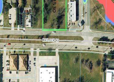
6 GC RS PD P SECRETARY DR CC GC RS-7.2 CC MATLOCK RD OC RS LI Feet OC PD PD This product is for informational purposes and may not have been prepared for or be suitable for legal, engineering, or surveying purposes. It does not represent an on-the-ground survey and represents only the approximate relative location of property boundaries. RS-7.2 to OC ACRES LOCATION MAP ZA16-1 / ^_ Prepared: iii-1 NB


7 ZA16-1 RS-7.2 to OC South of Secretary Drive and west of Matlock Road View of subject site. View west. View of adjacent office uses across Matlock. View east. View of adjacent office uses as seen from the subject site. View southeast. View of adjacent commercial uses located north of the subject site. View north. iv-1
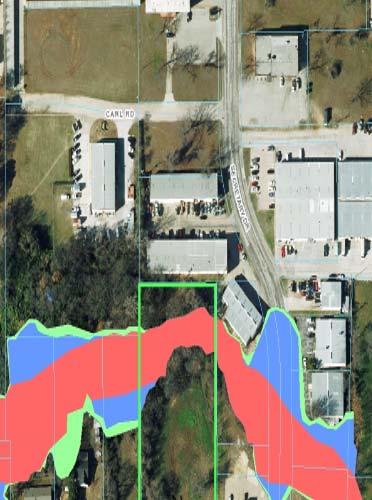
8 P.O. Box 2386, Arlington, Texas March 11, 2016 Planning and Zoning Commission City of Arlington 101 West Abram Street Arlington, Texas Commission Members: Heart of Arlington Neighborhood Association requests that the request for rezoning the property in Zoning Case ZA16-1 be denied for the following reasons: 1) The property is in the Johnson Creek floodway and watershed. 2) Development of this property would exacerbate the high risk of flooding for downstream structural (habitable) buildings (apartments, homes and businesses). 3) HANA s Neighborhood Action Plan, approved by Arlington City Council, discourages development of properties in a flood plain, and particularly for those uses allowed under the proposed rezoning. Environmental Impact & Sustainability Considerations: Enclosed is a section of the flood plain map from the City's website which shows that the original branch of Johnson Creek runs through the tract in Zoning Case ZA16-1. The flood plain map clearly shows that original western branch of Johnson Creek running through this property on the west side of Matlock, continuing north along Matlock through a concrete-lined channel and then going underground at Orthopedic Way where it crosses under Arkansas Lane and Matlock, then surfaces into another concrete channel between the apartments and car wash at the corner of Matlock and Arkansas, finally emptying into the main stream of Johnson Creek just north of Arkansas. Any development of this property (buildings, parking lots, other impervious surfaces) will mean increased runoff into that section of the creek, in turn creating more runoff downstream south of Arkansas Lane and Pioneer Parkway. Any increase in runoff in that section of Johnson Creek means a high probability of flooding further downstream. Several times in past years, the apartments at the corner of Pioneer Parkway and Matlock (across the creek from the car wash), have been flooded by Johnson Creek, from a few inches to several feet in some units. Those apartments were one reason the Sustainability chapter of our Neighborhood Action Plan (page 67) states that we (HANA) want to "Discourage building in the Johnson Creek flood plain". The same sentiment - that proposed development shall not cause flooding and damage downstream to properties (habitable dwellings and buildings) - is also expressed in the Drainage and Environmental
9
10
The proposed development has one point of access from East Arkansas lane.
 Case Information Applicant: Property Owner: Sector Plan: Charles Clawson John Chong, Farooq Wazirali and Richard Kang East Council District: 3 Allowable Uses: Development History: All uses as itemized
Zoning Case PD16-8 (A.E. Petsche/Arrow Electronics) Planning and Zoning Meeting Date: Document Being Considered: Ordinance
 Planning and Zoning Meeting Date: Document Being Considered: Ordinance") Staff Report Zoning Case 16-8 (A.E. Petsche/Arrow Electronics) Planning and Zoning Meeting Date: 6-15-16 Document Being Considered: Ordinance RECOMMENDATION Following the public hearing, consider Planned
Staff Report Zoning Case 16-8 (A.E. Petsche/Arrow Electronics) Planning and Zoning Meeting Date: 6-15-16 Document Being Considered: Ordinance RECOMMENDATION Following the public hearing, consider Planned
MKP Development, LLC., represented by Adlai Pennington
 Applicant: Property Owner: Sector Plan: MKP Development, LLC., represented by Adlai Pennington MKP Development, LLC., represented by Adlai Pennington Southwest Council District: 2 Allowable Uses: Development
RECOMMENDATION Following the public hearing, consider Zoning Case PD14-16, with a Development Plan.
 Staff Report Zoning Case PD14-16 (Helzer Tract) Planning and Zoning Meeting Date: 12-17-14 Document Being Considered: Ordinance RECOMMENDATION Following the public hearing, consider Zoning Case PD14-16,
Mycoskie McInnis Associates represented by Cliff Mycoskie
 Case Information Applicant: Property Owner: Acreage: Property Location: Sector Plan: Mycoskie McInnis Associates represented by Cliff Mycoskie HWP Parks Arlington II, Ltd 18.348 acres North of Interstate
Development Plan DP13-3 (Arlington Lofts) Planning and Zoning Meeting Date: Document Being Considered: Ordinance
 Planning and Zoning Meeting Date: Document Being Considered: Ordinance") Staff Report Development Plan DP13-3 (Arlington Lofts) Planning and Zoning Meeting Date: 6-19-13 Document Being Considered: Ordinance RECOMMENDATION Following the public hearing, consider Development Plan
Staff Report Development Plan DP13-3 (Arlington Lofts) Planning and Zoning Meeting Date: 6-19-13 Document Being Considered: Ordinance RECOMMENDATION Following the public hearing, consider Development Plan
Marion Johnson with Design & Development Consultants. Divine Grace Church represented by Patricia Owusu-Sampah
 Applicants: Property Owner: Marion Johnson with Design & Development Consultants Divine Grace Church represented by Patricia Owusu-Sampah Acreage: 3.78 Property Location: Sector Plan: North of East Interstate
Request of at least 60 percent of property owners in the proposed district. Allowable Uses: All uses in CD-R zoning as itemized in Attachment B.
 Applicant: Property Owner: Sector Plan: Request of at least 60 percent of property owners in the proposed district Same as applicant Central Council District: 5 Allowable Uses: All uses in CD-R zoning
PLANNING COMMISSION REPORT Regular Agenda Public Hearing Item
 PC Staff Report 11/12/12 Item No. 2B- 1 PLANNING COMMISSION REPORT Regular Agenda Public Hearing Item ITEM NO. 2B: A TO GPI; 110 ACRES; E OF K-10 & N OF W 6 TH ST (MKM) : Consider a request to rezone approximately
Revised Preliminary Plat (Viridian Village 1D) Planning and Zoning Meeting Date: Document Being Considered: Plat
 Planning and Zoning Meeting Date: Document Being Considered: Plat") Staff Report Revised Preliminary Plat (Viridian Village 1D) Planning and Zoning Meeting Date: 11-4-15 Document Being Considered: Plat RECOMMENDATION Following the public hearing, consider a revision to
Staff Report Revised Preliminary Plat (Viridian Village 1D) Planning and Zoning Meeting Date: 11-4-15 Document Being Considered: Plat RECOMMENDATION Following the public hearing, consider a revision to
Planning Department Oconee County, Georgia
 Planning Department Oconee County, Georgia STAFF REPORT REZONE CASE #: 6985 DATE: October 31, 2016 STAFF REPORT BY: Andrew C. Stern, Planner APPLICANT NAME: Williams & Associates, Land Planners PC PROPERTY
Planning & Zoning Commission
 Planning & Zoning Commission Planning & Development Department August 14, 01 Zoning Map Amendment MAP-1-0001 (Bay View Section 4) Request Rezone approximately 1.19 acres from OS (Open Space) to RSF- (Residential
TC- Districts TC-1 TC-2 Standards Key: = Permitted = Subject to Special Use Review RESIDENTIAL USES Single-family detached, semi-detached or endrow,
 Sec. 8-3216. Traditional Commercial Districts (TC-). (1) Purpose. (a) Traditional Commercial Neighborhood (TC-1). The TC-1 District is intended to ensure the vibrancy of historic mixed use neighborhoods
Memphis City Council Summary Sheet. S.D Roland Road Street Right-of-Way Dedication
 Memphis City Council Summary Sheet S.D. 16-01 Roland Road Street Right-of-Way Dedication Resolution requesting a Street Dedication south of U.S. Hwy 64 at the southern terminus of Roland Road to extend
STAFF REPORT. Community Development Director PO Box 4755 Beaverton, OR 97076
 STAFF REPORT HEARING DATE: July 7, 2010 TO: Planning Commission STAFF: Jana Fox, Assistant Planner PROPOSAL: Southeast Beaverton Office Commercial Zoning Map Amendment (ZMA2010-0006) LOCATION: The subject
CONCEPT PLAN SUBMISSION REQUIREMENTS:
 STAFF STRONGLY RECOMMENDS A PRE-DEVELOPMENT MEETING BEFORE THE SUBMITTAL OF ANY APPLICATION FOR ZONING, REZONING, CONDITIONAL USE PERMIT (CUP), OR FOR A TEXT AMENDMENT TO A PROVISION(S) OF THE ZONING ORDINANCE.
CHAPTER COMMERCIAL AND INDUSTRIAL ZONING DISTRICTS
 Commercial and Industrial Zoning Districts 106.26.010 CHAPTER 106.26 - COMMERCIAL AND INDUSTRIAL ZONING DISTRICTS COMMERCIAL AND INDUSTRIAL ZONING DISTRICTS Sections: 106.26.010 - Purpose 106.26.020 -
PLANNING COMMISSION REPORT Regular Agenda - Public Hearing Item
 Z-15-00469 Item No. 6A- 1 PLANNING COMMISSION REPORT Regular Agenda - Public Hearing Item PC Staff Report 11/16/15 ITEM NO. 6A GPI, RM12, & RS40 TO RM12; 14.756 ACRES; 5200 & 5300 CLINTON PKWY (SLD) Z-15-00469:
AGENDA PLANNING COMMISSION Tuesday, April 18, :00 PM City Council Chambers 125 East Avenue B, Hutchinson, Kansas
 AGENDA PLANNING COMMISSION Tuesday, April 18, 2017 5:00 PM City Council Chambers 125 East Avenue B, Hutchinson, Kansas 1. ROLL CALL Macklin Woleslagel Bisbee (Chair) Hamilton Peirce Vacant Carr Hornbeck
Glades County Staff Report and Recommendation REZONING
 Glades County Staff Report and Recommendation REZONING CASE NUMBER: RZ15-01 DATE: October 2, 2015 CASE TYPE: Application for Rezoning REQUEST: J.J. Wiggins Memorial Trust is requesting a rezoning of 22.1±
PC Staff Report 11/18/2013 Z Item No. 1-1
 Z-13-00401 Item No. 1-1 PLANNING COMMISSION REPORT Regular Agenda - Public Hearing Item PC Staff Report 11/18/2013 ITEM NO. 1: Z-13-00401 IG (General Industrial) District TO CS (Strip Commercial) District;
WESTMINSTER PARK SUBDIVISION
 WESTMINSTER PARK SUBDIVISION Engineering Comments: FINAL PLAT COMMENTS (should be addressed prior to submitting the FINAL PLAT for review and/or signature by the City Engineer): A. Provide all of the required
Overview. Central Street Master Plan. Appendix B: Zoning
 Central Street Master Plan Overview The City of Evanston has 36 zoning districts, of which 11 are found in the Central Street Corridor Study Area (See Figures B.1 and B.2). They include: R1: Single-Family
DIVISION 9. SD1 SPECIAL DEVELOPMENT DISTRICT SMALL- SCALE, MIXED-USE
 Sec. 61-11-154 Conditional other uses. (23) Steel barrel, drum, or pail renovation or reclaiming; (24) Steel mills; (25) Tanning, curing, or storage of raw hides or skins; (26) Tar products manufacture;
David J. Gellner, AICP, Principal Planner; (801) ; Zoning Map Amendment
 ; Zoning Map Amendment") Staff Report PLANNING DIVISION DEPARTMENT of COMMUNITY and NEIGHBORHOODS To: From: Salt Lake City Planning Commission David J. Gellner, AICP, Principal Planner; (801) 535-6107; david.gellner@slcgov.com
Staff Report PLANNING DIVISION DEPARTMENT of COMMUNITY and NEIGHBORHOODS To: From: Salt Lake City Planning Commission David J. Gellner, AICP, Principal Planner; (801) 535-6107; david.gellner@slcgov.com
ARTICLE C. ZONING TEXT, DISTRICT CLASSIFICATIONS AND BOUNDARIES
 ARTICLE C. ZONING TEXT, DISTRICT CLASSIFICATIONS AND BOUNDARIES Sec. 10-2054. ZONING TEXT, DISTRICT CLASSIFICATIONS AND BOUNDARIES. In order to regulate the location of structures, the height and bulk
Planning Commission 16 February 4, 2014 EDMOND PLANNING COMMISSION MEETING. Tuesday, February 4, 2014
 Planning Commission 16 EDMOND PLANNING COMMISSION MEETING Tuesday, 5:30 P.M. The Edmond Planning Commission Meeting was called to order by Chairperson Barry K. Moore at 5:30 p.m., Tuesday,, in the City
East Side Community Meeting
 East Side Community Meeting November 29, 2017 Pam Thompson, Senior Planner Sustainable Development and Construction City of Dallas Authorized Hearing Process City Plan Commission authorized a hearing to
RS9 LB-S RSQ-S RS9 RS9 DOCKET: W2822 PROPOSED ZONING: LB EXISTING ZONING: RS-9. PETITIONER: J&J Properties of W-S, LLC, for property owned by Same
 HAYMOUNT ST RS9 IP DOCKET: W2822 PROPOSED ZONING: LB POPE RD CLEMMONSVILLE RD EXISTING ZONING: RS-9 RSQ-S LB-S OLD SALISBURY RD WINSTON-SALEM ZONING FORSYTH COUNTY ZONING PETITIONER: J&J Properties of
MCGUIRE AV 374 COUNTRY CLUB RD RANDALL ST RYANDALE RD FLOODWAY FLOODWAY FRINGE
 SILAS CREEK MCGUIRE AV OLD COUNTRY CLUB RD 249 RYANDALE RD 323 374 COUNTRY CLUB RD S 441 SEDGEFIELD LN (PVT) QUEENSBURY RD FLOODWAY FLOODWAY FRINGE RANDALL ST SOUTHWIN DR November 19, 2004 Paul E. Burke,
Request Modification of Conditions (Religious Use) Staff Recommendation Approval. Staff Planner Marchelle Coleman
 Staff Recommendation Approval. Staff Planner Marchelle Coleman") Applicant Property Owner Unitarian Church of Norfolk (Unitarian Universalist) Public Hearing December 12, 2018 City Council Election District Kempsville Agenda Item 1 Request Modification of Conditions
Applicant Property Owner Unitarian Church of Norfolk (Unitarian Universalist) Public Hearing December 12, 2018 City Council Election District Kempsville Agenda Item 1 Request Modification of Conditions
Sec For the purpose of this Ordinance, the City of Plainwell is hereby divided into the following districts: TABLE INSET:
 15.030 Districts. Sec. 300. For the purpose of this Ordinance, the City of Plainwell is hereby divided into the following districts: TABLE INSET: 1. R-1A, R-1B Single-Family Residence District 2. R-1C
DeWITT CHARTER TOWNSHIP 1401 W. HERBISON ROAD, DeWITT, MI PLANNING COMMISSION MINUTES MONDAY, MARCH 6, 2006
 DeWITT CHARTER TOWNSHIP 1401 W. HERBISON ROAD, DeWITT, MI PLANNING COMMISSION MINUTES MONDAY, MARCH 6, 2006 The regularly scheduled meeting of the DeWitt Charter Township Planning Commission was called
Request Conditional Use Permit (Hair Care Center) Staff Recommendation Approval. Staff Planner Robert Davis
 Staff Recommendation Approval. Staff Planner Robert Davis") Applicant & Property Owner Public Hearing October 11, 2017 City Council Election District Princess Anne Agenda Item 2 Request Conditional Use Permit (Hair Care Center) Staff Recommendation Approval Staff
Applicant & Property Owner Public Hearing October 11, 2017 City Council Election District Princess Anne Agenda Item 2 Request Conditional Use Permit (Hair Care Center) Staff Recommendation Approval Staff
HB-S RM8-S RS9 RM18 HB-S RS9 DOCKET #: W2872. PROPOSED ZONING: RM8-S (Child Day Care Center) EXISTING ZONING: RS9 and RM8-S
 EXISTING ZONING: RS9 and RM8-S") 150' 80' RS9 UNIVERSITY PW STANLEYVILLE DR HB-S LB 123' 70' PROPOSED BELTWAY!( RM8-S S 289' NOEL DR 202' NITA AV MILL CREEK DOCKET #: W2872 PROPOSED ZONING: RM8-S (Child Day Care Center) EXISTING ZONING:
150' 80' RS9 UNIVERSITY PW STANLEYVILLE DR HB-S LB 123' 70' PROPOSED BELTWAY!( RM8-S S 289' NOEL DR 202' NITA AV MILL CREEK DOCKET #: W2872 PROPOSED ZONING: RM8-S (Child Day Care Center) EXISTING ZONING:
TOWN OF HERNDON, VIRGINIA ORDINANCE, 2016
 TOWN OF HERNDON, VIRGINIA ORDINANCE, 2016 Ordinance- to amend and reenact Chapter 78 of the Code of the Town of Herndon entitled Zoning, Sections 78-204, 78-400, and 78-403 to make changes for internal
AGENDA. EDMOND PLANNING COMMISSION 20 S. Littler, Edmond, Oklahoma Tuesday, February 18, :30 p.m. CITY COUNCIL WORKSHOP
 City of Edmond NOTICE OF PUBLIC MEETING The City of Edmond encourages participation from all its citizens. If participation at any Public meeting is not possible due to a disability, notification to the
Action Recommendation: Budget Impact:
 City of Fayetteville Staff Review Form 2018-0477 Legistar File ID 9/18/2018 City Council Meeting Date - Agenda Item Only N/A for Non-Agenda Item Garner Stoll Submitted By 8/28/2018 Submitted Date Action
PLANNING COMMISSION REPORT REGULAR AGENDA
 PP-4-4-11 Item No. 9-1 PLANNING COMMISSION REPORT REGULAR AGENDA PC Staff Report 06/22/11 ITEM NO 9: PRELIMINARY PLAT; KASOLD WATER TOWER ADDITION; SE OF TAM O SHANTER & KASOLD DR (MKM) PP-4-4-11: Consider
Planning Department Oconee County, Georgia STAFF REPORT
 Planning Department Oconee County, Georgia STAFF REPORT REZONE CASE #: 7332 DATE: November 28, 2017 STAFF REPORT BY: Gabriel Quintas, Planner APPLICANT NAME: Smith Planning Group PROPERTY OWNER: John Hadden
Department of Planning & Development Services
 Department of Planning & Development Services S T A F F R E P O R T February 9, 2015 CASE NO: PROJECT: EXECUTIVE SUMMARY: ZA14-154 Plat Revision for Lots 25R-1A, 25R-1B and 25R-1C, Block 1, Woodland Heights
LINCOLN COUNTY PLANNING & INSPECTIONS DEPARTMENT
 LINCOLN COUNTY PLANNING & INSPECTIONS DEPARTMENT 30 NORTH ACADEMY STREET, SUITE A, LINCOLNTON, NORTH CAROLINA 809 704-736-8440 OFFICE 704-736-8434 INSPECTION REQUEST LINE 704-73-900 FAX To: Board of Commissioners
Residential-1 District
 Residential-1 District City of Barnum, Minnesota Zoning District Information Sheet It is the purpose of the R-1 District to encourage the establishment and the preservation of residential neighborhoods
M E M O R A N D U M. Meeting Date: April 19, Item No. H-2. Mark Hafner, City Manager. Michele Berry, Planner II
 M E M O R A N D U M Meeting Date: April 19, 2016 Item No. H-2 To: From: Subject: Mark Hafner, City Manager Michele Berry, Planner II PUBLIC HEARING: Consider an ordinance approving a Specific Use Permit
Urban Planning and Land Use
 Urban Planning and Land Use 701 North 7 th Street, Room 423 Phone: (913) 573-5750 Kansas City, Kansas 66101 Fax: (913) 573-5796 Email: planninginfo@wycokck.org www.wycokck.org/planning To: From: City Planning
THE CITY OF RAYMORE, MISSOURI Single-Family Residential Zoning Districts
 THE CITY OF RAYMORE, MISSOURI Single-Family Residential Zoning Districts REGULATIONS COMMON TO ALL DISTRICTS: Uses permitted in each district include detached single-family dwellings, manufactured homes
RO-1 HIGH DENSITY RESIDENTIAL-PROFESSIONAL OFFICE DISTRICT
 6.12 - RO-1 HIGH DENSITY RESIDENTIAL-PROFESSIONAL OFFICE DISTRICT 6.12.1 PERMITTED USES: Within the RO-1 High Density Residential- Professional Office District the following uses are permitted: 6.12.1.1
Planning & Zoning Commission
 Zoning Change 13-03 (FM 646) Planning & Zoning Commission Planning & Development Department June 3, 2013 Request Permitted Uses Rezone approximately 24.89 acres of undeveloped land from RSF-7 (Residential
PLANNING BOARD AGENDA
 PLANNING BOARD AGENDA Public Hearing and Administrative Meeting Wednesday,, 1:30 P.M. PLANNING OMAHA Omaha/Douglas Civic Center 1819 Farnam Street Legislative Chamber DISPOSITION AGENDA This document states
RE: 6. GILL/GREEN COMPREHENSIVE PLAN AMENDMENT, REZONING AND PRELIMINARY PLAT
 commission memo DATE: Thursday - August 9, 2018 TO: Marion Planning & Zoning Commission FROM: David N. Hockett, AICP Principal Planner RE: 6. GILL/GREEN COMPREHENSIVE PLAN AMENDMENT, REZONING AND PRELIMINARY
Request Conditional Rezoning (AG-1 & AG-2 Agricultural to Conditional R-10 Residential & P- 1 Preservation District) Staff Recommendation Approval
 Staff Recommendation Approval") Applicant & Property Owner Public Hearing February 14, 2018 City Council Election District Princess Anne Agenda Item 7 Request Conditional Rezoning (AG-1 & AG-2 Agricultural to Conditional R-10 Residential
Applicant & Property Owner Public Hearing February 14, 2018 City Council Election District Princess Anne Agenda Item 7 Request Conditional Rezoning (AG-1 & AG-2 Agricultural to Conditional R-10 Residential
Cherokee Webster Development, LP. City of Webster, Texas Planned Development No. 3. Proposed Revision No. 4
 Cherokee Webster Development, LP. City of Webster, Texas Planned Development No. 3 Proposed Revision No. 4 October 2013 1 Statement of Intent This Revision No. 4 of the Statement of Intent is written in
Town of Cary, North Carolina Rezoning Staff Report 13-REZ-31 Weston PDD Amendment at Centregreen Park Town Council Meeting March 13, 2014
 Town of Cary, North Carolina Rezoning Staff Report 13-REZ-31 Weston PDD Amendment at Centregreen Park Town Council Meeting March 13, 2014 REQUEST This proposed amendment to the Town of Cary Official Zoning
TOWN OF ORO VALLEY PLANNING & ZONING COMMISSION MEETING DATE: December 6, 2011
 PLANNING & ZONING COMMISSION MEETING DATE: December 6, 2011 TO: FROM: SUBJECT: PLANNING & ZONING COMMISSION Matt Michels, Senior Planner mmichels@orovalleyaz.gov; tel. 229-4822 Public Hearing: Rancho de
ARTICLE III District Regulations. A map entitled "Franklin Zoning Map" is hereby adopted as part of this chapter 1.
 ARTICLE III District Regulations ~ 305-8. Adoption of Zoning Map. A map entitled "Franklin Zoning Map" is hereby adopted as part of this chapter 1. ~ 305-9. Official Zoning Map; amendments. Regardless
Town of Cary, North Carolina Rezoning Staff Report 14-REZ-31 Cary Park PDD Amendment (Waterford II) Town Council Meeting January 15, 2015
 Town Council Meeting January 15, 2015") Town of Cary, North Carolina Rezoning Staff Report 14-REZ-31 Cary Park PDD Amendment (Waterford II) Town Council Meeting January 15, 2015 REQUEST To amend the Town of Cary Official Zoning Map by amending
Town of Cary, North Carolina Rezoning Staff Report 14-REZ-31 Cary Park PDD Amendment (Waterford II) Town Council Meeting January 15, 2015 REQUEST To amend the Town of Cary Official Zoning Map by amending
9. REZONING NO Vicinity of the northwest corner of 143 rd Street and Metcalf Avenue
 9. REZONING NO. 2002-15 Vicinity of the northwest corner of 143 rd Street and Metcalf Avenue 1. APPLICANT: Andrew Schlagel is the applicant for this request. 2. REQUESTED ACTION: The applicant is requesting
ACTION FORM BRYAN CITY COUNCIL
 ACTION FORM BRYAN CITY COUNCIL DATE OF COUNCIL MEETING: July 8, 2014 DATE SUBMITTED: June 17, 2014 DEPARTMENT OF ORIGIN: Development Services SUBMITTED BY: Maggie Dalton MEETING TYPE: CLASSIFICATION: ORDINANCE:
B. The Plan is in conformity with the Comprehensive Plan.
 ARTICLE 17 PLANNING UNIT DEVELOPMENT 17.01 INTENT The purpose of this Section is to permit the creation of new Planned Unit Developments, permitted as Conditional Uses where maximum variations of design
PLANNING COMMISSION STAFF REPORT
 PLANNING COMMISSION STAFF REPORT REZONING CASE: RZ-15-002 REPORT DATE: January 26, 2016 CASE NAME: Thursday Lunch Club Rezoning PLANNING COMMISSION DATE: February 17, 2016 ADDRESS OF REZONING PROPOSAL:
SUBDIVISION REGULATIONS OF THE CITY OF DERBY, KANSAS
 SUBDIVISION REGULATIONS OF THE CITY OF DERBY, KANSAS ARTICLE 1. TITLE, PURPOSE, AUTHORITY, JURISDICTION, APPLICABILITY AND EXEMPTIONS 100 TITLE. These regulations shall be known and may be cited as the
Community Development
 Land Use Petition RZ-16-002 Date of Staff Recommendation Preparation: April 15, 2016 (CEL) Date of Planning Commission Recommendation: May 3, 2016 PROJECT LOCATION: DISTRICT/SECTION/LANDLOT(S): ACREAGE
Community Development
 Land Use Petition RZ-15-010 Concurrent Variance VC-15-010-01 Date of Staff Recommendation Preparation: August 14, 2015 Date of Planning Commission Recommendation: September 1, 2015 PROJECT LOCATION: DISTRICT/SECTION/LANDLOT(S):
ARTICLE 535. PD 535. C.F. Hawn Special Purpose District No. 3
 ARTICLE 535. PD 535. C.F. Hawn Special Purpose District No. 3 SEC. 51P-535.101. LEGISLATIVE HISTORY. PD 535 was established by Ordinance No. 23988, passed by the Dallas City Council on August 25, 1999.
ADDRESS / DESCRIPTION: Northeast corner of Sandbridge Road and Atwoodtown Road ELECTION DISTRICT: PRINCESS ANNE
 10 & 11 March 14, 2012 Public Hearing APPLICANT: MARLYN DEVELOPMENT CORPORATION PROPERTY OWNER: CORAL DEVELOPMENT, LLC STAFF PLANNER: Faith Christie REQUEST: Modification of Conditional Change of Zoning
Town of Waxhaw Board of Commissioners. Waxhaw Police Department Community Meeting Room Tuesday January 12, 2016
 Town of Waxhaw Board of Commissioners Waxhaw Police Department Community Meeting Room Tuesday January 12, 2016 Petition RZ-003994-2015 A request by the Town of Waxhaw Planning & Community Development Department,
ATTACHMENT C. Development Requirements
 ATTACHMENT C Development Requirements Development Codes, also known as Municipal Codes, were reviewed for each station and compiled by jurisdiction. Only those zoning designations located within 0.5 mile
Existing Land Use and Zoning District Single-family development under construction, woods / Conditional R-10 Residential, AG-1 Agricultural
 Applicant Property Owners, & William Snowden and James Snowden Public Hearing September 12, 2018 City Council Election District Princess Anne Agenda Items 8 & 9 Request Conditional Rezoning (AG-1 Agricultural
PLANNING COMMISSION REPORT Regular Agenda Public Hearing Item
 PC Staff Report 10/21/2013 Item No. 3B - 1 PC Staff Report 10/21/2013 ITEM NO. 3B: PLANNING COMMISSION REPORT Regular Agenda Public Hearing Item A TO CR- FP; 8.4 ACRES; 1900 W. 31 st STREET (SLD) : Consider
Sec Temporary Uses. Secs Reserved
 subject to any referenced use-specific standards and all other applicable regulations of this Ordinance: 1. Accessory dwelling unit (detached) 2. Kennel, private (for parcels less than 2 acres in size;
CITY OF TYLER CITY COUNCIL COMMUNICATION
 CITY OF TYLER CITY COUNCIL COMMUNICATION Agenda Number: Z-2 Date: January 23, 2019 Subject: PD18-035 FAIR NANCY WOOD (2801 AND 2835 SOUTH BROADWAY AVENUE) Request that the City Council consider approving
DAUPHIN CREEK ESTATES SUBDIVISION
 # 12 SUB-000076-2017 DAUPHIN CREEK ESTATES SUBDIVISION Engineering Comments: FINAL PLAT COMMENTS (should be addressed prior to submitting the FINAL PLAT for review and/or signature by the City Engineer):
5970 Golden Isles Parkway (Bergen Woods) Property Address. Planned Development (PD) Golden Isles Gateway Tract (GC-16-00) Existing Land Use
 Property Address. Planned Development (PD) Golden Isles Gateway Tract (GC-16-00) Existing Land Use") COMMUNITY DEVELOPMENT DEPARTMENT Planning and Zoning Division 125 Reynolds Street, Suite 200, Brunswick, GA 31520 Phone: 912-554-428/Fax: 1-888-252-326 BOARD OF COMMISSIONERS STAFF REPORT MEETING DATE:
COMMUNITY DEVELOPMENT DEPARTMENT Planning and Zoning Division 125 Reynolds Street, Suite 200, Brunswick, GA 31520 Phone: 912-554-428/Fax: 1-888-252-326 BOARD OF COMMISSIONERS STAFF REPORT MEETING DATE:
COUNTY OF LINCOLN, NORTH CAROLINA 302 NORTH ACADEMY STREET, SUITE A, LINCOLNTON, NORTH CAROLINA 28092
 COUNTY OF LINCOLN, NORTH CAROLINA 302 NORTH ACADEMY STREET, SUITE A, LINCOLNTON, NORTH CAROLINA 28092 PLANNING AND INSPECTIONS DEPARTMENT 704-736-8440 OFFICE 704-732-9010 FAX To: Alex Patton, Board of
Tuss and Lisa Taylor. Agriculture
 ZONE CHANGE STAFF REPORT CCPC City-County Planning Commission warrenpc.org (270) 842-1953 1141 State Street Bowling Green, KY 42101 DOCKET/CASE/APPLICATION NUMBER 2018-29-Z-CO PUBLIC HEARING DATE July
Request Subdivision Variance (to Section 4.4 (b) of the Subdivision Regulations) Staff Planner Kevin Kemp
 of the Subdivision Regulations) Staff Planner Kevin Kemp") Applicant Property Owner & Highland Parish Community Public Hearing July 13, 2016 City Council Election District Princess Anne Agenda Item 6 Request Subdivision Variance (to Section 4.4 (b) of the Subdivision
Applicant Property Owner & Highland Parish Community Public Hearing July 13, 2016 City Council Election District Princess Anne Agenda Item 6 Request Subdivision Variance (to Section 4.4 (b) of the Subdivision
!( 22 !( 115 !( 168. Zoning Districts Map. City of Frankfort. City of Frankfort. Zoning Ordinance. Lake Michigan. Lake Betsie
 4th St \\dtdata\projects\frk2002\01d\gis-data\projects\zoning Map Rev Apr 2017.mxd George St Crystal Lake Twp. City of Frankfort Denton Ave Beech St Bellows Ave Day Ave Lake Michigan Michigan Ave Winnebago
The intent of Business District B 1 is to provide an area for local and neighborhood shopping where
 CODE OF THE COUNTY DIVISION 9. BUSINESS DISTRICT B 1 Botetourt County, Virginia, Code of Ordinances Page 71 DIVISION 9. BUSINESS DISTRICT B 1 Sec. 25 221. Purpose. Sec. 25 222. Permitted uses. Sec. 25
Planning & Zoning Commission
 Zoning Change Z15-08 (2103 ) Planning & Zoning Commission Planning & Development Department May 18, 2015 Request Applicant /Owner Rezone approximately 2.844 acres of land from OS (Open Space) to RSF-20
Frequently Asked Questions for: Drainage, Watershed and Water Quality Property Owners Near Creeks Developers and Engineers and Definitions of Terms
 FREQUENTLY ASKED QUESTIONS Draft DEFINITIONS OF TERMS Last Revised July 2, 2008 Introduction: The following questions have been organized in the categories below. We have attempted to group the questions
Department of Planning & Development Services
 Department of Planning & Development Services S T A F F R E P O R T August 29, 2014 CASE NO: PROJECT: EXECUTIVE SUMMARY: DETAILS: ZA14-102 Zoning Change and Development Plan for the Carillon Corporate
PLANNING & DEVELOPMENT
 PLANNING & DEVELOPMENT STAFF REPORT Rezoning PETITION: APPLICANT: PROPERTY OWNER: TYPE OF REQUEST: SIZE OF TRACT: LOCATION: (#17-22) Rezone from A-PUD (Agri-Business Planned Unit Development) to A-PUD
Planning Commission Meeting: April 25, 2016
 Planning Commission Meeting: City of Olathe City Planning Division MINUTES Consent Agenda The meeting was called to order by Chairman Dean Vakas, with the following members present: Ryan Nelson, Mike Rinke,
Chapter CC COMMUNITY COMMERCIAL ZONES REGULATIONS
 Effective April 14, 2011 Chapter 17.35 CC COMMUNITY COMMERCIAL ZONES REGULATIONS SECTIONS: 17.35.010 Title, Intent, and Description 17.35.020 Required Design Review Process 17.35.030 Permitted and Conditionally
PLANNING AND ZONING COMMISSION ZONE CHANGE
 PLANNING AND ZONING COMMISSION ZONE CHANGE DOÑA ANA COUNTY COMMUNITY DEVELOPMENT DEPARTMENT Doña Ana County Government Center 845 N. Motel Blvd. Las Cruces, New Mexico 88007 Telephone: (575) 647-7350 MEETING
Town of Cary, North Carolina Rezoning Staff Report 12-REZ-27 Morris Branch Town Council Public Hearing January 24, 2013
 Town of Cary, North Carolina Rezoning Staff Report 12-REZ-27 Morris Branch Town Council Public Hearing January 24, 2013 REQUEST To amend the Town of Cary Official Zoning Map to rezone approximately 9.0
RM- 59 CATEGORY RM- 20 MU- DC MU-NB MU-SB. A (Airport) MU-D MU-SA MU-SC MU-N IA IL IH IP NR GCI LC P PK OS
 MU-D MU-SA MU-SC MU-N IA IL IH IP NR GCI LC P PK OS") M Minor Use Permit (Zoning dministrator CTEGORY RS-3 RS-6 20 59 MU- DC MU-D MU-S MU-SC MU-N I IL IH IP NR GCI LC P PK OS (irport) dditional Regulations RESIDENTIL USE CLSSIFICTIONS Single-Unit Dwelling
M Minor Use Permit (Zoning dministrator CTEGORY RS-3 RS-6 20 59 MU- DC MU-D MU-S MU-SC MU-N I IL IH IP NR GCI LC P PK OS (irport) dditional Regulations RESIDENTIL USE CLSSIFICTIONS Single-Unit Dwelling
STAFF SUMMARY FOR Z18-09 CONDITIONAL ZONING DISTRICT APPLICATION
 STAFF SUMMARY FOR Z18-09 CONDITIONAL ZONING DISTRICT APPLICATION APPLICATION SUMMARY Case Number: Z18-09 Request: Conditional R-10 Zoning District in order to develop a performance residential development
WESTMINSTER PARK PLACE SUBDIVISION
 WESTMINSTER PARK PLACE SUBDIVISION Engineering Comments: FINAL PLAT COMMENTS (should be addressed prior to submitting the FINAL PLAT for review and/or signature by the City Engineer): A. Provide all of
Suburban Commercial Center ( CE-S ) Permitted Principal Uses and Structures
 Permitted Principal Uses and Structures") Division 12. Suburban Commercial Center ( CE-S ) 2.9.1 Purpose Suburban commercial centers provide regional commercial destinations with design and site elements compatible with suburban character. Dimensional
Division 12. Suburban Commercial Center ( CE-S ) 2.9.1 Purpose Suburban commercial centers provide regional commercial destinations with design and site elements compatible with suburban character. Dimensional
M E M O R A N D U M. Meeting Date: May 1, Item No. H-4. Steve Polasek, Interim City Manager. David Hawkins, Senior Planner
 M E M O R A N D U M Meeting Date: May 1, 2012 Item No. H-4 To: From: Subject: Steve Polasek, Interim City Manager David Hawkins, Senior Planner PUBLIC HEARING: Consider an ordinance approving a planned
ARTICLE 426. PD 426.
 ARTICLE 426. PD 426. SEC. 51P-426.101. LEGISLATIVE HISTORY. PD 426 was established by Ordinance No. 22741, passed by the Dallas City Council on April 24, 1996. Ordinance No. 22741 amended Ordinance No.
CHAPTER COMMERCIAL ZONING DISTRICTS
 CHAPTER 27.10 - COMMERCIAL ZONING DISTRICTS 27.10.010 - Purpose of Chapter This Chapter lists the land uses that may be allowed within the commercial zoning districts established by Section 27.04.020 (Zoning
CITY OF PALM BEACH GARDENS CITY COUNCIL Agenda Cover Memorandum Meeting Date: November 1, 2018 Ordinance 24, 2018 / *Ordinance 25, 2018
 CITY OF PALM BEACH GARDENS CITY COUNCIL Agenda Cover Memorandum Meeting Date: November 1, 2018 Subject/Agenda Item: 11940 U.S. Highway One Small-Scale Comprehensive Plan Future Land Use Map Amendment and
ARTICLE VI. SUBDIVISION STANDARDS, PUBLIC
 ARTICLE VI. SUBDIVISION STANDARDS, PUBLIC IMPROVEMENTS, AND DESIGN REQUIREMENTS ARTICLE VI. SUBDIVISION STANDARDS, PUBLIC IMPROVEMENTS, AND DESIGN REQUIREMENTS DIVISION 1. GENERAL PROVISIONS Sec. 21-6100.
SECTION CLASSIFICATION OF ZONES For the purpose of this Code the following primary land use zoning districts are hereby established:
 ARTICLE 4 ZONING DISTRICTS SECTION 4.010 CLASSIFICATION OF ZONES For the purpose of this Code the following primary land use zoning districts are hereby established: Primary Zones Abbreviated Designation
Request Street Closure (Portion of Cardinal Road) Staff Recommendation Approval. Staff Planner Jimmy McNamara
 Staff Recommendation Approval. Staff Planner Jimmy McNamara") Applicant & Property Owner Public Hearing October 11, 2017 City Council Election District Lynnhaven Agenda Item 8 Request Street Closure (Portion of Cardinal Road) Staff Recommendation Approval Staff Planner
Applicant & Property Owner Public Hearing October 11, 2017 City Council Election District Lynnhaven Agenda Item 8 Request Street Closure (Portion of Cardinal Road) Staff Recommendation Approval Staff Planner
MINUTES. August 4, 2015
 MINUTES August 4, 2015 The minutes of the Fairfield County Regional Planning Commission meeting held at the Fairfield County Courthouse, Commissioners Hearing Room, 210 East Main Street, Lancaster, Ohio.
Request Modification of Proffers Modification of Conditions (Bulk Storage Yard) Staff Recommendation Approval. Staff Planner Marchelle Coleman
 Staff Recommendation Approval. Staff Planner Marchelle Coleman") Applicant & Property Owner Public Hearing October 10, 2018 City Council Election District Princess Anne Agenda Item 6 Request Modification of Proffers Modification of Conditions (Bulk Storage Yard) Staff
Applicant & Property Owner Public Hearing October 10, 2018 City Council Election District Princess Anne Agenda Item 6 Request Modification of Proffers Modification of Conditions (Bulk Storage Yard) Staff
CITY PLANNING COMMISSION CITY OF NEW ORLEANS EXECUTIVE DIRECTOR. City Planning Commission Staff Report. Executive Summary
 CITY PLANNING COMMISSION CITY OF NEW ORLEANS MITCHELL J. LANDRIEU MAYOR ROBERT D. RIVERS EXECUTIVE DIRECTOR LESLIE T. ALLEY DEPUTY DIRECTOR City Planning Commission Staff Report Zoning Docket 092/16 Executive