All items include discussion and possible action to approve, modify, deny, or continue unless marked otherwise.
|
|
|
- Baldwin McKinney
- 5 years ago
- Views:
Transcription

1 Jim Hindle Chairman Jim Collins Planning Commissioner Larry Prater Planning Commissioner Summer Pellett- Planning Commissioner Storey County Planning Commission Meeting Agenda Thursday January 17, :00 p.m. Storey County Courthouse, District Courtroom 26 South B Street, Virginia City, Nevada John Herrington Vice-Chairman Kris Thompson Planning Commissioner Laura Kekule Planning Commissioner All items include discussion and possible action to approve, modify, deny, or continue unless marked otherwise. 1. Call to Order at 6:00 p.m. 2. Roll Call 3. Pledge of Allegiance 4. Discussion/Possible Action: Approval of Agenda for January 17, Discussion/Possible Action: Election of Chairperson and Vice-Chairperson for Discussion/Possible Action: Approval of Minutes for October 18, Discussion/Possible Action: Approval of Minutes for November 1, Discussion/Possible Action: Approval of Minutes for November 15, Discussion/Possible Action: Special Use Permit request by applicant AT & T Wireless to allow for construction of a 90-foot high wireless commercial communications facility, including tower, equipment shelters, and other associated equipment. The tower will be configured as a water tower to disguise the proposed antenna equipment. The tower and associated equipment will be located on an approximate 35 x 35 leased area on Storey County property. The subject property is located at 160 E. Toll Road, Virginia City, Storey County, Nevada and having Assessor s Parcel Number Discussion Only/No Possible Action: Text amendments to Storey County Code Title 17 Zoning regulating certain setback, height, bulk, area, dimension, and density and similar requirements; through lots; allowed uses and uses requiring a special use permit; parking, egress, travel, easement, right-of-way and similar requirements; accessory structures and accessory buildings including buildings, fences, facilities, shipping containers and certain accessory dwellings; and other properly related matters; and changing zone district titles including R1 Single-Family Residential to SFR Single-Family Residential, R2 Multi-Family Residential to MFR Multi-Family Residential, I1 Light Industrial to IL Light Industrial, I2 Heavy Industrial to IH Heavy Industrial, and adding IN Neighborhood Industrial classification and other properly related matters. The amendments will include chapters General Provisions, P Public, A Agriculture, C Commercial, CR Commercial Residential, F Forestry, I1 Light Industrial, I2 Heavy Industrial, E Estate, SPR Special Planning Review zones, and other properly related matters. Additional information including, but not limited to, draft text may be obtained from the Planning Department at or planning@storeycounty.org, or viewed online at In addition to the provisions of the NRS, any person may complete and return to the Board a statement supporting or opposing the proposed amendments to the county code and/or zoning ordinance. 1
2 11. Discussion Only/No Possible Action. Map amendments to the Official Storey County Zoning Map, changing zone districts R1 Single-Family Residential to SFR Single-Family Residential, R2 Multi-Family Residential to MFR Multi-Family Residential, I1 Light Industrial to IL Light Industrial, I2 Heavy Industrial to IH Heavy Industrial, and adding IN Neighborhood Industrial to the list of classified zones, affecting all listed zones in Storey County except those located within the annexed portions of the Tahoe-Reno Industrial Center, and other properly related matters. Additional information including, but not limited to, draft text and maps may be obtained from the Planning Department at or or viewed online at In addition to the provisions of the NRS, any person may complete and return to the Board a statement supporting or opposing the proposed amendments to the county code and/or zoning ordinance. 12. Discussion/Possible Action: Determination of next Planning Commission meeting. 13. Discussion/Possible Action: Approval of Claims. 14. Correspondence (no action) 15. Public Comment (no action) 16. Staff (no action) 17. Board Comments (no action) 18. Adjournment Notes: There may be a quorum of Storey County Commissioners in attendance, but no action or discussion will be taken by the Commissioners. Public comment will be allowed after each item on the agenda (this comment should be limited to the item on the agenda). Public comment will also be allowed at the end of each meeting (this comment should be limited to matters not on the agenda). Items on the agenda may be taken out of order, the public body may combine two or more agenda items for consideration, and the public body may remove an item from the agenda or delay discussion relating to an item on the agenda at any time. Additional information pertaining to any item on this agenda may be requested from Lyndi Renaud, Planning Department ( ). Supporting material is available to the public and may be obtained at or the Storey County Courthouse, Planning Department, 26 South B Street, Virginia City, Nevada. Certification of Posting I, Lyndi Renaud, on behalf of the Storey County Planning Commission, do hereby certify that I posted, or caused to be posted, a copy of this Agenda at the following locations on or before January 8, 2019: Virginia City Post Office; Storey County Courthouse; Virginia City Fire Station 71; Virginia City RV Park; Mark Twain Community Center; Rainbow Bend Clubhouse; Lockwood Community Center; Lockwood Fire Station; Virginia City Highlands Fire Station; and the Virginia City Highlands Online Message Board. By Lyndi Renaud, Secretary 2
3 STOREY COUNTY PLANNING COMMISSION MEETING Thursday October 18, :00 p.m. Storey County Courthouse, District Courtroom 26 South B Street, Virginia City, NV MEETING MINUTES CHAIRMAN: Jim Hindle VICE-CHAIRMAN: John Herrington COMMISSIONERS: Larry Prater, Kris Thompson, Laura Kekule, Summer Pellett, Jim Collins 1. Call to Order: The meeting was called to order by the Chairman at 6:00 P.M. 2. Roll Call: Jim Hindle, Jim Collins, Summer Pellett, John Herrington, Larry Prater, and Kris Thompson. Absent: Laura Kekule Also Present: Planning Director Osborne, Planner Kathy Canfield, and Deputy D.A. Keith Loomis. 3. Pledge of Allegiance: The Chairman led those present in the Pledge of Allegiance. 4. Discussion/Possible Action: Approval of Agenda for October 18, Vice Chairman Herrington asked to move item 6 to be heard after item 5. Motion: Approve agenda with item 6 to be heard after item 5, for October 18, 2018, Action: Approve, Moved by Commissioner Thompson, Seconded by Commissioner Prater, Vote: Motion carried by unanimous vote (summary: Yes=6). No Public Comment 6. Discussion/Possible Action: Variance by applicants Ed and Molly Burnet. The applicants are requesting to allow the front yard setback for the construction of a new single family residence to be reduced from the required 20-feet to 0-feet. The property is located at 381 S. E Street, Virginia City, Storey County, Nevada, Assessor s Parcel Number (APN) Commissioner Collins recused himself due to being the general contractor for the project. Planner Canfield: Summarized the request. The parcel is currently vacant. The property is level along E Street for a depth of approximately 65 feet when it then drops sharply off down towards F Street. The residence is located along a residential street with a single residence located to the south and multi-family residences to the north. The property 1
4 directly across the property is vacant with other single family dwellings to the north and south on the west side of E Street. The property is zoned CR. The applicant is proposing to construct a new residence with an attached garage with a 0-foot front yard setback along E Street. The garage face would be located along the property line and the residence would be six feet from the property line, providing a front entrance way and sidewalk to the front door. The immediately adjacent multi-family structures were completed between 2000 and 2003, and were subject to the 1999 Zoning Code. The 1999 Zoning Code had the same required setbacks for CR zoning as the current zoning code, a 20-foot front and rear setbacks and 8-foot setbacks for the sides. These structures, however, were constructed with a 0-foot setback for the most immediate building and 10-foot setbacks for the northern most buildings. The adjacent structure was also built along the property line and not set back 8 feet as was required. No variance for these setbacks could be found. The E Street right-of-way is 62.5 feet wide. The actual paved travelled way is located 23-feet from the property line which gives the appearance of a front yard setback for all the structures along the street. Staff is recommending approval based on the topography of the parcel and the existing surroundings. Notices of the setback variance request were sent to 30 surrounding property owners. No response was received from anyone. Chairman Hindle received some responses, but because they did not file anything officially, will disregard. Planner Canfield confirmed that no responses were received from the public. Ed Burnet, Applicant: Requesting the variance because of the buildable square footage that is on the lot. This would allow us to construct the home that we have designed. The variance would conform to the properties to the north of us, and it is actually the front of the garage that will be at 0 setback and 8 feet from where the entrance to the house is. Historic home next door is on a separate parcel. We just completed a boundary line adjustment which brings the setbacks into conformance for the existing historic home, and now allows us to build a new home on two combined lots. Chairman Hindle: Asked Ed if he has any concern with the stability of the slope that runs down to F Street. Ed Burnet, Applicant: Said that he would like to terrace with beams, and also plans site drains to help with drainage. Brief discussion on where utility corridor is in relation to E Street and the Burnet s property. No issues. No Public Comment Motion: In accordance with the recommendation by staff, the Findings of Fact under Section 3.A of this report, and other findings deemed appropriate by the Planning Commission, and in compliance with the conditions of approval, I Larry Prater recommend approval of Variance to allow the front yard setback for the construction of a new single family residence to be reduced from the required 20-feet to the 0-feet. The property is located at 381 S. E Street, Virginia City, Storey County, Nevada, Assessor s Parcel Number (APN) Action: Approve, Moved by Commissioner Prater, Seconded by Commissioner Thompson, Planner Canfield read the findings into the record: (1) This variance (Variance ) allows the front yard setback for the construction of a new single family residence to be reduced from the required 20-feet to 0-feet. The property is located at 381 S. E Street, Virginia City, Storey County, Nevada, Assessor s Parcel Number (APN) (2) The subject property is located within CR Commercial Residential zoning in which single family residences are an allowed use (3) That because of special circumstances applicable to the subject property, including shape, size, topography or location of surroundings, the strict application of the zoning ordinance would deprive the subject property of privileges enjoyed by other properties in the vicinity or under identical zone classification. 2
5 (4) That the granting of the Variance is necessary for the preservation and enjoyment of substantial property rights of the applicant. (5) That the granting of the Variance will not, under the circumstances of the particular case, adversely affect to a material degree the health or safety of persons residing or working in the area of the subject property and will not be materially detrimental to the public welfare or materially injurious to property or improvements in the area of the subject property. (6) The proposed Variance is in compliance with all Federal, Nevada State, and Storey County regulations. (7) The proposed Variance is in compliance with Storey County Code Variances and General Provisions and CR Commercial Residential Zone when all Conditions of Approval are met. (8) The proposed Variance is in compliance with and supports the goals, objectives and policies of the 2016 Storey County Master Plan. The Master Plan states, The area immediately east of downtown, including most of D through F streets, is composed of sporadic clusters of commercial, and singleand multi-family residential uses separated by large tracts of vacant land. Most of the buildings and uses in this area are remnants from the 19th Century which to this day are occupied and used much as they were a century ago. The proposed residence will not alter the Mixed Use Commercial Residential Master Plan designation. Vote: Motion carried by unanimous vote (summary: Yes=5, Abstain=Jim Collins, general contractor for applicant). 6. Discussion/Possible Action: Special Use Permit by applicants Tim Farrell and Tracy Young. The applicants request to convert an existing detached garage to an accessory dwelling unit for immediate family on a developed residential property. The subject property is located at 2650 Castle Peak Road, Virginia City Highlands, Storey County, Nevada, Assessor s Parcel Number (APN) Planner Canfield: Summarized request. This is to convert an existing garage that was built in 1994 to an accessory dwelling. Proposed accessory dwelling meets the code requirements with the exception of the size. The existing garage is 1,584 square feet and the applicant would like to utilize the entire garage for the accessory unit. The zoning code limits the size from 500 minimum to 1,000 maximum square feet. Staff has reviewed the application and all other requirements are being met. The applicant will need to show that the septic system and water system complies with state requirements. There is also a requirement for a deed restriction and an affidavit of family. Staff is recommending approval with a limitation on the size of the accessory dwelling not to exceed 1,000 square feet. This is consistent with other applications received in the past. Commissioner Prater: For the record, he said that he did the engineering for the original structure, and he stated that he feels that he has no conflict of interest in considering this item. Commissioner Thompson: Asked for clarification on the policy behind the 1,000 square feet maximum. Planning Director Osborne: This is a carryover from the 1999 zoning ordinance, but the purpose is to not end up with two houses on one parcel. We do not want to create a duplex condition on the property. It is a typical regulation you oftentimes see in zoning. As an accessory dwelling it is a fully operational house; full kitchen and bathing facilities. Per the Building Department, but not speaking on their behalf, if the range is removed, it is not considered an accessory dwelling. Commissioner Herrington: Clarified that the state has to approve the septic and water well requirements. He stated for the record that his shop has its own septic system because the state required it. Planning Director Osborne: Confirmed that is correct. There is a condition in the special use permit that addresses the septic and water well requirements. If the state comes out and determines that the septic is not adequate, they would not approve it, and the use would not be able to be converted to accessory dwelling. Commissioner Thompson: Said if there is already a deed restriction that says when the immediate family member moves out, or the owner sells the property, that it has to be converted back to a non-residential use, what is the real danger of having two homes? 3
6 Planning Director Osborne: The deed restriction is one way to get these things under control. The deed restriction can alert the county and title companies during sale to illegal uses when a property changes ownership. The Highlands is an Estate zone. People that move there expect low density single family residential, not multi-family housing. Tracy Young, Applicant: Introduced herself. She grew up in Reno, and enjoys living in the Highlands with her husband Tim Farrell. She said her mom lives in Reno and is almost 80 years old. They have been planning on moving her mom to the Highlands to live with them. Said she is a registered nurse and wants to be there to take care of her. Decided about a year and half ago to convert the workshop to a living quarters for her mom. It is already wired, plumbed, and insulated and would be ideal because putting an addition on the house is expensive as opposed to a remodel of the workshop. She said they put up a barn on the property to house all of her husband s things that were in the workshop. The workshop is one story, and the house is three stories which wouldn t be good for someone who is almost 80 years old. Through the application request (special use permit), we learned of the 1,000 square feet maximum for the dwelling, but because the structure is there already, decided to ask for the larger size because it is existing. It would be more of a hardship to make it only 1,000 square feet. She asked for clarification about the deed restriction requirement that says The structure has to be converted back to a garage in order to sell the property. She asked about a new owner wanting to purchase the property and have their mother live there. What is the logic behind the deed restriction requirement to convert it back to a garage? Chairman Hindle: Said that just the stove would have to be removed to make it a non-accessory dwelling. Planner Canfield: Said that the new owners would need to apply for a special use permit for the accessory dwelling. Chairman Hindle said this potentially could be part of the purchase process. Tracy Young, Applicant: Talked about the septic requirements from the State of Nevada. The state couldn t find record of the septic system. There were plans in the property file, but no concrete evidence of the size of the tank. Tried to get tank size information from Easy Rooter, but they didn t have that information. They suggested to try Washoe County records since the property area zip code is (Reno), to no avail. This has been a challenge, and hope that we can get some guidance here tonight. Discussion among commission members, staff and the applicant regarding the maximum size requirement of 1,000 square feet included: -Existing structure is currently is 1,584 square feet. Partitioning off a portion with a wall in order to make it only 1,000 square feet. Sides of structure are entirely brick. -Structure in the past was an illegal accessory dwelling and was required to be removed. Planner Canfield said notations in the file showed that the structure was never identified as an accessory dwelling in The owner (not being the applicant) at the time had family members living there. It was discovered when the fire department was called to the property several times due to children being unconscious. Apparently they had some type of water heater in the bathroom that was giving off carbon monoxide. The building department at that time had them retrofit everything to make it a non-dwelling. Even though it was used as such, it was never permitted. There is no reference to the dwelling size at that time. Tracy Young, Applicant: That was prior to our purchase of the property. There is already a kitchen and bathroom in the garage. The shop part of the building is where we want to put in a bedroom and living room area. It is already plumbed into the current septic system and the same well. Commissioner Prater: Asked for clarification of staff s recommendation. Is staff suggesting to partition off a portion to keep it between 500 and 1,000 square feet? The rest could be a garage or storage? Discussion commenced and included the following issues: - Access to storage/garage area separate or combined; separating occupancies. - Building code and what is required for partitioning off portion of interior building to limit size. - Precedent for these requests has been to limit size to 1,000 square feet. i.e. accessory dwelling request on Five Mile Flat Rd. - Pros and cons of requiring, through the deed restriction, the accessory dwelling be convert back to a non-dwelling use when the immediate family members move out. Are there ways to simplify the code to allow the unit to remain vacant until immediate family members may need to use it again? Discussed ways to potentially implement this, but still prevent units from being rentals. - Changing deed restriction condition language regarding the requirement to convert back to non-dwelling use when family members moved out. - Notices were sent out to surrounding property owners. No response or comments were received. - Garage is existing. This could be difficult to separate. Deed restriction in place protect this from being a rental unit Acre Highland Ranches is minimum lot size. No potential for dividing this lot. - Alternative motion includes the option to approve the accessory dwelling unit for the existing size of 1,584 square feet. - Hardship to convert to only 1,000 square feet due to existing location of the garage door. Commissioners Thompson, Pellet and Herrington agree that the building is existing and making them partition off to allow for only 1,000 square feet could create an undue hardship. 4
7 Commissioner Prater: Concerned with precedent. We just discussed this (accessory dwelling unit request) two weeks ago, and have put a lot of thought into the zoning ordinance over the years. The 1,000 limitation wasn t arbitrary. It was to be sure that these were considered accessory dwellings and not primary dwellings. If they get larger than that, they could become a primary dwelling. Commissioner Pellet made an initial motion, then discussion continued regarding code sections of Title 17, and what sections are being referenced in the motion. Additional discussion regarding how to make a motion and make changes to conditions in the process to allow for the accessory dwelling to remain when property changes ownership. Deed Restriction condition is specific to the property, but the Transfer of Rights condition is specific to the owner. An affidavit of Family is also required. Deputy D.A. Loomis: Stated that his recommendation is this; the zoning ordinance provides for the deed restriction as set out in the report, by changing the deed restriction you are essentially amending the zoning ordinance without going through the amendment process. The appropriate way to address it is to go through the proper process of amending the ordinance rather than going through the informal process in terms of the conditions applicable to a specific application. Commissioner Thompson: Said if it is already in the ordinance (Title 17) then why does it have to be listed separately in the conditions? Commissioner Pellett: Asked if the applicant will still have to abide by the conditions in this report, even if the zoning ordinance changes in the future. Deputy D.A. Loomis: If the zoning ordinance is amended to provide for a different type of deed restriction, then the applicant can come back and we can address that, perhaps through a separate application or perhaps informally. Planning Director Osborne: Suggested a condition that the applicant must comply with Title of the zoning ordinance, and if changes, then they continue to be conforming to it. Discussion about what conditions to keep and what conditions to strike in order to amend the motion. A new condition regarding compliance with Title 17 and the wording of it was discussed and added to the motion. No Public Comment Amended Motion (to the initial motion made by Commissioner Pellett): Against the recommendation by staff, but in accordance with the Findings of Fact under Section 3.A of this report, and other findings deemed appropriate by the Planning Commission, and in compliance with the conditions of approval, striking conditions G, I, J, K, M and N, and adding a condition that the permit holder shall comply with all provisions of Title 17, and a condition that the accessory dwelling unit not exceed 1,584 square feet in size, I Summer Pellett recommend approval of Special Use Permit to allow the applicant to convert an existing detached garage to an accessory dwelling unit for immediate family on a developed residential property, and to allow for the size of the accessory dwelling not to exceed 1,584 square feet in size. The subject property is located at 2650 Castle Peak Road, Virginia City Highlands, Storey County, Nevada, Assessor s Parcel Number (APN) Action: Approve, Moved by Commissioner Pellett, Seconded by Commissioner Thompson. Planner Canfield read the findings into the record: (1) This approval is for Special Use Permit to allow the applicant to convert an existing detached garage to an accessory dwelling unit for immediate family on a developed residential property. The subject property is located at 2650 Castle Peak Road, Virginia City Highlands, Storey County, Nevada, Assessor s Parcel Number (APN) (2) The Special Use Permit conforms to the 2016 Storey County Master Plan for the Virginia City Highlands Rural Residential community area in which the subject property is located. A discussion supporting this finding for the Special Use Permit is provided in Section 2.E of this staff report and the contents thereof are cited in an approval of this Special Use Permit. The Special Use Permit complies with the general purpose, goals, objectives, and standards of the county master plan, the zoning ordinance and any other plan, program, map or ordinance adopted, or under consideration pursuant to the official notice by the county. (3) The proposal location, size, height, operations, and other significant features will be compatible with and will not cause substantial negative impact on adjacent land uses, or will perform a function or provide a service that is essential to the surrounding land uses, community, and neighborhood. 5
8 (4) The Special Use Permit will result in no substantial or undue adverse effect on adjacent property, the character of the neighborhood, traffic conditions, parking, public improvements, public sites or rightof-way, or other matters affecting the public health, safety, and general welfare, either as they now exist or as they may in the future be developed as a result of the implementation of the provisions and policies of the county master plan, this title, and any other plans, program, map or ordinance adopted or under consideration pursuant to an official notice, by the county, or other governmental agency having jurisdiction to guide growth and development. (5) The proposed use in the proposed area will be adequately served by and will impose no undue burden on any of the improvements, facilities, utilities, or services provided by the county or other governmental agency having jurisdiction in the county. (6) The Special Use Permit, with the recommended conditions of approval, complies with the requirements of Chapters Special Use Permit, Accessory Dwellings, Location and Placement, and Estate Zone. Vote: Motion carried by vote (summary: Yes=5, Nay= Larry Prater). 7. Discussion/Possible Action: Ordinance No amendment to the Storey County sign ordinance, Storey County Code Title 17 Zoning, including Chapters Signs and Billboards, General Provisions, Public zone, R1 Single-Family Residential zone, R2 Multi-Family Residential zone, A Agriculture zone, Chapter C Commercial zone, CR Commercial Residential zone, F Forestry zone, I1 Light Industrial zone, I2 Heavy Industrial zone, E Estate zone, SPR Special Planning Review zone, and Definitions as pertaining to signs and billboards, and other properly related matters. Additional information including, but not limited to, draft text may be obtained from the Planning Department at or planning@storeycounty.org, or viewed online at In addition to the provisions of the NRS, any person may complete and return to the Board a statement supporting or opposing the proposed amendments to the county code and/or zoning ordinance. Planner Canfield: Staff has had a chance to do a final review of the sign ordinance revision and just have couple more changes. The ordinance number is wrong. It should be not 274. Strike political signs from definitions. This is defined under Exempt signs. Added Natural Resource zone into section D. Cleaned up some of the language for election signs. Staff is proposing that signs and banners should not exceed 6 square feet in the R and E zoning districts with the exception of E40, and all other zones up to 32 square feet including the E40 zone. Language will now be signs during the election process instead of political signs. Cleaned up additional language to be consistent throughout the ordinance. Vanessa Stephens, county clerk: Clarified that no election signs may be allowed within a 100 of a polling location on Election Day. This was in reference to the Mark Twain location near the senior center which will be an allowable location of election signs on county property. No Public Comment Motion: Move to recommend approval of ordinance with proposed amendments by staff. Action: Approve, Moved by Commissioner Prater, Seconded by Commissioner Thompson, Vote: Motion carried by unanimous vote (summary: Yes=6). 8. Discussion Only/No Possible Action: Amendments to Storey County Code Title 17 Zoning regulating certain setback requirements, through lots, setback encroachments, minimum lot area, off street parking, and accessory buildings including shipping containers and certain accessory dwellings. The amendments will include chapters General Provisions, P Public, A Agriculture, C Commercial, CR Commercial Residential, F Forestry, I1 Light Industrial, I2 Heavy Industrial, IC Industrial Commercial, E Estate, SPR Special Planning Review zones, and other properly related matters. Additional information including, but not limited to, draft text may be obtained from the Planning Department at or planning@storeycounty.org, or viewed online at In addition to the provisions of the NRS, any person may complete and return to the Board a statement supporting or opposing the proposed amendments to the county code and/or zoning ordinance. 6
9 Planning Director Osborne: Discussed some ideas for changing the zoning text in some of our zoning districts. This is really a request for cleaning up the zoning again. Staff strives to address issues that we face in the community. In the Commercial Residential (CR) zone, it s questionable right now whether private garages are allowed or not without a house or business. There are private garages all over Virginia City in the CR zone that have been there for a long time. Staff doesn t really find any issues with allowing this use. It has been a hindrance to people that just want to put a private garage on a property in the downtown area of Virginia City. The International Zoning Code does allow for this if we were to use this code as a model. The language private garage came from that code. Commercial residential zone is proposed to allow private garages. Also propose to allow Contractor services, including general contractor offices, contractor service shops, carpet cleaning, pest control, printing and publishing, and similar uses , the current code allows up to 3 stories or 45 feet. In accordance with the International Zoning (IZ) Code that we change the height from 45 to 55 feet. Anything above 55 feet per the IZ is classified as a high rise. The building code has all kinds of new requirements at that point. Said he talked to Bert from the Historic District to see if he had any issues with the 55 feet height, and he said he had no problem with it whatsoever. The residential zone will remain 35 feet. The downtown district corridor right now has zero setbacks, front and sides, and 10 rear. The 10 feet in the rear was probably intended to accommodate a propane tank, parking, things like that. It doesn t provide for parking and a propane tank already has a 10 foot setback. The IZ says you should go 0 setback on all sides. Why not let the building code determine where to place a tank or put parking instead of our code requiring a 10 foot rear setback? That should determine where something is placed on a property, not an arbitrary setback. Looked at codes around the region, and they also allow 0 setback on each side. This would be proposed for the CR zone. Chairman Hindle: Do easements for roadways assume a zone for street parking? Planning Director Osborne: Yes, they are wide enough to accommodate utilities, sidewalks, drainage, parking on both sides and travel lanes. The code still requires two parking spaces for dwelling units and you must have 1 parking space for every 500 square feet of commercial space. Setbacks of buildings from the highway in Gold Hill has been talked about in the past, but why not allow buildings to be 0 setback here as they are in Virginia City. Further down the highway by Cabin in the Sky where the speed limit is 45 mph, maybe we should have a 20 setback in the front. Residential uses in the Virginia City Downtown District are proposed to be 0 setback in the rear instead of 10 feet. This is to be consistent with the proposed 0 setback in the CR zone. Building and Fire codes still require egress; reference to No primary emergency egress doors or windows may be placed on the building side walls, unless the subject side walls, doors, and windows are setback a minimum of 5 feet from the side lot line. Exception to the 5 foot setback may be made by the recording of an access easement on the abutting parcel (with the abutting lot owner s consent) for the purpose of establishing and maintaining emergency egress for the abutting building. Brief discussion on the pros and cons of proposed new language allowing an exception to the egress setback. Clarification. See underlined new language. For single-family attached and multifamily dwellings, one dwelling unit is allowed for every 2,000 square feet of gross lot area except when a special use permit is provided to exceed this density pursuant to subsection (5) below. There may be one or more separate detached dwellings on the lot. Residential (R) Zone: This is a concept that came out of the IZ code. In Virginia City everything is on a hill and terraced. Right now we allow someone to build a garage in the backyard of a residence with a special use permit. The proposal is to allow a garage in the front yard. In a residential zone where you have a steep slope, such as a 10 foot high slope at 50 feet linear point, you could build the garage into the slope, and the garage would be right on the street. You see this in mountainous communities. This could be allowed with a special use permit. There are examples of this around town. General Provisions: Staff feels that the shipping container code that was approved in the last zone text amendment was a bit overdone. Shipping containers existing especially in the Highlands are not an impact, and mostly unnoticeable. The code is virtually unenforceable. The way the code is written, it almost forces someone to put a shipping container where it doesn t look good. Shipping containers are not allowed to have any plumbing in the current code. Talked about some additional potential changes to shipping container code and the potential to allow shipping container homes in the future. Discussion about temporary shipping containers between staff and the commission. 7
10 Industrial zone: Right now we require a 50 setback all the way around a building, and is some cases there are density requirements. May pose to you to reduce those very substantially and allow someone to use all of their property, instead of requiring them to only use a portion of their property. Discussed this with the Fire Chief, and he is fine with it. May have to look at certain uses, but generally speaking this may work. The IZ code says 0 all the way around. Carson allows all sides 0, and thinks Washoe and Sparks also allows it. Staff will be looking at amending the code for accessory dwellings too. No Public Comment 9. Discussion/Possible Action: Determination of next planning commission meeting. No Public Comment Motion: Next planning commission meeting to be held on November 1, 2018, at 6:00 P.M. at the Storey County Courthouse, District Courtroom, Virginia City, Nevada, Action: Approve, Moved by Commissioner Prater, Seconded by Commissioner Thompson, Vote: Motion carried by unanimous vote (summary: Yes=6). 10. Discussion/Possible Action: Approval of claims None 11. Correspondence (No Action) None 12. Public Comment (No Action) None 13. Staff (No Action) Planner Canfield thanked Vanessa Stephens for filling in as secretary tonight. Planning Director Osborne: Sewer project is complete on time and under budget. Ames has already laid 1,300 feet of 12 water line five mile reservoir and Virginia City. Congressman Amodei announced that a new zip code for TRIC has been approved. It will be That project took about 20 years and now it s done. Antenna installation at the monopine has begun. A satellite dish and antennas will be installed. The building permit has been issued. 14. Board Comments (No Action) Commissioner Hindle thanked Vanessa, the clerk-treasurer for being here tonight. Commissioner Thompson said we are so lucky to have Austin and Kathy preparing clear, well set out, and organized reports. Thanked them for all their efforts. 15. Adjournment (No Action) - The meeting was adjourned 8:21 P.M. Respectfully Submitted, By Lyndi Renaud 8
11 STOREY COUNTY PLANNING COMMISSION MEETING Thursday November 1, :00 p.m. Storey County Courthouse, District Courtroom 26 South B Street, Virginia City, NV MEETING MINUTES CHAIRMAN: Jim Hindle VICE-CHAIRMAN: John Herrington COMMISSIONERS: Larry Prater, Kris Thompson, Laura Kekule, Summer Pellett, Jim Collins 1. Call to Order: The meeting was called to order by the Chairman at 6:11 P.M. 2. Roll Call: Jim Hindle, Summer Pellett, Larry Prater, and Jim Collins (via conference call). Absent: Laura Kekule, John Herrington, and Kris Thompson. Also Present: Planning Director Osborne, Planner Kathy Canfield, and Deputy D.A. Keith Loomis. 3. Pledge of Allegiance: The Chairman led those present in the Pledge of Allegiance. 4. Discussion/Possible Action: Approval of Agenda for November 1, No Public Comment Motion: Approve agenda for November 1, 2018, Action: Approve, Moved by Commissioner Prater, Seconded by Commissioner Pellett, Vote: Motion carried by unanimous vote (summary: Yes=4). 5. Discussion/Possible Action: Parcel Map by applicant NV Energy. The applicant is requesting approval of a Parcel Map ( ) to divide an existing acre parcel into four individual parcels of land. Two parcels will be linear in nature and follow the Amsterdam travelled way alignment and the second will follow the railroad alignment. The remaining two parcels will be approximately and acres in size. The subject property is located south of Waltham Way on either side of the Amsterdam travelled way, including the Amsterdam travelled way, and having Assessor s Parcel Number , McCarran, Storey County, Nevada. The project is a division of Parcel 3-A-1 as shown on Record of Survey Map No Planner Canfield: This map is creating four parcels from one existing parcel. The property is located south of Waltham Way where Amsterdam Way comes in. Two of the parcels are linear in nature. One will contain the railroad spur and the other will be Amsterdam Court. The remaining two will most likely be for industrial uses. The property itself is not located in TRIC. Staff received one inquiry. A staff report was sent out, and no other comment was received. 1
12 Chairman Hindle: Asked if this is typical to have long narrow parcels like this? Planner Canfield: Said that no, this is not typical. Staff will be addressing this in the zone text update. The I2 Heavy Industrial zone requires minimum 3 acre parcels, but because the I2 zone allows all uses in the I1 Light Industrial zone, this is allowed. Both the railroad use and the transportation/road use are allowed in I1 zoning. The I1 zone allows minimum parcel size of 1 acre. Planning Director Osborne: NRS allows these types of parcels if this involves a public ROW. Staff recognizes that we need to update our code for these types of cases. Public roads are actually parcels and most of them are not easements. ROWs are pieces of land that are owned by the county as opposed to an easement which allows travel across someone else s land. Commissioner Prater: Said that he had at one time been formally employed at Sierra Pacific Power, but has no affiliation with them now. He felt that he could participate in discussion and vote on this item without conflict. No Public Comment Motion: In accordance with the recommendation by Staff, the Findings under section 3.A of the Staff Report, and in compliance with all Conditions of Approval, I Summer Pellett, hereby recommend approval of a Parcel Map (File ) to divide an existing acre parcel into four individual parcels of land. Two parcels will be linear in nature and follow the Amsterdam travelled way alignment and the second will follow the railroad alignment. The remaining two parcels will be approximately and acres in size. The subject property is located south of Waltham Way on either side of the Amsterdam travelled way, including the Amsterdam travelled way, and having Assessor s Parcel Number , McCarran, Storey County, Nevada. The project is a division of Parcel 3-A-1 as shown on Record of Survey Map No Action: Approve, Moved by Commissioner Pellett, Seconded by Commissioner Prater, Planner Canfield read the findings into the record: (1) This approval is for a Parcel Map (File ) to divide an existing acre parcel into four individual parcels of land. Two parcels will be linear in nature and follow the Amsterdam travelled way alignment and the second will follow the railroad alignment. The remaining two parcels will be approximately and acres in size. The subject property is located south of Waltham Way on either side of the Amsterdam travelled way, including the Amsterdam travelled way, and having Assessor s Parcel Number , McCarran, Storey County, Nevada. The project is a division of Parcel 3-A-1 as shown on Record of Survey Map No (2) The property to be divided is zoned for the intended uses and the density and design of the division conforms to the requirements of the zoning regulations contained in the county code. (3) The proposed parcel map conforms to public facilities and improvement standards of this county land development code. (4) The proposed parcel map conforms to the design standards manual. (5) The developer and successor owners of each new parcel created understand that the county, county fire protection district, count school district, and special districts in the county are not obligated to furnish any service, specifically mentioning fire protection and roads, to the land so divided, and that any public utility may be similarly free from obligation. (6) There are no delinquent taxes or assessments on the land to be divided, as certified by the county treasurer. (7) The project is not located within an identified archeological or cultural study area, as recognized by the county. (8) The proposed parcel map that is adjacent to public lands will not cause substantial adverse impact to access to public lands, access to public lands provided before the parcel map will be mitigated, or reasonable alternative access to the adjacent public lands exists in the immediate vicinity. 2
13 (9) The proposed parcel map conforms to the county zoning ordinance and master plan. (10) The proposed parcel map accounts for physical characteristics of the land including floodplains, slope and soils. (11) The applicant shall comply with the requirements of the Nevada Division of Water Resources. Vote: Motion carried by unanimous vote (summary: Yes=4). 6. ITEM WITHDRAWN Discussion/Possible Action: Discussion and possible action on Bill 105, the first reading of Ordinance No , an amendment to Title 17 Zoning of the Storey County Code involving Chapter CR Commercial Residential zone and Chapter C Commercial zone to add a use of private garage to the list of allowed uses, and other properly related matters. Additional information including, but not limited to, draft text may be obtained from the Planning Department at or planning@storeycounty.org, or viewed online at In addition to the provisions of the NRS, any person may complete and return to the Board a statement supporting or opposing the proposed amendments to the county code and/or zoning ordinance. Planner Canfield: Staff posted a public notice this is the newspaper regarding a zone text amendment. Staff decided to withdraw the item. It is on the agenda simply because it was posted in the local newspaper. 7. Discussion/Possible Action: Amendments to Storey County Code Title 17 Zoning pertaining to setback requirements; through lots; off-street parking; accessory buildings; accessory dwelling units; shipping containers; driveways, right-ofway, and travelled ways; building and structure height and mass; allowed uses and uses allowed with a special use permit; definitions; and downtown district boundaries; and other properly related matters. Additional information including, but not limited to, draft text may be obtained from the Planning Department at or planning@storeycounty.org, or viewed online at In addition to the provisions of the NRS, any person may complete and return to the Board a statement supporting or opposing the proposed amendments to the county code and/or zoning ordinance. Discussion of zone text amendments between staff and the commission: -Shipping containers and restrictions on permanent versus temporary containers; added language to allow temporary containers allowed when a property has an active building permit. -Forestry zone: Allow single family residences without a special use permit. Agriculture and Domestic horticultural uses proposed to be allowed without a special use permit. Must have a principal use on the property before an accessory dwelling would be allowed, but it is allowed without a special use permit. This will be addressed in the zone text amendment. Zoos will be allowed with a special use permit. Forestry zone is intended to be kept as a low impact, low density zone. You can have more intensive uses in the Forestry zone, but these would require a special use permit. Minimum parcel size is 40 acres, however there are existing nonconforming parcels that are under 40 acres in size. -Differences between an animal sanctuary and a zoo. A zoo is more of a commercial enterprise where a sanctuary could be animal rescue or husbandry, but is not quite as commercial; For profit and non-profit uses and what may be allowed or not allowed and the legalities of those uses. -Setback encroachments; architectural features not providing additional habitable floor space may extend 6 feet into a required setback area so long as they are located no closer than 3 feet to the property line. The changes allow for certain building components to encroach into the setback, but not allow the living portions of the buildings to encroach into the setbacks. -General setback requirements: C Street is all zero setbacks in the downtown district; when you get to the Divide it becomes 3 feet; when you get down to Cabin in the Sky it becomes 20 feet. Suggested to revise the setbacks to zero feet for commercial uses to give people the right to fully utilize their property in the Commercial Residential (CR) zone. We don t arbitrarily have to revert back to the 1999 zoning. The Gold Hill Hotel and some other properties are already setback at close to zero. Discussed pros and cons of extending the downtown district into Gold Hill and potentially to the county line to allow for zero setbacks. Parcel sizes range from as little as 2,000 square feet to large parcels which could be up to a third of an acre or larger. 3
14 -Building and Fire codes still require bedroom egress; reference to No primary emergency egress doors or windows may be placed on the building side walls, unless the subject side walls, doors, and windows are setback a minimum of 5 feet from the side lot line. Exception to the 5 foot setback may be made by the recording of an access easement on the abutting parcel (with the abutting lot owner s consent) for the purpose of establishing and maintaining emergency egress for the abutting building. It was emphasized that such an easement could only be created with mutual cooperation and consent by the abutting property owner and that the easement would not be imposed upon that parcel without this cooperation and consent. Discussion regarding the Divide apartments currently under construction, and how they combined the uses (multi-family residential and commercial) in order to allow for a zero setback. Planning Director Osborne talked to Bert at the Historic District about potentially putting a garage in a front yard when there are certain slope conditions on the lot. Bert supported the concept for new construction and other certain conditions, but did not support the allowance of historic buildings being adversely affected. Bert stated that the Comstock Historic District Commission would oversee these uses regardless of county action. He said under new construction, they would consider it, but not necessarily on a historic building. It would be on a case by case basis. Planning Director Osborne displayed aerials of box type buildings in the industrial park to illustrate what the 50 foot setback looks like. This is the required setback now. Considering a zero setback in the Industrial zones. International Zoning (IZ) code allows for zero setbacks. Carson City and Sparks allow for zero setback, except there is a stated setback for proximity to a road. Discussion of pros and cons of zero setbacks in industrial zones. Consensus was that all truck traffic with regards to loading and unloading be completed with no impact to public right-of-ways and roads. Potentially allow reduced setbacks, but keep the same provision that dock doors, truck and loading, etc., not impact the public right-of-way and roads. There may be a taxable benefit to allow full use of the property. No zero setback if the industrial use abuts a residential use. Current setback of 50 feet would still apply. TRIC would most likely not be adopting this ordinance. They go by the 1999 zoning code. This would apply to Virginia City, Lockwood, and Gold Hill and anywhere else there is industrial zoning outside of TRIC. Fire and Building codes would still apply. There is industrial zoning on small parcels sizes in Virginia City around the fairgrounds that could benefit from a reduced setback. Some of these parcels which are legally non-conforming cannot accommodate the 50 foot setback. It would take up most of the area of the lot. Commissioner Pellett: Explained site plan review meetings for certain uses or special uses that was completed when she was a planner in Sparks which included the planning, building, fire, health departments, and that s when decisions were made on what a project requirements were. Planning took all the notes and sent the applicant a site plan review letter which explained all the requirements. Site plan reviews could also be conditioned as well. Planning would address master plan issues. Planning Director Osborne: The Design Standards manual that was implemented in the county has been used to address these issues. It was recently applied to a multi-family use. It has also been applied to other uses in the county. Its language is strong in PUD s and large subdivision projects. It is something we need to build on, and improve as we go along. It addresses shopping center, malls and those kinds of things, and it addresses Industrial Professional zones which we currently don t have in the county. TRIC has an Architectural Review Committee which does plan review, and we have the Historic District in Virginia City/Gold Hill. The master plan discusses a potential Industrial Professional zone around the Mark Twain area. That zone is addressed in the Design Standards manual. There is also a transition area in the Peri Ranch area to Industrial Professional zoning. There are some conflicts between R1 and R2 zoning labels that planning uses, but in the building code they mean something different. The building code calls apartments commercial, and the planning zoning code calls it residential. Both of them are called R2. Discussion on the matter continued until Deputy District Attorney Keith Loomis advised the planning commission not to discuss matters not expressly stated on the agenda. Commissioner Pellett: Noticed that time and time again when it comes to setbacks we measure setbacks from behind an easement, from the back of an easement. Is that typical? Planning Director Osborne: This started in the Highlands because the road is the easement line; it s not for utility easements that would not be the case. In the Highlands you sometimes have the road taking up a whole side of the parcel, if you measure from the property line, you could end up having a home right in the road. 4
15 Discussion between staff and Commissioner Pellett regarding accessory dwelling code revision to potentially not require a special use permit for these units. Title 17 contains all the requirements, but the special use permit still lists out all the requirements (conditions). Is this necessary? A deed restriction and requirement for family only occupation is the most important requirement for an accessory dwelling. Maybe just add a provision for a variance to size of unit for special circumstances. Feels that the provision to convert back to a non-accessory dwelling shouldn t be a requirement. This would be hard to enforce. Chairman Hindle: Feels that when the commission approves a special use permit for an accessory dwelling, public perception is that we are giving someone special privileges; where as if something is set to say it is not a special use, maybe it is just a variance to state what is the best use of the property. Discussion about the deed restriction requirements commenced. Need to make sure the unit is not converted to a rental once family is no longer occupying it. Size limitation can potentially reduce the possibility of the unit becoming a rental. Water availability in the Highlands is a major problem don t want to create situations where this worsens the problem. No Public Comment No Action Taken 8. Discussion/Possible Action: Determination of next planning commission meeting. No Public Comment Motion: Next planning commission meeting to be held on November 15, 2018, at 6:00 P.M. at the Storey County Courthouse, District Courtroom, Virginia City, Nevada, Action: Approve, Moved by Commissioner Prater, Seconded by Commissioner Collins, Vote: Motion carried by unanimous vote (summary: Yes=4). 9. Discussion/Possible Action: Approval of claims None 10. Correspondence (No Action) None other than what was already discussed within the agenda items. 11. Public Comment (No Action) None 12. Staff (No Action) None 13. Board Comments (No Action) Commissioner Prater asked for an update on the monopine cell tower. Planning Director Osborne: Checked on the status today. They (AT & T) have been issued building permits, and are working on the installation. Asked AT & T s representative about when the tower will go live, but haven t gotten a response yet. It is moving forward. 14. Adjournment (No Action) - The meeting was adjourned 8:01 P.M. Respectfully Submitted, By Lyndi Renaud 5
16 STOREY COUNTY PLANNING COMMISSION MEETING Thursday November 15, :00 p.m. Storey County Courthouse, District Courtroom 26 South B Street, Virginia City, NV MEETING MINUTES CHAIRMAN: Jim Hindle VICE-CHAIRMAN: John Herrington COMMISSIONERS: Larry Prater, Kris Thompson, Laura Kekule, Summer Pellett, Jim Collins 1. Call to Order: The meeting was called to order by the Chairman at 6:05 P.M. 2. Roll Call: Jim Hindle, Summer Pellett, Laura Kekule, John Herrington, Kris Thompson, and Jim Collins. Absent: Larry Prater. Also Present: Planning Director Osborne, Planner Kathy Canfield, County Commissioner Marshall McBride, and Deputy D.A. Keith Loomis. 3. Pledge of Allegiance: The Chairman led those present in the Pledge of Allegiance. 4. Discussion/Possible Action: Approval of Agenda for November 15, No Public Comment Motion: Approve agenda for November 15, 2018, Action: Approve, Moved by Commissioner Thompson, Seconded by Commissioner Pellett, Vote: Motion carried by unanimous vote (summary: Yes=6). 5. Discussion/Possible Action: Approval of Minutes for October 4, Motion: Approve Minutes for October 4, 2018, Action: Approve, Moved by Commissioner Kekule, Seconded by Commissioner Thompson, Vote: Motion carried by unanimous vote (summary: Yes=6). 6. ITEM WITHDRAWN Discussion/Possible Action: Zone Map Amendment of a request by applicant Storey County, and property owners Virginia City Ventures Inc. for APN , Lots 6-8 of Block 210, at 575 South H Street; Richard Correll for APN , Lots 2-5 of Block 210, at 535 South H Street; and Mark Charlton for APN , Lot 1 of Block 210, at 515 South H Street, all located in Virginia City, Storey County, Nevada, and, to amend the zoning designation of said parcels which are located within portions of Sections 29 and 30, Township 17 North, Range 21 East, 1
17 MDBM, from (I2) Heavy Industrial to (CR) Commercial Residential. The 2016 Storey County Master Plan map for this area designates these properties as a transition zone from Industrial to Mixed-Use Commercial Residential. 7. Discussion/Possible Action: Special Use Permit is a request by the applicant Danielle Salvadia to allow for construction of a single family residence and accessory structures on a 19.8 acre vacant property located in the Forestry zone east of Virginia City in Six Mile Canyon. The subject property is a portion of the West ½ of the Northwest ¼ of Section 25, Township 17 North, Range 21 East, Six Mile Canyon, Storey County, Nevada and having Assessor s Parcel Number Planner Canfield: Summarized the request and said that all uses in the Forestry zone require a special use permit. There was one inquiry from a neighbor regarding the location of the property. The neighbor had no concerns with the request. Forestry zoned parcels are a minimum 40 acres, however this is a legally non-conforming parcel size of 19.8 acres. There is a special flood hazard zone that runs along the parcel next to Six Mile Canyon Rd. No building is allowed in this zone, but it can be utilized for access. Correction to condition 4.F., language should state special use permit not variance. Commissioner Kekule: Asked the applicant about the water well requirement. Applicant and Property owner Michael Belanger: Said that they have contacted a well driller who is familiar with the area. They have maps and information on other wells in the vicinity, and will use the information to decide where the best location is to drill the well. No Public Comment Motion: In accordance with the recommendation by staff, the Findings of Fact under Section 3.A of this report, and other findings deemed appropriate by the Planning Commission, and in compliance with the conditions of approval and with the correction to 4.F, wording should say special use permit instead of variance, I Summer Pellett, recommend approval of Special Use Permit , a request by the applicant to allow for construction of a single family residence and accessory structures on a 19.8 acre vacant property located in the Forestry zoning district along Six Mile Canyon Road. The subject property is a portion of the West ½ of the Northwest ¼ of Section 25, Township 17 North, Range 21 East, Six Mile Canyon, Storey County, Nevada and having Assessor s Parcel Number Action: Approve, Moved by Commissioner Pellett, Seconded by Commissioner Thompson, Planner Canfield read the findings into the record: (1) This approval is for Special Use Permit , a request by the applicant to allow for construction of a single family residence and accessory structures on a 19.8 acre vacant property located in the Forestry zoning district along Six Mile Canyon Road. The subject property is a portion of the West ½ of the Northwest ¼ of Section 25, Township 17 North, Range 21 East, Six Mile Canyon, Storey County, Nevada and having Assessor s Parcel Number (2) The Special Use Permit conforms to the 2016 Storey County Master Plan for the Resources designated area in which the subject property is located. A discussion supporting this finding for the Special Use Permit is provided in Section 2.D of this staff report and the contents thereof are cited in an approval of this Special Use Permit. The Special Use Permit complies with the general purpose, goals, objectives, and standards of the county master plan, the zoning ordinance and any other plan, program, map or ordinance adopted, or under consideration pursuant to the official notice by the county. (3) The proposal location, size, height, operations, and other significant features will be compatible with and will not cause substantial negative impact on adjacent land uses, or will perform a function or provide a service that is essential to the surrounding land uses, community, and neighborhood. (4) The Special Use Permit will result in no substantial or undue adverse effect on adjacent property, the character of the neighborhood, traffic conditions, parking, public improvements, public sites or rightof-way, or other matters affecting the public health, safety, and general welfare, either as they now exist or as they may in the future be developed as a result of the implementation of the provisions and policies of the county master plan, this title, and any other plans, program, map or ordinance adopted or under consideration pursuant to an official notice, by the county, or other governmental agency having jurisdiction to guide growth and development. 2
18 (5) The proposed use in the proposed area will be adequately served by and will impose no undue burden on any of the improvements, facilities, utilities, or services provided by the county or other governmental agency having jurisdiction in the county. (6) The Special Use Permit, with the recommended conditions of approval, complies with the requirements of Chapters Special Use Permit, General Provisions, and Forestry Zone. Vote: Motion carried by unanimous vote (summary: Yes=6). 8. Discussion/Possible Action: Road Abandonment request by applicant Mark Boast. The applicant requests to abandon a portion of unimproved F Street right-of-way, located within Virginia City. The right-of-way abandonment would be approximately 50-feet by 65-feet, located between Lot 5, Block 227 and Lot 5, Block 228 of Virginia City. The project also includes the dedication of an existing travelled way identified as F Street (although not currently located in the F Street right-of-way). The right-of-way abandonment is located adjacent to vacant parcels owned by the applicant at 660 S. F Street, Virginia City, Storey County, Nevada and borders Assessor s Parcel Numbers (APNs) and The staff report for this project is available here: In addition, please contact the planning department to receive an audio recording of this meeting if desired. Planner Canfield: Summarized and explained the request for a portion of the mapped F Street right-of-way (ROW). There is no pavement or roadway in the mapped ROW. She used a power point to display aerials to better illustrate to the commission the area proposed to be abandoned. Also stated that an area near this property was previously abandoned, and included a dedication of a portion of the F Street travelled way. The existing F Street paved travelled way runs through Mr. Boast s property. Staff is requesting that Mr. Boast provide a dedicated easement for the F Street travelled way through his property, and a public utility easement. This is consistent with what was done with an adjacent property that received a portion of the mapped F Street ROW through a previous abandonment request in Contained in the conditions is the requirement to consolidate all lots into one parcel, so as not to create any landlocked parcels if the abandonment is approved. Commissioner Thompson asked if the paved travelled way goes through private property, why is it so far out of the mapped ROW? Planner Canfield: stated that she doesn t know the whole back story on why it was put there, but it was probably due to topography of the area. The county paved the road. The paved travelled way does go through private property, but it is not being assessed per the assessor s office. Mark Boast, applicant: Introduced himself and said he currently lives in Washington State. Bought the property at 660 F Street and figured he had enough gumption and know how to make the property useable. He doesn t think the land has ever been developed. Said he purchased lots 5,6,7,8 and 9 that go through F Street. Said he has been talking and working with Kathy to try and get the original F Street mapped ROW that was never built, abandoned or do a land swap so as to maintain part of his property. He said Kathy and Austin stated that the four lots to the east of his are individual lots and could potentially be sold individually. Asking for abandonment of the whole F Street mapped ROW next to his properties would create landlocked lots. That is why he is only asking for a portion. He said he has concerns with giving away his property (within the F Street travelled way) with a dedicated easement. He would prefer that an easement be adjustable or relocatable so that he doesn t lose so much of his property in dedicating it in the existing location. He said maybe in the future he can move it to the west a bit in order to better utilize his property. If in the future the county can abandon the rest of the F Street mapped ROW, then he would be agreeable to dedicate the existing travelled way in its current location. He said he would like to have a home here and bring his antiques and farm equipment that he s collected over the years. Stated he knows that the existing F Street (travelled way) was recently paved, and he doesn t want to take it away, but wants the option to relocate it if he desired to in the future. He wants to work with the county. He said he would agree to an adjustable easement of 31 and an additional 2 feet on each side if the county can approve the abandonment. Discussion included the following items: -Existing F Street travelled way recently re-paved. 3
19 -Topography of the area most likely was the cause of the location of the existing F Street travelled way. -Clarification of the location of the mapped F Street ROW. It is on paper, but not built. -Existing legal lots of record adjacent to the mapped F Street ROW must have legal access unless consolidated. G Street (mapped) has already been abandoned and could not provide access. -Traffic flow of existing F Street travelled way. Used for access to various properties. -Zoning of property is CR and setbacks are zero on three sides and rear 10 if the property were to be developed as commercial. Residential use setbacks are front 20, side 8 and rear 10. Corner lot properties have 10 for the side abutting the street. -Access to Boast property; F Street travelled way or Ridge Street. Planning Director Osborne: Mentioned a road abandonment approval in 2010 in this same area. Virginia City was mapped in a grid pattern over non-grid topography which is why certain roads are outside of the mapped areas. Staff is open to a relocatable easement as long as it is put in an appropriate place; avoiding underground and above ground utilities. Planner Canfield: Staff did receive a few inquiries. None were in opposition. One neighbor asked about potentially repaving Ridge Street. This didn t have to do with the request for abandonment. Commission, Staff, Deputy D.A. and the applicant discussed how to modify the recommended motion for approval to include relocatable in the easement language and the conditions associated with it. -Relocate no further to the east and with a condition that the county not commit to constructing the relocation. It would be up to the applicant to construct it. Deputy D.A. Loomis: Said that Mr. Boast bought the property with the existing road that s been there for at least 30 years. It may be that the county has prescriptive rights to the road. Also have to consider that compelling the applicant to dedicate the easement could be considered a taking. Asked to add the 2009 staff report (case ), an abandonment request, to the minutes of this meeting. Planning Director Osborne: Motion should include wording that the existing F Street paved travelled way becomes an easement that is relocatable. Reconstruction would be to county standards, or at least to the same standard that exists now including drainages and other pertinences that exist currently, subject to any underground or above ground utility easements that may exist in that area. Reconstruction or improvement will be the responsibility of the applicant, not the county, and that the relocatable easement not be located any further to the east. Conditions will be changed to reflect the motion. 4
20 Motion: In accordance with the recommendation by staff, the Findings under section 3.A of the Staff Report, and in compliance with all Conditions of Approval, I Kris Thompson, hereby recommend approval of an abandonment of a portion of unimproved F Street right-of-way, located within Virginia City. The right-of-way abandonment would be approximately 50-feet by 65-feet, located between Lot 5, Block 227 and Lot 5, Block 228 of Virginia City. The project also includes the dedication of a non-exclusive relocatable public access and utility easement of an existing travel way identified as F Street (although not located in the F Street right-of-way). Easement to follow the existing travel way, or may be developed by the property owner to existing standards. This is an express statement to not commit the county to develop. The right-of-way abandonment is located adjacent to a vacant parcel owned by the applicant at 660 S. F Street, Virginia City, Storey County, Nevada and borders Assessor s Parcel Numbers (APNs) and , Action: Approve, Moved by Commissioner Thompson, Seconded by Commissioner Collins, Planner Canfield read the findings into the record: (1) This approval is to abandon a portion of unimproved F Street right-of-way, located within Virginia City. The right-of-way abandonment would be approximately 50-feet by 65-feet, located between Lot 5, Block 227 and Lot 5, Block 228 of Virginia City. The project also includes the dedication of an existing travel way identified as F Street (although not located in the F Street right-of-way). The right-of-way abandonment is located adjacent to a vacant parcels owned by the applicant at 660 S. F Street, Virginia City, Storey County, Nevada and borders Assessor s Parcel Numbers (APNs) and (2) The Abandonment complies with NRS relating to Abandonment of a street or easement. (3) The Abandonment complies with all Federal, State, and County regulations pertaining to vacation or abandonment of streets or easements, including NRS (4) The Abandonment will not impose substantial adverse impacts or safety hazards on the abutting properties or the surrounding vicinity. (5) The Abandonment will not cause the public to be materially injured by the proposed abandonment. (6) The conditions of approval for the requested Abandonment do not conflict with the minimum requirements in Storey County Code Chapters , General Provision Access and Right-of-Ways, or any other Federal, State, or County Vote: Motion carried by unanimous vote (summary: Yes=6). 9. Discussion/Possible Action: Special Use Permit Amendment A by applicant Scott Jolcover representing Comstock Mining, LLC. The applicant requests an amendment to Special Use Permit (SUP) Number A- 5 to modify Condition 1.2 from an affective period of 10 years to 20 years for surface and underground mining, processing, and ancillary uses in accordance with Storey County Code 17.92; the amendment also includes modifying Condition 8.5 regarding contributions toward historic preservation projects. The subject properties of the SUP are located in American Flat and Gold Hill approximately in Township 16 North, Range 20 East, Sections 1 and 12; and Township 16 North, Range 21 East, Sections 4, 5, 6, 7, 8, and 9 MDBM, Storey County, Nevada. Planner Canfield: Summarized the request by the applicant to extend the special use permit expiration date from 10 years to 20 years. The new expiration date is proposed to be 2034 which is 20 years from the date of approval in The county is requesting that condition 8.5 regarding historic preservation contribution projects to be within Storey County. These are the changes requested. All other conditions of the special use permit will remain the same. Staff received a letter of opposition from the Comstock Residents Association (CRA). This was sent to the commission. Two other inquiries were received. Staff reports were sent out and there was no comment received. Staff s recommendation is to approve. The modification to 20 years is in line with what county code states. Modification of condition 8.5 will keep historic preservation efforts within Storey County where the special use permit was issued. Corrado DeGasperis, applicant: -Annual compliance review was completed in August. He handed out a power point presentation which highlighted how Comstock Mining has been a responsible company and has received several awards including the Boundary Peak Award; 5
21 Comstock Foundation for History & Culture 2018, Mine Safety Awards 2013 and 2016, Excellence in Mine Reclamation awards 2015 and 2017, and a Mineral Development Award Contributed almost $900k dollars to the Comstock Foundation for Historic Preservation projects. Sources from outside Storey County also contributed to restoration and preservation projects in the area. He mentioned recent work being completed in the restoration of the Donovan Mill. -Comstock Mining is very open to complying with the request for preservation and restoration projects to be completed in Storey County. Commissioner Thompson: Asked what the reason is for the extension request. Corrado DeGasperis, applicant: Said that in hindsight, the original permit request should have asked for a 20 year expiration date. Explained the joint venture with Tonogold and Comstock Mining on the Lucerne Mine Project. They are committed to spending $20M dollars over the next three years in drilling, developing and engineering, and to provide an updated mine plan and construction plan. The extension will allow the joint venture to develop and proceed. Planning Director Osborne: Said that when this was first put together, this was not just a standard special use permit. It took months including many long nights and weekends to write and create a customized staff report with the mining company, the NDEP, the Comstock Resident s Association, and all of the different interests that existed in the community, pro and against, the BLM, our own internal team, the planning commission and the board. This took an extraordinary amount of energy to create a very custom special use permit for a very interesting and unique community. Right now it is a 10 year permit and will expire in 6 years. Potentially if it does expire, whether it s Comstock Mining or someone else, the mine is not going away. By putting this as a 20 year extension from the date it was approved it keeps all of the components (conditions) in place, and not having to start all over again with potentially another mining company. No Public Comment Commissioner Thompson: Said that he witnessed this process in 2014 and agree that it was vetted heavily. He noted paragraphs 1.3 and 1.4 which state that if there are problems, that show cause proceedings would take place. There are also surety requirements. This company has been a great corporate citizen and has provided jobs to the community. Motion: In accordance with the recommendation by staff, the Findings of Fact under Section 6.A of this report, and other findings deemed appropriate by the Planning Commission, and in compliance with the conditions of approval, I Kris Thompson, recommend approval of Special Use Permit Amendment A , an amendment to Special Use Permit (SUP) Number A- 5 to modify Condition 1.2 from an affective period of 10 years to 20 years from the original date of approval in 2014, new expiration date will be 9/2/2034, for surface and underground mining, processing, and ancillary uses in accordance with Storey County Code and modifying Condition 8.5 regarding contributions toward historic preservation projects. The subject properties of the SUP are located in American Flat and Gold Hill approximately in Township 16 North, Range 20 East, Sections 1 and 12; and Township 16 North, Range 21 East, Sections 4, 5, 6, 7, 8, and 9 MDBM, Storey County, Nevada. Action: Moved by Commissioner Thompson, Seconded by Commissioner Collins, Planner Canfield read the findings into the record: (1) This approval is for Special Use Permit Amendment A , a request by applicant Scott Jolcover representing Comstock Mining, LLC. The applicant requests an amendment to Special Use Permit (SUP) Number A- 5 to modify Condition 1.2 from an affective period of 10 years to 20 years for surface and underground mining, processing, and ancillary uses in accordance with Storey County Code 17.92; the amendment also includes modifying Condition 8.5 regarding contributions toward historic preservation projects. The subject properties of the SUP are located in American Flat and Gold Hill approximately in Township 16 North, Range 20 East, Sections 1 and 12; and Township 16 North, Range 21 East, Sections 4, 5, 6, 7, 8, and 9 MDBM, Storey County, Nevada. (2) The Amended Special Use Permit A conforms to the 2016 Storey County Master Plan for the Gold Hill planning area in which the subject property is located. 6
22 (3) Granting of the Amended Special Use Permit A altering the permit expiration and the historic preservation area conditions, with the conditions of approval listed in this report, will not under the circumstances of the particular case adversely affect to a material degree the health or safety of persons/property in the neighborhood of the subject property and will not be materially detrimental to the public welfare or materially injurious to property improvements in the neighborhood or area of the subject property. (5) The Amended Special Use Permit A altering the permit expiration and the historic preservation area conditions will not impose substantial adverse impacts or safety hazards on the abutting properties or the surrounding area, and it will comply with all federal, state and county regulations. (6) The conditions under the Amended Special Use Permit A altering the permit expiration and the historic preservation area conditions do not conflict with the minimum requirements in the Storey County Zoning Ordinance. (7) Certain mineral and surface property rights exist across the county and the Zoning Ordinance serves to protect those rights. The Zoning Ordinance also recognizes and serves to abide by the Mining Law of 1872 which provides mineral property owners the right to mine where the property is a mine patent pursuant to Title 30 of the United States Code Section 29, or an unpatented mining claim located pursuant to Section 23, as well as the right to milling and ancillary uses pursuant to Section 42(a). (8) The county has a diversified economy including agriculture, commercial, industrial, tourism, recreation, and mining. Permitted uses under these categories are found to be economically and socially beneficial to the county, directly and indirectly, when they are appropriately regulated so that they do not cause substantial adverse impacts to adjacent uses and are not detrimental to the health, safety, and general welfare of citizens, property owners, scholars, and businesses in the county. (9) The provisions of the Zoning Ordinance serve to address and mitigate potential adverse impacts that mining and related activities may have on the natural and historic environment and adjacent land uses (e.g., residential, commercial, tourism, etc )as they now exist or as they may in the future be developed as a result of the implementation of the provisions and policies of the county master plan, Title 17, and any other plan, program, map or ordinance adopted or under consideration, pursuant to an official notice by the county or other governmental agency having jurisdiction to guide growth and development. Vote: Motion carried by unanimous vote (summary: Yes=6). 10. Discussion/Possible Action: Amendments to Storey County Code Title 17 Zoning regulating certain setback, height, bulk, area, dimension, and density and similar requirements; through lots; allowed uses and uses requiring a special use permit; parking, egress, travel, easement, right-of-way and similar requirements; accessory structures and accessory buildings including buildings, fences, facilities, shipping containers and certain accessory dwellings; and other properly related matters; and changing zone district titles including R1, R2, I1, and I2 to titles which conflict less with Storey County Code Title 15 Buildings and Construction and the International Zoning Code; and other properly related matters. The amendments will include chapters General Provisions, P Public, A Agriculture, C Commercial, CR Commercial Residential, F Forestry, I1 Light Industrial, I2 Heavy Industrial, IC Industrial Commercial, E Estate, SPR Special Planning Review zones, and other properly related matters. Additional information including, but not limited to, draft text may be obtained from the Planning Department at or planning@storeycounty.org, or viewed online at In addition to the provisions of the NRS, any person may complete and return to the Board a statement supporting or opposing the proposed amendments to the county code and/or zoning ordinance. 7
23 11. Discussion of zone text amendments between staff and the commission: -Accessory dwelling units for family members potentially may be allowable and not require a special use permit. -Maximum size requirement of 1,000 square feet. Is the same amount of water and sewer being utilized as it would at 1,000 square feet as opposed to 1,500 square feet? -Same requirements (Title 17) would apply, just not the special use permit requirement. -Streamline the accessory dwelling process. Public Comment: Martin Reeves, Storey resident: Asked if the county opposes having temporary buildings and ocean going containers on a property. Said he wanted to build a storage facility that was going to be very nice looking out of storage containers just to show that the bank that it would be feasible to have them while building permanent structures. Storey County said no, but Washoe County allows it, says everywhere else does too. He encouraged the county to allow nice looking temporary storage buildings/containers. They make good temporary offices, garages, and even temporary classrooms. Painted for instance a desert sand color can make them look nice and is appropriate for residential areas. He said he is pro modular buildings. Planning Director Osborne: All of the things mentioned by Mr. Reeves are in the new draft. There are provisions for temporary containers and permanent containers in all zones. They are very deregulated in the new draft, although earth tone colors are a requirement. The historic district and an HOA requirements may be stricter. Discussion resumed: -Fences are being deregulated. -Backyard and front yard fence heights, vision triangle, additional height allowed for decorative features. -Simply address problems as they exist. -HOAs have their own regulations for fences. -Fences along property lines. Setbacks for fences. -Potentially require a land survey to put a fence along a property line. If a property owner builds a fence on someone else s property, this is considered a civil matter between the two parties. Pros and cons of requiring a survey before a fence is erected. Fences do not require a building permit. Enforcement would be difficult. Commissioner Pellett: Said that they had a survey done and their survey markers were ripped out. The neighbor put a fence on our property. Planning Director Osborne: Said that if something like this was pointed out to the planning department, the department would recommend that the property owner contact a legal representative. Surveys are very expensive, doesn t recommend requiring a survey to put up a fence. -Workshops at communities within the county will be the next step, then prepare for adopting the revisions to Title 17. No Action Taken 12. Discussion/Possible Action: Determination of next planning commission meeting. No Public Comment Motion: Next planning commission meeting to be held on December 6, at 6:00 P.M. at the Storey County Courthouse, District Courtroom, Virginia City, Nevada, Action: Approve, Moved by Commissioner Thompson, Seconded by Commissioner Collins, Vote: Motion carried by unanimous vote (summary: Yes=6). 13. Discussion/Possible Action: Approval of claims None 14. Correspondence (No Action) None 15. Public Comment (No Action) None 16. Staff (No Action) 8
24 Planning Director Osborne: Zip code bill made it through congress. New zip code for TRIC will be 89437, and companies have up to a year to use the old zip code. Lands Bill has moved through the house and is working through the senate. Been working with the BLM and SHPO on some language modifications that are needed. Planner Canfield: Second reading of the sign ordinance is on the BOCC meeting agenda for Monday. Planning Assistant Renaud: Working on revising the noticing requirements per NRS for special use permits, variance and other requests to clarify the language and make it more in line with NRS. Will work with Austin and Keith to revise appropriately. 17. Board Comments (No Action) 18. Adjournment (No Action) - The meeting was adjourned 8:12 P.M. Respectfully Submitted, By Lyndi Renaud 9
25

26
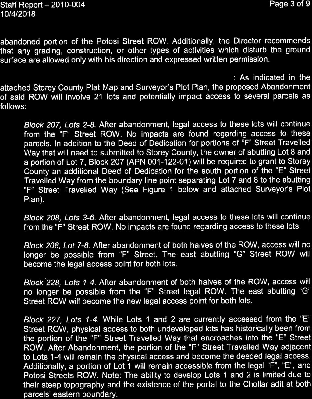
27

28
29
30
31
32 Storey County Planning Department Storey County Courthouse 26 South B Street, PO Box 190, Virginia City, Nevada Phone Fax planning@storeycounty.org To: From: Storey County Planning Commission Storey County Planning Department Meeting Date: January 17, 2019 Meeting Location: Staff Contact: Storey County Courthouse, 26 South B Street, Virginia City, Nevada Kathy Canfield File: Special Use Permit File Applicant: Property Owner: Property Location: Request: AT&T Wireless Storey County 160 E. Toll Road, Virginia City, Nevada Special Use Permit is a request by the applicant to allow for construction of a 90-foot high wireless commercial communication facility, including a tower, equipment shelters and other associated equipment. The tower will be configured as a water tower to disguise the proposed antenna equipment. The tower and associated equipment will be located on an approximate 35 x 35 leased area on Storey County property. The subject property is located at 160 E. Toll Road, Virginia City, Storey County, Nevada and having Assessor s Parcel Number Background & Analysis A. Site Location. The property is located between Toll Road and State Route 341, east of the Storey County Public Works yard in the Divide area between Virginia City and Gold Hill. The property is owned by Storey County and also contains the Storey County Jail and a communications tower, disguised as a flag pole, with associated equipment. The property is acres and the new tower and associated equipment will lease a 35- foot by 35-foot area (1,225 square feet) within the parcel. The lease area will be located adjacent to the existing flag pole tower. 1 of 14


33 Vicinity Map Property Location 2 of 14

34 Communication tower approximate location Assessor s Parcel Map 3 of 14

35 Zoning Map B. Proposed Project. The applicant is proposing to construct a 90-foot high wireless commercial communications tower and associated ground equipment. The tower is proposed to contain panel antennas, radio heads and other similar type communications equipment, all enclosed within a façade of a water tank to disguise the equipment from view. The communications tower will look like a water tower which will blend with the Comstock Historic District. The project will also include the ground installation of an approximate 8-foot by 8-foot closet equipment shelter and a back-up generator. C. Zoning Ordinance. The property is located within a Public Zone (P). The purpose of the zoning district is To accommodate the wide range of public institutional and auxiliary uses that are established in response to the health, safety, cultural, and welfare need of the citizens of the county. The proposed wireless commercial communications tower is consistent with this purpose and will provide service to the surrounding area. D. Special Use Permit. General Provisions Section states that any proposed wireless communication facility over 45-feet in height in the P zoning district requires a special use permit. The provision goes on to state A special use permit may be granted to exceed these height limitations provided that the structures may be safely erected and maintained at that height in view of surrounding conditions and circumstances. E. Comstock Historic District. The Comstock Historic District reviewed the proposed project at their October 8, 2018 meeting. The project was approved by the District subject to the actual construction materials being reviewed and approved by District staff. F. Additional Height. The applicant is proposing a tower height of 90-feet. The Public zoning district allows for a height of 45-feet, with additional height being subject to a 4 of 14


36 Special Use Permit. The additional height is needed to allow for the antenna to function without interference of land features. The proposed tower will be similar in height to the adjacent flag pole tower. View looking east, from area below Community Development Department building View looking south, from Jail parking lot along Highway of 14


37 Drawing of proposed facility Example of a similar water tower facility located in Northern California 6 of 14
38 2. Compatibility and Compliance A. Compatibility with surrounding uses and zones. The following table documents land uses, zoning classifications, and master plan designations for the land at and surrounding the proposed project. B. Compliance with Zoning. The proposed wireless commercial communications tower, with the request for additional height, is consistent with the requirements of the 2015 zoning ordinance including Section General Provisions and Section Public Zone. C. General use allowances and restrictions. Storey County Code , Special Use Permit, identifies the administration for the Board and Planning Commission for allowing a special use permit. The approval, approval with conditions, or denial of the Special Use Permit must be based on findings of fact that the proposed use is appropriate or inappropriate in the location. The findings listed below are the minimum to be cited in an approval. (1) Complies with the general purpose, goals, objectives, and standards of the county master plan, this title, and any other plan, program, map, or ordinance adopted, or under consideration pursuant to official notice by the county. The proposed wireless commercial communication tower will be consistent with the requirements of Section Public Zone and General Provisions. The project is requesting additional height beyond 45-feet which requires a special use permit. The project, as conditioned, is consistent with the Zoning Ordinance and the Storey County Master Plan. (2) The proposal location, size, height, operations, and other significant features will be compatible with and will not cause substantial negative impact on adjacent land uses, or will perform a function or provide a service that is essential to the surrounding land uses, community, and neighborhood. The proposed communication tower will be located adjacent to an existing communication tower on property owned by Storey County. The property is 7 of 14
39 zoned Public and the use provides a desired service to the surrounding community. The height of the proposed tower is 90-feet. The adjacent existing tower is 95-feet in height and is disguised as a flag pole. The base of the proposed tower will be located higher than the base of the flag pole tower because of the adjacent topography. The two towers are anticipated to be similar in height once constructed. The new tower will be disguised as a water tower to blend with the historic nature of the community. The closest property line to the tower site is approximately 160-feet, consistent with all required setbacks. (3) Will result in no substantial or undue adverse effect on adjacent property, the character of the neighborhood, traffic conditions, parking, public improvements, public sites or right-of-way, or other matters affecting the public health, safety, and general welfare, either as they now exist or as they may in the future be developed as a result of the implementation of the provisions and policies of the county master plan, this title, and any other plans, program, map or ordinance adopted or under consideration pursuant to an official notice, by the county, or other governmental agency having jurisdiction to guide growth and development. The proposed wireless commercial communications tower will be constructed on a small portion of a acre parcel owned by Storey County. The applicant will lease a 35-foot x 35-foot (1,225 square foot) area for the tower and associated ground equipment. The tower will be located adjacent to an existing flag pole communication tower on the parcel. The tower will be disguised to look like a water tower which is consistent with the public service use of the land and surrounding land to the west. The proposed wireless commercial communications tower will serve the surrounding area. Access to the site is from Toll Road. (4) The proposed use in the proposed area will be adequately served by and will impose no undue burden on any of the improvements, facilities, utilities, or services provided by the county or other governmental agency having jurisdiction in the county. The proposed use is not expected to require any additional governmental services or impact existing governmental facilities. The wireless commercial communications tower will serve the surrounding area. The applicant will lease the land from Storey County. D Storey County Master Plan. The 2016 Storey County Master Plan identifies the property within a Public Facilities designated area within the Divide Area Specific Plan. Chapter 3 of the Master Plan states Public works facilities in this area have expanded steadily in a commensurate level with population and commercial growth in the south part of the county, and it is expected that these facilities will grow at their current locations and at a similar rate into the foreseeable future. The new facility will be located within a public service facilities area, will serve the surrounding area, and is consistent with the master plan. 8 of 14
40 3. Findings of Fact A. Motion for approval. The following Findings of Fact are evident with regard to the requested special use permit when the recommended conditions of approval in Section 4, Recommended Conditions of Approval, are applied. (1) This approval is for Special Use Permit , a request by the applicant to allow for construction of a 90-foot high wireless commercial communication facility, including a tower, equipment shelters and other associated equipment. The tower will be configured as a water tower to disguise the proposed antenna equipment. The tower and associated equipment will be located on an approximate 35 x 35 leased area on Storey County property. The subject property is located at 160 E. Toll Road, Virginia City, Storey County, Nevada and having Assessor s Parcel Number (2) The Special Use Permit conforms to the 2016 Storey County Master Plan for the Public Facilities designated area in which the subject property is located. A discussion supporting this finding for the Special Use Permit is provided in Section 2.D of this staff report and the contents thereof are cited in an approval of this Special Use Permit. The Special Use Permit complies with the general purpose, goals, objectives, and standards of the county master plan, the zoning ordinance and any other plan, program, map or ordinance adopted, or under consideration pursuant to the official notice by the county. (3) The proposal location, size, height, operations, and other significant features will be compatible with and will not cause substantial negative impact on adjacent land uses, or will perform a function or provide a service that is essential to the surrounding land uses, community, and neighborhood. (4) The Special Use Permit will result in no substantial or undue adverse effect on adjacent property, the character of the neighborhood, traffic conditions, parking, public improvements, public sites or right-of-way, or other matters affecting the public health, safety, and general welfare, either as they now exist or as they may in the future be developed as a result of the implementation of the provisions and policies of the county master plan, this title, and any other plans, program, map or ordinance adopted or under consideration pursuant to an official notice, by the county, or other governmental agency having jurisdiction to guide growth and development. (5) The proposed use in the proposed area will be adequately served by and will impose no undue burden on any of the improvements, facilities, utilities, or services provided by the county or other governmental agency having jurisdiction in the county. 9 of 14
41 (6) The Special Use Permit, with the recommended conditions of approval, complies with the requirements of Chapters Special Use Permit, General Provisions, and Public Zone. (7) The Comstock Historic District has reviewed and approved the proposed project at their October 8, 2018 meeting. B. Motion for denial. Should a motion be made to deny the Special Use Permit request, the following findings with explanation why should be included in that motion. (1) This denial is for Special Use Permit , a request by the applicant to allow for construction of a 90-foot high wireless commercial communication facility, including a tower, equipment shelters and other associated equipment. The tower will be configured as a water tower to disguise the proposed antenna equipment. The tower and associated equipment will be located on an approximate 35 x 35 leased area on Storey County property. The subject property is located at 160 E. Toll Road, Virginia City, Storey County, Nevada and having Assessor s Parcel Number (2) The conditions under the Special Use Permit conflict with the minimum requirements/findings in the 2015 Storey County Zoning Ordinance Sections Special Use Permit, General Provisions and/or Public Zone. (3) The conditions under the Special Use Permit do not adequately mitigate potential adverse impacts on surrounding uses or protect against potential safety hazards for surrounding use. 4. Recommended Conditions of Approval A. Special Use Permit. This approval is for Special Use Permit to allow for construction of a 90-foot high wireless commercial communication facility, including a tower, equipment shelters and other associated equipment. The tower will be configured as a water tower to disguise the proposed antenna equipment. The tower and associated equipment will be located on an approximate 35 x 35 leased area on Storey County property. The subject property is located at 160 E. Toll Road, Virginia City, Storey County, Nevada and having Assessor s Parcel Number B. Requirements. The Permit Holder shall apply for any/all required permits and licenses, including building and fire permits, for the project within 24 months from the date of final approval of this Special Use Permit, and continuously maintain the validity of those permits/licenses, or this approval shall be null and void. This permit shall remain valid as long as the Permit Holder remains in compliance with the terms of this permit and Storey County, Nevada State, and federal regulations. C. Permit Contents. This permit incorporates by reference the standards, objectives, conditions, terms and requirements of all plans and submitted separately from this 10 of 14
42 permit. The requirements of all submitted plan, along with support material submitted with the application, become part of this Special Use Permit. D. Separate Permits Required. This Special Use Permit shall not be construed to be a permit for design or construction. A separate Storey County plan review, fire safety review, and building permit may be required for work previously performed or for future construction. E. Legal Responsibility. Issuance of this permit does not convey property rights of any sort or any exclusive privilege; nor does it authorize any injury to persons or property, any invasion of other private rights, or any infringement of state or local laws or regulations. F. Hold Harmless. The Permit Holder agrees to hold Storey County, its Officers and Representatives harmless from the costs and responsibilities associated with any damage or liability, and any/all other claims now existing or which may occur as a result of this Variance. G. Transfer of Rights. This Special Use Permit shall inure to the Permit Holder and shall run with the land defined herein. Any and all transfers of Special Use Permit shall be advised in writing to the Storey County Planning Department at least 90 days prior to assignee taking over the operation of the facility. Any new Permit Holder of the facility must sign and accept all conditions and requirements of SUP prior to any modifications or operations at the facility. H. Comstock Historic District. Prior to, or concurrent with, submittal for building permits, the Permit Holder shall demonstrate that the Comstock Historic District has approved the proposed design and construction materials and submit such approval to the Community Development Department and the Planning Department. I. Lease. The Permit Holder shall demonstrate that the lease agreement between the Permit Holder and Storey County has been finalized. J. Design. The proposed tower must be of an aesthetic design similar in appearance to that described and illustrated in this Special Use Permit Application and as documented in the associated staff report and attached to this approval letter. K. Lighting. Lighting of the tower and facility must conform to Storey County Code 8.02 Outdoor Lighting (Dark Skies). L. Emergency Management Plan. A comprehensive emergency management plan shall be developed by the Permit Holder and submitted to the Storey County Fire District for review and approval before obtaining a building permit. The plan shall include, but not be limited to, the following in case of tower failure of the support structure, antenna(s) thereon, and related appurtenances: (1) Permit Holder s emergency contact phone number(s); (2) emergency contact procedure, including for Dispatch 9-1-1, Storey County Emergency Direct-Connect ; (3) documenting and reporting; (4) post structure failure management, clean-up, reclamation, and material disposal; (5) electrical system shut-down procedure; (6) disclosure and management of hazardous materials (e.g., asbestos) or other conditions (e.g., radiation), if applicable; 11 of 14
43 and (7) post structure failure damage reporting and treatment of affected neighboring properties. M. Closure/Reclamation. In the event that the tower and facility becomes decommissioned or is absent any permitted wireless carriers for a period of any three consecutive years commencing after construction, Storey County shall reserve the right to deem the facility abandoned and mandate the tower and facility be removed within 180 days thereof at the Permit Holder s expense. The Permit Holder shall reserve the right to appeal the decision of abandonment. The process for the appeal shall be pursuant to Chapter Administrative Provisions, of the Storey County Code. Removal and reclamation shall include complete removal of the entire facility, including the tower, antenna, electrical wiring and connections, accessory structures, foundation and pads and all other appurtenances. Reclamation of the site to a condition reasonably existing prior to development shall be completed to the satisfaction of Storey County. Under no circumstances shall Storey County, its officers, or representatives bare any cost or responsibility for the deconstruction, disassembly, or removal of the antenna support structure or the facility, or reclamation. N. Noise. Any proposed power generator(s) (also to include alternator(s) ) shall be muffled and remain within a sound-insulated structure, encasement, or sound buffer walls (such as concrete masonry unit walls) sufficient to attenuate noise to or below the limitations set forth by the Storey County Code. Any generator shall only operate during power outages and/or during routine recharge and maintenance intervals. All other noise emitted from the facility, except during times of periodic maintenance and repair, shall not exceed 40 dba at a point of 100 from the antenna support structures or any other noise emitter within the property. O. Insurance. The Permit Holder shall maintain satisfactory liability insurance for all aspects of this operation under Special Use Permit for a minimum amount of $1,000, (one million dollars) and provide proof thereof to Storey County prior securing rights to the Special Use Permit. P. Cautionary Signage. Signage shall be installed at the main port of entry (i.e., facility gates) stating the company s name, site address, and 24-hour company management emergency contact phone number(s). Signage shall indicate all potential hazards and safety requirements associated with entering the facility. Q. Antenna Limitations. The communications tower and facility shall be used exclusively for commercial wireless communications. The tower shall not be used to support amateur or other non-commercial radio antennae, or lights, flags, banners, pennants, etc. Storey County and other government agency emergency repeaters and antenna shall be exempt from this requirement. R. Electrical Distribution and Controls. The location, routing, and alignment of exterior electrical and communication controls, associated wiring, and power lines (except those 12 of 14
44 now existing) shall be approved by the Building Department, when applicable. 5. Public Comment As of January 8, 2019, Staff has not received any comments from the public. 6. Power of the Board & Planning Commission At the conclusion of the hearing, the Planning Commission must take such action thereon as it deems warranted under the circumstances and announce and record its action by formal resolution, and such resolution must recite the findings of the Planning Commission upon which it bases its decision. The decision of the Planning Commission in the matter of granting the Special Use Permit is advisory only to the Board of County Commissioners and that governing body must consider the report and recommendation and must make such a decision thereon as it deems warranted. 7. Proposed Motions This section contains two motions from which to choose. The motion for approval is recommended by staff in accordance with the Findings of Fact under Section 3.A of this report. Those findings should be made part of the approval motion. A motion for denial may be made and that motion should cite one or more of the findings shown in Section 3.B. Other findings of fact determined appropriate by the Planning Commission should be made part of either motion. A. Recommended motion for approval In accordance with the recommendation by staff, the Findings of Fact under Section 3.A of this report, and other findings deemed appropriate by the Planning Commission, and in compliance with the conditions of approval, I (planning commissioner), recommend approval of Special Use Permit to allow for construction of a 90-foot high wireless commercial communication facility, including a tower, equipment shelters and other associated equipment. The tower will be configured as a water tower to disguise the proposed antenna equipment. The tower and associated equipment will be located on an approximate 35 x 35 leased area on Storey County property. The subject property is located at 160 E. Toll Road, Virginia City, Storey County, Nevada and having Assessor s Parcel Number B. Alternative motion for denial Against the recommendation by staff, but in accordance with the Findings of Fact under Section 3.B of this report, and other findings deemed appropriate by the Planning Commission, I (planning commissioner), recommend denial of Special Use Permit to allow for construction of a 90-foot high wireless commercial communication facility, including a tower, equipment shelters and other associated equipment. The tower will be configured as a water tower to disguise the proposed antenna equipment. 13 of 14
45 The tower and associated equipment will be located on an approximate 35 x 35 leased area on Storey County property. The subject property is located at 160 E. Toll Road, Virginia City, Storey County, Nevada and having Assessor s Parcel Number Appendix A Submitted Plans 14 of 14

46 SITE NUMBER: CVL06075 SITE NAME: GOLD HILL - HANGMAN Issued For: GOLD HILL - HANGMAN 911 HIGHWAY 341 VIRGINA CITY, NV PREPARED FOR 911 HIGHWAY 341 VIRGINA CITY, NV JURISDICTION: STOREY COUNTY APN: Camino Ramon, 4W850 N San Ramon, California SITE TYPE:WATER TOWER/SHELTER PROJECT DESCRIPTION PROJECT INFORMATION PROJECT TEAM SHEET INDEX REV PROPERTY INFORMATION: PROPERTY OWNER: APPLICANT / LESSEE: A&E DESIGN GROUP: POWER AGENCY: RF ENGINEER: ARCHITECT / ENGINEER: AT&T SITE NO: PROJECT NO: CVL PROJECT MGR.: DRAWN BY: SAD TELEPHONE AGENCY: CIVIL VENDOR.: CHECKED BY: CES CODE COMPLIANCE SITE ACQUISITION: 0 11/21/18 ZD 90% 0 11/28/18 ZD 100% CONSTRUCTION MGR.: ± 6,282.0' RFDS DATED , ISSUE 1.0 REVISION VICINITY MAP DIRECTIONS FROM AT&T REV DATE DESCRIPTION Licensor: IT IS A VIOLATION OF LAW FOR ANY PERSON, UNLESS THEY ARE ACTING UNDER THE DIRECTION OF A LICENSED PROFESSIONAL ENGINEER, TO ALTER THIS DOCUMENT. Engineer: NORTH ADAPTIVE RE-USE ENGINEERING Craig Horner, PE LEATHA WAY SACRAMENTO, CA craigmhorner@yahoo.com SPECIAL INSPECTIONS APPROVALS SHEET TITLE: OCCUPANCY AND CONSTRUCTION TYPE GENERAL CONTRACTOR NOTES TITLE SHEET SHEET NUMBER: T-1
47 GENERAL CONSTRUCTION NOTES: Issued For: GOLD HILL - HANGMAN 911 HIGHWAY 341 VIRGINA CITY, NV PREPARED FOR 2600 Camino Ramon, 4W850 N San Ramon, California AT&T SITE NO: PROJECT NO: DRAWN BY: CHECKED BY: CVL SAD CES 0 11/21/18 ZD 90% 0 11/28/18 ZD 100% APPLICABLE CODES, REGULATIONS AND STANDARDS: SYMBOLS LEGEND REV DATE DESCRIPTION Licensor: IT IS A VIOLATION OF LAW FOR ANY PERSON, UNLESS THEY ARE ACTING UNDER THE DIRECTION OF A LICENSED PROFESSIONAL ENGINEER, TO ALTER THIS DOCUMENT. Engineer: ADAPTIVE RE-USE ENGINEERING Craig Horner, PE LEATHA WAY SACRAMENTO, CA craigmhorner@yahoo.com SHEET TITLE: GENERAL NOTES SHEET NUMBER: GN-1
48 ISSUE STATUS DATE DESCRIPTION REV. TIMOTHY SCHAD, L.S ROUND VALLEY RD. GRASS VALLEY, CA PHONE: (530) /18/2018 AT&T SITE TOPOGRAPHY 1"=20' TITLE NOTES SURVEY NOTES OVERALL PARENT PARCEL 1"=100' LEGEND NO PRELIMINARY TITLE REPORT HAS BEEN PROVIDED. ANY EASEMENTS OR OTHER TITLE RELATED ISSUES NOT INCLUDED IN SAID REPORT WHICH ARE PART OF THE TITLE PROCESS MAY OR MAY NOT HAVE BEEN ADDRESSED, SURVEYOR ACCEPTS NO RESPONSIBILITY OR LIABILITY FOR BOUNDARY OR TITLE ITEMS ADDRESSED HEREON. THIS IS NOT A BOUNDARY SURVEY. SURVEYORS CERTIFICATE THIS SURVEY WAS PREPARED BY ME, OR UNDER MY DIRECTION AND IS BASED ON A FIELD SURVEY. CASEY R. LYNCH, P.L.S. LICENSE NO GEODETIC LOCATION DATE OF SURVEY: JUNE 30, 2018 SITE NUMBER / NAME: CVL06075 / GOLD HILL TYPE: PROPOSED "FAUX WATER TOWER) SITE ADDRESS: 911 HIGHWAY 341 VIRGINIA CITY, NV GEODETIC COORDINATES AT THE CENTERLINE OF THE PROPOSED TOWER: LATITUDE: 39º 17' 44.02" NORTH (NAD83) ( º NORTH) LONGITUDE: 119º 39' 05.21" WEST (NAD83) ( º WEST) GROUND ELEVATION: 6,282.0' (NAVD88) (0.0' A.G.L.) TOP PROPOSED TOWER ELEVATION: 6,358.0' (NAVD88) (76.0' A.G.L.) THE ACCURACY STANDARDS FOR THE ABOVE: DATE 1. ALL LATITUDES AND LONGITUDES ARE NAD 83, ALL ELEVATIONS ARE NAVD 88 (UNLESS NOTED OTHERWISE). 2. ALL BOUNDARY INFORMATION SHOWN HEREON HAS BEEN COMPILED FROM RECORD DATA. THIS IS NOT A BOUNDARY SURVEY. 3. DATE OF FIELD SURVEY JUNE 30, NO PRELIMINARY TITLE REPORT HAS BEEN PROVIDED, ANY EASEMENTS OR OTHER TITLE RELATED ISSUES NOT INCLUDED IN SAID REPORT OR WHICH ARE PART OF THE TITLE PROCESS MAY OR MAY NOT HAVE BEEN ADDRESSED, SURVEYOR ACCEPTS NO RESPONSIBILITY OR LIABILITY FOR BOUNDARY OR TITLE ITEMS ADDRESSED HEREON. THIS IS NOT A BOUNDARY SURVEY. LEGAL DESCRIPTION PARENT PARCEL PARCEL 1 OF PARCEL MAP DOC. NO OFFICIAL RECORDS OF STOREY COUNTY. APN: LEASE AREA COMMENCING AT THE MOST EASTERLY CORNER OF THE PREVIOUSLY DESCRIBED PARENT PARCEL; THENCE SOUTH 50º 27' 14" WEST, FEET TO THE TRUE POINT OF BEGINNING; THENCE THE FOLLOWING FOUR (4) COURSES: 1: SOUTH 17º 24' 57" WEST, FEET, 2: NORTH 72º 35' 03" WEST, FEET, 3: NORTH 17º 24' 57" EAST, FEET, 4: SOUTH 72º 35' 03" EAST, FEET TO THE TRUE POINT OF BEGINNING AND ENCOMPASSING 1,225.0 SQUARE FEET, MORE OR LESS. CVL06075 "GOLD HILL" 911 HIGHWAY 341 VIRGINIA CITY, NV STOREY COUNTY APN: GEODETIC COORDINATES: +/- FIFTEEN (15) FEET (NAD-83) ELEVATIONS: +/- THREE (3) FEET (NAVD-88) DATA WAS COLLECTED BY FIELD SURVEY UTILYZING TOPCON HYPER SV RECEIVERS. TOGETHER WITH THE RIGHTS OF INGRESS AND EGRESS BETWEEN THE PREVIOUSLY DESCRIBED LEASE AREA AND THE PUBLIC RIGHT OF WAY AND THE RIGHT TO INSTALL AND MAINTAIN UTILITIES NECESSARY FOR THE OPERATION OF THE FACILITY TO BE INSTALLED WITHIN THE PREVIOUSLY DESCRIBED LEASE AREA.
49 THIS IS NOT A SITE SURVEY ALL PROPERTY BOUNDARIES, ORIENTATION OF TRUE NORTH AND STREET HALF-WIDTHS HAVE BEEN OBTAINED FROM A TAX PARCEL MAP AND EXISTING DRAWINGS AND ARE APPROXIMATE. Issued For: GOLD HILL - HANGMAN 911 HIGHWAY 341 VIRGINA CITY, NV PREPARED FOR 2600 Camino Ramon, 4W850 N San Ramon, California AT&T SITE NO: PROJECT NO: DRAWN BY: CHECKED BY: CVL SAD CES 0 11/21/18 ZD 90% 0 11/28/18 ZD 100% REV DATE DESCRIPTION Licensor: IT IS A VIOLATION OF LAW FOR ANY PERSON, UNLESS THEY ARE ACTING UNDER THE DIRECTION OF A LICENSED PROFESSIONAL ENGINEER, TO ALTER THIS DOCUMENT. Engineer: PLAN NORTH ADAPTIVE RE-USE ENGINEERING Craig Horner, PE LEATHA WAY SACRAMENTO, CA craigmhorner@yahoo.com NORTH 1 100' 50' 0 100' 200' OVERALL SITE PLAN 1"=100'-0" SITE TYPE:WATER TOWER/SHELTER SHEET TITLE: OVERALL SITE PLAN SHEET NUMBER: A-1

50 Issued For: GOLD HILL - HANGMAN 911 HIGHWAY 341 VIRGINA CITY, NV PREPARED FOR 2600 Camino Ramon, 4W850 N San Ramon, California AT&T SITE NO: PROJECT NO: DRAWN BY: CHECKED BY: CVL SAD CES 0 11/21/18 ZD 90% 0 11/28/18 ZD 100% REV DATE DESCRIPTION Licensor: IT IS A VIOLATION OF LAW FOR ANY PERSON, UNLESS THEY ARE ACTING UNDER THE DIRECTION OF A LICENSED PROFESSIONAL ENGINEER, TO ALTER THIS DOCUMENT. Engineer: PLAN NORTH ADAPTIVE RE-USE ENGINEERING Craig Horner, PE LEATHA WAY SACRAMENTO, CA craigmhorner@yahoo.com 10' 5' 0 10' 20' NORTH 1"=10'-0" ENLARGED SITE PLAN 1 SITE TYPE:WATER TOWER/SHELTER SHEET TITLE: ENLARGED SITE PLAN SHEET NUMBER: A-1.1

51 KEYNOTES Issued For: GOLD HILL - HANGMAN 911 HIGHWAY 341 VIRGINA CITY, NV PREPARED FOR 2600 Camino Ramon, 4W850 N San Ramon, California AT&T SITE NO: PROJECT NO: DRAWN BY: CHECKED BY: CVL SAD CES 0 11/21/18 ZD 90% 0 11/28/18 ZD 100% REV DATE DESCRIPTION Licensor: IT IS A VIOLATION OF LAW FOR ANY PERSON, UNLESS THEY ARE ACTING UNDER THE DIRECTION OF A LICENSED PROFESSIONAL ENGINEER, TO ALTER THIS DOCUMENT. PLAN NORTH Engineer: ADAPTIVE RE-USE ENGINEERING Craig Horner, PE LEATHA WAY SACRAMENTO, CA craigmhorner@yahoo.com SHEET TITLE: 4' 2' 0 4' 8' EQUIPMENT AREA PLAN NORTH 3/8"=1'-0" SHEET NUMBER: 1 EQUIPMENT ENCLOSURE PLAN - EXTERIOR WALK IN EQUIPMENT CABINET SITE TYPE: WATER TOWER/SHELTER A-2
52 ERICSSON RRUS-32 MODEL: RRUS 32, 32-B2 32-B66 COLOR: WHITE DIMENSIONS: 26.7" TALL X 12.1" WIDE X 6.7" DEEP (INCLUDING SUNSHIELD) WIEGHT: +/- 69 LBS. (INCLUDING MOUNTING HARDWARE) RF SCHEDULE Issued For: GOLD HILL - HANGMAN 911 HIGHWAY 341 MFR'S STANDARD MOUNTING BRACKETS VIRGINA CITY, NV SUNSHIELD PREPARED FOR TOP VIEW 2600 Camino Ramon, 4W850 N San Ramon, California " CLR 12.1" 6.7" 6 RF SCHEDULE 26.7" MFR'S STANDARD MOUNTING BRACKETS SUNSHIELD AT&T SITE NO: PROJECT NO: DRAWN BY: CVL SAD 12" CLR CHECKED BY: CES FRONT VIEW SIDE VIEW 0 11/21/18 ZD 90% 0 11/28/18 ZD 100% 1 DC SURGE SUPPRESSION (SQUID) 2 ERICSSON WCS RRUS-32 REMOTE RADIO UNIT 2'-3" 1'-9" MOUNTING PIPE DOUBLE SWIVEL RRU MOUNT RRH SITE PRO 1 # RRUSM DUAL SWIVEL RRU MOUNT COLOR: LIGHT GRAY DIMENSIONS: HEIGHT: 4" WIDTH: 134" DEPTH: 2.25" WIEGHT: 40 LBS. TOP VIEW RRH PIPE DOUBLE SWIVEL RRU MOUNT REV DATE DESCRIPTION Licensor: RRH SIDE VIEW DOUBLE SIDED RRH MOUNT 4 3/4"=1'-0" FRONT VIEW IT IS A VIOLATION OF LAW FOR ANY PERSON, UNLESS THEY ARE ACTING UNDER THE DIRECTION OF A LICENSED PROFESSIONAL ENGINEER, TO ALTER THIS DOCUMENT. Engineer: PLAN NORTH ADAPTIVE RE-USE ENGINEERING Craig Horner, PE LEATHA WAY SACRAMENTO, CA craigmhorner@yahoo.com SHEET TITLE: NORTH 2' 1' 0 2' 4' 1/2"=1'-0" ANTENNA PLAN & DETAILS SHEET NUMBER: 3 ERICSSON RRUS- REMOTE RADIO UNIT 5 ANTENNA SPEC 7 ENLARGED ANTENNA PLAN SITE TYPE: WATER TOWER/SHELTER A-3

53 ERICSSON Issued For: GOLD HILL - HANGMAN 911 HIGHWAY 341 VIRGINA CITY, NV PREPARED FOR 2600 Camino Ramon, 4W850 N San Ramon, California AT&T SITE NO: PROJECT NO: DRAWN BY: CHECKED BY: CVL SAD CES 0 11/21/18 ZD 90% 0 11/28/18 ZD 100% REV DATE DESCRIPTION Licensor: IT IS A VIOLATION OF LAW FOR ANY PERSON, UNLESS THEY ARE ACTING UNDER THE DIRECTION OF A LICENSED PROFESSIONAL ENGINEER, TO ALTER THIS DOCUMENT. Engineer: ADAPTIVE RE-USE ENGINEERING Craig Horner, PE LEATHA WAY SACRAMENTO, CA craigmhorner@yahoo.com SHEET TITLE: NEW MONOPOLE / WATER TANK - NORTH & SOUTH ELEVATION 8' 4' 0 8' 16' 8' 4' 0 8' 16' SHEET NUMBER: 1 3/16"=1'-0" NEW NORTH ELEVATION 2 3/16"=1'-0" NEW SOUTH ELEVATION SITE TYPE: WATER TOWER/SHELTER A-4.1
All items include discussion and possible action to approve, modify, deny, or continue unless marked otherwise.
 Storey County Planning Commission Meeting and Public Workshop Agenda Thursday April 18, 2019 6:00 p.m. Lockwood Senior/Community Center 800 Peri Ranch Road, Lockwood, NV Jim Hindle Chairman Jim Collins
All items include discussion and possible action to approve, modify, deny, or continue unless marked otherwise.
 Jim Hindle Chairman Jim Collins Planning Commissioner Larry Prater Planning Commissioner Summer Pellett- Planning Commissioner Storey County Planning Commission Meeting Agenda Thursday November 1, 2018
MEETING MINUTES. COMMISSIONERS: Larry Prater, Kris Thompson, Laura Kekule, Summer Pellett, Jim Collins
 STOREY COUNTY PLANNING COMMISSION MEETING Thursday October 4, 2018 6:00 p.m. Storey County Courthouse, District Courtroom 26 South B Street, Virginia City, NV MEETING MINUTES CHAIRMAN: Jim Hindle VICE-CHAIRMAN:
All items include discussion and possible action to approve, modify, deny, or continue unless marked otherwise.
 Storey County Planning Commission Meeting Agenda Thursday, October 6, 2016 6:00 p.m. Storey County Courthouse, District Courtroom 26 South B Street, Virginia City, Nevada Larry Prater Chairman Virgil Bucchianeri
All items include discussion and possible action to approve, modify, deny, or continue unless marked otherwise.
 Storey County Planning Commission Meeting Agenda Thursday, November 3, 2016 6:00 p.m. Storey County Courthouse, District Courtroom 26 South B Street, Virginia City, Nevada Larry Prater Chairman Virgil
STOREY COUNTY PLANNING COMMISSION MEETING Thursday, April 7, :00 p.m. 500 Sam Clemens Ave., Mark Twain Estates Mark Twain, NV 89403
 STOREY COUNTY PLANNING COMMISSION MEETING Thursday, April 7, 2016 6:00 p.m. 500 Sam Clemens Ave., Mark Twain Estates Mark Twain, NV 89403 MEETING MINUTES CHAIRMAN: Larry Prater VICE-CHAIRMAN: Jim Hindle
All items include discussion and possible action to approve, modify, deny, or continue unless marked otherwise.
 Jim Hindle Chairman Jim Collins Planning Commissioner Larry Prater Planning Commissioner Summer Pellett- Planning Commissioner Storey County Planning Commission Meeting Agenda Thursday October 4, 2018
All items include discussion and possible action to approve, modify, deny, or continue unless marked otherwise.
 Jim Hindle Chairman Virgil Bucchianeri Planning Commissioner Larry Prater Planning Commissioner Summer Pellett- Planning Commissioner Storey County Planning Commission Meeting Agenda Thursday June 21,
STOREY COUNTY PLANNING COMMISSION MEETING Thursday, May 19, :00 p.m. Rainbow Bend Clubhouse 500 Ave de la Bleu de Clair in Lockwood, Nevada
 STOREY COUNTY PLANNING COMMISSION MEETING Thursday, May 19, 2016 6:00 p.m. Rainbow Bend Clubhouse 500 Ave de la Bleu de Clair in Lockwood, Nevada MEETING MINUTES CHAIRMAN: Larry Prater VICE-CHAIRMAN: Jim
All items include discussion and possible action to approve, modify, deny, or continue unless marked otherwise.
 Storey County Planning Commission Meeting Agenda Thursday, July 16, 2015 6:00 p.m. Virginia City Highlands Park, 2141 Empire Rd Corner of Sazarac Rd. and Empire Rd.* Virginia City Highlands, NV Bret Tyler
PETITION FOR VARIANCE. Village Hall Glen Carbon, IL (Do not write in this space-for Office Use Only) Notice Published On: Parcel I.D. No.
 Notice Published On: Parcel I.D. No.") (Execute in Duplicate) PETITION FOR VARIANCE Zoning Board of Appeals Village Hall Glen Carbon, IL 62034 Variance Request No. Date:, 20 (Do not write in this space-for Office Use Only) Date Set for Hearing:
(Execute in Duplicate) PETITION FOR VARIANCE Zoning Board of Appeals Village Hall Glen Carbon, IL 62034 Variance Request No. Date:, 20 (Do not write in this space-for Office Use Only) Date Set for Hearing:
LINCOLN COUNTY PLANNING COMMISSION PO Box 329, Pioche, NV Phone , Fax
 LINCOLN COUNTY PLANNING COMMISSION PO Box 329, Pioche, NV 89043 Phone 775-962-5345, Fax 775-962-5347 Approved Minutes for January 14, 2008, 7:00 P.M. 1. Roll Call, Open Meeting Law: The Board met in regular
Cascade Charter Township, Zoning Board of Appeals Minutes July 14, 2015 Page 1
 ZONING MINUTES Cascade Charter Township Zoning Board of Appeals Tuesday, July 14, 2015 7:00 P.M. Cascade Library Wisner Center 2870 Jackson Avenue SE ARTICLE 1. ARTICLE 2. ARTICLE 3. Chairman Casey called
TOWN OF WARWICK ZONING BOARD OF APPEALS FEBRUARY 22, 2010
 TOWN OF WARWICK ZONING BOARD OF APPEALS FEBRUARY 22, 2010 Members Present: Mr. Jan Jansen, Chairman Mr. Mark Malocsay, Co-Chairman Mr. Norm Paulsen Attorney Robert Fink Members Absent: Diane Bramich Chairman
Approved ( ) TOWN OF JERUSALEM ZONING BOARD OF APPEALS. July 8, 2010
 TOWN OF JERUSALEM ZONING BOARD OF APPEALS. July 8, 2010") TOWN OF JERUSALEM ZONING BOARD OF APPEALS Approved (8-12-10) July 8, 2010 The regular monthly meeting of the Town of Jerusalem Zoning Board of Appeals was called to order on Thursday, at 7 pm by Chairman
TOWN OF JERUSALEM ZONING BOARD OF APPEALS Approved (8-12-10) July 8, 2010 The regular monthly meeting of the Town of Jerusalem Zoning Board of Appeals was called to order on Thursday, at 7 pm by Chairman
REGULAR MEETING OF LURAY PLANNING COMMISSION APRIL 13, 2016
 REGULAR MEETING OF LURAY PLANNING COMMISSION The Luray Planning Commission met on Wednesday, April 13, 2016 at 7:00 p.m. in regular session. The meeting was held in the Luray Town Council Chambers at 45
NOTICE OF MEETING The City of Lake Elmo Planning Commission will conduct a meeting on Monday December 10, 2018 at 7:00 p.m. AGENDA
 3800 Laverne Avenue North Lake Elmo, MN 55042 (651) 747-3900 www.lakeelmo.org NOTICE OF MEETING The City of Lake Elmo Planning Commission will conduct a meeting on Monday December 10, 2018 at 7:00 p.m.
STAFF PRESENT: Community Development Director: Nathan Crane Secretary: Dorinda King
 1 0 1 0 1 Highland City Planning Commission April, The regular meeting of the Highland City Planning Commission was called to order by Planning Commission Chair, Christopher Kemp, at :00 p.m. on April,.
All items include discussion and possible action to approve, modify, deny, or continue unless marked otherwise.
 Larry Prater Chairman Virgil Bucchianeri Planning Commissioner John Herrington Planning Commissioner Storey County Planning Commission Meeting Agenda Thursday September 14, 2017 6:00 p.m. Storey County
CITY AND BOROUGH OF SITKA Planning Commission Minutes of Meeting
 CITY AND BOROUGH OF SITKA Planning Commission Minutes of Meeting Present: Jeremy Twaddle (Chair), Darrell Windsor (Member), Cheryl Westover (Member), Chris Spivey (Member), Melissa Henshaw (Planner I)
LIVONIA JOINT ZONING BOARD OF APPEALS MEETING MINUTES- May 4, 2015
 LIVONIA JOINT ZONING BOARD OF APPEALS MEETING MINUTES- May 4, 2015 Present: Chair P. Nilsson, M. Sharman, G. Cole, B. Weber, Rosemary Bergin Code Enforcement Officer A. Backus, Recording Secretary J. Brown
TOWN OF GILMANTON ZONING BOARD OF ADJUSTMENT THURSDAY, AUGUST 21, PM. ACADEMY BUILDING MINUTES
 Chair Elizabeth Hackett called the meeting to order at 7:08 PM. Members attending: Elizabeth Hackett, Perry Onion, Mike Teunessen, & Nate Abbott. Members not attending: none Also in attendance: Annette
Board of Adjustment Staff Report Meeting Date: June 1, 2017
 Board of Adjustment Staff Report Meeting Date: June 1, 2017 Subject: Applicant: Agenda Item Number: Summary: Recommendation: Prepared by: Phone: E-Mail: Administrative Permit Case Number Powning Family
Boise City Planning & Zoning Commission Minutes November 3, 2014 Page 1
 Page 1 PUD14-00020 / 2 NORTH HOMES, LLC Location: 2818 W. Madison Avenue CONDITIONAL USE PERMIT FOR A FOUR UNIT PLANNED RESIDENTIAL DEVELOPMENT ON 0.28 ACRES LOCATED AT 2818 & 2836 W. MADISON AVENUE IN
Town of Jerusalem Zoning Board of Appeals. January 10, 2019
 Approved Town of Jerusalem Zoning Board of Appeals January 10, 2019 The regular monthly meeting of the Town of Jerusalem Zoning Board of Appeals was called to order on Thursday, January 10 th, 2019 at
Community Dev. Coord./Deputy City Recorder
 1 2 3 4 5 6 7 8 9 10 11 12 13 14 15 16 17 18 19 20 21 22 23 24 25 26 27 28 29 30 31 32 33 34 35 36 37 38 39 40 41 42 43 44 45 46 NORTH OGDEN PLANNING COMMISSION MEETING MINUTES December 18, 2013 The North
Susan E. Andrade 91 Sherry Ave. Bristol, RI
 STATE OF RHODE ISLAND AND PROVIDENCE PLANTATIONS MINUTES THE ZONING BOARD OF REVIEW OF BRISTOL, RHODE ISLAND 02 OCTOBER 2017 7:00 PM BRISTOL TOWN HALL BRISTOL, RHODE ISLAND BEFORE THE TOWN OF BRISTOL ZONING
All items include discussion and possible action to approve, modify, deny, or continue unless marked otherwise.
 Storey County Planning Commission Meeting Agenda Thursday, April 7, 2016 6:00 p.m. Mark Twain Community Center 500 Sam Clemens Ave., Mark Twain Estates Mark Twain, NV 89403 Larry Prater - Chairman Virgil
AGENDA Wytheville Planning Commission Thursday, January 10, :00 p.m. Council Chambers 150 East Monroe Street Wytheville, Virginia 24382
 AGENDA Wytheville Planning Commission Thursday, January 10, 2019 6:00 p.m. Council Chambers 150 East Monroe Street Wytheville, Virginia 24382 A. CALL TO ORDER Chairman M. Bradley Tate B. ESTABLISHMENT
1 P a g e T o w n o f W a p p i n g e r Z B A M i n u t e MINUTES
 1 P a g e T o w n o f W a p p i n g e r Z B A M i n u t e 0 5-09- 17 MINUTES Town of Wappinger Zoning Board of Appeals May 9, 2017 Time: 7:00PM Town Hall 20 Middlebush Road Wappinger Falls, NY Summarized
1 N. Prospect Avenue Clarendon Hills, Illinois
 1 N. Prospect Avenue Clarendon Hills, Illinois 60514 630.286.5412 ZONING BOARD OF APPEALS/PLAN COMMISSION MEETING AGENDA Thursday, May 17, 2018 at 7:30 pm Board Room, Village Hall 1 N Prospect Avenue,
DRAFT. 1. Determination of Quorum Eric Young called the meeting to order at 1:31 p.m. The following members and staff were present:
 WASHOE COUNTY PARCEL MAP REVIEW COMMITTEE Meeting Minutes Parcel Map Review Committee Members Thursday, December 8, 2016 1:30 p.m. James Barnes, Planning Commission James English, Health District Tim Simpson,
John Kotowski, Tom Kostohryz, Jeff Risner, David Funk, Steve Robb, Keith Chapman
 Athens City Planning Commission Minutes of Regular Meeting Thursday, November 17, 2016, 12:00 p.m. The regular meeting of the Athens City Planning Commission was held in the Council Chambers, third floor,
Paw Paw Township Zoning Board of Appeals Minutes May 16, 2018
 Paw Paw Township Zoning Board of Appeals Minutes May 16, 2018 Chairman Arbanas called the Paw Paw Township Zoning Board of Appeals meeting to order at 7:06 P.M. on May 16, 2018 at the Township Hall. PRESENT:
City of Pass Christian Municipal Complex Auditorium 105 Hiern Avenue. Zoning Board of Adjustments Meeting Minutes Tuesday, July 11, 2017, 6pm
 1 2 3 4 5 6 7 8 9 10 11 12 13 14 15 16 17 18 19 20 21 22 23 24 25 26 27 28 29 30 31 32 33 34 35 36 37 38 39 40 41 42 43 44 45 46 47 48 49 50 51 City of Pass Christian Municipal Complex Auditorium 105 Hiern
HOW TO APPLY FOR A USE PERMIT
 HOW TO APPLY FOR A USE PERMIT MENDOCINO COUNTY PLANNING AND BUILDING SERVICES What is the purpose of a use permit? Throughout the County, people use their properties in many different ways. They build
CITY OF CEDARBURG. City Attorney Kaye Vance, City Planner Marty Marchek, Administrative Secretary Darla Drumel
 CITY OF CEDARBURG PLN20110906-1 A regular meeting of the Plan Commission of the City of Cedarburg was held on Tuesday, at Cedarburg City Hall, W63 N645 Washington Avenue, second floor, Council Chambers.
BOARD OF ADJUSTMENT MEETING CITY OF ST. PETE BEACH
 BOARD OF ADJUSTMENT MEETING CITY OF ST. PETE BEACH 155 Corey Avenue St. Pete Beach, Florida Wednesday, 11/15/2017 2:00 p.m. Call to Order Pledge of Allegiance Roll Call 1. Changes to the Agenda Agenda
1. Consider approval of the June 13, 2017 Regular Meeting Minutes
 Board of Adjustment Regular Meeting Agenda Tuesday August 8, 2017-6:30 PM Town Hall A. Roll Call, Determination of Quorum B. Approval of Minutes of Previous Meeting 1. Consider approval of the June 13,
SARPY COUNTY BOARD OF ADJUSTMENT MINUTES OF MEETING May 14, 2015
 l. CALL MEETING TO ORDER SARPY COUNTY BOARD OF ADJUSTMENT MINUTES OF MEETING May 14, 2015 A meeting of the Board of Adjustment of Sarpy County, Nebraska was convened in open and public session at the call
Board of Zoning Appeals
 Board of Zoning Appeals AGENDA Thursday, February 19, 2015 7:30 PM A. PLEDGE OF ALLEGIANCE B. ROLL CALL C. CONSENT ITEMS 1. APPROVE MINUTES FROM THE BOARD OF ZONING APPEALS MEETING OF OCTOBER 16, 2014.
CHEBOYGAN COUNTY ZONING BOARD OF APPEALS
 CHEBOYGAN COUNTY ZONING BOARD OF APPEALS 870 SOUTH MAIN ST. PO BOX 70 CHEBOYGAN, MI 49721 PHONE: (231)627-8489 FAX: (231)627-3646 CHEBOYGAN COUNTY ZONING BOARD OF APPEALS MEETING & PUBLIC HEARING WEDNESDAY,
Zoning Board of Appeals Minutes
 Zoning Board of Appeals Minutes (meeting taped) Monthly meeting: Thursday, July 16, 2009 in the City Hall aldermanic chambers. The meeting was called to order at 6:35 p.m. By roll call, members present:
City of Lake Elmo Planning Commission Meeting Minutes of January 14, 2013
 City of Lake Elmo Planning Commission Meeting Minutes of January 14, 2013 Chairman Williams called to order the workshop of the Lake Elmo Planning Commission at 7:00pm COMMISSIONERS PRESENT: Fliflet, Obermueller,
Present Harmoning Oleson Naaktgeboren: T
 CORINNA TOWNSHIP MINUTES BOARD OF ADJUSTMENT / PLANNING AND ZONING COMMISSION January 13, 2015 7:00 PM Charlotte Quiggle called meeting to order at 7:00 PM on January 13, 2015. Roll Call: Board of Adjustment/Planning
APPENDIX E FORMS INDEX OF ZONING FORMS
 APPENDIX E FORMS The zoning forms to follow in this appendix are used by Morrow County Zoning on behalf of their zoning resolution. There are two checklist sheets at the front of the forms that will assist
ZONING BOARD OF ADJUSTMENTS (ZBOA) MEETING AGENDA
 MEETING AGENDA") ZONING BOARD OF ADJUSTMENTS (ZBOA) MEETING AGENDA Notice is hereby given of a Regular Meeting of the La Porte Zoning Board of Adjustments to be held on Thursday, April 27, 2017 at 6:00 p.m. at City Hall
ZONING BOARD OF ADJUSTMENTS (ZBOA) MEETING AGENDA Notice is hereby given of a Regular Meeting of the La Porte Zoning Board of Adjustments to be held on Thursday, April 27, 2017 at 6:00 p.m. at City Hall
Planning and Zoning Commission
 Village of Lemont Planning and Zoning Commission 418 Main Street Lemont, Illinois 60439 phone 630-257-1595 fax 630-257-1598 PLANNING & ZONING COMMISSION Regular Meeting Wednesday, January 18, 2012 6:30
SPRINGFIELD TOWNSHIP ZONING BOARD OF APPEALS REGULAR MEETING October 17, 2018
 SPRINGFIELD TOWNSHIP ZONING BOARD OF APPEALS REGULAR MEETING October 17, 2018 Call to Order: Vice-Chairperson Whitley called the October 17, 2018 Zoning Board of Appeals meeting to order at 7:30 pm at
DICKINSON COUNTY PLANNING AND ZONING COMMISSION. Monday, May 18, :00 P.M.
 DICKINSON COUNTY PLANNING AND ZONING COMMISSION Monday, May 18, 2015 1:00 P.M. The Dickinson County Planning and Zoning Commission met Monday, May 18, 2015 at the 1:00 P.M. in the community room of the
Piatt County Zoning Board of Appeals. June 28, Minutes
 Piatt County Zoning Board of Appeals June 28, 2018 Minutes The Piatt County Zoning Board of Appeals met at 1:00 p.m. on Thursday, June 28, 2018 in Room 104 of the Courthouse. Chairman Loyd Wax called the
Request from Chad DeWaard for a Special Land Use Permit to Operate a Home-Based Business on property located at Cascade Road SE
 LOWELL CHARTER TOWNSHIP PLANNING COMMISSION REGULAR MEETING AND PUBLIC HEARINGS PRESENT: Blough, Batchelor, Simmonds, Clements, Edwards TOWNSHIP PLANNER: Tim Johnson CITIZENS IN ATTENDANCE: 13 The Regular
TOWN OF DUCK PLANNING BOARD REGULAR MEETING. October 9, The Planning Board for the Town of Duck convened at the Duck Meeting Hall on Wednesday,
 TOWN OF DUCK PLANNING BOARD REGULAR MEETING October 9, 2013 The Planning Board for the Town of Duck convened at the Duck Meeting Hall on Wednesday, October 9, 2013. Present were: Chair Joe Blakaitis, Vice
MINUTES CASCO TOWNSHIP PLANNING COMMISSION REGULAR MEETING TUESDAY, NOVEMBER 15, 2016
 MINUTES CASCO TOWNSHIP PLANNING COMMISSION REGULAR MEETING TUESDAY, NOVEMBER 15, 2016 Present Members: Stan Pankiewicz, Joe Stevens, Eric Reeve, Keith Teltow, Cynthia Goulston. Absent: Jim Edwards, Kyle
5. The suitability of the Applicant s property for the zoned purpose. The property was formerly used as a bank and a hardware store was next door.
 Piatt County Zoning Board of Appeals November 16, 2017 Minutes The Piatt County Zoning Board of Appeals met at 1:00 p.m. on Thursday, November 16, 2017 in Room 104 of the Courthouse. Chairman Loyd Wax
MINUTES ADJUSTMENTS AND APPEALS BOARD. April 3, 2013
 MINUTES ADJUSTMENTS AND APPEALS BOARD April 3, 2013 A Public Hearing of the City of South Daytona s Adjustments and Appeals Board was called to order in the South Daytona City Council Chambers, 1672 South
STAFF REPORT # CONDITIONAL USE PLANNING COMMISSION MEETING DATE: July 20, 2017
 STAFF REPORT #17-4000-0005 CONDITIONAL USE PLANNING COMMISSION MEETING DATE: July 20, 2017 1. APPLICATION: An application submitted by Stephanie Moye requesting a conditional use permit to allow for a
WEST BOUNTIFUL PLANNING COMMISSION
 Mayor Kenneth Romney City Engineer/ Zoning Administrator Ben White City Recorder Cathy Brightwell WEST BOUNTIFUL PLANNING COMMISSION 550 North 800 West West Bountiful, Utah 84087 Phone (801) 292-4486 FAX
WINTHROP PLANNING BOARD Wednesday, December 7, 2005 Minutes
 WINTHROP PLANNING BOARD Wednesday, December 7, 2005 Minutes Council Members Present: Chairman Eric Robbins: Board Members, Bryant Hoffman, Edward Vigneault, Stephen Robbins, Robert Ashby, Clark Phinney,
ALPINE TOWNSHIP PLANNING COMMISSION REGULAR MEETING June 15, 2017
 Page 1 of 6 ALPINE TOWNSHIP PLANNING COMMISSION REGULAR MEETING 17-26 CALL TO ORDER / APPROVAL OF THE REGULAR MEETING MINUTES OF MAY 18, 2017 AND THE / PUBLIC COMMENT ON NON-AGENDA ITEMS The Alpine Township
Storey County Planning Department
 Storey County Planning Department Storey County Courthouse 26 South B Street, PO Box 176, Virginia City, Nevada 89440 Phone 775-847-1144 Fax 775-847-0949 planning@storeycounty.org To: From: Meeting Date:
Perry City Planning Commission Perry City Offices, 3005 South 1200 West April 5, :00 PM
 Perry City Planning Commission Perry City Offices, 3005 South 1200 West April 5, 2012 7:00 PM Members Present: Chairman Jerry Nelson, Commissioner Esther Montgomery, Commissioner Todd Bischoff, Commissioner
Planning Commission April 23, 2008 Minutes
 Planning Commission April 23, 2008 Minutes The Chairman called the meeting to order. The following members were present: John Mears, David Miller, Mike Zuilhof, Lee Silvani, Ned Bromm, Paul Ernst and Brett
MINUTES OF THE MEETING OF THE FORT DODGE BOARD OF ADJUSTMENT CITY COUNCIL CHAMBERS TUESDAY, SEPTEMBER OCTOBER 3, 2017
 MINUTES OF THE MEETING OF THE FORT DODGE BOARD OF ADJUSTMENT CITY COUNCIL CHAMBERS TUESDAY, SEPTEMBER OCTOBER 3, 2017 MEMBERS PRESENT: Steve Hoesel, JP Mansfield, Jeanne Gibson, Jen Crimmins, Troy Anderson
AGENDA PLANNING COMMISSION Tuesday, April 18, :00 PM City Council Chambers 125 East Avenue B, Hutchinson, Kansas
 AGENDA PLANNING COMMISSION Tuesday, April 18, 2017 5:00 PM City Council Chambers 125 East Avenue B, Hutchinson, Kansas 1. ROLL CALL Macklin Woleslagel Bisbee (Chair) Hamilton Peirce Vacant Carr Hornbeck
Meeting Minutes New Prague Planning Commission Wednesday, February 22, 2006
 Meeting Minutes New Prague Planning Commission Wednesday, 1. Call Meeting to Order The meeting was called to order at 6:31 p.m. by Planning Commission Chairperson Grant Gengel with the following members
MUNICIPALITY OF MONROEVILLE ZONING HEARING BOARD APRIL 5, 2017 MINUTES. The meeting was called to order at 7:30 p.m. by Chairman Bob Stevenson.
 MUNICIPALITY OF MONROEVILLE ZONING HEARING BOARD APRIL 5, 2017 MINUTES The meeting was called to order at 7:30 p.m. by Chairman Bob Stevenson. PLEDGE OF ALLEGIANCE AND MOMENT OF SILENCE The Pledge of Allegiance
1. #1713 Hovbros Stirling Glen, LLC Amended Final Major Subdivision
 Call to Order: The meeting was called to order at 7:00 p.m. by Vice Chairman Salvadori who read the following statement: Notice of this meeting was sent in writing to the South Jersey Times on May 28,
MINUTES ADJUSTMENTS AND APPEALS BOARD. January 6, Heather Lill, Recording Secretary
 MINUTES ADJUSTMENTS AND APPEALS BOARD January 6, 2016 A Public Hearing of the City of South Daytona s Adjustments and Appeals Board was called to order in the South Daytona City Council Chambers, 1672
June 12, 2012 Minutes
 June 12, 2012 Minutes Members Present: Roger Huber Col. Langholtz Bob Beerman Wayne Bradshaw Scott Hay Staff Present: Zack Rainbow, Planner II Ben Bryner, Planning Services Manager Brad Stone, Planner
FREQUENTLY USED PLANNING & ZONING TERMS
 City Of Mustang FREQUENTLY USED PLANNING & ZONING TERMS Abut: Having property lines, street lines, or zoning district lines in common. Accessory Structure: A structure of secondary importance or function
MINUTES PARK TOWNSHIP ZONING BOARD OF APPEALS Park Township Hall nd Street Holland, MI Regular Meeting April 28, :35 P.M.
 MINUTES PARK TOWNSHIP ZONING BOARD OF APPEALS Park Township Hall 52 152 nd Street Holland, MI 49418 Regular Meeting April 28, 2014 6:35 P.M. DRAFT APPROVED COPY CALL TO ORDER: Chair Foster called to order
CHEBOYGAN COUNTY ZONING BOARD OF APPEALS
 CHEBOYGAN COUNTY ZONING BOARD OF APPEALS 870 SOUTH MAIN ST. PO BOX 70 CHEBOYGAN, MI 49721 PHONE: (231)627-8489 FAX: (231)627-3646 CHEBOYGAN COUNTY ZONING BOARD OF APPEALS MEETING & PUBLIC HEARING WEDNESDAY,
Town of Bayfield Planning Commission Meeting September 8, US Highway 160B Bayfield, CO 81122
 Planning Commissioners Present: Bob McGraw (Chairman), Ed Morlan (Vice-Chairman), Dr. Rick K. Smith (Mayor), Dan Ford (Town Board Member), Gabe Candelaria, Michelle Nelson Planning Commissioners Absent:
TOWN OF WARWICK ZONING BOARD OF APPEALS MAY 29, 2012
 TOWN OF WARWICK ZONING BOARD OF APPEALS MAY 29, 2012 Members Present: Jan Jansen, Chairman Mark Malocsay, Co-Chairman Diane Bramich Attorney Robert Fink Norman Paulsen Kevin Shuback minutes from the meeting
Administrative Permit Staff Report Meeting Date: February 2, 2017
 Administrative Permit Staff Report Meeting Date: February 2, 2017 Subject: Applicant: Agenda Item Number: Summary: Recommendation: Administrative Permit Case Number WADMIN16-0001 Carlson and Associates
Minutes of 09/03/2003 Planning Board Meeting [adopted]
![Minutes of 09/03/2003 Planning Board Meeting [adopted]](/thumbs/89/98509328.jpg "Minutes of 09/03/2003 Planning Board Meeting [adopted]") Minutes of 09/03/2003 Planning Board Meeting [adopted] Angel M Kropf on 09/10/2003 at 11:04 AM Category: Planning Board Minutes MINUTES Wake County Planning Board Wednesday, September 3, 2003 1:30 p.m.,
Minutes of 09/03/2003 Planning Board Meeting [adopted] Angel M Kropf on 09/10/2003 at 11:04 AM Category: Planning Board Minutes MINUTES Wake County Planning Board Wednesday, September 3, 2003 1:30 p.m.,
KETCHUM PLANNING AND ZONING
 IN RE: ) Barrow Variance and ) Fence Design Review ) KETCHUM PLANNING AND ZONING ) COMMISSION - FINDINGS OF FACT, ) CONCLUSIONS OF LAW AND DECISION Permit Number: 13-122 ) BACKGROUND FACTS OWNER: Strada
Conduct a hearing on the appeal, consider all evidence and testimony, and take one of the following actions:
 AGENDA ITEM #4.A TOWN OF LOS ALTOS HILLS Staff Report to the City Council SUBJECT: FROM: APPEAL OF PLANNING COMMISSION DENIAL OF A CONDITIONAL DEVELOPMENT PERMIT AND SITE DEVELOPMENT PERMIT FOR A NEW 3,511
ARTICLE SINGLE FAMILY SITE CONDOMINIUM DEVELOPMENT STANDARDS
 ARTICLE 28.00 SINGLE FAMILY SITE CONDOMINIUM DEVELOPMENT STANDARDS Section 28.01 PURPOSE The purpose of this Article is to recognize that conventional single family developments, traditionally developed
Springfield Township Zoning Board of Appeals Meeting Minutes of July 15, 2009
 Springfield Township Zoning Board of Appeals Meeting Minutes of July 15, 2009 Call to Order: Chairperson Wendt called the July 15, 2009 Regular Meeting of the Springfield Township Zoning Board of Appeals
KINGWOOD TOWNSHIP BOARD OF ADJUSTMENT. MINUTES May 11, :30 PM
 KINGWOOD TOWNSHIP BOARD OF ADJUSTMENT MINUTES May 11, 2016 7:30 PM CALL TO ORDER The meeting was called to order by M.L. Haring at 7:31 PM. PRESENT: T. Ciacciarelli ABSENT: L. Frank M.L. Haring J. Laudenbach
Tyrone Planning Commission Agenda
 Tyrone Planning Commission Agenda October 26, 2017 7:00 PM I. Call to Order II. Approval of Agenda Tyrone Planning Commission Will James Chairman Jeff Duncan Vice-Chairman Marlon Davis Commissioner David
CITY OF CUDAHY CALIFORNIA Incorporated November 10, 1960 P.O. Box Santa Ana Street Cudahy, California
 CITY OF CUDAHY CALIFORNIA Incorporated November 10, 1960 P.O. Box 1007 5220 Santa Ana Street Cudahy, California 90201-6024 PLANNING DIVISION PLANNING APPLICATION FOR MAJOR PROJECTS Appeal Change of Zone
D R A F T Whitewater Township Planning Commission Minutes of 10/06/10 Regular Meeting
 D R A F T Whitewater Township Planning Commission Minutes of 10/06/10 Regular Meeting Call to Order Chairperson, Zakrajsek, called the meeting to order at 7:01 p.m. Roll Call Members Present: Lyons, Miller,
ARTICLE 5.0 SCHEDULE OF REGULATIONS
 ARTICLE 5.0 SCHEDULE OF REGULATIONS Section 5.101 Table of Dimensional Standards by District. Dimensional Standards AG AG with sewer Districts Rural Residential Business Other SF SF with sewer R-1 R-1
Town of Hamburg Board of Zoning Appeals Meeting February 1, 2011 Minutes
 Town of Hamburg Board of Zoning Appeals Meeting February 1, 2011 Minutes The Town of Hamburg Board of Zoning Appeals met for a regular meeting on Tuesday, February 1, 2011 at 7:00 P.M. in Room 7B of Hamburg
ZONING VARIANCES - ADMINISTRATIVE
 Planning Department 200 W. Oak Street 3 rd Floor Fort Collins, CO 80521 970-498-7683 www.larimer.org/planning ZONING VARIANCES - ADMINISTRATIVE The submittal requirements listed in this packet are intended
MANCHESTER TOWNSHIP ZONING BOARD OF ADJUSTMENT REGULAR MEETING. Thursday, January 26, 2017
 MANCHESTER TOWNSHIP ZONING BOARD OF ADJUSTMENT REGULAR MEETING Thursday, January 26, 2017 Manchester Township Municipal Building 1 Colonial Drive, Manchester, NJ MINUTES OF MEETING 1. The meeting of the
MEETING MINUTES January 26, 2015
 PANAMA CITY BOARD OF ADJUSTMENT CITY HALL PANAMA CITY, FLORIDA MEETING MINUTES January 26, 2015 The City of Panama City Appeals Board met in regular session on the above date with the following members
TOWN OF WALLINGFORD ZONING BOARD OF APPEALS MAY 18, 2009 REGULAR MEETING MINUTES
 Zoning Board of Appeals 1 TOWN OF WALLINGFORD ZONING BOARD OF APPEALS MAY 18, 2009 REGULAR MEETING MINUTES A regular meeting of the Wallingford Zoning Board of Appeals was held Monday, at 7:00 p.m. in
BOARD OF ADJUSTMENT AGENDA
 PLANNING DEPARTMENT 970.668.4200 0037 Peak One Dr. PO Box 5660 www.summitcountyco.gov Frisco, CO 80443 BOARD OF ADJUSTMENT AGENDA January 17, 2018-5:30p.m. Buffalo Mountain Room County Commons 0037 Peak
BARRE TOWN PLANNING COMMISSION MINUTES
 BARRE TOWN PLANNING COMMISSION MINUTES The Town of Barre held its regular meeting on Wednesday, beginning at 7:00 p.m. at the Municipal Building, Lower Websterville, to consider the following: Members
MINUTES OF A REGULAR MEETING ZONING BOARD OF ADJUSTMENT OF THE BOROUGH OF MOUNTAIN LAKES February 24, 2016
 MINUTES OF A REGULAR MEETING ZONING BOARD OF ADJUSTMENT OF THE BOROUGH OF MOUNTAIN LAKES February 24, 2016 Chair Chris Richter called the meeting to order and announced: Adequate notice of this meeting
1. Call to Order 2. Roll Call 3. Approval of Minutes: a. November 15, 2016 Planning Commission Meeting
 PLANNING COMMISSION MEETING AGENDA REGULAR MEETING TUESDAY, JANUARY 17, 2017 6:30 PM Regular Meeting 1. Call to Order 2. Roll Call 3. Approval of Minutes: a. November 15, 2016 Planning Commission Meeting
MINUTES PARK TOWNSHIP ZONING BOARD OF APPEALS Park Township Hall nd Street Holland, MI Regular Meeting April 27, :30 P.M.
 MINUTES PARK TOWNSHIP ZONING BOARD OF APPEALS Park Township Hall 52 152 nd Street Holland, MI 49418 Regular Meeting April 27, 2015 6:30 P.M. DRAFT COPY CALL TO ORDER: Chair Foster called to order the regular
PLANNING & ZONING COMMISSION CITY OF PALMER, ALASKA REGULAR MEETING THURSDAY, JULY 17, :00 P.M. - COUNCIL CHAMBERS
 PLANNING & ZONING COMMISSION CITY OF PALMER, ALASKA REGULAR MEETING THURSDAY, JULY 17, 2014 7:00 P.M. - COUNCIL CHAMBERS A. CALL TO ORDER: The regular meeting of the Planning and Zoning Commission was
CITY PLAN COMMISSION STAFF REPORT
 CITY PLAN COMMISSION STAFF REPORT SUBJECT: Request for a Change of Zoning and Preliminary Development Plan FROM: Mara Perry, Director of Planning & Development MEETING DATE: November 6, 2017 PETITION:
PENINSULA TOWNSHIP PLANNING COMMISSION MINUTES Center Road Traverse City, MI (Township Hall) February 27, :30 pm - amended time
 February 27, :30 pm - amended time") Meeting called to order at 5:30 pm by Couture. PENINSULA TOWNSHIP PLANNING COMMISSION MINUTES 13235 Center Road Traverse City, MI 49686 (Township Hall) February 27, 2017 5:30 pm - amended time Present:
Meeting called to order at 5:30 pm by Couture. PENINSULA TOWNSHIP PLANNING COMMISSION MINUTES 13235 Center Road Traverse City, MI 49686 (Township Hall) February 27, 2017 5:30 pm - amended time Present:
AGENDA COMMITTEE OPENING OF. use. given the. by staff. CHAIRPERSON DALLAS BAKER CITY PLANNER OFFICIAL TODD MORRIS CHIEF BUILDING
 AGENDA CITY OF EL MONTE MODIFICATION COMMITTEE CITY OF EL MONTE MODIFICATION COMMITTEE CHAIRPERSON DALLAS BAKER PLANNING COMMISSION CITY PLANNER JASON C. MIKAELIAN CHIEF BUILDING OFFICIAL TODD MORRIS TUESDAY,