ANDREWS COUNTY, TEXAS. Subdivision Regulations Approved By Commissioners June 16, 2014
|
|
|
- Dominic Caldwell
- 5 years ago
- Views:
Transcription

1 ANDREWS COUNTY, TEXAS Subdivision Regulations Approved By Commissioners June 16, 2014 Court
2 ANDREWS COUNTY SUBDIVISION REGULATIONS TABLE OF CONTENTS ARTICLE 1. INTRODUCTION Preamble and Purpose 4 General Provisions 5 Short Title 5 Jurisdiction 5 Interpretation and Purposes 5 Applicability 5 Acceptance of Dedication : 5 Definitions 6 Enforcement 6 Special Provisions 6 Legal Provisions 6 Conflicting Orders 6 Severability Clause 6 Guarantee of Performance 6 Acceptance by Commissioners Court of Subdivision Streets for County maintenance and Public Subdivision streets subsequent to the date of this Order 7 Exceptions to Plat Requirement 7-9 Chapter 245 Determinations 9-11 ARTICLE 2. GENERAL SUBDIVISION REQUIREMENTS 11 General Requirements 11 Filing Deadlines and Hearings 11 Subdivision Approval Process 12 Transmittal Materials 12 Application Materials 12 Preliminary Plat 12 Recorded Plat 13 Application Review Periods 13 Application Fees 13 Subdivisions within the ETJ of a Municipality 14 \Nastewater and Development Permits 14 Privately Maintained Roads 14 Preliminary Plat Shall submit a preliminary plat to Commissioners Court 14 Licensed engineer or licensed land surveyor 14 Preliminary Plat required information Designation of subdivision as public or private 17 Flood Plain and Drainage Information 17 Water, Wastewater and Utilities Information 17 Proof of Ownership.: 18
3 County Has No Liability for Maintenance 18 Final and Record Plat 18 Approval by Commissioners Court 18 Requirements 18 Revision of Subdivision Plats (REPLATS) 19 Requirements 19 Application 19 Notice 19 Hearing ' 19 Filing 20 CANCELLATION OF SUBDIVISIONS 20 SUBDIVISIONS PLATTED UNDER MODEL SUBDIVISION RULES 20 ALL OTHER SUBDIVISIONS ARTICLE 3. MODEL SUBDIVISION RULES General and Administrative Provisions 21 Minimum Standards ARTICLE 4. DESIGN STANDARDS AND REQUIREMENTS 25 General Design Principles and Objectives 25 Conformity with the General Plan 25 Standards for Site Improvements 25 Construction and Specifications of Roads and Drainage 25 General 25 Base Material 25 Subgrade and Base 25 Width of Right-of-Ways 26 Width of County Road 26 Drainage, Minimum Grades, Retards, Headwalls, etc 26 Surface Treatment 27 Requirements for Roads and Streets 27 Lots and acreage tracts in Subdivision 28 General Layout 28 Residential Lot Sizing General considerations 28 Platted subdivisions served by a public water supply 29 Platted subdivisions served by individual water systems 29 Approval of existing small lots or tracts 29 Andrews CQlJnty 9[l-Sit~ ew~g~fa~iljh'jse-9u@ti9n~ 29 Manufactured housing communities or multi-use residential developments served by a central sewage collection system for on-site disposal 30 Exemptions and variances 30 Additional Requirements 30 Compliance 30 Plans 30 Inspection of Improvements 30 As-Built Plans 30 Street Improvements 30 Water Systems 31 General 31 Water Wells and Water Quality 31 2/Page
4 No County Liability 31 Flood Plain and Drainage 31 Changes to Road Names 31 Obstacles to Subdividing 31 ARTICLE 5. OTHER PROVISIONS 31 Construction and Maintenance Bonds Construction Bonds 31 Maintenance Bond 32 Cash Bond 32 Final Inspection 33 Penalty for Violation 33 Variance 33 Appendix A. Definitions Summaryof Standards 37 Appendix B. Fees 38 31Page
5 ANDREWS COUNTY SUBDIVISION AND DEVELOPMENT REGULATIONS ARTICLE 1. INTRODUCTION 1. Preamble and Purpose 41Page A. These Subdivision and Development Regulations have been adopted by Order of Andrews County Commissioners Court to provide a framework for the orderly and efficient development of rural and suburban Andrews County. B. These Subdivision Regulations have been adopted based on the following findings: I. The Commissioners Court of Andrews County has the authority to regulate the subdivision process pursuant to Local Government Code et. seg.; 2. The Commissioners Court of Andrews County has been designated by the Texas Commission on Environmental Quality as the authorized agent for the licensing and regulation of on-site sewerage facilities within Andrews County and these Regulations are a necessary component of such regulation; 3. The Commissioners Court of Andrews County has the authority and obligation to exercise general control over the roads, highways, bridges and related drainage structures and development within Andrews County; 4. The Commissioners Court of Andrews County has been granted the authority and responsibility under the Federal Emergency Management Act to administer floodplain development regulations within the County and to regulate associated development; 5. The Commissioners Court of Andrews County has considered the potential pollution, nuisances and injury to public health that could be caused by the use of private sewerage facilities within the County and has adopted these Regulations to abate or prevent the potential pollution, nuisances or injury to public health; 6. The Commissioners Court of Andrews County has the authority and obligation to protect the public health, safety and welfare of the citizens of Andrews County; 7. These Regulations are enacted to implement the powers conveyed to counties under the laws of the State of Texas, including but not limited to: Tex. Transportation Code Ann., Chapter 251 (general control over all roads, highways and bridges); Tex. Health and Safety Code Ann., Chapter 364 (County solid waste disposal systems); Tex. Utilities Code Ann., Sections (regulation of gas utility lines within county right-of-way); Tex. Health and Safety Code Ann., Chapter 366 (authority to adopt standards for on-site sewerage facilities); Tex. Health and Safety Code Ann., Chapter 365 (regulation of public highways for litter control), Tex. Local Gov't Code Ann. Chapter 232 (Authority to adopt and enforce subdivision regulations and require plat approval), Tex. Local Gov't Code Ann. Section (authority to regulate subdivisions pursuant to all statutes applicable to counties within the extraterritorial jurisdiction of municipalities), Tex. Health and Safety Code Sections and (authority to enforce laws and appropriate funds necessary to protect public health), Tex. Water Code Ann. Se.;;tion , et seq. (authority to set standards for construction within floodplain and to guide development of future development to minimize damage
6 caused by floods), Tex. Water Code Ann. Chapter 54 (municipal utility districts), Tex. Water Code Chapter 26 (Water Quality Control), and Tex. Water Code Sections and (regulation of water quality by counties); 8. The Commissioners Court has considered the potential burden on landowners and taxpayers of substandard development or poor quality road construction; 9. These Regulations are enacted to preserve and protect the resources, public health and private property interests of Andrews County. C. The Commissioners Court of Andrews County, following public notice, investigation and hearing, has declared and hereby declares these Regulations to be necessary and appropriate to accomplish the purposes and goals enumerated above. NOW, THEREFORE, BE IT ORDERED BY THE COMMISSIONERS COURT OF ANDREWS TEXAS, AS FOLLOWS: 2. General Provisions A. Short Title. This order and subsequent amendments shall be known as the "Subdivision Regulations" of Andrews County, Texas. B. Jurisdiction. No person shall create a subdivision in Andrews County outside of the corporate limits of any municipality without complying with the provisions of this Order. If the County and a municipality enter into a written agreement under Section of the Local Government Code which authorizes the municipality to regulate subdivision plats and approve related permits in the municipality's extraterritorial jurisdiction, then the land in the municipality's extraterritorial jurisdiction is not considered to be within the jurisdiction of the County. All plats and subdivisions of any such land within the County's jurisdiction shall conform to the rules and regulations herein set forth. C. Interpretation and Purposes. In their interpretation and application, the provisions of this Order shall be deemed to be the minimum requirements, and whenever the principles, standards or requirements of other orders of Andrews County, the more restrictive order shall control. D. Applicability. Model Subdivision Rules apply when the tract of land being divided into two (2) or more parts, creates two (2) or more lots of five (5) acres or less intended for residential purposes and utilizes centralized water and/or wastewater service. Lots of five (5) acres or less are presumed to be intended for residential purposes unless the land is restricted to nonresidential uses on the final plat and in all deeds and contracts for deeds. General Platting Requirements apply when the tract of land being divided creates two (2) or more lots greater than (5) five acres. E. Acceptance of Dedication. Approval of a plat by the Commissioner's Court shall not be deemed an acceptance of the proposed dedications, if any, shown thereon, and shall not impose any duty upon the County concerning maintenance or improvements of any such dedications. The Commissioners Court will determine which dedications will be accepted for county maintenance based on interconnectivity with existing county or state maintained roads. The enforcement of any plat or deed restrictions is the responsibility of the Subdivider and property owners in the subdivision. 51Page

7 3. Definitions. For the purpose of this Order, the terms, phrases, words, and their derivations used in these regulations shall have the meaning as stated in Appendix A. When not inconsistent with the context, words used in the present tense include the future; words used in the plural include the singular number. The word "shall" and "will" are always mandatory, while the word "may" is merely permissive. As used herein, singular nouns and pronouns shall include the plural, and the masculine gender shall include the feminine gender, where necessary for a proper understanding of these Rules. Definitions not expressly prescribed herein are to be construed in accordance with customary usage in governmental planning and engineering practices. 4. Enforcement. In addition to any other remedy provided by law, at the request of the Commissioner's Court, the County Attorney or other prosecuting attorney may file an action in a court of competent jurisdiction to: (a) Enjoin the violation or threatened violation of a requirement established by, or adopted by the commissioners court under a preceding section of this chapter; or (b) Recover damages in an amount adequate for the county to undertake any construction or other activity necessary to bring about compliance with a requirement established by, or adopted by the commissioner's court under a preceding section of this chapter. An offense under these regulations is a Class B misdemeanor punishable by fine or imprisonment or both. 5. Special Provisions. A. It shall be unlawful for the Andrews County Clerk to record the Final Plat or replat, unless and until the same shall have been approved by the Andrews County Commissioners Court. B. If any subdivision, developed subsequent to the date of this order, exists for which a final plat has not been approved or in which the standards contained herein or referred to herein have not been complied with in full then the Commissioners Court of Andrews County shall pass a resolution reciting the fact of such noncompliance or failure to secure final plat approval. The County Clerk shall, when directed by the Commissioners Court of Andrews County cause a certified copy of such resolution under the corporate seal of Andrews County to be filed in the Deed Records of Andrews County. 6. legal Provisions. A. Conflicting Orders. If any other County Order is in conflict with this Order, the most stringent rules will apply. Nothing will be permitted under the provisions of this Order that is in violation with another valid Order of the County. B. Severability Clause. If any provision of this Order, of the application thereof to any person or circumstance(s) is held invalid, the remainder of the Order, and the application of such provision to other persons or circumstances, shall not be affected thereby. 7. Guarantee of Performance. No plat of any subdivision shall receive final approval unless the subdivider has complied or provided for compliance with the policies and procedures set forth in these regulations as they may be applicable. Until these policies and procedures have been complied with by the subdivider and the plat approved by the Commissioners Court as herein required, no septic system permit or development permit shall be issued by the Andrews County Environmental Services as to any property in an unrecorded subdivision developed subsequent to this Order. 61Page
 percent or greater occupancy and/or a constant daily minimum traffic count consistent with public safety as determined by the")
8 8. Acceptance by Commissioners Court of Subdivision for County maintenance and Public Subdivision streets subsequent to the date of this Order. A. Main arterial roads within any subdivision established prior to this Order must have been dedicated to the public. B. All subdivisions affected under this section must reach fifty (50%) percent or greater occupancy and/or a constant daily minimum traffic count consistent with public safety as determined by the Precinct Commissioner. C. Property owners, within the subdivision, or subdividers, affected by this section, shall donate all material costs needed to improve roads to meet county specifications as a method of acceptance of subdivision roads. County will provide labor and equipment. D. Only the main arterial roads with a minimum 50 foot right-of-way in a subdivision will be considered for maintenance acceptance. E. Request for acceptance as county roads, must be by written petition signed by a majority of the property owners and/or the authorized representative of the subdivision association and/or the governmental trustees or entity. F. It shall be unlawful for commissioners to maintain the streets and roads in any subdivision, and Andrews County will not accept or maintain said street and roads in any subdivision, unless and until such streets and roads have been constructed as specified in these regulations or regulations in effect at the time subdivision was established and the required utilities and drainage facilities have been installed, and such improvements have been accepted in writing by the Commissioners Court. 9. Exceptions to Plat Requirement 71Page A. All provisions of Section of the Texas Local Government Code, as now in effect or hereafter amended, are hereby incorporated by reference. If a conflict exists between these Rules and the provisions of said statute, the provisions of said statute shall control over these Rules. In accordance with Local Government Code, a subdivision plat is not required if: 1. The owner of a tract of land located outside the limits of a municipality divides the tract into two or more parts and: a. The owner does not layout a part of the tract for streets, alleys, squares, parks, or other parts of the tract intended to be dedicated to public use or for the use of purchasers or owners of lots fronting on or adjacent to the streets, alleys, squares, parks, or other parts; b. The land is to be used primarily fer agricultural use, as defined by Section 1-d, Article VIII, Texas Constitution, or for farm, ranch, wildlife management, or timber production use within the meaning of Section 1-d-1, Article VIII, Texas Constitution; i. If a tract described by Subsection b ceases to be used primarily for agricultural use or for farm, ranch, wildlife management, or timber production use, the platting requirements of this regulation apply. 2. The owner of a tract of land located outside the limits of a municipality divides the tract into four or fewer parts and:
9 a. The owner does not layout a part of the tract for streets, alleys, squares, parks, or other parts of the tract intended to be dedicated to public use or for the use of purchasers or owners of lots fronting on or adjacent to the streets, alleys, squares, parks, or other parts; and b. Each of the lots is to be sold, given, or otherwise transferred to an individual who is related to the owner within the third degree by consanguinity or affinity, as determined under Chapter 573, Government Code. i. If any lot is sold, given, or otherwise transferred to an individual who is not related to the owner within the third degree by consanguinity or affinity, the platting requirements of this regulation shall apply. 3. The owner of a tract of land located outside the limits of a municipality divides the tract into two or more parts and: a. All of the lots of the subdivision are more than 10 acres in area; and b. The owner does not layout a part of the tract for streets, alleys, squares, parks, or other parts of the tract intended to be dedicated to public use or for the use of purchasers or owners of lots fronting on or adjacent to the streets, alleys, squares, parks, or other parts. 4. The owner of a tract of land located outside the limits of a municipality divides the tract into two or more parts and: The owner does not layout a part of the tract for streets, alleys, squares, parks, or other parts of the tract intended to be dedicated to public use or for the use of purchasers or owners of lots fronting on or adjacent to the streets, alleys, squares, parks, or other parts if all the lots are sold to veterans through the Veteran's Land Board Program. 5. The provisions of these regulations shall not apply to a subdivision of any tract of land belonging to the state or any state agency, board, or commission or owned by the permanent school fund or any other dedicated funds of the state unless the subdivision lays out a part of the tract for streets, alleys, squares, parks, or other parts of the tract intended to be dedicated to public use or for the use of purchasers or owners of lots fronting on or adjacent to the streets, alleys, squares, parks, or other parts. 6. The owner of a tract of land located outside the limits of a municipality divides the tract into two or more parts and: a. The owner of the land is a political subdivision of the state; and b. The land is situated in a floodplain, and c. The lots are sold to adjoining landowners. 7 The owner of a tract of land located outside the limits of a municipality divides the tract into two or more parts and: a. The owner does not layout a part of the tract for streets, alleys, squares, parks, or other parts of the tract intended to be dedicated to public use or for the use of purchasers or owners of lots fronting on or adjacent to the streets, alleys, squares, parks, or other parts; and 8/Page
10 b. One new part is to be retained by the owner, and the other new part is to be transferred to another person who will further subdivide the tract subject to the plat approval requirements of these regulations. 8. The owner of a tract of land located outside the limits of a municipality divides the tract into two or more parts and: a The owner does not layout a part of the tract for streets, alleys, squares, parks, or other parts of the tract intended to be dedicated to public use or for the use of purchasers or owners of lots fronting on or adjacent to the streets, alleys, squares, parks, or other parts; and b. All parts are transferred to persons who owned an undivided interest in the original tract and a plat is filed before any further development of any part of the tract. B. An Owner whose subdivision is exempt from the platting requirements of these Regulations may register the subdivision with the County Clerk and submit the following to the County Clerk: 1. A duplicate copy of the recorded conveyance instrument, with legible metes and bounds description attached hereto; 2. A surveyor plat showing the boundaries of the lots, adjacent roads and adjacent property owners; 3. An executed registration form in the form promulgated by the County which shall require the Owner to acknowledge that all lots remain subject to the on-site wastewater rules and development permit requirements of the County. 10. CHAPTER 245 GOVERNMENT CODE DETERMINATIONS A. Expiration of Existing Permits Any permit that does not have an expiration date or has an expiration date of less than two years from the effective date of this order, and where no progress towards completion of the project has occurred shall expire on the second anniversary of the effective date of this order. B. If no portion of the land subdivided under a plat approved under these regulations is sold or transferred before January 1 of the 51 st year after the year in which the plat was approved, the approval of the plat expires, and the owner must resubmit a plat of the subdivision for approval. A plat resubmitted for approval under this subsection is subject to the requirements prescribed by these regulations at the time the plat is resubmitted c. Expiration of Existing Projects Any project that does not have an expiration date, or has an expiration date of less than five years from the effective date of this ordinance and where no progress towards completion of the project has occurred shall expire on the fifth anniversary of the effective date of this order. 91Page
11 D. Application for Establishment of Chapter 245 Rights The provisions of this section shall apply to any application for a subdivision permit or project for which an applicant desires to establish rights under Chapter 245 of the Texas Local Government Code. An application shall be submitted in a form prescribed by the County, and shall be initially reviewed for completeness to ensure that all required items are available for technical review purposes. The application shall state the proposed date of applicable rules for the first in the series of permits, and the applicant shall supply documentation in support of the request. The following items may be considered as part of the application documentation: (l) Proof that a good-faith attempt was previously made to file with a regulatory agency an application for a permit necessary to begin or continue towards completion of the project; (2) Documentation of costs that have been incurred for developing the project including, without limitation, costs associated with roadway, utility, and other infrastructure facilities designed to serve, in whole or in part, the project (but exclusive of land acquisition) in the aggregate amount of five percent of the most recent appraised market value of the real property on which the project is located; Documentation of fiscal security posted with a regulatory agency to ensure performance of an obligation required by the regulatory agency; or (3) Documentation of utility connection fees or impact fees for the project paid to a regulatory agency. (4) Any application not deemed complete by the County shall be rejected, and the applicant shall be notified in writing of the missing or incomplete items within 10 working days of the initial application. An incomplete application shall expire if the missing or incomplete items are not provided by the applicant within 45 days of the date of initial submission of the application. (5) The County shall not accept an application or establish rights under Chapter 245 of the Texas Local Government Code where the application does not clearly specify land uses, densities or intensities. (6) Each application shall be reviewed by the Environmental Services Director or their designee in consultation with the County Attorney. Where the documentation submitted by the applicant is adequate to confirm a determination that rights exist under Chapter 245, then the regulations in place at the time such rights vested shall be applied in the further review of the project. (7) The Environmental Services Director or their designee shall either confirm or deny the application within 45 days of the date of the initial submission of the application. (8) The applicant may appeal a final determination by the Environmental Services director or their designee under this section to the County Commissioners Court within 30 days of the rejection of the application decision of the Environmental Services Director or their designee. (9) The Commissioners Court may enter into a consent agreement with the applicant that is intended to resolve a good-faith dispute concerning development rights and applicable regulations.in order to avoid the cost and uncertainty of litigation to both parties. 10 I P age

12 (J 0) The provisions of this section shall only apply to the specified land uses, densities and intensities set forth in the Fair Notice documentation provided by the applicant. Any modification of the land uses, densities or intensities shall be considered a new project subject to current County regulations. ARTICLE 2. PLATTING PROCEDURE The platting procedure for subdivisions within Andrews County will be as follows: 2.1 Prior to any subdivision of land and any official submittal of a plat for review, it is recommended that the Owner set a meeting with the Precinct Commissioner and any retained county Engineer. The Owner shall present a preliminary plat showing the street alignments and the lots. The Precinct Commissioner and the retained county Engineer will provide general comments and requirements to the Owner. Based upon these comments and requirements, the owner or his representative will submit one copy of the revised preliminary plat of the subdivision to the Precinct Commissioner's office and two additional copies to the retained county Engineer's Office The Precinct Commissioner will review the plat and forward any additional comments and recommendations to the County Engineer The retained county Engineer will review plans for compliance with the Andrews County Subdivision and Development Regulations The retained county Engineer will return his and the Commissioner's comments and recommendations to the Owner or his agent The Owner will address the comments and recommendations and set a meeting with the retained county Engineer to resolve the comments The retained county Engineer will contact the County Judge's Office to request placement of the plat on the next Commissioners Court agenda for approval if all comments have been addressed or placement of a variance request on the next Commissioners Court agenda. The County Judge's Office will verify with the proper Commissioner for his concurrence of placement Prior to approval of the plat, the Owner shall pay a scanning fee of $75.00/sheet to the County Engineer. This fee will be waived if the Owner supplies the County Engineer with a digital file of the final plat. The digital file shall be in a.dwg format If the property to be platted lies within the extraterritorial jurisdiction (ET J) of a city, this procedure will be accomplished simultaneously with the platting procedure of the city. The Owner must obtain preliminary approval of the city before preliminary approval by the Andrews County Commissioners' Court, unless otherwise provided by Interlocal Agreement The final plat procedure will be the same as the preliminary plat procedure. A General Requirements. Any Owner who subdivides a tract of land shall: 1. Comply in all respects with these regulations; and 2. Prepare and submit to the Commissioners Court an application for approval of the proposed Subdivision in accordance with the terms and procedures set forth in these regulations. lllpage
13 B. Filing Deadlines and Hearings. A completed Preliminary Plat and application, with three (3) copies, must be on file in the County Clerk's Office thirty (30) days prior to Preliminary Plat Hearing. Upon receipt of a completed application and plat, the hearing on the Final Plat shall be 14 days after the Preliminary Plat Hearing but in no event shall it be over 60 days from the filing of the completed application. C. Subdivision Approval Process. No approval in the form of the Judge's signature, verbal Commissioners Court action, or otherwise shall be given on any subdivision until the Owner has satisfied each of the following steps in the order indicated: 1. Filing of the Preliminary Plat and Application as required herein. 2. Approval of Preliminary Plat by Commissioners Court. 3. Approval of Final Plat by Commissioners Court. 4. Filing of Final Plat of record with the County Clerk, to be recorded in the Plat Records of the County. D. Transmittal Materials. All submissions to the Commissioners Court pursuant to these regulations, including amendments or supplemental materials, shall be filed with the County Clerk, including the official application form to be provided by the County. E. Application Materials. 1..: Preliminary Plat Submissions. Every Preliminary must be filed as herein directed and include the following: a. Three (3) 18" x 24" or 22" x 34" black line copies of the Preliminary Plat containing: i. Existing topographic contours at two-foot intervals for subdivision where lots are less than five acres, and 5-foot intervals for all other subdivisions; ii. Tangent lengths, centerline radii, names, and right-of-way dimensions for all proposed and existing streets; iii. Proposed easements, existing easements and detention ponds; iv. Proposed approximate property line dimensions; v. Adjacent property, owner's name, address, deed record, or subdivision name, block and lot number vi. A transmittal letter containing the name, address, telephone number and fax number for the subdivision owner and engineer; vii. viii. City limits, surveys, section, and county boundaries; Vicinity map. b. The application fee; c. A tax certificate showing all taxes currently due with respect to the Original Tract have been paid; d. A completed application in the current form promulgated by the County; 12IPage

14 e. All other documents or reports required pursuant to these regulations and any associated bonds or letters of credit f. Any requests for variances to these regulations shall be made in writing and submitted with the application. The request shall state all reasons for such request for a variance. g. An electronic copy of the plat shall be submitted to the 911 coordinator. The electronic copy of the plat should be based on the state plain grid. If the electronic copy submitted is other than state plain grid, the scale factor used must be indicated on the plat. 2. Recorded Plat. Three (3) 18" x 24" or 22" x 34" black line copies of the Final Plat shall be presented to the County Clerk for recording as the Record Plat. All writing and drawings on the Record Plat must be large enough to be easily legible. F. Application Review Periods. 1. If a person submits a plat application to the Commissioners Court that does not include all of the documentation or other information required herein, the Commissioners Court or the Court's designee shall, not later than the io" business day after the date the Commissioners Court receives the application, notify the applicant of the missing documentation. 2. An application is considered complete when all documentation or other information required herein is received. 3. The Commissioners Court or the Court's designee shall take final action on a plat application, including the resolution of all appeals, not later than the so" day after the date a completed plat application is received by the Commissioners Court or the Court's designee. 4. The 60 day time period for approval may be extended as follows: a. For a reasonable period, if agreed to in writing by the applicant and approved by the commissioners court or the court's designee; b. May be extended 60 additional days if Chapter 2007, Government Code, requires the county to perform a takings impact assessment in connection with a plat application; and c. Applies only to a decision wholly within the control of the commissioner's court or the court's designee. 5. The Commissioner's Court may refuse to approve a plat made for recordation based on the provisions in the Texas Local Government Code Section If the Commissioners Court or the Court's designee disapproves a plat application, the applicant shall be given a complete list of the reasons for the disapprovai by certified return receipt mail G. Fee. The County may impose an application fee and inspection fee as set forth in Appendix B to cover the cost of the County's processing of the application and inspection of street, road, and drainage improvements described by the plat. The fee may vary based on the number of proposed lots in the subdivision, the acreage described by the plat, the type or extent of proposed street and drainage improvements, or any other reasonable criteria as determined by the County Commissioners Court. The owner of the tract to be subdivided must pay the fee at the time of the submission of an application before the County conducts a review of the plat. The application shall be deemed incomplete if the fee is not paid at the time of submittal. The fee is subject to refund under (i), Texas Local Gov't Code. 13/Page

15 H. Subdivisions within the ETJ of a Municipality. The Plat must indicate whether the land covered by the plat or replat is in the extraterritorial jurisdiction of a municipality. If so, it must be approved by the appropriate municipal authorities prior to being filed as determined by any written agreement entered into by the County and municipality under Sections and of the Local Government Code if the agreement authorizes the municipality to regulate subdivision plats and approve related permits in the municipality's extraterritorial jurisdiction. The County Clerk may require written proof of exemption from a municipality to be filed with the Record Plat. In the event the land is subject to both municipal subdivision regulations and these regulations, then the stricter standard shall apply and may be enforced by either the City or the County or both. I. Wastewater and Development Permits. The County shall not issue an On-Site Sewage Facility or development permit, if any, on any parcel of land unless that property is in compliance with all the requirements of these Regulations and the Andrews County Rules of On-Site Sewage Facilities Regulation, or regulations enforced by the State of Texas. J. Privately Maintained Roads. If a street or road in a subdivision is to be privately maintained the following criteria must be satisfied. (a) The roads must be constructed to the same standards as required for County roads. (b) The following note shall be conspicuously displayed on the plat: "By filing this Plat [Owner], and all future owners of property within this subdivision, by purchastnq such property acknowledge and agree that the County shall have no obligation whatsoever to repair or accept maintenance of the roads in this subdivision unless and until the roadways have been improved to the current standards required by Andrews County, the roadways with all required right-of-way have been dedicated as a public street by the owners thereof, and the roads have been accepted by formal action of the Commissioners Court." (c) Restrictive covenants establishing a homeowners association, whose purpose shall be, but not limited to, the maintenance and repair of roads in the subdivision shall be filed of record concurrently with the recording of the Plat. (d) Financial assurance for not less than ten (10) years of maintenance cost for such privately maintained roads. Preliminary Plat. 141 P age A. Shall submit a preliminary plat to Commissioners Court. To secure the review and approval of a proposed subdivision by the Commissioners Court, the subdivider shall submit a preliminary plat and a completed subdivision application, as promulgated on the form on file with the County, to the court prior to making any street and road improvements or installation of utilities within any roadway. A copy of the Preliminary Plat shall be filed (but not recorded) with the County Clerk's office thirty (30) days prior to the hearing to consider preliminary plat. On approval of said preliminary plat the subdivider may proceed with the preparation of a final plat and such other plans and documents required by this Requlation. 8. The plat shall be prepared by a licensed engineer and a licensed land surveyor in accordance with these regulations and should depict the entire layout showing layouts of street blocks and certification by an engineer of adequate drainage for the subdivision. Where the proposed subdivision constitutes a unit of a larger tract owned by the subdivider which is intended to be subsequently subdivided as additional units of the same SUbdivision, the subdivision plat should be accompanied by a layout of the entire area showing the tentative layout of streets, blocks, drainage for such use. The overall
 Statement of conformance or list of variances.")
16 151 P age layout, if approved by the Commissioners Court, shall be attached to and filed with a copy of the approved subdivision plat in the permanent files of Andrews County. C. The preliminary plat shall provide the following information: (1) Legal description. The legal description of the land to be subdivided shall be sufficient for the requirements of title examination, including the current deed. (2) Statement of conformance or list of variances. The statement of conformance shall declare that the preliminary plat (including its supporting information) conforms to these Rules (including the associated Appendices) or shall list the instances in which it does not comply with these Rules, the reason for each such non-compliance, and whether a variance is requested. (3) Location Map. A location map or sketch at a scale of not more than four thousand (4,000) feet to one (1) inch shall show the proposed subdivision, existing adjacent subdivisions, school district lines, and roads in the vicinity. (4) Vicinity Map. A vicinity sketch or map at approximately one (1) inch = four hundred (400) feet scale shall show existing subdivisions, streets, easements, right-of-way, parks and public facilities, tracts of acreage in the vicinity, the general drainage plan and ultimate destination of water, and possible storm sewer, water, gas, electric, and sanitary sewer connections by arrows. (5) Location with respect to any municipal ETJ line. A statement indicating whether any part of the proposed subdivision lies within any extraterritorial jurisdiction of a municipality (under Texas Local Govt. Code or ) shall be provided. If an ETJ line traverses the subdivision, it shall be delineated and identified upon the preliminary plat. (6) Map of earlier plat. If the subdivision is part of a previously filed subdivision plat, a map shall be provided showing the portion of the earlier-filed plat that is owned by the applicant and included in the preliminary plat. (7) Restrictive covenant. Any restrictive covenants proposed to be imposed for the subdivision should be attached for reference. It should be noted whether these are existing or proposed and if proposed, at what time they will be recorded, prior to or subsequent to the recording of the final plat. (8) Certification by the owner of conformance or submittal for review. The owner shall certify that the preliminary plat has been reviewed and conforms to the requirements of the Colorado River Municipal Water District, Texas Commission on Environmental Quality, municipal utility districts, 911 addressing, school district, the gas, electricity, water, telephone, and television cable companies, irrigation, ground water, or water control and improvement districts and the U.S. Post Office; or that the agencies mentioned in the preceding paragraph were given at least ten (10) working days to review the proposed preliminary plat. This certification shall be in letter form and shall include the name, title, address, and telephone number of the person to whom the applicant delivered the preliminary plat foi ieview. (9) The preliminary plat shall include the name, address, and telephone number of the record owner(s) of lands being subdivided, and of the engineer, the surveyor, and any other persons responsible for the preparation of the data and information being submitted. (10) The preliminary plat shall include the subdivision name, which shall not duplicate the spelling or the pronunciation of any existing subdivision in the County. (11) The preliminary plat shall delineate the boundary of the subdivision by metes and bounds sufficiently for the requirements of title examination. Subdivision boundaries shall be
 The preliminary plat shall locate the subdivision with respect to an original corner of an original survey of which it is a part.")
17 161 P age indicated by a heavy line at least one sixteenth (1/16) inch wide. The total acreage in the subdivision shall be noted. (12) The preliminary plat shall locate the subdivision with respect to an original corner of an original survey of which it is a part. (13) The preliminary plat shall show the primary control points or description used to establish the subdivision. The description, location, and tie to such control points, including all dimensions, angles, bearings, block numbers, and summary data, shall be noted. (14) The preliminary plat shall note the existing conditions within or immediately adjacent to the subdivision, including the location, dimension, name, and description of each existing or recorded street; alley, reservation, easement, or other public rights-of-way or visible private encumbrance upon the land within or adjacent to the subdivision, intersecting or contiguous with its boundaries, or forming such boundaries (include the name of the subdivisions in which a street, alley, etc. is located); location, dimension, description, and flow line of any existing watercourses, drainage structures, or irrigation structures within the subdivision or within one hundred and fifty feet (150 feet) of the boundary of the subdivision; location, dimension, description, and name of all existing or recorded lots and blocks, parks, public areas, or permanent structures within the subdivision or contiguous with the subdivision; and, location, dimension, description, and name of all existing water, sewer, electric, gas, telephone, television cable, irrigation or other utilities. (15) The preliminary plat shall show the adjoining property owners' names and references to the deeds under which they hold ownership, or if the adjoining property is within a recorded subdivision, state the subdivision's name and provide the reference for where its plat is recorded in the Map Records of Andrews County. (16) The preliminary plat shall note the date of preparation, date of survey, the scale of the plat, and North arrow. (17) The preliminary plat shall include topographic information, including contour lines for every five vertical foot. The information shall include the flow lines of existing gutters and drainage ways.. It shall be sufficiently detailed to determine the existing drainage to and from the proposed subdivision and to determine the adequacy of the proposed drainage plan. Elevations shall be based on published U.S.C. & G. S. datum and the benchmark used shall be noted on the plat. (18) The preliminary plat shall show the proposed general plan for storm water drainage in sufficient detail to indicate the location of drainage ditches or structures and the direction of flow. Post development runoff shall not exceed pre-development runoff based on a 100 year event. (19) The preliminary plat shall show the approximate location, dimensions, and description of all proposed street rights-of-way, alleys, drainage structures, parks, squares, other public areas, reservations, easements, other rights-of-way, blocks, lots (lettered or numbered consecutively), permanent survey monuments, and other sites within the subdivision. The proposed width of each proposed street shall be measured at right angles, or radially where curved. (20) The preliminary plat shall show the name of the proposed subdivision or any of the physical features (such as streets, parks, etc.). The name of a proposed street shall conform to the name of an existing street of which it may become an extension but otherwise shall not duplicate or conflict with the recognized name of any other street located in the area subject to these Rules. Street and subdivision names will be coordinated through the 911 coordinator to ensure no duplication of street names. This coordination with 911 is the responsibility of the
18 developer. The street names must not be so similar in spelling or in pronunciation to the names of any similar features in Andrews County or in any incorporated city therein, as to cause confusion. (21) The preliminary plat shall show building setback lines (front, side, and rear). (22) The preliminary plat shall show the net area contained within each lot or tract to the nearest one tenth (1/10) of an acre. (23) The preliminary plat shall show the limits of any flood hazard areas and the proposed finish floor elevation of any building within these flood hazard areas. E. Designation of subdivision as public or private. The plat shall show the designation of the proposed subdivision improvements as public or private. H. Flood Plain and Drainage Information. 1. Each preliminary plat shall include base flood elevation data. 2. All subdivision proposals shall have adequate drainage provided to reduceexposure to flood hazards. 3. All subdivision proposals shall have public utilities and facilities such as sewer, gas, electrical and water systems located and constructed to minimize or eliminate flood damage. 4. All subdivision plats shall have the flood hazard area clearly delineated on the plat and where appropriated, shall be shaped and sized so as to provide adequate building space. 5. The developer, builder, seller or agent shall inform in writing, each prospective buyer of subdivision lots located in a flood hazard area that such property is in an identified flood hazard area. 6. Before any structure can be built in a known or identified flood hazard area, the developer, owner, builder, seller or agent must demonstrate that suitable engineering studies have been performed, and that any such structure can be built upon the known or identified flood hazard area in a manner that will not adversely affect the adjacent properties both in the subdivision, or in surrounding properties adjacent to the subdivision. Such engineering plans must be certified by a licensed engineer, and approved by the County Commissioners Court. Such review and approval shall require additional filing fees, as provided herein. I. Water. Wastewater and Utilities Information. The following information must be provided to the Court by reference or notation upon the plat. 1. Designation of the entity supplying electric, phone and gas utilities or a statement that such utilities are not available.. 2. The location of all proposed utility easements and/or infrastructure, including water well sanitary easements, if applicable. 3. Designation of the water and sewer utility provider, if known, and the source of the water intended to serve each Lot within the subdivided area or, if the source of water is not known, a statement to that effect. 171Page
19 4. Certification that all Lots have been designed in compliance with the Rules of Andrews County for On-Site Sewage Facilities. K. Proof of Ownership. The Developer shall provide proof of ownership. L. County Has No Liability. The Preliminary and the Final Plat shall contain the following two provisions: "The County shall not be responsible for the quantity or quality of a reliable water source"; and for plats which propose private roads, the plat shall state the following: "The County shall not accept all or a portion of the roads in this subdivision for maintenance without mere approval of the plat. Any road or portion of thereof shall be accepted for county maintenance only upon separate order of the Commissioners Court in conformity with this Subdivision Regulation." M. Final and Record Plat. Upon approval of the Preliminary Plat, the Subdivider shall revise the plat in accordance with the requirements and recommendations of the Commissioners Court and shall cause to be prepared a Final Plat of the proposed subdivision for consideration pursuant to these regulations. The hearing for final plat approval shall be at least fourteen (14) days after Preliminary Plat hearing. 13. Approval by Commissioners Court if the above has been adhered plus: 1. All roads must meet County specifications and standards in the regulations under design standards. 2. Drainage appurtenances have been inspected by the county commissioner or their designee for compliance to the drainage plans provided by the developer. 3. Bonding for the proper construction of all roads, streets, and drainage requirements. Bond amount to be determined by a licensed professional engineers statement of cost and is not to exceed the estimated cost of constructing roads, streets and drainage requirements. 4. Lot and block monumentation to be set by a registered professional surveyor before recordation of the plat. A. Requirements. The County Commissioners Court may approve a public subdivision when the following requirements are present: 1. A plat as required herein is presented for approval. 2. A plan and time frame for the development of the streets and roads is presented for approval setting forth: a. Design standards for streets and roads; b. Designs for drainage and a complete and comprehensive drainage study pursuant to 30 TAC 285.4(c), as prepared by an engineer; c. Width of streets, roads and right-of-way; d. Surface treatment of streets and roads. 3. The plan must be prepared by a registered engineer and surveyor. 18\ P age
20 Revision of Subdivision Plats (REPlATS) 191 P age A. Requirements: 1. Letter of application to Commissioner's Court requesting the revision. 2. Notice to be published as herein specified. 3. Cost of publication to be paid by applicant 4. Letter stating the revision is not in violation of existing deed restrictions to Commissioners Court. 5. Letter from Property Owners Association President stating they have no objection to the revision or replat. 6. If no Property Owners Association, a notice to each lot owner at his address on said tract by certified mail or regular mail, return receipt requested, and presented to the Commissioner's Court at the time of presentation of application. 7. Persons replatting property within the service area of a water or sewer utility provider shall have the written consent of the provider. B. Application. A person who owns subdivided land that is subject to this order may apply in writing to the Commissioners Court of the county for permission to revise the subdivision plat that has been filed for record with the County Clerk. C. Notice. 1. After the application is filed with the Commissioners Court, the Court shall require a notice by the applicant to be printed in a newspaper of general circulation in the county. The notice must include a statement of the time and place at which the Commissioners Court will meet to consider the application and to hear protests to the revision of the subdivision plat. 2. The notice must be published at least three times within the period beginning on the 30th day and ending on the 7th day before the date of the meeting. All cost of publication shall be paid by the applicant in advance. 3. If all or part of the subdivided tract has been sold to non-developer owners, notice shall also be given to each owner, at his address on said tract, by certified mail or registered mail; return receipt requested. D. Hearing. The Commissioners Court, during a regular meeting of the court, shall adopt an order permitting the person to revise the subdivision plat if it is shown to the court: 1. That the revision will not interfere with the established rights of any owner of a part of the subdivided land; 2. If the revision interferes with the rights of an owner of a part of the subdivided land, the owner has agreed to the revision; 3. That the revision is not a violation of any existing deed restriction(s); or 4. That the applicant has complied with Section , Texas Local Govemment Code.

21 E. Filing. If the Commissioners Court permit a person to revise a subdivision plat, the person may make the revision by filing for record with the County Clerk a revised plat or part of a plat showing the changes made to the original plat. CANCELLATION OF SUBDIVISIONS An application may be submitted to the County to request the cancellation of a subdivision and shall be processed according to the provisions stated below. All fees must be paid and accompany the application. DIVISION 1. SUBDIVISIONS PLATTED UNDER MODEL SUBDIVISION RULES A. If the Model Subdivision Rules apply, a Subdivider of land will follow the procedure described herein and provide notice and hearing consistent with the following: (1) Notice must be published in Spanish in the newspaper of highest circulation and in a Spanish-language newspaper in the County, if available. (2) Not later than the fourteenth (14th) day before the date of the hearing, the county chief appraiser shall by regular and certified mail provide notice to: (a) Each person who pays property taxes in the subdivision, as determined by the most recent tax roll; and (b) Each person with an interest in the property. (3) The Commissioners Court may require a Subdivider to provide the Court with the name and last known address of each person with an interest in the property. For purposes of the subsection, a person residing on a lot purchased through an executory contract has an interest in the property. (4) A person who fails to provide information requested under sub-section (3) above before the thirty-first (31st) day after the date the request is made is liable to the State for a penalty of $500 for each week the person fails to provide the information. 8. A resident of a subdivision for which the Subdivider has applied for cancellation has the same rights as a purchaser of land under this Chapter. C. The Commissioners Court may cancel a subdivision only after a public hearing. At the hearing, the Commissioners Court shall permit any interested person to be heard. At the conclusion of the hearing, the Commissioners Court shall adopt an order on whether to cancel the subdivision. DIVISION 2. ALL OTHER SUBDIVISIONS This section applies only to real property located outside municipalities and the extraterritorial jurisdiction of municipalities, as determined under Chapter 42. A. A person owning real property in Andrews County that has been subdivided into lots and blocks or into small subdivisions may apply to the County Commissioners Court for permission to cancel all or part of the subdivision, including a dedicated easement or roadway, to reestablish the property as acreage tracts as it existed before the subdivision. If, on the application, it is shown that the cancellation of all or part of the subdivision does not interfere with the established rights of any purchaser who owns any part of the subdivision, or it is shown that the purchaser agrees to the cancellation, the County Commissioners Court by order shall authorize the Owner of the subdivision to file an instrument canceling the subdivision in whole or in part. The instrument must describe the subdivision or the part of it that is cancelled. The County Commissioners Court shall enter the Order in its Minutes. After the cancellation 20 I P age

22 instrument is filed and recorded in the deed records of the County, the County Tax Assessor-Collector shall assess the property as if it had never been subdivided. B. The County Commissioners Court shall publish notice of an application for cancellation. The notice must be published in a newspaper, published in the English language, in the County for at least three weeks before the date on which action is taken on the application. The County Commissioners Court shall take action on an application at a regular term. The published notice must direct any person who is interested in the property and who wishes to protest the proposed cancellation to appear at the time specified in the notice. C. If delinquent taxes are owed on the subdivided tract for any preceding year, and if the application to cancel the subdivision is granted as provided by this Division, the Owner of the tract may pay the delinquent taxes on an acreage basis as if the tract had not been subdivided. For the purpose of assessing the tract for a preceding year, the County Tax Assessor-Collector shall back assess the tract on an acreage basis. D. On application for cancellation of a subdivision or any phase or identifiable part of a subdivision, including a dedicated easement or roadway, by the owners of seventy-five (75) percent of the property included in the subdivision, phase, or identifiable part, the County Commissioners Court by Order shall authorize the cancellation in the manner and after notice and a hearing as provided for herein. However, if the Owners of at least ten (10) percent of the property affected by the proposed cancellation file written objections to the cancellation with the County Commissioners Court, the grant of an order of cancellation is at the discretion of the County Commissioners Court. E. To maintain an action to enjoin the cancellation or closing of a roadway or easement in a subdivision, a person must own a lot or part of the subdivision that: (1) Abuts directly on the part of the roadway or easement to be canceled or closed; or (2) Is connected by the part of the roadway or easement to be canceled or closed, by the most direct feasible route, to (a) the nearest remaining public highway, county road, or access road to the public highway or county road; or (b) any un-canceled common amenity of the subdivision. F. A person who appears before the County Commissioners Court to protest the cancellation of all or part of a subdivision may maintain an action for damages against the person applying for the cancellation and may recover as damages an amount not to exceed the amount of the person's original purchase price for property in the canceled subdivision or part of the subdivision. The person must bring the action within one year after the date of the entry of the County Commissioners Court Order granting the cancellation. G. The County Commissioners Court may deny a cancellation under this section if the County Commissioners Court determines the cancellation will prevent the proposed interconnection of infrastructure to pending or existing development. ARTiCLE 3. MODEL SUBDiVISION RULES DIVISION 1. GENERAL AND ADMINISTRATIVE PROVISIONS A. Authority and Scope of Model Rules. These rules are adopted by Andrews County, Texas under the authority of the Local Government Code, Chapter 232 and Water Code, Notwithstanding any provision to the contrary, the rules under this Article apply only to a subdivision which creates two (2) or more lots to layout (1) a subdivision of the tract, including an addition; (2) lots; or (3) streets, alleys, squares, parks, or other parts of the tract intended to be dedicated to public use or for the use of purchasers or owners of lots fronting on or adjacent to the streets, alleys, squares, parks, or other parts, 211 P age
23 B. Purpose. It is the purpose of the rules under this chapter to aid in the orderly development of Andrews County, Texas, and provide guidelines which will lead to a desirable environment Specifically they have been prepared for the following purposes: 1. To furnish the developer with guidance and assistance in the expedient preparation and approval of his or her plat; 2. To protect the citizens of Andrews County by insuring minimum subdivision and development guidelines for residential, commercial and industrial subdivisions; 3. To provide for the welfare of the public by providing guidelines for the location, design, and improvements and other features that provide for the safety of the general public; and 4. To prevent Andrews county Commissioners from being burdened with substandard streets or roads in the future. C. Plat Required. 1. The owner of a tract of land located outside the corporate limits of a municipality and not within the extra-territorial jurisdiction of a municipality with which the county has a development agreement with pursuant to of the Local Government Code that divides the tract in any manner that creates two (2) or more parts to layout (1) a subdivision of the tract, including an addition; (2) lots; or (3) streets, alleys, squares, parks, or other parts of the tract intended to be dedicated to public use or for the use of purchasers or owners of lots fronting on or adjacent to the streets, alleys, squares, parks, or other parts, must have a plat of the subdivision prepared and file an application as required by these Regulations. For the purpose of adhering to (d), Water Code, lots of five (5) acres or less are presumed to be for residential purposes unless the land is restricted to nonresidential uses on the final plat and all deeds and contracts for deeds. 2. No subdivided land in Andrews County shall be sold or conveyed until the subdivider: (a) Has received approval of a final plat of the tract of land; and, (b) Has filed and recorded a legally approved plat with the County Clerk of Andrews County 3. A division of a tract includes a division regardless of whether it is made by using a metes and bounds description, or any description of less than a whole parcel, in a deed of conveyance or in a contract for a deed, using a contract of sale or other executory contract, lease/purchase agreement, or any other method to convey property. DIVISION 2. MINIMUM STANDARDS A. Residential Development Standards. The establishment of a residential development with two (2) or more iots of five (5) acres or less where the water supply and sewer services do not meet the minimum standards of this Chapter is prohibited. A subdivision with lots of five (5) acres or less is presumed to be a residential development unless the land is restricted to nonresidential use on the final plat and all deeds and contracts for deeds. B. Water Facilities Development. The following provides minimum standards for the development of water facilities. 1. Public Water Systems. 22/ P age

24 (a) Subdividers who propose to supply drinking water by connecting to any existing public water system must execute a written agreement with the retail public utility. The agreement must provide that the retail public utility has or will have the ability to supply the total flow anticipated from the ultimate development and occupancy of the proposed subdivision for a minimum of thirty (30) years. The agreement must reflect that the Subdivider has provided for the cost of any necessary connection equipment, membership fees, water rights acquisition costs, or other fees associated with connection to the public water system so that service is available to each lot upon completion of construction of the water facilities described on the final plat. Written proof that such an agreement has been executed and approved by the retail public utility shall be submitted with the plat application. (b) Where there is no existing retail public utility to construct and maintain the proposed water facilities, the Subdivider shall establish a retail public utility and obtain a Certificate of Convenience and Necessity (CCN) from the Texas Commission on Environmental Quality. The public water system, the water quality and system design, construction and operation shall meet the minimum criteria set forth in 30 TAC and , and as may hereinafter be amended. If groundwater is to be the source of the water supply, the Subdivider shall have complied with the requirements of the any Underground Water District with jurisdiction. If surface water is the source of supply, the Subdivider shall provide evidence that sufficient water rights have been obtained and dedicated, either through acquisition or wholesale water supply agreement that will provide a sufficient supply to serve the needs of the subdivision for a term of not less than thirty (30) years. 3. Non-Public Water Systems. i. Where individual wells or other non-public water systems are proposed for the supply of drinking water to residential establishments, a test well or wells located so as to be representative of the quantity and quality of water generally available from the supplying aquifer shall be drilled by the Subdivider and the produced waters sampled and submitted to a private laboratory for a complete chemical and bacteriological analysis of the parameters on which there are drinking water standards. The Subdivider shall have complied with the requirements of the Any Underground Water District with jurisdiction. The water quality of the water produced from the test well must meet the standards of water quality required for community water systems as set forth in 30 TAC , , and , either: (i) Without any treatment to the water; or (ii) With treatment by an identified and commercially available water treatment system. 4. Transportation of Potable Water. (a) The conveyance of potable water by transport truck or other mobile device to supply the domestic needs of the subdivision is not an acceptable method, except on an emergency basis. Absence of a water system meeting the standards of these rules due to the negligence of the Subdivider does not constitute an emergency. C. Wastewater Disposal. The following provides minimum standards for the development of wastewater disposal. 1. Organized Sewerage Facilities. (a) Subdividers who propose the development of an organized wastewater collection and treatment system must obtain a permit to dispose of wastes from the Texas Commission on Environmental Quality in accordance with 30 TAC Chapter 305 and obtain approval of engineering planning materials for such systems under 30 TAC Chapter 317 from the Texas Commission on Environmental Quality. 231 P age

25 (b) Subdividers who propose to dispose of wastewater by connecting to an existing permitted facility must execute a written agreement with the retail public utility. The agreement must provide that the retail public utility has or will have the ability to treat the total flow anticipated from the ultimate development and occupancy of the proposed subdivision for a minimum of 30 years. The agreement must reflect that the Subdivider has paid the cost of all fees associated with connection to the wastewater collection and treatment system have been paid so that service is available to each lot upon completion of construction of the wastewater facilities described on the final plat. Engineering plans, signed and sealed by a professional engineer registered in the State of Texas, for the proposed wastewater collection lines must comply with 30 TAC Chapter 317. Written proof that such an agreement has been executed and approved by the retail public utility shall be submitted with the plat application. 2. On-site Sewerage Facilities. (a) On-site sewerage facilities, which serve single family or multi-family residential dwellings with anticipated wastewater generations of no greater than five thousand (5,000) gallons per day, must comply with 30 TAC Chapter 285. (b) Proposals for sewerage facilities for the disposal of sewage in the amount of five thousand (5,000) gallons per day or greater must comply with 30 TAC Chapter 317. (c) The Texas Commission on Environmental Quality or its authorized agent shall review proposals for on-site sewage disposal systems and make inspections of such systems as necessary to assure that the system is in compliance with the Texas Health and Safety Code, Chapter 366 and rules in 30 TAC Chapter 285, and in particular 285.4, and and the County OSSF Order. In addition to the unsatisfactory on-site disposal systems listed in 30 TAC 285.3(b), pit privies and portable toilets are not acceptable waste disposal systems for lots platted under these rules. 3. Greywater Systems for Reuse of Treated Wastewater. (a) Organized or municipal sewerage systems. Any proposal for sewage collection, treatment and disposal, which includes greywater reuse, shall meet minimum criteria of 30 TAC Chapter 210 promulgated and administered by the Texas Commission on Environmental Quality. (b) On-site sewerage facilities. Any proposal for on-site sewage disposal, which includes provisions for greywater use, shall meet the minimum criteria of 30 TAC Chapter Sludge Disposal. The disposal of sludge from water treatment and sewerage facilities shall meet the criteria of 30 TAC Chapter 312 and Chapter Other Standards. (a) Setbacks. Setbacks from roads and rights-of-way shall be a minimum of ten (10) feet, setbacks from adjacent property lines shall be a minimum of five (5) feet, and shall not conflict with separation or setback distances required by rules governing public utilities, on-site sewerage facilities, or drinking water supplies. Setback lines required elsewhere in the Order or Rules of the County shall control to the extent greater setbacks are therein required. (b) Number of Dwellings per Lot. No more than one (1) single family detached dwelling shall be located on each lot. A notation of this restriction shall be placed on the face of the final plat. This restriction shall be placed in all deeds and contracts for deeds for real estate sold within the subdivision. Proposals, which include multi-family 241Page
26 residential, shall include adequate, detailed planning materials as required for determination of proper water and wastewater utility type and design. ARTICLE 4. Design Standards and Requirements A. General Design Principles and Objectives 1. Conformity with the General Plan. All subdivisions shall conform to a general plan for orderly and unified development of streets, utilities within roadways and public land facilities, as well as other provisions of this and other present regulations and codes. 2. Standards for Site Improvements. All roads and streets, alleys, utility installations and other site improvements required to be installed by the subdivider under the provisions of these regulations shall conform to the requirements of this Section and to the then current policies, specifications, and regulations of Andrews County, or other approved agencies responsible for design, construction methods and standards, payment, refunds, credits, and other financial arrangements. 3. All roads, streets, utility installations, drainage, and water/sewer provisions in any proposed subdivision shall be prepared by a properly licensed engineer, and shall bear a seal of such engineer that all such designs conform to generally acceptable engineering standards and these regulations. B. Construction and Specifications of Roads and Drainage. 1. General. The specifications for construction of roads and streets are based on the requirement that a flexible base with an asphalt pavement will be constructed. The materials, design, specification and procedure shall conform to those of the County for similar construction. This also applies if a concrete pavement is used instead of the flexible base with asphalt pavement. Base material used for roads or streets shall conform to the requirements of Andrews County or the following: argillaceous limestone, calcareous, or calcareous clay particles, with or without stone, conglomerate, gravel, sand or other granular materials obtained from sources approved by the Commissioners Court. The base material shall conform to Texas Department of Transportation Standard (TxDot) for base material reference item 247, type A, grade 4 (Odessa District), or as approved by the county engineer. 2. Base Material. The base material shall meet the following minimum requirements and must be inspected and approved, in writing, by the Precinct Commissioner concerned or other person designated by the Commissioners Court: a. A maximum of zero percent (0%) retained on a 2" screen. b. Between zero percent (0%) and three tenths percent (0.3%) retained on the one and three quarters inch (1 %") screen. Between ten percent (10%) and thirty five percent (35%) retained on the seven eighths inch (1 7/8") screen. Between twenty percent (20%) and fifty five percent (55%) retained on the three eighths inch (3/8") screen. Between sixty five percent (65%) and eighty five (85%) retained on the #40 screen. c. A plasticity index not to exceed twelve (12). d. Liquid limit not to exceed 40. e. The wet ball mill maximum allowable result = 45. The max increase in the material passing #40 sieve resulting from the wet ball will mill test shall not exceed 20%. 251 P age
 through natural cycles of consolidation or may be rolled and watered where placement of the base")
27 3. Subgrade and Base The preparation of the subgrade shall follow good engineering practices. The subgrade may be prepared and allowed to reach a Proctor Density of ninety-five percent (95%) through natural cycles of consolidation or may be rolled and watered where placement of the base material is to be done immediately. Testing shall be done at five hundred foot (500') intervals, with a minimum of two (2) tests, or wherever there is a change in the subgrade material. The subgrade must be inspected and approved by the Precinct Commissioner concerned or other person designated by the Commissioners Court, in writing, prior to any application of base. The grade base material must be evenly applied to a maximum depth of 8 inches uncompacted. A Proctor Density of ninety-five percent (95%) shall be derived using standard construction procedures with testing done at fifteen hundred foot (1500') intervals, with a minimum of two (2) tests. Proctor Density test results must be presented to the Precinct Commissioner concerned or other designated person, and all preparatory work must be inspected and approved, in writing by the Precinct Commissioner or other designated person before any topping may be done. Base must be to state specifications (Le. TxDot item 247, grade 4, type A) or as approved by the precinct commissioner, or their designee. 4. Width of Right-of-Ways. a. Streets or roads within such subdivision shall have a width of not less than 60 feet nor more than 100 feet These widths shall be derived from schedule 2 (Road Standards) of these regulations. b. The shoulder-to-shoulder width on collectors or on main arteries within the right-of-way shall not be less than 32 feet nor more than 56 feet; c. The shoulder-to-shoulder width on all other streets or roads within such subdivision within the right-of-way shall not be less than 25 feet nor more than 35 feet d. Width of alleys shall not be less than twenty (20) feet 5. Width of County Road. A proposed subdivision that enjoins or encompasses an existing or proposed public street, that does not conform to minimum right-'of-way requirements of these regulations, shall provide for the dedication of additional right-of-way along the side of said street from the center of the existing public road to establish at least one-half of the required right of way so that the minimum right-of way required by these regulations can be established, being defined herein as sixty (60') feet 6. Drainage, Minimum Grades, Retards, Headwalls, etc. 261Page a. All drainage requirements must comply with the Colorado River Municipal Water District's rules, regulations or orders where applicable. Generally it is desired that surface drainage from private property to be taken to roads and streets, or drainage courses as quickly as possible, but the practice of using roads and streets as major drainage courses is prohibited. Minimum grades of roads and streets shall be three-tenths of one percent All drains, drainage structures and appurtenances shall be designed by a registered professional engineer. Drainage calculations shall be made using the Rational Method (HEQ-HMS and HEQ-RAS are acceptable for larger acreages) for determining storm water runoff and Manning's Equation for ditch and pipe capacities. All data and calculations shall be presented with the preliminary plat. b. All roads and streets shall try to accommodate drainage using sheet flow. Where this is not possible, roads and streets shall have ditches which are a minimum depth of 12" below the shoulder of the subgrade. Greater depths shall be provided as required to accommodate greater flows. Concrete or rock retards shall be installed in ditch lines in areas where needed. Drainage structures of a permanent type shall be provided at crossings of drainage courses with roads and streets where needed in order that a
28 minimum of inconvenience and hazard to the traveling public will occur, and in order to maximize drainage to and excessive maintenance of public property. Such drainage structures type, size, and length of drainage shall conform to standard engineering practices. c. All roadways crossing streams or roadways subject to flooding must be rip-rapped and/or have concrete headwalls on both sides. d. Open channels and ditches shall be constructed to proper cross section, grade and alignment so as to function properly and without permitting destructive velocities. Grades exceeding six percent (6%) may require concrete chutes and/or flow restrictive devices. 7. Surface Treatment A two-course double penetration asphalt surface treatment may be required by the Commissioners Court of Andrews County, Texas. Such surface shall be in accordance with Texas Department of Transportation Standard (TxDot) Item 316 (Surface Treatments) and plans and specifications must be prepared by a Texas Registered Professional Engineer and approved by the Commissioners Court of Andrews County, Texas prior to actual construction. 8. Requirements for Roads and Streets. a. All dead-end streets or interior cul-de-sacs shall be provided with a properly crowned and sloped asphalt paved turnaround at the end thereof, with a diameter of not less than one hundred (100) feet of right of way. Diameter of paving shall be two times the new road witdth. Hammerhead type turnarounds will be considered on an as required basis. b. In a subdivision where water lines or other utilities are installed on rights-of-way, they shall be located off and away from the roadways (paved center portion and shoulders) and buried to a minimum depth of 30" and within three feet of property line. c. The installation of any water or utility lines, side roads, culverts, curb cuts, driveways, etc. on county right of way shall be prohibited unless expressly permitted in writing by the county commissioner. d. Subdivisions which may have adjoining privately owned properties that shall be subject to future subdividing may provide sixty (60) feet rights-of-way not more than one-half (%) mile apart at feasible locations for connecting future possible roadways with such adjacent properties. Unnatural drainage created by such connecting roadways and rightsof-ways shall be resolved beforehand by the land owners concerned through drainage easements or other lawful methods. e. Uniform traffic control signs, guard raiis and other safety features, as recommended by the Developer's engineering firm or the Precinct Commissioner or his designee, should be installed at required locations on all subdivision rights-of-way dedicated for public use at the Developer's expense. Culverts and bridges shall be at least as wide as the roadway portions (pavement and shoulder) of the streets and roads. Bridge abutments or other drop-ofts located at the edge of the shoulder portions of any road or street should be indicated by installation of protective posts or other devices equipped with reflectorized markers. 271 P age
29 f. Rights-of-way dedicated to public use shall be kept clear of tall weeds and brush so that property lines, drainage ditches and other hazardous conditions shall be readily distinguishable. Large trees which lend natural beautification to an area may be left in place and a right-of-way provided so that safety on the streets and roads is not impaired. g. Streets and roads must provide unhampered circulation through the subdivision. Where dead-end street is designed to be so permanently, a turn-around shall be provided at the closed end having an outside finished paved roadway diameter of two times the new road width and a street right-of-way diameter of one hundred (100) feet. Dead-end streets may be platted where the Commissioner concerned deems it desirable and where the land adjoins property not subdivided, in which case, the street shall be carried to the boundaries thereof. h. All roads and streets should intersect at a ninety (90) degree angle or within the designated limits of Schedule 2 (Road Standards) of this order. i. Where roads and streets in an adjoining subdivision dead-end at the property line of a new subdivision, the said roads and streets shall be continued through the new subdivision, either in a straight line or a curve as provided elsewhere herein. Where no adjacent connections are platted, the roads and streets in the new subdivision must in general be the reasonable projections of roads and streets in the adjacent subdividedtract. All roads and streets in new subdivisions should be platted so that a continuation of said roads and streets may be made in other subdivision in the future. C. Lots and acreage tracts in Subdivision. 1. General Layout. The size, width, shape and orientation of lots shall be appropriate for the area of the county in which the subdivision is located, and for the type of development and use contemplated, and must insure compliance with Section of the Standards for On-Site Sewerage Facilities promulgated by the TCEQ under authority of the Texas Sanitation and Health Protection Law, Texas Revised Civil Statutes, Article ; portions of which are set out and adopted herein: 2. Residential Lot Sizing. a. General considerations. The failure of an on-site sewerage system may be caused by a large number of circumstances, including inadequate soil percolation, improper construction, design, installation, and misuse. The single most important factor concerning public health problems resulting from these failures is the residential dwelling density which is primarily a function of lot size. The failure of a system in a highly populated area is the fundamental cause of public health hazards resulting from on-site sewage disposal. Surfacing sewage provides a medium for the transmission of disease, and the fact that many people are in the vicinity causes concern over the spreading of disease. Sewerage systems using soil absorption for effluent disposal are more likely to malfunction in high population density situations because the soil available to absorb or evaporate the effluent is limited. The failure of an absorption system on a small lot can be financially disastrous to the owner because the lot may not contain sufficient room to construct a new absorption field in a new location. b. Platted subdivisions served by a public water supply. Subdivisions of a single family dwellings platted or created after January 1, 1988, and served by a public water supply but utilizing individual OSSF methods for sewage disposal, shall provide for individual lots having surface areas of at least one-half acre, or shall 281Page

30 have a site-specific sewage disposal plan submitted by a registered professional engineer or Registered Professional Sanitarian and approved by the Permitting Authority or its designee. In no instance, shall the area available for such system be less than two times the design area. The location of an OSSF under this paragraph shall be in accordance with TAC (10) of the TCEQ Regulations. C. Platted subdivisions served by individual water systems. In subdivisions platted or created after January 1, 1988, for single family residences where each lot maintains an individual water supply well and an On Site Sewage Facilities (OSSF), the plat shall show the approved well location and a sanitary control easement around the well within a 150-foot radius in which no subsurface sewerage system may be constructed. A watertight sewerage unit or lined evapotranspiration bed with leak detection capability may be placed closer to the water well than 150 feet, provided the minimum separation stated in Table I of the Standards for On-Site Sewerage Facilities of the TCEQ is not violated. To minimize the possibility of the transmission of waterborne diseases due to the pollution of the water supplied for domestic use, each lot in a subdivision shall contain not less than one acre, or shall have site-specific planning materials prepared by a Registered Professional Engineer or a Registered Professional Sanitarian and approved by the Permitting Authority or its designee. In no instance shall the area available for such systems be less than two times the design area. d. Approval of existing small lots or tracts. Existing small lots or tracts, subdivided prior to January 1, 1988, and not conforming to the minimum lot size requirements, may be approved for an OSSF provided the following conditions are met: 1. Minimum separation distances in TAC (relating to Separation/Setback Requirements) of the TCEQ Requlations are maintained. 2. The site has been evaluated by the site evaluator in accordance with TAC (relating to Site Evaluations) of the TCEQ Regulations. D. Andrews County On-Site Sewage Facility RegUlations. All subdivisions shall comply with the Andrews County On-Site Sewage Facility Regulations. E. Manufactured housing communities or multi-use residential developments served by a central sewage collection system for on-site disposal. Manufactured housing communities and multiuse residential developments which are owned or controlled by an individual and which rents or leases space may utilize smaller lots than stated herein above provided a sewage disposal plan addressing replacement area is submitted to the permitting authority and approved. Developments of this type which connect living units to a sewage collection system for on-site disposal must provide planning materials for the system prepared by a registered professional engineer or registered sanitarian. The total anticipated sewage discharge shall not exceed 5,000 gallons per day from the connected homes and the OSSF must conform to the definition of OSSF's in TAC of the TCEQ Regulations. F. Exemptions and variances. Requests for exemptions or variances of any part or parts of these Standards for the design, installation or operation of anyon-site sewerage system shall be considered on an individual basis. The burden of proof is the responsibility of the Registered Professional Engineer, Registered Professional Sanitarian or other qualified individual responsible for the design or installation of the system under consideration. This individual must demonstrate to the satisfaction of the 291 P age

31 TCEO or licensing authority, that the exemption or variance has been requested because conditions are such that equivalent protection of the public health and environment can be provided by alternate means or construction features. Any such request must be accompanied by sufficient engineering or applicable data to meet the TCEQ or licensing authority's satisfaction. The TCEQ shall, at the request of local authorities, provide evaluation and comment services for any such local authority. 18. Additional Requirements A. Compliance. 1. Plans. Three (3) complete sets of plans, specifications and contracts covering construction of subdivision infrastructure, in the form of plans, or other satisfactorily written descriptions shall be filed with Andrews County Clerk upon filing of final plat. When required by the Commissioners Court these plans shall show such features as roadways, 100-year flood plain, cross-sections, and longitudinal slope for drainage, full description of proposed pavement or street improvement, its grade and slope, dimensions and specifications concerning public utilities to be installed showing proposed position on the ground when within street right-of-way, specifications of materials and constructions, and profile maps of all storm sewers showing both ground surface and flow line and any other pertinent information of similar nature. 2. Inspection of Improvements. The authorized representative of Andrews County shall from time to time inspect the construction of all utility facilities in street right-of-way in the subdivision during the course of construction to see that the same comply with the plats and standards governing the same. In this regard, free access to the subdivision shall be accorded Andrews County's duly authorized representative by the subdivider, his agents and employees. Failure of the County's representative to inspect will not diminish the Obligation of the subdivider to install improvements in the subdivision in accordance with plans and specifications as approved by the Commissioners Court. 3. As-Built Plans. After all required improvements have been completed by the owner or subdivider of the subdivision, two sets of "as-built drawings" of all underground utilities that have been constructed shall be filed with the County Clerk within thirty (30) days after completion of all required improvements. 4. Street Improvements. All road and street improvements shall meet the current requirements of the Subdivision Regulations. Each public street shall be marked with name and number with permanent marking in keeping with any acceptable plan for easy location. 5. Water Systems. a. General. All public water supply, treatment, storage and distribution facilities shall be furnished and installed in compliance with the requirements of the TCEQ. b. Water Wells and Water Quality. If a sewage system is to be installed, it must meet the requirements of the TCEQ. c. County Has No Liability. The County shall not be responsible for the quantity or quality of a reliable water source. 6. Flood Plain and Drainage. No lot that falls within the federally designated 1OO-year flood plain shall be sold by the original developer in any subdivision unless it is so noted by agreeing parties. 7. Changes to Road Names. Any changes to any subdivision road name shall be in accordance with the Andrews County Street\Road Name and Address Assignment Policy Procedures. 30 I P age

32 8. Obstacles to Subdividing. The Owner or Owners of any such tract of land shall provide the Commissioners Court with proof that there are no obstacles to subdividing, including but not limited to any prohibitions of transfer of property under any lien document. Article 5. Other Provisions.: A. Construction and Maintenance Bonds 1. Construction Bonds All construction shall be complete within 2 years after approval of final plat in a timely manner, and in accordance with the terms and specifications contained herein, the developer shall file a Construction Bond, executed with sureties by a Surety Company authorized to do business as a surety in Texas, and made payable to the County Judge of Andrews County, Texas or his successors in office. The bond shall be equal to one hundred percent (100%) of the estimated cost of construction of roads, streets, street signs, water and/or wastewater utilities, required drainage structures and all other construction. The Construction Bond shall be submitted to the Commissioner's Court with the final plat. The Construction bond shall remain in full force and in effect until all the roads, streets, street signs, underground utilities, required drainage structures and all other construction in the subdivision have been completed to the satisfaction of the Precinct Commissioner, and the Construction Bond has been released by a Court order from the Commissioner's Court. In the event any or all of the streets, roads, drainage and drainage structures, as constructed by the Owner, fail to meet the requirements of the foregoing specifications, and the said Owner fails or refuses to correct the defects called to his attention in writing by the County, the unfinished improvements shall be completed at the cost and expense of obligee as provided. 2. Maintenance Bond To insure roads, streets, street signs, underground utilities, required drainage structures and all other construction are maintained to the satisfaction of the precinct Commissioner, a Maintenance Bond executed by a Surety Company authorized to do business in this state, and made payable to the County Judge of Andrews County, Texas or his successors in office, shall be substituted for the Construction Bond at the time of release of said Construction Bond. The Maintenance Bond shall be equal to fifteen percent (15%) of the estimated cost of all construction based on the cost of construction to minimum county standards. This cost will be derived using an engineer's estimate. The conditions of the Maintenance bond shall be that the Owner shall guarantee to maintain, to the satisfaction of Andrews County, all of the streets, roads, drainage structures and drainage ditches and channels which have been constructed to specifications with construction security released by Court order from the Commissioners Court, in a good state of repair for a period of ten years from the date of official release of construction security. Periodic inspection of roads, streets, street signs, underground utilities, required drainage structures and all other construction, for which maintenance security is held, will be made by the precinct Commissioner during the period of liability covered by the Maintenance Bond. In the 311 P age

33 event any or all of the roads, streets, street signs, underground utilities, required drainage structures and all other construction are not being maintained in a good state of repair, the Owner will be so advised in writing and, if after a reasonable time, he fails or refuses to repair said items, they shall be maintained at the cost and expense of obligee as in said orders provided. The release of any bond shall be by order of the Commissioner Court. To request a release the developer who posted the bond in question shall present a written request to release said bond. If substantial patchinq is required during the two-year maintenance period, roads or streets must be resurfaced with a two-course surface treatment at the cost of the developer, or recourse upon the Maintenance Bond. 3. Cash Bonds Cash bonds may be accepted in lieu of surety bonds. The developer shall enter into a formal written and signed agreement for the performance of construction of the roads, streets, street signs, underground utilities, required drainage structures and all other construction related to the development. This agreement shall be approved by the county attorney. The amount of the cash bond is to be determined by the average of three (3) bona fide bids from competent contractors. The cash bond shall be held in the depository of the county's choice. The precinct commissioner in whose precinct the development is occurring shall have signatory responsibility and responsibility for the disbursement of the bond. Reductions or refunds from the cash bond shall be based on a 20/40/40 percentage completion of development. Upon completion of phases, the developer shall present a letter of completion from the project engineer to the precinct commissioner stating the completed work and upon majority approval of the commissioner's court may be granted a partial release of funds in the above specified amounts. The final forty percent (40%) shall not be released until a maintenance surety bond or a cash bond agreement and deposit for maintenance is received by the county. Final release of cash bonds are subject to majority approval from the commissioner's court. Variance from the specified refund amounts may be available by special consideration and a majority approval from the commissioner's court. The commissioner's court may accept a cash bond for one hundred and fifteen percent (115%) of the amount of construction withholding the extra fifteen percent (15%) in lieu of the maintenance bond for a period of two (2) years from the completion and approval of the subdivision construction or ten years for maintenance. Each cash bond agreement may be unique and will require written approval from the county attorney and a majority approval from the commissioner's court. 4. Final Inspection The Developer, upon completion of drainage, roads, streets or other facilities intended for the use of the public, or purchasers or owners of lots fronting or adjacent there to, shall request from the County a final inspection. The precinct Commissioner or their designee will inspect, within 10 days, the completed work for compliance. The Developer will be notified in writing, within 10 days of the final inspection, of approval or any work not found in compliance with these Subdivision Regulations. B. Penalty for Violation. 1. The Commissioners Court of Andrews County will cause an employee of the court, or any other person or persons it so designates, to review periodically deeds or sales contracts being recorded in the County Clerk's office to see that any subdivision affected thereby shall comply with requirements of these regulations and state law. 321 P age
34 2. If deeds, contracts of sale, transfers of title, or other transactions do not comply with the plat requirements as set forth in these regulations and state law, the Commissioners Court of Andrews County or its representative can so notify the party selling or transferring title in whole or in part to comply with these regulations 3. In the event the notified party refuses to comply with said requirements, the Commissioners Court of Andrews County can take appropriate action to obtain compliance. 4. A person commits an offense if the person knowingly or intentionally violates a requirement of these Regulations, including the Road Design and Construction Specifications incorporated into these Regulations and any appendices attached to these regulations, the Andrews County Flood Damage Prevention Order and the Rules of Andrews County for On-Site Sewage Facilities Regulations. An offense under this provision is a Class B misdemeanor punishable by fine or imprisonment or both. 5. At the request of the Commissioners Court, the County Attorney or legal counsel may file an action in a court of competent jurisdiction to: a. Enjoin the violation or threatened violation of a requirement established by or adopted by the Commissioners Court under these Regulations; and/or b. Recover damages in an amount adequate for the County to undertake any construction or other activity necessary to bring about compliance with a requirement established by or adopted by the Commissioners Court under these Regulations. 6. Variance. The Commissioners Court may authorize a variance from the Subdivision Regulations when, in its opinion, undue hardship will result from requiring strict compliance. In approving a variance, the Commissioners Court shall prescribe only conditions that it deems necessary or desirable to the public interest. Any person who wishes to receive a variance shall apply to the Court with a list of, and a detailed justification, for each variance requested. The decision of the Court whether to grant or deny a variance is at its complete discretion, and will be final. 331 P age
35 APPENDIX A Applicant refers to an Owner or its authorized representative submitting an application and seeking approval of a proposed Subdivision pursuant to these Regulations. AASHTO means the American Association of State Highway and Transportation Officials. Commissioners Court refers to the Commissioners Court of Andrews County. Precinct Commissioner refers to the Andrews County Commissioner in whose precinct the subdivision is located. If the subdivision is located in more than one precinct, approvals affecting the subdivision as a whole shall be obtained from all affected commissioners. County refers to Andrews County, Texas. County Engineer is a licensed engineer, as authorized by the State Statutes to practice the profession of engineering who has been designated by the Andrews County Commissioners Court to act as the Andrews County Engineer Lot refers to a parcel into which land that is intended for residential use is divided. Parent Tract The original tract owned by the developer prior to any division of the property. Daughter Tract Any of the tracts created by division of a parent tract, including the remainder of the parent tract itself. Minimum Requirement refers to the minimum acceptable requirements. Such requirements may be increased by the county due to issues pertaining to each unique subdivision. Owner All references in these regulations to an "Owner" shall be construed to refer to the person or persons possessing title and/or lien to the property subject to the proposed subdivision. This can also refer to the owner's surveyor, engineer, lawyer, or planner who has been given authority to represent the owner. Plat refers to the map, drawing, or chart on which subdivider's plan of a subdivision is presented, which he submits for approval, and all copies of it, including ail components described by Chapter 232 of the Texas Local Government Code, as now in effect or hereafter amended. 341 P age Preliminary Plat refers to a map or drawing of a proposed subdivision meeting the requirements of the Andrews County Subdivision and Development Regulations and is under review by the Andrews County Commissioners Court. The map and/or drawing, at the discretion of the County, is to show the proposed improvements to all the owner's adjacent property.
36 Final Plat refers to a map or drawing of a proposed subdivision of land prepared in a manner suitable for recording in the County records and prepared in conformance with the conditions of preliminary approval previously granted by the Commissioners Court and meeting the requirements of the Andrews County Rules and Regulations. Regulations refers to the Andrews County Subdivision and Development Regulations. Street or Road: The term "street" or "road" are interchangeable and mean a vehicular way or a way for vehicular traffic and are used to describe all vehicular ways regardless of any other designation they may have. Streets and roads shall be dedicated to the public except as indicated in Article 2 (E). The landowner may dedicate either the fee ownership in the land or an easement for street, drainage, and utility purposes, at the landowner's option. Arterial Streets or Roads - are those that are principally regional in nature and are used for through or heavy traffic and shall be divided into two classifications; i. Streets or roads which will serve vehicular traffic beyond the limits of the subdivision; and/or connect one collector or arterial with one or more collectors or arterials. ii. Streets or roads which are existing county roads, are at least one mile in length, and carry a numerical designation. Collector streets or roads - are those which connect arterial streets or roads with local streets or roads. Local streets or roads - are those which principally provide direct access to lots within the subdivision. Urban streets or roads - For the purpose of this ordinance, an urban street is any street situated such that the spacing of driveways is less than 100 feet apart for a distance of 'l4 of a mile. This distance does not apply to a subdivision using curb and gutter. Any curb and gutter street will be considered an urban street. Rural streets or roads - For the purpose of this ordinance, a rural street is any street situated such that the spacing of driveways is greater than 100 feet apart. Private Streets or roads - refer to any right-of-way not dedicated to the public and restricted to the use of certain property owners and their needs. Public Streets or roads - refer to any public right-of-way owned or, controlled by a city, the county, or state and maintained by same for use of vehicular traffic. This definition does not include streets dedicated to the public use and not accepted for maintenance by the aforesaid governmental entities. 351 P age
37 Secondary Streets and Roads - refers to minor streets or roads which principally provide access to abutting property, other than arterial roads and alleys. Sewer, sewer services, or sewer facilities, are synonymous and means treatment works as defined by Section , Water Code, or individual, on-site, or cluster treatment systems such as septic tanks and includes drainage facilities and other improvements for proper functioning of septic systems. Subdivider, Developer or Owner are synonymous and are used to include any person, partnership, firm, association, corporation (or combination thereof), or any officer, agent, employee, servant, or trustee thereof, that owns any interest in land and performs, or participates in the performance of, an act toward the subdivision of land within the intent, scope and purview of this Order. Subdivision As defined by Section of the Texas Local Government Code, all references in these regulations to "subdivision" shall be construed to refer to the division of a tract of land into two or more parts to layout: 1. a subdivision of the tract, including an addition; 2. lots; or 3. streets, alleys, squares, parks, or other parts of the tract intended to be dedicated to public use or for the use of purchasers or owners of lots fronting on or adjacent to the streets, alleys, squares, parks, or other parts. 4. A division of tracts under Subsection P includes a division regardless of whether it is made by using a metes and bounds description in a deed of conveyance or in a contract for deed, by using a contract of sale or other executory contract to conveyor by using any other method, including a condominium or multi-family scheme. Surveyor is a licensed State Land Surveyor or Registered Public Surveyor, as authorized by the State Statutes to practice the profession of surveying. Utility means a person, including a legal entity or political subdivision, that provides the services of: (a) an electric utility, as defined by Section , Utilities Code; (b) a gas utility, as defined by Section , Utilities Code; and (c) a water and sewer utility, as defined by Section , Water Code. Utility Easement means an interest in land granted to the county, to the public generally, and/or to a private utility corporation, for installing utilities across, over or under private or public land, together with the right to enter thereon with machinery and vehicles necessary for the maintenance of said utilities. 361 P age
38 SUMMARY OF ANDREWS COUNTY ROAD STANDARDS Average Daily Traffic (one-way trips)** S000 Functional Classification Local Minor Major Minor Street Collector Collector Arterial oeston Speed 25 mph 35 moh 45 moh 55 moh Number of Lanes ROW Width 60' 60' 70' 100' Width of Traveled Way 22' 22' 28' 48' Width of Shoulders 4' 5' 6' 8' Minimum Centerline Radius 17S' 375' 675' 975' Minimum Tangent Length between Reverse 75' 150' 300' SOO' Curves Or Compound Curves Minimum Radius for Edge of Pavement 25' 25' 25' 25' At intersections Intersecting Street Angle Maximum Grade * 11% 10% 9% 8% Minimum Street Centerline Offset at Adjacent 125' 125' 125' 12S' Intersections Minimum Stopping Sight Distance 17S' 250' 350' 550' Minimum Intersection SiQht Distance 250' 350' 450' 550' Steepest Ditch Fore Slope Grade 4:1 4:1 4:1 6:1 Flood Desiqn (year event) Any deviation from these standards must be the subject of an approved variance. * Lots that are restricted by plat note to one single-family residence shall be presumed to generate 10 one-way trips per day. Average daily traffic for all other lots shall be determined by the precinct commissioner of their designee. Factors to consider are lot size, other plat restrictions and the potential for future development. ** The entire side ditch shall be totally contained within the road right-of-way or a dedicated drainage easement. Guardrails shall be required wherever the ditch depth exceeds 8' from the edge of the shoulder to the bottom of the ditch on local streets, 6' form the edge of the shoulder to bottom of the ditch on minor collectors and 4' from the edge of the shoulder to the bottom of the ditch on all others larger than a minor collectors. Any development generating more than average daily traffic counts will be designed according to TxDot standards. 371 P age
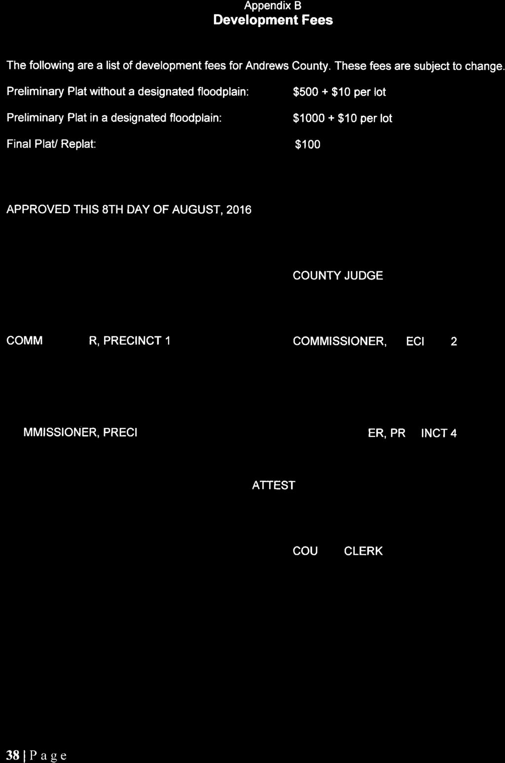

39
SUBDIVISION REGULATIONS McLennan County, Texas
 SUBDIVISION REGULATIONS McLennan County, Texas SUBDIVISION REGULATIONS McLennan County, Texas TABLE OF CONTENTS Article I... 1 Purpose and Authority... 1 Section 1.1 Purpose... 1 Section 1.2 Findings...
TABLE OF CONTENTS. PAGE ARTICLE I. 1. Preamble and Purposes ARTICLE II. 2. Definitions.. 4
 TABLE OF CONTENTS PAGE ARTICLE I. 1. Preamble and Purposes...... 1 ARTICLE II. 2. Definitions.. 4 ARTICLE III. 3. General Subdivision Requirements 8 3.1 General Requirements 8 3.2 Subdivision Approval
I. Requirements for All Applications. C D W
 108-16.1. Application checklists. Checklist for Required Submissions to the Planning Board or Zoning Board of Adjustment of Monroe Township All required submissions are to be made to the Administrative
201 General Provisions
 201 General Provisions 201.01 Title 201.09 Amendments 201.02 Purpose and Intent 201.10 Public Purpose 201.03 Authority 201.11 Variances and Appeals 201.04 Jurisdiction 201.12 Nonconformances 201.05 Enactment
TOWN OF WATERVILLE VALLEY NEW HAMPSHIRE SITE PLAN REVIEW REGULATIONS
 TOWN OF WATERVILLE VALLEY NEW HAMPSHIRE Effective date March 17, 1981 Revised March 16, 1982 Revised March 13, 1986 Revised March 10, 1987 Revised March 14, 2013 Revised March 8, 2016 TOWN OF WATERVILLE
WESTON COUNTY FINAL PLAT APPLICATION
 WESTON COUNTY FINAL PLAT APPLICATION Property Owner: Mailing Address of owner: Telephone Number(s) of owner: Property Owner: Mailing Address of owner: Telephone Number(s) of owner: (If subdivider/applicant
ARTICLE 1 GENERAL PROVISIONS
 ARTICLE 1 GENERAL PROVISIONS SECTION 100 TITLE This Ordinance shall be known and cited as the "Rice Township Subdivision and Land Development Ordinance." SECTION 101 AUTHORITY Rice Township is empowered
ELK RAPIDS TOWNSHIP ANTRIM COUNTY, MICHIGAN ORDINANCE NO
 ELK RAPIDS TOWNSHIP ANTRIM COUNTY, MICHIGAN ORDINANCE NO. 3-2011 AN ORDINANCE TO REPLACE THE SUBDIVISION CONTROL ORDINANCE WITH A NEW SUBDIVISION DEVELOPMENT ORDINANCE, IN ACCORD WITH THE LAND DIVISION
BY THE CITY COMMISSION ORDINANCE NO.:
 BY THE CITY COMMISSION ORDINANCE NO.: 2005-0868 AN ORDINANCE BY THE CITY COMMISSION OF THE CITY OF DADE CITY, FLORIDA CREATING A DEVELOPMENT REVIEW PROCEDURES ORDINANCE; PROVIDING FOR INTENT, PURPOSE,
13-2 SUBDIVISION PLANS AND PLATS REQUIRED EXCEPTIONS Subdivision Plats Required To be Recorded
 ARTICLE XIII SUBDIVISIONS 13-1 INTENT AND PURPOSE 13-1-1 Intent: It is the intent of the County Commission through the adoption of this Article to more fully avail itself of the power granted under 17-27-601
THE COUNTY BOARD OF SUPERVISORS OF THE COUNTY OF DOUGLAS DOES ORDAIN AS FOLLOWS:
 8.1 SUBDIVISION CONTROL ORDINANCE THE COUNTY BOARD OF SUPERVISORS OF THE COUNTY OF DOUGLAS DOES ORDAIN AS FOLLOWS: SECTION I. GENERAL INTERPRETATION This ordinance shall not repeal, impair or modify private
INFRASTRUCTURE DEVELOPMENT REGULATIONS FOR MANUFACTURED HOME RENTAL COMMUNITIES McLennan County, Texas
 INFRASTRUCTURE DEVELOPMENT REGULATIONS FOR MANUFACTURED HOME RENTAL COMMUNITIES McLennan County, Texas INFRASTRUCTURE DEVELOPMENT REGULATIONS FOR MANUFACTURED HOME RENTAL COMMUNITIES McLennan County, Texas
MINOR SUBDIVISION INFORMATION
 A. POINTS OF CONTACT: MINOR SUBDIVISION INFORMATION Surveyor: Address: Phone #: Fax # E-Mail Address: Representative (If different from applicant): Address: Phone #: Fax # E-Mail Address: B. GENERAL INFORMATION:
PALO PINTO COUNTY Subdivision Regulations
 PALO PINTO COUNTY Subdivision Regulations APPROVED BY THE PALO PINTO COUNTY COMMISSIONER S COURT September 26, 2014 PALO PINTO COUNTY Subdivision Regulations TABLE OF CONTENTS ARTICLE 1. GENERAL PROVISIONS...
TABLE OF CONTENTS. I. Preamble and Purpose I
 TABLE OF CONTENTS ARTICLE I '" I I. Preamble and Purpose I ARTICLE II, 3 2. DefInitions 3 2.1 Acre 3 2.2 Applicant 3 2.3 Commissioners Court 3 2.4 County 3 2.5 County Clerk 3 2.6 Development '" 3 2.7 Final
ARTICLE III GENERAL PROCEDURES, MINOR PLANS AND FEE SCHEDULES
 ARTICLE III GENERAL PROCEDURES, MINOR PLANS AND FEE SCHEDULES 301. Prior to Submission a. Copies of this Ordinance shall be available on request, at cost, for the use of any person who desires information
SUBDIVISION APPLICATION CHECKLIST SKETCH PLAN PRELIMINARY PLAT FINAL PLAT
 RECEIVED STAMP SUBDIVISION APPLICATION CHECKLIST SKETCH PLAN PRELIMINARY PLAT FINAL PLAT A checklist of background information and submission requirements for processing of a sketch plan, preliminary plat
Memorandum: October 13, 2008 REVISED To: Trowbridge Township Planning Commission From: P. Hudson, AICP Re: Suggested New Ordinance
 1 Memorandum: October 13, 2008 REVISED 2-11-09 To: Trowbridge Township Planning Commission From: P. Hudson, AICP Re: Suggested New Ordinance Because of changes in both the Michigan Planning Enabling Act
State Law reference Extraterritorial jurisdiction, V.T.C.A., Local Government Code et seq.
 ARTICLE I. - IN GENERAL Sec. 126-1. - Definitions. The following words, terms and phrases, when used in this chapter, shall have the meanings ascribed to them in this section, except where the context
BOARD OF COUNTY COMMISSIONERS ARCHULETA COUNTY, COLORADO RESOLUTION 2018-
 BOARD OF COUNTY COMMISSIONERS ARCHULETA COUNTY, COLORADO RESOLUTION 2018- ARCHULETA COUNTY IMPROPERLY DIVIDED PARCELS EXEMPTION INTERIM RESOLUTION - A RESOLUTION ADDRESSING PARCELS UNDER THE SIZE OF 35
TITLE 18 Subdivisions
 TITLE 18 Subdivisions ADMINISTRATION: 18.02 General Provisions 2 18.04 Definitions 6 18.06 Exceptions to Requirements 12 18.08 Enforcement 14 DIVISIONS OF LAND: 18.20 Tentative Parcel Maps 15 18.22 Tentative
BE IT ORDAINED BY THE CITY COUNCIL OF THE CITY OF BIG SPRING, TEXAS:
 ORDINANCE NO. AN ORDINANCE OF THE CITY OF BIG SPRING, TEXAS, AMENDING CHAPTER 15 OF THE BIG SPRING CITY CODE BY CHANGING THE TITLE TO SUBDIVISION REGULATIONS; AND INCORPORATING THE SUBDIVISION REGULATIONS
CHAPTER FINAL AND PARCEL MAPS
 CHAPTER 19.48 FINAL AND PARCEL MAPS Section Page 19.48.010 General... IV-25 19.48.020 Phasing... IV-25 19.48.030 Survey Required... IV-26 19.49.040 Form... IV-26 19.48.050 Contents... IV-27 19.48.060 Preliminary
BRIDGETON SUBDIVISION APPLICATION CHECKLIST
 APPLICATION NAME AND # CHECKLIST COMPLETED BY: DATE: Signature and printed name BRIDGETON SUBDIVISION APPLICATION CHECKLIST TO SUBDIVISION APPLICANTS: The attached checklist is to assist you in the submission
FINAL PLAT APPLICATION
 FINAL PLAT APPLICATION (Page 1 of 3) LEGAL OWNER(s): NAME: STREET ADDRESS OWNER(s): CITY, STATE, ZIP CODE: PHONE NUMBER: BILLING ADDRESS: NAME OF ENGINEER/SURVEYOR: Engineer/Surveyor Address, Phone: PROPERTY
-MENDOCINO COUNTY PLANNING AND BUILDING SERVICES- DIVISION OF LAND REGULATIONS TITLE 17
 ARTICLE VI -- GENERAL REGULATIONS AND PROVISIONS Sec. 17-50. Sec. 17-51 General Plan. Sec. 17-52 Lot and Block Design and Configuration. Sec. 17-53 Lot Access. Sec. 17-54 Private Roads. Sec. 17-55 Water
APPLICATION FOR 555 Washington Street Tentative Map Red Bluff, CA Subdivision Map (530) ext Parcel Map.
 ext Parcel Map.") City of Red Bluff Community Development Department Application No. APPLICATION FOR 555 Washington Street Tentative Map Red Bluff, CA 96080 Subdivision Map (530) 527-2605 ext. 3059 Parcel Map Applicant
City of Red Bluff Community Development Department Application No. APPLICATION FOR 555 Washington Street Tentative Map Red Bluff, CA 96080 Subdivision Map (530) 527-2605 ext. 3059 Parcel Map Applicant
SUBDIVISION APPLICATION
 SUBDIVISION APPLICATION Preliminary Plat Minor Plat Final Plat Amended Plat Applicant Name: Owner (if different from applicant) Name: Company: Company: Address: Address: City, State, Zip City, State, Zip
A GUIDE TO PROCEDURES FOR: SUBDIVISIONS & CONDOMINIUM CONVERSION
 A GUIDE TO PROCEDURES FOR: SUBDIVISIONS & CONDOMINIUM CONVERSION A GUIDE TO PROCEDURES FOR: SUBDIVISIONS (TENTATIVE MAPS) PURPOSE Definition: A subdivision is defined as the division of any improved or
MAJOR RESIDENTIAL AND NONRESIDENTIAL SUBDIVISIONS
 Lawrence-Douglas County MAJOR RESIDENTIAL AND NONRESIDENTIAL SUBDIVISIONS Preliminary Plats The applicant shall schedule a Pre-Application meeting with Planning Staff at least seven (7) working days prior
SUBDIVISION REGULATIONS
 CHAPTER 14 SUBDIVISION REGULATIONS 14-100 Provisions 14-200 Preliminary Plat 14-300 Final Plat 14-400 Replat 14-500 Minor Subdivision 14-600 Administrative Replat 14-700 Vacation of Roadways, Public Easements,
City of Fort Lupton Amended Plat Process
 City of Fort Lupton Amended Plat Process Purpose The Amended Plat process is an administrative process to amend a recorded Plat. An Amended Subdivision is an administrative revision to a recorded Subdivision
ARTICLE SINGLE FAMILY SITE CONDOMINIUM DEVELOPMENT STANDARDS
 ARTICLE 28.00 SINGLE FAMILY SITE CONDOMINIUM DEVELOPMENT STANDARDS Section 28.01 PURPOSE The purpose of this Article is to recognize that conventional single family developments, traditionally developed
Residential Major Subdivision Review Checklist
 Residential Major Subdivision Review Checklist Plan Submittal Requirements: 2 full sets of stamped plans Electric submittal - all plans contained in a single PDF 3 full sets if commercial kitchen or dining
LYON COUNTY TITLE 15 LAND USE AND DEVELOPMENT CODE LAND DIVISION REGULATIONS CHAPTERS October 19, 2017 Ordinance Draft DRAFT
 DRAFT LYON COUNTY TITLE 15 LAND USE AND DEVELOPMENT CODE LAND DIVISION REGULATIONS CHAPTERS 15.600 15.607 October 19, 2017 Ordinance Draft This page left blank intentionally DRAFT DRAFT Lyon County Contents
NICHOLS HILLS SUBDIVISION REGULATIONS TABLE OF CONTENTS
 NICHOLS HILLS SUBDIVISION REGULATIONS TABLE OF CONTENTS ARTICLE I. GENERAL Section 1.1 Title. Section 1.2 Purposes. Section 1.3 Scope and jurisdiction. Section 1.4 Policy. Section 1.5 Authority. ARTICLE
To provide for the review of the final engineering plans, the subdivision improvement agreement, public dedications, and other legal agreements.
 ARTICLE 5 FINAL PLAT 501 Intent DOUGLAS COUNTY SUBDIVISION RESOLUTION To provide for the review of the final engineering plans, the subdivision improvement agreement, public dedications, and other legal
HAMILTON COUNTY SUBDIVISION REGULATIONS
 HAMILTON COUNTY SUBDIVISION REGULATIONS Adoption Date: October 9, 2018 Page 1 I. Notices II. Owner s Responsibilities PART 1 General Provisions 101. Title 102. Purpose 103. Plat Required 104. Definitions
WASCO COUNTY PRELIMINARY SUBDIVISION APPLICATION
 WASCO COUNTY PRELIMINARY SUBDIVISION APPLICATION DETAILED SPECIFIC WRITTEN REQUEST File Number: SDV- Number of Proposed Lots & their Dimensions: PRELIMINARY SUBDIVISION PLAN REQUIREMENTS The approval of
CHAPTER 5. Subdivisions Regulations
 CHAPTER 5 Subdivisions Regulations 10-5-1 Introduction and Purpose 10-5-2 Definitions 10-5-3 General Provisions 10-5-4 Procedure for Submitting Subdivisions 10-5-5 Design Standards; Streets and Lots 10-5-6
610 LAND DIVISIONS AND PROPERTY LINE ADJUSTMENTS OUTSIDE A UGB
 ARTICLE VI: LAND DIVISIONS AND PROPERTY LINE ADJUSTMENTS VI-21 610 LAND DIVISIONS AND PROPERTY LINE ADJUSTMENTS OUTSIDE A UGB 610-1 Property Line Adjustments (Property Line Relocation) A property line
SUBDIVISION PLAT CHECKLIST. The following information shall be include on the plat:
 SUBDIVISION PLAT CHECKLIST Subdivision Name: Land Surveyor: Owner/Developer: Date Submitted: The following information shall be include on the plat: The plat shall be drawn at a scale of one inch equals
TOWNSHIP OF BORDENTOWN LAND DEVELOPMENT APPLICATION CHECKLIST. General Requirements for all Applications
 TOWNSHIP OF BORDENTOWN LAND DEVELOPMENT APPLICATION CHECKLIST This CHECKLIST has been adopted in accordance with Section 25:807 of the Land Development Ordinance of the Township of Bordentown and will
E L M E R B O R O U G H L A N D U S E B O A R D APPLICATION COVER SHEET (to be completed for all applications and appeals)
") E L M E R B O R O U G H L A N D U S E B O A R D APPLICATION COVER SHEET (to be completed for all applications and appeals) 1. Name(s): 2. Address: 3. Telephone Number(s): 4. E-mail: 5. Owner Name(s) (if
E L M E R B O R O U G H L A N D U S E B O A R D APPLICATION COVER SHEET (to be completed for all applications and appeals) 1. Name(s): 2. Address: 3. Telephone Number(s): 4. E-mail: 5. Owner Name(s) (if
Waseca County Planning and Zoning Office
 Waseca County Planning and Zoning Office 300 North State Street Waseca, Minnesota 56093 Phone: 507-835-0650 Fax: 507-837-5310 Form no. PZ 081009 Web Site: www.co.waseca.mn.us FEES: 1) CUP FEE- $400.00
BARROW COUNTY, GEORGIA
 BARROW COUNTY, GEORGIA Application For Rezoning, Special Use, and Change in Conditions BARROW COUNTY DEPARTMENT OF PLANNING AND DEVELOPMENT 30 North Broad Street Winder, Georgia 30680 770-307-3034 APPLICATION
THE UNINCORPORATED AREA OF CLARKE COUNTY, IOWA TABLE OF CONTENTS
 ORDINANCE #11 THE UNINCORPORATED AREA OF CLARKE COUNTY, IOWA TABLE OF CONTENTS ARTICLE I:-------------------------------------------------------------------------GENERAL PROVISIONS ARTICLE II:--------------------------------------------------------------------------------------DEFINITIONS
Preliminary Plat/Final Plat Application
 Melissa Municipal Center 3411 Barker Avenue Melissa, Texas 75454 Phone: (972) 838-2036 Applicant: Date: Address: Phone: Contact: Fax: E-mail: Propose Addition Name: Acres: Existing Zoning: Propose Zoning:
IV. REVIEW PROCEDURES FOR MINOR SUBDIVISIONS
 IV. REVIEW PROCEDURES FOR MINOR SUBDIVISIONS IV-A. General Minor subdivisions create five or fewer lots from a tract of record, each lot of which has legal and physical access. If the tract of record proposed
DRAFT PARK COUNTY US HIGHWAY 89 SOUTH EAST RIVER ROAD OLD YELLOWSTONE TRAIL ZONING DISTRICT REGULATIONS
 Formatting: Changes recommended by the Board and accepted by the County Commission are formatted in RED: Changes made by the Park County Commission are formatted in YELLOW highlight: and changes made by
^divisions are to be surveyed and platted by a Registered(5urveyor/or
 upsnur UPSHUR COUNTY CLERK Home Subdivision Plats... Introduction To Subdivision Piats H A subdivision is the division of any lot, tract, or parcel of land into two or more lots or sites for the purpose
STATE OF MICHIGAN COUNTY OF MARQUETTE, TOWNSHIP OF NEGAUNEE LAND DIVISION, SUBDIVISION AND CONDOMINIUM ORDINANCE
 STATE OF MICHIGAN COUNTY OF MARQUETTE, TOWNSHIP OF NEGAUNEE LAND DIVISION, SUBDIVISION AND CONDOMINIUM ORDINANCE Adopted: August 8 th, 2008 Effective: August 28 th, 2008 Sec.100. Title ARTICLE I GENERAL
CUSTER COUNTY SUBDIVISION REGULATIONS
 CUSTER COUNTY SUBDIVISION REGULATIONS 2003 Custer County Subdivision Regulations Revised December 12, 2003 SECTION 1 - GENERAL PROVISIONS 1.1 Short Title Short Title - These Regulations, along with all
ORDINANCE NO.: Adopted: August 2, 2005 Amended: March 27, 2007 Amended: September 23, Fillmore County Rural Addressing Ordinance
 ORDINANCE NO.: 2005-01 Adopted: August 2, 2005 Amended: March 27, 2007 Amended: September 23, 2008 Fillmore County Rural Addressing Ordinance Section 1 Purpose, Scope and Statutory Authorization 1-1 Purpose.
SUBDIVISION REGULATIONS
 CHAPTER 41 SUBDIVISION REGULATIONS 41.01 Short Title 41.17 Presentation to Commission or Board of Supervisors 41.02 Purpose 41.18 Subdivision Classified 41.03 Application 41.19 Plats Required 41.04 Recording
LABEL PLEASE NOTE: ALL APPLICATIONS AND SITE PLANS MUST BE COMPLETED IN BLACK OR BLUE INK ONLY Intake by:
 STAFF USE ONLY Thurston County Resource Stewardship 2000 Lakeridge Dr. S.W. Olympia, WA 98502 (360)786-5490 / (360)754-2939 (Fax) TDD Line (360) 754-2933 Email: permit@co.thurston.wa.us Supplemental Application
TITLE 25. SUBDIVISIONS 1
 TITLE 25. SUBDIVISIONS 1 Sections: Chapter 25.01 General Provisions. Section 25.01.01 Short Title. Section 25.01.02 Purposes. Section 25.01.03 Final Plat Required Before Lots May be Sold. Section 25.01.04
CHAPTER 22 SUBDIVISION AND LAND DEVELOPMENT
 CHAPTER 22 SUBDIVISION AND LAND DEVELOPMENT 22-101. Title 22-102. Legislative Intent Part 1 General Provisions 22-201. Development Permits Part 2 Administration 22-301. Fee Schedule Part 3 Fee Schedule
Chapter 100 Planned Unit Development in Corvallis Urban Fringe
 100.100 Scope and Purpose. Chapter 100 Planned Unit Development in Corvallis Urban Fringe (1) All applications for land divisions in the Urban Residential (UR) and Flood Plain Agriculture (FPA) zones within
Lampasas County Subdivision Regulations APPROVED MAY 5, 2005 REVISED DECEMBER 10, 2012 FEES REVISED APRIL 23, 2015
 $10.00 per copy payable to Lampasas County Lampasas County Subdivision Regulations APPROVED MAY 5, 2005 REVISED DECEMBER 10, 2012 FEES REVISED APRIL 23, 2015 1 TABLE OF CONTENTS PAGE A. INTRODUCTION 4
Subchapter 16 Subdivisions.
 Subchapter 16 Subdivisions. Sections: 35.16.1 Authority. 35.16.2 Purpose. 35.16.3 Jurisdiction. 35.16.4 Application. 35.16.5 Compliance and Enforcement. 35.16.6 Approval of Plat Required. 35.16.7 Lots,
WAYNE COUNTY, UTAH SUBDIVISION ORDINANCE
 WAYNE COUNTY, UTAH SUBDIVISION ORDINANCE A LAND USE ORDINANCE OF WAYNE COUNTY As Adopted by the Wayne County Board of County Commissioners Effective January 01, 2011 Prepared by: PLANNING AND DEVELOPMENT
MINOR PLAT. The following documents are provided as required by the City of Conroe for use in the above titled platting submittals:
 Public Works - Engineering Division CITY OF CONROE MINOR PLAT The following documents are provided as required by the City of Conroe for use in the above titled platting submittals: Submittal Questionnaire
SECTION 2. PROCEDURES FOR FILING AND REVIEW
 SECTION 2. PROCEDURES FOR FILING AND REVIEW Subdivision 2.01 Sketch Plan 2.02 Preliminary Plat 2.03 Final Plat 2.04 Certification Required 2.05 Denial of Plat 2.06 Administrative Subdivision 2.01 SKETCH
UPPER MOUNT BETHEL TOWNSHIP NORTHAMPTON COUNTY, PENNSYLVANIA
 UPPER MOUNT BETHEL TOWNSHIP NORTHAMPTON COUNTY, PENNSYLVANIA JOINDER DEED / LOT CONSOLIDATION TOWNSHIP REVIEW PROCESS When accepting proposed Joinder Deeds / Lot Consolidations, review the Joinder Deed
CITY OF SARALAND PRELIMINARY SUBDIVISION PLAT REVIEW
 PRELIMINARY SUBDIVISION PLAT REVIEW Application Number: Date Plat Submitted: Name of Subdivision: Name of Owner: Owner Address: (Street or P.O. Box) Telephone #: (City) (State) (Zip) E-mail: Name of Authorized
WEBSTER TOWNSHIP LAND DIVISION ORDINANCE. Summary Table of Amendments
 WEBSTER TOWNSHIP LAND DIVISION ORDINANCE Ordinance No. 2012 02 As Adopted 04-17-12 Summary Table of Amendments Adoption Date Affected Sections Summary October 10, 3 Added definition of Township Engineer
City of Colleyville Community Development Department. Subdivision Application Packet
 Community Development Department Subdivision Application Packet 1 Development Application Fees 100 Main Street Colleyville TX 76034 817.503.1050 Zoning Zoning Change $ 500 + $5 per acre Planned Unit Development
MAJOR SUBDIVISION PRELIMINARY PLAT CHECKLIST
 TOWNSHIP OF EGG HARBOR PLANNING BOARD/ZONING BOARD OF ADJUSTMENT 3515 BARGAINTOWN ROAD EGG HARBOR TOWNSHIP, NJ 08234 MAJOR SUBDIVISION PRELIMINARY PLAT CHECKLIST The following checklist is designed to
SUBDIVISION PROCEDURES AND REGULATIONS. for the Town of Stratford, New Hampshire
 SUBDIVISION PROCEDURES AND REGULATIONS for the Town of Stratford, New Hampshire TABLE OF CONTENTS Page A. PRE-APPLICATION 2 B. PRELIMINARY PLAN REQUIREMENTS 3 C. PRELIMINARY PLAN REVIEW 5 Site Plan Review
FINAL SUBDIVISION AND LAND DEVELOPMENT PLAN CHECKLIST. Plan Name. Applicant's Name:
 TOWNSHIP OF UPPER ST. CLAIR FINAL SUBDIVISION AND LAND DEVELOPMENT PLAN CHECKLIST Date Filed Plan Name PLC Applicant's Name: Phone Filing Date for Final Application Final Plat 114.22. FINAL APPLICATION
SUBDIVISION REGULATIONS*
 City of Cedar Hill, Texas SUBDIVISION REGULATIONS Page 1 of 46 Chapter 20 SUBDIVISION REGULATIONS* Art. I. In General, 20-1 - 20-40 Art. II. Park Land Dedication, 20-41 - 20-65 Art. III. Escarpment Development
St. Mary s County Comprehensive Zoning Ordinance Article 1. GENERAL PROVISIONS
 0 0 0 0 ARTICLE. GENERAL PROVISIONS CHAPTER 0 TITLE, PURPOSE AND ORGANIZATION Sections: 0. Title. 0. Authority. 0. Purpose. 0. Organization of the Zoning Ordinance. 0. Official Zoning Map. 0. Applicability.
Map Filing Law. 46: Effective date This act shall take effect January first, one thousand nine hundred and fiftyfour.
 46:23-9.8. Effective date This act shall take effect January first, one thousand nine hundred and fiftyfour. L.1953, c. 358, p. 1941, s. 8. 46:23-9.9. Short title This act shall be known and may be cited
Subdivision Regulations of Athens County, Ohio
 Subdivision Regulations of Athens County, Ohio ADOPTED NOVEMBER 21, 2000 Amended September 18, 2001 1 TABLE OF CONTENTS Article 1 GENERAL PROVISIONS 100 Title 9 101 Policy 9 102 Purpose 9 103 Authority
Township of Little Egg Harbor Planning Board 665 Radio Road Little Egg Harbor, New Jersey Phone: ext. 221 Fax:
 BLOCK(S) LOT(S) Township of Little Egg Harbor Planning Board 665 Radio Road Little Egg Harbor, New Jersey 08087 Phone: 609-296-7241 ext. 221 Fax: 609-294-3040 Development Application Amended Development
CITY OF DECATUR, TEXAS
 Final Plat or Amending Plat / Replat Checklist A submittal of a complete application will facilitate a timely review. Failure of the applicant to provide required information or obtain a waiver from the
Subdivision Ordinance. Adopted December 2, 2010 *Article III Amended June 6, 2013 TABLE OF CONTENTS
 Subdivision Ordinance Adopted December 2, 2010 *Article III Amended June 6, 2013 TABLE OF CONTENTS ARTICLE I INTRODUCTORY PROVISIONS Page Section 1-1 Title I-1 Section 1-2 Purpose I-1 Section 1-3 Authority
City of Sanibel. Planning Department STAFF REPORT
 City of Sanibel Planning Department STAFF REPORT Planning Commission Meeting: July 23, 2013 Planning Commission Agenda Item: No 7b. Application Number: 13-7438DP Applicant Name: Attorney Beverly Grady
CHAPTER SHORT SUBDIVISIONS
 CITY OF MOSES LAKE MUNICIPAL CODE CHAPTER 17.09 SHORT SUBDIVISIONS Sections: 17.09.010 Purpose 17.09.020 Scope 17.09.030 Preliminary Short Subdivision Conditions and Requirements 17.09.040 Referral to
MINOR PLAT FILING APPLICATION
 FILING APPLICATION Date of PC Meeting: Date of BCC Meeting: Fee Paid: 1. APPLICANT: DAYTIME PHONE: MAILING ADDRESS: LANDOWNER: DAYTIME PHONE: MAILING ADDRESS: AUTHORIZED AGENT: MAILING ADDRESS: RELATIONSHIP
PROCEDURE. Chapter 12: Subdivision Regulations
 SECTION 14-600 ADMINISTRATIVE REPLAT PROCEDURE 14-601 INTENT These procedures are to provide an abbreviated process for Replat applications that demonstrate compliance with the criteria contained herein.
THEREFORE BE IT RESOLVED
 INGHAM COUNTY HEALTH DEPARMENT REGULATION AMENDING THE SANITARY CODE BY ADDING CHAPTER VII REGULATIONS FOR THE INSPECTION OF ONSITE WATER AND SEWAGE DISPOSAL SYSTEMS AT THE TIME OF PROPERTY TRANSFER PREAMBLE:
Residential Minor Subdivision Review Checklist
 Residential Minor Subdivision Review Checklist Plan Submittal Requirements: 2 full sets of stamped plans Electric submittal - all plans contained in a single PDF 3 full sets if commercial kitchen or dining
ARTICLE V. PRELIMINARY PLAT
 ARTICLE V. PRELIMINARY PLAT PAGE 13 SECTION A. PURPOSE. The purpose of the preliminary plat is to allow the Planning and Zoning Commission to review overall platting of the tract and street patterns within
COUNTY SUBDIVISION REGULATION IN TEXAS CHANGING TIMES BY: J. GREG HUDSON INTRODUCTION
 COUNTY SUBDIVISION REGULATION IN TEXAS CHANGING TIMES BY: J. GREG HUDSON INTRODUCTION With the return of the "building boom" in Texas during the late 1990 s, county officials have been faced with numerous
CHAPTER XVIII SITE PLAN REVIEW
 CHAPTER XVIII SITE PLAN REVIEW Section 18.1 Section 18.2 Description and Purpose. The purpose of this chapter is to provide standards and procedures under which applicants would submit, and the Township
PENINSULA TOWNSHIP LAND DIVISION ORDINANCE TOWNSHIP OF PENINSULA COUNTY OF GRAND TRAVERSE, STATE OF MICHIGAN ORDINANCE NO OF 2012
 PENINSULA TOWNSHIP LAND DIVISION ORDINANCE TOWNSHIP OF PENINSULA COUNTY OF GRAND TRAVERSE, STATE OF MICHIGAN ORDINANCE NO OF 2012 AN ORDINANCE TO REGULATE THE DIVISION OF EXISTING PARCELS OF LAND PURSUANT
Plans shall be drawn at a readable scale, signed, and sealed by a Florida Registered Engineer. The application package shall include:
 CHAPTER 400. SECTION 403. PERMIT TYPES AND APPLICATIONS SITE DEVELOPMENT 403.3. Preliminary Site Plans (PSP) A. Intent and Purpose PSPs are used to identify existing site conditions and demonstrate general
CHAPTER 4 FINAL PLAT
 10-4-1 10-4-2 CHAPTER 4 FINAL PLAT SECTION: 10-4-1: Tentative Final Plat 10-4-2: Filing 10-4-3: Requirements 10-4-4: Amended Plats 10-4-5: Approval 10-4-6: Subdivision Agreement 10-4-1: TENTATIVE FINAL
these areas are compatible with such conditions. [Section (6) (c) C. R. S.]
![these areas are compatible with such conditions. [Section (6) (c) C. R. S.]](/thumbs/83/88180230.jpg "these areas are compatible with such conditions. [Section (6) (c) C. R. S.]") SECTION 14-200 PRELIMINARY PLAT 14-201 INTENT A Preliminary Plat is one of the first documents utilized when owners of a property wish to subdivide their property in accordance with State Statutes and
SECTION 14-200 PRELIMINARY PLAT 14-201 INTENT A Preliminary Plat is one of the first documents utilized when owners of a property wish to subdivide their property in accordance with State Statutes and
CITY OF GROVER BEACH COMMUNITY DEVELOPMENT DEPARTMENT Tentative Map Checklist
 CITY OF GROVER BEACH COMMUNITY DEVELOPMENT DEPARTMENT Tentative Map Checklist The following list includes all of the items you must submit for a complete application. Some specific types of information
MINOR SUBDIVISION PLAT CHECKLIST
 MINOR SUBDIVISION PLAT CHECKLIST Project Name: Tax ID #: Project Number: Date: _ Reviewed By: Telephone: NOTES: All lots on septic systems must comply with the Fulton County Health Department requirements
TITLE 13 SUBDIVISIONS
 TITLE 13 SUBDIVISIONS Chapter 1. General. 2. Subdivision Application Procedure. 3. Minor Subdivisions. 4. Standard Subdivisions. 5. Major Subdivisions. 6. Planned Unit Development Subdivisions. (Repealed)
FINAL PLAT. Community Development Department 8101 Ralston Road Arvada, Colorado 80002
 FINAL PLAT Community Development Department 8101 Ralston Road Arvada, Colorado 80002 September 2015 FINAL SUBDIVISION PLAT Final Subdivision Plat Review Applications for a Final Plat shall be submitted
CONDOMINIUM REGULATIONS
 ARTICLE 37 CONDOMINIUM REGULATIONS SECTION 37.01. Purpose The purpose of this Article is to regulate projects that divide real property under a contractual arrangement known as a condominium. New and conversion
City of Forest Hill Minor Plat Application
 City of Forest Hill Minor Plat Application APPLICANT NAME: DATE: SUB-DIVISION NAME: LEGAL DESCRIPTION: ACRES: CURRENT ZONING: PROPOSED ZONING: BEING PLATTED AS: LOTS: BLOCKS: PHASES: OWNER OF RECORD: ADDRESS:
Planning Grant Contract No. SC P-8 (G) South Carolina State Development Board Division of Community Planning of the Development and Research Center
 South Carolina State Development Board Division of Community Planning of the Development and Research Center") SUBDIVISION REGULATIONS Prepared for: Planning and Zoning Commission Anderson, South Carolina The preparation of this report was financed in part through an Urban Planning grant from the Department of
SUBDIVISION REGULATIONS Prepared for: Planning and Zoning Commission Anderson, South Carolina The preparation of this report was financed in part through an Urban Planning grant from the Department of
CHAPTER 3 PRELIMINARY PLAT
 10-3-1 10-3-3 SECTION: CHAPTER 3 PRELIMINARY PLAT 10-3-1: Consultation 10-3-2: Filing 10-3-3: Requirements 10-3-4: Approval 10-3-5: Time Limitation 10-3-6: Grading Limitation 10-3-1: CONSULTATION: Each
SUBTITLE V CHAPTER GENERAL PROVISIONS. (1) The ordinance codified in this subtitle shall be known as the City of Port Orchard subdivision code.
 The ordinance codified in this subtitle shall be known as the City of Port Orchard subdivision code.") SUBTITLE V CHAPTER 20.80 GENERAL PROVISIONS Sections: 20.80.010 Title. 20.80.020 Authority. 20.80.030 Purpose. 20.80.040 Definitions. 20.80.050 Applicability. 20.80.060 Exemptions. 20.80.070 Consent to
SUBTITLE V CHAPTER 20.80 GENERAL PROVISIONS Sections: 20.80.010 Title. 20.80.020 Authority. 20.80.030 Purpose. 20.80.040 Definitions. 20.80.050 Applicability. 20.80.060 Exemptions. 20.80.070 Consent to