CITY OF MANHATTAN BEACH DEPARTMENT OF COMMUNITY DEVELOPMENT. Richard Thompson, Director of Community Development
|
|
|
- Kristian Moody
- 5 years ago
- Views:
Transcription
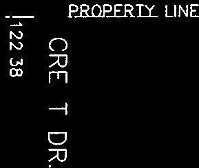
1 CITY OF MANHATTAN BEACH DEPARTMENT OF COMMUNITY DEVELOPMENT TO: FROM: BY: Planning Commission Richard Thompson, Director of Community Development Angelica Ochoa, Assistant Planner DATE: February 13, 2013 SUBJECT: Appeal of a Height Determination for a Coastal Permit (CA 12-25) for a New Single Family Residence at 301/ th Street RECOMMENDATION Staff recommends that the Planning Commission uphold the Community Development Director s decision to APPROVE the height determination for 301/ th Street and DENY the subject appeal. APPELLANT Dr. Rosario P. Armato ( appellant ) 2501 Crest Drive Manhattan Beach, CA BACKGROUND On October 12, 2012, a Coastal Permit application was submitted to the Community Development Department to demolish an existing duplex and construct a new single family three-story residence with an attached two-car garage located at 301/303 25th Street (Exhibit A). Since this project is located in the Coastal non-appealable area of the City, a Coastal Permit is required. The project is located in Area District III and zoned Residential High Density, RH. The lot is a half lot, x 52.50, approximately 1750 square feet in area. The original existing duplex was built in The surrounding area is a mix of two- and three-story condominium units, duplex and single family residences. Staff reviewed the Coastal plans and sent a notice of the proposed project on November 28, 2012 to the surrounding neighbors within the required 100 feet of the subject property. A Coastal Permit approving the demolition of the duplex and construction of the new single family residence, including the height determination, was issued on December 19, 2012 (Exhibit B). On December 27, 2012, an appeal was filed by the neighbor at 2501 Crest Drive located directly to the east (rear) of the subject property objecting to the property corners used to determine the maximum height of the proposed building (Exhibit C). According to Section A of the City of Manhattan Beach Local Coastal Program, Appeals, the decision of the Community Development Department Director may be appealed to the Planning Commission. The neighbor expressed concerns regarding the maximum height of the proposed new house since it would directly affect their ocean view. The rear portion of the proposed house will be 8-½ feet taller than the existing duplex. 1 Page 1 of 133
2 DISCUSSION Measurement of Height Per the City of Manhattan Beach Municipal Code, Section states the following when measuring height: Measurement of height. This section establishes regulations for determining compliance with the maximum building height limits prescribed for each zoning district and area district or as modified by an overlay district. The procedure involves a two (2) step process: first the reference elevation, defined as the average of the elevation at the four (4) corners on the lot, is determined and then a second limit is imposed to ensure that no building exceeds the maximum allowable height above existing grade or finished grade, whichever is lower, by more than twenty percent (20%). (a) (b) (c) Height shall be measured from a horizontal plane established by determining the average elevation of existing grade at all four (4) corners of the lot. In situations where the elevation of existing grade at a lot corner is not clearly representative of a site topography (because, for example, of the existence of such structures as retaining walls, property-line walls, or planters) the Community Development Director shall select an elevation that minimizes, to the extent reasonably possible, adverse impacts on adjacent properties and encourages some degree of consistency in the maximum building height limits of adjacent properties. Such interpretations may be appealed pursuant to the provisions of Chapter No portion of a building shall exceed the maximum allowable height for the zoning district and area district in which the building site is located by more than twenty percent (20%). For purpose of this requirement, height shall be measured from the existing grade or finished ground level grade, whichever is lower. To determine compliance with this section, the Community Development Director may require applicants to submit a topographic survey of the project site, and, if necessary, portions of adjacent sites, prepared by a licensed surveyor or licensed civil engineer, depicting existing contours and the contours of finished grade, if different from existing grade, at elevation change intervals no greater than five (5) feet. Survey measurements also shall indicate the elevations of adjacent curbs and street pavements where no curb exists. Exceptions: 1. The Community Development Director may approve measuring height from finished grade elevation within five (5) feet of front or street side property lines for alterations and additions to preexisting structures which have height nonconformities under the procedures for granting minor exceptions established in Section The Community Development Director may administratively approve measuring height from local grade adjacent to an existing or planned building that is adjacent 2 Page 2 of 133
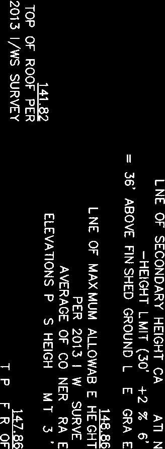
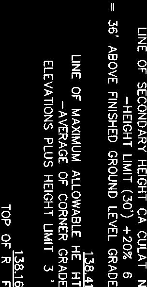
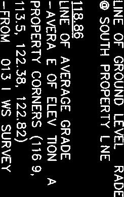
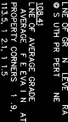
3 to a street where substantial grading occurred which lowered the street, which, in turn, affected the elevation of the street property line. The intent of this exception is to accommodate situations which exist, such as, on portions of Ardmore Avenue. (A) The procedure and standards established by this section shall not be amended, whether by change in regulation, by addition of exceptions or by other means, so as to increase the elevation above sea level of the highest point of any building on a given lot beyond the elevation permissible under existing law, unless the amendment is first submitted to a City-wide election and is approved by a majority of the voters. The term existing law as used in this subsection includes the outcome of the March 1997 referendum on Ordinance 1933 ( Measurement of Height ) and any future amendments to the municipal code. The four property corner elevations are taken from a survey, which is required for all new residences and most additions. A survey must be stamped, and signed by a State licensed surveyor or civil engineer and dated within 12 months of applying for a building permit application. A survey is used by staff to determine the maximum height of a building based on the property corners and to evaluate other conditions and code requirements, such as existing structures, setbacks, property line walls, and trees. In some cases, staff may request additional spot elevations on the survey where there are property line walls, planters, or other significant grade variations at or around the property corners. MBMC Section (A) clearly states how the Director may interpret corner elevations for consistency and to minimize impacts on adjacent properties. Measurement of height is not based on view but rather a calculation of actual property corner elevations; the City does not have a view ordinance. Staff often reviews surveys and plans of adjacent properties to ensure that property corner elevations are consistent and accurate. Staff reviewed the property corner elevations from a 1989 survey for a loft and roof deck addition at 2501 Crest Drive, to the rear of the subject property. The two property corners at the rear property line show a grade difference of 2.9 feet. In order to be consistent and comply with Section (A), one rear corner elevation was averaged for the subject property of 301/ th Street. The north east property corner of and a spot elevation 5 feet to the east adjacent to the rear property line of were averaged to equal (See chart below.) This averaging provides the same grade difference of 2.9 feet along the common rear property line as in the 1989 survey of the appellant. CORNER ELEVATION MAXIMUM HEIGHT NE /2=116.4 NW SW SE /4= = Page 3 of 133
4 Staff also inspected the subject property to analyze the existing conditions and surrounding properties. Since some of the surrounding properties to the north are full size lots and were built under the old Zoning Code which had a different height methodology using multiple elevations, the buildings are substantially higher (about 12 feet) on Crest Drive and lower (about 6 feet) on Highland Avenue than the current code allows. This is a common occurrence for older homes on steep full-size lots in the beach area. If these full-sized lots were to be re-developed per the current code, the height limit would be higher than the subject lot and lower than the appellant s lot. When determining building heights, in accordance with Section (A), the Director evaluates consistency in the maximum building height limits of adjacent properties. This evaluation is based on the allowed height limits, not the actual existing building heights, which may not reflect current code standards as in this case. On numerous occasions, staff met with the appellant, the appellant s attorney, and his architect to explain the process and reasons for the maximum height determination for the proposed building. According to the appellant at 2501 Crest Drive, the property corners used for the northeast and southeast elevations to determine the maximum height were not representative of the natural grade of the property and those numbers represented an artificial raised grade. Proposed Building The proposed building will be a three-story single family residence, with a deck at the top floor on the front and an attached two-car garage accessed from Highland Avenue. The total living area will be 2,864 square feet, under the allowable 2,985 square feet for the lot. The total open space will be 461 square feet consisting of a deck at the top floor, a balcony at the second floor and the rear yard, which meets the required 15% of the total living area. The maximum height limit for the building is feet per MBMC Section The proposed height for the building is feet, which is under the maximum height limit. According to the 2012 survey, the ridge height of the existing building at the highest point is feet, which is 8.49 feet lower than the proposed height. On the front facing Highland Avenue, the proposed top eave and the existing eave are at about the same height. Subject Appeal (Exhibit D) Appellant Rosario Armato, property owner of 2501 Crest Drive, is appealing the property corner elevations that were used at the rear of the subject property to determine the maximum height of the subject building since he feels it will block their view. Specifically, the appellant states the following: 1. The elevations used at the northeast property corner (average of and 115.9) are not the natural grade because of existing retaining walls. They state that the natural grade elevation is 109.2, located in the north side yard near the midpoint of the subject lot and they believe this number should be used to determine the maximum height of the proposed building. 2. The southeast property corner was raised by approximately 6 feet and the natural grade elevation should be , the elevation near the front door of the existing house by the walkstreet on 25 th Street, and not 113.5, the actual property corner. 4 Page 4 of 133
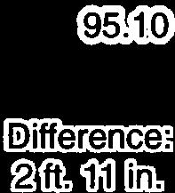
5 On February 6, 2013, staff and the City Attorney received a legal brief from the appellant s attorney requesting, among other things, to continue the Planning Commission hearing. The attorney alleges his client has not been provided due process because the City has denied him full access to copy surveys in the City s file. The City has fully complied with applicable law by providing copies of numerous documents to the attorney, and offering to allow the appellant and attorney the opportunity to inspect the City s official copy of the building plans. California Health and Safety Code Section provides that the public may inspect such plans, but requires approval from the licensed architect or designer and property owner in order for the City to provide copies of such plans. In his letter, the attorney now alleges that the City has denied him full access to surveys. In response to such representation, the attorney for the applicant has provided a copy of the 1966 survey. See attached dated February 4, 2013 enclosing the survey (Exhibit G). In addition to the , the appellants February 6, 2013 brief and a packet from the applicant dated February 6, 2013 are included in the packet delivered to the Commission and are available to the public. Staff has notified the attorney s appellant that the entire file and plans for th Street are available for review and the appellant, his attorney and his architect have reviewed the entire file several times. In consultation with the City Attorney, we do not believe that the appellant s attorney s letter provides any basis for granting a continuance. Staff s Determination (Exhibit E) Staff s determination of maximum height for the subject property is based on the following supporting documentation: Survey ( th Street) - The property corner elevations from the survey were used to calculate the maximum height of the proposed building of feet Survey (2501 Crest Drive) - To be consistent with the property corners that were used in 1989 for a loft and roof deck addition at 2501 Crest Drive (appellant), staff averaged the north east property corner for the subject building at th Street to be (average of and ). With staff s determination, the rear property corner elevations for the subject property and the appellant s property are consistent Street Plan - In order to verify street grading information on Highland Avenue, staff contacted the Engineering Department to obtain historic information. According to the contour map, it shows that the grade of th Street has steeper contour intervals than the rear appellant s lot at 2501 Crest Drive. Also, the street plan from 1913 shows that the grade, before the walkstreet was built on 25 th Street, and was steeper towards Highland Avenue than Crest Drive at the rear. Therefore, the existing grade of the lot is representative of the grade in Topographic Plan - According to City records, this plan shows the elevations when the original existing duplex at th Street was built. Staff extrapolated the property corner elevations shown in 1966 and compared them to the property corner elevations from the current 2012 survey to show if there were any grade differences. The difference in elevations for all property corners and the maximum height in 1966 compared to 2012 is minimal and it shows that the grade has not substantially changed in over 40 years. 5 Page 5 of 133
6 5) 1988 Shoring Plans (2504 Highland Avenue) The grade has not changed from the adjacent full lot directly to the north of the subject lot. The topographic elevations showed a difference of more than 15 feet between the common property corner elevation at Highland Avenue and the midpoint of the full lot, adjacent to the northeast property corner of the subject lot. This is consistent with the 2012 survey of the subject property. Staff s decision to approve the subject project, Coastal Development Permit CA and deny the subject appeal, is based on the grade elevations from the 2012 survey and the 1989 survey used for the loft and roof deck addition at 2501 Crest Drive. Other documentation that supports staff s decision, and are consistent with this decision, includes the 1966 topographic plan, the 1913 street plan, and the 1988 neighbors shoring plan. All of the documents mentioned above show that the grades and elevations have been consistent for the past 100 years. Public Comments (Exhibit F) Staff received one comment in support of the proposed project, stating the proposed building will comply with all zoning codes and development standards. Staff also received a petition signed by surrounding neighbors opposing the proposed development. CONCLUSION The proposed project complies with all of the required Zoning codes, the Local Coastal Program and development standards and therefore, staff recommends that the Planning Commission uphold the Community Development Director s decision to APPROVE the Coastal Permit for th Street (CA 12-25) and DENY the subject appeal. Attachments: Exhibit A Vicinity Map Exhibit B Coastal Development Permit CA Exhibit C Appellant s Application Request for Appeal Exhibit D Appellant s Appeal Documentation, including February 6, 2013 legal brief (Only Attachment 5 not available electronically; available at City Hall and Public Library) Exhibit E Staff s Supporting Documentation Exhibit F Public Comments Exhibit G Property Owner of th Street Documentation, including February 6, 2013 packet and February 4, with 1966 survey attachment Exhibit H Coastal Permit Building Plans (not available electronically, available at City Hall and Public Library) 6 Page 6 of 133

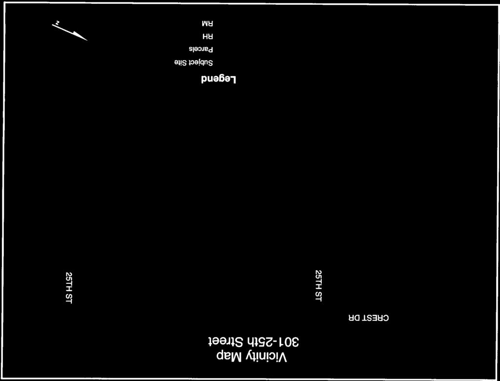

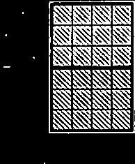
7 EXHIBIT A Page 7 of 133
8 THIS PAGE INTENTIONALLY LEFT BLANK Page 8 of 133
9 EXHIBIT B Page 9 of 133
10 Page 10 of 133
11 Page 11 of 133
12 Page 12 of 133
13 EXHIBIT C Page 13 of 133
14 Page 14 of 133
15 Page 15 of 133
16 THIS PAGE INTENTIONALLY LEFT BLANK Page 16 of 133
17 EXHIBIT D Page 17 of 133
18 Page 18 of 133
19 Page 19 of 133
20 Page 20 of 133


21 Page 21 of 133
22 THIS PAGE INTENTIONALLY LEFT BLANK Page 22 of 133

23 Page 23 of 133
24 THIS PAGE INTENTIONALLY LEFT BLANK Page 24 of 133

25 Page 25 of 133
26 THIS PAGE INTENTIONALLY LEFT BLANK Page 26 of 133
27 Page 27 of 133
28 Page 28 of 133
29 EXHIBIT D (CON'T) Page 29 of 133
30 Page 30 of 133
31 Page 31 of 133
32 Page 32 of 133
33 Page 33 of 133
34 Page 34 of 133
35 Page 35 of 133
36 Page 36 of 133
37 Page 37 of 133
38 THIS PAGE INTENTIONALLY LEFT BLANK Page 38 of 133
39 Page 39 of 133
40 Page 40 of 133
41 Page 41 of 133
42 THIS PAGE INTENTIONALLY LEFT BLANK Page 42 of 133
43 Page 43 of 133
44 Page 44 of 133
45 Page 45 of 133
46 Page 46 of 133
47 Page 47 of 133
48 Page 48 of 133
49 Page 49 of 133
50 THIS PAGE INTENTIONALLY LEFT BLANK Page 50 of 133
51 Page 51 of 133
52 THIS PAGE INTENTIONALLY LEFT BLANK Page 52 of 133
53 Page 53 of 133
54 THIS PAGE INTENTIONALLY LEFT BLANK Page 54 of 133


55 Page 55 of 133
56 THIS PAGE INTENTIONALLY LEFT BLANK PAGE 56 OF 133
57 EXHIBIT 5 UNAVAILABLE ELECTRONICALLY DUE TO LARGE SIZE Page 57 of 133
58 THIS PAGE INTENTIONALLY LEFT BLANK Page 58 of 133
59 Page 59 of 133
60 Page 60 of 133


61 Page 61 of 133
62 THIS PAGE INTENTIONALLY LEFT BLANK Page 62 of 133


63 Page 63 of 133
64 THIS PAGE INTENTIONALLY LEFT BLANK Page 64 of 133


65 Page 65 of 133
66 THIS PAGE INTENTIONALLY LEFT BLANK Page 66 of 133


67 Page 67 of 133
68 THIS PAGE INTENTIONALLY LEFT BLANK Page 68 of 133


69 Page 69 of 133
70 THIS PAGE INTENTIONALLY LEFT BLANK Page 70 of 133

71 Page 71 of 133
72 THIS PAGE INTENTIONALLY LEFT BLANK Page 72 of 133


73 Page 73 of 133
74 THIS PAGE INTENTIONALLY LEFT BLANK Page 74 of 133

75 Page 75 of 133
76 THIS PAGE INTENTIONALLY LEFT BLANK Page 76 of 133


77 Page 77 of 133
78 THIS PAGE INTENTIONALLY LEFT BLANK Page 78 of 133

79 Page 79 of 133
80 THIS PAGE INTENTIONALLY LEFT BLANK Page 80 of 133


81 Page 81 of 133
82 THIS PAGE INTENTIONALLY LEFT BLANK Page 82 of 133
83 EXHIBIT D (CON'T) Page 83 of 133
84 Page 84 of 133
85 Page 85 of 133
86 Page 86 of 133


87 EXHIBIT E Page 87 of 133


88 Page 88 of 133


89 Page 89 of 133


90 Page 90 of 133

91 Page 91 of 133

92 Page 92 of 133

93 Page 93 of 133


94 Page 94 of 133
95 EXHIBIT F Page 95 of 133
96 Page 96 of 133
97 Page 97 of 133
98 Page 98 of 133
99 Page 99 of 133
100 Page 100 of 133
101 Page 101 of 133
102 THIS PAGE INTENTIONALLY LEFT BLANK Page 102 of 133
103 EXHIBIT G Page 103 of 133
104 Page 104 of 133
105 Page 105 of 133
106 THIS PAGE INTENTIONALLY LEFT BLANK Page 106 of 133
107 EXHIBIT G (CON'T) Page 107 of 133
108 Page 108 of 133

109 Page 109 of 133
110 Page 110 of 133
111 Page 111 of 133
112 Page 112 of 133

113 Page 113 of 133
114 THIS PAGE INTENTIONALLY LEFT BLANK Page 114 of 133


115 Page 115 of 133


116 Page 116 of 133
117 Page 117 of 133
118 THIS PAGE INTENTIONALLY LEFT BLANK Page 118 of 133
119 Page 119 of 133
120 THIS PAGE INTENTIONALLY LEFT BLANK Page 120 of 133


121 Page 121 of 133
122 THIS PAGE INTENTIONALLY LEFT BLANK PAGE 122 OF 133
123 Page 123 of 133
124 THIS PAGE INTENTIONALLY LEFT BLANK Page 124 of 133

125 Page 125 of 133
126 THIS PAGE INTENTIONALLY LEFT BLANK Page 126 of 133
127 Page 127 of 133
128 THIS PAGE INTENTIONALLY LEFT BLANK Page 128 of 133


129 Page 129 of 133

130 Page 130 of 133
131 Page 131 of 133
132 Page 132 of 133
133 Page 133 of 133
Community Development Department City of Pismo Beach 760 Mattie Road Pismo Beach, CA Telephone: (805) / Fax: (805)
 / Fax: (805)") Community Development Department City of Pismo Beach 760 Mattie Road Pismo Beach, CA 93449 Telephone: (805) 773-4658 / Fax: (805) 773-4684 Address: APN: Area P Development Standards PISMO HEIGHTS PLANNING
Community Development Department City of Pismo Beach 760 Mattie Road Pismo Beach, CA 93449 Telephone: (805) 773-4658 / Fax: (805) 773-4684 Address: APN: Area P Development Standards PISMO HEIGHTS PLANNING
VICINITY MAP. Board of Adjustment File No.: VAR & VAR January 9, 2014 Page 2 of 11 ATTACHMENTS
 Board of Adjustment File No.: VAR2013 0024 & VAR2013 0025 January 9, 2014 Page 2 of 11 VICINITY MAP ATTACHMENTS Attachment A Applicant s Letter Attachment B Site Plan Attachment C Elevation Drawings Board
CITY OF MANHATTAN BEACH COMMUNITY DEVELOPMENT DEPARTMENT STAFF REPORT. Marisa Lundstedt, Director of Community Development
 CITY OF MANHATTAN BEACH COMMUNITY DEVELOPMENT DEPARTMENT STAFF REPORT TO: FROM: Planning Commission Marisa Lundstedt, Director of Community Development THROUGH: Laurie B. Jester, Planning Manager BY: Ted
 City Council 1-15-08- Exhibit A Mansionization Code Amendments Recommended by Planning Commission 11-14-07 INCREASE OPEN SPACE AND SETBACKS Section 10.12.030 and A.12.030 Property Development Regulations:
A GUIDE TO PROCEDURES FOR: SUBDIVISIONS & CONDOMINIUM CONVERSION
 A GUIDE TO PROCEDURES FOR: SUBDIVISIONS & CONDOMINIUM CONVERSION A GUIDE TO PROCEDURES FOR: SUBDIVISIONS (TENTATIVE MAPS) PURPOSE Definition: A subdivision is defined as the division of any improved or
CITY OF MANHATTAN BEACH COMMUNITY DEVELOPMENT DEPARTMENT STAFF REPORT. Richard Thompson, Director of Community Development
 CITY OF MANHATTAN BEACH COMMUNITY DEVELOPMENT DEPARTMENT STAFF REPORT TO: FROM: BY: Planning Commission Richard Thompson, Director of Community Development Eric Haaland AICP, Associate Planner DATE: February
Operating Standards Attachment to Development Application
 Planning & Development Services 2255 W Berry Ave. Littleton, CO 80120 Phone: 303-795-3748 Mon-Fri: 8am-5pm www.littletongov.org Operating Standards Attachment to Development Application 1 PLANNED DEVELOPMENT
Highland Park DC Bylaw Changes. provide for a combination of a mixed-use and street oriented development;
 Highland Park DC Bylaw Changes At time of 2 nd reading propose the following amendments to the DC bylaws. Bylaw 29D2017 (Attachment 11 1. Delete Section 1 and replace with the following. 1 This Direct
CITY AND BOROUGH OF SITKA PLANNING AND COMMUNITY DEVELOPMENT DEPARTMENT VARIANCES
 CITY AND BOROUGH OF SITKA PLANNING AND COMMUNITY DEVELOPMENT DEPARTMENT VARIANCES VARIANCES WHAT? A variance is a waiver of development standards as outlined by municipal code. Variances may be sought
APPLICATION PACKET FOR. In the Coastal Zone Area
 APPLICATION PACKET FOR Coastal Zone Permit In the Coastal Zone Area Planning Department 1650 Mission Street Suite 400 San Francisco, CA 94103-9425 T: 415.558.6378 F: 415.558.6409 Pursuant to Planning Code
CITY OF SIGNAL HILL SUBJECT: PUBLIC HEARING THE COURTYARD RESIDENTIAL DEVELOPMENT OF 10 CONDOMINIUMS AND A NEW SPECIFIC PLAN
 CITY OF SIGNAL HILL 2175 Cherry Avenue Signal Hill, CA 90755-3799 AGENDA ITEM TO: FROM: HONORABLE CHAIR AND MEMBERS OF THE PLANNING COMMISSION SELENA ALANIS ASSOCIATE PLANNER SUBJECT: PUBLIC HEARING THE
required findings for approval of the variance cannot be made
 RESOLUTION NO Rqg A RESOLUTION OF THE CITY COUNCIL OF THE CITY OF PISMO BEACH DENYING THE APPEAL OF MICHAEL SULLIVAN REGARDING 162 BLUFFS DRIVE AND APPROVING THE PERMITS FOR PROJECT NO 92 151 A On November
PART R3-AM-1 and R3-AM-2 ZONES, MID-RISE MULTIPLE DWELLING DISTRICT. Permitted Uses 1. The following uses are permitted:
 PART 3.10 R3-AM-1 and R3-AM-2 ZONES, MID-RISE MULTIPLE DWELLING DISTRICT Permitted Uses 1. The following uses are permitted: (d) (e) (f) single family dwellings and customary accessory uses, including
ARTICLE II: CELLULAR ANTENNA TOWERS
 Kenton County Planning Commission 8 ARTICLE II: CELLULAR ANTENNA TOWERS SECTION 2.0 PRE-APPLICATION CONFERENCE: Applicants must contact Staff and request a pre-application conference. This meeting will
Packet Contents: Page #
 CLEAR CREEK COUNTY PLANNING DEPARTMENT REQUIREMENTS FOR COMMERCIAL AND MULTI-FAMILY DEVELOPMENTS Prior to submitting a building permit application, the Planning staff will review the site plan and construction
PLANNING & COMMUNITY DEVELOPMENT DEPARTMENT STAFF REPORT
 PLANNING & COMMUNITY DEVELOPMENT DEPARTMENT STAFF REPORT DATE: TO: Hearing Officer SUBJECT: Minor Variance #11876 LOCATION: APPLICANT: ZONING DESIGNATION: GENERAL PLAN DESIGNATION: CASE PLANNER: STAFF
MINNETONKA PLANNING COMMISSION June 2, A conditional use permit for 2,328 square feet of accessory structures at 4915 Highland Road
 MINNETONKA PLANNING COMMISSION June 2, 2016 Brief Description A conditional use permit for 2,328 square feet of accessory structures at Recommendation Recommend the city council adopt the resolution approving
Accessory Dwelling Units
 Planning & Building Department 3675 Mt. Diablo Boulevard, Suite 210 Lafayette, CA 94549-1968 Tel. (925) 284-1976 Fax (925) 284-1122 http://www.ci.lafayette.ca.us Accessory Dwelling Units 6-560 Purpose
CONDITIONAL USE AUTHORIZATION
 1650 MISSION STREET, #400 SAN FRANCISCO, CA 94103 www.sfplanning.org CONDITIONAL USE AUTHORIZATION APPLICATION PACKET OF INFORMATION Pursuant to Planning Code Section 303, the Planning Commission shall
Current Development Projects
 2018 Current Development Projects City of Santa Cruz Planning and Community Development April 18, 2018 This page is intentionally left blank. This page is intentionally left blank. Delaware Addition 2120
SUBMISSION REQUIREMENTS AND INSTRUCTIONS FOR MINOR REVISIONS TO PUD PLANS
 WEST CHESTER TOWNSHIP, BUTLER COUNTY, OHIO COMMUNITY DEVELOPMENT DEPARTMENT 9577 Beckett Road, Suite 100, West Chester, Ohio 45069 TELEPHONE: (513) 777-4214 www.westchesteroh.org SUBMISSION REQUIREMENTS
AMENDED AGENDA BLUFFDALE CITY BOARD OF ADJUSTMENT. January 24, 2017
 AMENDED AGENDA BLUFFDALE CITY BOARD OF ADJUSTMENT January 24, 2017 Notice is hereby given that the Bluffdale City Board of Adjustment will hold a public meeting Tuesday, January 24, 2017, at the Bluffdale
ORDINANCE NO THE CITY COUNCIL OF THE CITY OF MANHATTAN BEACH DOES HEREBY ORDAIN AS FOLLOWS:
 ORDINANCE NO. 2032 AN ORDINANCE OF THE CITY COUNCIL OF THE CITY OF MANHATTAN BEACH, CALIFORNIA, APPROVING AMENDMENTS TO SECTIONS 10.04.030, 10.12.010, 10.12.030, 10.60.040 AND 10.84.120 OF THE MANHATTAN
Initial Subdivision Applications Shall Include the Following:
 Initial Subdivision Applications Shall Include the Following: 1) Subdivision Application Form: completely filled out (12 copies) 2) Plat: The Plat must adhere to the requirements set forth in the Town
SUBMISSION REQUIREMENTS AND INSTRUCTIONS FOR REVISED PRELIMINARY DEVELOPMENT PLAN
 WEST CHESTER TOWNSHIP, BUTLER COUNTY, OHIO COMMUNITY DEVELOPMENT DEPARTMENT 9577 Beckett Road, Suite 100, West Chester, Ohio 45069 TELEPHONE: (513) 777-4214 www.westchesteroh.org SUBMISSION REQUIREMENTS
MONTEREY COUNTY ZONING ADMINISTRATOR
 MONTEREY COUNTY ZONING ADMINISTRATOR Meeting: June 28, 2007 Time: 1:45pm Agenda Item No.: 4 Project Description: Combined Development Permit including after-the-fact permits to allow a 138 square foot
MINUTES MANHATTAN BOARD OF ZONING APPEALS City Commission Room, City Hall 1101 Poyntz Avenue Wednesday, July 9, :00 PM
 MINUTES MANHATTAN BOARD OF ZONING APPEALS City Commission Room, City Hall 1101 Poyntz Avenue Wednesday, July 9, 2014 7:00 PM MEMBERS PRESENT: Harry Hardy, Chairperson; Connie Hamilton, Vice Chairperson;
TOWN OF LANTANA. Preserving Lantana s small town atmosphere through responsible government and quality service.
 TOWN OF LANTANA Preserving Lantana s small town atmosphere through responsible government and quality service. SPECIAL EXCEPTION APPLICATION INFORMATION *Must have pre-application with Community Planner-
PD No. 15 Authorized Hearing Steering Committee Meeting #2
 PD No. 15 Authorized Hearing Steering Committee Meeting #2 July 11, 2018 Andrew Ruegg, Senior Planner Sustainable Development and Construction City of Dallas Authorized Hearing Process Community meeting
Staff Report City of Manhattan Beach
 Agenda Item #: Staff Report City of Manhattan Beach TO: Honorable Mayor Fahey and Members of the City Council THROUGH: Geoff Dolan, City Manager FROM: Richard Thompson, Director of Community Development
APPLICATION FOR MINOR SUBDIVISION INSTRUCTION TO APPLICANTS
 Planning Services Division 3675 Mt. Diablo Boulevard, Suite 210 Lafayette, CA 94549 Tel. (925) 284-1976 Fax (925) 284-1122 http://www.ci.lafayette.ca.us APPLICATION FOR MINOR SUBDIVISION INSTRUCTION TO
Guide to Replats. Step 1. Step 2. Step 3. Step 4. Step 5. Step 6. Step 7. Step 8. Step 9. Step 10
 Guide to Replats Introduction Douglas County is committed to providing open, transparent application processes to the public. This Guide is provided to assist anyone interested in the procedures and expectations
Chapter DENSITY AND OPEN SPACE REQUIREMENTS
 Chapter 19.52 DENSITY AND OPEN SPACE REQUIREMENTS Sections: 19.52.010 Lot coverage Requirements generally. 19.52.020 Measurement of lot coverage. 19.52.030 Lot coverage R-15 zone. 19.52.040 Lot coverage
PLANNING & COMMUNITY DEVELOPMENT DEPARTMENT STAFF REPORT KELVIN PARKER, PRINCIPAL PLANNER/ZONING ADMINISTRATOR
 DATE: JUNE 21, 2017 PLANNING & COMMUNITY DEVELOPMENT DEPARTMENT STAFF REPORT TO: FROM: BOARD OF ZONING APPEALS KELVIN PARKER, PRINCIPAL PLANNER/ZONING ADMINISTRATOR SUBJECT: APPEAL OF HEARING OFFICER S
(a) Commercial uses on Laurel Avenue, abutting the TRO District to the
 Commercial uses on Laurel Avenue, abutting the TRO District to the") 32X Zoning Code 150.36 TRANSITIONAL RESIDENTIAL OVERLAY DISTRICT. (A) Intent and purpose. (1) It is the intent of the Transitional Residential Overlay District (hereinafter referred to as the "TRO District")
32X Zoning Code 150.36 TRANSITIONAL RESIDENTIAL OVERLAY DISTRICT. (A) Intent and purpose. (1) It is the intent of the Transitional Residential Overlay District (hereinafter referred to as the "TRO District")
ARTICLE 24 SITE PLAN REVIEW
 ARTICLE 24 SITE PLAN REVIEW 24.1 PURPOSE: The intent of these Ordinance provisions is to provide for consultation and cooperation between the land developer and the Township Planning Commission in order
Planning Commission Report
 cjly City of Beverly Hills Planning Division 455 N. Rexford Drive Beverly Hills, CA 90210 TEL. (310) 285-1141 FAX. (370) 858-5966 Planning Commission Report Meeting Date: April 28, 2016 Subject: Project
ORDINANCE NO
 AN ORDINANCE OF THE CITY OF SANTA CRUZ AMENDING CHAPTER 24.08, PART 10 HISTORIC ALTERATION PERMIT, CHAPTER 24.12, PART 5 HISTORIC PRESERVATION, CHAPTER 24.12 COMMUNITY DESIGN, CHAPTER 24.16 AFFORDABLE
SUBDIVISION APPLICATION
 SUBDIVISION APPLICATION Preliminary Plat Minor Plat Final Plat Amended Plat Applicant Name: Owner (if different from applicant) Name: Company: Company: Address: Address: City, State, Zip City, State, Zip
SANTA BARBARA COUNTY PLANNING COMMISSION Staff Report for Bosshardt Appeal of Planning and Development Denial of Land Use Permit 06LUP
 SANTA BARBARA COUNTY PLANNING COMMISSION Staff Report for Bosshardt Appeal of Planning and Development Denial of Land Use Permit 06LUP-00000-00245 Deputy Director: Zoraida Abresch Staff Report Date: October
CITY OF MANHATTAN BEACH COMMUNITY DEVELOPMENT DEPARTMENT STAFF REPORT. Marisa Lundstedt, Director of Community Development
 CITY OF MANHATTAN BEACH COMMUNITY DEVELOPMENT DEPARTMENT STAFF REPORT TO: FROM: Planning Commission Marisa Lundstedt, Director of Community Development THROUGH: Laurie B. Jester, Planning Manager BY: Ted
Application for Sketch Plan Review
 Town of Standish 175 Northeast Road Standish, ME - 04084 Phone: (207)642-3461 Fax: (207) 642-5181 Application for Sketch Plan Review Applicant & Owner Information 1) Name of Applicant: Address: Phone:
ADMINISTRATIVE REVIEW FOR AN ACCESSORY DWELLING UNIT
 Community Planning and Economic Development Development Services Division 250 South 4 th Street, Room 300 Minneapolis MN 55415-1316 612-673-3000 ADMINISTRATIVE REVIEW FOR AN ACCESSORY DWELLING UNIT WHAT
KETCHUM PLANNING AND ZONING
 IN RE: ) Barrow Variance and ) Fence Design Review ) KETCHUM PLANNING AND ZONING ) COMMISSION - FINDINGS OF FACT, ) CONCLUSIONS OF LAW AND DECISION Permit Number: 13-122 ) BACKGROUND FACTS OWNER: Strada
INSTRUCTIONAL PACKET FOR VARIANCES
 Community Development Department Counter Hours: 8:00 a.m. to 12:00 noon Monday through Thursday (Please Call to Verify Counter Hours) Address: 1110 West Capitol Avenue, 2 nd Floor West Sacramento, CA 95691
Current Development Projects
 2017 Current Development Projects City of Santa Cruz Planning and Community Development February 28, 2017 This page is intentionally left blank. February 28, 2017 Page 1 of 15 555 Pacific Avenue - Mixed
Eric Feldt, Planner II, CFM Community Development Department
 DATE: August 28, 2014 TO: FROM: Board of Adjustment Eric Feldt, Planner II, CFM Community Development Department FILE NO.s: VAR2014 0017 & VAR2014 0018 PROPOSAL: A Variance to reduce two side yard setbacks
SECTION 7. RESIDENTIAL DISTRICTS
 SECTION 7. RESIDENTIAL DISTRICTS 7.1 RESIDENTIAL DISTRICTS PURPOSE 7.2 PERMITTED AND SPECIAL USES 7.3 YARD AND BULK REGULATIONS 7.4 GENERAL STANDARDS OF APPLICABILITY 7.5 FLOOR AREA RATIO MEASUREMENT AND
CITY OF SPRINGDALE, OHIO SPRINGDALE BUILDING DEPARTMENT SPRINGFIELD PIKE SPRINGDALE, OHIO TELEPHONE: (513)
") CITY OF SPRINGDALE, OHIO SPRINGDALE BUILDING DEPARTMENT 11700 SPRINGFIELD PIKE SPRINGDALE, OHIO 45246 TELEPHONE: (513) 346-5730 SUBMISSION REQUIREMENTS AND INSTRUCTIONS FOR MINOR REVISIONS TO PUD/TRANSITION
CITY OF SPRINGDALE, OHIO SPRINGDALE BUILDING DEPARTMENT 11700 SPRINGFIELD PIKE SPRINGDALE, OHIO 45246 TELEPHONE: (513) 346-5730 SUBMISSION REQUIREMENTS AND INSTRUCTIONS FOR MINOR REVISIONS TO PUD/TRANSITION
To: Stillwater Town Board Reference: Horst Variance Request Stillwater Township, Minnesota Copies To: Town Board Kathy Schmoekel, Town Clerk
 MEMORANDUM To: Stillwater Town Board Reference: Horst Variance Request Copies To: Town Board Kathy Schmoekel, Town Clerk From: Soren Mattick, Attorney Daniel and Karla Horst, Applicants Ann Pung-Terwedo,
A. ARTICLE 16 - STEEP SLOPE CONSERVATION DISTRICT
 1600. 1601.A. ARTICLE 16 - STEEP SLOPE CONSERVATION DISTRICT SECTION 1600 PURPOSE The purpose of this Article is to expand upon the Community Development Objectives associated with environmental protection
Medical Marijuana Special Exception Use Information
 Medical Marijuana Special Exception Use Information The Special Exception Use information below is a modified version of the Unified Development Code. It clarifies the current section 5:104 Special Exceptions
CITY OF DECATUR, TEXAS Development Services 1601 S. State Street Decatur, TX (940) voice (940) fax
 voice (940) fax") Call to Order ITEM 1: ITEM 2: ITEM 3: ITEM 4: CITY OF DECATUR, TEXAS Development Services 1601 S. State Street Decatur, TX 76234 (940) 393-0250 voice (940) 626-4629 fax AGENDA (Zoning) Board of Adjustment
Call to Order ITEM 1: ITEM 2: ITEM 3: ITEM 4: CITY OF DECATUR, TEXAS Development Services 1601 S. State Street Decatur, TX 76234 (940) 393-0250 voice (940) 626-4629 fax AGENDA (Zoning) Board of Adjustment
COMMUNITY DEVELOPMENT. Staff Report. Site Plan Review. SP June 19, 2018
 COMMUNITY DEVELOPMENT 333 Broadalbin Street SW, PO Box 490, Albany, Oregon 97321-0144 BUILDING 541-917-7553 PLANNING 541-917-7550 Staff Report Site Plan Review SP-18-18 June 19, 2018 Summary On May 1,
S U B D I V I S I O N A N D D E V E L O P M E N T A P P E A L B O A R D A G E N D A
 S U B D I V I S I O N A N D D E V E L O P M E N T A P P E A L B O A R D A G E N D A Thursday, 9:00 A.M. October 26, 2017 Hearing Room No. 3 Churchill Building, 10019-103 Avenue NW, Edmonton, AB Hearing
TOWN OF LANTANA. Preserving Lantana s small town atmosphere through responsible government and quality service.
 TOWN OF LANTANA Preserving Lantana s small town atmosphere through responsible government and quality service. Application Fee: $250.00 HEIGHT EXCEPTION APPLICATION INFORMATION Number of Copies: Please
GENERAL PLAN, DEVELOPMENT CODE AND ZONING MAP AMENDMENT APPLICATION INFORMATION SHEET
 GENERAL PLAN, DEVELOPMENT CODE AND ZONING MAP AMENDMENT APPLICATION INFORMATION SHEET GENERAL INFORMATION This information sheet explains how an application requesting an amendment to the Truckee General
PENINSULA TOWNSHIP LAND DIVISION ORDINANCE TOWNSHIP OF PENINSULA COUNTY OF GRAND TRAVERSE, STATE OF MICHIGAN ORDINANCE NO OF 2012
 PENINSULA TOWNSHIP LAND DIVISION ORDINANCE TOWNSHIP OF PENINSULA COUNTY OF GRAND TRAVERSE, STATE OF MICHIGAN ORDINANCE NO OF 2012 AN ORDINANCE TO REGULATE THE DIVISION OF EXISTING PARCELS OF LAND PURSUANT
SUBDIVISION APPLICATION
 SUBDIVISION APPLICATION Community Planning and Economic Development Development Services Division 250 South 4 th Street, Room 300 Minneapolis MN 55415-1316 612-673-3000 This application packet is used
ZONING VARIANCES ADMINISTRATIVE
 200 W. Oak Street, 3rd Floor Fort Collins, CO 80521 (970) 498-7683 / larimer.org/planning ZONING VARIANCES ADMINISTRATIVE The submittal requirements listed in this packet are intended to collect all of
PLANNING BOARD CITY OF CONCORD, NH MINOR SUBDIVISION CHECKLIST
 PLANNING BOARD CITY OF CONCORD, NH MINOR SUBDIVISION CHECKLIST Summary This checklist is intended to assist applicants and design professionals in the preparation of minor subdivision applications for
ORDINANCE NO THE CITY COUNCIL OF THE CITY OF MANHATTAN BEACH, CALIFORNIA, DOES HEREBY ORDAIN AS FOLLOWS:
 ORDINANCE NO. 2111 AN ORDINANCE OF THE CITY COUNCIL OF THE CITY OF MANHATTAN BEACH RECOMMENDING THAT THE MANHATTAN BEACH MUNICIPAL CODE (THE ZONING AND SUBDIVISIONS ORDINANCE- TITLES 10 AND 11) BE AMENDED
CITY OF WEST PALM BEACH ZONING BOARD OF APPEALS
 CITY OF WEST PALM BEACH ZONING BOARD OF APPEALS Meeting Date: November 2, 2017 Zoning Board of Appeals Case No. 3356 Dr. Alice Moore Apartments Variances Location Aerial I. REQUEST Site is outlined in
A DJUSTMENTS. A. Zoning Permits Required: Use Permit to construct a dwelling unit, as required by BMC Section 23D
 Z O N I N G A DJUSTMENTS B O A R D S t a f f R e p o r t FOR BOARD ACTION AUGUST 14, 2008 2421 Ninth Street Use Permit 05-10000084 to construct a two-story 1,766 sq. ft., detached dwelling unit at the
Village of Glenview Zoning Board of Appeals
 Village of Glenview Zoning Board of Appeals STAFF REPORT December 7, 2015 TO: Chairman and Zoning Board of Appeals Commissioners FROM: Community Development Department CASE #: Z2015-049 LOCATION: PROJECT
1069 regarding Accessory Dwelling Units (ADUs) were signed into law; and
 were signed into law; and") AN ORDINANCE OF THE CITY COUNCIL OF THE CITY OF ARROYO GRANDE AMENDING TITLE 16 OF THE ARROYO GRANDE MUNICIPAL CODE REGARDING ACCESSORY DWELLING UNITS FOR COMPLIANCE WITH STATE LAW AND ADDITIONALLY ROOFTOP
AN ORDINANCE OF THE CITY COUNCIL OF THE CITY OF ARROYO GRANDE AMENDING TITLE 16 OF THE ARROYO GRANDE MUNICIPAL CODE REGARDING ACCESSORY DWELLING UNITS FOR COMPLIANCE WITH STATE LAW AND ADDITIONALLY ROOFTOP
Taylor Lot Coverage Variance Petition No. PLNBOA North I Street Public Hearing: November 7, 2012
 APPEALS HEARING OFFICER STAFF REPORT Applicant: Mark Taylor, property owner Staff: Thomas Irvin (801) 535-7932 thomas.irvin@slcgov.com Tax ID: 09-32-159-006-0000 Current Zone: SR-1A Special Development
STAFF REPORT #
 STAFF REPORT #15-6000-0001 VARIANCE PLANNING COMMISSION MEETING DATE: May 21, 2015 1. APPLICATION: An application submitted by requesting a variance to allow for a front yard setback reduction to twenty
FINAL SUBDIVISION AND LAND DEVELOPMENT PLAN CHECKLIST. Plan Name. Applicant's Name:
 TOWNSHIP OF UPPER ST. CLAIR FINAL SUBDIVISION AND LAND DEVELOPMENT PLAN CHECKLIST Date Filed Plan Name PLC Applicant's Name: Phone Filing Date for Final Application Final Plat 114.22. FINAL APPLICATION
Village of Glenview Zoning Board of Appeals
 Village of Glenview Zoning Board of Appeals STAFF REPORT December 9, 2013 TO: Chairman and Zoning Board of Appeals Commissioners FROM: Community Development Department CASE #: Z2013-055 LOCATION: PROJECT
APPLICATION PROCESSING STEPS
 LOT LINE ADJUSTMENT 1810 E. HAZELTON AVENUE, STOCKTON CA 95205 BUSINESS PHONE: (209) 468-3121 Business Hours: 8:00 a.m. to 5:00 p.m. (Monday through Friday) APPLICATION PROCESSING STEPS STEP 1 CHECK WITH
CITY OF SPRINGDALE, OHIO SPRINGDALE BUILDING DEPARTMENT SPRINGFIELD PIKE SPRINGDALE, OHIO TELEPHONE: (513)
") CITY OF SPRINGDALE, OHIO SPRINGDALE BUILDING DEPARTMENT 11700 SPRINGFIELD PIKE SPRINGDALE, OHIO 45246 TELEPHONE: (513) 346-5730 SUBMISSION REQUIREMENTS AND INSTRUCTIONS FOR REVISIONS TO APPROVED DEVELOPMENT
CITY OF SPRINGDALE, OHIO SPRINGDALE BUILDING DEPARTMENT 11700 SPRINGFIELD PIKE SPRINGDALE, OHIO 45246 TELEPHONE: (513) 346-5730 SUBMISSION REQUIREMENTS AND INSTRUCTIONS FOR REVISIONS TO APPROVED DEVELOPMENT
SANTA BARBARA COUNTY ZONING ADMINISTRATOR Staff Report for Coleman SFD Addition Coastal Development Permit with Hearing
 SANTA BARBARA COUNTY ZONING ADMINISTRATOR Staff Report for Coleman SFD Addition Coastal Development Permit with Hearing Supervisorial District: First Staff Report Date: August 10, 2005 Staff: Lisa Hosale
ARLINGTON COUNTY, VIRGINIA
 ARLINGTON COUNTY, VIRGINIA Board of Zoning Appeals Agenda Item V-11394-18-UP-1: Meeting of October 17, 2018 DATE: October 12, 2018 APPLICANT: LOCATION: ZONING: LOT AREA: GLUP DESIGNATION: Sarah Sunday
TENTATIVE MAP INFORMATION SHEET
 TENTATIVE MAP INFORMATION SHEET GENERAL INFORMATION This information sheet explains how your Tentative Map application will be processed, what fees you must pay, and what plans you must submit. If you
Planning Division Department of Community & Economic Development. Applicant: Peter and Sandra Clark
 Planning Commission Staff Report Peter and Sandra Clark Special Exception-Unit Legalization Special Exception PLNPCM2013-00336 2551 S Highland Drive Public Hearing: September 25, 2013 Planning Division
Planning Department 168 North Edwards Street Post Office Drawer L Independence, California 93526
 Planning Department 168 North Edwards Street Post Office Drawer L Independence, California 93526 Phone: (760) 878-0263 FAX: (760) 878-0382 E-Mail: inyoplanning@ Inyocounty.us AGENDA ITEM NO.: 7 (Action
USE PERMIT AND VARIANCE APPLICATION
 USE PERMIT AND VARIANCE APPLICATION Case No. BOARD OF ZONING APPEALS APPLICATION FOR USE PERMITS AND VARIANCES ARLINGTON COUNTY, VIRGINIA D E P A R T M E N T O F C O M M U N I T Y P L A N N I N G, H O
S U B D I V I S I O N A N D D E V E L O P M E N T A P P E A L B O A R D A G E N D A
 S U B D I V I S I O N A N D D E V E L O P M E N T A P P E A L B O A R D A G E N D A Wednesday, 9:00 A.M. March 15, 2017 Hearing Room No. 2 Churchill Building, 10019-103 Avenue NW, Edmonton, AB Hearing
Village of Glenview Zoning Board of Appeals
 Village of Glenview Zoning Board of Appeals STAFF REPORT January 16, 2017 TO: Chairman and Zoning Board of Appeals Commissioners FROM: Community Development Department CASE #: Z2017-001 LOCATION: PROJECT
CITY OF SPRINGDALE, OHIO SPRINGDALE BUILDING DEPARTMENT SPRINGFIELD PIKE SPRINGDALE, OHIO TELEPHONE: (513)
") CITY OF SPRINGDALE, OHIO SPRINGDALE BUILDING DEPARTMENT 11700 SPRINGFIELD PIKE SPRINGDALE, OHIO 45246 TELEPHONE: (513) 346-5730 SUBMISSION REQUIREMENTS AND INSTRUCTIONS FOR DEVELOPMENT PLAN APPROVAL An
CITY OF SPRINGDALE, OHIO SPRINGDALE BUILDING DEPARTMENT 11700 SPRINGFIELD PIKE SPRINGDALE, OHIO 45246 TELEPHONE: (513) 346-5730 SUBMISSION REQUIREMENTS AND INSTRUCTIONS FOR DEVELOPMENT PLAN APPROVAL An
8 Maybeck Twin Drive Use Permit ZP# to construct a new, three-story, 2,557-square-foot single-family dwelling on a vacant lot.
 Z O N I N G A D J U S T M E N T S B O A R D S t a f f R e p o r t FOR BOARD ACTION FEBRUARY 9, 2017 8 Maybeck Twin Drive Use Permit ZP#2016-0097 to construct a new, three-story, 2,557-square-foot single-family
City of San Juan Capistrano Agenda Report
 City of San Juan Capistrano Agenda Report TO: FROM: DATE: SUBJECT: Zoning Administrator Ll j Charles View, Development Services Directo&J Prepared by: Laura Stokes, Housing Coordinator I Assistant Planne(.;('7"
CITY OF BLACK DIAMOND
 CITY OF BLACK DIAMOND January 21, 2016 CITY OF BLACK DIAMOND STAFF REPORT PAIGE SETBACK VARIANCE FILE NO.: PLN15-0055 I. APPLICATION INFORMATION Applicant: Jeffery D. Pike 31827 Thomas Rd. SE Auburn, WA
Directions For Filling Out A CAMA MINOR Permit
 Directions For Filling Out A CAMA MINOR Permit Please fill out the application completely including applicant's signature on the second page. Be sure to complete the "statement of ownership" and the "adjacent
Memorandum. Kenneth Johnstone, Community Development Director. November 25, 2015 (for December 3 Study Session)
") Memorandum TO: THROUGH: FROM: DATE: SUBJECT: Planning Commission Kenneth Johnstone, Community Development Director Lisa Ritchie, Planner II November 25, 2015 (for December 3 Study Session) Accessory Dwelling
Memorandum TO: THROUGH: FROM: DATE: SUBJECT: Planning Commission Kenneth Johnstone, Community Development Director Lisa Ritchie, Planner II November 25, 2015 (for December 3 Study Session) Accessory Dwelling
PLANNING & DEVELOPMENT SERVICES 1800 Continental Place Mount Vernon, WA Inspections Office Fax 360.
 PLANNING & DEVELOPMENT SERVICES 1800 Continental Place Mount Vernon, WA 98273 Inspections 360.416.1330 Office 360.416-1320 Fax 360.416-1340 Date Received: Administrative Setback Reduction Checklist Pursuant
CITY OF MERCED SMALL LOT SINGLE-FAMILY HOME DESIGN GUIDELINES
 CITY OF MERCED SMALL LOT SINGLE-FAMILY HOME DESIGN GUIDELINES Development Services Department Planning and Permitting Adopted August 15, 2005 SMALL LOT SINGLE FAMILY HOME GUIDELINES A. Purpose and Applicability.
Conduct a hearing on the appeal, consider all evidence and testimony, and take one of the following actions:
 AGENDA ITEM #4.A TOWN OF LOS ALTOS HILLS Staff Report to the City Council SUBJECT: FROM: APPEAL OF PLANNING COMMISSION DENIAL OF A CONDITIONAL DEVELOPMENT PERMIT AND SITE DEVELOPMENT PERMIT FOR A NEW 3,511
An application to the Zoning Board of Appeals is not complete and will not be scheduled until all of the following information has been provided:
 INCORPORATED VILLAGE OF PORT JEFFERSON ZONING BOARD OF APPEALS 88 North Country Road, Port Jefferson, NY 11777 Telephone: (631) 473-4744 Fax: (631) 473-2049 FILING REQUIREMENTS An application to the is
DATE: February 28, Marilynn Lewis, Principal Planner
 DATE: February 28, 2007 TO: FROM: RE: Salt Lake City Planning Commission Marilynn Lewis, Principal Planner Planning Commission Hearing for Petition 400-06-41 Zoning Map Amendment to Rezone 6 Properties,
TOWN OF EASTCHESTER BUILDING AND PLANNING DEPARTMENT PLANNING BOARD APPLICATION PACKAGE SUBDIVISIONS
 TOWN OF EASTCHESTER BUILDING AND PLANNING DEPARTMENT 40 Mill Road (914) 771-3317 building@eastchester.org Eastchester, NY 10709 (914) 771-3322 Fax www.eastchester.org TABLE OF CONTENTS PLANNING BOARD APPLICATION
SECTION 16. "PUD" PLANNED UNIT DEVELOPMENT OVERLAY DISTRICT
 SECTION 6. "PUD" PLANNED UNIT DEVELOPMENT OVERLAY DISTRICT Subsection. Purpose. This district is established to achieve the coordinated integration of land parcels and large commercial and retail establishments
CITY OF MANHATTAN BEACH [DRAFT] PLANNING COMMISION MINUTES OF REGULAR MEETING JANUARY 28, 2015
![CITY OF MANHATTAN BEACH [DRAFT] PLANNING COMMISION MINUTES OF REGULAR MEETING JANUARY 28, 2015](/thumbs/94/121103169.jpg "CITY OF MANHATTAN BEACH [DRAFT] PLANNING COMMISION MINUTES OF REGULAR MEETING JANUARY 28, 2015") CITY OF MANHATTAN BEACH [DRAFT] PLANNING COMMISION MINUTES OF REGULAR MEETING JANUARY 28, 2015 A Regular Meeting of the Planning Commission of the City of Manhattan Beach, California, was held on the 28
CITY OF MANHATTAN BEACH [DRAFT] PLANNING COMMISION MINUTES OF REGULAR MEETING JANUARY 28, 2015 A Regular Meeting of the Planning Commission of the City of Manhattan Beach, California, was held on the 28
TOWN OF NEW SHOREHAM ZONING BOARD OF REVIEW APPLICATION PROCEDURE
 TOWN OF NEW SHOREHAM ZONING BOARD OF REVIEW APPLICATION PROCEDURE 1. Please answer all questions on the application and please print clearly. If a question is not applicable, mark the space with a N/A.
EL DORADO COUNTY DEVELOPMENT SERVICES ZONING ADMINISTRATOR STAFF REPORT VARIANCE
 EL DORADO COUNTY DEVELOPMENT SERVICES ZONING ADMINISTRATOR STAFF REPORT Agenda of: August 6, 2008 Item No.: Staff: 4.d. Robert Peters VARIANCE FILE NUMBER: V08-0004 APPLICANT: Joseph and Ingrid Herrick
LABEL PLEASE NOTE: ALL APPLICATIONS AND SITE PLANS MUST BE COMPLETED IN BLACK OR BLUE INK ONLY Intake by:
 STAFF USE ONLY Thurston County Resource Stewardship 2000 Lakeridge Dr. S.W. Olympia, WA 98502 (360)786-5490 / (360)754-2939 (Fax) TDD Line (360) 754-2933 Email: permit@co.thurston.wa.us Supplemental Application
PLANNING COMMISSION STAFF REPORT
 106 William Avenue PC Meeting: 8/26/14 Agenda Item: 3 PLANNING COMMISSION STAFF REPORT DATE: August 26, 2014 RE: DR/FAR 14-26, Geoffrey Butler, Applicant; House Properties 77 LLP, Property Owner; 106 William
PROPOSED FINIDINGS ZONE VARIANCE APPLICATION FOR HEIGHT VARIANCE
 PROPOSED FINIDINGS ZONE VARIANCE APPLICATION FOR HEIGHT VARIANCE (PURSUANT TO LOS ANGELES MUNICIPAL CODE SECTION 12.27) CONCERNING 10550 WEST BELLAGIO ROAD, LOS ANGELES, CA 90077 Pursuant to Charter Section
CHAPTER XVIII SITE PLAN REVIEW
 CHAPTER XVIII SITE PLAN REVIEW Section 18.1 Section 18.2 Description and Purpose. The purpose of this chapter is to provide standards and procedures under which applicants would submit, and the Township