Regular Agenda / Public Hearing for Board of Commissioners meeting January 7, 2015
|
|
|
- Ellen Cross
- 5 years ago
- Views:
Transcription


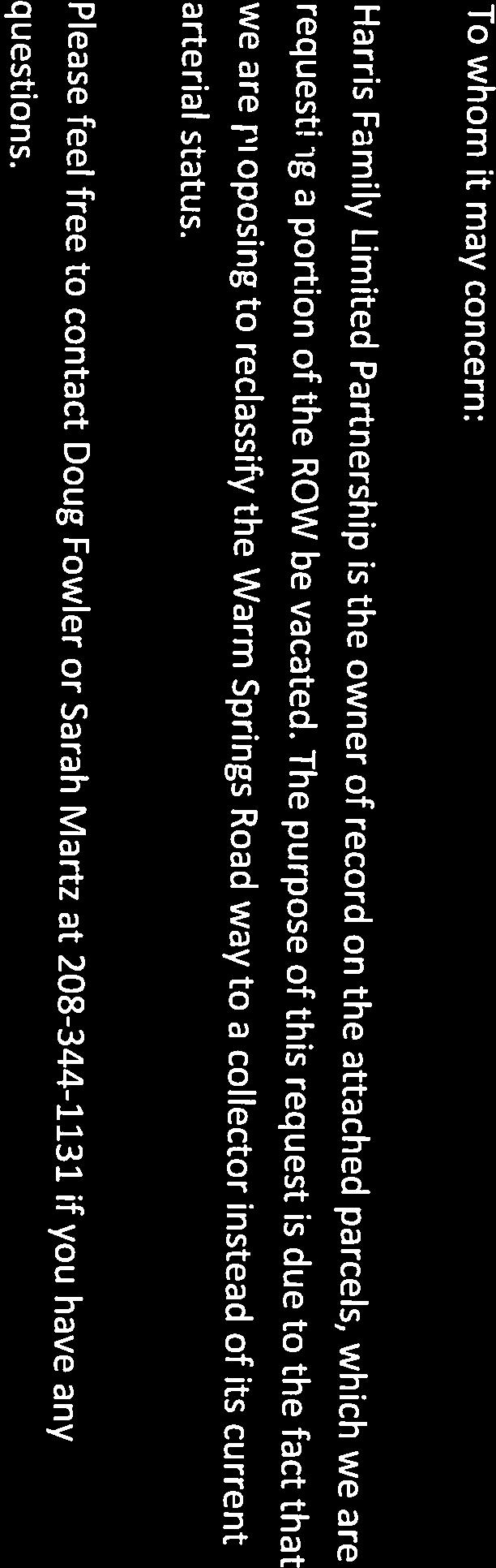
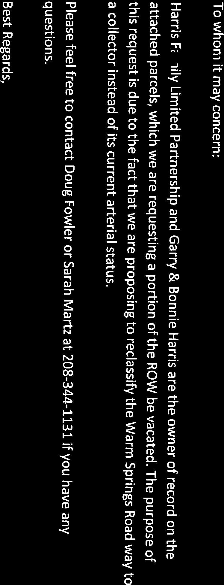
1 Rebecca W. Arnold, Commissioner Sara M. Baker, Commissioner Jim D. Hansen, Commissioner Kent Goldthorpe, Commissioner Paul Woods, Commissioner TO: FROM: ACHD Board of Commissioners & Bruce S. Wong, Director David Serdar Right of Way Supervisor DATE: December 23, 2014 SUBJECT: Vacation/Exchange of Public Right of Way - Public Hearing and adoption of Resolution Numbers 2081, 2082, 2083, 2084, 2085, 2086, 2087, 2088, and 2089 for an application to vacate the public right of way on E. Warm Springs Avenue and vacate 4 sidewalk easements along E. Warm Springs Avenue and Perrault Way. The portions of right of way are located in Sections 19, 20, 29, and 30, Township 3 North, Range 3 East, Boise Meridian, Ada County, Idaho, and the sidewalk easements are located in Section 19, Township 3 North, Range 3 East, Boise Meridian, City of Boise, Ada County, Idaho. Regular Agenda / Public Hearing for Board of Commissioners meeting January 7, 2015 EXECUTIVE SUMMARY FACTS & FINDINGS This action is taken to vacate portions of the public right of way on E. Warm Springs Avenue, E Parkcenter Blvd, and vacate 4 sidewalk easements along E. Warm Springs Avenue and Perrault Way. The portions of right of way are located in Sections 19, 20, 29, and 30, Township 3 North, Range 3 East, Boise Meridian, Ada County, Idaho, and the sidewalk easements are located in Section 19, Township 3 North, Range 3 East, Boise Meridian, City of Boise, Ada County, Idaho. 1. ACHD received a petition and application for the vacation of the above-referenced right of way from RiveRidge Engineering Company, on behalf of the Harris Family Limited Partnership, Barber Valley Development, and Gary and Bonnie Harris (Attachment 1). 2. This vacation is necessary to vacate and relocate existing rights of way along both north and south Warm Springs Avenue to align with the master roadway layout along Warm Springs. Once vacated, all final rights of way will be located to the road side of future sidewalks, as agreed to between the developer and ACHD. 3. The area being proposed for the portion of right of way to be vacated encompasses approximately acres or 36,950 sf of land, more or less. The area being proposed for the sidewalk Ada County Highway District 3775 Adams Street Garden City, ID PH FX
2 easements to be vacated encompasses approximately acres or 1,162 sf, more or less (Attachment 2). 4. The vacation/exchange is taking place as part of the commission approved development application. The developer wants E. Parkcenter Blvd to become a collector road instead of staying an arterial road. The new arterial road has already been dedicated to ACHD. The dedication is acres or 368,520 sf more or less (Attachment 3). The developer will pay to have the new 5 lane road built in the dedication location. 5. As required by Idaho Code, section a public hearing is to be held, of which hearing notice shall be published in accordance with the provisions of section Notice of the public hearing is being published in the Idaho Statesman on December 23 rd, 24 th, and December 31 st, 2014, with the last date of publication at least five (5) days before the hearing. 7. In accordance with Idaho Law and ACHD policy, comments were requested from the following public and private agencies and public utilities, regarding their plans for the area of the proposed vacation. In addition, ACHD staff has been notified and comments were requested concerning the requested vacation. A. ACHD Staff comments: Brian McCarthy, Utility Coordinator commented that any utilities existing within the vacated area will need to have access to maintain facilities. B. The following agencies had no response: Qwest Intermountain Gas Company Boise City Clerk Boise City Fire Department Boise City Public Works Boise City Parks Department Boise Project Board of Control Boise City Canal Company Bench Sewer District Integra Telecom Cable One Television
3 Time Warner Telecom Chevron Pipeline AT & T Communications Boise Warm Springs Water District Ada County Development Services American Fiber Systems C. The following agencies responded and had no objection: Nampa & Meridian Irrigation District United Water Idaho Tesoro Logistics West Boise Sewer District D. The following agencies responded and made comments: Boise City Public Works There are public street light facilities that are installed behind the sidewalk in some locations, and they would like to see them provide a 10 utility easement behind the new right of way line. Boise City Planning & Development Services The vacation is consented to subject to the following condition of approval: The applicant shall grant a sidewalk easement to the City of Boise for the vacated public street right of way segments. The applicant shall create a ten foot street light easement from the back of the curb along both sides of Warm Springs Avenue to ensure access for street lights, street light conduit, and any other associated equipment such as power cabinets as needed. 8. There is no access to Federal or State lands or waters that will be denied if the requested vacation is approved. 9. On December 4, 2014 a letter was sent out notifying all the property owners within 300 feet of the requested vacation of the public hearing date. 10. The public hearing for the vacation and abandonment of the above referenced public Right of Way will be conducted on January 7, Attached for Commission review and consideration are Resolution Numbers 2081, 2082, 2083, 2084, 2085, 2086, 2087, 2088, and 2089 (Attachment 4).
4 FISCAL IMPACT 12. Approval of the vacation and abandonment is subject to retention of the public and private utility easements, drainage easements, irrigation easements, and/or other easements of record or not of record or in use upon or under said described public right of way and/or the provisions for the relocation or replacement of existing facilities. 13. Costs associated with relocation or replacement of existing easements and facilities shall be borne by the applicant with approval of the applicable utility or agency. The required application fee of $ was paid by the applicant. POLICY IMPLICATIONS The public hearing and the vacation procedures were accomplished according to current ACHD policies. RECOMMENDATIONS Staff recommends that the Board of Commissioners approve and sign Resolution Numbers 2081, 2082, 2083, 2084, 2085, 2086, 2087, 2088, and 2089 and the president of the board sign the quitclaim deeds (Attachment 5) to vacate portions of the public right of way and sidewalk easements. This action is taken to vacate portions of the public right of way on E. Warm Springs Avenue and vacate 4 sidewalk easements along E. Warm Springs Avenue and Perrault Way. The portions of right of way are located in Sections 19, 20, 29, and 30, Township 3 North, Range 3 East, Boise Meridian, Ada County, Idaho, and the sidewalk easements are located in Section 19, Township 3 North, Range 3 East, Boise Meridian, City of Boise, Ada County, Idaho. ATTACHMENTS: 1. Application for vacation 2. Depiction of proposed vacation parcels and sidewalk easements 3. Depiction of dedicated area 4. Resolution Numbers 2081, 2082, 2083, 2084, 2085, 2086, 2087, 2088, and Quitclaim Deeds to the Harris Family Limited Partnership, Barber Valley Development, and Gary and Bonnie Harris cc: Right of Way File RiveRidge Engineering Company Attn: David G. Powell, dpowell@rvrdg.com

5


6

7


8

9

10


11


12


13


14


15

16
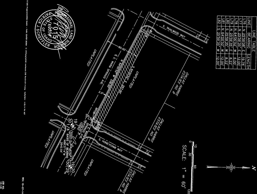
17 E Warm Springs Av S Perrault Way S Wise Way S Palmatier W ay E Parkcenter Blvd S Trailwood Way E. WARM SPRINGS AVE. Right of Way Vacations Right-of-Way Vacation 1 Approx Sq. Ft. Right-of-Way Vacation 2-A Approx. 640 Sq. Ft. Right-of-Way Vacation 2-B Approx Sq. Ft. Right-of-Way Vacation 3 Approx Sq. Ft. Right-of-Way Vacation 4 Approx Sq. Ft. Right-of-Way Vacation 5-A Approx. 368 Sq. Ft. Parcels 1 inch = 175 feet This map is a general depiction intended for visual reference only Right-of-Way Vacation 5-B Approx. 407 Sq. Ft. Right-of-Way Vacation 6-A Approx Sq. Ft. Right-of-Way Vacation 6-B Approx. 331 Sq. Ft. Right-of-Way Vacation 7 Approx Sq. Ft. Right-of-Way Vacation 8 Approx Sq. Ft. Right-of-Way Vacation 9 Approx Sq. Ft. Source: Esri, DigitalGlobe, GeoEye, i-cubed, Earthstar Geographics, CNES/Airbus DS, USDA, USGS, AEX, Getmapping, Aerogrid, IGN, IGP, swisstopo, and the GIS User Community
18 s rin g lvd aul t Sidewalk Easement Vacations Sidewalk Easement Vacation 2A Approx. 274 Sq. Ft. Sidewalk Easement Vacation 2B Approx. 388 Sq. Ft. Sidewalk Easement Vacation 2C Approx. 118 Sq. Ft. Sidewalk Easement Vacation 2D Approx. 382 Sq. Ft. Parcels 1 inch = 70 feet This map is a general depiction intended for visual reference only SP e rr E. WARM SPRINGS AVE. aul t en ter B SP e rr ark c Wa y EP Wa y EW arm Sp Attachment 2
19 S Wise Way E Parkcenter Blvd E. Warm Springs Dedication S Eckert Rd S Suntree Way E. Warm Springs Dedication Approx. 368,520 Sq. Ft. E Shady Glen Dr Parcels 1 inch = 435 feet This map is a general depiction intended for visual reference only E Boise Ave Source: Esri, DigitalGlobe, GeoEye, i-cubed, Earthstar Geographics, CNES/Airbus DS, USDA, USGS, AEX, Getmapping, Aerogrid, IGN, IGP, swisstopo, and the GIS User Community Path: H:\Kathy\ROWDS\Dawn Battles\Warm Springs Vacation\DedicationMap.mxd
20 RESOLUTION NUMBER 2081 AUTHORIZING AN ABANDONMENT/VACATION OF PUBLIC RIGHT OF WAY AND THE EXCHANGE OF LAND BY AND BETWEEN THE ADA COUNTY HIGHWAY DISTRICT AND Harris Family Limited Partnership, an Idaho Limited Partnership WITH OTHER CONSIDERATIONS BETWEEN THE PARTIES. WHEREAS, by its Resolution Number 2070 adopted and approved at its regular meeting held on December 3, 2014, the Ada County Highway District Commission, in accordance with the requirements of Idaho Code, section and , found that the portions of right of way that are located in Sections 19, 20, 29, and 30, Township 3 North, Range 3 East, Boise Meridian, Ada County, Idaho, and more particularly described in Exhibit A hereinafter subject public right of way ) was no longer useful to ACHD, and set a public hearing before the Commission for 12:00pm, on January 7, 2015, at which time any person could appear to show cause why the subject public right of way should not be vacated; and WHEREAS, in accordance with Idaho Code, sections and , the Commission does hereby make the following findings of fact and conclusions of law: FINDINGS OF FACT: 1. Date of Application: September 11, 2014 with an update on October 28, Upon the filing of a petition by the Petitioner for the abandonment/vacation of the subject public right of way, the following organizations and agencies were notified on October 31, 2014: A. Ada County Highway District Staff members; B. All appropriate local agencies and utilities were contacted and comments requested. 3. On December 3, 2014 a public hearing date was set by the Board of Commissioners for January 7, Following the filing of the petition for the abandonment/vacation, property owners within 300 feet of the subject right of way were notified by certified mail on December 4, 2014, of the time, date and place of the public hearing. 5. In accordance with Idaho law, a Notice of Public Hearing was published in the Idaho Statesman a daily newspaper published in Ada County, Idaho, on the 23 rd, 24 th, and 31 st of December, 2014, and an affidavit of publication was received by the Ada County Highway District and is on file in the office of the Right of Way and Development Services Department. 6. Any and all comments received from the October 31, 2014 notification of Ada County Highway District Staff members and all applicable local agencies are on file Abandonment/Vacation and Exchange Resolution - page 1 (3/29/2010)
21 in the office of the Right of Way and Development Services Department and are included within the Public Hearing staff memo dated December 23, Any and all comments, received from those property owners of real property within 300 feet of the subject right of way are on file in the office of the Right of Way and Development Services Department and are included within the Public Hearing staff memo dated December 23, At the public hearing on Wednesday, January 7, 2015, oral and or written testimony was presented and at the conclusion of which, Commissioner Rebecca W. Arnold, closed the public hearing for testimony. After discussion, the Commission found the abandonment/vacation and exchange was in the public s best interest and voted to approve the abandonment/vacation and exchange of the subject public right of way for the Exchange Parcel as an even exchange in value. CONCLUSIONS OF LAW: It is the opinion of the Board of Commissioners of the Ada County Highway District, per Commissioners, Rebecca W. Arnold, Sara M. Baker, Jim Hansen, Kent Goldthorpe, and Paul Woods, that the subject right of way is no longer needed by the Ada County Highway District and that it is the best interest of the traveling public, the adjacent property owners, and the Ada County Highway District that the abandonment/vacation of the portions of right of way that are located in Sections 19, 20, 29, and 30, Township 3 North, Range 3 East, Boise Meridian, Ada County, Idaho, and more particularly described in Exhibit A be approved and the subject public right of way abandoned/vacated. Subject to the following: Retention of public and private utility easements, drainage easements, irrigation easements and/or other easements of record or not of record or in use upon or under said described public right of way and/or the provisions for the relocation or replacement of existing facilities. NOW, THEREFORE, BE IT RESOLVED, pursuant to Idaho Code section and that the proposed abandonment/vacation of the public right of way is hereby authorized, and ACHD staff is hereby directed to negotiate a contract of sale with Petitioner in the amount of Zero Dollars ($0.00) and that the President of the Commission and the Director be, and are hereby, authorized and directed to execute such contract of sale on behalf of the Ada County Highway District and an appropriate Quitclaim Deed for the abandoned/vacated subject public right of way and such closing instructions and other instruments and documents as are required by such contract of sale, including the following, and deliver the same, together with the deed to the closing agent: 1. Subject to retention of public and private utility easements, drainage easements, irrigation easements and/or other easements of record or not of record or in use upon or under said described public right of way and/or the provisions for the Abandonment/Vacation and Exchange Resolution - page 2 (3/29/2010)
22 relocation or replacement of existing facilities. Costs associated with relocation or replacement of existing easements and facilities shall be borne by the Petitioner with approval of the applicable utility or agency. BE IT FURTHER RESOLVED, that only upon the District s receipt of full payment of all applicable charges, costs and fees and any other amounts owning and the deed for the Exchange Parcel from the Petitioner within ninety (90) days of the date of approval, shall this Resolution be recorded in the county records. BE IT FURTHER RESOLVED, that if District has not received full payment of all applicable charges, costs and fees and any other amounts owing and the deed for the Exchange Parcel from the Petitioner within one hundred twenty (120) days of the date of approval, the Board of Commissioners may, at a public hearing and upon thirty (30) days notice of said public hearing to the Petitioner by certified mail and adjacent property owners by regular mail, declare the abandonment/vacation and exchange void and issue a resolution declaring the same. ADOPTED AND APPROVED by the Board of Commissioners of the Ada County Highway District at its regular meeting held on this, day of, 201. ADA COUNTY HIGHWAY DISTRICT BOARD OF COMMISSIONERS By: REBECCA W. ARNOLD, Commissioner By: SARA M. BAKER, Commissioner By: JIM D. HANSEN, Commissioner By: KENT GOLDTHORPE, Commissioner By: PAUL WOODS, Commissioner ATTEST: Bruce S. Wong, Director Abandonment/Vacation and Exchange Resolution - page 3 (3/29/2010)
23 STATE OF IDAHO ) ) ss. County of Ada ) On this day of, 201, before me, a notary public in and for said State, personally appeared Commissioners, Rebecca W. Arnold, Sara M. Baker, Jim Hansen, Kent Goldthorpe, and Paul Woods, and known to me to be the Board of Commissioners, respectively, of the Ada County Highway District and that they executed this instrument on behalf of said Highway District for the purposes therein stated. IN WITNESS WHEREOF, I have hereunto set my hand and affixed my official seal, the day and year in this certificate first above written. Notary Public for the State of Idaho Residing at Boise, Idaho My Commission Expires: The Ada County Highway District (ACHD) is committed to compliance with Title VI of the Civil Rights Act of 1964 and related regulations and directives. ACHD assures that no person shall on the grounds of race, color, national origin, gender, disability or age, be excluded from participation in, be denied the benefits of, or be otherwise subjected to discrimination under any ACHD service, program or activity. Abandonment/Vacation and Exchange Resolution - page 4 (3/29/2010)
24 Description for Ada County Highway District East Warm Springs Avenue Right of Way Vacation Portions of East Warm Springs Avenue right-of-way located within the South 1/2 of Section 19, the South 1/2 of Section 20, the North 1/2 of Section 30 and the North 1/2 of Section 29, Township 3 North, Range 3 East, Boise Meridian, Ada County, Idaho, more particularly described as follows: Right of Way Vacation Description No. 1: Commencing at the Southeast corner of said Section 19, from which the South 1/4 corner of said Section 19 bears North West, feet; Thence along the southerly boundary line of said Section 19 North West, feet to the intersection with the centerline of said East Warm Springs Avenue; Thence departing said southerly boundary line and along said centerline North West, feet; Thence departing said centerline North East, feet to the REAL POINT OF BEGINNING; Thence North 64 00'52" West, feet; Thence North 69 43'30" West, feet; Thence feet along the arc of a non-tangent curve to the right having a radius of feet, a central angle of 09 30'04", and a long chord which bears North 59 13'32" West, a distance of feet; Thence North 38 21'00" East, 6.13 feet; Thence North 54 14'03" West, feet; Thence South 38 21'00" West, 5.99 feet; Thence feet along the arc of a non-tangent curve to the right having a radius of feet, a central angle of 52 18'55", and a long chord which bears North 25 20'36" West, a distance of feet; Thence feet along the arc of a compound curve to the right having a radius of feet, a central angle of 05 21'01", and a long chord which bears North 03 29'22" East, a distance of feet; Thence South 83 50'07" East, 6.01 feet; Thence North 06 42'08" East, feet; Thence North 83 50'07" West, 6.01 feet; Thence feet along the arc of a non-tangent curve to the right having a radius of feet, a central angle of 03 02'04", and a long chord which bears North 08 43'42" East, a distance of feet to a point on the exterior boundary line of Dallas Harris Estates Subdivision No. 1 as filed in Book 103 of Plats at Pages records of Ada County, Idaho;
25 Thence along said exterior boundary line South 64 00'25" East, 8.33 feet to a point on the Easterly line of that certain parcel of land described in Warranty Deed recorded on February 4, 2010 as Instrument No , official records of Ada County, Idaho ; Thence departing said exterior boundary line and along said Easterly line feet along the arc of a non-tangent curve to the left having a radius of feet, a central angle of 09 11'32", and a long chord which bears South 05 25'05" West, a distance of feet; Thence continuing along said Easterly line feet along the arc of a compound curve to the left having a radius of feet, a central angle of 29 45'41", and a long chord which bears South 14 03'31" East, a distance of feet to a point on the northerly right-of-way line of said East Warm Springs Avenue; Thence along said northerly right-of-way line South 64 00'52" East, feet to the intersection with the westerly right-of-way line of South Perault Way; Thence departing said northerly right-of-way line and along said westerly right-of-way line North 25 59'35" East, feet to an angle point on the exterior boundary line of Dallas Harris Estates Subdivision No. 2 as filed in Book 103 of Plats at Pages , records of Ada County, Idaho; Thence departing said westerly right-of-way line South 64 00'25" East, 0.50 feet; Thence South 25 59'35" West, feet; Thence North 64 00'52" West, 6.00 feet; Thence South 25 59'35" West, feet to the REAL POINT OF BEGINNING. Containing 4,627 square feet, more or less.
26
27 RESOLUTION NUMBER 2082 AUTHORIZING AN ABANDONMENT/VACATION OF PUBLIC RIGHT OF WAY AND THE EXCHANGE OF LAND BY AND BETWEEN THE ADA COUNTY HIGHWAY DISTRICT AND Harris Family Limited Partnership, an Idaho Limited Partnership and Gary & Bonnie Harris, husband and wife WITH OTHER CONSIDERATIONS BETWEEN THE PARTIES. WHEREAS, by its Resolution Number 2070 adopted and approved at its regular meeting held on December 3, 2014, the Ada County Highway District Commission, in accordance with the requirements of Idaho Code, section and , found that the portions of right of way that are located in Sections 19, 20, 29, and 30, Township 3 North, Range 3 East, Boise Meridian, Ada County, Idaho, and more particularly described in Exhibit A hereinafter subject public right of way ) was no longer useful to ACHD, and set a public hearing before the Commission for 12:00pm, on January 7, 2015, at which time any person could appear to show cause why the subject public right of way should not be vacated; and WHEREAS, in accordance with Idaho Code, sections and , the Commission does hereby make the following findings of fact and conclusions of law: FINDINGS OF FACT: 1. Date of Application: September 11, 2014 with an update on October 28, Upon the filing of a petition by the Petitioner for the abandonment/vacation of the subject public right of way, the following organizations and agencies were notified on October 31, 2014: A. Ada County Highway District Staff members; B. All appropriate local agencies and utilities were contacted and comments requested. 3. On December 3, 2014 a public hearing date was set by the Board of Commissioners for January 7, Following the filing of the petition for the abandonment/vacation, property owners within 300 feet of the subject right of way were notified by certified mail on December 4, 2014, of the time, date and place of the public hearing. 5. In accordance with Idaho law, a Notice of Public Hearing was published in the Idaho Statesman a daily newspaper published in Ada County, Idaho, on the 23 rd, 24 th, and 31 st of December, 2014, and an affidavit of publication was received by the Ada County Highway District and is on file in the office of the Right of Way and Development Services Department. 6. Any and all comments received from the October 31, 2014 notification of Ada County Highway District Staff members and all applicable local agencies are on file Abandonment/Vacation and Exchange Resolution - page 1 (3/29/2010)
28 in the office of the Right of Way and Development Services Department and are included within the Public Hearing staff memo dated December 23, Any and all comments, received from those property owners of real property within 300 feet of the subject right of way are on file in the office of the Right of Way and Development Services Department and are included within the Public Hearing staff memo dated December 23, At the public hearing on Wednesday, January 7, 2015, oral and or written testimony was presented and at the conclusion of which, Commissioner Rebecca W. Arnold, closed the public hearing for testimony. After discussion, the Commission found the abandonment/vacation and exchange was in the public s best interest and voted to approve the abandonment/vacation and exchange of the subject public right of way for the Exchange Parcel as an even exchange in value. CONCLUSIONS OF LAW: It is the opinion of the Board of Commissioners of the Ada County Highway District, per Commissioners, Rebecca W. Arnold, Sara M. Baker, Jim Hansen, Kent Goldthorpe, and Paul Woods, that the subject right of way is no longer needed by the Ada County Highway District and that it is the best interest of the traveling public, the adjacent property owners, and the Ada County Highway District that the abandonment/vacation of the portions of right of way that are located in Sections 19, 20, 29, and 30, Township 3 North, Range 3 East, Boise Meridian, Ada County, Idaho, and more particularly described in Exhibit A be approved and the subject public right of way abandoned/vacated. Subject to the following: Retention of public and private utility easements, drainage easements, irrigation easements and/or other easements of record or not of record or in use upon or under said described public right of way and/or the provisions for the relocation or replacement of existing facilities. NOW, THEREFORE, BE IT RESOLVED, pursuant to Idaho Code section and that the proposed abandonment/vacation of the public right of way is hereby authorized, and ACHD staff is hereby directed to negotiate a contract of sale with Petitioner in the amount of Zero Dollars ($0.00) and that the President of the Commission and the Director be, and are hereby, authorized and directed to execute such contract of sale on behalf of the Ada County Highway District and an appropriate Quitclaim Deed for the abandoned/vacated subject public right of way and such closing instructions and other instruments and documents as are required by such contract of sale, including the following, and deliver the same, together with the deed to the closing agent: 1. Subject to retention of public and private utility easements, drainage easements, irrigation easements and/or other easements of record or not of record or in use upon or under said described public right of way and/or the provisions for the Abandonment/Vacation and Exchange Resolution - page 2 (3/29/2010)
29 relocation or replacement of existing facilities. Costs associated with relocation or replacement of existing easements and facilities shall be borne by the Petitioner with approval of the applicable utility or agency. BE IT FURTHER RESOLVED, that only upon the District s receipt of full payment of all applicable charges, costs and fees and any other amounts owning and the deed for the Exchange Parcel from the Petitioner within ninety (90) days of the date of approval, shall this Resolution be recorded in the county records. BE IT FURTHER RESOLVED, that if District has not received full payment of all applicable charges, costs and fees and any other amounts owing and the deed for the Exchange Parcel from the Petitioner within one hundred twenty (120) days of the date of approval, the Board of Commissioners may, at a public hearing and upon thirty (30) days notice of said public hearing to the Petitioner by certified mail and adjacent property owners by regular mail, declare the abandonment/vacation and exchange void and issue a resolution declaring the same. ADOPTED AND APPROVED by the Board of Commissioners of the Ada County Highway District at its regular meeting held on this, day of, 201. ADA COUNTY HIGHWAY DISTRICT BOARD OF COMMISSIONERS By: REBECCA W. ARNOLD, Commissioner By: SARA M. BAKER, Commissioner By: JIM D. HANSEN, Commissioner By: KENT GOLDTHORPE, Commissioner By: PAUL WOODS, Commissioner ATTEST: Bruce S. Wong, Director Abandonment/Vacation and Exchange Resolution - page 3 (3/29/2010)
30 STATE OF IDAHO ) ) ss. County of Ada ) On this day of, 201, before me, a notary public in and for said State, personally appeared Commissioners, Rebecca W. Arnold, Sara M. Baker, Jim Hansen, Kent Goldthorpe, and Paul Woods, and known to me to be the Board of Commissioners, respectively, of the Ada County Highway District and that they executed this instrument on behalf of said Highway District for the purposes therein stated. IN WITNESS WHEREOF, I have hereunto set my hand and affixed my official seal, the day and year in this certificate first above written. Notary Public for the State of Idaho Residing at Boise, Idaho My Commission Expires: The Ada County Highway District (ACHD) is committed to compliance with Title VI of the Civil Rights Act of 1964 and related regulations and directives. ACHD assures that no person shall on the grounds of race, color, national origin, gender, disability or age, be excluded from participation in, be denied the benefits of, or be otherwise subjected to discrimination under any ACHD service, program or activity. Abandonment/Vacation and Exchange Resolution - page 4 (3/29/2010)
31 October 7, 2014 Description For ADA COUNTY HIGHWAY DISTRICT East Warm Springs Avenue Right of Way Vacation Right of Way Vacation Description No. 2-A Portions of the South 1/2 of the Southeast 1/4 of Section 19, Township 3 North, Range 3 East, Boise Meridian, City of Boise, Ada County, Idaho being more particularly described as follows: COMMENCING at a brass cap monument marking the Southeast corner of said Section 19 from which a brass cap monument marking the South 1/4 corner of said Section 19 bears North 88 37'14" West, feet; Thence North 71 51'33" West, feet to the intersection with the easterly right-of-way line of East Warm Springs Avenue and the most northerly corner of Lot 1, Block 15 of Dallas Harris Estates Subdivision No. 3 as same is filed in Book 103 of Plats at Page 13948, records of Ada County, Idaho, said point being THE REAL POINT OF BEGINNING; Thence North 64 00'52" West, feet; Thence feet along the arc of a non-tangent curve to the right having a radius of feet, a central angle of 06 37'50", and a long chord which bears North 23 38'37" East, a distance of feet to the intersection with the southerly boundary line of a former railroad right-of-way; Thence along said former railroad right-of-way line South 64 00'52" East, feet to the intersection with said easterly right-of-way line; Thence along said right-of-way line South 21 34'22" West, feet to the POINT OF BEGINNING. Contains an area of 640 square feet, more or less. Prepared By: Idaho Survey Group
32
33
34
35
36
37 RESOLUTION NUMBER 2083 AUTHORIZING AN ABANDONMENT/VACATION OF PUBLIC RIGHT OF WAY AND THE EXCHANGE OF LAND BY AND BETWEEN THE ADA COUNTY HIGHWAY DISTRICT AND Harris Family Limited Partnership, an Idaho Limited Partnership WITH OTHER CONSIDERATIONS BETWEEN THE PARTIES. WHEREAS, by its Resolution Number 2070 adopted and approved at its regular meeting held on December 3, 2014, the Ada County Highway District Commission, in accordance with the requirements of Idaho Code, section and , found that the portions of right of way that are located in Sections 19, 20, 29, and 30, Township 3 North, Range 3 East, Boise Meridian, Ada County, Idaho, and more particularly described in Exhibit A hereinafter subject public right of way ) was no longer useful to ACHD, and set a public hearing before the Commission for 12:00pm, on January 7, 2015, at which time any person could appear to show cause why the subject public right of way should not be vacated; and WHEREAS, in accordance with Idaho Code, sections and , the Commission does hereby make the following findings of fact and conclusions of law: FINDINGS OF FACT: 1. Date of Application: September 11, 2014 with an update on October 28, Upon the filing of a petition by the Petitioner for the abandonment/vacation of the subject public right of way, the following organizations and agencies were notified on October 31, 2014: A. Ada County Highway District Staff members; B. All appropriate local agencies and utilities were contacted and comments requested. 3. On December 3, 2014 a public hearing date was set by the Board of Commissioners for January 7, Following the filing of the petition for the abandonment/vacation, property owners within 300 feet of the subject right of way were notified by certified mail on December 4, 2014, of the time, date and place of the public hearing. 5. In accordance with Idaho law, a Notice of Public Hearing was published in the Idaho Statesman a daily newspaper published in Ada County, Idaho, on the 23 rd, 24 th, and 31 st of December, 2014, and an affidavit of publication was received by the Ada County Highway District and is on file in the office of the Right of Way and Development Services Department. 6. Any and all comments received from the October 31, 2014 notification of Ada County Highway District Staff members and all applicable local agencies are on file Abandonment/Vacation and Exchange Resolution - page 1 (3/29/2010)
38 in the office of the Right of Way and Development Services Department and are included within the Public Hearing staff memo dated December 23, Any and all comments, received from those property owners of real property within 300 feet of the subject right of way are on file in the office of the Right of Way and Development Services Department and are included within the Public Hearing staff memo dated December 23, At the public hearing on Wednesday, January 7, 2015, oral and or written testimony was presented and at the conclusion of which, Commissioner Rebecca W. Arnold, closed the public hearing for testimony. After discussion, the Commission found the abandonment/vacation and exchange was in the public s best interest and voted to approve the abandonment/vacation and exchange of the subject public right of way for the Exchange Parcel as an even exchange in value. CONCLUSIONS OF LAW: It is the opinion of the Board of Commissioners of the Ada County Highway District, per Commissioners, Rebecca W. Arnold, Sara M. Baker, Jim Hansen, Kent Goldthorpe, and Paul Woods, that the subject right of way is no longer needed by the Ada County Highway District and that it is the best interest of the traveling public, the adjacent property owners, and the Ada County Highway District that the abandonment/vacation of the portions of right of way that are located in Sections 19, 20, 29, and 30, Township 3 North, Range 3 East, Boise Meridian, Ada County, Idaho, and more particularly described in Exhibit A be approved and the subject public right of way abandoned/vacated. Subject to the following: Retention of public and private utility easements, drainage easements, irrigation easements and/or other easements of record or not of record or in use upon or under said described public right of way and/or the provisions for the relocation or replacement of existing facilities. NOW, THEREFORE, BE IT RESOLVED, pursuant to Idaho Code section and that the proposed abandonment/vacation of the public right of way is hereby authorized, and ACHD staff is hereby directed to negotiate a contract of sale with Petitioner in the amount of Zero Dollars ($0.00) and that the President of the Commission and the Director be, and are hereby, authorized and directed to execute such contract of sale on behalf of the Ada County Highway District and an appropriate Quitclaim Deed for the abandoned/vacated subject public right of way and such closing instructions and other instruments and documents as are required by such contract of sale, including the following, and deliver the same, together with the deed to the closing agent: 1. Subject to retention of public and private utility easements, drainage easements, irrigation easements and/or other easements of record or not of record or in use upon or under said described public right of way and/or the provisions for the Abandonment/Vacation and Exchange Resolution - page 2 (3/29/2010)
39 relocation or replacement of existing facilities. Costs associated with relocation or replacement of existing easements and facilities shall be borne by the Petitioner with approval of the applicable utility or agency. BE IT FURTHER RESOLVED, that only upon the District s receipt of full payment of all applicable charges, costs and fees and any other amounts owning and the deed for the Exchange Parcel from the Petitioner within ninety (90) days of the date of approval, shall this Resolution be recorded in the county records. BE IT FURTHER RESOLVED, that if District has not received full payment of all applicable charges, costs and fees and any other amounts owing and the deed for the Exchange Parcel from the Petitioner within one hundred twenty (120) days of the date of approval, the Board of Commissioners may, at a public hearing and upon thirty (30) days notice of said public hearing to the Petitioner by certified mail and adjacent property owners by regular mail, declare the abandonment/vacation and exchange void and issue a resolution declaring the same. ADOPTED AND APPROVED by the Board of Commissioners of the Ada County Highway District at its regular meeting held on this, day of, 201. ADA COUNTY HIGHWAY DISTRICT BOARD OF COMMISSIONERS By: REBECCA W. ARNOLD, Commissioner By: SARA M. BAKER, Commissioner By: JIM D. HANSEN, Commissioner By: KENT GOLDTHORPE, Commissioner By: PAUL WOODS, Commissioner ATTEST: Bruce S. Wong, Director Abandonment/Vacation and Exchange Resolution - page 3 (3/29/2010)
40 STATE OF IDAHO ) ) ss. County of Ada ) On this day of, 201, before me, a notary public in and for said State, personally appeared Commissioners, Rebecca W. Arnold, Sara M. Baker, Jim Hansen, Kent Goldthorpe, and Paul Woods, and known to me to be the Board of Commissioners, respectively, of the Ada County Highway District and that they executed this instrument on behalf of said Highway District for the purposes therein stated. IN WITNESS WHEREOF, I have hereunto set my hand and affixed my official seal, the day and year in this certificate first above written. Notary Public for the State of Idaho Residing at Boise, Idaho My Commission Expires: The Ada County Highway District (ACHD) is committed to compliance with Title VI of the Civil Rights Act of 1964 and related regulations and directives. ACHD assures that no person shall on the grounds of race, color, national origin, gender, disability or age, be excluded from participation in, be denied the benefits of, or be otherwise subjected to discrimination under any ACHD service, program or activity. Abandonment/Vacation and Exchange Resolution - page 4 (3/29/2010)
41 Description for Ada County Highway District East Warm Springs Avenue Right of Way Vacation Portions of East Warm Springs Avenue right-of-way located within the South 1/2 of Section 19, the South 1/2 of Section 20, the North 1/2 of Section 30 and the North 1/2 of Section 29, Township 3 North, Range 3 East, Boise Meridian, Ada County, Idaho, more particularly described as follows: Right of Way Vacation Description No. 2-B: Commencing at the Southeast corner of said Section 19, from which the South 1/4 corner of said Section 19 bears North West, feet; Thence along the southerly boundary line of said Section 19 North West, feet to the intersection with the centerline of said East Warm Springs Avenue; Thence departing said southerly boundary line and along said centerline North West, feet; Thence departing said centerline South West, feet to the REAL POINT OF BEGINNING; Thence South 25 59'35" West, 7.78 feet to a point on the southerly right-of-way line of said East Warm Springs Avenue; Thence along said southerly right-of-way line North 64 00'52" West, feet to a point on the Southerly line of that certain parcel of land described in Warranty Deed recorded on March 25, 2010 as Instrument No , official records of Ada County, Idaho ; Thence along said Southerly line feet along the arc of a curve to the left having a radius of feet, a central angle of 28 45'13", and a long chord which bears North 78 23'28" West, a distance of feet; Thence continuing along said Southerly line feet along the arc of a compound curve to the left having a radius of feet, a central angle of 34 33'24", and a long chord which bears South 69 57'13" West, a distance of feet to a point on the Easterly line of that certain parcel of land described in Warranty Deed recorded on March 25, 2011 as Instrument No , official records of Ada County, Idaho ; Thence departing said right-of-way line and along said Easterly line South 25 58'48" West, feet to the Southeast corner thereof; Thence along the Southerly line of said parcel described in Instrument No North 64 00'52" West, feet; Thence feet along the arc of a non-tangent curve to the right having a radius of feet, a central angle of 01 37'01", and a long chord which bears North 27 46'02" East, a distance of feet; Thence South 52 34'15" East, 9.91 feet; Thence North 25 58'22" East, feet; Thence North 52 34'15" West, 8.75 feet;
42 Thence feet along the arc of a non-tangent curve to the right having a radius of feet, a central angle of 48 33'21", and a long chord which bears North 60 59'59" East, a distance of feet; Thence feet along the arc of a compound curve to the right having a radius of feet, a central angle of 10 17'08", and a long chord which bears South 89 34'47" East, a distance of feet; Thence South 09 21'24" West, 6.03 feet; Thence South 83 35'35" East, feet; Thence North 09 21'24" East, 6.02 feet; Thence feet along the arc of a non-tangent curve to the right having a radius of feet, a central angle of 15 52'25", and a long chord which bears South 74 43'16" East, a distance of feet; Thence South 51 02'09" East, feet; Thence South 64 00'52" East, feet to the REAL POINT OF BEGINNING. Containing 2,695 square feet, more or less.
43
44
45
46
47
48 RESOLUTION NUMBER 2084 AUTHORIZING AN ABANDONMENT/VACATION OF PUBLIC RIGHT OF WAY AND THE EXCHANGE OF LAND BY AND BETWEEN THE ADA COUNTY HIGHWAY DISTRICT AND Harris Family Limited Partnership, an Idaho Limited Partnership WITH OTHER CONSIDERATIONS BETWEEN THE PARTIES. WHEREAS, by its Resolution Number 2070 adopted and approved at its regular meeting held on December 3, 2014, the Ada County Highway District Commission, in accordance with the requirements of Idaho Code, section and , found that the portions of right of way that are located in Sections 19, 20, 29, and 30, Township 3 North, Range 3 East, Boise Meridian, Ada County, Idaho, and more particularly described in Exhibit A hereinafter subject public right of way ) was no longer useful to ACHD, and set a public hearing before the Commission for 12:00pm, on January 7, 2015, at which time any person could appear to show cause why the subject public right of way should not be vacated; and WHEREAS, in accordance with Idaho Code, sections and , the Commission does hereby make the following findings of fact and conclusions of law: FINDINGS OF FACT: 1. Date of Application: September 11, 2014 with an update on October 28, Upon the filing of a petition by the Petitioner for the abandonment/vacation of the subject public right of way, the following organizations and agencies were notified on October 31, 2014: A. Ada County Highway District Staff members; B. All appropriate local agencies and utilities were contacted and comments requested. 3. On December 3, 2014 a public hearing date was set by the Board of Commissioners for January 7, Following the filing of the petition for the abandonment/vacation, property owners within 300 feet of the subject right of way were notified by certified mail on December 4, 2014, of the time, date and place of the public hearing. 5. In accordance with Idaho law, a Notice of Public Hearing was published in the Idaho Statesman a daily newspaper published in Ada County, Idaho, on the 23 rd, 24 th, and 31 st of December, 2014, and an affidavit of publication was received by the Ada County Highway District and is on file in the office of the Right of Way and Development Services Department. 6. Any and all comments received from the October 31, 2014 notification of Ada County Highway District Staff members and all applicable local agencies are on file Abandonment/Vacation and Exchange Resolution - page 1 (3/29/2010)
49 in the office of the Right of Way and Development Services Department and are included within the Public Hearing staff memo dated December 23, Any and all comments, received from those property owners of real property within 300 feet of the subject right of way are on file in the office of the Right of Way and Development Services Department and are included within the Public Hearing staff memo dated December 23, At the public hearing on Wednesday, January 7, 2015, oral and or written testimony was presented and at the conclusion of which, Commissioner Rebecca W. Arnold, closed the public hearing for testimony. After discussion, the Commission found the abandonment/vacation and exchange was in the public s best interest and voted to approve the abandonment/vacation and exchange of the subject public right of way for the Exchange Parcel as an even exchange in value. CONCLUSIONS OF LAW: It is the opinion of the Board of Commissioners of the Ada County Highway District, per Commissioners, Rebecca W. Arnold, Sara M. Baker, Jim Hansen, Kent Goldthorpe, and Paul Woods, that the subject right of way is no longer needed by the Ada County Highway District and that it is the best interest of the traveling public, the adjacent property owners, and the Ada County Highway District that the abandonment/vacation of the portions of right of way that are located in Sections 19, 20, 29, and 30, Township 3 North, Range 3 East, Boise Meridian, Ada County, Idaho, and more particularly described in Exhibit A be approved and the subject public right of way abandoned/vacated. Subject to the following: Retention of public and private utility easements, drainage easements, irrigation easements and/or other easements of record or not of record or in use upon or under said described public right of way and/or the provisions for the relocation or replacement of existing facilities. NOW, THEREFORE, BE IT RESOLVED, pursuant to Idaho Code section and that the proposed abandonment/vacation of the public right of way is hereby authorized, and ACHD staff is hereby directed to negotiate a contract of sale with Petitioner in the amount of Zero Dollars ($0.00) and that the President of the Commission and the Director be, and are hereby, authorized and directed to execute such contract of sale on behalf of the Ada County Highway District and an appropriate Quitclaim Deed for the abandoned/vacated subject public right of way and such closing instructions and other instruments and documents as are required by such contract of sale, including the following, and deliver the same, together with the deed to the closing agent: 1. Subject to retention of public and private utility easements, drainage easements, irrigation easements and/or other easements of record or not of record or in use upon or under said described public right of way and/or the provisions for the Abandonment/Vacation and Exchange Resolution - page 2 (3/29/2010)
50 relocation or replacement of existing facilities. Costs associated with relocation or replacement of existing easements and facilities shall be borne by the Petitioner with approval of the applicable utility or agency. BE IT FURTHER RESOLVED, that only upon the District s receipt of full payment of all applicable charges, costs and fees and any other amounts owning and the deed for the Exchange Parcel from the Petitioner within ninety (90) days of the date of approval, shall this Resolution be recorded in the county records. BE IT FURTHER RESOLVED, that if District has not received full payment of all applicable charges, costs and fees and any other amounts owing and the deed for the Exchange Parcel from the Petitioner within one hundred twenty (120) days of the date of approval, the Board of Commissioners may, at a public hearing and upon thirty (30) days notice of said public hearing to the Petitioner by certified mail and adjacent property owners by regular mail, declare the abandonment/vacation and exchange void and issue a resolution declaring the same. ADOPTED AND APPROVED by the Board of Commissioners of the Ada County Highway District at its regular meeting held on this, day of, 201. ADA COUNTY HIGHWAY DISTRICT BOARD OF COMMISSIONERS By: REBECCA W. ARNOLD, Commissioner By: SARA M. BAKER, Commissioner By: JIM D. HANSEN, Commissioner By: KENT GOLDTHORPE, Commissioner By: PAUL WOODS, Commissioner ATTEST: Bruce S. Wong, Director Abandonment/Vacation and Exchange Resolution - page 3 (3/29/2010)
51 STATE OF IDAHO ) ) ss. County of Ada ) On this day of, 201, before me, a notary public in and for said State, personally appeared Commissioners, Rebecca W. Arnold, Sara M. Baker, Jim Hansen, Kent Goldthorpe, and Paul Woods, and known to me to be the Board of Commissioners, respectively, of the Ada County Highway District and that they executed this instrument on behalf of said Highway District for the purposes therein stated. IN WITNESS WHEREOF, I have hereunto set my hand and affixed my official seal, the day and year in this certificate first above written. Notary Public for the State of Idaho Residing at Boise, Idaho My Commission Expires: The Ada County Highway District (ACHD) is committed to compliance with Title VI of the Civil Rights Act of 1964 and related regulations and directives. ACHD assures that no person shall on the grounds of race, color, national origin, gender, disability or age, be excluded from participation in, be denied the benefits of, or be otherwise subjected to discrimination under any ACHD service, program or activity. Abandonment/Vacation and Exchange Resolution - page 4 (3/29/2010)
Regular Agenda / Public Hearing for Board of Commissioners meeting September 24, 2014
 John S. Franden, President Mitchell A. Jaurena, Vice President Rebecca W. Arnold, Commissioner Sara M. Baker, Commissioner Jim D. Hansen, Commissioner TO: FROM: ACHD Board of Commissioners & Bruce S. Wong,
Regular Agenda / Public Hearing for Board of Commissioners meeting May 4, 2016
 Kent Goldthorpe, President Paul Woods, Vice President Rebecca W. Arnold, Commissioner Sara M. Baker, Commissioner Jim D. Hansen, Commissioner TO: FROM: ACHD Board of Commissioners & Bruce S. Wong, Director
4. Upon completion of the reconstruction of the road the applicant will dedicate a permanent rightof-way easement to ACHD.
 Paul Woods, President Rebecca W. Arnold, Vice President Sara M. Baker, Commissioner Jim D. Hansen, Commissioner Kent Goldthorpe, Commissioner Development Services Department TO: ACHD Commission, Director
PUBLIC AUCTION SEALED BID PACKET
 Sara M. Baker, President Rebecca W. Arnold, Vice President Jim D. Hansen, Commissioner Kent Goldthorpe, Commissioner Paul Woods, Commissioner PUBLIC AUCTION SEALED BID PACKET FOR PUBLIC AUCTION SALE OF:
REGULAR AGENDA ITEM May 25, 2016 Commission Meeting
 Kent Goldthorpe, President Paul Woods, Vice President Rebecca W. Arnold, Commissioner Sara M. Baker, Commissioner Jim D. Hansen, Commissioner May 13, 2016 TO: FROM; Subject: ACHD Board of Commissioners
REGULAR AGENDA ITEM December 10, 2014 Commission Meeting Eagle Road and McMillan Road ( Project )
") John S. Franden, President Mitchell A. Jaurena, Vice President Rebecca W. Arnold, Commissioner Sara M. Baker, Commissioner Jim D. Hansen, Commissioner November 25, 2014 TO: FROM: Subject: ACHD Board of
John S. Franden, President Mitchell A. Jaurena, Vice President Rebecca W. Arnold, Commissioner Sara M. Baker, Commissioner Jim D. Hansen, Commissioner November 25, 2014 TO: FROM: Subject: ACHD Board of
Property Owner/Address: Holiday Partners, LLC & Dawson-AZ, LLC 168 N. 9 th Street, Suite 200, Boise, ID 83702
 John S. Franden, President Mitchell A. Jaurena, Vice President Rebecca W. Arnold, Commissioner Sara M. Baker, Commissioner Jim D. Hansen, Commissioner November 25, 2014 TO: FROM: Subject: ACHD Board of
City of Seward, NE Tuesday, April 19, 2016 Regular Session
 , NE Tuesday, April 19, 2016 Regular Session Item G7 CONSIDERATION OF NOTICE OF LETTER OF INTENT FOR SW WELL #3 - Tim Richtig Administrative Report: This Notice of Intent will allow the City to keep the
BOI / DRH Albertsons grocery market and fueling center & pad sites
 Paul Woods, President Rebecca W. Arnold, Vice President Sara M. Baker, Commissioner Jim D. Hansen, Commissioner Kent Goldthorpe, Commissioner March 28, 2017 To: Mark Palmer Albertsons Companies 250 E.
WHEREAS, the Petition was filed by PATRICK AND KIMBERLY SHULER for the vacation of plat on property described herein; and
 VP 15-0003 RESOLUTION 2-16 A RESOLUTION PROVIDING FOR THE VACATION OF PLAT FOR A PUBLIC UTILITY AND DRAINAGE EASEMENT UNDERLYING A PREVIOUSLY VACATED RIGHT-OF-WAY BEING A PART OF SW 28 PLACE ADJACENT TO
PERPETUAL STORM WATER DRAINAGE EASEMENT (Non-Exclusive) This Non-Exclusive Perpetual Storm Water Drainage Easement (this Easement ) is
 This Non-Exclusive Perpetual Storm Water Drainage Easement (this Easement ) is") Magnolia Park COM15-0081 T4N, R1E, Section13 (Space Above Reserved for Ada County Recorder s Office) PERPETUAL STORM WATER DRAINAGE EASEMENT (Non-Exclusive) This Non-Exclusive Perpetual Storm Water Drainage
Magnolia Park COM15-0081 T4N, R1E, Section13 (Space Above Reserved for Ada County Recorder s Office) PERPETUAL STORM WATER DRAINAGE EASEMENT (Non-Exclusive) This Non-Exclusive Perpetual Storm Water Drainage
Zoning Board of Adjustment Meeting Date: April 6, 2016 BOAV16:03 Agenda Item #7
 City of Bastrop Agenda Information Sheet: Zoning Board of Adjustment Meeting Date: April 6, 2016 BOAV16:03 Agenda Item #7 Public Notice Description: Consideration and possible action on a Variance to Zoning
LANDSCAPE AND MAINTENANCE EASEMENT. THIS LANDSCAPE AND MAINTENANCE EASEMENT, (hereinafter Easement )
") Prepared by and return to: Parcel ID # LANDSCAPE AND MAINTENANCE EASEMENT THIS LANDSCAPE AND MAINTENANCE EASEMENT, (hereinafter Easement ) is made and entered into this day of, 2009, by and between THIRD
Prepared by and return to: Parcel ID # LANDSCAPE AND MAINTENANCE EASEMENT THIS LANDSCAPE AND MAINTENANCE EASEMENT, (hereinafter Easement ) is made and entered into this day of, 2009, by and between THIRD
COUNCIL AGENDA MEMO ITEM NO. III - #1
 COUNCIL AGENDA MEMO ITEM NO. III - #1 FROM: Anton Jelinek, Director of Utilities MEETING: October 24, 2017 SUBJECT: PRESENTER: Permanent Utility and Right-of-Way Easement Anton Jelinek Discussion: At the
BILL NO (Emergency Measure) ORDINANCE NO. 5072
 ORDINANCE NO. 5072") BILL NO. 5210 (Emergency Measure) ORDINANCE NO. 5072 AN ORDINANCE AUTHORIZING THE MAYOR TO EXECUTE WITH MICHELSON-HADLEY HEIGHTS DEVELOPMENT, LLC, A CONTRACT AND QUIT CLAIM DEED CONVEYING CERTAIN PROPERTIES
BILL NO. 5210 (Emergency Measure) ORDINANCE NO. 5072 AN ORDINANCE AUTHORIZING THE MAYOR TO EXECUTE WITH MICHELSON-HADLEY HEIGHTS DEVELOPMENT, LLC, A CONTRACT AND QUIT CLAIM DEED CONVEYING CERTAIN PROPERTIES
RESOLUTION NO. RD:EEH:LCP
 RESOLUTION NO. A RESOLUTION OF THE COUNCIL OF THE CITY OF SAN JOSE CONDITIONALLY VACATING A PORTION OF MERIDIAN AVENUE, SOUTH OF FRUITDALE AVENUE, AND RESERVING A PUBLIC SERVICE EASEMENT OVER THE VACATED
Committed to Service
 Committed to Service Paul Woods, President Rebecca W. Arnold, Vice President Sara M. Baker, Commissioner Jim D. Hansen, Commissioner Kent Goldthorpe, Commissioner August 25, 2017 Development Services TO:
AGENDA ITEM # CITY OF FERNLEY PLANNING COMMISSION AGENDA REPORT. Planning Commission. Melinda Bauer, Assistant Planner
 CITY OF FERNLEY PLANNING COMMISSION AGENDA REPORT AGENDA ITEM # TO: REPORT BY: REVIEWED BY: Planning Commission Melinda Bauer, Assistant Planner Tim Thompson, AICP Planning Director tthompson@cityoffernley.org
REGULAR PLANNING COMMISSION MEETING FOR OCTOBER 26, 2016, 6:00 PM
 Archuleta County Development Services Department ARCHULETA COUNTY PLANNING COMMISSION AGENDA County Commissioners Meeting Room, 398 Lewis Street Public is welcome and encouraged to attend. REGULAR PLANNING
The Filing Fee for a Minor Plat is $ PLUS $20.00 per lot created
 DEPARTMENT OF COMMUNITY DEVELOPMENT MINOR PLAT PROCEDURE The Filing Fee for a Minor Plat is $250.00 PLUS $20.00 per lot created Description: The purpose of a Minor Plat is to allow property to be platted
CITY OF OCALA CITY COUNCIL REPORT Council Meeting Date: 06/06/17
 CITY OF OCALA CITY COUNCIL REPORT Council Meeting Date: 06/06/17 Subject: Large Scale Land Use Map Amendment Submitted By: David Boston Department: Growth Management STAFF RECOMMENDATION (Motion Ready):
David L. Brown, Construction Services Manager
 Memorandum Date: 2/02/2013 Order Date: 2/27/2013 TO: DEPARTMENT: PRESENTED BY: AGENDA ITEM TITLE: Board of County s Public Works David L. Brown, Construction Services Manager In the Matter of Authorizing
GREENWAY EASEMENT AGREEMENT
 GREENWAY EASEMENT AGREEMENT This greenway access easement is entered into by and between the Laramie County School District Number One ( Grantor ), a corporate body organized under the laws of the State
Zoning Board of Adjustment Meeting Date: March 9, 2016 BOAV16:01 Agenda Item #5
 City of Bastrop Agenda Information Sheet: Zoning Board of Adjustment Meeting Date: March 9, 2016 BOAV16:01 Agenda Item #5 Public Notice Description: Consideration and possible action on a Variance to Zoning
AMENDED AGENDA BLUFFDALE CITY BOARD OF ADJUSTMENT. October 4, 2016
 AMENDED AGENDA BLUFFDALE CITY BOARD OF ADJUSTMENT October 4, 2016 Notice is hereby given that the Bluffdale City Board of Adjustment will hold a public meeting Tuesday, October 4, 2016, at the Bluffdale
AGENDA ITEM. Two Separate Public Hearings relating to the Eighth Avenue S./Orange Place Enclave Annexation
 DATE PREPARED: May 20, 2015 AGENDA ITEM PREPARED BY: Marisa M. Barmby, AICP, Senior Planner Central Florida Regional Planning Council AGENDA DATE: June 1, 2015 and June 8, 2015 REQUESTED ACTION: Two Separate
CHAPTER XIX ANNEXATION ARTICLE 1. ANNEXATION
 CHAPTER XIX ANNEXATION ARTICLE 1. ANNEXATION 19.0101 JABORSKY ADDITION: WHEREAS, The City of Belfield pursuant to Section 40-51.2-07 of the North Dakota Century Code has amended having passed a Resolution
FINAL PLAT APPLICATION
 FINAL PLAT APPLICATION (Page 1 of 3) LEGAL OWNER(s): NAME: STREET ADDRESS OWNER(s): CITY, STATE, ZIP CODE: PHONE NUMBER: BILLING ADDRESS: NAME OF ENGINEER/SURVEYOR: Engineer/Surveyor Address, Phone: PROPERTY
Easements, Establishments, Abandonments and Vacations
 Easements, Establishments, Abandonments and Vacations A highway easement conveys, in perpetuity, the right to construct and maintain a highway facility on the land of the fee holder. (Property owner) The
;:ft{n Siegel, City Manager
 5/17/2016 03 City of San Juan Capistrano Agenda Report TO: FROM: Honorable Mayor and Members of the City Council ;:ft{n Siegel, City Manager SUBMITTED BY: Steve May, Public Works and Utilities Director
PETITION APPLICATION PROCEDURE
 INSTRUCTIONS & EXPLANATIONS TO ABANDON/VACATE RIGHTS OF WAY, EASEMENTS AND PLATS UNDER THE JURISDICTION OF THE BOARD OF COUNTY COMMISSIONERS OF PALM BEACH COUNTY The following are explanations of the required
Marion County Board of County Commissioners
 Marion County Board of County Commissioners Date: 4/26/26 P&Z: 4/25/26 BCC: 5/17/26 Item Number 160509Z Type of Application Request to rezone the property from the Rural Commercial (RC-1) District to the
RESOLUTION NO. JORDAN, SHEALY AND THOMSON
 RESOLUTION NO. BY THE COUNCIL: BISTERFELDT, CLEGG, EBERLE, JORDAN, SHEALY AND THOMSON A RESOLUTION DECLARING THE INTENT OF THE CITY OF BOISE, TO DECLARE CERTAIN PARCELS OF REAL PROPERTY OWNED BY THE CITY
REQUEST TO SUBMIT OFFERS FOR THE LEASING OF SCHOOL BOARD PREMISES 30+/- ACRES- WEST AREA VACANT AGRICULTURAL PARCEL
 SCHOOL BOARD OF PALM BEACH COUNTY REQUEST TO SUBMIT OFFERS FOR THE LEASING OF SCHOOL BOARD PREMISES 30+/- ACRES- WEST AREA VACANT AGRICULTURAL PARCEL RELEASE DATE: November 16, 2018 INTRODUCTION 1. This
PROPERTY EXCHANGE & CONVEYANCE AGREEMENT RECITALS
 PROPERTY EXCHANGE & CONVEYANCE AGREEMENT This Property Exchange and Conveyance Agreement ( Agreement ) is entered into as of the date of execution by and between Laramie Church of Christ, Inc., a Wyoming
CAR Judith Balkins
 CAR14-00015 Judith Balkins Summary The applicant requests annexation of approximately 16.3 acres located at 6012 and 6050 N. Pierce Park Lane with R-1B (Single Family Residential) zoning. Prepared By David
Date: March 16, Jake Centers ERD, LLC P.O. Box 1610 Eagle, ID Elevation Ridge Subdivision (SUB & PUD ) Street Address
 Street Address") Rebecca W. Arnold, President Sara M. Baker, Vice President John S. Franden, Commissioner Carol A. McKee, Commissioner David L. Case, Commissioner Date: March 16, 2012 To: Jake Centers ERD, LLC P.O. Box
Rebecca W. Arnold, President Sara M. Baker, Vice President John S. Franden, Commissioner Carol A. McKee, Commissioner David L. Case, Commissioner Date: March 16, 2012 To: Jake Centers ERD, LLC P.O. Box
CITY MANAGER MEMORANDUM
 CITY MANAGER MEMORANDUM To: The Honorable Mayor Kelley and City Commissioners Through: Joyce A. Shanahan, City Manager From: Ric Goss, AICP, Planning Director Date: July 14, 2011 Subject: 17 Foxfords Chase,
Zoning Board of Adjustment Meeting Date: June 1, 2016 BOAV16:06 Agenda Item #5
 City of Bastrop Agenda Information Sheet: Zoning Board of Adjustment Meeting Date: June 1, 2016 BOAV16:06 Agenda Item #5 Public Notice Description: Consideration and possible action on a Variance to Zoning
E. 140TH AVE. VICINITY MAP SCALE: 1"=600' LAND USE TABLE NET AREA 599,946 SQFT AC. GROSS AREA 741,420 SQFT AC.
 SHEET OF PURPOSE STATEMENT: THIS PLAT IS INTENDED TO SUBDIVIDE. ACRES INTO SINGLE FAMILY ATTACHED LOTS, TRACTS, DEDICATE AND GRANT EASEMENTS. LEGAL DESCRIPTION: THE UNDERSIGNED BEING THE OWNER(S) OF A
CITY OF LARKSPUR Staff Report
 DATE: August 29, 2011 CITY OF LARKSPUR Staff Report September 7, 2011 City Council Meeting TO: FROM: SUBJECT: Larkspur City Council Hamid Shamsapour, Director of Public Works A Resolution of the City Council
REPORT TO THE SHASTA COUNTY PLANNING COMMISSION
 REPORT TO THE SHASTA COUNTY PLANNING COMMISSION PROJECT IDENTIFICATION: REGULAR AGENDA GENERAL PLAN AMENDMENT GPA18-0003 AND ZONE AMENDMENT ZA18-0004 AREA 3 - SOUTHWEST PALO CEDRO: GILBERT DRIVE CONTINUED
ABBREVIATION LEGEND SITE INFORMATION:
 SITE INFORMATION: Current Zone: R-3 PUD, governed by Fox Hollow 2nd MDA Basis of Elevations: Northeast Corner of Section 13, T6S, R1W, S.L.B. & M Elevation: 4599.26 (Benchmark) ABBREVIATION LEGEND Owners:
FINAL PLAT GUIDE TO SUBDIVIDING PROPERTY. Background
 FINAL PLAT GUIDE TO SUBDIVIDING PROPERTY Background A final plat is the second step in the process of subdividing land into separate parcels for future sale or lease. Once a preliminary plat has been approved
AGENDA ESCAMBIA COUNTY BOARD OF ADJUSTMENT June 21, :30 a.m. Escambia County Central Office Complex 3363 West Park Place, Room 104
 AGENDA ESCAMBIA COUNTY BOARD OF ADJUSTMENT June 21, 2017 8:30 a.m. Escambia County Central Office Complex 3363 West Park Place, Room 104 1. Call to Order. 2. Swearing in of Staff and acceptance of staff
DRAINAGE AND UTILITY EASEMENT. That Bruce Conrad, a single adult, hereinafter referred to as Grantor for good and
 DRAINAGE AND UTILITY EASEMENT KNOW ALL PERSONS BY THESE PRESENTS: That Bruce Conrad, a single adult, hereinafter referred to as Grantor for good and valuable consideration, the receipt and sufficiency
May 21, ACHD Board of Commissioners Stacey Yarrington, Planner II DRH /DRH
 Development Services Department May 21, 2013 TO: FROM: SUBJECT: ACHD Board of Commissioners Stacey Yarrington, Planner II DRH13-00106/DRH13-00108 Executive Summary: This is a design review application
CERTIFIED SURVEY MAP
 SCONSIN STATE PLANE N:389676.12 E:2130390.15 Center of Section 23 CERTIFIED SURVEY MAP 734.06' THE (PRITCHETTE) ORIGINAL PLAT OF ALL IN THE NW 1 4 OF THE SE 1 4 OF FRACTIONAL SECTION 23, T7N, R9E, IN THE
Easement Agreement--Ingress and Egress Camel s Back Park City of Boise/Alistair and Connie Macmillan
 TO: FROM: RE: Mayor David H. Bieter Members of the City Council J. Patrick Riceci Assistant City Attorney R-127-12 Easement Agreement--Ingress and Egress Camel s Back Park City of Boise/Alistair and Connie
ettjt. RE/Jto sn?m"" DATE & H01JA7
 ., 525459 No. _'l'fn::ii!:lii=nr--- AT THE AeaUEst 6F: ettjt. RE/Jto sn?m"" DATE & H01JA7 THIS DEVELOPMENT AGREEMENT for the Indian Hills 6th Addition subdivision between Thompson Development, L.L. C.,
SAMPLE DECLARATION OF VACATION OF EASEMENT/RIGHT OF WAY. of record in the Office of the Judge of Probate of Morgan County, Alabama in Plat
 SAMPLE DECLARATION OF VACATION OF EASEMENT/RIGHT OF WAY ) KNOW ALL MEN BY THESE PRESENTS, THAT: OWNER S NAME, owner of all of the property adjacent to that certain drainage, utilities, and telecommunications
City Council Agenda Item #13_ Meeting of March 6, 2017
 City Council Agenda Item #13_ Meeting of March 6, 2017 Description Recommendation Resolution vacating a sump easement and drainage and utility easements located at 1555 Linner Road. Hold the public hearing
When Recorded, Mail To: Town of Prescott Valley 7501 E. Civic Circle Prescott Valley, AZ RESOLUTION NO. 1702
 When Recorded, Mail To: Town of Prescott Valley 7501 E. Civic Circle Prescott Valley, AZ 86314 RESOLUTION NO. 1702 A RESOLUTION OF THE MAYOR AND COMMON COUNCIL OF THE TOWN OF PRESCOTT VALLEY, A MUNICIPAL
HONORABLE MAYOR AND MEMBERS OF THE CITY COUNCIL TITO HAES, ASSISTANT CITY MANAGER/PUBLIC WORKS DIRECTOR
 CONSENT ITEM D-16 TO: FROM: VIA: HONORABLE MAYOR AND MEMBERS OF THE CITY COUNCIL TITO HAES, ASSISTANT CITY MANAGER/PUBLIC WORKS DIRECTOR JAMES MAKSHANOFF, CITY MANAGER DATE: JUNE 16, 2014 SUBJECT: RESOLUTIONS
Steamboat Ski Area Zone Change
 ACTIVITY #: PL-15-1041 Steamboat Ski Area Zone Change HEARING DATES: Planning Commission: 11/19/15 at 6:00 pm Board of County Commissioners 12/7/15 at 1:30 pm pre-hearings: Board of County Commissioners:
ORDINANCE NO AN ORDINANCE To Be Entitled:
 3808 AN ORDINANCE To Be Entitled: AN ORDINANCE OF THE CITY COUNCIL OF THE CITY OF FORT MYERS, FLORIDA, REZONING FROM COMMERCIAL GENERAL TO PLANNED UNIT DEVELOPMENT AND APPROVING THE DEVELOPMENT PLAN FOR
ES ONDID4 City of Choice r
 ES ONDID4 City of Choice r Agenda Item No.: tc'' Date : June 9, 2010 TO: Honorable Mayor and Members of the City Council FROM : Edward N. Domingue, Director of Engineering Services Jo Ann Case, Economic
ORDINANCE NO. 14 ST. JOSEPH COUNTY ADDRESS ORDINANCE DATE 1997 AMENDED NOVEMBER 15, 2005
 ORDINANCE NO. 14 ST. JOSEPH COUNTY ADDRESS ORDINANCE DATE 1997 AMENDED NOVEMBER 15, 2005 WHEREAS, the people of St. Joseph County have voted to establish an enhanced 9-1-1 Central Dispatch System; and
MINOR PLAT FILING APPLICATION
 FILING APPLICATION Date of PC Meeting: Date of BCC Meeting: Fee Paid: 1. APPLICANT: DAYTIME PHONE: MAILING ADDRESS: LANDOWNER: DAYTIME PHONE: MAILING ADDRESS: AUTHORIZED AGENT: MAILING ADDRESS: RELATIONSHIP
EASEMENT AGREEMENT. WHEREAS, Hall Brothers owns certain real property located in Weber County, Utah ( Hall Brothers Property );
;") When Recorded Return to: Parcel No. EASEMENT AGREEMENT THIS EASEMENT AGREEMENT ( Agreement ) is entered into this day of, 2016 by and between VALLEY DREAMS PROPERTIES, LLC, a Utah limited liability company
When Recorded Return to: Parcel No. EASEMENT AGREEMENT THIS EASEMENT AGREEMENT ( Agreement ) is entered into this day of, 2016 by and between VALLEY DREAMS PROPERTIES, LLC, a Utah limited liability company
CITY OF PAPILLION MAYOR AND CITY COUNCIL REPORT MAY 16, 2018 AGENDA
 CITY OF PAPILLION MAYOR AND CITY COUNCIL REPORT MAY 16, 2018 AGENDA Subject: Type: Submitted By: A request to vacate the Final Plat for Prairie Queen First Subdivision, a subdivision legally described
AGENDA ITEM G-2 Public Works
 AGENDA ITEM G-2 Public Works STAFF REPORT City Council Meeting Date: 2/23/2016 Staff Report Number: 16-035-CC Consent Calendar: Adopt a resolution accepting Easements and approving the abandonment of two
EASEMENT DEED. 2) Thence N 60º12 36 W through said Parcel 1 a distance of Two Hundred Ninety- Five and 97/100 (295.97) feet to a point;
 Thence N 60º12 36 W through said Parcel 1 a distance of Two Hundred Ninety- Five and 97/100 (295.97) feet to a point;") EASEMENT DEED TALL TREES CONSTRUCTION CORP., a Maine corporation having a mailing address of 30 Preservation Drive, Falmouth, Maine 04105 (the "Grantor") for consideration paid, grants to the TOWN OF FALMOUTH,
EASEMENT DEED TALL TREES CONSTRUCTION CORP., a Maine corporation having a mailing address of 30 Preservation Drive, Falmouth, Maine 04105 (the "Grantor") for consideration paid, grants to the TOWN OF FALMOUTH,
NON-EXCLUSIVE ROADWAY AND UTILITY EASEMENT DEED AND AGREEMENT
 RETURN TO: STOGSDILL LAW OFFICE, P.C. 505 West Main, Suite 313 Lewistown, Montana 59457 (406) 538-2623 NON-EXCLUSIVE ROADWAY AND UTILITY EASEMENT DEED AND AGREEMENT THIS EASEMENT DEED AND AGREEMENT is
$395, /- Acres. Sevier County, TN. Thomas Krajewski Office: Cell: Fax:
 smoky@mountain property 31 +/- Acres Sevier County, TN $395,000 National Land Realty 10101 Sherrill Blvd Knoxville, TN 37932 www.nationalland.com Thomas Krajewski Office: 855.384.5263 Cell: 865.679.3873
Committed to Service
 Committed to Service Kent Goldthorpe, President Paul Woods, Vice President Rebecca W. Arnold, Commissioner Sara M. Baker, Commissioner Jim D. Hansen, Commissioner July 18, 2016 Development Services TO:
WATERFORD LANDING COMMUNITY DEVELOPMENT DISTRICT REGULAR MEETING AGENDA
 WATERFORD LANDING COMMUNITY DEVELOPMENT DISTRICT REGULAR MEETING AGENDA January 31, 2019 Waterford Landing Community Development District OFFICE OF THE DISTRICT MANAGER 2300 Glades Road, Suite 410W Boca
CITY OF WACONIA RESOLUTION
 CITY OF WACONIA RESOLUTION 2014-212 TOWNSHIP OF LAKETOWN RESOLUTION~~- \0 JOINT RESOLUTION STIPULATING TO THE AMENDMENT OF ORDERLY ANNEXATION AGREEMENT NO. 76-47 AND TO THE ORDERLY ANNEXATION OF THE RYLAND
Marion County Board of County Commissioners
 Marion County Board of County Commissioners Date: 10/27/2015 P&Z: 10/26/2015 BCC: 11/17/2015 Item Number 151104SU Type of Application Special Use Permit Request Parking of a Commercial Truck in the A-1
VICINITY MAP SCALE 1'' = 2000'
 CITY CREEK ANNEXATION TO THE CITY OF THORNTON LOCATED IN THE SOUTHWEST QUARTER OF SECTION 11 AND THE WEST HALF OF SECTION 14, TOWNSHIP 1 SOUTH, RANGE 68 WEST OF THE 6TH PRINCIPAL MERIDIAN, COUNTY OF ADAMS,
$230, /- Acres. Loudon County, TN. Thomas Krajewski Office: Cell: Fax:
 friendsville tennessee acreage 15.44 +/- Acres Loudon County, TN $230,000 National Land Realty 10101 Sherrill Blvd Knoxville, TN 37932 www.nationalland.com Thomas Krajewski Office: 855.384.5263 Cell: 865.679.3873
ORDINANCE NO. 408 THE COUNCIL OF THE CITY OF BRECKENRIDGE, MINNESOTA, DOES ORDAIN:
 ORDNANCE NO. 48 REC'D. BY MMB NOV 16 1987 AN ORDNANCE EXTENDNG THE CORPORATE LMTS OF THE CTY OF BRECKENRDGE TO NCLUDE CERTAN UNNCORPORATED PLATTED LAND NOT EXCEEDNG 2 ACRES N AN AREA ABUTTNG UPON THE CTY
Final Plat Mapping Requirements
 CURRENT PLANNING DIVISION 410 E. 5 th Street Loveland, CO 80537 970-962-2523 eplan-planning@cityofloveland.org cityofloveland.org/dc Final Plat Mapping Requirements All Final plats shall comply with the
Marion County Planning & Zoning Commission
 Marion County Planning & Zoning Commission Date: /3/24 P&Z: 9/29/24 BCC: /21/24 Item Number 1409Z Type of Application Rezoning Request From: R-3, Multiple Family Residential To: B-4, Regional Business
City Council Information Form
 City Council Information Form DATE: 08/13/2014 ASSIGNED STAFF: Robert McKay DEPARTMENT: Planning&Development TYPE OF FORM: Ordinances Form No.: 4490 APPROVALS: None ISSUE/REQUEST: AN ORDINANCE VACATING
ORDINANCE NO. CID-3087
 ORDINANCE NO. CID-3087 AN ORDINANCE MAKING FINDINGS AS TO THE NATURE AND ADVISABILITY OF CREATING A COMMUNITY IMPROVEMENT DISTRICT AT THE NORTHEAST CORNER OF 91 ST STREET AND METCALF AVENUE; CREATING SAID
AGENDA UPDATE ECONOMIC DEVELOPMENT & FINANCE STANDING COMMITTEE MEETING MONDAY, AUGUST 10, 2015 III. COMMITTEE AGENDA
 AGENDA UPDATE ECONOMIC DEVELOPMENT & FINANCE STANDING COMMITTEE MEETING MONDAY, AUGUST 10, 2015 III. COMMITTEE AGENDA REVISED ITEM NO. 4 150217.ORDINANCE: VACATION VILLAGE AREAS 1 AND 2A Synopsis: A revised
Utility Easement from Suncoast Community Health Centers Inc Release of Easement
 0 YLANi AGENDA REPORT 5T FLORID DATE 10 24 11 TO FROM SUBJECT City Commission Gregory Horwedel City Manager Utility Easement from Suncoast Community Health Centers Inc Release of Easement RECOMMENDATION
Village of Mantua, Ohio ORDINANCE
 AN ORDINANCE AUTHORIZING THE MAYOR TO EXECUTE A LEASE / OPTION TO PURCHASE AGREEMENT WITH THE PORTAGE PARK DISTRICT FOR THE HEADWATERS TRAIL WEST OF STATE ROUTE 44, AND DECLARING AN EMERGENCY. WHEREAS,
Hampton Township School District WORK SESSION Monday, June 06, :00 p.m. Dr. Harold Sarver Library. FACILITIES AGENDA, Ms.
 Hampton Township School District WORK SESSION Monday, June 06, 2016 7:00 p.m. Dr. Harold Sarver Library FACILITIES AGENDA, Ms. Balason, Chair TO: Mrs. Hennessey, Mrs. Lamagna, Mrs. Litwiler, Mrs. Lueers,
CONVEYANCE - COMMONWEALTH PROPERTY IN THE BOROUGH OF EAST STROUDSBURG, MONROE COUNTY Act of Jul. 1, 2016, P.L., No. 65 Cl.
 CONVEYANCE - COMMONWEALTH PROPERTY IN THE BOROUGH OF EAST STROUDSBURG, MONROE COUNTY Act of Jul. 1, 2016, P.L., No. 65 Cl. 85 An Act Authorizing the Department of General Services, with the approval of
LIST OF TAX FORFEITED LAND # FOR SALE TO PUBLIC
 LIST OF TAX FORFEITED LAND #218-1 FOR SALE TO PUBLIC Residential Properties RADON WARNING STATEMENT The Minnesota Department of Health strongly recommends that ALL homebuyers have an indoor radon test
RESOLUTION NO. BE IT RESOLVED BY THE COUNCIL OF THE CITY OF SAN JOSE THAT:
 RESOLUTION NO. A RESOLUTION OF THE COUNCIL OF THE CITY OF SAN JOSE SETTING A PUBLIC HEARING TO CONSIDER WHETHER TO CONDITIONALLY VACATE A 12,903 SQUARE FOOT PORTION OF OLD WEST JULIAN STREET BETWEEN NORTH
August 10, 2017 BOARD MATTER D-9 CONSIDER AMENDMENT TO WIND ENERGY LEASE. W.S ; Board of Land Commissioners Rules and Regulations, Chapter 6
 August 10, 2017 BOARD MATTER D-9 ACTION: AUTHORITY: CONSIDER AMENDMENT TO WIND ENERGY LEASE W.S. 36-5-114; Board of Land Commissioners Rules and Regulations, Chapter 6 Type of Use: Wind Farm Power Generation
BY BOARD OF COUNTY COMMISSIONERS
 BY BOARD OF COUNTY COMMISSIONERS ORDINANCE NO. AN ORDINANCE CREATING THE PLANTATION PALMS MUNICIPAL SERVICE BENEFIT UNIT; PROVIDING FOR BOUNDARIES; PROVIDING FOR LEVY OF NON AD-VALOREM SPECIAL ASSESSMENTS;
SUBDIVISION APPLICATION
 STAFF USE ONLY Date Submitted: Received by: Fee paid: Project # REQUIRED SUBMITTALS Application Fee: $600.00 (up to 5 lots) + $50.00 (per lot above 5) Publication Fee: $300.00 Mailing Fee: $6.00 per hearing
RESOLUTION NO
 RESOLUTION NO. 2009 233 A RESOLUTION OF THE CITY COUNCIL OF THE CITY OF ELK GROVE QUITCLAIMING A PORTION OF ABANDONED EAST STOCKTON BOULEVARD TO ELK GROVE V PARTNERS, LLC PURSUANT TO AN AGREEMENT WHEREAS,
ORDINANCE NO AN ORDINANCE AMENDING THE URBANA ZONING MAP. (Rezoning Multiple Properties to B-4 / Plan Case No.
 Passed: March 05, 2018 Signed: March 06, 2018 ORDINANCE NO. 2018-03-019 AN ORDINANCE AMENDING THE URBANA ZONING MAP (Rezoning Multiple Properties to B-4 / Plan Case No. 2329-M-18) WHEREAS, the Urbana Zoning
$99, /- Acres. Sevier County, TN. Thomas Krajewski Office: Cell: Fax:
 large@smoky mountain@cabin lot 16.6 +/- Acres Sevier County, TN $99,000 National Land Realty 10101 Sherrill Blvd Knoxville, TN 37932 www.nationalland.com Thomas Krajewski Office: 855.384.5263 Cell: 865.679.3873
AGENDA ITEM SUMMARY. Planning and Community Development
 AGENDA ITEM SUMMARY District Impacted 1 = Haberstroh 2 = Woolard 3 = Boyd 4 = Cisneros 5 = Bergmann All ITEM NO: AGENDA DATE: NOVEMBER 3, 2014 DESCRIPTION: Untable and Consider a request for a variance
AN ACT. The General Assembly of the Commonwealth of Pennsylvania hereby enacts as follows:
 CONVEYANCES - COMMONWEALTH PROPERTY IN LIGONIER BOROUGH, WEST MORELAND COUNTY; CITY OF CONNELLSVILLE, FAYETTE COUNTY; CITY OF ALLENTOWN, LEHIGH COUNTY; BENSALEM TOWNSHIP, BUCKS COUNTY, AND SUSQUEHANNA
DISTRICT. Huntington Beach. FIM 40-40C-3 APN and
 RECORDING REQUESTED BY W HEN RECORDED MAIL TO SOUTHERN CALIFORNIA EDISON COMPANY 2131 WALNUT GROVE AVENUE 2 ND FLOOR GO3 ROSEMEAD, CA 91770 Attn: Title and Real Estate Services SPACE ABOVE THIS LINE FOR
LISA ANDERSON-OGILVIE, AICP DEPUTY COMMUNITY DEVELOPMENT DIRECTOR AND PLANNING ADMINISTRATOR
 FOR MEETING OF: December 12, 2018 CASE NO.: VUL18-01 TO: FROM: HEARINGS OFFICER LISA ANDERSON-OGILVIE, AICP DEPUTY COMMUNITY DEVELOPMENT DIRECTOR AND PLANNING ADMINISTRATOR SUBJECT: VALIDATION OF UNIT
GENERAL WARRANTY DEED
 PROJECT. # 89008160 TRACT NO.:10 PARCEL ID NO.:PL199032200000001003 OWNERS NAME: Park Hill School District SITUS ADDRESS:5520 N. Northwood: KANSAS CITY, MISSOURI MAILING ADDRESS:7703 NW Barry Rd. Kansas
ORDINANCE NO (As Amended)
") ORDINANCE NO. 04-2016 (As Amended) Accepting a New Water Line Easement from Trivium Worthington LLC; Approving an Agreement to Install Utilities; and Vacating a Portion of the Original Water Line Easement
ORDINANCE NO. 04-2016 (As Amended) Accepting a New Water Line Easement from Trivium Worthington LLC; Approving an Agreement to Install Utilities; and Vacating a Portion of the Original Water Line Easement
RIGHT OF WAY AND COMMON DRIVEWAY AGREEMENT SUN8 PDC, LLC, c/o DISTRIBUTED SUN, LLC SUBDIVISION DRYDEN, NEW YORK
 RIGHT OF WAY AND COMMON DRIVEWAY AGREEMENT SUN8 PDC, LLC, c/o DISTRIBUTED SUN, LLC SUBDIVISION DRYDEN, NEW YORK THIS RIGHT OF WAY AGREEMENT ( Agreement ) is made this day of, 2017 by SCOTT PINNEY, an individual
DEPOSIT AGREEMENT GUARANTEEING SITE PLAN IMPROVEMENTS WITH CASH ESCROW
 DEPOSIT AGREEMENT GUARANTEEING SITE PLAN IMPROVEMENTS WITH CASH ESCROW This Deposit Agreement Guaranteeing Site Plan Improvements with Cash Escrow (the Agreement ) is made and entered into as of the day
Oakland County Michigan Register of Deeds Plat Engineering, GIS, & Remonumentation Dept. Ph: (248) Fax (248)
 Fax (248)") Oakland County Michigan Register of Deeds Plat Engineering, GIS, & Remonumentation Dept. Ph: (248)-858-1447 Fax (248)-858-7466 Requirements Needed for Final Plat Approval No. General Requirements. 1 Routing
Oakland County Michigan Register of Deeds Plat Engineering, GIS, & Remonumentation Dept. Ph: (248)-858-1447 Fax (248)-858-7466 Requirements Needed for Final Plat Approval No. General Requirements. 1 Routing
SECOND AMENDMENT TO LOCAL DEVELOPMENT AGREEMENT [Amazon] WITNESSETH:
![SECOND AMENDMENT TO LOCAL DEVELOPMENT AGREEMENT [Amazon] WITNESSETH:](/thumbs/89/99824086.jpg "SECOND AMENDMENT TO LOCAL DEVELOPMENT AGREEMENT [Amazon] WITNESSETH:") SECOND AMENDMENT TO LOCAL DEVELOPMENT AGREEMENT [Amazon] This SECOND AMENDMENT TO LOCAL DEVELOPMENT AGREEMENT ("Second Amendment") is made and entered into this 6 1 h day of April, 2017, by and between
SECOND AMENDMENT TO LOCAL DEVELOPMENT AGREEMENT [Amazon] This SECOND AMENDMENT TO LOCAL DEVELOPMENT AGREEMENT ("Second Amendment") is made and entered into this 6 1 h day of April, 2017, by and between
PRELIMINARY PLAT Checklist
 PRELIMINARY PLAT Checklist 3715 Bridgeport Way W University Place, WA 98466 PH: (253) 566-5656 FAX: (253) 460-2541 This is a checklist of materials required for a Preliminary Plat. This checklist is provided