BRUNSWICK TOWN COUNCIL Agenda December 17, 2018 Regular Meeting 6:30 P.M. Council Chambers Town Hall 85 Union Street
|
|
|
- Rosalyn Turner
- 5 years ago
- Views:
Transcription
1 Roll Call of Members/Acknowledgement Notice Pledge of Allegiance Adjustments to Agenda BRUNSWICK TOWN COUNCIL Agenda December 17, 2018 Regular Meeting 6:30 P.M. Council Chambers Town Hall 85 Union Street Recognition of outgoing Councilors Alison Harris and Suzan Wilson Public Comments/Announcements (for items not on the agenda) MANAGER S REPORT a) Financial update b) Holiday trash and recycling pick-up schedule c) Dog License Reminder d) Town Hall Closed December 24 th, 25 th and January 1 st e) Police Department Unmanned Aerial Vehicle (UAV) Policy PUBLIC HEARING 158. The Town Council will consider granting a Special Amusement license application, and will take any appropriate action. (Town Manager Eldridge) Brunswick Lodge of Elks #2043 D/B/A/ Brunswick Lodge of Elks 179 Park Row Ms. Angela Brackett HEARING/ACTION NEW BUSINESS 159. The Town Council will consider adopting Resolution Regarding the Investment, Management and Custody of the Town s Trust Funds, and will take any appropriate action. (Town Manager Eldridge) ACTION 160. The Town Council will consider proposed amendments to the Miller Point Conservation easement, and will take any appropriate action. (Town Manager Eldridge) ACTION 1
2 161. The Town Council will consider conveying a Town-owned 0.6 acre lot (Map U29, Lot 7) to the Willow Grove Homeowners Association, and will take any appropriate action. (Town Manager Eldridge) CORRESPONDENCE/COMMITTEE REPORTS ACTION CONSENT AGENDA a) Approval of the minutes of December 3, 2018 b) Approval of a Utility Location Permit on Collinsbrook Road by Northern New England Telephone Operations, LLC and Central Maine Power INDIVIDUALS NEEDING AUXILIARY AIDS FOR EFFECTIVE COMMUNICATION SHOULD CONTACT THE TOWN MANAGER S OFFICE AT (TDD ) To Town Council: towncouncil@brunswickme.org 2
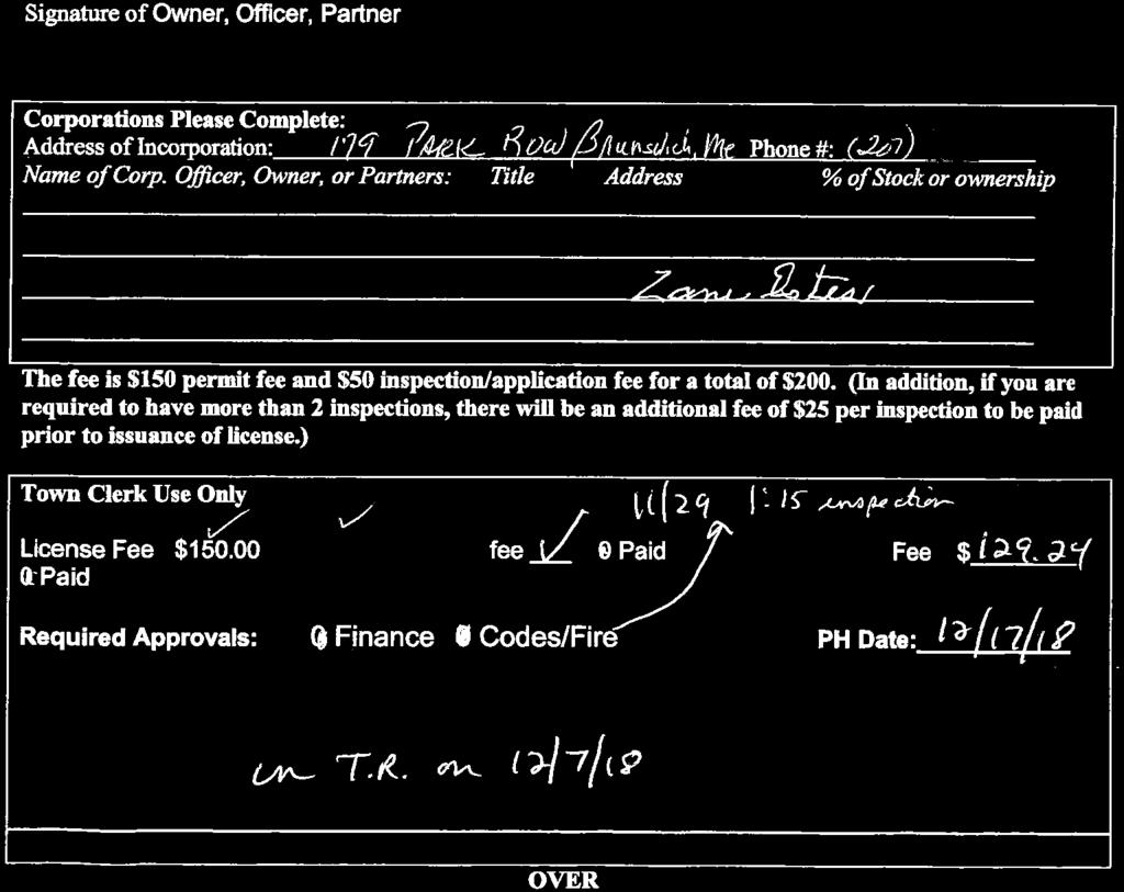
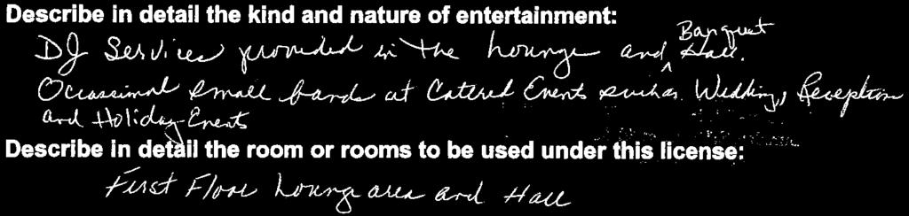
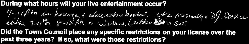
3 Brunswick Town Council Agenda December 17, 2018 Council Notes and Suggested Motions MANAGER S REPORT a) Financial update: Copies of the financial reports through November 30 th are included in the packet. b) Holiday trash and recycling pick-up schedule: No curbside trash & recycling collection on December 25 th and January 1 st. The makeup days will be December 29 th and January 5 th. The Public Works Department and the Graham Road Landfill will be closed on December 25 th and January 1 st. Christmas trees undecorated and unbagged will be picked up between January 2 nd and January 15 th on your normal trash day. For more information, call Public Works or visit the Town s website. c) Dog License Reminder: 2019 dog licenses are available in the Town Clerk s office. To renew by mail include the dog s name and rabies vaccination certificate. The cost is $6 for a spayed or neutered dog and $11 for a non-altered dog. The fee goes up substantially after January 31 st. For more information, check the Clerk s page on the Town s website. d) Town Hall Closed December 24 th, 25 th and January 1 st : Town Hall will be closed on December 24 th. Non-union employees will have the option of working, using vacation time or compensatory time for the day, while AFSCME and Public Works employees (who receive one-half day pay for the 24 th ), may cover the rest of the day by working, using vacation time or compensatory time. Town Hall will also be closed on December 25 th and January 1 st. e) Police Department Unmanned Aerial Vehicle (UAV) Policy: Commander Garrepy of the Police Department has provided to the Council, at their request, the Unmanned Aerial Vehicle Program Policy, which was implemented earlier this year. This policy has been refined several times to protect the privacy rights of the citizens of Brunswick, and will not be utilized any differently that what is constitutionally allowed. Primary purposes will be for trespass detection and emergencies. A copy of a memo from Commander Garrepy and the policy are included in the packet. PUBLIC HEARING 158. Notes: The Brunswick Lodge of Elks #2043 is requesting the renewal of a special amusement license to allow them to provide DJ services in the lounge and banquet hall, occasional small bands and Holiday events. The live entertainment would occur from 7:00 p.m. to 11:00 p.m. in the lounge and when the hall is booked, and DJ services from either 7:00 p.m. to 11:00 p.m or 8:00 p.m. to 12:00 a.m. on the weekends. A copy of their application and the public hearing notice are included in the packet. Suggested Motion: Motion to approve the renewal of a special amusement license for the Brunswick Lodge of Elks #2043, located at 179 Park Row. 3
4 NEW BUSINESS 159. Notes: The Trust Fund Advisory Committee has recently conducted a Request for Proposals for investment management of the Trust Funds, and recommends that the Council adopt the attached resolution authorizing the Chair of the Town Council and the Town Treasurer to execute an investment, management and related custody agreement with Harpswell Capital Advisors, LLC. DJ Shaughnessey, Chair of the Trust Fund Advisory Committee, and Julia Henze, Finance Director, will be at the meeting to answer questions. A copy of a memo from Ms. Henze and the resolution will be included in the packet. Suggested Motion: Motion to adopt the Resolution Regarding the Investment, Management and Custody of the Town s Trust Funds Notes: The proposed easement amendments to the Miller Point conservation easement seek to increase from three (3) to four (4) dwellings in area 1, while removing the one (1) dwelling allowed in area 2. Under the provisions of the Conservation Easement, the Town of Brunswick has the authority to approve the creation of more than three lots for the construction of more than three dwellings. The Conservation Commission voted unanimously in favor of sending this amendment to the Town Council on November 15, 2018, and no material detraction to the conservation values intended for protection were noted. The Town s attorney has also reviewed this request and concurred with the Conservation Commission. Suggested Motion: Motion to approve proposed amendments to the Miller Point conservation easement Notes: The Willow Grove Homeowners Association is requesting the Town Council convey a Town-owned 0.6 acre triangular-shaped lot (Map U29, Lot 7) to their association. The property was acquired by the Town from the Homeowners Association in 1988 with the intention of establishing a right-of-way through the property for a road connection between Greenwood Road and Arrowhead Drive. The road connection was initially supported by the Planning Board and the Town Council, but the 1994 Comprehensive Plan members were divided on the necessity of the connection, and it has now been 30 years. The Planning Board has recommended approval of this request, and further recommended that the Town Council explicitly state that the Greenwood Road Extension is no longer a viable or desired project. A copy of a memo from Matt Panfil, Director of Planning & Development, and historical documents, are included in the packet. Suggested Motion: Motion to convey a piece of land known as Map U29, Lot 7 to the Willow Grove Homeowners Association. CORRESPONDENCE/COMMITTEE REPORTS Councilors will provide brief updates of recent committee meetings. 4
5 CONSENT AGENDA a) Approval of the minutes of December 3, 2018: A copy of the minutes is included in the packet. b) Approval of a Utility Location Permit on Collinsbrook Road by Northern New England Telephone Operations, LLC and Central Maine Power: Northern New England Telephone Operations, LLC and Central Maine Power are seeking authorization for a pole permit to be located on Collinsbrook Road 1500 southwesterly of Durham Road. A copy of a memo from Town Engineer Ryan Barnes, along with the permit application and map are included in the packet. Suggested Motion: Motion to approve the Consent Agenda Suggested Motion: Motion to adjourn 5
6 MANAGER S REPORT - A BACK UP MATERIALS
7 12/03/ :51 Town of Brunswick P 1 bperreault NOVEMBER 2018 EXPENDITURE REPORT glytdbud FOR ORIGINAL TRANFRS/ REVISED AVAILABLE PCT APPROP ADJSTMTS BUDGET YTD EXPENDED ENCUMBRANCES BUDGET USED 00 Fill General Fund Transfers Out 1,700,958 1,075,500 2,776,458 2,780, , % TOTAL Fill 1,700,958 1,075,500 2,776,458 2,780, , % 10 General Government Administration 656, , , , % Finance Department 751, , , , % Technology Services Dept 391, , , , , % Municipal Officers 89, ,415 21, , % Munic Bldg - 85 Union 177, ,899 65, , , % Munic Bldg - 28 Federal % Risk Management 490, , , , % Employee benefits , , % Cable TV 86, ,555 30, , % Assessing 297, , , , , % Town Clerk & Elections 365, , , , % Planning Department 570,612 5, , , , , % Economic Development Dept 128, ,139 43, , % TOTAL General Government 4,004,947 5,897 4,010,844 1,426, , ,548, % 20 Public Safety Fire Department 3,450, ,450,611 1,295, , ,110, % Central Fire Station 46, ,500 9, , , % Emerson Fire Station 61,225 40, ,225 19, , , % Police Department 4,077, ,077,318 1,593, , ,480, % Police Special Detail , , % Emergency Services Dispatch 848, , , , % Police Station Building 112, ,098 40, , % Marine Resources 221, ,839 51, , % Streetlights 220, ,000 78, , % Traffic Signals 31, ,600 3, , % Hydrants 493, , , , % Civil Emergency Preparedness 2, , , %
8 12/03/ :51 Town of Brunswick P 2 bperreault NOVEMBER 2018 EXPENDITURE REPORT glytdbud FOR ORIGINAL TRANFRS/ REVISED AVAILABLE PCT APPROP ADJSTMTS BUDGET YTD EXPENDED ENCUMBRANCES BUDGET USED TOTAL Public Safety 9,565,594 40,000 9,605,594 3,530, , ,983, % 30 Public Works Public Works Administration 586, , , , , % PW General Maintenance 1,839, ,839, , , ,243, % Refuse Collection 658, , , , , % Recycling 341, , , , , % PW Central Garage 739, , , , , % TOTAL Public Works 4,165, ,165,022 1,188, , ,369, % 40 Human Services General Assistance 180, ,999 67, , , % Health & Social Services 2, ,826 1, , % TOTAL Human Services 183, ,825 69, , , % 45 Education School Department 38,132, ,132,210 10,445, ,686, % TOTAL Education 38,132, ,132,210 10,445, ,686, % 50 Recreation and Culture Recreation Administration 455, , , , % Rec Buildings and Grounds 895,868 48, , , , , % Rec Building ,729 17, ,724 89, , , % Teen Center 17, ,525 17, % People Plus 132, , , , % Curtis Memorial Library 1,484, ,484, , , % TOTAL Recreation and Culture 3,197,541 66,588 3,264,129 1,415, , ,827, % 60 Intergovernmental
9 12/03/ :51 Town of Brunswick P 3 bperreault NOVEMBER 2018 EXPENDITURE REPORT glytdbud FOR ORIGINAL TRANFRS/ REVISED AVAILABLE PCT 60 Intergovernmental APPROP ADJSTMTS BUDGET YTD EXPENDED ENCUMBRANCES BUDGET USED County tax 1,565, ,565,279 1,565, % TOTAL Intergovernmental 1,565, ,565,279 1,565, % 70 Unclassified Promotion and Development 284,094 3, , , , , % Additional School Assistance 10, , , % Cemetery Care 3, , , % Wage Adjustment Account 181,408-3, , , % TOTAL Unclassified 478, , , , , % 80 Debt Service CIP G/O Bonds 220, , , , % GO CIP Bonds 216, , , , % Police Station Bond 383, , , , % Elementary School Bond ,280, ,280, % Sch Revolving Reno Fund Bond , , % CIP GO Bonds 172, , , , % TOTAL Debt Service 992, ,458 2,346, ,353, % GRAND TOTAL 63,986,336 1,188,844 65,175,180 25,037, , ,376, % ** END OF REPORT - Generated by Branden Perreault **
10 12/03/ :47 Town of Brunswick P 1 bperreault NOVEMBER 2018 REVENUE REPORT glytdbud FOR ORIGINAL ESTIM REV REVISED ACTUAL YTD REMAINING PCT ESTIM REV ADJSTMTS EST REV REVENUE REVENUE COLL 10 Taxes Property Taxes 41,487, ,487,405 41,348, , %* Deferred Property Tax -200, , , % Tax Abatements -75, ,000-39, , % Interest on Taxes 70, ,000 19, , %* Tax Lien Costs Revenu 15, ,000 13, , %* Tax Lien Interest Rev 16, ,000 18, , %* Payment in Lieu of Ta 250, ,000 36, , %* BETE reimbursement 543, , , %* Homestead exemption r 1,020, ,020, , , %* Miscellaneous tax adj 6, , , %* Excise Tax - Auto 3,300, ,300,000 1,637, ,662, %* Excise Tax Boat/ATV/S 25, ,000 5, , %* Excise Tax - Airplane 2, , , %* TOTAL Taxes 46,461, ,461,532 43,855, ,605, % 20 Licenses & Fees TOTAL REVENUES 46,461, ,461,532 43,855, ,605, Passport Fees 16, ,000 10, , %* Passport Picture Reve 6, ,000 3, , %* Building Permits 175, , , , %* Electrical Permits 35, ,000 30, , %* Plumbing Permits 25, ,000 17, , %* Zoning Board Fees %* Hunting & Fishing Lic %* Dog License Fee 2, , , %* Vital Statistics 48, ,000 21, , %* General Licenses 31, ,435 3, , %* Victulars/Innkeepers 23, ,135 5, , %* Shellfish Licenses 31, ,775 1, , %* Neutered/Spayed Dog L 4, , , %* Mooring fees 16, , , %* Planning Board Appl F 28, ,000 12, , %* Fire Permits 2, , , %* Conc Weapons Permits %* Parking Permit fee %* Public Works Opening 21, ,000 16, , %*
11 12/03/ :47 Town of Brunswick P 2 bperreault NOVEMBER 2018 REVENUE REPORT glytdbud FOR ORIGINAL ESTIM REV REVISED ACTUAL YTD REMAINING PCT ESTIM REV ADJSTMTS EST REV REVENUE REVENUE COLL TOTAL Licenses & Fees 467, , , , % 30 Intergovernmental TOTAL REVENUES 467, , , , Highway Grant Fund 200, , , , %* State General Assista 25, ,000 4, , %* IFW-MerePoint Boat La 9, , , %* State Tax Exemption R 45, ,000 29, , %* State Revenue Sharing 1,138, ,138, , , %* Snowmobile Receipts 1, , , %* State Education Subsi 9,858, ,858,866 3,953, ,904, %* TOTAL Intergovernmental 11,278, ,278,915 4,721, ,557, % 40 Charges for services TOTAL REVENUES 11,278, ,278,915 4,721, ,557, Agent Fee Auto Reg 50, ,000 22, , %* Agent Fee Boat/ATV/Sn 1, , , %* Rental of Property 1, , %* Advertising Fees , , %* Ambulance Service Fee 900, , , , %* Special Detail - Fire 1, ,000 4, , %* Witness Fees 2, , , %* Police Reports 3, ,500 1, , %* School Resource Offic 92, ,000 92, %* Special Detail - Poli 3, ,000 11, , %* Dispatch Services fee 152, ,516 71, , %* PW Labor & Materials , , %* Recycling Revenue 15, ,000 9, , %* School Tuition, etc 98, ,349 7, , %* Rental of Property 1, ,500 1, %* TOTAL Charges for services 1,321, ,321, , , % 50 Fines & Penalties TOTAL REVENUES 1,321, ,321, , , Gen License Late Pena %*
12 12/03/ :47 Town of Brunswick P 3 bperreault NOVEMBER 2018 REVENUE REPORT glytdbud FOR ORIGINAL ESTIM REV REVISED ACTUAL YTD REMAINING PCT ESTIM REV ADJSTMTS EST REV REVENUE REVENUE COLL Mooring Fee Late Pena %* Victualers Lic Late P %* Unlicensed Dog Fines 6, , , %* False Alarm Fire 1, , , %* Fire Code Violation F %* Ordinance Fines %* Parking Tickets 30, ,000 11, , %* Leash Law Fines %* False Alarm Police %* TOTAL Fines & Penalties 39, ,495 13, , % 60 Interest earned TOTAL REVENUES 39, ,495 13, , Interest Earned 215, , , , %* TOTAL Interest earned 215, , , , % 70 Donations TOTAL REVENUES 215, , , , BDC Contrib to Econ D 25, , , %* TOTAL Donations 25, , , % 80 Use of fund balance TOTAL REVENUES 25, , , Unapprop General Fund 500,000 1,105,500 1,605, ,605, %* Bal of State Revenue 100, , , %* School Balance Forwar 2,611, ,611, ,611, %* TOTAL Use of fund balance 3,211,364 1,105,500 4,316, ,316, % 90 Other TOTAL REVENUES 3,211,364 1,105,500 4,316, ,316, Administration Miscel , , %*
13 12/03/ :47 Town of Brunswick P 4 bperreault NOVEMBER 2018 REVENUE REPORT glytdbud FOR ORIGINAL ESTIM REV REVISED ACTUAL YTD REMAINING PCT ESTIM REV ADJSTMTS EST REV REVENUE REVENUE COLL Finance Miscellaneous 3, ,000 1, , %* Property & Casualty D , , %* W/C Proceeds , , %* Cable Television 275, ,000 70, , %* Gen Govt Asset Sales %* Codes Miscellaneous %* Town Clerk Miscellane 1, ,750 1, %* Planning Miscellaneou %* Fire Miscellaneous 1, , %* Fire Vehicle Sales , , %* Police Miscellaneous %* Public Works Miscella 1, , , %* School Miscellaneous 83, ,000 12, , %* Recreation Miscellane 1, , , %* General Fund Transfer 600,000 40, , , %* TOTAL Other 966,400 40,000 1,006, , , % TOTAL REVENUES 966,400 40,000 1,006, , , GRAND TOTAL 63,986,336 1,145,500 65,131,836 49,865, ,266, % ** END OF REPORT - Generated by Branden Perreault **
14 MANAGER S REPORT - B NO BACK UP MATERIALS
15 MANAGER S REPORT - C NO BACK UP MATERIALS
16 MANAGER S REPORT - D NO BACK UP MATERIALS
17 MANAGER S REPORT - E BACK UP MATERIALS


18

19

20
21
22
23
24

25

26

27
28
29 ITEM 158 BACK UP MATERIALS

30


31
32
33

34
35 ITEM 159 BACK UP MATERIALS
36 Town of Brunswick, Maine OFFICE OF THE FINANCE DIRECTOR M E M O R A N D U M TO: FROM: John Eldridge Town Manager Julia Henze, Finance Director For the Trust Fund Advisory Committee DATE: November 30, 2018 SUBJECT: Proposed item for Town Council Meeting: Committee recommendation of investment management firm The Trust Fund Advisory Committee is recommending a new investment firm for the management of the Town of Brunswick Trust Funds. The Committee is charged with overseeing the investment of the funds, including regular review and evaluation of investment performance, and is responsible to make investment and management recommendations to the Town Council. The Brunswick Trust Funds have been professionally managed by an investment firm since Based on a review of the investment performance and management fees over the past ten years, and an analysis of the needs of the Funds, the Committee decided to solicit proposals for investment management services. A Request for Proposals for Investment Management Services was distributed on October 2, 2018, and proposals were received on October 31, The Committee reviewed the proposals, and invited two firms to meet with the Committee. Based on the interviews conducted on November 27 th, the Committee has selected Harpswell Capital Advisors, LLC to recommend to the Town Council. The Trust Fund Advisory Committee recommends that the Council adopt the attached resolution authorizing the Chair of the Town Council and the Town Treasurer to execute an investment, management and related custody agreement with Harpswell Capital Advisors, LLC. DJ Shaughnessey, chair of the Trust Fund Advisory Committee, and I will attend the Council meeting, and we will be happy to answer any questions.
37 TOWN OF BRUNSWICK, MAINE RESOLUTION REGARDING THE INVESTMENT, MANAGEMENT AND CUSTODY OF THE TOWN'S TRUST FUNDS WHEREAS, The Town of Brunswick Town Council is responsible for the investment and management of a number of Trust funds and may be responsible for additional Trust funds in the future; and WHEREAS, the Town has an established Trust Fund Advisory Committee that is responsible for making investment and management recommendations to the Town Council; and WHEREAS, the Town Treasurer is responsible for implementing the investment and management decisions made by the Town Council; and WHEREAS, since 1994 the Trust funds have been professionally managed by an investment firm; and WHEREAS, after issuing a Request for Proposal for Investment Management Services, reviewing responses and interviewing representatives of investment firms, the Trust Fund Advisory Committee has selected Harpswell Capital Advisors, LLC as the preferred investment firm to recommend to the Town Council; and WHEREAS, the Town Treasurer has negotiated a proposed investment, management and custody agreement with Harpswell Capital Advisors, LLC, which has been reviewed by the Town Attorney; NOW THEREFORE BE IT RESOLVED: 1. The Town Council Resolution Regarding the Investment, Management and Custody of the Town s Trust Funds dated December 19, 1994 is hereby repealed and replaced; 2. The Chair of the Town Council and Town Treasurer are authorized to execute the proposed investment, management and custody agreement with Harpswell Capital Advisors, LLC; 3. The Town Treasurer is authorized to take all actions necessary to implement the agreement with Harpswell Capital Advisors, LLC. 4. The individual trust funds shall continue to be pooled in a single portfolio for the purpose of investment management and custody. The Town Treasurer shall ensure that, after deducting expenses, income and principal gains and losses are properly allocated among the pooled funds. 5. The Trust Fund Advisory Committee shall continue to be a three-member committee appointed by the Town Council for fixed three-year terms. The Town Treasurer and a
38 Town Council member designated by the Town Council shall serve as non-voting members of the Committee. The Committee shall annually elect a chairman. The Town Treasurer shall act as Secretary and be responsible for recording minutes of Committee meetings. 6. The Trust Fund Advisory Committee shall administer the funds under the Uniform Prudent Management of Institutional Funds Act, and is authorized to establish investment objectives that in its judgment are most appropriate for the pooled funds. 7. The objectives shall be forwarded to Harpswell Capital Advisors, LLC which shall manage the portfolio in accordance with, and be evaluated on its ability to meet the investment objectives. The Trust Fund Advisory Committee shall evaluate performance at least semi-annually and make a record of its evaluation. 8. The Trust Fund Advisory Committee shall annually report the activities of the Trust Funds to the Town Council. Proposed to Town Council: December 17, 2018 Adopted by Town Council:
39 ITEM 160 BACK UP MATERIALS
40 MEMORANDUM TO: FROM: John Eldridge, Town Manager Matt Panfil, AICP CUD, LEED AP BD+C, Director of Planning & Development Jared Woolston, AICP Town Planner DATE: December 17, 2018 SUBJECT: Miller Point Easement Amendment On November 15, 2018, the Brunswick Conservation Commission reviewed a proposed amendment to the Miller Point conservation easement from landowners: Rob and Nancy King. The proposed conservation easement amendment seeks to increase the number of allowed houses within the protected premises from three (3) dwellings to four (4) dwellings on Area 1, so-called; and remove the one (1) allowed dwelling on Area 2, socalled. The reserved rights for development within Area 1 and Area 2 are described on page 4 of the recorded Miller Point conservation easement (Book 15378, Page 262). The Conservation Commission voted unanimously (4-0) to: advise the Town Council that the King s request to increase the house lots on Area 1 may be increased to four (4) dwellings provided the dwelling on Area 2 is removed from the easement. No material detraction to the conservation values intended for protection in the Miller Point conservation easement were noted by the Conservation Commission. However, Commissioner Tom Rumpf advised that the Town Attorney should consult with Maine s Attorney General to determine if the proposed easement amendment complies with State law. To be clear, Maine statute at Title 33 subsection 477-A (2) states the following: 2. Amendment and termination. Amendments and termination of a conservation easement may occur only pursuant to this subsection. A. A conservation easement executed on or after the effective date of this section must include a statement of the holder's power to agree to amendments to the terms of the conservation easement in a manner consistent with the limitations of paragraph B. [2007, c. 412, 4 (NEW).] B. A conservation easement may not be terminated or amended in such a manner as to materially detract from the conservation values intended for protection without the prior approval of the court in an action in which the Attorney General is made a party. In making this determination, the court shall consider, among other relevant factors, the purposes expressed by the parties in the easement and the public interest. If the value of the landowner's estate is
41 increased by reason of the amendment or termination of a conservation easement, that increase must be paid over to the holder or to such nonprofit or governmental entity as the court may designate, to be used for the protection of conservation lands consistent, as nearly as possible, with the stated publicly beneficial conservation purposes of the easement. [2007, c. 412, 4 (NEW).] At the Conservation Commission s request, the Town Attorney reviewed the above referenced statue and provided a legal opinion that the statute does not apply to this request as it does not materially detract from the conservation values intended for protection. Cc Sandy Stott, Chair Kurt Stinson, Vice Chair Enclosures: Miller Point Easement, page 4 (Notes from King s attorney); and Draft easement map prepared by Sarah Witte and entitled, Potential Location of Four Homes dated November 8, 2018.


42


43


44


45


46

47
48 Memorandum To: Matt Panfil From: John Cunningham Date: December 12, 2018 Re: Miller Point / Request to Move a House Lot from Area 2 to Area 1 The Kings have made two requests to the Town Council (those proposals are attached). The intended purpose is to move an allowed house lot from Area 2 of the Conservation Easement to Area 1. First, Section 3(a)(i) of the easement says the Kings need the Holder s (the Town s) approval to create more than 3 house lots in Area 1. So, the first request is for the Town to approve the creation of 4 house lots in Area 1. A copy of page 4 of the Conservation Easement is attached; it contains the relevant provisions. Second, Section 3(a)(ii) gives the Kings the right to put one house lot in Area 2, but there s no provision for the Kings to waive or give that up. So, the second request is to amend the conservation easement to give up the house lot in Area 2. The net effect of these two requests is to move a house lot from Area 2 to Area 1. The Kings would still only be allowed 4 house lots, but they d be combined in Area 1 rather than spread out over both areas. The Conservation Commission recommended that the Council approve our requests. Obviously, the two proposals are linked. The Kings would not expect the Town to increase the number of allowed house lots in Area 1 without a compensating reduction elsewhere, and the Kings would not be willing to give up the allowed house lot in Area 2 without gaining a house lot in Area 1. The question was asked, based on the statute requiring court review of some conservation easement amendments (33 MRS 477-A(2)), whether it would be necessary to consult with the Attorney General s office concerning the proposed amendment (the statute only applies to conservation easement amendments). The key point here is that the Kings are only asking for one amendment, namely, to eliminate a house lot from Area 2. (The possibility of the Town approving additional house lots in Area 1 was already included in the conservation easement when it was granted, so no amendment is needed for that proposal). The statute only relates to amendments that would materially detract from the conservation values. We hope that the Town will agree that an amendment to eliminate a potential house lot cannot possibly detract from the conservation values.
49 AGREEMENT AND APPROVAL The Town of Brunswick (the Town ) is the holder of the conservation easement dated March 21, 2000, entitled Conservation Easement Deed and Indenture Miller Point, and recorded in the Cumberland County Registry of Deeds in Book 15378, Page 259 (the Easement ). Nancy P. King and Robert C. King (the Kings ) are the Grantors of the Easement and the current owners of the land in Brunswick, Cumberland County, Maine, that is subject to the Easement. Section 3(a)(i) of the Easement provides that the Kings may create no more than three lots and three dwellings in Area 1 (as defined in the Easement) without the approval of the Town. The Kings now seek the approval of the Town to create up to four lots and dwellings in Area 1. The Town and the Kings agree as follows. 1. The Town approves and agrees that the Kings (and their heirs, devisees, and assigns as owners of the land subject to the Easement) may create up to four lots and dwellings in Area 1, subject to all the provisions of Section 3(a)(i) of the Easement. 2. This agreement and approval shall take effect only upon the amendment of the Easement to remove the right of the Kings (and their heirs, devisees, and assigns as owners of the land subject to the Easement) to construct a dwelling in Area 2 (as defined by the Easement). Witness our hands and seals as of this day of December, Town of Brunswick Witness By John S. Eldridge, Town Manager Witness Nancy P. King Witness Robert C. King - 2 -
50 STATE OF MAINE Cumberland County December, 2018 Personally appeared the above named John S. Eldridge, Town Manager of the Town of Brunswick, and acknowledged before me the foregoing instrument to be his free act and deed in his said capacity and the free act and deed of the Town of Brunswick. Notary Public/Attorney at law Print or type name as signed STATE OF MAINE Cumberland County December, 2018 Personally appeared the above named Nancy P. King and Robert C. King and acknowledged before me the foregoing instrument to be their free act and deed. Notary Public/Attorney at law Print or type name as signed - 3 -
51 AMENDMENT The Town of Brunswick (the Town ) is the holder of the conservation easement dated March 21, 2000, and recorded in the Cumberland County Registry of Deeds in Book 15378, Page 259 (the Easement ). Nancy P. King and Robert C. King (the Kings ) are the owners of the land in Brunswick, Cumberland County, Maine, that is subject to the Easement. The Town and the Kings agree to amend the Easement as follows. The first sentence of Section 3(a)(ii) of the Easement, which sentence reads: The Grantors reserve right to site, construct, maintain, repair, alter, renovate, remove and replace one (1) dwelling together with permitted structures on the Protected Premises east of Miller Creek within Area 2 as shown on Exhibit A, as permitted by the Town of Brunswick land use ordinances, is hereby deleted. The remaining text of Section 2(a)(ii) remains unchanged and in effect. Witness our hands and seals as of this day of December, Town of Brunswick Witness By John S. Eldridge, Town Manager Witness Nancy P. King Witness Robert C. King - 4 -
52 STATE OF MAINE Cumberland County December, 2018 Personally appeared the above named John S. Eldridge, Town Manager of the Town of Brunswick, and acknowledged before me the foregoing instrument to be his free act and deed in his said capacity and the free act and deed of the Town of Brunswick. Notary Public/Attorney at law Print or type name as signed STATE OF MAINE Cumberland County December, 2018 Personally appeared the above named Nancy P. King and Robert C. King and acknowledged before me the foregoing instrument to be their free act and deed. Notary Public/Attorney at law Print or type name as signed - 5 -


53
54 ...,. '.# Bt PG CONSERVATION EASEMENT DEED AND INDENTURE MILLER POINT TIIlS CONSERVATION DEED AND INDENTURE is made this o2 / day of ::mo.aen, 2000, between ROBERT C. KING, JR. and NANCY P. KING of 14 Knollwood Road, Short Hills, New Jersey (hereinafter referred to as the "Grantor") and the TOWN OF BRUNSWICK, a Maine municipality ("Holder"). WHEREAS, this Conservation Easement is being given to the Holder to satisfy an alternative condition of approval imposed by the Town of Brunswick Planning Board in the approval of the Grantors' application for the construction of a portion of a driveway within the setback from a high to moderate value wetland on an a parcel of land adjacent to the Protected Premises known as Miller Point [see minutes of Brunswick Planning Board dated March 9, 1999]. As voted by the Planning Board, this Conservation Easement is being granted in lieu of the Grantors' unilateral imposition of restrictive covenants on the Protected Premises that meet the other conditions of approval voted by the Planning Board. WHEREAS, Grantors hold title to approximately one hundred fifteen and 4/10 (115.4) acres of real property situated on Miller Point, so called, on Middle Bay, between John's Point and Mere Point (hereinafter referred to as "Miller Point"), and approximately nine and eight tenths (9.8) acres of land known as Lots C and Don John's Point, on Middle Bay between Simpson's Point and Miller Point (hereinafter referred to as "John's Point"), in Brunswick, Cumberland County, Maine, described on the attached survey entitled "Standard Boundary Survey of Miller Point and John's Point Road & Simpson Point Road Brunswick, Maine", for Robert C. King, Jr. and Nancy P. King, by Owen Haskell, Inc., dated January 6, 2000, to be recorded in the Cumberland County Registry of Deeds, attached hereto and made a part hereof at EXIDBIT A ( collectively referred to as the "Property" or the "Protected Premises") acquired by deeds recorded in the Cumberland County Registry of Deeds at: Book 14635, Page 301[Miller Point]; Book 14635, Page 303; [Miller Point] and Book 14657, Page 47, [Lot D, John's Point]; and, Book 15254, Page 304, [Lot C, John's Point] reference is also made to "Amended Subdivision Plan of John's Point, Simpson Point Road, Brunswick, :ME by Owen Haskell, Inc., dated March 4, 1999, to be recorded in the Cumberland l
55 - I, ;., I 4 St I PG Com1ty Registry of Deeds [Lots C and D, John's Point] (hereinafter referred to as the "John's Point Plan"); and, WHEREAS, in connection with the Grantor's plan to establish up to four (4) new dwellings on Miller Point (for a total of not more than five (5) dwellings on Miller Point, including the so-called Chase Homestead) and one (1) new dwelling on John's Point (sometimes referred to as the "permitted dwellings"), the delivery to the Holder of a conservation easement on the adjacent land heretofore owned by John's Point Association (hereinafter referred to as the "John's Point Common Land") by the Grantors and Gregory A. Kelly, MD and Lynda L. Kelly; the Grantors' development of a common access driveway (hereinafter referred to as "driveway") across the said adjacent John's Point Common Land from Simpson's Point Road to the Protected Premises, the Grantors wish to protect, in perpetuity, the natural, scenic, open space, recreational, wildlife and aesthetic values of the Property, for the benefit of the Protected Premises, the adjacent land owned by the Grantors and others on John's Point, the Town of Brunswick, and the protection of the Protected Premises' conservation values; and, WHEREAS, Holder is qualified and willing to accept the grant of this Conservation Easement Deed and Indenture pursuant to Internal Revenue Code, 26 U.S.C.A. l 70(h)(3), and the Maine Uniform Conservation Easement Act, 33 M.R.S.A. 476 et seq.; In consideration of the foregoing and the covenants herein contained, Grantors do hereby GRANT WITH WARRANTY COVENANTS to Holder, its successors and assigns, a conservation easement over the Protected Premises, subject to the reservation of rights unto Grantors for the benefit of the Protected Premises, all as follows: 1. PURPOSE. The purpose hereof is to preserve and protect in perpetuity the natural, scenic, open space, recreational, wildlife and aesthetic values of the Protected Premises, through the continuation of responsible conservation practices and recreational uses. For the purpose of this Conservation Easement the Protected Premises are defined as those areas of the Property not containing accessory and appurtenant structures to the permitted dwellings, septic systems and their components, driveways, turnouts and turnarounds. 2. AFFIRMATIVE RIGHTS CONVEYED TO THE HOLDER. Grantors convey to Holder the following affirmative rights: 2
56 - 8[ l PG 2 6 I a) The right to identify, to preserve and to protect in perpetuity the natural, scenic, open space, recreational, wildlife and aesthetic values of the Protected Premises. b) Upon advance written notice to the Grantors, the right to enter upon the Protected Premises not more often than once a quarter in any manner that will not unreasonably interfere with the permitted uses being made of the Protected Premises, for the sole purposes of inspection and to take any action as may be necessary, with or without order of Court, to remedy or abate any violation of this Easement; provided, however, in the event Holder has a reasonable belief that there has been, or there is ongoing, a violation of this easement, Holder may enter the Protected Premises at reasonable intervals to assess and see to the remediation of such violation. c) The right to enforce the covenants herein set forth. d) The right of the Protected Premises to be free of any taint, corruption or pollution of whatever character arising from any use of the Protected Premises in a manner not permitted hereunder. 3. RESERVED RIGlfl'S, RESIDENTIAL STRUCTURES and USES. By this Conservation Easement as more particularly set forth in this instrument, the Grantors reserve certain rights to construct, conserve, raze repair and maintain structures within the Development Areas shown on Exhibit A (individually sometimes hereinafter referred to as "Area" followed by the area number appearip.g on Exhibit A) and to utilize the Development Areas to the fullest non commercial residential potential permitted by the applicable land use ordinances and regulations. The rights reserved by the Grantors with respect to the Development Areas are to utilize the Development Areas for any residential purposes and uses permitted by the Town of Brunswick, State of Maine and federal land use ordinances, statutes and regulations and on three (3) Areas to construct therein not more than five (5) single family dwellings in the aggregate (three (3) within Area 1, one (1) within Area 2 and one (1) west of Miller Creek in Area 3), together with all appurtenant structures permitted in the zone within which the Development Areas are located. As used herein, the words "non commercial" shall not be construed to prevent the owner of any permitted dwelling to rent the dwelling or portions thereof for residential use or to prevent the use of a dwelling for any athome bu~iness or home occupation that is permitted by the Town of Brunswick land use ordinances in the applicable zoning district and, to the extent the use is 3
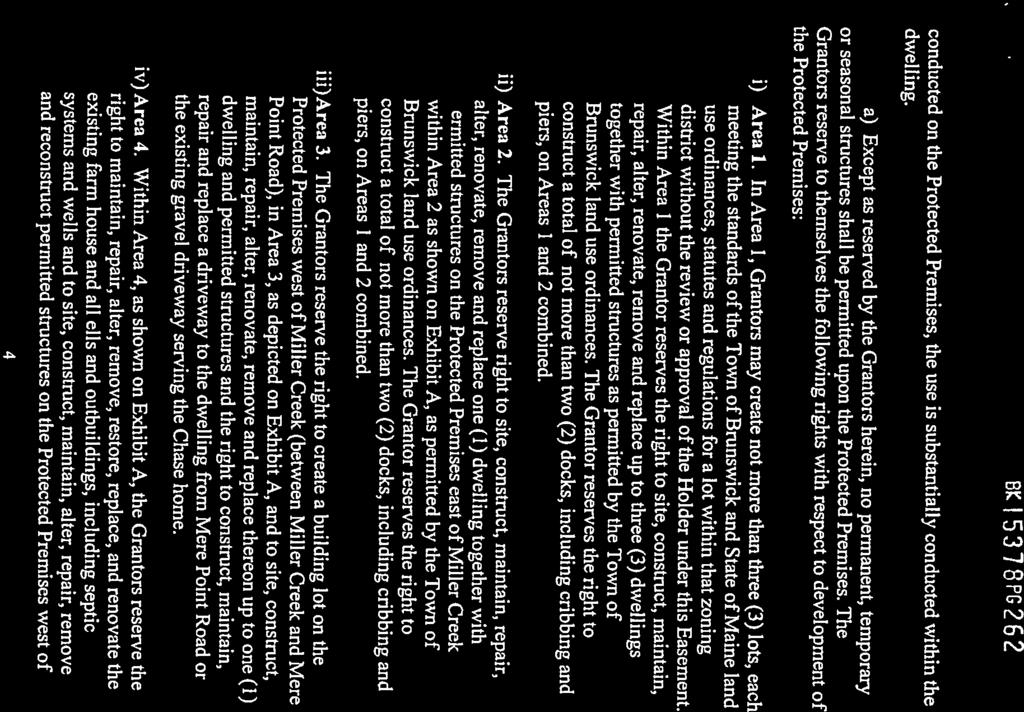
57 ,. BK I PG conducted on the Protected Premises, the use is substantially conducted within the dwelling. a) Except as reserved by the Grantors herein, no permanent, temporary or seasonal structures shall be permitted upon the Protected Premises. The Grantors reserve to themselves the following rights with respect to development of the Protected Premises: i) Area 1. In Area I, Grantors may create not more than three (3) lots, each meeting the standards of the Town of Brunswick and State of Maine land use ordinances, statutes and regulations for a lot within that zoning district without the review or approval of the Holder under this Easement. Within Area 1 the Grantor reserves the right to site, construct, maintain, repair, alter, renovate, remove and replace up to three (3) dwellings together with permitted structures as pemtltted by the Town of Brunswick land use ordinances. The Grantor reserves the right to. construct a total of not more than two (2) docks, including cribbing and piers, on Areas I and 2 combined. ii) Area 2. The Grantors reserve right to site, construct, maintain, repair, alter, renovate, remove and replace one (I) dwelling together with permitted structures on the Protected Premises east of Miller Creek within Area 2 as shown on Exhibit A, as permitted by the Town of Brunswick land use ordinances. The Grantor reserves the right to construct a total of not more than two (2) docks, including cribbing and piers, on Areas I and 2 combined. iii)area 3. The Grantors reserve the right to create a building lot on the Protected Premises west of Miller Creek (between Miller Creek and Mere Point Road), in Area 3, as depicted on Exhibit A, and to site, construct, maintain, repair, alter, renovate, remove and replace thereon up to one (1) dwelling and permitted structures and the right to construct, maintain, repair and replace a driveway to the dwelling from Mere Point Road or the existing gravel driveway serving the Chase home. iv) Area 4. Within Area 4, as shown on Exhibit A, the Grantors reserve the right to maintain, repair, alter, remove, restore, replace, and renovate the existing farm house and all ells and outbuildings, including septic systems and wells and to site, construct, maintain, alter, repair, remove and reconstruct permitted structures on the Protected Premises west of 4
![f f.. - +' 11 -a.t:: l 5378 PG 263 - Miller Creek, commonly known as the "Chase home" or the "Homestead," [see Motion of Approval with Conditions, Brunswick Planning Board, March 9, 1999].](/docs-images/92/109359616/images/58-0.jpg "This reserved right includes the right to raze all or part of the structure of the Chase home and the outbuildings and to construct and reconstruct replacements and additions to the Chase home and")
58 f f.. - +' 11 -a.t:: l 5378 PG Miller Creek, commonly known as the "Chase home" or the "Homestead," [see Motion of Approval with Conditions, Brunswick Planning Board, March 9, 1999]. This reserved right includes the right to raze all or part of the structure of the Chase home and the outbuildings and to construct and reconstruct replacements and additions to the Chase home and the outbuildings. b) Grantors reserve the right to apply to the Town of Brunswick Planning Board to expand Area I by approximately 2 acres by relocating that portion of the westerly boundary of Area 1 (now 250 feet from Miller Creek Cove) that is south of the medium value wetland, as determined by the Maine Department of Inland Fisheries and Wildlife, in a westerly direction to coincide with the applicable shoreland setback for the siting of "principal and accessory structures" ( currently 125 feet from normal high water line); and, if the Planning Board votes to permit such expansion, Area 1 shall, without the need for further Holder approval and upon the recording of the vote of the Planning Board in the Cumberland County Registry of Deeds and the delivery of notice of the Planning Board vote to the Holder, be automatically expanded to the applicable shoreland setback. c) Examples of structures and uses that are permitted within the Development Areas include but are not be limited to the following: permitted residential structures, attached and detached garages, water wells and associated mains, pumps and well houses, septic systems, tennis courts, paddle tennis courts, swimming pools and associated pool buildings and fencing, skating rinks, basketball courts, shuffle-board courts, volleyball courts, tether-ball courts, horseshoe pits, croquet courts, play equipment (swing sets, trampolines, jungle gyms, slides, teeter totters, play houses and forts, etc.), equestrian rings, lawns, gazeboes, greenhouses, composting areas, gardens of all types, fountains, stables, barns, workshops,~arden and storage sheds, pet and dog houses and runs, patios, decks, porches,.-exterior steps and stairs, ladders, walls, fences, paved areas (including walks, driveways and other appurtenant surfaces), storage facilities and structures (boat, automobile, RV, etc.), exterior lighting and light stanchions as necessary to safely enjoy the above; provided, no use or structure shall be for commercial purposes other than an at home business otherwise permitted by local land use ordinances. The foregoing are sometimes referred to in this Easement as "permitted structures." 5
59 ' et PG 2 G t. 4. STRUCTURES. a) The right to retain, repair, maintain, alter, remove, restore and replace all structures that exist on the Protected Premises on the date hereof, to wit: the bridge crossing Miller Creek and the Chase Homestead and accessory structures. b) The right to construct, maintain, repair, alter, remove, restore and replace perimeter fencing and other similar structures as needed for permitted wildlife, aesthetic and recreational purposes and for the protection and/or preservation of the Protected Premises. c) The right to construct, maintain, repair, alter, remove, restore and replace boundary monuments and non-commercial directional, cautionary, informational or instructional signage. d) The right to post the boundaries and perimeter of the Protected Premises with appropriate signage to prohibit trespass and trespass for the purpose of hunting, trapping and use of prohibited motorized vehicles on the Protected Premises. 5. ACCESS DRIVEWAYS. DRIVEWAYS and litilities. Except as specifically reserved by the Grantors herein there shall be no roads or driveways constructed or created on the Protected Premises, meaning and intending that there shall be no roads on the Protected Premises except: a) The driveways shown on the plan presented to the Brunswick Planning. Board on March 9, 1999, entitled "Right of Way Plan, King Property, Brunswick, Maine" by Mitchell & Associates, dated March 5, 1999, exclusive of the unbuilt extension of Tidal Run Lane (unless the Tidal Run Lane extension is needed for access to Lots C and/or D, John's Point): b) The right to retain, repair, maintain, alter, remove, restore and replace all ways that exist on the Protected Premises on the date hereof. c) The right to maintain, repair, pave, alter, remove, restore and replace the existing gravel driveway from Mere Point Road to the Chase home. d) The right to construct, maintain, repair, pave, alter, remove, restore and replace a driveway to and from Mere Point Road to serve Development Area 3 and the dwelling and structures constructed thereon
60 .. 'I '.. 8( "[ PG 265 e) The right to maintain, repair, alter, remove, restore and replace the driveway and bridge crossing Miller Creek immediately east of the Chase home where the old county road, so called, crossed Miller Creek. f) The right to construct, maintain, repair, remove, restore and replace a gravel access driveway from the access driveway constructed by the Grantors across the adjacent John's Point land from Simpson's Point Road to the Protected Premises substantially within the easement corridor shown on Exhibit A. for the exclusive purpose of providing ingress and egress to and from said Simpson's Point Road to the dwellings pennitted in the Developm~nt Areas shown on Exhibit A; provided, however, such driveway may serve a maximum of four (4) dwellings. After the gravel driveway has been fully constructed substantially within the corridor shown on Exhibit A, the Grantors shall have prepared at their expense an "as built" survey showing the location of the gravel driveway, as built, which survey will be recorded in the Cumberland County Registry of Deeds in order to establish the precise location of the driveway corridor on the face of the earth.. g) The right to construct, maintain, repair, alter, remove, restore and replace a gravel driveway to serve the dwelling permitted to be sited and constructed within Area 2 from said dwelling and its appurtenant structures to the access driveway from Simpson's Point Road to Miller Point, so long as the Grantor has not constructed a driveway over the extension of Tidal Run Lane from the existing terminus of Tidal Run Lane to a dwelling in Area 2. The driveway serving Area 2 may cross Area 1. h) The right to construct, maintain, repair, alter, remove, restore and replace above and below ground utility lines, poles and other equipment including but not limited to, electric, telephone and cablevision poles, wires, cables, conduits, pipes, transfonners, relay stations and supporting mechanical devices and housings serving not more than the four (4) dwellings and appurtenant structures permitted on the Protected Premises east of Miller Creek in Areas 1 and 2 along, on and under the access driveway corridor area shown on Exhibit A, from Simpson's Point Road across John's Point Common Land, so called, and to the Protected Premises and along, on and under the driveway and within the driveway corridor from the above mentioned access driveway to the structures within Areas 1 and SURFACE ALTERATIONS. No filling, dumping, excavations or other alterations shall be made to the surface of the Protected Premises other than caused by the forces of nature, except that Grantors reserve unto themselves the following 7
61 . ' St ~ j PG rights and the rights to make surface alterations as necessary to make improvements of the type and nature set forth at paragraph 4 of this easement: a) The right, within the Development Areas shown on Exhibit A, to fill, excavate and alter the surface of the Protected Premises, including but not limited to t4e laying of impervious surfaces such as walkways, sidewalks, paved aprons and driveways and excavating for wells, foundations, footings and basements. b) If, in the opinion of a licensed site evaluator, an insufficient number of suitable septic waste disposal areas exist within the Development Areas shown at Exhibit A, the Grantor reserves the right to construct, install, repair, maintain and replace suitable septic waste disposal areas, together with associated pipes, pumps and mains, outside the Development Area shown on Exhibit A, provided not more than one septic waste disposal field is created for each of the dwellings and appurtenant structures that are permitted within the Development Areas. c) The right to excavate and fill in connection with the construction, maintenance, repair and replacement of the permitted gravel driveways on the Protected Premises, including the driveway to Area 2,, and all appurtenant and adjacent ditches and associated culverts; and, to excavate and fill in connection with the maintenance, repair and replacement of above ground utility lines and poles and underground, utility lines and associated mechanical installations, provided that previous condition of the adjacent land be thereafter promptly substantially restored. d) The right to construct, maintain, repair, alter, remove, restore and replace (but not relocate) the paths and trails shown on Exhibit A to provide pedestrian access to, across and through the Protected Premises and its natural features and access for permitted purposes. e) The right to construct, maintain, repair, alter, remove, restore and replace temporary unpaved ways, such as skidder trails, to provide vehicular access for permitted purposes in a manner intended to minimize material and permanent adverse impact to the Protected Premises. f) With notice to the Holder, the right to excavate and alter small, select portions of the Protected Premises outside of the Development Areas for ecological or archeological purposes, provided that any such excavations shall be done according to generally accepted professional practices and standards in a manner 8
62 '. Bt l "5318PG 261 intended to minimize material and permanent adverse impact to the Protected Premises. g) The right to maintain, repair, rehabilitate, restore and support the pond within the Protected Premises as necessary to preserve the same. 7. TREE CUTTING AND VEGETATION. The destruction or removal of standing trees, plants, shrubs or other vegetation upon the Protected Premises shall not be permitted, except that Grantors reserve unto themselves the following rights: a) The right to cut, trim and remove trees and other vegetation within the Development Areas shown on Exhibit A as deemed necessary by the Gran.tors for the siting and construction of permitted dwellings and appurtenant out buildings and permitted structures. b) The right to mow and cut shrubs, saplings, grasses and other vegetation to maintain, restore and rehabilitate existing open fields, if any and to keep the ditches, culverts and sightlines along the permitted driveways clear. c) The right to graze, cultivate, fertilize, plant and harvest existing open fields west of Miller creek, for non-commercial purposes, employing the best management practices and nutrient loading management plan(s) as established and defined by the Maine Department of Agriculture Food, and Rural Resources, or its successor ; provided, however the prohibition against commercial agricultural purposes shall not be deemed to prohibit a community garden, truck garden, the harvest from which is sold by the Grantor, or the raising and sale of a small number of farm animals or products thereof. d) The right to clear, manage and restore vegetation and forest cover and other vegetation on and within the Protected Premises and the Development Areas, by selective cutting and/or planting so as to promote and maintain the health and aesthetic qualities of the forest and the forest eco-system, as well as the right to clear and restore forest cover and other vegetation that is damaged or destroyed by the forces of nature, such as ice storms, fire or disease, and when necessary to prevent the spread of disease and the elimination or reduction of potential forest fire fuel, in accordance with a plan prepared by a licensed forester in a manner intended to minimize material and permanent adverse impact to the Protected Premises that is not consistent with this right, which plan has been approved by Holder, the approval of which will not be unreasonably withheld. This right 9
63 I ' - st, \ 5318PG268 permits the Grantors to manage the forest for their personal, non-commercial, use to preserve the scenic and natural character of the Protected Premises to enhance wildlife values, and, to the extent possible, considering these goals, to provide a sustained yield of forest products to the Grantors for non-commercial purposes. Clear cutting is strictly prohibited for these purposes unless required to mitigate greater harm to the conservation values of the Protected Premises. Under no circumstances shall this paragraph be deemed to be the reservation of any right to manage and/or harvest the forest cover for commercial purposes, provided, however, the material cut and harvested pursuant to this paragraph may be used by the Grantors and put into the stream of commerce, sold or used as compensation for the forester and/or operator. e) The right to clear, cut and restore forest cover and other vegetation in the event of an emergency, such as when necessary to prevent the spread of fire. 8. PROHIBITED ACTIVITIES. The Protected Premises shall not be used fo~ the following purposes: a) Commercial, industrial, quarrying or mining activities, including but not limited to the stripping of loam or other soil strata. b) Placement or use of trailers or campers on the Protected Premises outside of the Development Areas, provided that such prohibition shall not prevent Grantors, their heirs or assigns, from erecting tents or building not more than four tree houses for occasional and temporary camping or recreational purposes outside of the Development Areas. c) Billboards, antennae or telecommunications apparatus that are visible from any lot, parcel of land, public or private road or driveway outside of the Protected Premises, provided, however, this provision shall not prohibit the erection and use of television, radio and similar antennae within the Development Areas used for the sending and reception of signals to be used by and disseminated by and to the dwellings permitted on and within the Protected Premises (hereinafter referred to as "private antennae") provided, reasonable effort is made to screen any free standing private antennae from view from any public way and residences sited off of the Protected Premises. 9. RESERVED RIGHTS. Grantors reserve unto themselves, as owners of the Protected Premises, the right to use ( or to regulate or prohibit use of) the Protected 10
 The right to regulate, control and prohibit the taking of flora and fauna specimens from the Protected Premises;")
64 ' l J 6( '\ 5318 PG 269 Premises for all purposes not inconsistent with rights of Holder under this grant, including but not limited to: a) The right to regulate, control or prohibit hunting or trapping of animals by any means, including the posting of the Protected Premises; b) The right to regulate, control and prohibit the taking of flora and fauna specimens from the Protected Premises; c) The right to regulate, control or prohibit the use of motorized vehicles on the Protected Premises; and, d) The right to regulate recreational uses such as camping, walking, hiking, bicycling, horseback riding, skiing; gardening and the use of the Protected Premises by pets and domesticated animals; provided, however, all signs prohibiting non-motorized access to the Protected Premises shall be approved by the Holder which approval will not be WU'easonably withheld. The failure of the Holder to grant or deny approval of Grantor's request for approval of signage prohibiting non-motorized access within thirty (30) days of the Holder's receipt of Grantor's request shall be deemed to be approval of the request. If the Grantors erect such signs to prevent or control the imminent threat of damage or injury to the Protected Premises or themselves and/or their families and their guests and invitees, no such advance approval shall be necessary, however notice of the same shall be given to Holder as soon thereafter as reasonably possible. 10. CONSTRUCTION. If uncertainty should arise in the interpretation of this easement, judgment should be made in favor of (a) conserving the Protected Premises outside of the Development Areas in its natural, scenic or open state and (b) preserving the use of the Protected Premises for recreational, wildlife and aesthetic purposes outside of the Development Areas while permitting full use of the driveway and utility rights reserved to the Grantors and allowing the Grantors full residential use and enjoyment of the Development Areas. Nothing herein shall be construed to permit any activity otherwise prohibited by the valid laws and regulations of any federal, state or local government or government agency having competent jurisdiction over the Protected Premises. 11. PUBLIC ACCESS. This easement does not confer upon the public a right of access to the Protected Premises. 12. MONITORING. Holder, its successors and assigns, shall make reasonable efforts from time-to-time to assure compliance by Grantors with all of the 11
65 ., BK f PG 210 covenants and restrictions herein. In exercising its access rights for inspection of the Protected Premises, Holder shall prepare, keep on file and make available to Grantor their monitoring reports for each inspection. 13. ENFORCEMENT. In the event Holder becomes aware of an event or circumstance of noncompliance with the terms and conditions herein set forth. Holder shall give notice to Grantors, their heirs or assigns, of such event or circumstance of noncompliance via certified mail, return receipt requested, and demand corrective action sufficient to abate such event or circumstance of noncompliance and sufficient to restore the Protected Premises to its condition prior to the breach. Failure by Grantors, their heirs or assigns, with reasonable speed to cause discontinuance, abatement or such other corrective action as may be demanded by Holder, shall entitle Holder, at its discretion, to enter the Protected Premises to take such action reasonably necessary to effect such correction without court order, to bring action at law or in equity in a court of competent jurisdiction to enforce the terms hereof, to obtain injunctive relief and to recover any damages arising from such noncompliance. If a court determines a breach thereof, Grantors, their heirs or assigns, shall reimburse Holder for any reasonable costs of restoration, correction and enforcement, including without limitation court costs and reasonable attorney fees. Nothing contained herein shall be construed to preclude Grantors from exhausting their legal remedies to determine whether the event or circumstance to which Holder objected was in fact not in compliance with the terms hereof. Language herein to the contrary notwithstanding, the Grantors shall not be liable, accountable or subject to damages to the Holder or any other party with standing as a Holder for any failure to remediate, abate or stop any activity on, or use of, the Protected Premises by third parties unless the Holder and its successors and assigns establish by a preponderance of the evidence that the Grantors had knowledge of the event or activity and, having such knowledge, failed to make any reasonable effort to prevent further or recurrent events or activity. 14. ESTOPPEL CERTIFICATES. Holder shall, within thirty (30) days after written request of Grantors, their successors and assigns, execute, acknowledge and deliver a written certificate in a fonn suitable for recordation stating that the Grantors are in compliance with the terms hereof, or stating what violations hereof may then exist. 15. COSTS AND TAXES. Grantors agree to bear all costs and responsibility of operation, upkeep and maintenance of the Protected Premises and do hereby relieve, indemnify and hold harmless Holder therefrom. In addition, Grantors
66 : 1'. ' :. ~ BIC i PG 21 I' agree to pay any and all real property taxes and asse&1ments levied by competent authority on the Protected Premises. However, nothing contained herein shall preclude Grantors from delegating the responsibility for payment of all costs as aforesaid and the responsibility for operation, upkeep and maintenance of the Protected Premises to any other party with an interest in the Protected Premises benefiting from the reservation of rights hereunder. 16. GRANT IN PERPETUITY. The conservation easement herein granted shall be a burden upon and shall run with the Protected Premises in perpetuity and shall bind Grantors forever. A copy of the restrictions contained herein or incorporation by reference hereof shall be included in any subsequent deed or legal ins1rument by which Grantors convey any interest (including a leasehold) in the Protected Premises. 17. SUBSEQUENT TRANSFEREES. By acceptance hereof, Holder covenants and agrees, as real covenants running with the land in perpetuity, and not as conditions hereof or as restraints on alienability: (a) that it will hold the conservation easement hereunder in perpetuity for conservation purposes; (b) that it will not transfer rights and obligations hereunder, except to an entity which, as a condition precedent to such transfer, gives Holder and Grantors assurances that it is committed to the conservation purposes hereof and is able to and agrees to enforce the rights granted herein; and ( c) that any such transferee shall be a "Qualified Organization" under Section 170(hX3) of the Internal Revenue Code and a qualified ''holder', under the Maine Uniform Conservation Easement Act, 33 M.R.S.A. 476 et seq., as amended. The rights and obligations of Holder hereunder may not be transferred in any event except with the prior consent of Grantors which consent shall not be unreasonably withheld. 18. NOTICE. All notices and other communications authorized or required hereunder shall be in writing and shall be effective only if sent by certified United States mail, return receipt requested. Notice shall be effective when received. a) All notices to the Grantors and their respective heirs and assigns shall be sent to them at the following addresses or such different address as the Grantors, or their agent shall provide to the Holder using the procedures for giving notice to the Holder: 13
67 : f ',I J 11' \ I B1' PG 212 i) ROBERT C. KING, JR. and NANCY P. KING 14 Knollwood Road Short Hills, New Jersey and JOHN F. LOYD, JR., ESQ. 13 Pleasant Street P. 0. Box40 Brunswick, Maine ii) The heirs and assigns of ROBERT C. KING, JR. and NANCY P. KING at their address( e )s of record served on the Holder by a notice mailed as hereinabove set forth or the records of the Town of Brunswick, Maine Tax Assessor. iii) The foregoing to the contrary notwithstanding, notice to either of the Kings at the address for notice to the Kings shall be deemed to be notice to b(?th Kings. b) Notice to Holder shall be sent to the Town Manager or, other chief executive officer at the Town office at the following address or such different address as the Holder and its successors and assigns shall provide to the Grantors, using the procedures for giving notice to the Grantors: Town of Brunswick 28 Federal Street Brunswick, Maine CONSENT OR APPROVAL OF HOLDER. a) To the extent the word "Holder" as used herein shall mean and refer to the Holder as a municipality, and in all events where the consent or approval of the Holder is required and no municipal permit is also required, the approval or consent of the Holder shall be sought by an application to the chief executive officer of the municipality or its successor (e.g., Town Manager). Except as may otherwis~ be specified herein, when the approval or consent of the Holder is required for an action or activity that does not otherwise require a municipal permit, the Holder shall have sixty (60) days from the date a request for approval

68 ., '. or consent is made by the Grantors to consider the request, and Holder's failure to deny such request within said sixty (60) day period and any permitted extension period shall be deemed to evidence Holder's consent to the request. If Holder denies any such request; to be effective as a denial, the denial shall be in writing and shall contain the reasons for denial and findings of fact upon which the denial is based. To be effective, the denial of a request for approval or consent shall be signed by the Town Manager or other chief executive officer of the Holder. b) Permits. To the extent the word "Holder'' as used herein shall mean and refer to the Holder as a municipality, and to the extent an activity or use requires a pennit from the Codes Enforcement Office, the Planning Board or other municipal office for any permitted use, the seeking of the permit shall not be interpreted to expand the rights of the Holder. Conversely, to the extent Grantors are issued a permit from the Codes Enforcement Office, the Planning Board or other municipal office for an activity or use which is not permitted under this Easement, the issuance shall not be interpreted to expand the rights of the Grantors under this Easement, and shall not be interpreted to prevent the Holder from pursuing available remedies for the wrongful issuance. 20. MISCELLANEOUS. a) The word "Gran.tors", wherever used herein, and any pronouns used in place thereof, shall mean and include, unless repugnant to the context, the abovenamed Grantors and their heirs and assigns and all persons hereafter claiming by, under or though said Grantors whether or not such persons executed this Conservation Easement Deed and Indenture or had an interest in the Protected Premises or the remainder of the Property as of the execution hereof; notwithstanding the foregoing, such a person shall have no obligation by virtue hereof, if and when such person shall cease to have any present, partial, contingent, collateral or future interest in the Protected Premises or any portion thereof by reason of a bona fide transfer for value ( or upon transfer by demise or dissolution), provided such entity shall have received an estoppel certificate from Holder as of the date of such transfer indicating compliance with the terms hereof. b) The word "Holder'' shall mean and refer to the Town of Brunswick or its designee, such as the Conservation Commission, and the assigns of the Town of Brunswick. 15
69 1 ' I ', " BK: 'I' PG 21 l; c) Language herein to the contrary notwithstanding, all rights reserved herein by the Grantor shall be exercised only in a manner consistent with the land use ordinances and statutes of the Town of Brunswick and the State of Maine. Nothing herein shall be construed to give or reserve a right to act other than pursuant to and in conformance with all applicable laws and regulations. d) In the event that the Protected Premises or portions thereof are owned by multiple parties and their assigns or they are multiple tenants in common or they othetwise own the Protected premises or any portion thereof in fractional interests, the exercise of a permitted or reserved right or use under this Easement shall require the consent of those persons collectively owning at least a majority interest in the Protected Premises based upon the record ownership in the Cumberland County Registry of Deeds. e) The fact that any of the uses prohibited herein, or other uses not mentioned, may become greatly more economically valuable than the permitted uses, or that neighboring properties may in the future be put entirely to such nonpermitted uses, has been considered by Grantors in granting this perpetual easement. It is Grantors' belief that any such changes will increase the benefit to the public of the continuation of this Conservation Easement Deed and Indenture and it is the intent of Grantors and Holder that any such changes should not be deemed to be changed conditions permitting termination hereof. f) If any provisions hereof or the application thereof to any person, partnership or corporation or circumstance is found to be invalid, the remainder of the provisions hereof and the application of such provisions to persons, partnerships or corporations or circumstances other than those as to which it is found to be invalid, shall not be affected thereby. g) Should it be necessary at any time in connection with any action of the Holder, to obtain the agreement or approval of multiple assigns of the Gran tors (i.e., multiple owners of the interest of the Grantors in and to the Protected Premises), in connection with any matter relating to this Conservation Easement Deed and Indenture, the agreement or approval of the assigns of the Grantors (who are of full age and competent) holding title to a majority of the interests in the Protected Premises, including lots created therefrom shall be deemed to be the agreement or approval of all of the assigns of the Grantors, unless the Grantors and/or th~ir respective heirs and assigns, have conveyed the authority to make such agreements with the Holder or to grant approval to the Holder, to a person, persons 16
70 r:.''; ~ m:: T PG 215 or an entity representing the Grantors and their assigns of their interest in the Protected Premises. h) Grantors and Holder agree that this Conservation Easement Deed and Indenture gives rise to a property right which vests immediately in Holder and which, for the pwposes of this paragraph, has a fair market value equal to the amount by which the fair market value of the unrestricted Protected Premises, on the date of the execution hereof, is reduced by the restrictions imposed hereby. Should this Conservation Easement Deed and Indenture be extinguished by judicial decree or the powers of eminent domain and Grantor thereafter sells, exchanges or receives payment for any part or whole of the then unrestricted Protected Premises, Holder shall be entitled to a portion of the proceeds of such a sale, exchange, or involuntary conversion, at least equal to the proportion that the value hereof, as calculated above, bore to the value of the unrestricted Protected Premises on the date of the execution hereof. Such proceeds shall be used by Holder for its conservation purposes. TO HA VE AND TO HOLD the said conservation easement as aforesaid unto the said Holder, and its successors and assigns forever, subject to such reservation of rights unto Grantors, their heirs and assigns. AND GRANTORS DO COVENANT with Holder, and its successors and assigns, that they are lawfully seized in fee of the premises, and that the premises are free of all encumbrances; that they have good right to convey the same to the said Holder to hold as aforesaid; and that they and their heirs and assigns shall and will WARRANT AND DEFEND the same to the said Holder, its successors and assigns, forever, against the lawful claims and demands of all persons. 17
71 .., - BKT537 8PG276 HOLDER'S ACCEPTANCE. The above and foregoing Conservation Easement Deed and Indenture was authorized to be accepted by the Town of Brunswick, Holder as aforesaid, and the said Holder does hereby accept the foregoing, by and through its T{)U..')rt manpr&-e:r, thereunto duly authorized, this '21 &" day of :rx:«u.ct,, By: Print Naine: --===:_..;.,,...;.=..,-..:=:..:.=u_-- T i tl e: 'TC>wn n'la-nf\6:e:& STATE OF MAINE County of Cumberland, ss. Personally appeared, before me, the above-named ROBERT C. KING, JR. and acknowledged the foregoing instrument to be his free act and deed. Printnaine ' Date commiss~s~:aine MY COMMISSION EXPIRES: 2111/
72 tr -~ '.. t-... B[~':5318PG21T1 STATE OF MAINE County of Cumberland, ss. ~~~----,J.----"'l /.,2000 PersonallJ appeared, before me, the above-named J.);~ lca ~ v.-..~ ( < \ ~. as~y!', \J\J\o.. i\o.=>-trofthe TOWN OF BRUNSWICK, and acknowledged the foregoing instrument to be his or her free act and deed and the free act and deed of the TOWN OF BRUNSWICK. Before me, ~ (Y'{\,. ~ J). Notary Public Elin M. Gould. Notary Public Prmt name My Commission Expires July Date commission expires 19 RECEIVED RECORDED REGISTRY OF DEED: 2000 HAR 2 2 AH H: 4 7 CUMBERLAND COUNTY ~~~
73 ITEM 161 BACK UP MATERIALS
 Greenwood Road Extension On November 27, 2018, the Planning Board recommended the Town Council approve the requested deed transfer of the")
74 Town of Brunswick, Maine DEPARTMENT OF PLANNING AND DEVELOPMENT MEMORANDUM TO: FROM: Brunswick Town Council Brunswick Planning Board Matt Panfil, Director of Planning & Development DATE: December 17, 2018 SUBJECT: Map U29, Lot 7 (Willow Grove Subdivision) Greenwood Road Extension On November 27, 2018, the Planning Board recommended the Town Council approve the requested deed transfer of the Town-owned 0.6 acre triangular-shaped lot (Map U29, Lot) to the Willow Grove Homeowners Association. The Planning Board further recommended the Town Council explicitly state that the Greenwood Road Extension is no longer a viable or desired project. COLONIAL ESTATES WILLOW GROVE WOODSIDE The property was acquired by the Town of Brunswick from the Willow Grove Homeowners Association in 1988 with the intention of establishing a right-of-way through the property for a road connection (often referred to in documents as either Perimeter Road or Greenwood Road Extension ) between Greenwood Road to the northwest (Colonial Estates Subdivision) and Arrowhead Drive (Woodside Subdivision) to the southeast. Initially supported by the Planning Board and Town Council, the popularity of the proposed Greenwood Road Extension quickly waned and by the time of the 1994 Comprehensive Plan (see Attachment A for a full timeline of events) there were divided opinions as to the necessity of the connection. ATTACHMENTS: A. Staff Memorandum to the Brunswick Planning Board, dated October 23, B. Map U29, Lot 7 Historical Documents
 Greenwood Road Extension I. PROJECT SUMMARY The Willow Grove Homeowners Association has requested the Town return a 0.")

75 Town of Brunswick, Maine DEPARTMENT OF PLANNING AND DEVELOPMENT MEMORANDUM TO: FROM: Town of Brunswick Planning Board Matt Panfil, AICP CUD, LEED AP BD+C Director of Planning and Development DATE: October 23, 2018 SUBJECT: Map U29, Lot 7 (Willow Grove Subdivision) Greenwood Road Extension I. PROJECT SUMMARY The Willow Grove Homeowners Association has requested the Town return a 0.6 acre triangularshaped lot referenced on the Brunswick Assessor s records as Map U29, Lot 7 (see below). The property was acquired by the Town of Brunswick from the Willow Grove Homeowners Association in 1988 with the intention of establishing a right-of-way through the property for a road connection (often referred to in documents as either Perimeter Road or Greenwood Road Extension ) between Greenwood Road to the northwest (Colonial Estates Subdivision) and Arrowhead Drive (Woodside Subdivision) to the southeast. Now 30 years later, the concept of the Greenwood Road Extension has all but officially been dismissed. COLONIAL ESTATES WILLOW GROVE WOODSIDE II. ACTION REQUESTED The Planning Board shall provide a recommendation to the Town Council to approve or deny the requested deed transfer of the subject property to the Willow Grove Homeowners Association or maintain possession of the property for the future Greenwood Road Extension.
, previous Planning Board reviews, and the 1993 and 2008 updates to the Comprehensive Plan: March 20, 1985 The final plan of Colonial Estates depicts Greenwood Road with")
 Mr.")
76 III. BACKGROUND INFORMATION MAP U29, LOT 7 / GREENWOOD ROAD EXTENSION Staff has identified the following background information in multiple documents (see Attachment A), including: Capital Improvement Programs (CIPs), previous Planning Board reviews, and the 1993 and 2008 updates to the Comprehensive Plan: March 20, 1985 The final plan of Colonial Estates depicts Greenwood Road with the potential road connection to the abutting property to the southeast. January 22, 1986 In a subdivision review letter from Mathew H. Eddy, Planner to Woodward Cove Associations (Woodside Subdivision) Mr. Eddy requested the applicant to, jointly provide preliminary engineering drawings that extend Greenwood from where it ends now, through the Carr property to the southern border of Phase III of the Woodside development. February 4, 1986 According to the minutes of this regularly scheduled meeting, the Planning Board voted: to request, from the Town Council, direction relative to the Greenwood Road Extension (i.e. Perimeter Road). This vote came at the request of two developers proposing projects in the area: the Village Green (later renamed Willow Grove) project proposed by Verrier Construction Company and the Woodside Subdivision, Phase II proposed by Woodward Cove
77 Associates. The Planning Board, in accordance with the Perimeter Road Report (adopted in principle by the Town Council) has been requesting that each developer incorporate the road into their proposal. At this preliminary juncture, both developers have agreed to do so, although final details and location must still be worked out. To this effort, the developers have agreed to share the cost and complete the engineering for the road extension. The Planning Board views the Greenwood Road Extension as a critical link that will help mitigate the direct impact on McKeen Street and Woodside Road that will result from these developments. February 6, 1986 In response to an objection from the developers of Willow Grove (Verrier Construction Company) to provide land for the Greenwood Road Extension, Mr. Eddy suggested to the Planning Board, lay out the road system now, to connect into the Perimeter Road, but chain it off in the short term. If traffic impact becomes increasingly negative on McKeen, the Town would have the right to open the gate and permit a second point of ingress/egress. February 24, 1986 Verrier Construction Company provides the Town with a traffic study that suggested, there is essentially no difference in the impact on McKeen Street, despite the location of the entrance of this project. The traffic study also suggested, the mixing of local residential and through traffic caused by an entrance onto Greenwood Road from the Verrier project is a safety hazard. April 30, 1986 A letter from Verrier Construction Company to John Bibber, Town Manager, confirmed that the developer: will construct the gravel base for the so called Perimeter Road for a distance of approximately 200 feet where the road crosses the southeast boundary of our property, all as per plans of Kimball Chase Company, Inc. Our final plan, as approved by the Planning Board, will show a 60 foot right of way for the road and will be marked Reserve to Town of Brunswick. And, At your option, we will either deed this property to the Town or the Town may take it by eminent domain, which we would not contest. May 2, 1986 John Bibber, Town Manager, responded to Verrier Construction Company s April 30 letter by stating, I endorse your understanding of our conversation. May 29, 1986 The Planning Board granted Final Plan Approval for the Willow Grove Subdivision, subject to multiple conditions. Two noteworthy conditions of approval included:
78 1. The approval is subject to the agreement between the Town Manager and Verrier Construction (correspondence dated May 2 and April 30, respectfully) relative to the Perimeter Road. 2. That the approval is subject to the construction schedule and phasing (re. May 5 correspondence from Verrier), including eventual completion of the 24 Right of Way to Perimeter Road (time with Town construction of said road). August 19, 1988 A letter from Verrier Construction Company to the Town summarized an on-site meeting with Mr. Bibber, Mr. Eddy, and C.B. Osgood. The letter states: We will proceed to deed the southwest corner of the property to the Town, eventually to be utilized in the proposed by pass. As it would be illogical to build the base at this time for only a small portion of the road, we propose either supplying the requisite gravel to the Town or paying an equivalent amount of money. We will pursue that further with C.B. December 5, 1988 The Town accepted the deed for the subject property from Verrier Construction Company. November 16, 1989 The Willow Grove Homeowners Association wrote a letter to Mr. Bibber in opposition of the construction of the Greenwood Drive Extension. Note: Staff was unable to locate any formal response from the Town to the association The 1993 Comprehensive Plan Update included a reference to the Greenwood Road Extension in Chapter 13, Transportation Inventory and Analysis: Perimeter Road (Greenwood Road Extension) This proposed roadway was initiated in the 1960's to respond to growing congestion problems resulting from rapid growth in Brunswick. This growth was particularly noticeable in the Meadowbrook/Parkview areas. The perimeter road concept was intended to divert the traffic destined for west Pleasant Street away from downtown streets and McKeen Street to Church Road and outer Pleasant Street. The plan originally was to use Baribeau Drive as the corridor but was shelved when Baribeau Drive became heavily developed. In the 1980's interest resumed in the perimeter road and a task force was formed to study alternate corridors. Four alternate corridors were identified; the most promising being an extension of Greenwood Road. At this time no decision has been finalized on the issue. Opinions are divided as to whether it should be constructed. This issue needs to be resolved by the town planning board. At this point this Subcommittee has no specific recommendation since the decision is one pertaining more to land use and future growth of Brunswick than to transportation.
79 Fiscal Year The Greenwood Road Extension is included in the Fiscal Year Capital Improvement Program. Staff was unable to locate subsequent Capital Improvement Programs (CIP) until the fiscal year. By that time the Greenwood Road Extension was no longer included in that CIP or any subsequent CIPs The plan for the development of Woodside Subdivision Phase III still depicted a connection to the proposed Greenwood Road Extension. March 13, 2003 The developers of the Woodside Subdivision requested an extension of Cypress Lane to allow for more developable lots. In a letter to the Planning Board, the developer s attorney, Patrick J. Mellor, states: In the Woodside subdivision plan that was initially provided to the Town in 1984 (the Original Plan"), Mr. Odell had planned for a total of eighty eight (88) lots. The Original Plan provided for a looping road system that was within the parameters established by the Town of Brunswick. The Town, however, required Mr. Odell to alter his Original Plan to accommodate the proposed Greenwood Road extension (the "Modified Plan. ) Due to the Town's mandate that the
80 Modified Plan accommodate the inclusion of the Greenwood Road Extension, Mr. Odell was forced to withdraw the Original Plan with a looping road and to develop the property in accord with the Town's Plan. To comply with the Town's Plan, Mr. Odell reengineered the project and constructed a 60 foot wide roadway across the property complete with curbing, sidewalks, drainage, etc. Additionally, the addition of the Greenwood Road Extension eliminated 2 house lots from the Original Plan at a further Cost to Mr. Odell. In all, the Town's multiple modifications cost Mr. Odell well over $100,000. Later, the Town changed its plan so that the "Greenwood Road Extension" within Woodside has become an over engineered orphan; waiting at both ends for the Town's connections as called for in the Original Plan. Unfortunately, it is now inconceivable that the Greenwood Road Extension will become a reality. It is obvious that the present road plan for the Woodside Subdivision is not a result of Mr. Odell's failure to comply with the Town's ordinances. To the contrary, Mr. Odell did what the town required and now he finds himself paying an additional price because the Town has not gone forward with the Greenwood Road Extension. The best and most equitable solution to this issue would be the issuance of a variance. The Planning Board denied the request. In combination with the project not appearing in that year s CIP, the letter is one of the first indications that the Town may have abandoned the concept of the Greenwood Road Extension. August 15, 2017 IV. DRAFT MOTION The Greenwood Road Extension is not identified as a paper street through the Town s paper street identification effort. This is consistent with staff finding no documentation of an official right-of-way within the subject property. That the Planning Board recommends the Town Council (does or does not) deed Map U29, Lot 7 to the Willow Grove Homeowners Association. V. ATTACHMENTS Attachment A Map U29, Lot 7 Historical Documents
81 April 25, 1985 KIMBALL CHASE Civil Environmental Engineers company, inc. Mr. Mathew Eddy Town Planner 28 Federal Street Brunswick, Maine Subject: Preliminary Plans for Greenwood / Dear Mr. Eddy: We are pleased to transmit the preliminary plans for the Greenwood Road Extension. These plans have been designed based upon a centerline profile survey and cross-sections completed on Apri 1 23, This material is being submitted on behalf of Woodward Cove Association, for the Woodside Subdivision and Verrier Construction Company, for the Willow Grove Planned Unit Development. After you have had an opportunity to review the preliminary design, we would be pleased to meet with you and answer any questions you might have. Very truly yours, Kimball Chase Company, Inc. Stephen C. Dewick, P.E. Project Manager cc: Peter Odell, Woodward Cove Association Peter Rysman, Verrier Construction Company Enclosures SCD/lmo

82
83 .. r.i INCORPORATSD 1738 OFFICE OF THE TOWN PLANNER MATHEW H. EDDY. PLANNER 28 PEDERAL STREET BRUNSWICK, MAINE TELEPHONE ~ TO: FROM: DATE: SUBJECT: Woodward Cove Associates - Woodside II Verrier Construction - Village Green Mathew H. Eddy ~ January 22, 1986 Project Planning As a result of the January 21 meeting, it has become readily apparent that there needs to be a number of engineering issues addressed in a comprehensive manner, before the Planning Board makes a final desision on either project. These items include: (1) (2) Drainage Sewage Disposal (3) The Perimeter Road Because the two parties have had the forethought to contract with Kimball Chase, it is the Board 1 s feeling, as evidenced Tuesday, that these issues can be worked out to everyone'-s satisfaction. As was pointed out, the drainage plan will incorporate flow information from both projects and must receive both DEP approval and comment from SCS {John Simon). Questions remain as concerns the final flow disposal area leading to Mere Brook. The same conditions will exist for the analysis of the sewage disposal system. We anticipate an overall impact study will be required. The Perimeter Road question becomes somewhat more clouded. In terms of the Woodside development, I would note that a condition set at the time of Phase I approval was that "(l) After 2 years or approval of Phase II whichever comes first, a second access or temporary emergency access be provided:" It is my understanding from other Board members that a second access would be required by the time Phase III were completed. In Verrier s case, the Town Council established the Perimeter Road as a policy objective prior to submitting a project application. Thus, the present review process seems conducive to continuing the efforts, begun by the developers of Colonial Estates, to extend the Greenwood Road. Thus, in accordance with Section 5 of the Subdivision Ordinance, we will ask that you jointly provide
84 ~ - ' Woodward Cove Associates Verrier Construction January 22, 1986 Page 2 preliminary engineering drawings that extend Greenwood from where it ends now, through the Carr property to the southern border of Phase III of the Woodside deyelopment. Please consider, in this design, a 60' R-0-W with a 24' width and 3' shoulders (consistent with previous planning}. These preliminary plans will permit the Town to begin preparation of a DEP application in accordance with the Site Location Law. This will likely require a shuffling of Woodside III lots, which this office will be glad to assist with. Concurrently, it still does not address the issue of ingress/egress at the Perimeter Road for the Verrier project. This issue will likely be settled in the near future. I look forward to working with all of you concerning the above items. CC: John Bibber, Town Manager Anne Favreau, Chairman, Conservation Commission Charles Kellogg, Department of Environmental Protection Steve Dewick, Kimball Chase Brunswick Planning Board
85 ' nfun nf ~nnn.unitk, ~me INCORPORATEI) OFFICE OF THE TOWN PLANNER ; MATHEW H. EDDY, PLANNER 28 FEDERAL STREET BRUNSWICK, MAINE TELEPHONE !5 TO: FROM: Robert Shepherd, Council Chairman John Bibber, Town Manager Jane Flower, Chairman DATE: February 5, 1986 SUBJECT : Continuing the Greenwood Road Extension At their regularly scheduled meeting of February 4 the Planning Board voted to request, from the Town Council, direction relative to the Greenwood Road Extension (i.e. Perimeter Road). This vote came at the request of two developers proposing projects in the area: the "Village Green" project proposed by Verrier Construction Company and the "Woodside Subdivision, Phase II 11 proposed by Woodward Cove Associates. The Planning Board, in accordance with the Perimeter Road Report (adopted in principle by the Town Council) has been requesting that each developer incorporate the road into their proposal. ~t this preliminary juncture, both developers have agreed to do so, although final details and location must still be worked out. To this effort, the developers have agreed to share the cost and complete the engineering for the road extension. The Planning Board views the Greenwood Road Extension as a critical link that will help mitigate the direct impact on McKeen Street and Woodside Road that will result from these developments. Concurrently, communication has also begun with the remaining land owner (Kenneth Berry) who has shown an interest in cooperating. The Planning Board needs to know the following: ( 1 ) Does the Town Council endorse the concept of extending Greenwood Road to accomodate these two developments? (2) Will the Town Council agree to enter into negotiation to determine final location and appropriate financial responsibilities? (3) Can we set a preliminary time table for construction, assuming that neither developer will need to connect into this system until 1987? We would appreciate some guidance on this matter at your earliest convenience. Thank you for your cooperation. CC: Peter Rysman, Verrier Construction Peter Odell, Woodward Cove Associates
86 INCORPORATED OFFICE OF THE TOWN PLANNER MATHEW H. EDDY, PLANNER 28 FECERAL STREET BRUNSWICK, MAINE TELEPHONE TOJ Brunswick Planning Board FROM: Mathew H. Eddy ~, DATE: February 6, 1986 SUBJECT: The Former VillagP- GrP-P-n Project Meeting (2/6} I met with the developer and representatives from Kimball Chase and EPDA to discuss a number of issues concerning their project. The developer would like us to consider a number of alternatives to what we are presently holding them to. Those alternatives, along with my opinions, are presented below: 1. Connecting into Perimeter Road. The consultant's argument remains that if a majority of buyers remain older, empty nesters, then not only are the trips per day lower, but that the peak period trips per day would also be lower. The net effect is minimal impact on McKeen. Concurrently, the consultant mairitrnins that there will be thru traffic from such an alignment, resulting, actually, in an increased impact on McKeen. My concerns were presented as follows: (1} If the demographic projections are incorrect, and are dominated by starters/transfers vs. empty nesters, the home/work base trips become critical in the p.m.. peak periods. In fact demographics and changes play an important role in wha:t.:ev-er that impact may be. (2) That once the Durham Road interchange is completed {granted not for 7-20 years), that access would increase in importance. (3) That even if no Durham Interchange were completed, I would anticipate increased use of a signalized Church Road as McKeen Street becomes increasingly conjested. (4) That at a minimum we must consider alternative contingencies for the future. A compromise may be in order, for which I would appreciate your thoughtful consideration. Lay out the road system now, to connect into the Perimeter Road, but chain it off in the short term. If traffic impact becomes increasingly negative on McKeen, then the Town would
87 Brunswick Planning Board February 6, 1986 Page 2 have the right to open the gate and permit a second point of ingress/ egress. I believe this is a reasonable compromise. The catching point remains the timing of this "gate opening". The developer would prefer to see that occur after the Durham Road Interchange and associated improvements are made. I would prefer to key into the negative impact on McKeen, simply to provide a second alternative. While not discussed, we could poss~i:bj.-y agree on a base level of service, or Durham Road Interchange, whichever comes first. I would think a level of service C may be appropriate. What do you think? Additionally, the developer is also considering the potential of laying out a 50' R-0-W, where the Association could eventually petition the Town to take it over. 2. Recreation. The developer has agreed to provide a 100 X 100, give or take, open field. 3. Drainage. The developer realizes that his project is presently tied up by the problems with Woodside. They are going to consider containing all post construction flows on their site, rather than at the Detention Pond. I have pointed out that because of present chanalization, we still would be concerned about the Pond outlet (i.e. Navy or Masse property).. In any case, we will first be concerned with an overall hydrology assessment. At that point, we may be able to discuss some options. SCS, as well as DEP review, would be required in any case. 4. Greenwood Road Extension. The developers of both projects will continue to develop preliminary engineering for the Perimeter Road/Greenwood Road Extension. CC: Peter Rysman EPDA Kimball Chase John Bibber
88 ATTACHMENT NO. 8 VILLAGE GREEN D.E.P. AP~LICATION FEBRUARY 24, 1986 TRAFFIC NARRATIVE The following is a projection of the population of the Village Green Project, based on 87 units with two bedrooms (one master suite and one smaller bedroom). Total square footage of each unit is 960 sq. ft. on the second floor. PROJECTED MARKET MIX Type of Occupant Per.Cent No. Units Population/Unit Empty Nester Military Transfer/Starte r 50% 15% 35% Note: Data is based on studies of similar projects in Brunswick and Greater Portland. Detailed analysis of the traffic has been made based upbn the proje cted project population (PPP) and the Southwest Bypass Study Data for External Trips prepare d by the Brunswick Planning Board and Staff. We have used the Total Trip Generation figures from analysis of similar projects and ITE studies as the AADT base. We have split the destinations based on the PPP and the Southwest Bypass Analysis. The result was then analyzed to distribute the trips on the road in accordance with destinations. The central fact is the proje ct populati on's age and character. one out of two homes will be occupied by oneor more people over 55 who will reside there until they move to Florida, die or go to an elderly care facility. For this reason, traffic analysis is based on the follwoing desire line distribution. While the project is legally referred to as a P. U.D., it is not one for planning land use or traffic analysis. For analysis, it should be refe rred to as in its market or Code designation of a single family attached condominium. This then clarifie s
89 2 the use of ITE trip generation charts. These figures s h ow that the John Murphystudy of Colonial Village and Applegate in Falmouth fit the natural patterns. The general pattern is that with age of population the trip per unit drops and that, as density drops, trips increase, but only if you also switch housing types and move the housing. further out from the core. Village Green is intended for high~r density, close in location and older population mix. These all are factors which reduce the trips per unit below the 7.9 mentioned. In fact, we have used the 6. 7 from the Murphy study rather than the lower figures suggested by the ITE study. DESTINATION ANALYSIS Total Units Total Trips /D.U. x 87 = 583 External Trips: West to Freeport/Portland North to Augusta/Topsham 11. 3% 28.8% Internal Brunswick Town 59.9% 349 Total: 100.0% 583 McKEEN STREET TRAFFIC IMPACT The major daily tri p patter for the residents of Village Green will be to downtown Brunswick. This tr~nd will intensify as the PPP ages and the renovation and upgrading of shops and services continues. For this reason, McKeen Street traffic generated by this project varies only with the alternative entrance schemes. The impactof three entrance schemes follows: Entrance only on McKeen Street. entrance only on proposed southwest connector, and entrances on both, thus creating a through road. Entrance on McKeen Street Only Total Trips 100% on McKeen Street Proceeding West 44% Proceeding East 56% Percent Increase Baribeau Drive Percent Increase Church St. Int % 7.9%
90 3. Entrance on Southwest Bypass Only 100% Trips on Southwest Bypass West on Bypass North/East on Church Local on McKeen Percent Increase Baribeau Drive Percent Increase Church St. Int % 37.3% 51 6% % 9.3% 583 Through Road (Entrances on McKeen and Bypass) This analysis assumes that if the bypass is connected to a Durham Road interchange, some traffic will exit onto the bypass, but it will still be easier for all but a few hours to use McKeen Street for all trips. Trips on Bypass West 11 1 % 64 Trips on McKeen Street East 56.2% 328 West 32.7% 1 9 l Percent Increase Baribeau Drive 6.0% Percent Increase Church St. Int. 5.9% Comparison All Bypass All McKeen St. Through McKeen at Baribeau 5.6% 6.0% 6.0% There is essentially no difference in the impact on McKeen Street, despite the location of the entrance of this project. Impact of Through Road on This Project The major problem is that abutting single family homes will find it quicker and more convenient to drive to schools, Bowdoin College and the Central Business District by cutting through the proposed project. The proposed 279 homes in the area adjacent to the proposed project will generate 2,790 trips per day, with the majority or 60% being internal.to Brunswick. If their destinations are
91 4 assumed to be schools, Bowdoin College, Cooks Corner, or the Central Business District, then' 60% of 2,790 or 1,674 trips will be on desire lines through the proposed project. This means a minimum of 279 {10%) will cut through the proposed project and a maximum od 837 (30%) will cut through. The above minimum number is 47.8% of the total trips generated by the entire project itself. At worst, the residents could be overwhelmed by three times their own population :cutting through. EVALUATION There is no-noticeable difference in the impact upon McKeen Street based on the entrance location of the project. The figure shown for percentage increase in McKeen street are based on AADT because these are actual measurements which have been taken at Baribeau and Church Street intersections. We compared AADT's rather than peak hour because peak hour measurements are based on AADT which is then multiplied by the peak hour percentage which is also an assumption. However, if peak hours are compared, a major factor is that the peak hour occurs at a different time for the proposed project and for McKeen Street. Peak hour traffic for the drivers is not at rush hour. Active retireds or the elderly deliberately drive at off peak hours because they choose to drive slower, esier, safer. Hence, comparison of peak hour traffic for the project and McKeen Street cannot be done because they do not occur at the same time. What is reasonable is that generally the peak hour fo~village Green will NOT coincide with McKeen Street peak traffic.~ In short, work base to house trips determine the McKeen Street peak while internal trips to Brunswick dominate Village Green trips. As for th split betwwn Church and McKeen Street, it should be clear that to older and retired drivers (particularly women), the difference in time between routes is not as important as the number of decisions, the visual confusion and the number of lanes. An older driver will follow the simpler route, rather than the faster route to make it safer. There is a major safety, security, legal, quality of life and cost problem associated with through traffic, if any connection is made to the Southwest Bypass.
92 There is no foreseeable date when the Bypass will connect to the Interstate or be constructed. The present road system of Colonial estates is unsuited in R.O.W. width, pavement width, driveways, vertical curves, site lines or pavement surface to some as a major collector street. The mixing of local residential and through traffi9 caused by an entrance onto Greenwood Road from the Verrier project is a safety hazard.. 5.
93 INCORPORATED 1788 OFFICE OF THE TOWN PLANNER MATHEW H. EDDY, PLANNER 28 FEDERAL STREET BRUNSWICK, MAINE TELEPHONE !5 TO: FROM: Brunswick Planning Board Mathew H. Eddy DATE: February 27, 1986 SUBJECT: Willow Gr,~ (Village Green) McKeen Street Verrier Construction The applicant is presenting, at the March 4 meeting, a Final Plan. As you will remember, the Board accepted the preliminary plan at the February 4 meeting, but did not approve the preliminary plan. The reasons at that time have been addressed below: (1) A meeting is set for the second week in March between the applicant and the Recreation Department. New plans have incorporated our recommendations, including a small field in the power line area. - ( 2 ) ( 3 ) A complete test pit analysis has been conducted. The conclusions, suggesting high water tables, were as expected. These areas remain out of what is considered unbuildadle. The applicant will show the delineated unbuildable area at the meeting, and why other areas were not included. The Perimeter Road issue is now at a I would recommend the following: (a) The road be constructed at a 24 1 of the Carr property; ( b) ( C) compromise position. width to thea~ That it be gated (even after the Perimeter Road is constructed) until level of service at the McKeen Street entrance or McKeen Street/Church Road intersection drops to "C", as judged by the Town; That level of service be assessed when 30 units are completed, 60 units and 87 units. Thereafter, as traffic builds over time on McKeen; (d) That the road will be opened if the Durham Road interchange is completed, regardless of level of service. The applicant has agreed to participate in the engineering of the Greenwood Road extension. Concurrently, the Town Council has voted to support the concept and to begin negotiations for construction responsibility.
94 Brunswick Planning Board Willow Green February 27, 1986 Page 2 (4) The cul-de-sac issue has been resolved. A minimum of 35' radius is required; additional frontage has been added where necessary. (5) Sidewalks will be laid out at 5'. (6) The applicant proposes to now maintain all 25 year storm peaks on site through small detention areas, eventually hooking into the drainage system of Woodside. The applicant recognizes that where the water goes after the Woodside detention pond is still at issue. Concurrently, the applicant realizes that an overall hydrology analysis will still need to be completed, with SCS review before we approve the project. Any preliminary plan approval/final plan acceptance should be subject to the above. The applicant will explain why no subsurface water displacement is expected as a result of foundation construction. I am, however, still concerned about some ditching action which may result in lowering the 90' seasonal water table level. The soils expert will address these issues at the meeting. (7) The recycling center has been located and approved by the Solid Waste Director. Final Plan Acceptance. Plan Acceptance: The following issues are appropriate to Final (1) That the applicant be made aware that permanent monuments be laid prior to final plan approval. (2) As part of the easements and restrictions, either in the covenants or on the plan, I would like it noted that no further subdivision or construction of additional units may be permitted. Proposed by-laws and covenant restrictions have been provided to this office. I have a specific problem with these by-laws: The responsibilities of Verrier Construction are unclear relative to the association as the project develops. I will work with applicant on this. (3) The following comments have been received from appropriate agencies: (a) The Water District has agreed to serve this site. Any approval shall be subject to their final design approvals. (b) The Fire Department has reviewed the project, and approves of its design. This design includes, because of low water pressure, the use of a residential sprinkler system. The applicant, at this time, is not in favor of such an approach. (c) The Sewer District is still studying the impact of the project. No final approval should be.granted until the study is completed.
95 Brunswick Planning Board Willow Green Gebruary 27, 1986 Page 3 (d) The Town Manager has reviewed the plan and estimates a Bond of $185,000. The Manager also notes the problems with the Woodside drainage system and recommends that all such problems be addressed in a satisfactory fashion prior to final approval. (e) The Conservation Commission recommends the same action be taken relative to the drainage problem. (8) The recreation Commission will be reviewing the project prior to the April 1 meeting. CC : EPDA Peter Rysman Steve Dewick
96 Robert A. Verrier, Pres. Pe1er Rysman, Treas. Verrier Construction Co. The Cinamon Building One Pleasant Street Portland, Maine Telephone April Town of Brunswick 28 Federal Street Brunswick, Maine Attention: John Bibber, Town Manager Dear John: Reference: Willow Grove The purpose of this letter is to confirm the understanding which we reached at your office April 28, Verrier Construction Co. will construct the gravel base for the so-called Perimeter Road for a distance of approximately 200 feet where the road crosses the southeast boundary of our property, all as per plans of Kimball-Chase Company, Inc. Our final plan, as approved by the Planning Board, will show a 60 foot right-of-way for the road and will be marked Reserve to Town of Brunswick. Should there be excess soil as a result of this construction, you will premit us to leave the soil on-site at our discretion without requiring us to truck away the soil. At your option, we will either deed this property to the Town or the Town may take it by eminant domain, which we would not contest. Sincerely, PR:dd cc: Mathew Eddy
97 JOHN P fh,. ' INCORPORATJ:t> 17:!I e. ~', ',. OFFICE OF THE TO~ A ~ t/,,. '/'-', ~... 'I. BIBBER, MANAGER ~~ ~/~ e; 'F'~ -~AL.STRE:ET "'Filf 1,PRUNS'1JJ5J'.",; M.A l'n,e r TEL.EPf4~)Jlf:' 72~ ~ <'.,.,~ ' t- ~ -laa, Mr. Peter Rysman Verrier Construction Co. One Pleasant Street Portland, Maine Re : Willow Grove Dear Mr. Rysman: Thank you for your letter of April 30, I endorse your understanding of our conversation. My only added comment is that the center-line distance of the Perimeter Road across Willow Grove property appears to measure approximately 225 feet. JPB/pjl CC: M. Eddy Sincerely,,//;/: /://,,,,r_,. '",,I f'' 'A, ~.,.,,/ 7 l'~h 1 I / t-""',. / John P. Bibber, \., Town Manager
98 Robert A. Verrier, Pre,. Pe(er Rysman, Treas. Verrier Construction Co. The Cinamon Building One Pleasant Street Portland, Maine Telephone May 5, Town of Brunswick 28 Federal Street Brunswick, Maine Attention: Mathew H. Eddy Reference : Willow Grove Dear Mat: Enclosed please find a survey showing the 9 phases of Willow Grove. Each phase will be separately annexed to the Homeowners Association as construction commences for that phase. Prior to annexation of each ph~se, the fee interest will be owned by Verrier Construction Co. As each phase is annexed and construction commences on that phase, all improvements within that given phase will be completed. Additionally, there are certain improvements, either off-site or located on other phases, that will completed as part of Phases I, V and VII. As part of Phase I, we will construct the road, sidewalks, street lights and primary sewer, water and electric services to the pump station located in Phase VI. Additionally, we will either complete or make arrangements for (as determined by the Brunswick Sewer District and Frank McVey's letter which I have not yet seen) for off-site sewer improvements. We will also do the front sidewalk as part of Phase I. As part of Phase V, we will complete the roads, sidewalks, street lights and primary sewer, water and electric services to all of the remaining phases. We will also move the CMP line as part of Phase v, complete any off-site surface water arrangements over to Woodside Subdivision, construct the ball field, active play area located in Phase VI, and complete all trail constrution.
99 Mathew H. Eddy Town of Brunswick May 5, 1986 Page Two As part of Phase VII, we will construct the gravel base for the perimeter road as well as completing the tie-in to the perimeter road across the Berry property. PR:dd Enclosure

100 PLANNING BOARD, a9 FEDERAi. STREET arunswicjc, IIAJN BRUNSWICK PLANNING BOARD MlNUT:EB MAY 29, 1986 The meeting was called to order at 7:25 Members Present: :Barry" Kohler, Robert Jarratt, Andrew Cook. Zoning Sub Committee Mem~ers Present: John Donovan, Bill Longley, Randy Bean, Absent: Jane Flower, Barry Smith, Frank Russo, and Steven Tibbets. Staff Present: Town Pla."lil.er Mathew :Eiidy. Willow Grove Planned Unit Development Dr Cook moved to grant Final Plan approval for the Willow Grove Subdivision subject to the following conditions: ( \ (1) (2) r_ (3) (4) ~~~ ~ (7) (a) (9) ( 1 o) The approval is subject to the agreement between the Town Ysnager and Verrier Construction (re. corespondence dated May 2 and April 30, respectfully) relative to the Perimeter Road. That the approval is subject to the construction achedule and phasing (re. May 5 correspondence from Verrier), including e.ventual completion of the 24' Right-of-Way to Perimeter Road (timed with Town construction of said road). That the approval is subject to the incorporation of a residential sprinkler system. No building permit will be issued until a Letter of Credit is received by the Town. No building permit will be issued until final DEP approval is granted. That the applicant may begin -t:onstruction on Phase I and II, wi tth no other phases started until the Woodside Detention Pond construction has been completed. All such constrution related to the D:etention Pond shall bi completed. by September 15. No occupancy permits for Phases II shall be issued until the Woodside Detention Pond is completed.. No building permit shall be issued until final water and sewer district construction approvals are granted. That the applicant shall pay $ towards the municipal purchase of a "bush hog" to help maintain the stormwater management system. The approval is contingent upon receiving the written approval of the DEP relative to the Recreation Area. That no building permit be issued until formal agreements are received from the masses and Regional Memorial Hospital regarding the stormwater management system. Ji'~).
101 JNC:ORl"ORATl!D 17aa OFFICE OF THE TOWN PLANNER MATHEW H. EDDY, PLANNER To: Peter Rysmon-EPDA From: Mothew H. Eddy Deite: June 6, FEDERAL STREET BRUNSWICK, MAINE 0401 f TELEPHONE Subject: Wi11ow Grove P.U.D. At ther regulbrly scheduled meeting of Moy 29, 1986, the Planning Board granted finol opproval for the Willow Grove project, subject to the following conditions: ( l) The approval is subject to the ogreement between the Town Manager ond Verrier Construction (re. correspondence doted Moy 2 ond April 30, respectively) reletiove to the Perimeter Road. (2) That the approval is subject to the construction scheduled ond phosi ng (re. Moy 5 correspondence from Verrier), including eventu6l completion of the 24' Right-of-Wey to Perimeter Rood (timed with Town construction of soid roeid). (3) That the approval is subject to the incorporation of o resident i 6 l sprinkler system. (4) No building permit will be issued until o Letter of Credit is received by the Town. (5) No bui 1 ding permit wi 11 be issued unt i 1 fi no 1 DEP opprovo 1 is grnnted. (6) Thet the 6pp1iurnt moy begin construction on Phase I and 11, with no other phoses started until the Woodside Detention Pond construction h6s been comp 1 et ed. A 11 such construction re 1 ated to the Detention Pond sha 11 be completed by September 15. No occupancy permits for Phose II sholl be issued until the Woodside Detention Pond is comp 1 eted. (7) No building kpermit sholl be issued until fin1:1l wester ond sewer district construction opprovols ore gronted. (B) That the opplicant shall pey $ towards the municipal purcheise of e "bush hog" to help mflintoin the stormwoter m6n1:1gement system.
102 -2- {9) The approvo 1 is contingent on receiving the writ ten opprovol of the Recreotion Deportment ond final statements from the DEP re 1 ot i ve to the Recreot ion Areo. ( 1 O) That no bui 1 ding permit be issued wnt i 1 f orma 1 ogreements ore received form the mosses ond Regional Memoriol Hospitol regording the Stormwttter Monogement System. We wish you the best of luck in the development of your project. Should you have any questions or problems, please feel free to ask. CC. R. Lovell Brown, Codes Enforcement Officer John Bibber, Town Monoge G. Mirabile, DEP
103 INCOltl'OllATl;;C, OFFICE OF THE TOWN PLANNER MATHEW H. EDDY, PLANNER 28 FEDERAL STREET BRUNSWICK. MAINE TELEPHONE TO: FROM: DATE: SUBJECT: Peter Odell Kimball Chase George Glover Mathew H. Eddy June 6, 1986 Woodside Subdivision Phase II At their regularly scheduled meeting of June 3, the Planning Board approved the final plan of Woodside Subdivision, Phase II, subject to the following conditions: (1) No building permit be issued until a letter of credit is received by the Planning Department; (2) Thctthe development of Greenwood Road Extension in Phase III of this development be noted on the plan; (3) Phase III will provide adequate access for town equipment to maintain the stormwater management system; (4) Final construction approval by the water and sewer districts is required before a building permit is to be issued; (5) A proposed construction schedule shall be submitted before a building permit is issued; (6) Construction shall not commence until written agreement from the Masses and Regional Memorial Hospital concerning the stormwater management system is received by the Town Planner; (7) That the stormwater management system be completed by September 1, 1986 or all construction shall cease; (8) The approval is subject to DEP final approval. Please understand that no construction is to begin until the above conditions are met. Concurrently, in accordance with the requirements of Phase I, no road construction for Phase II is to begin until the following improvements are made:
104 ~ 2 - ~ (1) v~ (2) rdk (3) That the drainage ditch to Mere Brook be under construction; That the outlet structure be operational in accordance with the conditions outlined in the Storm Water Management report completed by Kimball-Chase; That the so called intermittant stream be stabilized to the satisfaction of the Planning Department. Should construction begin prior to the completion of the above, you will be subject to fines and legal action in accordance with the Brunswick Zoning Ordinance and appropriate state statutes. Should you have any questions, please feel free to ask. luck in the future development of this project. Good cc: R. Lovell Brown, Codes Enforcement Officer John Bibber, Town Manager D. Studert, DEP
105 June 11, 1986 r,-~ KIMBALL CHASE~ company, inc. Civil Environmental Engineers 53 Front Street Bath Maine04530 Mr. Mathew H. Eddy Town Planner 28 Federal Street Brunswick, Maine Subject: Woodside Subdivision Phase III Dear Mr. Eddy: Woodward Cove Association has requested our firm to _begj n desig n on Phase III-of the Woodside Subdivision. One of the key aspects of the design hinges upon the status of the perimeter road, as proposed by the Town of Brunswick. Preliminary plans for the perimeter road were preoared by our firm and submitted to your office on April 25, Has the Town of Brunswick submitted these plans to the Bureau of Land Qua li tv Control, at the Department of Environmenta 1 Protection for review and aoproval? We do not feel that we can beqin design of Phase III until the status of the perimeter road is known. -Your time and cooperation in this matter are aporeciated. Very truly yours, :Kimball Chase Company. Inc. Stephen c. Dewick, P.E. Project Manager cc_: Peter Odell Dick Zamore SCD/vlq
106 86 51 INCORPORATED 17S8 OFFICE OF THE TOWN PLANNER MATHEW H. EDDY, PLANNER 28 FEDERAL STREET BRUNSWICK, MAINE TELEPHONE June 12, 1986 Mr. Stephen c. DeWick Kimball Chase Co, Inc. 53 Front Street Bath, Maine Subject: Woodside Subdivision - Phase III Dear Steve: With regard to the Perimeter Road, the Town has in fac,t placed that project in its Capital Improvement Program. The project is scheduled to begin in As the Perimeter Road project is an integral part of the Woodside Subdivision (in accordance with the previous decisions of the Planning Board) we would anticipate that the engineering work would be done in conjunction with your Phase III. To that end, we would also anticipate that the design for the road can be submitted to DEP as part of your Phase III application. This, we believe, is the most efficient process to be followed, in that it will avoid duplication of effort. I would recommend that you schedule a conference with John Bibber to establish appropriate financial responsibilities as soon as possible. With those items worked out, you will then be able to proceed with your planning efforts for Phase III. MHE/pjl CC: John Bibber
107 ( -.,,_..~ ~ TI I'... - IIT,nw IMf... U!l!.!IGo' ~~,..,.. M,,l!ti,' ~a. rt" ~9,.-.' ~-%' 9, 1!4' ~~.44' 125.~'...,, , ffi.,j. 1 ~t.; :-~~- ~ a.:-.--,t;~l!i ~ -:.;~ ""-"T f;"'. f.. --., _ _ I '< ;! e G 19,... _. 1rr-~ ~"" ~ ~, ,._ aljll,,/f;,,, lrnll,p'na"5tt -~~~, 1...-~.,... J: CUffl!I I-HJ.,AC. ~s. 11.~ l>c- f'ma'll,ll.31. Cl.OJ'& 9dt '5) ~@ ~. I I 6) I I * -- ~:-=,;.-- I I I I I --'- *' ~ ,. 8 I I I _J UAME:.a"'1\AG6!! --- ""'-UC:.".,.,..,~, 8 I I I I ',w:-~j. CEIITIFICATION, =:"::--:i=~~~on _L.N«ll..., ptjllt,,c.mra131cc'l'!_c.o1r,1.cr1t1a"'..jtl wn11 "TMa f'oi..i..o'mimg- a)cca:-01'-n ~ll F1NAL 6ue.otv1~10N PLA,...a WOODSIDE Wooos10~ ROAo 6RUN&IINICK. M... N& 5,c.A.L..I!!.:,~ =,oo' ~ejlrwfl5eii...._, ~~ """ WOOr:NVAR.D COVE. A560C.LA"T LON...,... a...+, e,. ~...,1.,.t-1 L.S. 1\75 ~~_.,.,...,..,,,::. Jae,...
108 r- 9'.,/\'-* Verrier Construction Co. 1Y.1",;? The Cinamon Building One Pleasant Street Portland, Maine Robert A. Verrier, Pres. Peter Rysman, Treas. Telephone August 19, Town of Brunswick 28 Federal street Bru2swick, Maine ATT: Matthew Eddy RE: Willow Grove Dear Mat: On August 16, you, John Bibber and C.B. Osgood met at Willow Grove with Bob Verrier, Rob Verrier and myself to review the matters involved in completing Willow Grove. I want to summarize where we stand on those matters. 1. The paving is approved as installed. Although we have completed installation of the drainage, we couldn't present it to you as such because a severe thunderstorm two nights before caused wash-out. We will clean out the ditches and stabilize the banks. 2. The residents have expressed unanimous and intense opposi~ion to the installation of the tot lot. You were not sympathetic but indicateg you would notify the Planning Board of the homeowners' concerns which largely involve liability. Accordingly, we are proceeding with plans to install the tot lot and will no~ify the ~omeowner'~ Association that the Planning Board is the proper entity for any further discussions on that matter. 3. We will not h~ve to clear the wooded area behind the relocated CMP Right of way. That is a relief to the homeowners. 4. We will proceed to deed the southwest ~orner of the property to the Town, eventually to be utilized in the proposed by-pass. As it would be illo~ical to build the base at this time for only a small portion of the road, we propose either supplying the requisite gravel to the Town or paying an equivalent amount of money. We will pursue that furth~r with C.IE.
109 Matthew Eddy August 19, 1988 Page Two 5. The recycling station will be installed inside the garage portion of the existing structure at the entrance to Willow Grove. Again, we will work out the details with C.B. I believe that covers all the matters necessary to the completion of Willow Grove. On behalf of all of us at Verrier Construction, I want to express our sincere appreciation to you especially, the members of the Planning Board and to John Bibber for reasonable and neighborly cooperation throughout this project. It has been a pleasure to work with you and we hope you feel the same way about us. Sincerely, ~ Peter Rysman
110 .. INCORPORATID 17Slll OFFICE OF THE TOWN MANAGER JOHN P. BIBBER. MANAGER 2B FEDERAL STREET BRUNSWICK. MAINE TELEPHONll December 6, 1988 Peter Rysman Verrier Construction 1 Pleasant Street Portland, Maine Re: Willow Grove Dear Peter: For the record, the Brunswick Town Council voted last night to accept the dee~ from Verrier Construction Co. for the triangular parcel of land. Sincerely, JPB/blg pqhn P. Bibber Town Manager cc: M. Eddy
111 a!ofmt of ~runsfuick, ~ TNCORPOR/1.TED 1739 OFFICE OF THE TOWN MANAGER JOHN P. BIBBER, MANAGER 28 FEDERAL STREET BRUNSWICK, MAINE TELEPHONE March 1, 1989 Peter H. Traill, Vice President Peoples Heritage Bank 481 Congress Street Portland, Maine Re: Willow Grove-Irrevocable Letter of Credit #23372 Dear Mr. Traill: This is to certify that Verrier Construction Company has met all its obligations with respect to the Willow Grove development project. The Town has no claim on the above-noted letter of credit. SAi)~ A~~~ P. Bibber (;!'own Manager JPB/blg cc: Robert Verrier

112 Willow Grove Homeowners Association, Inc. P.O. Box 116 Brunswiclc, Maine Town Manager Town of Brunswick 28 Federal Street Brunswick, Maine November 16, 1989 Dear Sir, This letter's purpose is to establish the concerns of the Willow Grove Homeowners Association about the proposed Woodside Subdisi~n Phase III development, the work already performed on it, and its relationship to the possible extension of Greenwood Drive. These items involve Willow Grove owners because they collectively hold title to the common land, including the Central Maine Power right of way, which abuts the propose~ development; and a number of them are being adversely affected' directly by the current situation. In June 1989 the Woodside III developer installed a storm sewer servicing Arrowhead and Meredith Drives and discharging into an open trench about ten feet deep and about 200 feet long following generally the proposed Greenwood Dr. extension. In the process of excavating for the sewer the entire wooded buffer separating Willow Grove from Woodside III was removed from about a 60 foot section of the boundary. There is no apparent reason for this action at this stage of the project. The dirt moved during excavation has been left piled along the trench resulting in a very unsightly and potentially dangerous situation. The trench is partly filled with water and attracts neighborhood children who could be seriously injured especially with the advent of ice and snow. The area has also been used by all terrain vehicles to gain access to Willow Grove property. The location of the gap in the wooded buffer zone is also a matter of concern. Assuming that the gap was located to accommodate the passage of Greenwood Dr. extension, it appears to be centered about 100 feet to the east of the center of the right of way as depicted on the Woodside III sketch plan. Furthermore, the only available Willow Grove plans show that Verrier Corporation deeded to Brunswick for a "by-pass" a corner of the plat ending about 50 feet west of where the Woodside III plan shows it being located. The correct location of this right of way should be established before any more work is performed, and any buffer trees improperly removed should be replaced. This discussion of the location of the Greenwood Dr. extension ignores the basic issue of its necessity or desirability. If it were developed it would become a major thoroughfare for traffic going to the local hospitals, Meres Point, the Harpswells and Orr's and Bailey's Islands. This may be desirable from the standpoint of relieving traffic in downtown Brunswick, but it should not be done at the cost of routing these vehicles over secondary roads through medium density residential neighborhoods. This

113 .. L. particular stretch of r~ad connecting the present terminus of Greenwood Rd. with the proposed extension in Woodside III would be especially hazardous because it would decend a steep grade just before crossing the Central Maine Power right of way in very close proximity to the back yards of several Willow Grove units currently occupied by families with children who play in their back yards. The potential for serious accidents and excessive noise is obvious. Furthermore, the proposed route traverses an area covered largely with water. Filling or draining this wetlan~ would further complicate the drainage problem which is already severe in Willow Grove. It appears that the existing alternatives for Greenwood Rd. traffic to use either McKeen St. or WoQdside Rd. to Pleasant Hill Rd. provide adequate routes without involving the risks and expenses outlined above. In summary, this Association strongly recommends the following: That the Woodside III developer be re.quired to: 1. Restore the ground in the vicinity of the proposed Arrowhead Dr./Greenwood Dr. extension intersection to a reasonably smooth grade. 2. Fill in the open trench either with or without a culvert installed. 3. Restore the wooded buffer zone separating Woodside III from Willow Grove. That the Town of Brunswick: 1. Abandon plans for connecting the existing portion of Greenwood Dr. with the proposed Woodside III portion. or if that is not deemed feasible, 2. Establish exactly where the right of way traverses Willow Grove property. 3. Inform this Association of any hearings or other actions involving the matters covered above. We trust that these actions can be taken expeditiously so that the existing unsatisfactory conditions are remedied and so that future decisions will not be complicated by the existence of construction completed prior to official approval or done with approval not based on consideration of all the factors. We greatly appreciate the courtesy and cooperation given us by the personnel in the Planning and Code Enforcement Offices in obtaining the information upon which this letter is based. Sincerely, /..s/ Stephen H. Rogers President Willow Grove Homeowners Association Enclosures: 1. Sketch of Willow Grove/ Woodside III interface. 2. Photographs of current conditions. Copies to: Brunswick Planning and Code Enforcement Offices
114 ll... VJ 0 ~ g ri '!!.:t: Q 0 m "TI w ~ ~ - ~ i Tl Ci) l> jq n o 111 C:. m I, I. i II - r 0 i (j) 1) 0 < rn.u.c.o..' "'J~ I c
115 o.e.o~ge. ~ 'iotmonei. < -Te!,-U.. r e_c.~, / 327 C-C.45/ 21 l..' ~ u.,p_.. ;f.. f\l w "' 0., -6) ' IV :n ; 1-i ' 0 t-- 6l 1 ' -, "' tfl 3G,, IU, :~~ j {;I : ~ ')l,.... ~ae.. -~ : p,. "' ~ ~-J,o'-zo.. 2 ~., l<,"2.'.- &7 ' I 0,... 2 s-s 83 ;;J t :. ~ v,.. ; i.:ji z ~.' ~ lllj Y.... : ~~~?: I! uj::i;. ~RE.~ :.. '1~"'~C),, Q(I 5.- '<:!' I.. DJ : u)'... ~~ <!) ~~,-T.,?,~ r-,41. ~Ee. >-JO,e. F.. - ~ Id,..... :.....,, "' i ~~.'ec..... ;"r. i> l1j : 0 ~ -6' I r- 2 r &) I ~ "1,.J8-Z.- 40-Z.O 'U ~2..n in ;' ~ '1-..l ez -40' - ~ ~ N ec./,.. \V 00 ~I DE. "'::> l -wooo,v~o c;p-
116 ''* " ~ ~..,,. " "' "' '",,, "' c-..,r,, ~' ::: :,.;-z;;, 1,.,,A, /.-., '1//J/.;v t'",._,, I,1,,,, II,,,.,, Ill I,,,d U/1, IH /I WI J I.S# Jlf'/ ~,t "',1,.~... ' l p "'"',., fl(. f ~ N /'lll,i Kip, PF,,., i,., flu - - II1IP'I ~,ry rtr ---=,..,...,''"'."'' ;:::..,,Jhu I ~ :::,,,,J,,,,,,,,, IW/. ',s r.hr,, _., ut,f,j '-'"': I fll/,j 11,11,,~ 1 J " n,&r.,,.,,,,.,,~.. 11.,,....,,..,,,.... c.,1u~.'t.~ :7...,..,,.,_,,,_,7,;it\il.o~ hcuj.i., ;;.~.i~r.. ~. ':t~'. Ill ::;' ~:'.:F":~~ t,r ~-- -,r,t~~:::::: :~~::::::...,..,.. l'hiisg 11/ 'l)iyisltjn /'LAN FINAL SV8. E WOODSfD- --~ _,,,,, OYE ASSOCIATION,OODIAHO C -1 11» 11'1 ~~II HUl IJI/ l.lr!iiwi.,tj()ds I DE,_}tJ:':mem AN/) "~,!" ~! l.fvlfsi/~,.,..-
117 R.OADNA.\1E / DESCRIPTION Exhibit A LIST OF PAPER STREETS IN BRUNSWICK As o:: 08/15/17 4-Rod Road Unaccepted portion of Purchase St. Pej epscot Terrace Ext. & R/W Lori Lane (end) Grove St. South St. (n.of Grove) South St. (e.of Coffin) Unnamed (Longfellow-Berry) Hawthorne St. (Coll ege-longfellow) Unnamed (So~th-Grove) Berry St. ( s. of Bowdoir.) Berry St. ti. of Whittier) Prospect St. /Sunset Hill Rd. Dunning St. Ext. (w. of Prospect) "Passageway" parellel to Weymouth (Unio:i. - Spring) S. Curtis St. R/W s. of Mage an Botany Place Curtis (Thompsm-Columbia) Stanwood St. ( s. of McKeen) Unaccepted portions of Douglas Park Unnamed (Weymouth-MCRR) Curtis St. (Armory-McKeen) Page St. (Spring-Stanwood) Turner St. Ext. Unnamed(Westminster-Pleasant) 10' R/W e. of Robinso:i. Ave. Ballard St. Androscogin St. Ext. Stimson St. Ext. Barrett St. f:iarry Dr. ) Unbuilt portions o f Smiley Subd. Weyrr.outh St. (e. of Baribeau) Ur.r.amed Weymout~-Hen~essey) Unnamed (Coutry La:i.e-Hennessey) Unnamed ttennessey-bouchard) Unnamed (Hennessey-Bouchard) Unnamed (n.ofbouchard) Unnamed (n.ofbo~chard) Unnamed ( e.of Bouchard) TAX MAP U"- 1,U-40 U-2 U-5 U-5 U-9, U-12 U-9 U-9 U-12 U-12 U-12 U-11 U-11 U-15 U-15 U-16 U-18 U-18 U-19 U-21 U-21 U-21 U-22 U-22 U-22 U-23 U-23 U-23 U-24 U-24 U-24 U-27 U-27 U-28 U-28 U-28 U-28 U-28 U-28 U-28 U-28 PL BK/PAGE Photo Atlas/82 : 23/3 136/5 122/ /22 96/12 14/5 14/5 14/5 14/5. 14/5 14/5 17/37 17/37 27/18 27/18 6/50 39/10 73/2 94/4 14/75 ]1/48 16/24 58/53 14/15 9/16 13/78 31/48 16/24 22/26 71/31 31/47, 32/5 73/25 123/59 167/5 31/48 9/16, 17 /38, 87/22, 44/34
118 Unaccepted portions of Bowdoin Park Subdivision U-19 Range Rd. Ext. Roy St. U-33 U-33 Leon St. Unbuilt portions of College Park U-33 Subdivision ( off of Harpswell Rd. ) U-35 10' Pedestrian Easement eeach Drive Ext. to Coffin Land) U-36 Unnamed '5.of Tarra tine by #51&52) U-3 9 Unnamed {n.of Melden next to #104) U-39 Unnamed {End of Tarratine) U-39 4-Rod Rd. (1ext to Town Carnnon) U-40, 24 Unnamed p.of Hemlock by #8&9) Unnamed (n.w. of Hemlock by #4 &5) Unnamed (w. of Hemlock by #1A&2A) Unnamed (e. of Hemlock by 3A&4A) "Future Road" Chestnut Rd. Ext.) Sumac to Parkview Estates Beach Dr. Ext. (El..ueberry Lane to Land of Coffin) Moose Drive Entrance to Parkview Hospital Carol Dr. Morin R/W (n.of Hillside) Future Rd. (e. of Industry Way) Miranda (end) Unaccepted portions of Woodside Subdivision Wood Pond Rd. /Brackett Rd. R/W' s Oak Ridge Dr. (md) Unbuilt portions of Bunganuc Landing Subdivision 69. Princess Point Rd. Ext Toads Landing Rd. 71. Woodward Cove Rd. U-40 U-40 U-40 U U-40 U-40 U-40 U Unbuilt Portions of Sandy Ridge Subd Wi 1 derness Way Monument Ln. MP /58 14/58 14/58 35/41 166/28 159/23 111/14 145/18 130/7 5 Photo Atlas/82 145/12 145/12 145/12 145/ / / /12 80/32 138/61 147/4 144/35 142/49 143/31 146/29 101/2 101/17 114/47 96/11 136/55 143/16 122/23 136/ /52 143/18 107/11 145/35
119 7 6. Sunset Way 77. Birch Island Rd. Ext MP-2 MP Unnamed MP Unnamed MP GnbuiltPortionsofWildwood Subdivision ' R/W of Mere Point Lanci of Alvo:::-d off Si mpson Point Bar.:.beau R/W' s, McKeen St. A:!::'ea Thanpson FarmR/W' s off Mere Point 30' Public Way at Harpswell Cove I Thompson Estate of Booker :\/W's off Mere Pt. Rd. Unbuilt or unaccepted portions of Brunswick Gardens Subdi vis.:.on R/W o::f Old Bath ~d. Coanbs R/W off Merryman!..ane Coombs R/w' s off Woodside Road R/W off River Roaci R/W over lands of Stephenson, Getchell, Carville Prcposed streets near standp.:pe Harding Station R/W Road to Goat Island Bridge Bow Street of 1833 R/W of River Rd. Prooosed R/W 50,-R/W Ocean Drive Ext. and Ocean View Drive 1 2\venue", Blackstone Park Roads off Woodward Pt. Road Roads offmaa.uoit Road 1 Rod Road e-. of Woodside 2 R/W' s off?leas ant Hill Rd. Gunda2.o Rd. R/W' son Plan 50' R/W or. R.:..ng land ~. of Adams) R/W to Merry:nan and Bowdoin College 110. Skolf.:..eld Estate, Section of Mericoneag Rd Unbuilt R/W 'sin Solar Ridge St;.bdi vision 112. R/W' s to Middle Bay, Sam and Be tty Smith 113. Gross Point 114. Westv.iew 115. Smith, Eastern Shore Road 116. S:nith 117. Sea Point 118. Staples Subdiv Pierce Land Ends (Summit Park) RD.BK. 14/44 R!:l. BK. 1/68 10/ / 4, 55/33 75/28 35/75 14 /44 69/20 139/ 49 14/80 79/33 148/3 118/46 92/35 39/ 66 27/49 27/1 12/63 12/63 2/40 58/53 65/38 72 / 19 11/69 73/1 73/1 73/6 73/8 73/14 80/28 111/7 140/22 128/66 114/ / /32 136/72 136/28 34/13 34/31 10/ 59 21/32 73/7 10/59 4/37 151/39 46/46 78/25
120 120. R/W over Robbins land 121. Rooney, 20' R/W to Middle Bay Rd R/W to Shore Lots R/W to Marshes and 10' R/W along Marshes Kuykendall and Gamble lands R/W, Lacy lots subd. ( Durham Rd. ) R/W, Leeman Subdivision (s. of Rt. 1) 126. R/W to other land of Gleason off Church Rd R/W at Howard's Point 128. RM' sat Howard' s Point 126/50 123/9 125/75 142/13 161/1 85/11 135/ 42 38/60 155/68 130/39 130/47

121 f PERKINS OLSON, P.A. ATTORNEYS AT LAW 30 Milk Street P.O. Box449 Portland, Maine (207) FAX (207) 87I~OS21 Patrick J. Mellor March 13, 2003 Town of Brunswick Planning Board 28 Federal Street Brunswick, ME Dear Members of the Planning Board: This firm represents the legal interests of Peter Odell as they relate to the proposed extension of Cypress Lane. Cypress Lane is a dead-end street within the Woodside Subdivision that extends off of Arrowhead Drive. At present, it is approximately 250 feet in length. The proposed extension would add approximately 450 feet to Cypress Lane. Additional submissions by Kevin Clark of Site line Engineering will orient you to the layout of the present road system and proposed extension. I. Briefllistory of the Woodside Subdivision In the Woodside subdivision plan that was initially provided to the Town in 1984 (the.. Original Plan"), Mr. Odell had planned for a total of eighty-eight (88) lots. The Original Plan provided for a looping road system that was within the parameters established by the Town of Brunswick. The Town, however, required Mr. Odell to alter his Original Plan to accommodate the proposed Greenwood Road extension (the "Modified Plan''). Due to the Town's mandate that the Modified Plan accommodate the inclusion of the Greenwood Road Extension, Mr. Odell was forced to withdraw the Original Plan with a looping road and to develop the property in accord with the Town's Plan. To comply with the Town' s Plan, Mr. Odell re-engineered the project and constructed a 60 foot wide roadway across the property complete with curbing, sidewalks, drainage, etc. Additionally, the addition of the Greenwood Road Extension eliminated 2 house lots from the Original Plan at a further Cost to Mr. Odell. In all, the Town's multiple modifications cost Mr. Odell well over $100,000. Later, the Town changed its plan so that the "Greenwood Road Extension" within Woodside has become an over-engineered orphan; waiting at both ends for the Town's connections as called for in the Original Plan.
122 Unfortunately, it is now inconceivable that the Greenwood Road Extension will become a reality. It is obvious that the present road plan for the Woodside Subdivision is not a result of Mr. Odell's failure to comply with the Town's ordinances. To the contrary, Mr. Odell did what the town required - and now he finds himself paying an additional price because the Town has not gone forward with the Greenwood Road Extension. The best and most equitable solution to this issue would be the issuance of a variance. II. The Town Should not Combine Multiple Streets to Arrive at the Length of a Dead End Street. As you know, the Town of Brunswick limits the length of a dead end street to 1,500 feet. Interestingly, in considering Mr. Odell's proposal, the Town intends to combine the length of Cypress Lane with the length of Arrowhead Drive when determining the length of the dead end street. This interpretation would, in the absence of a variance, have the effect of precluding the extension of Cypress Lane as the length, when combined with Arrowhead Drive, would be over 1,500 feet. Unfortunately, the Town's Ordinance does not define "dead-end-street". One definition of a dead-end street is "a passage with access only at one end." WordNet 1.6, 1997 Princeton University. If the intention of the Ordinance was to preclude the addition of cul-desacs or small lanes by using the combined length of various streets, it is our belief that the Ordinance would have done so. It is stretching the applicability of the Ordinance too far to interpret it as precluding the construction of streets within a subdivision's road system. If, however, the Town decides to apply the length of two or more roads to arrive at the length of a single dead-end street, then this letter serves as a request for a waiver. III. Brunswick's Ordinance Provides for a Waiver of Dimensional Requirements. Section 410 of the Town's Ordinance provides that "The reviewing entity may waive requirements of the Development Review Process or of standards found in Chapter 5." With this letter, we request a meeting with the Director of Planning and Development to discuss potential waivers. Additionally, because Mr. Odell's proposal is in compliance with the goals of the Planning District, as indicated in Appendix I of Brunswick's Ordinance, the reviewing entity should grant a waiver of the dead-end dimensional requirement. IV. Under State Law, the Town Should Grant a Variance. In recent years, the State Legislature created a statute that allows for the Planning Board to grant a variance from the dimensional standards of a zoning ordinance. See 30-A M.R.S.A C. A variance is appropriate under the statute if strict application of the dimensional standards to the Woodside Subdivision would cause a practical difficulty and when the following five conditions exist:
123 f l \ A. The need for a variance is due to the unique circumstances of the property and not to tbe general condition of the neighborhood; As indicated above, the circumstances surrounding this property are unique. In fact, had the Original Plan been implemented by the Town, the need for the Cypress Street extension would not exist. B. The granting of a variance will not produce an undesirable change in the character of the neighborhood and will not unreasonably detrimentally affect the use or market value of abutting properties; The two additional homes that are plarmed for the Cypress Street location will be of similar quality and character to those already in the neighborhood and will not ''unreasonably detrimentally affect the use or market value of abutting properties." C. The practical difficulty is not the result of action taken by the petitioner or a prior owner; Again, the practical difficulty in this matter is a result of Mr. Odell's compliance with the Town's Original Plan and requests, and not due to his own independent actions. D. No other feasible alternative to a variance is available to the petitioner; Without the variance, the property will be without a practical use. If the variance is granted the property will contribute more to the town's taxes and provide much needed housing. E. The granting of a variance will not unreasonably adversely affect the natural environment; and If the Town grants the variance allowing the proposed extensiont the Woodside Subdivision will still be well within the Recreational Requirements for Residential Developments as set forth in section of the Town's Zoning Ordinances. Mr. Odell remains willing to discuss all options relative to the additional lots and the extension of the road to accommodate these lots. Thank you in advance for your attention to this matter and cooperation. Sincerely, PJM/dnf Patrick J. Mellor
124 CHAPTER 13 TOWN OF BRUNSWICK COMPREHENSIVE PLANNING COMMITTEE TRANSPORTATION SUBCOMMITTEE INVENTORY AND ANALYSIS INTRODUCTION Within the town limits of Brunswick there is a total of 162 miles of roads. Of these, 18 miles are eligible for State-aid. Based on current town records, miles are the general maintenance responsibility of the town while miles are maintained during the winter. At the Town Charrette held in September 1991, Brunswick residents made clear their belief that traffic management decisions not be made in a vacuum, and that community character considerations be given at least as much credence as the goals of improving traffic flow and relieving congestion. They underscored the need to make downtown and other areas of the town more hospitable to the pedestrian, and to undertake engineering innovations in neighborhoods to slow traffic down, encourage walking and cycling, and make neighborhoods safer for children and others. They demanded greater access to public transportation and to neighborhood stores so that driving will not be necessary for every outing. In short, Brunswick citizens have expressed a frustration with the compromises to liveability that standard traffic management approaches have brought during the post-wwii era and have demanded that we put people ahead of cars as we plan for the 21st century. Accordingly, this section of the comprehensive plan will attempt to present solutions that incorporate the "holistic" approach to transportation issues that Brunswick citizens have demanded, recognizing that other considerations outside the purview of this section, such as zoning and land use planning, also come into play in any effort to realize the vision of our town articulated at the charrette. Although much of the committee's focus has been directed to the streets and highways considered as principal and minor arterials, it has become apparent that the character of the collector and local neighborhood streets is also critical and must be addressed in the plan. In addition to roadway needs, the committee has also considered air, rail and waterborne transportation needs. Finally, the committee has considered the special transportation needs of pedestrians, bicyclists, and the elderly and handicapped. THE HIGHWAY SYSTEM 215
125 Frank Woods Bridge Without Bypass 26,300 26,800 33,300 With Bypass 26,300 15,100 19,300 Pleasant Street west of Church Without Bypass 19,900 22,200 30,500 With Bypass 19,900 19,200 26,900 CONGESTION It is generally recognized that existing congestion can be alleviated by either increasing the capacity or reducing or managing the demand. Analysis of the transportation impacts of future proposed development will be needed to prevent avoidable future congestion. Capacity can be increased by constructing new roadways; adding through or turning lanes; improved channelization or other minor intersection construction work, or by adding traffic signals or improving the existing signal timing. Demand can be reduced by working with large employers to adjust work hours, thereby lengthening the peak travel periods. Demand can also be reduced by encouraging greater vehicle occupancy through carpools, vanpools, busses or trains. NEW CONSTRUCTION Topsham-Brunswick Bypass The construction of the Topsham-Brunswick Bypass is expected to begin in the next few years and be completed in This will remove a significant amount of Bath-bound traffic from the Frank Woods Bridge and the northbound Route 1 intersection at Maine Street. Perimeter Road (Greenwood Road Extension) This proposed roadway was initiated in the 1960's to respond to growing congestion problems resulting from rapid growth in Brunswick. This growth was particularly noticeable in the Meadowbrook/Parkview areas. The perimeter road concept was intended to divert the traffic destined for west Pleasant Street away from downtown streets and McKeen Street to Church Road and outer Pleasant Street. The plan originally was to use Baribeau Drive as the corridor but was shelved when Baribeau Drive became heavily developed. In the 1980's interest resumed in the perimeter road and a task force was formed to study alternate corridors. Four alternate corridors were identified; the most promising being an extension of Greenwood Road. At this time no decision has been finalized on the issue. Opinions are divided as to whether it should be constructed. This issue needs to be resolved by the town planning board. At this point this 227
126 Subcommittee has no specific recommendation since the decision is one pertaining more to land use and future growth of Brunswick than to transportation. Other potential new construction One situation which should be looked at in greater depth is the considerable volume of eastbound traffic on the one-way portion of Pleasant Street from Mill Street to Maine Street. There is currently no corresponding westbound capacity. This contributes to the severe but predictable congestion problem at the Maine Street/Mill Street intersection. Any solution would probably involve some major reconstruction to Mill Street or to one of the parallel street to provide a westbound one-way complementary movement. Such an undertaking would have a significant impact on the character of the parallel street, since all parallel streets are presently residential. The recently completed southbound exit ramp at Route 1 and the future construction of the Topsham-Brunswick Bypass should reduce traffic volumes at this intersection at least for the short term. DEMAND MANAGEMENT In some areas such techniques as staggered or flexible work hours have helped reduce the peak hour demands or enabled workers to take advantage of carpools and vanpools. While significant changes are not considered likely at Bath Iron Works, other employers may be able to accommodate changes and flexibility in employee work schedules. As part of the 1981 Storch study, a survey was conducted to analyze the likelihood of additional work-hour flexibility among the leading employers in the Brunswick area. The result indicated that for the most part any flexibility in work hours has already been made and that significant additional changes are not likely. INCIDENT MANAGEMENT This is an area which is receiving increased attention across the country. An incident is an event that causes disruption and congestion but that occurs at a non-predictable frequency. Examples include parades, fairs or traffic accidents. Advance planning for these incidents should involve coordination between local agencies such as police, planning and public works officials. It may also involve coordination with medical facilities or service stations with wreckers. At this time incident management is being coordinated by the Brunswick Police Department. No formal written plans have been developed, but at this time it is not considered essential to do so. 228
' 1'oed BrulllWic:k, Mlille 04011 (207) 72'\"\"\" FAX(207}123-66,s TO: Peter Odell, Woodward Cove, Inc. Terry Buck, T. Buck Construction, Inc. -~ FROM: John A. Foster, Town Engineer/Dir.")
127 ~.e111t B ; : Brunswick Public Works Dept; To: TOWN HALL At: ; Oct :15PM; Page 1/2 FAXMEMO hblic Woru Drpin..eat 9 lndul&i)' 1'oed BrulllWic:k, Mlille (207) 72'""" FAX(207}123-66,s TO: Peter Odell, Woodward Cove, Inc. Terry Buck, T. Buck Construction, Inc. -~ FROM: John A. Foster, Town Engineer/Dir. PWD ~? DATE: 29 October, 1998 SUBJECT: Intersection of Arrowhead Drive and Greenwood Road Planning Board ConditiOn No. 11 As we discussed at out meeting on 10/21/98, I have prepared and attached a sketch of the revision I would like to see constructed to the intersection layout. Since Greenwood Road extension back to Church Road is at best 5+ years away I do not want to see an extension constructed at this time. We agreed In the future if the Town should go forward with Greenwood (Perimeter) Road it will be the Town's responsibility to construct any needed road improvements to tie into your revised subdmsion street layout. In drawing up the plan I noted a few changes and wanted to call your attention to the following: 1. Greenwood Road is a 60 foot right-of-way in your subdmslon where alt other roads in your subdivision are SO foot right-of-ways. 2. The pavement in Phase 3 is 27 feet wide, 15 feet wide {centerline to face of curb) on the side where a walk is cahed for and 12 foot wide with a 3 foot shoulder on the opposite side. Please note the pavement is not centered in the right-of-way. 3. I have revised the sidewalk/curb layout and moved the cn:swalk to before the beginning of the Arrowhead Dr. curb radius. I did not want to start any curbing In the middle of a turn. Please note all sidewalk wilt require ramps at all intersections and must meet all ADA accesslbllity requirements. If you have any questions on what is needed be sure to let me know and we can review accessibility compliance. 4. All catch basins located opposite the sidewalk side are to be centered 9 feet from the edge of pavement (3 foot gravel shoulder and 6 foot slope down at 3:1 to give a 2 foot rim height betow pavement). Toe rim elevation of all such basins is to be 2.0 feet below the edge of pavement to allow a uniform ditch for drainage as shown on the plans. Culverts will be required in ah driveways opposite the sidewalk side. 5. I am concerned about drainage Jn transitioning from the existing end of Arrowhead Drive towards Greenwood Road. I suggest we meet in the field before any drainage structures are installed in this area to review how drainage will be handled. At this time the sketch for the revised layout leaves CB#4 and CB#lA at the location as indicated on the original plan but I would like to field review the drainage to these structures and the 12" field inlet from CB#4 to make sure they will function properly. Enclosure cc: PhH Carey, Planner (w/end.) c:'nwax11'l.doc

128 s,~nt s~ : Brunswick Public Works Dept; ~ TOWN OF BRUNSWICK Public Works Department 9 Industry Road BRUNSWICK, MAINE (207) : ; Oct : 15PM; Page 2 / 2 "'"",.. -- : ~, ' ~t 270, vl'm o..,l SIIUTNO L...-- OF..'---,::----r--- CAlCUU\ TEO 8V ~~~ DATe _...~... l~~~ l~k--... Ct1E(;Kl:O av OIITE sc.t.l.e- -- : -- : ~;, ~--,._> -r ;- ;..., ;...,...:,...:.. t"""... -, : :?,o ~ '-- " ' '... :. -~ -! '"'"' '"' :., :.. ~.. - : : '" - -~ N.~... 7,... _t?f<-b :-~o~:~~-o, -~---.;AJ~~: ;.... tr~(fowt><~a.o ~ii,/i-,y.j:.f;,.j~~ ~ ',4~~ -c ~... 0 \ j -~~e.-:-&i, s..~_jj ~1r.. 4-.'..,.:. n,-~ -~--.:. / -\ ~-. ~ :-.\.. :...; \ :---: : ,(... :..., :....
129 r WOODWARDN Woodward Cove, Inc. Peter Odell, President 25 River Road P.O. Box244 Brunswick, Maine HISTORY OF PHASES!, II AND Ill PROPOSED PHASE N Prepared By: Larry Slaughter, PLS 1133 Pejepscot Survey Team 93 Bardwell Street Lewiston, Maine

130 Narrative This account has been prepared for review by the Town of Brunswick, the Maine Department of Environmental Protection and other required agencies. The Woodside project began in 1983 and was originally designed for 88 lots on 51 acres to be served by town water, sewer, road maintenance and waste disposal. See Exhibit A. The project included a storm water management pond (see Exhibit B) situated on a 7.2 acre reserved parcel serving Woodside and the Willow Grove Development, an adjacent subdivision. Phase I was approved by the Brunswick Planning Board on 3/5/1984, revised 7/3/1984, see Exhibit C. After Woodside II (Exh.tbit D) was approved on 7/29/1986, the Planning Board requested a change in the proposed Phase III configuration. At the time, the town was considering extending Greenwood Road easterly from Church Road as an arterial. The extension of60' wide Greenwood Road would traverse the Woodside Phase III project. The process of reconfiguring Phase III to conform to the Greenwood Road Extension Design resulted in an 86 lot subdivision and a reduction in the proposed recreational area to 6.8 acres. Exh.tbit E depicts both the original Phase III (thin lines) and the III (thick lines). Conditional approval for revised Phase III was on 4/24/1990 inal approv 8~ ~/~ s;/"11 A pre-application meeting for a proposed five lot subdivision plan (Exhibit G) was held on Monday, July 22, 2002 with Marybeth Richardson ( ) of the Portland 6-{'.Q_ "'. ~ DEP office and the project surveyor. The introduction to the parcel included the previous { ~ iv' phased subdivision plans, the proposed Phase IV -E Five Lot Subdivision Plan, various st:( photographs and the Wetland Repon by Gary Emond ofe-pro Engineering of Augusta, Maine. Recommendations at that meeting produced the revised proposal for Phase-IV (Exhibit H) is to construct 4 house lots with 530 lineal feet of paved road (Exhibit I, plan/profile) on 3.09 acres. The 3.09 acres is a portion of the 6.8 acres which was to have been accepted as a recreational area. In 1989 the Brunswick Recreation Conunission ruled that the 6.8 acre site was unsuitable for a recreational area. A final decision by the town to not accept the 6.8 acres was made during the construction of Phase III at a meeting with the Town Manager, Town Planner, Recreational Director, the Assessor, the developer and the project surveyor on 1/28/1999. A fee for recreational funding was paid to the town by the developer in lieu of conveying the reserved area. The pond, its outlet structure and remaining land will continue to be held and maintained by the developer. A waiver will be requested to the Planning Board to eliminate the requirement for a tee turnaround at the end of the proposed extension of Cypress Lane. By removing said turnaround, a sufficient building envelope will exist entirely out of the wetland area. It is the intent of Woodward Cove, Inc. to construct this project with the same pleasing esthetics and functional characteristics as its other endeavors in Brunswick, those being; Woodside Phases I, II and III, Colonial Estates and in Topsham, Colonial Park and Taylor Fann.
131 The following figures depict the various areas of the project and the breakdown of areas that would require the filling of wetlands to determine the tier criteria for application and licensing fees. Lot 87 Lot 88 Lot 89 Lot 90 Roadway area Project Area Wetland Area Roadway filling acres acres acres acres acres acres 1.23 acres 0.32 acres 53,580 square feet 14,100 square feet Lot 87 filling Lot 88 filling Lot 89 filling Lot 90 filling 0 0 2,500 0 square feet square feet square feet square feet Wetland to be filled 16,600 square feet Tier Two, AIS Code TD, fee $ Summary: 1. Development is 4 lots on 3.09 acres, 530 lineal feet of pavement 24' wide 2. Title to the subject land is held by Woodward Cove, Inc., see book 8621, page The Woodward Cove, Inc. has the :financial capacity to support such a project 4. Woodward Cove, Inc., has demonstrated its technical ability in the previous phases 5. Noise will not exceed normal construction related levels 6. The visual quality and scenic character will be maintained similar to the previous phases 7. Wildlife and fisheries are limited and will likely remain in the pond area 8. No historic sites have been observed on this site 9. No unusual natural areas have been observed 10. Buffers (30') shall be maintained along the north line as per previous phases 11. Soil types have been presented in the Wetlands Report 12. A Storm Water Management Plan was implemented prior to Phase I, revised to accept flows from the adjacent Willow Grove Development and a condition of Phase III was to rebuild the spillway, replace and stiffen the trash grates and clean out the discharge structure 13. Woodward Cove, Inc. shall continue to inspect, maintain and repair the storm system 14. Woodward Cove, Inc. shall ensure any contractors will follow the standard practices of Erosion and Sediment Control 15. Groundwater is not expected to be affected as wastewater will be piped offsite 16. The water supply will be through the Topsham-Brunswick Water District, estimated 1,200 gpd

132 17. Wastewater disposal is oflsite by the Brunswick Sewer District, 1,200 gpd 18. It is estimated that SS tons per year will be taken otrsite by the Sanitation Department from household use and about 480 CY of comtruction debris will be generated, some of which will be taken to the brush dump. 19. The FEMA map indicates the subject parcel does not mll in a 100 or 500 year flood z.one 20. No blasting is anticipated on this project 21. No damaging or unusual air emissions are anticipated on this project 22. No unusual odors are expected to be generated on this project 23. No unusual amount of water vapor is expected to be generated by this project 24. No encroachment ofswtlight is expected to affect the neighbors on this project 25. Notices to abutters will be sent to the following: I. Tax map, lot, United States of America, Capehart Housing 2. Tax map 3. Tax map 4. Tax map 5. Tax map 6. Tax map 7. Tax map 'lot, lot, lot, lot, lot, lot NASBrunswick, ME 04011, Willow Grove, Lot 83 Phase III, Lot 84 Phase III, Lot 85 Phase III, Lot 86 Phase III, Central Maine Power
133 30 Milk Street P.O. Box 449 Portland, Maine PERKINS OLSON, P.A. ATTORNEYS AT L AW November 12, 2002 (207) FAX (207) 87i-0521 http ://www. per kinsolson. com Patrick J. Mellor pmellor( :1)perkinsolson.com r,j,e,.,v /5ib : W0od<:,/,( 0 s,. lxf,'v. PL.?sc :II1,4,... c,j ~I~ Phil Carey Town of Brunswick Dept. of Planning & Development 28 Federal Street Brunswick, ME RE: Proposed Woodside Subdivision - Phase III Amendment Dear Phil: This office represents the legal interests of Peter Odell as they relate to the Woodside Subdivision. This letter is being written in response to the letter from you to Mr. Odell dated September 17, After reviewing your assessment of Mr. Odell's revised subdivision plan, it appears as though there are two primary issues that need analysis and clarification: the proposed additional lots, and the extension of the existing road to accommodate those lots. I. ADDITIONAL LOTS As you probably know, Woodside Subdivision's Declaration of Restrictions, Section Cl, states as follows: The recreation areas designated on said plan shall be deeded to the Town of Brunswick for the use of the owners oflots shown on said plan and other residents of Brunswick. Said areas sha11 be subject to the regulations set forth by the Town of Brunswick for the use of said recreation for the use of the areas. In February of 1999, the Town detennined that the parcel ofland in question was not of suitable dimension or general character for the proposed recreational use, and, therefore, the Town chose not to purchase the parcel. Due to the Town's decision not to accept the parcel, Mr. Odell has been responsible for, and paid to the Town, the recreational impact fee of $10, It is important to note that Mr. Odell plans to maintain 3.5 acres of the parcel in question as a recreational area, complete with nature trails, for the use of lot owners within the Woodside subdivision and other residents of Brunswick.

134 November 12, 2002 Page 2 Legal Challenge to Mr. Odell. It is evident that Section Cl of the Declaration of Restrictions was based upon the assumption that the 'Town of Brunswick would accept title to the designated 6.8 acre recreation area. Due to the nonoccmtence of that event, Mr. Odell's obligations are excused under the doctrine of impracticability. See Restatement (2d) of Contracts, Section 261 (1981). Therefore, a challenge by the owners of lots whose deeds refer to the approved plan would likely be negated by that contractual doctrine. Additionally, the fact that the Woodside Subdivision will continue to enjoy a 3.5 acre recreational area further weakens any potential challenge by Woodside residents. Legal Challenge to the Town of Brunswick. This brings us to the question of whether the Town of Brunswick wo uld then be exposed to liability due to its failure to enable Mr. Odell to fulfill his obligations under the Declaration of Restrictions. However, the Town of Brunswick is not a party to the Declaration of Restrictions. The only signatories on that document are Mr. Odell and Richard Zamore. Mr. Zamore was originally Mr. Odell's partner but has since passed away. Additionally, the Enforcement Provision of the Declaration of Restrictions, Section F-4, states as follows: Enforcement of all covenants and obligations herein shall be by proceedings at law or in equity against any person or persons violating or attempting to violate any covenant either to restrain violation or to recover debts or damages. Individual LOT owners shall have standing to enforce such covenants and obligations. (Emphasis added). Based upon the plain language of the Enforcement Provision, any claim of a lot owner must be made against the party alleged to have violated a covenant. As far as we are aware, there are no covenants or other undertakings enforceable against the Town by lot owners relating to the Woodside Subdivision. Under the present scenario, therefore, any claim regarding breach of the declarations would have to be made against Mr. Odell. II. ROAD LENGTH The second issue stemming from your September 17 letter 1s the 1,500-foot maximum dead-end road that is contained in the Town of Brunswick's current street standards. You may or may not be aware of the history regarding the proposed "perimeter road" that was set forth by the Town in h1 the Woodside subdivision plan that was initially provided to the Town in 1984 (the "Original Plan"), Mr. Odell had planned for a total of eighty-eight (88) lots. The Original Plan provided for a looping road system that was within the parameters established by the Town of Brunswick.
135 November 12, 2002 Page 3 The Town, however, required Mr. Odell to alter his Original Plan to accommodate the proposed Greenwood Road extension (the "Modified Plan"). Due to the Town's mandate that the Modified Plan accommodate the inclusion of the Greenwood Road extension, Mr. Odell was forced to withdraw the Original Plan with a looping road and to develop the property in accord with the Town's Plan. To comply with the Town's Plan, Mr. Odell re-engineered the project and constructed a 60 foot wide roadway across the prope11y complete with curbing, drainage, etc. Additionally, the addition of the Greenwood Road extension eliminated 2 house lots from the Original Plan at a further Cost to Mr. Odell. In all, the Town's multiple modifications has cost Mr. Odell well over $100,000. Later, the Town changed its Plan so that the "Greenwood Road Extension" within Woodside has become an over-engineered orphan; waiting at both ends for the Town's connections. Without the Town's completion of the Greenwood Road Extension, this is not an ideal road scheme, however, the present road plan is not a result of Mr. Odell's failure to comply with the Town's ordinances. To the contrary, Mr. Odell did what the town required - and now he finds himself paying an additional price because the Town has not gone forward with the Greenwood Road Extension. A possible solution to this issue would be the issuance of a vanance. Mr. Odell remains willing to discuss all options relative to the additional lots and the extension of the road to accommodate these lots. Thank you for your attention to this matter and continued cooperation. We look forward to your response. PJM/dnf cc: Peter Odell F:\CLIENTS\Odell\carey ltr doc Sincerely, -f ~ ~ C'-.-- Patrick J. Mellor

136 Jensen Baird Gardner&Henry WALTER E. WEBBER KENNETH M. CO!,E lil NICHOLAS S. NADZO FRANK H. FRYE DAVID J. JONES MICHAEi, A. NE!,SON RICHARD H. SPENCER,.:R. ALt\N R. ATKINS RONA!,D A. EPSTEIN Wll,l,IAM H. DAl,E JOSEPH H. GROFF m F. BRUCE S!,EEPER DEBORAH M. MANN l,esue E. l,qwry Ill PATRICIA MCDONOUGH DUNN MICHAELJ. QUINLAN R. LEE rvy NATALIE L. BURNS SALLY J. DAGGETT BRENDAN P. RIELLY JEFFREY B. HERBERT SUZANNE R. SCOTT ANGELA G. CROCKER ATTORNEYS AT LAW TEN FREE STREET P.O. B0X4510 PORTI.AND, MAINE (207) TELECOPIER (207) M. DONALD GARDNER YORK COUNTY MERTON G. HENRY OFFICE JAMES E. KAPLAN OF COUNSEL 11 MAIN STREET, SUITE 4 KENNEBUNK, MAINE RAYMOND E. JENSEN (207) ( ) TELECOPIER (207) KENNETH BAIRD (1914-l987J December 5, 2002 Philip Carey, Town Planner Town of Brunswick 28 Federal Street Brunswick, ME Re: Phase III Woodside Subdivision Dear Phil: Pursuant to our various telephone conversations and your fax of November 26, 2002, I have reviewed the original Woodside subdivision plans and the issues addressed in the letter from Mr. Odell's attorney, Patrick Mellor, and I would advise you as follows: 1. Additional Lots. The various Woodside plans, recorded in Cumberland County Registry of Deeds, initially note that the rear land was to be a storm water and detention pond to be conveyed to the Town of Brunswick. Those notes are carried forward right through the Phase II plan as recorded in the early 1990's in the Cumberland County Registry of Deeds in Plan Book 156, Page 64. However, the Phase III plan which is recorded in Plan Book 198, Page 234 and dated July 14, 1998 adds to the note on the proposed conveyance to the Town the words "and open space". Under Maine law, any purchaser on the plan gets the benefit of all the common easements shown on that plan. See ALC Development Corp. v. Walker, 2002 ME 11, 787 A.2d 770. Therefore, although the lot owners in the earlier phases of Woodside may not have a specific claim to the retention of this open space, those owners oflots shown on the Phase Ill plan (Lots 66 through 86) clearly have the right to argue that the 6.80 acres was to be dedicated open space. Although this is a private, civil claim, the Planning Board in deciding whether or not to allow that open space to be converted into lots may take into consideration the open space designation on the plan approved in 1998 and the reference to it in the Declaration of Restrictions. The fact that the Town of Brunswick declined to accept the title does not change the open space designation. Finally, although I would agree that the Town of Brunswick has no direct liability if the Planning Board permitted an amendment of the Phase III plan allowing lots to be developed in this open space, the Town would be exposed to a successful legal challenge of that Planning Board change as an arbitrary and unreasonable decision. 2. Road Length. I have reviewed the existing land use ordinance and its 1,500 foot maximum dead end provision. Although Mr. Odell's attorney points out that the original Phase III plan was modified to meet the Town's plans for a Greenwood Road Extension, that does not - Celebrating Our 5()th Year -

137 December 5, 2002 Page2 Jensen Baird Gardner&Henry mean that somehow the Town is now estopped from asserting changes in the land use ordinance, nor that the Town is in some way obligated to build out the other parts of Greenwood Road Extension. As we have discussed, I do not believe the Planning Department can unilaterally prohibit Mr. Odell from seeking approval from the Planning Board for lots beyond the 1,500 feet, since it is clearly within the Planning Board's prerogative to waive this condition if it finds compelling reasons to do so. Were the 1,500 foot prohibition in the zoning ordinance, the Planning Board would not even have this authority since Maine case law recognizes that only the Zoning Board can grant a variance in that instance. See Perkins v. Town of Ogunquit, 1998 ME 42, 709 A.2d 106. In conclusion, we find that the open space on the Phase III plan was clearly designated as such on the plan and therefore the lot owners can, in fact. assert rights that it be maintained. The Board has the discretion to allow a plan amendment but such an amendment would not affect private rights. The Planning Board has the authority, should it desire to do so, to waive the 1,500 foot road length standard but such a waiver is dependent on Mr. Odell providing the Board with compelling reasons to do so. KMC/ab If there is anything further that you need from me in this regard, please let me know. Very truly yours, ~ Kenneth M. Cole III
138 PERKINS OLSON, P.A. A TIORNEYS AT LAW 30 Milk Street P.O. Box449 Portland, Maine (207) FAX (207) / Patrick J. Mellor pmellor@perkinsolson.com March 13, 2003 Town of Brunswick Planning Board 28 Federal Street Brunswick. ME Dear Members of the Planning Board: This firm represents the legal interests of Peter Odell as they relate to the proposed extension of Cypress Lane. Cypress Lane is a dead-end street within the Woodside Subdivision that extends off of Arrowhead Drive. At present, it is approximately 250 feet in length. The proposed extension would add approximately 450 feet to Cypress Lane. Additional submissions by Kevin Clark of Siteline Engineering will orient you to the layout of the present road system and proposed extension. I. Brief History of the Woodside Subdivision In the Woodside subdivision plan that was initially provided to the Town in 1984 (the "Original Plan"), Mr. Odell had planned for a total of eighty-eight (88) lots. The Original Plan provided for a looping road system that was within the parameters established by the Town of Brunswick. The Town, however, required Mr. Odell to alter his Original Plan to accommodate the proposed Greenwood Road extension (the "Modified Plan"). Due to the Town's mandate that the Modified Plan accommodate the inclusion of the Greenwood Road Extension, Mr. Odell was forced to withdraw the Original Plan with a looping road and to develop the property in accord with the Town's Plan. To comply with the Town's Plan, Mr. Odell re-engineered the project and constructed a 60 foot wide roadway across the property complete with curbing, sidewalks, drainage, etc. Additionally, the addition of the Greenwood Road Extension eliminated 2 house lots from the Original Plan at a further Cost to Mr. Odell. In all, the Town's multiple modifications cost Mr. Odell well over $100,000. Later, the Town changed its plan so that the "Greenwood Road Extension" within Woodside has become an over-engineered orphan; waiting at both ends for the Town's connections as called for in the Original Plan.

139 f Unfortunately, it is now inconceivable that the Greenwood Road Extension will become a reality. It is obvious that the present road plan for the Woodside Subdivision is not a result of Mr. Odell's failure to comply with the Town's ordinances. To the contrary, Mr. Odell did what the town required- and now he finds himself paying an additional price because the Town has not gone forward with the Greenwood Road Extension. The best and most equitable solution to this issue would be the issuance of a variance. II. The Town Should not Combine Multiple Streets to Arrive at the Length of a Dead End Street. As you know, the Town of Brunswick limits the length of a dead end street to 1,500 feet. Interestingly, in considering Mr. Odell's proposal, the Town intends to combine the length of Cypress Lane with the length of Arrowhead Drive when determining the length of the dead end street. This interpretation would, in the absence of a variance, have the effect of precluding the extension of Cypress Lane as the length, when combined with Arrowhead Drive, would be over 1,500 feet. Unfortunately, the Town's Ordinance does not define "dead-end street". One definition of a dead-end street is "a passage with access only at one end." WordNet 1. 6, 1997 Princeton University. If the intention of the Ordinance was to preclude the addition of cul-desacs or small lanes by using the combined length of various streets, it is our belief that the Ordinance would have done so. It is stretching the applicability of the Ordinance too far to interpret it as precluding the construction of streets within a subdivision's road system. If, however, the Town decides to apply the length of two or more roads to arrive at the length of a single dead-end street, then this letter serves as a request for a waiver. III. Brunswick's Ordinance Provides for a Waiver of Dimensional Requirements. Section 410 of the Town's Ordinance provides that "The reviewing entity may waive requirements of the Development Review Process or of standards found in Chapter 5." With this letter, we request a meeting with the Director of Planning and Development to discuss potential waivers. Additionally, because Mr. Odell's proposal is in compliance with the goals of the Planning District, as indicated in Appendix I of Brunswick's Ordinance, the reviewing entity should grant a waiver of the dead-end dimensional requirement. IV. Under State Law, the Town Should Grant a Variance. In recent years, the State Legislature created a statute that allows for the Planning Board to grant a variance from the dimensional standards of a zoning ordinance. See 30-A M.R.S.A C. A variance is appropriate under the statute if strict application of the dimensional standards to the Woodside Subdivision would cause a practical difficulty and when the following five conditions exist:
140 (~ A. The need for a variance is due to the unique circumstances of the property and not to the general condition of the neighborhood; As indicated above, the circumstances surrounding this property are unique. In fact, had the Original Plan been implemented by the Town, the need for the Cypress Street extension would not exist. B. The granting of a variance will not produce an undesirable change in the character of the neighborhood and will not unreasonably detrimentally affect the use or market value of abutting properties; The two additional homes that are planned for the Cypress Street location will be of similar quality and character to those already in the neighborhood and will not "unreasonably detrimentally affect the use or market value of abutting properties." C. The practical difficulty is not the result of action taken by the petitioner or a prior owner; Again, the practical difficulty in this matter is a result of Mr. Odell's compliance with the Town's Original Plan and requests, and not due to his own independent actions. D. No other feasible alternative to a variance is available to the petitioner; Without the variance, the property will be without a practical use. If the variance is granted the property will contribute more to the town's taxes and provide much needed housing. E. The granting of a variance will not unreasonably adversely affect the natural environment; and If the Town grants the variance allowing the proposed extension, the Woodside Subdivision will still be well within the Recreational Requirements for Residential Developments as set forth in section of the Town's Zoning Ordinances. Mr. Odell remains willing to discuss all options relative to the additional lots and the extension of the road to accommodate these lots. Thank you in advance for your attention to this matter and cooperation. Sincerely, PJM/dnf Patrick J. Mellor
141 CONSENT AGENDA - A BACK UP MATERIALS
142 Draft BRUNSWICK TOWN COUNCIL Minutes December 3, 2018 Regular Meeting 6:30 P.M. Council Chambers Town Hall 85 Union Street Councilors Present: W. David Watson, Stephen S. Walker, Suzan Wilson, John M. Perreault, Christopher Watkinson, Jane F. Millett, James Mason, Kathy Wilson and Alison Harris Councilors Absent: None Town Staff Present: John S. Eldridge, III, Town Manager; Fran Smith, Town Clerk; Ryan Leighton, Assistant Town Manager; Matt Panfil, Director of Planning and Development; Julia Henze, Finance Director; Tom Garrepy, Police Commander; Branden Perreault, Deputy Finance Director; Jared Woolston, Town Planner; Dan Devereaux, Marine Resource Warden; and TV video crew Chair John Perreault called the meeting to order, asked for roll call, and led the Pledge of Allegiance. The Town Clerk provided roll call and acknowledged the meeting had been properly noticed. Public Comments/Announcements (for items not on the agenda) (This item was discussed at 6:31 p.m.) Jean Powers, 40 Redwood Lane, said the trains are still using horns, and she wanted to remind people of the importance of keeping informed on what is happening at the Council level and that there are agenda packets for meetings online. Bob Morrison, Bouchard Drive, spoke on train noise and idling issues. Councilor Jane Millett, Manager Eldridge, and Councilor Kathy Wilson spoke regarding the train issues. MANAGER S REPORT (This item was discussed at 6:42 p.m.) a) Dog License Reminder Fran Smith, Town Clerk, gave this report. b) Holiday Trash & Recycling Schedule Manager Eldridge provided this report.
143 Town Council Minutes December 3, 2018 Page 2 c) Social Services Funding Manager Eldridge provided this report. d) Town Hall Closed December 24 th. Manager Eldridge provided this report. PUBLIC HEARING 148. (This public hearing is continued tonight after beginning at the meeting on November 19, 2018) The Town Council will hear public comments on proposed amendments to Chapter 11 Article III Marine Activities, Structures and Ways regarding student licenses, and will take any appropriate action. (Marine Resource Committee) (This item was discussed at 6:45 p.m.) Chair John Perreault opened the public hearing. Dan Devereaux, Marine Resource Warden, explained the student shellfish program and proposed amendments, and responded to questions from Councilor James Mason, Councilor Stephen Walker, Chair John Perreault, Councilor Jane Millett, Councilor Christopher Watkinson, Councilor Suzan Wilson, and Councilor Alison Harris. The following people spoke regarding this item: Andrew Johnson, Waldoboro nonresident harvester Jean Powers, 40 Redwood Lane Jim Coffin, Princes Point Road Richard Fisco, 2 Lincoln Street Max Burtis, 9 Pinefields Lane Rachel Johnson, 9 Coyote Run Everett Horch, 44 Pleasant Street Officer Devereaux and Ms. Smith spoke regarding this item. Rick Wilson, Brunswick High School, responded to a question from Councilor Jane Millett. Chair John Perreault closed the public hearing. Councilor Christopher Watkinson moved, Councilor Jane Millett seconded, to suspend the Council Rules to allow the Council to vote on this item at this meeting. The motion carried with nine (9) yeas.
144 Town Council Minutes December 3, 2018 Page 3 MOTION: Councilor Jane Millett moved, Councilor Kathy Wilson seconded, to approve the proposed amendments to Chapter 11 Article III Marine Activities, Structures and Ways regarding changes to student licenses with the following changes: eliminating changes proposed under section ; under proposed section (6) and (7) change the maximum age to 22 or when no longer in school, whichever comes first; and there will be no changes to the proposed sections and The Council discussed wanting to have the Marine Resource Committee look at the reporting for all harvesters, the transfer of licenses, and better educational programs. VOTE ON THE MOTION: Councilor Jane Millet moved, Councilor Kathy Wilson seconded, to approve the proposed amendments to Chapter 11 Article III Marine Activities, Structures and Ways regarding changes to student licenses with the following changes: eliminating changes proposed under section ; under proposed section (6) and (7) change the maximum age to 22 or when no longer in school, whichever comes first ; and there will be no changes to the proposed sections and The motion carried with nine (9) yeas. (A copy of the adopted ordinance will be attached to the official minutes.) 149. The Town Council will hear public comments regarding a Property Tax Assistance Program, and will take any appropriate action. (Town Manager Eldridge) (This item was discussed at 7:59 p.m.) Chair John Perreault opened the public hearing. Julia Henze, Finance Director, introduced this item. The following people spoke regarding this item: Dan Ankeles, 7 Beech Drive Jean Powers, 40 Redwood Lane Councilor Christopher Watkinson spoke regarding this item. Chair John Perreault closed the public hearing. Councilor Jane Millett moved, Councilor Kathy Wilson seconded, to suspend the Council Rules to allow the Council to vote on this item at this meeting. The motion carried with nine (9) yeas. MOTION: Councilor Jane Millett moved, Councilor Kathy Wilson seconded, to approve the proposed Property Tax Assistance Program.
145 Town Council Minutes December 3, 2018 Page 4 Councilor James Mason, Councilor Jane Millett, Councilor Stephen Walker, Councilor Suzan Wilson, and Chair John Perreault spoke regarding the motion. VOTE ON MOTION: Councilor Jane Millett moved, Councilor Kathy Wilson seconded, to approve the proposed Property Tax Assistance Program. The motion carried with nine (9) yeas. (A copy of the adopted ordinance will be attached to the official minutes.) 150. The Town Council will hear public comments regarding Brunswick Landing Zoning Map amendments, and will take any appropriate action. (Town Manager Eldridge) (This item was discussed at 8:21 p.m.) Chair John Perreault opened the public hearing. Jared Woolston, Town Planner, introduced this item, and responded to questions from Councilor James Mason, Councilor Jane Millett, Chair John Perreault, Councilor Stephen Walker, and Councilor David Watson. Chair John Perreault closed the public hearing. Councilor Suzan Wilson moved, Councilor Kathy Wilson seconded, to suspend the Council Rules to allow the Council to vote on this item at this meeting. The motion carried with nine (9) yeas. MAIN MOTION: Councilor Christopher Watkinson moved, Councilor David Watson seconded, to accept proposed zoning map amendments on Brunswick Landing to the Brunswick Zoning Ordinance. AMENDMENT: Councilor James Mason moved, Councilor Christopher Watkinson seconded, to amend to except out Lot 632 from the amendments until after the summer when the area can be studied. The motion failed with three (3) yeas. Councilor Dave Watson, Councilor Steve Walker, Councilor Suzan Wilson, Councilor Jane Millett, Councilor Alison Harris, and Councilor Kathy Wilson were opposed. VOTE ON MAIN MOTION: Councilor Christopher Watkinson moved, Councilor David Watson seconded, to accept proposed zoning map amendments on Brunswick Landing to the Brunswick Zoning Ordinance. The motion carried with eight (8) yeas. Councilor James Mason was opposed. (A copy of the adopted ordinance will be attached to the official minutes.)
146 Town Council Minutes December 3, 2018 Page 5 NEW BUSINESS 151. The Town Council will consider granting permission to the Brunswick Police Department to apply for, and if awarded, to expend, four grants through the Maine Bureau of Highway Safety, and will take any appropriate action. (Police Department) (This item was discussed at 8:49 p.m.) Tom Garrepy, Commander, introduced this item. Councilor Stephen Walker spoke regarding this item. Councilor Jane Millett moved, Councilor David Watson seconded, to approve four proposed grant applications for the Brunswick Police Department and approval to expend the grant monies, if awarded. The motion carried with nine (9) yeas The Town Council will consider leasing Town-owned property near the Water Street Boat Launch to the Brunswick Sewer District, who would then sublease this land to the Merrymeeting Community Rowing Association to enable construction of a boat and scull storage area, and will take any appropriate action. (Town Manager Eldridge) (This item was discussed at 8:52 p.m.) Manager Eldridge introduced this item. Scott Bailey, President of Merrymeeting Community Rowing Association, spoke regarding this item, and responded to questions from Councilor James Mason, Councilor Stephen Walker, and Councilor David Watson. Councilor Jane Millett, Councilor Suzan Wilson, Councilor Stephen Walker, and Councilor Christopher Watkinson spoke regarding this item. Lenny Blanchette, General Manager for Brunswick Sewer District, spoke regarding this item. The Youth Coach for the rowing association spoke regarding this issue. Councilor Suzan Wilson moved, Councilor David Watson seconded, to approve a lease to the Brunswick Sewer Department of a portion of Town-owned property near the BSD pump station on Water Street, which they will then lease to the Merrymeeting Community Rowing Association for the purpose of constructing storage for their equipment. The motion carried with nine (9) yeas. (A copy of a memo from Town Manager Eldridge, s from Scott Bailey, President of the Association, the proposed lease, a survey map of the area to be leased, and an aerial photo of the area to be leased will be attached the official minutes.)
147 Town Council Minutes December 3, 2018 Page The Town Council will consider the acceptance of a portion of Botany Place Drive, and will take any appropriate action. (Town Manager Eldridge) (This item was discussed at 9:06 p.m.) Manager Eldridge introduced this item. Councilor Jane Millett moved, Councilor James Mason seconded, to accept Botany Place Drive as a Town Road. The motion carried with nine (9) yeas. (A copy of the warranty deed will be attached to the official minutes.) 154. The Town Council will consider the acceptance of Ledgewood Drive, and will take any appropriate action. (Town Manager Eldridge) (This item was discussed at 9:07 p.m.) Manager Eldridge introduced this item and responded to Councilor Stephen Walker s questions. Chair John Perreault moved, Councilor David Watson seconded, to accept Ledgewood Drive as a Town road. The motion carried with nine (9) yeas. (A copy of the warranty deed will be attached to the official minutes.) 155. The Town Council will consider the acceptance of the proposed new section of Pine Street, constructed between Bath Road and the remaining public portion of Pine Street, and will take any appropriate action. (Town Manager Eldridge) (This item was discussed at 9:09 p.m.) Manager Eldridge introduced this item. Councilor Jane Millett moved, Councilor Kathy Wilson seconded, to accept the new portion of Pine Street as a Town Road. The motion carried with nine (9) yeas. (A copy of the warranty deed will be attached to the official minutes.) 156. The Town Council will consider proposed amendments to the Capital Improvement Program Policy, and will take any appropriate action. (Town Manager Eldridge) (This item was discussed at 9:11p.m.) Manager Eldridge and Ms. Henze introduced this item. Councilor Jane Millett, Councilor Alison Harris, and Councilor Suzan Wilson spoke regarding this item. Councilor Jane Millett moved, Councilor Stephen Walker seconded, to approve the proposed amendments to the Capital Improvement Program Policy. The motion carried with nine (9) yeas.
148 Town Council Minutes December 3, 2018 Page 7 (A copy of the redlined adopted CIP policy will be attached to the official minutes.) 157. The Town Council will consider amending the Town of Brunswick Group Dynamic Plan document language to align with the contents of each respective Collective Bargaining Unit, only to the Medical Flexible Spending Account (FSA) language as negotiated, and will take any appropriate action. (Town Manager Eldridge) (This item was discussed at 9:15 p.m.) Manager Eldridge introduced this item. Councilor Jane Millett moved, Councilor Kathy Wilson seconded, to amend document language changes specific to the Medical Flexible Spending Account (FSA) in the AFSCME Summary Plan Description, and to create a new Summary Plan Description for BECOA, to align with the negotiated contracts. The motion carried with nine (9) yeas. CORRESPONDENCE/COMMITTEE (This item was discussed at 9:20 p.m.) Reports were given on the following committees: Trust Fund Advisory Committee, Teen Center Advisory Committee, Tree Committee, Elementary School Building Committee, and Rivers and Coastal Waters Commission. Councilor Kathy Wilson spoke of the Legislative Policy Committee meeting at the Maine Municipal Association. Councilor David Watson spoke regarding the Wreaths Across America caravan visiting Brunswick. CONSENT AGENDA a) Approval of the minutes of November 19, 2018 Councilor Kathy Wilson moved, Councilor Jane Millett seconded, to approve the Consent Agenda. The motion carried with nine (9) yeas. Councilor David Watson moved, Chair John Perreault seconded, to adjourn the meeting. The motion carried with nine (9) yeas. The meeting adjourned at 9:24 p.m. PLEASE NOTE: THESE MINUTES ARE ACTION MINUTES. THE ENTIRE MEETING CAN BE VIEWED AT Frances M. Smith Town Clerk December 4, 2018
149 Town Council Minutes December 3, 2018 Page 8 December 4, 2018 Date of Approval Council Chair
150 CONSENT AGENDA - B BACK UP MATERIALS
151
152

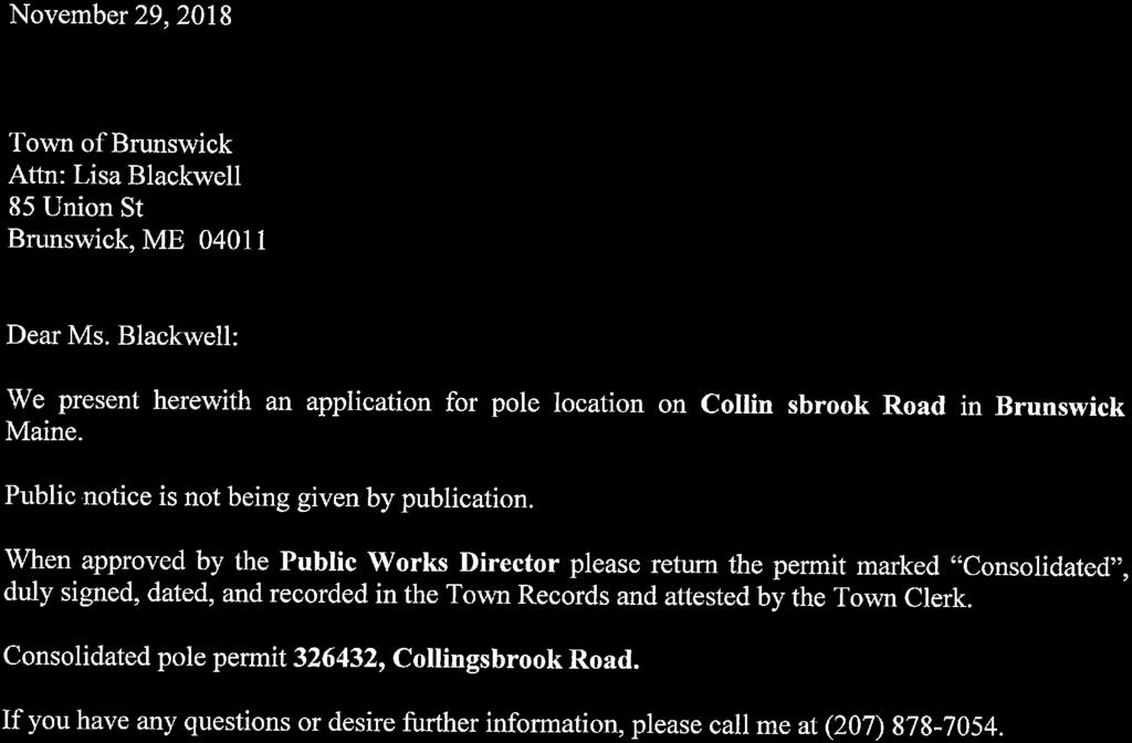

153
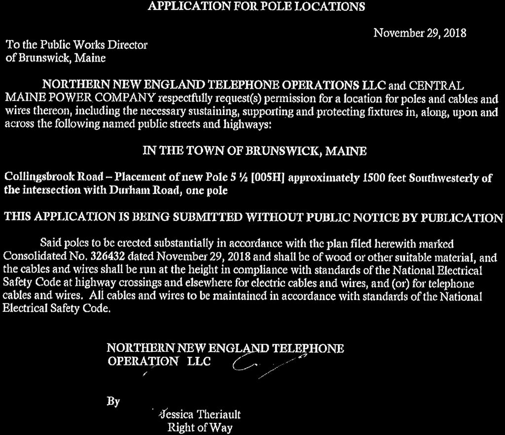

154


155


156

157
CONSERVATION EASEMENT DEED AND INDENTURE MILLER POINT
 , 0015,3', BK 1 5378 PG 259 02.20.00 CONSERVATION EASEMENT DEED AND INDENTURE MILLER POINT THIS CONSERVATION DEED AND INDENTURE is made this 02 / 41' day of 1Y/cul c,11, 2000, between ROBERT C. KING, JR.
BRUNSWICK TOWN COUNCIL Agenda June 18, 2018 Regular Meeting - 6:30 P.M. Council Chambers Town Hall 85 Union Street
 Roll Call of Members/Acknowledgement Notice Pledge of Allegiance Adjustments to Agenda BRUNSWICK TOWN COUNCIL Agenda June 18, 2018 Regular Meeting - 6:30 P.M. Council Chambers Town Hall 85 Union Street
Roll Call of Members. Acknowledgement of Meeting Notice. Pledge of Allegiance. Adjustments to Agenda. Public Comments (for items not on the agenda)
") BRUNSWICK TOWN COUNCIL Agenda January 24, 2019 Executive Session at end of meeting Regular Meeting 6:30 P.M. Council Chambers Town Hall 85 Union Street Roll Call of Members Acknowledgement of Meeting Notice
BRUNSWICK TOWN COUNCIL Agenda January 24, 2019 Executive Session at end of meeting Regular Meeting 6:30 P.M. Council Chambers Town Hall 85 Union Street Roll Call of Members Acknowledgement of Meeting Notice
Thunderbird Hill Homeowner Association (THHA) Villages II-III Covenant Amendments of January 2018
 Villages II-III Covenant Amendments of January 2018") Thunderbird Hill Homeowner Association (THHA) Villages II-III Covenant Amendments of January 2018 THHA Board Consolidation Reflecting Changes to Covenants on Jan 1997, Feb 2013, Jan 2017, and Feb 2017
Thunderbird Hill Homeowner Association (THHA) Villages II-III Covenant Amendments of January 2018 THHA Board Consolidation Reflecting Changes to Covenants on Jan 1997, Feb 2013, Jan 2017, and Feb 2017
GRANT OF TRAIL ACCESS EASEMENT, COVENANTS AND RESTRICTIONS
 This is a sample easement provided for discussion and illustrative purposes only. Easements for each property will be customized based upon the needs of each landowner and the Path. GRANT OF TRAIL ACCESS
DECLARATION OF RESTRICTIONS GREYSTONE ESTATES SOUTH
 DECLARATION OF RESTRICTIONS GREYSTONE ESTATES SOUTH WHEREAS, EARNSHAW LAND CO., INC, a Kansas corporation, EARNSHAW, INC., a Kansas corporation, ROBERT R. EARNSHAW and BARBARA EARNSHAW, have heretofore
TRANSBAY JOINT POWERS AUTHORITY
 STAFF REPORT FOR CALENDAR ITEM NO.: 15 FOR THE MEETING OF: March 10, 2011 TRANSBAY JOINT POWERS AUTHORITY BRIEF DESCRIPTION: Approving a Temporary Easement Agreement (Temporary Easement) between the Transbay
STATE OF SOUTH CAROLINA ) DECLARATION OF RESTRICTIVE ) COVENANTS FOR CLEMSON DOWNS COUNTY OF PICKENS ) SUBDIVISION AND RELEASE OF ) EASEMENT
 DECLARATION OF RESTRICTIVE ) COVENANTS FOR CLEMSON DOWNS COUNTY OF PICKENS ) SUBDIVISION AND RELEASE OF ) EASEMENT") STATE OF SOUTH CAROLINA ) DECLARATION OF RESTRICTIVE ) COVENANTS FOR CLEMSON DOWNS COUNTY OF PICKENS ) SUBDIVISION AND RELEASE OF ) EASEMENT WHEREAS, the undersigned parties are owners of the property
STATE OF SOUTH CAROLINA ) DECLARATION OF RESTRICTIVE ) COVENANTS FOR CLEMSON DOWNS COUNTY OF PICKENS ) SUBDIVISION AND RELEASE OF ) EASEMENT WHEREAS, the undersigned parties are owners of the property
It is necessary for the Board to adopt the attached resolution accepting the dedication of the easement.
 SOUTHAMPTON COUNTY BOARD OF SUPERVISORS Regular Session i May 28, 2013 11. ACCEPTANCE OF A SANITARY SEWER EASEMENT FROM THE COMMONWEALTH OF VIRGINIA, DEPARTMENT OF TRANSPORTATION Attached for your review
CITIZENS PROPERTY INSURANCE CORPORATION. and. REGIONS BANK, as Indenture Trustee and Escrow Agent ESCROW DEPOSIT AGREEMENT.
 GT Draft No. 3 11/20/14 CITIZENS PROPERTY INSURANCE CORPORATION and REGIONS BANK, as Indenture Trustee and Escrow Agent ESCROW DEPOSIT AGREEMENT Relating to Citizens Property Insurance Corporation High-Risk
PERMANENT EASEMENT AGREEMENT. good and valuable consideration, the sufficiency and receipt of which is hereby acknowledged, The Esther Harrison
 PERMANENT EASEMENT AGREEMENT For and in consideration of the sum of Seven thousand thirty and 00/100 dollars ($7,030.00) and other good and valuable consideration, the sufficiency and receipt of which
ARTICLES OF INCORPORATION OF ALDASORO RANCH HOMEOWNERS COMPANY
 02/17/91 ARTICLES OF INCORPORATION OF ALDASORO RANCH HOMEOWNERS COMPANY The undersigned, desiring to establish a nonprofit corporation pursuant to the Colorado Nonprofit Corporation Act, hereby certifies:
AMENDED DECLARATION OF COVENANTS FOR COUNTRY CREEK SUBDIVISION
 AMENDED DECLARATION OF COVENANTS FOR COUNTRY CREEK SUBDIVISION THIS AMENDED DECLARATION OF COVENANTS, made this 17th day of February, 2004, by Frontier Land Company, an Indiana corporation (hereinafter
DECLARATION OF EASEMENTS AND COST SHARING AGREEMENT
 PREPARED BY AND AFTER RECORDING RETURN TO: James Johnston, Esq. Shutts & Bowen LLP 300 S. Orange Avenue Suite 1000 Orlando, Florida 32801 Tax Parcel I.D.s: 25-21-29-0000-00-032 25-21-29-4432-00-001 DECLARATION
AMENDED RESTRICTIONS FOR GRAND OAK ESTATES BEAUMONT, JEFFERSON COUNTY, TEXAS
 AMENDED RESTRICTIONS FOR GRAND OAK ESTATES BEAUMONT, JEFFERSON COUNTY, TEXAS On this 9 day of January, 1996, Graff Development Company, L.C., hereinafter called Developer joined herein by all current owners
EXTRACTS FROM MINUTES OF MEETING OF THE BOARD OF TRUSTEES OF THE VILLAGE OF MAMARONECK, COUNTY OF WESTCHESTER, STATE OF NEW YORK
 EXTRACTS FROM MINUTES OF MEETING OF THE BOARD OF TRUSTEES OF THE VILLAGE OF MAMARONECK, COUNTY OF WESTCHESTER, STATE OF NEW YORK (Refunding Bond Resolution, 2019) A regular meeting of the Board of Trustees
REGULATORY AND RESTRICTIVE COVENANTS FOR LAND USE AGREEMENT
 LIHTCP-8 WVHDF (7/14/05) REGULATORY AND RESTRICTIVE COVENANTS FOR LAND USE AGREEMENT Low-Income Housing Tax Credit Program West Virginia Housing Development Fund APPENDIX F THIS REGULATORY AND RESTRICTIVE
To achieve the conservation purposes, the following conditions and restrictions are set forth:
 DEED OF CONSERVATION EASEMENT (Conservation Subdivision District) STATE OF GEORGIA COUNTY OF COBB THIS DEED OF CONSERVATION EASEMENT (herein "Conservation Easement") is made this day of, 20, by and between
SPECIAL ASSESSMENT AGREEMENT AND DECLARATION OF NOTICE OF SPECIAL ASSESSMENT
 Attachment 7A: Form of Special Assessment Agreement SPECIAL ASSESSMENT AGREEMENT AND DECLARATION OF NOTICE OF SPECIAL ASSESSMENT THIS SPECIAL ASSESSMENT AGREEMENT AND DECLARATION OF NOTICE OF SPECIAL ASSESSMENT
AGENDA ITEM FORM INFORMATION ONLY PRESENTATION DISCUSSION ONLY ACTION ITEM
 Town of Dumfries Council Meeting AGENDA ITEM FORM Meeting Date: Agenda Item# February 5, 2019 XIII-A TYPE OF AGENDA ITEM: PURPOSE OF ITEM: CONSENT AGENDA INFORMATION ONLY PRESENTATION DISCUSSION ONLY ACTION
PERMANENT EASEMENT AGREEMENT
 PERMANENT EASEMENT AGREEMENT This Permanent Easement Agreement ("Agreement") effective this day of, 2016, by and between Goin Straight, LLC, a Colorado limited liability company (Grantor"), whose mailing
DEED RESTRICTIONS PROTECTIVE COVENANTS
 DEED RESTRICTIONS PROTECTIVE COVENANTS The undersigned, being owner of the property on North Territorial Road and as described on the attached exhibit known as Exhibit A do, this day of April, 2006; HEREBY
MIDDLE PLANTATION CIVIC LEAGUE BOARD OF DIRECTOR'S GUIDELINES AND INSTRUCTIONS FOR ENFORCEMENT OF RECORDED RESTRICTIONS
 MIDDLE PLANTATION CIVIC LEAGUE BOARD OF DIRECTOR'S GUIDELINES AND INSTRUCTIONS FOR ENFORCEMENT OF RECORDED RESTRICTIONS BY THE MIDDLE PLANTATION ARCHITECTURAL REVIEW COMMITTEE PREAMBLE THESE GUIDELINES
FIRST AMENDED DEED RESTRICTION
 RECORDED AT THE POLK COUNTY COURTHOUSE IN VOLUME 349, PAGES 850 TO 854 STATE OF TEXAS COUNTY OF POLK FIRST AMENDED DEED RESTRICTION WHEREAS, the undersigned DON E. WARFIELD, and C. L. CONNER, CO- TRUSTEES,
ARTICLES OF INCORPORATION CHELAN MAINTENANCE ASSOCIATION
 ARTICLES OF INCORPORATION OF CHELAN MAINTENANCE ASSOCIATION Articles of Incorporation Signed 16 June 1969 AFN# 229473 recorded in King County, WA Identifying File #s: 198592 & 143492 Filed with Washington
Articles of Incorporation for a Nonprofit Corporation filed pursuant to , et seq. and of the Colorado Revised Statutes (C.R.
 Document Processing Fee If document is on paper: $125.00 If document is filed electronically: $ 50.00 Fees are subject to change. For electronic filing and to obtain copies of filed documents visit www.sos.state.co.us
DECLARATION OF BY-LAWS AND RESTRICTIVE COVENANTS BINDING SEVEN BAYS ESTATES UNLIMITED HOMEOWNERS AND HOMEOWNERS ASSOCIATION
 DECLARATION OF BY-LAWS AND RESTRICTIVE COVENANTS BINDING SEVEN BAYS ESTATES UNLIMITED HOMEOWNERS AND HOMEOWNERS ASSOCIATION ************************************************************************ This
2018 TOWN WARRANT. To: Coreen Sylvester, a resident of the Town of Carmel, in the County of Penobscot.
 2018 TOWN WARRANT State of Maine Penobscot, ss To: Coreen Sylvester, a resident of the Town of Carmel, in the County of Penobscot. Greetings: In the name of the State of Maine, you are hereby required
DECLARATION OF PARTY WALL RIGHTS, COVENANTS, CONDITIONS, RESTRICTIONS AND EASEMENTS
 DECLARATION OF PARTY WALL RIGHTS, COVENANTS, CONDITIONS, RESTRICTIONS AND EASEMENTS This Declaration of Party Wall Rights, Covenants, Conditions, Restrictions and Easements (the Declaration) is made this
Southampton Swim Club, Inc. Governing Documents
 Southampton Swim Club, Inc. Governing Documents Southampton Swim Club, Inc. Amended Declaration of Covenants, Conditions and Restrictions Southampton Swim Club Inc. TABLE OF CONTENTS Page RECITALS 1 DECLARATIONS
W I T N E S S E T H: ARTICLE I. The property described in Exhibit A, attached hereto is hereby designated residential, single family.
 STATE OF NORTH CAROLINA COUNTY OF CARTERET AMENDED AND RESTATED DECLARATION OF COVENANTS AND RESTRICTIONS BRANDYWINE BAY DEVELOPMENT Chelsea Park North Subdivision Map Book 30 Page 479 THIS AMENDED AND
AMENDED DEED OF CONSERVATION EASEMENT
 Prepared by: Wayne E. Flowers Lewis, Longman & Walker, P.A. 245 Riverside Ave. Suite 150 Jacksonville, FL 32202 Return recorded original to: Mitigation Marketing 1091 W. Morse Blvd. Suite 101 Winter Park,
EASEMENT AGREEMENT. WHEREAS, Ferguson is the 100% owner of the property described on Exhibit B attached hereto (the Williams Property );
;") EASEMENT AGREEMENT THIS EASEMENT AGREEMENT ( Agreement ) is entered into as of this day of, 2016, by and between CRAIG FERGUSON ( Ferguson ), and MAMIE DAVIS and JERRY MOORE ( Davis & Moore ), whose legal
EASEMENT AGREEMENT THIS EASEMENT AGREEMENT ( Agreement ) is entered into as of this day of, 2016, by and between CRAIG FERGUSON ( Ferguson ), and MAMIE DAVIS and JERRY MOORE ( Davis & Moore ), whose legal
NC General Statutes - Chapter 116 Article 21B 1
 Article 21B. The Centennial Campus, the Horace Williams Campus, and the Millenial Campuses Financing Act. 116-198.31. Purpose of Article. The purpose of this Article is to authorize the Board of Governors
Storm Water Management BMP Maintenance Agreement City of St. George, Utah
 RECORDED, MAIL TO: St. George City 175 East 200 North St. George, UT 84770 Tax ID: BMP Maintenance Agreement City of St. George, Utah WHEREAS, the Property Owner recognizes that the post construction storm
DECLARATION OF RESTRICTIVE COVENANTS. THIS DECLARATION OF RESTRICTIVE COVENANTS made this day of, 200_, by ( Declarant ). RECITALS
. RECITALS") DECLARATION OF RESTRICTIVE COVENANTS THIS DECLARATION OF RESTRICTIVE COVENANTS made this day of, 200_, by ( Declarant ). RECITALS WHEREAS, Declarant is the owner of the surface of certain real property
DECLARATION OF RESTRICTIVE COVENANTS THIS DECLARATION OF RESTRICTIVE COVENANTS made this day of, 200_, by ( Declarant ). RECITALS WHEREAS, Declarant is the owner of the surface of certain real property
Port Malabar Holiday Park Mobile Home Park Recreation District. Deed Restrictions, Rules and Regulations. Restriction of Deed
 Port Malabar Holiday Park Mobile Home Park Recreation District Deed Restrictions, Rules and Regulations Restriction of Deed The Declaration of Restrictions, Conditions, Covenant and Reservations affecting
SECTION III - RESTRICTIVE COVENANTS
 , dated August 26, 1986 and recorded September 2, 1986 as Document No. 8622978: Lots 1-117, 118-152 SECTION III - RESTRICTIVE COVENANTS The covenants and restrictions contained in this instrument shall
WATER LINE & INGRESS/EGRESS EASEMENT AGREEMENT WITNESSETH:
 Prepared by and return to: Carie E. Shealy, MMC, City Clerk City of Cocoa 65 Stone Street Cocoa, Florida 32922 Parcel ID. #(s): WATER LINE & INGRESS/EGRESS EASEMENT AGREEMENT THIS EASEMENT AGREEMENT is
WARRANTY DEED With Conservation Restrictions
 WARRANTY DEED With Conservation Restrictions KNOW ALL PERSONS BY THESE PRESENTS, that FRYE ISLAND, INC., a Maine corporation, for consideration paid, GRANTS TO the TOWN OF FRYE ISLAND, MAINE, a Maine municipal
DEED OF EASEMENTS PREPARED BY, AND WHEN RECORDED RETURN TO:
 Addendum-12-14-13-C1-4736 Lee Highway Easements - Page 1 PREPARED BY, AND WHEN RECORDED RETURN TO: Real Estate Bureau Chief Department of Environmental Services Arlington County Government 2100 Clarendon
DECLARATION OF COVENANTS AND RESTRICTIONS OLE PLANTATION
 Prepared by Robert W. Wolf, Attorney at Law 138 South Broadway, Forest City, NC 28043 DECLARATION OF COVENANTS AND RESTRICTIONS OLE PLANTATION WHEREAS, The Peaks at Lake Lure, a North Carolina Limited
City of Melissa, Texas Plat Dedication Language
 City of Melissa, Texas Plat Dedication Language [INCLUDE THE FOLLOWING DEDICATION LANGUAGE FOR INDIVIDUALS (MODIFY APPROPRIATELY TO REFLECT EXACTLY AS SHOWN ON PROPERTY DEED)]: NOW THEREFORE, KNOW ALL
THE SCHOOL BOARD OF BROWARD COUNTY, FLORIDA acting as the governing body of the School District of Broward County, Florida and U.S. BANK NATIONAL ASSO
 THE SCHOOL BOARD OF BROWARD COUNTY, FLORIDA acting as the governing body of the School District of Broward County, Florida and U.S. BANK NATIONAL ASSOCIATION, as Escrow Agent SERIES 2010B ESCROW DEPOSIT
DEED OF EASEMENT STATE OF NEW JERSEY AGRICULTURE RETENTION AND DEVELOPMENT PROGRAM. BETWEEN, whose address is and is referred to as the Grantor;
 Page 1 of 8 E3-E DEED OF EASEMENT STATE OF NEW JERSEY AGRICULTURE RETENTION AND DEVELOPMENT PROGRAM This Deed is made, 20. BETWEEN, whose address is and is referred to as the Grantor; AND, whose address
THAT WE, the undersigned, being sole Owners of the lands and premises described as follows:
 THE STATE OF TEXAS COUNTY OF POLK KNOW ALL MEN BY THESE PRESENTS: THAT WE, the undersigned, being sole Owners of the lands and premises described as follows: BRIDGEVIEW Subdivision, Section One, a subdivision
DEVELOPMENT AGREEMENT RIVER EDGE COLORADO PLANNED UNIT DEVELOPMENT
 DEVELOPMENT AGREEMENT RIVER EDGE COLORADO PLANNED UNIT DEVELOPMENT THIS AGREEMENT, is made and entered into between the BOARD OF COUNTY COMMISSIONERS OF THE COUNTY OF GARFIELD, a body politic and corporate
EASEMENT AGREEMENT (Distributor Performance Non-Exclusive)
") EASEMENT AGREEMENT (Distributor Performance Non-Exclusive) THIS EASEMENT AGREEMENT, effective the day of, 20, is made between WITNESSETH:, hereafter called Grantor, (whether grammatically singular or plural)
EASEMENT AGREEMENT (Distributor Performance Non-Exclusive) THIS EASEMENT AGREEMENT, effective the day of, 20, is made between WITNESSETH:, hereafter called Grantor, (whether grammatically singular or plural)
TOWNSHIP OF FREEHOLD ORDINANCE # O-18-7 TOWNSHIP COMMITTEE MEETING MAY 22, 2018
 TOWNSHIP OF FREEHOLD ORDINANCE # O-18-7 TOWNSHIP COMMITTEE MEETING MAY 22, 2018 BOND ORDINANCE AUTHORIZING VARIOUS CAPITAL IMPROVEMENTS IN AND FOR THE TOWNSHIP OF FREEHOLD, IN THE COUNTY OF MONMOUTH, NEW
THIRD AMENDED DECLARATION OF COVENANTS, CONDITIONS AND RESTRICTIONS FOR TIMBER RIDGE
 THIRD AMENDED DECLARATION OF COVENANTS, CONDITIONS AND RESTRICTIONS FOR TIMBER RIDGE THE STATE OF TEXAS KNOW ALL MEN BY THESE PRESENTS: COUNTY OF BURNET WHEREAS, TIMBER RIDGE is an unrecorded subdivision
SECTIONS 1 THROUGH 4, SECTION 4-A, SECTIONS 5 THROUGH 11, SECTIONS 11-A AND 11-B, SECTIONS 12 THROUGH 17, SECTION 17-A, AND SECTIONS 18 AND
 AMENDMENTS TO THE AMENDED RESERVATIONS, RESTRICTIONS AND COVENANTS for TANGLEWOOD SECTIONS 1 THROUGH 4, SECTION 4-A, SECTIONS 5 THROUGH 11, SECTIONS 11-A AND 11-B, SECTIONS 12 THROUGH 17, SECTION 17-A,
ARTICLES OF INCORPORATION CREEKSIDE WEST TOWNHOME OWNERS ASSOCIATION ARTICLE I NAME OF CORPORATION
 ARTICLES OF INCORPORATION OF CREEKSIDE WEST TOWNHOME OWNERS ASSOCIATION ARTICLE I NAME OF CORPORATION The name of the Corporation shall be CREEKSIDE WEST TOWNHOME OWNERS ASSOCIATION (the Corporation or
NORTH CAROLINA DEED OF TRUST NORTH CAROLINA HOUSING FINANCE AGENCY $15,000 DPA Program Only
 NORTH CAROLINA DEED OF TRUST NORTH CAROLINA HOUSING FINANCE AGENCY $15,000 DPA Program Only After recording, return the executed document back to the Originating Lender (not NCHFA) within 24 hours of closing.
Executive session Economic Development to discuss the MRRA TIF per 1 M.R.S.A. 405(6)(C)
(C)") BRUNSWICK TOWN COUNCIL Agenda March 19, 2012 Executive Session 6:30 P.M. Regular Meeting - 7:00 P.M. Municipal Meeting Room Brunswick Station 16 Station Avenue Executive session Economic Development to
BRUNSWICK TOWN COUNCIL Agenda March 19, 2012 Executive Session 6:30 P.M. Regular Meeting - 7:00 P.M. Municipal Meeting Room Brunswick Station 16 Station Avenue Executive session Economic Development to
AMENDED DEED RESTRICTIONS FOR TIMBERGROVE MANOR SECTION 12
 THIS Amended Deed Restrictions for Timbergrove Manor, hereinafter called the "Declaration," is made on the date hereinafter set forth by the individuals and/or entities whose names are signed on the signature
COMMERCIAL PROPERTY ASSESSED CLEAN ENERGY ( C-PACE ) AGREEMENT
 AGREEMENT") COMMERCIAL PROPERTY ASSESSED CLEAN ENERGY ( C-PACE ) AGREEMENT THIS AGREEMENT is made and entered into as of the day of, 2015, by and between [TOWN NAME], CONNECTICUT, a municipal corporation organized
COMMERCIAL PROPERTY ASSESSED CLEAN ENERGY ( C-PACE ) AGREEMENT THIS AGREEMENT is made and entered into as of the day of, 2015, by and between [TOWN NAME], CONNECTICUT, a municipal corporation organized
LEASE AGREEMENT Premises Rent
 LEASE AGREEMENT THIS LEASE is made this day of, 201_, by and between, (hereinafter Landlord ), a notfor-profit corporation (hereinafter, X and, (hereinafter Tenant ). 1. Premises. Landlord leases to Tenant,
AFFORDABLE HOUSING RESTRICTION
 AFFORDABLE HOUSING RESTRICTION For Projects in Which Affordability Restrictions Survive Foreclosure THIS AFFORDABLE HOUSING RESTRICTION (this Restriction) is: [ ] incorporated in and made part of that
DECLARATIONS OF COVENANTS, RESTRICTIONS, CONDITIONS AND RESERVATIONS
 THIS DECLARATION, made this 30 th day of December, 1969, by Jasper Valley Development Corporation, hereinafter called the Developer. WITNESSETH: Whereas, Developer is the owner of the real property described
Dated October 14, 1966 As to Acknowledged October 14, 1966 University Hills No. 2 Subdivision Reported October 18, 1966 Liber 1954, Page 28
 Orchard Lane Land Company Declaration of Restrictions Dated October 14, 1966 As to Acknowledged October 14, 1966 University Hills No. 2 Subdivision Reported October 18, 1966 Liber 1954, Page 28 This Declaration,
REGULAR TOWNSHIP MEETING January 2, 2018
 REGULAR TOWNSHIP MEETING January 2, 2018 MUNICIPAL BUILDING DELRAN, NJ CALL TO ORDER SALUTE TO THE FLAG Sunshine Statement: Be advised that proper notice has been given by the Township Council in accordance
ADDENDUM B DECLARATION OF COVENANTS, CONDITIONS AND RESTRICTIONS OF FRESHWATER ESTATES. Prepared by Jeanne Dove-Taylor, Esquire.
 ADDENDUM B DECLARATION OF COVENANTS, CONDITIONS AND RESTRICTIONS OF FRESHWATER ESTATES Prepared by Jeanne Dove-Taylor, Esquire. KNOW ALL MEN BY THESE PRESENTS: That the undersigned. VA TIMBERLINE, LLC,
DECLARATION OF COVENANTS, CONDITIONS AND RESTRICTIONS WATERFORD POINTE
 DECLARATION OF COVENANTS, CONDITIONS AND RESTRICTIONS WATERFORD POINTE THIS DECLARATION OF COVENANTS, CONDITIONS AND RESTRICTIONS (the Declaration ) is made this 30 th day of October, 2000, by CRESCENT
CITY OF ROHNERT PARK CITY COUNCIL AGENDA REPORT
 Meeting Date: February 12, 2013 Mission Statement We Care for Our Residents by Working Together to Build a Better Community for Today and Tomorrow. CITY OF ROHNERT PARK CITY COUNCIL AGENDA REPORT ITEM
AGREEMENT FOR DEED. Articles of Agreement Made this day of A.D. 2016, between Seller, ( Seller ) and Buyers, ( Buyers ).
 and Buyers, ( Buyers ).") Prepared by and after Recording return to: Joseph M. Kosteck Law Office of Joseph M. Kosteck Ltd. 10201 W. Lincoln Hwy Frankfort, IL 60423 AGREEMENT FOR DEED Articles of Agreement Made this day of A.D.
Prepared by and after Recording return to: Joseph M. Kosteck Law Office of Joseph M. Kosteck Ltd. 10201 W. Lincoln Hwy Frankfort, IL 60423 AGREEMENT FOR DEED Articles of Agreement Made this day of A.D.
Blaire Meadows Homeowners Association Board of Directors And By Laws And Declarations
 Blaire Meadows Homeowners Association Board of Directors And By Laws And Declarations This declaration is made this 15th day September 1994 by Blaire Meadows Venture, a registered Michigan homeowners association
Property Development Standards All Zones. Property Development Standards Commercial and Industrial. Property Development Standards Mixed Use
 Division 17.50 Development Standards Chapter 17.51 Property Development Standards All Zones Chapter 17.53 Chapter 17.55 Chapter 17.57 Property Development Standards Commercial and Industrial Property Development
Resolution No
 EXHIBIT A Page 1 of 2 Resolution No. 17-04 RESOLUTION OF THE BOARD OF TRUSTEES OF THE SOUTH ORANGE COUNTY COMMUNITY COLLEGE DISTRICT DECLARING ITS INTENT TO ENTER INTO IRWD GRANT OF EASEMENT AGREEMENT
OFFER TO PURCHASE AND CONTRACT
 1 NORTH CAROLINA WAKE COUNTY OFFER TO PURCHASE AND CONTRACT WHEREAS, ( Buyer ) hereby agrees to purchase and Wake County Board of Education ( Seller ) hereby agrees to convey a parcel of land at,,, being
ARTICLES OF INCORPORATION OF SPRING CREEK ASSOCIATION 451 Spring Creek Parkway Spring Creek, NV 89815
 ARTICLES OF INCORPORATION OF SPRING CREEK ASSOCIATION 451 Spring Creek Parkway Spring Creek, NV 89815 KNOW ALL MEN BY THESE PRESENTS: THAT we, the undersigned, a majority of whom are residents of the State
TOWN OF FREEPORT Planning Department
 TOWN OF FREEPORT Planning Department June 10, 2010 TO: Dale Olmstead From: Donna Larson RE: Freeport Housing Trust Contract Zone On June 2, 2010 at 5PM a site walk was conducted for members of the Town
DECLARATION OF PROTECTIVE COVENANTS FOR GREEN HILL SUBDIVISION
 DECLARATION OF PROTECTIVE COVENANTS FOR GREEN HILL SUBDIVISION STATE OF GEORGIA. COUNTY OF HALL COMES NOW, Saddle Creek Development, LLC ("Owner/Developer"), as record owner of all that tract or parcel
AMENDED AND RESTATED TRANSMISSION LINES EASEMENT AND RIGHT OF WAY AGREEMENT THE STATE OF TEXAS KNOW ALL MEN BY THESE PRESENTS: COUNTY OF SAN PATRICIO
 AMENDED AND RESTATED TRANSMISSION LINES EASEMENT AND RIGHT OF WAY AGREEMENT THE STATE OF TEXAS KNOW ALL MEN BY THESE PRESENTS: COUNTY OF SAN PATRICIO That the Port of Corpus Christi Authority of Nueces
Articles of Incorporation
 Restated Articles of Incorporation Restated February 17, 2009 Note: The following is a history of the Articles of Incorporation: 1. Originally filed on August 11, 1993 (on file with the Arizona Corporation
DECLARATION OF PROTECTIVE COVENANTS LELY COUNTRY CLUB - PALMETTO DUNES As amended 6/24/14
 DECLARATION OF PROTECTIVE COVENANTS LELY COUNTRY CLUB - PALMETTO DUNES As amended 6/24/14 Table of Contents Page Article I Definitions 1 Article II Lot Usage 2 Article III Architecture 3 Article IV Landscaping
IDENTURE OF TRUST AND RESTRICTIONS FOR WHISPERING HILLS, ST. LOUIS COUNTY, MISSOURI
 IDENTURE OF TRUST AND RESTRICTIONS FOR WHISPERING HILLS, ST. LOUIS COUNTY, MISSOURI THIS INDENTURE, made and entered into this 22nd day of March, 1967, by and between E. JERRY HARDESTY and JOSEPH L. JOHNSON,
Public Portion: Mr. Bianchini opened the public portion. There being no comment, the public portion was closed. Resolutions:
 GLOUCESTER TOWNSHIP SPECIAL COUNCIL MEETING DECEMBER 1, 2008 MUNICIPAL BUILDING, CHEWS LANDING NEW JERSEY Pledge Allegiance to the Flag Statement: Mr. Bianchini read a statement setting forth the time,
DEVELOPMENT AGREEMENT
 STATE OF NORTH CAROLINA COUNTY OF CHATHAM DEVELOPMENT AGREEMENT This Development Agreement (this Agreement ) is made and entered into as of the day of, 2009 (the Effective Date ), by and between the COUNTY
PROPERTY; PROVIDING FOR EXPENDITURE OF REVENUE; PROVIDING FOR REIMBURSEMENT
 ORDINANCE NO. 12- AN ORDINANCE OF MARION COUNTY, FLORIDA ESTABLISHING THE RAINBOW PARK UNITS 1 & 2 MUNICIPAL SERVICE BENEFIT UNIT FOR ROAD MAINTENANCE; PROVIDING FOR A PURPOSE; PROVIDING FOR THE POWERS
AGREEMENT FOR TEMPORARY CONSTRUCTION EASEMENT AND PERMANENT SEWER UTILITY EASEMENT
 AGREEMENT FOR TEMPORARY CONSTRUCTION EASEMENT AND PERMANENT SEWER UTILITY EASEMENT This Agreement for Temporary Construction Easement and Permanent Sewer Utility Easement (hereinafter the "Agreement")
FIRST AMENDMENT TO THE DECLARATION OF COVENANTS, CONDITIONS AND RESTRICTIONS FOR GENTLE WOODS HOMEOWNERS ASSOCIATION, INC.
 PREPARED BY AND RETURN TO : Th e Law Offices of George H. G. Hall 4n 6 Blandin!; Blvd Jackso nville, FL 32210 Doc # 2010016708, OR BK 15135 Page 159, Number Pages: 5 Recorded 011251201 0 at 1230 PM, JIM
DECLARATION OF RESTRICTIONS AND COVENANTS
 DECLARATION OF RESTRICTIONS AND COVENANTS THIS DECLARATION, Made this 14 th day of April 1982, by QUENTIN V. FREY, JR. and JAMES G. GROSS, hereinafter referred to as the Developers. W I T N E S S E T H:
Colorado Secretary of State Date and Time: 02/27/ :44 PM Id Number: Document number:
 Document processing fee If document is filed on paper $125.00 If document is filed electronically $ 25.00 Fees & forms/cover sheets are subject to change. To file electronically, access instructions for
DECLARATION OF COVENANTS AND RESTRICTIONS FOR MT. HOLLY PRESERVE
 DECLARATION OF COVENANTS AND RESTRICTIONS FOR MT. HOLLY PRESERVE U.S. Bronco Services, Inc., (hereinafter sometimes called Owner) being the Owner of the following described property and the individual
CITY AND COUNTY OF BROOMFIELD SUBDIVISION IMPROVEMENT AGREEMENT FOR (PROPERTY NAME - ALL CAPS)
") CITY AND COUNTY OF BROOMFIELD SUBDIVISION IMPROVEMENT AGREEMENT FOR (PROPERTY NAME - ALL CAPS) THIS AGREEMENT, made and entered into this day of, 20, by and between The CITY AND COUNTY OF BROOMFIELD, a
CITY AND COUNTY OF BROOMFIELD SUBDIVISION IMPROVEMENT AGREEMENT FOR (PROPERTY NAME - ALL CAPS) THIS AGREEMENT, made and entered into this day of, 20, by and between The CITY AND COUNTY OF BROOMFIELD, a
[RECIPIENT] and NEW YORK STATE DIVISION OF HOUSING AND COMMUNITY RENEWAL LOW-INCOME HOUSING CREDIT REGULATORY AGREEMENT.
![[RECIPIENT] and NEW YORK STATE DIVISION OF HOUSING AND COMMUNITY RENEWAL LOW-INCOME HOUSING CREDIT REGULATORY AGREEMENT.](/thumbs/77/75739244.jpg "[RECIPIENT] and NEW YORK STATE DIVISION OF HOUSING AND COMMUNITY RENEWAL LOW-INCOME HOUSING CREDIT REGULATORY AGREEMENT.") [RECIPIENT] and NEW YORK STATE DIVISION OF HOUSING AND COMMUNITY RENEWAL LOW-INCOME HOUSING CREDIT REGULATORY AGREEMENT Dated as of, 201_ This instrument affects real and personal property situated in
[RECIPIENT] and NEW YORK STATE DIVISION OF HOUSING AND COMMUNITY RENEWAL LOW-INCOME HOUSING CREDIT REGULATORY AGREEMENT Dated as of, 201_ This instrument affects real and personal property situated in
SOUTH DAKOTA BOARD OF REGENTS. Committee on Budget and Finance ******************************************************************************
 SOUTH DAKOTA BOARD OF REGENTS Committee on Budget and Finance AGENDA ITEM: III O DATE: December 12-13, 2012 ****************************************************************************** SUBJECT: Resolution
This chapter shall be known and may be cited as the "Unit Property Act." (25 Del. C. 1953, 2201; 54 Del. Laws, c. 282.)
") DELAWARE 2201. Short title. This chapter shall be known and may be cited as the "Unit Act." (25 Del. C. 1953, 2201; 54 Del. Laws, c. 282.) 2202. Definitions. The following words or phrases, as used in
DELAWARE 2201. Short title. This chapter shall be known and may be cited as the "Unit Act." (25 Del. C. 1953, 2201; 54 Del. Laws, c. 282.) 2202. Definitions. The following words or phrases, as used in
TEMPORARY CONSTRUCTION EASEMENT JEA SEWER SYSTEM CUSTOMER OWNED, OPERATED AND MAINTAINED
 Return to: JEA Real Estate Services Attention: Jordan Pope 21 West Church Street (CC-6) Jacksonville, Florida 32202 TEMPORARY CONSTRUCTION EASEMENT JEA SEWER SYSTEM CUSTOMER OWNED, OPERATED AND MAINTAINED
W I T N E S S E T H: ARTICE I
 STATE OF NORTH CAROLINA COUNTY OF WAKE PROTECTIVE COVENANTS THIS DECLARATION, made this 29th day of September 1978, by STURBRIDGE DEVELOPMENT COMPANY, INC., a North Carolina corporation, hereinafter called
AMENDED DECLARATION OF PROTECTIVE COVENANTS LELY COUNTRY CLUB - TORREY PINES (as amended/modified 08/26/80, 05/23/06 and 6/24/14)
") AMENDED DECLARATION OF PROTECTIVE COVENANTS LELY COUNTRY CLUB - TORREY PINES (as amended/modified 08/26/80, 05/23/06 and 6/24/14) Table of Contents Page Article I Definitions 2 Article II Lot Usage 2 Article
AMENDED DECLARATION OF PROTECTIVE COVENANTS LELY COUNTRY CLUB - TORREY PINES (as amended/modified 08/26/80, 05/23/06 and 6/24/14) Table of Contents Page Article I Definitions 2 Article II Lot Usage 2 Article
CITY OF WEATHERFORD DEVELOPER AGREEMENT WITH CITY PARTICIPATION
 CITY OF WEATHERFORD DEVELOPER AGREEMENT WITH CITY PARTICIPATION STATE OF TEXAS Subdivision Name: Town Creek Phase II Developer Name: Ms. Marina Sears, Square S COUNTY OF PARKER Construction and Development
Caroline County, Maryland Department of Planning & Codes FEE SCHEDULE Tel: Fax:
 Health & Public Services Bldg. 403 S. 7th St., Suite 210, Denton, MD 21629 RESIDENTIAL Caroline County, Maryland Department of Planning & Codes FEE SCHEDULE www.carolineplancode.org Tel: 410-479-8100 Fax:
TEMPORARY CONSTRUCTION EASEMENT AND AGREEMENT JEA WATER AND WASTEWATER SYSTEMS CUSTOMER OWNED, OPERATED AND MAINTAINED
 Return to: Greg Corcoran, Manager JEA 21 West Church Street Jacksonville, Florida 32202 TEMPORARY CONSTRUCTION EASEMENT AND AGREEMENT JEA WATER AND WASTEWATER SYSTEMS CUSTOMER OWNED, OPERATED AND MAINTAINED
DECLARATION OF PROTECTIVE COVENANTS, RESERVATIONS RESTRICTIONS, EASEMENTS AND OWNERS MAINTENANCE ASSOCIATION OF TIMBERWOOD VILLAGE SUBDIVISION
 DECLARATION OF PROTECTIVE COVENANTS, RESERVATIONS RESTRICTIONS, EASEMENTS AND OWNERS MAINTENANCE ASSOCIATION OF TIMBERWOOD VILLAGE SUBDIVISION th THIS DECLARATION made this 26 day of July, 1999, by Bellmore,
VICINITY MAP/AERIAL MAP SITE
 VICINITY MAP/AERIAL MAP SITE N ZONING MAP PA 9 PA 5 SITE Solterra West ODP PA 7 N , DATE, 2013, TIME, COUNTY OF JEFFERSON, STATE OF COLORADO, $ DEDICATION CERTIFICATE THE UNDERSIGNED, BEING THE OWNER(S)
RESOLUTION NO
 MIA 184152500v2 RESOLUTION NO. 15-028 A RESOLUTION OF THE SCHOOL BOARD OF OSCEOLA COUNTY, FLORIDA, AUTHORIZING EXECUTION OF AMENDED AND RESTATED SCHEDULE 1995A AND AMENDED AND RESTATED SCHEDULE 2004A TO
Declaration of Lien Interest - Instructions
 Declaration of Lien Interest - Instructions The Declaration of Lien Interest enforces the repayment of the outstanding assistance in the event of a refinance of the first mortgage, sale of the home, or
City of Stevenson Planning Department
 City of Stevenson Planning Department (509)427-5970 7121 E Loop Road, PO Box 371 Stevenson, Washington 98648 TO: City Council FROM: Ben Shumaker DATE: January 16 th, 2014 SUBJECT: Bridging Byways Trail
6. No existing structure shall be moved onto any part of the premises within this plat.
 ADACROFT COMMONS BUILDING RESTRICTIONS (copy of original document as recorded w/ Kent Co. Register of Deeds, Liber 2274, pages 1182-1187) WHEREAS, Maryland Development Company, a Michigan corporation,