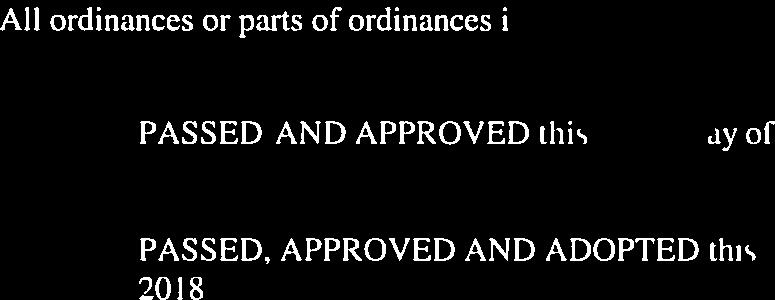
Table of Contents City of Henderson Zoning Ordinance
|
|
|
- Brett Pitts
- 5 years ago
- Views:
Transcription
1 Table of Contents City of Henderson Zoning Ordinance 2017, Bradley E. Johnson, AICP
2 Table of Contents 1: Ordinance Foundation 1.01 Basic Provisions Zoning Districts Official Zoning Map Planning and Zoning Commission Certification City Council Adoption : Zoning Districts 2.01 Agriculture (AG) District Intent, Permitted Uses, and Special Exception Uses Agriculture (AG) District Development Standards Parks and Recreation (PR) District Intent, Permitted Uses, and Special Exception Uses Parks and Recreation (PR) District Development Standards Residential Estate (RE) District Intent, Permitted Uses, and Special Exception Uses Residential Estate (RE) District Development Standards Low Density Single-family Residential (R1) District Intent, Permitted Uses, and Special Exception Uses Low Density Single-family Residential (R1) District Development Standards Medium Density Single-family Residential (R2) District Intent, Permitted Uses, and Special Exception Uses Medium Density Single-family Residential (R2) District Development Standards High Density Single-family Residential (R3) District Intent, Permitted Uses, and Special Exception Uses High Density Single-family Residential (R3) District Development Standards Manufactured Home (R4) District Intent, Permitted Uses, and Special Exception Uses Manufactured Home (R4) District Development Standards Low Density Multiple-family Residential (M1) District Intent, Permitted Uses, and Special Exception Uses Low Density Multiple-family Residential (M1) District Development Standards Medium Density Multiple-family Residential (M2) District Intent, Permitted Uses, and Special Exception Uses Medium Density Multiple-family Residential (M2) District Development Standards High Density Multiple-family Residential (M3) District Intent, Permitted Uses, and Special Exception Uses High Density Multiple-family Residential (M3) District Development Standards Institutional (IS) District Intent, Permitted Uses, and Special Exception Uses Institutional (IS) District Development Standards Local Commercial (C1) District Intent, Permitted Uses, and Special Exception Uses Local Commercial (C1) District Development Standards General Commercial (C2) District Intent, Permitted Uses, and Special Exception Uses General Commercial (C2) District Development Standards Urban Commercial (UC) District Intent, Permitted Uses, and Special Exception Uses Urban Commercial (UC) District Development Standards Office Commercial (OC) District Intent, Permitted Uses, and Special Exception Uses Office Commercial (OC) District Development Standards Low Intensity Industrial (I1) District Intent, Permitted Uses, and Special Exception Uses Low Intensity Industrial (I1) District Development Standards General Industrial (I2) District Intent, Permitted Uses, and Special Exception Uses General Industrial (I2) District Development Standards High Impact (HI) District Intent, Permitted Uses, and Special Exception Uses High Impact (HI) District Development Standards Table 2-A Appropriate Adjacent Districts : Overlay Districts 3.01 Floodplain Overlay (FPO) District Intent, Effect on Uses, and Effect on Standards FPO District Applicability FPO District Boundary FPO District Development Standards Historic District Overlay (HDO) District Intent, Effect on Uses, and Effect on Standards HDO District Applicability HDO District Boundary HDO Historic Landmark Designation HDO Criteria For Historic Landmark Designation HDO Establishment of Historic Landmark Preservation Committee HDO Function of Historic Landmark Preservation Committee ii City of Henderson Zoning Ordinance
3 Table of Contents 3.12 HDO Action by Planning and Zoning Commission HDO Action by City Council and Recording Designation HDO Certificate of Appropriateness Review HDO Historic Landmark Demolition or Removal HDO Provisions Herein Not to Affect the Present Uses HDO Penalties HDO District Development Standards : Planned Development District 4.01 Planned Development (PD) District Intent, Regulations, and Prerequisites General Planned Development Standards Origination of Proposals Rules of Procedure Limitation of Revisions to the Zoning Ordinance Designation of Permanent Open Space : Development Standards 5.01 Icon Key AS-01: General Accessory Structure Standards AS-02: Parks and Recreation and Agricultural Accessory Structure Standards AS-03: Residential Estate Accessory Structure Standards AS-04: Single-family and Two-family Residential Accessory Structure Standards AS-05: Manufactured Home District Accessory Structure Standards AS-06: Multiple-family Residential Accessory Structure Standards AS-07: Institutional Accessory Structure Standards AS-08: Local Commercial Accessory Structure Standards AS-09: Urban Commercial Accessory Structure Standards AS-10: General Commercial Accessory Structure Standards AS-11: Industrial Accessory Structure Standards AR-01: Residential Architectural Standards AR-02: Manufactured Home District Architectural Standards AR-03: Multiple-family Residential Architectural Standards AR-04: Commercial Architectural Standards AR-05: Urban Commercial Architectural Standards AR-06: Industrial Architectural Standards DI-01: Density and Intensity Standards EN-01: Environmental Standards FW-01: General Fence and Wall Standards FW-02: Parks and Recreation Fence and Wall Standards FW-03: Agricultural Fence and Wall Standards FW-04: Residential Fence and Wall Standards FW-05: Institutional and Commercial Fence and Wall Standards FW-06: Industrial and High Impact Fence and Wall Standards FA-01: Floor Area Standards HT-01: Height Standards HB-01: Type 1 Home Business Standards HB-02: Type 2 Home Business Standards HB-03: Type 3 Home Business Standards KA-01: Agricultural Keeping of Animals Standards KA-02: Residential Estate Keeping of Animals Standards KA-03: Lower Density Single-Family Residential Keeping of Animals Standards KA-04: Higher Density Single-Family Residential Keeping of Animals Standards LA-01: General Landscaping Standards LA-02: Residential Lot Planting Standards LA-03: Non-Single-Family Residential Lot Planting Standards LA-04: Parking Lot Planting Standards LA-05: Bufferyard Planting Standards LT-01: Lighting Standards Table of Contents iii
4 Table of Contents 5.42 LD-01: Loading Standards LO-01: Lot Standards OD-01: Outdoor Dining Standards SS-01: General Outdoor Storage and Sales Standards SS-02: Commercial Outdoor Storage Standards SS-03: Industrial and High Impact Outdoor Storage Standards PK-01: General Parking Standards PK-02: Single-family Residential Parking Standards PK-03: Manufactured Home District Parking Standards PK-04: Multiple-family Residential Parking Standards PK-05: Urban Commercial Parking Standards PK-06: Non-residential Parking Standards PF-01: General Performance Standards PI-01: General Public Improvement Standards SB-01: Setback Standards SW-01: Sewer and Water Standards SX-01: Sexually Oriented Entertainment Business Standards SI-01: General Sign Standards SI-02: Agricultural Sign Standards SI-03: Single-family and Two-family Residential Sign Standards SI-04: Multiple Family Residential Sign Standards SI-05: Institutional Sign Standards SI-06: Urban Commercial Sign Standards SI-07: Moderate Intensity Commercial Sign Standards SI-08: Office Commercial Sign Standards SI-09: Industrial Sign Standards SE-01: Special Exception Standards ST-01: Structure Standards TC-01: Telecommunication Facility Standards TU-01: General Temporary Use and Structure Standards TU-02: Agricultural Temporary Use and Structure Standards TU-03: Residential Temporary Use and Structure Standards TU-04: Nonresidential Temporary Use and Structure Standards TR-01: Trash Receptacle Standards VC-01: Vision Clearance Standards : Nonconformances 6.01 Intent of Nonconformance Rules Distinction Between Conforming, Illegal Nonconforming, and Legal Nonconforming Illegal Nonconforming Structures, Lots, and Uses Legal Nonconforming Structures Legal Nonconforming Lots Legal Nonconforming Use : Processes 7.01 Introduction to Processes Improvement Location Permit Temporary Improvement Location Permit Administrative Appeal Development Plan Planned Development; General Planned Development: Step Planned Development; Step Public Hearing Special Exception Use Variance Zoning Map Amendment (Rezoning) Zoning Ordinance Text Amendment iv City of Henderson Zoning Ordinance
5 Table of Contents 8: Enforcement 8.01 Actionable Violations Enforcement Official Discovery of Violations Inspection of Property or Structure Responsibility for Violations New Permits at Location Where a Violation Exists Enforcement Action Options Request to Stop Work Stop Work Order Request to Remedy Invoke a Legal, Equitable, or Special Remedy Enforce a Condition, Covenant, or Commitment Request a Prohibitory or Permanent Injunction to Restrain Request a Mandatory Injunction to Remove a Structure Impose a Fine for Violation Invoke a Fine for Violation Other Remedy : Definitions 9.01 General Defined Words Appendix A: Land Use Matrix Appendix B: Index Appendix C: Zoning Map Appendix D: Amendment Tracking Table Table of Contents v
6 Table of Contents vi City of Henderson Zoning Ordinance
7

8
9 1 Ordinance Foundation City of Henderson Zoning Ordinance 2017, Bradley E. Johnson, AICP
10 Basic Provisions 1.01 Basic Provisions A. Title: This ordinance shall be formally known as the City of Henderson Zoning Ordinance, and may be cited and referred to as the Zoning Ordinance. B. Defined Words: Words used in a special sense in the Zoning Ordinance are defined in 9: Definitions. C. Authority: The Zoning Ordinance is adopted by the City of Henderson pursuant to its authority under the laws of the State of Texas. D. Purpose: The Zoning Ordinance is intended to guide the growth and development of the City of Henderson and for the following purposes: 1. Basic Rights: To secure adequate light, air, convenience of access, and safety from fire, flood, and other dangers which may include providing adequate open spaces for light, air, and outdoor uses. 2. General Welfare: To promote the public health, safety, morals, comfort, convenience, and general welfare. 3. Development and Growth: To promote the orderly, responsible and beneficial development and growth of the areas within the zoning jurisdiction. 4. Character: To protect the character and stability of agricultural, residential, institutional, commercial, industrial, and natural areas. 5. Circulation: To minimize or avoid congestion on public streets and to ensure safe, convenient, and efficient traffic circulation. 6. Environmental Integrity: To preserve and enhance the scenic beauty, natural aesthetics, and environmental integrity of the zoning jurisdiction. 7. Compatibility: To assure compatibility between differing land uses and to protect the scale and character of existing development from the encroachment of incompatible uses. 8. Intensity: To regulate and restrict the intensity use of structures and land for business, industry, residence, and other uses as to not depreciate neighboring area s property values or reduce quality of life of nearby areas. 9. Public Service: To define the powers and duties of administrative officers and bodies, and to establish procedures for the implementation and enforcement of the Zoning Ordinance. 10. Compliance: To require ongoing compliance with the regulations and punitive recourse for noncompliance regarding the provisions of the Zoning Ordinance. 11. Light Pollution: To limit the amount of glare and light trespass caused by light fixtures. 12. Landscaping: To require the minimal amount of plant materials necessary to enhance the visual quality of developments, maintain community character, define the edges of streets for vehicular and pedestrian safety and flow, minimize stormwater runoff, improve quality of water runoff, and improve air quality. 13. Minimum Buildable Lot: To require a reasonable amount of land for each buildable lot. E. Compliance: 1. Structure: No structure shall be located, erected, constructed, reconstructed, moved, altered, converted, enlarged or used, except when in full compliance with all provisions of the Zoning Ordinance and when the permits and certificates required by the Zoning Ordinance have lawfully been issued. 2. Land: No piece of land (e.g. lot) shall be used except when in full compliance with all provisions of the Zoning Ordinance and when the permits and certificates required by the Zoning Ordinance have lawfully been issued. 3. Existing Use: No existing use may be expanded except when in full compliance with all provisions of the Zoning Ordinance and when the permits and certificates required by the Zoning Ordinance have lawfully been issued. F. Severability: If any provision or the application of any provision of the Zoning Ordinance is held unconstitutional or invalid by a court of competent jurisdiction, the remainder of the Zoning Ordinance or the application of such provision to other circumstances shall not be affected City of Henderson Zoning Ordinance
11 Basic Provisions G. Interpretation: 1. Minimum Requirements: The provisions of the Zoning Ordinance are the minimum requirements necessary to achieve this ordinance's purpose. 2. Conflict or Inconsistency: a. Internal: Unless otherwise specifically stated within the Zoning Ordinance, if two (2) or more provisions of the Zoning Ordinance are in conflict or are inconsistent with one another, then the most restrictive provision shall apply. b. Federal, State, and Local: i. Whenever a provision of the Zoning Ordinance imposes a greater restriction or a higher standard than is required by any State or Federal code or regulation, or other City ordinance or regulation, the provision of the Zoning Ordinance shall apply, unless clearly and legally required otherwise. ii. Whenever a provision of any State or Federal code or regulation, or other City ordinance or regulation imposes a greater restriction or a higher standard than is required by the Zoning Ordinance, the provision of the State or Federal code or regulation, or other City ordinance or regulation shall apply. c. Other: Whenever a private covenant, contract, commitment, agreement, or other similar private land use regulation imposes a greater restriction or a higher standard than is required by a provision of the Zoning Ordinance, the stricter standard would apply, albeit by a non-governmental regulation. However, if a project complies with the Zoning Ordinance, the City is still obligated to issue the permit or otherwise approve the project. 3. Illustrations: If differences are found between the meaning or implication of any illustration or drawing, the regulating text of the Zoning Ordinance shall apply. 4. Tables: If differences are found between the meaning or implication of the document text and a table s text, the stricter of the provisions shall apply. 5. Time Frames: Unless specifically noted otherwise, time frames stated within the Zoning Ordinance shall be calculated to include weekdays, weekends, and holidays. If a time frame ends on a Saturday, Sunday, or holiday that the City of Henderson offices are closed, the time frame will be extended to the end of the next business day. 6. Delegation of Authority: If a provision in the Zoning Ordinance requires the Zoning Administrator or other City officer to perform an act or duty, that provision shall also include any person working under the authority and supervision of the Zoning Administrator unless specified otherwise. 7. Mandatory and Permissive Terms: The words shall or must are always mandatory. The words may or should are always permissive. 8. Words Used: If words used in the Zoning Ordinance are not defined in 9: Definitions, they shall be construed to be the common usage of the language. Any legal or technical words not defined in the Zoning Ordinance shall be construed to be as defined by an appropriate lexicon or current and common dictionary. 9. Tense: If words are used in a specific tense (i.e. past, future or present) it shall be construed to include all tenses, unless the context clearly indicates a specific tense. 10. Singular/Plural Form: If words are used in singular form, the plural form shall apply and vice versa, unless the context clearly indicates the contrary. 11. Gender: If a feminine term is used, the masculine shall also apply and vice versa. 12. Conjunctions: The word and shall be construed to include all connected items, conditions, and provisions in a series, unless the context clearly suggests the contrary. The word or shall be construed to include one or more of the items, conditions, and provisions in a series, unless the context clearly suggests the contrary. 13. Rounding: If a regulatory formula is used within the Zoning Ordinance and results in a non-whole number of an indivisible object or feature (i.e. a tree), the non-whole number shall be up rounded to the next highest whole number. H. Ordinance Jurisdictional Area: The Zoning Ordinance applies to all land within the City of Henderson's zoning jurisdiction. 1 1: Ordinance Foundation 1-3
12 Basic Provisions I. Repealer: The following City of Henderson ordinances are hereby repealed and are replaced by this City of Henderson Zoning Ordinance and Official Zoning Map: 1. Zoning Ordinance: City of Henderson Zoning Ordinance, Ord. # as amended, and its associated Zoning Map. J. Transition Rules 1. Planning and Zoning Commission: Any application filed with the Planning and Zoning Commission that is full and complete prior to the effective date of the Zoning Ordinance shall be regulated by the terms and conditions of the City of Henderson Zoning Ordinance that was in place at the time of filing. 2. Rezone: Any application for a Zone Map Amendment (i.e. Rezone) filed with the Planning and Zoning Commission that is full and complete prior to the effective date of the City of Henderson Zoning Ordinance shall continue through the process to completion pursuant to the terms and conditions of the City of Henderson Zoning Ordinance that was in place at the time of filing. 3. Board of Adjustments: Any appeal (e.g. Development Standards Variance, Administrative Appeal, and Special Exception Use) filed with the Board of Adjustments that is full and complete prior to the effective date of the Zoning Ordinance shall continue through the process to completion pursuant to the terms and conditions of the Zoning Ordinance that was in place at the time of filing, provided that the appeal is still required by the terms of the Zoning Ordinance. 4. Planned Unit Development: An application for a Planned Unit Development District filed with the Planning and Zoning Commission that is full and complete prior to the adoption of an amendment to the Planned Development District Ordinance and/or Concept Plan shall continue the process pursuant to the terms and conditions of the Planned Development District Ordinance and/or Concept Plan in place prior to the amendment. 5. Building Sites: All new building sites shall meet the requirements of the Zoning Ordinance unless: a. Improvement Location Permit: A complete Improvement Location Permit application was filed prior to the effective date of the Zoning Ordinance and is still valid; or b. Buildable Lot: A parcel was approved as a buildable lot by the Planning and Zoning Commission (valid Primary or Secondary Plat) or the Board of Adjustments (valid Development Standards Variance) prior to the effective date of the Zoning Ordinance; or c. Primary Plat: A complete and valid Primary Plat application has been filed with the Zoning Administrator prior to the effective date of the Zoning Ordinance. K. Administrative Officer: The Zoning Administrator shall have the primary responsibility for administration and enforcement (or coordination of enforcement) of the Zoning Ordinance within the City of Henderson's zoning jurisdiction. L. Saving Provision: The Zoning Ordinance shall not be construed as eliminating or reducing any action now pending under, or by virtue of, an existing law, previous zoning ordinance, or related ordinance. The Zoning Ordinance shall not be construed as discontinuing, reducing, modifying, or altering any penalty accruing or about to accrue. M. Effect of Annexation or Vacation on Zoning: The Planning and Zoning Commission shall be guided by the City of Henderson Zoning Ordinance in making recommendations to the City of Henderson City Council regarding the zoning district classifications for newly annexed areas. N. Statutory Changes: Whenever the Texas Code cited in the Zoning Ordinance has been amended or superseded, the Zoning Ordinance shall be deemed amended in reference to the new or revised code. O. References: Whenever any agency, department, position, document, map, or publication referenced in the Zoning Ordinance changes, the new or substitute agency, department, position, document, map, or publication shall be deemed incorporated into the Zoning Ordinance City of Henderson Zoning Ordinance
13 Zoning Districts 1.02 Zoning Districts A. Establishment of Standard Zoning Districts: Each of the standard zoning districts in the Zoning Ordinance stand alone and is not a part of a hierarchy or pyramidal system of zoning. For example, what is permitted in one (1) zoning district is not related to what is permitted in another zoning district. Only those uses and development standards which are expressly permitted in the list for each zoning district apply to that zoning district. For the purpose of this Zoning Ordinance, the City of Henderson has established the following standard zoning districts: Standard District Code Standard District Name Standard District Purpose AG Agriculture This district is established for existing low intensity agricultural uses remaining within city limits. 1 PR Parks and Recreation This district is established for active and passive recreational areas, parks, linear trails, nature preserves, and other land in conservation. RE Residential Estate This district is established for single-family detached dwellings on estate-sized lots. R1 Low Density Singlefamily This district is established for single-family detached dwellings on large sized lots. Residential R2 Medium Density This district is established for single-family detached dwellings on medium sized lots. Single-family Residential R3 High Density Singlefamily This district is established for single-family detached dwellings on small sized lots. Residential R4 Manufactured Home This district is established for leased lot developments (mobile or Manufactured Home Parks) which typically lease dwelling sites for single-wide and double-wide manufactured homes. M1 Low Density Multiplefamily Residential This district is established for single-family attached dwellings in the form of duplexes and triplexes. M2 M3 Medium Density Multiple-family Residential High Density Multiplefamily Residential This district is established for medium density multiple-family dwellings in the form of apartment buildings and quadplexes. This district is established for high density multiple-family dwellings in the form of apartment complexes. IS Institutional This district is established for various institutional and office uses including governmental, hospital, educational, and religious institutions. C1 Local Commercial This district is established for a variety of retail, service, entertainment, and eating establishments that are small to medium in scale, and that in aggregate create a low to moderate intensity district. C2 General Commercial This district is established for a wide variety of retail, service, entertainment, and eating establishments that are medium to large in scale, and that in aggregate create a high intensity district. UC Urban Commercial This district is established to accommodate the unique mix of retail, commercial, entertainment, governmental, and professional uses with appropriate upper floor uses that occur in a downtown setting. OC Office Commercial This district is established for office uses in a technology or business park setting. I1 Low Intensity This district is established for low intensity industrial uses and light manufacturing facilities. Industrial I2 General Industrial This district is established for moderate intensity industrial uses and manufacturing facilities. HI High Impact This district is established for specific uses that may have a high impact to the community. 1: Ordinance Foundation 1-5
14 Zoning Districts B. Establishment of Overlay District: The overlay districts as noted below have been established to modify the applicability of development standards and land uses which will help the City of Henderson accomplish its goals. For the purpose of the Zoning Ordinance, the following overlay district has been established for the purpose as stated: Overlay District Code Overlay District Name Overlay District Purpose 1 FPO Floodplain Overlay This district is established to prevent building and disturbances in the floodplain that are detrimental to water quality, water storage, and natural aesthetic along waterways and lakes. HDO Historic District Overlay This district is established to prevent historic amenities in the City of Henderson, particularly in the downtown area, from being altered or demolished without review by a special committee. See 3: Overlay Districts for regulations applicable to Overlay Districts. C. Establishment of Planned Development District: A Planned Development District (i.e. Planned Unit Development) is hereby established. However, only the following standard zoning districts may be rezoned to a Planned Development District: See 4: Planned Development District for regulations applicable to Planned Development Districts. D. Zoning District Land Uses: The two page layout for each standard zoning district in 2: Zoning Districts identifies land uses allowed in each respective district. Such land uses are of two (2) kinds: Permitted Uses and Special Exception Uses. The City of Henderson's Permitted and Special Exception Uses for each district shall be as noted in the "Permitted Use" and "Special Exception Use" columns on each two page layout for each particular standard zoning district. E. Unlisted Land Uses: Any land use not listed in either the Permitted Use or Special Exception Use column of a particular standard zoning district shall be prohibited in that particular standard zoning district. F. Administrative Interpretation: Any land use not listed in either the Permitted Use or Special Exception Use column of a particular standard zoning district, but that is significantly similar or related to a use that is a Permitted Use or a Special Exception Use in that particular standard zoning district may be deemed permitted through an Administrative Interpretation Process as described in 7: Processes. 1-6 City of Henderson Zoning Ordinance
15 Official Zoning Map 1.03 Official Zoning Map A. Description: The map labeled Official Zoning Map maintained by the Planning and Zoning Commission is hereby included as part of the Zoning Ordinance and is to function as the means to apply a zoning district to each parcel within the City of Henderson's zoning jurisdiction. The zoning map shall be formally known as the Official Zoning Map, and it may be cited and referred to as the City of Henderson Zoning Map or the Zoning Map. B. Location: The Official Zoning Map as approved by the Planning and Zoning Commission will be located in the City Manager s Office and maintained by the Planning and Zoning Commission. C. Zoning District Boundaries: 1. Standard Zoning Districts: The standard zoning district boundaries shall be shown on the Official Zoning Map. The two-digit abbreviations for the standard zoning districts appearing in the Zoning Ordinance or a specific color noted on the map legend shall be used to identify the standard zoning districts on the map. 2. Overlay Districts: The overlay district boundaries shown on the Official Zoning Map shall be interpreted as follows: a. Labeling: An overlay district shall be noted on the Official Zoning Map with a hatch or textured pattern and be noted as such on the map legend. b. Fully Covered: A lot that is fully covered (bounded) by an overlay district shall be interpreted to be subject to the overlay district standards found in 3: Overlay Districts. c. Partially Covered: A lot that is partially covered (i.e. transected) by an overlay district boundary shall be interpreted to be subject to the overlay district standards where the lot area is covered by the overlay district. 3. Additional Standards: Zoning district boundaries on the Official Zoning Map shall be interpreted as follows: a. Streets: Zoning district boundaries shown within or parallel to the lines of streets, easements, and transportation rights-of-way shall be deemed to follow the centerline of the affected street, easement, or right of way. b. Section Lines: Zoning district boundaries indicated as following or being parallel to section lines, fractional sectional lines, or platted lot lines shall be construed as following or paralleling such lines. c. Water: Zoning district boundaries indicated as approximately following the centerline of streams, rivers or other moving bodies of water shall be construed to follow such centerlines. d. Vacated: Whenever any street, alley, public way, railroad right of way, waterway, or other similar area is vacated by proper authority, the zoning districts adjoining each side of vacated areas shall be extended automatically to the center of the vacated area. All areas included in the vacation shall thereafter be subject to all regulations of the extended zoning districts. In the event of a partial vacation, the adjoining zoning district, or zoning district nearest the portion vacated, shall be extended automatically to include all of the vacated area. 4. Disputes: Any dispute about an exact zoning district boundary shall be determined by the Zoning Administrator. The Zoning Administrator may refuse to make a determination when he/she cannot definitely determine the location of a zoning district boundary. The Planning and Zoning Commission may then interpret the location of the zoning district boundary with reference to the scale of the Official Zoning Map and the purposes set forth in all relevant provisions of the Zoning Ordinance. D. Regular Revisions: The Official Zoning Map shall be formally revised by the Zoning Administrator as time permits. During the time it takes for each revision to be made electronically, hand drawn lines and text on a printout of the previous Official Zoning Map will be appropriate to note official changes. Revisions may be made at any time to correct drafting errors, clerical errors or omissions in the Official Zoning Map. E. Copies: Print copies of the Official Zoning Map may be distributed. Each copy of the Official Zoning Map shall be accurate only to the date on which it was last updated. The date of the latest revision shall be printed on copies of the Official Zoning Map. F. Damage, Destruction, or Loss: In the event the Official Zoning Map becomes damaged, destroyed, lost, or difficult to interpret, the Planning and Zoning Commission may prepare a new map which shall depict the Official Zoning Map as best as possible, and shall thereafter supersede the damaged, destroyed, lost, or difficult to interpret map. The new map shall be adopted by resolution of the Planning and Zoning Commission and shall thereafter be the Official Zoning Map. 1 1: Ordinance Foundation 1-7
16 Planning and Zoning Commission Certification 1.04 Planning and Zoning Commission Certification The Zoning Ordinance was certified with a favorable recommendation for adoption on the <DATE>, by the City of Henderson Planning and Zoning Commission after holding a legally announced public hearing. The records that monumented the Planning and Zoning Commission s public hearing and certification of the Henderson Zoning Ordinance, with signatures, can be found on file in Planning and Zoning Commission s minutes and records located in the City offices. Since its adoption, the Henderson Zoning Ordinance may be updated from time to time to adjust to new trends, calibrate regulations to current or future needs, close loopholes, or to comply with evolving case law or State Statutes. Each time amendments are adopted, the Planning and Zoning Commission first held a legally advertised public hearing and certified the amendments for adoption to the City Council. Those public hearings and certifications can be found on record in the City offices. Details about each successful amendment can be found in the Planning and Zoning Commission s corresponding meeting minutes City of Henderson Zoning Ordinance
17 City Council Adoption 1.05 City Council Adoption The City of Henderson Zoning Ordinance was adopted by the City of Henderson City Council by Ordinance <NUMBER> on <DATE> by unanimous vote. The City of Henderson Zoning Ordinance became effective on <DATE>. The ordinance instrument that adopted the Henderson Zoning Ordinance, with signatures, can be found on file in the City s Office. Since its adoption, the Henderson Zoning Ordinance has been updated from time to time to adjust to new trends, calibrate regulations to current or future needs, close loopholes, or to comply with evolving case law or State Law. The City Council considered each amendment once the Planning and Zoning Commission held a legally advertised public hearing and gave favorable recommendation to adopt the amendment. The ordinances that adopted each amendment to the Henderson Zoning Ordinance can be found, with signatures, in the City s offices. 1 1: Ordinance Foundation 1-9
18 City Council Adoption City of Henderson Zoning Ordinance
19 2 Zoning Districts City of Henderson Zoning Ordinance 2017, Bradley E. Johnson, AICP
20 Agriculture (AG) District 2.01 Agriculture (AG) District Intent, Permitted Uses, and Special Exception Uses District Intent The AG (Agriculture) District is intended to be used as follows: Use, Type, and Intensity General agricultural operations Family farms Application of District Existing agricultural land Development Standards Enact development standards to protect the natural environment and neighboring low intensity uses. Enact development standards to grant reasonable agricultural practices Appropriate Adjacent Districts AG, PR, RE, R1, R2, R3, R4, M1, M2, M3, IS, C1, C2, OC, I1, I2 and HI Permitted Uses Accessory Permitted Uses home business (type 1) Agricultural Permitted Uses agricultural crop production agricultural products, storage agricultural tourism (type 1) forestry hobby farming land conservation orchard plant nursery, wholesale raising of farm animals stable (private) tree farm, wholesale vineyard Institutional Permitted Uses nature preserve water tower wellhead, public Residential Permitted Uses dwelling, single-family detached 2 Special Exception Uses Accessory Special Exception Uses home business (type 2) home business (type 3) Agricultural Special Exception Uses agricultural products, processing agricultural products, sales agricultural tourism (type 2) bio-diesel production (micro) grain elevator stable (public) Commercial Special Exception Uses kennel shooting range (outdoor) winery Industrial Special Exception Uses composting facility telecommunication facility Residential Special Exception Uses bed and breakfast 2-2 City of Henderson Zoning Ordinance
21 Agriculture (AG) 2.02 Agriculture (AG) District Development Standards 2 Lot Width Rear Yard Setback Lot Area Lot Depth Building Envelope Side Yard Setback Accessory Structure Property Line Front Yard Setback Primary Structure Lot Coverage ROW ROW ROW 2016, Bradley E. Johnson, AICP Minimum Lot Area 5 acres Minimum Lot Width 200 feet Sewer and Water sewer utility connection is required when available - 2X rule water utility connection is required when available - 2X rule 2016, Bradley E. Johnson, AICP Minimum Front Yard Setback 60 feet for primary and accessory structure Minimum Side Yard Setback 25 feet for primary structure 20 feet for accessory structure Minimum Rear Yard Setback 30 feet for primary structure 15 feet for accessory structure Maximum Lot Coverage 20% of lot area Minimum Dwelling Unit Size 1,100 square feet Maximum Primary Structures 8 non-residential structures 1 primary dwelling 2016, Bradley E. Johnson, AICP Accessory Structure Structure Height Primary Structure Pitched Roof Structures (from highest point on pitched roof) chimneys are exempt 2016, Bradley E. Johnson, AICP Maximum Structure Height 40 feet for primary structure 40 feet for accessory structure 2 ½ stories for primary structure 2 stories for accessory structure Accessory Structure AS AS Density and Intensity DI Environmental EN Fence and Wall FW FW Floor Area FA Height HT Home Business HB HB HB Keeping of Animals KA Landscaping LA LA Additional Development Standards that Apply Lighting LT Lot LO Outdoor Storage SS Performance PF Public Improvement PI Setback SB Sewer and Water SW Signs SI Special Exception SE Structure ST Telecommunication TC Temporary Use TU TU Trash Receptacle TR Vision Clearance VC : Zoning Districts 2-3
22 Parks and Recreation (PR) District 2.03 Parks and Recreation (PR) District Intent, Permitted Uses, and Special Exception Uses District Intent The PR (Parks and Recreation) District is intended to be used as follows: Use, Type, and Intensity All types of passive and active recreation including parks, golf courses, picnic areas, trails, playgrounds, and sports fields Application of District Existing and new parks and recreation areas Development Standards Promote high quality recreational areas for public use and enjoyment unshielded outdoor lighting restricted to early evening hours Appropriate Adjacent Districts AG, PR, RE, R1, R2, R3, R4, M1, M2, M3, IS, C1, C2, UC, OC, I1, I2 and HI Permitted Uses Agricultural Permitted Uses land conservation Commercial Permitted Uses farmers market golf course Institutional Permitted Uses botanical gardens community center nature center nature preserve park, public water tower wellhead, public Residential Permitted Uses caretakers residence 2 Special Exception Uses Agricultural Special Exception Uses forestry Commercial Special Exception Uses cabins (for rent) campground country club driving range paintball facility party facility recreational vehicle park sports field (indoor) sports field (outdoor) swimming pool Industrial Special Exception Uses composting facility telecommunication facility utility facility, above ground Institutional Special Exception Uses observatory performing arts center police station wildlife preserve zoo 2-4 City of Henderson Zoning Ordinance
23 Parks and Recreation (PR) District 2.04 Parks and Recreation (PR) District Development Standards 2 Lot Area Rear Setback Property Line Accessory Structures Lot Depth Side Setback Side Setback Lot Coverage Lot Width Building Envelope Front Setback ROW ROW ROW 2016, Bradley E. Johnson, AICP Minimum Lot Area no minimum Minimum Lot Width no minimum Sewer and Water sewer utility connection is required water utility connection is required 2016, Bradley E. Johnson, AICP Minimum Front Yard Setback 30 feet for primary and accessory structure Minimum Side Yard Setback 25 feet for primary and accessory structure Minimum Rear Yard Setback 25 feet for primary and accessory structure Maximum Lot Coverage 20% of lot area Minimum Dwelling Unit Size 1,100 square feet Maximum Primary Structures , Bradley E. Johnson, AICP Accessory Structure Structure Height Primary Structure Pitched Roof Structures (from highest point on pitched roof) 2016, Bradley E. Johnson, AICP Maximum Structure Height 40 feet for primary structure 25 feet for accessory structure 2 ½ stories for primary structure 1 story for accessory structures chimneys are exempt Accessory Structure AS AS Density and Intensity DI Environmental EN Fence and Wall FW FW Floor Area FA Height HT Landscaping LA LA LA LA Lighting LT Lot LO Additional Development Standards that Apply Outdoor Storage SS Parking PK PK Performance PF Public Improvement PI Setback SB Sewer and Water SW Signs SI SI Special Exception SE Structure ST Telecommunication TC Temporary Use TU TU Trash Receptacle TR Vision Clearance VC : Zoning Districts 2-5
24 Residential Estate (RE) District 2.05 Residential Estate (RE) District Intent, Permitted Uses, and Special Exception Uses District Intent The RE (Residential Estate) District is intended to be used as follows: Use, Type, and Intensity Residential estates and hobby farming Agricultural uses when surface water is not negatively impacted Very low intensity single-family detached dwellings on very large lots Application of District Existing and new development Development Standards Promote low-impact development in harmony with a natural setting Appropriate Adjacent Districts AG, PR, RE, R1, R2, and IS Permitted Uses Accessory Permitted Uses home business (type 1) Agricultural Permitted Uses agricultural crop production hobby farming land conservation orchard Residential Permitted Uses dwelling, single-family detached 2 Special Exception Uses Accessory Special Exception Uses home business (type 2) home business (type 3) Agricultural Special Exception Uses forestry plant nursery, wholesale raising of animals (farm) stable (private) tree farm, wholesale Residential Special Exception Uses bed and breakfast 2-6 City of Henderson Zoning Ordinance
25 Residential Estate (RE) District 2.06 Residential Estate (RE) District Development Standards 2 Lot Area Building Envelope Rear Yard Setback Primary Structure Accessory Structure Lot Width Lot Depth Side Yard Setback Side Yard Setback Lot Coverage Property Line Front Yard Setback ROW ROW ROW 2016, Bradley E. Johnson, AICP Minimum Lot Area 3 acres Minimum Lot Width 150 feet Sewer and Water sewer utility connection is required water utility connection is required 2016, Bradley E. Johnson, AICP Minimum Front Yard Setback 50 feet for primary and accessory structure Minimum Side Yard Setback 50 feet for primary structure 40 feet for accessory structure Minimum Rear Yard Setback 50 feet for primary structure 30 feet for accessory structure Maximum Lot Coverage 20% of lot area Minimum Dwelling Unit Size 1,700 square feet Maximum Primary Structures , Bradley E. Johnson, AICP Accessory Structure Structure Height Primary Structure Pitched Roof Structures (from highest point on pitched roof) 2016, Bradley E. Johnson, AICP Maximum Structure Height 40 feet for primary structure 30 feet for accessory structure 2 ½ stories for primary structure 2 stories for accessory structure chimneys are exempt Accessory Structure AS AS Architectural AR Density and Intensity DI Environmental EN Fence and Wall FW FW Floor Area FA Height HT Home Business HB HB HB Keeping of Animals KA Additional Development Standards that Apply Landscaping LA LA LA Lighting LT Lot LO Outdoor Storage SS Parking PK PK Performance PF Public Improvement PI Setback SB Sewer and Water SW Signs SI SI Special Exception SE Structure ST Temporary Use TU TU Trash Receptacle TR Vision Clearance VC : Zoning Districts 2-7
26 Low Density Single-family Residential (R1) District 2.07 Low Density Single-family Residential (R1) District Intent, Permitted Uses, and Special Exception Uses District Intent The R1 (Low Density Single-family Residential) District is intended to be used as follows: Use, Type, and Intensity Low intensity single-family detached dwellings on large sized lots Application of District Existing and new development Development Standards Promote low impact development Appropriate Adjacent Districts AG, PR, RE, R1, R2, IS, and C1 Permitted Uses Accessory Permitted Uses home business (type 1) Residential Permitted Uses dwelling, single-family detached 2 Special Exception Uses Accessory Special Exception Uses home business (type 2) home daycare facility Residential Special Exception Uses bed and breakfast 2-8 City of Henderson Zoning Ordinance
27 Low Density Single-family Residential (R1) District 2.08 Low Density Single-family Residential (R1) District Development Standards 2 Lot Area Building Envelope Rear Yard Setback Lot Coverage Accessory Structure Lot Depth Side Yard Setback Side Yard Setback Property Line Lot Width Front Yard Setback Primary Structure 2016, Bradley E. Johnson, AICP Minimum Lot Area 10,000 square feet Minimum Lot Width 100 feet Sewer and Water sewer utility connection is required water utility connection is required 2016, Bradley E. Johnson, AICP Minimum Front Yard Setback 35 feet for primary and accessory structure Minimum Side Yard Setback 10 feet for primary structure 5 feet for accessory structure Minimum Rear Yard Setback 20 feet for primary structure 5 feet for accessory structure Maximum Lot Coverage 30% Minimum Dwelling Unit Size 1,500 square feet Maximum Primary Structures , Bradley E. Johnson, AICP Accessory Structure Structure Height Primary Structure Pitched Roof Structures (from highest point on pitched roof) 2016, Bradley E. Johnson, AICP Maximum Structure Height 35 feet for primary structure 25 feet for accessory structure 2 ½ stories for primary structure 1 story for accessory structure chimneys are exempt Accessory Structure AS AS Architectural AR Density and Intensity DI Environmental EN Fence and Wall FW FW Floor Area FA Height HT Home Business HB HB Keeping of Animals KA Additional Development Standards that Apply Landscaping LA LA LA Lighting LT Lot LO Outdoor Storage SS Parking PK PK Performance PF Public Improvement PI Setback SB Sewer and Water SW Signs SI SI Special Exception SE Structure ST Temporary Use TU TU Trash Receptacle TR Vision Clearance VC : Zoning Districts 2-9
28 Medium Density Single-family Residential (R2) District 2.09 Medium Density Single-family Residential (R2) District Intent, Permitted Uses, and Special Exception Uses District Intent The R2 (Medium Density Single-family Residential) District is intended to be used as follows: Use Type and Intensity Moderate density single-family detached on medium sized lots Application of District Existing and new development Appropriate Adjacent Districts AG, PR, RE, R1, R2, R3, M1, M2, M3, IS and C1 Permitted Uses Accessory Permitted Uses home business (type 1) Residential Permitted Uses dwelling, single-family detached Special Exception Uses Accessory Special Exception Uses home business (type 2) home daycare facility City of Henderson Zoning Ordinance
29 Medium Density Single-family Residential (R2) District 2.10 Medium Density Single-family Residential (R2) District Development Standards 2 Rear Yard Setback Property Line Lot Area Lot Depth Side Yard Setback Building Envelope Side Yard Setback Primary Structure Accessory Structure Lot Width Front Yard Setback Lot Coverage R.O.W. 2016, Bradley E. Johnson, AICP R.O.W. 2016, Bradley E. Johnson, AICP R.O.W. 2016, Bradley E. Johnson, AICP Minimum Lot Area 7,500 square feet Minimum Lot Width 75 feet Sewer and Water sewer utility connection is required water utility connection is required Minimum Front Yard Setback 30 feet for primary and accessory structure Minimum Side Yard Setback 7 ½ feet for primary structures 5 feet for accessory structures Minimum Rear Yard Setback 20 feet for primary structure 5 feet for accessory structure Maximum Lot Coverage 30% Minimum Dwelling Unit Size 1,000 square feet Maximum Primary Structures 1 Accessory Structure Structure Height Primary Structure Pitched Roof Structures (from highest point on pitched roof) 2016, Bradley E. Johnson, AICP Maximum Structure Height 35 feet for primary structure 25 feet for accessory structure 2 ½ stories for primary structure 1 story for accessory structure chimneys are exempt Accessory Structure AS AS Architectural AR Density and Intensity DI Environmental EN Fence and Wall FW FW Floor Area FA Height HT Home Business HB HB Keeping of Animals KA Additional Development Standards that Apply Landscaping LA LA LA Lighting LT Lot LO Outdoor Storage SS Parking PK PK Performance PF Public Improvement PI Setback SB Sewer and Water SW Signs SI SI Special Exception SE Structure ST Temporary Use TU TU Trash Receptacle TR Vision Clearance VC : Zoning Districts 2-11
Article. Ordinance Foundation Town of Clear Lake Unified Development Ordinance. 2009, Bradley E. Johnson, AICP
 01 Ordinance Foundation Town of Clear Lake Unified Development Ordinance 2009, Bradley E. Johnson, AICP Basic Provisions 01 1.01 Title This Ordinance shall be formally known as the Town of Clear Lake Unified
Jasper County. Unified Development Ordinance
 Jasper County Unified Development Ordinance Table of Contents Jasper County Unified Development Ordinance 2012, Bradley E. Johnson, AICP Table of Contents 1: Ordinance Foundation 1.01 Title... 1-2 1.02
Chapter. Ordinance Foundation Porter County Unified Development Ordinance. website
 01 Ordinance Foundation Porter County Unified Development Ordinance Draft C; February 1, 2006 2006 Bradley E. Johnson, AICP website www.groundrulesinc.com Basic Provisions Chapter 01 1.01 Title This Ordinance
Foreword. Table of Contents Porter County Unified Development Ordinance. website Bradley E.
 Table of Contents Porter County Unified Development Ordinance 2007 Bradley E. Johnson, AICP website www.groundrulesinc.com ii Porter County, Indiana Unified Development Ordinance Table of Contents Chapter
Article. Table of Contents City of Birmingham Zoning Ordinance. 2006, Bradley E. Johnson, AICP
 00 Table of Contents City of Birmingham Zoning Ordinance 2006, Bradley E. Johnson, AICP Table of Contents One: Zoning Ordinance Foundation Page # 1.01 Title... 1-2 1.02 Defined Words... 1-2 1.03 Authority...
St. Mary s County Comprehensive Zoning Ordinance Article 1. GENERAL PROVISIONS
 0 0 0 0 ARTICLE. GENERAL PROVISIONS CHAPTER 0 TITLE, PURPOSE AND ORGANIZATION Sections: 0. Title. 0. Authority. 0. Purpose. 0. Organization of the Zoning Ordinance. 0. Official Zoning Map. 0. Applicability.
Midwest City, Oklahoma Zoning Ordinance
 2010 Midwest City, Oklahoma Zoning Ordinance 9/2/2010 Table of Contents Section 1. General Provisions... 5 1.1. Citation... 5 1.2. Authority... 5 1.3. Purpose... 5 1.4. Nature and Application... 5 1.5.
Article. Table of Contents Town of Fishers Unified Development Ordinance. 2013, Bradley E. Johnson, AICP
 00 Table of Contents Town of Fishers Unified Development Ordinance 2013, Bradley E. Johnson, AICP Table of Contents 00 1: Ordinance Foundation 1.01 Title... 1-2 1.02 Defined Words... 1-2 1.03 Authority...
ZONING ORDINANCE Ordinance No January 2011
 ZONING ORDINANCE Ordinance No. 121410 January 2011 McCordsville, Indiana Table of Contents Article I. General Provisions... 7 Section 1.01 Title... 7 Section 1.02 Purpose & Authority... 7 Section 1.03
Elkhart County ZONING ORDINANCE
 Elkhart County ZONING ORDINANCE ADOPTED: December 15, 2014 EFFECTIVE: February 2, 2015 LAST AMENDED: N/A If you are viewing a digital version of this Zoning Ordinance, you may click on any cross-reference
Chapter 1107: Zoning Districts
 Chapter 1107: Zoning Districts 1107.01 Establishment of Zoning Districts (a) Districts Established In order to carry out the purpose of this code, the City is hereby divided into the zoning districts established
DISCUSSION DRAFT 1 INTRODUCTORY PROVISIONS
 1 INTRODUCTORY PROVISIONS 1.1 GENERAL...3 Title 3 Authority 3 Applicability 3 Purpose 3 Regulatory Scope 4 Compliance 4 Fines and Penalties 4 Conflicting Provisions 5 Meaning & Intent 5 Text & Graphics
GREENCASTLE, INDIANA Zoning Ordinance
 GREENCASTLE, INDIANA Zoning Ordinance CITY OF GREENCASTLE - ZONING ORDINANCE Table of Contents Prepared by: Urban Planning Architecture Interior Design Landscape Architecture Historic Preservation RATIO
PUBLIC DRAFT May 2017 Zoning Districts Use Regulations Definitions (partial)
") PUBLIC DRAFT May 2017 Zoning Districts Use Regulations Definitions (partial) Table of Contents Subchapter 1: General Provisions... 1 Subchapter 2: Administration & Procedures... 3 Subchapter 3: Zoning
PUBLIC DRAFT May 2017 Zoning Districts Use Regulations Definitions (partial) Table of Contents Subchapter 1: General Provisions... 1 Subchapter 2: Administration & Procedures... 3 Subchapter 3: Zoning
LAND USE AND ZONING OVERVIEW
 OVERVIEW OF PLANNING POLICIES LAND USE AND ZONING OVERVIEW The Minneapolis Plan for Sustainable Growth and Other Adopted Plans Community Planning and Economic Development Development Services Division
ARTICLE 2: General Provisions
 ARTICLE 2: General Provisions 2-10 Intent The basic intent of the Town of Orange s Zoning Ordinance is to implement the goals and objectives of the adopted Town of Orange Comprehensive Plan, hereafter
Article 1 UNIVERSITY PARK ZONING DRAFT. LEGEND See inside front cover. August 31, 2018 DRAFT 4.0 ZONING ORDINANCE CITY OF UNIVERSITY PARK
 Article 1 UNIVERSITY PARK ZONING DRAFT LEGEND See inside front cover DRAFT 4.0 August 31, 2-12018 Article 1 LEGEND Proposed deletion of existing ordinance provision (red text with red strke-through) Proposed
CHAPTER RESIDENTIAL AND OPEN SPACE ZONING DISTRICTS
 Residential and Open Space Zoning Districts 106.24.010 CHAPTER 106.24 - RESIDENTIAL AND OPEN SPACE ZONING DISTRICTS RESIDENTIAL AND OPEN SPACE ZONING DISTRICTS Sections: 106.24.010 - Purpose 106.24.020
SECTION CLASSIFICATION OF ZONES For the purpose of this Code the following primary land use zoning districts are hereby established:
 ARTICLE 4 ZONING DISTRICTS SECTION 4.010 CLASSIFICATION OF ZONES For the purpose of this Code the following primary land use zoning districts are hereby established: Primary Zones Abbreviated Designation
Year. Simply Dental PUD. Town of Fishers Planned Development Ordinance No v
 Simply Dental PUD v. 02.03.14 Town of Fishers Planned Development Ordinance No. 010614 1.01 Declaration, Purpose and Intent, and Permitted Uses Declaration Ordinance No. 010614 (this Ordinance") Adopted:
ARTICLE VII. NONCONFORMITIES. Section 700. Purpose.
 ARTICLE VII. NONCONFORMITIES. Section 700. Purpose. The purpose of this chapter is to regulate and limit the development and continued existence of legal uses, structures, lots, and signs established either
ARTICLE 1 Development Code Applicability
 CITY OF GRASS VALLEY MUNICIPAL CODE - TITLE 17 - DEVELOPMENT CODE ARTICLE 1 Development Code Applicability Chapter 17.10 - Purpose and Applicability of Development Code... 1-3 17.10.010 - Purposes of the
ARTICLE 1 GENERAL PROVISIONS
 ARTICLE 1 GENERAL PROVISIONS SECTION 100 TITLE This Ordinance shall be known and cited as the "Rice Township Subdivision and Land Development Ordinance." SECTION 101 AUTHORITY Rice Township is empowered
DRAFT PARK COUNTY US HIGHWAY 89 SOUTH EAST RIVER ROAD OLD YELLOWSTONE TRAIL ZONING DISTRICT REGULATIONS
 Formatting: Changes recommended by the Board and accepted by the County Commission are formatted in RED: Changes made by the Park County Commission are formatted in YELLOW highlight: and changes made by
DIVISION 1 PURPOSE OF DISTRICTS
 ARTICLE 2 ZONING DISTRICTS AND MAP DIVISION 1 PURPOSE OF DISTRICTS Section 2.101 Zoning Districts. For the purpose of this Ordinance, the City of Richmond is hereby divided into districts as follows: DISTRICT
Villa Park. Zoning Ordinance
 Villa Park Zoning Ordinance Effective July 1, 2018 Contents Article 1. Introductory Provisions...1-1 Sec. 1.1. Official Name (Title)... 1-2 Sec. 1.2. Authority... 1-2 Sec. 1.3. Effective Date... 1-2 Sec.
Article 1: General Provisions... 1
 Zoning Ordinance Update CONSOLIDATED DRAFT MARCH 2018 Syracuse Zoning Ordinance Contents Article 1: General Provisions... 1 1.1 Title and Effective Date... 1 1.2 Purpose... 1 1.3 Authority... 1 1.4 Applicability
Prince Edward County Zoning Ordinance. Effective October 1, 2007
 Prince Edward County Zoning Ordinance Effective October 1, 2007 ARTICLE I GENERAL PROVISIONS...6 SEC. 1-100 TITLE AND AUTHORITY...6 SEC. 1-102 JURISDICTION...6 SEC. 1-104 PURPOSE...6 SEC. 1-106 EFFECTIVE
Village of South Elgin, IL. CHAPTER 156: Unified Development Ordinance
 Village of South Elgin, IL CHAPTER 156: Unified Development Ordinance UNIFIED DEVELOPMENT ORDINANCE (UDO) EFFECTIVE DATE: October 1, 2018 1 TABLE OF CONTENTS SECTION 156.01: TITLE AND APPLICABILITY...4
this page left intentionally blank DENVER ZONING CODE
 Article 1. GENERAL PROVISIONS this page left intentionally blank Contents ARTICLE 1. GENERAL PROVISIONS DIVISION 1.1 GENERAL...1.1-1 Section 1.1.1 Purpose...1.1-1 Section 1.1.2 Intent...1.1-1 Section 1.1.3
NOTICE OF PUBLIC HEARINGS CITY OF LIVE OAK, CALIFORNIA
 NOTICE OF PUBLIC HEARINGS CITY OF LIVE OAK, CALIFORNIA NOTICE IS HEREBY GIVEN that public hearings by the Live Oak City Council will be held to receive public comments at 7:00 PM on Wednesday, December
ORDINANCE NO. AN ORDINANCE AMENDING THE ZONING ORDINANCE OF FISHERS, INDIANA 2006
 ORDINANCE NO. AN ORDINANCE AMENDING THE ZONING ORDINANCE OF FISHERS, INDIANA 2006 AN ORDINANCE AMENDING THE ZONING ORDINANCE OF FISHERS, INDIANA 2006. BE IT ORDAINED BY THE TOWN COUNCIL OF THE TOWN OF
TABLE OF CONTENTS. 1.1 Official Title Effective date Authority
 Chapter 1: GENERAL PROVISIONS TABLE OF CONTENTS 1.1 Official Title... 1-1 1.2 Effective date... 1-1 1.3 Authority... 1-1 1.3.1 General Authority... 1-1 1.3.2 References to North Carolina General Statutes...
ARTICLE 15. RULES, REGULATIONS AND DEFINITIONS
 ARTICLE 15. RULES, REGULATIONS AND DEFINITIONS Section 1. Interpretation and Construction: The following rules and regulations regarding interpretation and construction of the Ulysses-Grant County, Kansas,
Sec HC - Highway commercial district.
 Sec. 36-422. - HC - Highway commercial district. (1) Purpose. This district is intended for commercial uses which depend upon high visibility, generate high traffic volumes, or cater to the traveling public.
CITY OF ROCKFORD Z O N I N G O R D I N A N C E
 CITY OF ROCKFORD Date Printed: --00 Table of Contents 0 0 Part Introductory Provisions... -i Article Legal Framework...- Article General Rules of Language and Interpretation...- Article Zoning Map...-
13 NONCONFORMITIES [Revises Z-4]
![13 NONCONFORMITIES [Revises Z-4]](/thumbs/87/97238669.jpg "13 NONCONFORMITIES [Revises Z-4]") Dimensional Standards Building Design Standards Sidewalks Tree Protection & Landscaping Buffers & Screening Street Tree Planting Parking Lot Landscaping Outdoor Lighting Signs 13.1 PURPOSE AND APPLICABILITY
Dimensional Standards Building Design Standards Sidewalks Tree Protection & Landscaping Buffers & Screening Street Tree Planting Parking Lot Landscaping Outdoor Lighting Signs 13.1 PURPOSE AND APPLICABILITY
CITY OF HENDERSON TABLE OF CONTENTS. Section 101: Purpose... 1 Section 102: Authority... 1 GENERAL REGULATIONS APPLIED TO ALL DISTRICTS
 TABLE OF CONTENTS ARTICLE 100: PURPOSE AND AUTHORITY Section 101: Purpose... 1 Section 102: Authority... 1 ARTICLE 200: GENERAL REGULATIONS APPLIED TO ALL DISTRICTS Section 201: Jurisdiction and Zoning
SECTION 6. RESIDENTIAL DISTRICTS
 SECTION 6. RESIDENTIAL DISTRICTS 6.1 RESIDENTIAL DISTRICTS PURPOSE 6.2 PERMITTED AND CONDITIONAL USES 6.3 LOT AND BUILDING BULK REGULATIONS 6.4 GENERAL STANDARDS OF APPLICABILITY 6.1 RESIDENTIAL DISTRICTS
CLOVIS. Unified Development Ordinance. New Mexico PUBLIC HEARING DRAFT
 CLOVIS New Mexico Unified Development Ordinance PUBLIC HEARING DRAFT April 2019 Substantive changes from current zoning ordinance are identified in footnotes 1 and through redline (new/add) and strikethrough
Chapter 59 Montgomery county zoning ordinance planning board draft
 Chapter 59 Montgomery county zoning ordinance planning board draft Use of the Zoning Ordinance 1. Coordination with Other Chapters A. The use of structures and land within Montgomery County must satisfy
CITY OF TORONTO ZONING BY-LAW
 CITY OF TORONTO ZONING BY-LAW BY-LAW NO. 569-2013 ENACTED BY CITY COUNCIL MAY 9, 2013 OFFICE CONSOLIDATION Chapters 1-800 of By-law No. 569-2013 - as amended Updated August 20, 2014 If a regulation in
Article 2. Zoning Districts and Regulations
 Article 2. Zoning Districts and Regulations Section 2.01 Zoning Districts, Map, Boundaries and changes Section 2.01.1 - Districts For the purpose of this Ordinance, the following Zoning Districts shall
CITY OF TORONTO - Zoning By-law
 Office Consolidation CITY OF TORONTO - Zoning By-law BY-LAW NO 569-2013 Last Updated: March 22, 2018 ************************* OMB File: PL130592 This office consolidation includes all OMB decisions of
Fulton County Zone Ordinance
 Fulton County Zone Ordinance Fulton County City of Rochester Town of Akron Town of Kewanna Town of Fulton Effective Date: January 2008 Amended May 2011 Table of Contents Table Of Contents i Fulton County
DRAFT PARK COUNTY US HIGHWAY 89 SOUTH EAST RIVER ROAD OLD YELLOWSTONE TRAIL ZONING DISTRICT REGULATIONS
 DRAFT PARK COUNTY US HIGHWAY 89 SOUTH EAST RIVER ROAD OLD YELLOWSTONE TRAIL ZONING DISTRICT REGULATIONS I. TITLE These regulations and the accompanying map(s) shall be known as, and shall be cited and
CHAPTER XX ZONING PART 1 GENERAL PROVISIONS PART 2 RESIDENTIAL DISTRICTS
 CHAPTER XX ZONING PART 1 GENERAL PROVISIONS 101 Titles 102 General Intent 103 General Goals 104 General Provisions 105 Relationship to the Comprehensive Plan 106 Establishment of Controls and Districts
CHAPTER 21.11: NONCONFORMITIES...1
 0 0 TABLE OF CONTENTS CHAPTER.: NONCONFORMITIES.....0 General Provisions... A. Purpose... B. Authority to Continue... C. Determination of Nonconformity Status... D. Nonconformities Created Through Government
Northfield, Minnesota Land Development Code
 Northfield, Minnesota Land Development Code August 2, 2011 Revised April 17, 2012 Revised June 19, 2012 Revised April 16, 2013 Revised November 19, 2013 Revised April 7, 2015 Table of Contents Article
Public Hearing Draft Zoning Ordinance ARTICLE I Administration
 Administration ARTICLE I Public Hearing Draft Zoning Ordinance ARTICLE I Administration Adopted July, 2013 Administration ARTICLE I Table of Contents Chapter 18.02 Purpose and Applicability... I-1 Chapter
Zoning Most Frequently Asked Questions
 Zoning Most Frequently Asked Questions Zoning is needed to achieve the following: Orderly development consistent with utility location/capacity, street network, public services; Compatible land uses in
ARTICLE 3 DEFINITIONS
 Sections: 3-1 Rules of Construction 3-2 Definitions ARTICLE 3 DEFINITIONS SECTION 3-1 RULES OF CONSTRUCTION 3-101. a. The language set forth in these regulations shall be interpreted in accordance with
SECTION 822 "R-1-A" AND "R-1-AH" - SINGLE FAMILY RESIDENTIAL DISTRICTS
 SECTION 822 "R-1-A" AND "R-1-AH" - SINGLE FAMILY RESIDENTIAL DISTRICTS The "R-1-A" and "R-1-AH" Districts are intended to provide for the development of single family residential homes at urban standards
ARTICLE 1 INTRODUCTION
 ARTICLE 1 INTRODUCTION 1.1 PREFACE 1-1 1.2 A VISION FOR THE CITY OF SARATOGA SPRINGS 1-2 1.2.1 REVIEW & APPROVALS Reference Chart 1-3 1.3 GENERAL PROVISIONS 1-4 1.3.1 Title and Authority 1-4 1.3.2 Consistency
Article Optional Method Requirements
 Article 59-6. Optional Method Requirements [DIV. 6.1. MPDU DEVELOPMENT IN RURAL RESIDENTIAL AND RESIDENTIAL ZONES Sec. 6.1.1. General Requirements... 6 2 Sec. 6.1.2. General Site and Building Type Mix...
ARTICLE 2 ZONING DISTRICTS AND MAPS
 ARTICLE 2 ZONING DISTRICTS AND MAPS SECTION 2.100 PURPOSE OF DISTRICTS Section 2.101. For the purpose of this Ordinance, Billings Township is hereby divided into districts as follows: DISTRICT NAME SYMBOL
Columbia County Zoning Code. Title 16 Chapter 100 Columbia County Board of Supervisors Adopted: May 21, 2014 Amended: July 19, 2017
 Columbia County Zoning Code Title 16 Chapter 100 Columbia County Board of Supervisors Adopted: May 21, 2014 Amended: July 19, 2017 Table of Contents Table of Contents Columbia County Zoning Code... i
WOODBURN ZONING ORDINANCE
 Chapter 152 Planning and Development... 5 Comprehensive Plan... 5 152.01 152.02 152.03 152.04 Title and Adoption... 5 Guidance and Consideration... 5 Amendments... 5 Copy on File... 5 Transportation Plan...
RE: 6. GILL/GREEN COMPREHENSIVE PLAN AMENDMENT, REZONING AND PRELIMINARY PLAT
 commission memo DATE: Thursday - August 9, 2018 TO: Marion Planning & Zoning Commission FROM: David N. Hockett, AICP Principal Planner RE: 6. GILL/GREEN COMPREHENSIVE PLAN AMENDMENT, REZONING AND PRELIMINARY
Town of Truckee. Contents. Article I - Development Code Enactment and Applicability. Chapter Purpose and Effect of Development Code...
 Town of Truckee TITLE 18 - DEVELOPMENT CODE Article I - Development Code Enactment and Applicability Chapter 18.01 - Purpose and Effect of Development Code... I-3 18.01.010 - Title... I-3 18.01.020 - Purposes
301. Zoning Districts. C-D A-1 R-1 R-V B-1 I-1
 301. Zoning Districts. The Township is divided into the districts set forth by this chapter and as shown by the district boundaries on the Official Zoning District Map. The zoning districts are: C-D Conservation
TAMARAC, FLORIDA LAND DEVELOPMENT CODE. ADOPTION DRAFT July 2018 DRAFT
 TAMARAC, FLORIDA LAND DEVELOPMENT CODE ADOPTION July 2018 Chapter 10: Table of Contents Article 1. General Provisions... 1 10-1.1 Title... 1 10-1.2 Effective Date... 1 10-1.3 Authority... 1 10-1.4 Purpose...
201 General Provisions
 201 General Provisions 201.01 Title 201.09 Amendments 201.02 Purpose and Intent 201.10 Public Purpose 201.03 Authority 201.11 Variances and Appeals 201.04 Jurisdiction 201.12 Nonconformances 201.05 Enactment
SECTION 16. "PUD" PLANNED UNIT DEVELOPMENT OVERLAY DISTRICT
 SECTION 6. "PUD" PLANNED UNIT DEVELOPMENT OVERLAY DISTRICT Subsection. Purpose. This district is established to achieve the coordinated integration of land parcels and large commercial and retail establishments
SUMMARY TABLE OF CONTENTS
 SUMMARY TABLE OF CONTENTS Article 72-1: General Provisions... 1-1 72-10 Title... 1-1 72-11 Authority... 1-1 72-12 General Purpose and Intent... 1-1 72-13 Applicability and Jurisdiction... 1-2 72-14 Procedures
City of Manteca Municipal Code Title 17 Zoning
 City of Manteca Municipal Code Title 17 Zoning Title 17 Zoning Table of Contents City of Manteca Municipal Code Title 17 Zoning Table of Contents Article I Zoning Code Establishment, Administration, and
CHAPTER 50 LAND USE ZONES ARTICLE 50 BASIC PROVISIONS
 CHAPTER 50 LAND USE ZONES ARTICLE 50 BASIC PROVISIONS 50.010 - PURPOSE The purposes of this chapter are to establish land use zones required to implement the goals and policies of the Klamath County Comprehensive
Town Center South End Development Area District
 175.28 ESTABLISHMENT OF DISTRICTS. In order to carry out the purpose and intent of this chapter, the area of the is hereby divided into eighteen (18) Zoning District Classifications and one overlay zoning
ARTICLE C. ZONING TEXT, DISTRICT CLASSIFICATIONS AND BOUNDARIES
 ARTICLE C. ZONING TEXT, DISTRICT CLASSIFICATIONS AND BOUNDARIES Sec. 10-2054. ZONING TEXT, DISTRICT CLASSIFICATIONS AND BOUNDARIES. In order to regulate the location of structures, the height and bulk
7.20 Article 7.20 Nonconformities
 Article Nonconformities.01 Intent It is the intent of this ordinance to permit legal nonconforming lots, structures, or uses to continue until they are removed but not to encourage their survival. For
PLANNING COMMISSION REPORT Regular Agenda Public Hearing Item
 PC Staff Report 11/12/12 Item No. 2B- 1 PLANNING COMMISSION REPORT Regular Agenda Public Hearing Item ITEM NO. 2B: A TO GPI; 110 ACRES; E OF K-10 & N OF W 6 TH ST (MKM) : Consider a request to rezone approximately
FERRY COUNTY BUILDING ORDINANCE # UPDATED
 FERRY COUNTY BUILDING ORDINANCE #2008-10 UPDATED ORDINANCE #2006-02 ORDINANCE #00-02 ORDINANCE #91-03 FERRY COUNTY BUILDING ORDINANCE Ordinance 2008-10 An Ordinance of the County of Ferry expressly adopting
Town of Windsor Zoning Ordinance
 Town of Windsor Zoning Ordinance Planning & Building Department 9291 Old Redwood Highway P.O. Box 100 Windsor, CA 95492 (707) 838-1021 townofwindsor.com Adopted: July 5, 2000 Town Council Ordinance No.
FREQUENTLY USED PLANNING & ZONING TERMS
 City Of Mustang FREQUENTLY USED PLANNING & ZONING TERMS Abut: Having property lines, street lines, or zoning district lines in common. Accessory Structure: A structure of secondary importance or function
PINE CANYON PD ZONING REGULATIONS
 Review Notes: Green highlight = blanks to be completed before recording. 1. DEFINITIONS For purposes of the PD Plan and these Zoning Regulations: (1) capitalized terms used but not defined in the PD Plan
WAYNE COUNTY, UTAH SUBDIVISION ORDINANCE
 WAYNE COUNTY, UTAH SUBDIVISION ORDINANCE A LAND USE ORDINANCE OF WAYNE COUNTY As Adopted by the Wayne County Board of County Commissioners Effective January 01, 2011 Prepared by: PLANNING AND DEVELOPMENT
1.300 ZONING DISTRICT REGULATIONS
 1.205 VACANT LOT SPECIAL REQUIREMENTS: On lots less than 1.5 acres, only one garage allowed with a maximum size of 672 square feet in area. 1.300 ZONING DISTRICT REGULATIONS 1.301 ESTABLISHMENT OF DISTIRCTS:
DRAFT DATED: 8/2/10 ORDINANCE
 DRAFT DATED: 8/2/10 ORDINANCE A CITY INITIATED ORDINANCE AMENDINGTO AMEND MISSOULA MUNICIPAL CODE TITLE 20 TO INCORPORATE MAINTENANCE REVISIONS AS SHOWN IN THIS ORDINANCE. BE IT ORDAINED BY THE MISSOULA
ORDINANCE NO BROWNSBURG, INDIANA, 2014
 ORDINANCE NO. 2013-33 BROWNSBURG, INDIANA, 2014 AN ORDINANCE TO AMEND ARTICLES 1, 2, 4, 5, 7, AND 9, 1.01 (I)(1) ZONING ORDINANCE, 1.03 (B) LOCATION, 1.04 PLAN COMMISSION CERTIFICATION, 1.05 TOWN COUNCIL
WEBSTER TOWNSHIP LAND DIVISION ORDINANCE. Summary Table of Amendments
 WEBSTER TOWNSHIP LAND DIVISION ORDINANCE Ordinance No. 2012 02 As Adopted 04-17-12 Summary Table of Amendments Adoption Date Affected Sections Summary October 10, 3 Added definition of Township Engineer
TOWNSHIP OF UPPER MACUNGIE LEHIGH COUNTY, PENNSYLVANIA. ORDINANCE NO [To be considered for Adoption June 1, 2017]
![TOWNSHIP OF UPPER MACUNGIE LEHIGH COUNTY, PENNSYLVANIA. ORDINANCE NO [To be considered for Adoption June 1, 2017]](/thumbs/91/106428876.jpg "TOWNSHIP OF UPPER MACUNGIE LEHIGH COUNTY, PENNSYLVANIA. ORDINANCE NO [To be considered for Adoption June 1, 2017]") TOWNSHIP OF UPPER MACUNGIE LEHIGH COUNTY, PENNSYLVANIA ORDINANCE NO. 2017 05 [To be considered for Adoption June 1, 2017] AN ORDINANCE OF THE BOARD OF SUPERVISORS OF THE TOWNSHIP OF UPPER MACUNGIE, LEHIGH
TOWNSHIP OF UPPER MACUNGIE LEHIGH COUNTY, PENNSYLVANIA ORDINANCE NO. 2017 05 [To be considered for Adoption June 1, 2017] AN ORDINANCE OF THE BOARD OF SUPERVISORS OF THE TOWNSHIP OF UPPER MACUNGIE, LEHIGH
4.2 RESIDENTIAL ZONING DISTRICTS
 4.2 RESIDENTIAL ZONING DISTRICTS A. Purpose: To define regulations and standards for each residential zoning district in the City. The following sections identify uses, regulations, and performance standards
Zoning Regulations Village of South Lebanon, Ohio
 Zoning Regulations Village of South Lebanon, Ohio ADOPTED: August 10, 1991 UPDATED: January 23, 2013 TABLE OF CONTENTS INDEX OF AMENDMENTS ARTICLE 1 GENERAL PROVISIONS 1 Sec 15.1.1 Sec 15.1.2 Sec 15.1.3
ORDINANCE NO
 ORDINANCE NO. 2016-01 AN ORDINANCE AMENDING SECTION 12-12-040 OF THE CENTERVILLE ZONING ORDINANCE REGARDING THE DEFINITION OF ACCESSORY DWELLING UNITS, AMENDING TABLE 12-36 OF THE SAME REGARDING TABLE
PART 3 RESIDENTIAL ZONING DISTRICTS. Designation of Residential Zoning Districts and Purpose Statements.
 PART 3 S Section 301. Designation of and Purpose Statements. See Table 3-1 herein this Section for the designations and purpose statements of the respective Residential Zoning Districts which are shown
Special Use Permit - Planned Unit Development Checklist. Property Address:
 Special Use Permit - Planned Unit Development Checklist Special Use Permit Number. Parcel Code/s #28-11- - - Property Address: Applicant: ARTICLE VIII Ordinance Reference - Section 8.1.2 Permit Procedures:
COMMERCIAL ZONING DISTRICTS (Amended 11/13/14) Part I. C-1 Restricted Commercial District
 Part I. C-1 Restricted Commercial District") ARTICLE XI. COMMERCIAL ZONING DISTRICTS (Amended 11/13/14) Part I. C-1 Restricted Commercial District Section 152: Purpose This district is designed to accommodate commercial uses which act as a transition
ARTICLE XI. COMMERCIAL ZONING DISTRICTS (Amended 11/13/14) Part I. C-1 Restricted Commercial District Section 152: Purpose This district is designed to accommodate commercial uses which act as a transition
Residential Project Convenience Facilities
 Standards for Specific Land Uses 35.42.220 E. Findings. The review authority shall approve a Land Use Permit in compliance with Subsection 35.82.110.E (Findings required for approval) or a Conditional
Subchapter 5 Zoning Districts and Limitations
 Subchapter 5 Zoning Districts and Limitations 35.5.1 Rural Districts Sections: 35.5.1.1 Purpose. 35.5.1.2 Permitted Uses. 35.5.1.3 General Regulations. 35.5.1.1 Purpose. The purpose of a Rural District
DRAFT ZONING ORDINANCE Plan Commission Hearing. December 2, 2014
 DRAFT ZONING ORDINANCE Plan Commission Hearing December 2, 2014 Agenda Overview Public Process Goals Reformat Reorganize Streamline Contents Staff Recommendation Overview Overview Regulatory Pyramid Laws
City of Smithville Code of Ordinances
 City of Smithville Code of Ordinances Chapter 14 - Zoning Smithville Zoning Ordinance_v9_10-16-18_FINAL TABLE OF CONTENTS 1. PROVISIONS... 3 1.1. Title... 3 1.2. Effective Date... 3 1.3. Previous Zoning
Appendix A: Guide to Zoning Categories Prince George's County, Maryland
 Appendix A: Guide to Zoning Categories Prince George's County, Maryland RESIDENTIAL ZONES 1 Updated November 2010 R-O-S: Reserved Open Space - Provides for permanent maintenance of certain areas of land
Fulton County Subdivision Control Ordinance
 Fulton County Subdivision Control Ordinance Effective January 2008 Amended May 2011 Table of Contents Table Of Contents i Fulton County Zoning Ordinance Fulton County Zoning Ordinance Table of Contents
ORDINANCE NO. Be it ordained by the City Council of the City of Abilene, Texas:
 ORDINANCE NO. An ordinance repealing Chapter 23, Subpart B of the Code of the City of Abilene, Texas, entitled Mobile Homes and Vacation Travel Trailers; stating the authority; setting forth the scope
City of Haslet Zoning Ordinance. Created for Haslet by: KSA Engineers, Inc. and Livable Plans & Codes
 City of Haslet Zoning Ordinance Created for Haslet by: KSA Engineers, Inc. and Livable Plans & Codes Effective December 2, 2017 December 2, 2017 CITY OF HASLET, TEXAS ZONING ORDINANCE Table of Contents
UPPER MOUNT BETHEL TOWNSHIP NORTHAMPTON COUNTY, PENNSYLVANIA
 UPPER MOUNT BETHEL TOWNSHIP NORTHAMPTON COUNTY, PENNSYLVANIA JOINDER DEED / LOT CONSOLIDATION TOWNSHIP REVIEW PROCESS When accepting proposed Joinder Deeds / Lot Consolidations, review the Joinder Deed
Town of Windham Land Use Ordinance Sec. 400 Zoning Districts SECTION 400 ZONING DISTRICTS
 Town of Windham Land Use Ordinance Sec. 400 Zoning Districts Sections SECTION 400 ZONING DISTRICTS SECTION 400 ZONING DISTRICTS 4-1 401 Districts Enumerated 4-2 402 Location of districts; Zoning Map 4-2
The following regulations shall apply in the R-E District:
 "R-E" RESIDENTIAL ESTATE DISTRICT (8/06) The following regulations shall apply in the R-E District: 1. Uses Permitted: The following uses are permitted. A Zoning Certificate may be required as provided
TOWNSHIP OF HARTLAND ORDINANCE NO. 57-1, AN ORDINANCE AMENDING THE LAND DIVISION ORDINANCE
 TOWNSHIP OF HARTLAND ORDINANCE NO. 57-1, AN ORDINANCE AMENDING THE LAND DIVISION ORDINANCE An ordinance to amend the Land Division Ordinance enacted pursuant to but not limited to the State Land Division
Boyertown Borough and Colebrookdale and Pike Townships Joint Zoning Ordinance
 Boyertown Borough and Colebrookdale and Pike Townships Joint Zoning Ordinance Berks County, Pennsylvania Effective Date - November 7, 2010 This Ordinance was prepared under the direction of the Boyertown