SUBDIVISION AND/OR LAND DEVELOPMENT APPLICATION PACKAGE
|
|
|
- Oswald Harvey Grant
- 5 years ago
- Views:
Transcription

1 Borough of Doylestown Building and Zoning Department 57 West Court Street, Doylestown, PA SUBDIVISION AND/OR LAND DEVELOPMENT APPLICATION PACKAGE Contents: 1. General Procedures and Instructions 2. Doylestown Borough Subdivision and Land Development Application 3. Doylestown Borough Subdivision and Land Development Checklist 4. Bucks County Planning Commission Subdivision and Land Development Application 5. Bucks County Conservation District Subdivision and Land Development Application 6. Pennsylvania Department of Environmental Resources Application for Sewage Facilities Planning Module 7. Bucks County Water and Sewer Authority Subdivision and Land Development Developer Request for Water and Sewer Service Directions 8. Doylestown Borough Subdivision and Land Development Fee Schedule 9. Doylestown Borough Subdivision and Land Development Timetable 1/1/13
2 Subdivision and Land Development Application Package Introduction GENERAL PROCEEDURES/ INSTRUCTIONS The Borough of Doylestown defines Subdivision and Land Developments in accordance with the Pennsylvania Municipalities Planning Code (Act 247) as follows: Subdivision: The division or redivision of a lot, tract or parcel of land by any means into two or.more lots, tracts, parcels or other divisions of land including changes in existing lot lines for the purpose, whether immediate or future, of lease, transfer of ownership or building or lot development: provided, however, that the subdivision by lease of land for agricultural purposes into parcels of more than ten acres dwellings shall be exempted. (As amended l982 P.L. 628, No. 177) Land Development: The improvement of one lot or two or more contiguous lots, tracts, or parcels of land for any purpose involving: 1. a group of two or more residential or nonresidential buildings, whether proposed initially or cumulatively, or single nonresidential building on a lot or lots regardless of the number of occupants or tenure; or 2. the division or allocation of land or space whether initially or cumulatively, between or among two or more existing or prospective occupants by means of or for the purpose of streets, common areas, leaseholds, condominiums, building groups, or other features. (As amended 1988, P.O. No. l77) If your project falls into one or both of the above definitions, then you are required to obtain plan approvals from Council on the proposal. PRELIMINARY PLANS Preliminary subdivision and/or land development plans are required for any land development project, or a subdivision involving the creation of 3 or more lots (Major Subdivision.) The purpose of preliminary plan review is to require formal conditional approval in order to minimize changes and revisions before final plans are submitted. A preliminary plan is not required for minor subdivisions. Preliminary plans shall in all respects conform to the provisions outlined in the Subdivision Development Checklist of the Borough or Doylestown unless specifically waived by Borough Council. FINAL PLANS Final Plans are required for any land development project or subdivision. In the case of a Minor Subdivision, the Final Plan is the one required. The purpose of the Final Plan is to require formal approval before plans are recorded. All Final Plans are to be submitted conforming to the changes recommended during the Preliminary Plan Review. Final Plans shall in all respects conform to the provisions outlined in the Subdivision and Land Development Regulations and Subdivision and Land Development Checklist of the Borough of Doylestown unless specifically waived by Borough Council. 6/9/2015
3 Subdivision and Land Development Application Package Plan Submission Requirements This package contains all necessary applications for preliminary or final subdivision or land development plan submission. In order for an application to be complete for initial review by the Zoning Officer it should contain the following: 1. Twenty-four (24) copies of the Doylestown Borough Application for Subdivision and/or Land Development and for specified fee(s). 2. Completed Subdivision and Land Development Checklist. 3. Bucks County Planning Commission application for Subdivision and/or Land Development and specified fee(s). 4. Bucks County Conservation District application for Subdivision and/or Land Development application and specified fee(s). 5. Bucks County Water and Sewer Authority Subdivision and Land Developer Request for Water and Sewer Service ( Will Serve ) Letter 6. Pennsylvania Department of Environmental Protection Sewage Facilities Planning Module or exemption. 7. Appropriate Doylestown Borough fees in accordance with the enclosed Borough fee schedule made payable to each reviewing agency (Escrow fees for the Borough should be paid separately from the application fee.) 8. Twenty-four (24) copies of the plan. 9. Electronic file of plan (all pages) in pdf format on CD. All plans must be prepared by engineer or a registered surveyor or engineer and should contain all the necessary items required by required by the Subdivision and Land Development Ordinance and Subdivision and Land Development Checklist. It is strongly suggested that if your consultant is not familiar with Doylestown Borough Ordinance requirements, that a copy of the regulations be purchased prior to plan preparation. It is also suggested that the applicant schedule informal review or discussion of the project with the Zoning of Officer before plans are prepared. Project Review Time Tables This packet contains the timetable and submission deadlines for review and submission deadlines for review and approval of Subdivision and/or Land Development applications. In order to provide adequate time for Borough Staff, and other reviewing agencies tocomplete a plan review this timetable cannot be changed Applicants should anticipate an average of sixty (60) to seventy-five (75) days for each preliminary and final plan review. 6/9/2015
4 Subdivision and Land Development Application Package Plan Reviews An initial review of each Subdivision and/or Land Development plan will be conducted by the Zoning Officer using the checklist to determine if the plans meet the minimum ordinance requirements. If this review determines that the plans are deficient they will be returned to the applicant for revision as noted. Once the plans are checked for completeness and accepted by the Zoning Officer they will be so marked and the review process will begin. Plans are initially distributed to the Borough Engineer and other reviewing agencies who submit detailed reports on compliance with Borough Ordinances and other regulations. When the reports are completed the plans and comments are forwarded to the Borough Planning Commission for review. The Commission will not review any plan applications that do not contain reports from the Borough Engineer and other reviewing agencies. All applicants must attend the Doylestown Borough Planning Commission meetings when their plans are reviewed. It is suggested that the consulting engineer or surveyor also attend these meetings in order to respond to detailed engineering and related questions. Once the Planning Commission is satisfied with the plans as presented or modified, it will recommend that Borough Council approve the plans. Often these approvals contain certain conditions that the applicant must meet. In a public hearing Borough Council will then act on the recommendations of the Planning Commission. The above procedure is followed for both Preliminary and Final Plan reviews and the length of time necessary for each review stage should be anticipated by the applicant. Questions or comments regarding Subdivision and Land Development review procedures should be directed to the Zoning Officer. 6/9/2015
5 Subdivision and Land Development Application Package APPLICATION FOR SUBDIVISION/ LAND DEVELOPMENT Date of Application: Fee Paid: Application for: Tentative Sketch Review Preliminary Review Final Review Site Development Review 1. Name/address of owner of record of land: Telephone Number: 2. Name/address of applicant, if different than owner, and nature of applicant's interest in the land: Telephone Number: 3. Name/address of attorney or agent (if any) : Telephone Number: 4. Name/address of Registered Engineer or Surveyor: Telephone Number: 5. Name of Subdivision or Development: 6. Where Deed is recorded: Book No. Page No. 7. Number of Lots or Units: 8. Tax Parcel Number : 6/9/2015
6 Subdivision and Land Development Application Package 9. Area to Be Developed or Subdivided: Gross: Net: 10. Copy of all restrictions, covenants, etc., if any, under which lots are to be sold: Attached: None: 11. Improvements to be made by applicant to subject land. YES NO a. Curbs b. Sidewalks c. Widening of the Existing Streets d. Park Land e. Street Lighting f. Storm Drainage g. Water Supply and Fire Hydrants h. Sewage Disposal i. Monument j. Recreational Areas k. Others (specify) 12. Copy of the description of land as set forth in the deed shall be attached. 13. Signature of Owner or Applicant: 6/9/2015
7 Subdivision and Land Development Application Package APPLICATION FOR SUBDIVISION/LAND DEVELOPMENT ORDINANCE SECTION WAIVER In accordance with Act 170 (Revised Municipal Planning Code), an applicant for Subdivision/Land Development must state all requested waivers from the Subdivision/Land Development Ordinance at the time of application. Therefore, space has been provided below for the list of requested waivers from the Doylestown Borough Subdivision/Land Development Ordinance. This completed form must be turned in at the time an applicant submits their complete application or the waivers will not be considered during the review/approval process. Name of Subdivision/Land Development: Name of Applicant: Date: I, request the following waivers: Ordinance Section Reason for Request Applicant Signature This sheet must be completed, signed, and submitted with the Subdivision/Land Development application for waiver application to be accepted. 6/9/2015
8 Subdivision and Land Development Application Package CHECKLIST FOR SUBDIVISION AND LAND DEVELOPMENT PLANS Name of Subdivision/Land Development: Name of Applicant: Date: The following check list summarizes the information which must be shown in order that plans comply with Article VIII of Borough Subdivision and Land Development Regulations. This list is not necessarily complete. It is intended primarily for the use of the Planning Commission, but is made available to the applicant for his information and convenience. (T)-Tentative (P)-Preliminary (F)-Final (MS)-Minor Subdivision (SDP)-Site Development Plan *Indicates that the requirement may be waived by the Borough Zoning Officer when it can be demonstrated by the applicant that it is not necessary for reviewing the plan application. T P F MS SDP Information to be shown: Name of the subdivision or land development. Name and address of the owner. Name and address of the applicant. Name and Address of the engineer, surveyor, or architect. Tract boundaries. North point, date, and scale. Location map for the purpose of locating the site to be subdivided or developed at a scale of not less than eight hundred (800) feet to the inch showing the relation of the tract to adjoining properties and to all streets, roads, tax parcels, municipal boundaries and zoning districts boundaries existing within one thousand (11.000) feet of any part of the property proposed to-be subdivided or developed. Existing streets on and adjacent to the tract. Significant topographical and physical features. Proposed general street layout. Proposed general lot layout or building layout. * * Contours based on U.S.G.S. topography. Present zoning classifications; on the subject tract and all adjacent land areas. EXISTING FEATURES Complete outline survey of the property to be subdivided or developed, showing all courses, distances, and areas and tie-ins to all adjacent street intersections and a certification as to whether the boundary was established from deeds or a physical field survey. 6/9/2015
9 Subdivision and Land Development Application Package T P F MS SDP Information to be shown: * * The location, names and widths of streets, the location of adjacent property lines and name of owners, the location of water courses, sanitary sewers, storm drains and similar features within four hundred (400) feet of any part of the land to be subdivided. Location of all existing monuments noting type and material. Location, size, and ownership of all underground utilities and any rights-of-way or easements within or adjacent to the property. * * Appropriate contours at two (2) to five (5) foot intervals with sufficient details to show the course structure and capacity of all drainage facilities and the method of drainage of the adjacent or contiguous lands. All benchmarks utilized in the contour map shall be referenced with exact elevations above U.S.Coast and Geodetic datum. * * Location, character of existing buildings species and size of large trees standing alone, the outline of all wooded areas, quarries, marshy areas, areas of alluvial soils as delineated in the SGS soil survey for Bucks and Philadelphia Counties areas of seasonal high water tables and permanent high water table and other data which may serve to affect the street or building lay out. * * Location, character and size of existing lakes, ponds, streams and flood plains as delineated in the HUD Flood Insurance Report for the 100 year Flood or, in areas where there is no HUD Flood delineations, a line delineating the 100 year flood determined by a method approved by the Borough Engineer, and additional Flood data as may be requested. PROPOSED LAYOUT T P F MS SDP Information to be shown: The layout of streets, including name and width of streets, alleys, and crosswalks. The layout, approximate dimensions of lots and consecutive numbering of lots. The Net and Gross area for each lot. The arrangement of buildings.and. parking areas in nonresidential and multifamily developments. Applicable zoning requirements delineated in a table with proposed zoning requirements. 6/9/2015
10 Subdivision and Land Development Application Package INFORMATION TO BE SHOWN ON PROPOSED LAYOUT T P F MS SDP Information to be shown: Signatures specified seals and acknowledgments as (See Record Plan Requirement.) A reference to any land dedicated for public use, or offered for dedication for parks recreation area, schools, widening of streets or other public uses. For multifamily developments/ the total area, total dwelling units number of buildings proposed density total parking spaces building coverage and the ratio shall be noted on the plan as specified in the applicable sections the Zoning Ordinance. For subdivisions, the total area, number of lots average and minimum lot size, and proposed length of new streets shall be noted in the plan. Location and size of storm drains, sanitary sewers, culverts water courses and all appurtenances thereof, on-site sewage disposed facilities, gas mains, water mains, fire hydrants, street light, planting, special structures, and other underground consults or. Structures and all easements or rights-of-way pertaining thereto. * Proposed grading plan with existing contours delineated with a dashed line and proposed contours. Delineated with a solid line of no less than a two (2) foot contour interval. * A plan for the surface drainage of the tract to be subdivided and all related hydraulic and hydrologic calculations. * An erosion control plan including plans for emergency seeding during construction for review by the Borough Engineer. * Plan review and letter of approval or Permit by Pennsylvania Department of Transportation Highway occupancy Permit for right-of-way encroachments Building setback lines, established by zoning or other ordinances, or deed restrictions with distances from the right-of-way line. An indication of any lots in which -other than a residential use is intended. 6/9/2015
11 Subdivision and Land Development Application Package T P F MS SDP Information to be shown: Rights-of-way and/or easements proposed to be created for all drainage purposes utilities or other pertinent reasons. Tentative typical cross-sections and center line profiles for each proposed street shown on the preliminary plan. These plans may be submitted as separate sheets (see Improvements Construction Information Requirements.) * A plan of proposed planting showing the location of street trees and all general landscape treatments. * A plan of proposed planting for reverse frontage lots and all required buffer strips. * Landscape plant list noting material, quantity and size, and installation details. Where the preliminary plan covers only a part of the owner s entire holding, a sketch shall be submitted of the proposed Development Plan layout for the remainder. * Proposed street, building and parking lot lighting fixture quantity and location. * Proposed street, building and parking lot lighting, fixture details. * The words Preliminary Plan Not to Be Recorded shall be shown on the plan. For Apartment projects, a model at a scale of 1 = 50, need not be submitted at the time of submission of plan and application but shall be submitted at the time of review by the Borough Planning Commission and the Borough Council. Lot layout, including dimensions and bearings and consecutive numbering of lots. Sewer and water feasibility report. The proposed names, cartway width, and right-of-way width of all proposed streets. Sufficient data to determine readily the location, the bearing and length of every street, lot, and boundary line. Accurate locations of all monuments, one (1) to be placed at each change in direction of boundary; two (2) to be placed at each street intersection and one (l) on one side of each street at angle points and at the beginning and end of curves. Utility easements shall be monumented at their beginning and at their end and areas to be conveyed for public use shall be fully monumented at their external boundaries. 6/9/2015
12 Subdivision and Land Development Application Package T P F MS SDP Information to be shown: The location, width, and purpose of all easements or rightsof-way and boundaries by bearings and dimensions. Statement of dedication to the Borough of land located between the present and future right-of-ways. The location of all existing and proposed fire hydrants and utilities. Certification of water and sewer facilities from the Borough Water and. Sewer Departments. All lots shall have a number for each house or lot as assigned by the Borough Manager. IMPROVEMENT CONSTRUCTION INFORMATION The information shall include all detail determined to be necessary to review all the required improvements set forth in Article IV hereof. The improvement construction information shall consist of plans, profiles, cross-sections submitted with the final plan and shall be at any of the following scales: Horizontal 50'/ inch 100'/inch Vertical 5 /inch 10 /inch PLANS: (Streets and utilities where applicable). T P F MS SDP Information to be shown: * Center line with bearings, distance, curve data, stations corresponding to the profiles and street names, and pavement widths. * Right-of-way. and curb lines with radii intersections. Beginning and end of proposed construction. Tie-ins by courses and distances to intersection of all public roads, with their names and widths. Location of all monuments existing and proposed with reference to them. Location of sidewalks, curbs, and driveway depressions. Property lines, and proposed, (addresses) and parcels and right-of-way lines existing lot numbers, street numbers ownership of all lots and parcels. 6/9/2015
13 Subdivision and Land Development Application Package T P F MS SDP Information to be shown: Location of water courses, drainage structures, storm pipes, inlets, sanitary sewers and appurtenances, water lines. and appurtenances, all easements and right-of-way noting ownership and width. Construction access points noting tire cleaning areas. Utility lateral locations. Street lights and street signs. PROFILES These should be included with each corresponding plan of streets and/or utilities. Profile of existing ground surface along center line of street. Proposed center line grade with percent on tangents and spot elevations at fifty (50) foot intervals, grade intersection and both ends of curb radii. Proposed utilities including all storm water, sanitary sewer and water lines showing pipe sizes, slope, direction of flow, inlets, manholes, valves, and additional information as determined to be necessary by the Borough. CROSS SECTIONS: All proposed streets delineating the following: Right-of-way width and location and width of pavlng. Type, construction and crown of paving Type, size and location of all curbs and sidewalks. Grading of Right-of-way and sidewalks. Typical location of storm pipes, sanitary, sewer, waterlines and other utilities. CONSTRUCTION DETAILS: All proposed improvements shall by appropriate construction details with sufficient information to determine acceptability. RECORD PLANS The following language shall be used on the Final Record Plan: This Plan was approved by Borough Council of the Borough of Doylestown at a duly advertised public meeting held on, 20 subject to certain conditions required to be completed prior to Plan recording and said conditions imposed for such approval have been fully completed and satisfied and the said Plan approval made effective this day of, /9/2015
14 Subdivision and Land Development Application Package Upon approval of the Final Plans (and Minor Subdivision Plans) three (3) appropriate Record Plans of clear and legible blue or black line print on white opaque linen shall be presented to the Borough Manager for appropriate signatures as noted below. Upon affixing of these the Borough shall record the Record Plan at the Court House and return one (1) copy for Borough Records and one (1)" copy to the applicant. The following signatures, seals, notarizations, etc. must appear on the record plans for each of the plan submissions noted above: T P F MS SDP Information to be shown: The impressed seal and signature of the licensed engineer or surveyor responsible for the plan. A statement of the effect that the applicant is the owners of the land proposed to be subdivided or developed and that the application for subdivision or land development shown on the plan(s) is made with his or their consent and that it is desired.to record the same. The impressed seal and signature of a notary public or other qualified officer acknowledging the owner s statement of intent. The signatures of the owner or owners of the land. If the owner of the land is a corporation, the signatures of the president and secretary of the corporation shall appear and the corporate seal must appear on the plan. The signature of the chairman of the Borough Planning Commission. The signature of the Borough Engineer. The signature of the Borough Manager. The signature of the president of Borough Council. The Statement of dedication of land between the existing and future rights-of-way. 6/9/2015
15 1260 Almshouse Road Neshaminy Manor Center Doylestown, Pa Phone 215/ FAX 215/ This application must be completed by the applicant or his/her agent and submitted along with one copy of the plan and required fee (see fee schedule on back) for subdivision and land development reviews mandated by the Pennsylvania Municipalities Planning Code, Act 247 of 1968, as amended. Municipality Name of Proposal Location Subdivision and Land Development Review Application Tax Parcel No. Applicant Address Owner of Record Address Present Land Use Proposal Residential 1) Number of lots or units Total Acreage Telephone Nonresidential 1) Number of lots or leaseholds 2) Proposed new building area Gross square feet (floor area) Water Supply Public Sewerage Public (check one) Community On-site (check one) Community On-site Individual On-lot Individual On-lot The following documentation is required for every plan submission at the applicable level in addition to a completed application form. Please check appropriate state of plan submission. Sketch Plan or Revised Sketch Plan Preliminary Plan or Revised Preliminary Plan Final Plan or Revised Final Plan One copy of plan One copy of preliminary plan/revised preliminary plan Review of fee (see schedule on back) Proof of variances, special exceptions, conditional uses, or other agreements Sewage Facilities Planning Module Transportation Impact Study One copy of final plan/revised final plan Review fee (see schedule on back) Conditions of preliminary approval If proposal is made by applicant or agent directly to the Bucks County Planning Commission (BCPC), the following certification is required to assure that all plans submitted to the BCPC are also submitted to the municipal government for review. I hereby certify that this plan has been submitted for review to the Township/Borough of and that, if the plan is withdrawn from consideration by the municipality, it will also be withdrawn from the BCPC review process via written notification. Members of the BCPC and staff are authorized to enter land for site inspection if necessary. Print Name of Applicant BCPC USE ONLY BCPC File No. Date Received Signature of Applicant Date Review Date Fee Paid
16 BUCKS COUNTY PLANNING COMMISSION FEE SCHEDULE FOR REVIEWS The following fees will be charged by the Bucks County Planning Commission for subdivision and land development reviews as authorized by Act 194 amending Act 247, the Pennsylvania Municipalities Planning Code. These fees are effective January 1, Plans will not be accepted for review without the appropriate fee and completed application form. If you need assistance in calculating application fee(s), please call us at Residential subdivisions, land developments, and conversions (Including Tentative Planned Residential Development Plans) Base Fee lots or units = $ lots or units = $100 + $60 for each lot/unit over lots or units = $600 + $40 for each lot/unit over lots or units = $1,200 + $35 for each lot/unit over lots or units = $1,800 + $15 for each lot/unit over lots or units = $2,400 + $10 for each lot/unit over 100 Nonresidential land developments Base Fee + 0-5,000 sq. ft. = $300 + $40 for every 1,000 gross sq. ft. of floor area 5,001 + sq. ft = (no base fee) $0.10 per square foot not to exceed $4,500 Nonresidential subdivisions - 2 lots or units = $ lots or units = $100 per lot 11 + lots or units = $95 per lot Curative Amendments (not municipal curative amendments) $1,500 Private Petitions for Zoning Change (not municipal petition) $1,000 For the purposes of this Fee Schedule the definitions in Article II of the Pennsylvania Municipalities Planning Code of subdivision and land development shall be used. There is no fee for review of a sketch plan or final plan (unless otherwise noted below) submission. All fee charges are intended to cover the entire review process from preliminary to final stages except as follows: 1) Each resubmission of a preliminary or final plan with minor revisions shall be subject to an additional fee not to exceed the required fee listed in the tables above or $200.00, whichever is less. A subdivision which proposes no more than two lots may be resubmitted with minor revisions one time without a charge for the review. 2) Each resubmission of a preliminary or final plan involving a major revision or change in program from the original submission shall be required to pay an additional fee as required in the tables above. A major revision or change in program may include but is not limited to a change in use, dwelling type, density, lot layout, or street layout. 3) Each plan submitted for review two years after the first submission shall be subject to an additional fee not to exceed the required fee listed in the tables above or $150.00, whichever is less, if the plan contains only minor revisions. If there are major revisions to the plan, the submission will require a fee in accordance with the fee schedule above. 4) Proposals submitted which contain a mix of uses will be subject to the appropriate fee for each use. MEETINGS WITH THE STAFF of the Bucks County Planning Commission to discuss applications either prior to or during the formal development application are encouraged and are free of charge. Appointments can be made by contacting 215/ SIGNING OF PLANS FOR RECORDING: We require one paper copy of a final plan with municipal signatures when mylars/plans are brought in to the Bucks County Planning Commission for signing. REQUESTS FOR ADDITIONAL COPIES OF REVIEW Copies of the Bucks County Planning Commission review of this proposal will be sent to the applicant, municipality, and municipal engineer. If you wish to have copies sent to other persons, please type names and addresses below: Engineer/Architect/Surveyor: Other:
17

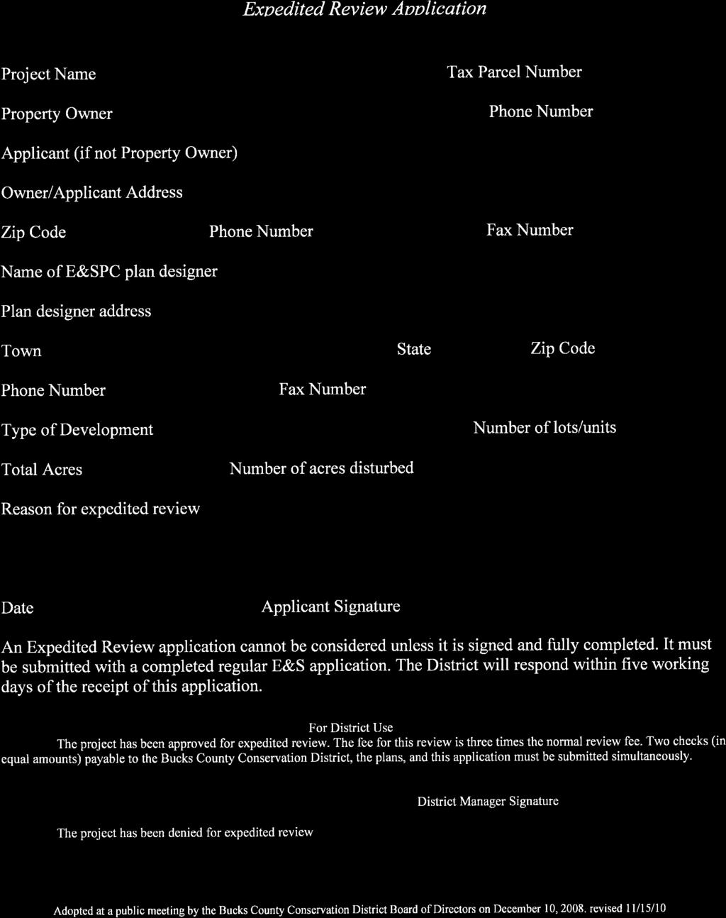
18 Effective Date: January 1, 2013 BUCKS COUNTY CONSERVATION DISTRICT 1456 FERRY ROAD, SUITE 704 DOYLESTOWN, PA P (215) F (215) In Pursuit of Environmental Excellence E&S APPLICATION / GENERAL INFORMATION FORM This form must be completed and submitted along with the required plans and fees for both first time E&S reviews and resubmissions. Please see page 2 for instructions regarding the number of copies required for various submissions. PLEASE SUBMIT FOLDED PLANS TO THE DISTRICT. ROLLED PLANS WILL NOT BE ACCEPTED. Township/Borough Project Street Location Project Name Tax Parcel No. (s) Name of Nearest Stream Stream Classification Submitted By: Engineering Firm/Plan Designer Contractor Landowner Twp. Sealed Engineer Name: Engineering Contact: Name of Engineering/Designing Firm Phone#: Ext. Mailing Address Fax#: Landowner Name(s) Landowner Phone# Landowner Mailing Address *TOTAL ACREAGE *ACRES TO BE DISTURBED #Lots #Units *(Do not use square feet. Square feet divided by 43,560 = Total Acres) Plan Date OR Most Recent Revision Date: NEW PLAN RESUBMISSION ADMINISTRATIVE INCOMPLETE INFO ONLY ($ RE-FILING FEE) SINGLE LOT = 1 RESIDENCE **FEE SCHEDULE FOR E&S REVIEWS (BASED ON DISTURBED ACRES ONLY) ALL OTHER EARTH DISTURBANCE to 1.99 acres $ to 0.99 acres $ to 2.99 acres $ to 1.99 acres $1, to 3.99 acres $ to 4.99 acres $1, to 4.99 acres $ to 9.99 acres $2, acres $ to acres $3, acres $3, Additional $70.00 per acre for each acre over 25 (Fractions of an acre are rounded up to the next whole acre.) **PLEASE READ PAGE 2 OF THIS APPLICATION UNDER EXEMPTIONS AND EXCEPTIONS TIMBER HARVEST (DISTURBED ACRES ONLY) ACRES = $65.00; ACRES = ESC PERMIT SMALL POND WORK E&S FEE = $65.00 (MAY REQUIRE NPDES PERMIT, SEE REVERSE SIDE / NPDES INFORMATION. INCLUDED WITH SUBMISSION ARE: PLANS/NARRATIVES FEE(S) NPDES APPLICATION FOR PROJECTS WITH EARTH DISTURBANCE OF ONE (1) ACRE OR MORE IT IS REQUIRED THAT AN NPDES APPLICATION (NOI) BE SENT WITH E&S SUBMISSION. BCCD USE ONLY BEYOND THIS POINT ENTRY # E&S FEE REC D $ CHECK# EXPEDITED FEE$ CHECK# NPDES FEE $ CHECK# DATE SENT BACK DEP CWF FEE $ CHECK# P&H FEE $ CHECK# NPDES # ASSIGNED 12/27/2012 PLEASE READ ALL INSTRUCTIONS ON PAGE 2 OF APPLICATION - 1 -
19 GENERAL INFORMATION: E&S reviews are processed in the order they are received. The District is required to complete its review within 30 days. Projects requiring NPDES Applications (NOI) will be reviewed for Administrative and Technical completeness within 15 Business days of receipt. If the NOI is considered to be Administratively and Technically Complete, the E&S review will follow within 22 Business days. Re-submittals will be processed within 22 business days of receipt. The BCCD Office Does NOT process Chapter 105 General Permits 1-9 & 15. They must be submitted to the S.E. Regional DEP Office, 2 East Main Street, Norristown, PA Please refer to the DEP website ( for any further information. If a meeting with the BCCD is needed, PLEASE CALL AHEAD TO SCHEDULE AN APPOINTMENT. E&S Review letters are sent to the Landowner, appropriate Municipal government, Bucks County Planning Commission, and Engineer / Plan Designer. PLEASE NOTE: If copies of review letters are needed by any other entities please attach names and addresses. E&S FEE INFORMATION: BCCD DOES NOT ACCEPT CASH OR CREDIT CARDS. E&S FEE EXEMPTIONS AND EXCEPTIONS: State and county agencies, volunteer fire stations, volunteer ambulance services, conservation co-operator farms, & plans with lot subdivision only and no earthmoving involved are exempt from fees. Municipalities and Public Schools please submit One half (1/2) of the fee listed under ALL OTHER EARTH DISTURBANCE fee schedule. FEES ARE REQUIRED FOR ALL OTHER SUBMISSIONS. THERE ARE NO EXEMPTIONS FROM EXPEDITED REVIEW FEES. E&S submissions and resubmissions require one (1) plan set, one (1) General Information Form, and appropriate fee. MAKE CHECKS PAYABLE TO BUCKS COUNTY CONSERVATION DISTRICT OR BCCD. Withdrawal of a submission prior to a response from the BCCD is subject to a fee of either fifteen percent (15%) of the original fee or $150.00, whichever is less. NPDES INFORMATION: A separate federally mandated NPDES General Permit is needed if proposed earth disturbance is one (1) acre or greater. The fee for this permit is $500.00, payable to BCCD-CWF An NPDES Individual Permit is needed if the project is one (1) acre or greater and located in High Quality (HQ) or Exceptional Value (EV) Watershed. Please refer to Chapter 93, Water Quality Standards, Title 25 of PA CODE. The fee for this permit is $ , payable to BCCD- CWF. With every NPDES Submission, please include 3 copies of plans and narratives for review. In a separate package provide a copy of the BCCD General Information Form, the Notice of Intent (NOI), a USGS location Map and a check for $ per disturbed acre, (rounded to the nearest whole acre) made payable to the PA-CWF. DISTURBED ACRE FEES ARE COLLECTED BY THE BCCD AND DELIVERED TO THE PA DEP WEEKLY. BCCD requires a $ Re-filing fee for NPDES applications found to be incomplete or missing information on the first submission. Required information must be submitted to BCCD within 60 days of notice or the application will be considered withdrawn. ALL APPLICATIONS FOR NPDES PERMITS ARE PROCESSED BY BCCD OFFICE. PLEASE INCLUDE THEM WITH THE E&S SUBMISSION IN THEIR ENTIRETY. FOR E&S FORM, NPDES FORMS, and POLICIES PLEASE VISIT OR RESUBMISSION GUIDELINES: Any submission involving a Major Revision from a previously reviewed plan shall be required to submit the FULL E&S Fee. A MAJOR change or revision on a plan may include, but is not limited to: a change in use, lot layout, street layout, grading changes, OR BASIN revisions. If you have any questions, please call the BCCD office. A Fee of 20% of the CURRENT FEE will be charged for each resubmission without major changes. New revision dates noted on the plans require a resubmission to BCCD, including an application and resubmission fee. A new review letter is required with corresponding plan dates. Failure to begin earthmoving within 2 years from date of BCCD s Adequate E&S Review Letter will require a resubmission and will be subject to a full E&S Fee. 12/27/2012 PLEASE READ ALL INSTRUCTIONS ON PAGE 2 OF APPLICATION - 2 -

20


21
22 ACT 537: EXEMPTIONS FROM SEWAGE PLANNING REQUIREMENTS ( Exemptions ) Act 537 (the Pennsylvania Sewage Facilities Act) requires each municipality in the state to have an Official Sewage Facilities Plan (Official Plan) that addresses the existing and future sewage disposal needs of the municipality. In most cases, DEP requires completion of sewage facilities planning for new land development (planning module) to update or revise the municipal official plan before a subdivision is created. However, amendments to the Sewage Facilities Act created a process by which certain subdivisions or new land developments may be exempt from the planning module process. Questions about these projects and the exemption process are discussed below. Additional information may be found in 25 Pa. Code 71.51(b). This section of DEP s regulations, as well as others, is available online at Who determines if a subdivision is exempt from planning? Depending on the location of the proposed subdivision, DEP or a delegated agency will make this determination using information provided by the developer on the Application for Sewage Facilities Planning Module mailer (available at keyword: Sewage). Upon request, DEP will assist delegated agencies by providing them with information necessary for making exemption determinations. If a delegated agency makes the determination that a subdivision is exempt, must they inform DEP? Yes. Delegated agencies are required to submit quarterly reports to DEP. The reports should include the names and locations of subdivisions determined to be eligible for the planning exemption, the number of lots and the projected sewage flow for each subdivision. What information is necessary to make the determination? The information contained in the Sewage Facilities Planning Module Application Mailer may be sufficient to make the determination. If not, additional information may be requested to support the request for determination. Mailers should be sent to DEP or the delegated local agency for evaluation. What types of subdivisions are eligible for the planning exemption? Subdivisions served by either onlot sewage disposal systems or public sewers may be eligible, if they fit the requirements outlined in Act 537. These requirements are discussed below. What are the requirements for subdivisions served by onlot sewage disposal systems? To be eligible for an exemption from the sewage facilities planning requirements, the proposed subdivision must fulfill the following conditions: 1. The official plan must show that the area planned for the development is to be served by onlot sewage disposal facilities, as confirmed by the appropriate municipal official(s). 2. The area proposed for the use of the onlot systems must not be underlain by carbonate geology (determined by DEP) nor be located within one-quarter mile of water supplies having documented nitrate-nitrogen concentrations exceeding five parts per million (determined by DEP). 3. The area proposed for development is outside of high quality or exceptional value watersheds established under the Clean Streams Law (as confirmed by DEP). 4. All subdivided lots and the remaining portion of the original tract after subdivision (if any) will be one acre or larger in size. 5. Soils testing and site evaluation have established that separate sites are available for both a permitted primary onlot sewage disposal system and a replacement onlot sewage disposal system on each lot of the subdivision, as confirmed by the Sewage Enforcement Officer serving the municipality in which the development is proposed.
23 What are the requirements for subdivisions proposed to be served by public sewers? Sewage facilities planning is not required for subdivisions proposing service by public sewers when the following conditions are met: 1. DEP or a delegated agency has determined that the existing collection, conveyance and treatment facilities are in compliance with the Clean Streams Law and related rules and regulations. 2. DEP or a delegated agency has determined that the permittees of the receiving sewerage facilities have submitted information under 25 Pa. Code Chapter 94, that documents that the existing collection, conveyance and treatment system does not have either an existing hydraulic or organic overload or a five-year projected overload. 3. The applicant has provided written certification from the permittees of the receiving collection, conveyance and treatment facilities to the municipality where the subdivision is located that there is capacity to receive and treat the sewage flows from the applicant s proposed new land development and that the additional wasteload will not create a hydraulic or organic overload within the next five years. 4. The municipality where the project is located has a current, approved sewage facilities plan that is being implemented. The official plan of the municipality may not be under an order from DEP to submit an update revision or special study for the proposed subdivision area. Note: Proposals intended to be served by sewage facilities that require a new or modified permit from DEP under the Clean Streams Law are ineligible for a planning exemption. What happens if the subdivision is found to be ineligible for the planning exemption? If the proposed subdivision is found to be ineligible for the planning exemption, sewage facilities planning must be completed and approved before the subdivision may be developed. Should this occur, the approving agency will provide the applicant with the proper forms and instructions necessary to complete sewage facilities planning for the development. For more information, visit keyword: Sewage, or contact the local DEP offices. Northwest Region 230 Chestnut St. Meadville, PA Main Telephone: Hour Emergency: Counties: Butler, Clarion, Crawford, Elk, Erie, Forest, Jefferson, Lawrence, McKean, Mercer, Venango and Warren Southwest Region 400 Waterfront Drive Pittsburgh, PA Main Telephone: Hour Emergency: Counties: Allegheny, Armstrong, Beaver, Cambria, Fayette, Greene, Indiana, Somerset, Washington and Westmoreland DEP Regional Offices North-central Region 208 W. Third St., Suite 101 Williamsport, PA Main Telephone: Hour Emergency: Counties: Bradford, Cameron, Clearfield, Centre, Clinton, Columbia, Lycoming, Montour, Northumberland, Potter, Snyder, Sullivan, Tioga and Union South-central Region 909 Elmerton Ave. Harrisburg, PA Main Telephone: Hour Emergency: Counties: Adams, Bedford, Berks, Blair, Cumberland, Dauphin, Franklin, Fulton, Huntingdon, Juniata, Lancaster, Lebanon, Mifflin, Perry and York Northeast Region 2 Public Square Wilkes-Barre, PA Main Telephone: Hour Emergency: Counties: Carbon, Lackawanna, Lehigh, Luzerne, Monroe, Northampton, Pike, Schuylkill, Susquehanna, Wayne and Wyoming Southeast Region 2 E. Main St. Norristown, PA Main Telephone: Hour Emergency: Counties: Bucks, Chester, Delaware, Montgomery and Philadelphia Commonwealth of Pennsylvania Department of Environmental Protection FS-DEP1859 Rev. 7/2013
24 SEWAGE FACILITIES PLANNING MODULE APPLICATION MAILER For more information, visit DEP's website at keyword: Act 537.
25 3800-CD-BPNPSM0359 2/2015 INSTRUCTIONS FOR COMPLETING SEWAGE FACILITIES PLANNING MODULE APPLICATION MAILER (remove before sending mailer to the approving agency (the Department of Environmental Protection (DEP) or delegated local agency)) Please read the following instructions carefully before completing the application mailer. This information will be used to determine if sewage facilities planning is necessary for your project, and, if it is, which forms are appropriate. Act 537 Sewage Facilities planning is the duty of local municipalities. The responsibility of meeting the sewage disposal needs of the municipality rests with the municipality. Each municipality is required to have an Act 537 Official Sewage Facilities Plan to adequately address these needs. Adoption by resolution of a planning module is the vehicle for legally amending the municipality s Official Plan. It is imperative that the municipality receives all of the information required in order to make informed decisions. Upon completion, submit this Mailer / Application form to the approving agency (DEP or delegated local agency). Additionally, provide a copy of the completed form to the County Health Department having jurisdiction over the area in which the proposed project is located. Unless your project qualifies for one of the planning exemptions provided in Act 537, a package of sewage facilities planning forms appropriate for the project will be sent to the return address indicated on the mailer, or instructions for obtaining the appropriate forms from DEP s website ( will be issued. Each form includes detailed instructions that explain the use of the form and how to complete it. The package of completed forms and its supporting documentation is called a sewage facilities planning module, or planning module. Once the planning module is complete, it must be submitted to the municipality in which the project is located for review and, if acceptable, adoption. After adoption by the municipality, complete planning modules are submitted to either DEP or, if appropriate, to the delegated agency for review and final action. Some municipalities (or groups of municipalities working together) have requested and received DEP approval to review and take final action on planning modules. These are known as delegated agencies. To find out if your project is located in an area served by a delegated agency, contact the municipality or DEP s regional office serving your area. Please note that both DEP and delegated agencies are required by law to charge fees for the review of planning modules. The fees DEP must charge are set by law in Act 537, while delegated agencies may set fees which can be the same or different from those in Act 537. For more information on review fees for your particular project, see the planning module documents or contact the approving agency (DEP or delegated agency) serving the area of your project. NOTE: DEP will provide all planning module forms, however, if your project is a minor subdivision (defined as a subdivision of 10 lots or less, intended for single family residential homes served by individual onlot sewage disposal systems) you may also contact the municipality in which your project is located for a Component 1 minor subdivision planning module form. 1. Print the name of the proposed development and name, address, telephone number and address of the person who is proposing the project. If planning module components are to be sent to a different person or address, include this information on the front of the mailer in the return address block. 2. a. Enter the county in which the project is located. b. Enter the municipality in which the project is located. c. Enter the road or address (if available) or street coordinates (example - west side of T-235, 1 mile south of intersection of Rt 15 and T-235). d. Enter the appropriate tax parcel identification number (if available) of the parcel proposed for subdivision. e. Enter the name of the U.S. Geological Survey (USGS) 7.5-minute quadrangle map which contains the project area, and the location of the project area on that map in inches up and over from the lower right corner of the map to the approximate center of the project. (Example - Centerville West quad, 7 inches up and 2.5 inches over from lower right corner of map.) Alternatively, include an original or a copy of the USGS quad map with the project area outlined on it. f. If the proposed project is located within a special protection watershed, (i.e., watersheds with a stream classification of High Quality or Exceptional Value), check yes. If not located in special protection watershed, check no. 3. Check the box that best describes the intended use of the proposed land development project. Residential refers to single-family lots. Multi-residential includes apartments, condos, etc. Commercial includes retail centers, office - 1 -
26 3800-CD-BPNPSM0359 2/2015 parks, industrial development, etc. Institutional refers to schools, hospitals and the like. Brownfield Site Redevelopment refers to projects proposing to recycle land. Some developments will involve more than one type of use, or will not fit comfortably into any of the classifications given. If this is the case, choose more than one category or explain under Other. 4. a. Enter the number of single family residential lots or Equivalent Dwelling Units (EDUs) proposed. An EDU is defined as that part of a multi-family dwelling or nonresidential project with flows equal to 400 gallons per day (gpd) (the assumed flow, for planning purposes, of a single family residential lot). To determine the number of EDUs, divide the proposed sewage flow of the project by 400 gpd. b. Enter the total number of lots created from this parcel of land since May 15, 1972, including the lots being proposed at this time. (Onlot disposal proposals only.) c. Enter the total project acreage and the acreage of any remaining land (land not proposed for development but under the same ownership and adjacent to the project area). 5. Enter the proposed total sewage flow from the project in gpd. See Title 25 of the Pennsylvania Code, Chapter 73, Section 73.17, ( or DEP's Domestic Wastewater Facilities Manual, DEP ID: available on DEP's website at keyword: wastewater. 6. Choose the category (a, b, c or d) that describes the method of sewage disposal planned to serve the project and enter the information requested. Since this information could have an effect on the planning requirements for your project, be as accurate as possible. If more than one method of sewage disposal is planned, or if an interim method is planned, indicate it here. a. Sewerage System If an existing system is being extended to serve the proposed project, or if lots are to connect directly to an existing sewage collection system, check all boxes that describe the project. Write in the names of the existing collection systems that will be used, the interceptor sewer which will be used for conveyance and the treatment facility where the sewage flows will be treated. Include the National Pollutant Elimination Discharge System (NPDES) permit number for the treatment facility, where applicable. b. Construction of Sewage Treatment Facility (with stream discharge or with spray irrigation as final disposal option) Check the box corresponding to the chosen final disposal option (stream discharge or spray irrigation field). This category does NOT include individual residence spray irrigation systems (IRSIS) which are considered onlot sewage disposal systems ((c), below). For stream discharges, name the receiving waterbody. If the proposed facility is intended to replace an existing, malfunctioning onlot system, check the box marked "repair." c. Onlot Sewage Disposal Systems (individual, community, or large-volume) Check the box corresponding to the type of onlot sewage disposal systems proposed to serve the project. An individual onlot sewage disposal system is a system of piping, tanks or other facilities used for collecting, treating and disposing of sewage into a subsurface absorption area. This category also includes IRSIS. A community onlot system is a facility either publicly or privately owned which will collect and dispose of sewage from two or more lots or EDUs into a subsurface absorption area. A large-volume onlot system is an individual or community onlot system which is designed to treat flows in excess of 10,000 gpd. The approving agency must be notified at least 10 days in advance of all soil testing activities (including those related to planning exemption requests - see 7(b)(5)(v)), so that its staff have the option of observing the tests. d. Retaining Tanks (holding tanks or privies) If retaining tanks are proposed as the method of sewage disposal, enter the number of holding tanks or privies which are proposed to serve the project. 7. Check this box if you desire to obtain your sewage facilities planning module forms from DEP s website. You will be provided with appropriate instructions, website addresses and DEP coding information in a letter rather than a package of paper forms
SEWAGE FACILITIES PLANNING MODULE APPLICATION MAILER
 SEWAGE FACILITIES PLANNING MODULE APPLICATION MAILER COMMONWEALTH OF PENNSYLVANIA Department of Environmental Protection Mark Schweiker, Governor David E. Hess, Secretary For more information, visit us
ADDrESS federal ID (fein) 12/31/18
 12/31/18") 1271018101 rct-127 A 01-19 PAge 1 of 7 2018 PUBLIc UtILItY realty tax report revenue ID NAmE ADDrESS federal ID (fein) _ (Department Use only) Date received o Check to send all correspondence to preparer.
1271018101 rct-127 A 01-19 PAge 1 of 7 2018 PUBLIc UtILItY realty tax report revenue ID NAmE ADDrESS federal ID (fein) _ (Department Use only) Date received o Check to send all correspondence to preparer.
SUBDIVISION APPLICATION
 SUBDIVISION APPLICATION Preliminary Plat Minor Plat Final Plat Amended Plat Applicant Name: Owner (if different from applicant) Name: Company: Company: Address: Address: City, State, Zip City, State, Zip
TOWNSHIP OF DOYLESTOWN APPLICATION FOR REVIEW OF SUBDIVISION OR LAND DEVELOPMENT PROPOSAL. Please PRINT; all information MUST be filled out completely
 TOWNSHIP OF DOYLESTOWN APPLICATION FOR REVIEW OF SUBDIVISION OR LAND DEVELOPMENT PROPOSAL Please PRINT; all information MUST be filled out completely Date: Name of Subdivision or Land Development: Location:
Lower Gwynedd Township 1130 N. Bethlehem Pike, P.O. Box 625 Spring House, PA (215) phone (215) fax
 phone (215) fax") Lower Gwynedd Township 1130 N. Bethlehem Pike, P.O. Box 625 Spring House, PA 19477 (215)646-5302- phone (215)646-3357-fax www.lowergwynedd.org Subdivision and Land Development Application Procedures Requests
Lower Gwynedd Township 1130 N. Bethlehem Pike, P.O. Box 625 Spring House, PA 19477 (215)646-5302- phone (215)646-3357-fax www.lowergwynedd.org Subdivision and Land Development Application Procedures Requests
Residential Major Subdivision Review Checklist
 Residential Major Subdivision Review Checklist Plan Submittal Requirements: 2 full sets of stamped plans Electric submittal - all plans contained in a single PDF 3 full sets if commercial kitchen or dining
BOROUGH OF JESSUP SUBDIVISION AND LAND DEVELOPMENT ORDINANCE
 BOROUGH OF JESSUP SUBDIVISION AND LAND DEVELOPMENT ORDINANCE 1993 Amended May 1995 Reenacted May 2000 Amended February 9, 2004 Amended May 7, 2007 SUBDIVISION AND LAND DEVELOPMENT ORDINANCE BOROUGH OF
E L M E R B O R O U G H L A N D U S E B O A R D APPLICATION COVER SHEET (to be completed for all applications and appeals)
") E L M E R B O R O U G H L A N D U S E B O A R D APPLICATION COVER SHEET (to be completed for all applications and appeals) 1. Name(s): 2. Address: 3. Telephone Number(s): 4. E-mail: 5. Owner Name(s) (if
E L M E R B O R O U G H L A N D U S E B O A R D APPLICATION COVER SHEET (to be completed for all applications and appeals) 1. Name(s): 2. Address: 3. Telephone Number(s): 4. E-mail: 5. Owner Name(s) (if
Residential Minor Subdivision Review Checklist
 Residential Minor Subdivision Review Checklist Plan Submittal Requirements: 2 full sets of stamped plans Electric submittal - all plans contained in a single PDF 3 full sets if commercial kitchen or dining
ARTICLE 5 MINOR SUBDIVISION/LAND DEVELOPMENT
 ARTICLE 5 MINOR SUBDIVISION/LAND DEVELOPMENT SECTION 501 ONLY FINAL PLAN REQUIRED The classification of a proposed subdivision as a "Minor Subdivision" shall only require the submission, review and approval
FINAL SUBDIVISION AND LAND DEVELOPMENT PLAN CHECKLIST. Plan Name. Applicant's Name:
 TOWNSHIP OF UPPER ST. CLAIR FINAL SUBDIVISION AND LAND DEVELOPMENT PLAN CHECKLIST Date Filed Plan Name PLC Applicant's Name: Phone Filing Date for Final Application Final Plat 114.22. FINAL APPLICATION
APPLICATION PROCEDURE
 ANTRIM PLANNING BOARD P. O. Box 517 Antrim, New Hampshire 03440 Phone: 603-588-6785 FAX: 603-588-2969 APPLICATION FORM AND CHECKLIST FOR MINOR OR MAJOR SITE PLAN REVIEW File Date Received By APPLICATION
SUBDIVISION AND LAND DEVELOPMENT. 185 Attachment 20
 185 Attachment 20 APPENDIX S Plat No. Date of Submission Twp. Fee $ Dauphin Co. Fee $ TOWNSHIP OF DERRY SUBDIVISION OR LAND DEVELOPMENT PLAN SUBMISSION APPLICATION This block for Twp. use only 1. Title
National Legislative Program Evaluation Society September 19, Pennsylvania Legislative Budget and Finance Committee
 National Legislative Program Evaluation Society September 19, 2011 House Resolution 2009-334 Study the systems of real property valuation and assessment Pennsylvania Other states, in particular Maryland
Use permitted by: Right Special Exemption
 CENTER TOWNSHIP 150 Henricks Road Butler, PA 16001-8472 Phone (724) 282-7805 Fax (724) 282-6550 Application Number: FEE COLLECTED: Application for: Preliminary Final Land Development Location: Map and
I. Requirements for All Applications. C D W
 108-16.1. Application checklists. Checklist for Required Submissions to the Planning Board or Zoning Board of Adjustment of Monroe Township All required submissions are to be made to the Administrative
CHECKLIST FOR DEVELOPMENT REVIEW
 CHECKLIST FOR DEVELOPMENT REVIEW Petitions and related documents and plans for land development or other proposals regulated by Title 16 of the Municipal Code (Development Ordinance) and Title 17 of the
Application for Subdivision and Land Development
 Application for Subdivision and Land Development Montgomery Township 1001 Stump Road Montgomeryville, PA 18936-9605 Telephone: 215-393-6920 Fax: 215-855-1498 www.montgomerytwp.org 9-2017 TO: FROM: RE:
BRIDGETON SUBDIVISION APPLICATION CHECKLIST
 APPLICATION NAME AND # CHECKLIST COMPLETED BY: DATE: Signature and printed name BRIDGETON SUBDIVISION APPLICATION CHECKLIST TO SUBDIVISION APPLICANTS: The attached checklist is to assist you in the submission
BID ITEM WORKBOOK COSTARS-8 Maintenance, Repair, & Operation Equipment & Supplies ("MRO") (07/25/2012) BIDDER/CONTRACTOR DATA
 (07/25/2012) BIDDER/CONTRACTOR DATA") BID ITEM WORKBOOK COSTARS-8 Maintenance, Repair, & Operation Equipment & Supplies ("MRO") (07/25/2012) BIDDER/CONTRACTOR DATA BIDDER/CONTRACTOR'S LEGAL NAME: D/B/A NAME, IF APPLICABLE: BIDDER ADDRESS:
BID ITEM WORKBOOK COSTARS-8 Maintenance, Repair, & Operation Equipment & Supplies ("MRO") (07/25/2012) BIDDER/CONTRACTOR DATA BIDDER/CONTRACTOR'S LEGAL NAME: D/B/A NAME, IF APPLICABLE: BIDDER ADDRESS:
City of Prior Lake APPLICATION FOR COMBINED PRELIMINARY AND FINAL PLAT
 Case File No. Property Identification No. City of Prior Lake APPLICATION FOR COMBINED PRELIMINARY AND FINAL PLAT Requested Action Brief description of proposed project (Please describe the proposed amendment,
FACT SHEET. Instructions for Completing Form MV-4ST, Vehicle Sales and Use Tax Return/Application for Registration
 FACT SHEET Instructions for Completing Form MV-4ST, Vehicle Sales and Use Tax Return/Application for Registration (FOR PENNDOT AUTHORIZED AGENTS USE ONLY) This form is used to obtain a Pennsylvania Certificate
Township of Collier 2418 Hilltop Road Presto, PA 15142
 Township of Collier 2418 Hilltop Road Presto, PA 15142 Fees: Major: 2 checks $600 + $50 per lot & $1700 Escrow) APPLICATION FOR SUBDIVISION major FINAL only Plans must be folded Rolled plans will not be
FINAL PLAT APPLICATION
 FINAL PLAT APPLICATION (Page 1 of 3) LEGAL OWNER(s): NAME: STREET ADDRESS OWNER(s): CITY, STATE, ZIP CODE: PHONE NUMBER: BILLING ADDRESS: NAME OF ENGINEER/SURVEYOR: Engineer/Surveyor Address, Phone: PROPERTY
Township of Little Egg Harbor Planning Board 665 Radio Road Little Egg Harbor, New Jersey Phone: ext. 221 Fax:
 BLOCK(S) LOT(S) Township of Little Egg Harbor Planning Board 665 Radio Road Little Egg Harbor, New Jersey 08087 Phone: 609-296-7241 ext. 221 Fax: 609-294-3040 Development Application Amended Development
TOWN OF ROXBURY PLANNING BOARD
 UPDATED: APRIL 2011 TOWN OF ROXBURY PLANNING BOARD Applicant s Guide for Subdivision Review The Town Planning Board administers the subdivision review process. This guide has been prepared in order to
City of Prior Lake APPLICATION FOR REGISTERED LAND SURVEY
 Case File No. Property Identification No. City of Prior Lake APPLICATION FOR REGISTERED LAND SURVEY Requested Action Brief description of proposed project (Please describe the proposed amendment, project,
SUBDIVISION APPLICATION CHECKLIST SKETCH PLAN PRELIMINARY PLAT FINAL PLAT
 RECEIVED STAMP SUBDIVISION APPLICATION CHECKLIST SKETCH PLAN PRELIMINARY PLAT FINAL PLAT A checklist of background information and submission requirements for processing of a sketch plan, preliminary plat
Pennsylvania Tax Credit Rental Housing Survey
 2012 Pennsylvania Tax Credit Rental Housing Survey 155 East Columbus Street Suite 220 Pickerington, OH 43147 Bowen National Research conducted a statewide survey of approximately 65% of Tax Credit rental
SEWAGE FACILITIES PLANNING MODULE
 COMMONWEALTH OF PENNSYLVANIA DEPARTMENT OF ENVIRONMENTAL PROTECTION BUREAU OF WATER STANDARDS AND FACILITY REGULATION SEWAGE FACILITIES PLANNING MODULE Component 2. Individual and Community Onlot Disposal
Initial Subdivision Applications Shall Include the Following:
 Initial Subdivision Applications Shall Include the Following: 1) Subdivision Application Form: completely filled out (12 copies) 2) Plat: The Plat must adhere to the requirements set forth in the Town
TOWNSHIP OF BORDENTOWN LAND DEVELOPMENT APPLICATION CHECKLIST. General Requirements for all Applications
 TOWNSHIP OF BORDENTOWN LAND DEVELOPMENT APPLICATION CHECKLIST This CHECKLIST has been adopted in accordance with Section 25:807 of the Land Development Ordinance of the Township of Bordentown and will
ARTICLE 4 MAJOR SUBDIVISION/LAND DEVELOPMENT PLAN REQUIREMENTS
 ARTICLE 4 MAJOR SUBDIVISION/LAND DEVELOPMENT PLAN REQUIREMENTS SECTION 401 LAND SKETCH PLANS FOR MAJOR SUBDIVISIONS AND DEVELOPMENTS 401.1 Sketch Plan Information The following process and procedures shall
SEWAGE FACILITIES PLANNING MODULE
 Code. COMMONWEALTH OF PENNSYLVANIA DEPARTMENT OF ENVIRONMENTAL PROTECTION BUREAU OF WATER STANDARDS AND FACILITY REGULATION SEWAGE FACILITIES PLANNING MODULE Component 3s. Small Flow Treatment Facilities
Preliminary Plat/Final Plat Application
 Melissa Municipal Center 3411 Barker Avenue Melissa, Texas 75454 Phone: (972) 838-2036 Applicant: Date: Address: Phone: Contact: Fax: E-mail: Propose Addition Name: Acres: Existing Zoning: Propose Zoning:
SUBDIVISION CHECKLIST GREEN TREE BOROUGH Green Tree Planning Commission 10 West Manilla Avenue Pittsburgh, PA
 TO BE COMPLETED BY BOROUGH: SUBDIVISION CHECKLIST GREEN TREE BOROUGH Green Tree Planning Commission 10 West Manilla Avenue Pittsburgh, PA 15220 412-921-1110 SD - - DATE STAMP RECEIVED NOTE TO ALL APPLICANTS:
CITY OF SARALAND PRELIMINARY SUBDIVISION PLAT REVIEW
 PRELIMINARY SUBDIVISION PLAT REVIEW Application Number: Date Plat Submitted: Name of Subdivision: Name of Owner: Owner Address: (Street or P.O. Box) Telephone #: (City) (State) (Zip) E-mail: Name of Authorized
A.3. ARTICLE 7 PLAN REQUIREMENTS FOR MINOR SUBDIVISION AND/OR LAND DEVELOPMENT
 700. 701.A.3. ARTICLE 7 PLAN REQUIREMENTS FOR MINOR SUBDIVISION AND/OR LAND DEVELOPMENT SECTION 700 PURPOSE The purpose of this Article is to set forth a streamlined set of Plan Requirements for minor
MAJOR SUBDIVISION PRELIMINARY PLAT CHECKLIST
 TOWNSHIP OF EGG HARBOR PLANNING BOARD/ZONING BOARD OF ADJUSTMENT 3515 BARGAINTOWN ROAD EGG HARBOR TOWNSHIP, NJ 08234 MAJOR SUBDIVISION PRELIMINARY PLAT CHECKLIST The following checklist is designed to
BOROUGH OF HELLERTOWN 685 Main St., Hellertown PA Phone: Fax:
 SUBDIVISION / LAND DEVELOPMENT REVIEW CHECKLIST Subdivision / Land Development Preliminary Plan Preliminary Plan Checklist A scaled plan not less that 1 = 100 feet (422.01) Proposed subdivision name or
TOWN OF LEWISTON PLANNING BOARD APPLICATION
 TOWN OF LEWISTON PLANNING BOARD APPLICATION DESCRIPTION OF PROPOSED REQUEST: Name of Property Owner: Phone #: Name of Applicant:Phone #: Address or Location of Proposal:_SBL# Size of Parcel or Structure:Existing
MINOR SUBDIVISION PLAT CHECKLIST
 MINOR SUBDIVISION PLAT CHECKLIST Project Name: Tax ID #: Project Number: Date: _ Reviewed By: Telephone: NOTES: All lots on septic systems must comply with the Fulton County Health Department requirements
CHAPTER 22 SUBDIVISION AND LAND DEVELOPMENT
 CHAPTER 22 SUBDIVISION AND LAND DEVELOPMENT 22-101. Title 22-102. Legislative Intent Part 1 General Provisions 22-201. Development Permits Part 2 Administration 22-301. Fee Schedule Part 3 Fee Schedule
CITY OF SARALAND FINAL SUBDIVISION PLAT REVIEW
 CITY OF SARALAND FINAL SUBDIVISION PLAT REVIEW Application Number: Date Plat Submitted: Name of Subdivision: Name of Owner: Owner Address: (Street or P.O. Box) Telephone #: (City) (State) (Zip) E-mail:
CITY OF DECATUR, TEXAS
 Final Plat or Amending Plat / Replat Checklist A submittal of a complete application will facilitate a timely review. Failure of the applicant to provide required information or obtain a waiver from the
Residential Subdivision Preliminary Plat Application
 WATER MODELING FEES Major : $650 or Minor : $550 # of lots x $35 per lot Residential Preliminary Plat Application Lots: 1-9 10-19 20-49 50-99 100-199 $300 $400 $475 $625 $825 200-349 350-499 500-499 700-999
MAJOR RESIDENTIAL AND NONRESIDENTIAL SUBDIVISIONS
 Lawrence-Douglas County MAJOR RESIDENTIAL AND NONRESIDENTIAL SUBDIVISIONS Preliminary Plats The applicant shall schedule a Pre-Application meeting with Planning Staff at least seven (7) working days prior
PRELMINARY PLAT CHECKLIST
 PRELMINARY PLAT CHECKLIST A. All preliminary plat submitted for approval shall be prepared by a Registered Professional Land Surveyor. B. Preliminary plats must be drawn to a scale of XXX with such accuracy
LOWER SAUCON TOWNSHIP PLANNING APPLICATION 3700 OLD PHILADELPHIA PIKE BETHLEHEM, PA
 rev. 02/08/06 rev. 01/03/13 File No. LOWER SAUCON TOWNSHIP PLANNING APPLICATION 3700 OLD PHILADELPHIA PIKE BETHLEHEM, PA 18015 (610) 865-3291 Type of Application: Date of Application CONDITIONAL USE REQUEST
INSTRUCTIONS FOR TRANSFER OF A CHAPTER 105 PERMIT AND/OR SUBMERGED LANDS LICENSE AGREEMENT (SLLA)
") 3150-PM-BWEW0016 Rev. 10/2016 Instructions COMMONWEALTH OF PENNSYLVANIA DEPARTMENT OF ENVIRONMENTAL PROTECTION BUREAU OF WATERWAYS ENGINEERING AND WETLANDS INSTRUCTIONS FOR TRANSFER OF A CHAPTER 105 PERMIT
3150-PM-BWEW0016 Rev. 10/2016 Instructions COMMONWEALTH OF PENNSYLVANIA DEPARTMENT OF ENVIRONMENTAL PROTECTION BUREAU OF WATERWAYS ENGINEERING AND WETLANDS INSTRUCTIONS FOR TRANSFER OF A CHAPTER 105 PERMIT
APPLICATION FOR 555 Washington Street Tentative Map Red Bluff, CA Subdivision Map (530) ext Parcel Map.
 ext Parcel Map.") City of Red Bluff Community Development Department Application No. APPLICATION FOR 555 Washington Street Tentative Map Red Bluff, CA 96080 Subdivision Map (530) 527-2605 ext. 3059 Parcel Map Applicant
City of Red Bluff Community Development Department Application No. APPLICATION FOR 555 Washington Street Tentative Map Red Bluff, CA 96080 Subdivision Map (530) 527-2605 ext. 3059 Parcel Map Applicant
City of Prior Lake APPLICATION FOR PRELIMINARY PLAT
 City of Prior Lake APPLICATION FOR PRELIMINARY PLAT Requested Action Brief description of proposed project (Please describe the proposed amendment, project, or variance request. Attach additional sheets
SITE DEVELOPMENT PLAN REQUIREMENTS CHECKLIST
 SITE DEVELOPMENT PLAN REQUIREMENTS CHECKLIST Completed DRC Application for Review Required for Application Process DRC Processing Fee 1 Commercial $2,500.00 Fire Department Review Fee 150.00 Total $2,650.00
APPLICATION for MINOR SUBDIVISION REVIEW for CONCEPT and FINAL PLAT within COALVILLE CITY. Project Name: Project Address or Area: Name of Owner:
 APPLICATION for MINOR SUBDIVISION REVIEW for CONCEPT and FINAL PLAT within COALVILLE CITY For Office Use Only: Application #: Application Date: PC Approval Date: CC Approval Date: Community Development
PLANNING COMMISSION SUBDIVISION PLAT APPLICATION
 PLANNING COMMISSION SUBDIVISION PLAT APPLICATION Economic Development Department 3468 North Fulton Avenue Hapeville, Georgia 30354 Phone - 404.669.8269 Fax 404.669.3302 Rev. 09/23/16 1 The following information
ARTICLE V PRELIMINARY PLAN SUBMISSION
 ARTICLE V PRELIMINARY PLAN SUBMISSION 501. Plan Requirements a. On or before the 25 th day of the month prior to a regularly scheduled meeting of the Planning Commission, the applicant shall submit two
*For Special Exception and Conditional Uses, Complete Page 3 of this application.
 PLEASE READ CAREFULLY All applications, plans fees and support documents must be submitted at least 21 days prior to the Planning Commission meeting. Applicants must submit 20 FOLDED copies of their plan.
SUBMITTAL REQUIREMENTS: The number indicates the number of copies for submittal (if applicable).
.") Office Use Only Preliminary Long Plat Long Subdivision Applicant Checklist PLANNING, COMMUNITY, & ECONOMIC DEVELOPMENT DEPARTMENT PRELIMINARY LONG PLAT LONG SUBDIVISION CHECKLIST Mailing Address: P.O.
Office Use Only Preliminary Long Plat Long Subdivision Applicant Checklist PLANNING, COMMUNITY, & ECONOMIC DEVELOPMENT DEPARTMENT PRELIMINARY LONG PLAT LONG SUBDIVISION CHECKLIST Mailing Address: P.O.
CHAPTER 3 PRELIMINARY PLAT
 10-3-1 10-3-3 SECTION: CHAPTER 3 PRELIMINARY PLAT 10-3-1: Consultation 10-3-2: Filing 10-3-3: Requirements 10-3-4: Approval 10-3-5: Time Limitation 10-3-6: Grading Limitation 10-3-1: CONSULTATION: Each
TOWN OF LERAY PLANNING BOARD Minor Subdivision Application Packet
 This Packet is designed to assist applicants in providing the forms needed for submission of a 1 to 4 lot subdivision to the Planning Board for approval. The following should be filled out to ensure the
YCCD EROSION & SEDIMENT POLLUTION CONTROL (E&SPC) PROGRAM SERVICES FEE SCHEDULE, RULES, & GUIDELINES
 PROGRAM SERVICES FEE SCHEDULE, RULES, & GUIDELINES") YCCD EROSION & SEDIMENT POLLUTION CONTROL (E&SPC) PROGRAM SERVICES FEE SCHEDULE, RULES, & GUIDELINES Adopted by the YCCD Board of Directors on December 14, 2018 Effective January 1, 2019. I. Authority
YCCD EROSION & SEDIMENT POLLUTION CONTROL (E&SPC) PROGRAM SERVICES FEE SCHEDULE, RULES, & GUIDELINES Adopted by the YCCD Board of Directors on December 14, 2018 Effective January 1, 2019. I. Authority
ARTICLE IV PLAN REQUIREMENTS
 ARTICLE IV PLAN REQUIREMENTS Section 401 SKETCH PLAN Sketch Plans may be drawn by the landowner, subdivider or developer, or by his engineer, surveyor or agent and should include sufficient data to make
A. Appropriate agency responsible for transportation review for the subject property.
 7.8.10 Procedure Any person desiring to create a minor subdivision shall submit to the Commission for approval an application on forms provided by the Division, and a record plat in conformance with the
MINOR & MAJOR SUBDIVISION APPLICATION
 TOW OF HOOKSETT APPLICATIO # DATE MIOR & MAJOR SUBDIVISIO APPLICATIO Application for: Completeness Map and Lot o. Public Hearing o. of Lots LOCATIO: (Specify Street Address) OWER: APPLICAT: ADDRESS: ADDRESS:
City of Columbia ENgiNEEriNg regulations Part 6: ProCEDurEs For the subdivision of land table of CoNtENts Paragraph Description Page No.
 City of Columbia Engineering Regulations PART 6: PROCEDURES FOR THE SUBDIVISION OF LAND Table of Contents Paragraph Description Page No. 6.1 General 6-1 6.2 Sketch Plan Review 6-1 6.3 Preliminary Plat
A GUIDE TO PROCEDURES FOR: SUBDIVISIONS & CONDOMINIUM CONVERSION
 A GUIDE TO PROCEDURES FOR: SUBDIVISIONS & CONDOMINIUM CONVERSION A GUIDE TO PROCEDURES FOR: SUBDIVISIONS (TENTATIVE MAPS) PURPOSE Definition: A subdivision is defined as the division of any improved or
SECTION 4: PRELIMINARY PLAT
 SECTION 4: PRELIMINARY PLAT After the completion of the sketch plan process, if submitted, the owner or developer shall file with the City an application for preliminary plat. The preliminary plat stage
Plan ID: Plan Date: Rev. Date: No. Pages:
 FOR TOWNSHIP USE ONLY SUBDIVISION & LAND DEVELOPMENT APPLICATION PROJECT NAME: Date Received: Application No: App. Fee Paid: Escrow Fee Paid: 90 Day Start: 90 Day End: Plan ID: Plan Date: Rev. Date: No.
PLANNING BOARD CITY OF CONCORD, NH MINOR SUBDIVISION CHECKLIST
 PLANNING BOARD CITY OF CONCORD, NH MINOR SUBDIVISION CHECKLIST Summary This checklist is intended to assist applicants and design professionals in the preparation of minor subdivision applications for
PRELIMINARY PLAT CHECK LIST
 PRELIMINARY PLAT CHECK LIST Name of Proposed Subdivision: The following items must be included with the initial submittal of a Preliminary Plat: Application, filled out completely Project Narrative Pre-application
Gates County Planning and Zoning
 Gates County Planning and Zoning PO Box 411, 200 Court Street, Gatesville, NC 27938 phone: 252-357-2411 fax: 252-357-0073 Application for Technical Review Committee For Staff Use Only: Date: Application
SECTION 6 - APPROVAL OF PLATS. Whenever any subdivision of land is proposed, and before any permit for the
 SECTION 6 - APPROVAL OF PLATS 6-1 APPROVAL REQUIRED BEFORE SALE Whenever any subdivision of land is proposed, and before any permit for the erection of a structure shall be granted, the subdivider or his
géãç Éy VtÇtÇwt zât 5440 Routes 5 & 20 West Canandaigua, NY Phone: (585) / Fax: (585)
 / Fax: (585)") géãç Éy VtÇtÇwt zât 5440 Routes 5 & 20 West Canandaigua, NY 14424 Phone: (585) 394-1120 / Fax: (585) 394-9476 APPLICATION FOR LOT-LINE ADJUSTMENT The applicant is responsible for the completeness of all
géãç Éy VtÇtÇwt zât 5440 Routes 5 & 20 West Canandaigua, NY 14424 Phone: (585) 394-1120 / Fax: (585) 394-9476 APPLICATION FOR LOT-LINE ADJUSTMENT The applicant is responsible for the completeness of all
Preliminary Subdivision Application (Major) (Four (4) lots or more)
 (Four (4) lots or more)") Gunnison City Offices www.gunnisoncity.org 38 West Center Gunnison, Utah 84634 (435) 528 7969 Date of Application: Preliminary Subdivision Application (Major) (Four (4) lots or more) APPLICANT INFORMATION
Gunnison City Offices www.gunnisoncity.org 38 West Center Gunnison, Utah 84634 (435) 528 7969 Date of Application: Preliminary Subdivision Application (Major) (Four (4) lots or more) APPLICANT INFORMATION
City of Suwanee Development Regulations ARTICLE 10 PLAN AND PLAT SPECIFICATIONS
 ARTICLE 10 PLAN AND PLAT SPECIFICATIONS 10.1 CONCEPT PLAN SPECIFICATIONS The following paragraphs outline the required elements of both the required and optional plans and plats mentioned throughout these
Preliminary Subdivision Application (Minor) (Three (3) lots or less)
 (Three (3) lots or less)") Gunnison City Offices www.gunnisoncity.org 38 West Center Gunnison, Utah 84634 (435) 528 7969 Date of Application: Preliminary Subdivision Application (Minor) (Three (3) lots or less) APPLICANT INFORMATION
Gunnison City Offices www.gunnisoncity.org 38 West Center Gunnison, Utah 84634 (435) 528 7969 Date of Application: Preliminary Subdivision Application (Minor) (Three (3) lots or less) APPLICANT INFORMATION
PLYMOUTH PLANNING BOARD APPLICATION FOR A MINOR SUBDIVISION OR MAJOR SUBDIVISION
 CASE # PLYMOUTH PLANNING BOARD APPLICATION FOR A MINOR SUBDIVISION OR MAJOR SUBDIVISION The undersigned Applicant hereby submits to the Plymouth Planning Board a completed application for a proposed minor
SUBMITTAL REQUIREMENTS
 PRELIMINARY PLAT APPLICATION ***A PRE-APPLICATION MEETING WITH CITY STAFF IS REQUIRED FOR THIS APPLICATION*** DATE STAMP FOR CITY USE ONLY PROJECT NAME (if any): TO BE FILLED OUT BY APPLICANT PROJECT STREET
LAND USE APPLICATION
 LAND USE APPLICATION File Name: File No(s).: Receipt No.: Receipt Date: Received By: Amount.: $ Instructions for Applicants Please read and follow all instructions on your application carefully. If you
SUBDIVISION AND / OR LAND DEVELOPMENT SUBMITTAL REQUIREMENTS
 SUBDIVISION AND / OR LAND DEVELOPMENT SUBMITTAL REQUIREMENTS Please review checklist prior to submittal. Incomplete submittals will delay the review process. Township 90-day time clock begins upon submission
Administrative Plat Application Form
 1 Administrative Plat Application Form This form shall be submitted with each application for an administrative plat. CONTACT INFORMATION Applicant Architect (if different) Property Owner (if different)
WASCO COUNTY PRELIMINARY SUBDIVISION APPLICATION
 WASCO COUNTY PRELIMINARY SUBDIVISION APPLICATION DETAILED SPECIFIC WRITTEN REQUEST File Number: SDV- Number of Proposed Lots & their Dimensions: PRELIMINARY SUBDIVISION PLAN REQUIREMENTS The approval of
City of Forest Hill Minor Plat Application
 City of Forest Hill Minor Plat Application APPLICANT NAME: DATE: SUB-DIVISION NAME: LEGAL DESCRIPTION: ACRES: CURRENT ZONING: PROPOSED ZONING: BEING PLATTED AS: LOTS: BLOCKS: PHASES: OWNER OF RECORD: ADDRESS:
TENTATIVE PARCEL MAP APPLICATION GUIDE TENTATIVE PARCEL MAP APPLICATION REQUIREMENTS
 TENTATIVE PARCEL MAP APPLICATION GUIDE SISKIYOU COUNTY PLANNING DIVISION 806 South Main Street, Yreka CA 96097 Phone: (530) 841-2100 / Fax: (530) 841-4076 TENTATIVE PARCEL MAP APPLICATION REQUIREMENTS
Chapter 22. Subdivision and Land Development
 Chapter 22 Subdivision and Land Development Part 1 Short Title, Authority and Purpose 22-101. Short Title 22-102. General Legislative Authority 22-103. Activities to Be Regulated 22-104. Exemptions from
LAND DEVELOPMENT CHECKLIST GREEN TREE BOROUGH Green Tree Planning Commission 10 West Manilla Avenue Pittsburgh, PA
 TO BE COMPLETED BY BOROUGH: LAND DEVELOPMENT CHECKLIST GREEN TREE BOROUGH Green Tree Planning Commission 10 West Manilla Avenue Pittsburgh, PA 15220 412-921-1110 SP - - DATE STAMP RECEIVED NOTE TO ALL
Town of Lisbon, Maine SUBDIVISION REVIEW APPLICATION
 Date Received: Fee Paid (amount): Applicant: Town of Lisbon, Maine SUBDIVISION REVIEW APPLICATION Subdivision Name/Title: This application must be received at the Town Office by close of business on the
LYNN TOWNSHIP SUBDIVISION AND LAND DEVELOPMENT ORDINANCE ORDINANCE NO
 LYNN TOWNSHIP SUBDIVISION AND LAND DEVELOPMENT ORDINANCE ORDINANCE NO. 1980-2 -1980- Revised December 1999 Printed July 17, 2002 Revised September, 2002 Revised November 2003 saldol.wpd LYNN TOWNSHIP SUBDIVISION
City of Yelm. Community Development Department BOUNDARY LINE ADJUSTMENT OR LARGE LOT SUBDIVISION
 City of Yelm Community Development Department BOUNDARY LINE ADJUSTMENT OR LARGE LOT SUBDIVISION Fee Date Received By File No. FEES: Boundary Line Adjustment $100.00 LARGE LOT SUBDIVISION $250.00, + $10.00/lot
Sketch Plan 2018 Bargersville Plan Commission Application Kit
 Sketch Plan 2018 Bargersville Plan Commission Application Kit For Commercial, Industrial, and Residential Developments At least 31 days prior to the intended filing of the Primary Plat or Development Plan
SUBMITTAL REQUIREMENTS: The number indicates the number of copies for submittal (if applicable).
.") Office Use Only Preliminary Long Plat Long Subdivision Applicant Checklist PLANNING, COMMUNITY, & ECONOMIC DEVELOPMENT DEPARTMENT FINAL LONG PLAT LONG SUBDIVISION CHECKLIST Mailing Address: P.O. Box 547,
Office Use Only Preliminary Long Plat Long Subdivision Applicant Checklist PLANNING, COMMUNITY, & ECONOMIC DEVELOPMENT DEPARTMENT FINAL LONG PLAT LONG SUBDIVISION CHECKLIST Mailing Address: P.O. Box 547,
Town of Canandaigua 5440 Routes 5 & 20 West Canandaigua, NY Phone: (585) / Fax: (585)
 / Fax: (585)") Town of Canandaigua 5440 Routes 5 & 20 West Canandaigua, NY 14424 Phone: (585) 394-1120 / Fax: (585) 394-9476 NOTICE TO ALL PLANNING BOARD APPLICANTS FOR SINGLE STAGE PRELIMINARY/FINAL SUBDIVISION PLAT
Town of Canandaigua 5440 Routes 5 & 20 West Canandaigua, NY 14424 Phone: (585) 394-1120 / Fax: (585) 394-9476 NOTICE TO ALL PLANNING BOARD APPLICANTS FOR SINGLE STAGE PRELIMINARY/FINAL SUBDIVISION PLAT
City of Leavenworth DEPARTMENT OF DEVELOPMENT SERVICES MAJOR SUBDIVISION APPLICATION 1
 Proposed Name of Subdivision: City of Leavenworth DEPARTMENT OF DEVELOPMENT SERVICES MAJOR SUBDIVISION APPLICATION 1 FOR PRELIMINARY SUBDIVISION APPROVAL This application must be filled out legibly, in
-MENDOCINO COUNTY PLANNING AND BUILDING SERVICES- DIVISION OF LAND REGULATIONS TITLE 17
 ARTICLE VI -- GENERAL REGULATIONS AND PROVISIONS Sec. 17-50. Sec. 17-51 General Plan. Sec. 17-52 Lot and Block Design and Configuration. Sec. 17-53 Lot Access. Sec. 17-54 Private Roads. Sec. 17-55 Water
Request for Action form is also defined as an application to be considered by the Planning Commission.
 CITY OF NORTH RIDGEVILLE INSTRUCTIONS FOR FILING REQUEST FOR ACTION APPLICATIONS WITH THE PLANNING COMMISSION (Please read the full instruction as it will help in providing a full complete application)
W E S T T O W N T O W N S H I P 1039 Wilmington Pike P.O. Box 79 West Chester, PA Westtown, PA PHONE: (610) FAX: (610)
 FAX: (610)") W E S T T O W N T O W N S H I P 1039 Wilmington Pike P.O. Box 79 West Chester, PA 19382 Westtown, PA 19395 PHONE: (610) 692-1930 FAX: (610) 692-9651 APPLICATION FOR APPROVAL OF PRELIMINARY PLAN Plan title:
W E S T T O W N T O W N S H I P 1039 Wilmington Pike P.O. Box 79 West Chester, PA 19382 Westtown, PA 19395 PHONE: (610) 692-1930 FAX: (610) 692-9651 APPLICATION FOR APPROVAL OF PRELIMINARY PLAN Plan title:
ADAMS COUNTY CONSERVATION DISTRICT S
 Approved by District Board on 12-15-2016 I. Authority & Applicability of Fees for Services A. Authority - The Adams County Conservation District is delegated with the responsibility to administer the Commonwealth
APPLICATION SUBMITTAL REQUIREMENTS FOR Tentative Parcel or Subdivision Maps
 CITY OF EL CERRITO Community Development Department Planning and Building Division 10890 San Pablo Avenue, El Cerrito, CA 94530 (510) 215-4330 FA (510) 233-5401 planning@ci.el-cerrito.ca.us APPLICATION
Chapter 100 Planned Unit Development in Corvallis Urban Fringe
 100.100 Scope and Purpose. Chapter 100 Planned Unit Development in Corvallis Urban Fringe (1) All applications for land divisions in the Urban Residential (UR) and Flood Plain Agriculture (FPA) zones within
ARTICLE III GENERAL PROCEDURES, MINOR PLANS AND FEE SCHEDULES
 ARTICLE III GENERAL PROCEDURES, MINOR PLANS AND FEE SCHEDULES 301. Prior to Submission a. Copies of this Ordinance shall be available on request, at cost, for the use of any person who desires information