Purchase of Development Rights in Fayette County: A Hedonic Price Analysis of Easement Payments Submitted by Perry A. Papka March 30, 2006
|
|
|
- Derick Harrington
- 5 years ago
- Views:
Transcription

1 Purchase of Development Rights in Fayette County: A Hedonic Price Analysis of Easement Payments Submitted by Perry A. Papka March 30, 2006 Capstone in Public Administration Martin School of Public Policy & Administration University of Kentucky
2 Table of Contents I. Executive Summary. 3 II. Issue Statement... 4 III. Development Pressure in Fayette County, KY...6 IV. The Purchase of Development Rights Program.8 Funding. 8 Farm Selection Criteria..9 Valuation of Easements..12 V. Literature Review.13 Valuation of Conservation Easements.14 Use of Hedonic Price Analysis..16 VI. Methodology.18 Independent Variables & Expected Effects.19 VII. Results of Analysis..21 VIII. Estimates of Development Right Costs 24 Farm Level Estimates.25 Characteristic Level Estimates..26 IX. Limitations of Analysis.28 X. Conclusions.29 XI. References..31 XII. Appendix A (Maps).33 XII. Appendix B (Tables)
3 I. Executive Summary In January of 2000, the Lexington-Fayette Urban County Government established a purchase of development rights (PDR) program as part of the comprehensive Rural Service Area Land Management Plan. The goal of the program is to purchase conservation easements on 50,000 acres of farmland and natural areas within the county by the year By purchasing the development rights of these lands, the program intends to preserve the agricultural and natural character of the county that development pressures otherwise threaten. Typically, PDR programs calculate the value of a conservation easement by subtracting the current value of the property with the easement in force from the current value of the land if it were to be developed. While there are rules to appraising consistency remains an issue. As well, traditional techniques may not capture values on which public land programs place an emphasis. Some researchers and policy makers suggest using a point or attribute-based system reflecting the contribution of certain characteristics to easement values. In the past, this has proven difficult due to the lack of data on easement values. Such a system, if properly modeled, could provide an alternative and/or supplement to costly appraisals. A hedonic price analysis of 116 easement transactions in Fayette County, from 2001 to 2005, provides information on easement costs and the contribution of specific characteristics to these costs. The estimated model explains 33.65% of the observed variation in easement values. Results of this analysis suggest that the marginal contributions to easement cost of several parcel characteristics are significant including the following: parcel size, distance from urban center, adjacency to other lands under easement or designated for long-term natural resource use, adjacency to or within the view of the interstate, within the view shed of public lands, within a national or local historic district, designation as a national historic landmark, possessing registered or significant archeological sites. Considering these characteristics carefully when evaluating applicant farms may reduce total purchase costs and maximize social benefits. Specifically, program administrators can use this information to refine the relative weights of the selection criteria to focus on the most desirable mix of parcel attributes. This type of analysis can also be used as an alternative to traditional, more costly appraisal systems. Fayette County s current appraisal fees are approximately $2,500 for each farm. Using a formula-based appraisal to eliminate this cost for the remaining land needed to reach the program s goal could save over $700,000 in current dollars. Moreover, this report suggests savings approaching $9 million, in current dollars, could be realized by purchasing the remaining land needed (36,000 acres) to reach the program s goal using this report s estimates vs. the current actual average. As the pool of land available for participation diminishes and funding sources tighten, efforts to reduce costs and maximize available dollars may be prudent. 3
4 II. Issue Statement The conversion of agricultural lands to nonagricultural uses represents a substantive policy issue for all levels of government. At the federal and state level, various policies seek to address this concern. For example, the 1981 Farmland Protection Policy Act directs federal agencies to reduce or eliminate farmland conversion caused by federal programs. Additionally, the Farm and Ranch Land Protection Program, administered by the USDA, distributes grants to states and localities to purchase conservation easements. Many state governments offer property tax relief to farms in the form of preferential use value assessments meant to discourage the sale of agricultural land for development. Policies at the local level represent the most direct response to farmland conversion, typically through zoning ordinances that restrict the type and density of development. Some research argues that these efforts have proven ineffective at preserving farmland (Buist, Fischer, Michos, & Tegene 1995). Beginning in the 1970s, governments developed new policy tools to discourage the conversion of agricultural lands for development purposes. In addition to preserving agricultural capacity, advocates for land preservation cited a growing list of reasons for new policy approaches including: open space amenities, economic growth, and environmental protection. One such tool meant to address these concerns is purchase of development rights (PDR) programs. PDR programs use the legal instrument of easements to establish common property rights over qualifying lands. In the case of local governments, the county or municipality purchases the conservation easement from the land owner, precluding the development of the land in perpetuity. The owner maintains all other rights over the land, but divests the right to develop. 4
5 Principally, PDR programs attempt to preserve the maximum amount of socially desirable land given available funds. Preferred land attributes, as well as the amount and source of funding, varies among states and local jurisdictions. For example, Daniels (1990) notes that certain localities more heavily weight development pressure in selecting land to purchase, while others focus on the land s agricultural potential. Additionally, local programs across the U.S. purchasing agricultural conservation easements receive funds from various sources. These include bond issues, state/federal transfers, general appropriations, real estate transfer taxes, and property taxes (American Farmland Trust, Status of Local PACE Programs, 2005). As PDR programs expand, several questions with respect to implementation consistently arise. Primarily, program administrators find difficulty maximizing the public s preferences for land preservation, while also minimizing program costs. The fiscal constraints imposed upon government budgets often compel administrators to purchase less land than is desirable, thus undermining the chief program goal of preservation. By focusing analysis on the major implementation elements of a PDR program, efficiencies may be identified that reduce cost and maximize social welfare. These elements include 1) funding sources 2) selection mechanisms for ranking and choosing lands to purchase and 3) appraisal methods for valuing conservation easements. This report evaluates the PDR program of Fayette County, Kentucky with respect to its farm selection and appraisal system. A review of the county s program provides a précis illustrating the program s development and key components. Subsequently, a hedonic price analysis of easement transactions made from 2001 to 2005 provides 5
6 information on easement costs and the contribution of specific characteristics to these costs. This type of analysis can be used as an alternative to more costly, traditional appraisal systems. As well, such an analysis may aid in crafting selection criteria that include attributes land markets typically do not capture. Fayette County s program administrators may use this analysis to reduce costs and/or to refine current procedures. Moreover, Fayette County s program represents the pilot for the state of Kentucky. Other counties may find the information in this report useful in developing and implementing their own PDR programs. III. Development Pressure in Fayette County, KY According to the U. S. Department of Agriculture s (USDA) Census of Agriculture, Fayette County contained 738 farms in 2002, a reduction of 11% from the 826 farms counted in The actual number of acres in farming decreased by 14% over the same time period. Even with this decline, the county ranks #2 in Kentucky in terms of agricultural cash receipts, selling approximately $289 million in agricultural products in Moreover, Fayette County maintains one of the most famous and productive horse industries in the world serving as the bedrock of an estimated $669 million tourism industry providing over 14,000 jobs (ftp://ftp/lfucg.com/adminsvcs/pdr/king_info.pdf). The Lexington-Fayette Urban County government (LFUCG) utilizes a mix of policy tools to manage development and urban growth. Since 1958, the city has maintained an urban services area (USA) demarcating the extent to which the 6
7 government develops services such as sanitary sewers. Reviewed and updated every five years, the USA complements more traditional tools such as zoning ordinances. From 1964 until 1998, the rural service area (RSA) had a zoning density of 1:10- meaning land owners retained one development right per ten acres of property. From 1990 to 1998, the county saw a rise in the creation of ten acre lots in the RSA as these properties became more economically viable for single-family residences. During this period, property owners platted 429 new lots over an area of 4740 acres (LFUCG Rural Land Management Plan, 1999). Due to such pressure from a growing urban fringe, the city began a process to develop a Rural Service Area Land Management Plan (RLMP). The RLMP ultimately catalogued the land capabilities for the entire county outside of the USA and provided policy alternatives to manage growth and development. These alternatives included the development of a PDR program to preserve agricultural and natural lands indefinitely. Prior to the adoption of the RLMP in 1999, the city placed a moratorium on ten acre plats in the RSA. The new zoning density changed to 1:40- meaning land owners retained one development right per forty acres of property. To make this down-zoning more palatable to land owners, the new ordinance included a sunset provision. It required the city to adopt and adequately fund a purchase of development rights program. Otherwise the zoning density would revert back to the ten acre level (Margaret Graves Personal Communication, 2006). 7

8 IV. The PDR Program In January of 2000, the city council passed Ordinance No establishing the new PDR program. Program goals included purchasing the development rights of 50,000 acres in the RSA by the year This area represents nearly 27% of the entire county and 41% of eligible lands defined as natural areas or core agricultural and rural land in the RLMP (see Appendix A for a map of these lands). The acquisition of these lands will preserve and manage agricultural, rural and natural lands (LFUCG Ordinance , p. 1). To date, conservation easements for approximately 16,000 acres have been acquired (see Appendix A for a map of these lands). While the rate of easement purchases may be viewed as a program success, challenges remain in achieving the overall goal. Issues related to funding, farm selection, and easement valuation may be problematic in the future as the supply of land available for participation declines. Funding Fayette County s PDR program receives funding from a mix of sources including: general appropriations from the city government, the issuance of general obligation bonds, and state and federal transfers. Table 1 provides a summary of these funds through the year The program initially received a one-time, $15 million grant from Kentucky s Agricultural Development Board. Local G.O. bonds matched these funds, as well as a commitment of $2 million per year from the city council. Currently, the program has 8
9 utilized the balance of the state grant and average appropriations from the city are $1.1 million (Billy Van Pelt, Personal Communication, 2006). The federal Farm and Ranch Lands Protection Program (FRLP) provides additional funds, but must be matched dollar for dollar. The initial state grant allowed the city to avoid a potentially difficult public referendum to initiate a new tax to fund the program. Bond issues have continued to provide monies needed for easement acquisitions. As more land is preserved and development pressures continue, easement costs are likely to increase. Fiscal pressures to appropriate revenues elsewhere may limit these financing options. Moreover, federal dollars appropriated to the FRLP have declined 34% in the past three years ( Recognizing these strains on funding sources, program administrators acknowledge that a dedicated source of funding may become necessary (Donna Counts and Margaret Graves, Personal Communication, 2006). Efforts made to reduce administrative and land acquisition costs could ease future financial strain and make potential public tax referenda practicable. Farm Selection Criteria Most PDR programs use a variation of the USDA s Land Evaluation and Site Assessment (LESA) system to assess and prioritize farms seeking to participate. Initially used to implement provisions of the Federal Farmland Protection Act of 1981, state and local governments have widely adopted this framework for their own programs (Coughlin et. al., 1994). The USDA s Natural Resource and Conservation Service defines LESA as a technical framework to numerically rank land parcels based on local 9

10 resource evaluation and site considerations ( LESA essentially provides a mechanism by which program administrators can prescribe socially desirable parcel characteristics, assign these weights, score parcels and prioritize applicants such that the program may acquire the most desirable lands given the amount of funding available. Two elements comprise the LESA assessment: 1. Land Evaluation- This assesses agricultural value typically through measures of soil quality. 2. Site Assessment- This assesses non-soil factors related to agricultural use, factors related to development pressure, and other locally specific public values. Typically, LESA criteria are crafted and weighted in order to reflect broader program goals. The following reasons for preservation are cited in the originating ordinance of Fayette County s PDR program: 1. Maintenance of scenic views and historical landmarks. 2. Preservation of cultural identity and sense of place 3. Maintenance of agricultural and tourism economy. 4. To enhance planning for future urban needs and growth management. Table 2 provides the detail of LESA criteria utilized by Fayette County including a description, maximum point value, and the relative weight of the category. 10
11 The categories for parcel size, soil quality, active farming and agricultural improvements proxy for agricultural viability. Together, these comprise 38% of the total possible score. Environmental attributes account for 18% of the total possible score including location within an environmentally sensitive area, rural greenway, focus area, or natural protection area. These characteristics proxy for whether the land represents critical habitat or a groundwater recharge site, but also capture open space amenities. Scenic and historic/cultural attributes comprise 16% of the total possible score. These include whether location on designated scenic roads, location within a historic district, or retention of traditional stone fencing. Lastly, the negative scores for proximity to the USA and urban development reflect a compromise with land developers during the program s creation. The development community wanted to avoid an emerald necklace of preserved land around the border of the urban service area. To this end, farms within one mile of the USA or within certain sewerability districts receive a reduction in points (Margaret Graves, Personal Communication, 2006). Fayette County s LESA system attempts to capture the broader social value of attributes not necessarily associated with agricultural productivity. The inclusion and relative weights of the environmental, scenic, historic, and cultural attributes reflects local preferences regarding these features. Several of these (i.e. stone fencing and archeological sites) set Fayette County apart from other local and state programs across the country (Coughlin et al., 1994; Wright et al., 1983; Daniels, 1990). Other counties in Kentucky implementing PDR programs may choose categories and weights more suited to their local economy and development pressures. 11
12 Valuation of the Easements Typically, PDR programs calculate the value of a conservation easement by subtracting the current value of the property with the easement in force from the current value of the land if it were developed, termed the before-after approach (Vicary, 1994). To arrive at these values real estate appraisers typically utilize comparable sales data and/or the capitalization of income approach. 1 While there are rules to appraising, consistency remains an issue, as well as whether these techniques can capture values on which public land programs place an emphasis. Fayette County takes a unique approach to valuing conservation easements for lands applying to its PDR program. While utilizing the before-after approach, the PDR ordinance defines the before value as the unrestricted value of the tract as of August 26, 1998 (LFUCG Ordinance , p. 4). Immediately following this date, a moratorium on ten acre plats took place effectively reducing the option value of land in the rural service area. Therefore, the before value represents not a current value, but a value restricted to a particular time. The after value remains the current value of the land as encumbered by the conservation easement. Problems with this approach, as well as challenges faced by traditional appraisal techniques in valuing easements, will be discussed further in this report s literature review. Despite problems associated with the ability of appraisal techniques to capture the true economic value of easements, Fayette County s program has proceeded without much complaint (Maner Ferguson, Personal Communication, 2006). The existence of 1 Capitalization of income equals the net present value of all future streams of rent to the land. 12
13 four years worth of easement transactions between the PDR program and land owners enables an analysis of easement values. Specifically, estimates can be made using a hedonic price analysis of the average easement value per acre given certain parcel characteristics. Such an analysis could provide a less costly alternative (currently $2,500 per appraisal) to existing appraisal techniques, and also derive the marginal contribution of certain attributes to easement values (Lynch and Lovell, 2002). Policy makers and program administrators may use this information when implementing new or refining existing PDR programs. V. Literature Review A broad scope of academic literature exists with respect to land use, growth management and the economic implications of various policy alternatives, particularly zoning regulations (Fischel, 1990). Narrowing the extent of research to farmland protection programs yields a thinner body of literature more appropriate to Fayette County s PDR program. Researchers have taken various approaches to evaluating farmland and programs whose primary goal is preservation. For example, Libby (1997) takes a broad brush to farmland protection policies and their effect on the efficiency of land use. Peddle (1997) uses a descriptive approach to illustrate the effect certain growth management alternatives have on agricultural land values. More specifically, Daniels (1991) offers a comprehensive review of PDR programs and specific pros and cons of interest to policy makers. Kline and Wichelns (1996) study public preferences regarding the goals of farmland preservation in Rhode Island. Their research reveals a strong belief that environmental objectives- including critical habitat and groundwater protection- 13
14 should be central to preservation programs. In evaluating preservation programs in Maryland, Lynch and Musser (2001) determined the relative efficiency of programs in achieving the goals of preserving productive, contiguous farms and maximizing the total number of acres under easement. While this research largely informs the discussion of Fayette County s program, other literature deals more closely with the focus of this report. Specifically, an examination of the literature with respect to the valuation of easements and the use of hedonic price analyses informs this report. Valuation of Conservation Easements Lassner (1998) defines the value of a conservation easement as the difference between the value of the land without conservation restrictions and the value of the land after restrictions have been imposed (p. 146). This calculation, illustrated below, has long been the accepted method for valuing easements and is termed the before and after method (Vicary, 1994). Before Value (Unencumbered by Easement) After Value (Encumbered by Easement) = Value of Easement The dominant use of this method primarily reflects the lack of data regarding actual sale transactions of land encumbered by easements (Byrne and Minck, 2000). Moreover, inconsistencies arise with respect to what constitutes the actual before and after values of the land. Commonly, the before value represents the highest and best use of the land in question. Byrne and Minck (2000) define the highest and best use as the reasonable and probable use that supports the highest present value (p. 414). Typically, the value of the 14
15 land in development constitutes the before value. The after value of land is subject to considerably more variation. Generally, analyses of land sales having similar attributes to the parcel of interest provide the before and after values. This proves difficult for the after value due to underdeveloped markets for encumbered lands. In the absence of such data, the appraiser must derive a discount to the land caused by the easement restriction. Alternatively, some preservation programs calculate the after value as the most profitable agricultural use in the area. For example, Rhode Island s PDR program utilizes this method and subtracts the estimated value of turfgrass production from the fair market value defined by the land s highest and best use (Wichelns and Kline, 1993). The alternative to the before and after method utilizes direct comparable sales. Much of literature challenges this approach due to the lack of data with respect to sales of land with easement restrictions (Vicary, 1994; Lassner, 1998; Byrne and Minck, 2000; Buist et al, 1995). Vicary (1994) and Byrne and Minck (2000) note that federal regulators increasingly prefer the direct comparison method as more data becomes available. As previously discussed, Fayette County employs a variation of the before and after method. The PDR ordinance defines the after value as the current value of the restricted land, while the value of the land fixed in 1998 (prior to more restrictive zoning regulations) represents the before value. This approach remains open to questions raised by Buist et al. (1995) and Plantinga and Miller (2001) with respect to the ability of standard appraisal methods to capture the option to develop in the future. Specifically, current methods cannot predict future rents from development or when development 15
16 might occur. Therefore, the option to develop may not be capitalized into the easement value. Moreover, other researchers suggest that current methods may not capture the value of characteristics that are socially desirable (Wichelns and Kline, 1993; Lynch and Lovell, 2002; Loomis et al, 2004). Some researchers and policy makers suggest using a point or attribute-based system reflecting the contribution of certain characteristics to easement values. In the past, this has proven difficult due to the lack of data on easement values. Such a system, if properly modeled, could provide an alternative and/or supplement to costly appraisals. Use of Hedonic Price Analysis Economists typically use hedonic analyses to estimate property value differentials stemming from public goods such as air or water quality (Loomis et al, 2004). Since property sells as a bundle of attributes, knowledge of the value of each attribute provides an estimate of the benefit derived from that attribute. Hedonic analyses derive this information by decomposing land value into the marginal implicit price for each attribute. Chicoine (1981), in oft cited research, utilized the hedonic method to estimate farmland values at the urban fringe of Chicago. He hypothesized that determinants of land value included distance to urban area, road frontage, soil quality, access to services (i.e. sewer), natural amenities, parcel size, and use restrictions. Shonkwiler and Reynolds (1986) conducted a similar analysis on land surrounding the Sarasota-Bradenton area of Florida. These studies provide a theoretical framework for hedonic analyses, but do not specifically address transactions involving the sale of conservation easements and development rights. 16
17 Loomis et al. (2004) estimate a hedonic model for the purchase of lands and easements to preserve open space along the Front Range in Colorado. Their model included independent variables such as parcel size, access to water, and adjacency to other public lands. Similarly, Wichelns and Kline (1993) estimated the appraised value of development rights for 34 parcels participating in Rhode Island s PDR program. Their model regressed the development right value against the parcel size, distance from urban areas and the coast, road frontage, and a scenic view of water. The estimated price elasticities showed that as distance from urban areas and parcel size increased, the value of the development right decreased. As well, a view of water and an increase in road frontage increased the development right value. Lynch and Lovell (2002) improved upon previous work by analyzing 409 actual easement transactions in three Maryland counties. Their model regresses actual easement value per acre against parcel size, distance to city and town, soil quality, proximity to other preserved parcels, and current land use. Similar price effects to that of Wichelns and Kline resulted from this hedonic price analysis. Easement values decreased as parcel size and distance from urban areas increased. Interestingly, Lynch and Lovell hypothesized that easement values would decrease as soil quality increased. Better soils indicate greater agricultural productivity and landowners may accept lower easement payments reflecting higher net returns to agricultural. In contrast to the hypothesis, easement values actually increased with higher quality soils. The research discussed above provides the theoretical and empirical basis for the hedonic price analysis of easement transactions in Fayette County. Such an analysis has 17
18 two major functions: 1) estimates the price per acre for various parcels with a particular combination of attributes and 2) acts as a guide to the cost of various desirable characteristics (Loomis et al, 2004). These estimates may provide a possible alternative to traditional, more costly appraisal systems and guide future decisions with respect to selection criteria that attempt to maximize social preferences given available funds. VI. Methodology Actual LESA assessments and easement purchases on 116 farms in Fayette County, from 2001 to 2005, constitute the data for the hedonic price analysis. PDR program staff provided the information in the following format: 1) individual LESA scoring sheets for each farm and 2) condensed spreadsheets showing the appraised values of the land and the actual value of the easement paid to the land owner. LESA criteria provide the independent variables for the hedonic price analysis. Since these criteria prioritize farm parcels based on parcel characteristics, as well as reflect social preferences, it is reasonable to use them to evaluate the cost of actual easements. The data were merged and used to estimate the following empirical model as an ordinary least-squares regression: ln(ease $/acre)= lnβ 0 + β 1 ln(acres) + β 2 ln(distance) + β 3 (ownership) + β 4 (frontage) + β 5 (proximity) + β 6 (soil) + β 7 (environmental) + β 8 (scenic) + β 9 (cultural) The non-linear functional form selected for the model displays the influence of the marginal value of one variable on another. As well, the double-log form allows the regression coefficients to be interpreted as price elasticities (Loomis et al, 2004). From this model, cost functions can be inferred for lands with particular attributes. 18
19 Many of the independent variables selected conform to those found in the literature including: parcel size, distance from urban area, road frontage, soil quality, and proximity to other preserved parcels (Loomis et al, 2004; Lynch and Lovell, 2002; Wichelns and Kline, 1993). The LESA assessment conducted by Fayette County includes measures of environmental, scenic and cultural attributes that previous research lacked in analyses of easement prices. Valuing these characteristics provides information with respect to how the market may discount socially preferred lands. Independent Variables & Expected Effects Table 3 below provides a summary of the independent variable categories, their proxy characteristic, and the expected effect on the easement value. The expected effects of the independent variables follow expectations from the literature previously cited. Parcel size represents a proxy for agricultural productivity and should decrease the easement value as size increases. The other proxy for agricultural productivity, soil quality, is measured as a series of five dummy variables reflecting various percentages of prime farmland. A decline in easement value should occur with higher quality soil resulting from a farm owner s higher expected income from more productive land. 19
20 Distance, a proxy for development pressure, measures the miles from the parcel to the main office of the Lexington-Fayette Urban County Government. Despite the crude calculation of this value by Google R Maps, an increase in distance from the city center should lower the value of the easement. An increase in road frontage, measured as a series of three dummy variables representing various levels of feet, should increase the value of the easement. Additionally, some farm owners choose to retain 40 acre development rights. This allows them to build another residence, particularly for family members. Retaining this ownership right should significantly reduce the value of the easement. A series of dummy variables measured proximity to other preserved parcels and to lands designated for long-term natural resource use or conservation. An increase in proximity was expected to increase the value of easements capturing the spill-over effect associated with the environmental amenity. The expected effects of other environmental attributes remained uncertain. These included dummy variables reflecting parcel location within environmentally sensitive areas, within a designated rural greenway, within a designated focus area, or within a designated natural protection area. The Fayette County Rural Land Management Plan defines these environmental designations. As well, the expected effects of specific scenic and cultural/historic attributes remained uncertain. Scenic resources included the following dummy variables: location on a scenic rural road, location on a local/state designated scenic highway, adjacent to or in the viewshed of I-64/I-75, location in the scenic viewshed of public lands, and possessing other features such as tree-lined canopies or significant viewsheds. Cultural 20
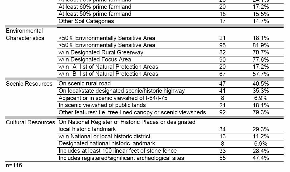
21 and historic resources included the following dummy variables: placement on the National Register of historic places or a designated local historic landmark, location within a national or local historic district, designation as a national historic landmark, possessing a minimum of 100 linear feet of stone fence, and possessing registered or significant archeological sites. All independent variables used to estimate the easement value represent LESA measures employed by Fayette County to rank land seeking participation in the PDR program. The LESA assessments provided the best available data given the time constraints of this report. Variables such as parcel size, distance, soil quality, road frontage and proximity have a basis in the academic literature. The additional environmental, scenic and cultural/historic attributes are more particular to this analysis, but provide reasonable measures of important social preferences. VII. Results of Analysis Appendix B provides complete tables summarizing the results of the analysis including: the frequency of each LESA characteristic, regression coefficients and their relative effect on easement value, and cost functions estimating the value of particular farms and particular attributes using the hedonic equation. For the 116 farms evaluated, the mean easement cost per acre was $2, with an average parcel size of acres and an average distance from the city center of 10.2 miles. The frequencies of specific attributes vary widely, but certain ones stand out. Nearly 80% of farms possess greater than 1001 feet of road frontage and contain scenic features such as tree-lined canopies or significant viewsheds. As well, more than 50% of farms are within ½ mile of other 21
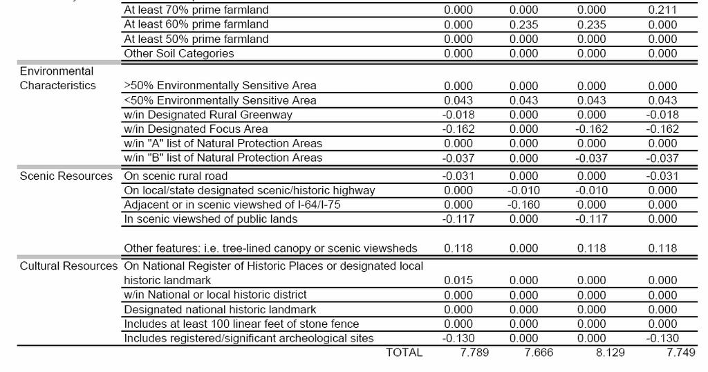
22 preserved land or land designated for long-term natural resource use or conservation. Over 70% of farms fall within a designated greenway or focus area, while nearly 50% contain registered or significant archeological sites. The estimated model explains 33.65% of the observed variation in the cost of conservation easements. The effects of certain parcel characteristics on easement value are mixed with respect to expectations (see Appendix B, Table 3). Parcel Size, Distance, Ownership, & Road Frontage Easement value was expected to decrease as parcel size increased, yet the model observed the opposite effect. For a 1% increase in parcel size, the model suggests easement values will increase 0.08%. On the other hand, the elasticity of distance suggests that a 1% increase in distance from the city center decreases easement values by 0.23%. As expected, retaining 40 acre development rights had a negative and significant impact on easement value. The coefficient suggests that the retention of such rights decreases easement value by 40.7%. The amount of road frontage had no statistically significant impact on easement values. A joint f-test on the three dummy variables representing this category confirmed this result (Appendix B, Table 4). Soil Quality The coefficients on the five dummy variables representing soil quality were all positive, but statistically insignificant. A joint f-test revealed that the null hypothesis that the dummy variables together have no effect cannot be rejected (Appendix B, Table 4). The absence of an effect may reflect how little soil variation is observed in a small area 22
23 such as a single county. Moreover, the importance of soil quality to the dominant equinebased industry in Fayette County is uncertain. Proximity to Other Preserved Lands Proximity to other preserved land or lands designated for long-term natural resource use was expected to increase easement value, yet results were mixed. The coefficient for adjacency to other preserved lands is negative and significant. This suggests that easement values for farms adjacent to lands with conservation easements decline 13.85%. Conversely, the model suggests that easement values for farms adjacent to other lands designated for long-term natural resource use increase by 23.68%. Joint f- tests on the three dummy variables representing each of these proximity categories rejected the null hypotheses of no effect at statistically significant levels (Appendix B, Table 4). This may reflect the market s preference for property closer to public lands with long-term protection, rather than private land in which protection remains unclear and access more restrictive. Environmental Attributes Expectations for environmental attributes in the model were uncertain. Negative coefficients on five of the six dummy variables suggest that the market discounts lands in these areas. Only one of these variables, location within a designated focus area, approached statistical significance. The coefficient for focus areas suggests easement values for lands in such areas decrease by 15%. 23
24 Scenic Attributes Expectations for scenic resources in the model were also uncertain. Negative coefficients on four of the five dummy variables suggest that the market discounts farms with such attributes. Location within the viewshed of public land or being adjacent to or seen from the interstate both had statistical significance. This suggests that easement values for lands with these attributes decrease by 11% and 14.75%, respectively. In contrast, the model suggests easement values for lands with other features such as treelined canopies or scenic viewsheds increase by 12.5%. Such a contrast may reflect the market s preference for land outside of the public s view, but with some measure of internal environmental attributes. Cultural & Historic Attributes Three of the five dummy variables reflecting cultural and historic attributes were statistically significant: location within a national or local historic district, designation as a national historic landmark, and possessing registered or significant archeological sites. The estimated coefficients suggest that easement values for farms with these attributes increased by 30%, decreased by 17.25%, and decreased by 12.2%, respectively. This may reflect the difficulties in developing property with archeological sites or historic landmarks, while acknowledging some preference to locate within a historic district. VIII. Estimates of Development Right Costs The results discussed above suggest certain farm attributes serve to either increase or decrease the amount paid for conservation easements. For example, the model estimates that distance from the city center, adjacency to preserved land, the presence of 24
25 archeological sites, and adjacency to or views of the interstate all decrease easement values. Conversely, the model suggests that larger parcel size, adjacency to lands designated for long-term natural resource use, and location within a national or local historic district all increase easement values. From the results of the model, which utilized actual transaction data, cost functions for properties with particular attributes may be estimated. Such estimations may offer an alternative to more costly and time consuming traditional appraisal methods. Farm Level Cost Estimates Table 4 below presents per acre costs for several farms. It reports both the actual transaction value and the easement value derived from the model (see Appendix B, Table 5 for more detail). Results in Table 4 suggest that for the farm scoring highest on the LESA assessment the actual easement value exceeded the model s estimate by $ per acre. Conversely, the model estimates that for the lowest scoring farm and a mean sample farm the actual easement values fell below the model s estimate by $ and $272.65, respectively. These figures imply that the program may over pay or under pay for certain easements, relative to the average. 25
26 The estimated typical farm compares the actual mean easement value from the sample with an estimate of the typical farm using the model. Attributes of the typical farm include: the mean log of parcel size, the mean log of distance, and all dummy variables possessed by 50% or more of the sample. The estimate shows, that on average, the typical farm s easement value is $ less than the mean easement value from the sample. This information suggests that the city could realize cost savings from utilizing a formula-based valuation method. These savings might reflect reduced appraisal fees, but also potential reductions in the average per acre easement cost. Parcel Characteristic Cost Estimates The hedonic model also provides estimates of the effect particular parcel characteristics have on easement value. Characteristic level data provides information that could serve two major functions: 1) the creation of a formula based appraisal mechanism and 2) refinement of the relative weights applied to the LESA-based assessment and selection system. Table 5 below displays the effect certain features have on easement cost per acre and total parcel cost (see Appendix B, Table 6 for greater detail). For each variation, all other parcel characteristics are held at the mean/typical level. 2 2 Parcel Size and Distance are held at mean log levels, whereas dummy variables are considered typical if more than 50% of the sample possessed the attribute. 26

27 The estimated easement value per acre increased by $ for a parcel located within a national or local historic district. The market for development rights places a premium on this attribute, perhaps because some view it as a desirable place to locate. As well, the easement cost for parcels adjacent to lands otherwise designated for longterm natural resource increased $ Other development restrictions may exist in these designated areas and should be evaluated to see if these characteristics are appropriately weighted in the LESA assessment. The estimated per acre easement value for a parcel located within a designated focus area is $ less than one located outside this designation. This suggests the market for development rights discounts this attribute. If program goals include giving priority to lands within focus areas, administrators may want to consider giving this attribute a higher LESA weight given the reduction in cost. The model estimated similar 27
28 reductions for the following attributes: possessing an archeological site, designation as a national historic landmark, adjacency to other lands with conservation easements, adjacency to or within the scenic viewshed of the interstate, and location within the scenic viewshed of public lands. The discount applied to these attributes suggests it may be possible to purchase more socially desirable land at lower costs by increasing the relative weight of such attributes on the LESA assessment. IX. Limitations of Analysis Several deficiencies in the regression model limit the generalizability of the results. First, the use of Google R Maps to measure distance represents a crude proxy for development pressure. More appropriate and ideal would be the distance from the urban service area and/or sewerability districts. Time constraints did not allow for the collection of such information. Second, the extensive use of dummy variables limits the models ability to predict marginal price effects for otherwise continuous attributes. Ideally, measures of road frontage, soil quality, and proximity to other preserved lands would be continuous allowing for better estimates of these atttributes price elasticity. Taken together, these limitations likely influenced the explanatory power of the regression model. While an R 2 of 34% is similar to some analyses in the literature, the use of such a model to calculate actual easement values may require greater power to gain acceptance. Participation in the PDR program is voluntary. Therefore, there exists a selfselection bias in the sample evaluated. Farm owners choosing to participate may in fact be conservation minded and be willing to accept a lower easement payment. Such 28
29 institutional factors are not controlled for in the regression model presented. Future analyses may want to consider variables such as participant motivation, although this may have little impact at the county level. X. Conclusions & Recommendations This report examined the impact of certain farm attributes on the value of conservation easements. Results of this analysis suggest that the marginal contributions to easement cost of several parcel characteristics are significant. These include: Parcel size Distance from urban center Adjacency to other lands under easement or designated for natural resource use Adjacency to or within the view of the interstate Within the view shed of public lands Within a national or local historic district Designation as a national historic landmark Possessing registered or significant archeological sites Considering these characteristics carefully when evaluating applicant farms may reduce total purchase costs and maximize social benefits. Specifically, program administrators can use this information to refine the relative weights of the LESA assessment criteria to focus on the most desirable mix of parcel attributes. Additionally, the analysis presented here could form the basis of an alternative to traditional appraisal techniques. Using a formula-based system saves administrative costs associated with appraisals and may better account for the value of characteristics not typically captured by the market. Several programs have done just this. Howard County, Maryland and the Maryland Rural Legacy Program both use formulas for attribute-based easement valuation (Lynch and Lovell, 2002). 29
30 Fayette County s current appraisal fees are approximately $2,500 for each farm. Using a formula-based appraisal to eliminate this cost for the remaining land needed to reach the program s goal could save over $700,000 in current dollars. Moreover, this report suggests savings approaching $9 million, in current dollars, could be realized by purchasing the remaining land needed (36,000 acres) to reach the program s goal using this report s estimates vs. the current actual average. As the pool of land available for participation diminishes and funding sources tighten, efforts to reduce costs and maximize available dollars may be prudent. Additionally, other counties may find the information in this report useful in developing and implementing their own PDR programs. Further research is needed prior to any attempt to utilize the type of analysis presented in this report. First, limitations to using an attribute-based formula to calculate easement values need to be identified. It may be the case that certain government programs providing funds for land acquisition require a specific appraisal method. Second, land owners may be reluctant to accept offers calculated by such a formula. A survey of Fayette county farm owners could reasonably gauge how such a method would be accepted. Lastly, the model presented here needs refinement to more adequately capture the variation in easement values. The use of GIS information and real appraisal data could greatly enhance the power of the estimates. 30
31 References American Farmland Trust. Fact Sheet: Status of Local PACE Programs. (2005), Beaton, W. Patrick and Pollock, Marcus. Economic Impact of Growth Management Policies Surrounding the Chesapeake Bay. Land Economics 68, no. 4 (November 1992): Brown, Ralph and Schmitz, Jerome. Appraising Wetlands Easements. The Appraisal Journal 46, no. 2 (April 1978): Brunstadt, Rolf; Gaasland, Ivar and Vardal, Erling. Agricultural Production and the Optimal Level of Landscape Preservation. Land Economics 75, no. 4 (November 1999): Buist, Henry; Fischer, Carolyn; Michos, John and Tegene, Abebayehu. Purchase of Development Rights and the Economics of Easements. AER No. 718, U.S. Department of Agriculture, Economic Research Service: Washington D.C., Byrne, Craig and Minck, Michael. Understanding the Evolution of Conservation Easement Appraisal through Case Law. The Appraisal Journal 68, no. 4 (October 2000): Chicoine, David. Farmland Values at the Urban Fringe: An Analysis of Sale Prices. Land Economics 57, no. 3 (August 1981): Coughlin, R.E.; Pease, J.R.; Steiner, F. et al. The Status of State and Local LESA Programs. Journal of Soil and Water Conservation 49, no. 1 (Jan-Feb 1994): Daniels, Tom. Using LESA in a Purchase of Development Rights Program. Journal of Soil and Water Conservation 45, no. 6 (Nov-Dec 1990): Daniels, Tom. The Purchase of Development Rights. Journal of the American Planning Association 57, no. 4 (Autumn 1991): Field, Barry and Conrad, Jon. Economics of Compensation in Development Rights Programs. Journal of the Northeastern Agricultural Economics Council 4, no. 2 (October 1975): Fischel, William. Introduction: Four Maxims for Research on Land-Use Controls. Land Economics 66, no. 3 (August 1990): Fischel, William. The Urbanization of Agricultural Land: A Review of the National Agricultural Lands Study. Land Economics 58, no. 2 (May 1982): Gardner, B. Delworth. The Economics of Agricultural Land Preservation. American Journal of Agricultural Economics 59, no. 5 (December 1977): Kay, Steve and Scott, Jean. Preserving the Bluegrass. (Fall 2002). Kentucky Agricultural Development Board Press Release. Kentucky Agricultural Development Board Announces Application Process, Farmland Preservation Effort. (December 1, 2001), Kline, Jeffrey and Wichelns, Dennis. Public Preferences Regarding the Goals of Farmland Preservation Programs. Land Economics 72, no. 4 (November 1996): Lassner, Janis. Valuing Conservation Easements. The Appraisal Journal 66, no.2 (April 1998): Lexington-Fayette Urban County Government. Ordinance No (2000), ftp://ftp.lfucg.com/adminsvcs/pdr/pdrordinance.pdf. Lexington-Fayette Urban County Government. Rural Service Area Land Management Plan: Our Rural Heritage in the Next Century. (1999). Lexington-Fayette Urban County Government. Selling Your Development Rights. (2005), ftp://ftp.lfucg.com/adminsvcs/pdr/king_info.pdf. Libby, Lawrence. Farmland Protection Policy: An Economic Perspective. Working Paper 97-1, American Farmland Trust, Center for Agriculture in the Environment (1997), 31
32 Loomis, John; Rameker, Vicki and Seidl, Andy. A Hedonic Model of Public Market Transactions for Open Space Protection. Journal of Environmental Planning and Management 47, no. 1 (January 2004): Lynch, Lori and Lovell, Sabrina. Hedonic Price Analysis of Easement Payments in Agricultural Land Preservation Programs. University of Maryland, Department of Agricultural and Resource Economics, Working Paper (2002), Lynch, Lori and Musser, Wesley. A Relative Efficiency Analysis of Farmland Preservation Programs. Land Economics 77, no. 4 (November 2001): Nickerson, Cynthia and Lynch, Lori. The Effect of Farmland Preservation Programs on Farmland Prices. American Journal of Agricultural Economics 83, no. 2 (May 2001): Peddle, Michael. Farmland Protection Policy: The Effects of Growth Management on Agricultural Land Values. Working Paper 97-7, American Farmland Trust, Center for Agriculture in the Environment (1997), Personal Communication with Margaret Graves, Chair of Lexington-Fayette County Rural Land Management Board (February 5, 2006). Personal Communication with Maner Ferguson, Program Manager for the Lexington-Fayette County PDR Program (February 8, 2006). Personal Communication with Billy Van Pelt, Administrative Officer for the Lexington- Fayette County PDR Program (February 17, 2006) Personal Communication with Billy Van Pelt, Administrative Officer for the Lexington- Fayette County PDR Program (February 17, 2006) Personal Communication with Chris King, Planning Director for the Lexington-Fayette County Planning Office (February 17, 2006) Personal Communication with Paul Moore, Review Appraiser for the Lexington-Fayette County PDR Program (March 10, 2006) Personal Communication with Donna Counts, Finance Director for the Lexington-Fayette Urban County Government (March 22, 2006). Plantinga, Andrew and Miller, Douglas. Agricultural Land Values and the Value of Rights to Future Land Development. Land Economics 77, no. 1 (February 2001): Ready, Richard; Berger, Mark and Blomquist, Glenn. Measuring Amenity Benefits from Farmland: Hedonic Pricing vs. Contingent Valuation. Growth and Change 28, no. 4 (Fall 1997): Shi, Yue Jin; Phipps, Timothy and Colyer, Dale. Agricultural Land Values under Urbanizing Influences. Land Economics 73, no. 1 (February 1997): Shonkwiler, J.S. and Reynolds, J.E. A Note on the Use of Hedonic Price Models in the Analysis of Land Prices at the Urban Fringe. Land Economics 62, no. 1 (February 1986): U.S. Department of Agricultural Census of Agriculture: County Profile, Fayette, Kentucky. (2002), Vicary, Brent. Trends in Appraising Conservation Easements. The Appraisal Journal 62, no. 1 (January 1994): Wichelns, Dennis and Kline, Jeffrey. The Impact of Parcel Characteristics on the Cost of Development Rights to Farmland. Agricultural and Resource Economics Review 22, no.2 (October 1993): Wright, Lloyd; Zitzmann, Warren; Young, Keith and Googins, Richard. LESA- Agricultural Land Evaluation and Site Assessment. Journal of Soil and Water Conservation 38, no. 2 (Mar-Apr 1983):

33 Appendix A 33

34 Appendix A 34
35 Appendix B 35

36 Appendix B 36

37 Appendix B 37

38 Appendix B 38

39 Appendix B 39

40 Appendix B 40
Protecting Farmland in Maryland: A Review of the Agricultural Land Preservation Program
 Protecting Farmland in Maryland: A Review of the Agricultural Land Preservation Program Craig Shollenberger Planning Intern (former) Anne Arundel County Maryland INTRODUCTION During the past ten to twelve
Northgate Mall s Effect on Surrounding Property Values
 James Seago Economics 345 Urban Economics Durham Paper Monday, March 24 th 2013 Northgate Mall s Effect on Surrounding Property Values I. Introduction & Motivation Over the course of the last few decades
The Effect of Relative Size on Housing Values in Durham
 TheEffectofRelativeSizeonHousingValuesinDurham 1 The Effect of Relative Size on Housing Values in Durham Durham Research Paper Michael Ni TheEffectofRelativeSizeonHousingValuesinDurham 2 Introduction Real
General Development Plan Background Report on Agricultural Land Preservation
 General Development Plan 2008 Background Report on Agricultural Land Preservation February 2008 I. Introduction Anne Arundel County has been an agricultural community for over 350 years, beginning with
Taxes and Land Preservation Computing the Capital Gains Tax
 Fact Sheet 780 Taxes and Land Preservation Computing the Capital Gains Tax Many farmers have their wealth tied up in their land and would like to convert some of this land value into cash. Others want
Chapter XX Purchase of Development Rights Program
 Chapter XX Purchase of Development Rights Program Short Title. This ordinance is to be known and may be cited as the Purchase of Development Rights ( PDR ) Program. Purpose Pursuant to the authority granted
Montgomery County Demographics
 Formula Based Easement Valuations An Alternative to Standard Appraisals Montgomery County s Agricultural Easement Program AEP Montgomery County Demographics 1 2 Farmland Protected by Easements as of June
UNOFFICIAL COPY OF HOUSE BILL 1272 A BILL ENTITLED
 UNOFFICIAL COPY OF HOUSE BILL 1272 M4 6lr0525 By: Delegates Smigiel, Kelley, Rosenberg, and Sossi Introduced and read first time: February 10, 2006 Assigned to: Environmental Matters 1 AN ACT concerning
FARMLAND AMENITY PROTECTION. A Brief Guide To Conservation Easements
 FARMLAND AMENITY PROTECTION A Brief Guide To Conservation Easements The purpose of this guide is to help landowners access their land amenity value and to provide direction to be compensated for this value.
p URCHASE of development rights
 A well-designed Land Evaluation and Site Assessment (LESA) system can help public officials, with limited funds, acquire development rights to a "critical mass" of preserved farmland Using LESA in a purchase
Land Preservation in the Highlands Region
 Land Preservation in the Highlands Region Prepared by the Highlands Water Protection and Planning Council - August 2010 The Highlands watersheds are the best in the State in respect to ease of collection,
Hedonic Pricing Model Open Space and Residential Property Values
 Hedonic Pricing Model Open Space and Residential Property Values Open Space vs. Urban Sprawl Zhe Zhao As the American urban population decentralizes, economic growth has resulted in loss of open space.
RESEARCH BRIEF. Oct. 31, 2012 Volume 2, Issue 3
 RESEARCH BRIEF Oct. 31, 2012 Volume 2, Issue 3 PDR programs affect landowners conversion decision in Maryland PDR programs pay farmers to give up their right to convert their farmland to residential and
School Quality and Property Values. In Greenville, South Carolina
 Department of Agricultural and Applied Economics Working Paper WP 423 April 23 School Quality and Property Values In Greenville, South Carolina Kwame Owusu-Edusei and Molly Espey Clemson University Public
Estimating the Value of the Historical Designation Externality
 Estimating the Value of the Historical Designation Externality Andrew J. Narwold Professor of Economics School of Business Administration University of San Diego San Diego, CA 92110 USA drew@sandiego.edu
Preserving Farms and Forests in Sussex County, Delaware: Public Value
 Preserving Farms and s in Sussex County, Delaware: Public Value Joshua M. Duke, Ph.D. University of Delaware Robert J. Johnston, Ph.D. Tammy Warner Campson University of Connecticut July 2007 This research
The purpose of the appraisal was to determine the value of this six that is located in the Town of St. Mary s.
 The purpose of the appraisal was to determine the value of this six that is located in the Town of St. Mary s. The subject property was originally acquired by Michael and Bonnie Etta Mattiussi in August
Procedures Used to Calculate Property Taxes for Agricultural Land in Mississippi
 No. 1350 Information Sheet June 2018 Procedures Used to Calculate Property Taxes for Agricultural Land in Mississippi Stan R. Spurlock, Ian A. Munn, and James E. Henderson INTRODUCTION Agricultural land
Chapter 35. The Appraiser's Sales Comparison Approach INTRODUCTION
 Chapter 35 The Appraiser's Sales Comparison Approach INTRODUCTION The most commonly used appraisal technique is the sales comparison approach. The fundamental concept underlying this approach is that market
Chapter VIII. Conservation Easements: Valuing Property Subject to a Qualified Conservation Contribution
 A. Overview and Purpose Chap. VIII Conservation Easements: Valuing... Jacobson & Becker 91 Chapter VIII Conservation Easements: Valuing Property Subject to a Qualified Conservation Contribution Forest
What Factors Determine the Volume of Home Sales in Texas?
 What Factors Determine the Volume of Home Sales in Texas? Ali Anari Research Economist and Mark G. Dotzour Chief Economist Texas A&M University June 2000 2000, Real Estate Center. All rights reserved.
Appendix J Agricultural Land Preservation in Other States
 Appendix J Agricultural Land Preservation in Other States Appendix J Agricultural land preservation in other states Many states across the U.S. are working to protect agricultural land from development.
PROJECT SCORING GUIDANCE. Introduction: National Proiect Selection:
 FOREST LEGACY PROGRAM PROJECT SCORING GUIDANCE Introduction: This document provides guidance to the National Review Panel on how to score individual Forest Legacy Program (FLP) projects, including additional
Effects of Zoning on Residential Option Value. Jonathan C. Young RESEARCH PAPER
 Effects of Zoning on Residential Option Value By Jonathan C. Young RESEARCH PAPER 2004-12 Jonathan C. Young Department of Economics West Virginia University Business and Economics BOX 41 Morgantown, WV
THE EFFECT OF PROXIMITY TO PUBLIC TRANSIT ON PROPERTY VALUES
 THE EFFECT OF PROXIMITY TO PUBLIC TRANSIT ON PROPERTY VALUES Public transit networks are essential to the functioning of a city. When purchasing a property, some buyers will try to get as close as possible
GENERAL ASSESSMENT DEFINITIONS
 21st Century Appraisals, Inc. GENERAL ASSESSMENT DEFINITIONS Ad Valorem tax. A tax levied in proportion to the value of the thing(s) being taxed. Exclusive of exemptions, use-value assessment laws, and
DEMAND FR HOUSING IN PROVINCE OF SINDH (PAKISTAN)
") 19 Pakistan Economic and Social Review Volume XL, No. 1 (Summer 2002), pp. 19-34 DEMAND FR HOUSING IN PROVINCE OF SINDH (PAKISTAN) NUZHAT AHMAD, SHAFI AHMAD and SHAUKAT ALI* Abstract. The paper is an analysis
19 Pakistan Economic and Social Review Volume XL, No. 1 (Summer 2002), pp. 19-34 DEMAND FR HOUSING IN PROVINCE OF SINDH (PAKISTAN) NUZHAT AHMAD, SHAFI AHMAD and SHAUKAT ALI* Abstract. The paper is an analysis
RATE STUDY IMPACT FEES PARKS
 RATE STUDY FOR IMPACT FEES FOR PARKS CITY OF KENMORE, WASHINGTON May 15, 2001 TABLE OF CONTENTS Executive Summary................................................... 1 1. Statutory Basis and Methodology
2011 ASSESSMENT RATIO REPORT
 2011 Ratio Report SECTION I OVERVIEW 2011 ASSESSMENT RATIO REPORT The Department of Assessments and Taxation appraises real property for the purposes of property taxation. Properties are valued using
Volume Title: Well Worth Saving: How the New Deal Safeguarded Home Ownership
 This PDF is a selection from a published volume from the National Bureau of Economic Research Volume Title: Well Worth Saving: How the New Deal Safeguarded Home Ownership Volume Author/Editor: Price V.
The Improved Net Rate Analysis
 The Improved Net Rate Analysis A discussion paper presented at Massey School Seminar of Economics and Finance, 30 October 2013. Song Shi School of Economics and Finance, Massey University, Palmerston North,
APPLICATION OF GEOGRAPHIC INFORMATION SYSTEM IN PROPERTY VALUATION. University of Nairobi
 APPLICATION OF GEOGRAPHIC INFORMATION SYSTEM IN PROPERTY VALUATION Thesis Presented by STEPHEN WAKABA GATHERU F56/69748/2013 Supervised by DR. DAVID NYIKA School of Engineering Department of Geospatial
Trends in Affordable Home Ownership in Calgary
 Trends in Affordable Home Ownership in Calgary 2006 July www.calgary.ca Call 3-1-1 PUBLISHING INFORMATION TITLE: AUTHOR: STATUS: TRENDS IN AFFORDABLE HOME OWNERSHIP CORPORATE ECONOMICS FINAL PRINTING DATE:
Hedonic Modeling of Open Space in James City County
 Hedonic Modeling of Open Space in James City County Andrew Waxman Stanford University Robert L. Hicks, Mentor Interdisciplinary Watershed Program Funded by an REU Grant From NSF Open Space Undeveloped,
The Impact of Urban Growth on Affordable Housing:
 The Impact of Urban Growth on Affordable Housing: An Economic Analysis Chris Bruce, Ph.D. and Marni Plunkett October 2000 Project funding provided by: P.O. Box 6572, Station D Calgary, Alberta, CANADA
Oil & Gas Lease Auctions: An Economic Perspective
 Oil & Gas Lease Auctions: An Economic Perspective March 15, 2010 Presented by: The Florida Legislature Office of Economic and Demographic Research 850.487.1402 http://edr.state.fl.us Bidding for Oil &
I. BACKGROUND. As one of the most rapidly developing states in the country, North Carolina is losing
 PROTECTING CONSERVATION EASEMENTS IN EMINENT DOMAIN PROCEEDINGS Presented by W. Edward Poe, Jr. On Behalf of the NC Land Trust Council Environmental Review Commission December 18, 2008 I. BACKGROUND As
ORANGE COUNTY VOLUNTARY FARMLAND PRESERVATION PROGRAM ORDINANCE
 4/18/00 1 ORANGE COUNTY VOLUNTARY FARMLAND PRESERVATION PROGRAM ORDINANCE Section I - ENACTMENT Pursuant to the authority conferred by the Farmland Preservation Enabling Act, Article 61 of Chapter 106
Additionality in Conservation Easements Programs: Grassland Easements in the Prairie Pothole Region
 Additionality in Conservation Easements Programs: Grassland Easements in the Prairie Pothole Region Jeffrey Savage, USDA-ERS, jsavage@ers.usda.gov Roger Claassen, USDA-ERS Vince Breneman, USDA-ERS Chuck
The Farmland Preservation Program in Sussex County
 The Farmland Preservation Program in Sussex County Preserved Tranquility Farm The Importance of Saving Farmland and Farmers Photo by Tanya Nolte Farmland, an irreplaceable natural resource, and the farmers
RESEARCH BRIEF. Jul. 20, 2012 Volume 1, Issue 12
 RESEARCH BRIEF Jul. 2, 212 Volume 1, Issue 12 Do Agricultural Land Preservation Programs Reduce Overall Farmland Loss? When purchase of development rights () programs are in place to prevent farmland from
An Accounting Tradeoff Between WRP and Government Payments. Authors Gregory Ibendahl Mississippi State University
 An Accounting Tradeoff Between WRP and Government Payments Authors Gregory Ibendahl Mississippi State University ibendahl@agecon.msstate.edu Selected Paper prepared for presentation at the Southern Agricultural
Village of Scarsdale
 Village of Scarsdale VILLAGE HALL / 1001 POST ROAD / SCARSDALE, NY 10583 914.722.1110 / WWW.SCARSDALE.COM Village Wide Revaluation Frequently Asked Questions Q1. How was the land value for each parcel
Estimating User Accessibility Benefits with a Housing Sales Hedonic Model
 Estimating User Accessibility Benefits with a Housing Sales Hedonic Model Michael Reilly Metropolitan Transportation Commission mreilly@mtc.ca.gov March 31, 2016 Words: 1500 Tables: 2 @ 250 words each
Special Consideration Multiple jurisdictions is cumbersome
 Elements of Agricultural Land Preservation Hawaii Technique Comments Status in Hawaii Agriculture Zoning Most effective if it minimizes farmland conversion and prevents the intrusion of nonfarm uses into
TRANSFER OF DEVELOPMENT RIGHTS
 STEPS IN ESTABLISHING A TDR PROGRAM Adopting TDR legislation is but one small piece of the effort required to put an effective TDR program in place. The success of a TDR program depends ultimately on the
Understanding the Cost to Provide Community Services in the Town of Holland, La Crosse County, Wisconsin
 Understanding the Cost to Provide Community Services in the Town of Holland, La Crosse County, Wisconsin Rebecca Roberts Land Use Specialist Center for Land Use Education and Karl Green Community Development
METHODOLOGY GUIDE VALUING LANDS IN TRANSITION IN ONTARIO. Valuation Date: January 1, 2016
 METHODOLOGY GUIDE VALUING LANDS IN TRANSITION IN ONTARIO Valuation Date: January 1, 2016 August 2017 August 22, 2017 The Municipal Property Assessment Corporation (MPAC) is responsible for accurately assessing
April 12, The Honorable Martin O Malley And The General Assembly of Maryland
 April 12, 2011 The Honorable Martin O Malley And The General Assembly of Maryland As required by Section 2-202 of the Tax-Property Article of the Annotated Code of Maryland, I am pleased to submit the
IAS Revenue. By:
 IAS - 18 Revenue International Accounting Standard No 18 (IAS 18) Revenue In 1998, IAS 39, Financial Instruments: Recognition and Measurement, amended paragraph 11 of IAS 18, adding a cross-reference to
Torch Lake Township Antrim County, Michigan
 Torch Lake Township Antrim County, Michigan Farmland and Open Space Development Rights Ordinance Ordinance No. 04-01 Effective September 3, 2004 AN ORDINANCE creating a farmland and open space protection
Hennepin County Economic Analysis Executive Summary
 Hennepin County Economic Analysis Executive Summary Embrace Open Space commissioned an economic study of home values in Hennepin County to quantify the financial impact of proximity to open spaces on the
Use of the Real Estate Market to Establish Light Rail Station Catchment Areas
 Use of the Real Estate Market to Establish Light Rail Station Catchment Areas Case Study of Attached Residential Property Values in Salt Lake County, Utah, by Light Rail Station Distance Susan J. Petheram,
The Corner House and Relative Property Values
 23 March 2014 The Corner House and Relative Property Values An Empirical Study in Durham s Hope Valley Nathaniel Keating Econ 345: Urban Economics Professor Becker 2 ABSTRACT This paper analyzes the effect
Part 1. Estimating Land Value Using a Land Residual Technique Based on Discounted Cash Flow Analysis
 Table of Contents Overview... v Seminar Schedule... ix SECTION 1 Part 1. Estimating Land Value Using a Land Residual Technique Based on Discounted Cash Flow Analysis Preview Part 1... 1 Land Residual Technique...
Summary of Key Issues from Skagit County TDR Focus Group Meetings January 7, 2014
 Summary of Key Issues from Skagit County TDR Focus Group Meetings January 7, 2014 Overall Observations Some participants, particularly in the development group, emphasized that TDR was taking something
Initial sales ratio to determine the current overall level of value. Number of sales vacant and improved, by neighborhood.
 Introduction The International Association of Assessing Officers (IAAO) defines the market approach: In its broadest use, it might denote any valuation procedure intended to produce an estimate of market
APPENDIX A FACTORS INFLUENCING CITY FINANCES
 APPENDIX A FACTORS INFLUENCING CITY FINANCES This page left blank intentionally Appendix A Factors Influencing City Finances The finances of cities are affected by many different factors. Some of the variation
Factors Affecting Land Trust Agents Preferences for Conservation Easements
 JRAP 42(2): 88-103. 2012 MCRSA. All rights reserved. Factors Affecting Land Trust Agents Preferences for Conservation Easements Eric D. Cropper *, Donald M. McLeod *, Christopher T. Bastian *, Catherine
Status of State PACE Programs
 F A R M L A N D I N F O R M A T I O N C E N T E R Status of PACE Programs As of May 2013, 27 states have state-level purchase of agricultural conservation easement (PACE) programs. Four states Arizona,
STATUS OF STATE PACE PROGRAMS
 FARMLAND INFORMATION CENTER STATUS OF STATE PACE PROGRAMS As of January 2015, 28 states have state-level purchase of agricultural conservation easement (PACE) programs. Three states Arizona, Georgia and
619 STANDARD 2: REAL PROPERTY APPRAISAL, REPORTING
 619 STANDARD 2: REAL PROPERTY APPRAISAL, REPORTING 620 In reporting the results of a real property appraisal, an appraiser must communicate each analysis, 621 opinion, and conclusion in a manner that is
Sorting based on amenities and income
 Sorting based on amenities and income Mark van Duijn Jan Rouwendal m.van.duijn@vu.nl Department of Spatial Economics (Work in progress) Seminar Utrecht School of Economics 25 September 2013 Projects o
NC General Statutes - Chapter 106 Article 61 1
 Article 61. Agricultural Development and Preservation of Farmland. Part 1. General Provisions. 106-735. Short title, purpose, and administration. (a) This Article shall be known as "The Agricultural Development
Walworth County Farmland Preservation Plan Update, Chapter 1 Plan Summary (Cover Document)
") Background Walworth County Farmland Preservation Plan Update, 2012 Chapter 1 Plan Summary (Cover Document) For over 30-years, the Wisconsin Farmland Preservation Program has served to preserve Walworth
Background Walworth County Farmland Preservation Plan Update, 2012 Chapter 1 Plan Summary (Cover Document) For over 30-years, the Wisconsin Farmland Preservation Program has served to preserve Walworth
City of Puyallup. Parks Impact Fee Study
 City of Puyallup Parks Impact Fee Study August 23, 2005 Prepared by Financial Consulting Solutions Group, Inc. 8201 164 th Avenue NE, Suite 300 Redmond, WA 98052 tel: (425) 867-1802 fax: (425) 867-1937
LEGISLATIVE PURPOSES. 2. Provide sources of agricultural products within the state for the citizens of the state
 LEGISLATIVE PURPOSES 1. Assist in sustaining the farming community 2. Provide sources of agricultural products within the state for the citizens of the state 3. Control the urban expansion which is consuming
Land-Use Regulation in India and China
 Land-Use Regulation in India and China Jan K. Brueckner UC Irvine 3rd Urbanization and Poverty Reduction Research Conference February 1, 2016 Introduction While land-use regulation is widespread in the
CONSERVATION EASEMENTS FREQUENTLY ASKED QUESTIONS
 CONSERVATION EASEMENTS FREQUENTLY ASKED QUESTIONS CCALT Founder and Steamboat rancher, Jay Fetcher notes, You shouldn t even be considering a conservation easement unless two things have happened: (1)
Innovative Local Government Land Conservation Techniques
 Innovative Local Government Land Conservation Techniques Three new successful land conservation programs used in Maryland by Baltimore and Carroll Counties are worthy of further examination. Baltimore
Status of HUD-Insured (or Held) Multifamily Rental Housing in Final Report. Executive Summary. Contract: HC-5964 Task Order #7
 Multifamily Rental Housing in Final Report. Executive Summary. Contract: HC-5964 Task Order #7") Status of HUD-Insured (or Held) Multifamily Rental Housing in 1995 Final Report Executive Summary Cambridge, MA Lexington, MA Hadley, MA Bethesda, MD Washington, DC Chicago, IL Cairo, Egypt Johannesburg,
Status of HUD-Insured (or Held) Multifamily Rental Housing in 1995 Final Report Executive Summary Cambridge, MA Lexington, MA Hadley, MA Bethesda, MD Washington, DC Chicago, IL Cairo, Egypt Johannesburg,
PURCHASE OF DEVELOPMENT RIGHTS AND TRANSFER OF DEVELOPMENT RIGHTS CASE STUDIES
 PURCHASE OF DEVELOPMENT RIGHTS AND TRANSFER OF DEVELOPMENT RIGHTS CASE STUDIES Prepared for Boone County Planning Commission By American Farmland Trust May 4, 2001 Table of Contents Page Number Montgomery
Flexibility in the Law: Reengineering of Zoning to Prevent Fragmented Landscapes
 Pace University DigitalCommons@Pace Pace Law Faculty Publications School of Law 2-18-1998 Flexibility in the Law: Reengineering of Zoning to Prevent Fragmented Landscapes John R. Nolon Elisabeth Haub School
How to Read a Real Estate Appraisal Report
 How to Read a Real Estate Appraisal Report Much of the private, corporate and public wealth of the world consists of real estate. The magnitude of this fundamental resource creates a need for informed
Using Hedonics to Create Land and Structure Price Indexes for the Ottawa Condominium Market
 Using Hedonics to Create Land and Structure Price Indexes for the Ottawa Condominium Market Kate Burnett Isaacs Statistics Canada May 21, 2015 Abstract: Statistics Canada is developing a New Condominium
Crediting Conservation: Frequently Asked Questions
 Crediting Conservation: Frequently Asked Questions 1) How and who developed the Conservation Plus family of land use scenarios, also known as Land Policy Best Management Practices (BMPs)? The Conservation
Twenty-Four Years of Farmland Preservation in Michigan, PA 116. Kurt J. Norgaard. Ph. D. Extension Land Use Specialist
 Staff Paper Twenty-Four Years of Farmland Preservation in Michigan, PA 116 Kurt J. Norgaard. Ph. D. Extension Land Use Specialist Staff Paper No. 99-2 January 1999 Department of Agricultural Economics
CENTRAL GOVERNMENT ACCOUNTING STANDARDS
 CENTRAL GOVERNMENT ACCOUNTING STANDARDS NOVEMBER 2016 STANDARD 4 Requirements STANDARD 5 INTANGIBLE ASSETS INTRODUCTION... 75 I. CENTRAL GOVERNMENT S SPECIALISED ASSETS... 75 I.1. The collection of sovereign
APPENDIX A FACTORS INFLUENCING COUNTY FINANCES
 APPENDIX A FACTORS INFLUENCING COUNTY FINANCES This page left blank intentionally Appendix A Factors Influencing County Finances The finances of counties are affected by many different factors. Some of
California Real Estate License Exam Prep: Unlocking the DRE Salesperson and Broker Exam 4th Edition
 California Real Estate License Exam Prep: Unlocking the DRE Salesperson and Broker Exam 4th Edition ANSWER SHEET INSTRUCTIONS: The exam consists of multiple choice questions. Multiple choice questions
FINAL REPORT AN ANALYSIS OF SECONDARY ROAD MAINTENANCE PAYMENTS TO HENRICO AND ARLINGTON COUNTIES WITH THE DECEMBER 2001 UPDATE
 FINAL REPORT AN ANALYSIS OF SECONDARY ROAD MAINTENANCE PAYMENTS TO HENRICO AND ARLINGTON COUNTIES WITH THE DECEMBER 2001 UPDATE Robert A. Hanson, P.E. Senior Research Scientist Cherie A. Kyte Senior Research
The Positive Externalities of Historic District Designation
 The Park Place Economist Volume 12 Issue 1 Article 16 2004 The Positive Externalities of Historic District Designation '05 Illinois Wesleyan University Recommended Citation Romero '05, Ana Maria (2004)
Kent Land Trust Strategic Reassessment Project Final Report
 Kent Land Trust Strategic Reassessment Project Final Report Prepared For: Connecticut Institute for Resilience and Climate Adaptation (CIRCA) Prepared by: Michael A. Benjamin, Land Steward, Kent Land Trust
Selected Paper prepared for presentation at the Southern Agricultural Economics Association s Annual Meetings Mobile, Alabama, February 4-7, 2007
 DYNAMICS OF LAND-USE CHANGE IN NORTH ALABAMA: IMPLICATIONS OF NEW RESIDENTIAL DEVELOPMENT James O. Bukenya Department of Agribusiness, Alabama A&M University P.O. Box 1042 Normal, AL 35762 Telephone: 256-372-5729
Farm Real Estate Ownership Transfer Patterns in Nebraska s Panhandle Region
 University of Nebraska Lincoln Research Bulletin RB349 Farm Real Estate Ownership Transfer Patterns in Nebraska s Panhandle Region Bruce B. Johnson, Professor, Agricultural Economics Dennis M. Conley,
REVENUE ESTIMATING CONFERENCE TAX: ISSUE:
 REVENUE ESTIMATING CONFERENCE TAX: Ad Valorem ISSUE: Millage rate cap of 13.5 mills (1.35%) on all real property BILL NUMBER(S): HB 385 SPONSOR(S): Rivera MONTH/YEAR COLLECTION IMPACT BEGINS: DATE OF ANALYSIS:
Regression Estimates of Different Land Type Prices and Time Adjustments
 Regression Estimates of Different Land Type Prices and Time Adjustments By Bill Wilson, Bryan Schurle, Mykel Taylor, Allen Featherstone, and Gregg Ibendahl ABSTRACT Appraisers use puritan sales to estimate
Ontario Rental Market Study:
 Ontario Rental Market Study: Renovation Investment and the Role of Vacancy Decontrol October 2017 Prepared for the Federation of Rental-housing Providers of Ontario by URBANATION Inc. Page 1 of 11 TABLE
BLOCK ISLAND LAND TRUST RULES AND REGULATIONS. The name of the Trust shall be the Block Island Land Trust (hereinafter called the Trust).
.") ARTICLE I NAME The name of the Trust shall be the Block Island Land Trust (hereinafter called the Trust). ARTICLE II AUTHORITY A. AN ACT RELATING TO THE PRESERVATION OF FARM LAND AND OPEN SPACE IN THE
ARTICLE I NAME The name of the Trust shall be the Block Island Land Trust (hereinafter called the Trust). ARTICLE II AUTHORITY A. AN ACT RELATING TO THE PRESERVATION OF FARM LAND AND OPEN SPACE IN THE
Remains eligible for state or federal farm programs. Can use land as collateral for loans. Can reserve home lots for children
 December 2002 B-1132 Conservation Easements: An Introductory Review for Wyoming By Allison Perrigo and Jon Iversen, William D. Ruckelshaus Institute of Environment and Natural Resources William D. Ruckelshaus
Technical Description of the Freddie Mac House Price Index
 Technical Description of the Freddie Mac House Price Index 1. Introduction Freddie Mac publishes the monthly index values of the Freddie Mac House Price Index (FMHPI SM ) each quarter. Index values are
Housing Supply Restrictions Across the United States
 Housing Supply Restrictions Across the United States Relaxed building regulations can help labor flow and local economic growth. RAVEN E. SAKS LABOR MOBILITY IS the dominant mechanism through which local
Misconceptions about Across-the-Fence Methodology
 Misconceptions about Across-the-Fence Methodology BY JOHN SCHMICK Across-the-fence methodology (ATF) is an appraisal tool frequently used in valuation assignments where the subject is part of railroad
A TDR Program for Naples. May 11, 2007
 ATTACHMENT G A TDR Program for Naples May 11, 2007 Introduction This paper is intended to supplement and expand upon the Draft TDR Program Framework authored by Solimar in February 2007. 1 The Framework
Sponsored by a Grant TÁMOP /2/A/KMR Course Material Developed by Department of Economics, Faculty of Social Sciences, Eötvös Loránd
 Urban and real estate economics Sponsored by a Grant TÁMOP-4.1.2-08/2/A/KMR-2009-0041 Course Material Developed by Department of Economics, Faculty of Social Sciences, Eötvös Loránd University Budapest
Report on Inspection of Ferlita, Walsh, Gonzalez & Rodriguez, P.A. (Headquartered in Tampa, Florida) Public Company Accounting Oversight Board
 Public Company Accounting Oversight Board") 1666 K Street, N.W. Washington, DC 20006 Telephone: (202) 207-9100 Facsimile: (202) 862-8433 www.pcaobus.org Report on 2017 Gonzalez & Rodriguez, P.A. (Headquartered in Tampa, Florida) Issued by the Public
1666 K Street, N.W. Washington, DC 20006 Telephone: (202) 207-9100 Facsimile: (202) 862-8433 www.pcaobus.org Report on 2017 Gonzalez & Rodriguez, P.A. (Headquartered in Tampa, Florida) Issued by the Public
Conservation Easement Stewardship
 Conservation Easements are effective tools to preserve significant natural, historical or cultural resources. Conservation Easement Stewardship Level of Service Standards March 2013 The mission of the
Demonstration Properties for the TAUREAN Residential Valuation System
 Demonstration Properties for the TAUREAN Residential Valuation System Taurean has provided a set of four sample subject properties to demonstrate many of the valuation system s features and capabilities.
MEASURING THE BENEFITS RETICULATED SEWERAGE: EXPECTATIONS AND EXPERT PROPERTY VALUATION
 MEASURING THE BENEFITS OF RETICULATED SEWERAGE: EXPECTATIONS AND EXPERT PROPERTY VALUATION Prepared by Robert Gillespie 1 1 Robert Gillespie is the Principal of Gillespie Economics (a resource and environmental
IFRS - 3. Business Combinations. By:
 IFRS - 3 Business Combinations Objective 1. The purpose of this IFRS is to specify to disclose financial information by an entity when carrying out a business combination. In particular, specifies that