Town of Acton, Maine ZONING ORDINANCE. Amendments Approved at Town Meeting, June 16, 2018
|
|
|
- Arleen Williams
- 5 years ago
- Views:
Transcription
1 Town of Acton, Maine ZONING ORDINANCE Amendments Approved at Town Meeting, June 16, 2018
2 Originally adopted at annual Town meeting: March 9, 1974 Revised and printed May, 1985 Revised and printed April, 1989 Revised and printed September, 1990 Revised and printed October, 1991 Revised and printed December, 1992 Revised and printed March, 1996 Revised and printed June, 1997 Revised and printed November, 1999 Revised and printed June, 2001 Revised and printed January, 2002 Revised and printed June, 2003 Correction and printed December, 2003 Revised and printed June, 2004 Revised and printed June, 2005 Revised and printed June, 2007 Revised and printed June, 2008 Revised and Printed November, 2009 Revised and printed September, 2011 Revised and printed February, 2012 Revised and printed June, 2015 Revised and printed November, 2015 Revised and printed June, 2016 Revised and printed June, 2
3
4 i
5 i
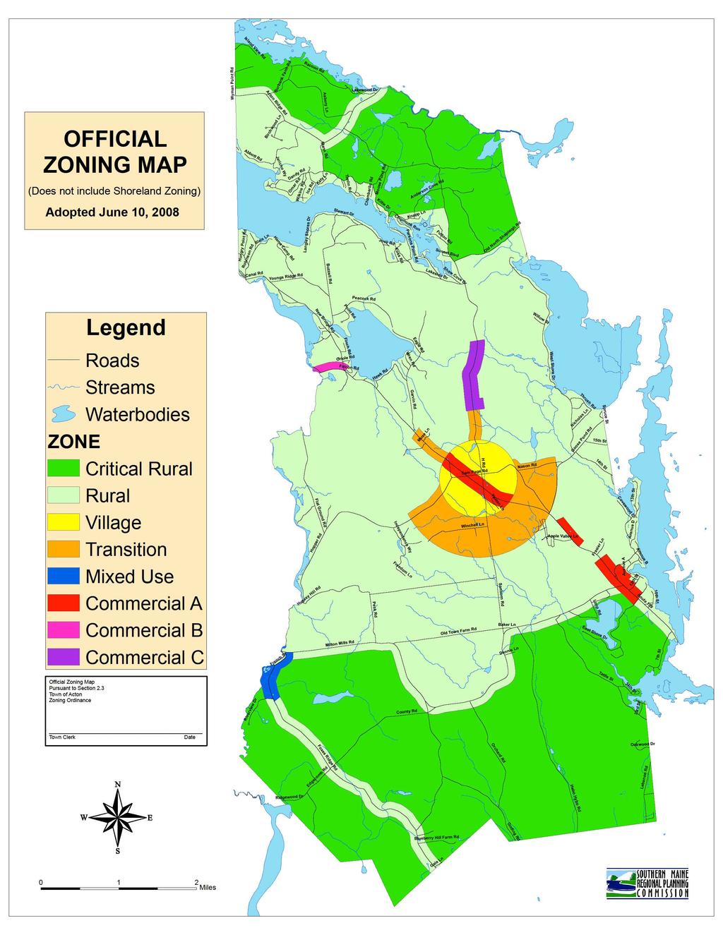
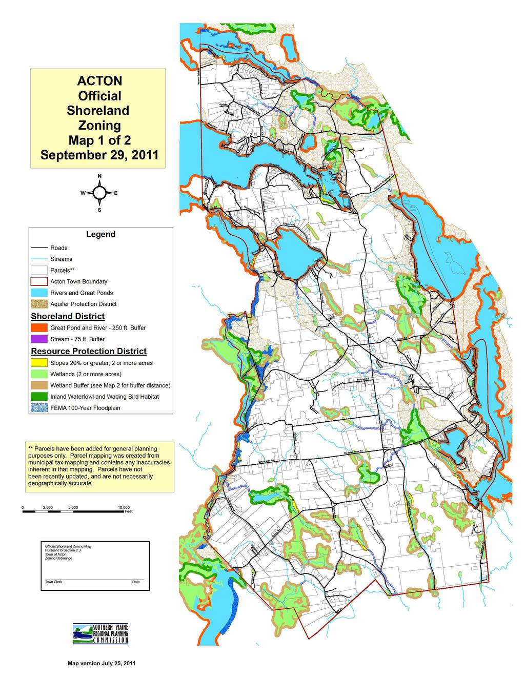
6 *TABLE OF CONTENTS Official Zoning Map dated June 10, 2008 Shoreland Map 1 of 2 dated September 29, 2011 Buffer Map 2 of 2 dated September 29, 2011 List of Districts... 1 ARTICLE 1 GENERAL 1.1 Short Title Purpose Basic Requirements Non-Conformities Validity and Severability Conflict with Other Ordinances Amendment Restoration of Unsafe Property Pending Application for Building Permits Repetitive Petitions Effective Date Availability... 9 ARTICLE 2 ESTABLISHMENT OF DISTRICTS 2.1 Zoning Districts and Official Zoning Maps Certification of and Changes to Official Zoning Map(s) Location of Districts Uncertainty of Boundary Location Division of Lots by District Boundaries General Lot Standards Land Use Chart Land Use Chart Footnotes ARTICLE 3 CONSTRUCTION OF LANGUAGE AND DEFINITIONS 3.1 Construction of Language Definitions i
7 ARTICLE 4 LAND USE DISTRICT REQUIREMENTS 4.1 Resource Protection and Shoreland Districts Resource Protection District Shoreland District Little Ossipee River District Commercial A District (Service Business) Commercial B (Low Water Impact) Commercial C District (Limited Industrial) Village District Transition District Rural District Critical Rural District Mixed Use District Aquifer Protection District ARTICLE 5 PERFORMANCE STANDARDS 5.1 Accessory Buildings Agriculture Beach Construction Individual Private Campsites Campgrounds Filling, Grading or other Earth-Moving Activity Roads and Driveways in the Shoreland District Erosion and Sedimentation Control in the Shoreland and Resource Protection District Mineral Exploration and Mineral Extractive Industry Commercial or Industrial Groundwater and/or Spring Water Extraction and/or Storage Good Neighbor and Design Standards for Proposed Development Home Occupations Manufactured Housing and Manufactured House Parks Multi-Family Dwelling Units Off-Street Parking and Loading Requirements Piers, Docks and other Shoreland Construction Sanitary Provisions Signs Timber Harvesting i
8 5.20 Clearing or Removal of Vegetation for Activities other than Timber Harvesting Water Quality Protection Application of Sludge/Residuals to Land Residential Growth Ordinance Commercial and Industrial Uses State Mandated Prohibitions in the Shoreland and Resource Protection Districts Stormwater Runoff Essential Services Soils Archaeological Site ARTICLE 6 ADMINISTRATION 6.1 Enforcement Building or Use Permit Plumbing Permit Required Legal Acton and Violations Fines Appeals and Conditional Use Permits *This Table of Contents was added for reference only and was not adopted by the Annual Town Meeting of June 16, 2018 approving the Acton Zoning Ordinance. i
9 ZONING ORDINANCE OF THE TOWN OF ACTON, MAINE Consisting of the following Districts: 1. Resource Protection District: This District is specifically designed to protect fragile or ecologically important areas such as swamps, bogs or wetlands. The Resource Protection District includes areas in which development would adversely affect water quality, productive habitat, biological ecosystems, or scenic and natural values. 2. Shoreland District: This District is designed for the use of the municipality to protect its undeveloped or relatively undeveloped shoreline areas from development which would adversely affect water quality. 3. Little Ossipee River District: This District is similar to the Shoreland District except that it has been modified to meet the criteria of the Saco River Corridor Commission. 4. Commercial A District (Service Business): This District is designed to allow service, tourist oriented, and small commercial businesses. 5. Commercial B District (Low Water Impact): This District is designed to service the lakes and numerous summer residents. This District will also be protected with additional environmental safeguards related to water usage, impervious surfaces, and phosphorous control measures. 6. Commercial C District (Limited Industrial): This District is designed to allow commercial/light industrial uses. 7. Village District: This District is designed to allow mixed uses, greater density, and unlimited growth. 8. Transition District: This District is designed as a transition zone to accommodate growth between the Village District and the Rural District, but at a lower density than the Village District. 9. Rural District: This District is designed for larger residential lot sizes and limited growth in a manner which preserves the rural character of the community. 10. Critical Rural District: This District is designed to preserve important natural resources within watershed boundaries and large undeveloped areas surrounding undeveloped great ponds. 11. Mixed Use District: This District is designed to preserve the existing New England Village character to include a mixture of commercial and residential uses. 12. Aquifer Protection District: This District is designed to preserve the significant sand and gravel aquifer. Town of Acton Zoning Ordinance, Amended June 16, 2018 Page 1 of 108
10 ARTICLE 1 - GENERAL 1.1 Short Title: This Ordinance shall be known and cited as the "Zoning Ordinance of the Town of Acton, Maine," and will be referred to herein as this "Ordinance." 1.2 Purpose: To further the maintenance of safe and healthful conditions and the general welfare, prevent and control water pollution, protect spawning grounds, fish, aquatic life, bird and other wildlife habitat, control building sites, placement of structures and land uses to protect buildings and lands from flooding and accelerated erosion, conserve shore cover, and visual as well as actual points of access to waters, to conserve natural beauty and open space, protect archeological and historic resources, to protect wetlands, and to anticipate and respond to the impacts of development in shoreland areas. This Ordinance does not grant any property rights; it does not authorize any person to trespass, infringe upon or injure the property of another; it does not excuse any person of the necessity of complying with other applicable laws and regulations. 1.3 Basic Requirements: All buildings or structures hereinafter erected, reconstructed, altered, enlarged or moved, and uses of premises in the Town of Acton shall be in conformity with the provisions of this Ordinance. No building, structure, land or water area shall be used for any purpose or in any manner except as permitted within the district in which such building, structure, land, or water area is located. No lot shall be created which is not in conformance with this Ordinance. Permitted and conditional uses shall conform to all dimensional requirements and other applicable requirements of this Ordinance. A plumbing permit and building permit (in that order) shall be required for all buildings, uses and sanitary facilities, according to the provisions of Article 6 of this Ordinance. 1.4 Non-Conformities: Purpose: It is the intent of this Ordinance and specifically this Article to promote land use conformities. All buildings, whether being erected, demolished, altered, or repaired, all parcels of land, and the uses of all buildings and land in the Town must be in conformance with the provisions of this Ordinance, except those which by the provisions of this Article become non-conforming. All buildings, parcels of land, and the uses thereof which are not in conformance with the provisions of this are prohibited, unless a variance is granted. However, non-conforming conditions and situations that legally existed before the effective date of the Ordinance or any amendment are allowed to continue, subject to the regulations set forth in Section 1.4 except as otherwise provided in this Ordinance, a non-conforming condition shall not be permitted to become more non-conforming Definition: Non-conformities are those buildings, parcels of land, and the uses thereof which fail to meet the current requirements of this Ordinance but which were lawful at the time of the original adoption or subsequent amendment of this Ordinance and which are allowed to continue as lawful pursuant to the provisions of this Article Repair and Maintenance: This Ordinance allows the normal upkeep and maintenance of nonconforming uses and structures including repairs or renovations that do not involve expansion of the non-conforming use or structure, and such other changes in a non-conforming use or structure as federal, state, or local building and safety codes may require Non-Conforming Lot: A non-conforming lot is a single lot of record which, at the time of adoption or amendment of this Ordinance, does not meet the minimum net lot area, net lot area per dwelling unit, maximum lot coverage, minimum lot width, or other similar lot requirements of the District in which it is located. It is allowed solely because it was in lawful existence as of March 9, Town of Acton Zoning Ordinance, Amended June 16, 2018 Page 2 of 108
11 1974, or as of the date a subsequent amendment rendering the lot non-conforming was adopted, as evidenced by a deed on record on or before that date in the York County Registry of Deeds Non-Conforming Building or Structure: A non-conforming building or structure is one that does not meet one or more of the following dimensional requirements; minimum setback, maximum height, maximum lot coverage, or similar building requirements of the District in which it is located. It is allowed solely because it was in lawful existence as of March 9, 1974, or as of the date a subsequent amendment rendering the building non-conforming took effect Non-Conforming Use: A non-conforming use is a use of premises, buildings, structures, land, or parts thereof that is not an allowed use in the District in which it is located, but which is allowed to remain solely because it was in lawful existence as of March 9, 1974, or as of the date a subsequent amendment rendering the use non-conforming took effect Non-Conforming Vacant Lot A vacant non-conforming lot of record as of the effective date of this Ordinance or amendment thereto may be built upon, without the need for a variance, provided that such lot shall be in separate ownership and not contiguous with any other lot in the same ownership and can meet all provisions of this Ordinance except lot size, road and shore frontage, and lot width in the Resource Protection and Shoreland Districts, provided that the State Minimum Lot Size Law (12 M.R.S.A. sections 4807-A through 4807-D) and Subsurface Waste Disposal Rules are complied with. In case of absence of road frontage, a driveway that accesses from a road that meets the Acton Road Standards (Level A, B, or C), and which is a deeded right of way at least 30 ft. wide, shall lead to the proposed buildings, and the building lot shall have at least one lot line of 250 ft. Variances relating to setback or other requirements not involving lot size, lot width, or road and shore frontage shall be obtained by action of the Acton Board of Appeals If two or more contiguous lots are in single or joint ownership of record at the time of or since adoption or amendment of this Ordinance, if any of these lots do not individually meet the dimensional requirements of this Ordinance or subsequent amendments, and if one or more of the lots are vacant or contain no principal structure, the lots shall be combined to the extent necessary to meet the dimensional requirements Non-Conforming Lots with Buildings If two or more contiguous lots are in a single or joint ownership of record at the time of adoption of this Ordinance, if all or part of the lots do not meet the dimensional requirements of this Ordinance, and if a principal use or structure exists on each lot, the non-conforming lots may be conveyed separately or together, provided that the State Minimum Lot Size Law (12 M.R.S.A. sections 4807-A through 4807-D) and Subsurface Wastewater Disposal Rules are complied with. If two or more principal uses or structures existed on a single lot of record on the effective date of this Ordinance, each may be sold on a separate lot provided that the Subsurface Wastewater Disposal Rules are complied with. When such lots are divided each lot thus created must be as conforming as possible to the dimensional requirements of this Ordinance A structure built on a non-conforming lot may be repaired, replaced, maintained or improved, may be enlarged, and an accessory building may be built upon the lot in conformity with the applicable dimensional requirements. Town of Acton Zoning Ordinance, Amended June 16, 2018 Page 3 of 108
12 1.4.9 Division of Non-Conforming Lot No division of any lot may be made which violates any minimum space or bulk requirements of this Ordinance or which makes worse an existing nonconforming situation Non-Conforming Uses Continuance The use of land, building, or structure, lawful at the time of adoption or subsequent amendment of this Ordinance, may continue although such use does not conform to the provisions of this Ordinance Resumption Whenever a non-conforming use is superseded by a permitted use of a structure, or structure and land in combination, such structure or combination of land and structure shall thereafter conform to the provisions of this Ordinance and the non-conforming use may not thereafter be resumed. In the Resource Protection and Shoreland Districts, a lot, building or structure in or on which a nonconforming use is discontinued for a period exceeding Twelve (12) months, or which is superseded by a conforming use, may not again be devoted to a non-conforming use except that the Planning Board may, for good cause shown by the applicant, grant up to a one year extension to that time period. This provision shall not apply to the resumption of a use of a residential structure provided that the structure has been used or maintained for residential purposes during the preceding five (5) year period Discontinuance non-conforming use which is discontinued for a period of two years, without regard to intent to abandon, may not be resumed. The uses of the land, building or structure shall thereafter conform to the provisions of this Ordinance Expansion of Use A non-conforming building, or structure may be repaired, replaced, maintained, or improved, but the area in non-conforming use may not be extended or expanded except in conformity with the provisions of this Ordinance. In the Shoreland District, expansions of non-conforming uses are prohibited, except that non-conforming residential uses may, after obtaining a permit from the Planning Board, be expanded within existing residential structures or within expansions of such structures as allowed in Section b. Expansions of nonconforming uses in the Resource Protection District are prohibited Change of Use An existing non-conforming use may be changed to another nonconforming use provided that the proposed use has no greater adverse impact on the subject and adjacent properties and resources than the former use, as determined by the Planning Board. The determination of no greater adverse impact shall be made according to criteria listed in Section Transfer or Ownership Ownership of land, structures, and uses which remain lawful but become non-conforming by the adoption or amendment of this Ordinance may be transferred and the new owner may continue the non-conforming use or continue to use the non-conforming structure or lot, subject to the provisions of this Ordinance Non-Conforming Buildings or Structures Maintenance or Enlargement: A non-conforming structure may be repaired, replaced, maintained, or improved provided the repair, replacement, maintenance, or improvement does not increase the nonconformity of the structure by encroaching any further on any of the setbacks and all required permits are obtained. Town of Acton Zoning Ordinance, Amended June 16, 2018 Page 4 of 108
13 Expansion in Shoreland District or Resource Protection District within the Shoreland Zone a) A non-conforming structure may be added to or expanded after obtaining a permit from the same permitting authority as that for a new structure, if such addition or expansion does not increase the non-conformity of the structure and is in accordance with subparagraphs (b) and (c) below. b) After January 1, 1989, if any portion of a structure in the Shoreland District is less than the required setback from the normal high-water line of a water body or tributary stream or upland edge of a wetland, that portion of the structure shall not be expanded, as measured in floor area or volume, by more than thirty (30) percent during the lifetime of the structure. If a replacement structure conforms with the requirements of Section , and is less than the required setback from a water body, tributary stream or wetland, the replacement structure may not be expanded if the original structure existing on January 1, 1989 had been expanded by thirty (30) percent in floor area or volume since that date. c) Whenever a new, enlarged, or replacement foundation is constructed under a nonconforming structure, the structure and new foundation must be placed such that the setback requirement is met to the greatest practical extent as determined by the Planning Board, basing its decision on the criteria specified in subsection below. If the completed foundation does not extend beyond the exterior dimensions of the structure, except for expansion in conformity with Section b above, and the foundation does not cause the structure to be elevated by more than three (3) additional feet, as measured from the uphill side of the structure (from original ground level to the bottom of the first floor sill), it shall not be considered to be an expansion of the structure. d) No structure which is less than the required setback from the normal high-water line of a water body, tributary stream, or upland edge of a wetland shall be expanded toward the water body, tributary stream or wetland Expansion of Structures Existing Prior to September 29, 2011 in the Resource Protection District Outside of the Shoreland Zone a) A non-conforming structure may be added to or expanded after obtaining a permit from the same permitting authority as that for a new structure, if such addition or expansion does not increase the non-conformity of the structure and is in accordance with subparagraphs (b) and (c) below. b) If any portion of a structure in the Resource Protection District outside of the Shoreland Zone is less than the required setback from a tributary stream or upland edge of a wetland, that portion of the structure shall not be expanded, as measured in floor area or volume, by more than thirty percent (30) during the lifetime of the structure. If a replacement structure conforms with the requirements of Section , and is less than the required setback from a tributary stream or wetland, the replacement structure may not be expanded if the original structure existing on September 29, 2011 had been expanded by thirty percent (30%) in floor area or volume since that date. Town of Acton Zoning Ordinance, Amended June 16, 2018 Page 5 of 108
14 c) Whenever a new, enlarged, or replacement foundation is constructed under a nonconforming structure, the structure and new foundation must be placed such that the setback requirement is met to the greatest practical extent as determined by the Planning Board, basing its decision on the criteria specified in subsection below. If the completed foundation does not extend beyond the exterior dimensions of the structure, except for expansion in conformity with Section b above, and the foundation does not cause the structure to be elevated by more than three (3) additional feet, as measured from the uphill side of the structure (from original ground level to the bottom of the first floor sill), it shall not be considered to be an expansion of the structure. d) No structure which is less than the required setback from a tributary stream, or upland edge of a wetland shall be expanded toward the water body, tributary stream or wetland Reconstruction or Replacement Any non-conforming structure which does not meet one or more of the required setbacks, including the required setbacks from a water body, tributary stream, or wetland in the Resource Protection District within the Shoreland Zone and Shoreland District and which is removed, or damaged, or destroyed, regardless of the cause, by more than fifty (50) percent of the market value of the structure over a five (5) year period before such damage, destruction, or removal, may be reconstructed or replaced provided that a permit is obtained within eighteen (18) months of the date of said damage, destruction, or removal, and provided that such reconstruction or replacement is in compliance with all required setbacks, and the water body, tributary stream or wetland setback requirements in the Resource Protection District within the Shoreland Zone and the Shoreland Districts, to the greatest practical extent as determined by the Planning Board in accordance with the purposes of this Ordinance. In no case shall a structure be reconstructed or replaced so as to increase its non-conformity. If the reconstructed or replacement structure is less than the required setback it shall not be any larger than the original structure, except as allowed pursuant to Section above, as determined by the non-conforming floor area and volume of the reconstructed or replaced structure at its new location. If the total amount of floor area and volume of the original structure can be relocated or reconstructed beyond the required setback area, no portion of the relocated or reconstructed structure shall be replaced or constructed at less than the setback requirement for a new structure. When it is necessary to remove vegetation in order to replace or reconstruct a structure, vegetation shall be replanted in accordance with Section below. An Historical Structure as defined in Section 3.2 of this ordinance, which is not located in the Shoreland Zone, shall be exempt from the setback requirements of the preceding paragraph provided that: a) The use of the structure after reconstruction and replacement is the same as the use of the structure prior to reconstruction or replacement; b) The architecture and general appearance of the structure are not altered; c) The dimensions of the structure are not increased; d) The structure is reconstructed or replaced in its original location. In the event that a reconstructed or replacement structure has not previously been designated an Historical Structure under the ordinance, the Planning Board shall apply the criteria set forth in the definition of Historical Structure in Section 3.2 to determine whether the reconstructed or replacement structure qualifies for the exemption from setback requirements provided herein. Town of Acton Zoning Ordinance, Amended June 16, 2018 Page 6 of 108
15 Any non-conforming structure which is damaged or destroyed by fifty (50) percent or less of the market value of the structure, excluding normal maintenance and repair, may be reconstructed in place with a permit from the Code Enforcement Officer. In the Resource Protection District within the Shoreland Zone and the Shoreland District any nonconforming structure which is located less than the required setback from a water body, tributary stream, or wetland and which is removed by fifty (50) percent or less of the market value, or damaged or destroyed by fifty percent (50%) or less of the market value of the structure, excluding normal maintenance and repair, may be reconstructed in place if a permit is obtained from the Code Enforcement Officer within one (1) year of such damage, destruction, or removal. In determining whether the building reconstruction or replacement meets the setback to the greatest practical extent the Planning Board shall consider, in addition to the criteria in Section below, the physical condition and type of foundation present, if any Relocation A non-conforming structure shall be relocated within the boundaries of the parcel on which the structure is located provided that the site of relocation conforms to all setback requirements to the greatest practical extent as determined by the Planning Board, and provided that the applicant demonstrates that the present subsurface sewage disposal system meets the requirements of State Law and the State of Maine Subsurface Wastewater Disposal Rules or that a new system can be installed in compliance with the law and said Rules. In no case shall a structure be relocated in a manner that causes the structure to be more non-conforming. In determining whether the building relocation meets the setback to the greatest practical extent, the Planning Board shall consider the size of the lot, the slope of the land, the potential for soil erosion, the location of other structures on the property and on adjacent properties, the location of the septic system and other on-site soils suitable for septic systems, and the type and amount of vegetation to be removed to accomplish the relocation. The Planning Board shall not consider any improvements to the property that have occurred within the preceding five (5) years. A building permit must be obtained within eighteen (18) months of Planning Board approval. In the Resource Protection and Shoreland Districts, when it is necessary to remove vegetation within the water or wetland setback area in order to relocate a structure, the Planning Board shall require replanting of native vegetation to compensate for the destroyed vegetation. In addition, the area from which the relocated structure was removed must be replanted with vegetation. Replanting shall be required as follows: a) Trees removed in order to relocate a structure must be replanted with at least one native tree, three (3) feet in height, for every tree removed. If more than five trees are planted, no one species of tree shall make up more than fifty (50) percent of the number of trees planted. Replaced trees must be planted no further from the water or wetland than the trees that were removed. Other woody and herbaceous vegetation, and ground cover, that are removed or destroyed in order to relocate a structure must be re-established. An area at least the same size as the area where vegetation and/or ground cover was disturbed, damaged, or removed must be reestablished within the setback area. The vegetation and/or ground cover must consist of similar native vegetation and/or ground cover that was disturbed, destroyed, or removed. b) Where feasible, when a structure is relocated on a parcel the original location of the structure shall be replanted with vegetation which may consist of grasses, shrubs, trees, or a combination thereof. Town of Acton Zoning Ordinance, Amended June 16, 2018 Page 7 of 108
16 Change of Use of a Non-Conforming Structure The use of a non-conforming structure may not be changed to another use unless the Planning Board, after receiving a written application, determines that the new use will have no greater adverse impact on the water body, tributary stream, or wetland, or on the subject or adjacent properties and resources, than the existing use. In determining that no greater adverse impact will occur, the Planning Board shall require written documentation from the applicant, regarding the probable effects on public health and safety, erosion and sedimentation, water quality, fish and wildlife habitat, vegetative cover, visual and actual points of public access to waters, natural beauty, flood plain management, and archeological and historic resources. 1.5 Validity and Severability Should any section or provision of this Ordinance be declared by the courts to be invalid, such decisions shall not invalidate any other section or provision of this Ordinance. 1.6 Conflict with Other Ordinances This Ordinance shall not repeal, annul, or in any way impair or remove any other rule, regulation, by-law, permit, or provision of law. Where this Ordinance imposes a greater restriction upon the use of land, buildings, or structures the more restrictive provisions of this Ordinance shall control. Whenever a Resource Protection District or Shoreland District provision of this Ordinance conflicts with or is inconsistent with another provision of this Ordinance or of any other Ordinance, regulation, or statute administered by the municipality, the more restrictive provision shall control. 1.7 Amendment Any amendment to this Ordinance may only be adopted by a majority vote at a special or regular town meeting. A proposal for an amendment to this Ordinance may be initiated by: a) Majority vote of the Planning Board. b) The Board of Selectmen. c) An individual, through a request to the Planning board who then may initiate only by a majority vote; or d) A written petition of a number of the voters equal to at least ten (10) percent of the vote cast in the last gubernatorial election. In any case(s), the Planning Board shall hold a public hearing at least thirty (30) days prior to the meeting of the governing body. Pursuant to M.R.S.A. 30A Section 4352, notice of the hearing shall be posted in the town office at least fourteen (14) days before the hearing, and at least two (2) times in a newspaper of general circulation in the area. The date of the first publication must be at least twelve (12) days before the hearing, and the date of the second publication must be at least seven (7) days prior to the hearing. If the amendment constitutes a change in zoning district boundaries or other amendment which would permit commercial, industrial or retail uses where previously prohibited, or prohibits all such uses where previously permitted, notice of the hearing shall be mailed to all owners of all property that is within or abutting an area affected by the proposed amendment. The Planning Board must maintain a list of the names and addresses of the persons to whom notice was sent. Notice of the hearing shall be mailed at least fourteen (14) days before the hearing to all owners of property in and abutting the area to be rezoned. The notice shall contain a map indicating the property to be rezoned. In the Resource Protection District within the Shoreland Zone and the Shoreland Districts, copies of amendments, attested and signed by the Municipal Clerk, shall be submitted to the Commissioner of the Department of Environmental Protection following adoption by the municipal legislative body and shall not be effective unless approved by the Commissioner. If the Commissioner fails to act on any amendment within Town of Acton Zoning Ordinance, Amended June 16, 2018 Page 8 of 108
17 forty-five (45) days of his/her receipt of the amendment, the amendment is automatically approved. Any application for a permit submitted to the municipality within the forty-five (45) day period shall be governed by the terms of the amendment, if such amendment is approved by the Commissioner. 1.8 Restoration of Unsafe Property Nothing in this Ordinance shall prevent the strengthening or restoring to safe condition any part of any building or structure declared unsafe by the Code Enforcement Officer. 1.9 Pending Application for Building Permits Nothing in this Ordinance shall require any change in the plans, construction, size, or designated use for any building, structure, or part thereof for which application for building permit has been made or a building permit has been issued or upon which construction shall start within 60 days after issuance of such permit Repetitive Petitions No proposed change in this Ordinance which has been unfavorably acted upon by the governing body shall be considered on its merits by the governing body within one (1) year after the date of such unfavorable action unless adoption of the proposed change is recommended by unanimous vote of the Planning Board, or requested by a petition signed by a number of required voters in the town at least ten (10) percent the number of votes cast in the last gubernatorial election Effective Date a) This Ordinance was originally adopted by the municipal legislative body on March 9, 1974 and amended most recently on June 17, Except as provided, amendments shall take effect upon adoption by the Town Meeting. b) Amendments to any provision affecting the Shoreland District or Resource Protection District shall not be effective unless approved by the Commissioner of the Department of Environmental Protection (Commissioner). A certified copy of the Ordinance, attested and signed by the Municipal Clerk, shall be forwarded to the Commissioner for approval. If the Commissioner fails to act on the amendment within forty-five (45) days of his/her receipt of the amendment, it shall be automatically approved. c) Notwithstanding the provision of Section 1.4, any application for a permit within the Shoreland District or Resource Protection District submitted to the municipality within the forty-five (45) day period shall be governed by the terms of the amendment, if the amendment is approved by the Commissioner of the Department of Environmental Protection Availability A certified copy of this Ordinance shall be filed with the Municipal Clerk and shall be accessible to any member of the public. Copies shall be made available to the public at reasonable cost at the expense of the person making the request. Notice of availability of this Ordinance shall be posted. Town of Acton Zoning Ordinance, Amended June 16, 2018 Page 9 of 108
18 ARTICLE 2 - ESTABLISHMENT OF DISTRICTS 2.1 Zoning Districts and Official Zoning Map(s) Districts are located and bounded as shown on the Official Zoning Map which is a made a part of this Ordinance. There may, for purpose of clarity, necessitated by reasons of scale on the map, be more than one Official Zoning Map. The Shoreland District, Resource Protection District, and Little Ossipee District, boundaries are determined by the terms of the sections creating those districts, and any delineation of them on the Official Zoning Map shall be for reference only and shall not supersede or modify such boundaries as created in those sections Resource Protection District within the shoreland zone (see definition of Shoreland Zone in section 3.2). A map showing the Resource Protection District shall be drawn at a scale of not less than: 1 inch = 2000 feet. District boundaries shall be clearly delineated and a legend indicating the symbols for each district shall be placed on the map. These Districts may be shown on the same map as the other Zoning Districts Resource Protection District outside the Shoreland Zone (see definition of Shoreland Zone in section 3.2) Shoreland District A map showing the Shoreland District shall be drawn at a scale of not less than: 1 inch = 2000 feet. District boundaries shall be clearly delineated and a legend indicating the symbols for each district shall be placed on the map. These Districts may be shown on the same map as the other Zoning Districts Little Ossipee District extends to all land areas within five hundred (500) feet from the normal high-water mark of Balch Pond and the Little Ossipee River Commercial A District (Service Business) Commercial B District (Low Water Impact) Commercial C District (Limited Industrial) Village District Transition District Rural District Critical Rural District Mixed Use District Aquifer Protection District 2.2 Certification of and Changes to Official Zoning Map(s) The Official Zoning Map(s) shall be certified by the attested signature of the Municipal Clerk and shall be located in the municipal office. In the event the municipality does not have a municipal office, the Municipal Clerk shall be the custodian of the map. If amendments, in accordance with Section 1.7, are made to the Resource Protection and Shoreland District boundaries or other matter portrayed regarding these Districts on the Official Zoning Map, such changes shall Town of Acton Zoning Ordinance, Amended June 16, 2018 Page 10 of 108
19 be made on the Official Zoning Map within thirty (30) days after the amendment has been approved by the Commissioner of the Department of Environmental Protection. 2.3 Location of Districts All Districts, with the exception of the Resource Protection, Shoreland, Little Ossipee and Aquifer Protection Districts, are located and bounded as shown on the Official Zoning Map, entitled "Zoning Map of Acton, Maine," dated June 10, 2008 and on file in the office of the Municipal Clerk. This Official Map shall be signed by the Municipal Clerk and Chairman of the Planning Board at the time of adoption or amendment of this Ordinance certifying the date of such adoption or amendment. Additional copies of this Map may be seen in the Office of the Selectmen, or Code Enforcement Office. The Official Map showing the Resource Protection and Shoreland Districts, dated September 29, 2011 shall be certified by the attested signature of the Municipal Clerk and shall be located in the municipal office. 2.4 Uncertainty of Boundary Location Where uncertainty exists with respect to the boundaries of the various districts as shown on the Official Zoning Map(s), the following rules shall apply: Boundaries indicated as approximately following the center lines of street, highways, alleys, or streams shall be construed to follow such center lines Boundaries indicated as approximately following well-established lot lines shall be construed as following such lot lines Boundaries indicated as approximately following municipal limits shall be construed as following municipal limits Boundaries indicated as following shorelines shall be construed to follow such shorelines; and in the event of natural change in the shoreline shall be construed as moving with the actual shoreline; boundaries indicated as approximately following the center line of streams, rivers, canals, lakes, or other bodies of water shall be construed to follow such center line Boundaries indicated as being parallel to or extensions of features indicated in subsections (1) through (4) above shall be so construed. Distances not specifically indicated on the Official Zoning Map(s) shall be determined by the scale of the Map(s) Sources for the exact delineation of the Special Flood Hazard areas shall be the Acton Flood Insurance Rate Map dated April 1, 1987 by FEMA or the most recent duly adopted amendment Where physical or cultural features existing on the ground are at variance with those shown on the Official Zoning Map(s), or in other circumstances not covered by subsections (1) through (6) above, the Board of Appeals shall interpret the district boundaries. 2.5 Division of Lots by District Boundaries Where a zoning district boundary line, other than a boundary line of the Resource Protection District, Little Ossipee River District, or Shoreland District, divides a lot or parcel of land of the same ownership of record at the time such line is established by adoption or amendment of this Ordinance, the regulations applicable to the less restricted portion of the lot may be extended not more than fifty (50) feet into the more restricted portion of the lot. Extension of use shall be considered a conditional use, subject to approval of the Planning Board and in accordance with the criteria set forth in Section Town of Acton Zoning Ordinance, Amended June 16, 2018 Page 11 of 108
20 2.6 General Lot Standards All corner lots shall be kept free from visual obstructions for a distance of twenty-five (25) feet measured along with intersecting street lines No portion of a building shall exceed thirty-five (35) feet in height except chimneys. Features of detached accessory buildings may exceed thirty-five (35) feet in height, but shall be set back from the nearest lot line a distance not less than the height of such structure, unless a greater setback is required by other provisions of this Ordinance Any new lot shall meet minimum road frontage requirements for the district in which the frontage is located, and the road frontage must be based on the horizontal distance between the intersections of the side lot lines with the front lot line along a road that meets the Town of Acton Road Standards (Level A, B, or C) Minimum Lot Standards a) Land below the normal high-water line of a water body or upland edge of a wetland and land beneath roads serving more than two (2) lots shall not be included toward calculating minimum lot area. b) Lots located on opposite sides of a public or private road shall be considered each a separate tract or parcel of land unless such road was established by the owner of land on both sides thereof after September 22, c) The minimum width of any portion of any lot within one hundred (100) feet, horizontal distance, of the normal high-water line of a water body or upland edge of a wetland shall be equal to or greater than the shore frontage requirement for a lot with the proposed use. If more than one (1) residential dwelling unit, principal governmental, institutional, commercial or industrial structure or combination thereof, is constructed or established on a single parcel, all dimensional requirements shall be met for each additional dwelling unit, principal structure, or use. d. If more than one (1) residential dwelling unit, principal governmental, institutional, commercial or industrial structure or combination thereof, is constructed or established on a single parcel, all dimensional requirements shall be met for each additional dwelling unit, principal structure, or use. 2.7 Land Use Chart 1. Exception: Accessory Dwelling Unit (ADU) ANY USE NOT LISTED HEREIN IS PROHIBITED C = Conditional Use Review LPI = Licensed Plumbing Inspector N = Not Permitted (use not allowed) P = Permitted (use allowed without a permit, must comply with all applicable land use standards) R = CEO Review (use must be reviewed by CEO and a permit may be required) Town of Acton Zoning Ordinance, Amended June 16, 2018 Page 12 of 108
21 S = Site Plan Review SD = Subdivision Review NA = Not applicable Village Area Transition Area (2-acre) Rural Area (2-acre) Critical Rural Area (5- acre) Commercial A Commercial B Commercial C Mixed Use Resource Protection Shoreland Little Ossipee Aquifer Protection District RURAL USES Open Space Use (non-intensive recreational uses not requiring structures such as hunting, fishing, hiking) P P P P P P P P P P P P Agriculture (commercial) C P P P P P P P N N N R Application and/or storage of sludge/residuals C C C N N N N N N N N N Gardening P P P P P P P P P P P P Forest Management Activities (silviculture, which does not include commercial timber harvesting and land management roads) P P P P P P P P P P P P Timber Harvesting for Commercial P P P P P P P P P P P P Sale of produce and plants raised on the premises, or seasonal sales of produce and plants not raised on the premises. Public or private recreation facilities including parks, playgrounds, golf courses, driving ranges, and swimming pools (does not include residential uses) P P P P P P P P R R R P S S S N S S S S N N N S Campgrounds N S S N N N N N N N N S Mineral Exploration R R R R R R R R R7 R7 R R7 Commercial ground water or spring water extraction N N S S N N N N N N N S Town of Acton Zoning Ordinance, Amended June 16, 2018 Page 13 of 108
22 Village Area Transition Area (2-acre) Rural Area (2-acre) Critical Rural Area (5- acre) Commercial A Commercial B Commercial C Mixed Use Resource Protection Shoreland Little Ossipee Aquifer Protection District Nature preserves and trails R R R R R R R R R8 R8 R8 R Structures and uses accessory to permitted uses Structures and uses accessory to conditional uses R R R R R R R R N R R R C C C C C C C C C C C C RESIDENTIAL STRUCTURES AND USES Single family dwelling R R R R R R R R N R R R Accessory Dwelling Unit (ADU) R R R R R R R R N N N N/A Two family dwelling R R R R R R R R N R R R Multi-family dwelling S S S N N N N S N N N S Planned unit development or cluster development SD SD SD SD N N N SD N N SD SD Manufactured Housing Park N SD N N N N N N N N N N Home Occupation R R R R R R R R N C C R Structures and uses accessory to permitted uses Structures and uses accessory to conditional uses Two single family residential dwellings on one lot R R R R R R R R N5 R R R C C C C C C C C C C C C R9 R9 R9 R9 R9 R9 R9 R9 N N N R9 COMMERCIAL AND INDUSTRIAL Planned Unit Development or Cluster Development Facilities offering food and beverages prepared on the premises sit down S S S N S S S S N N N S S S S N S S S S N N N S Town of Acton Zoning Ordinance, Amended June 16, 2018 Page 14 of 108
23 Village Area Transition Area (2-acre) Rural Area (2-acre) Critical Rural Area (5- acre) Commercial A Commercial B Commercial C Mixed Use Resource Protection Shoreland Little Ossipee Aquifer Protection District Auto service stations N N N N S N S S N N N N Auto repair garages N C C N C N C S N N N S Automobile graveyards and junkyard N N N N N N S N N N N N Kennels and animal care facility N S S S S S S S N N N S Medical treatment facility or rehabilitation facility Nursing facility, residential care facility, or congregate care facility Professional and business services having less than 2,500 square feet of gross floor area Professional and business services having 2,500 square feet or more of gross floor area (does not include home occupation) Child day care (as a home occupation) S S S N S S S S N N N S S S S N S S S S N N N S C C C N C C C C N N N C S S N N S S S S N N N S C C C C C C C C N C C C Child care facility C C C N C C C C N N N C Facilities not listed above having less than 2,500 square feet of gross floor area (not including home occupation) Facilities, which by the nature of their operation require a shorefront location, such as boatyards, marinas, and commercial fishing facilities S S S N S S S S N N N S N N N N N N N N N S S S PUBLIC, SEMI-PUBLIC, AND INSTITUTIONAL Church or other places of worship, parish house, convent, and other religious institutions S S S N S S S S N N N S Town of Acton Zoning Ordinance, Amended June 16, 2018 Page 15 of 108
24 Village Area Transition Area (2-acre) Rural Area (2-acre) Critical Rural Area (5- acre) Commercial A Commercial B Commercial C Mixed Use Resource Protection Shoreland Little Ossipee Aquifer Protection District Public buildings such as libraries, museums, or civic centers Public, private, and parochial school Cemeteries (not including family plots) S S S N S S S S N N N S S S S N N N N S N N N S C C C C N N N C N N N C Public Utilities S S S S S S S S S S S S Water and sewage treatment facilities S S S N S S S S N N N S Municipal Buildings S S S S S S S S N N N S OTHER USES Piers, docks, wharfs, bridges, and other structures and uses extending over or below the normal highwater line or within a wetland a. Temporary NA NA NA NA NA NA NA NA R R R R b. Permanent NA NA NA NA NA NA NA NA C C C C Signs R R R R R R R R N R R R Filling, grading, or other earth moving activity 500 to 9,999 cubic yards per year Filling, grading, or other earth moving activity 100 to 499 cubic yards per year Filling, grading, or other earth moving activity less than 99 cubic yards per year P P P P P P P P N N N P P P P P P P P P C C C P P P P P P P P P R R R P Town of Acton Zoning Ordinance, Amended June 16, 2018 Page 16 of 108
25 Village Area Transition Area (2-acre) Rural Area (2-acre) Critical Rural Area (5- acre) Commercial A Commercial B Commercial C Mixed Use Resource Protection Shoreland Little Ossipee Aquifer Protection District Filling, grading, or other earth moving activity more than 10,000 cubic yards per year Filling, grading, or other earth moving activity more than 10,000 cubic yards (Mineral Extraction Industrial) Uses and structures accessory to conditional uses Uses which are similar to conditional uses Uses and structures which are similar to permitted uses N C C C C C C C N N N C N C C C C C C C N N N C C C C C C C C C C C C C C C C C C C C C C C C R R R R R R R R R N5 R R R Boat yard (non-shorefront) N N N N S S S S N S N S Motorized vehicular traffic on existing roads and trails Clearing or removal of vegetation for activities other than timber harvesting P P P P P P P P P P P P P P P P P P P P R1 R R P Fire prevention activities P P P P P P P P P P P P Wildlife management practices P P P P P P P P P P P P Soil and water conservation practices P P P P P P P P P P P P Surveying and resource analysis P P P P P P P P P P P P Emergency operations P P P P P P P P P P P P Aquaculture P P P P P P P P S S S S Town of Acton Zoning Ordinance, Amended June 16, 2018 Page 17 of 108
Land Use Ordinance. Town of Readfield, Maine. Adopted June 12, 2018
 Land Use Ordinance Town of Readfield, Maine Adopted June 12, 2018 Revised: March 20, 2000; June 14, 2001; September 17, 2001; June 13, 2002; June 12, 2003; September 15, 2004; June 15, 2006; June 16, 2007;
Sullivan, Maine Selected Ordinances
 The University of Maine DigitalCommons@UMaine Maine Town Documents Maine Government Documents 2011 Sullivan, Maine Selected Ordinances Sullivan (Me.) Follow this and additional works at: https://digitalcommons.library.umaine.edu/towndocs
TOWN OF GREENE LAND USE ORDINANCE
 TOWN OF GREENE LAND USE ORDINANCE TABLE OF CONTENTS Chapter 1... 1-1 1-101 General... 1-1 1-101.1 Authority... 1-1 1-101.2 Purpose... 1-1 1-101.3 Applicability... 1-1 1-101.4 Effective Date... 1-1 1-101.5
Town of Winthrop Zoning Ordinance
 The University of Maine DigitalCommons@UMaine Maine Town Documents Maine Government Documents 2004 Town of Winthrop Zoning Ordinance Winthrop (Me.) Follow this and additional works at: https://digitalcommons.library.umaine.edu/towndocs
ZONING ORDINANCE MUNICIPALITY OF PHILLIPS, MAINE
 ZONING ORDINANCE OF THE MUNICIPALITY OF PHILLIPS, MAINE Originally adopted June 1974 Amended: March, 1975 September, 1975 March, 1978 March, 1979 September, 1979 March, 1981 December, 1983 March, 1991
Town of Sweden, Maine Zoning and Land Use Ordinance. Seventh Revision March 21, 2009
 Town of Sweden, Maine Zoning and Land Use Ordinance Seventh Revision March 21, 2009 Publication History: Originally Adopted - March 1975 First Revision - March 1979 Second Revision - August 1983 Third
LAND USE ORDINANCE, TOWN OF RICHMOND, MAINE TABLE OF CONTENTS
 LAND USE ORDINANCE, TOWN OF RICHMOND, MAINE TABLE OF CONTENTS ARTICLE 1. GENERAL A. TITLE... 1 B. PURPOSES... 1 C. BASIC REQUIREMENTS... 1-2 D. ADMINISTRATION & ENFORCEMENT... 2-3 E. VALIDITY AND SEVERABILITY...
ARTICLE 4.00 NONCONFORMITIES
 Section 4.01 -- INTENT ARTICLE 4.00 NONCONFORMITIES Nonconformities are uses, structures, buildings, or lots which do not conform to one or more provisions or requirements of this Ordinance or a subsequent
Town of Greenwood Maine Ordinances
 The University of Maine DigitalCommons@UMaine Maine Town Documents Maine Government Documents 2018 Town of Greenwood Maine Ordinances Greenwood, Me. Follow this and additional works at: https://digitalcommons.library.umaine.edu/towndocs
2019 Land Use Code. Town of Minot
 2019 Land Use Code Town of Minot Adopted March 4, 2006 AMENDMENTS: March 3, 2007 Chapters 7 & 8 and Land Use Control Map March 1, 2008 Chapters 4, 7, 9, & 14 March 6, 2010 Section 5-401.5C (reprint 11/2010)
ARTICLE 2: General Provisions
 ARTICLE 2: General Provisions 2-10 Intent The basic intent of the Town of Orange s Zoning Ordinance is to implement the goals and objectives of the adopted Town of Orange Comprehensive Plan, hereafter
7.20 Article 7.20 Nonconformities
 Article Nonconformities.01 Intent It is the intent of this ordinance to permit legal nonconforming lots, structures, or uses to continue until they are removed but not to encourage their survival. For
Town of Scarborough, Maine
 Town of Scarborough, Maine Miscellaneous Appeal INFORMATION REQUIRED FOR ALL APPEALS Before any appeal can be processed, the following material must be submitted to the Code Enforcement Office: 1. A fee
Town of Windham Land Use Ordinance Sec. 400 Zoning Districts SECTION 400 ZONING DISTRICTS
 Town of Windham Land Use Ordinance Sec. 400 Zoning Districts Sections SECTION 400 ZONING DISTRICTS SECTION 400 ZONING DISTRICTS 4-1 401 Districts Enumerated 4-2 402 Location of districts; Zoning Map 4-2
Chapter 9 - Non-Conformities CHAPTER 9 - INDEX
 CHAPTER 9 - INDEX 9-10: GENERAL... 3 9-20: SUBSTANDARD SIZE LOTS OR PARCELS... 3 9-20-10: GENERAL... 3 9-20-20: CUMULATING OF SUBSTANDARD SIZE LOTS OR PARCELS... 3 9-20-30: SEPARATION OF PLATTED SUBSTANDARD
ARTICLE Nonconformities
 ARTICLE 3.00 Section 3.01 Intent are uses, structures, buildings, or lots which do not conform to one or more provisions or requirements of this Ordinance or a subsequent amendment, but which were lawfully
MOBILE HOME PARK ORDINANCE OF THE TOWN OF LIVERMORE FALLS
 1 Section I. TITLE MOBILE HOME PARK ORDINANCE OF THE TOWN OF LIVERMORE FALLS This ordinance shall be known and cited as the Mobile Home Park Ordinance of the Town of Livermore Falls, Maine. Section II.
ARTICLE III NONCONFORMITIES
 ARTICLE III NONCONFORMITIES 3.1 PURPOSE The purpose of this Article is to establish regulations and limitations on the continued existence of uses, buildings, platted lots or structures established prior
SECTION 500 RURAL RESIDENTIAL DISTRICTS VERY LOW DENSITY RESIDENTIAL DISTRICTS (VLDR-5, VLDR-2 ½, VLDR-1) [Last Amended 5/24/12; Ord.
 [Last Amended 5/24/12; Ord.") This section and related information is available at www.co.yamhill.or.us/plan/planning/ordinance/zoning_toc.asp SECTION 500 RURAL RESIDENTIAL DISTRICTS 502. VERY LOW DENSITY RESIDENTIAL DISTRICTS (VLDR-5,
This section and related information is available at www.co.yamhill.or.us/plan/planning/ordinance/zoning_toc.asp SECTION 500 RURAL RESIDENTIAL DISTRICTS 502. VERY LOW DENSITY RESIDENTIAL DISTRICTS (VLDR-5,
ARTICLE V AGRICULTURAL PRESERVATION AND RURAL RESIDENTIAL DISTRICT
 ARTICLE V AP AGRICULTURAL PRESERVATION AND RURAL RESIDENTIAL DISTRICT Section 500. PURPOSE It is the purpose of the AP, Agricultural Preservation and Rural Residential District, to foster the preservation
Draft Zoning Ordinance for Planning Board Review Town of Brunswick, Maine
 Draft Zoning Ordinance for Planning Board Review Town of Brunswick, Maine PLANNING BOARD DRAFT Clarion Associates Brunswick Zoning Ordinance Rewrite Committee June 2016 Contents Chapter 1 General Provisions...
PLANNED RESIDENTIAL DEVELOPMENT (PRD)
") PLANNED RESIDENTIAL DEVELOPMENT SECTION 10. PLANNED RESIDENTIAL DEVELOPMENT (PRD) 10.1 Purpose Planned Residential Development allows by special permit from the Board an alternative pattern of residential
PLANNED RESIDENTIAL DEVELOPMENT SECTION 10. PLANNED RESIDENTIAL DEVELOPMENT (PRD) 10.1 Purpose Planned Residential Development allows by special permit from the Board an alternative pattern of residential
TOWN OF WALES LAND USE ORDINANCE
 TOWN OF WALES LAND USE ORDINANCE Final Draft Date: May 30, 2009 Note: This ordinance replaces the ordinance adopted June 11, 2005 Adopted: June, 2009 Article 1. Purposes The purpose of this ordinance is
ARTICLE IX. NONCONFORMITIES. Section 900. Purpose.
 ARTICLE IX. NONCONFORMITIES Section 900. Purpose. It is the purpose of this Article to provide for the regulation of nonconforming structures, lots of record and uses, and to specify those circumstances
MULTI-FAMILY DWELLING UNIT SUBDIVISION ORDINANCE TOWN OF SIDNEY, MAINE
 MULTI-FAMILY DWELLING UNIT SUBDIVISION ORDINANCE TOWN OF SIDNEY, MAINE I. GENERAL A. Title B. Purpose C. Administration D. Scope II. DEFINITIONS A. Building Height B. Dwelling Unit C. Family D. Multi-Unit
TABLE OF CONTENTS ARTICLE TITLE AND PURPOSE 1
 TABLE OF CONTENTS ARTICLE 100... TITLE AND PURPOSE 1 ARTICLE 200... AUTHORITY AND ADMINISTRATION 1 210 AUTHORITY... 1 220 ADMINISTRATION... 1 230 EFFECTIVE DATE... 1 ARTICLE 300... APPLICABILITY 1 ARTICLE
NONCONFORMING LOTS, STRUCTURES, AND USES.
 ARTICLE 7. NONCONFORMING LOTS, STRUCTURES, AND USES. Sec. 25-7.1. Purpose. The purpose of this section is to provide regulations for nonconforming lots, structures, and uses. These regulations are necessary
ARTICLE 10. NONCONFORMITIES
 ARTICLE 10. NONCONFORMITIES 10.1. General A lawful preexisting use, structure, or lot that does not meet the requirements of this UDO is deemed a nonconformity. Special provisions apply to nonconformities,
Inside the Proposed Ordinance Creating the Shoreland General Development 3 -- Route One South -- SG3 District
 Inside the Proposed Ordinance Creating the Shoreland General Development 3 -- Route One South -- SG3 District GOAL: To allow the Ogunquit Playhouse to accomplish need-based improvements to ensure its long-term
CHAPTER 2 RELATIONSHIP WITH OTHER LAWS.
 CHAPTER 2 General Provisions 12-2-1 Minimum Requirements 12-2-2 Relationship with Other Laws 12-2-3 Effect on Existing Agreements 12-2-4 Scope of Regulations 12-2-5 Building Permit 12-2-6 Nonconforming
Midwest City, Oklahoma Zoning Ordinance
 2010 Midwest City, Oklahoma Zoning Ordinance 9/2/2010 Table of Contents Section 1. General Provisions... 5 1.1. Citation... 5 1.2. Authority... 5 1.3. Purpose... 5 1.4. Nature and Application... 5 1.5.
BY BOARD OF COUNTY COMMISSIONERS AN ACT TO BE ENTITLED
 BY BOARD OF COUNTY COMMISSIONERS ORDINANCE NO. AN ACT TO BE ENTITLED AN ORDINANCE AMENDING THE PASCO COUNTY LAND DEVELOPMENT CODE, ARTICLE 700, BY REPEALING EXISTING SECTION 702, ENVIRONMENTALLY SENSITIVE
CHAPTER 21.11: NONCONFORMITIES...1
 0 0 TABLE OF CONTENTS CHAPTER.: NONCONFORMITIES.....0 General Provisions... A. Purpose... B. Authority to Continue... C. Determination of Nonconformity Status... D. Nonconformities Created Through Government
** If your lot does not meet the requirements above, please read Sec below
 Sec. 13-1-60 Zoning District Dimensional Requirements. For the Zoning Dept To Issue a Land Use Permit The Following Dimensions are Required. Minimum Side and Rear Yards s Lakes Classification Minimum Class
FREQUENTLY USED PLANNING & ZONING TERMS
 City Of Mustang FREQUENTLY USED PLANNING & ZONING TERMS Abut: Having property lines, street lines, or zoning district lines in common. Accessory Structure: A structure of secondary importance or function
SECTION 10.7 R-PUD (RESIDENTIAL PLANNED UNIT DEVELOPMENT) ZONE
 ZONE") Article X Zones 10-20 SECTION 10.7 R-PUD (RESIDENTIAL PLANNED UNIT DEVELOPMENT) ZONE A. PURPOSE AND INTENT: The R-PUD Residential PUD Zone is intended to provide alternative, voluntary zoning procedures
Article X Zones 10-20 SECTION 10.7 R-PUD (RESIDENTIAL PLANNED UNIT DEVELOPMENT) ZONE A. PURPOSE AND INTENT: The R-PUD Residential PUD Zone is intended to provide alternative, voluntary zoning procedures
Town of Stoneham, Maine, Selected Ordinances
 The University of Maine DigitalCommons@UMaine Maine Town Documents Maine Government Documents 2009 Town of Stoneham, Maine, Selected Ordinances Stoneham (Me.) Follow this and additional works at: https://digitalcommons.library.umaine.edu/towndocs
Residential Project Convenience Facilities
 Standards for Specific Land Uses 35.42.220 E. Findings. The review authority shall approve a Land Use Permit in compliance with Subsection 35.82.110.E (Findings required for approval) or a Conditional
Town of Lisbon, Maine SUBDIVISION REVIEW APPLICATION
 Date Received: Fee Paid (amount): Applicant: Town of Lisbon, Maine SUBDIVISION REVIEW APPLICATION Subdivision Name/Title: This application must be received at the Town Office by close of business on the
4. facilitate the construction of streets, utilities and public services in a more economical and efficient manner;
 PVPC MODEL BYLAW BY-RIGHT CLUSTER ZONING BYLAW Prepared by Pioneer Valley Planning Commission Revised: October 2001 1.00 Development 1.01 Development Allowed By Right Development in accordance with this
Lane Code CHAPTER 10 CONTENTS
 Lane Code CHAPTER 10 CONTENTS AGRICULTURAL LAND DISTRICT (A-2) 10.107-05 Purpose. 10.107-10 Uses. 10.107-12 Review Process. 10.107-20 Land Division Requirements. 10.107-30 Land s. 10.107-40 Setback Requirements.
STAFF REPORT. Arthur and Kathleen Quiggle 4(b)
") STAFF REPORT Application: Requests related to the construction of a 28' x 41' dwelling and 6' wrap-around open deck to replace an existing 24' x 32' cabin and wrap-around open deck and the installation
STAFF REPORT Application: Requests related to the construction of a 28' x 41' dwelling and 6' wrap-around open deck to replace an existing 24' x 32' cabin and wrap-around open deck and the installation
Special Use Permit - Planned Unit Development Checklist. Property Address:
 Special Use Permit - Planned Unit Development Checklist Special Use Permit Number. Parcel Code/s #28-11- - - Property Address: Applicant: ARTICLE VIII Ordinance Reference - Section 8.1.2 Permit Procedures:
SECTION 822 "R-1-A" AND "R-1-AH" - SINGLE FAMILY RESIDENTIAL DISTRICTS
 SECTION 822 "R-1-A" AND "R-1-AH" - SINGLE FAMILY RESIDENTIAL DISTRICTS The "R-1-A" and "R-1-AH" Districts are intended to provide for the development of single family residential homes at urban standards
TABLE OF CONTENTS CHAPTER 1 INTRODUCTORY PROVISIONS Section 1 Purposes. 6. Section 2 Statutory Authorization. 7.
 An Ordinance requiring permits for buildings, structures and the uses thereof; for land uses and for water supply and sewage treatment facilities; establishing minimum lot sizes, setbacks and side yards,
(B) On lots less than 1.5 acres, accessory buildings shall have a maximum size of 672 square feet in area.
 On lots less than 1.5 acres, accessory buildings shall have a maximum size of 672 square feet in area.") Setbacks in Commercial Districts: (1) Downtown Business District: Setbacks from State Highways 70 and 155 shall be the lesser of a minimum of 100 feet or the footprint of the present principal building
Setbacks in Commercial Districts: (1) Downtown Business District: Setbacks from State Highways 70 and 155 shall be the lesser of a minimum of 100 feet or the footprint of the present principal building
1.300 ZONING DISTRICT REGULATIONS
 1.205 VACANT LOT SPECIAL REQUIREMENTS: On lots less than 1.5 acres, only one garage allowed with a maximum size of 672 square feet in area. 1.300 ZONING DISTRICT REGULATIONS 1.301 ESTABLISHMENT OF DISTIRCTS:
ARTICLE 21 NONCONFORMITIES
 ARTICLE 21 NONCONFORMITIES Sections: 21-1 General Provisions 21-2 Nonconforming Lots of Record 21-3 Nonconforming Structures 21-4 Nonconforming Uses 21-5 Nonconforming Manufactured Homes SECTION 21-1 GENERAL
ARTICLE SCHEDULE OF REGULATIONS
 ARTICLE 21.00 SCHEDULE OF REGULATIONS FOOTNOTES TO ARTICLE 21.00 SCHEDULE OF REGULATIONS a. If one or both public sanitary sewers and/or public water supply are not available minimum lot size shall be
Article XII. General Provisions and Regulations
 and Regulations The regulations contained in this chapter are intended to clarify, supplement or modify the regulations set forth elsewhere in this ordinance. 157.182. USE OF LAND OR STRUCTURES A. Conformity
CITY OF APALACHICOLA ORDINANCE
 CITY OF APALACHICOLA ORDINANCE 2017-05 AN ORDINANCE AMENDING ORDINANCE 91-7 WHICH ADOPTS THE CITY OF APALACHICOLA LAND DEVELOPMENT CODE REVISING SECTION II (DEFINITIONS) RELATING TO HISTORIC STRUCTURES,
LAND USE AND DEVELOPMENT ORDINANCE FOR THE TOWN OF VERONA ISLAND, MAINE
 LAND USE AND DEVELOPMENT ORDINANCE FOR THE TOWN OF VERONA ISLAND, MAINE Adopted 1992 Special Town Meeting Amended March 31, 2007 1 LAND USE AND DEVELOPMENT ORDINANCE FOR THE TOWN OF VERONA, MAINE SECTION
ARTICLE 10 NONCONFORMITIES
 SECTION 10.01 - GENERAL PROVISIONS ARTICLE 10 NONCONFORMITIES A. Lots, structures, and uses of land and structures that were lawful before this Ordinance was adopted or amended and which would be prohibited,
13 NONCONFORMITIES [Revises Z-4]
![13 NONCONFORMITIES [Revises Z-4]](/thumbs/87/97238669.jpg "13 NONCONFORMITIES [Revises Z-4]") Dimensional Standards Building Design Standards Sidewalks Tree Protection & Landscaping Buffers & Screening Street Tree Planting Parking Lot Landscaping Outdoor Lighting Signs 13.1 PURPOSE AND APPLICABILITY
Dimensional Standards Building Design Standards Sidewalks Tree Protection & Landscaping Buffers & Screening Street Tree Planting Parking Lot Landscaping Outdoor Lighting Signs 13.1 PURPOSE AND APPLICABILITY
CHAPTER 3 REGULATIONS INSIDE THE COASTAL ZONE
 CHAPTER 3 REGULATIONS INSIDE THE COASTAL ZONE Organization. Chapter 3 contains the regulations which apply exclusively within the California Coastal Zone in Humboldt County and is organized as follows:
Town of Lincolnville Subdivision Ordinance
 Town of Lincolnville Subdivision Ordinance November 8, 2005 Amended: 06-10-2008---Article 4, Section 4.4.1 Conceptual Plan 06-11-2015---Article 5, Section 5.2.3.i., Article 6.2.3.l., Article 8 & 12 Access
Draft Zoning Changes for the 2nd Planning Board Public Hearing, January 22, 2018.
 Draft Zoning Changes for the 2nd Planning Board Public Hearing, January 22, 2018. No changes were made at the 1st Public Hearing. Proposed wording for the 1 st Public Hearing in red, eliminated text in
SECTION CLASSIFICATION OF ZONES For the purpose of this Code the following primary land use zoning districts are hereby established:
 ARTICLE 4 ZONING DISTRICTS SECTION 4.010 CLASSIFICATION OF ZONES For the purpose of this Code the following primary land use zoning districts are hereby established: Primary Zones Abbreviated Designation
OXFORD ZONING ORDINANCE
 OXFORD ZONING ORDINANCE Adopted June 21, 2008 Amended June 21, 2008 Amended January 06, 2011 Amended December 12, 2012 Amended September 19, 2013 Amended April 2, 2016 Amended June 10, 2017 Amended September
PUBLIC NUISANCES & DETRIMENTAL NONCONFORMITIES
 CHAPTER 6: NONCONFORMITIES SECTION 6.1 PURPOSE Within the primary and overlay districts established in this Ordinance or amendments that may later be adopted, certain situations may occur in which an existing
ARTICLE 10 NONCONFORMITIES
 ARTICLE 10 NONCONFORMITIES SECTION 10.01 GENERAL PROVISIONS A. Lots, structures, and uses of land and structures that were lawful before this Ordinance was adopted or amended and which would be prohibited,
CHAPTER 21.12: NONCONFORMITIES
 CHAPTER 21.12: NONCONFORMITIES 21.12.010 GENERAL PROVISIONS... 12-2 A. Purpose... 12-2 B. Authority to Continue... 12-2 C. Determination of Nonconformity Status... 12-3 D. Government Agency Property Acquisitions...
ARTICLE VII. NONCONFORMITIES. Section 700. Purpose.
 ARTICLE VII. NONCONFORMITIES. Section 700. Purpose. The purpose of this chapter is to regulate and limit the development and continued existence of legal uses, structures, lots, and signs established either
17.0 NONCONFORMITIES CHAPTER 17: NONCONFORMITIES Purpose and Applicability
 17.0 NONCONFORMITIES 17.1 Purpose and Applicability The purpose of this section is to regulate and limit the continued existence of uses and structures established prior to the effective date of this Ordinance
Article 11.0 Nonconformities
 Sec. 11.1 Generally The purpose of this Article is to establish regulations and limitations on the continued existence of uses, lots, structures, signs, parking areas and other development features that
Box Elder County Land Use Management & Development Code Article 3: Zoning Districts
 Chapter 3-6 Mobile Homes, Mobile Home Subdivisions, & Recreational Vehicle Parks Box Elder Zoning Ordinance as Adopted October 2007 Sections. 3-6-010. Purpose and Intent. 3-6-020. Conditional Use Permit
Chapter 210 CONDITIONAL USES
 Chapter 210 CONDITIONAL USES 210.01 Purpose 210.02 Authorization 210.03 Process Type 210.04 Determination of Major or Minor Conditional Use Review 210.05 Approval Criteria 210.06 Conditions of Approval
Multiple Use Forest District (MUF)
") This district is defined as Multiple Use Forest District with a minimum lot size of 20 acres. 11.15.2162 Purposes The purposes of the Multiple Use Forest District are to conserve and encourage the use
This district is defined as Multiple Use Forest District with a minimum lot size of 20 acres. 11.15.2162 Purposes The purposes of the Multiple Use Forest District are to conserve and encourage the use
ARTICLE III: LAND USE DISTRICTS AGRICULTURE AND FOREST DISTRICT (AF-10)
") ARTICLE III: LAND USE DISTRICTS III-153 346 AGRICULTURE AND FOREST DISTRICT (AF-10) 346-1 Intent and Purpose The AF-10 District is intended to retain an area s rural character and conserve the natural
ARTICLE III: LAND USE DISTRICTS III-153 346 AGRICULTURE AND FOREST DISTRICT (AF-10) 346-1 Intent and Purpose The AF-10 District is intended to retain an area s rural character and conserve the natural
LAND USE ORDINANCE OF THE TOWN OF SOUTHPORT, MAINE
 LAND USE ORDINANCE OF THE TOWN OF SOUTHPORT, MAINE Enacted March 1, 1993 Amended March 7, 1994, March 4, 1996, March 3, 1997, March 1, 1999, March 7, 2000, March 12, 2001, March 4, 2002, March 7, 2005,
ARTICLE I ZONE BASED REGULATIONS
 ARTICLE I ZONE BASED REGULATIONS RZC 21.08 RESIDENTIAL REGULATIONS 21.08.290 Cottage Housing Developments A. Purpose. The purpose of the cottage housing requirements is to: 1. Provide a housing type that
Town of Searsmont. Land Use Ordinance
 Land Use Ordinance I. Contents SECTION 100 GENERAL PROVISIONS... 1 101 TITLE... 1 102 AUTHORITY... 1 103 PURPOSE... 1 104 APPLICABILITY... 1 105 VALIDITY AND SEVERABILITY... 1 106 CONFLICTS... 1 107 EFFECTIVE
ARTICLE 7. SPECIFIC USE STANDARDS
 ARTICLE 7. SPECIFIC USE STANDARDS Section 7.1 Applicability The following standards apply to specified uses in all zoning districts in which such uses are allowed. Section 7.2 Accessory Apartments (A)
Article 30: Residence Zones
 ARTICLE 30, Use Regulations Controlling Residence Zones 118-300. Island Conservation Zone. [Added effective 1-22-1974] A. Declaration of necessity and purpose. Article 30: Residence Zones (1) It is declared
TOWNSHIP OF EGG HARBOR ZONING BOARD ADJUSTMENT CHECK LIST
 TOWNSHIP OF EGG HARBOR ZONING BOARD ADJUSTMENT CHECK LIST Schedule A - General Requirements 1. Where the application involves only a variance one (1) original and nineteen (19) copies of the appropriate
The intent of the Exclusive Farm Use District is to preserve and maintain commercial agricultural land within the County.
 III 121 340 EXCLUSIVE FARM USE DISTRICT (EFU) 340 1 Intent and Purpose The intent of the Exclusive Farm Use District is to preserve and maintain commercial agricultural land within the County. The purpose
Town of Berlin, Vermont Zoning Regulations. March 6, 1973
 Town of Berlin, Vermont Zoning Regulations March 6, 1973 Revised August 1980 Revised March 1985 Revised March 1987 Revised March 1988 Revised March 1989 Revised March 1998 Revised March 2002 Revised October
DRAFT PARK COUNTY US HIGHWAY 89 SOUTH EAST RIVER ROAD OLD YELLOWSTONE TRAIL ZONING DISTRICT REGULATIONS
 Formatting: Changes recommended by the Board and accepted by the County Commission are formatted in RED: Changes made by the Park County Commission are formatted in YELLOW highlight: and changes made by
ZONING ORDINANCE Town of Sugar Hill, NH
 ZONING ORDINANCE Town of Sugar Hill, NH As adopted: November 1986 Amended: March 1988, 1991, 1992, 1993, 1994, 1996, 1997, 1998, 2001, 2003, 2006 1 TABLE OF CONTENTS ARTICLE TITLE PAGE 1 PREAMBLE AND TITLE
WASCO COUNTY PRELIMINARY SUBDIVISION APPLICATION
 WASCO COUNTY PRELIMINARY SUBDIVISION APPLICATION DETAILED SPECIFIC WRITTEN REQUEST File Number: SDV- Number of Proposed Lots & their Dimensions: PRELIMINARY SUBDIVISION PLAN REQUIREMENTS The approval of
St. Mary s County Comprehensive Zoning Ordinance Article 1. GENERAL PROVISIONS
 0 0 0 0 ARTICLE. GENERAL PROVISIONS CHAPTER 0 TITLE, PURPOSE AND ORGANIZATION Sections: 0. Title. 0. Authority. 0. Purpose. 0. Organization of the Zoning Ordinance. 0. Official Zoning Map. 0. Applicability.
APPLICATION PROCEDURE
 ANTRIM PLANNING BOARD P. O. Box 517 Antrim, New Hampshire 03440 Phone: 603-588-6785 FAX: 603-588-2969 APPLICATION FORM AND CHECKLIST FOR MINOR OR MAJOR SITE PLAN REVIEW File Date Received By APPLICATION
TO WN O F WESTFO RD ZONING REGULATIONS
 TO WN O F WESTFO RD ZONING REGULATIONS FIRST Ado pted: No vem ber 1972 LASTADO PTED: FEBRUARY 2011 C:\Users\Melissa\Desktop\planning\regulations\adopted zoning\2011\2011_zoning.doc TABLE OF CONTENTS 1.0
Part 72. Sec. 1. This ordinance shall be known and may be cited as the Clyde Township Wetlands Ordinance.
 Part 72 72.000 WETLANDS ORDINANCE Ord. No. 1 Adopted: June 12, 1991 Amended: April 13, 1994 72.001 SHORT TITLE. 72.002 PURPOSE. 72.003 DEFINITIONS. CLYDE TOWNSHIP ORDAINS: Sec. 1. This ordinance shall
Chapter 100 Planned Unit Development in Corvallis Urban Fringe
 100.100 Scope and Purpose. Chapter 100 Planned Unit Development in Corvallis Urban Fringe (1) All applications for land divisions in the Urban Residential (UR) and Flood Plain Agriculture (FPA) zones within
Boyertown Borough and Colebrookdale and Pike Townships Joint Zoning Ordinance
 Boyertown Borough and Colebrookdale and Pike Townships Joint Zoning Ordinance Berks County, Pennsylvania Effective Date - November 7, 2010 This Ordinance was prepared under the direction of the Boyertown
NONCONFORMITIES ARTICLE 39. Charter Township of Commerce Page 39-1 Zoning Ordinance. Article 39 Nonconformities
 ARTICLE 39 NONCONFORMITIES SECTION 39.01. Intent and Purpose It is recognized that there exists within the districts established by this Ordinance lots, structures, sites and uses which were lawful prior
Door County Shoreland Zoning. Door County Land Use Services Department June 26, 2018
 Door County Shoreland Zoning Door County Land Use Services Department June 26, 2018 Wisconsin ShorelandZoning: Background June 12, 1968: State-mandated date for counties to begin administering shoreland
GARDEN HIGHWAY SPECIAL PLANNING AREA
 GARDEN HIGHWAY SPECIAL PLANNING AREA 501-250. INTENT. The land area between the Garden Highway and the Sacramento River possesses unique environmental amenities that require special treatment and regulation.
May 12, Chapter RH HILLSIDE RESIDENTIAL ZONES REGULATIONS Sections:
 May 12, 2017 Chapter 17.13 RH HILLSIDE RESIDENTIAL ZONES REGULATIONS Sections: 17.13.010 Title, intent, and description. 17.13.020 Required design review process. 17.13.030 Permitted and conditionally
This EFU District is provided to meet the Oregon statutory and administrative rule requirements.
 ARTICLE III: LAND USE DISTRICTS III-121 340 EXCLUSIVE FARM USE DISTRICT (EFU) 340-1 Intent and Purpose The intent of the Exclusive Farm Use District is to preserve and maintain commercial agricultural
Planned Residential Development Zone
 SECTION 55 Planned Residential Development Zone 55.0 [Reserved] 55.1 General The Planned Residential Development (PRD) Zone is a class of zone in addition to and overlapping a portion or portions of the
RURAL RESIDENTIAL FARMIFOREST 5 ACRES (RRFF-5) (6126/03)
 (6126/03)") CLACKAMAS COUNTY WNING AND DEVELOPMENT ORDINANCE 309 309.01 RURAL RESIDENTIAL FARMIFOREST 5 ACRES (RRFF-5) (6126/03) PURPOSE A. To provide areas for rural living where this type of development is compatible
CLACKAMAS COUNTY WNING AND DEVELOPMENT ORDINANCE 309 309.01 RURAL RESIDENTIAL FARMIFOREST 5 ACRES (RRFF-5) (6126/03) PURPOSE A. To provide areas for rural living where this type of development is compatible
UPPER MOUNT BETHEL TOWNSHIP NORTHAMPTON COUNTY, PENNSYLVANIA
 UPPER MOUNT BETHEL TOWNSHIP NORTHAMPTON COUNTY, PENNSYLVANIA JOINDER DEED / LOT CONSOLIDATION TOWNSHIP REVIEW PROCESS When accepting proposed Joinder Deeds / Lot Consolidations, review the Joinder Deed
CHELSEA SUBDIVISION ORDINANCE
 June 11, 2015 CHELSEA SUBDIVISION ORDINANCE I. Purpose and Authority A. This ordinance will pertain to all land within the boundaries of the Town of Chelsea. The purpose of this ordinance is to protect
FINAL DRAFT 12/1/16, Rev. to 7/18/17
 FINAL DRAFT 12/1/16, Rev. to 7/18/17 (As Adopted 8/8/17 Effective 9/1/17) SHELTON PLANNING AND ZONING COMMISSION Proposed Amendments to Zoning Regulations I. Amend Section 23 PERMITTED USES by inserting
Land Use Ordinance Town of Phippsburg
 The University of Maine DigitalCommons@UMaine Maine Town Documents Maine Government Documents 2012 Land Use Ordinance Town of Phippsburg Phippsburg (Me.) Follow this and additional works at: https://digitalcommons.library.umaine.edu/towndocs
ALBEMARLE COUNTY CODE CHAPTER 18. ZONING SECTION 10. RURAL AREAS DISTRICT, RA
 CHAPTER 18. ZONING SECTION 10. RURAL AREAS DISTRICT, RA Sections: 10.1 Intent, where permitted. 10.2 Permitted uses. 10.2.1 By right. 10.2.2 By special use permit. 10.3 Application of regulations for development
Signs along highways shall meet all of the requirements of the zoning districts in which they are located.
 SECTION 39 SIGNS 39.1 INTENT 39.1.1 The intent of this section is to regulate signs as defined hereinafter, to protect the safety of users of the streets and highways, to assure compatibility with uses
TOWN OF RYEGATE ZONING BY-LAW
 TOWN OF RYEGATE ZONING BY-LAW Adopted March 5, 1996 TOWN OF RYEGATE ZONING BY-LAW Table of Contents ARTICLE 1: ENACTMENT, PURPOSE Section 101: Enactment...4 Section 102: Purpose...4 Section 103: Application