Executive Summary: Location:
|
|
|
- Clara Moody
- 5 years ago
- Views:
Transcription
1 Recommendation Report Regarding a Zoning By-law Amendment and a Draft Plan of Subdivision (Saffron Meadows) Application Received for Part of Twp. Lot 171 (File Nos. AM and 26T ) Executive Summary: The purpose of this report is to seek a decision from the Committee of the Whole regarding an application seeking approval to amend Zoning By-law No (1987), as amended, and an application seeking approval of a phased draft plan of subdivision (Saffron Meadows) to facilitate the development of seventy-one (71) single detached residences, eleven blocks for forty-eight (48) street townhouses, two blocks for a minimum fifteen (15) street townhouses, one block for nineteen (19) block townhouses, one block for a minimum thirty-two (32) block townhouses, one block for open space (environmental protection), two blocks for stormwater management purposes, one block for a watercourse, four blocks for trail purposes, five blocks for 0.3 m reserves, and one block for road widening. Location: The subject land is located on the south side of Port Robinson Road, west of Rice Road (Regional Road 54) (refer to Figure 1). The legal description of the subject land is Thorold Part Twp. Lot 171. For Committee s information, since the public meeting, the applicant has included the single detached dwelling, municipally known as 166 Port Robinson Road, which was previously excluded from the applications in the draft plan of subdivision. In Planning staff s opinion, the inclusion of the severed dwelling in the draft plan allows for a comprehensive development of the subject land and is considered to be a minor change.
 and consists of five separate parcels-- three owned by Hert Inc. and two owned by Hummel Properties Inc., who have partnered for the proposed development.")
2 Figure 1: Location of Proposed Draft Plan of Saffron Meadows Subdivision Project Description and Purpose: The subject land totals approximately acres (13.54 hectares) and consists of five separate parcels-- three owned by Hert Inc. and two owned by Hummel Properties Inc., who have partnered for the proposed development. The two most northerly parcels, owned by Hummel Properties Inc., were the subject of a consent application (B12/2015P) that severed the home, municipally known as 166 Port Robinson Road, from the remainder of the land, which is vacant-- both parcels are to be developed as part of the proposed development. The second most northerly parcel, owned by Hert Inc., has previously been used for agricultural purposes and has been left fallow. It contains a tributary of the Singer Drain which is identified as Important Type 2 Fish Habitat. The third most northerly parcel, owned by Hert Inc., municipally known as 1342 Rice Road, is currently being used for residential purposes with the intent that all structures will be demolished if the proposed development proceeds. The southerly parcel, owned by Hert Inc., contains meadow and a portion of woodlot identified as part of the Kunda Park Forest Regional Significant Area of Natural and Scientific Interest (ANSI).
3 The subject land is currently designated as Built Boundary, Greenfield Overlay, Secondary Plan Area (East Fonthill), East Fonthill- Low Density (EF-LD) Residential, East Fonthill- Medium Density (EF-MD) Residential, and Environmental Protection Two (EP2) with the presence of a Highly Vulnerable Aquifer (HVA), a stream, Regional Life Science ANSI, and wooded area in the Town s Official Plan, The current zoning is Agricultural (A) and a site specific Residential Multiple 1 (RM1-264) according to Zoning By-law No (1987), as amended. The subject land is surrounded by vacant land that previously was used for agricultural purposes but is targeted for future residential development, including low and medium density residential uses, and woodlot areas. The River Estates subdivision is to the north; the Kunda Park Forest Regional Significant ANSI, land designated Environmental Protection One (EP1), Environmental Protection Two (EP2), and East Fonthill- Low Density (EF-LD) Residential is to the south; land formerly used for agricultural purposes now designated as East Fonthill- Medium Density (EF-MD) Residential, East-Fonthill Low Density (EF-LD) Residential, Environmental Protection Two (EP2), and Public Parkland is to the west; and, a commercial use (Rice Road Greenhouses and Garden Centre) and several single detached residential lots lie to the east. In addition, the municipal boundary with the City of Thorold is located to its east. On March 6, 2014 a pre-consultation meeting was held with the applicants, their agent, and planners from the Town, Niagara Region, and the Niagara Peninsula Conservation Authority (NPCA). On May 14, 2014, applications for the draft plan of subdivision and zoning by-law amendment were received that proposed the construction of seventy-four (74) single detached residences, forty (40) semi-detached residences, twenty-four (24) street townhouses, and fifty-five (55) block townhouses. The applicant submitted the following reports in support of the application: archaeological assessment, environmental impact study, functional servicing study, noise feasibility study, planning justification report, stormwater management plan, and a watercourse realignment feasibility assessment study. On November 10, 2015, an amended submission for the draft plan of subdivision and zoning by-law amendment applications was received that proposed the construction of seventy-one (71) single detached residences, eleven blocks for forty-eight (48) street townhouses, one block for nineteen (19) block townhouses, one block for a minimum forty-five (45) block townhouses, one block for open space, two blocks for stormwater management purposes, one block for watercourse, five blocks for trail
4 purposes, seven blocks for 0.3 m reserves, one block for daylighting triangle, and one block for road widening. The revised submission was prepared to address agency comments received from the original submission that raised natural heritage concerns and identified endangered species. On July 11, 2016 a public meeting was held and an information report was presented to the Committee of the Whole. On September 8, 2016, an amended submission for the draft plan of subdivision and zoning by-law amendment applications was received that proposed the construction of seventy-one (71) single detached residences, eleven blocks for forty-eight (48) street townhouses, two blocks for a minimum fifteen (15) street townhouses, one block for nineteen (19) block townhouses, one block for a minimum thirty-two (32) block townhouses, one block for open space (environmental protection), two blocks for stormwater management purposes, one block for a watercourse, four blocks for trail purposes, five blocks for 0.3 m reserves, and one block for road widening (refer to Figure 2). The revised submission was prepared to include the home, municipally known as 166 Port Robinson Road, in the draft plan; to amend the dimensions of former Block 84 now Block 85 (block townhouse units) and former Block 87 now Block 89 (stormwater management facility); and, to introduce Blocks 83 and 84 for the development of a minimum of fifteen (15) street townhouse units. In Planning staff s opinion, the amendments are minor and allow for a more comprehensive development of the street townhouse units that will front onto Port Robinson Road. In addition, the development of street townhouse units on Blocks 83 and 84 will provide the residents of Block 85 with privacy in their rear yards as the street townhouse units of Blocks 83 and 84 will be accessed by a privately owned window street or private laneway, that will be a common element (created through a plan of condominium), that parallels Port Robinson Road and not by a rear lane (refer to Figure 3). As the amendments are minor, an additional public meeting on the applications and circulation to agencies is not required. The owners wish to move forward with seeking draft plan approval for the entire plan with a holding (H) provision being placed on the zoning for the lands to the south (Phase 2) (refer to Figure 4). The holding (H) provision will remain in place until such time as the endangered species concerns are addressed to the satisfaction of the Ministry of Natural Resources and Forestry (MNRF).
5 Figure 2: Proposed Draft Plan of Subdivision Figure 3: Concept Plan of Blocks 83 and 84 illustrating Window Street Access onto Port Robinson Road
6 Conceptual Elevations of Street Townhouse Units on Blocks 83 and 84


7 Conceptual Layout of Street Townhouse Units on Blocks 83 and 84 Figure 4: Phasing Plan of the Proposed Draft Plan of Subdivision
8
9 The zoning by-law amendment application seeks approval to change the zoning of the subject land from Agricultural (A) and a site specific Residential Multiple 1 (RM1-264) to a site specific Residential 2 (R2), four site specific Residential Multiple 1 (RM1), and several site specific Open Space (OS) zones to accommodate the proposed development (refer to Table 1 and Figure 5). The purpose of the draft plan of subdivision and zoning by-law amendment applications is to facilitate the development of seventy-one (71) single detached residences, eleven blocks for forty-eight (48) street townhouses, two blocks for a minimum fifteen (15) street townhouses, one block for nineteen (19) block townhouses, and one block for a minimum thirty-two (32) block townhouses. Policy Review: Planning Act Section 3 of the Planning Act requires that, in exercising any authority that affects a planning matter, planning authorities shall be consistent with the policy statements issued under the Act and shall conform with the provincial plans that are in effect on that date, or shall not conflict with them, as the case may be. Section 34 of the Act allows for the consideration of amendments to the zoning by-law. Section 36 of the Act allows for the use of the holding symbol (H) in conjunction with any use designation in a zoning by-law passed under Section 34. Section 51 of the Act allows for the consideration of a plan of subdivision. Section 51 (24) of the Act states that in considering a draft plan of subdivision, regard shall be had, among other matters, to the health, safety, convenience, accessibility for persons with disabilities and welfare of the present and future inhabitants of the municipality and to: The effect of development of the proposed subdivision on matters of provincial interest as referred to in section 2; Whether the proposed subdivision is premature or in the public interest; Whether the plan conforms to the official plan and adjacent plans of subdivision, if any; The suitability of the land for the purposes for which it is to be subdivided;
10 The number, width, location and proposed grades and elevations of highways, and the adequacy of them, and the highways linking the highways in the proposed subdivision with the established highway system in the vicinity and the adequacy of them; The dimensions and shapes of the proposed lots; The restrictions or proposed restrictions, if any, on the land proposed to be subdivided or the buildings and structures proposed to be erected on it and the restrictions, if any, on adjoining land; Conservation of natural resources and flood control; The adequacy of utilities and municipal services; The adequacy of school sites; The area of land, if any, within the proposed subdivision that, exclusive of highways, is to be conveyed or dedicated for public purposes; The extent to which the plan s design optimizes the available supply, means of supplying, efficient use and conservation of energy; and, The interrelationship between the design of the proposed plan of subdivision and site plan control matters relating to any development on the land, if the land is also located within a site plan control area designated under subsection 41 (2) of this Act. Planning staff will provide comments regarding Section 51 (24) of the Planning Act at the conclusion of this report. Provincial Policy Statement, 2014 The subject land is identified as being within a Settlement Area according to the Provincial Policy Statement, 2014 (PPS). The PPS provides policy direction on matters of provincial interest related to land use planning and development in Ontario. It is recognized that the province s long-term prosperity, environmental health, and social well-being depends on wisely managing change. Efficient land use and development patterns will achieve healthy, liveable, and resilient communities that will protect the environment, public health and safety, and will facilitate economic growth.
11 Policy outlines how healthy, liveable, and safe communities are sustained. Settlement Areas shall be the focus of growth, and new development, in designated growth areas, should have a compact form and a mix of uses and densities that allow for the efficient use of land, infrastructure, and public service facilities (Policies , (a), and ). Development should provide for an appropriate range and mix of housing types and densities to minimize the cost of housing, and facilitate compact form, while maintaining appropriate levels of public health and safety (Policy 1.4.3). Healthy, active communities meet the needs of pedestrians by fostering and facilitating active transportation and ensuring community connectivity (Policy 1.5.1). In addition, development shall efficiently use and optimize existing municipal sewage and water services; and, stormwater management shall promote best practices and low impact development (Policies and ). In Policy 2.1.6, it is stated that development and site alteration is not permitted in fish habitat, except in accordance with provincial and federal requirements. Policy states that development and site alteration shall not be permitted in habitat of endangered species and threatened species, except in accordance with provincial and federal requirements. In addition, Policy notes that development and site alteration shall not be permitted on adjacent lands to natural heritage features and areas (i.e. fish habitat) unless the ecological function of the adjacent lands has been evaluated and it has been demonstrated that there will be no negative impacts on the natural features or on their ecological functions. The proposed development is in the built-up and designated growth areas within Fonthill s settlement area. The lotting pattern has resulted in a compact form with a mix of land uses and densities that efficiently utilizes land and existing municipal infrastructure. The diversity of its built form and ownership options (i.e. freehold and condominium) will provide current and future residents with a range of housing styles and costs while ensuring public health and safety. There is no need to expand public service facilities as a result of this development.
12 The connectivity and health of the community is promoted through the provision of the off-road trail adjacent to Rice Road (Regional Road 54), sidewalks on both sides of all streets, and bike lanes on both sides of Street A. The Niagara Peninsula Conservation Authority (NPCA) reviewed the Watercourse Realignment Feasibility Assessment prepared by LCA Environmental Consultants, dated June 20, 2014, and was satisfied that site alteration on Tributary A (Block 90) could occur without incurring negative impacts. The NPCA will issue a work permit for all site alteration within the fish habitat and its adjacent lands. In addition, the NPCA did not have an issue with the loss of Tributary B, which is not identified as a channel. The NPCA and the Ministry of Natural Resources and Forestry (MNRF) reviewed the Environmental Impact Study prepared by Beacon Environmental, dated May The MNRF has requested additional environmental studies that need to be reviewed and approved by the agency. There will be draft plan condition that will prevent development in the habitat of endangered and threatened species, unless approval is granted by MNRF relating to any species at risk on the subject land. In Planning staff s opinion, a decision by Council to approve the zoning by-law amendment and draft plan of subdivision will be consistent with PPS, Greenbelt Plan, 2005 The subject land is located in an identified settlement area that is outside the Greenbelt Plan Area; therefore, the policies of the Greenbelt Plan do not apply. Niagara Escarpment Plan, 2005 The subject land is not located in the Niagara Escarpment Plan Area; therefore, the policies of the Niagara Escarpment Plan do not apply. Growth Plan for the Greater Golden Horseshoe, 2006 The subject land is identified as being within the Built-up Area and a Designated Greenfield Area according to the Growth Plan for the Greater Golden Horseshoe.
13 The Growth Plan policies aim to build stronger, prosperous communities by directing growth to built-up areas, promoting transit-supportive densities and a healthy mix of residential and employment land uses, preserving employment areas, planning for community infrastructure, and supporting the conservation and protection of natural systems, prime agricultural areas, and cultural heritage. A significant portion of new growth is to be directed to the Built-up Areas of the community through intensification (Policy (a)). It is stated that population and employment growth will be accommodated by building compact, transitsupportive communities in designated greenfield areas (Policy (c)). New development will: contribute to creating complete communities; create street configurations, densities, and an urban form that supports walking, cycling, and transit services; provide a diverse mix of land uses to support vibrant neighbourhoods; and, create high quality public open spaces with site design and urban design standards (Policy ). Designated Greenfield Areas will be planned to achieve a minimum density target that is not less than 50 residents and jobs combined per hectare (Policy ). With regard to infrastructure, expansion of water and wastewater system services are to serve growth in a manner that supports the achievement of the density targets and innovative stormwater management is encouraged (Policies (b) and ). The proposed development will contribute to the creation of a complete community as it has residential and open space uses that will extend the off-road trail, that initiates at Highway 20 East, along Rice Road (Regional Road 54) and provide trail connectivity across the watercourse block (Block 90) to the future neighbourhood park-- located to the west of the proposed development. The development of street townhouses (Blocks 83 and 84) adjacent to Port Robinson Road will intensify the Built-up Area from its current single detached residential use. The presence of the off-road trail, sidewalks, and bike lanes on Street A supports active transportation. The varying built form (i.e. single detached residences; and, street and block townhouses) will support the formation of a vibrant neighbourhood. The implementation of the East Fonthill Urban Design
14 Guidelines will assist in the creation of high quality public open spaces and high quality residential construction. The minimum density target of approximately 43 persons and jobs per gross hectare combined for Neighbourhood 3, the location of the subject land, required by Policy B (b) of the East Fonthill Secondary Plan, is met. The water and wastewater system will support the achievement of the density target and the stormwater management ponds will be landscaped with a trail that will connect the proposed development with the future neighbourhood park. In Planning staff s opinion, a decision by Council to approve the zoning by-law amendment and the draft plan of subdivision will be consistent with the Growth Plan. Regional Official Plan, consolidated August 2015 The subject land is designated as Built-up Area and Designated Greenfield Area with Environmental Conservation Area (the Kunda Park Forest Regional Significant ANSI in the southern portion of the land) with the presence of Fish Habitat- Important (the tributary of the Singer Drain that flows west to east in the northern portion of the land) in the Regional Official Plan. Built-up Areas will be the focus of residential and employment intensification and redevelopment within the Region over the long term (Policy 4.G.8.1). Designated Greenfield Areas will: accommodate a range of land uses; make a significant contribution to the growth of the respective urban area as a complete community; provide opportunities for integrated, mixed land uses; create street patterns that are fine grain and in grid pattern; support transit and active transportation within the area and to adjacent areas; ensure that greenfield development is sequential, orderly, and contiguous with existing built-up areas; and, ensure that the provision of municipal servicing is in accordance with the water and wastewater servicing master plans (Policy 4.C.5.1). The Region will require a minimum combined gross density target of 50 people and jobs per hectare across all designated greenfield areas excluding features within Environmental Protection Areas and Environmental Conservation Areas (i.e. woodlot) and the habitat of endangered species and threatened species (Policy 4.C.6.1).
15 A stormwater management plan shall demonstrate that the proposal will minimize vegetation removal, grading and soil compaction, erosion and sedimentation, and impervious services (Policy 7.A.2.7). New development should be designed to maintain or enhance the natural features and functions of a site (Policy 7.A.3). The Core Natural Heritage System components, outlined in Policy 7.B.1.1, consist of: core natural areas (either Environmental Protection Areas or Environmental Conservation Areas), potential natural heritage corridors connecting the core natural areas, greenbelt natural heritage and water resources systems, and fish habitat. Environmental Conservation Areas, defined in Policy 7.B.1.4, include: significant woodlands, significant wildlife habitat, significant habitat of species of concern, regionally significant life science ANSIs, other evaluated wetlands, significant valleylands, savannahs and tallgrass prairies, alvars, and publically owned conservation lands. To be identified as significant, a woodland must meet one or more of the following criteria: contain threatened or endangered species or species of concern; in size be equal to or greater than 2 hectares (if located within or overlapping Urban Area Boundaries), 4 hectares (if located outside Urban Areas and north of the Niagara Escarpment), 10 hectares (if located outside of Urban Areas and south of the Escarpment); contain interior woodland habitat at least 100 metres in from the woodland boundaries; contain older growth forest and be 2 hectares or greater in area; overlap or contain one or more of the other significant natural heritage features listed in Policies 7.B.1.3 or 7.B.1.4; or, abut or be crossed by a watercourse or water body and be 2 or more hectares in area (Policy 7.B.1.5). Policy 7.B.1.11 states that development and site alteration may be permitted in Environmental Conservation Areas; and, on adjacent lands to Environmental Protection and Environmental Conservation Areas (except those lands within vegetation protection zones associated with Environmental Protection Areas in the Greenbelt Natural Heritage System) if it has been demonstrated that, over the long term, there will be no significant negative impact on the Core Natural Heritage System component or adjacent lands, and the proposed development or site alteration is not prohibited by other Policies in this Plan. The proponent is required to prepare an environmental impact study (EIS) in accordance with Policies 7.B.2.1 to 7.B.2.5.
16 Policy 7.B.1.15 permits development and site alteration within fish habitat if it will result in no net loss of the productive capacity of fish habitat. The proponent is required to prepare an EIS (in accordance with Policies 7.B.2.1 to 7.B.2.5) to the satisfaction of the Department of Fisheries and Oceans, or its designate. Priority is given to avoiding harmful alteration or destruction of fish habitat by redesigning or relocating the proposal or mitigating its impacts. A minimum 15 metre buffer from the stable top of bank shall be required adjacent to important or marginal fish habitat. A narrower buffer may be considered where the EIS has demonstrated that it will not harm fish or fish habitat (in non-critical fish habitat locations). Policy 7.B.1.18 states that where development or site alteration is approved in or adjacent to the Core Natural Heritage System new lots created shall not extend into either the area to be retained in a natural state as part of the Core Natural Heritage System or the buffer zone identified through an EIS (prepared in accordance with Policies 7.B.2.1 to 7.B.2.5). The lands to be retained in a natural state and the adjacent buffer zone shall be maintained as a single block and zoned to protect their natural features and ecological functions. The Region encourages local municipalities, the Conservation Authority, and other appropriate public and private conservation organizations to assume ownership of the lands. Where development or site alteration is approved within the Core Natural Heritage System or adjacent lands, the applicants shall submit a tree saving plan maintaining or enhancing the remaining natural features and ecological functions. The Plan shall be prepared in accordance with the Regional Forest Conservation By-law (Policy 7.B.1.19). Municipal sewage and water services are the required form of servicing for development in urban areas (Policy 8.B.9). In addition, the Region encourages attractive, well designed residential development that: provides for active transportation; de-emphasizes garages especially in the front yard; emphasizes the entrance and points of access to neighbourhoods; is accessible to all persons; incorporates the principles of sustainability in building design; provides an attractive, interconnected, and active transportation friendly streetscape; contributes to a sense of safety within the public realm; balances the need for private and public space; creates or enhances an aesthetically pleasing and functional neighbourhood;
17 and, encourages a variety of connections between land uses based on diverse transportation modes (Policy 11.A.2). The proposed development has a mix of residential and open space uses (i.e. the off-road trail) that contributes to the creation of a complete community; the street pattern is a modified grid that will connect to future neighbourhoods; active transportation is supported through the provision of sidewalks, bike lanes on Street A, and the off-road trail; it is a sequential and orderly development that is located south of the River Estates subdivision; and, municipal servicing will be in keeping with Regional and Town servicing plans. In addition, the land, municipally known as 166 Port Robinson Road, will be redeveloped and intensified with street townhouse units. The minimum density target of approximately 43 persons and jobs per gross hectare combined for Neighbourhood 3, the location of the subject land, required by Policy B (b) of the East Fonthill Secondary Plan, is met. The East Fonthill Secondary Plan was approved by the Region. The NPCA has reviewed and approved the stormwater management plan. The fish habitat, Tributary A, is being maintained and enhanced as a watercourse (Block 90). The Watercourse Realignment Feasibility Assessment prepared by LCA Environmental Consultants, dated June 20, 2014, has been reviewed and approved by the NPCA. A NPCA Work Permit is required for alterations to the channel. The impact on the significant woodland, Kunda Park Forest Regional Significant ANSI, and endangered and threatened species were detailed in the Environmental Impact Study prepared by Beacon Environmental, dated May 2013, and in the Response to NPCA Comments on the Environmental Impact Study letter sent by Beacon Environmental, dated October 7, MNRF have requested additional environmental studies. A draft plan condition will require the developer obtain all necessary approvals from the MNRF relating to any species at risk on the subject land. A draft plan condition will require the developer to submit a tree saving plan prepared in accordance with the Regional Forest Conservation By-law. The development will be serviced by municipal sewage and water services.
18 The proposed development is well designed and meets Regional objectives. It provides for: active transportation; deemphasizes garages with the proposed zoning regulations; the principles of sustainability are illustrated in its design; the multiple sightlines through the open space uses the offroad trail channel, and stormwater management facilities contributes to a sense of safety within the public realm and continues the off-road trail along Rice Road (Regional Road 54) and to the new neighbourhood park that will be constructed to the west of the development; the design has balanced the need for private and public space and has created an aesthetically pleasing and functional neighbourhood. In Planning staff s opinion, a decision by Council to approve the zoning by-law amendment and draft plan of subdivision will conform to the Regional Official Plan. Town of Pelham Official Plan, 2014 The subject land is designated as Built Boundary- Secondary Plan Area, Greenfield Overlay, Secondary Plan Area (East Fonthill), East Fonthill- Low Density (EF-LD) Residential, East Fonthill- Medium Density (EF-MD) Residential, and Environmental Protection Two (EP2) with the presence of a Highly Vulnerable Aquifer (HVA), a stream, Regional Life Science ANSI, and wooded area in the Town s Official Plan, Greenfield Overlay Policy B1.8.1 states that the East Fonthill Secondary Plan is a high priority future development area in the Town and contains the majority of the Town s total greenfield area. With the exception of identified natural heritage features, the East Fonthill Secondary Plan shall assign land uses, unit types and densities that derive an average density of 50 people and jobs per hectare. The proposed development meets the density target for a Neighbourhood 3 development as outlined in Policy B (b). EF-Low Density Residential The permitted uses in the EF- Low Density (EF-LD) Residential designation include: single detached and semi-detached dwelling units; accessory apartments/secondary suites; accessory buildings and structures related to the primary residential dwelling unit; home occupations, etc. In addition, townhouses may be permitted and may constitute up to a maximum of 15 % of the total number of dwelling units within any individual draft plan of subdivision.
19 Policy B states that for single detached units (a), density shall range from a minimum 10 units per net hectare up to 30 units per net hectare; for semi-detached units (b), density shall range from a minimum of 20 units per net hectare, up to 40 units per net hectare; and, permitted street townhouse dwellings shall be developed at densities ranging from a minimum of 20 units per hectare up to 50 units per hectare. The Draft Plan, dated September 8, 2016, indicates that the density of single detached units is units per net hectare and the density of street townhouse units 6.14 units per net hectare, not including watercourse, stormwater management, open space, and road widening lands. The Draft Plan, September 8, 2016, indicates that the density for Block 86, block townhouse units, will be units per hectare. Planning staff note that the density requirement is met. Policy B (d) notes that the maximum height for any building within the EF-Low (EF-LD) Density Residential designation shall be 3 storeys, or 10.5 metres, whichever is less. The policy has been implemented in the proposed zoning by-law amendment. The proposed single detached dwellings and block townhouse units are permitted uses in the EF-Low (EF-LD) Density Residential designation. EF-Medium Density Residential The permitted uses in the EF- Medium Density (EF-MD) Residential designation include: all forms of townhouse units; small scale apartment buildings; accessory apartments/secondary suites; live-work units; housing for seniors and/or special needs housing; accessory buildings and structures related to the primary residential dwelling unit; home occupations, etc. Policy B (a) states that townhouse dwellings shall be developed at densities ranging from a minimum of 20 units per net hectare, up to 60 units per net hectare; and, (b) small scale apartment buildings shall be developed at densities ranging from a minimum of 35 units per net hectare, up to 75 units per net hectare.
20 The Draft Plan, September 8, 2016, indicates that the density of Blocks 83 and 84, street townhouse units, will be units per hectare. The density requirement is met. Policy B (d) notes that the maximum height for any building within the EF- Medium Density (EF- MD) Residential designation shall be 5 storeys, or 17 metres, whichever is less, and may include a 4 metre minimum height requirement on the first floor to accommodate live-work units. The zoning bylaw amendment requests the maximum height for any building be 3 storeys or 10.5 metres (34.3 ft.), whichever is less for the townhouse units. Planning staff supports the requested maximum height of 3 storeys or 10.5 metres (34.3 ft.), whichever is less, as it is considered an appropriate height and is consistent with the existing built form in Pelham. Policy B (h) encourages the development on the basis of public or private lanes and may be required where dwelling units front onto a collector main street. The EF- Medium Density (EF-MD) Residential units proposed with this development front onto a collector main street. For Committee s information, Planning staff have had discussions with the applicants and their consultants regarding the use of rear lanes. The applicants have indicated a desire to not have rear laneways due to the challenge of integrating with existing development and the streetscape of Port Robinson Road. It is noted that the Demonstration Plan illustrating the road and rear lane network of the East Fonthill Secondary Plan Area is an appendix to the Official Plan and is not a schedule; therefore, it is for guidance only and may be subject to adjustments. The applicants and their consultants have provided a concept plan that illustrates street townhouses with a front window street, or a front laneway, providing access to Port Robinson Road on Blocks 83 and 84 (refer to Figure 3). The window street will be a common element that will be created through a subsequent plan of condominium application. The street townhouses will be freehold. Planning staff have discussed the development proposal with the Town s solicitor who confirmed that there are no legal issues surrounding the proposal and that it is a common development practice elsewhere in Niagara. Planning staff are of the opinion that the front window street conforms to the Town s Official Plan as a private lane will be constructed serving the purpose of restricting the number of driveways onto the collector main street. It is noted that the Official Plan does not state that the public or private lanes must be located at the rear of the dwelling units. Planning staff has reviewed the concept plan for
21 Blocks 83 and 84 (refer to Figure 3) and are of the opinion that it conforms to Provincial, Regional, and Local policies and is considered good planning. The proposed street townhouse units are permitted uses in the EF-Medium (EF-MD) Density Residential designation. Environmental Protection Two Policy B notes that the policies applicable to the lands designated Environmental Protection Two (EP2) are found in Section B3.3 of the Official Plan. Section B outlines that the principal uses of land in the Environmental Protection Two (EP2) designation shall be: forest, fish and wildlife management uses; conservation and flood control projects (where it has been demonstrated that they are necessary); and, small-scale, passive recreational uses (such as trails, fences, docks and picnic facilities) that will have no negative impact on the natural heritage features or on the ecological functions of such features. Policy B states that new development and site alteration may be permitted in the Environmental Protection Two (EP2) designation provided it has been demonstrated through an environmental impact study (EIS) that there will be no negative impact to the natural heritage feature or its ecological functions. In addition, Policy B notes that development and site alteration may be permitted without an official plan amendment on adjacent lands (all lands within 50 metres of land designated Environmental Protection Two) if an EIS demonstrates that there will be no negative impact on the natural heritage feature or its ecological functions. The EIS prepared by Beacon Environmental, dated May 2013, was reviewed by the NPCA and MNRF. Beacon Environmental in a letter, dated October 7, 2015, responded to NPCA comments on the EIS. There are outstanding studies that need to be addressed to the satisfaction of the NPCA and MNRF. A draft plan condition will require the developer obtain all necessary approvals from the MNRF relating to any species at risk on the subject land and that the outstanding studies are submitted to the NPCA for review and approval. Policy B indicates that where lot creation is proposed in the Environmental Protection Two designation, the new lot (s) shall not be comprised of any land in the Environmental Protection Two designation. The retained lands shall be retained as a single lot in a natural state and shall be zoned to protect ecological functions and natural heritage features. The EIS prepared by Beacon Environmental,
22 dated May 2013, was reviewed by the NPCA and MNRF and it was determined that the boundary of Block 87 protected the identified natural features and species at risk and that there were no environmental features or species at risk requiring protection on Block 86 and that it could be a developable lot. Block 87 will be retained in its natural state and will be zoned to protect ecological functions and natural heritage features. Policy B notes that when development or site alteration is proposed within 50 metres of a Wooded Area, an assessment will be required to determine if the feature is significant in accordance with the Regional Official Plan. This assessment was undertaken under the scope of the EIS prepared by Beacon Environmental, dated May 2013, reviewed by the NPCA and MNRF, and it was determined that the boundary of Block 87 protected significant endangered and threatened tree species and that no additional significant species, that needed protection, existed outside of the boundary of Block 87. A draft plan condition requires that the developer submit a tree saving plan and a woodland edge management plan to the NPCA for review and approval. Fish management uses and small-scale passive recreational uses, i.e. the off-road trail, proposed for Block 90 and forest management uses proposed for Block 87 are permitted uses in the Environmental Protection Two designation. Highly Vulnerable Aquifers Policy C5.3 outlines vulnerable groundwater area/highly Vulnerable Aquifer policies. minimize risks posed by land uses on this feature, the following uses shall be prohibited: In order to Generation and storage of hazardous waste or liquid industrial waste; New waste disposal sites and facilities, organic soil conditioning sites, and snow storage and disposal facilities; Underground and above-ground storage tanks that are not equipped with an approved secondary containment device; and, Storage of a contaminant listed in Schedule 3 (Severely Toxic Contaminants) to Ontario Regulation 347 of the Revised Regulations of Ontario, 1990, or its successor. The proposed development will not result in a prohibited use occurring on the subject land. Planning staff are of the opinion that there will not be any negative impact to the highly vulnerable aquifer.
23 Stream Policy C2.1 states that streams in the Town are considered to be environmentally significant since they constitute fish habitat; function as corridors for migrating wildlife habitat movement and vegetation dispersal; serve to maintain the quality and quantity of surface and ground water resources; and, assist in the improvement of air quality. Policy C2.1.1 indicates that a natural vegetated buffer zone of 15 metres for important fish habitat is recommended from the stable top of bank for features outside of the Specialty Agricultural designation. Reduction to the setback requires the preparation of an EIS and/or issuance of a work permit by the NPCA as well as comments from the Region. Council shall be satisfied that the proposed development can be accommodated without there being a negative impact on the features and functions of the habitat feature. The proposed development retains the stream and its function as fish habitat on Block 90. The NPCA reviewed the Watercourse Realignment Feasibility Assessment prepared by LCA Environmental Consultants, dated June 20, 2014, and was satisfied that site alteration could occur without incurring negative impacts. The NPCA will issue a Work Permit for all site alteration within the fish habitat and its adjacent lands. Also it is noted that this channel will outlet in the proposed Singers Corner Municipal Drain and the developer will be responsible for their proportionate share of the costs required to establish the Municipal Drain in order to have a secure outlet for stormwater purposes. There is a condition of draft plan approval to that effect. Development Policies Policy B (b) states that Neighbourhood 3, the location of the subject land, shall achieve an overall minimum density of approximately 43 persons and jobs per gross hectare combined. The Draft Plan, dated September 8, 2016, indicates that the density will be persons and jobs per hectare.
24 According to Policy B (e), the Demonstration Plans (provided in Appendix A of Official Plan, 2014) and the Urban Design Guidelines (provided in Appendix B of Official Plan, 2014) may constitute the components of the Neighbourhood Master Plan (outlined in Policy B (d)), if the proposed development is generally consistent with the Demonstration Plans and Urban Design Guidelines, to the satisfaction of the Town. In Planning staff s opinion, the proposed development is consistent with the Demonstration Plans and Urban Design Guidelines. It is noted that the northern portion of the development does not have a local urban street or laneway as illustrated on the Demonstration Plan. As Block 85 will be a condominium development there is no need for a public street as the individual units will be accessed from private internal roadways. As Blocks 83 and 84 abut Block 85, there is no opportunity for mirroring blocks of street townhouses that would utilize a collective rear lane. Consequently, the proposal for a front window street to provide access to Port Robinson Road for the street townhouse units on Blocks 83 and 84 is an appropriate deviation from the Demonstration Plan. Policy B insists that in addition to the policies found in Section C6 of the Official Plan, stormwater management facilities will be key features within the community contributing to the appearance and ambience of the neighbourhood. The stormwater management facilities are to be designed to blend into the natural landscape and replicate natural land forms in the area, not be fenced, and have trails, overlooks and interpretive signage in a manner that is generally consistent with the Urban Design Guidelines, while achieving functional objectives related to flow moderation and water quality. A draft plan condition will require that the stormwater management facilities are reviewed and approved by the NPCA and the Town s Public Works staff. Planning staff will ensure that the plans illustrate that the stormwater management facilities will not be fenced, will have trails and signage, and will have appropriate natural landscaping. A draft plan condition states that the stormwater management facilities are to be designed in accordance with the Urban Design Guidelines. Policy B (b) lists the right-of-way widths for public roads within the East Fonthill Secondary Plan Area and states that all roads developed; and, (c) the trails system, stormwater management facilities, open spaces, parks and the road system for pedestrians and cyclists shall be generally consistent with the Urban Design Guidelines. Street A is classified as a collector neighbourhood Main Street. Collector neighbourhood Main Streets are to have a right-of-way width of between 20.0 and 22.0 metres with a minimum 1.8 metre wide sidewalk on both sides of the street and a minimum 1.8 metre bike lane on both sides of the street. Streets B, C, D, and F are classified as local urban streets.
25 Local urban streets are to have a right-of-way width of between 16.0 and 18.0 metres with a 1.5 metre wide sidewalk on both sides of the street. The draft plan conditions require the submission of a streetscaping plan and that the right-of-way widths, sidewalks, boulevard treatment, trails, and stormwater management facilities are consistent with the Urban Design Guidelines. Policy B indicates that Council shall promote utilities to be planned for and installed in initial common trenches, where feasible, in a coordinated and integrated basis and to encourage innovative methods of containing utility services on or within streetscape features. As well, Policy D1.1 states that full municipal sewage and water services are required for the servicing of development. A draft plan condition requires the coordination of utilities. The proposed development will be on full municipal sewage and water services. In addition to Policy B , regarding the subdivision of land within the East Fonthill Secondary Plan Area, Policy D5.3 states that prior to the consideration of an application for Plan of Subdivision, Council shall be satisfied that: The approval of the development is not premature and is in the public interest; The lands will be appropriately serviced with infrastructure, schools, parkland and open space, community facilities and other amenities, as required; The density of the development is appropriate for the neighbourhood as articulated in the policies of this Plan that relate to density and intensification; The subdivision, when developed, will be easily integrated/connected with other development in the area through the use of roadways, natural corridor linkages and trails to accommodate active transportation; The subdivision conforms with the environmental protection and management policies of this Plan; and, The proposal conforms to Section 51 (24) of the Planning Act, as amended. Planning staff will provide comments regarding Policy D5.3 at the conclusion of this report.
26 In Planning staff s opinion, a decision by Council to approve the zoning by-law amendment and draft plan of subdivision will conform to the Town s Official Plan. Zoning By-law 1136 (1987), as amended The subject land is zoned Agricultural (A) and a site specific Residential Multiple 1 (RM1-264) according to Zoning By-law No (1987), as amended. Therefore, a zoning by-law amendment is required to complement the proposed subdivision plan. The permitted uses in the Agricultural (A) zone include: agricultural uses including greenhouses; one single detached dwelling on one lot; home occupations; uses, buildings and structures accessory to the foregoing permitted uses; and, forestry and conservation uses. The site specific Residential Multiple 1 (RM1-264) zone has reduced minimum corner lot frontage, minimum exterior side yard, and minimum interior side yard regulations. The permitted uses in the Residential Multiple 1 (RMI) zone include: triplex dwellings; semi-detached dwellings; duplex dwellings; boarding house dwellings; converted dwellings; street townhouse dwellings; block townhouse dwellings; fourplex dwellings; and, uses, buildings and structures accessory to the foregoing permitted uses. The permitted uses in the Residential 2 (R2) zone include: one single detached dwelling; uses, buildings and structures accessory thereto; and, home occupations. The permitted uses in the Open Space (OS) zone include: public and private parks, conservation and forestry uses; cemeteries, mausoleums and crematoriums; and, uses, buildings and structures accessory to the foregoing permitted uses excluding accessory residential uses. The zoning by-law amendment application seeks approval to change the zoning of the subject land from Agricultural (A) and a site specific Residential Multiple 1 (RM1-264) to a site specific Residential 2 (R2), four site specific Residential Multiple 1 (RM1), and several site specific Open Space (OS) zones to accommodate the proposed development (refer to Table 1 and Figure 5).
27 For Committee s information, holding (H) provisions will be applied to the land falling within Phase 2 of the proposed development until such time as the endangered species concerns are addressed to the satisfaction of the Ministry of Natural Resources and Forestry (MNRF) (refer to Figure 4). Table 1: Requested Zoning By-law Amendment RESIDENTIAL 2 (R2) REQUESTED R2-SITE SPECIFIC 14.1 PERMITTED USES a) one single detached dwelling; b) uses, buildings and structures accessory thereto; no change c) home occupations 14.2 REGULATIONS a) Minimum Lot Area 360 m 2 (3, ft 2 ) no change b) Minimum Lot Frontage 12 m (39.37 ft) no change 15 m (49.21 ft) on a corner lot c) Maximum Lot Coverage 50 percent no change d) Minimum Front Yard 6.5 m (21.33 ft) 4.5 m (14.76 ft) to the front face of the dwelling and 6 m (19.68 ft) to the front face of the garage e) Minimum Interior Side Yard 1.5 m (4.92 ft) on one side and 3 m (9.84 ft) on the other side where there is no carport of garage attached, or 1.5 m (4.92 ft) on both sides where a carport or garage is attached 1.2 m (3.93 ft) on one side and 3 m (9.84 ft) on the other side where there is no carport or garage attached, or 1.2 m (3.93 ft) on both sides where a carport or garage is attached. f) Minimum Exterior Side Yard 5 m (16.4 ft) from the side lot line or 15 m 3 m (3.28 ft) (49.21 ft) from the centre line of the road whichever is greater g) Minimum Rear Yard 7.5 m (24.61 ft) 6m (19.68 ft) h) Maximum Height for a Dwelling 10.5 m (34.34 ft) no change h) Minimum Ground Floor Area for a Dwelling: One storey Two storeys 93 m 2 (1, ft 2 ) 55 m 2 ( ft 2 ) no change 6.35 YARD ENCROACHMENTS PERMITTED c) Unenclosed Porches, Balconies, Steps and Patios Notwithstanding the yard provisions of this Bylaw to the contrary, unenclosed porches, balconies, steps and patios, covered or uncovered may project into any required yard a maximum distance of 1.5 m (4.92 ft) provided that, in the case of porches, steps or patios, such A covered porch is permitted to encroach into a front and exterior side yard 1.5 m (4.92 ft) and into a rear yard 3 m (9.84 ft)
28 uses are not more than 1.3 m (4.27 ft) above ground. Patios may project into any required rear yard provided they are not more than 0.6 m (1.97 ft) above grade. RESIDENTIAL MULTIPLE 1 (RM1) STREET TOWNHOUSE 16.1 PERMITTED USES a) triplex dwellings, semi-detached dwellings, duplex dwellings, boarding house dwellings, converted dwellings, street townhouse dwellings, block townhouse dwellings, fourplex dwellings b) uses, buildings and structures accessory to the foregoing permitted uses 16.3 REGULATIONS FOR STREET TOWNHOUSE DWELLINGS a) Minimum Lot Frontage 6 m (19.69 ft) per dwelling unit, except that in the case of an interior lot containing a dwelling attached on one side only, the minimum lot frontage required shall be 9 m (29.53 ft) REQUESTED RM1- SITE SPECIFIC 1 a) street townhouse dwellings b) uses, buildings and structures accessory to the foregoing permitted uses no change b) Minimum Corner Lot Frontage 14 m (45.93 ft) 8 m (26.2 ft) c) Minimum Lot Area 230 m 2 (2, ft 2 no change d) Minimum Front Yard 7.5 m (24.61 ft) 14 m (45.93 ft) to the front face of the dwelling and 15 m (49.21 ft) to the front face of the garage e) Minimum Exterior Side Yard 7.5 m (24.61 ft) 3 m (3.28 ft) f) Minimum Interior Side Yard 3 m (9.84 ft) 1.5 m (4.92 ft) or 0 m (0 ft) for a common wall g) Minimum Rear Yard 7.5 m (24.61 ft) 7.5 m (24.61 ft) to back face of the dwelling and 5 m (16.4 ft) to a covered rear porch h) Maximum Building Height 10.5 m (34.45 ft) no change h) Minimum Ground Floor Area for a Dwelling: One storey Two storeys 88 m 2 ( ft 2 ) 50 m 2 ( ft 2 ) no change j) Planting Strips A planting strip 1.5 m (4.92 ft) minimum in width shall be provided where the boundary of a RM1 zone abuts an R1 or R2 zone A 3 m (9.84 ft) wide planting strip shall be provided along the entire Port Robinson Road frontage for all units within this zone. k) All street townhouses fronting onto Port Robinson Road shall be serviced by a private front laneway accessed from Port Robinson Road
29 6.35 YARD ENCROACHMENTS PERMITTED c) Unenclosed Porches, Balconies, Steps and Patios 16.1 PERMITTED USES Notwithstanding the yard provisions of this Bylaw to the contrary, unenclosed porches, balconies, steps and patios, covered or uncovered may project into any required yard a maximum distance of 1.5 m (4.92 ft) provided that, in the case of porches, steps or patios, such uses are not more than 1.3 m (4.27 ft) above ground. Patios may project into any required rear yard provided they are not more than 0.6 m (1.97 ft) above grade. RESIDENTIAL MULTIPLE 1 (RM1) BLOCK TOWNHOUSE a) triplex dwellings, semi-detached dwellings, duplex dwellings, boarding house dwellings, converted dwellings, street townhouse dwellings, block townhouse dwellings, fourplex dwellings b) uses, buildings and structures accessory to the foregoing permitted uses A covered porch is permitted to encroach into a front and exterior side yard 1.5 m (4.92 ft) and a covered porch is permitted to encroach into a rear yard 2.5 m (8.2 ft) REQUESTED RM1- SITE SPECIFIC 2 a) block townhouse dwellings b) uses, buildings and structures accessory to the foregoing permitted uses 16.4 REGULATIONS FOR BLOCK TOWNHOUSE DWELLINGS a) Minimum Lot Frontage 30 m (98.43 ft) 12 m (39.37 ft) b) Minimum Lot Area m 2 ( ft 2 ) 1.4 ha (3.46 ac) c) Minimum Density Maximum Density: 35 dwelling units per hectare (14.17 dwelling units per ac) A minimum density of 22 units per hectare d) Minimum Front Yard 7.5 m (24.61 ft) on either a street or an internal roadway not applicable e) Minimum Side Yard 4.5 m (14.76 ft), except that where the rear of a building faces the side yard the minimum side yard shall be 7.5 m (24.61 ft), and the minimum side yard abutting a street or an internal roadway shall be 7.5 m (24.61 ft) 1.5 m (4.92 ft), except where the rear of a building faces the side yard the minimum side yard shall be 6 m (19.68 ft) and the minimum side yard abutting a street or an internal roadway shall be 3 m (9.84 ft) f) Minimum Rear Yard 7.5 m (24.61 ft) 6 m (19.68 ft) g) Maximum Building Height 10.5 m (34.45 ft) no change h) Minimum Ground Floor Area for no change a Dwelling: One storey Two storeys 88 m 2 ( ft 2 ) 50 m 2 ( ft 2 ) i) Distance between buildings on the same lot: A FACE OF A BUILDING means A FACE OF A BUILDING means one or other of the longest walls of a building. each building shall be deemed to have two faces. one or other of the longest walls of a building. each
30 A SIDE OF A BUILDING MEANS one or other of the shortest walls on a building. Each building shall be deemed to have two sides. Any face of one townhouse shall be no closer to any side of another townhouse than 9 m (29.53 ft). Any face of any townhouse shall be no closer than 15 m (49.21 ft) to any face of another townhouse. Any side of any townhouse shall be no closer than 9 m (29.53 ft) to any side of another townhouse. building shall be deemed to have two faces. A SIDE OF A BUILDING MEANS one or other of the shortest walls on a building. Each building shall be deemed to have two sides. Any face of one townhouse shall be no closer to any side of another townhouse than 9 m (29.53 ft). Any face of any townhouse shall be no closer than 15 m (49.21 ft) to any face of another townhouse. Any side of any townhouse shall be no closer than 3 m (9.84 ft) to any side of another townhouse. j) Minimum Landscaped Area 25 % no change k) Planting Strip A planting strip of 1.5 m (4.92 ft) minimum in no change width shall be provide where the boundary of an RM1 zone abuts an R1 or R2 zone. l) Amenity Area An amenity area shall be provided of a size that no change will contain at least 2.5 m 2 (26.91 ft 2 ) of area for each one-bedroom unit and at least 5 m 2 (53.82 ft 2 ) of area for each two or more bedroom units in one location for recreational use for the residents of the development. RESIDENTIAL MULTIPLE 1 (RM1) BLOCK TOWNHOUSE REQUESTED RM1- SITE SPECIFIC PERMITTED USES a) triplex dwellings, semi-detached dwellings, duplex dwellings, boarding house dwellings, converted dwellings, street townhouse dwellings, block townhouse dwellings, fourplex dwellings b) uses, buildings and structures accessory to the foregoing permitted uses 16.4 REGULATIONS FOR BLOCK TOWNHOUSE DWELLINGS a) block townhouse dwellings b) uses, buildings and structures accessory to the foregoing permitted uses
31 a) Minimum Lot Frontage 30 m (98.43 ft) 10 m (32.8 ft) b) Minimum Lot Area m 2 ( ft 2 ) 0.9 ha (2.2 ac) c) Minimum Density Maximum Density: 35 dwelling units per hectare (14.17 dwelling units per ac) A minimum density of 20 units per hectare d) Minimum Front Yard 7.5 m (24.61 ft) on either a street or an internal not applicable roadway e) Minimum Side Yard 4.5 m (14.76 ft), except that where the rear of a building faces the side yard the minimum side yard shall be 7.5 m (24.61 ft), and the minimum side yard abutting a street or an internal 1.5 m (4.92 ft), except where the rear of a building faces the side yard the minimum side yard shall be 6 m (19.68 ft) and roadway shall be 7.5 m (24.61 ft) the minimum side yard abutting a street or an internal roadway shall be 3 m (9.84 ft) f) Minimum Rear Yard 7.5 m (24.61 ft) 6 m (19.68 ft) g) Maximum Building Height 10.5 m (34.45 ft) no change h) Minimum Ground Floor Area for a Dwelling: One storey Two storeys 88 m 2 ( ft 2 ) 50 m 2 ( ft 2 ) no change i) Distance between buildings on the same lot: A FACE OF A BUILDING means one or other of the longest walls of a building. each building shall be deemed to have two faces. A SIDE OF A BUILDING MEANS one or other of the shortest walls on a building. Each building shall be deemed to have two sides. Any face of one townhouse shall be no closer to any side of another townhouse than 9 m (29.53 ft). A FACE OF A BUILDING means one or other of the longest walls of a building. each building shall be deemed to have two faces. A SIDE OF A BUILDING MEANS one or other of the shortest walls on a building. Each building shall be deemed to have two sides. Any face of any townhouse shall be no closer than 15 m (49.21 ft) to any face of another townhouse. Any side of any townhouse shall be no closer than 9 m (29.53 ft) to any side of another townhouse. Any face of one townhouse shall be no closer to any side of another townhouse than 9 m (29.53 ft). Any face of any townhouse shall be no closer than 15 m (49.21 ft) to any face of another townhouse. Any side of any townhouse shall be no closer than 3 m (9.84 ft) to any side of another townhouse.
32 Minimum Landscaped Area 25 % no change Planting Strip A planting strip of 1.5 m (4.92 ft) minimum in no change width shall be provide where the boundary of an RM1 zone abuts an R1 or R2 zone. Amenity Area An amenity area shall be provided of a size that no change will contain at least 2.5 m 2 (26.91 ft 2 ) of area for each one-bedroom unit and at least 5 m 2 (53.82 ft 2 ) of area for each two or more bedroom units in one location for recreational use for the residents of the development. RESIDENTIAL MULTIPLE 1 (RM1) STREET TOWNHOUSE REQUESTED RM1- SITE SPECIFIC PERMITTED USES a) triplex dwellings, semi-detached dwellings, duplex dwellings, boarding house dwellings, converted dwellings, street townhouse dwellings, block townhouse dwellings, fourplex dwellings b) uses, buildings and structures accessory to the foregoing permitted uses 16.4 REGULATIONS FOR STREET TOWNHOUSE DWELLINGS a) Minimum Lot Frontage 6 m (19.69 ft) per dwelling unit, except that in the case of an interior lot containing a dwelling attached on one side only, the minimum lot frontage required shall be 9 m (29.53 ft) a) street townhouse dwellings b) uses, buildings and structures accessory to the foregoing permitted uses no change b) Minimum Corner Lot Frontage 14 m (49.93 ft) 12 m (39.3 ft) c) Minimum Lot Area 230 m 2 ( ft 2 ) 180 m 2 ( ft 2 ) d) Minimum Front Yard 7.5 m (24.61 ft) 4.5 m (14.76 ft) to the front face of the dwelling and 6.0 m (19.68 ft) to the front face of the garage e) Minimum Exterior Side Yard 7.5 m (24.61 ft) 3 m (9.84 ft) f) Minimum Interior Side Yard 3 m (9.84 ft) 1.2 m (1.93 ft) or 0 m (0 ft) for a common wall g)minimum Rear Yard 7.5 m (24.61 ft) 6.5 m (21.32 ft) h)maximum Building Height 10.5 m (34.45 ft) no change i) Minimum Ground Floor Area for no change a Dwelling: One storey Two storeys 88 m 2 ( ft 2 ) 50 m 2 ( ft 2 ) j) Planting Strip A planting strip of 1.5 m (4.92 ft) minimum in width shall be provide where the boundary of an RM1 zone abuts an R1 or R2 zone. delete
33 6.35 YARD ENCROACHMENTS PERMITTED c) Unenclosed Porches, Balconies, Steps and Patios Notwithstanding the yard provisions of this Bylaw to the contrary, unenclosed porches, balconies, steps and patios, covered or uncovered may project into any required yard a maximum distance of 1.5 m (4.92 ft) provided that, in the case of porches, steps or patios, such uses are not more than 1.3 m (4.27 ft) above ground. Patios may project into any required rear yard provided they are not more than 0.6 m (1.97 ft) above grade. OPEN SPACE (OS) A covered porch is permitted to encroach into a front and exterior side yard 1.5 m (4.92 ft) and a covered porch is permitted to encroach into a rear yard 3 m (9.84 ft) REQUESTED OS- SITE SPECIFIC WATERCOURSE 26.1 PERMITTED USES a) Public and private parks, conservation and forestry uses. a) Forest, fish and wildlife management uses. b) Cemeteries, mausoleums and crematoriums. b) Conservation and flood control projects. c) Uses, buildings and structures accessory to the foregoing permitted uses excluding accessory residential uses. c) Small-scale passive recreational uses such as trails, fences, docks, and picnic facilities that will have no negative impact on the natural heritage features or on the ecological functions of such features REGULATIONS a) Minimum Lot Area 0.8 ha (1.98 ac) 0.62 ha (1.53 ac) b) Minimum Lot Frontage 15 m (49.21 ft) 33 m ( ft) 26.1 PERMITTED USES OPEN SPACE (OS) a) Public and private parks, conservation and forestry uses. REQUESTED OS- SITE SPECIFIC STORMWATER MANAGEMENT a) Facilities and features that are intended to manage the flow of stormwater from adjacent development sites. b) Cemeteries, mausoleums and crematoriums. b) Water features and associated landscaping to ensure the attractiveness and safety of the stormwater management facility. c) Uses, buildings and structures accessory to c) Small-scale passive
34 the foregoing permitted uses excluding accessory residential uses. recreational uses such as trails, fences, and picnic facilities that will have no negative impact on the functions of such features. d) Trails for cyclists and pedestrians. e) Gateway features and/or public art installations REGULATIONS a) Minimum Lot Area 0.8 ha (1.98 ac) no change b) Minimum Lot Frontage 15 m (49.21 ft) no change OPEN SPACE (OS) REQUESTED OS- SITE SPECIFIC ENVIRONMENTAL PROTECTION 26.1 PERMITTED USES a) Public and private parks, conservation and forestry uses. a) Forest, fish and wildlife management uses. b) Cemeteries, mausoleums and crematoriums. b) Conservation and flood c) Uses, buildings and structures accessory to the foregoing permitted uses excluding accessory residential uses. control projects REGULATIONS a) Minimum Lot Area 0.8 ha (1.98 ac) no change b) Minimum Lot Frontage 15 m (49.21 ft) no change OPEN SPACE (OS) REQUESTED OS- SITE SPECIFIC TRAIL 26.1 PERMITTED USES a) Public and private parks, conservation and no change forestry uses. b) Cemeteries, mausoleums and crematoriums. c) Uses, buildings and structures accessory to the foregoing permitted uses excluding accessory residential uses REGULATIONS a) Minimum Lot Area 0.8 ha (1.98 ac) ha (0.04 ac) b) Minimum Lot Frontage 15 m (49.21 ft) 6 m (19.69 ft)
35 Figure 4: Requested Zoning By-law Amendment (H) (H) (H) (H) (H) (H) (H) (H) (H)
36 LEGEND Site Specific R2 Single Detached Site specific OS Environmental Protection Site Specific RM1 #1 Street Townhouses Site specific OS Watercourse Site specific RM1 #2 Block Townhouses Site specific OS Trail Site Specific RM1 #3 Block Townhouses Site Specific OS Stormwater Management Site specific RM1 #4 Street Townhouses Submitted Reports: The information report, dated July 11, 2016, provided a synopsis of the following appropriate studies submitted by the applicant: Archaeological Assessments, Environmental Impact Study, Response to NPCA Comments on Environmental Impact Study, Functional Servicing Study, Noise Feasibility Study, Planning Justification Report, Stormwater Management Plan, and a Watercourse Realignment Feasibility Assessment Report. Agency Comments: On June 21, 2016 and June 22, 2016 a notice of public meeting was circulated to external agencies and internal departments directly affected by the proposed applications. Comments were received and attached to the information report, dated July 11, No issues or objections to the applications were raised from the following agencies and internal departments: Bell Canada, Canada Post, City of Thorold, District School Board of Niagara, Enbridge, Niagara Peninsula Conservation Authority (NPCA), Department of Public Works, Department of Fire and Protection Services, and the Building Department. The Ministry of Natural Resources and Forestry (MNRF) is not yet in a position to support the application. A draft plan condition requires the developer obtain all necessary approvals from the MNRF relating to any species at risk on the subject land. Since that date, the following comment has been received:
37 Niagara Region Planning and Development Services, in a letter dated July 28, 2016, has no objection to the applications from a Provincial or Regional perspective, subject to the conditions of approval listed in the attached Appendix, the amending zoning by-law containing the specified minimum number of townhouse units on previous Block 84 now Block 85 and previous Block 83 now Block 86 as well as the requested holding (H) provision for the revised Phase 2 lands to satisfy endangered species concerns, the comments/conditions of the Niagara Peninsula Conservation Authority and the Ministry of Natural Resources and Forestry, and the satisfaction of any local requirements (refer to Appendix 1). The draft plan conditions provided from agencies and internal departments have been included in the draft plan conditions presented for approval (refer to Appendix 2). Public Comments: On June 21, 2016 and June 22, 2016, a notice of public meeting was circulated to all accessed property owners within 120 metres of the subject land boundaries. In addition, public notice signs were posted on the property facing Port Robinson Road and Rice Road. On July 11, 2016 a public meeting was held and an information report was presented to Committee of the Whole that included public comments received to date. There were no comments expressed by the public at the public meeting. No additional public comments have been received to date. Staff Comments: The purpose of this report is to provide the Committee of the Whole with information regarding the application, applicable policies, and comments received to facilitate discussion between interested parties. The draft plan of subdivision proposes the construction of seventy-one (71) single detached residences, eleven blocks for forty-eight (48) street townhouses, two blocks for a minimum fifteen (15) street townhouses, one block for nineteen (19) block townhouses, one block for a minimum thirty-two (32) block townhouses, one block for open space (environmental protection), two blocks for stormwater
38 management purposes, one block for a watercourse, four blocks for trail purposes, five blocks for 0.3 m reserves, and one block for road widening(refer to Figure 2). The zoning by-law amendment application seeks approval to change the zoning of the subject land from Agricultural (A) and a site specific Residential Multiple 1 (RM1-264) to a site specific Residential 2 (R2), four site specific Residential Multiple 1 (RM1), and several site specific Open Space (OS) zones to accommodate the proposed development (refer to Table 1 and Figure 5). Analysis of Section 51 (24) of the Planning Act and Policy D5.3 of the Town s Official Plan, 2014 Effect of Development on Matters of Provincial Interest Planning staff have reviewed the applications to ensure that they are consistent with PPS, 2014 and conform to applicable Provincial plans. In Planning staff s opinion, the development addresses all matters of Provincial interest outlined in Section 2 of the Planning Act. Whether the Proposed Subdivision is Premature or in the Public Interest The proposed subdivision is not premature and is in the public interest. Whether the Plan Conforms to the Official Plan and Adjacent Plans of Subdivision The draft plan of subdivision conforms to the Official Plan and the East Fonthill Secondary Plan. The plan allows for connectivity to future plans of subdivision. Suitability of Land for the Purposes for which it is to be Subdivided The subject land is Built-up Area and a Designated Greenfield Area within Fonthill s settlement area. The density of the development is appropriate for East Fonthill Secondary Plan- Neighbourhood 3. There are no environmental or physical features that will be negatively impacted. The fish habitat corridor will be maintained as a watercourse (Block 90). The endangered species and threatened species are protected in Block 87.
39 The Number, Width, Location, Proposed Grades, Elevations of Highways, their Adequacy, and the Highways linking the Highways in the Proposed Subdivision with the Established Highway System New internal roads, Streets A and B, will be accessed off Rice Road (Regional Road 54). There will be a signaled intersection at Rice Road (Regional Road 54). The condominium development (Block 85) will have access off Port Robinson Road. The provision of window streets (Blocks 83 and 84) will minimize the number of driveways on Port Robinson Road and eliminate driveway entrances onto Rice Road (Regional Road 54) to provide improved safety and traffic flow for pedestrians and vehicles. Planning staff note that the window street proposed to be located on Blocks 83 and 84 will be privately owned as a common element. Street A is classified as a collector neighbourhood Main Street. Collector neighbourhood Main Streets are to have a right-of-way width of between 20.0 and 22.0 metres with a minimum 1.8 metre wide sidewalk on both sides of the street and a minimum 1.8 metre bike lane on both sides of the street. Streets B, C, D, and F are classified as local urban streets. Local urban streets are to have a right-ofway width of between 16.0 and 18.0 metres with a 1.5 metre wide sidewalk on both sides of the street. Streets A, B, C, D, and F meet the right-of-way width requirements. When the neighbouring property to the west is developed, Street F will connect with a north-south local urban street (aligning with River Estate s Lametti Drive) providing access to Port Robinson Road and Streets A and D will extend. Planning staff note that turnaround facilities are required for any dead-end portion of an access route more than 90 metres long according to the 2012 Building Code Section (f). Street F, north of Street B, and Street D (prior to Phase 2 construction), is in excess of 90 metres without a turnaround facility. Temporary easements for the purposes of providing a turnaround facility will be required until such time as Street F is connected to another public road and Phase 2 construction connects Street D to Street C.
40 The proposed street network provides connectivity to the established highway system and conforms to the street patterns depicted in the East Fonthill Demonstration Plans with additional east-west streets to provide for greater walkability that also serve to facilitate the phasing of the subdivision. Draft plan conditions will require sidewalks and bicycle lanes to be constructed following the requirements outlined in the East Fonthill Secondary Plan Area Urban Design Guidelines. Associated grades will be consistent with the grading and servicing plans that will be reviewed and approved by the NPCA and the Town s Department of Public Works. This will be a condition of draft plan approval. Dimensions and Shapes of the Proposed Lots The proposed development will provide private units of land that are generally rectangular and have varying frontage and depths. The Restrictions or Proposed Restrictions, if any, on the Land Proposed to be Subdivided or the Buildings and Structures Proposed to be Erected on it and the Restrictions, if any, on Adjoining Land There are no restrictions on the land proposed to be subdivided or on adjoining land. The development shall conform to the proposed zoning by-law (in addition to other relevant municipal by-laws, where applicable). Conservation of Natural Resources and Flood Control The identified fish habitat corridor and Environmental Conservation Area (ECA) will be maintained as a channel. The applicant submitted an EIS prepared by Beacon Environmental, dated May 2103, and a Watercourse Realignment Feasibility Report prepared by LCA Environmental Consultants, dated June 20, 2014, that details conservation efforts and the watercourse realignment that was reviewed and supported by the NPCA. In addition, a NPCA Work permit is required for the channel realignment. The EIS indicated the presence of endangered and threatened species. Block 87 will not result in the development in or alteration of mature forest lands designated as Environmental Protection Two and
41 the habitat for identified endangered and threatened species. Planning staff note that environmental studies are on-going and that approvals from the MNRF are outstanding. A draft plan condition will require the provision of a tree saving plan and woodland edge management plan to be reviewed and approved by the NPCA, and that the developer obtain all necessary approvals from the MNRF relating to any species at risk on the subject land. The proposed zoning by-law amendment would prohibit buildings and structures as permitted uses within the site specific Open Space (OS) zones- Block 90 (watercourse) and Block 87 (environmental protection). The NPCA will review and approve submitted stormwater management plans. The Adequacy of Utilities and Municipal Services A servicing study report and detailed servicing plans will be required to be submitted for review and approval by the Department of Public Works and Niagara Region. This will be a condition of draft plan approval. In addition, the developer will be responsible their proportionate share of the costs associated with the establishment of the Singers Corner Municipal Drain which will provide a secure outlet for stormwater for this development. The Adequacy of School Sites The District School Board of Niagara has requested a provision in the draft plan conditions for sidewalks to be constructed along all collector streets to facilitate student travel to the school/bus stop locations. It is anticipated that future students from the development would be accommodated at Glynn A. Green Public School (JK-8) and E.L. Crossley Secondary School (9-12). Comments have not been received from the Niagara District Catholic School Board; however, students would likely be accommodated at St. Alexander Public School (JK-8) and Notre Dame College (9-12). Adequacy of Parkland and Open Space, Community Facilities, and Other Amenities, as Required (D5.3) The proposed development does not include a neighbourhood park. A future neighbourhood park is located west of the proposed development that residents will be able to access using the off-road trail that will be built on the bank of the watercourse (Block 90). In addition, residents can utilize the River
42 Estates park that is located north of the proposed development. Future park designs and programming will be coordinated and implemented by the Department of Recreation, Culture, and Wellness. An off-road trail will be designed and constructed by the developer for public purposes across Blocks 90 (watercourse) and 100 locations that are illustrated in the Demonstration Plans. The Town will be responsible for constructing the off-road trail across Block 88 (stormwater management facility) and Blocks 97, 98, and 99 (off-road trail). The off-road trail design will be detailed in the streetscape plan that will be reviewed and approved by the Department of Community Planning and Development, Department of Recreation, Culture and Wellness, and Department of Public Works. This will be a condition of draft plan approval. It is noted that the Community Centre is located north of the proposed development. The Area of Land, if any, Within the Proposed Subdivision that, Exclusive of Highway, is to be Conveyed Or Dedicated For Public Purposes The draft plan indicates that 0.23 ha (1.66%) of land is to be dedicated for park purposes as off-road trail. Section 51 (3) of the Planning Act permits the Town, in lieu of accepting conveyed or dedicated land, to require the payment of money by the owner of the land to the value of the land (five (5) per cent of the land included in the plan) otherwise to be conveyed. The Town will require the payment of money for the value of the land included in the plan that is not being conveyed as parkland (3.34%) being the difference of 5% less 1.66%. This will be a condition of draft plan approval. The Extent to which the Plan s Design Optimizes the Available Supply, Means of Supplying, Efficient Use and Conservation of Energy The design of the proposed development optimizes the available land supply and will aid in the efficient use and conservation of energy.
43 The Interrelationship between the Design of the Proposed Plan of Subdivision and Site Plan Control Matters Relating to any Development on the Land, if the Land is also Located Within a Site Plan Control Area designated under Subsection 41 (2) Of This Act. Planning staff note that the future development of Block 85 for block townhouse units (minimum 32 units) and Block 86 for block townhouse units (minimum 19 units) will require site plan control. Site plan control for Blocks 85 and 86 will be a condition of draft plan approval. In Planning staff s opinion, a decision by Council to approve the zoning by-law amendment and draft plan of subdivision conditions will conform to Section 51 (24) of the Planning Act and Policy D5.3 of the Town s Official Plan, Architectural Control Policy B (d) (iii) indicates that the developer is to provide the Town with Urban Design and Architectural Control Guidelines that will provide more detail and implement the Town s Urban Design Guidelines. The developer has stated that they intend to utilize the Town s East Fonthill Urban Design Guidelines. The implementation of the Town s East Fonthill Urban Design Guidelines will be a condition of draft plan approval. Planning staff recommend that the Plan of Subdivision be draft approved subject to the draft plan conditions (refer to Appendix 2) as the application is consistent with PPS 2014, conforms to Provincial plans and Regional and Local policies, and represents good planning. Planning staff recommend that Council approve the by-law to re-zone the subject parcel from Agricultural (A) and a site specific Residential Multiple 1 (RM1-264) to a site specific Residential 2 (R2), four site specific Residential Multiple 1 (RM1), and several site specific Open Space (OS) zones as the application is consistent with PPS 2014, conforms to Provincial plans and Regional and Local policies, and represents good planning. Prepared by: Julie Hannah, MCIP, RPP, Planner Reviewed by: Barbara Wiens, MCIP, RPP, Director of Community Planning and Development Alternatives:
44 Council could choose to not grant draft approval status to the Plan of Subdivision for Saffron Meadows. Council could choose to alter the length of time that draft approval is given. Council could choose to alter or delete draft plan conditions. Council could choose to not approve the zoning by-law amendment. Recommendation: THAT, Committee of the Whole receive this Department of Community Planning and Development report for information as it pertains to application File No. AM and 26T regarding Part of Twp. Lot 171 (Saffron Meadows); AND THAT, the Plan of Subdivision for Saffron Meadows be draft approved subject to the conditions in Appendix 2; AND THAT, the Mayor or designate be authorized to sign the draft plan as approved 20 days after notice of Council s decision has been given as required by the Planning Act, provided no appeals of the decision have been lodged; AND THAT, draft approval be given for three years, after which approval will lapse unless an extension is requested by the developer and granted by Council; AND THAT, Committee direct Planning staff to prepare the by-law to amend the portion of the land located on the south side of Port Robinson Road, west of Rice Road (Regional Road 54), legally described as Part of Twp. Lot 171, from Agricultural (A) and a site specific Residential Multiple 1 (RM1-264) to a site specific Residential 2 (R2), four site specific Residential Multiple 1 (RM1), and several site specific Open Space (OS) zones for Council s consideration; AND FURTHER THAT, Council approve the zoning by-law amendment.

45 Appendix 1: Niagara Region Planning and Development Services Comments
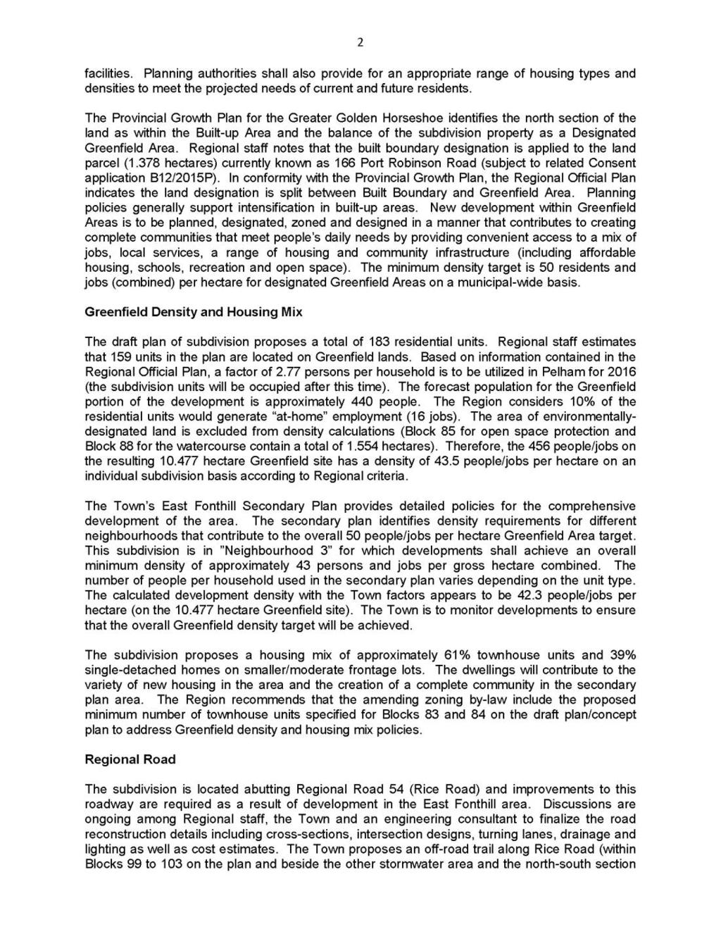
46
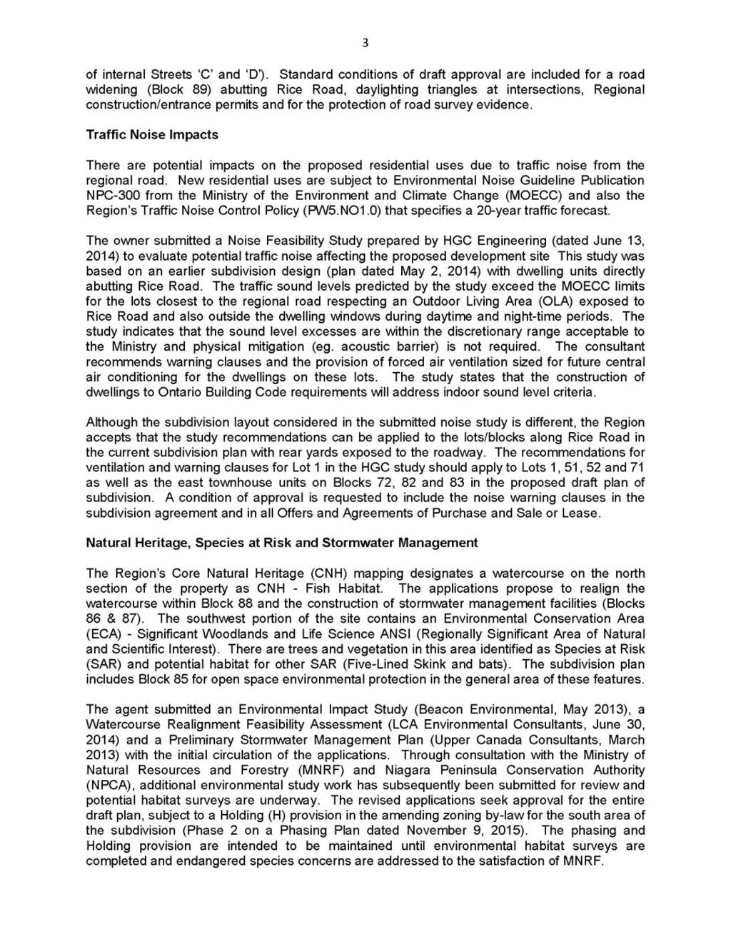
47
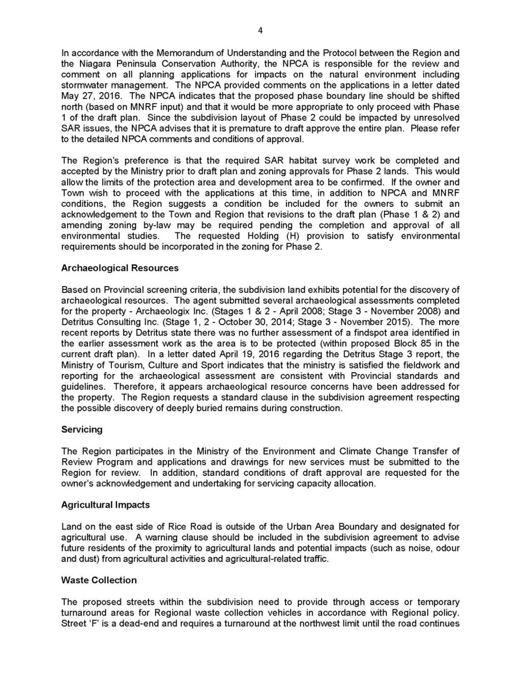
48
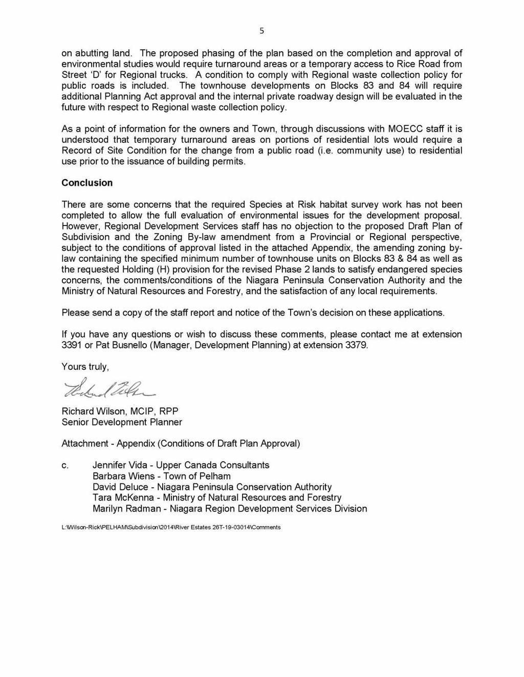
49
50
51
For Vintages of Four Mile Creek Town of Niagara on the Lake, Ontario
 Planning Impact Analysis For Vintages of Four Mile Creek Town of Niagara on the Lake, Ontario Prepared by: Upper Canada Consultants 261 Martindale Road Unit #1 St. Catharines, Ontario L2W 1A1 Prepared
Planning Justification Report
 Planning Justification Report 101 Kozlov Street, Barrie, Ont. Destaron Property Management Ltd. November 2015 Revised February 2017 TABLE OF CONTENTS Page 1.0 INTRODUCTION... 1 2.0 DESCRIPTION OF SUBJECT
PLANNING REPORT Gordon Street City of Guelph. Prepared on behalf of Ontario Inc. March 17, Project No. 1507
 PLANNING REPORT 1131 Gordon Street City of Guelph Prepared on behalf of 1876698 Ontario Inc. March 17, 2016 Project No. 1507 423 Woolwich Street, Suite 201, Guelph, Ontario, N1H 3X3 Phone (519) 836-7526
AMENDMENT NUMBER 38 TO THE OFFICIAL PLAN OF THE TOWNSHIP OF WEST LINCOLN (COMPLIANCE)
") AMENDMENT NUMBER 38 TO THE OFFICIAL PLAN OF THE TOWNSHIP OF WEST LINCOLN (COMPLIANCE) 2013 AMENDMENT NUMBER 38 TO THE OFFICIAL PLAN OF THE TOWNSHIP OF WEST LINCOLN PART 1 - THE PREAMBLE 1.1 TITLE This
AMENDMENT NUMBER 38 TO THE OFFICIAL PLAN OF THE TOWNSHIP OF WEST LINCOLN (COMPLIANCE) 2013 AMENDMENT NUMBER 38 TO THE OFFICIAL PLAN OF THE TOWNSHIP OF WEST LINCOLN PART 1 - THE PREAMBLE 1.1 TITLE This
Planning Justification Report Addendum
 Planning Justification Report Addendum 2031818 Ontario Inc 0 Airport Road Town of Caledon, Region of Peel September 2015 File 5073 i Table of Contents 1 Introduction... 1 2 Historical Overview and Site
Planning Justification Report - Update Castlegrove Subdivision, Gananoque Draft Plan of Subdivision and Class III Development Permit
 Planning Justification Report - Update Castlegrove Subdivision, Gananoque Draft Plan of Subdivision and Class III Development Permit by IBI Group Table of Contents Executive Summary... 1 1 Introduction...
Planning Rationale in Support of an Application for Plan of Subdivision and Zoning By-Law Amendment
 Planning Rationale in Support of an Application for Plan of Subdivision and Zoning By-Law Amendment The Kilmorie Development 21 Withrow Avenue City of Ottawa Prepared by: Holzman Consultants Inc. Land
Director, Community Planning, North York District
 STAFF REPORT ACTION REQUIRED 3, 5, 11, 17, 21 Allenbury Gardens & 3, 5 Kingslake Road Official Plan and Zoning By-law Amendment and Rental Housing Demolition Applications Final Report Date: February 6,
Township of Tay Official Plan
 Township of Tay Official Plan Draft for Consultation (v.3) March 2016 Contents 1. INTRODUCTION... 1 1.1 Content, Title and Scope... 1 1.2 Basis and Purpose of this Plan... 1 1.3 Plan Structure... 2 2.
PLANNING REPORT. Prepared for: John Spaleta 159 Delatre Street Woodstock Ontario N4S 6C2
 PLANNING REPORT County Official Plan Amendment and Zoning By-law Amendment to Permit a Seasonal Dwelling on an Existing Lot of Record with Access onto a Seasonally Maintained Road Parts of Lot 29, Concession
Members of the City of Brantford Committee of Adjustment. 1.0 TYPE OF REPORT Committee of Adjustment Decision Regarding an Application for Consent
 DATE: October 18 th 2017 REPORT NO. CD2017-168 TO: Members of the City of Brantford Committee of Adjustment FROM: Brandon Kashin, Current Development Planner 1.0 TYPE OF REPORT Committee of Adjustment
5. That the Owner shall agree that all development Blocks shown within the Draft Plan will be connected to full municipal services.
 Conditions Relating to Draft Plan of Subdivision Approval East Fonthill 26T 01014 (Draft Plan dated December 1, 2013, and revised August 28, 2014), the Town of Pelham 1. This approval applies to the Draft
CITY OF HAMILTON PLANNING AND ECONOMIC DEVELOPMENT DEPARTMENT Planning Division
 CITY OF HAMILTON PLANNING AND ECONOMIC DEVELOPMENT DEPARTMENT Planning Division TO: Chair and Members Planning Committee COMMITTEE DATE: January 16, 2018 SUBJECT/REPORT NO: WARD(S) AFFECTED: Ward 11 PREPARED
TOTTENHAM SECONDARY PLAN
 TOTTENHAM SECONDARY PLAN AMENDMENT NO. 11 TO THE OFFICIAL PLAN OF THE TOWN OF NEW TECUMSETH The following text and schedules to the Official Plan of the Town of New Tecumseth constitute Amendment No. 11
1555 Midland Avenue - Zoning Amendment & Subdivision Applications - Preliminary Report
 STAFF REPORT ACTION REQUIRED 1555 Midland Avenue - Zoning Amendment & Subdivision Applications - Preliminary Report Date: October 24, 2013 To: From: Wards: Reference Number: Scarborough Community Council
Planning Justification Report
 Planning Justification Report, Township of Puslinch FARHI HOLDINGS CORPORATION Updated January 27, 2017 Zelinka Priamo Ltd. Page i TABLE OF CONTENTS Page No. 1.0 1.1 1.2 1.3 2.0 2.1 2.2 2.3 2.4 2.5 3.0
TOWN OF WHITBY REPORT RECOMMENDATION REPORT
 TOWN OF WHITBY REPORT RECOMMENDATION REPORT REPORT TO: Planning and Development Committee REPORT NO: PL 4-08 DATE OF MEETING: January 21, 2008 FILE NO(S): MI-01-07 (SW- 2002-03) PREPARED BY: Planning Department
4027 and 4031 Ellesmere Road Zoning Amendment and Draft Plan of Subdivision Applications - Request for Direction Report
 STAFF REPORT ACTION REQUIRED 4027 and 4031 Ellesmere Road Zoning Amendment and Draft Plan of Subdivision Applications - Request for Direction Report Date: August 22, 2013 To: From: Wards: Reference Number:
MINTO COMMUNITIES INC. AVALON WEST STAGE 4 PLANNING RATIONALE. July Prepared for:
 MINTO COMMUNITIES INC. AVALON WEST STAGE 4 PLANNING RATIONALE July 2015 Prepared for: MINTO COMMUNITIES INC. 200 180 Kent Street Ottawa, Ontario K1P 0B6 Prepared by: J.L. RICHARDS & ASSOCIATES LIMITED
3.1. OBJECTIVES FOR RESIDENTIAL LAND USE DESIGNATIONS GENERAL OBJECTIVES FOR ALL RESIDENTIAL DESIGNATIONS
 3. RESIDENTIAL LAND USE DESIGNATIONS INTRODUCTION The Residential land use designations provide for housing and other land uses that are integral to, and supportive of, a residential environment. Housing
8.5.1 R1, Single Detached Residential District
 8.5.1 R1, Single Detached Residential District The purpose of this district is to provide for residential development in the form of single detached dwellings. Dwelling, Single Detached Home Business,
6040 Bathurst Street and 5 Fisherville Road Zoning Bylaw Amendment Application Preliminary Report
 STAFF REPORT ACTION REQUIRED 6040 Bathurst Street and 5 Fisherville Road Zoning Bylaw Amendment Application Preliminary Report Date: January 24, 2017 To: From: Wards: Reference Number: North York Community
Islington Avenue - Official Plan and Zoning By-law Amendment Application - Preliminary Report
 STAFF REPORT ACTION REQUIRED 3002-3014 Islington Avenue - Official Plan and Zoning By-law Amendment Application - Preliminary Report Date: Febuary 2, 2016 To: From: Wards: Reference Number: Etobicoke York
STAFF REPORT PLN September 11, 2017
 Page: 1 TO: SUBJECT: GENERAL COMMITTEE APPLICATIONS FOR OFFICIAL PLAN AMENDMENT AND ZONING BY-LAW AMENDMENT 37 JOHNSON STREET WARD: WARD 1 PREPARED BY AND KEY CONTACT: SUBMITTED BY: GENERAL MANAGER APPROVAL:
SUBJECT: Official Plan and Zoning By-law Amendment Applications for 4853 Thomas Alton Boulevard
 Page 1 of Report PB-100-16 SUBJECT: Official Plan and Zoning By-law Amendment Applications for 4853 Thomas Alton Boulevard TO: FROM: Development and Infrastructure Committee Planning and Building Department
Staff Report for Council Public Meeting
 Agenda Item 3.3 Staff Report for Council Public Meeting Date of Meeting: September 27, 2017 Report Number: SRPRS.17.134 Department: Division: Subject: Planning and Regulatory Services Development Planning
PLANNING REPORT. 33 Arkell Road City of Guelph. Prepared on behalf of OHM Arkell Inc. August 4, Project No. 1327
 PLANNING REPORT 33 Arkell Road City of Guelph Prepared on behalf of OHM Arkell Inc. August 4, 2015 Project No. 1327 423 Woolwich Street, Suite 201, Guelph, Ontario, N1H 3X3 Phone (519) 836-7526 Fax (519)
Financial Impact Statement There are no immediate financial impacts associated with the adoption of this report.
 STAFF REPORT Planning and Development Department Subject: Application by RYC Property to rezone a portion of lands on John Murray Dr. and Megan Lynn Dr. from R2 to R3 and to enter into a Development Agreement
507, 509 and 511 Kingston Road - Official Plan and Zoning By-law Amendment Applications Request for Interim Directions Report
 REPORT FOR ACTION 507, 509 and 511 Kingston Road - Official Plan and Zoning By-law Amendment Applications Request for Interim Directions Report Date: June 6, 2018 To: From: Wards: Reference Number: Toronto
Corporate Report. Planning & Development Services, Implementation. Date of Report: January 7, 2013 Date of Meeting: January 21, 2013
 Corporate Report Report from Planning & Development Services, Implementation Date of Report: January 7, 2013 Date of Meeting: January 21, 2013 Report Number: PDS-019-2013 File: 60.46.394 Subject: Application
Town of Niagara-on-the-Lake Official Plan Review. Discussion Paper: Second Residential Units. Prepared for: The Town of Niagara-on-the-Lake
 Town of Niagara-on-the-Lake Official Plan Review Discussion Paper: Second Residential Units Prepared for: The Town of Niagara-on-the-Lake October 15, 2015 PLANSCAPE Inc. Building Community through Planning
12, 14, 16 and 18 Marquette Avenue and 7 Carhartt Street Zoning By-law Amendment Application - Preliminary Report
 STAFF REPORT ACTION REQUIRED 12, 14, 16 and 18 Marquette Avenue and 7 Carhartt Street Zoning By-law Amendment Application - Preliminary Report Date: July 17, 2014 To: From: Wards: Reference Number: North
39 Thora Avenue Zoning Amendment Application Preliminary Report
 STAFF REPORT ACTION REQUIRED 39 Thora Avenue Zoning Amendment Application Preliminary Report Date: January 28, 2014 To: From: Wards: Reference Number: Scarborough Community Council Director, Community
Director, Community Planning, Scarborough District ESC 44 OZ & ESC 44 SB
 STAFF REPORT ACTION REQUIRED 6175, 6183 Kingston Road and 1, 2, 4, 5, 7,10 & 11 Franklin Avenue - Official Plan Amendment, Zoning Amendment and Draft Plan of Subdivision Applications Preliminary Report
Planning & Development. Background. Subject Properties
 Planning & Development APPLICATION BRIEFING Prepared For: Planning Advisory Committee Submitted by: Jason Fox, Director of Planning & Development Date: Subject: Application by Meech Holdings Limited to
ARTICLE FIVE FINAL DRAFT
 ARTICLE FIVE 021218 FINAL DRAFT Sec. 503.6 Open Space Preservation Option Open Space Preservation Option Open Space Preservation developments may be approved in the AR, R-1, R-2 and R-3 zoning districts,
TO: CHAIR AND MEMBERS PLANNING AND ENVIRONMENT COMMITTEE
 TO: CHAIR AND MEMBERS PLANNING AND ENVIRONMENT COMMITTEE FROM: GEORGE KOTSIFAS, P.ENG. MANAGING DIRECTOR, DEVELOPMENT & COMPLIANCE SERVICES AND CHIEF BUILDING OFFICIAL SUBJECT: APPLICATION BY: SIFTON PROPERTIES
Bathurst Street Zoning Amendment Application and Rental Housing Demolition Application under Municipal Code Chapter 667 Final Report
 STAFF REPORT ACTION REQUIRED 1996-2000 Bathurst Street Zoning Amendment Application and Rental Housing Demolition Application under Municipal Code Chapter 667 Final Report Date: January 26, 2017 To: Toronto
Kingston Road - Zoning Amendment and Draft Plan of Subdivision Applications - Preliminary Report
 STAFF REPORT ACTION REQUIRED 6480-6484 Kingston Road - Zoning Amendment and Draft Plan of Subdivision Applications - Preliminary Report Date: April 19, 2016 To: From: Wards: Reference Number: Scarborough
P. H. Robinson Consulting Urban Planning, Consulting and Project Management
 PLANNING RATIONALE REPORT FOR SITE PLAN AND DRAFT PLAN OF CONDOMINIUM APPLICATIONS 73-75 HARVEY STREET CITY OF OTTAWA PREPARED BY: P H ROBINSON CONSULTING AUGUST 2012 1 This report has been prepared on
Planning and Building Department
 Page 1 of Report PB-83-13 TO: Development and Infrastructure Committee Planning and Building Department SUBJECT: OP & Rezoning 5001 Corporate Drive Appleby Gardens LJM Developers Report Number: PB-83-13
Report to: Development Services Committee Report Date: April 21, 2015
 SUBJECT: Preliminary Report Applications for Draft Plan of Subdivision, Zoning By-law Amendment, Plan of Condominium and Site Plan Approval by Urbancorp Inc. 9064-9110 Woodbine Avenue File No s: SU/ZA/CU/SC
PLANNING RATIONALE REPORT
 PLANNING RATIONALE REPORT Zoning By-law Amendment Application 2920 Danbury Way Prepared for: Bravar Custom Builders Inc. and Village View Estates Ltd. by: 6393 Roslyn Street Ottawa (Orleans), Ontario K1C
PIN , Part 1, Plan SR-713 in Lot 2, Concession 5, Township of McKim (1096 Dublin Street, Sudbury)
") STAFF REPORT Applicant: Dalron Construction Limited Location: PIN 02124-0103, Part 1, Plan SR-713 in Lot 2, Concession 5, Township of McKim (1096 Dublin Street, Sudbury) Official Plan and Zoning By-law:
STAFF REPORT Applicant: Dalron Construction Limited Location: PIN 02124-0103, Part 1, Plan SR-713 in Lot 2, Concession 5, Township of McKim (1096 Dublin Street, Sudbury) Official Plan and Zoning By-law:
111 Plunkett Road (formerly part of 135 Plunkett Road) - Zoning By-law Amendment Application and Plan of Subdivision Application - Preliminary Report
 - Zoning By-law Amendment Application and Plan of Subdivision Application - Preliminary Report") STAFF REPORT ACTION REQUIRED 111 Plunkett Road (formerly part of 135 Plunkett Road) - Zoning By-law Amendment Application and Plan of Subdivision Application - Preliminary Report Date: May 27, 2013 To:
STAFF REPORT ACTION REQUIRED 111 Plunkett Road (formerly part of 135 Plunkett Road) - Zoning By-law Amendment Application and Plan of Subdivision Application - Preliminary Report Date: May 27, 2013 To:
PLANNING REPORT Draft Plan of Subdivision Zoning Bylaw Amendment Phase 4 Lora Bay The Town of the Blue Mountains County of Grey
 PLANNING REPORT Draft Plan of Subdivision Zoning Bylaw Amendment Phase 4 Lora Bay The Town of the Blue Mountains County of Grey September 2018 TABLE OF CONTENTS 1.0 LOCATION... 3 2.0 SURROUNDING USES...
Chapter Planned Residential Development Overlay
 Chapter 19.29 Planned Residential Development Overlay Sections 010 Purpose 020 Scope 030 Definitions 030 Minimum Size 040 Allowable Uses 050 Minimum Development Standards 060 Density Bonus 070 Open Space
LOT AREA AND FRONTAGE
 LOT AREA AND FRONTAGE Lot Area & Frontage for the R2.1 Zone Lot Area & Frontage for the R2.4 Zone Minimum Lot Minimum Lot Zone Area Width R2.1 700 sq m 18 m R2.4 600 sq m 16 m Lot Area means the total
66 Isabella Street Rezoning Application - Preliminary Report
 STAFF REPORT ACTION REQUIRED 66 Isabella Street Rezoning Application - Preliminary Report Date: November 15, 2010 To: From: Wards: Reference Number: Toronto and East York Community Council Director, Community
25 Leonard Avenue - Official Plan Amendment and Zoning Amendment Applications - Preliminary Report
 STAFF REPORT ACTION REQUIRED 25 Leonard Avenue - Official Plan Amendment and Zoning Amendment Applications - Preliminary Report Date: March 8, 2017 To: From: Wards: Reference Number: Toronto and East York
MUNICIPAL DISTRICT OF ROCKY VIEW NO. 44 ELBOW VALLEY WEST DIRECT CONTROL DISTRICT BYLAW C
 This document has been consolidated for convenience only. A current listing of any and all amendments can be obtained from the Municpal District Office Bylaw No. Date of Approval Amendment Type Bylaw C-6042-2005
PLANNING REPORT THE CORPORATION OF THE TOWN OF COBOURG
 THE CORPORATION OF THE TOWN OF COBOURG PLANNING REPORT TO: Planning & Sustainability Advisory Committee FROM: Desta McAdam, MCIP, RPP Planner I Development DATE OF MEETING: May 8 th, 2018. REPORT TITLE/SUBJECT:
Appendix1,Page1. Urban Design Guidelines. Back to Back and Stacked Townhouses. DRAFT September 2017
 Appendix1,Page1 Urban Design Guidelines DRAFT September 2017 Back to Back and Stacked Townhouses Appendix1,Page2 Table of Contents 1 Introduction 1 1.1 Purpose 1 1.2 Urban Design Objectives 1 1.3 Building
1202 & 1204 Avenue Road Zoning By-law Amendment Application - Preliminary Report
 STAFF REPORT ACTION REQUIRED 1202 & 1204 Avenue Road Zoning By-law Amendment Application - Preliminary Report Date: March 17, 2017 To: From: Wards: Reference Number: North York Community Council Director,
2018 APPLICATION FOR CONSENT - No.:
 2018 APPLICATION FOR CONSENT - No.: Pursuant to Section 53 of the Planning Act, RSO. 1990, as amended, an application for Consent is hereby submitted, and enclosed is the Prescribed Information (in metric),
3390, 3392, 3394, 3396 and 3398 Bayview Avenue - Official Plan Amendment, Zoning By-law Amendment Application - Preliminary Report
 STAFF REPORT ACTION REQUIRED 3390, 3392, 3394, 3396 and 3398 Bayview Avenue - Official Plan Amendment, Zoning By-law Amendment Application - Preliminary Report Date: March 14, 2016 To: From: Wards: Reference
DATE: April 26, 2017 REPORT NO. CD Members of the City of Brantford Committee of Adjustment
 DATE: April 26, 2017 REPORT NO. CD2017-075 TO: Members of the City of Brantford Committee of Adjustment FROM: Victoria Coates, Current Development Planner 1.0 TYPE OF REPORT Committee of Adjustment Decision
50 Humberwood Boulevard - Zoning By-law Amendment Application - Preliminary Report
 STAFF REPORT ACTION REQUIRED 50 Humberwood Boulevard - Zoning By-law Amendment Application - Preliminary Report Date: September 14, 2015 To: From: Wards: Reference Number: Etobicoke York Community Council
Report Regarding a Pre-Servicing Agreement for the River Estates Draft Plan of Subdivision River Realty Development (1976) Inc. (File No.
 Inc. (File No.") Report Regarding a Pre-Servicing Agreement for the River Estates Draft Plan of Subdivision River Realty Development (1976) Inc. (File No. 26T19-03014) Executive Summary: The purpose of this report is to
Report Regarding a Pre-Servicing Agreement for the River Estates Draft Plan of Subdivision River Realty Development (1976) Inc. (File No. 26T19-03014) Executive Summary: The purpose of this report is to
PLANNING REPORT. Lot 5, SDR Lot 6 and 7 Concession 3 Township of Normanby Municipality of West Grey County of Grey
 PLANNING REPORT Dwelling Surplus to a Farm Operation Official Plan and Zoning By-law Amendment and Consent to Sever Lot 5, SDR Lot 6 and 7 Concession 3 Township of Normanby Municipality of West Grey County
COUNTY OF BRANT DEVELOPMENT SERVICES DEPARTMENT COMMITTEE OF ADJUSTMENT. Chair and Members of the Committee of Adjustment
 COUNTY OF BRANT DEVELOPMENT SERVICES DEPARTMENT COMMITTEE OF ADJUSTMENT TO: FROM: Chair and Members of the Committee of Adjustment Ruchika Angrish, Senior Planner DATE: January 23, 2014 REPORT: CA-14-06
Residential. Infill / Intensification Development Review
 Residential Infill / Intensification Development Review How Best to Manage The Compatible Integration of New Housing Within Established Residential Neighbourhoods Identification of Issues Privacy/overlook/height
Request for Approval Proposed Expansion to the Puccini Drive Neighbourhood Residential Infill Study Town File D (SRPRS.17.
 Staff Report for Committee of the Whole Meeting Department: Division: Subject: Planning and Regulatory Services Development Planning Request for Approval Proposed Expansion to the Puccini Drive Neighbourhood
THE CORPORATION OF THE TOWNSHIP OF KING THE CERTIFICATE PAGE FOR AMENDMENT NO. 89 TO THE OFFICIAL PLAN OF THE TOWNSHIP OF KING
 THE CORPORATION OF THE TOWNSHIP OF KING THE CERTIFICATE PAGE FOR AMENDMENT NO. 89 TO THE OFFICIAL PLAN OF THE TOWNSHIP OF KING (KING CITY COMMUNITY PLAN) The attached text and schedules constituting Amendment
111 Wenderly Drive Official Plan and Zoning By-law Amendment Applications - Preliminary Report
 STAFF REPORT ACTION REQUIRED 111 Wenderly Drive Official Plan and Zoning By-law Amendment Applications - Preliminary Report Date: August 17, 2015 To: From: Wards: Reference Number: North York Community
PLANNED RESIDENTIAL DEVELOPMENT (PRD)
") PLANNED RESIDENTIAL DEVELOPMENT SECTION 10. PLANNED RESIDENTIAL DEVELOPMENT (PRD) 10.1 Purpose Planned Residential Development allows by special permit from the Board an alternative pattern of residential
PLANNED RESIDENTIAL DEVELOPMENT SECTION 10. PLANNED RESIDENTIAL DEVELOPMENT (PRD) 10.1 Purpose Planned Residential Development allows by special permit from the Board an alternative pattern of residential
40 Moccasin Trail and 50 Green Belt Drive - OMB
 REPORT FOR ACTION 40 Moccasin Trail and 50 Green Belt Drive - OMB Date: March 21, 2017 To: City Council From: City Solicitor Wards: Ward 34 SUMMARY The purpose of this report is to request further direction
Keele Street - Official Plan and Zoning By-law Amendment Application - Preliminary Report
 STAFF REPORT ACTION REQUIRED 406-410 Keele Street - Official Plan and Zoning By-law Amendment Application - Preliminary Report Date: September 20, 2017 To: From: Wards: Reference Number: Etobicoke York
20 Edward Street Zoning Amendment Application - Preliminary Report
 STAFF REPORT ACTION REQUIRED 20 Edward Street Zoning Amendment Application - Preliminary Report Date: January 20, 2015 To: From: Wards: Reference Number: Toronto and East York Community Council Director,
25 Vickers Road, 5555 and 5559 Dundas Street West and 10 Shorncliffe Road - Zoning Amendment Application - Request for Direction Report
 STAFF REPORT ACTION REQUIRED 25 Vickers Road, 5555 and 5559 Dundas Street West and 10 Shorncliffe Road - Zoning Amendment Application - Request for Direction Report Date: October 31, 2011 To: From: Wards:
CHAPTER 14 PLANNED UNIT DEVELOPMENTS
 9-14-1 9-14-1 CHAPTER 14 PLANNED UNIT DEVELOPMENTS SECTION: 9-14-1: Purpose 9-14-2: Governing Provisions 9-14-3: Minimum Area 9-14-4: Uses Permitted 9-14-5: Common Open Space 9-14-6: Utility Requirements
Galloway Road and 4097 Lawrence Avenue East - Zoning Amendment Application - Preliminary Report
 STAFF REPORT ACTION REQUIRED 197-201 Galloway Road and 4097 Lawrence Avenue East - Zoning Amendment Application - Preliminary Report Date: November 29, 2013 To: From: Wards: Reference Number: Scarborough
31, 33 and 35 Wilmington Avenue, Rezoning Application - Final Report
 STAFF REPORT ACTION REQUIRED 31, 33 and 35 Wilmington Avenue, Rezoning Application - Final Report Date: October 15, 2009 To: From: Wards: Reference Number: North York Community Council Director, Community
Sheppard Ave East and 6, 8 and 10 Greenbriar Road - Official Plan Amendment and Zoning Amendment Applications - Preliminary Report
 STAFF REPORT ACTION REQUIRED 625-627 Sheppard Ave East and 6, 8 and 10 Greenbriar Road - Official Plan Amendment and Zoning Amendment Applications - Preliminary Report Date: April 15, 2016 To: From: Wards:
Combined Zoning/Minor Variance and Boulevard Parking Agreement Exception
 Residential Front Yard and Boulevard Parking Policy Name: Residential Front Yard and Boulevard Parking Legislative History: Enacted September 19, 2017 (By-law No. CPOL.-223-475); Amended June 26, 2018
Plan Dutch Village Road
 Plan Dutch Village Road Objective: The lands around Dutch Village Road are a minor commercial area that services the larger Fairview community. Maintaining the vibrancy of the area by planning for redevelopment
Frequently Asked Questions
 Frequently Asked Questions Cambridge West Land Use Planning Matters January 10, 2018 Q1 What is proposed for the undeveloped lands within the Cambridge West area? A. Four separate landowners each own part
377 Spadina Rd and 17 Montclair Ave - Zoning Amendment Application - Preliminary Report
 STAFF REPORT ACTION REQUIRED 377 Spadina Rd and 17 Montclair Ave - Zoning Amendment Application - Preliminary Report Date: May 15, 2015 To: From: Wards: Reference Number: Toronto and East York Community
49 51 Lawrence Avenue East and 84 Weybourne Crescent Official Plan Amendment and Zoning By-law Amendment Application Request for Direction Report
 STAFF REPORT ACTION REQUIRED 49 51 Lawrence Avenue East and 84 Weybourne Crescent Official Plan Amendment and Zoning By-law Amendment Application Request for Direction Report Date: June 8, 2016 To: From:
Municipality of Brockton Planning Report. Application: Minor Variance Application. Members of the Committee of Adjustment, Municipality of Brockton
 Municipality of Brockton Planning Report Application: Minor Variance Application File No: A-14-18.34 Date: May 14, 2018 To: From: Subject: Members of the Committee of Adjustment, Municipality of Brockton
AMENDMENT NO. 25 TO THE OFFICIAL PLAN OF THE TOWN OF BRADFORD WEST GWILLIMBURY. Growth and Population Review
 AMENDMENT NO. 25 TO THE OFFICIAL PLAN OF THE TOWN OF BRADFORD WEST GWILLIMBURY Growth and Population Review ADOPTED: March 21, 2017 APPROVED BY THE COUNTY OF SIMCOE:, 201_ IN EFFECT:, 201_ OFFICIAL PLAN
250, 252, 254 and 256 Royal York Road and 8 and 10 Drummond Street - Zoning By-law Amendment Application - Preliminary Report
 STAFF REPORT ACTION REQUIRED 250, 252, 254 and 256 Royal York Road and 8 and 10 Drummond Street - Zoning By-law Amendment Application - Preliminary Report Date: May 28, 2013 To: From: Wards: Reference
Mr. Trevor Hawkins Development Planner Development Services City of Waterloo 100 Regina Street South Waterloo, ON N2J 4A8. Dear Mr.
 KITCHENER WOODBRIDGE LONDON KINGSTON BARRIE Mr. Trevor Hawkins Development Planner Development Services City of Waterloo 100 Regina Street South Waterloo, ON N2J 4A8 Dear Mr. Hawkins: RE: Grey Silo Road/
FINAL DRAFT 10/23/06 ARTICLE VI
 FINAL DRAFT 10/23/06 ARTICLE VI 185-41.1. Planned Residential Development A. Purpose and Intent. The purposes of the Planned Residential Development (PRD) bylaw are to maintain the rural character of Dover,
6. RESIDENTIAL ZONE REGULATIONS
 6. RESIDENTIAL ZONE REGULATIONS PART 6A PURPOSE OF CHAPTER (1) The purpose of this Chapter is to provide detailed regulations and requirements that are relevant only to residential zones and specific residential
Prepared for: Ontario Limited
 Application for Zoning By-law Amendment and Plan of Subdivision 1353 Scharfgate Drive Planning Rationale Report Prepared for: 1384341 Ontario Limited November 28, 2014 Planning Rationale Report Introduction
Public Meetings: Loon Call (Muskoka) Inc. Bracebridge II Proposed Plan of Subdivision (File No. S2015-2) Zoning Amendment Application D14-15/16
 Inc. Bracebridge II Proposed Plan of Subdivision (File No. S2015-2) Zoning Amendment Application D14-15/16") Public Meetings: Loon Call (Muskoka) Inc. Bracebridge II Proposed Plan of Subdivision (File No. S2015-2) Zoning Amendment Application D14-15/16 Town of Bracebridge December 14, 2016 Public Notification
Public Meetings: Loon Call (Muskoka) Inc. Bracebridge II Proposed Plan of Subdivision (File No. S2015-2) Zoning Amendment Application D14-15/16 Town of Bracebridge December 14, 2016 Public Notification
Acting Director, Community Planning, Scarborough District
 STAFF REPORT ACTION REQUIRED 1955 1991 Victoria Park Avenue Residential Rental Housing Property Demolition and Conversion and Draft Plan of Condominium Applications - Preliminary Report Date: March 16,
Staff Report. October 19, 2016 Page 1 of 17. Meeting Date: October 19, 2016
 October 19, 2016 Page 1 of 17 Staff Report Report No.: PDSD-P-58-16 Meeting Date: October 19, 2016 Submitted by: Subject: Recommendation: Ben Puzanov, RPP, Senior Planner Application for Zoning By-law
6208 Jeanne D Arc Boulevard North. Planning Rationale. Site Plan Control
 Site Plan Control Prepared By: NOVATECH Suite 200, 240 Michael Cowpland Drive Ottawa, Ontario K2M 1P6 November / 24 / 2015 Novatech File: 115100 Ref: R-2015-179 November 24, 2015 City of Ottawa 110 Laurier
166 Clinton Street Zoning Amendment Application Preliminary Report
 STAFF REPORT ACTION REQUIRED 166 Clinton Street Zoning Amendment Application Preliminary Report Date: May 4, 2011 To: From: Wards: Reference Number: Toronto and East York Community Council Director, Community
Staff Report for Council Public Meeting
 Agenda Item 3.3 a Staff Report for Council Public Meeting Date of Meeting: April 11, 2018 Report Number: SRPRS.18.087 Department: Division: Subject: Planning and Regulatory Services Development Planning
CITY OF VAUGHAN EXTRACT FROM COUNCIL MEETING MINUTES OF SEPTEMBER 27, 2018
 CITY OF VAUGHAN EXTRACT FROM COUNCIL MEETING MINUTES OF SEPTEMBER 27, 2018 Item 5, Report No. 28 of the Committee of the Whole (Public Hearing), which was adopted without amendment by the Council of the
PLANNING JUSTIFICATION REPORT INNOVATIVE PLANNING SOLUTIONS. Centreville Stroud Yonge Street, Stroud. Town of Innisfil
 INNOVATIVE PLANNING SOLUTIONS planners project managers land development PLANNING JUSTIFICATION REPORT Centreville Stroud 7958 Yonge Street, Stroud Centreville Stroud 7958 Yonge Street County of Simcoe
Director, Community Planning, North York District
 STAFF REPORT ACTION REQUIRED 35-53 and 101-113 Valley Woods Road and 1213-1229 York Mills Road Official Plan, Rezoning, Draft Plan of Subdivision and Rental Housing Demolition Applications Final Report
Staff Report for Council Public Meeting
 Agenda Item 3.3 a Staff Report for Council Public Meeting Date of Meeting: February 7, 2018 Report Number: SRPRS.18.022 Department: Division: Subject: Planning and Regulatory Services Development Planning
DRAFT FOR PUBLIC HEARING (rev. March, 2016)
") Chapter 200. ZONING Article VI. Conservation/Cluster Subdivisions 200-45. Intent and Purpose These provisions are intended to: A. Guide the future growth and development of the community consistent with
Chapter 200. ZONING Article VI. Conservation/Cluster Subdivisions 200-45. Intent and Purpose These provisions are intended to: A. Guide the future growth and development of the community consistent with
Northwest Corner of Dufferin Street and McAdam Avenue (0 Dufferin Street) Rezoning Application Final Report
 Rezoning Application Final Report") STAFF REPORT ACTION REQUIRED Northwest Corner of Dufferin Street and McAdam Avenue (0 Dufferin Street) Rezoning Application Final Report Date: April 8, 2010 To: From: Wards: Reference Number: North York
STAFF REPORT ACTION REQUIRED Northwest Corner of Dufferin Street and McAdam Avenue (0 Dufferin Street) Rezoning Application Final Report Date: April 8, 2010 To: From: Wards: Reference Number: North York
QUEEN STREET 219 VICTORIA STREET & THE REAR LANDS OF JOHNSON STREET AND 129 JOHNSON STREET PROPOSED HOTEL
 114 126 QUEEN STREET 219 VICTORIA STREET & THE REAR LANDS OF 115-119 JOHNSON STREET AND 129 JOHNSON STREET PROPOSED HOTEL PLANNING IMPACT ASSESSMENT & STREETSCAPE STUDY Planning Impact Assessment Page
2306 St. Clair Avenue West Zoning By-law Amendment Application - Preliminary Report
 STAFF REPORT ACTION REQUIRED 2306 St. Clair Avenue West Zoning By-law Amendment Application - Preliminary Report Date: August 10, 2017 To: From: Wards: Reference Number: Etobicoke York Community Council