TOWN OF WOODSTOCK SUBDIVISION REGULATIONS
|
|
|
- Neal O’Connor’
- 5 years ago
- Views:
Transcription

1 TOWN OF WOODSTOCK CONNECTICUT SUBDIVISION REGULATIONS Original Effective date: August 25, 2005 Revised through: June 15,
2 TABLE OF CONTENTS CHAPTER/SECTION PAGE I. Purpose, Title, and Authority 4 II. Definitions 5 III. Application and Review 1. Preliminary Review Process 9 2. Formal Application Submission and Review 9 3. Conditions of Formal Application Approval Post-Approval Procedure 12 IV. Submission Requirements 1. Initial Document Requirements Drafting Standards and Plan Details 18 V. Site Design 1. Site Design Process Lot Design Specifications Contextual Priorities Streets and Driveways Site Preparation and Cleanup 24 VI. Conservation Land 1. Conservation Easement or Agricultural Easement Required Conservation Priorities Conservation Land Standards Ownership and Dedication Conservation Land Transfer Family Transfer Fee In Lieu of Conservation Land Notification Requirements Compliance 29 VII. Road and Construction Standards 1. Street Planning Right-of-Way Width Construction Standards Street Intersection Terminus Street Temporary Turnaround Street Width Existing Street Improvements Street Names and Signs Street Lighting Landscaping Street Trees Street Dedication Monument and Marker Specifications Sidewalks All utility lines shall be located underground in all subdivisions 36 VIII. Affordable Housing and Accessory Apartments 1. Maximum Lot Yield Bonus for Affordable Housing Maximum Lot Yield Bonus for Accessory Apartments Compliance 37 IX. Bonds and Insurance 1. Insurance Bonding Application of Bond Bond Release Agreement for Installation of Improvements Certificate of Zoning Compliance 41 2
3 CHAPTER/SECTION PAGE X. Water, Wastewater, and Water Tanks 1. Water Supply Sanitary Waste Disposal Technical Reports Water Tanks 43 XI. Stormwater, Erosion & Sedimentation Control Applicability Stormwater Pollution Control Requirements Stormwater Pollution Control Standards Stormwater Pollution Control Soil Erosion and Sediment Control Special Flood Hazard Areas 47 XII. Miscellaneous Provisions 1. Waivers Penalty for Failure to Comply Amendments 48 XIII. Exhibits 48 I. Subdivision Agreement II. Typical Roadway and Sidewalk Cross Section III. Curb Design Alternatives IV. Subdivision Application V. Ownership History diagram VI. Residential Driveway Details VII. Intersection Sight Distances VIII. Off-site Directional Signs IX. Development Review Checklist 3
4 CHAPTER I PURPOSE, TITLE AND AUTHORITY These Regulations have been adopted by the Woodstock Planning and Zoning Commission pursuant to the authority granted in Chapter 126 of the General Statutes of the State of Connecticut. It is declared to be the policy of the Commission that as the subdivision of land is a major determinant of the future physical form of the Town, it should be carried out in a responsible manner in order to protect the public health and safety of its citizens, as well as the environment, natural resources, and character of the Town, and to further the goals of the Woodstock Plan of Conservation and Development. Accordingly, it is the purpose of these Regulations to insure that land to be subdivided shall be of such character that it can be used for building purposes without danger to health or the public safety; that proper provision is made for water supply, surface drainage and sanitary sewerage; that proper provision is made for protective flood control measures; that roads are arranged to provide safe intersection and are adequate for prospective traffic needs and provide access for emergency services; that open spaces for conservation, parks and playgrounds are provided; that provisions are made for soil erosion and sediment control; and that provisions are made for energy-efficient patterns of development and land use. These Regulations are not intended to interfere with, abrogate, or annul any other ordinance, regulation, or other provision of law, or any easement, covenant, or other private agreement or legal relationship, and is not the purpose of these Regulations to intercede in, resolve, or arbitrate any private civil dispute. When these Regulations impose restrictions different from those imposed by any other statute, ordinance, or other requirement imposed by any level of government, whichever provisions are more restrictive or impose higher standards shall govern. These regulations of the Planning and Zoning Commission shall be known as the Subdivision Regulations of the Town of Woodstock, Connecticut, which herein are called the Regulations. Upon the adoption of these Regulations, no person shall transfer, sell, lease, or agree to sell land, nor shall building permits be issued in a proposed subdivision until a plan for such subdivision has been approved by the Commission in accordance with these Regulations. All plans for the subdivision or resubdivision of land must be submitted to the Commission for approval. No lot resulting from the subdivision or resubdivision of any tract or parcel of land shall be sold or offered for sale or used for building development and no Certificate of Zoning Compliance (Zoning Permit) for any use, nor any building permit for the erection or enlargement of any building on such lot, shall be granted without the prior approval of the subdivision or resubdivision plan, or any amendment thereof, by the Commission, and the filing of the endorsed Final Approved Plan in the Office of the Town Clerk. e) No Formal Application of subdivision or resubdivision shall be approved by the Commission unless it shall conform to these Regulations, the Woodstock Zoning Regulations, the Woodstock Plan of Conservation and Development, and shall demonstrate compatibility with the Woodstock Plan of Open Space and Conservation. f) These Regulations shall be enforced by the Woodstock Planning and Zoning Commission or its designee, whose members are charged with the duty of preventing illegal subdivisions and securing compliance with requirements imposed by the Commission in granting subdivision approvals. Any person, firm, or corporation making any subdivision of land without the Commission s approval shall be subject to penalties as provided for by Section 8-25 of the Connecticut General Statutes. g) These Regulations shall take effect on August 25, 2005 and at that time shall replace all previous Subdivision Regulations of the Town of Woodstock. h) Should any portion of these Regulations be declared invalid, the validity of all other portions shall not be affected or impaired. 4
5 CHAPTER II - DEFINITIONS Certain terms and words used in these Regulations shall be interpreted and defined as set forth in this Section: A Plan of Open Space and Conservation (APOSC): Document prepared by the Woodstock Conservation Commission, accepted by the Town of Woodstock on June 20, 2001, updated December 3, 2003, and as may be amended from time to time. Agricultural Easement: A conservation restriction stated in the form of an easement whose primary purpose is to retain land exclusively in agricultural and related use. Applicant: Any person, firm, corporation, partnership, or other legally recognized entity who shall apply to the Commission for approval of a subdivision, either on the Applicant s own behalf or as an agent for one or more others. Same as Subdivider. Application: A request for approval of a specific subdivision plan, including an Application form as may be prescribed by the Commission, accompanied by all supporting information, documents, reports, and the like required by these Regulations. Board of Selectmen: The Board of Selectmen of the Town of Woodstock. Bond: A form of financial guarantee including certified check, passbook, certificate of deposit, or other instrument of credit in an amount and form required by Chapter IX of these Regulations; and may include Performance Bonds, Maintenance Bonds and Erosion and Sediment Control Bonds. Bonus Lot: A lot created pursuant to a Maximum Lot Yield bonus in accordance with the provisions of Chapter VIII, Affordable Housing and Accessory Apartments, of these Regulations. Building: Any structure having a roof supported by columns or walls and intended for the shelter, housing, or enclosure of persons, animals or things. Commission: The Planning and Zoning Commission of the Town of Woodstock, CT. Conservation Commission: The Conservation Commission of the Town of Woodstock, CT. Conservation Easement: A conservation restriction pursuant to Connecticut General Statute 47-42(a), stated in the form of an easement. Conservation Land: The portion of Gross Buildable Acreage permanently and legally protected and dedicated to conservation, Open Space, or agricultural purposes as set forth in Chapter V of these Regulations. Copy: A blueprint, Photostat, litho print or other copy which reproduces exactly the data on the original drawing(s) from which it is made. Critical Watershed Land: Areas defined by possessing one or more of the following characteristics: land within 250 feet of a reservoir or public water supply diversion; land within 100 feet of a tributary stream; wetlands associated with tributary streams; land subject to stream overflow; and land with slopes 15% or greater without significant interception by wetlands, swales and natural depressions between the slope and the watercourse. Cul-de-sac: A street having only one outlet to another road, and having a circular, elliptical, or similar turnaround at its terminus. Curb Cut: a point of access to a public street for a street, laneway or driveway. 5
6 Date of Receipt: The day of the first regularly scheduled meeting of the Commission immediately following the day of submission of the Application to the Commission, or its staff, or thirty-five (35) days after such submission, whichever is sooner in accordance with Section 8-7d of the Connecticut General Statutes. Development Land: The portion of Gross Buildable Acreage that is deemed available for development after the delineation of Conservation Land boundaries as required by Chapter V and Chapter VI of these Regulations. Disturbed Area: An area where the natural vegetative ground cover is destroyed, moved or removed. Developer: The person or other legally recognized entity primarily responsible for implementing the improvements proposed in the Final Approved Plan; may be the same as Subdivider. Development for Agricultural Purposes: Development exclusively for use as agricultural land, as that term is defined in Connecticut General Statutes Section 22-26bb. Development Review Checklist: The checklist (attached as Exhibit ) used to review subdivision and special permit Applications for compatibility with A Plan of Open Space and Conservation. Easement: A right, established by deed or other legal means, of one party to use a designated portion of a second party's land for a specific, limited purpose. Erosion: The detachment and movement of soil or rock fragments by water, wind, ice or gravity. First Selectman: The First Selectman of the Town of Woodstock, Connecticut. Flood or Flooding: A general and temporary condition of partial or complete inundation of normally dry land areas from the overflow of inland or tidal water, and/or the unusual and rapid accumulation or runoff of surface waters from any source. Final Approved Plan: The map, drawings, and all supporting data as required by Chapter IV of these Regulations and as approved by the Commission, containing all modifications and revisions required by such approval, and ready for endorsement by the Commission and for filing with the Town Clerk pursuant to Connecticut General Statutes Section Formal Application: The map, drawings, all supporting data and applicable fees presented as a complete and accepted legal Application for subdivision before the Commission, as required by Chapter IV of these Regulations and representing the formal Application for subdivision pursuant to Connecticut General Statutes Gross Buildable Acreage: All land contained within a parcel, exclusive of state-defined inland wetlands and watercourses, and pre-existing conservation easements or other Restricted Land. Improvement: Any alteration to the existing conditions of a parcel for the purpose of rendering the site more suitable for development and/or habitation. As used in these Regulations, improvements include but are not limited to construction and installation of roadways, curbs, gutters, utilities, street signs, monuments, shade trees, drainage facilities, erosion and sedimentation control measures, structures, earth filling or removal, seeding and grading. Inland Wetlands Agency: The Inland Wetlands and Watercourses Agency of the Town of Woodstock. Large Forest Block: An area of contiguous forest or woodland (including forested wetland areas) comprising 100 acres or more in area, which may be located on one or more parcels of land. Legal Counsel: The attorney or attorneys on retainer to the Town of Woodstock charged with providing 6
7 legal assistance to the Commission. Loop Street: A street having only one outlet to another road that curves back to intersect with itself, and may include a designed one-way traffic pattern. Lot: The portion or portions of a parcel into which land is divided or proposed to be divided. Open Space: Areas designated for neighborhood or municipal public use and access for open space, parks, and playgrounds, which may be dedicated to the Town and which may include Conservation Land. Parking Space: A space designed to accommodate one vehicle, whether unenclosed or in a garage. Unenclosed (exterior) parking spaces shall be a minimum of 9 feet x 18 feet, and shall be paved with gravel, bituminous concrete, or concrete. Plan and Profile: The drawing(s) depicting respectively the horizontal and vertical design for street construction and drainage, and containing all information required to be submitted for approval as part of a subdivision Application. Plan of Conservation and Development (POCD): Document prepared by the Woodstock Planning and Zoning Commission that establishes goals and priorities for growth and preservation in the Town of Woodstock, updated in 2002 and as may be amended from time to time. Preliminary Proposal: The preliminary map, drawing(s) and supporting data recommended by Chapter III of these Regulations, indicating the proposed layout of the subdivision. Private Road: A street, road, or other private way providing vehicular access that is not included on the list of improved and unimproved town aid roads published by the Connecticut Department of Transportation and which has not been accepted by the Town. All maintenance, repair, and legal liability for Private Roads lie with a homeowner s association of the residents of the street with powers and responsibilities established by these Regulations. Private Way: A lane, alley, discontinued street, abandoned street, farm road, woods road, historic cart path, trail or other unimproved way not generally providing vehicle access, excluding a Street or Private Road. Regulations: The Subdivision Regulations, effective August 25, 2005, of the Town of Woodstock, Connecticut, including amendments thereto. Restricted Land: Property subject to a conservation easement; agricultural easement; conservation or preservation restrictions as defined by Connecticut General Statute 47-42(a); land legally dedicated for Open Space or land having other use restrictions legally limiting or preventing development. Resubdivision: A change in a map of an approved or recorded subdivision or resubdivision if such change: (a) affects any street layout shown on such map; (b) affects any area reserved thereon for public use; or (c) diminishes the size of any lot shown thereon and creates an additional building lot, if any of the lots shown thereon have been conveyed after the approval of recording of such map. Right-of-Way: A strip of land occupied or intended to be occupied by a street, alley, walkway, sanitary or storm sewer, stream, drainage or other special use. Scenic Road: A town-approved road that has been given official scenic designation through the process detailed by Woodstock Town Ordinance, effective May 15, 1986 and as may be amended from time to time or similar designation by State or Federal agencies. Special Flood Hazard Area: Any area indicated as flood prone on the Woodstock Special Flood Hazard Area map issued on November 1, 1984 by the Federal Emergency Management Agency, as may be 7
8 amended from time to time, and on file at Town Hall. Street: A street, avenue, highway, boulevard, parkway, road, lane, alley or other way that is included on the list of improved and unimproved town aid roads published by the Connecticut Department of Transportation or any street meeting the standards of these Regulations and accepted by the Town. All streets referred to herein are one of the following types: 1. An ARTERIAL is a street providing for present or future movement of relatively large volumes of traffic between communities. 2. A COLLECTOR is a street providing for present or future movement of through traffic from one point to another within a community or between neighborhoods. A collector street ties in at one end or both ends with an arterial street. 3. A LOCAL street is a street which only provides access to properties and which does not and will not carry through traffic from one community or neighborhood to another. Street Width: The lateral dimension of the wearing or exposed surface of the roadway used by vehicular traffic. Structure: Anything constructed, erected, or located, the use of which requires location on the ground or attachment to something having location on the ground, but excluding fences and stone walls. Subdivider: Same as Applicant. Subdivision: The division of a tract or parcel of land after the enactment of Woodstock Subdivision Regulations in August, 1965 into three (3) or more parts or lots for the purpose, whether immediate or future, of sale or building development expressly excluding development for municipal, conservation, or agricultural purposes. The term subdivision includes resubdivision. Terminus Street: A street which is either a Loop Street or a Cul-de-sac. Total Parcel: A tract of land. Town: The Town of Woodstock, CT Town Clerk: The Clerk of the Town of Woodstock, CT. Town Engineer: The licensed engineer or engineers on retainer to the Town of Woodstock charged with providing engineering assistance to the Commission. Town Planner: The employee of the Town of Woodstock providing primary staff support to the Planning and Zoning Commission. Transfer Site: A parcel specifically designated as the location for Conservation Land under the Conservation Land Transfer provisions of Chapter VI. Wetlands and Watercourses: Areas as defined by the regulations of the Woodstock Inland Wetlands and Watercourses Agency. Zoning Regulations: The Zoning Regulations of the Town of Woodstock, CT. 8
9 CHAPTER III APPLICATION AND REVIEW 1. Preliminary Review Process To better facilitate the overall subdivision application and design process, it is strongly recommended that the following steps be followed. a. Pre-Application Meeting A meeting should be held between the Applicant, the site designer, and the Town Planner, to introduce the Applicant to the Regulations and procedures, to discuss the Applicant's objectives, and to coordinate site inspections, meetings and submissions as described below. Applicants should have a general idea of site conditions and development goals at this meeting, which may be held in conjunction with an informal site visit to review and discuss conservation and development objectives of the Town and the Applicant. The Commission strongly recommends relying on a Landscape Architect licensed by the State of Connecticut to design the site. b. Preliminary Proposal 1. Copies of a Preliminary Proposal, meeting the requirements set forth below, should be submitted to the Town Planner at least ten (10) days prior to the Commission meeting at which the Preliminary Proposal is to be discussed. The Preliminary Proposal is a general diagram for the site, Conservation Lands, Streets, and Lots and should be based on the Site Context Map, Development Review Checklist and Site Resource Assessment, and developed in accordance with the Site Design process and Conservation Land Priorities, but does not represent a Formal Application to the Commission. 2. The Commission and the Town Planner should review the Preliminary Proposal to advise the Applicant of the proposal s consistency with these Regulations, and may suggest modifications to improve its conformance. The review may also include preliminary input from relevant commissions and officials including but not limited to the Conservation Commission, Town Counsel, Town Engineer, Highway Foreman, Fire Marshall, Inland Wetlands Agency, and Building Official. 3. The Preliminary Review Process is voluntary. The Applicant, Town Planner, Commission, and other town officials shall not be in any way bound by any statement made during such Preliminary Proposal consideration, it being acknowledged by the Applicant that the Commission's responses are preliminary, and that nothing herein shall limit the Commission s right to provide further modifications at any time prior to its Final Approval. There shall be no vote or other formal action on any Preliminary Proposal, other than referrals to other municipal, State, or Federal agencies or other commissions or consultants for review and comment if required by the Commission. 2. Formal Application Submission and Review a. All Applicants for subdivision approval shall file for approval on a form provided by the Commission ( The Application ), attached as Exhibit A-3, and shall submit such additional information as required by these Regulations. Submission of an Application, including all applicable fees, shall represent the Initial Formal Application under Connecticut General Statutes Sec.8-25; and the Formal Application under these Regulations shall constitute authorization for the Commission to enter upon the property to obtain additional information or to inspect proposed improvements. b. It is the Applicant s responsibility to submit a complete Formal Application, and to demonstrate compliance with all criteria and requirements of these Regulations and, accordingly, the Applicant may submit such additional reports or information as may be required to satisfy that responsibility. Any Formal Application not completed in full, including submission of all required documentation and payment of required fees may be deemed incomplete by the Commission and may not be accepted or may be accepted and subsequently denied approval unless the Commission in its sole discretion waives one or more of the requirements of submission. 9
10 c. The Commission shall hold a public hearing on any plan of resubdivision and may hold a public hearing on any subdivision if the Commission determines that the circumstances so warrant. Such hearing shall be held within such time as established by the Connecticut State Statutes. Notice of a hearing shall be published in a newspaper of general circulation in the Town at least twice at intervals of not less than two days, the first not more than fifteen nor less than ten days and the second not less than two days prior to the hearing and by sending a copy thereof by certified mail to the Applicant. d. The Applicant shall notify all owners of property abutting the site of a proposed subdivision, and all owners of property within 300 of any portion of the property proposed for subdivision, and all holders of conservation easements on the subject or abutting properties. If a parcel proposed for subdivision abuts a town designated scenic road, all owners of property with frontage on that road shall be notified. Notification shall be sent by mail, no later than seven (7) days after submission of a Formal Application as defined in these Regulations. Notification shall state that the full Application is available for review in the Woodstock Planning Office, and that interested parties may contact the Woodstock Planning Office, Woodstock Building Department, or Woodstock Town Clerk for additional information, and shall state the address and telephone number for each office. Evidence of such notification in the form of a certificate of mailing shall be promptly filed with the Commission. (Amendment effective June 15, 2007) e. The Commission may request or receive reports or recommendations from any officer, board, commission, or agency of the local, state or federal government or an independent consultant as it may reasonably require in order to evaluate compliance of the Formal Application with these Regulations. f. The Commission may perform an official Site Inspection prior to or during the statutory review period on the Formal Application. The Commission and the Town Planner may extend invitations to appropriate town officials to participate in the Site Inspection. g. Upon receipt of all supporting information as required by these Regulations, the Commission may, at one or more regular or special public meetings, review the Formal Application and shall either approve, modify and approve, or deny any Formal Application within 65 days after the public hearing, or if no hearing is held, within 65 days following the official receipt thereof. The Applicant or an authorized representative should attend any public hearing. One or more extensions, as authorized by the Connecticut General Statutes, may be had with the consent of the Applicant, provided the total extension does not exceed 65 days. h. If the Formal Application is modified and approved, the Commission shall specify all modifications to be reflected on the Final Approved Plan to be endorsed by the Chairman of the Commission. i. If any proposed amendment or modification involves or includes any change in a property line, improvement or other physical feature shown on the approved Formal Application, the Applicant must submit four (4) copies of a modified Formal Application. For each Formal Application, the Applicant shall also submit such additional information and documents as the Commission may require in order to evaluate the nature and purpose of the proposed modification or amendment. All provisions of the original approved Formal Application shall be complied with, except for modifications specifically approved by the Commission. j. Notice of a decision by the Commission shall be published in a newspaper of general circulation in the Town and a copy thereof sent to the Applicant by certified mail, under the signature of the authorized Commission staff in any written, printed, typewritten or stamped form, within 15 days after the decision has been rendered. k. If at any time the Applicant revises and resubmits a Formal Application (unless such revision is a condition of the Commission s approval), it may be deemed a new Application and shall not be accepted unless it is accompanied by the Applicant's written and executed agreement of a 65 day extension of the period required by these regulations for decision. No new Application fee shall be required for any revision submitted within six months of the first Formal Application. 10
11 3. Conditions of Formal Application Approval Approval of any Formal Application shall, in addition to any other applicable provisions of these Regulations, be subject to the following conditions: a. The Applicant shall execute a Subdivision Agreement in accordance with these Regulations (see Exhibit A), verifying that the Applicant agrees to construct all required improvements and common amenities, and further verifying that the Applicant guarantees completion and maintenance of these improvements and amenities through a bond or escrow agreement acceptable to the Commission. b. The Applicant shall tender to the Town a warranty deed of dedication in a form satisfactory to the Commission and its Legal Counsel for streets and improvements thereto, including public improvements within the public right-of-way such as street paving, water mains, fire hydrants, storm sewers, inlets, pumping stations and other appurtenances within the public right-of-way (and/or easements on related improvements outside of the public right-of-way), after all streets and improvements to be dedicated to the Town are completed and are certified as being satisfactory by the Town Engineer. The Commission shall require that the Applicant provide a certificate from a duly licensed title insurance company certifying that the title to be conveyed is good and marketable, free of all liens and encumbrances, except utility easements, before any property is accepted by the Town. c. The Applicant shall execute a conservation easement or agricultural easement in perpetuity restricting the Conservation Land against further subdivision or development or improvement of any kind except as specifically allowed by these Regulations or other exceptions specifically allowed by the Commission in a form acceptable to the Commission and its Legal Counsel. A copy of such executed easement shall be provided to the Commission. The Applicant also shall provide a letter or other written evidence from the proposed recipient of the easement stating that it is willing to accept such easement and assume responsibility for the management of Conservation Land as described in Chapter VI of these Regulations. d. The Applicant shall tender to the entity receiving the Conservation Land title in fee simple of all land that is required by the Commission in its approval of the Formal Application. The Applicant shall tender to the Town any land dedicated for the purposes of open space, parks or playgrounds pursuant to Connecticut General Statutes The Commission shall require that the Applicant provide a certificate from a duly licensed title insurance company certifying that the title to be conveyed is good and marketable, free of all liens and encumbrances, except utility easements, before any property is accepted by the Town or other entity as applicable. e. The Applicant shall tender to the Town or its designee a warranty deed of dedication in a form satisfactory to the Commission and its Legal Counsel for any public or municipal right-of way for recreational, trail or other access required by the Commission in its approval of the Formal Application. f. The Applicant shall tender to the Commission, if the creation of a homeowners association is required, all legal documents creating and empowering such association according to the requirements set forth in Chapter VI. g. For any subdivision approved pursuant to the Family Transfer provisions of Chapter VI, Section 6 of these Regulations, the Applicant shall submit the proposed deed for each lot to the Commission prior to endorsement of the Final Approved Plan by the Chairman or Secretary. Each recorded deed shall include the following language: This lot was created by subdivision approved by the Woodstock Planning and Zoning Commission on [date] under a claim by the owner of an exemption from Conservation Land requirements of the Woodstock Subdivision Regulations under Connecticut General Statute 8-25, where the open space requirements of this sections shall not apply if the transfer of all land in a subdivision of less than five parcels is to a parent, child, brother, sister, grandparent, grandchild, aunt, uncle or first cousin for no consideration. Conveyance of this lot to any other person prior to ten (10) years from the date of subdivision approval shall require provision 11
12 of such Conservation Land or payment of a fee in lieu of conservation land by the seller in accordance with the Woodstock Subdivision Regulations, as the Woodstock Planning and Zoning Commission may determine in its sole discretion. Any deed recorded in the land records of the Town shall incorporate the terms and language of the proposed deed submitted to the Commission. The Applicant shall submit to the Commission a copy of the federal or state gift tax return demonstrating transfer of each lot in the subdivision for no consideration to a parent, child, brother, sister, grandparent, grandchild, aunt, uncle or first cousin of the current legal owner as required by Connecticut General Statute 8-25 within 180 days of the date the Final Approved Plan is recorded in the office of the Town Clerk. (Amendment effective June 16, 2007) 4. Post-Approval Procedure a. Endorsement of Final Approved Plan. Following approval or modification and approval of a Formal Application, the Applicant shall provide to the Planning Department a Final Approved Plan on polyester film (mylar), which Plan shall incorporate any modifications of such approval, and shall be accompanied by any documents required by these Regulations, such as bonds, deeds, conservation and drainage easements, etc. The Final Approved Plan on mylar shall include, reproduced on the face thereof, a copy of the Commission s decision to approve including any modifications made a part thereof. All monumentation (with Surveyor's Certificate) and all required subdivision work shall be completed or bonded pursuant to the Commission's approval action prior to endorsement by the Commission Chairman. Upon determining that the Final Approved Plan properly incorporates all matters required by the Commission s decision and by these Regulations the Commission Chairman or other authorized official shall endorse the Commission s approval on the Final Approved Plan. Endorsed Final Approved Plans shall be returned to the Applicant in accordance with the provisions of section 8-25 of the State Statutes. b. Filing of Final Approved Plan. 1. Provided the conditions of approval, endorsement, bonding and all other requirements have been satisfied, all Final Approved Plans, after endorsement by the Commission Chairman or Commission Secretary, shall be subsequently recorded by the Applicant (at the Applicant s cost) in the office of the Town Clerk within ninety (90) days of either (1) the expiration of the appeal period pursuant to Section 8-8 of the Connecticut State Statutes, or (2) in the case of an appeal, the termination of such appeal by dismissal, withdrawal or judgment in favor of the Applicant. The Commission or its authorized staff may grant up to two ninety (90)-day filing extensions, provided there are no revisions other than those required by the Commission's approval action. 2. Final Approved Plans also shall be submitted in digital form ArcView shapefile, NAD83 or compatible form acceptable to the Town (unless specifically waived by the Commission for smaller subdivisions of three lots or fewer where a digital form is not available) at the time of filing of the Final Approved Plan. c. Lot Line Revision in Final Approved Plans The revision of any lot line or lot lines shown in a subdivision plan that has been previously approved by the Commission shall be deemed to constitute a modification of the Final Approved Plan. Any and all such modifications must be reviewed and approved by the Commission. d. Alteration of Final Approved Plan If any part of the Final Approved Plan is altered, changed, erased or revised in any way after the Commission's approval is endorsed thereon, the entire Final Approved Plan approval shall be null and void. All revisions and modifications shall require the approval of the Commission and any alteration shall be so indicated on the Final Approved Plan. Failure to obtain necessary approvals shall be considered a violation of these regulations and pursued in accordance with municipal and State enforcement provisions. e. Expiration 12
13 The expiration provisions of the Connecticut General Statutes (particularly Sections 8-26c and 8-26g) shall govern for all subdivision approvals. Except for subdivisions that qualify for longer approval periods pursuant to statutory provisions, all work associated with an approved subdivision shall be completed within five (5) years of the date of approval unless an extension is granted by the Commission pursuant to statutory provisions. 13
14 CHAPTER IV SUBMISSION REQUIREMENTS 1. Initial Document Requirements The submission requirements for all Formal Applications for proposed subdivisions shall consist of the following documents, and shall be prepared in accordance with the drafting standards and all other requirements described below. a. Application Form: The Application form shall be completed in the form provided in Exhibit A-3 and available in the Planning Department Office at Woodstock Town Hall. b. Site Context Map A map at a working scale of 1 =400 showing the location of the proposed subdivision within its neighborhood context of a 3000 radius shall be submitted. The features that shall be shown on the Site Context Maps include topography (from U.S.G.S. maps), inland wetlands and watercourses, floodplains, contiguous forest areas over one hundred acres, ridge lines, public roads, parcel boundaries with ownership of abutting properties noted, existing private streets and private ways, public land, and land protected for conservation or agricultural purposes, Critical Watershed Lands, and designated Historic Districts and notable historic and archeological sites and graves. Conditions beyond the parcel boundaries may be described on the basis of existing published data available from governmental agencies, and from aerial photographs. The Site Context Map shall identify the names of abutting property owners. The Site Context Map shall include a layout showing future road and access potential of the abutting properties (including across streets) to reasonably ensure that future potential subdivision may be accomplished with appropriate access in accordance with these Regulations. Submission and review of such plan described in this paragraph shall not constitute approval of the future subdivision shown thereon. c. Site Resource Assessment A Site Resource Assessment shall be prepared to provide the developer and the municipality with a comprehensive analysis of existing conditions, both on the proposed development site and within 500 feet of the parcel boundaries. The following information shall be included in the Site Resource Assessment at a scale of 1 =200 or 1 =100 : 1. Topography, the contour lines of which shall generally be at two-foot intervals, determined by photogrammetry (although 10-foot intervals are permissible beyond the parcel boundaries, interpolated from U.S.G.S. published maps). Slopes above 20% should be clearly indicated. Topography shall be prepared by a professional land surveyor or professional engineer confirmed by an actual field survey of the site or from stereoscopic aerial photography and shall be coordinated with official U.S.G.S. benchmarks. Ridge lines and watershed boundaries shall be identified. 2. The location and delineation of ponds, streams, ditches, drains, and drainage swales, as well as the 100-year floodplains and all wetlands. 3. General vegetative cover conditions on the property including cultivated land, meadow, pasture, old field, hedgerow, wetland and woodland canopy. Significant Natural Communities defined by the Connecticut Department of Environmental Protection shall be indicated. 4. Areas with potential State and Federally-listed endangered, threatened or special concern species as per the current State and Federal Listed Species and Significant Natural Communities Map published by the Connecticut Geological and Natural History Survey of the Connecticut Department of Environmental Protection.. 5. Soil series, types and phases, clearly identifying Prime Farmland and Farmland of Additional Statewide Importance as defined and mapped by the U.S. Department of Agriculture, Natural Resources Conservation Service in the published soil survey for the county, 14
15 including any accompanying data published for each soil relating to its suitability for septic system leaching. 6. Significant geologic formations on the proposed development parcel, including major ledge and rock outcroppings and cliffs, as well as locations of Critical Watershed Lands. 7. All existing man-made features including but not limited to public and private streets, private ways, cart paths, driveways, structures, foundations, walls, wells, drainage fields and swales, dumps, utilities, fire hydrants, and storm and sanitary sewers and septic systems. 8. Structures and features listed on the National or State Register of Historic Places, or designated as a Historic Property by the Town, and known or suspect archeological sites or graves. 9. Existing national, state or locally-designated scenic roads and byways. 10. All easements, rights-of-way, and other encumbrances of property which are or have been filed of record with the Town Clerk. 11. Total acreage of the tract. 12. A vertical aerial photograph current to within five years enlarged to a scale not less detailed than 1 inch = 400 feet, with the site boundaries clearly marked. d. Development Review Checklist: The Applicant shall complete the Woodstock Conservation Commission Development Review Checklist for assessment of compatibility of the proposed subdivision with A Plan of Open Space and Conservation, and shall submit the completed Checklist as an addendum to the subdivision Application materials. e. Formal Application: The Formal Application shall include the following items, of which a minimum of five (5) copies shall be submitted to the Commission, along with all required supplementary information and required fees: 1. The Site Resource Assessment. 2. Site Context Map. 3. Development Review Checklist. 4. Calculation and delineation of Total Parcel. 5. Calculation and delineation of Gross Buildable Acreage. 6. Calculation and delineation of Development Land. 7. Calculation and delineation of Conservation Land. 8. Calculation of Maximum Lot Yield. 9. Existing and proposed lot lines, lot areas, and lot numbers. 10. Location, alignment, width and tentative names of all proposed streets, street extensions and rights-of-way. 11. Location of proposed drainage swales, drainage easements, culverts, stormwater and related management facilities. 12. Layout of proposed septic systems, including but not limited to the tentative locations of septic leaching fields and reserve areas, showing the size and capacity of facilities. 13. Location of all percolation tests, including all approved and failed test sites or pits and including an approved reserve site for each lot. All approved sites shall be clearly distinguished from failed sites. 15
16 14. Layout of proposed water facilities including fire hydrants, storage tanks, wells, ponds and other water sources. 15. Where the Applicant proposes to install the improvements in phases, a delineation of the proposed sections and a schedule within which Applications of each section are expected to be filed. 16. Locations of existing and proposed utility easements. 17. Location of proposed trees and other major landscape features, and locations of existing vegetation to be retained outside of Conservation Lands, including a line-of disturbance indication. 18. An Improvements Construction Plan for public or private improvements, including all related specifications prepared by a registered professional engineer setting forth the precise nature and exact location of the improvements, all subject to approval of the Town Engineer. The Improvements Construction Plan shall contain the following information: a) Detailed plan and profile sheets for all proposed streets within the tract. b) Detailed plans and specifications for all electric utilities and street lights to be installed, together with the contract for street light installation. c) Detailed plans and specifications for any drainage and stormwater management facilities. d) Detailed designs for all other public improvements. 19. Overall boundary survey to a stated accuracy of 0.01 and 20", according to accepted standards for a "Class A-2 Transit Survey" as defined by the Connecticut Association of Land Surveyors, Inc. The survey shall be tied to the Connecticut Plane Coordinate System of Proposed building and driveway locations with associated grading information. All regrading and tree removal necessary to address driveway drainage and sightline issues shall be depicted. Length of sightline shall be shown using sightline criteria outlined in the most current Connecticut Department of Transportation Highway Design Manual, that exists or will be achieved for each existing and proposed driveway, and shall demonstrate that each driveway will not exceed a slope of fifteen (15) percent. 21. Location of all proposed monuments and lot markers. 22. All grading, fill and removal activity associated with a proposed subdivision, including but not limited to road construction, drainage, open space/recreation improvements, driveway, foundation, building and septic system construction. Where existing topography is proposed to be altered, the volumes of material to be removed from, or brought onto, the site; areas of proposed blasting, and the estimated volume thereof; the location at which excavated material being removed from the site will be deposited. The grading/fill/removal plan shall be prepared by a qualified professional engineer or professional surveyor registered in the State of Connecticut. 23. A brief history of the parcel, including any changes that have taken place in ownership of the parcel from August 31, 1965 to the present and shall appear on the Formal Application. 24. To indicate conformance to the Site Design specifications, the Conservation Land requirements and all other applicable aspects of these Regulations, the name, signature, and seal of a landscape architect licensed by the State of Connecticut shall be provided with the Formal Application. 25. If the Commission so requests, one or more graphical renderings of the proposed development showing the subdivision with proposed improvements, buildings on all 16
17 proposed building sites, and any proposed grading, clearing and landscaping as viewed from one or more adjacent streets. 26. The plan of subdivision or resubdivision shall contain the following language printed on the mylar whenever applicable: This application claims an exemption from Conservation Land requirements under Connecticut General Statute 8-25, where the open space requirements of this sections shall not apply if the transfer of all land in a subdivision of less than five parcels is to a parent, child, brother, sister, grandparent, grandchild, aunt, uncle or first cousin for no consideration. If the Commission determines, subsequent to approval of the subdivision, that such transfers were intended to be temporary or for the purpose of evading the Conservation Land requirements of the Woodstock Subdivision Regulations, the Commission may void, in whole or in part, such subdivision approval and may cause notice thereof to be filed in the land records and may, in its sole discretion, require provision of Conservation Land or payment of a fee in lieu of Conservation Land by the violator sufficient to meet the requirements of the Woodstock Subdivision Regulations. In addition, a copy of the proposed deed for each lot in the proposed subdivision or resubdivision submitted in accordance with the requirements of Chapter III, Sec. 3(g) of these Regulations shall be printed on the mylar. The Commission may require the Applicant to submit a statement signed by the Applicant under penalty of false statement certifying that the proposed subdivision or resubdivision is not intended to be temporary or for the purpose of evading the Conservation Land requirements of the Woodstock Subdivision Regulations. (Amendment effective June 16, 2007) f. Final Stormwater Management and Erosion & Sedimentation Control Plan The Applicant shall submit as part of the Formal Application a complete Erosion and Sediment Control Plan in accordance with the requirements of the Connecticut General Statutes, the Woodstock Zoning Regulations and these Regulations, to be reviewed, and if acceptable, approved by the Commission upon the recommendation of the Town Planner and Town Engineer. g. Final Conservation Land Ownership and Management Plan The Applicant shall submit a proposed Conservation Land Ownership and Management Plan based upon the requirements of Chapter VI and including the following documents: 1. A map showing the precise boundaries, exact acreage, and proposed ownership of all proposed Conservation Land. All proposed conservation or agricultural easements shall also be indicated. 2. Complete copies of all proposed conservation or agricultural easement documents and a signed letter from the organization or entity indicating acceptance and willingness to assume responsibility for management of such easement. The Conservation Land Ownership and Management Plan and all related documents shall be in form and substance acceptable to the Commission and its Legal Counsel. h. Additional Approvals, Certificates and Documents The Formal Application shall include the following: 1. A description of any existing deed restriction, covenant, easement, right-of-way, or similar encumbrance that runs with the land, including the identity of the dominant and servient estates, the volume and page of the Woodstock Land Records where the same are recorded, and the date upon which they will expire, if any. 2. A copy of such deed restrictions, easements, covenants and declarations that are to be imposed upon the property to comply with the Formal Application as approved by the Commission. All such documents shall be in such form satisfactory to the Commission and its Legal Counsel. 3. The name, certification information, and signature of a certified soil scientist whenever wetlands or watercourses exist within one hundred fifty feet of proposed building areas or additionally if the Commission determines that a soil scientist is needed to address requirements of these Regulations. 17
18 4. An engineer's estimate of cost of construction of all public improvements satisfactory to the Town Engineer, Town Planner, and the Commission; 5. Any agreement made with the Connecticut Department of Transportation when a proposed street or storm drain joins with a state highway; 6. A statement regarding the considerations that have been made to address solar access and energy-efficient design. 7. Statements from the Town Engineer, Sewer Authority, and public utility companies as appropriate, approving public improvements and utilities; 8. A report from the Northeast District Department of Health, regarding the adequacy of individual subsurface sewage disposal systems and water supply. Such report shall contain the results of soil tests (including both percolation and deep hole tests for both primary and reserve leaching areas) which shall be performed under the supervision of the Northeast District Department of Health on each proposed building lot not having an approved sewage disposal system and any other information necessary for compliance with these Regulations. 9. Any other certifications as required by any law or regulation, including approvals or waivers from any federal, state, regional, county, or local agency having jurisdiction over any matters related to the legal subdivision or land development. These agencies may include: Connecticut Department of Transportation, Connecticut Department of Environmental Protection, Connecticut Department of Public Utility Control, U.S. Army Corps of Engineers, Department of Agriculture, Eastern Connecticut Conservation District, Historic District Commission, Woodstock Inland Wetlands Agency, Woodstock Water Pollution Control Authority, and Connecticut Office of State Archaeology. 2. Drafting Standards and Plan Details The Formal Application shall include the information in the form listed below. Such plans shall be drawn by a land surveyor registered in the State of Connecticut and shall conform to the Class A-2 survey and map standards of accuracy of the "Code of Recommended Practice for Standards of Accuracy of Maps" of the Connecticut Technical Council, Inc. Plans shall also conform to the requirements of the Connecticut General Statutes, Section a. Name and address of the legal owner, the equitable owner, and/or the Applicant, and the date; b. Name, address, seal and signature of the professional engineer, surveyor, planner, architect, soil scientist, landscape architect, and site designer responsible for preparing the plan; c. The Map/Block Lot Number of the parcel as identified on the records of the Assessor of the Town. d. Horizontal scale of all plans shall be l"=40'; vertical scale - l" = 4'. Such plans shall show, where applicable: Locations of street rights-of-way, bearings, curve data (arc length, radii, and central angles) street names, and stations along center lines at 50' intervals and at all points of tangency and points of curvature; a North arrow with declination, scale, legend, title, index and sheet number. e. For all roads: existing ground surface grade on the center line, the proposed center line grade, and elevations at both right-of-way lines; Grades, expressed as percentages; Location and elevation of at least one bench mark; Typical cross-section of each street indicating locations, dimensions, and materials of proposed paved areas; In addition, for drainage systems: watershed data used in the design of the system, all calculations used in the drainage design, and all drainage structures and easements; 18
19 f. The words "Approved by the Woodstock Planning and Zoning Commission", with a designated place for the signature of the Chairman and the date of signing. This requirement shall be addressed on all sheets where required subdivision information is provided. g. In the case of one or two building lots being subdivided from an agricultural or conservation parcel, which remaining parcel will be at least five acres in size following such subdivision and is not proposed for building development, such agricultural or conservation parcel may, at the discretion of the Commission, be exempted from the requirements of this Chapter IV, Section 2. The Commission shall base its decision on the need to maintain accurate land records to protect present and future property owners in the Town and the probability that the exempted parcel will remain in agricultural or conservation use. The approximate boundaries of the exempted parcel shall be shown on the vicinity map. 19
20 CHAPTER V SITE DESIGN 1. Site Design Process Proposals for all residential subdivisions shall follow a design process as described below. a. Maximum Lot Yield Calculation: For each Total Parcel, the Maximum Lot Yield shall be calculated by taking the acreage of the Total Parcel, subtracting the acreage of wetlands, watercourses, and Restricted Land to determine the Gross Buildable Acreage. This Gross Buildable Acreage shall be divided by the factor of 2.5 as set forth in the Zoning Regulations to arrive at the Maximum Lot Yield. b. Conservation Land Calculation: A minimum of 50% of the Gross Buildable Acreage shall be set aside as permanently protected Conservation Land. Conservation Land shall be delineated according to the priorities of Chapter VI of these Regulations. c. Development Land Calculation: A maximum of 50% of the Gross Buildable Area shall be available for Development Land. Development Land shall constitute the remaining portion of the Gross Buildable Acreage after delineation of the Conservation Land. The Development Land may be divided into no more lots than the number determined by the Maximum Lot Yield, except as allowed under the provisions of Chapter VIII, Affordable Housing and Accessory Apartments. EXAMPLE: Below is an example of a hypothetical 50-acre subdivision using this calculation method: Total Parcel Wetlands, Watercourses, and Restricted Land Gross Buildable Acreage (GBA) 50 acres 10 acres 40 acres Conservation Land (50% of GBA) 20 acres Development Land (50% of GBA) 20 acres Density Factor 2.5 Maximum Lot Yield 16 lots d. Alternative Small Parcel Calculation: In the case of the subdivision of a lot created prior to the effective date of these Regulations that is ten (10) acres or less, such parcels shall meet all other requirements of this Chapter V and these Regulations except that the Maximum Lot Yield shall be calculated by dividing the acreage of the Total Parcel by the factor of 2.5 without deduction of wetlands, watercourses, and Restricted Land. e. Cumulative Conservation Land Measurement: Notwithstanding the foregoing, in no case shall the required amount of Conservation Land or other Open Space required by provisions of the Woodstock Subdivision Regulations (collectively, the Conservation Land ) on any parcel existing as of August, 1965 (an Original Parcel ) exceed a cumulative total of 50%. In the case of resubdivision of Original Parcels, the required acreage of Conservation Land shall be reduced by the previous required dedication of Conservation Land provided that such reduction shall be credited proportionately based on the acreage of each parcel proposed for resubdivision divided by the acreage of the Original Parcel from which it was subdivided. f. Building Site Locations: Building site locations shall be identified within the designated Development Land. Buildings shall be constructed in the location shown on the Final Approved Plan. g. Street Location: With building site locations identified, Applicants shall delineate a street or driveway system to provide vehicular access to each lot in a manner conforming to the tract's natural topography and providing for a safe pattern of circulation, ingress and egress to and from the building lots and the subdivision. Streets shall minimize adverse impacts on the Conservation Land. 20
21 h. Lot Line Location: Lot lines should follow the configuration of building sites and streets in a logical and flexible manner. 2. Lot Design Specifications Lots shall be laid out in a manner generally consistent with specifications of this section. a. Lot Size and Configuration - The size of the lots shall be as required by the Zoning Regulations of the Town. Corner lots shall be of sufficient dimensions so that any structure placed thereon shall conform to the front building setback line on each street. All side lines of lots shall deviate no more than 20 degrees from perpendicular to straight street lines and radial to curved street lines. There shall not be any fragments of a lot or remainder of a subdivision area of less than the specified minimum lot area. No lot shall be created, regardless of size, which is rendered useless for building due to utility easement, rights-of-way, wetlands, watercourses, or topography. Such property shall be combined with adjacent lots or Conservation Land. The building setback lines shall conform to the requirements of the Zoning Regulations. Interior (Rear or Flag ) Lots, herein defined as lots with an access strip that provides road frontage that is less than the minimum frontage requirement of the Zoning Regulations and being primarily positioned behind another lot with adjacent frontage on the same road, shall not be allowed except as follows: i) For subdivision of a parcel of ten (10) acres or more, provided these lots are located at the rear corners of a cul-de-sac or loop road, or ii) For subdivision of a parcel of less than ten (10) acres existing on August 25, 2005, provided there is no reasonable alternative for access allowing development of the site. b. Health Requirements and Larger Lots Unless systems are located in common Conservation Land, in areas specifically designated by the Commission for this purpose, each lot shall have sufficient area to accommodate, where public facilities are not otherwise provided, a private water supply and a private subsurface sewage disposal system and reserve area adequate for a minimum four-bedroom residence. The Commission may require lots of larger size if needed to conform to State or local health requirements or if it is determined, based on a hydrogeologic analysis of the area, or other reliable data, that larger lots will help prevent detrimental impacts to existing or proposed water supply wells proximate to the subject subdivision. No lot shall be approved if found unsuitable for occupancy and building by reason of utility easements, unstable or adverse soil conditions, topography, water or flooding conditions, and/or public health concerns related to water supply and/or wastewater disposal; such lots shall be combined with another adjacent lot or Conservation Land. c. Lot Design The design of the lots and location of streets should be consistent with the existing topography and landscape. Lot lines should follow existing natural and man-made boundaries such as stone walls, tree lines and patterns of open fields. d. Building Locations The orientation of individual building sites should be such as to maintain maximum natural topography and cover. Structures should be oriented in a rational and pleasing manner in relation to existing and proposed public and private streets. Buildings should be spaced and set back an approximately uniform distance from an existing or proposed public street or private road. Where site conditions, topography, configuration of existing lots, roads, structures, rights-of-way, legal requirements, or other constraints preclude full compliance with this Chapter V, Applicant shall consult with the Town Planner to determine recommended priorities and potential site design alternatives. Where practicable, the Commission may alter the configuration and location of Conservation Land, Development Land, streets, lots, lot lines, and building sites for the 21
22 purposes of better achieving the goals and objectives of these Regulations and the Woodstock Plan of Conservation and Development. 3. Contextual Priorities As a guideline, the design of Development Land should be in a manner consistent with the Conservation Land priorities of Chapter VI as follows: a. Agricultural Land and Prime Agricultural Soils Site design should avoid division of agricultural land and should minimize negative impacts on agriculture on and adjacent to the parcel. Structure and driveway locations should be located so as be clustered at the edges of open fields, away from areas of existing agricultural activity on or adjacent to the parcel. Vegetated areas should be preserved where they buffer agricultural operations. b. Ridge Lines and Scenic Roads Development near prominent hilltops and ridge lines should be sited so that building silhouettes will be below the ridge line as viewed from nearby streets. Clear-cutting of lots along ridgelines should be minimized. In considering the visual impact of development, the Commission may require additional reasonable restrictions to minimize the visibility of developments from existing public streets. Structures should be located to avoid prominent placement in the foreground of the viewshed. Subdivisions within view of national, state or locally-designated scenic roads shall be of particular concern relative to these standards. c. Natural Diversity Habitat Areas Lots should be configured and structures and disturbance located so as to provide reasonable protection for natural habitats and communities as described in the Site Resource Assessment. d. Historic and Archaeological Resources - Historic and prehistoric structures, sites and features should be preserved. e. Stone Walls Subdivisions should be designed to preserve all existing stone walls. Portions removed shall be rebuilt elsewhere on the property, or used to enhance other existing walls on the property. Stone walls fronting any existing public or private street shall be maintained intact. Stone walls or other natural and manmade features should be used for lot boundary lines and proposed street right-of-way delineation. f. Wetlands and Watercourses In order to protect water quality and wildlife habitats, development and disturbance should be minimized within 75 feet of any wetland and 125 feet of any watercourse as required by the Woodstock Inland Wetlands and Watercourses Commission. These provisions do not require the creation of an undisturbed buffer around any wetland or watercourse. g. Large Forest Blocks Contiguous, unfragmented areas of forest 100 acres or more in size have significant and unique conservation value. Development and site disturbance should be located as much as practicable to avoid or minimize the fragmentation or diminution of existing contiguous Large Forest Blocks on or adjacent to the parcel. h. Trails The integrity of existing cart paths, historic ways, discontinued and abandoned roads, and trails which can serve as connections to Conservation Land or adjacent parcels should be preserved. i. Trees - Subdivisions should be designed to preserve healthy mature woodlands, specimen trees and groups of trees that significantly contribute to the aesthetic or natural character of the site and adjacent streets, including trees over twelve (12) inches d.b.h., woodlands and vegetated buffers along roadways, property lines, watercourses, and stone walls as buffers between adjacent properties and streets. 22
23 4. Streets and Driveways a. Location Streets, driveways and utility corridors should adapt to existing contours, terrain, wetlands, watercourses, and other linear site features such as stone walls, significant tree lines, and the pattern of open fields in order to minimize disturbance of existing features, to minimize required cuts and fills and the potential for erosion and to retain the rural characteristics of the subdivision site. Streets, driveways and utility corridors shall use or share existing accesses and rights-of-way where feasible; follow existing contours to achieve angled ascents where practicable, and avoid areas of very steep slopes. b. New Curb Cuts 1. The Applicant shall be entitled to one Curb Cut per 1000 linear feet of frontage on each existing town or state road but not less than a minimum of one Curb Cut per existing public street fronted by the parcel. The Commission may approve additional curb cuts to an existing public street as part of the Final Approved Plan if: (i) The provision of additional Curb Cuts to an existing public street produces a pattern of access and circulation that provides safer vehicular ingress and egress; and (ii) The provision of additional Curb Cuts to an existing public street produces a configuration of lots, Development Land and Conservation Land in the proposed subdivision that satisfies the requirements and intent of these Regulations in a superior manner. c. Driveways 1. Driveway Access - Lots shall be laid out so that driveways have access to streets in the following order of priority: (1) local street; (2) collector street; (3) arterial street. 2. Slope, Sightlines and Drainage: No proposed driveway shall exceed a slope of fifteen (15) percent, and all existing and proposed driveways shall be reconstructed or improved as necessary or designed and constructed to prevent drainage problems or unsafe driveway sightlines along adjacent streets. The Commission shall have the right to require a subdivider to construct any driveway with a slope of ten (10) percent or greater and necessary drainage and sightline work as part of the subdivision improvements. 3. Common Driveways a. Common driveways serving more than one dwelling unit are encouraged. The Applicant shall demonstrate adequate snow shelf and driveway curb-cut separations at cul-de-sacs (public or private). b. Common driveways may serve up to five dwelling units, and shall be paved with bituminous concrete or gravel to a minimum width of eighteen (18) feet. Final design is site specific and subject to the recommendation of the Town Engineer. Bituminous concrete pavement is required where road grade is greater than or equal to 10%. The pavement cross section shall consist of : 1) 6" rolled gravel sub-base; 2) 4" compacted processed stone base; 3) 1 1/2" compacted bituminous concrete Class I pavement binder course; and 4) 1 1/2" compacted bituminous concrete Class II pavement finish course. The unpaved cross section shall consist of : 1) 8" rolled gravel sub-base; and 2) 4" compacted processed stone finish course. c. All common driveways are to be maintained by a homeowner's association, and are to remain private in perpetuity with documentation in a form acceptable to the Commission and its Legal Counsel. Appropriate easements shall be provided for ingress, egress, curb-cut separation, utilities, snow storage and pull-off. 23
24 4. Vehicle Ingress/Egress - To help ensure safe and appropriate ingress and egress to a site for all vehicles, including emergency vehicles, the following provisions shall apply for all driveways exceeding a length of three hundred (300) feet: a. All driveways shall have a minimum travel width of twelve (12) feet plus minimum load-bearing shoulder widths of two (2) feet. All driveway curves shall have a minimum inside radius of twenty-five (25) feet; b. Pull-off areas adjacent to all driveways shall be provided at average intervals of every three hundred (300) feet or as deemed necessary by the Commission, upon advice from the Fire Marshall and/or Town Engineer due to slope, sightline or other site characteristics. Pull-offs shall have a minimum load-bearing length of forty (40) feet and minimum width of ten (10) feet; c. An adequately-sized, located and surfaced turnaround area that will accommodate a fire truck shall be provided. Unless the following distance requirements are waived by the Commission due to specific site characteristics, the turnaround area shall be no closer than fifty (50) feet from a house site and no further than two hundred (200) feet from a house site and the turnaround shall be at least thirty (30) feet in length with two (2) foot wide, load-bearing shoulders. d. Slopes: 1.Certain moderately sloping lands (15 to 25 percent) and steeply sloping lands (over 25 percent) are prone to severe erosion if disturbed. Erosion and the resulting overland flow of soil sediments into streams, ponds and public roads, are detrimental to water quality and aquatic life, and a potential hazard to public safety. 2. All grading and earthmoving on slopes exceeding 15 percent shall be minimized. Grading or earthmoving on all sloping lands of 15 percent or greater shall not result in earth cuts or fills whose highest vertical dimension exceeds six feet. Finished slopes of all cuts and fills shall be as required to minimize disturbance of natural grades. 3. No site disturbance shall be allowed on slopes exceeding 25 percent. 4. On slopes of 15 to 25 percent, the only permitted grading shall be in conjunction with the siting of a single-family dwelling, its access driveway and the septic system. 5. Site Preparation and Cleanup a. Pre-Application Clearing or Disturbance: No clearing or earth disturbance (except for soil analysis for proposed sewage disposal systems) shall be permitted on a site before approval of final plans. Determination of sight distance clearances along roadways shall be made graphically and not by clearing on-site prior to final plan approval. b. Protection of Vegetation from Mechanical Injury. Where earthwork, grading, or construction activities will take place in or adjacent to significant vegetation or site features, the limit of disturbance shall be delineated and such vegetation protected through installation of temporary fencing or other approved measures. Such fencing or other delineation shall be installed prior to commencing of and shall be maintained throughout the period of construction activity. c. Protection of Vegetation from Grading Change and Excavation. Grade changes and excavation to occur at any location of the property shall not result in an alteration to soil or drainage conditions which would adversely affect existing vegetation to be retained following site disturbance, unless adequate provisions are made to protect such vegetation and its root systems. When digging trenches for utility lines or similar uses, disturbances to the root 24
25 zones of all woody vegetation shall be minimized. All stumps shall be removed from the site and disposed of properly. d. Protection of Topsoil. Topsoil removal from the site shall be the minimum amount required for construction purposes; topsoil removed from the site shall not be removed from the Town or sold and may only be used to provide topsoil to another development site in Woodstock where needed. Topsoil removed shall be redistributed and stabilized as quickly as possible following the establishment of required grades for a project or project phase. All exposed earth surfaces shall be reseeded and stabilized. At least six inches (6 ) depth of topsoil shall be provided to cleared areas around each building site. 25
26 CHAPTER VI CONSERVATION LAND 1. Conservation Easement or Agricultural Easement Required All Conservation Land shall be protected in perpetuity with a conservation easement or agricultural easement or a similar development restriction for playgrounds, playing fields or other recreation purpose. Such easement shall be in a form acceptable to the Commission and its Legal Counsel. The Applicant shall provide the proposed easement as well as a letter of acceptance or other written evidence from the proposed recipient of the easement stating that it is willing to accept such easement and responsibility for maintenance as detailed in this Chapter VI. The easement shall, at a minimum provide for the following: a. a development restriction prohibiting all future development, including construction of any Improvement or structure on the parcel except as specifically allowed by these Regulations. b. a right to inspect and enforce the development restriction, and to enter the property for such purposes. c. a right to assess enforcement costs against the owner of the land. 2. Conservation Priorities The following resources, in the order of priority listed below, shall be incorporated into the Conservation Land to the maximum extent possible. a. Agricultural Land and Prime Agricultural Soils Areas of Prime Farmland or Farmland of Additional Statewide Importance, in order to maintain existing and future productive agricultural potential. b. Ridgelines and Scenic Roads Visual and scenic qualities on ridgelines and along national, state or locally-designated scenic streets and byways, and where scenic vistas or the aesthetic qualities of the streetscape contribute significantly to the rural character of the town. c. Natural Diversity Habitat Areas Significant natural communities and wildlife habitats, based on the Connecticut Department of Environmental Protection Natural Diversity Data Base or shown on the current State and Federal Listed Species and Significant Natural Communities Map published by the Connecticut Geological and Natural History Survey of the Connecticut Department of Environmental Protection. d. Historic and Archaeological Sites Significant known or suspected historic and archaeological features and sites, including historic ways, foundations, earthworks, and graves. e. Large Forest Blocks and Prime Forest Soils The unfragmented preservation of contiguous large forest blocks 100 acres or more in size, whether located in whole or part on the parcel. f. Trails and Recreational Access - Existing cart paths, historic ways, discontinued and abandoned roads, and trails; no trails in Conservation Land shall be designed to accommodate motor vehicles, with the exception of farm vehicles and vehicles required for maintenance. g. Neighborhood Greens, Playing Fields and Playgrounds At the discretion of the Commission, neighborhood green of one half acre or more in size, and playing fields and playgrounds. Notwithstanding the above, the prioritization of these resources may be modified for any particular site by the Commission if such modification better achieves the goals and objectives of these Regulations, or the Woodstock Plan of Conservation and Development. Where multiple priorities exist, the guidance provided in APOSC shall be considered. 26
27 3. Conservation Land Standards a. Conservation Land shall be free of all Improvements except for historic structures and stone walls, necessary accessory buildings intended for agricultural purposes, recreational use of playing fields and playgrounds, or for storm drainage, sewage treatment or water supply. b. No lot or portion thereof which is smaller than three acres, or which has a length-to-width ratio of greater than 3:1, or which is less than 200 feet in width in any direction or at any point, shall count toward the required acreage of Conservation Land, except a playground, neighborhood green, trail or right-of-way for access to Conservation Land or to protect riparian and scenic road buffers. c. To the maximum extent practicable Conservation Land shall be a contiguous parcel, and shall be undivided by streets or driveways. Conservation Land shall be left in a natural state and shall not be graded or cleared except as required for agricultural use or approved recreational use. Conservation Land shall not be used as a repository for debris. d. Lots Required - All Conservation Land shall consist of separate and distinct lots, except that the Commission may approve Conservation Land on the same lot or lots containing Development Land under the following circumstances: i. For subdivisions in which all lots are greater than ten (10) acres, up to 50% of Conservation Land may be located on Development Land. ii. For parcels existing on August 25, 2005 with total area of less than ten (10) acres, up to 100% of the required Conservation Land may be contained or located on the Development Land. Conservation Land located on Development Land shall be permanently protected by a conservation easement and shall comply with all other requirements of this Chapter. e. Access Required - Conservation Land shall have access from a street, or shall abut Conservation Land or public land having such access. The Commission may require the subdivider to provide public access via a right-of-way to or across all or a portion of the Conservation Land. f. Boundary Lines - The boundary lines of all Conservation Lands shall be set in the field and marked by permanent, readily-visible markers where such lines intersect any lot line, street or perimeter line within the proposed subdivision. Wherever they do not closely follow the boundary lines of a lot, the boundary lines of all conservation easements and agricultural easements shall be set in the field and marked by permanent, readily-visible markers at intervals of no more than 200 feet. 4. Ownership and Dedication Title to Conservation Land may be held or dedicated by conveyance in fee simple to any one or more of the following entities: a. A person, corporation, or other legal entity acceptable to the Commission in its sole discretion. b. A Homeowners Association - An association of all property owners within the proposed subdivision, and provisions for such transfer must be provided with the Formal Application and shall: 1. Establish a mandatory participation in a permanent association of property owners to maintain the Conservation Land, provided with any necessary legal power to assess all members for all maintenance, insurance, improvements, and all other necessary costs. 2. Be binding on all future property owners. 3. Provide for enforcement by the Town through appropriate legal action, including assessment for enforcement costs. 4. Comply with the Connecticut Common Interest Ownership Act (CIOA) and other relevant state laws and regulations. 27
28 5. Conform to any other requirements as deemed reasonably necessary by the Commission. c. The Town of Woodstock - The Commission may require such dedication and transfer in fee simple of all or a portion of the Conservation Land to the Town for the provision of open spaces, parks, or playgrounds pursuant to Connecticut General Statute Section 8-25(a), provided it is determined that the Town is willing to accept such land. d. Other Governmental Agency, Non-profit Land Trust, or Non-profit Conservation Organization Conservation Land may be transferred in fee simple to any government agency, land trust or other non-profit conservation organization acceptable to the Commission, whose primary purpose is the preservation and management of conservation or agricultural lands. The final determination of the appropriate method(s) of meeting Conservation Land dedication requirements shall be made by the Commission after consultation with the Town Planner and the Conservation Commission guided by the expected maximum benefit to the Town. 5. Conservation Land Transfer Based on consultation with the Woodstock Conservation Commission, the Commission in its sole discretion may allow the subdivider to reduce the required on-site acreage of Conservation Land within the proposed subdivision in exchange for the provision by the subdivider of Conservation Land of equal or greater size on a Transfer Site located elsewhere in the Town of Woodstock. The Applicant shall be responsible for all negotiations necessary to prepare the proposal for presentation to the Commission. The proposed transfer shall be on an acre-for-acre basis, e.g. if the Commission approves Conservation Land on a Transfer Site, the Commission will reduce the required acreage of Conservation Land on the parcel to be subdivided by an equivalent amount, and increase the Gross Buildable Acreage and the Maximum Lot Yield accordingly. All other requirements concerning Conservation Land shall apply to the Transfer Site. No transfer of Conservation Land shall be approved by the Commission unless the Commission finds that the provision of Conservation Land on the Transfer Site rather than within the proposed subdivision better meets the Conservation Priorities of this Chapter and the goals of the Woodstock Plan of Conservation and Development. 6. Family Transfer In accordance with the provisions of Connecticut General Statutes Section 8-25, where the transfer of all land in a subdivision of less than five (5) lots is to a parent, child, brother, sister, grandparent, grandchild, aunt, uncle, or first cousin of the property owner for no consideration, the Commission shall not require the provision of Conservation Land. Such intended transfer shall be evidenced by covenants, restrictions, contracts, or other legally binding documents as the Commission may approve, which documents shall be filed with the Woodstock land records along with the Final Approved Plan. The Plan of subdivision shall show sufficient contiguous undeveloped land so as to meet the requirements of these Regulations for provision of Conservation Land in the event the Commission determines, subsequent to the filing of the Final Approved Plan, that the claim of exemption from open space requirements under Connecticut General Statute 8-25 was intended to be temporary or for the purpose of avoiding the Conservation Land requirements of these Regulations. If the Commission so determines, the Commission may, following a public hearing with notice by certified mail to the violator and to all recorded owners of lots in the subdivision, void, in whole or part, any subdivision approval, and may cause notice thereof to be filed in the Land Records of the Town or may take any other actions authorized by law including requiring dedication of Conservation Land or payment of a fee in lieu of Conservation Land by the violator sufficient to meet the requirements of this Chapter. The amount of any fee in lieu of Conservation Land shall be ten (10) percent of the fair market value of the lot or lots in violation, excluding the value of any existing buildings or structures, at the time such notice is filed in the land records. (Amendment effective June 16, 2007) 7. Fee in Lieu of Conservation Land As set forth in Section 8-25 of the Connecticut General Statutes, the Commission may authorize the Applicant to pay a fee to the Town, or pay a combination of fee and land transfer to the Town in lieu of 28
29 the full requirement to provide Conservation Land as set forth in Chapter V. Such authorization may be granted by the Commission only if it determines, in consultation with the Town Planner and the Conservation Commission, that conditions such as subdivision size, population densities, existing open space in the neighborhood, topography, soils, or other characteristics are such that on-site Conservation Land is not as desirable as a fee-in-lieu of Conservation Land. Fees submitted under this section shall be deposited by the Town in the Open Space and Agricultural Land Acquisition Fund or its successor. Such fee, or combination of fee and the fair market of any land permanently dedicated as Conservation Land, shall be equal to not more than ten percent (10%) of the fair market value of the land to be subdivided prior to the approval of the subdivision. The fair market value shall be determined by an appraiser jointly selected by the Commission and the Applicant, with the cost of all appraisal fees and expenses borne by the Applicant. To employ the fee-in-lieu of Conservation Land option, the Applicant shall submit to the Commission a written proposal to pay a fee in lieu of providing open space, along with an MAI appraisal by a firm acceptable to the Commission. 8. Notification Requirements Each lot created or modified as part of a subdivision that is encumbered by a conservation easement shall incorporate in the deed appropriate language describing the easement and its conditions acceptable to the Commission and its Legal Counsel. No title to such lot shall be sold or transferred without incorporation of such language. Each lot created or modified as part of a subdivision shall incorporate in the deed appropriate language acceptable to the Commission and its Legal Counsel, if any portion of such subdivision is encumbered by or adjacent to a parcel encumbered by an agricultural easement or by a conservation easement allowing agricultural operations. No title to such lot shall be sold or transferred without incorporation of such language. 9. Compliance No Certificate of Zoning Compliance or Certificate of Occupancy may be issued by the Town for any building on any lot approved or altered pursuant to the Final Approved Plan unless all required conservation easements, agricultural easements, rights-of-way and other legal documents required to comply with the Final Approved Plan have been recorded on the Woodstock Land Records. No Certificate of Zoning Compliance or Certificate of Occupancy may be issued by the Town for any building on any lot approved or altered pursuant to the Final Approved Plan unless all required boundary markers, pins and signs have been set as required by the Final Approved Plan. 29
30 CHAPTER VII ROAD, UTILITY AND CONSTRUCTION STANDARDS (Amendment effective June 15, 2007) 1. Street Planning a. Proposed streets, roads and rights-of- way shall be planned in such a manner as to provide safe, functional, and convenient access to proposed building sites. b. Streets and roads should follow the contour of the land, with a location and grade which protects natural and manmade features, minimizes grading cuts and fills and provides a functional layout that promotes neighborhood compatibility and other conservation design objectives of these regulations. c. Street planning for new developments shall be done with the purpose of preserving rural streetscapes and their natural features and minimizing roadway cuts, especially on arterial or collector streets. d. Whenever possible, and with due consideration given to topography, streets shall be laid out with an east-west orientation, so as to facilitate the use of solar collectors on residential structures. e. Local streets shall provide a safe and convenient system for present and prospective traffic in the neighborhood around the subdivision and shall be planned where appropriate to provide for continuation of existing streets in adjoining areas and for projection into adjoining properties when subdivided. f. Proposed streets which may be projected into adjoining properties shall be carried to the boundary line. g. All streets and private roads in a subdivision shall have full access to or shall be a continuation of one or more State or Town highways. h. All dead-end streets shall terminate in cul-de-sac or loop. 2. Right-of-way Width a. Street and private road right-of-way widths shall be in accordance with the specifications of these Regulations, with all streets and roads having a minimum right-of-way of at least 50 feet (See Table I). b. When a subdivision abuts one side of any State or accepted Town street, the subdivider shall be required to dedicate one-half of the total right-of-way necessary to make said street conform to these Regulations; in addition, the subdivider may be required to dedicate the full right-ofway necessary to make horizontal and vertical adjustments to said street. Any such dedication shall be transferred to the Town by quit-claim deed or warranty deed, and shall be accompanied by a certification by the subdivider's attorney as to title and release or subordination of all liens and encumbrances. 3. Construction Standards a. General: All standards contained within this section shall be considered minimum standards and may be increased by the Commission where soil conditions or other physical conditions so require. Streets and related improvements shall be constructed in accordance with Standard Specifications for Roads, Bridges, and Incidental Construction (Form 8l2, latest revision) published by the Connecticut Department of Transportation, except as otherwise provided by these Regulations or other applicable Town ordinances or regulations. Upon completion of construction, the developer shall submit an "as-built" survey. In order to be accepted, all street slopes shall be within 95% of those specified on the approved plans. b. Inspection: All streets and other subdivision improvements proposed for dedication to the Town shall be made available for inspection by the Board of Selectmen or their designated agent. The inspector shall be notified in writing at least two working days in advance as to the date of the following stages of construction: 1. Completion of the street subgrade; 2. Completion of drainage structures and pipe, prior to covering; 3. Completion of the first layer of the subbase; and 4. Beginning of construction of the wearing surface. None of these construction stages shall be undertaken until the previous stage has been inspected and approved. 30
31 c. Graded Width: The Commission may require that streets be graded beyond the full width of the street up to the full width of the right-of-way based on the recommendation of the Town Engineer so as to create a storage area for snow, to improve sight distances, to provide drainage, to provide space for emergency parking, and to facilitate expansion of the street and other improvements. Should this grading be required, such slopes shall not exceed one inch per foot (l"/l'0") and shall be extended to the right-of-way line on either side of the street. d. Side Slopes: Slopes along the outside of the right-of-way line of streets in cut or fill shall not be steeper than three feet horizontal for each foot vertical, except that rock cuts may have greater slopes where proper drainage is provided so that erosion will not result. e. Street Subgrade: A subgrade for all streets shall be constructed in accordance with the following minimum standards: 1. Ledge and boulders shall be removed to a depth of 12" below the base course. 2. Immediately in advance of depositing the subbase, the subgrade shall be brought to proper line, grade, and cross-section as shown on approved plans. Soft, spongy or yielding spots shall be entirely removed and the space refilled with suitable material and thoroughly compacted by a roller weighing at least ten tons. (See Exhibit A-1, Typical Roadway and Sidewalk Cross Section.) f. Subbase: Subbase material as specified in Section M Subsection 1, of Connecticut Department of Transportation Form 811, latest revision, shall be spread to a minimum total depth of at least 9 inches after compaction. Construction methods shall be as specified in Section 2.12 of Connecticut Department of Transportation Form 811. g. Base Course: Processed stone meeting the requirements of Section M.02.02, Subsection 2, of Connecticut Department of Transportation Form 811, latest revision, shall be spread to a depth of at least 5 inches after compaction by a roller weighing at least ten tons. h. Wearing Surface: The wearing surface shall be bituminous concrete constructed in two courses over the gravel base. The bituminous concrete mixture shall consist of course aggregate, fine aggregate, mineral filler, and designated bitumen combined to meet the standards of Table I, Bituminous Concrete Mixtures, Class I, Connecticut Department of Transportation Form 811. The finished wearing surface shall be at least four inches thick. Streets shall be constructed with a crown or cross pitch of l/4 inch per foot of distance measured from the center line to the edge of the pavement. i. Curbing: Curbing may be required by the Commission where necessary to ensure adequate drainage. Curbs shall be backed to their full height by solidly packed earth, a driveway or a sidewalk. Curbing shall be made of machine laid bituminous concrete and shall conform to the design standards indicated in Exhibit A-2. Where necessary, driveways shall be provided with a raised lip to prevent flooding. In no case will street drainage be allowed to prevent flooding. In no case will street drainage be allowed to collect and pond on private property without the proper easement and right-to-drain having been secured. Where curbing is not used, positive drainage shall be assured by use of drainage swales, culverts or other means. j. Private Roads: All private roads shall be built to the standards of public roads. The Commission, in its sole discretion, may approve a wearing surface for private roads that is gravel. If the Commission approves a gravel wearing surface for a private road, it may require such additional construction standards for the road as it deems necessary, based on topography, drainage, soil conditions, and other related factors. Bituminous concrete pavement shall be required wherever the road grade is greater than or equal to 6%, where a closed drainage system is deemed necessary by the Commission, or where curbing is deemed necessary by the Commission. Guidance on the design and construction of a gravel road may be found in The Massachusetts Unpaved Roads BMP Manual, Winter 2001 (copies may be obtained 31
32 in the Planning Office). The Commission, in its sole discretion, may require any private road to be paved. All private roads are to be maintained by a homeowner's association, and are to remain private in perpetuity subject to a legal agreement in form and substance acceptable to the Commission, which shall, at the Commission's discretion, be subject to review by the Town Counsel. If the documents establishing the homeowners association are found acceptable by the Commission, the document shall be filed by the subdivider as part of the Final Approved Plan, in the Office of the Town Clerk. Appropriate easements shall be provided for travel, utilities, snow storage, maintenance, storm water drainage, and to accommodate any hammerhead turnaround and associated snow shelf. All private roads shall be identified on the subdivision plans. 4. Street Intersection a. Where new streets or private roads are to be constructed, a subdivision shall have at least one street or private road intersecting with an existing Town street or State highway. b. No more than two (2) streets or roads shall intersect or meet at any one point and the center line of all streets entering an intersection shall pass through a single point. c. Local or collector street openings onto a major artery shall be, in general, at least 500 feet apart. d. The center line of alternate side streets shall not be closer than 150 feet, measured along the center line of the principal street. e. Except where impractical because of topography or other conditions, the center lines of streets and roads shall be at right angles to each other for at least 100 feet extending in each direction from the intersection of the center lines of said street or road. f. All proposed or future street line intersections shall be connected with an arc having a minimum radius of fifteen (15) feet. 5. Terminus Street a. A terminus street is intended to provide residential areas with adequate vehicular access while maintaining privacy and minimizing traffic flow. b. A terminus street shall be designed as either a loop street or a cul-de-sac in accordance with standards of this Chapter. c. Whenever possible a terminus street shall be designed as a loop street rather than a cul-de-sac. d. A terminus street shall be considered to begin where it intersects with a through street. e. Loop Streets i. If a loop street is designed as a one-way boulevard with a vegetated median, the paved width of the travel portion of the road shall be a minimum of twelve (12) feet, and one-way signage shall be posted at the entrance to the loop. ii. If adequate acreage and site conditions exist, the interior of the loop street may be used as a building site. iii. Use of the interior area of a loop street as a Neighborhood Green, Playing Field or Playground is encouraged. f. Cul-de-sacs i. A cul-de-sac shall not exceed 2,000 feet in length. 32
33 ii. A cul-de-sac shall terminate in a circular or elliptical turnaround having a minimum right-of-way radius of 60 feet and a minimum radius of 50 feet. Right-of-way and paved roadway shall be enlarged where the turnaround joins the rest of the street by reverse curves of the same radii as the turnaround. iii. An island shall be left in the center of the turnaround, provided: the radius of such island leaves a paved roadway at least 25 feet wide. iv. Utility poles are not allowed in the island. v. The island shall retain its existing vegetation and at least one large tree or be planted with Junipers Horizontalis var, vi. At the discretion of the Commission, the cul-de-sac may be sloped to drain to the island center, which shall then be designed as a rain garden to receive stormwater, with appropriate design and plantings. vii. Where a cul-de-sac does not extend to the boundaries of a tract, it shall be generally separated from such boundaries by a distance not less than the minimum lot depth prescribed by the Zoning Regulations in which the proposed subdivision is located. g. Temporary Cul-de-sac i. A street designed as a temporary cul-de-sac shall terminate in a temporary turnaround as described above. ii. Only the area within such street that constitutes an extension of the normal street right-of-way shall be dedicated to the Town, but such dedicated area shall extend flush to the boundary of the tract proposed for subdivision. The area outside this normal width of street right-of-way, which is dedicated to the Town in the case of a permanent cul-de-sac, shall follow the ownership of the abutting lots, but the Town shall be given a right-of-way easement for such area. The additional easement shall be temporary and shall terminate upon extension of the street. The developer who extends a street from a cul-de-sac shall be required to remove the existing pavement outside of the normal paved roadway width and to loam and seed the original turnaround area at his own expense. 6. Temporary Turnaround a. Temporary turnarounds may be required where it can reasonably be expected that the street will continue onto adjoining land in the future or where a permanent cul-de-sac is shorter than allowed above and said street is likely to be extended to provide access to maximum lots or distance allowed. b. Temporary turnarounds shall be designed and constructed to Town specifications. c. Land for a temporary turnaround shall be provided in the form of an easement to the Town, which shall contain a condition for automatic termination of the easement upon extension of the street. d. Pavement of the temporary turnaround shall be removed upon the termination of the easement and as a condition of the projection of the street into the adjoining property. The subdivider who provides the extension of the street shall remove the pavement for the temporary turnaround, and the same subdivider shall also improve the street in the area of the turnaround to meet specifications of the Town. 7. Street Width All roads shall be constructed to the widths and dimensions shown below in Table I. Such width may be increased by the Commission to accommodate safety standards for current or future traffic. 33
34 TABLE I STREET DESIGN STANDARDS ~~~~~~~~~~~~~~~~~~~~~~~~~~~~~~~~~~~~~~~~~~~~~~~~~~~~~~~~~~~~~ Arterial Collector Local Private Right-of-Way 60' 60' 50' 50 Minimum Pavement Width 24' 24'* 20'* 20 * Maximum grade**. 6% 6% l0% 10% Minimum grade l% l% l% 1% Min. center line radius of curve. 200' 200' l00' 100 Minimum curve sight distance*** 200' 200' 200' 200 Min. tangent between curves****.. 200' 200' l00' 100 ~~~~~~~~~~~~~~~~~~~~~~~~~~~~~~~~~~~~~~~~~~~~~~~~~~~~~~~~~~~~~ NOTES: * 1. Collectors may be reduced by the Commission to 22' and local and private streets to 18' of pavement width if all lots fronting on such streets have at least 2 all-weather parking spaces designed so that an automobile can enter the street from either space without having to move the other automobile, unless the Commission finds that such reduced width is not in keeping with public safety, convenient travel, or the Woodstock Plan of Conservation and Development. ** 2. Grade within 50' of an intersection shall not exceed 4% and within the intersection itself shall not exceed l%. *** 3. Minimum curve sight distance on permanent cul-de-sacs shall be l00'. **** 4. Multiple curves without intervening tangents may be approved if center line radii are increased to the satisfaction of the Commission and Selectmen. ~~~~~~~~~~~~~~~~~~~~~~~~~~~~~~~~~~~~~~~~~~~~~~~~~~~~~~~~~~~~~ 8. Existing Street Improvements Whenever any subdivision is proposed for land fronting on or accessible only by an existing street or streets that do not meet the Town's current engineering standards and specifications, and the Commission determines that approval of the subdivision plan would be contrary to the public safety unless such street or streets were altered or improved along the frontage of the proposed subdivision or beyond the limits of the proposed subdivision, the Commission may disapprove such plan or may condition its approval upon completion of the improvements or alteration of such street or streets by and at the expense of the subdivider, or may disapprove such plan until the Town has completed such improvements. In making the above determination, the Commission shall take into account the width and degree of improvement of the street and its ability to handle the increased volumes of traffic which will be generated by the proposed subdivision, the ability of school buses and emergency vehicles to travel the street safely, the drainage conditions of the street and, generally, the ability of any vehicle to use the street safely. 9. Street Names and Signs A proposed street which joins or is in alignment with an existing street shall bear the same name. All proposed streets and private roads serving more than one lot shall have a name which does not duplicate or closely approximate in spelling or sound existing street names in Woodstock or any adjoining city or town. One street name sign and supporting post shall be installed at all street intersections at the expense of the subdivider and shall conform to the standards of the Town. 10. Street Lighting When required by the Commission for public safety, the subdivider shall install street lights at all intersections, including intersections of new streets with existing streets. The subdivider shall be responsible for all operating and maintenance costs until the streets are accepted by the Town. Street lighting shall be installed in accordance with standards established by the Town. Lighting fixtures shall be selected so as to promote safe intersections while taking into account the goals of minimizing the amount of lighting, 34
35 preventing undesirable illumination or glare above the site and preventing light spill (undesirable light that falls outside the area of intended illumination). 11. Landscaping The entrance to the new street or private road shall be landscaped to visually ease the transition from the existing street. The subdivider shall incorporate existing natural vegetation, stone walls and other features to the maximum extent possible in such landscaping. The new street or private road shall only be cleared of existing vegetation to provide for safety, drainage, construction, snow shelf and utilities. 12. Street Trees All new street trees shall be selected by the project landscape architect based on existing trees, soil conditions, site characteristics, street design, and architecture and tree durability. Where appropriate based on site and neighborhood characteristics, native tree species shall be considered. All new streets and private roads shall incorporate existing or proposed street trees in accordance with the following standards: a. Where possible, after consideration of other regulatory provisions, specimen trees and groups of trees that contribute to scenery and/or help protect significant manmade and natural features shall be preserved within the street right-of-way. b. Existing or proposed trees shall be retained or planted on each side of a new street at an average interval of every forty (40) feet or as deemed appropriate by the Commission, based on site characteristics. In addition, at least one large tree shall be planted or retained in the center island of every cul-de-sac. c. All new street trees shall be located a minimum of twenty-five (25) feet from any existing or proposed septic system or septic reserve area. d. At time of planting, small trees shall be in the twelve (12) to eighteen (18) foot height range; medium to tall trees shall have a inch minimum caliper. e. Planting details for all street trees shall be included on the subdivision plans. f. Non-native invasive and potentially invasive plant species listed by the Connecticut Invasive Plants Council in accordance with Connecticut General Statutes Section 22a-281a et seq. shall not be allowed nor included in any plantings. g. Planting of native, deciduous species is strongly encouraged. h. The plan for street tree preservation and planting shall be prepared by and signed, dated, and sealed by a landscape architect licensed by the State of Connecticut. 13. Street Dedication Approval of a Final Approved Plan shall not be deemed to constitute or affect an acceptance of any street by the Town. However, the filing of a Final Approved Plan shall constitute an irrevocable offer of dedication by the owner of the land to the Town. 14. Monument and Lot Marker Specifications a. Monuments shall be set at corners and angles of all streets, at all points of curvature and all points of tangency of curved streets, with accurate reference to some existing permanent monument or marker. Monuments shall be concrete (or equivalent suitable to the Commission, not less than four (4) inches square and four (4) feet long with brass or copper plug or drill holes with cross marking the center of the four (4) inch square, above proposed grades. b. All lots shall have iron pins at all corners and other control points on all lot lines installed before endorsement of the final map. Markers indicating lot boundaries may be iron pipe one (1) inch inside diameter, four (4) feet long, driven three (3) feet into the ground. 35
36 15. Sidewalks Sidewalks may be required by the Commission, it it s sole discretion, in all subdivisions within or proximate to commercial areas or traditional village centers; in locations proximate to schools, playgrounds, parks and other public facilities; and in areas along or proximate to Town-designated walkway or bicycle priority routes. In determining the need for sidewalks, the Commission shall review the location of the proposed subdivision and its relationship to commercial areas, traditional village centers, school sites, playground areas and other public areas. 16. All utility lines shall be located underground in all subdivisions. The Commission may waive this requirement where safe underground installation is not feasible because of soil or water conditions or other natural or physical manmade condition. (Amendment effective June 15, 2007) 36
37 CHAPTER VIII AFFORDABLE HOUSING AND ACCESSORY APARTMENTS 1. Maximum Lot Yield Bonus for Affordable Housing a. Definitions as used in this section: i. Affordable housing means a dwelling to be sold subject to binding recorded deeds containing covenants or restrictions which require that such dwelling units be sold or rented at, or below, prices which will preserve the units as housing for which persons and families pay thirty per cent or less of income, where such income is less than or equal to eighty per cent of the median income; and ii. Median income" means, after adjustments for family size, the area median income for the area in which the Town is located, as determined by the United States Department of Housing and Urban Development. b. A Maximum Lot Yield bonus shall be allowed for subdivisions and resubdivisions that provide affordable housing up to 20% of units in proposed subdivisions. The Maximum Lot Yield may be increased by the Commission by one additional lot for each two new affordable housing units proposed by the Applicant, up to a maximum of ten percent (10%) of the total number of lots (as determined by the Maximum Lot Yield calculation) that would otherwise be allowed. Each additional lot created under provisions of this section shall be deemed a bonus lot ( Bonus Lot ). 2. Maximum Lot Yield Bonus for Accessory Apartments a. As used in this section, "accessory apartment" means a separate dwelling unit that has a square footage that is not more than thirty per cent of the total square footage of the primary dwelling unit on a parcel up to a maximum of 1000 square feet. b. A Maximum Lot Yield bonus shall be allowed for subdivisions that incorporate accessory apartments. The Maximum Lot Yield shall be increased by the Commission by one additional lot for each five (5) lots where the Applicant proposes to construct an accessory apartment. Each additional lot created under provisions of this section shall be deemed a bonus lot. 3. Compliance a. No Zoning Permit nor Certificate of Occupancy may be issued by the Town for any building on any lot approved or altered pursuant to the Final Approved Plan as a bonus lot under the provisions of Section 1, Maximum Lot Yield Bonus for Affordable Housing and designated as Affordable Housing unless all deed covenants and restrictions required to comply with the provisions of this Chapter have been recorded on the Woodstock Land Records. b. No Zoning Permit nor Certificate of Occupancy may be issued by the Town for any building on any lot approved or altered pursuant to the Final Approved Plan as a bonus lot under the provisions of Section 2, Maximum Lot Yield Bonus for Accessory Apartments unless a Certificate of Occupancy has been issued for every accessory apartment shown on the Final Approved Plan. 37
38 CHAPTER IX INSURANCE AND BONDS 1. INSURANCE The Developer shall file with the Commission a certificate providing evidence of the existence of an insurance policy with general liability limits as required below. This policy shall be in effect for the length of the Performance Bond and shall be extended in conformance with any extension of the Performance and Maintenance Bond. The policy shall insure the Town and the Developer against all claims for damage or injury to persons or property that may arise from the construction, installation, or maintenance, or lack thereof, of any subdivision improvements, or from any operations in the development or completion of the subdivision, including but not limited to clearing, removal of vegetation, grading, excavating, filling, inspection, testing, well installation, sediment and erosion control measures, and road construction and improvement. The policy shall have the following limits: Property Damage (including automobile) Each Accident: Not less than $2 million Bodily Injury (including automobile) Each Person: Not less than $2 million Each Accident: Not less than $2 million 2. BONDING a. Completion: The Commission may, with the advice of the Town Engineer and Town Planner, prescribe the extent to which and manner in which the required improvements, including but not limited to streets, utilities, drainage, erosion control measures, landscaping, markers and services, be provided in connection with any subdivision plan prior to final approval of the plan. The Commission may require that all or a specified portion of such work and installations be completed prior to the filing of the subdivision on the Land Records. b. Performance Bond: In lieu of completion of all or part of the required improvements, the Commission may require the Developer to file with the Town a Performance Bond of sufficient amount, as prepared by the Developer and approved by the Town Engineer, to secure to the Town the actual cost of construction and installation of such improvements. The period within which required improvements shall cover the full construction and installation period for the final improvements, and shall be subject to the approval of the Commission. The Performance Bond shall be submitted and approved prior to the filing of the subdivision on the land records. c. Bond Amount: The amount of a Performance Bond as established by the Commission shall reflect: 1. The construction cost of all required improvements, including storm drainage system, roads and pavements, sidewalks and curbs, trees, grading, setting of monuments, and any other requirements made as a condition for subdivision approval or depicted on the endorsed Final Approved Plan, Plan and Profile, and Erosion and Sedimentation Control Plan. 2. Costs for the Town to advertise and award a contract for construction of the improvements or site restoration. 3. Costs shall be projected to a point at the end of the improvements construction period. Any extension of the term of the Performance Bond may result in an adjustment as to the Bond total. 4. The total estimated cost of the Performance Bond shall also include a 20% addition to cover contingencies and engineering and 10% per year inflation factor. 5. Where a subdivision is to be developed in phases, the developer may petition the Commission in writing for permission to post a Performance Bond covering the costs itemized in paragraphs (c) 1 through 4 above, related to those improvements and utilities located within or required to serve one or more phases rather than for the entire development. Similar permission shall be obtained by the developer prior to commencing development of any or all additional phases. Where the developer bonds in phases as authorized in this paragraph, no improvement, as that term is defined in these Regulations, shall be commenced in any phase for which no Bond has been 38
39 posted. d. Form of Bond: All Bonds required under this section shall be in the form of a certified check payable to the town; a savings passbook; an irrevocable sight draft letter of credit from a bank chartered to do business in Connecticut; or a certificate of deposit in the name of the Town to be held in escrow by the Town, together with a letter from the Developer stating that the Bond is being provided in accordance with the approved site plan and may be drawn against by the Town, if necessary, all in form and substance acceptable to the Commission and its Legal Counsel. If at any time, the Bond required by this Section shall not be in effect for incomplete or unaccepted public improvements, the Commission may file a caveat on the Land Records warning potential purchasers of such fact. e. Term: The term of any Performance Bond proposed by the developer should be approximately 150% of the proposed period of development. The developer shall be entitled to complete all required subdivision improvements within the time allowed by state law, provided the developer continuously maintains the Performance Bond, or a substitute Performance Bond acceptable to and approved by the Commission in accordance with these Regulations, for the full duration of such time. If, at any time, the Performance Bond lapses, is terminated or withdrawn, or ceases to be effective or in force, regardless of whether the developer is responsible for such circumstances, the subdivision approval shall lapse and become null and void except as provided hereafter. Within 60 days prior to the date of any such lapse, termination, withdrawal, or cessation of the effectiveness of any such Performance Bond, the developer may submit to the Commission a written request for approval of a substitute Performance Bond. The Commission may deny such request if it determines that such proposed substitute Performance Bond does not provide adequate security for the timely completion of all required subdivision improvements and utilities or if it determines that the developer has failed to comply with any terms or conditions of the subdivision approval or any of these Regulations. The Commission may also approve the provision of a substitute Performance Bond different in form and amount than that requested by the developer. In the event the Commission approves the provision of a substitute Performance Bond, the developer shall be allowed 30 days following the date of such approval to submit the substitute Performance Bond. The Commission may, upon the developer s written request, extend the time within such substitute Performance Bond may be provided by no more than an additional 30 days. If the developer fails to provide the substitute Bond within such period of days, or if the developer fails to submit a written request for approval of a substitute Bond within the time set for above, the subdivision approval shall become immediately and irrevocably null and void. Nothing in this section will prevent or prohibit subsequent subdivision of the property. f. Separate Sediment and Erosion Control Bond: Measures and facilities specified on the approved Soil Erosion and Sediment Control Plan shall be guaranteed by a separate performance Bond (the Erosion and Sediment Control Bond ). In the event the Developer fails to maintain proper sedimentation and erosion controls on the subdivision site, the Bond required under this section may be used by the Town to stabilize eroding areas, remove sediment, and otherwise correct sedimentation and erosion problems on site at the sole discretion of the Commission or its designated agent. g. Default: In the event the subdivision approval terminates or lapses before all required subdivision improvements and utilities have been completed, the Commission may, in its discretion, and subject to any contrary provisions of state law, use the funds available in the Performance Bond and/or Sedimentation and Erosion Control Bond at its option to complete improvements or restore all or any portion of the site to a natural condition. The Commission shall not make any decision to use a Bond for restoration without obtaining an estimate for the costs of both restoration and completion of all required improvements and utilities from the Town Engineer or a similarly qualified consultant. 39
40 3. APPLICATION OF BONDS The Commission may call any Bond and apply the proceeds of such Bond to the construction and installation of required subdivision improvements and utilities or the restoration of the site in any of the following circumstances: a. If the Commission has called the Bond under this section, and the expiration or termination date of the Bond is subsequently extended for a period of no less than one (1) additional year, or a replacement Bond of equivalent or greater amount is subsequently provided with terms and conditions, and in a form satisfactory to the Commission, the Commission shall have the option of proceeding to complete any portion of the required subdivision improvements and utilities under the original Bond or accepting the extended or replacement Bond in lieu of completing such improvements. b. The Commission may call the Bond at any time within sixty (60) days before the date, as it may have been extended, on which the approval of the subdivision is scheduled to expire under any applicable provision of state or local law if any portion of the required subdivision improvements or utilities has not been completed. c. The Commission may call the Bond at any time to complete any portion of the required improvements or utilities the Commission deems reasonably necessary to serve any lots within the subdivision that have been sold or otherwise conveyed. ANY PERSON WHO SUBMITS AN APPLICATION FOR FINAL APPROVAL OF A SUBDIVISION BASED UPON THE PROVISION OF A BOND IN LIEU OF THE COMPLETION OF ALL REQUIRED IMPROVEMENTS AND UTILITIES SHALL BE DEEMED TO HAVE READ, UNDERSTOOD AND ACCEPTED ALL OF THE FOREGOING TERMS. THE COMMISSION SHALL NOT ISSUE ANY FINAL APPROVAL OF A SUBDIVISION APPLICATION BASED UPON THE PROVISION OF A BOND UNLESS THE APPLICANT AGREES TO ABIDE BY THE FOREGOING PROVISIONS. 4. BOND RELEASE a. Application for the release of any Bond upon completion of all required improvements shall include the submission of properly scaled as-built drawings, which shall include all changes in the plans as authorized by the Commission during the course of construction. The as-built drawings shall be signed and sealed by a Connecticut Registered Land Surveyor licensed in the State of Connecticut. b. Prior to the release of the Performance Bond the developer shall present a Maintenance Bond equal to ten (10%) percent of the full amount (i.e., the highest amount set by the Commission before any subsequent reductions) of the Performance Bond. The Maintenance Bond shall be for a period of fourteen (14) months and shall guarantee the improvements installed against defects in materials or workmanship, or damage caused to the improvements by any construction activity in the subdivision. The fourteen-month period shall commence upon the effective date of the acceptance of any road or other public improvements by the Town. The Developer shall repair all defects in construction or operation of required improvements occurring during the period covered by the Maintenance Bond. The Developer s failure to perform needed repairs within thirty (30) days when so requested by the Commission or their designate may result in the Town s undertaking the repairs and billing the Developer for the cost of repair and/or applying funds from the Maintenance Bond to correct the condition. c. Upon submission of a written report from the Town Engineer, which shall be reviewed by the Town Planner, that all or a certain specified stage in the construction of improvements has been satisfactorily completed, the Developer may request that the Commission reduce any outstanding Bond to reflect the cost of construction of the remaining improvements. The Commission shall grant no more than three (3) such reductions per phase prior to the final release of Bonds, and the Commission shall refuse such reductions if it finds the construction of any improvements in violation of any provision of these Regulations or the plans, terms, or conditions for any subdivision approved hereunder. 40
41 5. AGREEMENT FOR INSTALLATION OF IMPROVEMENTS An Application for approval of a subdivision plan that involves the construction or installation of public improvements shall constitute an agreement by the Applicant to be personally responsible for the completion of any portions of the improvements the Commission may deem necessary to serve any lots that may be conveyed following approval of the plan. The Commission s ability to call a Bond or other surety pursuant to CT General Statute Section 8-26c ( c) shall not prevent the Commission from enforcing the personal responsibility of the Applicant to complete the necessary improvements. 6. CERTIFICATE OF ZONING COMPLIANCE Before any Certificate of Occupancy may be issued for any building in such subdivision on a lot that fronts on a subdivision road that has not been accepted by the Town as a public road, the developer must complete such road, in accordance with all applicable specifications, up to the farther side line of such lot plus an additional distance that shall be provided for emergency vehicles to turn around, to a stage in construction at which only final surfacing of the road remains to be done before completion of the road. The foregoing condition shall not apply to street trees, sidewalks, or other types of road-related improvements not required for vehicular travel, but shall apply to the installation of street name signs to facilitate the provision of emergency services. The balance of the work on such road, and all other public improvements, must also be bonded in accordance with the provisions of these Regulations. In addition, water supplies and effluent disposal systems shall be operational and accepted by the appropriate Town or State agencies prior to the issuance of a Certificate of Zoning Compliance allowing the occupancy of a dwelling on any lot. 41
42 CHAPTER X WATER SUPPLY, WASTEWATER, & WATER TANKS 1. WATER SUPPLY Every proposed lot must be suitable for the installation of an adequate water supply consisting of a drilled well, artesian well or community water supply. Where evidence before the Commission indicates that water supply may not be adequate, whether because of poor quality, insufficient quantity or other reason, the Developer may be required to submit additional information demonstrating the adequacy, quality and quantity of the proposed water supply. Such information shall be submitted to the Northeast District Department of Health, the Town Planner, Town Engineer, and/or other independent consultant designated by the Commission for review and comment. The Commission may also require the installation of test wells in one or more locations prior to issuing approval of any Formal Application. 2. SANITARY WASTE DISPOSAL a. All lots requiring an individual septic system for sewage disposal shall not be considered for approval by the Commission until the lot has been approved by the Northeast District Department of Health as suitable for a system designed for a minimum of a four-bedroom residence. Percolation tests, soil reports, and the relevant Northeast District Department of Health report must be submitted with the Formal Application. The Commission may require additional information in Applications, including, but not limited to, a permeability analysis and/or renovation analysis of bacteria, phosphates, or other pollutants, and any additional review by its designated independent consultants. b. It is the responsibility of the Applicant to contact the Northeast District Department of Health to ensure that the soil conditions and lot area are adequate to permit the installation and operation of an individual sewage disposal system. The Applicant shall provide the necessary equipment and labor for the making of any and all tests required by the Northeast District Department of Health and/or any independent consultants designated by the Commission. The Commission may approve the Application subject to conditions, determined by the Northeast District Department of Health or recommended by the Town s designated consultants. When Northeast District Department of Health approval is given subject to conditions, such conditions shall be noted on the record map. c. A minimum of one (1) deep observation hole and percolation test shall be performed in each proposed primary, and in each proposed reserve, septic system area indicated on the subdivision plans. 3. TECHNICAL REPORTS a. In addition to approval from the Northeast District Department of Health, the Applicant shall obtain from a licensed sanitary or civil engineer a written report or reports as to the general feasibility of the proposed water supply and the proposed drainage plan and sewage disposal in the area to be subdivided, and provide such report(s) to the Commission. The Commission may require the Applicant to perform additional seepage or other tests and, may request such other information as it deems advisable to evaluate compliance with these Regulations. b. A report from the Northeast District Department of Health or their respective designees indicating compliance with the Public Health Code for each and every lot depicted upon the Formal Application; or, if the Applicant proposes to utilize a community sewerage system, as defined in Connecticut General Statutes Section 7-245, a report from the Woodstock Water Pollution Control Authority indicating that all requirements including those set forth in Connecticut General Statutes Section 7-246f have been satisfied. c. Where significant environmental impact may be involved, the Commission may request a review of the Application by the Eastern Connecticut Environmental Review Team or other consultant. 42
43 4. WATER TANKS The Applicant shall make provision for the installation of underground water tanks at scale and locations appropriate to provide for adequate on-site water supply for fire fighting. In general, the Applicant shall follow the guidelines of the NFPA 1141 (National Fire Protection Association Standards for Fire Protection in Planned Building Groups), 2003 Edition, and as may be amended from time to time, and shall provide for an underground cistern of a minimum size of 10,000 gallons. Specific size, type, and location of fire protection components shall be subject to the recommendations the recommendations of the Town Engineer, Fire Marshall, and Chief of the Fire Department in the district in which the parcel is to be subdivided and confirmed by the Commission. 43
44 CHAPTER XI STORMWATER POLLUTION (Amendment effective June 16, 2007) 1. Applicability A Formal Application for subdivision or resubdivision shall meet the stormwater pollution control requirements of this Chapter. A Formal Application shall include a complete Stormwater Pollution Control Plan that satisfactorily prevents pollution caused by soil erosion and sedimentation during and after construction and stormwater pollution caused by use of the site after construction is completed. The Applicant and Developer shall ensure that adequate stormwater pollution control and erosion and sedimentation control measures, structures and practices are an integral part of each Plan of Subdivision and are fully constructed, implemented and maintained during and after development. 2. Stormwater Pollution Control Requirements A subdivision or resubdivision shall be designed so as to comply with and adhere to all of the following: a. the guiding principles and design techniques of The Connecticut Department of Environmental Protection 2004 Connecticut Stormwater Quality Manual, as may be amended from time to time, (hereinafter referred to as The Connecticut Stormwater Quality Manual ); b. the requirements of the 2002 Connecticut Guidelines for Soil Erosion and Sediment Control as may be amended from time to time; c. the requirements of The Connecticut Department of Environmental Protection General Permit for the Discharge of Stormwater and Dewatering Wastewaters from Construction Activities, as may be amended from time to time, including development and implementation of the Stormwater Pollution Control Plan required under the General Permit; d. the requirements and standards of this Chapter; and, e. all other applicable Federal, State and local regulations and requirements. 3. Stormwater Pollution Control Standards A subdivision or resubdivision shall be designed so as to meet the following standards for stormwater pollution control: a. Preserve pre-development site hydrology (i.e., runoff, infiltration, interception, evapotranspiration, groundwater recharge, and stream baseflow) to the extent possible; b. After construction has been completed and the site is permanently stabilized, reduce the average annual total suspended solids loadings by eighty (80) percent. For high quality receiving waters and sites with the highest potential for significant pollutant loadings, reduce post-development pollutant loadings so that average annual post-development loadings do not exceed pre-development loadings (i.e.: no net increase) c. Preserve and protect wetlands, stream buffers, natural drainage systems and other natural features that provide water quality and quantity benefits; d. Manage runoff velocity and volume in a manner that has minimal impact on the physical and biological character of existing drainage systems and prevents increases in downstream flooding/streambank erosion; 44
45 e. Prevent pollutants from entering receiving waters and wetlands in amounts that exceed the systems natural ability to assimilate the pollutants and provide the desired functions; and, f. Seek multi-objective benefits (i.e., flood control, water quality, recreation, aesthetics, habitat) from stormwater control measures. 4. Stormwater Pollution Control a. Site Planning and Design Standards Effective site planning and design techniques shall be incorporated in the proposed plan of subdivision or resubdivision to the maximum extent possible as the primary method to meet the Stormwater Pollution Control Standards of this Chapter. The Low Impact Development Management Practices of Section 4.4 of The Connecticut Stormwater Quality Manual shall be incorporated whenever feasible. b. Stormwater Treatment Practices Where site planning and design techniques will be insufficient to meet the Stormwater Pollution Control Standards, or it is not feasible to use Low Impact Development Management Practices, the Proposed Plan of Subdivision or Resubdivision shall incorporate stormwater treatment practices as described in Chapter 6 of The Connecticut Stormwater Quality Manual sufficient to meet the Stormwater Pollution Control Standards. Whenever such stormwater treatment practices are required, stormwater wetlands, infiltration practices, and water quality swales shall be preferred. Stormwater ponds and detention basins shall be avoided whenever possible and shall be designed, when necessary, to minimize size and number. Stormwater ponds and detention basins shall be located and designed to avoid or minimize adverse impacts to adjacent properties, existing or proposed streets, conservation lands, and parks and playgrounds. Stormwater ponds and detention basins shall be screened by appropriate earthen or vegetated buffers where desirable in the judgment of the Commission. c. Inspection, Maintenance and Repair of Stormwater Treatment Facilities The Stormwater Pollution Control Plan shall specify the manner by which all improvements, structures or facilities designed or intended for stormwater treatment will be maintained in good working order, and shall specify the person(s) responsible for inspection, maintenance and repair. The Commission may require that regular reports be submitted to the Town Engineer or other party designated by the Commission concerning such inspection, maintenance and repair. The Commission may require that a bond be posted with the Town to ensure that necessary maintenance and repairs are performed. The Commission may require that inspection, maintenance and repair be the responsibility of a homeowners association. The Commission may further require that if a responsible party fails to conduct any necessary inspection, maintenance or repair action, the Town or its designee shall have the authority to accomplish such inspection, maintenance or repair and shall assess the costs of such action against the homeowners association or against the owners of lots within the subdivision. All improvements, structures or facilities designed or intended for stormwater treatment shall be accessible for inspection. Where such improvements, structures or facilities are not located on public land or within a public right-of-way an easement shall be granted in favor of the Town for inspection, maintenance and repair of all improvements, structures and facilities. d. Authority of the Commission All improvements, structures or facilities designed or intended for stormwater treatment, including stormwater ponds and detention basins, shall be designed and located in a manner the Commission deems consistent with these Regulations. The Commission may modify or deny a Formal Application if it finds that the proposed plan will not meet the Stormwater Pollution Control Standards or the requirements of these Regulations. 45
46 5. Soil Erosion and Sediment Control A Formal Application for subdivision or resubdivision shall include or incorporate a Soil Erosion and Sediment Control Plan. The Soil Erosion and Sediment Control Plan shall contain proper provisions to adequately control accelerated erosion and sedimentation and to reduce the danger from storm water runoff on the proposed site based on the best available technology and the principles, methods and practices of the 2002 Connecticut Guidelines for Soil Erosion and Sediment Control as may be amended from time to time. a. General Requirements for Erosion Control The terms and phrases used herein refer to specifications contained in the 2002 Connecticut Guidelines for Soil Erosion and Sediment Control. Such Erosion and Sediment Control Plan and supporting narrative shall consist of: i. Property lines, wetlands, stream courses, topography, and all proposed roads and other improvements shall be shown on the plan described in these Regulations. ii. Locations of areas to be stripped of vegetation and other exposed or unexposed areas including soil types. iii. The proposed area alterations and a schedule of operations to include starting and completion dates for major development phases, such as land clearing and grading, street, sidewalk and storm sewer installation, and sediment control measures. iv. Sequence of grading and construction activities. v. Sequence for installation and/or application, of erosion and sediment control measures. vi. Sequence for final stabilization of project site. vii. Location and design details for all erosion and sediment control measures and stormwater management facilities including structures such as diversions, waterways, grade stabilization structures, debris, etc. viii. The operation and maintenance program for the proposed erosion and sediment control measures and stormwater management facilities. ix. All other requirements as contained in the 2002 Connecticut Guidelines for Soil Erosion and Sediment Control as may be amended from time to time. b. Minimum Acceptable Standards Plans for soil erosion and sediment control shall be developed in accordance with these Regulations using the principles as outlined in Chapters 3 and 4 of the 2002 Connecticut Guidelines for Soil Erosion and Sediment Control as amended. A Soil Erosion and Sediment Control Plan shall only be certified by the Commission for a development that (1) minimizes erosion and sedimentation during construction; (2) is stabilized and protected from erosion when completed; and, (3) does not cause off-site erosion or sedimentation. The minimum standards for individual measures shall be those in the 2002 Connecticut Guidelines for Soil and Erosion Control, as amended. c. Issuance or Denial of Certification The Commission shall either certify that the Soil Erosion and Sediment Control Plan, as filed, complies with the requirements and standards of this Chapter and the 2002 Connecticut Guidelines for Soil Erosion and Sediment Control as amended, or shall deny certification when the Plan does not comply with such 46
47 Regulations and Guidelines. The Commission shall deny a Formal Application if it denies certification of the Soil Erosion and Sediment Control Plan. Approval of a Final Approved Plan of Subdivision or Resubdivision by the Commission after review and evaluation of the Soil Erosion and Sediment Control Plan shall be deemed to be certification of such Plan as required by C.G.S. Sec. 22a-329. d. Conditions Relating to Soil Erosion and Sediment Control The Commission may refer these plans to the Eastern Connecticut Conservation District or other agency or person for consultive technical assistance. Measures to be taken to control soil erosion and sedimentation, if required, shall be described and provided for in the Final Approved Plan. The estimated cost of accomplishing such measures may be covered in a Soil Erosion and Sediment Control Bond provided by the Applicant and acceptable to the Commission. e. Inspection Inspection may be made by the Commission or its designated agent to ensure compliance with the certified Plan and to verify that control measures and facilities have been properly performed or installed according to the certified Plan and are being properly operated and maintained. 6. Special Flood Hazard Areas a. The Commission shall review subdivision proposals to determine whether such proposals will be reasonably safe from flooding. If a subdivision proposal is in a designated flood-prone area, i.e., within Zone A on the Woodstock Flood Hazard Boundary Map, any such proposal shall be reviewed to assure that all such proposals are consistent with the need to minimize flood damage within the flood prone areas; all public utilities and facilities, such as sewer, gas, electrical and water systems are located and constructed to minimize or eliminate flood damage; adequate drainage is provided to reduce exposure to flood hazards; and all such proposals are in accordance with the requirements of the Town of Woodstock Flood Damage Prevention Ordinance, adopted at Town Meeting, October 25, b. All subdivision proposals which are situated within Zone A on the Woodstock Flood Hazard Boundary Map, shall include within such Application base flood elevation data. c. In the absence of base flood elevation data which may be furnished by the Federal Insurance Administrator, the Commission shall with the assistance of the Applicant obtain, review, and reasonably utilize any base flood elevation data from a Federal, State or other source, until such other data has been provided by the Administrator, as criteria for meeting the provisions of the preceding paragraph. (Amendment Effective June 16, 2007) 47
48 CHAPTER XII MISCELLANEOUS PROVISIONS 1. WAIVERS The Commission recognizes that each parcel of property is unique in location, dimensions, orientation, topography, etc., and the various factors in the design of subdivisions are variable with relation to each other and to the above characteristics of the property. Therefore, in accordance with Connecticut General Statutes Section 8-26, the Commission may in its discretion modify or waive, subject to appropriate conditions, such requirements as, in its judgment of the special circumstances and conditions, are not requisite to the interest of public health, safety and general welfare, provided, however, that no such waiver shall be granted that would significantly lessen the goals and objectives of Chapters V and VI of these Regulations. In considering a modification or waiver of these Regulations, the Commission shall only approve such modification or waiver upon a finding that all of the following conditions are met: a. Conditions exist on the subject property which are not generally applicable to other land in the Town; b. Said conditions were not created by the property owner nor by his/her predecessor(s) in title, including the first legal split of the property; c. The granting of the modification or waiver would be in harmony with the purpose and intent of these Regulations and the Woodstock Plan of Conservation and Development; and, d. The granting of the modification or waiver would not have a significant adverse impact on adjacent properties values, or the public health, safety, and welfare, and would not be in conflict of the recommendations of the Plan of Conservation and Development, as the same may be amended from time to time. e. The modification or waiver would not allow an increased number of lots to be created than otherwise allowed by these Regulations and the Woodstock Zoning Regulations. The Commission may request and consider the recommendations of the Town Planner and Legal Counsel before approving any modification or waiver of these Regulations. No modification or waiver of these Regulations shall be approved by the Commission for any subdivision for which a public hearing has not been held pursuant to Chapter III. Any request for modification or waiver under this Chapter shall be set forth in writing in the Formal Application, and, if granted, shall be noted on the Final Approved Plan with a reference to the lot(s) affected, and the Section of these Regulations modified or waived, and the extent or nature thereof. In granting or denying any request under this Chapter, the Commission shall state upon the record the reasons for such action. In addition to the above requirements, any waiver granted under these Regulations shall require the affirmative vote of seven (7) voting members of the Commission for approval. 2. PENALTY FOR FAILURE TO COMPLY In accordance with Connecticut General Statutes Section 8-25, any person, firm, corporation, partnership or association making the subdivision or resubdivision of land without approval of the Commission, in addition to any other remedy by law, shall be liable to a fine of Five Hundred ($500.00) Dollars for each lot sold or offered for sale. In the event that any developer shall violate these Regulations, or the conditions or requirements of any subdivision approved hereunder, the Commission may, following a public hearing with notice by certified mail to the violator, void, in whole or in part, any such subdivision approval, and may cause notice thereof to be filed in the Woodstock Land Records. 3. AMENDMENTS These Regulations may be amended by the Commission in accordance with the procedures set forth in Section 8-25 of the Connecticut General Statutes. 48
49 LIST OF AMENDMENT CHANGES Amend Chapter XI. Stormwater and Erosion & Sedimentation Control (revised chapter) Amended: December 15, 2005 Effective: December 20, 2005 Amend Chapter III. Application and Review, Section 2. Formal Application Submission and Review, subsection d. (revised subsection) Effective: June 16, 2006 Amend Chapter III. Application and Review, Section 2. Formal Application Submission and Review, subsection d. (revised subsection) Amended: April 19, 2007 Effective: June 15, 2007 Amend Chapter VII. Road, Utility and Construction Standards (revised title) Amend Chapter VII. Road, Utility and Construction Standards, Section 16 (new subsection) Amended: April 19, 2007 Effective: June 15, 2007 Amend Chapter III. Application and Review, Section 3. Conditions of Formal Application Approval, subsection g. (new subsection) Amended: May 17, 2007 Effective: June 16, 2007 Amend Chapter IV. Submission Requirements, Section 1, Initial Document Requirements, subsection e. Formal Application, number 26. (new subsection) Amended: May 17, 2007 Effective: June 16, 2007 Amend Chapter VI. Conservation Land, Section 6. Family Transfer (revised section) Amended: May 17, 2007 Effective: June 16, 2007 Amend Chapter XI. Stormwater Pollution (revised title) Amend Chapter XI. Stormwater Pollution (revised chapter) Amended: May 17, 2007 Effective: June 16, 2007 Updated printing to include all amendments to date Approved March 20, 2008 Amend Chapter XII Miscellaneous Provisions Section 1. Waivers shall changed to may Amended: May 16, 2013 Effective: June 15,
50 CHAPTER XIII EXHIBITS Exhibit I: Subdivision Agreement AGREEMENT In consideration of the Woodstock Planning and Zoning Commission s approval on, of subdivision Application dated, a subdivision to be known as, the undersigned Applicant for the subdivision approval,, hereby agrees to be personally responsible for the completion of any portions of the Improvements the Commission may deem necessary to serve any lots that may be conveyed following approval of the plan. The Commission s ability to call a Bond or other surety pursuant to Connecticut General Statute Section 8-26c(c) shall not prevent the Commission from seeking to enforce the personal responsibility of the undersigned Applicant to complete the necessary Improvements. WOODSTOCK PLANNING AND ZONING COMMISSION APPLICANT By Its Chairman Duly Authorized By Its Duly Authorized 50
51 Exhibit II 51
52 Exhibit III 52
53 Exhibit IV 53
54 54
55 55
56 Exhibit V 56
57 Exhibit VI 57
58 Exhibit VII 58
59 Exhibit VIII 59
60 Exhibit IX 60
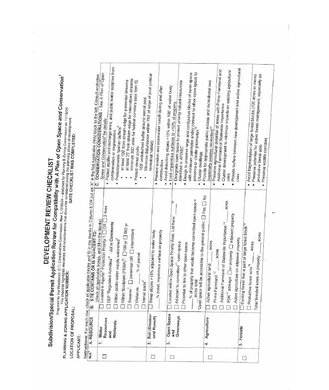
61 61
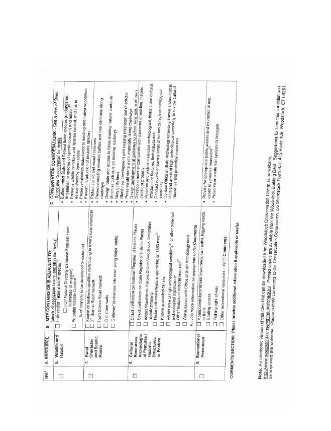
62 62

63 63
THE COUNTY BOARD OF SUPERVISORS OF THE COUNTY OF DOUGLAS DOES ORDAIN AS FOLLOWS:
 8.1 SUBDIVISION CONTROL ORDINANCE THE COUNTY BOARD OF SUPERVISORS OF THE COUNTY OF DOUGLAS DOES ORDAIN AS FOLLOWS: SECTION I. GENERAL INTERPRETATION This ordinance shall not repeal, impair or modify private
New Private Way Ordinance Westbrook Planning Board Workshop , Planning Board Public Hearing Definitions
 201 Definitions Private Right of Way; Private way A strip of land at least fifty feet wide, meeting the minimum standards for the construction of a gravel base for a public road, over which abutters may
ARTICLE 4 MAJOR SUBDIVISION/LAND DEVELOPMENT PLAN REQUIREMENTS
 ARTICLE 4 MAJOR SUBDIVISION/LAND DEVELOPMENT PLAN REQUIREMENTS SECTION 401 LAND SKETCH PLANS FOR MAJOR SUBDIVISIONS AND DEVELOPMENTS 401.1 Sketch Plan Information The following process and procedures shall
ARTICLE V PRELIMINARY PLAN SUBMISSION
 ARTICLE V PRELIMINARY PLAN SUBMISSION 501. Plan Requirements a. On or before the 25 th day of the month prior to a regularly scheduled meeting of the Planning Commission, the applicant shall submit two
Chapter 100 Planned Unit Development in Corvallis Urban Fringe
 100.100 Scope and Purpose. Chapter 100 Planned Unit Development in Corvallis Urban Fringe (1) All applications for land divisions in the Urban Residential (UR) and Flood Plain Agriculture (FPA) zones within
PLYMOUTH PLANNING BOARD APPLICATION FOR A MINOR SUBDIVISION OR MAJOR SUBDIVISION
 CASE # PLYMOUTH PLANNING BOARD APPLICATION FOR A MINOR SUBDIVISION OR MAJOR SUBDIVISION The undersigned Applicant hereby submits to the Plymouth Planning Board a completed application for a proposed minor
TOWN OF WATERVILLE VALLEY NEW HAMPSHIRE SITE PLAN REVIEW REGULATIONS
 TOWN OF WATERVILLE VALLEY NEW HAMPSHIRE Effective date March 17, 1981 Revised March 16, 1982 Revised March 13, 1986 Revised March 10, 1987 Revised March 14, 2013 Revised March 8, 2016 TOWN OF WATERVILLE
SUBDIVISION PROCEDURES AND REGULATIONS. for the Town of Stratford, New Hampshire
 SUBDIVISION PROCEDURES AND REGULATIONS for the Town of Stratford, New Hampshire TABLE OF CONTENTS Page A. PRE-APPLICATION 2 B. PRELIMINARY PLAN REQUIREMENTS 3 C. PRELIMINARY PLAN REVIEW 5 Site Plan Review
SUBDIVISION REGULATIONS
 SUBDIVISION REGULATIONS for the Town of North Stonington, Connecticut Effective October 18, 1963 and amended through October 16, 2009 TABLE OF CONTENTS 1: TITLE, PURPOSE, AUTHORITY, AND EFFECTIVE DATE
SECTION 4: PRELIMINARY PLAT
 SECTION 4: PRELIMINARY PLAT After the completion of the sketch plan process, if submitted, the owner or developer shall file with the City an application for preliminary plat. The preliminary plat stage
APPLICATION PROCEDURE
 ANTRIM PLANNING BOARD P. O. Box 517 Antrim, New Hampshire 03440 Phone: 603-588-6785 FAX: 603-588-2969 APPLICATION FORM AND CHECKLIST FOR MINOR OR MAJOR SITE PLAN REVIEW File Date Received By APPLICATION
I. Requirements for All Applications. C D W
 108-16.1. Application checklists. Checklist for Required Submissions to the Planning Board or Zoning Board of Adjustment of Monroe Township All required submissions are to be made to the Administrative
-MENDOCINO COUNTY PLANNING AND BUILDING SERVICES- DIVISION OF LAND REGULATIONS TITLE 17
 ARTICLE VI -- GENERAL REGULATIONS AND PROVISIONS Sec. 17-50. Sec. 17-51 General Plan. Sec. 17-52 Lot and Block Design and Configuration. Sec. 17-53 Lot Access. Sec. 17-54 Private Roads. Sec. 17-55 Water
TOWN OF COVENTRY SUBDIVISION REGULATIONS
 TOWN OF COVENTRY SUBDIVISION REGULATIONS Adopted: 04/23/54 Amended: 01/23/75 10/01/79 06/02/80 03/11/82 06/30/85 12/14/98 06/02/04 08/13/07 03/26/08 08/01/11 Revisions: Open Space Standards Chapter IV,
géãç Éy VtÇtÇwt zât 5440 Routes 5 & 20 West Canandaigua, NY Phone: (585) / Fax: (585)
 / Fax: (585)") géãç Éy VtÇtÇwt zât 5440 Routes 5 & 20 West Canandaigua, NY 14424 Phone: (585) 394-1120 / Fax: (585) 394-9476 APPLICATION FOR LOT-LINE ADJUSTMENT The applicant is responsible for the completeness of all
géãç Éy VtÇtÇwt zât 5440 Routes 5 & 20 West Canandaigua, NY 14424 Phone: (585) 394-1120 / Fax: (585) 394-9476 APPLICATION FOR LOT-LINE ADJUSTMENT The applicant is responsible for the completeness of all
The purpose of this Chapter is to establish rules, regulations, standards and procedures for approval of subdivisions of land to promote and ensure:
 CHAPTER 7 SUBDIVISION SECTION 7.1 PURPOSE The purpose of this Chapter is to establish rules, regulations, standards and procedures for approval of subdivisions of land to promote and ensure: A. Conformity
ARTICLE 5 MINOR SUBDIVISION/LAND DEVELOPMENT
 ARTICLE 5 MINOR SUBDIVISION/LAND DEVELOPMENT SECTION 501 ONLY FINAL PLAN REQUIRED The classification of a proposed subdivision as a "Minor Subdivision" shall only require the submission, review and approval
MAJOR SUBDIVISION PRELIMINARY PLAT CHECKLIST
 TOWNSHIP OF EGG HARBOR PLANNING BOARD/ZONING BOARD OF ADJUSTMENT 3515 BARGAINTOWN ROAD EGG HARBOR TOWNSHIP, NJ 08234 MAJOR SUBDIVISION PRELIMINARY PLAT CHECKLIST The following checklist is designed to
TABLE OF CONTENTS SECTION TITLE PAGE 1 PURPOSE 1
 TABLE OF CONTENTS SECTION TITLE PAGE 1 PURPOSE 1 2 GENERAL PROVISIONS 2 2.1 Sale of Lots 2 2.2 Town Clerk 2 2.3 Adjacent Development 2 2.4 Character of Land 2 2.5 Health, Safety & General Welfare 2 2.6
Town of Lisbon, Maine SUBDIVISION REVIEW APPLICATION
 Date Received: Fee Paid (amount): Applicant: Town of Lisbon, Maine SUBDIVISION REVIEW APPLICATION Subdivision Name/Title: This application must be received at the Town Office by close of business on the
SUBDIVISION REGULATIONS FOR THE TOWN OF WILLINGTON. Planning and Zoning Commission. Willington, Connecticut
 , SUBDIVISION REGULATIONS FOR THE TOWN OF WILLINGTON Planning and Zoning Commission Willington, Connecticut Adopted: 2/27/69 Effective: 3/3/69 Amended: 11/27/75 1/77 4/89 5/15/92 06/01/2011 11/01/2011
610 LAND DIVISIONS AND PROPERTY LINE ADJUSTMENTS OUTSIDE A UGB
 ARTICLE VI: LAND DIVISIONS AND PROPERTY LINE ADJUSTMENTS VI-21 610 LAND DIVISIONS AND PROPERTY LINE ADJUSTMENTS OUTSIDE A UGB 610-1 Property Line Adjustments (Property Line Relocation) A property line
TENTATIVE PARCEL MAP APPLICATION GUIDE TENTATIVE PARCEL MAP APPLICATION REQUIREMENTS
 TENTATIVE PARCEL MAP APPLICATION GUIDE SISKIYOU COUNTY PLANNING DIVISION 806 South Main Street, Yreka CA 96097 Phone: (530) 841-2100 / Fax: (530) 841-4076 TENTATIVE PARCEL MAP APPLICATION REQUIREMENTS
Residential Major Subdivision Review Checklist
 Residential Major Subdivision Review Checklist Plan Submittal Requirements: 2 full sets of stamped plans Electric submittal - all plans contained in a single PDF 3 full sets if commercial kitchen or dining
SUBDIVISION AND LAND DEVELOPMENT. 185 Attachment 20
 185 Attachment 20 APPENDIX S Plat No. Date of Submission Twp. Fee $ Dauphin Co. Fee $ TOWNSHIP OF DERRY SUBDIVISION OR LAND DEVELOPMENT PLAN SUBMISSION APPLICATION This block for Twp. use only 1. Title
BRIDGETON SUBDIVISION APPLICATION CHECKLIST
 APPLICATION NAME AND # CHECKLIST COMPLETED BY: DATE: Signature and printed name BRIDGETON SUBDIVISION APPLICATION CHECKLIST TO SUBDIVISION APPLICANTS: The attached checklist is to assist you in the submission
SUBDIVISION APPLICATION
 SUBDIVISION APPLICATION Preliminary Plat Minor Plat Final Plat Amended Plat Applicant Name: Owner (if different from applicant) Name: Company: Company: Address: Address: City, State, Zip City, State, Zip
A.3. ARTICLE 7 PLAN REQUIREMENTS FOR MINOR SUBDIVISION AND/OR LAND DEVELOPMENT
 700. 701.A.3. ARTICLE 7 PLAN REQUIREMENTS FOR MINOR SUBDIVISION AND/OR LAND DEVELOPMENT SECTION 700 PURPOSE The purpose of this Article is to set forth a streamlined set of Plan Requirements for minor
SECTION 10.7 R-PUD (RESIDENTIAL PLANNED UNIT DEVELOPMENT) ZONE
 ZONE") Article X Zones 10-20 SECTION 10.7 R-PUD (RESIDENTIAL PLANNED UNIT DEVELOPMENT) ZONE A. PURPOSE AND INTENT: The R-PUD Residential PUD Zone is intended to provide alternative, voluntary zoning procedures
Article X Zones 10-20 SECTION 10.7 R-PUD (RESIDENTIAL PLANNED UNIT DEVELOPMENT) ZONE A. PURPOSE AND INTENT: The R-PUD Residential PUD Zone is intended to provide alternative, voluntary zoning procedures
CHAPTER 22 SUBDIVISION AND LAND DEVELOPMENT
 CHAPTER 22 SUBDIVISION AND LAND DEVELOPMENT 22-101. Title 22-102. Legislative Intent Part 1 General Provisions 22-201. Development Permits Part 2 Administration 22-301. Fee Schedule Part 3 Fee Schedule
DRAFT FOR PUBLIC HEARING (rev. March, 2016)
") Chapter 200. ZONING Article VI. Conservation/Cluster Subdivisions 200-45. Intent and Purpose These provisions are intended to: A. Guide the future growth and development of the community consistent with
Chapter 200. ZONING Article VI. Conservation/Cluster Subdivisions 200-45. Intent and Purpose These provisions are intended to: A. Guide the future growth and development of the community consistent with
ELK RAPIDS TOWNSHIP ANTRIM COUNTY, MICHIGAN ORDINANCE NO
 ELK RAPIDS TOWNSHIP ANTRIM COUNTY, MICHIGAN ORDINANCE NO. 3-2011 AN ORDINANCE TO REPLACE THE SUBDIVISION CONTROL ORDINANCE WITH A NEW SUBDIVISION DEVELOPMENT ORDINANCE, IN ACCORD WITH THE LAND DIVISION
Town of Lincolnville Subdivision Ordinance
 Town of Lincolnville Subdivision Ordinance November 8, 2005 Amended: 06-10-2008---Article 4, Section 4.4.1 Conceptual Plan 06-11-2015---Article 5, Section 5.2.3.i., Article 6.2.3.l., Article 8 & 12 Access
CHAPTER 3 PRELIMINARY PLAT
 10-3-1 10-3-3 SECTION: CHAPTER 3 PRELIMINARY PLAT 10-3-1: Consultation 10-3-2: Filing 10-3-3: Requirements 10-3-4: Approval 10-3-5: Time Limitation 10-3-6: Grading Limitation 10-3-1: CONSULTATION: Each
ARTICLE 15 - PLANNED UNIT DEVELOPMENT
 Section 15.1 - Intent. ARTICLE 15 - PLANNED UNIT DEVELOPMENT A PUD, or Planned Unit Development, is not a District per se, but rather a set of standards that may be applied to a development type. The Planned
MINOR SUBDIVISION INFORMATION
 A. POINTS OF CONTACT: MINOR SUBDIVISION INFORMATION Surveyor: Address: Phone #: Fax # E-Mail Address: Representative (If different from applicant): Address: Phone #: Fax # E-Mail Address: B. GENERAL INFORMATION:
Town of Canandaigua 5440 Routes 5 & 20 West Canandaigua, NY Phone: (585) / Fax: (585)
 / Fax: (585)") Town of Canandaigua 5440 Routes 5 & 20 West Canandaigua, NY 14424 Phone: (585) 394-1120 / Fax: (585) 394-9476 NOTICE TO ALL PLANNING BOARD APPLICANTS FOR SINGLE STAGE PRELIMINARY/FINAL SUBDIVISION PLAT
Town of Canandaigua 5440 Routes 5 & 20 West Canandaigua, NY 14424 Phone: (585) 394-1120 / Fax: (585) 394-9476 NOTICE TO ALL PLANNING BOARD APPLICANTS FOR SINGLE STAGE PRELIMINARY/FINAL SUBDIVISION PLAT
TABLE OF CONTENTS. Page TITLE, SHORT TITLE, AND PURPOSE SUBMISSION AND REVIEW PROCEDURES
 ARTICLE I TABLE OF CONTENTS TITLE, SHORT TITLE, AND PURPOSE Page 101 Title 3 102 Short Title 3 103 Purpose 3 104 Application of the Ordinance 3 105 Interpretation 4 106 Revision and Resubdivisions 4 ARTICLE
CHAPTER 18 SUBDIVISION AND PLATTING ORDINANCE OF THE TOWN OF OSCEOLA CODE OF ORDINANCES
 TOWN OF OSCEOLA POLK COUNTY WISCONSIN ORDINANCE # 18-03-03 CHAPTER 18 SUBDIVISION AND PLATTING ORDINANCE OF THE TOWN OF OSCEOLA CODE OF ORDINANCES 18.01 Purpose Adopted 3/08/99, Amended 5/12/03, 7/9/07,
TOWN OF GOSHEN, NEW HAMPSHIRE
 TOWN OF GOSHEN, NEW HAMPSHIRE SUBDIVISION REGULATIONS As Amended on August 6, 2018 August 6, 2018 P.O Box 68, Goshen, NH 03752 http://www.goshennh.org/index.html Table of Contents SECTION 1 ADOPTION 1
SUBDIVISION REGULATIONS
 CHAPTER 41 SUBDIVISION REGULATIONS 41.01 Short Title 41.17 Presentation to Commission or Board of Supervisors 41.02 Purpose 41.18 Subdivision Classified 41.03 Application 41.19 Plats Required 41.04 Recording
TOWNSHIP OF BORDENTOWN LAND DEVELOPMENT APPLICATION CHECKLIST. General Requirements for all Applications
 TOWNSHIP OF BORDENTOWN LAND DEVELOPMENT APPLICATION CHECKLIST This CHECKLIST has been adopted in accordance with Section 25:807 of the Land Development Ordinance of the Township of Bordentown and will
13-2 SUBDIVISION PLANS AND PLATS REQUIRED EXCEPTIONS Subdivision Plats Required To be Recorded
 ARTICLE XIII SUBDIVISIONS 13-1 INTENT AND PURPOSE 13-1-1 Intent: It is the intent of the County Commission through the adoption of this Article to more fully avail itself of the power granted under 17-27-601
City of Prior Lake APPLICATION FOR COMBINED PRELIMINARY AND FINAL PLAT
 Case File No. Property Identification No. City of Prior Lake APPLICATION FOR COMBINED PRELIMINARY AND FINAL PLAT Requested Action Brief description of proposed project (Please describe the proposed amendment,
SUBDIVISION APPLICATION CHECKLIST SKETCH PLAN PRELIMINARY PLAT FINAL PLAT
 RECEIVED STAMP SUBDIVISION APPLICATION CHECKLIST SKETCH PLAN PRELIMINARY PLAT FINAL PLAT A checklist of background information and submission requirements for processing of a sketch plan, preliminary plat
Section Preliminary Plat Checklist and Application Forms
 Section 201 - Preliminary Plat Checklist and Application Forms PRELIMINARY SUBDIVISION PLAT REVIEW PROCESS CHART PRELIMINARY SUBDIVISION PLAT APPLICATION PRELIMINARY PLAT REVIEW CHECKLIST CITY OF NAMPA
ARTICLE 3 DEFINITIONS
 Sections: 3-1 Rules of Construction 3-2 Definitions ARTICLE 3 DEFINITIONS SECTION 3-1 RULES OF CONSTRUCTION 3-101. a. The language set forth in these regulations shall be interpreted in accordance with
MAJOR RESIDENTIAL AND NONRESIDENTIAL SUBDIVISIONS
 Lawrence-Douglas County MAJOR RESIDENTIAL AND NONRESIDENTIAL SUBDIVISIONS Preliminary Plats The applicant shall schedule a Pre-Application meeting with Planning Staff at least seven (7) working days prior
CITY OF GROVER BEACH COMMUNITY DEVELOPMENT DEPARTMENT Tentative Map Checklist
 CITY OF GROVER BEACH COMMUNITY DEVELOPMENT DEPARTMENT Tentative Map Checklist The following list includes all of the items you must submit for a complete application. Some specific types of information
CHAPTER 26 PLANNING AND ZONING ARTICLE VII. MOBILE HOMES AND RECREATIONAL VEHICLE (RV) PARKS. Recreational Vehicle (RV) Park Development Standards
 PARKS. Recreational Vehicle (RV) Park Development Standards") CHAPTER 26 PLANNING AND ZONING ARTICLE VII. MOBILE HOMES AND RECREATIONAL VEHICLE (RV) PARKS. Section 26-VII-1. Section 26-VII-2. Section 26-VII-3. Section 26-VII-4. Section 26-VII-5. Purpose Permitted
CHAPTER 26 PLANNING AND ZONING ARTICLE VII. MOBILE HOMES AND RECREATIONAL VEHICLE (RV) PARKS. Section 26-VII-1. Section 26-VII-2. Section 26-VII-3. Section 26-VII-4. Section 26-VII-5. Purpose Permitted
TOWNSHIP OF EGG HARBOR ZONING BOARD ADJUSTMENT CHECK LIST
 TOWNSHIP OF EGG HARBOR ZONING BOARD ADJUSTMENT CHECK LIST Schedule A - General Requirements 1. Where the application involves only a variance one (1) original and nineteen (19) copies of the appropriate
CITY OF SARALAND FINAL SUBDIVISION PLAT REVIEW
 CITY OF SARALAND FINAL SUBDIVISION PLAT REVIEW Application Number: Date Plat Submitted: Name of Subdivision: Name of Owner: Owner Address: (Street or P.O. Box) Telephone #: (City) (State) (Zip) E-mail:
Chapter Plat Design (LMC)
") Chapter 18.14 Plat Design (LMC) Sections: 18.14.010 Lot width 18.14.020 Right-of-way requirements 18.14.030 Pipe stem lots 18.14.040 Division resulting in minimum lot sizes 18.14.050 Flood prone and bad
Chapter 18.14 Plat Design (LMC) Sections: 18.14.010 Lot width 18.14.020 Right-of-way requirements 18.14.030 Pipe stem lots 18.14.040 Division resulting in minimum lot sizes 18.14.050 Flood prone and bad
ARTICLE SINGLE FAMILY SITE CONDOMINIUM DEVELOPMENT STANDARDS
 ARTICLE 28.00 SINGLE FAMILY SITE CONDOMINIUM DEVELOPMENT STANDARDS Section 28.01 PURPOSE The purpose of this Article is to recognize that conventional single family developments, traditionally developed
FINAL SUBDIVISION AND LAND DEVELOPMENT PLAN CHECKLIST. Plan Name. Applicant's Name:
 TOWNSHIP OF UPPER ST. CLAIR FINAL SUBDIVISION AND LAND DEVELOPMENT PLAN CHECKLIST Date Filed Plan Name PLC Applicant's Name: Phone Filing Date for Final Application Final Plat 114.22. FINAL APPLICATION
Guide to Combined Preliminary and Final Plats
 Guide to Combined Preliminary and Final Plats Introduction The Douglas County is committed to providing open, transparent application processes to the public. This Guide is provided to assist anyone interested
Major Subdivision Application Packet. Revised June 2018
 Major Subdivision Application Packet Revised June 2018 Caroline County Department of Planning and Community Development 233 West Broaddus Avenue Bowling Green, VA 22427 www.co.caroline.va.us Phone: 804-633-4303
CHELSEA SUBDIVISION ORDINANCE
 June 11, 2015 CHELSEA SUBDIVISION ORDINANCE I. Purpose and Authority A. This ordinance will pertain to all land within the boundaries of the Town of Chelsea. The purpose of this ordinance is to protect
APPLICATION for MINOR SUBDIVISION REVIEW for CONCEPT and FINAL PLAT within COALVILLE CITY. Project Name: Project Address or Area: Name of Owner:
 APPLICATION for MINOR SUBDIVISION REVIEW for CONCEPT and FINAL PLAT within COALVILLE CITY For Office Use Only: Application #: Application Date: PC Approval Date: CC Approval Date: Community Development
THE UNINCORPORATED AREA OF CLARKE COUNTY, IOWA TABLE OF CONTENTS
 ORDINANCE #11 THE UNINCORPORATED AREA OF CLARKE COUNTY, IOWA TABLE OF CONTENTS ARTICLE I:-------------------------------------------------------------------------GENERAL PROVISIONS ARTICLE II:--------------------------------------------------------------------------------------DEFINITIONS
Initial Subdivision Applications Shall Include the Following:
 Initial Subdivision Applications Shall Include the Following: 1) Subdivision Application Form: completely filled out (12 copies) 2) Plat: The Plat must adhere to the requirements set forth in the Town
TOWN OF LEWISTON PLANNING BOARD APPLICATION
 TOWN OF LEWISTON PLANNING BOARD APPLICATION DESCRIPTION OF PROPOSED REQUEST: Name of Property Owner: Phone #: Name of Applicant:Phone #: Address or Location of Proposal:_SBL# Size of Parcel or Structure:Existing
ARTICLE 15. RULES, REGULATIONS AND DEFINITIONS
 ARTICLE 15. RULES, REGULATIONS AND DEFINITIONS Section 1. Interpretation and Construction: The following rules and regulations regarding interpretation and construction of the Ulysses-Grant County, Kansas,
Subdivision Regulations
 Woodbury Planning Commission Subdivision Regulations Effective March 14, 1956 Revised to October 10, 1991 Revised to July 6, 1996 Revised to December 1, 2001 Revised to January 1, 2006 Town of Woodbury
MUNICIPALITY OF THE COUNTY OF PICTOU SUBDIVISION BY-LAW. Act means the Municipal Government Act, Stats. N.S., 1998, c. 18 and amendments thereto;
 MUNICIPALITY OF THE COUNTY OF PICTOU SUBDIVISION BY-LAW SHORT TITLE 1. This by-law may be cited as the Pictou County Subdivision By-Law and shall apply to all lands within the Municipality of the County
SECTION 10 STANDARD PLATS
 SECTION 10 - STANDARD PLATS Subdivision 1: Purpose Standard Plats allow the subdivision of land into lots smaller than the minimum metes and bounds size in the zoning district, and control road development
Residential Minor Subdivision Review Checklist
 Residential Minor Subdivision Review Checklist Plan Submittal Requirements: 2 full sets of stamped plans Electric submittal - all plans contained in a single PDF 3 full sets if commercial kitchen or dining
CHAPTER 25 REVIEW AND APPROVAL OF SITE CONDOMINIUM AND CONDOMINIUM PROJECTS
 CHAPTER 25 REVIEW AND APPROVAL OF SITE CONDOMINIUM AND CONDOMINIUM PROJECTS Section 25.1. Purpose and Scope. 1. Tracts of land that are developed and sold as site condominium developments and condominium
MINOR & MAJOR SUBDIVISION APPLICATION
 TOW OF HOOKSETT APPLICATIO # DATE MIOR & MAJOR SUBDIVISIO APPLICATIO Application for: Completeness Map and Lot o. Public Hearing o. of Lots LOCATIO: (Specify Street Address) OWER: APPLICAT: ADDRESS: ADDRESS:
APPLICATION SUBMITTAL REQUIREMENTS FOR Tentative Parcel or Subdivision Maps
 CITY OF EL CERRITO Community Development Department Planning and Building Division 10890 San Pablo Avenue, El Cerrito, CA 94530 (510) 215-4330 FA (510) 233-5401 planning@ci.el-cerrito.ca.us APPLICATION
ARTICLE 100 SUBDIVISION APPLICATION PROCEDURE AND APPROVAL PROCESS
 ARTICLE 100 SUBDIVISION APPLICATION PROCEDURE AND APPROVAL PROCESS 100.01 General Procedure 100.02 Exempt Subdivision 100.03 Administrative Subdivision 100.04 Major Subdivision 100.05 Signing and Recording
CHAPTER 22 SUBDIVISION AND LAND DEVELOPMENT. Part 1 General Provisions. Part 2 Application Procedure and Approval Process
 CHAPTER 22 SUBDIVISION AND LAND DEVELOPMENT Part 1 General Provisions 101. Title 102. Policy 103. Purposes 104. Authority 105. Jurisdiction 106. Interpretation, Conflict and Separability 107. Municipal
E L M E R B O R O U G H L A N D U S E B O A R D APPLICATION COVER SHEET (to be completed for all applications and appeals)
") E L M E R B O R O U G H L A N D U S E B O A R D APPLICATION COVER SHEET (to be completed for all applications and appeals) 1. Name(s): 2. Address: 3. Telephone Number(s): 4. E-mail: 5. Owner Name(s) (if
E L M E R B O R O U G H L A N D U S E B O A R D APPLICATION COVER SHEET (to be completed for all applications and appeals) 1. Name(s): 2. Address: 3. Telephone Number(s): 4. E-mail: 5. Owner Name(s) (if
FINAL PLAT APPLICATION
 FINAL PLAT APPLICATION (Page 1 of 3) LEGAL OWNER(s): NAME: STREET ADDRESS OWNER(s): CITY, STATE, ZIP CODE: PHONE NUMBER: BILLING ADDRESS: NAME OF ENGINEER/SURVEYOR: Engineer/Surveyor Address, Phone: PROPERTY
ARTICLE 6 PRELIMINARY PLAT
 ARTICLE 6 PRELIMINARY PLAT SECTION: 30-06-01: Preliminary Plat 30-06-02: Information Required for Preliminary Plat 30-06-03: Determination of Requirement for Environmental Review Documents 30-06-04: Additional
City of Prior Lake APPLICATION FOR REGISTERED LAND SURVEY
 Case File No. Property Identification No. City of Prior Lake APPLICATION FOR REGISTERED LAND SURVEY Requested Action Brief description of proposed project (Please describe the proposed amendment, project,
PLANNING BOARD CITY OF CONCORD, NH MINOR SUBDIVISION CHECKLIST
 PLANNING BOARD CITY OF CONCORD, NH MINOR SUBDIVISION CHECKLIST Summary This checklist is intended to assist applicants and design professionals in the preparation of minor subdivision applications for
MINOR SUBDIVISION FINAL PLAT APPLICATION Town of Apex, North Carolina
 MINOR SUBDIVISION FINAL PLAT APPLICATION Town of Apex, North Carolina This document is a public record under the North Carolina Public Records Act and may be published on the Town s website or disclosed
SECTION I. POLICY AND GENERAL REQUIREMENTS
 SECTION I. POLICY AND GENERAL REQUIREMENTS 1-1 Declaration of Policy: It is declared to be the policy of the Planning and Zoning Commission of the City of Shelton to consider land subdivision as a living
CHARLES CITY COUNTY SITE PLAN ORDINANCE. This Ordinance shall be known as the Charles City County Site Plan Ordinance.
 CHARLES CITY COUNTY SITE PLAN ORDINANCE Section 1. Title This Ordinance shall be known as the Charles City County Site Plan Ordinance. Section 2. Authority. This Ordinance is enacted pursuant to the authority
SUBDIVISION CONTROL ORDINANCE. LaPorte County City of LaPorte City of Michigan City
 SUBDIVISION CONTROL ORDINANCE LaPorte County City of LaPorte City of Michigan City Adopted January 7, 2012 Table of Contents Table of Contents Article 01 Basic Provisions 01.01 Preamble and Enacting Clause
ARTICLE IV: DEVELOPMENT STANDARDS
 ARTICLE IV: DEVELOPMENT STANDARDS IV-53 409 PRIVATE STREETS A private street means any way that provides ingress to, or egress from, property by means of vehicles or other means, or that provides travel
TOWN OF WALLINGFORD SUBDIVISION REGULATIONS
 TOWN OF WALLINGFORD SUBDIVISION REGULATIONS ADOPTED: October 26, 1987 AMENDED: April 17, 1990 EFFECTIVE: November 2, 1987 March 6, 1994 December 16, 1995 January 14, 1996 February 14, 1999 May 14, 2000
SUBMITTAL REQUIREMENTS
 PRELIMINARY PLAT APPLICATION ***A PRE-APPLICATION MEETING WITH CITY STAFF IS REQUIRED FOR THIS APPLICATION*** DATE STAMP FOR CITY USE ONLY PROJECT NAME (if any): TO BE FILLED OUT BY APPLICANT PROJECT STREET
Chapter 22 LAND USE* Article III. Subdivisions
 Chapter 22 LAND USE* Article III. Subdivisions Sec. 22-256. Authority to Regulate. Sec. 22-257. Scope; plat required. Sec. 22-258. Definitions. Sec. 22-259. Interpretations and Meanings. Sec. 22-260. Procedure
Condominium Unit Requirements.
 ARTICLE 19 CONDOMINIUM REGULATIONS Section 19.01 Purpose. The purpose of this Article is to regulate projects that divide real property under a contractual arrangement known as a condominium. New and conversion
City of Leavenworth DEPARTMENT OF DEVELOPMENT SERVICES MAJOR SUBDIVISION APPLICATION 1
 Proposed Name of Subdivision: City of Leavenworth DEPARTMENT OF DEVELOPMENT SERVICES MAJOR SUBDIVISION APPLICATION 1 FOR PRELIMINARY SUBDIVISION APPROVAL This application must be filled out legibly, in
Guide to Minor Developments
 Guide to Minor Developments Introduction The Douglas County (DCD) is committed to providing open, transparent application processes to the public. This Guide is provided to assist anyone interested in
SUBDIVISION ORDINANCE CITY OF DES MOINES, IOWA
 SUBDIVISION ORDINANCE CITY OF DES MOINES, IOWA SUBDIVISION REGULATIONS CITY OF DES MOINES, IOWA NOTICE This is an unofficial and annotated copy of excerpts from the Municipal code of the City of Des Moines,
(voice) (fax) (voice) (fax) Site Plan Review
 (fax) (voice) (fax) Site Plan Review") Town of South Boston PO Box 417 455 Ferry Street South Boston Virginia 24592 Planning Department Public Works Department (Engineering) 434.575.4241 (voice) 434.575.4275 (fax) 434.575.4260 (voice) 434.575.4275
Town of South Boston PO Box 417 455 Ferry Street South Boston Virginia 24592 Planning Department Public Works Department (Engineering) 434.575.4241 (voice) 434.575.4275 (fax) 434.575.4260 (voice) 434.575.4275
ARTICLE XVI SUBDIVISION DEVELOPMENT
 ARTICLE XVI SUBDIVISION DEVELOPMENT 16.0 The division of land into 4 or more lots that will require the construction or extension of public streets, water or sanitary sewerage (other than the direct connection
MASTER SUBDIVISION FINAL PLAT APPLICATION Town of Apex, North Carolina
 MASTER SUBDIVISION FINAL PLAT APPLICATION Town of Apex, North Carolina This document is a public record under the North Carolina Public Records Act and may be published to the Town s website or disclosed
géãç Éy VtÇtÇwt zât 5440 Routes 5 & 20 West Canandaigua, NY Phone: (585) / Fax: (585)
 / Fax: (585)") géãç Éy VtÇtÇwt zât 5440 Routes 5 & 20 West Canandaigua, NY 14424 Phone: (585) 394-1120 / Fax: (585) 394-9476 NOTICE TO ALL PLANNING BOARD APPLICANTS FOR PRELIMINARY SUBDIVISION PHASED PROJECTS The applicant
géãç Éy VtÇtÇwt zât 5440 Routes 5 & 20 West Canandaigua, NY 14424 Phone: (585) 394-1120 / Fax: (585) 394-9476 NOTICE TO ALL PLANNING BOARD APPLICANTS FOR PRELIMINARY SUBDIVISION PHASED PROJECTS The applicant
TITLE 18 Subdivisions
 TITLE 18 Subdivisions ADMINISTRATION: 18.02 General Provisions 2 18.04 Definitions 6 18.06 Exceptions to Requirements 12 18.08 Enforcement 14 DIVISIONS OF LAND: 18.20 Tentative Parcel Maps 15 18.22 Tentative
RESIDENTIAL CLUSTER DEVELOPMENT DISTRICT SPECIAL PERMIT RULES AND REGULATIONS OF THE PLANNING BOARD OF THE TOWN OF COHASSET, MASSACHUSETTS
 RESIDENTIAL CLUSTER DEVELOPMENT DISTRICT SPECIAL PERMIT RULES AND REGULATIONS OF THE PLANNING BOARD OF THE TOWN OF COHASSET, MASSACHUSETTS Attached: Residential Cluster Development District Special Permit
WASCO COUNTY PRELIMINARY SUBDIVISION APPLICATION
 WASCO COUNTY PRELIMINARY SUBDIVISION APPLICATION DETAILED SPECIFIC WRITTEN REQUEST File Number: SDV- Number of Proposed Lots & their Dimensions: PRELIMINARY SUBDIVISION PLAN REQUIREMENTS The approval of
STATE OF MICHIGAN COUNTY OF MARQUETTE, TOWNSHIP OF NEGAUNEE LAND DIVISION, SUBDIVISION AND CONDOMINIUM ORDINANCE
 STATE OF MICHIGAN COUNTY OF MARQUETTE, TOWNSHIP OF NEGAUNEE LAND DIVISION, SUBDIVISION AND CONDOMINIUM ORDINANCE Adopted: August 8 th, 2008 Effective: August 28 th, 2008 Sec.100. Title ARTICLE I GENERAL
TOWNSHIP OF SPRINGBROOK SUBDIVISION AND LAND DEVELOPMENT
 TOWNSHIP OF SPRINGBROOK SUBDIVISION AND LAND DEVELOPMENT ORDINANCE JULY, 1995 with Revisions to January, 2001 SUBDIVISION AND LAND DEVELOPMENT ORDINANCE TOWNSHIP OF SPRINGBROOK LACKAWANNA COUNTY, PENNSYLVANIA
SUBDIVISION REGULATIONS
 Adopted October 1, 1963 ARTICLE I PREAMBLE AND TITLE SECTION 101. Preamble Whereas it is deemed necessary to promulgate certain regulations in order to improve and protect the interests of the Town of
To provide for the review of the final engineering plans, the subdivision improvement agreement, public dedications, and other legal agreements.
 ARTICLE 5 FINAL PLAT 501 Intent DOUGLAS COUNTY SUBDIVISION RESOLUTION To provide for the review of the final engineering plans, the subdivision improvement agreement, public dedications, and other legal