P & L Anderson PROPOSED SUBDIVISION. 71 Keri Downs Road, Kerikeri PLANNERS REPORT & ASSESSMENT OF ENVIRONMENTAL EFFECTS
|
|
|
- Jodie Elliott
- 5 years ago
- Views:
Transcription
1
2
3
4
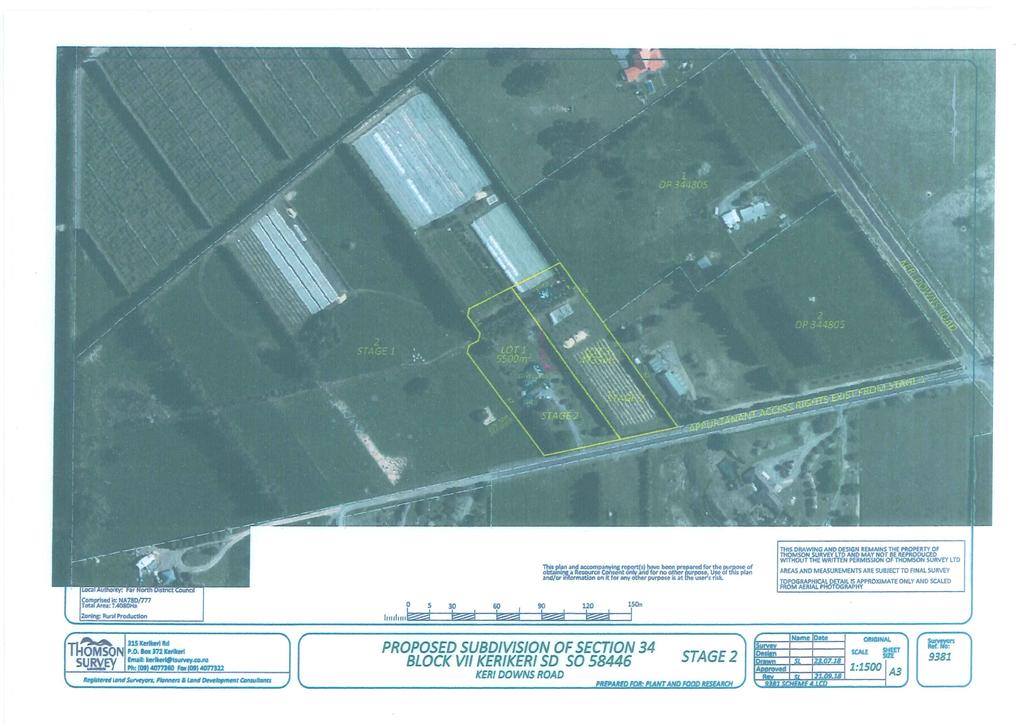
5 Thomson Survey Limited Subdivision Proposal Nov-18 P & L Anderson PROPOSED SUBDIVISION 71 Keri Downs Road, Kerikeri PLANNERS REPORT & ASSESSMENT OF ENVIRONMENTAL EFFECTS Thomson Survey Ltd Kerikeri 1.0 INTRODUCTION 1.1 The Proposal The applicants propose to carry out a subdivision of property at 71 Keri Downs Road, (Sect 34) Kerikeri, in two stages, firstly by creating Lot 1 around their an existing residence and a balance larger Lot 2 which is proposed to be transferred to the owners of the adjacent property, and secondly to further subdivide Lot 1 leaving a smaller area of land around the existing residence and creating an additional vacant lot. Access is existing, off Keri Downs Road down a long shared ROW. Refer to Appendix 1 for a copy of the Scheme Plan; and to Appendix 2 for a location map. 1.2 Scope of this Report This assessment and report accompanies the Resource Consent Application made by our clients, and is provided in accordance with Section 88 and Schedule 4 of the Resource Management Act The application seeks consent to carry out a subdivision of a title, in two stages with the final result being two lots of over 4000m 2 each, and a balance in excess of 4ha, which is proposed to transfer to be held in the same ownership of the adjacent Section 32, Blk VII Kerikeri SD. This is regarded as a restricted discretionary subdivision activity. The information provided in this assessment and report is considered commensurate with the scale and intensity of the activity for which consent is being sought, and covers: Page 1 Planning Report and Assessment of Environmental Effects Anderson Job # 9381 Keri Downs Road
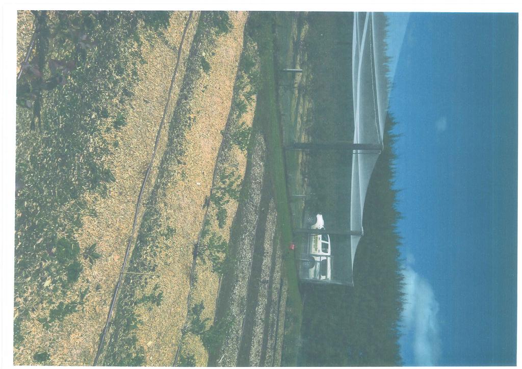
6 Thomson Survey Limited Subdivision Proposal Nov-18 A description of the proposal; A description of the site and its environs; An assessment of environmental effects; An assessment of the proposal against relevant objectives and policies of the Far North District Plan; An assessment of the proposal against relevant provisions of Part 2 of the Act and other National and Regional Standards, Policies and Plans; Record of consultation. The name and address of the owner of the property is contained in the Form 9 Application Form. There are no other activities that are a part of the proposal to which the application relates, and no other resource consents required other than that addressed in this application. 2.0 PROPERTY DETAILS Location: Legal description: CT: Title area: 71 (Sect 34) Keri Downs Road, Kerikeri; also involving adjacent property with an address shown as 121 Keri Downs Road Lot 1 DP ; also involving Section 32 Blk VII, Kerikeri SD (which which Lot 2 of Stage 1 hereon will be held) CFR NA78D/777, dated November 1990; also involving NA77D/958, dated May 1991 (copies of Titles attached as Appendix 3) ha (NA78D/777). Area of NA77D/958, with which Lot 2 of Stage will be held, is shown as ha (Sections 32 and 45 combined). 3.0 SITE DESCRIPTION 3.1 Physical characteristics The application property and adjoining property involved in the proposal, are both zoned Rural Production. Areas of properties are listed above. No resource features in either the District Plan Maps or Regional Policy Statement Maps apply to the site. The property is accessed via an existing ROW that comes off Keri Downs Road, approximately 680m from its intersection with Purerua Road. This is a long straight downward sloping (away from Keri Downs Road) ROW, with sealed surface. See picture on following page. Page 2 Planning Report and Assessment of Environmental Effects Anderson Job # 9381 Keri Downs Road


7 Thomson Survey Limited Subdivision Proposal Nov-18 View looking west and down slope from Keri Downs Road. The application site is near the end, on the right hand side. The property supports an existing modestly sized residence with carport along with some sheds. The area around the existing residence is enclosed by shelter/hedgerow plantings to the east of the house, along part of the western fenceline of the house, and to the rear of the house on the far side of a wide drain. There is an area to the east of the house that the owners use to grow blueberries to a modest scale. Beyond the trees/hedgerow at the rear of the house, and over the drain, is a larger area used for productive purposes. This is on the large Lot 2 of Stage 1 which will transfer to be held with the adjacent property. The balance of the property is primarily in gently rolling pasture, currently grazed. Refer to photo below. The property extends beyond the far hedgerow plantings. Photo looking west across balance Lot 2 land. Page 3 Planning Report and Assessment of Environmental Effects Anderson Job # 9381 Keri Downs Road
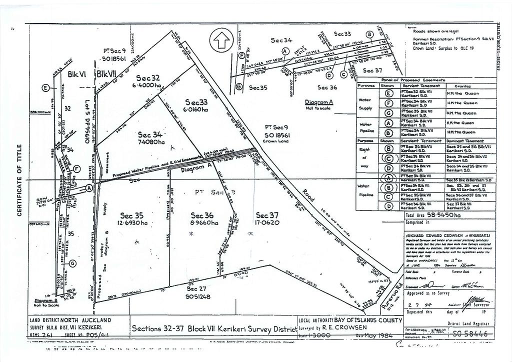
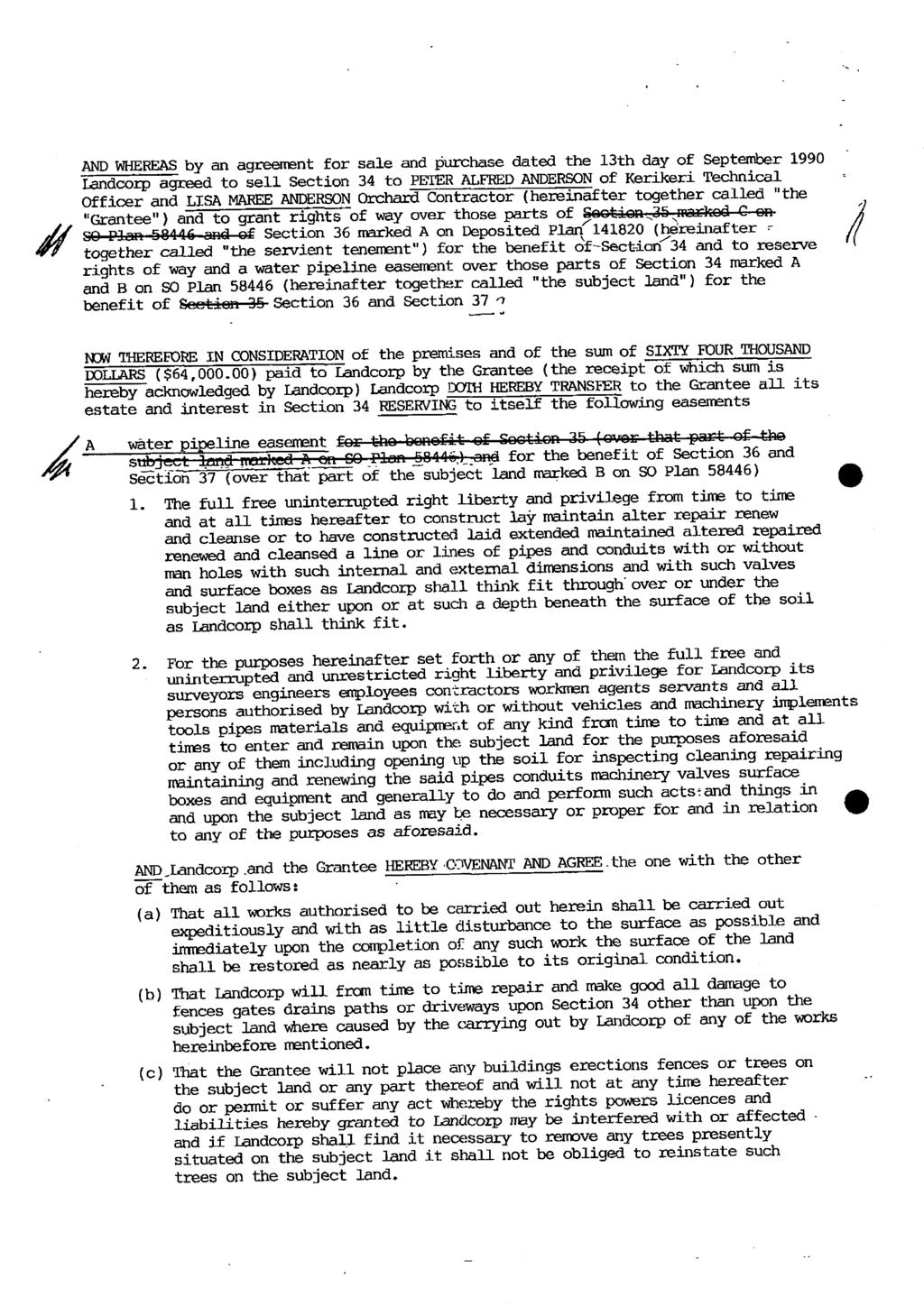
8 Thomson Survey Limited Subdivision Proposal Nov Legal Interests The property, like much of the land in New Zealand that has previously been state owned, is subject to a suite of pieces of legislation such as the Atomic Energy Act and Mining Act. The property is also subject to a water pipeline easement and water supply right in gross in favour of the Kerikeri Irrigation Company, and to water pipeline rights created by C & C A copy of the latter is attached in Appendix 4. The property is subject to, and has appurtenant rights of way pursuant to C (attached in Appendix 5). This instrument includes water pipeline right as well. In addition the property is subject to, and has appurtenant right of way pursuant to Transfer C , also attached in Appendix 5. The land with which Lot 2 is to be held has similar but fewer legal interests. As with the application property, it is subject to a water supply right in gross in favour of the Kerikeri Irrigation Company. 3.3 Consent History The subject site has three buildings, consented via 3 buildings consents: BP BP BC m 2 Pioneer Cottage. 43m 2 double garage. 54m 2 storage shed. 4.0 THE PROPOSAL IN DETAIL Our clients are seeking to subdivide their land in two stages, as follows: Stage 1: Stage 2: Creation of Lot 1 of 1.02ha around existing residence; and Lot 2 of 6.38ha subject to an Amalgamation Condition as follows: That Lot 2 Hereon be held in the same certificate of title as Section 32 Blk VII Kerikeri SD. Subdivide Lot 1 of Stage 1 to create new Lot 1 of 5500m 2 supporting existing residence, and new Lot 2 of 4735m 2. The net result of the above is the creation of two lots of greater than 4000m 2, plus balance of greater than 4ha, all from one title, and because of the proposed amalgamation condition, a net increase of one additional title only. The property has existing appurtenant ROW access and the additional lot will utilise this same appurtenant ROW. Page 4 Planning Report and Assessment of Environmental Effects Anderson Job # 9381 Keri Downs Road
9 Thomson Survey Limited Subdivision Proposal Nov ACTIVITY STATUS 5.1 Zoning The property is zoned Rural Production Zone. There are no resource features applying. 5.2 Far North District Plan Rules The subdivision standards applying in the zone are shown below. TABLE : MINIMUM LOT SIZES (i) RURAL PRODUCTION ZONE Controlled Activity Status (Refer also to ) The minimum lot size is 20ha. Restricted Discretionary Activity Status (Refer also to 13.8) 1. Subdivision that complies with the controlled activity standard, but is within 100m of the boundary of the Minerals Zone; 2. The minimum lot size is 12ha; or 3. A maximum of 3 lots in any subdivision, provided that the minimum lot size is 4,000m2 and there is at least 1 lot in the subdivision with a minimum lot size of 4ha, and provided further that the subdivision is of sites which existed at or prior to 28 April 2000, or which are amalgamated from titles existing at or prior to 28 April 2000; or 4. A maximum of 5 lots in a subdivision (including the parent lot) where the minimum size of the lots is 2ha, and where the subdivision is created from a site that existed at or prior to 28 April 2000; Discretionary Activity Status (Refer also to 13.9) 1. The minimum lot size is 4ha; or 2. A maximum of 3 lots in any subdivision, provided that the minimum lot size is 2,000m² and there is at least 1 lot in the subdivision with a minimum size of 4ha, and provided further that the subdivision is of sites which existed at or prior to 28 April 2000, or which are amalgamated from titles existing at or prior to 28 April 2000; or 3. A subdivision in terms of a management plan as per Rule may be approved. The subdivision is of one Title, older than April It involves the adjacent title insofar as one of the lots being created in Stage 1 is to be transferred to that adjacent title, which is also dated older than April The proposal is consistent with option 3, italicised in the above Table. The subdivision creates a maximum of 3 lots, two of minimum lot size of 4000m 2, and the third larger than 4ha. Looked at simply, Stage 1 creates the first of two 4000m + lots able to be created, and Stage 2 creates the second. The subdivision is therefore a restricted discretionary activity. Page 5 Planning Report and Assessment of Environmental Effects Anderson Job # 9381 Keri Downs Road
10 Thomson Survey Limited Subdivision Proposal Nov ASSESSMENT OF ENVIRONMENTAL EFFECTS 6.1 Allotment sizes and dimensions Stage 1 of the subdivision proposes to provide for a lifestyle lot around an existing residence and grounds, of 1.02ha area. The balance Lot 2 of 6.38ha is to be amalgamated with an adjacent title and likely remain in production use. Stage 2 proposes to create the second small lot provided for by the District Plan. This will result in a 5500m 2 lot around the existing residence of a size and dimension able to continue to support the existing use. The proposed boundaries and dimensions provide for the retention of a large open space and planted area around the residence. Lot 2 of stage 2 will be 4735m 2 in area. The shape of the lot is long and narrow, and only 37m across, but 136m deep. The proposed lot cannot accommodate a 30m x 30m square building envelope in compliance the zone s 10m setback requirement, but can readily accommodate a rectangular building envelope of the same total dimension, i.e. 900m 2. A dwelling can be designed and built to fit easily within the 10m setback requirements on both boundaries, i.e. it can be 17m across and shaped in a rectangular fashion, lengthwise to match the lot s shape, without breaching setback requirements. I am satisfied that Lot 3 is of an appropriate size and dimension to support a residential use. I do not believe that the inability to comply with Rule Allotment Dimensions, that requires a 30m x 30m square building envelope in the Rural Production Zone, alters the overall activity status for the application. 6.2 Property Access The proposal results in one additional user of an existing access. I have researched the existing Right of Way through historic Title Plans and the easement instruments. From what I can ascertain the original ROW instrument involved 4 titles having the right to use the ROW Sections inclusive, Blk VII Kerikeri SD. Section 35 was subdivided in 2002 with two additional users added, therefore a total of 6. In 2003, Section 37 was subdivided but it appears the result of that was that none of Section 37 is reliant on the ROW any longer. This therefore reduced numbers of users to 5. In 2006, the land that was Section 36 was subdivided to create 2 additional lots, neither of which is reliant on the ROW, both getting access off Morris Lane to the south instead. This left the status quo in place in terms of users of the ROW (still at 5). This current proposal will increase that by one back to the 6 that were utilising the ROW when Section 35 was subdivided. Page 6 Planning Report and Assessment of Environmental Effects Anderson Job # 9381 Keri Downs Road
. Refer to the photo on pg 3. The crossing to Keri Downs is existing, with wide sealed splays.")

11 Thomson Survey Limited Subdivision Proposal Nov-18 There is no difference in private access required carriageway width between 5 and 6 users, and the access is already formed and sealed to 5m width, with stormwater drain (swale). Refer to the photo on pg 3. The crossing to Keri Downs is existing, with wide sealed splays. View to the south along Keri Downs Road towards intersection with Purerua Road. View to the north along Keri Downs Roads There is extra width at the crossing because the adjoining Lot 2 DP gains direct access of Keri Downs Road at this same location, slightly to the north, immediately adjoining such that it is a continuous wide crossing rather than two separate crossings. The proposal does not, in my opinion, result in any additional adverse effect in terms of traffic, parking and access. There is an existing crossing to the residence on proposed Lot 1, and a similar crossing can be constructed to Lot 3 adjacent to the parked car showing in the photo on the following page photo taken from just to the west of existing driveway entrance, looking back towards Keri Downs Road. Page 7 Planning Report and Assessment of Environmental Effects Anderson Job # 9381 Keri Downs Road


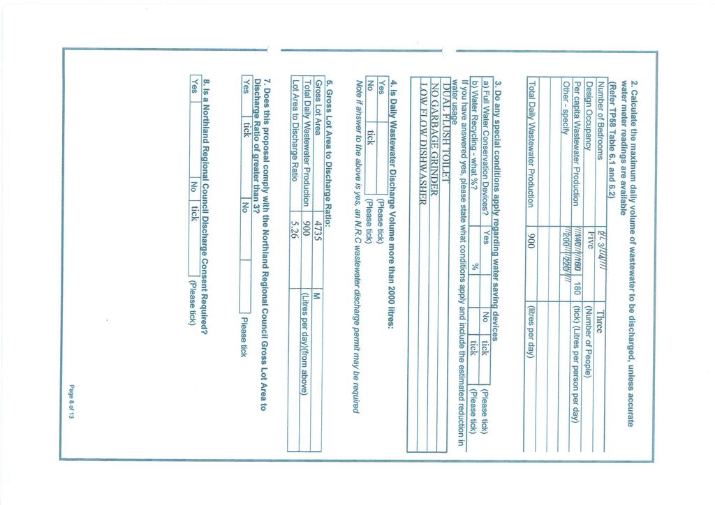
12 Thomson Survey Limited Subdivision Proposal Nov Natural and Other Hazards The property is not shown as being prone to any natural hazard. In regard to other hazards, information regarding the site s use is covered later in this report. 6.4 Water Supply The existing house has its own water supply. If the Council considers it necessary it can impose its standard consent notice in regard to any future water supply requirement for the proposed additional vacant lot. Land in Lot 2 will remain in productive use and I do not believe it warrants the same Consent Notice to be imposed. 6.5 Stormwater Disposal Stormwater is addressed in the Site Suitability Report by Kerikeri Drainage Ltd, attached in Appendix 6. The stormwater on the site is sheet flow towards the open drain on the northern boundary and open roadside drain on the southern boundary. Stormwater overflow from water tanks and hard stand areas associated with the vacant lot can be directed to the overland flowpath which has a large open drain dug through it on the northern boundary Existing drainage ditch running east to west (flow wise) near the rear of proposed Lots 1 & 3. Page 8 Planning Report and Assessment of Environmental Effects Anderson Job # 9381 Keri Downs Road
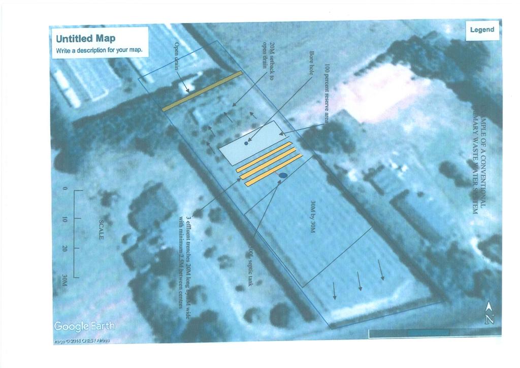
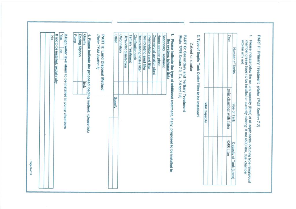
13 Thomson Survey Limited Subdivision Proposal Nov-18 Stormwater from the drive will flow naturally to the open drain on the edge of the right of way on the southern boundary. The existing house s water tank overflow goes to ground, and the new proposed boundary has provided ample scope/distance from the tank to new boundary for that overflow. 6.6 Sanitary Sewage Disposal A report from Kerikeri Drainage Ltd is attached in Appendix 6. The existing wastewater system on proposed Lot 1 is inside the new (stage 2) boundaries and working well. The site has good drainage. With the size of the lot and the type of soil, a conventional wastewater treatment system being a septic tank with shallow media filled trenches for irrigation would suit the new vacant lot. A secondary treated wastewater treatment system could also be installed if that is what the owners require. 6.7 Energy Supply & Telecommunications The existing house has power and telephone. Power and telephone are not a requirement of rural subdivision. Nonetheless, given the proposed vacant property s proximity to services, both Top Energy and Chorus have been consulted to ensure availability of services. Refer Appendix Easements for any purpose Existing easements have been discussed earlier. These will carry over. It is proposed that the larger Lot 2 will own the existing access ROW, with Lots 1 & 3 being dominant tenements over this. 6.9 Effect of Earthworks and Utilities The only earthworks required as part of this proposal will be that associated with the future formation of a crossing into the vacant Lot Building Locations & Amenity Lot 1 supports an existing residence. Lot 2 will likely remain in production, although there is nothing preventing a dwelling being constructed at some time in the future. Lot 3 can accommodate a building anywhere (subject to setback requirements) within the front portion of the site, between the drain and access. There is existing mature screen planting right along the proposed boundary between this lot and house Lot 1. There is no intention of protecting this row of plantings by any formal means, as it is not believed essential for maintaining any amenity or privacy between two adjacent large lots. Lot 3 is currently in small scale blueberry crop, and this is discussed in more detail later in this report. Lot 3 is believed to be sized and designed such that a residential use can establish whilst maintaining a high level of amenity (via gardens and landscaping), and a nice open Page 9 Planning Report and Assessment of Environmental Effects Anderson Job # 9381 Keri Downs Road
14 Thomson Survey Limited Subdivision Proposal Nov-18 space to built environment ratio. It is intended to retain a shed beyond the rear drain and trees within the boundaries of Lot 3. The boundary is set to ensure the 10m minimum setback Preservation of heritage resources, vegetation, fauna and landscape, and land set aside for conservation purposes Flora and Fauna The property is zoned Rural Production. There are no areas of significant indigenous vegetation or habitat within the site. The site is not a high density kiwi area, but is within a vast area identified as kiwi present. I do not consider it necessary to impose a ban on cats and dogs given the surrounding area s current land uses. The Stage 1 larger lot is to be held with an adjoining parcel that has no restrictions. An Advice Note on the consent should be sufficient to advise the consent holder of the need to keep dogs and cat under control. Heritage Resources A search of the NZ Archaeological Association database (ArchSite) has been undertaken. There are no sites shown on the site. There are no identified Site of Cultural Significance to Maori on the site. I believe that it is adequate in this instance to include the standard Advice Note and attachment regarding the Accidental Discovery Protocol Soil The proposal s Stage 1 separates just over 1ha of residential use and small scale blueberry growing from a larger balance area that is to be held in the same Title as adjoining production land. The second stage further subdivides the smaller lot without impact on the ability of the larger combined production land s ability to continue with a production use. I do not believe the subdivision has any adverse effects on the life supporting capacity of soil Access to reserves and waterways There are no reserves or waterways to which access would be required or necessary Land use compatibility (reverse sensitivity) The subdivision does little to change the status quo and I do not believe any additional reverse sensitivity effect will result Other matters (including Schedule 4 matters not addressed elsewhere in this report) Precedent & Cumulative Effects The application is a restricted discretionary activity subdivision and does not therefore create a precedent effect, or any unanticipated cumulative effect. Page 10 Planning Report and Assessment of Environmental Effects Anderson Job # 9381 Keri Downs Road
15 Thomson Survey Limited Subdivision Proposal Nov-18 Positive Effects I believe this subdivision provides for peoples economic and social well being. It provides an opportunity for a future land owner to live and work in an attractive rural setting. Other Schedule 4 matters The application does not include the use of hazardous installations. The application does not include the discharge of any contaminant. The scale and significance of the activity s effects are not such that monitoring is required. The site is not subject to any protected customary right. 7.0 STATUTORY ASSESSMENT 7.1 District Plan Objectives and Policies Objectives and policies relevant to this proposal are those in Chapter 13 of the District Plan (subdivision), along with those applicable to the Rural Production Zone. Being a restricted discretionary activity subdivision, the proposal is deemed consistent with the objectives and policies in the Plan relevant to subdivision. As the proposal is only for subdivision, with no land use anticipated, and that subdivision is a restricted discretionary activity, the proposal would also be deemed to be consistent with objectives and policies relevant to the Rural Production Zone. General consistency with objectives and policies in Chapters 13 and 8.6 is therefore assumed. Subdivision objectives and policies relevant to the application are those related to sustainable management; mitigating adverse effects; amenity values; appropriate design and layout; water supply and stormwater management. These matters are all addressed in Section 6 of this Report (Assessment of Environmental Effects). Rural Production Zone objectives and policies relevant to the application are similarly those related to sustainable management; efficient use of the zone; amenity values; and reverse sensitivity. All of these matters are addressed in Section 6 of this Report. Importantly the proposal preserves the majority of the land for production use. In summary this proposal is an anticipated one within this zone and in this location and is consistent with the objectives and policies of the District Plan. 7.2 Part 2 Matters 5 Purpose Page 11 Planning Report and Assessment of Environmental Effects Anderson Job # 9381 Keri Downs Road
16 Thomson Survey Limited Subdivision Proposal Nov-18 (1) The purpose of this Act is to promote the sustainable management of natural and physical resources. (2) In this Act, sustainable management means managing the use, development, and protection of natural and physical resources in a way, or at a rate, which enables people and communities to provide for their social, economic, and cultural well-being and for their health and safety while (a) sustaining the potential of natural and physical resources (excluding minerals) to meet the reasonably foreseeable needs of future generations; and (b) safeguarding the life-supporting capacity of air, water, soil, and ecosystems; and (c) avoiding, remedying, or mitigating any adverse effects of activities on the environment. 6 Matters of national importance In achieving the purpose of this Act, all persons exercising functions and powers under it, in relation to managing the use, development, and protection of natural and physical resources, shall recognise and provide for the following matters of national importance: (a) the preservation of the natural character of the coastal environment (including the coastal marine area), wetlands, and lakes and rivers and their margins, and the protection of them from inappropriate subdivision, use, and development: (b) the protection of outstanding natural features and landscapes from inappropriate subdivision, use, and development: (c) the protection of areas of significant indigenous vegetation and significant habitats of indigenous fauna: (d) the maintenance and enhancement of public access to and along the coastal marine area, lakes, and rivers: (e) the relationship of Maori and their culture and traditions with their ancestral lands, water, sites, waahi tapu, and other taonga: (f) the protection of historic heritage from inappropriate subdivision, use, and development: (g) the protection of protected customary rights: (h) the management of significant risks from natural hazards. 7 Other matters In achieving the purpose of this Act, all persons exercising functions and powers under it, in relation to managing the use, development, and protection of natural and physical resources, shall have particular regard to (a) (aa) (b) (ba) (c) (d) (e) (f) (g) (h) (i) (j) kaitiakitanga: the ethic of stewardship: the efficient use and development of natural and physical resources: the efficiency of the end use of energy: the maintenance and enhancement of amenity values: intrinsic values of ecosystems: [Repealed] maintenance and enhancement of the quality of the environment: any finite characteristics of natural and physical resources: the protection of the habitat of trout and salmon: the effects of climate change: the benefits to be derived from the use and development of renewable energy. Page 12 Planning Report and Assessment of Environmental Effects Anderson Job # 9381 Keri Downs Road
17 Thomson Survey Limited Subdivision Proposal Nov-18 8 Treaty of Waitangi In achieving the purpose of this Act, all persons exercising functions and powers under it, in relation to managing the use, development, and protection of natural and physical resources, shall take into account the principles of the Treaty of Waitangi (Te Tiriti o Waitangi). As a restricted discretionary activity, the proposal is one envisaged by the District Plan. The Far North District Plan was written to be consistent with all matters raised in Part 2 and therefore it is not necessary to have further recourse to Part 2 of the District Plan. 7.3 National Policy Statements There are no relevant national policy statements. 7.4 National Environmental Standards The Regional Council s Selected Land Use Sites on-line maps show the Plant and Food Research site at the end of Keri Downs Road as a HAIL site classes A1 Agrichemicals including spray contractors commercial premises; and A10 persistent pesticide bulk storage or use. This is not the site being subdivided but is land associated with the title with which the Stage 1 Lot 2 is to be held. There is no need to consider the land under the NES-CS, because the proposal does not subdivide the land in a manner that prevents it from being in production use. Stage 1 Lot 2 of 6.38ha supports existing horticultural use and the subdivision does not change that use, so again, this land is not covered by the NES. Lots 1 and 3 support recently established blueberries. The owners (and applicant) have provided a written statement about this activity and the historic use of the land in Lots 1 and 3. Refer to Appendix 8. Kocide is a copper-based fungicide product, approved for use on organic crops. (Source: DC Tron oil is a fungal preventative spray oil. To the best of my knowledge, neither product is regarded as a persistent pesticide. Buster weed control is a product noted as a common herbicide on the DoC s website under common herbicides used to control weeds (Source: It is listed as being a systemic contact herbicide (via the leaf) with no residual life in the soil. It is therefore not a persistent pesticide. I am of the opinion that, based on the above descriptions and statement from the applicant, the land in Lots 1 & 3 is not a piece of land that is HAIL. Therefore the NES-CS does not apply. 7.5 Regional Policy Statement for Northland In preparing this application, the Regional Policy Statement for Northland has been considered, in particular those Objectives and Policies relevant to rural subdivision. The site is not identified within the Regional Policy Statement as having any outstanding or high natural character values. The proposal does not result in any need for vegetation clearance. Page 13 Planning Report and Assessment of Environmental Effects Anderson Job # 9381 Keri Downs Road
18 Thomson Survey Limited Subdivision Proposal Nov-18 The proposal enables economic wellbeing, does not result in significant or additional reverse sensitivity effects, and allows current productive use of the land to continue. It does not significantly impact on the ability of the land to used for productive purposes and does not sterilise or fragment productive land to any significant degree. I believe the proposal to be consistent with objectives and policies in the Regional Policy Statement. 7.6 Regional Water & Soil Plan and Proposed Regional Plan The property is not erosion prone. The subdivision itself does not result in any need for a discharge consent or land use consent for land use disturbance. As such, it is considered that neither the Regional Water and Soil Plan, nor the Proposed Regional Plan, are relevant in this instance. 8.0 CONSULTATION/ AFFECTED PERSONS As a restricted discretionary activity and not, in my opinion, adversely impacting on any adjacent land to a minor or more than minor degree, no consultation has been undertaken with any adjacent landowner. Access is existing and already formed to an appropriate standard, as is the crossing. I believe other users of the access are not adversely affected by the proposal. 9.0 CONCLUSION The site is considered suitable for the proposed subdivision, and effects on the wider environment are no more than minor. The proposal is consistent with the relevant objectives and policies of the District Plan and the Regional Policy Statement as well as Part 2 of the Resource Management Act. No special circumstances have been identified that would suggest public notification is required, which is precluded in any event because the subdivision is a restricted discretionary activity. No affected persons are identified. I request that the Council grant consent to this subdivision non notified under delegated authority. Signed Dated. 14 th November 2018 Lynley Newport, Senior Planner Thomson Survey Ltd Page 14 Planning Report and Assessment of Environmental Effects Anderson Job # 9381 Keri Downs Road
19 Thomson Survey Limited Subdivision Proposal Nov LIST OF APPENDICES APPENDIX 1 APPENDIX 2 Scheme Plan(s) Location Map APPENDIX 3 Certificates of Title x 2 APPENDIX 4 C APPENDIX 5 C & C APPENDIX 6 APPENDIX 7 APPENDIX 8 Site Suitability Report Consultation with Top Energy & Chorus Statement from Applicant NES-CS Page 15 Planning Report and Assessment of Environmental Effects Anderson Job # 9381 Keri Downs Road
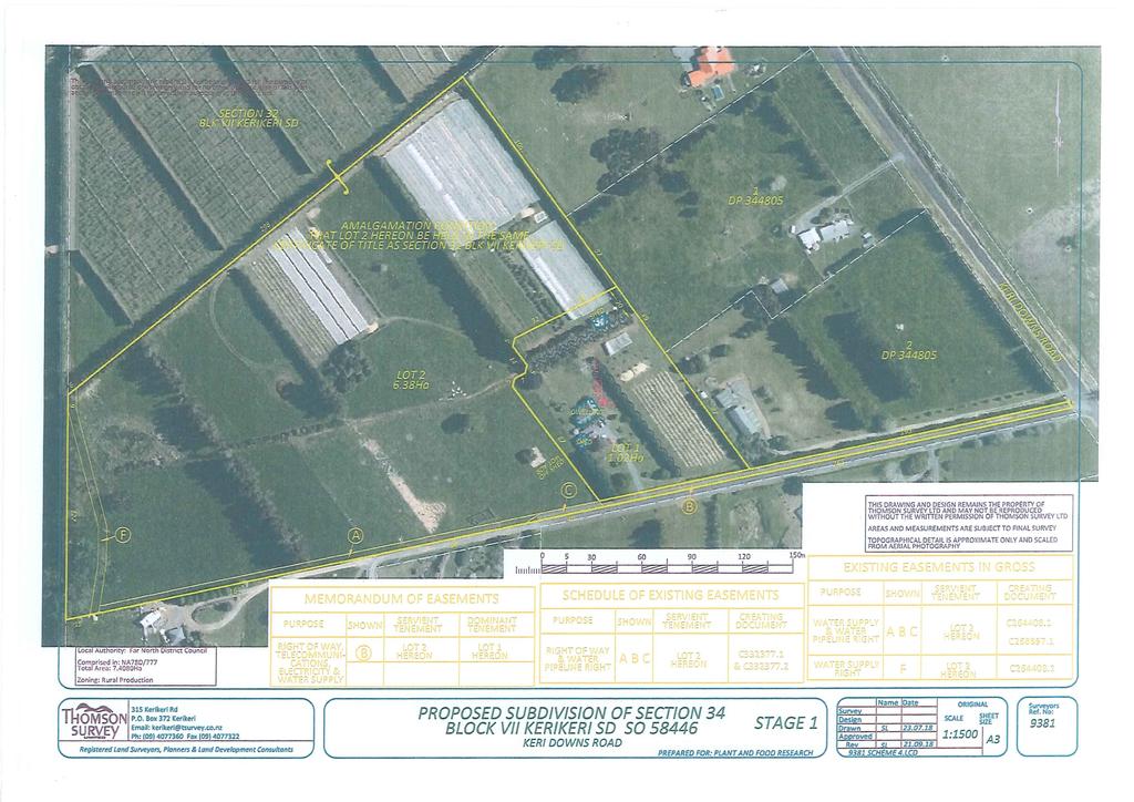
20 Thomson Survey Limited Subdivision Proposal Nov-18 APPENDIX 1 Scheme Plan(s) Page 16 Planning Report and Assessment of Environmental Effects Anderson Job # 9381 Keri Downs Road
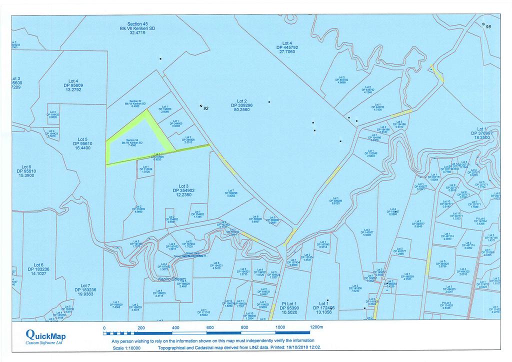
21 Thomson Survey Limited Subdivision Proposal Nov-18 APPENDIX 2 Location Map Page 17 Planning Report and Assessment of Environmental Effects Anderson Job # 9381 Keri Downs Road
22 Thomson Survey Limited Subdivision Proposal Nov-18 APPENDIX 3 Certificates of Title (x2) Page 18 Planning Report and Assessment of Environmental Effects Anderson Job # 9381 Keri Downs Road
23 Thomson Survey Limited Subdivision Proposal Nov-18 APPENDIX 4 C Page 19 Planning Report and Assessment of Environmental Effects Anderson Job # 9381 Keri Downs Road
24 Thomson Survey Limited Subdivision Proposal Nov-18 APPENDIX 5 C & C Page 20 Planning Report and Assessment of Environmental Effects Anderson Job # 9381 Keri Downs Road
25 Thomson Survey Limited Subdivision Proposal Nov-18 APPENDIX 6 Site Suitability Report Page 21 Planning Report and Assessment of Environmental Effects Anderson Job # 9381 Keri Downs Road
26 Thomson Survey Limited Subdivision Proposal Nov-18 APPENDIX 7 Consultation with Top Energy & Chorus Page 22 Planning Report and Assessment of Environmental Effects Anderson Job # 9381 Keri Downs Road
27 Thomson Survey Limited Subdivision Proposal Nov-18 APPENDIX 8 Statement from Applicant (NES-CS) Page 23 Planning Report and Assessment of Environmental Effects Anderson Job # 9381 Keri Downs Road
28
29
30
31
32
33
34
35
36
37
38
39
40
41
42
43
44
45
46
47
48
49
50
51
52
53
54
55
56
57
58
59
60
61
62

63
64
65
66
67
68

69
70

71
72
73
74

75

76
77
78
79
80
81
82
83
ThoMSON. SURVE LI MI re D. 8844*ati,J{ 5 ; 2 '. r 1
 Z 0 n. *013* ThoMSON SURVE LI MI re D 2(9062-4 Our reference: 9310.1(FNDC) 30 April 2018 Resource Consents Department Far North District Council JB Centre Kerikeri Road 8844*ati,J{ 5 ; 2 '. r 1 RE: Potter
Figure 1 below shows the subdivision process. [Ministry for the Environment Quality Planning website]
![Figure 1 below shows the subdivision process. [Ministry for the Environment Quality Planning website]](/thumbs/87/97093311.jpg "Figure 1 below shows the subdivision process. [Ministry for the Environment Quality Planning website]") 13 SUBDIVISION CONTEXT The Far North District Council is responsible for issuing two types of resource consents land use consents and subdivision consents. In many cases both types of consents must be
13 SUBDIVISION CONTEXT The Far North District Council is responsible for issuing two types of resource consents land use consents and subdivision consents. In many cases both types of consents must be
APPLICATION FOR RESOURCE CONSENT OR FAST-TRACK RESOURCE CONSENT
 Office Use Only Application Number: APPLICATION FOR RESOURCE CONSENT OR FAST-TRACK RESOURCE CONSENT (Or Associated Consent Pursuant to the Resource Management Act 1991 (RMA)) (If applying for a Resource
PART SIXTEEN - SUBDIVISION AND DEVELOPMENT
 16.1 24 July 2010 PART SIXTEEN - SUBDIVISION AND DEVELOPMENT 1. INTRODUCTION Council has the statutory responsibility to control subdivision of land and the effects of land use throughout the District.
Section 12A Purpose of Subdivision Provisions
 Section 12A 12A Purpose of Subdivision Provisions Subdivision is primarily about creating land parcels that define and redefine property rights and, in most instances, the creation of new parcels of land
Form 10 APPLICATION FOR CHANGE OR CANCELLATION OF RESOURCE CONSENT CONDITION. Section 127, Resource Management Act 1991
 Form 10 APPLICATION FOR CHANGE OR CANCELLATION OF RESOURCE CONSENT CONDITION To Far North District Council : Section 127, Resource Management Act 1991 We, Bruce Robin Ansley and Justine Anne Marra, apply
Sanctuary North Ltd Cove Rd - Mangawhai Proposed Subdivisions, Changes to Consent Conditions and Consent Notice
 Sanctuary North Ltd Cove Rd - Mangawhai Proposed Subdivisions, Changes to Consent Conditions and Consent Notice Resource Consent Applications Assessment of Environmental Effects August 2016 REPORT INFORMATION
Gisborne District Council
 12.0 SUBDIVISION... 1 12.1 INTRODUCTION... 1 12.2 ISSUE... 1 12.3 OBJECTIVE (SUBDIVISION)... 1 12.4 POLICIES (SUBDIVISION)... 2 12.5 METHODS OF IMPLEMENTATION... 4 12.5.1 REGULATION... 4 12.6 RULES FOR
PAPAKAINGA DISTRICT WIDE ACTIVITY
 SECTION 13.1 PAPAKAINGA DISTRICT WIDE ACTIVITY 13.1.1 INTRODUCTION The Resource Management Act 1991 introduced specific and new obligations for those exercising functions and powers under the Act to provide
Resource Consent Application Form
 Resource Consent Application Form Section 88 of the Resource Management Act 1991. This form provides us with your contact information and details about your proposal. Please print clearly and complete
Activities which do not satisfy the General Rules and are not provided for as Restricted Discretionary activities... 9
 16.0 PAPAKAINGA AND MARAE SETTLEMENTS... 1 16.1 INTRODUCTION... 1 16.2 ISSUES... 1 16.3 OBJECTIVE (PAPAKAINGA)... 2 16.4 POLICIES (PAPAKAINGA)... 2 16.5 OBJECTIVE (SURROUNDING ENVIRONMENT)... 2 16.6 POLICIES
PALMERSTON NORTH CITY SECTIONAL DISTRICT PLAN REVIEW PROPOSED PLAN CHANGE 2: CLIFF PROTECTION LINE
 PALMERSTON NORTH CITY SECTIONAL DISTRICT PLAN REVIEW PROPOSED PLAN CHANGE 2: CLIFF PROTECTION LINE PART I DESCRIPTION OF PROPOSED PLAN CHANGE This proposed Plan Change seeks to amend the Cliff Protection
Build Over Easement Guidelines
 Build Over Easement Guidelines Document Owner Creation Date 13/04/2015 Revision Date 20/04/2015 Manager Engineering Services Engineering Services Please check Council s Intranet to ensure this is the latest
Section 11 Land Subdivision #
 Section 11 Land Subdivision # 11.1 General Features 11-1 11.1.1 Land Ownership 11-1 11.1.2 Subdivision Patterns 11-1 11.2 Legislative Considerations 11-2 11.2.1 Resource Management Act 11-2 11.3 Management
Volume Three Appendix 7. Scheme Plan and other subdivision requirements
 Volume Three Appendix 7 Appendix 7 Scheme Plan and other subdivision requirements Any application for subdivision consent must be accompanied by a Scheme Plan that contains the information set out in this
Riverton Properties Ltd Proposed Special Housing Area
 Riverton Properties Ltd Proposed Special Housing Area Housing Accords and Special Housing Areas Act 2013 Expression of Interest 1 This Expression of Interest is made on behalf of Riverton Properties Ltd,
DRAFT PROPOSED CHAPTER 21 SPECIFIC PURPOSE - FLAT LAND RECOVERY ZONE
 DRAFT PROPOSED CHAPTER 21 SPECIFIC PURPOSE - FLAT LAND RECOVERY ZONE Note: The Specific Purpose (Flat Land Recovery) Zone is a "holding" zone that will be subject to a later plan change to confirm the
Application for Outline Plan / Outline Plan Waiver Section 176A, Resource Management Act
 Email: applications@waidc.govt.nz www.waikatodistrict.govt.nz Telephone (all hours) 07 824 8633 Call Free 0800 492 452 District Office 15 Galileo Street Private Bag 544 Ngaruawahia 3742 Application for
Explanation The policies ensure that land is suitable for subdivision and will not increase risks to people, the environment and property.
 23 Subdivision 23.1 Purpose a) Subdivision is essentially the process of dividing a parcel of land or a building into one or more further parcels, or changing an existing boundary location. Subdivision
15.1 Introduction. Waipa District Plan. Section 15 - Infrastructure, Hazards, Development and Subdivision. Page Version - 1 November 2016 Page 1 of 56
 15.1 Introduction 15.1.1 How and where development and subdivision occurs is critical to the sustainable management of the District s natural and physical resources. This section of the Plan focuses on
SECTION B - GUIDELINES
 SECTION B - GUIDELINES APPLICATION KIT FOR SUBDIVISION RESOURCE CONSENT UNDER SECTION 88 OF THE RESOURCE MANAGEMENT ACT 1991 CONTENTS: PLEASE READ AND COMPLETE 1. Making an Application for a Subdivision
E38. Subdivision - Urban
 E38. Subdivision - Urban E38.1. Introduction Subdivision is the process of dividing a site or a building into one or more additional sites or units, or changing an existing boundary location. Objectives,
Section Three, Part 9 - Subdivision
 PART 9 SUBDIVISION SUBDIVISION AND DEVELOPMENT OF LAND 9.1 INTRODUCTION This part of the District Plan sets out the provisions in respect of the subdivision and development of land in the urban part of
Landuse Consent Subdivision Consent Certificate of Compliance Variation/Cancellation of Consent Conditions Outline Plan Waiver
 Resource Consent Application for resource consent Form 9, Resource Management Act 1991 All sections of this form must be completed before your application can be assessed. Information required to accompany
Application for Resource Consent (Subdivision) Section 88, Resource Management Act 1991 Form 9
 Section 88, Resource Management Act 1991 Form 9") Email: applications@waidc.govt.nz www.waikatodistrict.govt.nz Telephone (all hours) 07 824 8633 Call Free 0800 492 452 District Office 15 Galileo Street Private Bag 544 Ngaruawahia 3742 Application for
Email: applications@waidc.govt.nz www.waikatodistrict.govt.nz Telephone (all hours) 07 824 8633 Call Free 0800 492 452 District Office 15 Galileo Street Private Bag 544 Ngaruawahia 3742 Application for
SUBDIVISION, DEVELOPMENT AND EARTHWORKS
 PROPOSED CHAPTER 8 SUBDIVISION, DEVELOPMENT AND EARTHWORKS Chapter 8 Subdivisions - Proposed Changes to delete all draft provisions under the Residential Established New Neighbourhood Zone and replace
Longreach Developments Limited
 1 APPLICATION FOR RESOURCE CONSENT UNDER SECTION 88 OF THE RESOURCE MANAGEMENT ACT 1991 TO: THAMES COROMANDEL DISTRICT COUNCIL Longreach Developments Limited c/- Brown and Company, PO Box 91-839, Auckland
RURAL SETTLEMENT ZONE - RULES
 Chapter 38 RURAL SETTLEMENT ZONE - RULES INTRODUCTION This Chapter contains rules managing land uses in the. The boundaries of this zone are shown on the planning maps. There is limited opportunity for
H18. Future Urban Zone
 H18. Future Urban Zone H18.1. Zone description The Future Urban Zone is applied to greenfield land that has been identified as suitable for urbanisation. The Future Urban Zone is a transitional zone. Land
Presentation to the Real Estate Institute of New Zealand 28 October 2016
 Presentation to the Real Estate Institute of New Zealand 28 October 2016 Disclaimer This presentation provides a high level overview of specific parts of the Proposed Auckland Unitary Plan Decisions Version
R16.01a Motiti Avocados Ltd - Report Pursuant to Section 42A RMA
 R16.01a Motiti Avocados Ltd - Report Pursuant to Section 42A RMA 1. Background Beca Ltd has been commissioned by the Department of Internal Affairs (DIA) to process a Resource Consent for the subdivision
Division 5 Residential Low Density Zone: Assessment Criteria and Assessment Tables
 Division 5 Residential Low Density Zone: Assessment Criteria and Assessment Tables 4.5.1 Residential Low Density Zone The provisions in this division relate to the Residential Low Density Zone as follows
Guide to Subdivision and Land Development
 Guide to Subdivision and Land Development Fraser Thomas Ltd......is an engineering and surveying consulting firm based in Highbrook which has provided Surveying, Engineering, Planning and Resource Management
Letter of Intent May 2017 (Revised November 2017)
") THE BEACH AT WOODMOOR LETTER OF INTENT MAY 2017 (REVISED NOVEMBER 2017) OWNER/APPLICANT: CONSULTANT: Lake Woodmoor Holdings LLC N.E.S. Inc. 1755 Telstar Drive, Suite 211 619 North Cascade Avenue Colorado
THE BEACH AT WOODMOOR LETTER OF INTENT MAY 2017 (REVISED NOVEMBER 2017) OWNER/APPLICANT: CONSULTANT: Lake Woodmoor Holdings LLC N.E.S. Inc. 1755 Telstar Drive, Suite 211 619 North Cascade Avenue Colorado
HOW TO APPLY FOR A USE PERMIT
 HOW TO APPLY FOR A USE PERMIT MENDOCINO COUNTY PLANNING AND BUILDING SERVICES What is the purpose of a use permit? Throughout the County, people use their properties in many different ways. They build
Community Occupancy Guidelines
 Community Occupancy Guidelines Auckland Council July 2012 Find out more: phone 09 301 0101 or visit www.aucklandcouncil.govt.nz Contents Introduction 4 Scope 5 In scope 5 Out of scope 5 Criteria 6 Eligibility
Nga Potiki is a Treaty Settlement tribe with mana whenua over the Te Maunga, Mangatawa, Rangataua and Papamoa areas.
 THE NGA POTIKI HOUSING DEVELOPMENT PROPOSAL SPECIAL HOUSING AREA PROPOSAL 6 October 2014 Overview of proposal Nga Potiki plan to develop approximately 27 hectares of land in Papamoa for residential housing.
Flinders Avenue, Lara Planning Scheme Amendment Combined Application for Rezoning and Multi-Lot Subdivision Reference : Decembe
 143-179 Flinders Avenue, Lara Planning Scheme Amendment Combined Application for Rezoning and Multi-Lot Subdivision Reference: 14134-03 TGM Group Geelong Melbourne Ballarat 1/27-31 Myers Street (PO Box
ACCESSORY DWELLING UNITS
 ACCESSORY DWELLING UNITS LAND USE BYLAW C-4841-97 ACCESSORY DWELLING UNIT (ADU): means a subordinate dwelling unit attached to, created within or detached from the principal dwelling, single detached,
DRAFT FOR PUBLIC HEARING (rev. March, 2016)
") Chapter 200. ZONING Article VI. Conservation/Cluster Subdivisions 200-45. Intent and Purpose These provisions are intended to: A. Guide the future growth and development of the community consistent with
Chapter 200. ZONING Article VI. Conservation/Cluster Subdivisions 200-45. Intent and Purpose These provisions are intended to: A. Guide the future growth and development of the community consistent with
LIM Application for 1/ 240 Hurstmere Road Takapuna 0622
 21 October 2015 G Bogiatto and B J Malcolm 23B Riverside Road OREWA 0931 LIM Application for 1/ 240 Hurstmere Road Takapuna 0622 This Land Information Memorandum (LIM) details information known to Council
STAFF REPORT. Financial Impact Statement There are no immediate financial impacts associated with the adoption of this report.
 STAFF REPORT Planning and Development Department Subject: Cottage Country Unsubstantial Amendment to Development Agreement To: CAO for Planning Advisory Committee, December 13, 2016 Date Prepared: December
Town of Falmouth s Four Step Design Process for Subdivisions in the Resource Conservation Zoning Overlay District
 Town of Falmouth s Four Step Design Process for Subdivisions in the Resource Conservation Zoning Overlay District All subdivisions shall be designed in accordance with the following four-step process.
A. Preserve natural resources as identified in the Comprehensive Plan.
 1370.08 Conservation Residential Overlay District. Subd. 1 Findings. The City finds that the lands and resources within the Conservation Residential Overlay District are a unique and valuable resource
Chapter 17.2 Papakainga and Maori Purpose Areas Page 1
 Chapter 17.2 Papakainga and Maori Purpose Areas Page 1 Chapter 17.2 Papakainga and Maori Purpose Areas 17.2.1 Introduction 17.2.1.1 Background The tangata whenua of Manukau include various tribal and sub-tribal
RESERVE REVOCATION FOR HUNDERTWASSER PROJECT Ruben Wylie - Manager - Infrastructure Planning
 MEETING: COUNCIL - 10 AUGUST 2017 Name of item: Author: Date of report: 09 June 2017 Document number: Executive Summary RESERVE REVOCATION FOR HUNDERTWASSER PROJECT Ruben Wylie - Manager - Infrastructure
ARTICLE 3 DEFINITIONS
 Sections: 3-1 Rules of Construction 3-2 Definitions ARTICLE 3 DEFINITIONS SECTION 3-1 RULES OF CONSTRUCTION 3-101. a. The language set forth in these regulations shall be interpreted in accordance with
Residential Project Convenience Facilities
 Standards for Specific Land Uses 35.42.220 E. Findings. The review authority shall approve a Land Use Permit in compliance with Subsection 35.82.110.E (Findings required for approval) or a Conditional
ARTICLE 7. SPECIFIC USE STANDARDS
 ARTICLE 7. SPECIFIC USE STANDARDS Section 7.1 Applicability The following standards apply to specified uses in all zoning districts in which such uses are allowed. Section 7.2 Accessory Apartments (A)
GUIDE TO SUBDIVISION & LAND DEVELOPMENT
 GUIDE TO SUBDIVISION & LAND DEVELOPMENT The Fraser Thomas Difference: Fraser Thomas Ltd is an engineering and surveying consulting firm based in Highbrook, and has been providing; Surveying, Engineering,
CONSERVATION COVENANT (Section 77 Reserves Act 1977) IN RESPECT OF IDENTIFIED (NA???/???)
 IN RESPECT OF IDENTIFIED (NA???/???)") CONSERVATION COVENANT (Section 77 Reserves Act 1977) IN RESPECT OF IDENTIFIED (NA???/???) BETWEEN AND Insert the landowner names here (Please use capital, bold letters and check that the landowner is the
CONSERVATION COVENANT (Section 77 Reserves Act 1977) IN RESPECT OF IDENTIFIED (NA???/???) BETWEEN AND Insert the landowner names here (Please use capital, bold letters and check that the landowner is the
PLANNING RATIONALE REPORT
 PLANNING RATIONALE REPORT Zoning By-law Amendment Application 2920 Danbury Way Prepared for: Bravar Custom Builders Inc. and Village View Estates Ltd. by: 6393 Roslyn Street Ottawa (Orleans), Ontario K1C
A.3. ARTICLE 7 PLAN REQUIREMENTS FOR MINOR SUBDIVISION AND/OR LAND DEVELOPMENT
 700. 701.A.3. ARTICLE 7 PLAN REQUIREMENTS FOR MINOR SUBDIVISION AND/OR LAND DEVELOPMENT SECTION 700 PURPOSE The purpose of this Article is to set forth a streamlined set of Plan Requirements for minor
building or renovating your home?
 Thinking about... building or renovating your home? What you should know before you start. What you should know before you start... Building or renovating your home can be a very exciting time. You need
H5. Residential Mixed Housing Urban Zone
 H5. Residential Mixed Housing Urban Zone [ENV-2016-AKL-000197: Robert Adams] Addition sought H5.1. Zone description The Residential Mixed Housing Urban Zone is a reasonably high-intensity zone enabling
Conceptual Scheme SE W4
 December 2012 1. PURPOSE 1.1. The purpose of a Conceptual Scheme (CS) is as follows: a) To provide a framework for the subsequent subdivision and/or development of land within the Country Residential Policy
Inverness Area Planning Advisory Committee Inverness County Planning Advisory Committee Inverness County Council Planning Staff (EDPC)
") STAFF REPORT To: From: Inverness Area Planning Advisory Committee Inverness County Planning Advisory Committee Inverness County Council Planning Staff (EDPC) Date: January 18, 2018 Reference: Request for
STAFF REPORT To: From: Inverness Area Planning Advisory Committee Inverness County Planning Advisory Committee Inverness County Council Planning Staff (EDPC) Date: January 18, 2018 Reference: Request for
A Guide to the Municipal Planning Process in Saskatchewan
 A Guide to the Municipal Planning Process in Saskatchewan A look at the municipal development permit and the subdivision approval process in Saskatchewan May 2008 Prepared By: Community Planning Branch
LAND USE PROCEDURES (LUP) BYLAW NO. 1235, 2007
 BYLAW NO. 1235, 2007") TOWN OF OSOYOOS LAND USE PROCEDURES (LUP) BYLAW NO. 1235, 2007 Adopted August 13, 2007 PART 1 PART 2 PART 3 PART 4 PART 5 PART 6 PART 7 PART 8 TABLE OF CONTENTS Index provided for ease of use and was not
TOWN OF OSOYOOS LAND USE PROCEDURES (LUP) BYLAW NO. 1235, 2007 Adopted August 13, 2007 PART 1 PART 2 PART 3 PART 4 PART 5 PART 6 PART 7 PART 8 TABLE OF CONTENTS Index provided for ease of use and was not
Central Lathrop Specific Plan
 Addendum to the Draft Environmental Impact Report for the Central Lathrop Specific Plan SCH# 2003072132 Prepared for City of Lathrop Prepared by December 2005 Addendum to the Draft Environmental Impact
PLANNING REPORT. Prepared for: John Spaleta 159 Delatre Street Woodstock Ontario N4S 6C2
 PLANNING REPORT County Official Plan Amendment and Zoning By-law Amendment to Permit a Seasonal Dwelling on an Existing Lot of Record with Access onto a Seasonally Maintained Road Parts of Lot 29, Concession
Larimer County Planning Dept. Procedural Guide for 1041 PERMITS
 - Larimer County Planning Dept. Procedural Guide for 1041 PERMITS PLEASE NOTE: A PRE-APPLICATION CONFERENCE IS REQUIRED PRIOR TO SUBMITTING THIS APPLICATION. PURPOSE: State Statutes allow local governments
Draft Neighbourhood Plan for the former Land Settlement Association Estate at Great Abington March 2017
 Draft Neighbourhood Plan for the former Land Settlement Association Estate at Great Abington March 2017 1 Neighbourhood Plan Contents 1 Why a Neighbourhood Plan for the former Abington Land Settlement
Chapter 100 Planned Unit Development in Corvallis Urban Fringe
 100.100 Scope and Purpose. Chapter 100 Planned Unit Development in Corvallis Urban Fringe (1) All applications for land divisions in the Urban Residential (UR) and Flood Plain Agriculture (FPA) zones within
RURAL GENERAL RG 1. PERMITTED USES DISCRETIONARY USES
 RURAL GENERAL RG PURPOSE: To protect the agricultural land base of the municipality while allowing nonagricultural developments which complement the area's economy. 1. PERMITTED USES DISCRETIONARY USES
Subdivision & Development Subdivision and Development Explanatory Statement Significant Issues... 3
 Section Contents Subdivision & Development... 2 12. Subdivision and Development... 2 Explanatory Statement... 2 12.1 Significant Issues... 3 12.2 Objectives and Policies... 4 12.3 Rules... 6 12.4 Activity
MINOR SUBDIVISION INFORMATION
 A. POINTS OF CONTACT: MINOR SUBDIVISION INFORMATION Surveyor: Address: Phone #: Fax # E-Mail Address: Representative (If different from applicant): Address: Phone #: Fax # E-Mail Address: B. GENERAL INFORMATION:
Request for Development Land in the Palm Springs Subdivision to be Granted Special Housing Area Status under the Tauranga Housing Accord
 Request for Development Land in the Palm Springs Subdivision to be Granted Special Housing Area Status under the Tauranga Housing Accord Development Proposal Overview of proposal This request is lodged
Proposed Plan Change 8 Technical Amendments. Section 32 Evaluation Report. Waikato Section, Waikato District Plan
 Proposed Plan Change 8 Technical Amendments Section 32 Evaluation Report Waikato Section, Waikato District Plan Waikato District Plan To be Notified 17 October 2015 Plan Change 8 Technical Amendments Section
H5. Residential Mixed Housing Urban Zone
 H5. Residential Mixed Housing Urban Zone H5.1. Zone description The Residential Mixed Housing Urban Zone is a reasonably high-intensity zone enabling a greater intensity of development than previously
Municipality of Colchester. Subdivision Bylaw. March 31, Colchester
 Municipality of Colchester Subdivision Bylaw March 31, 2010 Colchester Municipality of the County of Colchester Subdivision Bylaw (Consolidated Edition) Revisions Adopted by Council January 28, 2010 Effective
CHAPTER 3 PRELIMINARY PLAT
 10-3-1 10-3-3 SECTION: CHAPTER 3 PRELIMINARY PLAT 10-3-1: Consultation 10-3-2: Filing 10-3-3: Requirements 10-3-4: Approval 10-3-5: Time Limitation 10-3-6: Grading Limitation 10-3-1: CONSULTATION: Each
MAKING THE MOST EFFECTIVE AND SUSTAINABLE USE OF LAND
 165 SOC146 To deliver places that are more sustainable, development will make the most effective and sustainable use of land, focusing on: Housing density Reusing previously developed land Bringing empty
ARTICLE 7: PLOT PLANS AND SITE PLAN REQUIREMENTS AND REVIEW
 ARTICLE 7: PLOT PLANS AND SITE PLAN REQUIREMENTS AND REVIEW Section 7.0 - Purpose The purpose of this article is to specify the documents and/or drawings required for a Site Plan Review or a Plot Plan
SCHEDULE 12 TO THE URBAN GROWTH ZONE. Shown on the planning scheme map as UGZ12. Kororoit Precinct Structure Plan
 SCHEDULE 12 TO THE URBAN GROWTH ZONE Shown on the planning scheme map as UGZ12. Kororoit Precinct Structure Plan 1.0 The plan Map 1 below shows the future urban structure proposed in the Kororoit Precinct
COUNTY OF BRANT DEVELOPMENT SERVICES DEPARTMENT COMMITTEE OF ADJUSTMENT. Chair and Members of the Committee of Adjustment
 COUNTY OF BRANT DEVELOPMENT SERVICES DEPARTMENT COMMITTEE OF ADJUSTMENT TO: FROM: Chair and Members of the Committee of Adjustment Ruchika Angrish, Senior Planner DATE: January 23, 2014 REPORT: CA-14-06
PLANNING SUBMISSION & CLAUSE 56 ASSESSMENT RESIDENTIAL SUBDIVISION OF LAND 1525 POUND ROAD, CLYDE NORTH (LOT 2 PS F, SIENNA PARK ESTATE)
") PLANNING SUBMISSION & CLAUSE 56 ASSESSMENT RESIDENTIAL SUBDIVISION OF LAND 1525 POUND ROAD, CLYDE NORTH (LOT 2 PS 327975F, SIENNA PARK ESTATE) DFC (PROJECT MANAGEMENT) PTY LTD (A DENNIS FAMILY CORPORATION
PLANNING SUBMISSION & CLAUSE 56 ASSESSMENT RESIDENTIAL SUBDIVISION OF LAND 1525 POUND ROAD, CLYDE NORTH (LOT 2 PS 327975F, SIENNA PARK ESTATE) DFC (PROJECT MANAGEMENT) PTY LTD (A DENNIS FAMILY CORPORATION
RESIDENTIAL AND RECREATIONAL
 Energy, Mines & Resources Land Management Branch 320-300 Main Street Whitehorse, Yukon Y1A 2B5 667-5215 Fax 667-3214 www.emr.gov.yk.ca RESIDENTIAL AND RECREATIONAL Lot Enlargement Policy OBJECTIVE To facilitate
Guide to Preliminary Plans
 Guide to Preliminary Plans Introduction The Douglas County is committed to providing open, transparent application processes to the public. This Guide is provided to assist anyone interested in the procedures
ARTICLE 13 CONDOMINIUM REGULATIONS
 ARTICLE 13 CONDOMINIUM REGULATIONS Section 13.01 Purpose. The purpose of this Article is to regulate projects that divide real property under a contractual arrangement known as a condominium. New and conversion
Appendix A. Definitions
 Definitions 1. Terms Defined. Words contained in this are those having a special meaning relative to the purposes of this Ordinance. Words not listed in this section shall be defined by reference to: (1)
Condominium Unit Requirements.
 ARTICLE 19 CONDOMINIUM REGULATIONS Section 19.01 Purpose. The purpose of this Article is to regulate projects that divide real property under a contractual arrangement known as a condominium. New and conversion
Implementation Tools for Local Government
 Information Note #5: Implementation Tools for Local Government This Information Note is a guide only. It is not a substitute for the federal Fisheries Act, the provincial Riparian Areas Regulation, or
ERECTION OF 42 NO. HOUSING UNITS (OUTLINE) AT Reserve Sites A And D, Hindhead Knoll, Walnut Tree FOR English Partnerships
 AT Reserve Sites A And D, Hindhead Knoll, Walnut Tree FOR English Partnerships") 05/01386/OUT ERECTION OF 42 NO. HOUSING UNITS (OUTLINE) AT Reserve Sites A And D, Hindhead Knoll, Walnut Tree FOR English Partnerships INTRODUCTION The 13 Week Date for the determination of this major
05/01386/OUT ERECTION OF 42 NO. HOUSING UNITS (OUTLINE) AT Reserve Sites A And D, Hindhead Knoll, Walnut Tree FOR English Partnerships INTRODUCTION The 13 Week Date for the determination of this major
CITY OF FORT COLLINS NATURAL AREAS AND CONSERVED LANDS EASEMENT POLICY
 CITY OF FORT COLLINS NATURAL AREAS AND CONSERVED LANDS EASEMENT POLICY Adopted January 3, 2012 PURPOSE: The purpose of the policy statement is to clarify the policies and procedures of the City of Fort
Section 7 Subdivision
 78 Section 7 Subdivision 79 Palmerston North City Council District Plan March 2010 Proposed Draft Amendments to Section 7: Subdivision Note: new text to be added to the District Plan is shown as coloured
TENTATIVE MAP INFORMATION SHEET
 TENTATIVE MAP INFORMATION SHEET GENERAL INFORMATION This information sheet explains how your Tentative Map application will be processed, what fees you must pay, and what plans you must submit. If you
CHARLOTTE PLANNING COMMISSION FINDINGS OF FACT AND DECISION IN RE APPLICATION OF. George R. Aube 1450 Dorset Street
 CHARLOTTE PLANNING COMMISSION FINDINGS OF FACT AND DECISION IN RE APPLICATION OF George R. Aube 1450 Dorset Street Final Plan Review For A Two-Lot Subdivision Application # PC-13-19 Background The Planning
Division 4 Large Lot Residential Zone: Assessment Criteria and Assessment Tables
 Division 4 Large Lot Residential Zone: Assessment Criteria and Assessment Tables 4.4.1 Large Lot Residential Zone The provisions in this division relate to the Large Lot Residential Zone as follows overall
Kitsap County Department of Community Development. Notice of Administrative Decision
 Kitsap County Department of Community Development Notice of Administrative Decision Date: March 27, 2018 To: Tammy Mabry, tammystattoostudio@gmail.com Interested Parties and Parties of Record RE: Permit
CONDOMINIUM REGULATIONS
 ARTICLE 37 CONDOMINIUM REGULATIONS SECTION 37.01. Purpose The purpose of this Article is to regulate projects that divide real property under a contractual arrangement known as a condominium. New and conversion
Environmental Planning and Assessment Act 1979
 New South Wales State Environmental Planning Policy (Major Development) Amendment (State Significant Sites South Wallarah Peninsula) 2010 under the Environmental Planning and Assessment Act 1979 His Excellency
Chapter SPECIAL USE ZONING DISTRICTS
 Chapter 20.20 Sections: 20.20.010 Urban Transition (U-T) Zoning District 20.20.020 Planned Development (P-D) Zoning Districts 20.20.010 Urban Transition (U-T) Zoning District A. Purpose. The purpose of
MASTER SUBDIVISION FINAL PLAT APPLICATION Town of Apex, North Carolina
 MASTER SUBDIVISION FINAL PLAT APPLICATION Town of Apex, North Carolina This document is a public record under the North Carolina Public Records Act and may be published to the Town s website or disclosed
ARTICLE 5 MINOR SUBDIVISION/LAND DEVELOPMENT
 ARTICLE 5 MINOR SUBDIVISION/LAND DEVELOPMENT SECTION 501 ONLY FINAL PLAN REQUIRED The classification of a proposed subdivision as a "Minor Subdivision" shall only require the submission, review and approval
I. Requirements for All Applications. C D W
 108-16.1. Application checklists. Checklist for Required Submissions to the Planning Board or Zoning Board of Adjustment of Monroe Township All required submissions are to be made to the Administrative
Section 3. Administration
 Administration 3.1 Authorities 3.1.1 Except as otherwise provided in this By-law, the Director of Planning, the City Building Inspector and the Director of Licenses and Inspections are authorized to: administer
CAIRNGORMS NATIONAL PARK AUTHORITY
 CAIRNGORMS NATIONAL PARK AUTHORITY Title: Prepared by: REPORT ON CALLED-IN PLANNING APPLICATION NEILSTEWART (PLANNER, DEVELOPMENT CONTROL) DEVELOPMENT PROPOSED: ERECTION OF NEW DWELLINGHOUSE, AT LAND BETWEEN
H6 Residential Terrace Housing and Apartment Buildings Zone
 H6. Residential Terrace Housing and Apartment Buildings Zone [CIV-2016-404-002333: Franco Belgiorno-Nettis]-Note: The properties affected by this appeal are identified on the Auckland Unitary Plan viewer.
COMPLETENESS OF APPLICATION:
 Community Development Department 50 Dickson Street, 3 rd Floor, P.O. Box 669 Cambridge ON N1R 5W8 Tel: (519) 621-0740 ext. 4289 Fax: (519) 622-6184 TTY: (519) 623-6691 MINOR VARIANCE Application for a