Springfield, New Hampshire Dartmouth Grant
|
|
|
- Lucy Bennett
- 5 years ago
- Views:
Transcription
1 Springfield, New Hampshire Dartmouth Grant
2
3
4
5
6
7
8
9
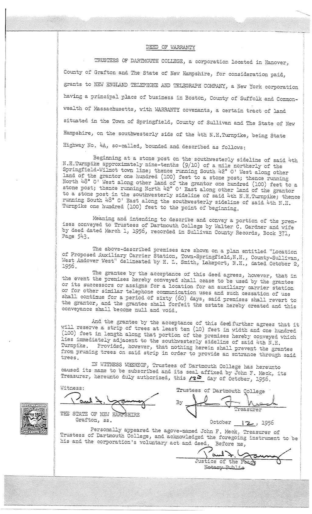
10 Springfield, New Hampshire Route 4A
11
12
13
14
15
16
17
18
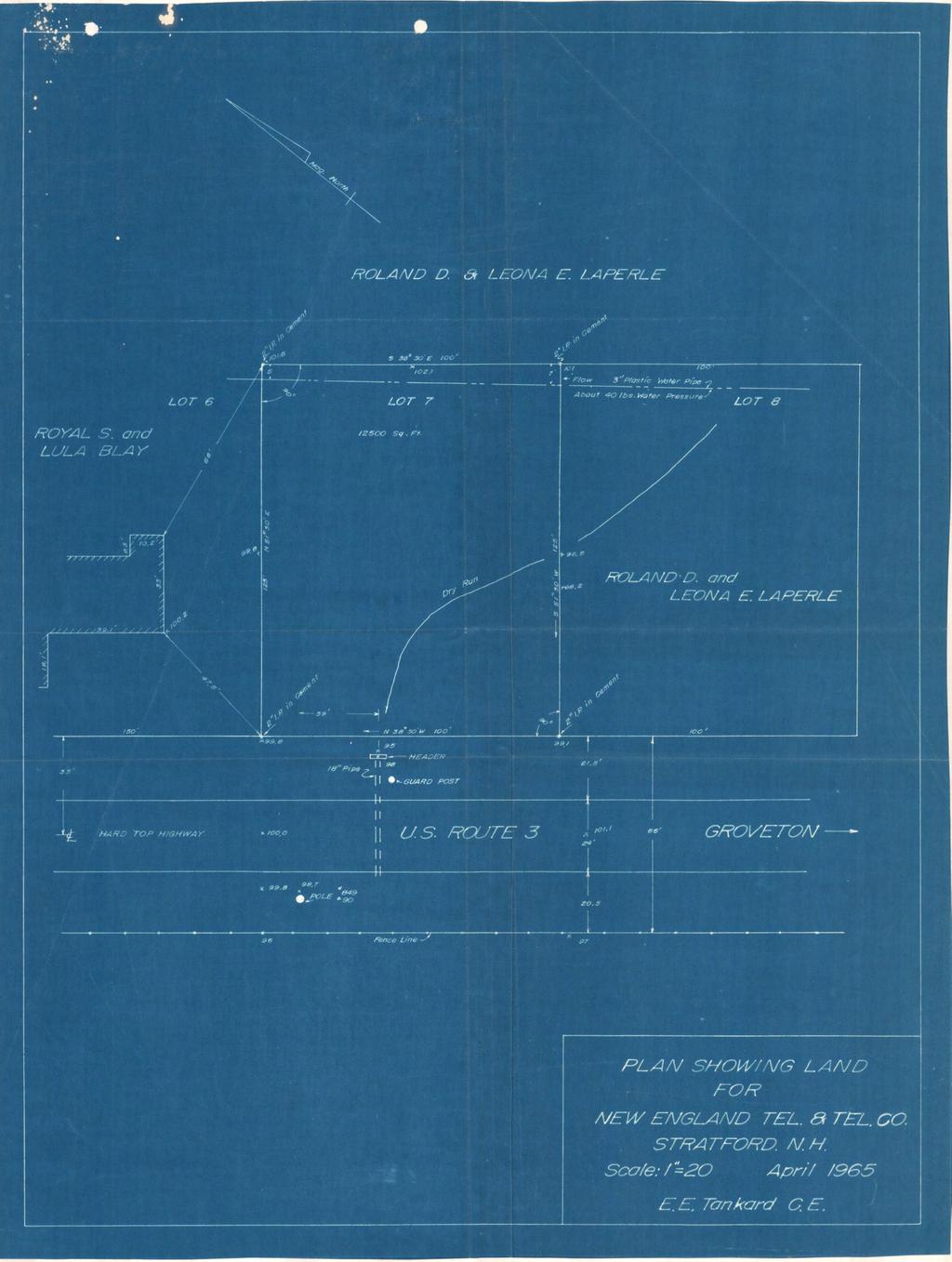
19 Stratford, New Hampshire Tax Map 2130, Lot 11

20
21
22
23
24
25
26
27
28
29
30
31 Stratford, New Hampshire Tax Map 2370, Lot 14

32
33
34
35
36
37
38
39
40
41
42
43 Troy, New Hampshire
44
45
46
47
48
49
50
51
52
53
54
55

56 BK2500fG07 13 Lula F. Gates dated September 10, 1956 and recorded in the Cheshire County Registry of Deeds at Book 631, Page 422. Lot 2: A certain tract of land in said Troy on the southerly side of High Street, bounded and described as follows: Beginning at a granite monument on the southerly side of said High Street at the northwest comer of land now or formerly of Harold Boyden; thence South 21 15' West by land of said Boyden one hundred thirty-two and eighty-two hundredths (132.82) feet to a concrete monument at the northwest comer of land now or formerly of New England Telephone and Telegraph Company; thence continuing in the same direction by land f said New England Telephone and Telegraph Company eighty-one and fifty-hundredths (81.50) feet to a granite monument at land now or formerly of Alphonse Russell; thence North IT 16' West by said Russell land to a concrete monument at land of Robert H. Norton and Barbara E. Norton; thence North 21 20' East by land of said Robert H. Norton and Barbara E. Norton two hundred thirteen (213) feet to a concrete monument at the southerly side of said High Street; thence South 82 54' East by the southerly side of said High Street fifteen (15) feet to the granite monument at the point of beginning. Meaning and intending to describe and convey the same Premises conveyed to New England Telephone and Telegraph Company by deed of Robert H. Norton and Barbara E. Norton dated July 22,1957 and recorded in the Cheshire County Registry of Deeds at Book 637, Page 440. PARCEL 17 Route 12 A certain tract of land situated in Troy, Cheshire County, New Hampshire, lying on the west side of State Highway Route #12, described as follows: Beginning at a point in the center line of State Highway Route #12, said point being feet south of the west side of the west abutement and feet south of the east side of the east abutment of the State Highway Bridge # spanning the South Branch of the Ashelot River; thence running south 7 r ' west, 33 feet to an iron pipe at the northeast corner of the land herein conveyed; thence running South 71 30' West, 100 feet to an iron pipe; thence running south 18 30' east, 100 feet to an iron pipe; thence running North 71 30' East, 100 feet to an iron pipe, said last three courses being bounded on land now or formerly of The C.L. Lane Company; thence running North 18 30' West, 100 feet to the bound first mentioned, said last course being parallel to the center line of said State Highway Route #12 and 33 feet distant therefrom; said tract of land, containing 10,000 square feet.
57 BK 2_5 0 Of I U Save and except that portion of land adjacent to State Highway Route #12 taken in condemnation proceedings by the State of New Hampshire dated February 12,1962, Highway Layout Troy-Marlboro-Swanzey F013-1(12) p Meaning and intending to describe and convey the same Premises conveyed to New England Telephone and Telegraph Company by deed of C.L. Lane Company, a New Hampshire Corporation dated May 25,1956 and recorded in the Cheshire County Registry of Deeds in Book 623, Page 354. PARCEL 18 Westminster St. A certain tract or parcel of land situated at the junction of Westminster and Park Street in Walpole, in the County of Cheshire and State of New Hampshire bounded and described as follows: Beginning at a point in the easterly line of Park Street and the southerly line of Westminster Street; thence south twenty-seven (27) degrees twenty-one (21) minutes east along the easterly side of Park Street one hundred and three hundredths (100.03) feet to a stone bound; thence turning at an angle of ninetytwo (92) degrees and twenty-one (21) minutes and running north sixty-five (65) degrees east ninety-five and nine tenths (95.9) feet to a stone bound; thence turning at an angle of ninety (90) degrees and running north twenty-five (25) degrees west one hundred (100) feet to a stone bound in the southerly line of Westminster Street; thence along the southerly line of Westminster Street south sixty-five (65) degrees west one hundred (100) feet to the point begun at. Meaning and intending to describe and convey the same Premises conveyed to New England Telephone and Telegraph Company by deed of Mason E. Harker, Emma G. Harker and M.E. Harker Company dated December 6,1946 and recorded in the Cheshire County Registry of Deeds at Book 526, Page 533. PARCEL 19 Westmoreland Rd. / Rt. 63 A certain tract or parcel of land situated at the junction of Westminster and Park Street in Walpole, in the County of Cheshire and State of New Hampshire bounded and described as follows: Beginning at a point in the easterly line of Park Street and the southerly line of Westminster Street; thence south twenty-seven (27) degrees twenty-one
58 Warner, New Hampshire Chemical Lane
59
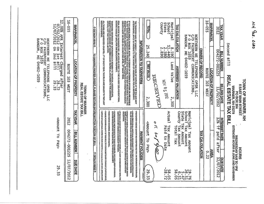
60

61
62
63
64
65
66
67 Warner, New Hampshire Route 103
68
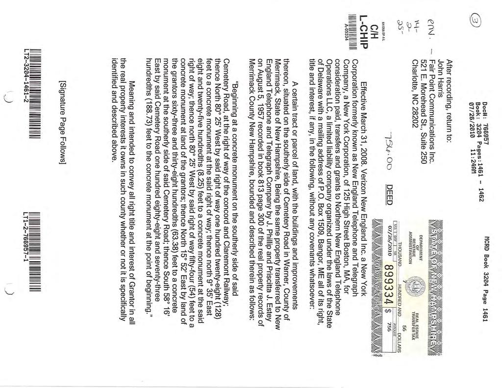
69
70
71
72
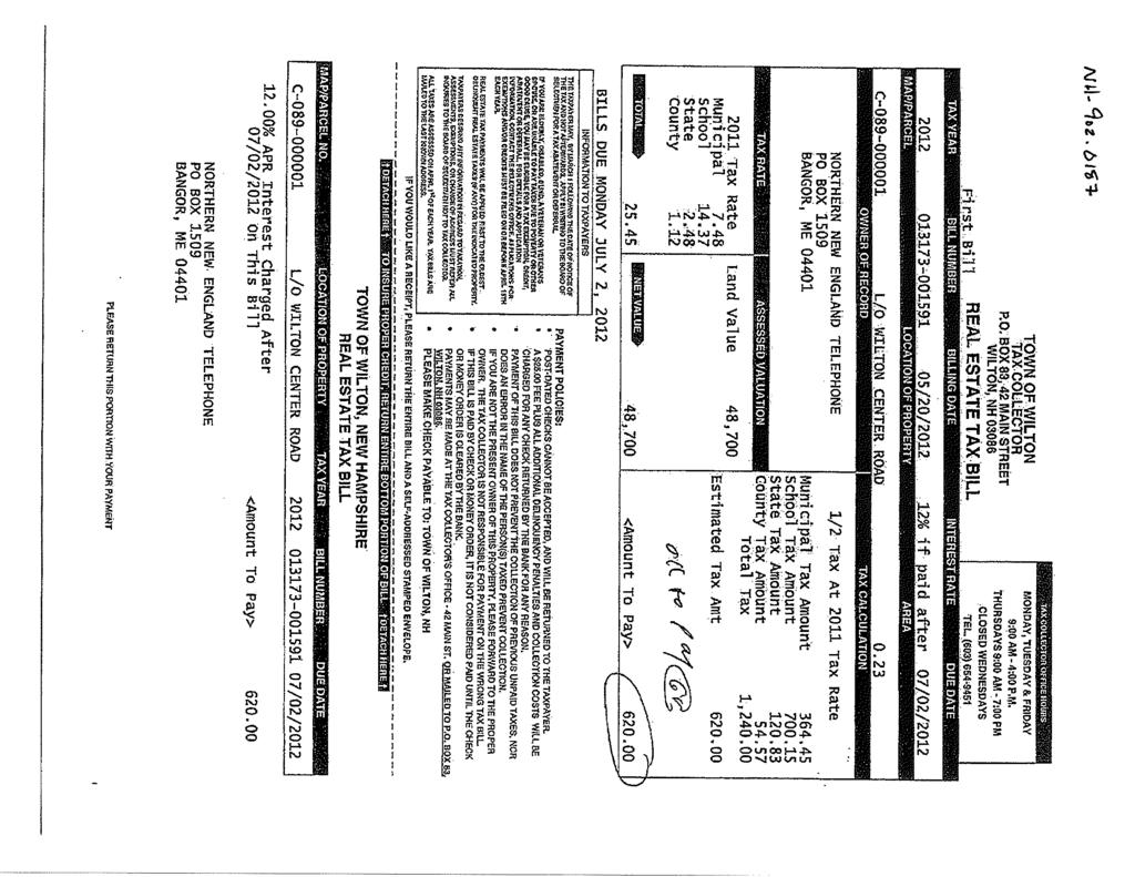
73
74
75 =- of For recorders use Transfer Tax: $ 89,079 Recording Fee: $, Return to: Fairpoint Communications Inc, Attn: John Harris 521 E, Morehead S1. Ste, 250 Charlotte, NC eq O'7b- OD Doell: Book: 3056 Pages: /01/ :03AM Book 3056 Page 927 / cover sheet I not intended'to alter attached document Property located in Andover, Bow, Canterbury, Concord, Danbury, Epsom, Franklin, Hooksett, Northfield/Tilton, Penacook, Pittsfield, Hooksett, Warner, New Hampshire. Deed Grantor: Verizon New England Inc. a New York Corporation formerly known as New England Telephone and Telegraph Company, a New York Corporation, of 125 High Street Boston, MA, Grantee: Northern New England Telephone Operations LLC, a limited liability company organized under the laws of the State of Delaware with a mailing address of P.O. Box 1509, Bangor, ME LT DEPARTMENT or REVEIIUE ADr.lIIIlSTRATlotl 89 REAL ESTATE TRMISFERTAX 76
76 After recording, return to: John Harris Fair Point Communications Inc. 521 E. Morehead St., Suite 250 Charlotte, NC Book 3056 Page 928 DEED Verizon New England Inc. a New York\Corporation formerly Imown as New England Telephone and Telegraph Compimy, a New York Corporation, of 125 High 9treet Boston, MA, for consideration paid, transfers and grants to Northern New England Telephone Operations LLC, a limited liability company organized under the laws of the State of Delaware with a mailing address of P.O. Box 1509, Bangor, ME all of its right, title and interest, if any, in the following, without any covenants whatsoever: A certain tracts or parcels of land, with the buildings and improvements thereon, situated in the County of Merrimack, State of New Hampshire, bounded and described as follows: See Exhibit "A" attached hereto and incorporated herein for all purposes. Meaning and intended to,.{;onvey all right title and interest of Grantor in all the real property interests it owns in such county whether or not it is specifically identified and described above. [Signature Page Follows]
77 Book 3056 Page 929 A'S or- 1M DATE~ tris 31~ day of March, VERIZON NEW ENGLAND INC. formerly known as New England Telephone and Telegraph Company By: '.E.fg{~, its Authorized agent,. STATE OF NEWYORK COUNTY OF NEW YORK The foregoing instrument was acknowledged before me this d7~~ of March, 2008, by Stephen E. Smith, the authorized agent, ofverizon New England Inc. formerly known as New England Telephone and Telegraph ~ompany, a New Yorl( yorporation, on behalf of t~7rporatio~. (SEAL) Notary PUQ IC Printed Name: My Commission Expires: 6o~L--'- JACKIE V. ROSARIO NOTARY PUBLIC, Stale of New YoIi( No.02R06OS6299 Qualiflsd In Quaens Cou~"07 commission expires JDnUllry 2~,, :;toll
78 PARCEL 14 Hwy Rt. '103 NR. ' A certain tract of land in said Warner situated on the southerly side of State highway Route #103, bounded and described as follows: Beginning at a concrete monument on the southerly side of said Route #103, which monument is approximately 150 feet westerly of the intersection of said Route #103 with the Melvin Mills Road; thence running south 8 45' East a distance of feet to a point in the northerly line of the aforesaid Melvin Mills Road; thence turning and running South 39 West by the northerly line of said Melvin Mills Road 55 feet to land now or formerly of Clifford A. Rogers and Gordon G. Anderson; thence turning and running North 32 16' West by land of said Clifford A. Rogers and Gordon G. An'dersdn and an old woods road feet to a cpncrete monument in the southerly line of Route #103; thence running North 49 13' East by the southerly line of said Route 1/103, 125 feet to the point of beginning. ' Meaning and intended to convey the same premises conveyed to New England Telephone and Telegraph Company by deed of Clifford A. Rogers and Gordon G. Anderson on August 6, 1957 recorded in the Merrimack County Registry of Deeds Book 813, Page 306 Lot 2 A certain tract of land in the Town of Warner, county of Merrimack, and the State of New Hampshire, situ<j.ted on the southerly side of a certain highway known as route 1/103, bounded arid described as follows: Beginning at a concrete monument on the southerly side of route 1/103 in said Warner at land now or formerly of the State of New Hampshire; thence S. 0 35' West by other land of the state of New Hampshire one hundred (100) feet to a concrete monument at other land of the state of New Hampshire; thence south 87" 18' west by other land of the state of New Hampshire one hundred (100) feet to a concrete monument at land now or formerly of Fred A. Bailey; thence North 0 35' East by land of Fred A. Bailey one hundred (100) feet to a concrete monument at the southerly side of route #103; thence north 87" 18' East by route 1/103 one hundred (100) feet to the concrete monument at the point of beginning; containing 10,000 square feet. " Meaning and intended to convey the property transferred from the State of New.. Hampshire to New England Telephone and Telegraph Company dated June 28, 1957 recorded in the Merrimack county registry of deeds Booll 808, Page 510. Save and Except: A portion of said land conveyed by New England Telephone and Telegraph Company to The State of New Hampshire by Warranty Deed on September 14, 1965 described in said deed as follows:
79 Book 3056 Page 943 A small parcel of land in the Town of Warner, County of Merrimack, State of New Hampshire, situated on the Southerly side of N.H. Route 103 as now traveled near Station of said Route Center Line as shown on the Plan of Hopkinton - Warner (50)13, P-3309-H,described as follows: Being all the land of the Grantors that lies between the Southerly Side Line of N.H. Route 103 and a line that is fifty (50')feet Southerly of and parallel to said N.H. Route 103 Center Line, bounded on the West by land of the State of New Hampshire and bounded on the East by other land of the State of New Hampshire. Containing in all about three thousand (3,000) square feet. And the Grantors do hereby convey to the Stllte of New Hampshire all rights of access, air, view and light over, from, or to the,limited Access Highway to be constructed on land conveyed above, pertaining to the remainder of abutting lands, beh;mging to the Grantors, their heirs, assigns, executors and administrators, as defined in Chapter 236, RSA of 1955 entitled "Limited Access Highways.", MERRIMACK COUNTY RECORDS c;f'~ d 40,CPO, Register
80 Wilton, New Hampshire
81
82 Print Summary Page 1 of 2 2/13/2013 No Image Powered by Vision Government Solutions, Inc. MBLU : C/ / 089/ 01/ / Location: WILTON CENTER ROAD Owner Name: FAIRPOINT COMMUNICATIONS Account Number: Parcel Value Item Appraised Value Assessed Value Buildings 0 0 Xtra Bldg Features 0 0 Outbuildings 0 0 Land 48,700 48,700 Total: 48,700 48,700 Owner of Record FAIRPOINT COMMUNICATIONS PO BOX 1659 BANGOR, ME Ownership History Owner Name Book/Page Sale Date Sale Price FAIRPOINT COMMUNICATIONS 8237/0988 9/3/ ,933 NEW ENGLAND TEL & TEL 0 Land Use Land Use Code Land Use Description 1320 Vac Undev Land Line Valuation Size Zone Neighborhood Appraised Value Assessed Value 0.23 AC RA A13 48,700 48,700 Construction Detail Building # 1 STYLE Vacant Land MODEL Vacant Building Valuation Living Area: 0 square feet Replacement Cost: 0 Year Built: Building Value: 0
83 Print Summary Page 2 of 2 2/13/2013 Extra Features Code Description Units Appraised Value No Extra Building Features Outbuildings Code Description Units Appraised Value No Outbuildings Building Sketch Vacant Land, No Sketch
84
85
86
87
88
89
90 Wolfeboro, New Hampshire


91 Tax Map Wolfeboro, NH 1 Inch = 41 Feet March 29, 2013 Data shown on this map is provided for planning and informational purposes only. The municipality and Cartographic Associates, Inc. are not responsible for any use for other purposes or misuse or misrepresentation of this map.
92
93
94
95
96
97
98
99
100
MUNICIPAL QUITCLAIM DEED
 DRAFT MUNICIPAL QUITCLAIM DEED The INHABITANTS OF THE TOWN OF WARREN, a body corporate and politic, located at Warren, Knox County, Maine, for consideration paid, Release to, whose mailing address is,
The Sale or Lease of Certain Lands Act
 1 SALE OR LEASE OF CERTAIN LANDS S-2 The Sale or Lease of Certain Lands Act being Chapter S-2 of The Revised Statutes of Saskatchewan, 1978 (effective February 26, 1979) as amended by the Statutes of Saskatchewan,
Tax Map & Property Information Location Map Assessment Information Municipal Information Zoning Information...
 Table of Contents Parcel #5 5.99+/- Acres Office/Warehouse Buildings 28-30 Gordon Drive Rockland, Maine Keenan Auction Company Tax Map & Property Information... 1 Location Map... 2 Assessment Information...
FORECLOSURE DEED. MASCOMA SAVINGS BANK, as successor by merger to Connecticut River Bank, N.A.
 FORECLOSURE DEED MASCOMA SAVINGS BANK, as successor by merger to Connecticut River Bank, N.A. with a mailing address of P.O. Box 4399, White River Junction, VT 05001, holder of several commercial mortgages,
EASEMENT DEED. 2) Thence N 60º12 36 W through said Parcel 1 a distance of Two Hundred Ninety- Five and 97/100 (295.97) feet to a point;
 Thence N 60º12 36 W through said Parcel 1 a distance of Two Hundred Ninety- Five and 97/100 (295.97) feet to a point;") EASEMENT DEED TALL TREES CONSTRUCTION CORP., a Maine corporation having a mailing address of 30 Preservation Drive, Falmouth, Maine 04105 (the "Grantor") for consideration paid, grants to the TOWN OF FALMOUTH,
EASEMENT DEED TALL TREES CONSTRUCTION CORP., a Maine corporation having a mailing address of 30 Preservation Drive, Falmouth, Maine 04105 (the "Grantor") for consideration paid, grants to the TOWN OF FALMOUTH,
AN ACT. The General Assembly of the Commonwealth of Pennsylvania hereby enacts as follows:
 CONVEYANCES - COMMONWEALTH PROPERTY IN LIGONIER BOROUGH, WEST MORELAND COUNTY; CITY OF CONNELLSVILLE, FAYETTE COUNTY; CITY OF ALLENTOWN, LEHIGH COUNTY; BENSALEM TOWNSHIP, BUCKS COUNTY, AND SUSQUEHANNA
FILED: NEW YORK COUNTY CLERK 08/08/2012 INDEX NO /2011 NYSCEF DOC. NO. 34 RECEIVED NYSCEF: 08/08/2012
 FILED: NEW YORK COUNTY CLERK 08/08/2012 INDEX NO. 652061/2011 NYSCEF DOC. NO. 34 RECEIVED NYSCEF: 08/08/2012 NYC DEPARTMENT OF FINANCE OFFICE OF THE CITY REGISTER This page is part of the instrument. The
No approval of the Governor, to convey to the Historical and Genealogical
 712 Act 2000-97 LAWS OF PENNSYLVANIA SB 1468 No. 2000-97 AN ACT Amending the act of June 25, 1999 (P.L.205, No.27), entitled An act authorizing the Department of General Services, with the approval of
NON-EXCLUSIVE ROADWAY AND UTILITY EASEMENT DEED AND AGREEMENT
 RETURN TO: STOGSDILL LAW OFFICE, P.C. 505 West Main, Suite 313 Lewistown, Montana 59457 (406) 538-2623 NON-EXCLUSIVE ROADWAY AND UTILITY EASEMENT DEED AND AGREEMENT THIS EASEMENT DEED AND AGREEMENT is
Sketch & Legal Description of Mitigation Bank and Ingress/Egress Access Easements
 Appendix H: Sketch & Legal Description of Mitigation Bank and Ingress/Egress Access Easements Tippen Bay Wetland Mitigation Bank DeSoto County, Florida Prepared by: September, 2017 Original file
FILED: NEW YORK COUNTY CLERK 12/15/ :54 PM
 Rosenthal Affidavit Exhibit 1 NYC DEPARTMENT OF FINANCE OFFICE OF THE CITY REGISTER This page is part of the instrument. The City Register will rely on the information provided by you on this page for
COUNTY OF CHISAGO, STATE OF MINNESOTA
 OFFICE OF COUNTY AUDITOR-TREASURER COUNTY OF CHISAGO, STATE OF MINNESOTA NOTICE OF EXPIRATION OF REDEMPTION To all persons interested in the lands hereinafter described: You are hereby notified that the
Village of Mantua, Ohio ORDINANCE
 AN ORDINANCE AUTHORIZING THE MAYOR TO EXECUTE A LEASE / OPTION TO PURCHASE AGREEMENT WITH THE PORTAGE PARK DISTRICT FOR THE HEADWATERS TRAIL WEST OF STATE ROUTE 44, AND DECLARING AN EMERGENCY. WHEREAS,
approval of the Release and Satisfaction of Property Donation Requirements (Burnt Store Road
 RESOLUTION 38-16 A RESOLUTION OF THE CITY OF CAPE CORAL ACCEPTING A QUIT CLAIM DEED FROM ZREV FARM, LLC, FOR A 2.07 ACRE PARCEL LYING WITHIN SECTION 20, TOWNSHIP 43 SOUTH, RANGE 23 EAST; APPROVING AND
;;o. c I"'\ z. :enc. ml>~ ("\ Vt. ,.. :c CORPORATION WARRANTY DEED WITH RESTRICTIONS
 -------- ' j 2 - (I; }> (.' 0 W "tjo v :.; ' ;;o -n c I"'\ z :enc l> ("\ Vt,.. :c ("\ () ::c );> Ito V'I -n? :c 1' '.:'\...,, ' \ "' Q - ( co I. > :v:.. ', (., i"),, r1 (.,.) l'i y ;. t.,._; "",.. 3 U:.J
PIPELINE RIGHT-OF-WAY EASEMENT
 PIPELINE RIGHT-OF-WAY EASEMENT THIS RIGHT-OF-WAY EASEMENT made this day of March, 2014, by the City of Rochester Hills, a municipal corporation in the State of Michigan,, having an address at 1000 Rochester
Municipality of Cumberland By-Law Upper Nappan Water Supply By-Law
 Municipality of Cumberland By-Law 98-01 Upper Nappan Water Supply By-Law 1. This By-Law shall be known as and may be cited as the Upper Nappan Water Supply By- Law. 2. This By-Law shall apply to properties
ATTACHMENT B GRANT DEED. This deed is in satisfaction of the Eminent Domain Action Case No. GRANT DEED
 GRANT DEED RECORDING REQUESTED BY AND WHEN RECORDED MAIL TO: County of Orange County Executive Office CEO Real Estate 333 W. Santa Ana Blvd. Bldg. 10 Santa Ana, California 92701 AND MAIL TAX STATEMENTS
SALE & BARRINGTON STREET HALIFAX, NS PRIME SOUTH END HISTORIC BUILDING AND VACANT LOT 7,151 SF 2,607 SF
 FOR SALE 1265-1271 & 1273-1275 BARRINGTON STREET HALIFAX, NS PRIME SOUTH END HISTORIC BUILDING AND VACANT LOT 7,151 SF 2,607 SF BRIAN WOODS, ABR Real Estate Advisor 902.407.2492 brianwoods@kwcommercial.com
BILL NO (Emergency Measure) ORDINANCE NO. 5072
 ORDINANCE NO. 5072") BILL NO. 5210 (Emergency Measure) ORDINANCE NO. 5072 AN ORDINANCE AUTHORIZING THE MAYOR TO EXECUTE WITH MICHELSON-HADLEY HEIGHTS DEVELOPMENT, LLC, A CONTRACT AND QUIT CLAIM DEED CONVEYING CERTAIN PROPERTIES
BILL NO. 5210 (Emergency Measure) ORDINANCE NO. 5072 AN ORDINANCE AUTHORIZING THE MAYOR TO EXECUTE WITH MICHELSON-HADLEY HEIGHTS DEVELOPMENT, LLC, A CONTRACT AND QUIT CLAIM DEED CONVEYING CERTAIN PROPERTIES
Town of Mansfield SPECIAL TOWN MEETING
 Town of Mansfield SPECIAL TOWN MEETING November 13, 2018 7:00 PM MANSFIELD HIGH SCHOOL AUDITORIUM EAST STREET, MANSFIELD CALL TO ORDER: 7:00 PM MOTIONS Town of Mansfield Special Town Meeting November 13,
CONVEYANCES - COMMONWEALTH PROPERTY IN MULTIPLE MUNICIPALITIES Act of Jul. 2, 2014, P.L. 881, No. 100 Cl. 85 An Act
 Pennsylvania General Assembly http://www.legis.state.pa.us/cfdocs/legis/li/uconscheck.cfm?txttype=htm&yr=2014&sessind=0&smthlwind=0&act=100 08/04/2014 10:34 AM Home / Statutes of Pennsylvania / Unconsolidated
As Introduced. 131st General Assembly Regular Session H. B. No
 131st General Assembly Regular Session H. B. No. 239 2015-2016 Representative Sears A B I L L To amend section 5120.092 and to enact section 5120.80 of the Revised Code to allow the Director of Budget
THIS DECLARATION made this day of, 2016, by Cambridge and Wyndfall Community Association, Inc. ( Association ) and Lennar Carolinas, LLC ( Owner ).
 and Lennar Carolinas, LLC ( Owner ).") Prepared by and return to: Lori P. Jones, Jordan Price, P.O. Box 10669, Raleigh, NC 27605 Indexing: Grantors: Lennar Carolinas, LLC Grantee: Cambridge and Wyndfall Community Association, Inc. NORTH CAROLINA
Prepared by and return to: Lori P. Jones, Jordan Price, P.O. Box 10669, Raleigh, NC 27605 Indexing: Grantors: Lennar Carolinas, LLC Grantee: Cambridge and Wyndfall Community Association, Inc. NORTH CAROLINA
LEGAL NOTICE LEGAL DESCRIPTION SEE EXHIBIT A
 LEGAL NOTICE PUBLIC AUCTION OF CERTAIN PROPERTY BY THE BOARD OF EDUCATION OF THE LAKEWOOD CITY SCHOOL DISTRICT THAT IS NO LONGER NEEDED FOR SCHOOL PURPOSES Notice. Under the provisions of Ohio R.C. 3313.41,
Title summary for property offered for sale by Peppertree-Atlantic Beach Association, Inc.
 Title summary for property offered for sale by Peppertree-Atlantic Beach Association, Inc. The bulk of the property offered for sale consists of a total of 4.392 acres of land, more or less, as more particularly
NOTICES OF SHERIFF'S SALE
 Updated: 10/14/17 at 1:33 AM NOTICES OF SHERIFF'S SALE Date & Time of Sale: Thu, Jul 27, 2017 at 1:00 pm Sheriff Sale File number: 65-17-0021-SS Judgment to be Satisfied: $183,768.60 Cause Number: 65C01-1701-MF-000023
Exhibit A: REAL ESTATE TRANSFER AGREEMENT
 Exhibit A: REAL ESTATE TRANSFER AGREEMENT This agreement is made between the City of Urbana, Illinois, a municipal corporation of the State of Illinois (the Seller ), and Homestead Corporation of Champaign-Urbana,
QUITCLAIM DEED CR 202 THE STATE OF TEXAS KNOW ALL MEN BY THESE PRESENTS: COUNTY OF WILLIAMSON
 QUITCLAIM DEED CR 202 THE STATE OF TEXAS KNOW ALL MEN BY THESE PRESENTS: COUNTY OF WILLIAMSON That WILLIAMSON COUNTY, TEXAS, hereinafter referred to as Grantor, whether one or more, for and in consideration
Loan No. File No / EXHIBIT A-1 (The Garrison Place Real Estate Investment Trust - Nottingham)
") *CR *. **** *... * *** Loan No. File No. 53648/83177 EXHIBIT A-1 (The Garrison Place Real Estate Investment Trust - Nottingham) certain tract of land, situated in Nottingham, in the County of Rockingham
*CR *. **** *... * *** Loan No. File No. 53648/83177 EXHIBIT A-1 (The Garrison Place Real Estate Investment Trust - Nottingham) certain tract of land, situated in Nottingham, in the County of Rockingham
Community Development Department Council Chambers, 7:30 PM, December 1, 2016
 STAFF REPORT 2016-35P: Subdivision Community Development Department Council Chambers, 7:30 PM, December 1, 2016 To: From: Re: Paul Luke, Chairman, Skokie Plan Commission Mike Voitik, Planning Technician
ORDINANCE NO.:
 ORDINANCE NO.: 2013-098 Authorizing the City Manager to execute a Limited Warranty Deed conveying the improvements (an approximate 300 space parking garage) known as the Bell South Parking Garage constructed
COMMONWEALTH OF MASSACHUSETTS
 SPECIAL TOWN MEETING October 1, 2018 COMMONWEALTH OF MASSACHUSETTS HAMPDEN, SS To Ms. Kim Batista, Town Clerk of the Town of Ludlow in said County: GREETINGS: In the name of the Commonwealth of Massachusetts,
CONVEYANCE - COMMONWEALTH PROPERTY IN THE BOROUGH OF EAST STROUDSBURG, MONROE COUNTY Act of Jul. 1, 2016, P.L., No. 65 Cl.
 CONVEYANCE - COMMONWEALTH PROPERTY IN THE BOROUGH OF EAST STROUDSBURG, MONROE COUNTY Act of Jul. 1, 2016, P.L., No. 65 Cl. 85 An Act Authorizing the Department of General Services, with the approval of
INTERGOVERNMENTAL AGREEMENT
 INTERGOVERNMENTAL AGREEMENT This Intergovernmental Agreement (this Agreement) is made and entered into as of December 1, 2010, by and between the VILLAGE OF BIG ROCK, an Illinois municipal corporation
CITY OF SARATOGA SPRINGS ZONING ORDINANCE
 Appendix C: 8. The Village At Saratoga Planned Unit Development (formerly 241.8) Chapter 241.8 AN ORDINANCE PROVIDING FOR THE ESTABLISHMENT OF A PLANNED UNIT DEVELOPMENT DISTRICT TO BE KNOWN AS "THE VILLAGE
IIIlIIIIII IllIllhllIllIllIll III Ill Sacramento County Recorder David Villanueva,-Clerk/Recorder
 Record for the Benefit of the City of Sacramento - Fee Exempt Pursuant to Government Code Section 6103 and 27383. Transfer Tax exempt under Revenue and Taxation Code 11921, When Recorded, Mail to: Office
REVIEWED BY: Administrator Counsel Program Mgr.: Tiffany Schaufler Board Committee Engineer Other
 Minnehaha Creek Watershed District REQUEST FOR BOARD ACTION MEETING DATE: May 11, 2017 TITLE: Authorization to Grant a Temporary Easement to the City of Minnetrista RESOLUTION NUMBER: 17-034 PREPARED BY:
OFFICIAL SUMMARY OF AN ORDINANCE TO CONVEY CERTAIN RAMSEY COUNTY PARK AND OPEN SPACE LANDS TO THE CITY OF MAPLEWOOD.
 OFFICIAL SUMMARY OF AN ORDINANCE TO CONVEY CERTAIN RAMSEY COUNTY PARK AND OPEN SPACE LANDS TO THE CITY OF MAPLEWOOD. This ordinance authorizes the conveyance of park and open space land owned by Ramsey
The General Assembly of the Commonwealth of Pennsylvania hereby enacts as follows:
 CONVEYANCE - COMMONWEALTH PROPERTY LOCATED IN SOLEBURY TOWNSHIP, BUCKS COUNTY AND CITY OF PHILADELPHIA Act of Oct. 8, 2008, P.L. 1105, No. 94 Cl. 85 AN ACT Authorizing the Pennsylvania Fish and Boat Commission
Settlement A.qreement and General Release. This Settlement Agreement and General Release ("Agreement") is made
 is made") Settlement A.qreement and General Release This Settlement Agreement and General Release ("Agreement") is made and entered into as of... 2009, by and between George Rich dba Caravan Lounge, ("Tenant") and.by
Settlement A.qreement and General Release This Settlement Agreement and General Release ("Agreement") is made and entered into as of... 2009, by and between George Rich dba Caravan Lounge, ("Tenant") and.by
NORTH CAROLINA DEED OF TRUST
 NORTH CAROLINA DEED OF TRUST SATISFACTION: The debt secured by the within Deed of Trust together with the note(s) secured thereby has been satisfied in full. This the day of, 20 Signed: Parcel Identifier
EASEMENT AGREEMENT. WHEREAS, Ferguson is the 100% owner of the property described on Exhibit B attached hereto (the Williams Property );
;") EASEMENT AGREEMENT THIS EASEMENT AGREEMENT ( Agreement ) is entered into as of this day of, 2016, by and between CRAIG FERGUSON ( Ferguson ), and MAMIE DAVIS and JERRY MOORE ( Davis & Moore ), whose legal
EASEMENT AGREEMENT THIS EASEMENT AGREEMENT ( Agreement ) is entered into as of this day of, 2016, by and between CRAIG FERGUSON ( Ferguson ), and MAMIE DAVIS and JERRY MOORE ( Davis & Moore ), whose legal
CONDITIONS OF SALE. The conditions of the present public sale are as follows:
 Prepare in duplicate. Post copy during sale and then give it to Purchaser. The conditions of the present public sale are as follows: CONDITIONS OF SALE 1. The property to be sold is a tract of improved
Grade: Curative Items: Non Curative Items:
 Order Details Title Company Information Property Address:31 Ann Street, Pottsville, PA 17901 Assigned Coordinator Details Escrow Officer: Email: closings@bntc.com Title Officer: Email: curative@bntc.com
PURCHASE AND SALE AGREEMENT
 PURCHASE AND SALE AGREEMENT THIS AGREEMENT made this day of July, 2017, by and between JPMCC 2011- C5 APPLETREE MALL LLC, having an address at c/o Torchlight Loan Services, 475 5th Avenue, 10 th Floor,
17-1 SECTION 17 - RURAL AGRICULTURAL ZONE- RA (BY-LAW 2972 AND 9349) The following provisions shall apply in all RURAL AGRICULTURAL ZONES RA:
 The following provisions shall apply in all RURAL AGRICULTURAL ZONES RA:") 17-1 SECTION 17 - RURAL AGRICULTURAL ZONE- RA (BY-LAW 2972 AND 9349) The following provisions shall apply in all RURAL AGRICULTURAL ZONES RA: No PERSON shall HEREAFTER USE any BUILDING, STRUCTURE or land
17-1 SECTION 17 - RURAL AGRICULTURAL ZONE- RA (BY-LAW 2972 AND 9349) The following provisions shall apply in all RURAL AGRICULTURAL ZONES RA: No PERSON shall HEREAFTER USE any BUILDING, STRUCTURE or land
OPTION TO PURCHASE-CASH SALE. All payments must be made payable to the order of the Department of Transportation.
 4-SCl-101-35.5 DD-000044-02-01 OPTION TO PURCHASE-CASH SALE For the purchase of the real property described in the Director's Deed attached hereto and made a part hereof, City of San Jose, hereinafter
C fl26t, Tax Map Parcel Nos and (all Units)
") C fl26t,2 0221 Tax Map Parcel Nos. 3-34-6.00-553.01 and 3-34-6.00-553.01 (all Units) PREPARED BY AND RETURN TO: Wilson, Halbrook and Bayard, P.A. P.O. Box 690, Geor etown, DE 19947 i-'ad~ TWENTIETH AMENDMENT
C fl26t,2 0221 Tax Map Parcel Nos. 3-34-6.00-553.01 and 3-34-6.00-553.01 (all Units) PREPARED BY AND RETURN TO: Wilson, Halbrook and Bayard, P.A. P.O. Box 690, Geor etown, DE 19947 i-'ad~ TWENTIETH AMENDMENT
ENVIRONMENTAL COVENANT
 OHIO E.P.A. Environmental Covenant AUG 19 ZOII Page 1 entered DIRECTOirs JOURNAL " official ENVIRONMENTAL COVENANT To be recorded with Deed Records - ORC 317.08 This Environmental Covenant is entered into
Keenan Auction Company
 Keenan Auction Company PROPERTY INFORMATION PACKAGE Our 6,500 th Auction Real Estate Foreclosure Auction 13-322 Ranch Style Home 1674 North Belfast Ave., Vassalboro, Maine Tuesday, December 10, 2013 at
ORDINANCE NO WHEREAS, the Parties desire to amend the Original Easement to add the land upon which the Monument Sign was constructed.
 Irading 2 rtadir g 2 J A/ y readtng Voled 4n 7 2 / i Ano, PASSEDX% DEFEATED ORDINANCE NO. 2019-6 AN ORDINANCE AUTHORIZING THE MAYOR TO EXECUTE THE FIRST AMENDMENT TO THE TRAFFEC CONTROL AND LANDSCAPING
City of Grand Island Tuesday, August 8, 2017 Council Session
 City of Grand Island Tuesday, August 8, 2017 Council Session Item F-1 #9638 - Consideration of Correction to Ordinance No. 9631 Relative to Vacation of the North End of Voss Road; North of Seedling Mile
DISTRICT. Huntington Beach. FIM 40-40C-3 APN and
 RECORDING REQUESTED BY W HEN RECORDED MAIL TO SOUTHERN CALIFORNIA EDISON COMPANY 2131 WALNUT GROVE AVENUE 2 ND FLOOR GO3 ROSEMEAD, CA 91770 Attn: Title and Real Estate Services SPACE ABOVE THIS LINE FOR
RELEASE DEED Sheepscot Harbour Village & Resort, A Condominium
 Form to be Used For Unit 505 RELEASE DEED Sheepscot Harbour Village & Resort, A Condominium SBM PROPERTY A, INC., a Maine corporation, having a mailing address in care of The Bank of Maine, 190 Water Street,
APPLICATION TO REGISTER NOTICE OF AN AGREEMENT THE LAND TITLES ACT SECTION 74
 26 th May 1981 Campeau - City of Kanata 40% Open Space Agreement APPLICATION TO REGISTER NOTICE OF AN AGREEMENT THE LAND TITLES ACT SECTION 74 TO: THE LAND REGISTRAR FOR THE LAND TITLES DIVISION OF OTTAWA-CARLETON
DECLARATIONS OF RESTRICTIONS, GRANTS, TRUSTS AND CHARGES AFFECTING THE LAND KNOWN AS
 This is a consolidated and updated, but unofficial, version of PGL s original Declarations dated August 4, 1939 and September 14, 1954, as filed with the Rockland County Clerk at LIBER 373 PAGE 55 and
SHERIFF'S SALE. ALL those certain tracts of land situate in the Borough of Westfield, Tioga County, Pennsylvania, bounded and described as follows:
 No. 43-CV-2017 ALL those certain tracts of land situate in the Borough of Westfield, Tioga County, Pennsylvania, bounded and described as follows: TRACT NO. 1: Located on the North side of Stephenson Street
DECLARATIONS OF COVENANTS, RESTRICTIONS, CONDITIONS AND RESERVATIONS
 THIS DECLARATION, made this 30 th day of December, 1969, by Jasper Valley Development Corporation, hereinafter called the Developer. WITNESSETH: Whereas, Developer is the owner of the real property described
WATERFORD LANDING COMMUNITY DEVELOPMENT DISTRICT REGULAR MEETING AGENDA
 WATERFORD LANDING COMMUNITY DEVELOPMENT DISTRICT REGULAR MEETING AGENDA January 31, 2019 Waterford Landing Community Development District OFFICE OF THE DISTRICT MANAGER 2300 Glades Road, Suite 410W Boca
HALIFAX REGIONAL MUNICIPALITY BY-LAW NUMBER P-1300 RESPECTING PRIVATE WAYS
 HALIFAX REGIONAL MUNICIPALITY BY-LAW NUMBER P-1300 RESPECTING PRIVATE WAYS WHEREAS Susan Sheehan (now Susan Sutherland) petitioned the Council of the Municipality pursuant to the Private Ways Act to obtain
AGREEMENT RECITALS: Draft 3/26/2015
 AGREEMENT This Agreement is entered into this day of April, 2015, by and between the SCHOOL BOARD OF BREVARD COUNTY, FLORIDA (the "School Board") and THE CITY OF MELBOURNE, a Florida municipal corporation
COUNTY OF LOS ANGELES
 JAMES A. NOYES, Director COUNTY OF LOS ANGELES DEPARTMENT OF PUBLIC WORKS 900 SOUTH FREMONT AVENUE ALHAMBRA, CALIFORNIA 91803-1331 Telephone: (626) 458-5100 www.ladpw.org ADDRESS ALL CORRESPONDENCE TO:
AMENDED DECLARATION OF COVENANTS FOR COUNTRY CREEK SUBDIVISION
 AMENDED DECLARATION OF COVENANTS FOR COUNTRY CREEK SUBDIVISION THIS AMENDED DECLARATION OF COVENANTS, made this 17th day of February, 2004, by Frontier Land Company, an Indiana corporation (hereinafter
Conditional Sales Contract
 Conditional Sales Contract FROM TO FM ED FUK kecorp MAR 27 1957 Recorder ' Delaware Cotmty THK KAUTZ STATIONERY CO. 124 N. Pennsylvania St.. Indianapolis 2M-1-36-FPCO. CONDITIONAL SALES CONTRACT THIS AGREEMENT
PROPERTY INFORMATION PACKAGE
 AMG AUCTION MARKETING GROUP PROPERTY INFORMATION PACKAGE Thank you for your interest in the Auction. We have compiled the following Property Information to assist you in your research. Please understand
THE GENERAL ASSEMBLY OF PENNSYLVANIA SENATE BILL AN ACT
 PRINTER'S NO. THE GENERAL ASSEMBLY OF PENNSYLVANIA SENATE BILL No. INTRODUCED BY VANCE, APRIL, 00 REFERRED TO STATE GOVERNMENT, APRIL, 00 Session of 00 AN ACT 0 0 Authorizing the Department of General
LAND USE RESTRICTION - - INCLUSIONARY ZONING
 LAND USE RESTRICTION - - INCLUSIONARY ZONING Re:, an Apartment development located at, City of Madison, Wisconsin WHEREAS,, a Limited Liability Wisconsin Corporation ( Developer ) will record a PLANNED
TOWN OF CHISAGO LAKE CITY OF CENTER CITY CHISAGO COUNTY, MINNESOTA. City Resolution N o,a._o I d. --0~- 0 S C Town Resolution No. /,J:- oto o I
 TOWN OF CHISAGO LAKE CITY OF CENTER CITY CHISAGO COUNTY, MINNESOTA REO'OBV MBA 'JUL. 17 2012 City Resolution N o,a._o I d. --0~- 0 S C Town Resolution No.,J:- oto - 11- o I JOINT RESOLUTION OF THE TOWN
COUNCIL ACTION FORM Meeting Date: September 13, 2012 Staff Contact: John Sullivan, Public Works Director
 COUNCIL ACTION FORM Meeting Date: September 13, 2012 Staff Contact: John Sullivan, Public Works Director Agenda Item: Consider vacation of a Landscape Easement granted to the City of Westwood for the construction
Declaration of Condominium Of Northridge Lakes -East Bay Owners' Association, Inc. Table of Contents
 1 Declaration of Condominium Of Northridge Lakes -East Bay Owners' Association, Inc. Table of Contents Section Page Amendments 9 Administration of Property 4 Annexation 6 Building Description -Original
CONSENT ACTION BY THE BOARD OF DIRECTORS OF VENETO IN MIRAMAR CONDOMINIUM ASSOCIATION, INC.
 CONSENT ACTION BY THE BOARD OF DIRECTORS OF VENETO IN MIRAMAR CONDOMINIUM ASSOCIATION, INC. The undersigned, being all of the members of the Board of Directors of Veneto in Miramar Condominium Association,
RECORD OF ORDINANCES
 RECORD OF ORDINANCES Ordinance No. 2016-8 August 8, 2016 City of Bellbrook Ordinance No. 2016-8 An Ordinance Granting an Easement to the State of Ohio, Department of Transportation for Improvements to
ENCROACHMENT AGREEMENT (Farmland O Connell Road)
") STATE OF KANSAS Tract 28103, 28112, 28124, L3031 & L4218 COUNTY OF DOUGLAS Line: E ENCROACHMENT AGREEMENT (Farmland Development @ O Connell Road) THIS AGREEMENT, entered into by and between SOUTHERN STAR
STATE OF KANSAS Tract 28103, 28112, 28124, L3031 & L4218 COUNTY OF DOUGLAS Line: E ENCROACHMENT AGREEMENT (Farmland Development @ O Connell Road) THIS AGREEMENT, entered into by and between SOUTHERN STAR
RESOLUTION OF INDIAN LAKE BOROUGH. *, 1997 the Borough Council. WHEREAS, Bernie Wires submitted a proposed plan for an elevated sand mound on
 RESOLUTION 1997-2 OF INDIAN LAKE BOROUGH AND NOW, this 1 3 t h day of m *, 1997 the Borough Council of Indian Lake Borough hereby resolves as follows: WHEREAS, Bernie Wires submitted a proposed plan for
CONVEYANCE - COMMONWEALTH PROPERTY IN DELAWARE TOWNSHIP, NORTHUMBERLAND COUNTY, TO THE WARRIOR RUN-FORT FREELAND HERITAGE SOCIETY
 CONVEYANCE - COMMONWEALTH PROPERTY IN DELAWARE TOWNSHIP, NORTHUMBERLAND COUNTY, TO THE WARRIOR RUN-FORT FREELAND HERITAGE SOCIETY Act of Oct. 30, 2017, P.L., No. 47 Cl. 85 An Act Authorizing the Department
DRAINAGE AND UTILITY EASEMENT. That Bruce Conrad, a single adult, hereinafter referred to as Grantor for good and
 DRAINAGE AND UTILITY EASEMENT KNOW ALL PERSONS BY THESE PRESENTS: That Bruce Conrad, a single adult, hereinafter referred to as Grantor for good and valuable consideration, the receipt and sufficiency
PERMANENT DRAINAGE EASEMENT
 City Project No. Project Name: ; Tr. # Parcel No. (LLC, Corporation, Partnership) PERMANENT DRAINAGE EASEMENT THIS AGREEMENT, made and entered into this day of, 201, by and between, a, hereinafter called
FIFTH AMENDMENT OF DECLARATION OF DEED RESTRICTIONS AND DEDICATIONS FOR PINEHURST ESTATES (A Clatsop County, Oregon Subdivision)
") After Recording Return To: W. Louis Larson 990 Astor Street Astoria, OR 97103 FIFTH AMENDMENT OF DECLARATION OF DEED RESTRICTIONS AND DEDICATIONS FOR PINEHURST ESTATES (A Clatsop County, Oregon Subdivision)
After Recording Return To: W. Louis Larson 990 Astor Street Astoria, OR 97103 FIFTH AMENDMENT OF DECLARATION OF DEED RESTRICTIONS AND DEDICATIONS FOR PINEHURST ESTATES (A Clatsop County, Oregon Subdivision)
RESOLUTION TO ACCEPT DEED OF DEDICATION FOR A RELOCATED UTILITY EASEMENT AS SHOWN ON APPROVED SUBDIVISION PLAN FOR THE LOWER MERION HIGH SCHOOL
 Exhibit D RESOLUTION TO ACCEPT DEED OF DEDICATION FOR A RELOCATED UTILITY EASEMENT AS SHOWN ON APPROVED SUBDIVISION PLAN FOR THE LOWER MERION HIGH SCHOOL WHEREAS, the Board of Commissioners of the Township
FILED: QUEENS COUNTY CLERK 12/21/ :19 PM INDEX NO /2015 NYSCEF DOC. NO. 28 RECEIVED NYSCEF: 12/22/2015
 FILED: QUEENS COUNTY CLERK 12/21/2015 02:19 PM INDEX NO. 713077/2015 NYSCEF DOC. NO. 28 RECEIVED NYSCEF: 12/22/2015 SUPREME COURT OF THE STATE OF NEW YORK COUNTY OF QUEENS X Index No.: 713077/2015 AMERICAN
3. No buildings or other permanent structures are allowed in Easement Area without Grantee's written consent.
 GRANT OF EASEMENT KNOW ALL PERSONS BY THESE PRESENTS that the CITY OF ANN ARBOR, a Michigan municipal corporation, whose address is 301 East Huron Street, P.O. Box 8647, Ann Arbor, Michigan 48104, as fee
SUBDIVISION APPLICATION
 SUBDIVISION APPLICATION Preliminary Plat Minor Plat Final Plat Amended Plat Applicant Name: Owner (if different from applicant) Name: Company: Company: Address: Address: City, State, Zip City, State, Zip
AT A REGULAR MEETING OF THE GLOUCESTER COUNTY BOARD OF SUPERVISORS, HELD ON TUESDAY, APRIL 7, 2015, AT 7:00 P.M
 AT A REGULAR MEETING OF THE GLOUCESTER COUNTY BOARD OF SUPERVISORS, HELD ON TUESDAY, APRIL 7, 2015, AT 7:00 P.M., IN THE COLONIAL COURTHOUSE, 6504 MAIN STREET, GLOUCESTER, VIRGINIA: ON A MOTION DULY MADE
INVITATION FOR PROPOSALS SALE OF REAL PROPERTY INSTRUCTIONS, TERMS AND CONDITIONS
 INVITATION FOR PROPOSALS SALE OF REAL PROPERTY INSTRUCTIONS, TERMS AND CONDITIONS The City Council of the City of Covington invites members of the general public to submit sealed bid proposals to purchase
DOCUMENT VET SHEET for Karen McConnaughay Chairman, Kane County Board
 DOCUMENT VET SHEET for Karen McConnaughay Chairman, Kane County Board Name of Document: Temporary Construction Easement for Grading Purposes between Geneva School District and Counzy of Kane Submitted
PROPERTY INFORMATION PACKAGE #
 PROPERTY INFORMATION PACKAGE # 8-1070 Mortgagee s Foreclosure AUCTION THURSDAY, OCTOBER 16 TH AT 11AM ON-SITE LAFAYETTE RD./RT. 1 & KENDELL LN., SALISBURY, MA Essex South Plan Book & Plan Book 171 Page
.07:06 AM j) Title: Master Lease-Delete 0'' Property With: Sacramento Financing Authority Authorization: Reso
 Title: Master Lease-Delete 0'' Property With: Sacramento Financing Authority Authorization: Reso") Record for the Benefit of the City of Sacramento- Fee Exempt Pursuant to Government Code Section 6103 and 27383. When Recorded, Mail to: ell ~ ORIGINAL Accepted for Recording COPY-NOT CERTIFIED Office
Record for the Benefit of the City of Sacramento- Fee Exempt Pursuant to Government Code Section 6103 and 27383. When Recorded, Mail to: ell ~ ORIGINAL Accepted for Recording COPY-NOT CERTIFIED Office
AGENDA UPDATE ECONOMIC DEVELOPMENT & FINANCE STANDING COMMITTEE MEETING MONDAY, AUGUST 10, 2015 III. COMMITTEE AGENDA
 AGENDA UPDATE ECONOMIC DEVELOPMENT & FINANCE STANDING COMMITTEE MEETING MONDAY, AUGUST 10, 2015 III. COMMITTEE AGENDA REVISED ITEM NO. 4 150217.ORDINANCE: VACATION VILLAGE AREAS 1 AND 2A Synopsis: A revised
REAL ESTATE AUCTION R17-216B
 REAL ESTATE AUCTION R17-216B 430 VAUGHN RD, DOVER-FOXCROFT, ME MONDAY, OCTOBER 23RD @ 10:30 AM 10/23/17 430 Vaughn Rd, Dover-Foxcroft, ME PREVIEW: MONDAY, OCTOBER 9TH @ 11-12 PM or by appt. MAP/LOT 011-023B
FOR LEGAL DESCRIPTION, SEE EXHIBIT "A" ATTACHED HERETO AND MADE APART HEREOF.
 RECORDING REQUESTED BY SOUTHERN CALIFORNIA EDISON WHEN RECORDED MAIL TO SOUTHERN CALIFORNIA EDISON COMPANY Real Properties 2131 Walnut Grove Avenue, 2nd Floor Rosemead, CA 91770 Attn: Distribution/TRES
=r..-()~s...,t_o_n~j:.,...[e-~ w:7":-_e.,..b-:,._ v-=e=s=-:,... ; ~"C"!!i,-.N";-;;O'" "
~s...,t_o_n~j:.,...[e-~ w:7:-_e.,..b-:,._ v-=e=s=-:,... ; ~C!!i,-.N;-;;O'") COUNTY OF KANE Christopher J. Lauzen Kane County Board Chairman Kane County Government Center 719 South Batavia A venue Geneva, JL 60134 P: (630) 232-5930 F: (630) 232-9188 clauzen@kanecoboard.org www.countyofkane.org
COUNTY OF KANE Christopher J. Lauzen Kane County Board Chairman Kane County Government Center 719 South Batavia A venue Geneva, JL 60134 P: (630) 232-5930 F: (630) 232-9188 clauzen@kanecoboard.org www.countyofkane.org
LANDSCAPE AND MAINTENANCE EASEMENT. THIS LANDSCAPE AND MAINTENANCE EASEMENT, (hereinafter Easement )
") Prepared by and return to: Parcel ID # LANDSCAPE AND MAINTENANCE EASEMENT THIS LANDSCAPE AND MAINTENANCE EASEMENT, (hereinafter Easement ) is made and entered into this day of, 2009, by and between THIRD
Prepared by and return to: Parcel ID # LANDSCAPE AND MAINTENANCE EASEMENT THIS LANDSCAPE AND MAINTENANCE EASEMENT, (hereinafter Easement ) is made and entered into this day of, 2009, by and between THIRD
ORDINANCE NO
 DRAFT NO. 16-52 ORDINANCE NO. 2016 48 AN ORDINANCE AUTHORIZING THE CITY MANAGER, OR HIS DESIGNEE, TO ENTER INTO AN AGREEMENT BETWEEN THE CITY OF KENT AND GARY PHILLIP BERARDINELLI TO SELL 0.2833 ACRES
CONDITIONS OF SALE CERTAIN PROPERTY B Y T H E B O A R D O F E D U C A T I O N O F T H E SOUTH EUCLID-LYNDHURST CITY SCHOOL DISTRICT
 CONDITIONS OF SALE O F CERTAIN PROPERTY B Y T H E B O A R D O F E D U C A T I O N O F T H E SOUTH EUCLID-LYNDHURST CITY SCHOOL DISTRICT The Board of Education of the South Euclid-Lyndhurst City School
ORDINANCE NO (As Amended)
") ORDINANCE NO. 04-2016 (As Amended) Accepting a New Water Line Easement from Trivium Worthington LLC; Approving an Agreement to Install Utilities; and Vacating a Portion of the Original Water Line Easement
ORDINANCE NO. 04-2016 (As Amended) Accepting a New Water Line Easement from Trivium Worthington LLC; Approving an Agreement to Install Utilities; and Vacating a Portion of the Original Water Line Easement
GREENWAY EASEMENT AGREEMENT
 GREENWAY EASEMENT AGREEMENT This greenway access easement is entered into by and between the Laramie County School District Number One ( Grantor ), a corporate body organized under the laws of the State
LEGAL NOTICE NOTICE OF FORECLOSURE SALE OF REAL AND PERSONAL PROPERTY
 LEGAL NOTICE NOTICE OF FORECLOSURE SALE OF REAL AND PERSONAL PROPERTY Reference is made to the Mortgage, Assignment of Leases and Rents and Security Agreement from APPLETREE MALL ASSOCIATES LLC, a Massachusetts
2. WHEREAS, thereafter said corporation, by additional plats did subdivide certain blocks and tracts of land in Lake Lotawana, as follows:
 LAKE LOTAWANA EXTENSION OF RESTRICTIONS Filed October 7th 1947 Book 803 Page 1 No. 533446 1. WHEREAS, Lake Lotawana Development Company, a corporation organized and doing business under the laws of the
Dact= Bk:31661 Ps: 116
 Dact= 33591 Bk:31661 Ps: 116 AMENDMENT TO THE MASTER DECLARATION OF COVENANTS, CONDITIONS AND RESTRICTIONS FOR DUNSTAN CROSSING [Submission of Project Phase IIIl CHAMBERLAIN CONSTRUCTION, INC., a Maine