CAPE ELIZABETH LAND TRUST STRATEGIC LAND CONSERVATION PLAN
|
|
|
- Gavin Hensley
- 5 years ago
- Views:
Transcription
1 CAPE ELIZABETH LAND TRUST STRATEGIC LAND CONSERVATION PLAN The Cape Elizabeth Land Trust permanently conserves and provides stewardship for lands cherished by our community - from shore lands to marshes, from farmlands to woodlands - for the education, use and enjoyment of this and future generations. THIS PROJECT WAS SUPPORTED WITH FUNDING FROM THE MAINE COAST PROTECTION INITIATIVE S IMPLEMENTATION GRANTS PROGRAM, IN PARTNERSHIP WITH THE LAND TRUST ALLIANCE, THE NOAA COASTAL SERVICE CENTER, MAINE COAST HERITAGE TRUST, THE MAINE STATE PLANNING OFFICE, AND OTHER SUPPORTING ORGANIZATIONS. THE MAINE COAST PROTECTION INITIATIVE IS A FIRST-OF-ITS KIND PUBLIC-PRIVATE PARTNERSHIP DESIGNED TO INCREASE THE PACE AND QUALITY OF LAND PROTECTION BY ENHANCING THE CAPACITY OF MAINE S CONSERVATION COMMUNITY TO PRESERVE THE UNIQUE CHARACTER OF THE MAINE COAST. INTRODUCTION Cape Elizabeth Land Trust: The Cape Elizabeth Land Trust (CELT) is dedicated to preserving Cape Elizabeth s distinctive sense of place by permanently protecting open space, scenic views, agricultural lands and encouraging recreational access to an expanding network of trails. Since 1985, CELT has preserved more than 570 acres of forest, shorefront and working farmland on 22 individual parcels all for public benefit. Our organization is primarily focused upon three core programmatic areas: Land acquisition through fee and easement acquisition, Stewardship of lands we manage; Maintaining trails, monitoring the ecological health of properties, and conservation planning. Educational programs, special events and outreach products that help local students and residents understand, enjoy and appreciate our local environment and the importance of land protection and stewardship. A full-time Executive Director, and a 30/hr/wk administrator currently staff CELT s office, which is located in a renovated farm stand in the town center district of Cape Elizabeth. The majority of 1
2 the organizations operating funding come from CELT s 650 active members. Governed by a 16- member Board of Directors the organization is largely dependent upon these volunteers to chair the organizations various committees. Currently CELT has active board participation on the following committees: Executive; Stewardship; Education; Lands; Development; Marketing/Outreach; Special Events; Governance and Finance. Including board participation the organization receives close to 2,000 hours of community volunteer hours annually. Organizational goals and strategy are largely informed by periodic strategic planning retreats and reports. The Executive Director and Board President share responsibilities relating to ensuring that committee tasks and goals are in alignment with CELT s overall strategic objectives. Active educational programs for area youth and adults are increasingly seen as integral components to our goal of greater community participation in our efforts. Over the past year CELT has coordinated nearly 30 outings offered to area residents utilizing our properties for naturalist led walks and talks. CELT also maintains an active presence within our local schools coordinating an integrated 4 th grade learning module, and 8 th grade annual trail project, 2 nd grade visits to our office as well as after school and summer programs. Conservation land easements, purchases and donations are pursued on a willing landowner basis and typically leverage local donations with funds from federal, state and municipal sources and private foundations. As we look forward, we remain committed to our core programs focusing on land protection, stewardship, public access and education. STRATEGIC CONSERVATION PLAN This document represents more than 12 months of research, meetings, planning and mapping in recognition of the need for CELT to pursue a more strategic approach to land protection. This new strategic approach to conservation will help us effectively direct our efforts to saving the most important lands for the permanent protection of natural resources, farmland resources, recreational access and our quality of life in Cape Elizabeth. Based upon a curriculum and training facilitated by the Land Trust Alliance, this plan is designed to orient and inform staff, Board members, volunteers, town officials and local residents about CELT s land protection priorities. The plan further outlines our objectives, strengthens our strategic decisions, and increases the transparency of our decision-making process. Ultimately, this plan promotes greater understanding of, and ultimately well informed support for our activities. 2
3 Through the designation of three Focus Areas (Agricultural, Habitat/Conservation, and Recreation), we have positioned ourselves to pro-actively direct our conservation activities toward these identified priority areas with the goal of increasing the pace and effectiveness of our land protection activities. This conservation plan has served as impetus for outlining our future development and fundraising goals and strategies to help increase our fundraising success with private foundations and government agencies, individual donors and landowners. As this plan outlines the rationale for our strategic objectives, new land protection efforts will benefit from their association to an overall strategy for land protection in Cape Elizabeth. From an internal operational perspective, a Strategic Conservation Plan also helps the Cape Elizabeth Land Trust to meet new national Land Trust Alliance standards providing a best practices approach to planning, and conducting our land protection efforts. As a planning tool for our land trust this Strategic Conservation Plan provides not only a blueprint for our efforts, but also provides valuable inventory, and open space analysis which will be used to find common areas of interest in support of municipal land protection interests. Current issues pertaining to protection of open space: In recent years, acquisition costs for land protection have risen dramatically in Cape Elizabeth, following a trend felt throughout Southern Maine. Despite the worsening economic conditions in late 2008, local home and land sales are still relatively strong. Rising land values also places increased pressure on local farmers, who are challenged to maintain profitable operations. In the December 2005 town-wide survey conducted as part of the planning process for the recently approved Town Comprehensive Plan, 94% of Town residents listed the natural environment as an important benefit of living in Cape Elizabeth. Similarly, more than 80% of town residents valued protecting and preserving wetlands, ponds and wooded areas, and preserving the town s rural character and protecting farmland as top planning priorities. While the vast majority of residents appreciate the areas of Cape Elizabeth that remains undeveloped, less than 15% of Cape Elizabeth s land is permanently protected. Implicit in these findings is a desire by local residents to continue the preservation of natural areas. Similarly we sense a concern that if too many of the vacant parcels were developed, Cape Elizabeth would lose highly valued natural areas and farmland that define the rural character of our community. 3
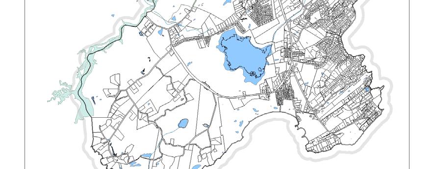
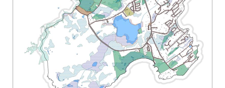
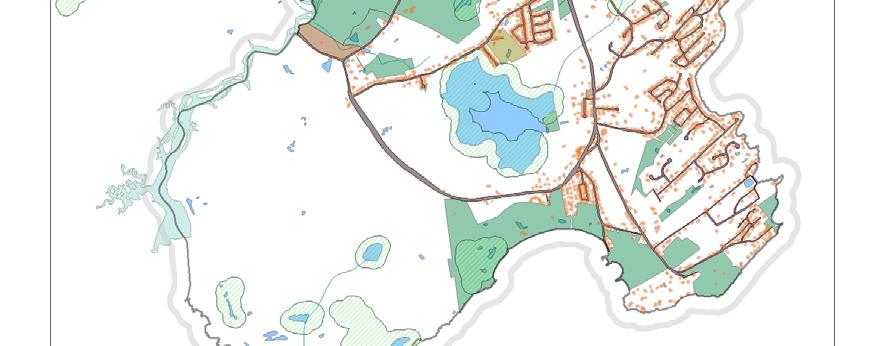
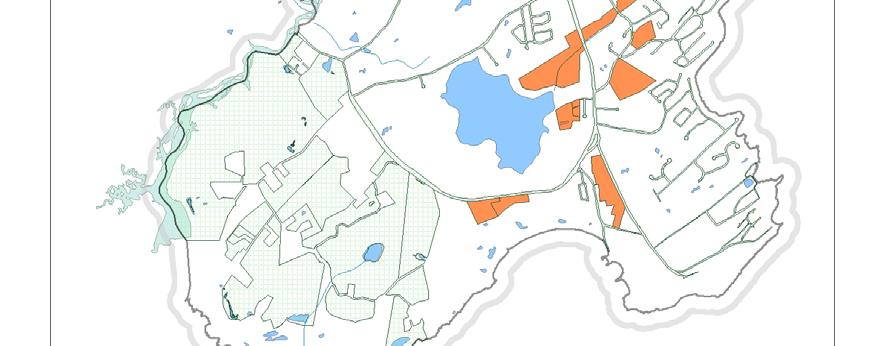
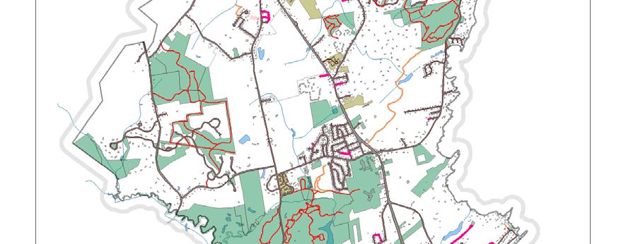
4 While we acknowledge that residential development will continue in Cape Elizabeth. We also recognize that local residents clearly cherish the natural lands that contribute to our quality of life and make Cape Elizabeth increasingly unique in the Greater Portland region. The intent of this Strategic Conservation Plan is to develop an Action Plan and identify Focus Areas to ensure that the land trust concentrates its acquisition efforts in areas of the town that make most sense to preserve always with the support and involvement of willing landowners. NATURAL AND CULTURAL RESOURCE BASELINE INFORMATION: Utilizing a wealth of natural resource and planning data, and maps gathered by CELT from municipal, regional, statewide and federal data sources we began our planning efforts by creating a baseline inventory of existing conservation lands, wetlands, farmlands, habitat areas and local recreational trails. Many of these attributes are represented on our conservation maps generated by CELT, and amended to this report. Some of these data sources include: Town GIS layers including: Parcel Maps; Assessors Database; Local Zoning Maps; Wetland delineations; Roads; Sewer Lines; Existing Conservation Lands and Trails; Paper Streets; and Town Owned Vacant Lands. State GIS layers including: Habitat Data; Soils Layers; Aerial Imagery; Contour Layers; Watershed Layers; and Layers and Data from the Beginning With Habitat collaborative. Federal GIS layers and data sources: Habitat Data and Layers; Floodplain Layers; Wetlands Layers; and Land Cover Another essential component of our baseline conservation planning relates to demographic trends and local land use policy. It is absolutely necessary to develop a working knowledge of these data sources prior to looking at conservation options. These data provide an important context from which to understand current limitations and restrictions of land use are based, and that in large part predict how land will be used locally in the near future. While it is important to remember that local ordinance and zoning designations can change (and in some cases must change) to facilitate a comprehensive land use policy friendly to conservation initiatives, understanding current restrictions is equally as important. Understanding that some future development of your community is inevitable, understanding where this development is 4
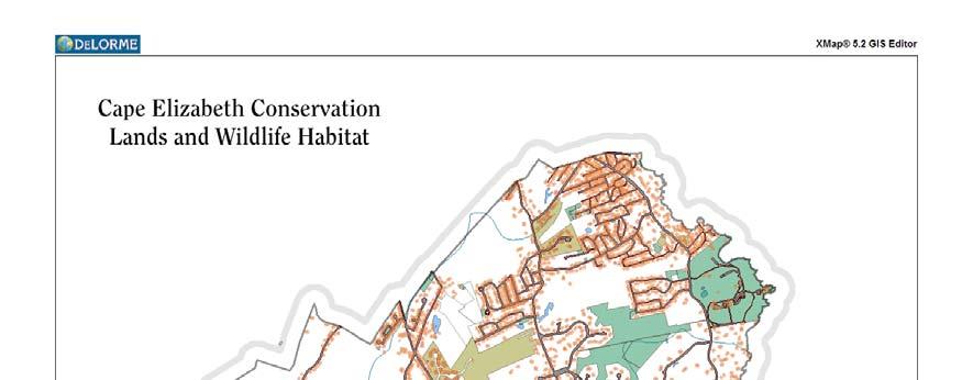
5 likely (or encouraged) to occur should be investigated. This analysis becomes particularly helpful in evaluating the relative risk that properties under consideration for conservation may instead be developed. In addition to these hard data sources our conservation planning also included many local inputs relating to historic land use, locally recognized habitat features, trails, as well as field data collected by CELT using GPS coordinates and personal observation. These inputs were collected from site visits, correspondence, local historical society, public meetings and organizational notes since Maps: Utilizing in-house GIS mapping software (DeLorme XMap 5.2 GIS Editor) has enabled CELT to analyze available data, and to identify specific parcels for consideration. More importantly CELT has been able to utilize data from existing maps created by the town, and other entities, and to standardize the presentation of the information contained in these maps. The following baseline maps, created by CELT, are included as Appendices: Conserved lands and trails Wildlife and plant habitat Zoning and parcels Wetlands Existing farmlands and high value farmland soils What s left? (Includes lands not currently developed and land not permanently protected, and other lands that provide strategic trail connections or are lightly developed and could accommodate land protection initiatives) Public Input: In order to fully inform this plan, the Land Trust actively sought advice and ideas from Town officials, Cape Elizabeth residents and area conservation groups. Public meetings were held in April, August, October and December of Open House style public meetings were held at the CELT office and designed to balance the presentation of materials with ample time for questions and comments. Our first round of meetings was used to survey participant s priorities as they relate to CELT s objectives. These discussions 5
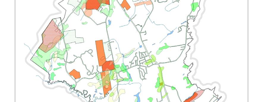
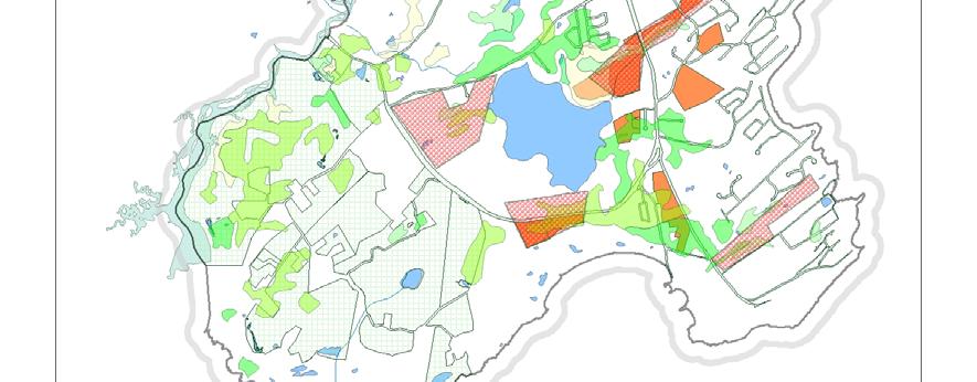
6 centered on the type of lands in need of protection (including specific parcels), CELT s land acquisition criteria, and a survey* of the relative importance of these criteria. *This survey also expanded our criteria to include scoring of a wider range of considerations regarding potential conservation lands including: Cost; Landowner Willingness; Stewardship responsibilities/costs; Current and Past agricultural use, and several others. The most valuable aspect of these early meetings was our ability to tap local knowledge of important conservation lands and recreational trails on private lands. The meetings also served an important orientation to the specifics of how CELT operates in regard to conservation planning. These meetings benefited further from the interactive use of large printed maps for people to draw on and to make notations. These public meetings were followed by individual meetings with local elected officials and town staff to review, and glean the same information with an eye toward the identification of shared interests.* *Our local land preservation efforts are somewhat dependent upon municipal support, as certain state funding sources such as the Land for Maine s Future program require local municipal financial support. Later public meetings were used to share review again our baseline conservation maps and to walk through the process we used to determine, and create our three focus areas. The latter meetings were also used to gather feedback on the draft focus area selections providing both the rationale for the choices, and to provide an opportunity to amend our findings. FOCUS AREAS The process of determining focus areas for priority conservation lands came about from three planning meeting findings: Public Input, CELT acquisition criteria, and analysis of available planning and land use data. From the outset we wanted to be sure that our instincts, and current objectives did not steer the process towards the lands we had already identified as strategic parcels. Rather we wanted to step back and examine these inputs on their own merits to determine relative significance. Initially our group had intended upon creating a single focus area to encompass the myriad conservation interests of our organization. As a result of our own internal discussions and those with community members we found that the areas of Habitat, Recreation and Farmland were 6
7 recurring themes of discussion. Ultimately the decision to create focus areas specific to these three was agreed upon. Farmland Protection Focus Area: To clarify our strategic interest in farmland and agricultural lands we began with a census of known current agricultural uses. In addition to mapping the current agricultural uses of lands, we also attempted to map former agricultural lands, as well as a mapping layer depicting farmland soils of statewide significance. From these criteria we began the process of looking at each of these areas individually to determine the relative importance of each area by attributing local knowledge regarding current ownership, current enrollment in statewide taxation programs, relative size of the parcels, current land cover, zoning, and suitability for farming. In our examination of these various inputs we were surprised to find (as a formerly heavily farmed community) that the majority of the prime farmland soils were now built upon, including much of what is now the Cape Elizabeth Town Center and School buildings. Interestingly, though perhaps not surprisingly, many of the historic multi-generational farms were also located on areas of prime farmland soils. Another finding came in relation to the existence of prime farmland soils on much of what is considered resource protection (2) lands. (RP2 is a zoning designation for wetlands that are largely restricted from home or building construction, road crossings etc.). Many of these lands, while apparently marginally available for new development, nonetheless made it into our farmland focus area as farmland exists not only as a cultural resource, but often too as an ecological resource and many of these resource protection areas were being considered for preservation in other focus areas. Habitat Focus Area: The process of refining our interest in habitat protection began with baseline mapping of the known waterways (ponds, rivers, streams, estuaries). Subsequently we analyzed data on undeveloped blocks of land, and lands that adjoined, or provided linkage to other conservation properties. From this baseline we were then able to begin utilizing the wealth of State and Federal data regarding habitat types and known habitat focus areas. As Maine is blessed with a coordinated approach to sharing this type of data (Beginning With Habitat (BWH) compiles State and Federal Data of this sort), we were able to see not only specific habitat data from US F+WS, but also the State Inland Fisheries Data, Deer wintering habitat, estuarine resources, shorebird data, and rare and threatened species data. 7
8 Using these data sources as the known important habitat areas CELT began employing other methods to identify properties providing linkages between existing conservation lands, and a more thorough examination of the wetlands and watersheds, and coastal resources within our service area. Despite its relatively small size, Cape Elizabeth s 9,000 acres still support varied habitat for a diversity of mammalian, avian, and plant species. Through an active outings program CELT has gathered a strong inventory of these resources on our properties, and by extension, on many of the habitat types represented locally. The habitat focus areas primarily represent the protection of salt and freshwater wetlands and upland habitat (including wooded wetland and vernal pools), coastal estuaries and coves, mature hardwood forest, and areas providing additional acreage and linkage to existing conservation lands. As nearly one-third of Cape Elizabeth is classified as wetlands we prepared an inventory of these areas to classify habitat types. Many of our wetland areas can be divided into four distinct watersheds: Spurwink River, Pond Cove Brook, Alewives Brook, and Trout Brook. Several smaller streams and ponds represent the balance of local wetland resources. As a coastal town with nearly 12 miles of shorefront, we recognized the importance of protecting our coastal resources, which include estuarine habitat, and more than 20 named coves that provide essential water bird habitat. Predominantly the coastal frontage of Cape Elizabeth is now developed and very few vacant parcels remain. Notable exceptions to the development of our coastal habitat resources are the two state parks at Crescent Beach and Two Lights, and the town owned Ft. Williams Park. In our effort to identify coastal resources still available for preservation we identified several parcels whose protection would help to retain this coastal habitat in its natural state. The inland, wooded areas of Cape Elizabeth are largely relatively young mixed hardwood forest with red oak, maple, birch, white pine and hemlock being the most abundant species. As a community deeply rooted in agriculture the entire town was nearly devoid of trees near the turn of the 20 th century. The remnant areas not cleared for planting at this time are largely found in areas of rocky outcrops and ledge. In these areas we are still able to find relatively undisturbed mature forests hosting excellent habitat for a variety of plant, animal and bird species. 8
9 Recreation Focus Area: Recognized as one of the more tangible public benefits of conservation, the role of public access and use of conservation lands was chosen as our third focus area. While there was some concern that the public use of land is not itself a conservation benefit, ultimately we determined that the myriad benefits of public access to existing and future projects warranted their inclusion. The primary goal of our conservation efforts is to preserve a healthy environment that supports the preservation of important habitat, wildlife species, and lands that protect these areas and species from encroachment and disturbance. We also felt that conservation lands with walking trails aid our efforts to preserve such places from new development. The ability of residents to walk in the woods, or along unspoiled water frontage, we believe, instills them with a greater appreciation of these areas. We try to foster this appreciation through more than 30 public walks and talks at these properties each year. As a related benefit we find that frequent users of our conservation lands are the most likely to become stewardship volunteers who assist our efforts to maintain the integrity of these parcels, we also find that frequent users are more likely to support our conservation efforts. Another rationale for the recreation focus area was the overall benefit of a connected trail system linking neighborhoods to area conservation lands. Without the need for parking areas as isolated destination properties, we are attempting to preserve trail corridors that maintain, or complement existing trails throughout Cape Elizabeth. One of the recommended implementation steps for our Recreation Focus Area is a review of the existing paper streets in town, and the many existing trails entirely on private lands. While the pure conservation gains of these acquisitions may not be as important as habitat protection, they do provide great, and measurable public benefit allowing the free passage across a coordinated network of trails. ACTION PLAN The determination of our three focus areas has now set in motion several coordinated efforts to advance the probability of preserving these most important lands. This planning exercise has also 9
10 given us a strong indication of the financial resources necessary to fully realize a comprehensive land use profile for the Town. As we move forward the Cape Elizabeth Land Trust will pursue four courses of action aimed at forwarding progress on our conservation goals. 1. Public Participation: To ensure that our strategic conservation efforts capitalize on strong public support, CELT is planning to set up individual neighborhood meetings throughout These meetings will serve both an outreach objective, as well as a cultivation effort for potential donations to our land protection efforts. Serving generally as an orientation for each neighborhood group to the existing conservation lands in their general area, these meetings will also identify any focus area designations in their neighborhood and speak to their strategic importance. Through this effort we hope to engage neighborhood associations, and residents in the stewardship of existing conservation lands, and to create natural allies in support of our future conservation goals. 2. Funding: Based upon our findings, and focus area designations CELT recognizes an elemental need to strengthen and broaden our fundraising efforts. To this end we have engaged our board and an outside consultant to perform an assessment of our organizational strengths and weaknesses in the area of development, and to coordinate specific training sessions for board members and staff to address critical areas in need of improvement. 3. Municipal Support: With our conservation goals clearly defined and exhibited, our land trust will now begin to work with town elected officials and staff to find areas of common interest. As the town s conservation planning is largely based on its 2001 Greenbelt Plan, CELT is eager to be an active participant in the redrafting of this document scheduled for Given the wealth of new information and maps informed by this Strategic Conservation Plan, CELT will also attempt to position our findings as a template for municipal land planning efforts. It is our hope that the town will choose to adopt many of our findings as a greenprint for future conservation priorities. CELT will also be working with town officials to review the existing open space set-aside provisions related to new residential sub-divisions. Currently the developer largely decides the identification and demarcation of these lands with little consideration given to the strategic nature of the lands being protected. 10
11 A third and critical component of our ongoing relationship to the Town of Cape Elizabeth will be an effort to build municipal support for a land bond. To complement this effort we are exploring collaborative relationships to provide specific data regarding the relative costs associated with local residential development as compared to the relative costs of conservation land, and farmland preservation. Typically these studies provide guidance for local planners to assess the long-term service costs of these types of land use. 4. Landowner Outreach: Perhaps the most important, and exciting outcome of our Strategic Conservation Planning will be a renewed effort to meet with local landowners to discuss potential conservation designation for their properties. Using the focus area designations as impetus, these conversations will orient local landowners to the strategic importance of their lands, and offer the land trust an opportunity to gauge relative interest in conservation, and to answer questions. LAND TRUST POLICY AND PRACTICE: Land Protection Criteria Cape Elizabeth Land Trust has long employed qualitative criteria to help guide the selection of appropriate lands for acquisition and permanent protection. Criteria used in the past have been carefully determined, based on thoughtful feedback from Land Trust staff, Board members and Town residents. In developing this Strategic Conservation Plan, the criteria have been reviewed and refined again. The qualitative criteria remain helpful as a tool to clearly and simply expressing our priorities, internally and externally. See Appendix A As part of this Strategic Conservation Plan, Cape Elizabeth Land Trust has also developed a quantitative worksheet for evaluating lands for potential acquisition. This tool refines our selection criteria further; creating a procedural review that may be more objective and transparent than the qualitative criteria alone. The worksheet functions as a tool to document conservation values of each project under consideration. See Appendix B TOOLS TO SUPPORT LAND CONSERVATION: Over the past twenty-five years the methods and strategies for land conservation have evolved to include a wider breadth of conservation options. While fee acquisition and deed restrictions in the form of conservation easements will likely continue to represent the vast majority of our projects 11
12 there are new strategies available to assist the financing of these projects. As an integral component to designing a comprehensive strategic conservation plan our board spent time evaluating, and agreeing upon the methods of land protection available to our organization. Consistent throughout these methods has been a commitment to working with willing landowners. While often a mantra of land conservation CELT is actively trying to broaden the use of this term to include landowners who are simply open to considering conservation but simply need more information. An example of this tool is illustrated by our recent work with a local farmer who simply did not know the value of his land, the development potential, or the zoning restrictions on his property. It became immediately clear that he would need more information on which to base his consideration of our proposal to conserve the majority of his property. Rather than waiting for the landowner to initiate the requisite wetland and boundary surveys, CELT offered to share these costs in the interest of investing ourselves in the future of his lands. While there is some direct cost in this type of cultivation we feel that for the right properties we can not simply wait until a landowner decides to explore these options as invariably this occurs at the behest, and expense of a developer interested in building on the parcel. As a precursor to entering into formal negotiations we feel that this more proactive approach to conservation is both necessary and effective. The process of aligning a landowner s interest in conservation with available methods is a critical component of successful negotiation. To ensure that we were able to creatively approach each negotiation our organization reviewed the mechanisms of various land preservation strategies to ensure that we were able to consider, and discuss multiple approaches. These methods are outlined below. Acquisition primer Fee acquisition : Typically, lands that are acquired at fair market value, based on a legitimate real estate appraisal. It is often considered best practice to back up a fee acquisition by one conservation partner with easement ownership by a second conservation partner. Alternately a Declaration of Trust may be suitable. A double line of protection provides extra protection, in the event that the primary conservation owner cannot or will not live up to the terms of the acquisition in perpetuity. Fee donation: Donations may permit landowners to make generous gifts without necessarily making large financial sacrifices. Donations can eliminate property taxes and 12
13 remove property value from your estate, thereby reducing high tax consequences for heirs. There are multiple tools available for landowners to consider employing (ie. Donating by will, donating a remainder interest, establishing a charitable gift annuity or a charitable remainder trust). Easement acquisition or donation: A conservation easement is a legally binding document in which the owner voluntary limits or relinquishes specific rights typically associated with land ownership (i.e construction of buildings, extraction of minerals, timber harvest, etc.). Easements can be sold or donated. Typically, a conservation easement will be designed to meet the needs of the landowner and also protect the land s natural and cultural values. Often, but not always, easements provide public access. Conservation easement obligations pass from one owner to the next, and the easement holder takes on a permanent responsibility to monitor the property and ensure that landowners comply with the terms of the easement. Consequently, land trusts generally establish a stewardship fund to pay for the costs of monitoring and if needed, to legally defend easements in the event of disputes. Placing an easement on land typically reduces its resale value, but donated easements can qualify for tax deductions if the easement provides significant public benefits. In addition, the value of donated easements can typically be used as the equivalent of matching funds for many grant proposals. Bargain sale: A bargain sale constitutes an agreement to purchase land below fair market value. The difference between the fair market value and the actual sale price constitutes the bargain sale, which can be considered as a donation for tax purposes, and can typically be used as the equivalent of matching cash funds for many grant proposals. b). In an installment sale, the seller agrees to accept a series of payments over time, rather than a lump sum for the land. Installment sales benefit the seller by spreading out the income and taxable gains over multiple years, and installment sales allow the purchasing organization to raise funds over an extended period of time. Option to purchase: This method allows the purchasing organization to pay a relatively small amount of upfront risk money to hold the sale while continuing to raise sufficient funds to acquire the property. The option binds the seller to wait a specified amount of time before selling to anyone else. If the purchasing organization fails to raise sufficient money by the deadline, the original owner can keep the option money. Conservation buyer: Conservation buyers can be individuals who value natural lands and agree to purchase and permanently protect threatened lands, working in concert with a conservation organization. Sometimes, conservation buyers will purchase lands recently 13
14 acquired by a land trust and then placed under a conservation easement. Other conservation buyers help preserve lands by acting quickly to acquire a threatened property and then allowing the land trust time needed to raise funds to acquire. Buy-Restrict-Sell: Buy-Restrict-Sell is the direct approach of purchasing lands, ensuring their future conservation, and then reselling the property as restricted against certain detrimental uses of the land. Deed restrictions and mutual covenant: Restrictive covenants can be placed in a deed when land is transferred. Landowners can impose deed restrictions on land when they deed it to others, but only to benefit land they retain. These restrictions are placed directly in the deed, but they are less reliable as a permanent form of land protection than conservation easements because future owners may not be committed to or able to enforce deed restrictions, and there is no second party to enforce compliance. Furthermore, owners of the restricted parcel and the benefited parcel can agree to terminate the restriction, and if one landowner acquires both parcels, the deed restrictions will be erased. Management agreements/assistance: Management agreements and assistance are best employed when a landowner is unwilling, or uninterested in relinquishing or sharing ownership of a parcel, yet is keenly interested in managing the property for conservation values. Land Trust involvement in designing, and even implementing management plans for a property can have great value despite having no legal effect on the potential uses of the property. This type of cooperative approach may well entrust a landowner to consider conservation options at some future date. Limited Development: Limited development is increasingly viewed by conservation organizations as a viable means for land preservation. This approach appears to work well with large parcels whose appraised value is of such great proportions that outright purchase, or even easement purchase is simply too high. In certain instances the planned development of a portion of the property in order to preserve a smaller, yet strategic portion of the property can be seen as an important land protection tool. OTHER RESOURCES TO SUPPORT LAND CONSERVATION 14
15 Town of Cape Elizabeth: The Town of Cape Elizabeth must continually balance its land protection efforts against other competing priorities. Recent surveys make it clear that the overwhelming majority of Town residents value, and wish to protect the rural character, the natural landscape and the local passive outdoor recreational opportunities. Polling also indicates a strong interest in having the town play an active role in preserving these attributes. As a municipality, the Town has the ability to employ tools not directly available to the Land Trust specifically in the areas of zoning, local ordinance, assessment, and long-term comprehensive planning. Zoning/Ordinance: As a municipality governed by Town Council with the assistance of a town manager and a town planner, local zoning districts and local ordinance inform many land uses, and restrictions. These designations directly effect the preservation of local stream corridors, shoreland setbacks and wetlands. Zoning districts also serve to dictate the type, and placement of new development. As existing ordinance, and zoning regulations are an integral component of determining the value of undeveloped lands, they often have a great effect upon our land trust s ability to work with local landowners when considering conservation. More recently CELT has begun to work more closely with the town council and town committees to better understand how ordinance and zoning serve to encourage, or discourage the preservation of natural habitats, and natural areas. Subdivision set-asides: Cape Elizabeth employs this as a method to encourage/require developers to permanently protect 40% of their property from construction activities, and to set the land aside as open space. Set-asides can be particularly helpful in providing open space near people s homes, and in establish trail corridors linking larger open spaces and developing the Greenbelt Trail. However, set-asides of conservation lands behind housing developments can be notoriously difficult to manage and enforce, with the potential for multiple landowners to encroach on the conservation lands. Moreover, poorly designed or located set-asides may be narrow parcels surrounded by development, offering questionable or limited value for wildlife or recreation. The Land Trust urges the Town to consider a more strategic approach by providing developers the opportunity to build out their parcel more completely in exchange for providing significant funding to protect high priority parcels in identified Focus Areas. Assessment: The valuation of local lands for tax purposes must also be considered a tool for conservation, particularly the valuation of undeveloped lands and farmland. While some statewide programs to set assessment standards for agricultural lands and working forests exist, few local 15
16 landowners have utilized these programs. When a landowner chooses not to enroll their lands in one of these current use programs the local assessor is charged with determine a fair valuation. Historically local assessment of working farmland has been taxed at a rate significantly below typical open space properties of similar acreage. However, even these generous rates are--by a factor of 10-- higher than statewide-recommended rates for lands enrolled in current use programs. Another local consideration is the valuation of estate lands, typically larger parcels with a single home. While some municipalities could defend a valuation based upon the potential value of a property, our local assessor has not done so. The town s approach to the assessment of property values can both encourage, and discourage the conservation, or development of natural areas. Should an assessment become too high the pressure to sell increases, while actions taken to stabilize, or reduce valuations on natural areas, tends to keep land ownership less volatile. Long Range Planning: As a New England Home Rule municipality the public process for determining future planning priorities is designed for citizen input. Periodically the town council is charged with revising long-term land use plans. There are two notable reports that directly effect conservation policy and priorities; a town Comprehensive Plan (mandated by the State Planning Office every years), and the town s Greenbelt Plan to determine conservation goals (last updated in 2001). Comprehensive Plan: Last updated in 2007, the Town of Cape Elizabeth Comprehensive Plan follows a template established by the State Planning Office to ensure that local municipalities are planning for future land use, updating census information, current land use statistics and demographic and planning data. As a conservation organization this plan provided an opportunity to suggest ways in which the town could encourage the continued, strategic acquisition, and protection of natural resources. A particularly revealing, and encouraging, finding of the public opinion polls conducted during this time was the strong public support for the preservation of natural areas. In the December 2005 town-wide survey fully 94% of Town residents listed the natural environment as an important benefit of living in Cape Elizabeth. Additionally, more than 80% of town residents valued protecting and preserving wetlands, ponds and wooded areas, and preserving the town s rural character and protecting farmland as the top three planning priorities. Recommendations from the final report document the strong public support for protecting open space, natural areas, farmland and trails, yet does little to propose any proactive, or strategic approach to land protection. In fact, the report suggests that future land protection initiated by the 16
17 town will largely be accomplished through the utilization of lands extracted from new development as required by local ordinance. Much of the input provided to this planning process focused on encouraging the town to view the strategic, pro-active preservation of key natural areas as a top planning priority reflecting public sentiment as gathered in the public opinion survey. Key findings and recommendations of the Comprehensive Plan are attached within the appendix of this paper. Comprehensive Plan Findings: From 1960 the present, the population of Cape Elizabeth increased 65% from 5,505 to 9,608. The Plan assumes a 2% community growth rate into the future, which translates to 330 new homes projected in the next 20 years. In general, the Comprehensive Plan recommendations enthusiastically reflect community support for land protection and support the land trust s interests in protecting the natural and rural character of Cape Elizabeth. The Comprehensive Plan includes the following recommendations: Growth areas identified in Residential B zoning districts, constituting 7% of the town (Designated growth areas include specific farms as well other specific properties with deed restrictions that preclude residential development). Promote (but not require) clustered development, leaving 40% of each subdivision parcel for trails and open space. Support completion of the Greenbelt trail corridor, with trail spokes radiating to all neighborhoods (Currently, there are 17.8 miles of walking trails in Town). Encourage preservation of working farms. Expand open space, but emphasis will shift to trail construction rather than additional acquisition. Increase publicly accessible open space to preserve current ratio of 118 acres of open space per 1,000 people. Partner with Cape Elizabeth Land Trust. Maintain dialog with large landowners. Evaluate new funding sources for land and trail protection. Continue Open Space Zoning and Impact Fees. While in general agreement with many of the recommendations of the Comprehensive Plan, a few of the recommendations make it apparent that the interests of the Town, the Land Trust and many residents may diverge on specific projects and on areas of greatest focus and interest. For example, Designated Growth Areas (zoning districts where new development, particularly subdivisions, are encouraged) include several properties that may not be appropriate for 17
18 residential development, including current farm land parcels, and properties that have deed restrictions that preclude residential development. The Town is shifting its emphasis to completing the Greenbelt Trail, and will de-emphasize land acquisition. The Town is committed to maintaining the current ratio of 118 acres of protected open space per 1,000 residents. While in support of this general goal, the means of achieving this goal were outlined as relying upon the set-aside land from future subdivisions. While the open space zoning approach does buffer new development, this type of land protection is neither strategic, nor does it further the goal of maintaining the character of the community. Nevertheless, there is much common ground binding the Town s Comprehensive Plan, the interests of Town residents, and the Land Trust s Strategic Conservation Plan. The Land Trust is committed to working towards aligning all three groups with a collaborative mindset and consistent conservation purposes. Ultimately, land protection opportunities largely depend on the choices made by individual landowners. Greenbelt Plan: In 2001 the Town of Cape Elizabeth released a Master Greenbelt Plan, outlining a vision for a central trail corridor (referred to as the cross-town trail) connected to a series of neighborhood access points and side trails. Also included in the planning document were prioritized recommended areas of interest for the town to acquire and/or preserve lands encompassing this trail network. This municipal interest in expanding and improving the town trail system is an important consideration for the Land Trust as we look for areas of alignment with the town for cooperative preservation projects. Subsequent to the Greenbelt Plan the town conservation commission conducted an inventory of all town owned land with an eye towards identifying lands that may be considered for preservation, and those the town would consider selling. This inventory also gave a similar set of recommendations on the future status of the network of Paper Streets throughout Cape Elizabeth. State and Federal: State and Federal entities are both potential partners in land acquisition and land acquisition funding. Within Cape Elizabeth we have State Parks at Two Lights State Park and Crescent Beach State Park, and nearly 50 acres of federal lands owned by the US Fish & Wildlife Service (Rachel Carson National Wildlife refuge) and the Coast Guard. 18
19 State and Federal Agencies play an important role in the preservation of important habitat areas, and rare and threatened species. Increasingly State and Federal funds are available for larger comprehensive conservation projects dedicated to the protection of these resources. Conclusions: Throughout this planning process our organization has seen this exercise as an opportunity to engage staff, board members and the community at large in a discussion regarding collaborative strategic conservation. At the conclusion of the Town s Comprehensive Plan a statement relating to the protection of unique and strategic lands begged the question as to what was strategic. As a Land Trust we have long understood our own priorities but this process has been particularly helpful in enabling CELT to clearly articulate why these lands are important. Specifically the use of maps has proven to be the most rewarding part of our strategic conservation planning. Beginning with the natural resource inventory maps and existing conservation lands and wetlands maps we went through a process of re-orienting our vision of conservation to the town as a whole rather than simply looking at individual parcels. This comprehensive framework continued throughout our planning and has forever transformed the lens through which we view our conservation planning. We are especially thankful to Caroline Norden who provided initial training for this effort based upon the Land Trust Alliance Conservation Planning Student Guide, and to the staff of the Land Trust Alliance, Maine Coast Heritage Trust, and the Maine Coast Protection Initiative. Finally we would like to thank Lois Winter who was employed as a consultant during the early stages of this process. --Cape Elizabeth Land Trust December
20 Appendix A: Land Protection Criteria Land Acquisition Criteria As a non-profit 501(c)(3) corporation the Cape Elizabeth Land Trust is recognized as a qualified holder of conservation lands. To ensure that our land protection projects provide demonstrable public benefit (as required by law) we have developed the following guidelines and criteria for the acquisition of conservation easements or fee interests in land parcels: Projects for consideration must meet at least one of the following criteria: Ecological importance Visual attractiveness Public access Suitability for passive recreation Relation to Greenbelt Preservation of working farms In addition to the above criteria the following guidelines are offered for clarification of the process CELT uses to approve projects under consideration. An authorized family member or representative must willingly put each project forth for consideration. The project must entail some form of qualified public benefit. All projects will be reviewed by the CELT Lands Committee Projects recommended by the Lands Committee will be then forwarded to the organization s Board of Directors. CELT will refrain from offering specific legal and/or financial planning advice. Information regarding the tax consequences of land donation/preservation should to be determined by an independent source. A recent property appraisal is needed to validate the stated value of a parcel (if seeking a tax deduction). 20
21 Appendix B: Land Protection Criteria Quantitative Scoring Project Name: Location: Map/Lot #: Owner(s): Personal Contact Date: Date of Visit:_ Reviewers Name: Public Benefit: All properties must meet IRS standard for public benefit. Circle public benefit(s) that apply: Public access/recreation Protection of natural resources (water quality, habitat) Scenic values Historically Important Notes: Focus Area: The property falls within one or more of CELT focus areas. Please refer to CELT Focus Area Maps 21
22 Habitat Focus Area (10 points) Farmland Focus Area (10 points) Recreation Focus Area (10 points) Connectivity: The property is adjacent to or provides linkage to existing conservation lands. Property abuts CELT holding(s) (4 points) Property abuts other conservation lands (3 points) Property currently provides trail connectivity (3 points) Property would provide new trail connectivity (3 points) Property provides connectivity for Cross Town Trail (4 points) Conservation Values: The property contains recognized conservation values. Rare/Threatened/Endangered species (4 points) Significant or Unique Conservation Values (3 points) River/Stream Corridor Within wetland setback (2 points) Beyond wetland setbacks (3 points) Vernal Pools (3 points) 22
23 Community Values: The property preserves community character and/or traditional uses. Water Access (3 points) Agricultural Lands Working (3 points) Prime Farmland Soils (2 points) Scenic Views (3 points) Historic Site (2 points) Working Waterfront (2 points) Other Considerations: Landowner Willingness (2 points) Alignment with Comprehensive Plan/municipal goals (2 points) Clear funding source/ partnership (2 points) Development Threat (2 points) TOTAL SCORE 23
24 24
25 25
26 26
27 27
28 28
29 29
30 30
31 31
32 32
33 33
34 34
35 35
36 36
37 37
38 38
About Conservation Easements
 Section Three: Farm Transfer Tools About Conservation Easements Editor s note: One question that our education collaborative has fielded consistently throughout the years is about conservation easements.
Working Together to Conserve Land
 Working Together to Conserve Land A Resource for Landowners Protecting land for future generations About Loon Echo was formed as a 501(c)(3)nonprofit organization in 1987 to preserve land in the northern
Chapter VIII. Conservation Easements: Valuing Property Subject to a Qualified Conservation Contribution
 A. Overview and Purpose Chap. VIII Conservation Easements: Valuing... Jacobson & Becker 91 Chapter VIII Conservation Easements: Valuing Property Subject to a Qualified Conservation Contribution Forest
IRS FORM 8283 SUPPLEMENTAL STATEMENT DONATION OF CONSERVATION EASEMENT
 Name(s) shown on income tax return Identifying Number Robert T. Landowner 021-34-1234 Susan B. Landowner 083-23-5555 IRS FORM 8283 SUPPLEMENTAL STATEMENT DONATION OF CONSERVATION EASEMENT On November 12,
Central Pennsylvania Conservancy Project Selection Criteria Form
 Central Pennsylvania Conservancy Project Selection Criteria Form The following criteria guide the actions of the Central Pennsylvania Conservancy s Land Protection Committee and Board of Directors in selecting
Kent Land Trust Strategic Reassessment Project Final Report
 Kent Land Trust Strategic Reassessment Project Final Report Prepared For: Connecticut Institute for Resilience and Climate Adaptation (CIRCA) Prepared by: Michael A. Benjamin, Land Steward, Kent Land Trust
PROJECT SCORING GUIDANCE. Introduction: National Proiect Selection:
 FOREST LEGACY PROGRAM PROJECT SCORING GUIDANCE Introduction: This document provides guidance to the National Review Panel on how to score individual Forest Legacy Program (FLP) projects, including additional
CONSERVATION EASEMENTS FREQUENTLY ASKED QUESTIONS
 CONSERVATION EASEMENTS FREQUENTLY ASKED QUESTIONS CCALT Founder and Steamboat rancher, Jay Fetcher notes, You shouldn t even be considering a conservation easement unless two things have happened: (1)
Land Trust of Santa Cruz County. Strategic Plan. July 2012 to June This is a public version of a more detailed internal plan.
 Land Trust of Santa Cruz County Strategic Plan July 2012 to June 2015 This is a public version of a more detailed internal plan. Over the next three years the Land Trust will pursue four critical strategies.
CONSERVATION EASEMENTS FREQUENTLY ASKED QUESTIONS
 CONSERVATION EASEMENTS FREQUENTLY ASKED QUESTIONS CCALT Founder and Steamboat rancher, Jay Fetcher notes, You shouldn t even be considering a conservation easement unless two things have happened: (1)
APPENDIX B. Fee Simple v. Conservation Easement Acquisitions NTCOG Water Quality Greenprint - Training Workshops
 APPENDIX B Fee Simple v. Conservation Easement Acquisitions NTCOG Water Quality Greenprint - Training Workshops Lake Arlington Watershed and Lewisville Lake East Watershed June 21, 2011 Presenter Talking
PRE-APPLICATION FREQUENTLY ASKED QUESTIONS (FAQ) GENERAL PURCHASE OF DEVELOPMENT RIGHTS (PDR) FAQs
 GENERAL PURCHASE OF DEVELOPMENT RIGHTS (PDR) FAQs") PRE-APPLICATION FREQUENTLY ASKED QUESTIONS (FAQ) Q: Question #26 asks me to describe how protecting my land will buffer and enhance important public natural areas. What types of natural areas do you mean?
PRE-APPLICATION FREQUENTLY ASKED QUESTIONS (FAQ) Q: Question #26 asks me to describe how protecting my land will buffer and enhance important public natural areas. What types of natural areas do you mean?
General Development Plan Background Report on Agricultural Land Preservation
 General Development Plan 2008 Background Report on Agricultural Land Preservation February 2008 I. Introduction Anne Arundel County has been an agricultural community for over 350 years, beginning with
DESCRIPTION OF A LAND TRUST
 DESCRIPTION OF A LAND TRUST What is a land trust? Land trusts are non-profit organizations that work hand-in-hand with landowners to protect our valuable natural resources. Land trusts have become increasingly
Conservation Easement Stewardship
 Conservation Easements are effective tools to preserve significant natural, historical or cultural resources. Conservation Easement Stewardship Level of Service Standards March 2013 The mission of the
DRAFT FOR PUBLIC HEARING (rev. March, 2016)
") Chapter 200. ZONING Article VI. Conservation/Cluster Subdivisions 200-45. Intent and Purpose These provisions are intended to: A. Guide the future growth and development of the community consistent with
Chapter 200. ZONING Article VI. Conservation/Cluster Subdivisions 200-45. Intent and Purpose These provisions are intended to: A. Guide the future growth and development of the community consistent with
Conservation Options for Private Landowners
 Conservation Options for Private Landowners What You Can Do to Help Protect the Nature of Massachusetts The Need for Conservation Massachusetts is blessed with a rich and varied landscape. Our hills, river
Conservation Easements: Creating a Conservation Legacy for Private Property
 Conservation Easements: Creating a Conservation Legacy for Private Property What is a Conservation Easement? For landowners who want to conserve their land and yet keep it in private ownership and use,
Nova Scotia Community Lands Trust Discussion Paper. Approaches to Enable Community Participation In the Purchase of Land
 Nova Scotia Community Lands Trust Discussion Paper Approaches to Enable Community Participation In the Purchase of Land Objective Nova Scotians have expressed a desire to acquire and make use of lands
Siskiyou Land Trust. Strategic Plan Update
 Siskiyou Land Trust Strategic Plan Update 2018-2023 Issued by the Board of Directors of Siskiyou Land Trust, May 2018 Our Mission: The Siskiyou Land Trust is dedicated to long-term stewardship of agricultural,
Columbia Land Trust is seeking a Conservation Lead to join its passionate team!
 Job Title: Conservation Lead Salary Range: $54,000 - $64,000 Location: Astoria Office (with regular travel to the Vancouver Office) Reports To: Conservation Director Appl. Deadline: Open until filled -
OPEN SPACE PRESERVATION. Reflections on the Value of Acquiring Property for Preservation Purposes
 OPEN SPACE PRESERVATION Reflections on the Value of Acquiring Property for Preservation Purposes What is open space and what does it do? The Town Plan of Conservation and Development defines it as follows:
Interpretation of Conservation Purpose INTERNAL REVENUE GUIDANCE AS TO WHAT CONSTITUES A CONSERVATION PURPOSE
 Interpretation of Conservation Purpose INTERNAL REVENUE GUIDANCE AS TO WHAT CONSTITUES A CONSERVATION PURPOSE 170(h)(4)(A) of Title 26, Internal Revenue Code, Subtitle A of the United States Code gives
TOWN OF MIDDLEBOROUGH COMMUNITY PRESERVATION PLAN
 TOWN OF MIDDLEBOROUGH COMMUNITY PRESERVATION PLAN Vision The residents of Middleborough desire a community which is family-oriented and which retains its small town character while preserving an abundance
OPEN SPACE & RECREATION PLAN
 OPEN SPACE & RECREATION PLAN HOPEWELL TOWNSHIP Cumberland County, New Jersey Prepared by: Hopewell Township Environmental Commission Final October 2011 (THIS PAGE INTENTIONALLY LEFT BLANK) PUBLIC MEETINGS
With projections for Strategic Plan
 7 With projections for Strategic Plan Protecting the land we love for future generations December Introduction Land trusts are community based, non-profit, charitable organizations that focus on the protection
TOWN OF PELHAM, NEW HAMPSHIRE
 TOWN OF PELHAM, NEW HAMPSHIRE BUILDOUT ANALYSIS Prepared for the PELHAM CONSERVATION COMMISSION with the assistance of the NASHUA REGIONAL PLANNING COMMISSION TABLE OF CONTENTS I. INTRODUCTION...1 II.
LAND USE Inventory and Analysis
 LAND USE Inventory and Analysis The land use section is one of the most important components of the comprehensive plan as it identifies the location and amount of land available and suitable for particular
Midway City Council 15 January 2019 Work Meeting. Open Space Committee / Procedures
 Midway City Council 15 January 2019 Work Meeting Open Space Committee / Procedures Memo Date: January 15, 2019 To: Midway City Council From: Michael Henke Re: Open Space Committee Bond Documents Following
Town of Falmouth s Four Step Design Process for Subdivisions in the Resource Conservation Zoning Overlay District
 Town of Falmouth s Four Step Design Process for Subdivisions in the Resource Conservation Zoning Overlay District All subdivisions shall be designed in accordance with the following four-step process.
STAFF REPORT. Permit Number: Porter. Kitsap County Board of Commissioners; Kitsap County Planning Commission
 STAFF REPORT Permit Number: 15 00461 Porter DATE: November 9, 2015 TO: FROM: Kitsap County Board of Commissioners; Kitsap County Planning Commission Katrina Knutson, AICP, Senior Planner, DCD and Jeff
TRANSFER OF DEVELOPMENT RIGHTS
 STEPS IN ESTABLISHING A TDR PROGRAM Adopting TDR legislation is but one small piece of the effort required to put an effective TDR program in place. The success of a TDR program depends ultimately on the
Land Conservation Agreements Project Guidance
 Land Conservation Agreements Project Guidance Stakeholder Informed OTHER OPTIONS Introduction Enhanced or permanent protection of corporate lands through land conservation agreements means that companies
Guide to Planned Giving
 Guide to Planned Giving Leave it to nature, forever. Tax ID# 91-1533402 For more information: Skagit Land Trust 1020 S Third Street - PO Box 1017 Mount Vernon, WA 98273 360.428.7878 Molly Doran, Executive
UNOFFICIAL COPY OF HOUSE BILL 1272 A BILL ENTITLED
 UNOFFICIAL COPY OF HOUSE BILL 1272 M4 6lr0525 By: Delegates Smigiel, Kelley, Rosenberg, and Sossi Introduced and read first time: February 10, 2006 Assigned to: Environmental Matters 1 AN ACT concerning
Georgia Conservation Tax Credit Program Frequently Asked Questions
 Georgia Conservation Tax Credit Program Frequently Asked Questions What are the minimum requirements for eligibility under the Georgia Conservation Tax Credit Program (GCTCP)? Individual and corporate
New Brunswick Community Land Trust
 New Brunswick Community Land Trust Helping landowners maintain land in production to support our rural economy New Brunswick Community Land Trust For more information about NBCLT or to get involved, contact:
Remains eligible for state or federal farm programs. Can use land as collateral for loans. Can reserve home lots for children
 December 2002 B-1132 Conservation Easements: An Introductory Review for Wyoming By Allison Perrigo and Jon Iversen, William D. Ruckelshaus Institute of Environment and Natural Resources William D. Ruckelshaus
Final Report: Conserving the Pugwash Estuary
 Final Report: Conserving the Pugwash Estuary Habitat Conservation Fund Grant to Nature Conservancy of Canada, Atlantic Region Report Prepared by: Craig Smith Nova Scotia Program Manager November 20 th,
Goals for Today s Session. Understand Best Practices for sound real estate transactions. Learn tips & tricks to implement
 Anatomy of A Real Estate Transaction Texas Land Conservation Conference March 1, 2017 Goals for Today s Session Understand Best Practices for sound real estate transactions Learn tips & tricks to implement
Title 5: ADMINISTRATIVE PROCEDURES AND SERVICES
 Title 5: ADMINISTRATIVE PROCEDURES AND SERVICES Chapter 353: LAND FOR MAINE'S FUTURE Table of Contents Part 15-A. LAND FOR MAINE'S FUTURE... Section 6200. FINDINGS... 3 Section 6201. DEFINITIONS... 3 Section
South Burlington Land Trust
 South Burlington Land Trust dedicated to preserving South Burlington s forests, wetlands, farmlands and other natural areas through landowner preservation agreements and other conservation vehicles to
Open Space. Introduction. Vision. Defining Open Space. Midway City 2017 General Plan
 Open Space Midway City 2017 General Plan Introduction The importance of preserving open space to meet the goals and objectives of the General Plan cannot be overstated. Indeed, references to preserving
Planning with Conservation Easements
 Planning with Conservation Easements Succession, Tax & Estate Planning Issues & Ideas for Legacy Land October 23, 2015 Intergenerational Planning for Legacy Land Begin with the end in mind. Your goals
Land Conservation 101. Chris LaPointe, Director of Land Conservation Essex County Greenbelt Association
 Land Conservation 101 Chris LaPointe, Director of Land Conservation Essex County Greenbelt Association Greenbelt 34 cities and towns of Essex County 17,500 acres of land since 1961 Nearly 6,000 acres comprise
Land Transaction Procedures Approved July 17, 2012
 Land Transaction Procedures Approved July 17, 2012 Purpose: The Greenbelt Land Trust (GLT) acquires fee title or conservation easements for lands to fulfill its mission to conserve and protect in perpetuity
THE MANADA CONSERVANCY
 THE MANADA CONSERVANCY Description of a Land Trust What is a land trust? Land Trusts are non-profit organizations which work hand-in-hand with landowners to protect open spaces increasingly threatened
Baseline Documentation and Inventory Protocol, Version 2
 Rhode Island Conservation Stewardship Collaborative Baseline Documentation and Inventory Protocol, Version 2 September 2014 Carol Lynn Trocki Conservation Biologist Scott Ruhren, Ph.D. Senior Director
Staying Connected in the Northern Appalachians
 Staying Connected in the Northern Appalachians Potential Conservation Easement Provisions Designed to Explicitly Address Connectivity in the Northern Appalachians Updated and Revised May 2012 In this document,
Land Use. Existing Land Use
 8 Land Use 8.1 Land Use Chapter Purpose and Contents This element includes a brief summary of existing land use conditions and trends followed by a series of goals, objectives, and recommendations to guide
ALREADY SUBMITTED FOR HIGHLANDS COUNCIL PRE
 Highlands Preservation Area Approval Application Checklist Items Block 15901 Lot 1, West Milford See Highlands Council Review at: http://www.highlands.state.nj.us/njhighlands/projectreview/ **For advisory
NANTUCKET ISLANDS LAND BANK AFFORDABLE HOUSING POLICY Adopted by the vote of the Land Bank Commission on November 10, 2015
 NANTUCKET ISLANDS LAND BANK AFFORDABLE HOUSING POLICY Adopted by the vote of the Land Bank Commission on November 10, 2015 In recent history, the island of Nantucket has experienced a shortage of affordable,
ANN ARBOR GREENBELT DISTRICT STRATEGIC PLAN 2013
 ANN ARBOR GREENBELT DISTRICT STRATEGIC PLAN 2013 Approved by: Greenbelt Advisory Commission April 4, 2013 Prepared for: City of Ann Arbor Community Services Area & Greenbelt Advisory Commission 301 E.
protect your place Guide to Understanding Conservation Easements
 protect your place Guide to Understanding Conservation Easements To the Landowner Founded in 1990, the Teton Regional Land Trust is a community-based non-profit conservation organization that works to
What is a land trust? Their mission is to preserve land via conservation easements and/or acquisition.
 Agenda What is a conservation easement? Resources for conservation easements and land trusts Real Property Bundle of Rights Conditions Landowner Benefits Tax deductions Funding Options Required Information
MITIGATION POLICY FOR DISTRICT-PROTECTED LANDS
 MITIGATION POLICY FOR DISTRICT-PROTECTED LANDS Approved by the District Board of Directors on July 18, 2017 The following Mitigation Policy is intended to inform the evaluation of environmental mitigation-related
CONSERVATION EASEMENTS. Public Policy Considerations for PRIVATE Land Management Harriet M. Hageman Hageman & Brighton, P.C.
 CONSERVATION EASEMENTS Public Policy Considerations for PRIVATE Land Management Harriet M. Hageman Hageman & Brighton, P.C. Conservation Easements What are They? A legally-binding agreement b/w a property
Land Use. Land Use Categories. Chart 5.1. Nepeuskun Existing Land Use Inventory. Overview
 Land Use State Comprehensive Planning Requirements for this Chapter A compilation of objectives, policies, goals, maps and programs to guide the future development and redevelopment of public and private
Using Easements to Conserve Biodiversity. Jeff Lerner Defenders of Wildlife
 Using Easements to Conserve Biodiversity Jeff Lerner Defenders of Wildlife jlerner@defenders.org Northeast LTA June 10, 2006 Defenders of Wildlife Mission: to protect native wild animals and plants in
Topics to be Covered
 CONSERVATION EASEMENTS Presented by Claire Fiegener, Greenbelt Land Trust Topics to be Covered What is a conservation easement? What is a land trust and how do they relate to conservation easements? What
Preserving Forested Lands
 Preserving Forested Lands Maryland Woodland Stewards October 3, 2014 Megan Benjamin, Western & Central Region Planner Forestlands in Maryland Forests cover 41% of the State 2.6 million acres Ownership
Tools for Conservation: Land Trusts & Easements
 Tools for Conservation: Land Trusts & s CSS 235 Dr. Ed Krumpe 2 4 Basic Ways to Protect Land Acquisition the only permanent solution? Regulation Protect sensitive areas Control development patterns Address
Forest Service Role CHAPTER 2
 CHAPTER 2 Forest Service Role Implementation of the Management Plan charters a federal presence with an expanded focus beyond traditional Forest Service roles. In addition to administration of the National
Assets to Acres. Your Gift of Developed Real Estate Can Help Protect New Hampshire s Special Places
 Assets to Acres Your Gift of Developed Real Estate Can Help Protect New Hampshire s Special Places The Forest Society accepts donations of land and conservation easements directly protecting our forests,
FARMLAND AMENITY PROTECTION. A Brief Guide To Conservation Easements
 FARMLAND AMENITY PROTECTION A Brief Guide To Conservation Easements The purpose of this guide is to help landowners access their land amenity value and to provide direction to be compensated for this value.
Claudia Stuart, Williamson Act Program Manager and Nick Hernandez, Planning Intern
 Land Conservation (Williamson) Act Advisory Committee STAFF REPORT September 15, 2014 Prepared by: Claudia Stuart, Williamson Act Program Manager and Nick Hernandez, Planning Intern Subject: Discussion:
Landowner Information Packet
 Landowner Information Packet Please review and feel free to call us with any questions that you might have. We look forward to speaking with you about your conservation goals. Conservation Staff: Liz Edsall
How to Read a Real Estate Appraisal Report
 How to Read a Real Estate Appraisal Report Much of the private, corporate and public wealth of the world consists of real estate. The magnitude of this fundamental resource creates a need for informed
The Farmland Preservation Program in Sussex County
 The Farmland Preservation Program in Sussex County Preserved Tranquility Farm The Importance of Saving Farmland and Farmers Photo by Tanya Nolte Farmland, an irreplaceable natural resource, and the farmers
ARTICLE XI - CONSERVATION SUBDIVISIONS
 ARTICLE XI - CONSERVATION SUBDIVISIONS Section 1101: Purpose and Intent. This Article is intended to provide for residential subdivisions that are designed based first and foremost on the preservation
SECTION V: LAND USE PLANNING AND ACQUISITION
 SECTION V: LAND USE PLANNING AND ACQUISITION A. Philosophy and Guiding Principles The City s park system has evolved over more than a century, with acquisition of park parcels gradually building a system
New York Agricultural Land Trust
 New York Agricultural Land Trust P.O. Box 121 Preble, NY 13141 www.nyalt.org New York Agricultural Land Trust Agricultural Conservation Easements and Appraisals Introduction An agricultural conservation
TRENDS IN QUALIFIED CONSERVATION EASEMENTS. By: Melinda M. Beck, Esq.
 TRENDS IN QUALIFIED CONSERVATION EASEMENTS By: Melinda M. Beck, Esq. What is a Conservation Easement? An easement interest granted by a landowner to a land trust or governmental entity that voluntarily
LIVING LANDS BIODIVERSITY GRANTS: INFORMATION AND APPLICATION. Due: January 16, 2009
 LIVING LANDS BIODIVERSITY GRANTS: INFORMATION AND APPLICATION Due: January 16, 2009 PURPOSE OF LIVING LANDS PROJECT Defenders of Wildlife s Living Lands project provides financial, technical and educational
GWINNETT COUNTY CSO CONSERVATION SUBDIVISION OVERLAY DISTRICT REQUIREMENTS
 GWINNETT COUNTY CSO CONSERVATION SUBDIVISION OVERLAY DISTRICT REQUIREMENTS Section 1316. CSO Conservation Subdivision Overlay District. 1. Purposes. The purposes of this overlay district are as follows:
2018 Highlands Region Land Preservation Status Report
 2018 Highlands Region Land Preservation Status Report Highlands Development Credit (HDC) properties (l to r): Tewksbury Township, Hunterdon County; Mount Olive, Morris County; Independence Township, Warren
Connecting Conservation and Community
 1 Executive Summary: Jackson Hole Land Trust Community Assessment with Flitner Strategies Connecting Conservation and Community Background & History: Six years ago, the Jackson Hole Land Trust (JHLT) partnered
Hennepin County Economic Analysis Executive Summary
 Hennepin County Economic Analysis Executive Summary Embrace Open Space commissioned an economic study of home values in Hennepin County to quantify the financial impact of proximity to open spaces on the
What is a conservation easement?
 What is a conservation easement? A conservation easement is defined as: A non-possessory interest of a holder in real property imposing limitations or affirmative obligations the purposes of which include
THE FAIRFIELD COUNTY REGIONAL CONSERVATION PARTNERSHIP 4/18/2014 DRAFT STRATEGIC ACTION PLAN
 THE FAIRFIELD COUNTY REGIONAL CONSERVATION PARTNERSHIP 4/18/2014 DRAFT STRATEGIC ACTION PLAN The Fairfield County Regional Conservation Partnership DRAFT STRATEGIC ACTION PLAN TABLE OF CONTENTS Introduction..
Preserving the Avon Hills Landscape: Phase 2 Funding provided by the Minnesota Environment and Natural Resources Trust Fund
 Preserving the Avon Hills Landscape: Phase 2 Funding provided by the Minnesota Environment and Natural Resources Trust Fund In cooperation with: 2012-2016 Project Funded for $778,000 Preserving the Avon
Understanding. Clean and Green
 Understanding Clean and Green Lycoming County Assessment Office 48 West Third Street Williamsport PA 17701 (570) 327-2301 DISCLAIMER: The material contained in this booklet is intended to provide only
Protecting Farmland in Maryland: A Review of the Agricultural Land Preservation Program
 Protecting Farmland in Maryland: A Review of the Agricultural Land Preservation Program Craig Shollenberger Planning Intern (former) Anne Arundel County Maryland INTRODUCTION During the past ten to twelve
CITY OF FORT COLLINS NATURAL AREAS AND CONSERVED LANDS EASEMENT POLICY
 CITY OF FORT COLLINS NATURAL AREAS AND CONSERVED LANDS EASEMENT POLICY Adopted January 3, 2012 PURPOSE: The purpose of the policy statement is to clarify the policies and procedures of the City of Fort
15 July Ms E Young Team Leader Protected Area Establishment Department of Environment and Natural Resources Adelaide
 15 July 2011 Ms E Young Team Leader Protected Area Establishment Department of Environment and Natural Resources Adelaide PROTECTED AREAS ON PRIVATE LAND DISCUSSION PAPER The Environmental Defenders Office
Your Land. Your Legacy.
 Your Land. Your Legacy. Protect Your Land with a Conservation Easement Conserving our land and water resources; making an environmentally healthy and economically prosperous region; and creating a high
Land Preservation in the Highlands Region
 Land Preservation in the Highlands Region Prepared by the Highlands Water Protection and Planning Council - August 2010 The Highlands watersheds are the best in the State in respect to ease of collection,
West Virginia Outdoor Heritage Conservation Fund. Grant Program TECHNICAL ASSISTANCE MANUAL
 West Virginia Outdoor Heritage Conservation Fund Grant Program TECHNICAL ASSISTANCE MANUAL Please Note: 1. All applicants are advised to read this manual prior to even starting on a grant application.
Private Land Conservation: Conservation Easements. Matt Singer Land Stewardship Manager
 Private Land Conservation: Conservation Easements Matt Singer Land Stewardship Manager Galveston Bay Foundation Mission: To preserve, protect, and enhance the natural resources of the Galveston Bay estuarine
Midway City Council 4 December 2018 Regular Meeting. Ordinance / General Plan Amendment
 Midway City Council 4 December 2018 Regular Meeting Ordinance 2018-23 / General Plan Amendment CITY COUNCIL MEETING STAFF REPORT DATE OF MEETING: December 4, 2018 DOCUMENT: NAME OF APPLICANT: AGENDA ITEM:
INVENTORY POLICY For Real Property
 INVENTORY POLICY For Real Property (Broader Public Sector Entities) Page 1-12 CONTENTS 1. TITLE... 3 2. OVERVIEW... 3 3. PURPOSE... 3 4. POLICY STATEMENT... 3 5. APPLICATION... 7 6. EVALUATION AND REVIEW...
Public Meeting Regarding Acquisition of Lansing, NY Bell Station Property by NYS Department of Environmental Conservation (DEC)
") Public Meeting Regarding Acquisition of Lansing, NY Bell Station Property by NYS Department of Environmental Conservation (DEC) January 24, 2014, 3 PM Lansing Town Hall The room was filled to capacity,
Public Meeting Regarding Acquisition of Lansing, NY Bell Station Property by NYS Department of Environmental Conservation (DEC) January 24, 2014, 3 PM Lansing Town Hall The room was filled to capacity,
Sycamore Land Trust Frequently Asked Questions
 Sycamore Land Trust Frequently Asked Questions PO Box 7801, Bloomington, IN 47407 info@sycamorelandtrust.org (812) 336-5383 www.sycamorelandtrust.org Contents: I. Land Trusts Generally II. Sycamore Land
CHAPTER 2 VACANT AND REDEVELOPABLE LAND INVENTORY
 CHAPTER 2 VACANT AND REDEVELOPABLE LAND INVENTORY CHAPTER 2: VACANT AND REDEVELOPABLE LAND INVENTORY INTRODUCTION One of the initial tasks of the Regional Land Use Study was to evaluate whether there is
Midway City Council 16 October 2018 Work Meeting. Ordinance / General Plan Amendment
 Midway City Council 16 October 2018 Work Meeting Ordinance 2018-23 / General Plan Amendment CITY COUNCIL MEETING STAFF REPORT DATE OF MEETING: October 16, 2018 DOCUMENT: NAME OF APPLICANT: AGENDA ITEM:
Guide to Appraisal Reports
 Guide to Appraisal Reports What is an appraisal? An appraisal is an independent valuation of real property prepared by a qualified Appraiser and fully documented in a report. Based on a series of appraisal
Farmland and Open Space Preservation Purchase of Development Rights Program Frequently Asked Questions
 Farmland and Open Space Preservation Purchase of Development Rights Program Frequently Asked Questions Why should a community consider farmland preservation programs? Farmland preservation is important
Conservation Easement Assistance Program
 PENNSYLVANIA LAND TRUST ASSOCIATION Conservation Easement Assistance Program GUIDELINES last updated 3/12/2013 Introduction... 2 Qualify an Organization... 2 The Basics... 2 Open Application Period...
With increased media focus on
 Conservation easements, the IRS & charity By Robert W. Wood With increased media focus on global climate change, people are paying attention to the environment, and especially to its conservation and preservation.
White Paper of Manuel Jahn, Head of Real Estate Consulting GfK GeoMarketing. Hamburg, March page 1 of 6
 White Paper of Manuel Jahn, Head of Real Estate Consulting GfK GeoMarketing Hamburg, March 2012 page 1 of 6 The misunderstanding Despite a very robust 2011 in terms of investment transaction volume and