PLANNING AND ZONING COMMISSION MEETING CITY COUNCIL CHAMBERS 757 North Galloway Avenue August 27, :00 P.M.
|
|
|
- Reynold Phillips
- 5 years ago
- Views:
Transcription
1 PLANNING AND ZONING COMMISSION PRE-MEETING CITY COUNCIL CONFERENCE ROOM 757 North Galloway Avenue August 27, :30 P.M. To discuss the items on the regular agenda. PLANNING AND ZONING COMMISSION MEETING CITY COUNCIL CHAMBERS 757 North Galloway Avenue August 27, :00 P.M. Pursuant to Section of the Texas Government Code, the Planning and Zoning Commission may meet in a closed executive session to consult with the City Attorney regarding matters authorized by Section , including matters posted on this agenda. AGENDA I. APPROVAL OF THE MINUTES OF THE AUGUST 13, 2018 MEETING II. ZONING A. Conduct a public hearing and consider an application submitted by Dick Demien, HHW Solutions for a Zoning Change I Industrial to I Industrial, with a Condition Use Permit to allow Storage and Aggregation of chemicals on a property described as Dalworth Industrial District, Block B, Lot 4, City of Mesquite, Dallas County, TX, located at 844 Dalworth Drive, Suite 7. (Z ). Tabled from the August 13, 2018, Planning and Zoning Commission meeting. B. Conduct a public hearing and consider an application submitted by Jose Martinez, Martinez Inspections for a Zoning Change C Commercial to C Commercial, with a Conditional Use Permit to allow the sale of used tires on a property described as Beltline Range Addition, Block A, Lot 1R, City of Mesquite, Dallas County, TX, located at 1616 Range Drive, Suite 100, (Z ). Tabled from the August 13, 2018, Planning and Zoning Commission meeting. C. Conduct a public hearing and consider an application submitted by Travis Boghetich on behalf of Scyene Rodeo, LTD for a Zoning Change from Planned Development Townhomes #3817; Light Commercial, Commercial, and Planned Development Light Commercial #3753 within the Mesquite Arena Rodeo Overlay District (MA/RE) to Planned Development Light Commercial and Planned Development Residential within the Mesquite Arena Rodeo Overlay District (MA/RE) to allow a development with residential uses (townhomes and zero-lot line homes) and commercial uses including retail, restaurant, entertainment, and indoor recreational uses on a property described as /- acres situated in the Daniel Tanner Survey, Abstract No and in the Job Badgley Survey, Abstract No. 74, City of Mesquite, Dallas County, Texas, located at 1900 and 2000 W. Scyene Road, and IH 635, 1703 and 1705 Rodeo Drive, 417 Rodeo Center Drive. (Z ). III. DIRECTOR S REPORT
2 A. Director s Report on recent City Council action on zoning items at their meeting on August 20, B. Director s Report on the progress of updating Mesquite Comprehensive Plan. At the conclusion of business, the Chairman shall adjourn the meeting. Pursuant to Section 30.06, Penal Code (trespass by license holder with a concealed handgun), a person licensed under Subchapter H, Chapter 411, Government Code (handgun licensing law), may not enter this property with a concealed handgun. Conforme a la Sección del Código Penal (entrada ilegal de persona titular de licencia con arma de fuego oculta), personas con licencia segun el Sub-capitulo H, Capitulo 411, Código de Gobierno (ley de permiso para portar arma de fuego), no deben entrar a esta propiedad portando un arma de fuego oculta. Pursuant to Section 30.07, Penal Code (trespass by license holder with an openly carried handgun), a person licensed under Subchapter H, Chapter 411, Government Code (handgun licensing law), may not enter this property with a handgun that is carried openly. Conforme a la Sección del Código Penal (entrada ilegal de persona titular de licencia con arma de fuego a la vista), personas con licencia segun el Sub-capitulo H, Capitulo 411, Código de Gobierno (ley de permiso para portar arma de fuego), no deben entrar a esta propiedad portando una arma de fuego a la vista. CERTIFICATE I, Garrett Langford, Manager of Planning and Zoning for the City of Mesquite, Texas, hereby certify that the attached agenda for the Planning and Zoning Commission meeting to be held August 27, 2018, was posted on the bulletin boards at the Municipal Center and City Hall on August 24, 2018 by 5:00 p.m. and remained so posted until after the meeting. This notice was likewise posted on the City s website at for a minimum of 72 hours prior to the meeting. Garrett Langford, AICP Manager of Planning and Zoning City of Mesquite, Texas
3 MINUTES OF THE PLANNING AND ZONING COMMISSION MEETING, HELD AT 7:00 P.M., AUGUST 13, 2018, 757 NORTH GALLOWAY AVENUE, MESQUITE, TEXAS Present: Chairman Ronald Abraham, Sergio Garcia, Dharma Dharmarajan, Vice-Chair Sherry Williams, Jennifer Vidler, Debbie Anderson, Yolanda Shepard Absent Alternate Elizabeth Allen Staff: Director of Planning & Development Services Jeff Armstrong, Manager of Planning & Zoning Garrett Langford, Principal Planner Johnna Matthews, Planner Hannah Carrasco, Planner Ben Callahan, Assistant City Attorney Cynthia Steiner, Senior Administrative Secretary Devanee Winn Chairman Ronald Abraham called the meeting to order and declared a quorum present. I. APPROVAL OF THE MINUTES OF THE JULY 23, 2018 MEETING A. A motion was made by Ms. Vidler to approve the minutes. Ms. Anderson seconded. The motion passed unanimously 7-0. II. PLATS A. Conduct a public hearing and take action on a Replat for Skyline Business Park, Section 2, submitted by JDJR Engineers and Consultants, Inc., on behalf of W.D. Diamond Development, Inc., on property described as Lot 5, Block D of Skyline Business Park, Section 2, located at 1720 S. Town East Blvd. (PL , Skyline Business Park, Section 2, Block D, Lots 5R1 & 5R2). Manager of Planning & Zoning Garrett Langford briefed the Commissioners. Mr. Langford stated that the replat meets all the requirements. Chair opened the public hearing. No one came to speak. Chair closed the public hearing. A motion was made by Ms. Vidler to approve. Vice Chair Williams seconded. The motion passed unanimously 7-0. B. Consider and take action on a Preliminary Plat for American National Bank, submitted by Raymond L. Goodson Jr., Inc., on behalf of American National Bank, on property described as /- acres in the Daniel S. Carver Survey, Abstract No. 342, City of Mesquite, Dallas County, TX, located at 917 Military Parkway. (PL , J.R. Anderson Addition, Block A, Lot 1). Mr. Langford briefed the Commissioners and stated that the Preliminary Plat meets all the requirements. Chair opened the public hearing. No one came to speak. Chair closed the public hearing. A motion was made by Vice Chair Williams to approve. Mr. Garcia seconded. The motion passed unanimously 7-0. III. ZONING A. Conduct a public hearing and consider an application submitted by Manuel Rosales (Iglesia Cristiana Canaan) for a Zoning Change to remove two tracts of land from the Skyline Logistics Hub Overlay District, to allow for the construction of a church. The subject tracts will retain the underlying zoning district of C Commercial, on properties described as Tract 1 ( acres) and Tract 2 ( acres) in the Henry J. Webb Abstract No. 1636, City of Mesquite, Dallas County, TX, located at 4600 Samuell Blvd. and 4636 Samuell Blvd. (Z ). Principle Planner Johnna Matthews briefed the Commissioners. Chairman Abraham opened for Staff questions. Ms. Shepard asked if the only reason Staff recommended denial is
4 because the land is to be saved for industrial use. Ms. Matthews answered yes. There were no other questions for staff. Chairman Abraham invited the applicant up to answer any questions the Commission might have. David Rosales representing the applicant Manuel Rosales came up to speak. Mr. Rosales explained that when they purchased the property in 2011, they discussed with the City about building a church on the property. The City told the applicant that they could build a church and so they purchased the property. The applicant feels that building a church will not affect the surrounding businesses. The applicant feels that the surrounding residential property would benefit from a church more than an industrial building. Vice-Chair Williams asked Mr. Rosales if they were aware of the zoning change that took place in Mr. Rosales stated that they never received a notice about the zoning change. Ms. Delia Rios came up to speak. Ms. Rios represented the applicant at the time they purchased the land. Ms. Rios explained that it has taken some time to get the funds to start building a church as big as they want to build. Ms. Rios also said that she does not think the applicant received a notice stating the zoning change. There was a discussion between the Staff and Commissioners about the process of notifying the land owners and the public prior to the zoning change. There were no other questions for the applicant or Staff. Chairman Abraham opened the public hearing. No one came up to speak. Chairman Abraham closed the public hearing. Ms. Vidler made the statement that she agrees with the Staff s recommendation. Ms. Shepard has concern that the applicant bought the land with the intention of building a church and the City changed the zoning. A motion was made by Ms. Vidler to deny the request for a zoning change. Mr. Dharmarajan seconded. The motion passed 4-3 with Vice-Chair Williams, Mr. Garcia, and Ms. Shepard dissenting. B. Conduct a public hearing and consider an application submitted by Trevor Kollinger for a Zoning Change from A Agriculture to GR General Retail to allow General Retail uses that are permitted in the GR zoning district on a property described as /- acres in the Martha Music Survey, Abstract No. 312, City of Mesquite, Kaufman County, TX, generally located at the southeast corner of IH 20 and FM 741 Rd. (Z ). Planner Hannah Carrasco briefed the Commissioners. Trevor Kollinger came forward as the applicant and gave a presentation showing the future plans for the property. Ms. Vidler asked if the list of prohibited uses that is included in the commission packet is acceptable to the applicant. Mr. Kollinger answered yes. There were no other questions. Chairman Abraham opened the public hearing. No one came up to speak. Chairman Abraham closed the public hearing. A motion was made by Ms. Vidler to approve the zoning change. Ms. Shepard seconded. The motion passed unanimously 7-0. C. Conduct a public hearing and consider an application submitted by Dick Demien, HHW Solutions for a Zoning Change I Industrial to I Industrial, with a Condition Use Permit to allow Storage and Aggregation of chemicals on a property described as Dalworth Industrial District, Block B, Lot 4, City of Mesquite, Dallas County, TX, located at 844 Dalworth Drive, Suite 7. (Z ). Planner Ben Callahan briefed the Commissioners. Mr. Callahan requested that the case be tabled until the August 27 th Planning & Zoning meeting. The Commission had questions concerning the storage and disposal of the chemical that staff and/or the applicant will address at the August 27 th meeting. Chairman Abraham opened the public hearing. No one came up to speak. Chairman Abraham stated that the public hearing would stay open until the August 27, 2018, Planning & Zoning meeting. A motion was made by Ms. Vidler to table and keep the public hearing open until August 27 th meeting. Mr. Garcia seconded. The motion passed unanimously 7-0.
5 D. Conduct a public hearing and consider an application submitted by Jose Martinez, Martinez Inspections for a Zoning Change C Commercial to C Commercial, with a Conditional Use Permit to allow the sale of used tires on a property described as Beltline Range Addition, Block A, Lot 1R, City of Mesquite, Dallas County, TX, located at 1616 Range Drive, Suite 100, (Z ). Mr. Callahan briefed the Commissioners. Chairman Abraham opened for Staff questions. Chairman Abraham asked if the applicant knows of the condition Staff has recommended. Mr. Callahan answered yes. Ms. Vidler asked if the applicant was here to answer some questions. Mr. Callahan answered that the applicant was informed of the meeting and that he would attend; however, the applicant failed to appear. There was a discussion regarding outdoor display versus outdoor storage. Mr. Langford gave the Commissioners the definition of both. There were no other questions for Staff. The Commissioners wanted to table this case until the August 27 th Planning & Zoning meeting so they can ask the applicant questions. Chairman Abraham opened the public hearing. No one came up to speak. A motion was made by Vice-Chair Williams to table and keep the public hearing open until the August 27 th meeting. Ms. Shepard seconded. The motion passed unanimously 7-0. E. Conduct a public hearing and consider an application submitted by Les Pritchett, Urban Air Adventure Park for a Zoning Change C Commercial to C Commercial, with a Conditional Use Permit to allow indoor recreation on a property described as The Emporium, Block B, Lot 13, City of Mesquite, Dallas County, TX, located at 3777 Childress Avenue, (Z ). This case was withdrawn. IV. DIRECTOR S REPORT A. Director s Report on recent City Council action on zoning items at their meeting on August 6, Mr. Langford briefed the Commissioners. City Council approved the text amendments to allow indoor recreational uses in most of the City s non-residential areas by right. As a result of the approved text amendment, the request for the Conditional Use Permit to allow indoor recreation at 3600 Gus Thomasson Road was no longer needed. There being no further items before the Commission, the Vice Chairman adjourned the meeting at 8:12 p.m. Chairman Ronald Abraham
6 REQUEST FOR ZONING RECLASSIFICATION PLANNING AND DEVELOPOMENT SERVICES FILE NO.: Z P&Z HEARING DATE: August 27, 2018 COUNCIL DATE: September 4, 2018 GENERAL INFORMATION APPLICANT: REQUESTED ACTION: Dick Demien, HHW Solutions Conditional Use Permit to allow storage and aggregation of household chemicals LOCATION: 844 Dalworth Drive, Suite 7 SITE BACKGROUND EXISTING LAND USE AND SIZE: SURROUNDING LAND USE AND ZONING (see attached map): Suite 7 is an approximately 800-square foot lease space located in the Dalworth Industrial Park that is zoned Industrial and is currently vacant. Zoning Existing Land Use North I -Industrial Geo s Import Auto Repair (Automotive-related use) South Union Pacific Railroad West I Industrial Solo Indoor Soccer (Indoor Recreation Facility) East I Industrial Boroughs Sign (Sign manufacturing and service) ZONING HISTORY 1951: Annexed and zoned Residential 1955: Zoned Light Manufacturing 1956: Zoned Industrial PLATTING: Dalworth Industrial District, Block B, Lot 4 GENERAL: The applicant is requesting a Conditional Use Permit (CUP) to allow for the storage and aggregation of household chemicals in Suite 7 at 844 Dalworth Drive. The chemicals and storage quantity (See Attachment 5) would include oil based paint, diesel, batteries, propane, turpentine, organic peroxides, etc. The applicant anticipates that the majority of all collection would consist of latex paint, estimated around 85% of all collection. The company would temporarily store the chemicals before moving them off site for safe disposal. The lease space is located within the Dalworth Industrial Park, consisting of two separate structures with multiple lease spaces. Suite 7 is located within the east structure. HHW Solutions is a start-up company that will offer a chemical collection service for residents within the cities of Kaufman, Crandall, Watauga, and Village of Westover Hills. The company contracts with Planning and Development Services Department Planning & Zoning Division Prepared by: Ben Callahan, Planner
7 ZONING RECLASSIFICATION FILE NO.: Z Page 2 municipalities to collect hazardous household chemicals for a fee. The chemicals are then aggregated and transported to a final disposal site. The company will not require any outside storage needs or storage of collection trucks at this time. Additional Information: To address the concern of transporting chemicals (See Attachment 7) HHW Solutions will use drum spill containment pallets along with specialized moving carts to limit and reduce the hazard of a chemical spill during the transport from trucks to the building. According to the owner, around 90 percent of all stored chemicals at this location will be latex paint in the original containers with lids. STAFF COMMENTS The Mesquite Comprehensive Plan designates the subject property as Industrial/Business Park. The Plan describes the intent of the Industrial/Business Park designations in the Development Areas as follows: This designation is intended to primarily provide sites for employment through manufacturing, wholesale distribution, and heavy commercial. This location is within the Dalworth Industrial District, a designated industrial area along Dalworth Drive that provides space for small industrial and heavy commercial users, including truck transportation and manufacturing. Uses which are generally not appropriate in these locations include areas of retail and personal services, along with non-employment uses. Staff does not anticipate the proposed use at 844 Dalworth Drive to conflict with the Mesquite Comprehensive Plan. Mesquite Zoning Ordinance Sec : Review Criteria for Conditional Use Permits (Staff comments are provided below each criteria.) 1. Existing Uses The Conditional Use will not be injurious to the use and enjoyment of other property in the immediate area for purposes already permitted, nor substantially diminish and impair property values within the immediate vicinity. The subject property abuts nonresidential uses. The surrounding nonresidential uses include railroad tracks, an indoor-soccer facility, a sign company, roofing supply, and automotive repair uses. The proposed use is consistent and compatible with surrounding nonresidential uses. The proposed use also conforms to the General Retail zoning of the subject property as well as to the Comprehensive Plan. It is not anticipated that the proposed use will be injurious to the property or surrounding area. 2. Vacant Properties The Conditional Use will not impede the normal and orderly development and improvement of surrounding vacant property for uses predominant in the area.
8 ZONING RECLASSIFICATION FILE NO.: Z Page 3 Staff does not expect the proposed use to impact the development or redevelopment of any nearby property. 3. Services Adequate utilities, access roads, drainage, and other necessary facilities have been or are being provided. Adequate utilities, access roads and drainage facilities exist for the site and are sufficient for accommodating the demands associated with the request for a Conditional Use Permit to allow the proposed use. 4. Parking Adequate measures have been or will be taken to provide sufficient off-street parking and loading spaces to serve the proposed uses. The parking lot contains sufficient spaces to accommodate all currently operating businesses and including vacant suites. 5. Performance Standards Adequate measures have been or will be taken to prevent or control offensive odor, fumes, dust, noise, and vibration, so that none of these will constitute a nuisance and to control lighted signs and other lights in such a manner that no disturbance to neighboring properties will result. Staff anticipates no disturbances to neighboring businesses as a result of the proposed use. Analysis The proposed Conditional Use Permit to allow for the collection and aggregation of household chemicals is consistent with the future land use designation of the Comprehensive Plan as well as the existing zoning district. The proposed use will be adjacent to multiple nonresidential uses and located within an existing I Industrial zone. Staff does not anticipate any adverse impacts from the proposed use on the surrounding uses or properties. RECOMMENDATIONS Staff recommends approval of the request to allow the collection and aggregation of household chemicals in a lease space located at 844 Dalworth Dr., Suite 7. PUBLIC NOTICE Notices were mailed to property owners within 200 feet of the property. As of the date of this writing, staff has not received any returned notices from property owners within 200 feet of the subject properties. ATTACHMENTS 1 Aerial Map 2 Public Notification Map 3 Zoning Map 4 Application
9 ZONING RECLASSIFICATION FILE NO.: Z Page 4 5 Description of Chemicals & Storage Quantity 6 Site Pictures 7 Additional Information

10 ZONING RECLASSIFICATION FILE NO.: Z Page 5 ATTACHMENT 1 AERIAL MAP

11 ZONING RECLASSIFICATION FILE NO.: Z Page 6 ATTACHMENT 2 PUBLIC NOTIFICATION MAP

12 ZONING RECLASSIFICATION FILE NO.: Z Page 7 ATTACHMENT 3 ZONING MAP
13 ZONING RECLASSIFICATION FILE NO.: Z Page 8 ATTACHMENT 4 APPLICATION

14 ZONING RECLASSIFICATION FILE NO.: Z Page 9 ATTACHMENT 5 DESCRIPTION OF CHEMICALS & STORAGE QUANTITY Proposed Storage Drum Use for Chemical Storage


15 ZONING RECLASSIFICATION FILE NO.: Z Page 10 ATTACHMENT 6 SITE PICTURES Front view of Suite 7 within the Dalworth Industrial Park View of Dalworth Industrial Park from Dalworth Drive


16 ZONING RECLASSIFICATION FILE NO.: Z Page 11 View from the south side of the property facing Dalworth Drive Rear view of structure looking north towards Dalworth Drive
17 ZONING RECLASSIFICATION FILE NO.: Z Page 12 ATTACHMENT 7 Additional Information

18 ZONING RECLASSIFICATION FILE NO.: Z Page 13

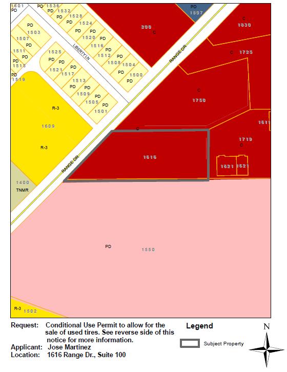
19 FILE NO.: Z P&Z HEARING DATE: August 13, 2018 COUNCIL DATE: September 4, 2018 GENERAL INFORMATION APPLICANT: REQUESTED ACTION: Joes Martinez, Martinez Inspections Conditional Use Permit to allow for the occasional sale of used tires LOCATION: 1616 Range Dr., Suite 100 SITE BACKGROUND EXISTING LAND USE AND SIZE: The 1.49 acre parcel is the location of a retail center that is zoned C, Commercial. Suite 100 is an approximately 900 square-foot lease space that is currently vacant. SURROUNDING LAND USE AND ZONING (see attached map): North Zoning C - Commercial PD-SF Single-Family Existing Land Use Retail Strip with multiple tenants (hair salon, barber shop), across Range Drive are townhomes within Hillcrest Park Addition Undeveloped Property South PD-LC Light Commercial West C Commercial Multiple health clinics within a small office park East SF R-3 Single-Family Single-family home on 1.8 acre lot. ZONING HISTORY: 1951: Annexed and zoned Residential 1974: Zoned Commercial PLATTING: GENERAL: Beltline Range Addition, Block A, Lot 1R The applicant is requesting a Conditional Use Permit (CUP) to allow for the occasional sale of used tires at Martinez Inspections. The main operation of the business will continue to be state automobile inspections. The applicant plans to store 100 to 150 used tires within the structure, with no storage or display of tires outside the structure. Mr. Martinez intends to offer the occasional sale of these tires, along with general automotive accessories during inspections such as headlights, breaks, converters, etc. Mr. Martinez has operated C & M Discount Tire & Muffle Company for over four years at an alternative location in Balch Springs and is proposing to open a second location in Mesquite at 1616 Range Drive. The lease space is located in a small retail center among multiple tenant occupancies of varying commercial uses, including automotive repair. The suite space is located on the west end of the building that is situated near Range Drive.
20 STAFF COMMENTS The Mesquite Comprehensive Plan designates the subject property as General Business. The Plan describes the intent of the General Business designations in the Development Areas as follows: The General Business designation is utilized in both the Community Areas and the Development Areas to designate areas primarily providing services to residents of the surrounding sectors of the City. In the Development Areas, this designation is used to indicate locations where business use is appropriate, but where the relationship to neighborhoods warrants a more limited business scope. The designation is generally assigned along the fringe of the Development Areas, indicating that goods and services should be oriented to the surrounding community, although some regional services may be included. The community orientation means that certain types of uses acceptable in other parts of the Development Areas will not be appropriate in these locations. Uses which are generally not appropriate in these locations include entertainment/recreation, highway related uses, outdoor display lots and outdoor storage yards. Staff does not anticipate the proposed use to conflict with the Mesquite Comprehensive Plan within the General Business designation area. Mesquite Zoning Ordinance Sec : Review Criteria for Conditional Use Permits (Staff comments are provided below each criteria.) 1. Existing Uses The Conditional Use will not be injurious to the use and enjoyment of other property in the immediate area for purposes already permitted, nor substantially diminish and impair property values within the immediate vicinity. The subject property is located within C commercial zoning district and within a small retail center. The surrounding nonresidential uses include minor automotive repair shops, and miscellaneous personal services including a cleaning service, barber shop and hair salon. The proposed use is compatible with surrounding nonresidential uses. The proposed use also conforms to the Commercial zoning of the subject property as well as to the Comprehensive Plan. It is not anticipated that the proposed use will be injurious to the surrounding area. 2. Vacant Properties The Conditional Use will not impede the normal and orderly development and improvement of surrounding vacant property for uses predominant in the area. Staff does not expect this proposed use to impact the development or redevelopment of any nearby property. 3. Services Adequate utilities, access roads, drainage, and other necessary facilities have been or are being provided.
21 Adequate utilities, access roads and drainage facilities exist on site and are sufficient for accommodating the demands associated with the request for a Conditional Use Permit. 4. Parking Adequate measures have been or will be taken to provide sufficient off-street parking and loading spaces to serve the proposed uses. The parking lot contains sufficient parking spaces to accommodate all currently operating businesses and including vacant suites. 5. Performance Standards Adequate measures have been or will be taken to prevent or control offensive odor, fumes, dust, noise, and vibration, so that none of these will constitute a nuisance and to control lighted signs and other lights in such a manner that no disturbance to neighboring properties will result. Staff anticipates no disturbances to neighboring businesses as a result of the proposed use. Analysis The proposed Conditional Use Permit to allow for the sale of used tires is consistent with the future land use designation of the Comprehensive Plan as well as the existing zoning district. The proposed use is an additional amenity to an automotive state inspection business located within the existing retail strip. Indoor storage of all tires will allow for minimal visual impact on the property and surrounding area. Staff does not anticipate any adverse impacts from the proposed use on the surrounding uses or properties. RECOMMENDATIONS Staff recommends approval of the request to allow the sale of used tires in a lease space located at 1616 Range Drive, Suite 100 with the following stipulation: 1. Any outdoor display of tires shall be prohibited. PUBLIC NOTICE Notices were mailed to property owners within 200 feet of the property. As of the date of this writing, staff has not received any returned notices from property owners within 200 feet of the subject properties. ATTACHMENTS 1 Aerial Map 2 Public Notification Map 3 Zoning Map 4 Application 5 Site Pictures 6 Alternate Site Pictures


22 ATTACHMENT 1 AERIAL MAP

23 ATTACHMENT 2 PUBLIC NOTIFICATION MAP

24 ATTACHMENT 3 ZONING MAP
25 ATTACHMENT 4 APPLICATION


26 ATTACHMENT 5 SITE PICTURES Proposed lease space at 1616 Range Drive ATTACHMENT 6 ALTERNATE SITE PICTURES


27 Current location in Balch Springs View of mechanic bays on west side of business in Balch Springs
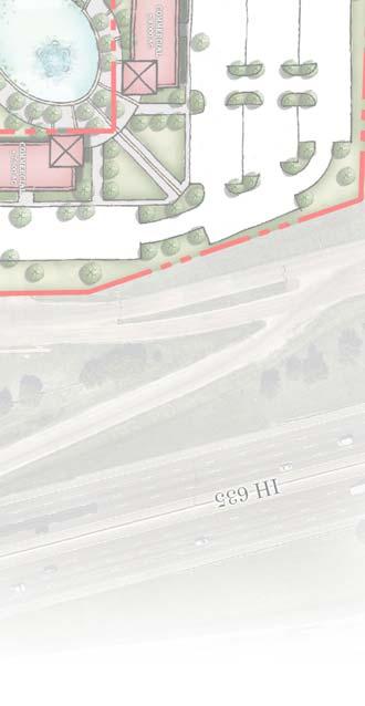
28 REQUEST FOR ZONING RECLASSIFICATION PLANNING AND DEVELOPOMENT SERVICES FILE NO.: Z P&Z HEARING DATE: August 27, 2018 COUNCIL DATE: September 4, 2018 GENERAL INFORMATION APPLICANT: REQUESTED ACTION: LOCATION: Travis Boghetich on behalf of Scyene Rodeo, LTD Planned Development Light Commercial and Planned Development Residential within the Mesquite Arena Rodeo Overlay District (MA/RE). Southwest corner of IH-635 and W. Scyene Road SITE BACKGROUND EXISTING LAND USE AND SIZE: The approximately 56 +/- acres is undeveloped. SURROUNDING LAND USE AND ZONING (see attached maps): North: East: South: West: Retail and Restaurant zoned General Retail and Commercial IH-635 Mesquite Arena zoned PD Light Commercial Single family homes zoned R-3, Single Family. ZONING HISTORY: 1951: Annexed and zoned Residential 1958: Rezoned to Commercial, Special Use Permit 1968: Rezoned to Commercial 1984: Light Commercial 2005: Rezoned to PD Light Commercial 2006: Rezoned to PD - Townhomes PLATTING: Unplatted. GENERAL: The applicant is requesting a rezoning of the subject property to allow construction of a commercial and residential development as shown on the Concept Plan (Exhibit B). The proposed development will include trails, water features and landscaping located throughout the commercial and residential portion of the development as shown on the Landscape Concept Plan (Exhibit C). In addition, the applicant as part of the Planned Development (PD) is proposing development standards as shown in Exhibit D. If approved, the proposed development will follow the standard requirements in the Mesquite Zoning Ordinance (MZO) and Mesquite City Code except for those requirements specified in the approved Development Standards and Concept Plan. The development will also continue to be governed by the MA/RE Overlay District. The property owner is also pursuing a Development Agreement with the City in order to establish a Public Improvement District and to capture revenue generated from the Tax Increment Reinvestment Zone (TIRZ) No. 1. The property owner is requesting these financial incentives in order to alleviate the Planning and Development Services Department Planning & Zoning Division Prepared by: Garrett Langford, AICP
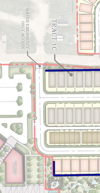
29 ZONING RECLASSIFICATION FILE NO.: Z Page 2 cost of public improvements associated with the proposed project. If approved, the development agreement will detail the obligations of both the property owner and the City. The agreement will specify additional standards and conditions that will govern development of the property. These standards and conditions will mirror those requirements in the PD and will include additional standards. The developer made a presentation to City Council on August 20, This presentation can be viewed online. The commercial development will consist up to 114,000 square feet of commercial space spread out over three tracts as shown on the Concept Plan. The underlying zoning for the commercial tracts will be based on the Light Commercial zoning district with changes in allowed uses. The proposed PD would allow a bowling alley in Tract 1A. The PD would prohibit check cashing services, auto and motorcycle repair and sales, recycling kiosk, sexually oriented businesses, auto and home supply stores, fuel sales, tobacco stores, funeral services, car rental, medical equipment rental, and bail bond services. The commercial portion of the development will be required to follow the Community Appearance Manual and meet landscaping requirements for the MA/RE Overlay District which is a minimum of 15% of the site. The residential portion of development will consist 338 dwellings of various product types that include the following: Type Entry Lot Size Dwelling Size Number Townhome Rear Entry 22 by 67 1,200 sf. 200 Zero Lot Line Front Entry 24 by 65 1,250 sf wide Front Entry 40 by 100 1,250 sf wide Front Entry 40 by 65 1,250 sf. 51 The residential dwellings will follow the City s masonry requirements for singlefamily homes which is 90% masonry. Additionally, the PD proposes the front elevation shall not be repeated within three lots for zero-lot line homes and shall not be repeated within two lots for the 40-ft wide lots. STAFF COMMENTS Mesquite Comprehensive Plan The Mesquite Comprehensive Plan designates the subject property as part of the Rodeo Center which is described as a regional conference and entertainment district intended to provide a concentration of recreational, entertainment and cultural uses. Development on the adjoining tracts of undeveloped land presents the opportunity to create a unique, diverse entertainment area which complements the existing conference center/exhibit hall and arena facilities. The Plan further described the area as follows: Rodeo Center is the area immediately surrounding the Mesquite Arena. In the late 1980 s, the Mesquite Arena-Rodeo Entertainment (MA-RE) overlay was created to encourage the regional entertainment role of the area. In the
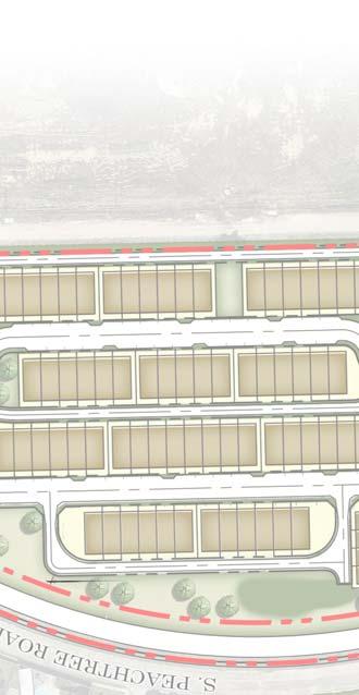
30 ZONING RECLASSIFICATION FILE NO.: Z Page s, this role was greatly expanded with the construction of the conference center and exhibit hall facilities anchored by the Hampton Inn. The area offers a unique opportunity for entertainment and/or western-theme development which may be the City s greatest opportunity to establish/retain a unique identity and image among the growing number of suburban cities in the region. Piecemeal development of business uses on smaller tracts which are not in a consistent design and not of a complimentary theme would be highly detrimental to the overall potential of the area. Development of a concept/design plan for the area could help encourage development of the desired type. Setting additional design standards for the MA-RE overlay could require any development in the area to meet basic design objectives. Analysis The commercial portion of the proposed PD is in keeping with the intent of the Mesquite Arena- Rodeo Entertainment Overlay district and the Comprehensive Plan. The commercial portion of the development will provide amenities that include trails, water features and abundance of landscaping as shown on the Concept Plan and Concept Landscape Plan. This portion of the development will provide for a unique and diverse entertainment area as envision by the Comprehensive Plan. While the Comprehensive Plan did not envision a residential development within the Rodeo Center area, it is appropriate as part of an overall development plan such as the one being proposed. The additional residential density is needed in order to support the additional commercial development being proposed and to create a vibrant environment. As proposed, the mixture of commercial uses combined with different residential product types along with the proposed amenities will provide for a unique and vibrant development that will contribute to making the Mesquite Arena area a regional draw. RECOMMENDATIONS Staff recommends approval of the request with the following conditions. 1. Except as provided herein, the plat and site plan for the property shall conform substantially to the Concept Plan (Exhibit B), Landscape Concept Plan (Exhibit C), and PD Development Standards (Exhibit D). 2. The façade of all residential homes shall conform substantially to the Elevations presented and are to be included in the PD Ordinance as shown in Exhibit E. 3. District screening shall be provided in accordance with the PD Development Standards and as shown on the Screening Plan (Exhibit F). 4. No off-premise signs shall be permitted. Pole signs shall be prohibited. All signs shall share a common architecture in design and materials as permitted by the Mesquite Sign Ordinance. 5. A Traffic Impact Analysis (TIA) is required. As part of the TIA, recommended measures
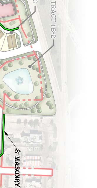
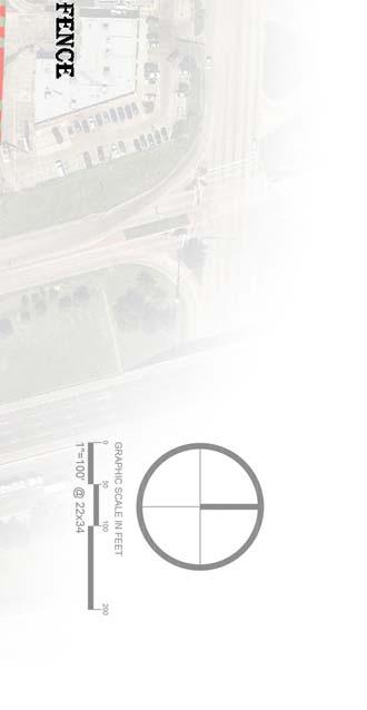
31 ZONING RECLASSIFICATION FILE NO.: Z Page 4 to minimize and/or mitigate the anticipated impacts and determine the adequacy of the development's planned access points. Mitigation measures shall be acceptable to the city engineer and may include, without limitation: an access management plan; transportation demand management measures; street improvements on or off the site; placement of pedestrian, bicycle or transit facilities on or off the site; or other capital improvement projects such as traffic calming infrastructure or capacity improvements. The developer is responsible for making the improvements recommended by the TIA and approved by the City that are necessitated by and proportional to the development. PUBLIC NOTICE Notices were mailed to property owners within 200 feet of the property. As of the date of this writing, staff received nine returned notices from property owners within 200 feet of the subject properties. Five responses are in favor while four are in opposition to the request. ATTACHMENTS 1 Aerial Map 2 Public Notification Map 3 Zoning Map 4 Public Responses Exhibit A Legal Descriptions (not included this report) Exhibit B Concept Plan Exhibit C Concept Landscape Plan Exhibit D Development Standards Exhibit E Residential Elevations Exhibit F Screening Plan

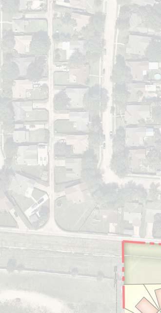
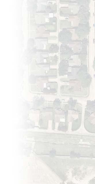
32 ZONING RECLASSIFICATION FILE NO.: Z Page 5 Attachment 1 Aerial Map

33 ZONING RECLASSIFICATION FILE NO.: Z Page 6 Attachment 2 Notification Map

34 ZONING RECLASSIFICATION FILE NO.: Z Page 7 Attachment 3 Zoning Map

35 Attachment 4 - Public Responses Z


36 Attachment 4 - Public Responses Z

37 Attachment 4 - Public Responses Z


38 Attachment 4 - Public Responses Z


39 Attachment 4 - Public Responses Z


40 Attachment 4 - Public Responses Z

41 Attachment 4 - Public Responses Z


42 Attachment 4 - Public Responses Z


43 Attachment 4 - Public Responses Z
44 Exhibit B Z
45 Exhibit C Z
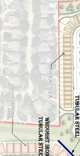
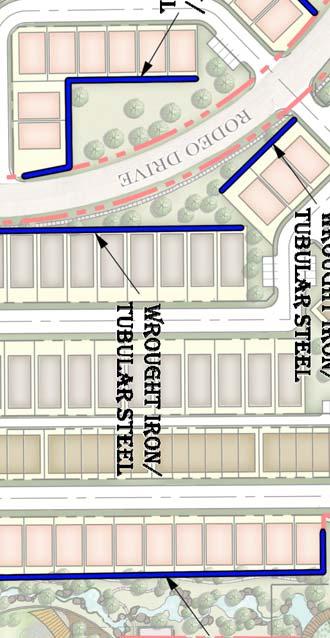
46 Exhibit D Z Iron Horse Village Planned Development I. Residential Development Regulations A. Residential Lot Standards Table 1 Lot Type Tracts per Concept Plan Min. Lot Size Min. Lot Width* Min. Lot Depth SF Bungalows Tract 1C,2A 2,600 S.F. 40' 65' Min. Front Yard Setback 8' (main structure) 20' (garage) Min. Rear Yard Setback Min. Side Yard Setback (Interior Lot) Min. Side Yard Setback (Corner Lot) Max. Height Max. Lot Coverage Min. Dwelling Size Min. Separation Between Buildings Max. Number of Units per Building 2' 2.5' 10' 35' No Max. 1,250 S.F. 5' N/A SF Villas Tract 1C 4,000 S.F. 40' 100' 20' 10' 5' 10' 35' No Max. 1,250 S.F. 10' N/A Zero Lot Line Tract 2A 1,296 S.F. 24' 55' 6' 4' 0' side setback on one side, 3' side setback on the other side 10' 45' No Max. 1,200 S.F. N/A N/A Townhouse - Rear Entry Tracts 1C, 2A, 3 1,400 S.F. 22' 65' 6' 4' per Fire Code 10' 35' No Max. 1,200 S.F. 10' 8 Townhouse - Front Entry Screening and Fencing Tract 1C -Southern Egress Phasing Tracts 1C, 2A, 3 *Minimum Lot Width is measured along the front building line for all lots. Parking 1,400 S.F. 25' 85' 20' 4' per Fire Code 10' 35' No Max. 1,200 S.F. 10' 8 Zero Lot Line Residential - The plat shall dedicate, a one foot (2 ) wide Ingress, Egress, Overhang and Drainage Easement within the three foot (3') side setback for the purpose of maintenance, repair, and/or replacement of wall, overhang, roof, and/or eaves, and drainage onto the adjacent property. A minimum of three feet (3') seperation between all principal structures must be provided for Zero Lot Line Residential. No front elevation of a Zero Lot Line Residential shall be repeated any more often than once every 3 lots in a row. No front elevation of Villas and Bungalows Residential shall be repeated any more often than once every 2 lots in a row. All residential dwellings shall conform to City of Mesquite's Fire code. Depending on code and building seperation, certain dwellings may need to be sprinklered and/or a higher fire wall may be required. Parking and Storage of Recreational Vehicles and Equipment. No recreational vehicle, motorhome, watercraft or other equipment greater than six feet (6 ) in height when mounted on its transporting trailer shall be parked or stored on any lot with a dwelling unit. Regardless of height, no such equipment shall be parked or stored on any street for longer than 24 hours. Homeowner s Association. Before the issuance of a certificate of occupancy for a project containing any common areas or community facilities, it shall be necessary to assure the City that provisions have been made for adequate upkeep and maintenance association established to maintain and manage all such common areas, residential front lawns, and community facilities. HOA shall maintain residential areas once per week. Documents creating such association shall grant the City the right to collect maintenance fees and provide maintenance in the event that the Association fails to do so. Primary Building Façade Front, Side and Rear elevations shall each be 90% brick or stone masonry exluding doors, windows, garage doors, and dormers; other façade materials may be Hardie-board/plank or equivalent. Materials In order to create a walkable urban environment, screening shall only be required along arterials and directly adjacent to commercial areas. Where required, screening shall be (i) precast panel wall masonry construction or (ii) masonry construction, minimum Eight feet (8 ) in height. Any further screening may be provided at the discretion of the developer and approved by the City of Mesquite. Wooden fencing shall never be adjacent to Right-of-Way. Wrought Iron Fencing shall be permissable as screening in certain areas given City of Mesquite Approval. Wrought Iron fencing is acceptable behind Tract 1C Lots along Rodeo Drive. 1.) All Residential Units, attached or detached, shall provide two (2) garage Spaces per Unit. 2.) Front Entry Residential shall provide two (2) off-street parking spaces through use of a minimum eighteen foot (18') by eighteen foot (18') wide driveway and parallel or head in parking. 3.) Rear Entry Residnetial units, attached or detached, shall provide one and half (1.5) parking spaces for every two (2) units. Parking shall be either designated parallel, head-in, or driveway space. Second egress point at the southern border of Tract 1C shall be a gated exit per City of Mesquite's Approval. Development may be constructed in phases. B. Residential Landscape, Open Space, and Screening as shown on Landscape Concept Plan. 1. General Landscape Requirements a. Landscape areas equal to a minimum of 10 percent of the site area shall be provided. b. Calculation of the minimum landscape area may include internal landscaping in parking areas and a required buffer tree line. Adjacent rights-of-way shall 1
47 Exhibit D Z be landscaped, but these areas shall not be included in the calculation of required area. c. Portions of the site area planned for development as part of a later phase may be excluded from the calculation of minimum landscape area for the portion of the site area being developed as part of the current phase. d. Adjacent rights-of-ways shall be landscaped with lawn or groundcover, but these areas shall not be included in the calculation of required minimum landscape area. 2. Tree Requirement a. One shade tree, or one evergreen tree, or 3 ornamental tress shall be provided for each 500 square feet of required landscape area. Trees provided for internal parking area landscaping and trees in a required buffer tree line may be counted to fulfill this requirement, provided that at least 50% of the required trees are located between the main building and the front and/or exterior side property lines. 3. Individual Lot Landscape Standards a. For each single family residential lot - a minimum of one shade tree, or one evergreen tree, or 3 small ornamental trees in the front yard of each dwelling unit; and one gallon shrubs, planted no more than 3 feet on center, along the front of the structure. Plant material to be selected at a later date, by lot builder, and shall satisfy the City of Mesquite required plant schedule outlined by table 1A Tract 1B-1, 1B-2, 1C, 2A, and 3 a. Required: 10% of total Site Area b. 50% of the above landscape requirement to be located between main building and front or side property lines. c. 1 tree / 500 sf within a required landscape area 5. Tract 1C (Rodeo Drive) 6 concrete sidewalk. Outside of ROW landscaping area will include flowering ornamental trees and landscape berms with shrubs/groundcover where a decomposed granite pathway shall lie. The landscaping will also consist of native grasses for groundcover, Bermuda sod, and a steel cattle themed landscape monument. 6. Tract 2A (Rodeo Drive) 6 concrete sidewalk along tract 2A. Outside of ROW landscaping area will include steel cattle themed landscape monuments, a decomposed granite pathway, and a raised water feature. Large canopy trees, planter bed seating area surrounded by ornamental trees, Bermuda sod, and screening shrubs/groundcover. 2
48 Exhibit D Z Tract 3 (Peachtree Road) 5 concrete sidewalk. Flowering ornamental tree that will bring color to the area and large canopy trees with seating area. The landscaping will also consist of native grasses used for groundcover, Bermuda sod, and a small screening fence with planter beds. II. Non-Residential Development Regulations - The permitted uses and standards must be in accordance with the Light Commercial zoning districts, unless otherwise specified herein: Commercial per Concept Plan Tract Land Uses Min. Front Yard Setback (Primary Use Structure) Min. Front Yard Setback (Accessory Use Structure) Max. Height Max. Lot Coverage Zoning Tract 1A (Light Commercial) Zoning Tract 1D (Light Commercial) Zoning Tract 2B (Light Commercial) * Tract 2B Tract 1A Tract 1D LC LC Per City Code Per City Code Tract 2B LC 25' 10' Per City Code Per City Code 1. The primary use within a platted lot shall be considered to be the structure within which the primary business is conducted on the property. All other improvements, excluding signage, within a platted lot shall be considered accessory uses. Primary uses shall be subject to a 25 foot front yard setback. Accessory uses shall be subject to a 10 foot front yard setback. For non-residential uses within Tract 2B, only frontage on Sycene shall be considered to be the front yard, all other street frontage shall be considered to be side or rear yards. There is no rear or side yard setback for nonresidential uses in Tract 2B. 2. If developer is required to construct a right turn decel lane at the intersection of Scyene Road and Rodeo Drive, no greater than a five (5) foot sidewalk shall be required along Scyene Road for Tract 2B. 3. Sign Regulations. For the purposes of this subsection, Tract 2B (as shown on the concept plan) shall be considered on premise and as such, Tract 2B shall be permitted to erect one sign, not located on the platted lot for which the sign is servicing. Such off-lot sign shall not prohibit the construction of any on-lot signage on the platted lot which the referenced sign is servicing. All signage must be compliant with the standards of Chapter Bowling Center/Indoor Recreational Facility permitted by right on Tract 1A. 2. Prohibited Uses: a. Check Cashing Services b. Motorcycle Sales and Repair c. Recycling Kiosk d. Sexually Oriented Businesses e. Limited Fuel Sales f. Automotive Dealers g. Auto and Home Supply Store h. Tobacco Stores i. Funeral Services, Crematories j. Medical Equipment Rental k. Bail Bond Services 3
49 Exhibit D Z l. Passenger Car Rental m. Automotive Repair Shops n. Automotive Parking (Principle Use) o. Automotive Diagnostic, Inspection Services p. Hotels, Camps, Other Lodging Places q. Repair Services 2. Nonresidential Architectural Standards shall be governed by the POA s CCR s. Architectural Standards for all Light Commercial shall resemble the architectural standards set forth by the Residential HOA. Architectural Standards shall meet or exceed the City of Mesquite s Community Appearance Manual. Nonresidential Developments shall have the opportunity for alternate standards given City approval. 3. Nonresidential Tracts 1A, 1D, and 2B (per concept plan) are subject to City of Mesquite Commercial Property Landscape Standards. 3. Public Streets and Sidewalks 1. Public Streets. The street system is intended to create an urban feel and pedestrian friendly environment with easy and convenient access to community open spaces and amenities, some of which are shared with the adjacent commercial/retail. Streets shall be classified and constructed as follows: a) Urban Residential Type 1 (Front Entry, Tract 1) a. Right-of-Way shall be fifty-feet (50 ) wide; b. Pavement shall be thirty-one feet (31 ) wide from back of curb to back of curb; c. Pavement shall be a minimum of six-inch (6 ) thick, 4000 PSI with number four (4) bars on eighteen-inch (18 ) centers both ways. b) Urban Residential Type 2 (Front Entry, Tract 2 and Tract 3) a. Right-of-Way shall be forty-two feet (42 ) wide; b. Pavement shall be thirty-one feet (31 ) wide from back of curb to back of curb; c. Pavement shall be a minimum of six-inch (6 ) thick, 4000 PSI with number four (4) bars on eighteen-inch (18 ) centers both ways. c) Urban Residential Type 3 (Parallel Street Parking) a. Right-of-Way shall be forty-two feet (42 ) wide; b. Pavement width shall be increased by a minimum of two-feet (2 ) in width on the side of the street with rear entry residential. If rear entry residential is provided on one side of the street then the paving shall be a minimum of thirty-two and a half feet (32.5 ) wide from back of curb to back of curb. If rear entry residential is provided on both sides of the street then the paving shall be a minimum of thirty-four feet (34 ) wide from back of curb to back of curb. Trees wells can be provided to define parking areas and provide landscaping. Where tree wells are provided, a minimum of twenty-four feet (24 ) clear paving shall be provided; 4
50 Exhibit D Z c. Pavement shall be a minimum of six-inch (6 ) thick, 4000 PSI with number four (4) bars on eighteen-inch (18 ) centers both ways. d) Alley Entry (Standard) a. Right-of-Way shall be eighteen feet (18 ) wide; b. Right-of-Way shall transition from eighteen feet (18 ) wide at its typical section to twenty-two feet (22 ) wide at the Right-of-Way for the connecting street. The transition shall occur over twenty feet (20 ); c. Alley pavement shall be twelve feet (12 ) wide from edge of alley to edge of alley; d. Alley pavement shall transition from twelve (12 ) wide at its typical section to sixteen feet (16 ) wide at the Right-of-Way for the connecting street. The transition shall occur over twenty feet (20 ). e. Pavement shall be a minimum of eight-inch (8 ) thick at the edge and five-inch (5 ) thick at the invert, 4000 PSI with number four (4) bars on eighteen-inch (18 ) centers both ways. e) Alley Entry (Fire/EMS Access) a. Right-of-Way shall be twenty-four feet (24 ) wide; b. Right-of-Way shall transition from twenty-four feet (24 ) wide at its typical section to twenty-eight feet (28 ) wide at the Right-of-Way for the connecting street. The transition shall occur over twenty feet (20 ); c. Alley pavement shall be twenty feet (20 ) wide from edge of alley to edge of alley; d. Alley pavement shall transition from twenty (20 ) wide at its typical section to twenty-four feet (24 ) wide at the Right-of-Way for the connecting street. The transition shall occur over twenty feet (20 ). e. Pavement shall be a minimum of eight-inch (8 ) thick at the edge and five-inch (5 ) thick at the invert, 4000 PSI with number four (4) bars on eighteen-inch (18 ) centers both ways. f) Ingress and Egress Easement, Volume 85144, Page 375 and Utility and Drainage Easement, Volume 85186, Page 5465 adjacent to Lot 1, Block A, The Landmark Addition, Volume 85135, Page Development Road connecting Peach Tree Road and Rodeo Drive as shown on the Concept Plan. a. Residential development shall be allowed to connect to the existing access and utility easement. b. Developer may dedicate this as an Urban Residential street as long as the improvements are reconstructed to the standards established herein. c. Regardless of whether the improvements are public or private, access shall be allowed to serve both the residential or commercial use. If the improvements are to remain private, then a property owner s association or homeowner s association must be established for the inspection and maintenance of said improvements. Documents creating such association shall grant the City the right 5
51 Exhibit D Z to collect maintenance fees and provide maintenance in the event that the Association fails to do so. g) Horizontal Geometry a. Urban Residential The minimum center line horizontal radius shall be fifty feet (50 ). b. Alley Streets The minimum center line horizontal radius shall be fifty feet (50 ). c. Curb Returns i. Urban Residential to Urban Residential minimum curb return shall be twenty feet (20 ) radius; ii. Urban Residential to Collector minimum curb return shall be twenty feet (20 ) radius; iii. Urban Residential to Arterial minimum curb return shall be twenty feet (20 ) radius; 2. Curbs. All curbs shall be standard six-inch with the exception that mountable curbs will be allowed adjacent to front entry townhomes (Lot Type: Townhouse Front Entry 2-502). 3. Signage. The developer shall provide signage that designates no parking areas along Urban Residential Streets as determined and directed by the City Engineer. All signage requirements will be determined during the preliminary platting and final platting processes. 4. Public Sidewalks. The sidewalk system is intended to create walkability within this urban mix use development easy and convenient access to community open spaces, amenities, commercial/retail businesses. Sidewalks shall be constructed as follows: a. Along Urban Residential shall be five feet (5 ) wide and located adjacent to the back of curb. b. Along Rodeo Drive shall be six feet (6 ) wide and located one foot (1 ) inside the rightof-way line. c. Along Hwy 352 shall be ten feet (10 ) wide per the trail plan and located within the right-of-way on the right-of-way line. d. Along Rodeo Center Boulevard Shall be six feet (6 ) wide and located one foot (1 ) inside the right-of-way line. Developer may meander the sidewalk within the development up to eight feet (8 ) as long as a sidewalk maintenance easement is provided. 5. Residential Mailboxes. Cluster boxes shall be provided as required by the US Postal Service. Cluster boxes shall be limited to eight units per box unless otherwise directed by the US Postal Service. The developer shall provide a preliminary cluster box layout for the City s review with the preliminary plat submittal. 6

52 Zero Lot Line Elevations Exhibit E - Residential Elevations Z

53 Exhibit E - Residential Elevations Z
54 Exhibit E - Residential Elevations Z

55 Exhibit E - Residential Elevations Z

56 Exhibit E - Residential Elevations Z


57 Exhibit F - Screening Z
PLANNING AND ZONING COMMISSION PRE-MEETING CITY COUNCIL CONFERENCE ROOM 757 North Galloway Avenue October 9, :30 P.M. Pre-Meeting Agenda
 PLANNING AND ZONING COMMISSION PRE-MEETING CITY COUNCIL CONFERENCE ROOM 757 North Galloway Avenue October 9, 2017-6:30 P.M. Pre-Meeting Agenda I. Administer the Oath of Office to the newly appointed members.
AGENDA I. APPROVAL OF THE MINUTES OF THE JULY 23, 2018 MEETING II. PLATS
 PLANNING AND ZONING COMMISSION PRE-MEETING TRAINING ROOM A & B 757 North Galloway Avenue August 13, 2018-6:30 P.M. To discuss the items on the regular agenda. PLANNING AND ZONING COMMISSION MEETING TRAINING
PLANNING AND ZONING COMMISSION MEETING CITY COUNCIL CHAMBERS 757 North Galloway Avenue January 14, :00 P.M.
 PLANNING AND ZONING COMMISSION PRE-MEETING CITY COUNCIL CONFERENCE ROOM 757 North Galloway Avenue January 14, 2019-6:30 P.M. To discuss the items on the regular agenda. PLANNING AND ZONING COMMISSION MEETING
BOARD OF ADJUSTMENT REGULAR MEETING CITY COUNCIL CHAMBERS 757 North Galloway Avenue September 27, :30 P.M. AGENDA
 BOARD OF ADJUSTMENT PRE-MEETING CITY COUNCIL BRIEFING ROOM 757 North Galloway Avenue September 27, 2018-6:00 P.M. Discussion of Items on the Regular Agenda BOARD OF ADJUSTMENT REGULAR MEETING CITY COUNCIL
PLANNING AND ZONING COMMISSION MEETING CITY COUNCIL CHAMBERS 757 North Galloway Avenue January 8, :00 P.M.
 PLANNING AND ZONING COMMISSION PRE-MEETING CITY COUNCIL CONFERENCE ROOM 757 North Galloway Avenue January 8, 2018-6:30 P.M. To discuss the items on the regular agenda PLANNING AND ZONING COMMISSION MEETING
PLANNING AND ZONING COMMISSION MEETING CITY COUNCIL CHAMBERS 757 North Galloway Avenue August 28, :00 P.M.
 PLANNING AND ZONING COMMISSION PRE-MEETING CITY COUNCIL CONFERENCE ROOM 757 North Galloway Avenue August 28, 2017-6:30 P.M. To discuss the items on the regular agenda PLANNING AND ZONING COMMISSION MEETING
BOARD OF ADJUSTMENT REGULAR MEETING CITY COUNCIL CHAMBERS 757 North Galloway Avenue April 26, :30 P.M. AGENDA
 BOARD OF ADJUSTMENT PRE-MEETING CITY COUNCIL BRIEFING ROOM 757 North Galloway Avenue April 26, 2018-6:00 P.M. Discussion of Items on the Regular Agenda BOARD OF ADJUSTMENT REGULAR MEETING CITY COUNCIL
BOARD OF ADJUSTMENT REGULAR MEETING CITY COUNCIL CHAMBERS 757 North Galloway Avenue August 23, :30 P.M. AGENDA
 BOARD OF ADJUSTMENT PRE-MEETING CITY COUNCIL BRIEFING ROOM 757 North Galloway Avenue August 23, 2018-6:00 P.M. Discussion of Items on the Regular Agenda BOARD OF ADJUSTMENT REGULAR MEETING CITY COUNCIL
PLANNING AND ZONING COMMISSION MEETING CITY COUNCIL CHAMBERS 757 North Galloway Avenue July 23, :00 P.M.
 PLANNING AND ZONING COMMISSION PRE-MEETING CITY COUNCIL CONFERENCE ROOM 757 North Galloway Avenue July 23, 2018-6:30 P.M. To discuss the items on the regular agenda PLANNING AND ZONING COMMISSION MEETING
PLANNING AND ZONING COMMISSION MEETING CITY COUNCIL CHAMBERS 757 North Galloway Avenue July 9, :00 P.M.
 PLANNING AND ZONING COMMISSION PRE-MEETING CITY COUNCIL CONFERENCE ROOM 757 North Galloway Avenue July 9, 2018-6:30 P.M. To discuss the items on the regular agenda PLANNING AND ZONING COMMISSION MEETING
PLANNING AND ZONING COMMISSION MEETING CITY COUNCIL CHAMBERS 757 North Galloway Avenue May 29, :00 P.M.
 PLANNING AND ZONING COMMISSION PRE-MEETING CITY COUNCIL CONFERENCE ROOM 757 North Galloway Avenue May 29, 2018-6:30 P.M. To discuss the items on the regular agenda PLANNING AND ZONING COMMISSION MEETING
BOARD OF ADJUSTMENT PRE-MEETING CITY COUNCIL BRIEFING ROOM 757 North Galloway Avenue May 24, :00 P.M. Discussion of Items on the Regular Agenda
 BOARD OF ADJUSTMENT PRE-MEETING CITY COUNCIL BRIEFING ROOM 757 North Galloway Avenue May 24, 2018-6:00 P.M. Discussion of Items on the Regular Agenda BOARD OF ADJUSTMENT REGULAR MEETING CITY COUNCIL CHAMBERS
BOARD OF ADJUSTMENT REGULAR MEETING CITY COUNCIL CHAMBERS 757 North Galloway Avenue December 6, :30 P.M. AGENDA
 BOARD OF ADJUSTMENT PRE-MEETING CITY COUNCIL BRIEFING ROOM 757 North Galloway Avenue December 6, 2018-6:00 P.M. Discussion of Items on the Regular Agenda BOARD OF ADJUSTMENT REGULAR MEETING CITY COUNCIL
PLANNING AND ZONING COMMISSION MEETING CITY COUNCIL CHAMBERS 757 North Galloway Avenue April 23, :00 P.M.
 PLANNING AND ZONING COMMISSION PRE-MEETING CITY COUNCIL CONFERENCE ROOM 757 North Galloway Avenue April 23, 2018-6:30 P.M. To discuss the items on the regular agenda PLANNING AND ZONING COMMISSION MEETING
PLANNING AND ZONING COMMISSION MEETING CITY COUNCIL CHAMBERS 757 North Galloway Avenue March 26, :00 P.M.
 PLANNING AND ZONING COMMISSION PRE-MEETING CITY COUNCIL CONFERENCE ROOM 757 North Galloway Avenue March 26, 2018-6:30 P.M. To discuss the items on the regular agenda PLANNING AND ZONING COMMISSION MEETING
PLANNING AND ZONING COMMISSION MEETING CITY COUNCIL CHAMBERS 757 North Galloway Avenue March 12, :00 P.M.
 PLANNING AND ZONING COMMISSION PRE-MEETING CITY COUNCIL CONFERENCE ROOM 757 North Galloway Avenue March 12, 2018-6:30 P.M. To discuss the items on the regular agenda PLANNING AND ZONING COMMISSION MEETING
COMMERCIAL ZONING DISTRICTS (Amended 11/13/14) Part I. C-1 Restricted Commercial District
 Part I. C-1 Restricted Commercial District") ARTICLE XI. COMMERCIAL ZONING DISTRICTS (Amended 11/13/14) Part I. C-1 Restricted Commercial District Section 152: Purpose This district is designed to accommodate commercial uses which act as a transition
ARTICLE XI. COMMERCIAL ZONING DISTRICTS (Amended 11/13/14) Part I. C-1 Restricted Commercial District Section 152: Purpose This district is designed to accommodate commercial uses which act as a transition
M E M O R A N D U M. Meeting Date: October 23, Item No. F-1. Planning and Zoning Commission. Daniel Turner, Planner I
 M E M O R A N D U M Meeting Date: October 23, 2017 Item No. F-1 To: From: Subject: Planning and Zoning Commission Daniel Turner, Planner I PUBLIC HEARING: Consider a recommendation of a of Planned Development
UPPER MOUNT BETHEL TOWNSHIP NORTHAMPTON COUNTY, PENNSYLVANIA
 UPPER MOUNT BETHEL TOWNSHIP NORTHAMPTON COUNTY, PENNSYLVANIA JOINDER DEED / LOT CONSOLIDATION TOWNSHIP REVIEW PROCESS When accepting proposed Joinder Deeds / Lot Consolidations, review the Joinder Deed
THE CITY OF RAYMORE, MISSOURI Single-Family Residential Zoning Districts
 THE CITY OF RAYMORE, MISSOURI Single-Family Residential Zoning Districts REGULATIONS COMMON TO ALL DISTRICTS: Uses permitted in each district include detached single-family dwellings, manufactured homes
City of Valdosta Land Development Regulations
 Chapter 206 Section 206-1 Base Zoning Districts Standards for Uses, Structures, and Property Development (B) (C) Principal Uses and Structures. Principal uses and structures permitted in each base zoning
BOARD OF ADJUSTMENT PRE-MEETING CITY COUNCIL BRIEFING ROOM 757 North Galloway Avenue July 27, :00 P.M. Discussion of Items on the Regular Agenda
 BOARD OF ADJUSTMENT PRE-MEETING CITY COUNCIL BRIEFING ROOM 757 North Galloway Avenue July 27, 2017-6:00 P.M. Discussion of Items on the Regular Agenda BOARD OF ADJUSTMENT CITY COUNCIL CHAMBERS 757 North
RESIDENTIAL DISTRICTS
 RESIDENTIAL DISTRICTS RESIDENTIAL DISTRICTS The residential district standards have been revised to reflect on-the-ground development conditions, while continuing to respect the use patterns established
CITY OF SANTA ROSA COMMUNITY DEVELOPMENT DEPARTMENT STAFF REPORT FOR PLANNING COMMISSION SEPTEMBER 10, 2015 APPLICANT FILE NUMBER MJP
 ITEM NO. 9 CITY OF SANTA ROSA COMMUNITY DEVELOPMENT DEPARTMENT STAFF REPORT FOR PLANNING COMMISSION SEPTEMBER 10, 2015 PROJECT TITLE Yogurt Time Center ADDRESS/LOCATION 3093 Marlow Road ASSESSOR S PARCEL
90+/-Acres D-19 Southwest corner of I-96 & D-19 Marion Township, Michigan
 90+/- Acres of Commercial Land 90+/-Acres D-19 Southwest corner of I-96 & D-19 Marion Township, Michigan F O R S A L E Exclusively listed by Mark W. Szerlag, CCIM Partner T: 248.476.3700 F: 248.476.3560
PART 3 - ZONING ORDINANCE
 PART 3 - ZONING ORDINANCE ARTICLE 3.1 Section 3-101. Short Title GENERAL PROVISIONS Part 3 of the Alpine Land Use and Development Code shall be known, cited and referred to as the Alpine Zoning Ordinance.
Town Center South End Development Area District
 175.28 ESTABLISHMENT OF DISTRICTS. In order to carry out the purpose and intent of this chapter, the area of the is hereby divided into eighteen (18) Zoning District Classifications and one overlay zoning
4-900 MILITARY PARKWAY-SYCENE CORRIDOR OVERLAY DISTRICT
 4-900 MILITARY PARKWAY-SYCENE CORRIDOR 4-901 PURPOSE AND SCOPE Ord. 3846/12-18-06 The Military Parkway Scyene Corridor is positioned centrally between the Mesquite Arena and Rodeo Entertainment District,
ORDINANCE NO The Town Council of the Town of Yucca Valley does ordain as follows:
 ORDINANCE NO. 141 AN ORDINANCE OF THE TOWN COUNCIL OF THE TOWN OF YUCCA VALLEY, CALIFORNIA, AMENDING TITLE 8, DIVISION 12, CHAPTER 1 RELATING TO DEFINITIONS AND TITLE 8, DIVISION 8, CHAPTER 3, RELATING
3. Section is entitled Accessory Buildings ; limited applicability/regulation.
 MEMORANDUM DATE: October 9, 2017 TO: FROM: RE: Chairperson Hetzel, PC Commissioners, and Interim Administrator Meyer Cynthia Smith Strack, Community Development Director 6.1 Discussion: Detached Accessory
ARTICLE 143. PD 143.
 ARTICLE 143. PD 143. SEC. 51P-143.101. LEGISLATIVE HISTORY. PD 143 was established by Ordinance No. 17685, passed by the Dallas City Council on February 2, 1983. Ordinance No. 17685 amended Ordinance No.
MINUTES JOINT MEETING LINCOLN COUNTY and SIOUX FALLS PLANNING COMMISSIONS 7:00 pm August 10, 2011
 MINUTES JOINT MEETING LINCOLN COUNTY and SIOUX FALLS PLANNING COMMISSIONS 7:00 pm August 10, 2011 Commissioners Room - Lincoln County Court House A joint meeting of the Lincoln County and Sioux Falls Planning
DEVELOPMENT DEPARTMENT STAFF REPORT THE PARK AT 5 TH
 DEVELOPMENT DEPARTMENT STAFF REPORT ARB Meeting Date: July 3, 2018 Item #: _PZ2018-293_ THE PARK AT 5 TH Request: Site Address: Project Name: Parcel Number: Applicant: Proposed Development: Current Zoning:
CHAPTER 29 ARTICLE 8. 20,000 sf 30,000 sf 100,000 sf (with approval by Special Use Permit according to Sec
 CHAPTER 29 ARTICLE 8 (3) Zone Development Standards. The zone development standards for the NC Zone are set forth in Table 29.81(3) below: Table 29.81(3) Neighborhood Commercial (NC) Zone Development Standards
Planned Unit Development (PUD). Sections:
. Sections:") Chapter 19.07. Planned Unit Development (PUD). Sections: 19.07.01. Purpose. 19.07.02. PUD Definition and Design Compatibility. 19.07.03. General PUD Standards. 19.07.04. Underlying Zones. 19.07.05. Permitted
Chapter 19.07. Planned Unit Development (PUD). Sections: 19.07.01. Purpose. 19.07.02. PUD Definition and Design Compatibility. 19.07.03. General PUD Standards. 19.07.04. Underlying Zones. 19.07.05. Permitted
City of Colleyville City Council Agenda Briefing
 City of Colleyville City Council Agenda Briefing City Hall 100 Main Street Colleyville, Texas 76034 www.colleyville.com Agenda Number 5a Agenda Date 01/06/2015 Number Ordinance O-14-1942 Type Ordinance
Chapter DOWNTOWN ZONING DISTRICTS
 Chapter 20.14 Sections: 20.14.010 Purpose of the Downtown Zoning Districts 20.14.020 Land Use Regulations for Downtown Zoning Districts 20.14.030 Development Standards for Downtown Zoning Districts 20.14.010
PINE RIDGE COMMONS PUD AMEND ORDINANCE NUMBER 99-94
 PINE RIDGE COMMONS PUD AMEND ORDINANCE NUMBER 99-94 Title page of the Planned Unit Development Document, previously attached as Exhibit A to the PUD document of Ordinance Number 99-94, the Pine Ridge commons
Conditional Use Permit case no. CU 14-06: Bristol Village Partners, LLC
 PLANNING AND ZONING COMMISSION STAFF REPORT August 7, 2014 Conditional Use Permit case no. CU 14-06: Bristol Village Partners, LLC CASE DESCRIPTION: LOCATION: LEGAL DESCRIPTION: EXISTING LAND USE: ZONING:
PLANNING AND ZONING COMMISSION FEBRUARY 20, :30 P.M. PLANNING AND ZONING MEMBERS PRESENT MEMBERS ABSENT: STAFF PRESENT:
 PLANNING AND ZONING COMMISSION FEBRUARY 20, 2018 5:30 P.M. PLANNING AND ZONING MEMBERS PRESENT Chair Lester Fettig Omar Crisp Paulino Castillo Lydia Alaniz Bryant Ward Jessica Walker Jeremy Langley MEMBERS
Introduction. General Development Standards
 Introduction The development standards will set the zoning regulations for the East Park development. This section will illustrate lot standards, approximate open space locations and road standards. The
Article 3. SUBURBAN (S-) NEIGHBORHOOD CONTEXT
 NEIGHBORHOOD CONTEXT") Article 3. SUBURBAN (S-) NEIGHBORHOOD CONTEXT this page left intentionally blank Contents ARTICLE 3. SUBURBAN (S-) NEIGHBORHOOD CONTEXT DIVISION 3.1 NEIGHBORHOOD CONTEXT DESCRIPTION...3.1-1 Section 3.1.1
Article 3. SUBURBAN (S-) NEIGHBORHOOD CONTEXT this page left intentionally blank Contents ARTICLE 3. SUBURBAN (S-) NEIGHBORHOOD CONTEXT DIVISION 3.1 NEIGHBORHOOD CONTEXT DESCRIPTION...3.1-1 Section 3.1.1
MINUTES OF THE JOINT MEETING MINNEHAHA COUNTY & SIOUX FALLS PLANNING COMMISSIONS June 22, 2015
 MINUTES OF THE JOINT MEETING MINNEHAHA COUNTY & SIOUX FALLS PLANNING COMMISSIONS June 22, 2015 A joint meeting of the County and City Planning Commissions was held on June 22, 2015 at 7:00 p.m. in the
DEVELOPMENT DEPARTMENT STAFF REPORT DRESDEN HEIGHTS PHASE II DCI
 DEVELOPMENT DEPARTMENT Meeting Date: January 10, 2019 Item #: PZ2019-393 Project Name: Applicant and Owner: Proposed Development: Requests: STAFF REPORT DRESDEN HEIGHTS PHASE II DCI Dresden Heights Phase
DIVISION 1 PURPOSE OF DISTRICTS
 ARTICLE 2 ZONING DISTRICTS AND MAP DIVISION 1 PURPOSE OF DISTRICTS Section 2.101 Zoning Districts. For the purpose of this Ordinance, the City of Richmond is hereby divided into districts as follows: DISTRICT
PERMITTED USES: Within the MX-1 Mixed Use Neighborhood District the following uses are permitted:
 6.25 MX-1 - MIXED USE NEIGHBORHOOD 6.25.1 INTENT: The purpose of the MX-1 Mixed Use Neighborhood District is to accommodate the development of a wide-range of residential and compatible non-residential
Rapid City Planning Commission
 Rapid City Planning Commission Initial Planned Development Overlay Project Report March 9, 2017 Item #15 Applicant Request(s) Case # 17PD007 Initial Planned Development Overlay to allow a residential development
PLANNING AND ZONING COMMISSION MEETING CITY COUNCIL CHAMBERS 757 North Galloway Avenue May 14, :00 P.M.
 PLANNING AND ZONING COMMISSION PRE-MEETING CITY COUNCIL CONFERENCE ROOM 757 North Galloway Avenue May 14, 2018-6:30 P.M. To discuss the items on the regular agenda PLANNING AND ZONING COMMISSION MEETING
4.2 RESIDENTIAL ZONING DISTRICTS
 4.2 RESIDENTIAL ZONING DISTRICTS A. Purpose: To define regulations and standards for each residential zoning district in the City. The following sections identify uses, regulations, and performance standards
Subchapter 5 Zoning Districts and Limitations
 Subchapter 5 Zoning Districts and Limitations 35.5.1 Rural Districts Sections: 35.5.1.1 Purpose. 35.5.1.2 Permitted Uses. 35.5.1.3 General Regulations. 35.5.1.1 Purpose. The purpose of a Rural District
EXECUTIVE SUMMARY 04/06/2017
 AGENDA ITEM #22 EXECUTIVE SUMMARY 04/06/2017 COUNCIL AGENDA SUBJECT: Discuss and consider the Second Reading of an Ordinance regarding 16-OR-006a amending the Leander Code of Ordinances, Chapter 14, Zoning,
Coding For Places People Love Main Street Corridor District
 Coding For Places People Love Main Street Corridor District 1) Scope a) District boundaries are assigned according to the District Boundary Map. b) The Primary Retail Corridor is assigned according to
ARTICLE VII. NONCONFORMITIES. Section 700. Purpose.
 ARTICLE VII. NONCONFORMITIES. Section 700. Purpose. The purpose of this chapter is to regulate and limit the development and continued existence of legal uses, structures, lots, and signs established either
ARTICLE 10 SPECIAL PURPOSE DISTRICTS
 ARTICLE 10 SPECIAL PURPOSE DISTRICTS Sec. 29.1000. SPECIAL PURPOSE DISTRICTS. (1) Purpose. Each Special Purpose District will appear on the City's Zoning Map as a Base Zone. The Special Purpose Districts
INFORMATION & PROCEDURES FOR CHANGE OF ZONING REQUESTS AND CONDITIONAL USE PERMITS
 INFORMATION & PROCEDURES FOR CHANGE OF ZONING REQUESTS AND CONDITIONAL USE PERMITS The applicant is strongly encouraged to attend a pre-application meeting for the project prior to submittal of a zoning
Glades County Staff Report and Recommendation REZONING
 Glades County Staff Report and Recommendation REZONING CASE NUMBER: RZ15-01 DATE: October 2, 2015 CASE TYPE: Application for Rezoning REQUEST: J.J. Wiggins Memorial Trust is requesting a rezoning of 22.1±
Cover Letter with Narrative Statement
 Cover Letter with Narrative Statement March 31, 2017 rev July 27, 2017 RE: Rushton Pointe Residential Planned Unit Development Application for Public Hearing for RPUD Rezone PL2015 000 0306 Mr. Eric Johnson,
Sec Tier 2 principal uses and structures. The principal uses of land and structures allowed in Tier 2 are provided below subject to the
 Sec. 27-730.4.9. Tier 2 principal uses and structures. The principal uses of land and structures allowed in Tier 2 are provided below subject to the standards and limitations contained within this division.
DRAFT -- PROPOSED EXPANSION AND REVISIONS TO DIVISION 24. SPECIAL DISTRICT--COLLEGE AND UNIVERSITY NEIGHBORHOODS DISTRICT
 DRAFT -- PROPOSED EXPANSION AND REVISIONS TO DIVISION 24. SPECIAL DISTRICT--COLLEGE AND UNIVERSITY NEIGHBORHOODS DISTRICT Sec. 28-831. Purpose. The college and university neighborhoods district purposes
The following regulations shall apply in the R-E District:
 "R-E" RESIDENTIAL ESTATE DISTRICT (8/06) The following regulations shall apply in the R-E District: 1. Uses Permitted: The following uses are permitted. A Zoning Certificate may be required as provided
DEVELOPMENT DEPARTMENT STAFF REPORT STAFF REPORT DRESDEN DRIVE TOWNHOMES DCI
 DEVELOPMENT DEPARTMENT STAFF REPORT Meeting Date: September 13, 2018 Item #: PZ2018-319 STAFF REPORT DRESDEN DRIVE TOWNHOMES DCI Request: Project Name: Development of Community Compact (DCI) and six concurrent
5. Approval of Minutes a. Approval of January 15, 2019 Planning and Zoning Commission special call meeting minutes
 JOINT PLANNING AND ZONING COMMISSION/CITY COUNCIL SPECIAL CALL MEETING February 19, 2019 5:30 P.M. Orange Public Library Auditorium (City Council Chambers) 220 N. Fifth Street Orange, Texas 77630 1. Call
ARTICLE IV DISTRICT REGULATIONS
 PART 1. RESIDENTIAL DISTRICTS 4-101. RS. Single-Family Residential Suburban District. The RS District is designed for single-family dwellings, and compatible uses, at a density no greater than one dwelling
Midwest City, Oklahoma Zoning Ordinance
 2010 Midwest City, Oklahoma Zoning Ordinance 9/2/2010 Table of Contents Section 1. General Provisions... 5 1.1. Citation... 5 1.2. Authority... 5 1.3. Purpose... 5 1.4. Nature and Application... 5 1.5.
PLANNED DEVELOPMENT DISTRICT STANDARDS. Cadence Site
 PLANNED DEVELOPMENT DISTRICT STANDARDS Cadence Site A Planned Development District 1. Statement of General Facts, Conditions and Objectives Property Size: Approximately 57.51 Acres York County Tax Map
PLANNING COMMISSION REPORT Regular Agenda -Public Hearing Item
 PDP-13-00518 Item No. 3B- 1 PLANNING COMMISSION REPORT Regular Agenda -Public Hearing Item PC Staff Report 2/24/14 ITEM NO. 3B PRELIMINARY DEVELOPMENT PLAN FOR HERE @ KANSAS; 1101 INDIANA ST (SLD) PDP-13-00518:
CITY OF CEDAR HILL CITY COUNCIL AGENDA ITEM
 Public Hearing #2 Agenda Date: September 9, 2014 CITY OF CEDAR HILL CITY COUNCIL AGENDA ITEM Agenda Item Wording: Case No. 2014-26 CONDUCT A PUBLIC HEARING and consider a request for Conditional Use Permit
MEMORANDUM. TO: Plan Commission. FROM: Jeff Ryckaert, Principal Planner and Dan Nakahara, Planner. DATE: October 5, 2017
 MEMORANDUM TO: Plan Commission FROM: Jeff Ryckaert, Principal Planner and Dan Nakahara, Planner DATE: October 5, 2017 RE: Public Hearing on the Request for Approval of a Class B Special Use to Permit the
Watkinsville First Baptist Church Building and Parking Masterplan Norton Road & Simonton Bridge Road Oconee County Georgia
 Watkinsville First Baptist Church Building and Parking Masterplan Norton Road & Simonton Bridge Road Oconee County Georgia Special Use Approval A-1 CUP to A-1 with Special Use Approval Total Site Area
ARTICLE 504. PD 504.
 ARTICLE 504. PD 504. SEC. 51P-504.101. LEGISLATIVE HISTORY. PD 504 was established by Ordinance No. 23475, passed by the Dallas City Council on March 25, 1998. Ordinance No. 23475 amended Ordinance No.
ARTICLE B ZONING DISTRICTS
 ARTICLE B ZONING DISTRICTS Sec. 8-3021 Established. In order to protect the character of existing neighborhoods; to prevent excessive density of population in areas which are not adequately served with
RE: 6. GILL/GREEN COMPREHENSIVE PLAN AMENDMENT, REZONING AND PRELIMINARY PLAT
 commission memo DATE: Thursday - August 9, 2018 TO: Marion Planning & Zoning Commission FROM: David N. Hockett, AICP Principal Planner RE: 6. GILL/GREEN COMPREHENSIVE PLAN AMENDMENT, REZONING AND PRELIMINARY
Town of Windham Land Use Ordinance Sec. 400 Zoning Districts SECTION 400 ZONING DISTRICTS
 Town of Windham Land Use Ordinance Sec. 400 Zoning Districts Sections SECTION 400 ZONING DISTRICTS SECTION 400 ZONING DISTRICTS 4-1 401 Districts Enumerated 4-2 402 Location of districts; Zoning Map 4-2
ACTION FORM BRYAN CITY COUNCIL
 ACTION FORM BRYAN CITY COUNCIL DATE OF COUNCIL MEETING: July 8, 2014 DATE SUBMITTED: June 17, 2014 DEPARTMENT OF ORIGIN: Development Services SUBMITTED BY: Maggie Dalton MEETING TYPE: CLASSIFICATION: ORDINANCE:
ARTICLE 887. PD 887. Valley View - Galleria Area Special Purpose District
 ARTICLE 887. PD 887. Valley View - Galleria Area Special Purpose District SEC. 51P-887.101. LEGISLATIVE HISTORY. PD 887 was established by Ordinance No. 29032, passed by the Dallas City Council on June
PLANNING COMMISSION STAFF REPORT
 PLANNING COMMISSION STAFF REPORT West Capitol Hill Zoning Map Amendment Petition No. PLNPCM2011-00665 Located approximately at 548 W 300 North Street, 543 W 400 North Street, and 375 N 500 West Street
Development Plan DP13-3 (Arlington Lofts) Planning and Zoning Meeting Date: Document Being Considered: Ordinance
 Planning and Zoning Meeting Date: Document Being Considered: Ordinance") Staff Report Development Plan DP13-3 (Arlington Lofts) Planning and Zoning Meeting Date: 6-19-13 Document Being Considered: Ordinance RECOMMENDATION Following the public hearing, consider Development Plan
Staff Report Development Plan DP13-3 (Arlington Lofts) Planning and Zoning Meeting Date: 6-19-13 Document Being Considered: Ordinance RECOMMENDATION Following the public hearing, consider Development Plan
Chapter CC COMMUNITY COMMERCIAL ZONES REGULATIONS
 Effective April 14, 2011 Chapter 17.35 CC COMMUNITY COMMERCIAL ZONES REGULATIONS SECTIONS: 17.35.010 Title, Intent, and Description 17.35.020 Required Design Review Process 17.35.030 Permitted and Conditionally
ARTICLE 44. PD 44. Unless otherwise stated, the definitions and interpretations in Chapter 51 apply to this
 ARTICLE 44. PD 44. SEC. 51P-44.101. LEGISLATIVE HISTORY. PD 44 was established by Ordinance No. 13164, passed by the Dallas City Council on January 25, 1971. Ordinance No. 13164 amended Ordinance No. 10962,
Accessory Dwelling Units
 Accessory Dwelling Units Housing Committee October 19, 2015 Department of Sustainable Development and Construction Purpose of Briefing Update the Committee on Accessory Dwelling Units To get direction
Marion County Board of County Commissioners
 Marion County Board of County Commissioners Date: 12/2/2015 P&Z: 11/30/2015 BCC: 12/16/2015 Item Number 151210SU Type of Application Special Use Permit Request To establish a Clay Electric Co-Operative
2.110 COMMERICAL MIXED USE (CM)
") CITY OF KEIZER DEVELOPMENT BULLETIN 2.110.01 Purpose 2.110 COMMERICAL MIXED USE (CM) The Commercial Mixed Use (CM) zone is the primary commercial zone within the City. The zone is specifically designed
CITY OF KEIZER DEVELOPMENT BULLETIN 2.110.01 Purpose 2.110 COMMERICAL MIXED USE (CM) The Commercial Mixed Use (CM) zone is the primary commercial zone within the City. The zone is specifically designed
ARTICLE C. ZONING TEXT, DISTRICT CLASSIFICATIONS AND BOUNDARIES
 ARTICLE C. ZONING TEXT, DISTRICT CLASSIFICATIONS AND BOUNDARIES Sec. 10-2054. ZONING TEXT, DISTRICT CLASSIFICATIONS AND BOUNDARIES. In order to regulate the location of structures, the height and bulk
PLANNING COMMISSION REPORT Regular Agenda Public Hearing Item
 PC Staff Report 11/12/12 Item No. 2B- 1 PLANNING COMMISSION REPORT Regular Agenda Public Hearing Item ITEM NO. 2B: A TO GPI; 110 ACRES; E OF K-10 & N OF W 6 TH ST (MKM) : Consider a request to rezone approximately
AGENDA BURLESON PLANNING AND ZONING COMMISSION February 10, 2015 BURLESON CITY HALL 141 W. RENFRO BURLESON, TX 76028
 AGENDA BURLESON PLANNING AND ZONING COMMISSION BURLESON CITY HALL 141 W. RENFRO BURLESON, TX 76028 REGULAR SESSION 6:00 p.m. Call to Order Invocation Pledge of Allegiance 1. Consent Agenda All items listed
Exhibit A-1. Piney Creek Bend Planned Development
 Exhibit A-1 Piney Creek Bend Planned Development A. Purpose and Intent The Piney Creek Bend PD is composed of approximately 90.91 acres, as described in Exhibit D (Field Notes). The development of this
OVERLAY DISTRICT TITLE SPECIFIC PURPOSE AND INTENT LOCATIONAL CRITERIA
 Section 10-300 STRASBURG BUSINESS/COMMERCIAL OVERLAY DISTRICT 10-301 TITLE These Regulations, as amended from time to time, shall be known as Strasburg Business/ Commercial Overlay District and are referred
ARTICLE 20 SIGNS. SIGN, AREA: The entire area of all sign faces, cumulatively, including sign faces on which no copy is currently displayed.
 ARTICLE 20 SIGNS 7 TCC 1-20 (a) Purpose. The purpose of the article is to provide regulation and control of the location, size, content and placement of signs throughout the County in order to promote
NOTICE OF THE REGULAR MEETING OF THE PLANNING & ZONING COMMISSION Tuesday, August 4, 2015 REGULAR MEETING AGENDA 6:30 PM
 NOTICE OF THE REGULAR MEETING OF THE PLANNING & ZONING COMMISSION Tuesday, August 4, 2015 Notice is hereby given of the Regular Meeting of the Planning & Zoning Commission beginning at 6:30 p.m. Tuesday,
Rapid City Planning Commission Rezoning Project Report
 Rapid City Planning Commission Rezoning Project Report June 9, 2016 Item 13 Applicant Request(s) Case # 16RZ0014; a request to rezone property from Low Density Residential District to Light Industrial
Financial Impact Statement There are no immediate financial impacts associated with the adoption of this report.
 STAFF REPORT Planning and Development Department Subject: Application by RYC Property to rezone a portion of lands on John Murray Dr. and Megan Lynn Dr. from R2 to R3 and to enter into a Development Agreement
CHAPTER 14 PLANNED UNIT DEVELOPMENTS
 9-14-1 9-14-1 CHAPTER 14 PLANNED UNIT DEVELOPMENTS SECTION: 9-14-1: Purpose 9-14-2: Governing Provisions 9-14-3: Minimum Area 9-14-4: Uses Permitted 9-14-5: Common Open Space 9-14-6: Utility Requirements
Staff Report PLANNED DEVELOPMENT. Salt Lake City Planning Commission. From: Lauren Parisi, Associate Planner; Date: December 14, 2016
 Staff Report PLANNING DIVISION COMMUNITY & NEIGHBORHOODS To: Salt Lake City Planning Commission From: Lauren Parisi, Associate Planner; 801-535-7932 Date: December 14, 2016 Re: 1611 South 1600 East PLANNED
DEVELOPMENT DEPARTMENT STAFF REPORT STAFF REPORT MCDONALD S ZONING MAP AMENDMENT AND CONCURRENT VARIANCES
 DEVELOPMENT DEPARTMENT STAFF REPORT Meeting Date: October 12, 2017 Item #: _PZ2017-172_ STAFF REPORT MCDONALD S ZONING MAP AMENDMENT AND CONCURRENT VARIANCES Request: Rezone property from MU-BC to CC,
Section 7.01 Area Regulations
 SECTION 7: AREA, YARD AND FENCE REGULATIONS Section 7.01 Area Regulations Except as hereinafter provided, no building or structure or part thereof shall be erected, altered or converted for any use permitted
M E M O R A N D U M. Meeting Date: April 19, Item No. H-2. Mark Hafner, City Manager. Michele Berry, Planner II
 M E M O R A N D U M Meeting Date: April 19, 2016 Item No. H-2 To: From: Subject: Mark Hafner, City Manager Michele Berry, Planner II PUBLIC HEARING: Consider an ordinance approving a Specific Use Permit
MINUTES JOINT MEETING LINCOLN COUNTY and SIOUX FALLS PLANNING COMMISSIONS 7:00 pm July 14, 2010
 MINUTES JOINT MEETING LINCOLN COUNTY and SIOUX FALLS PLANNING COMMISSIONS 7:00 pm July 14, 2010 Commissioners Room - Lincoln County Court House A joint meeting of Lincoln County and Sioux Falls Planning
AMENDED ZONING BY-LAW ARTICLE SENIOR LIVING COMMUNITY
 AMENDED ZONING BY-LAW ARTICLE 13.5 - SENIOR LIVING COMMUNITY ARTICLE : To see if the Town will vote to amend the Zoning Bylaw as follows: 2. By deleting existing Section 13.5, Senior Living Community,
City and County of Broomfield, Colorado
 City and County of Broomfield, Colorado CITY COUNCIL AGENDA MEMORANDUM To: From: Mayor and City Council George Di Ciero, City and County Manager Teri Malies, Principal Planner Terrance Ware, Planning Director
VILLAGE OF DOWNERS GROVE PLAN COMMISSION VILLAGE HALL COUNCIL CHAMBERS 801 BURLINGTON AVENUE. June 2, :00 p.m. AGENDA
 VILLAGE OF DOWNERS GROVE PLAN COMMISSION VILLAGE HALL COUNCIL CHAMBERS 801 BURLINGTON AVENUE June 2, 2014 7:00 p.m. AGENDA 1. Call to Order 2. Roll Call a. Pledge of Allegiance 3. Approval of Minutes April