Brooklin Study Secondary Plan and Transportation Master Plan Background Report: Potential Intensification Opportunities
|
|
|
- Irene June Knight
- 5 years ago
- Views:
Transcription


1 Brooklin Study Secondary Plan and Transportation Master Plan Background Report: Potential Intensification Opportunities January 2015 prepared by Sorensen Gravely Lowes Planning Associates inc. with for the Town of Whitby
2
3 Table of Contents 1 Background... 2 Policy Background... 2 Growth Plan... 2 Regional Policy... 4 Local Policy... 7 This Study Builds on the Whitby Intensification Strategy... 8 Focus on the Built-Up Area Methodology Potential Intensification Sites Area A: Downtown South Baldwin / Winchester Area B: Downtown North Area C: Baldwin St North Area D: Winchester Road East Other Intensification Sites Conlin/Anderson Area Conclusion Appendix A Property Details for Area A Property Details for Area B Property Details for Area C Property Details for Area D
4
5 1 Background The Town of Whitby is undertaking a comprehensive study, called the Brooklin Study, to prepare a Secondary Plan and Transportation Master Plan to enable the Town to guide and manage growth in the Brooklin area. The purpose of the Secondary Plan is to determine the land use designations for the urban expansion areas north and west of Brooklin, the employment lands adjacent to the future Highway 407 and the lands in the vicinity of the Conlin Road/Anderson Street intersection, as well as to update the existing Brooklin Community Secondary Plan. Stage 1 involves the preparation of a number of background studies to inform the secondary plan and potential land uses. This report, Potential Intensification Opportunities, is one of the background studies prepared as part of Stage 1 of the Brooklin Secondary Plan Review. This report identifies and assesses the potential intensification opportunities within Brooklin. Policy Background Growth Plan The Growth Plan for the Greater Golden Horseshoe, 2013, (Growth Plan) is a provincial document that provides direction on growth within the Greater Golden Horseshoe, which includes Whitby. The Growth Plan deals with many aspects of growth, including intensification. Intensification is generally defined as development of a property at a higher density than currently exists. This intensification may occur through: redevelopment of an existing developed property, development of vacant property or area within a previously developed area; infill on smaller vacant lots; or the expansion or conversion of an existing building. The Growth Plan requires municipalities to direct a significant portion of new growth to the built-up area in the community through intensification and to focus intensification in intensification areas and corridors. The built-up area has been delineated by the Province in each urban area within the Greater Golden Horseshoe. The built-up area in Brooklin is shown in Figure 1. The Growth Plan sets a target that 40 per cent of new growth by the year 2015 and for each year after be intensification within the built-up area. 2
6 Figure 1: Location of Brooklin Built Boundary Further, the Growth Plan directs municipalities to develop through their Official Plans a strategy and policies to phase in and achieve intensification and the intensification target. Among other things, the intensification strategy is to: encourage intensification generally throughout the built-up area; identify intensification areas to support achievement of the intensification target; recognize urban growth centres, intensification corridors and major transit station areas as a key focus for development to accommodate intensification; 3
7 identify the appropriate type and scale of development in intensification areas; and plan for a range and mix of housing, taking into account affordable housing needs. Regional Policy The Region of Durham Official Plan was updated to conform to the policies of the Growth Plan and to implement policies pertaining to intensification. The Region undertook a Growth Plan Implementation Study (Growing Durham) that assessed various growth options to ensure conformity with the Growth Plan. A series of background reports were prepared as part of this process, among them Growing Durham: Recommended Growth Scenario and Policy Directions (November 18, 2008, Urban Strategies et. al.). With respect to intensification, the report noted that intensification is to occur in a manner that strengthens the existing urban structure, promotes reinvestment in sites with potential for re-urbanization and leverages infrastructure investment. Recommendations on intensification included: Respecting the surrounding built form context; Providing adequate transition to existing lower scale communities; Directing higher density development to appropriate locations, particularly in close proximity to transit and mixed use corridors; Encouraging pedestrian-friendly environments and pedestrian priority areas; Encouraging integration of uses to create walkable communities; and Providing public spaces and community facilities to support complete communities. The report also discussed that intensification is not appropriate for all areas and recommended that: Stable residential areas are not considered appropriate for undergoing major intensification. The Regional and Local Official Plans should reinforce this principle and indicate that growth in stable residential areas will primarily be accommodated through the provision of accessory units and incremental redevelopment over the longer term (Section 6.4.2). The culmination of the Growing Durham process was Regional Official Plan Amendment # 128 (ROPA 128). The Amendment introduced a series of policies addressing intensification, including: accommodating a minimum 40% of all residential development through intensification within built-up areas (Section a), although Whitby has been assigned a specific target of 45%; and requiring area municipalities to development intensification strategies (Section ). 4
8 The area municipal intensification strategies are to be based on the following: i) the growth management objectives of Policy 7.3.9; ii) intensification in appropriate locations throughout the built-up area; iii) the identification of intensification areas; iv) the recognition of Urban Growth Centres, Regional and Local Centres, Corridors, Waterfront Places and Transportation Hubs and Commuter Stations as the key focus for intensification; v) the identification of the appropriate scale of development in intensification areas; vi) the provision of a range and mix of housing, taking into account affordable housing needs; vii) the permission of secondary suites; and viii) the provision of a diverse and compatible mix of land uses, to support vibrant neighbourhoods, providing high quality public open spaces with site design and urban design standards that create attractive and vibrant places, support transit, walking and cycling and achieve an appropriate transition to adjacent areas. (Section ) These policies not only required intensification to occur in the Region but also required that the Region ensures that local municipalities address intensification within their boundaries. Under the Regional Official Plan, Downtown Brooklin is generally designated as a Regional Centre, which, as per policy , is an area where intensification is to be focused. This designation is shown by the pink circle in Figure 2. 5

 and contain an appropriate mix of high-rise and mid-rise development, as determined by area municipalities. (policy 8A.2.2 c) 6")
9 Figure 2: Land use designations of Brooklin in Regional Official Plan The policies of the Regional Official Plan direct that Regional Centres: provide a fully integrated array of institutional, commercial, major retail, residential, recreational, cultural, entertainment and major office uses ; (policy 8A.2.2 b) function as places of symbolic and physical interest for the residents, and shall provide identity to the area municipalities within which they are located; (policy 8A.2.2 b) support an overall, long-term density target of at least 75 residential units per gross hectare and a floor space index of 2.5, within the Lake Ontario Shoreline Urban Areas ; (policy 8A.2.2 c) and contain an appropriate mix of high-rise and mid-rise development, as determined by area municipalities. (policy 8A.2.2 c) 6
10 Further, Winchester Road West, Baldwin Street and Columbus Road West are designated as Regional Corridors (see Figure 4), where intensification is also to be focused. Local Policy The Whitby Official Plan designates Downtown Brooklin as a Major Central Area. Under the policies of the Official Plan, Major Central Areas are intended to develop with more intensive residential uses (policy a) and, within Brooklin, provide, for shopping, personal and business service, office, institutional, community, recreational and a range of residential uses (policy ). The Major Central Area policies of the Town s Official Plan implements the Regional Centre polices of the Regional Official Plan. Both of these Plans intend that this area be a focus of activity, development and redevelopment. In order to conform to ROPA 128, the Town of Whitby amended the Official Plan through OPA 90, which introduced policies pertaining to intensification (September 2010). It was subsequently amended in November 2011 to deal with intensification sites. OPA 90 is currently under appeal. OPA 90 as amended introduced Section 4.13 Intensification Areas to the Official Plan with the objective to accommodate a significant percentage of the new growth anticipated as intensification in areas that are the most highly suited (Section ). OPA 90 identified the Baldwin/Winchester Area as an Intensification Area and Baldwin Street, Winchester Road and Columbus Road as Intensification Corridors. OPA 90 as amended also introduced a series of policies pertaining to height, building, massing, design, parking, amenity areas, the public realm, waste management, land use compatibility and reductions in density that apply to all intensification areas within Whitby. It also introduced specific built form visions for the different intensification areas within Whitby, including for the Baldwin Street/Winchester Road area in Brooklin. Specific policies were also provided for intensification corridors and other intensification sites. The following table highlights some of the policies for the three intensification types: Height Intensification Area (Baldwin/ Winchester) 2 6 storeys* * Higher buildings may only be permitted within the Regional Intensification Corridors 2-8 storeys* * Can be increased to 12 storeys on larger sites that abut natural features and front on arterial roads Other Intensification Sites Max. 6 storeys 7
11 Long Term Overall Density Target Long Term FSI Potential Unit capacity by 2031 Potential for Jobs by 2031 Intensification Area (Baldwin/ Winchester) Centre to the south of Winchester Road 75 residential units per gross hectare Intensification Corridors * Buildings that have a height of between 4-8 storeys are to be located at intersections wherever possible to take advantage of the location of transit stops and to establish neighbourhood focal points and landmarks 60 residential units per gross hectare Other Intensification Sites Not specified Not specified Approximately 950 additional residential units (2,150 people) Approximately 540 additional jobs Not specified Not specified Not specified Not specified Within the Regional Centre / Major Central Area, the intensification policies of OPA 90 with respect to intensification areas and intensification corridors overlap with the Region Centre / Major Central Area policies. In view of the foregoing policy review, within this report, the potential intensification sites fall into 4 categories under the Official Plan: Regional Centre /Major Central Area - Intensification Area; Regional Centre / Major Central Area Other; Intensification Corridor; and Other Intensification Sites. This Study Builds on the Whitby Intensification Strategy This report builds on previous intensification studies undertaken as background work to OPA 90. These previous background intensification studies included the Whitby Intensification Strategy - Intensification Analysis by Meridian Planning Consultants and planningalliance et al. (March 28 th, 2010) as well as an earlier report, Recommended Basis for Intensification Strategy (Meridian Planning 8
12 Consultants, planningalliance et al., January 27, 2010), which focused on the recommended policies, consistent with the policy direction provided through Growing Durham and ROPA 128. The 2010 Intensification Strategy identified potential intensification parcels, within Whitby, that met the following criteria: parcel is vacant or contains a parking lot, gas station, car dealership, outdoor storage or a single storey commercial plaza that has less than 40% lot coverage, or a 2+ storey commercial or mixed use that has less than 25% lot coverage; and parcel is approximately 25 metres in width and 50 metres in depth or greater. However, despite meeting the above criteria, parcels were excluded if they met the following criteria: properties that have been listed or designated as culturally significant; properties within the F (floodplain) zoning; single family residential properties, except where they front onto a regional corridor and meet the parcel size and lot coverage criteria described above, and where the condition of the existing use and neighbouring uses appeared to provide some intensification potential; and lands designated as employment areas in ROPA 128. The inventory of sites was then further revised by the consultants based on correspondence with the Town but did not consider adjacent uses, zoning, or land use designations. The sites were qualified as one of the following categories: intensification area parcel, intensification corridor parcel and other intensification parcels. Figure 3 shows all the potential intensification sites within Brooklin identified in the 2010 report and Figure 4 shows a close-up of the intensification area at Baldwin and Winchester. This intensification area is designated as part of a Regional Centre in the Regional Official Plan and as part of the Major Central Area in the Town s Official Plan. 9

 Figure 4: Map of Intensification Area in")
 10")
13 Figure 3: Map of Potential Intensification Parcels from Whitby Intensification Strategy- Intensification Analysis Report (March 28, 2010) Figure 4: Map of Intensification Area in Brooklin from Whitby Intensification Strategy- Intensification Analysis Report (March 28, 2010) 10
14 Focus on the Built-Up Area This report deals specifically with intensification within the built-up area, and thus focuses predominantly on potential opportunities within the built-up area as shown in Figure 1. There may be vacant or underutilized properties within Brooklin that fall outside the built-up area, but these properties are not the focus of this report. In many cases, these vacant parcels are already designated for their planned use. However, the planned land use for a few of the properties may be subject to change and in such cases, these properties are reviewed in this report. South of the existing Secondary Plan Area, a few properties in the Conlin- Anderson area are identified as part of the built-up area, but these properties are largely undeveloped greenfield lands. The lands are shown with red hatching on Figure 1. These lands are designated in the Regional Official Plan as Living Area and will be planned for residential and associated purposes. 11
15 2 Methodology Each of the parcels within the Brooklin built-up area that were identified in the 2010 Intensification Analysis were re-examined and any property that had been developed since 2010 was removed from the analysis. Some additional vacant parcels were added and some of the parcels were expanded to include adjacent properties that may have redevelopment potential. Figure 5 is a key map that identifies the various categories of intensification and groups them into four general areas: Area A: Downtown South Baldwin / Winchester; Area B: Downtown North; Area C: Baldwin Street North; and Area D: Winchester Road East. The following section describes the intensification potential of each of these areas based on detailed profiles of each site or groups of sites. The profile of each site is included in Appendix A and each profile includes: the property address(es); the site area, frontage and depth; a description of the existing uses on the site; a description of the land uses on the surrounding properties; the Brooklin Secondary Plan land use designation zoning information; the property rating in the Brooklin Heritage Conservation District Plan Study Inventory; the intensification category (i.e. Regional Centre / Major Central Area - intensification area, Regional Centre / Major Central Area Other, intensification corridor and other intensification site); an aerial photo; and a site photo. 12

16 Figure 5: Key Map of Intensification Sites 13

17 3 Potential Intensification Sites Area A: Downtown South Baldwin / Winchester Area Description The intersection of Winchester Road West and Baldwin Street is designated as a Regional Centre in the Durham Official Plan and as part of the Brooklin Major Central Area in the Town s Official Plan. It is also identified as an Intensification Area in OPA 90. The area consists of 5 groups of properties. The majority of these properties currently contain a single detached dwelling or smaller scale commercial uses, with the exception of the Brooklin Towne Centre that is located at the southeast corner of the intersection. Development Potential There are multiple opportunities for intensification around the Winchester Road and Baldwin Street intersection. To the northwest of the intersection, there are some recently developed townhouses and a low-rise apartment building. The underutilized site to the west of this new development (shown as A1) may be 14
 provides a longer term intensification opportunity.")


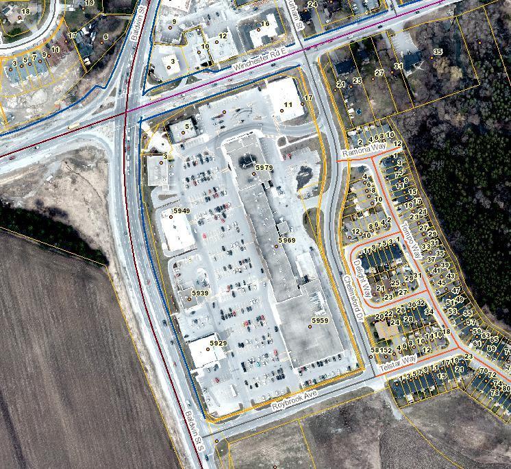
18 redeveloped for similar uses. As the site appears to be unused, this could likely occur prior to To the southeast of the intersection, the Town Plaza site (shown as A2) provides a longer term intensification opportunity. As this is a recently developed property, redevelopment is not expected to occur prior to 2031, however, over the long term, there is an opportunity for this site to develop for mixed use, likely with some commercial uses at grade and residential uses above. To the east of the Town Plaza property, existing residential properties fronting on the north and south sides of Winchester Road (shown as A3 and A4) could potentially re-develop for either townhouses or low-rise apartments. The properties to the south are designated High Density Residential while the properties to the north are designated Major Commercial. Redevelopment of these properties would likely require assembling 2 or more Photo Thatcher Imboden Photo IBI Group Photo Momentum Developments 15
19 properties to create a viable redevelopment site. Along the west side of Baldwin Street, north of Winchester Road, (shown as A5) there are a series of properties that may also redevelop. 12 Baldwin is already proposed to be redeveloped for a 2 storey professional office and dwelling unit with a lane/vehicular easement to the rear of the property. There are opportunities for further small-scale mixed-use redevelopment similar to this or alternatively redevelopment for a mix of retail and office development. However, a number of the properties have heritage value, and the area is within the Brooklin Heritage Conservation District, which may limit the opportunities for redevelopment in this area. As well, it is the intent of the Town that as properties along this portion of Baldwin redevelop, a rear lane for parking would be provided, as was required in the recently approved proposal for 12 Baldwin. The southwest corner of the Regional Centre / Major Central Area is currently vacant (shown in purple). While this area is outside of the built-boundary, it has a significant opportunity to develop for a mix of higher intensity retail, commercial and residential uses. Under the existing secondary plan, the area is designated Major Commercial, Mixed Use and Prestige Industrial Business Park (OPA 85). The Brooklin Secondary Plan Review study will create a detailed land use plan for this area. Overall, within the built boundary, the area could see approximately 130 new units by Post 2031, an additional 500 units could be developed over the long term. These figures exclude any development in at the southwest corner of Baldwin Street South and Winchester Road West, which is outside of the built boundary. 16

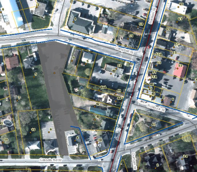
20 Area B: Downtown North Area Description Downtown Brooklin is part of the Regional Centre in the Region s Official Plan and part of the Major Central Area under the Town s Official Plan, but unlike the intersection of Winchester Road and Baldwin Street, it is not part of an Intensification Area in OPA 90. However, there are opportunities for intensification in Downtown Brooklin along Baldwin Street as well as surrounding the core commercial strip along Pearl, Price and Way streets. The area consists of 6 possible sub-areas of potential intensification, as is shown in the map below. The majority of these properties currently contain either a single detached dwelling or small commercial uses. Development Potential There are a number of existing commercial uses (as shown in sub-areas B1, B2 and B3) that could be assembled and redeveloped for mixed uses with at grade 17
.")

 may also provide opportunities for intensification for medium density uses, such as townhouses or low-rise")
21 commercial and residential units above. Alternatively these properties could be redeveloped solely for more retail purposes. However, a number of the buildings have significant heritage value and will need to be protected. As well, these areas are within the Heritage Conservation District (see Figure 6). As such, the heights, built form and density would need to be consistent with the Heritage Conservation District guidelines to ensure the unique character of the Downtown is maintained. Photo Thetorontoblog.com Infill and intensification for commercial use along Baldwin Street will likely occur by 2031, however mixed use intensification will likely be slower to occur. There are additional opportunities for intensification of adjacent residential properties that are within the Regional Centre / Major Central Area. Properties that front onto Pearl Street and Price Street (see areas shown as B5 and B6) may also provide opportunities for intensification for medium density uses, such as townhouses or low-rise apartments. Such intensification along Pearl Street and Way Street would provide opportunities for a public walkway system along the Lynde Creek. Photo Ed Massery Photo Brooklin Heritage Conservation District Plan 18
.")

22 To the north of the Downtown, a vacant property is located at Baldwin Street and George Street (shown as B4). This site is likely to redevelop for townhouses or other low rise built form by Overall, it is estimated that approximately 190 units might develop in the Downtown north area prior to 2031, with an additional 300 units over the longer term. Photo Paul Kulig 19

23 Figure 6: Brooklin Village Heritage Conservation District Boundary from Brooklin Heritage Conservation District Plan (Bray Heritage et al., July 30, 2007) 20

24 Area C: Baldwin St North Area Description The general area from Carnwith Road to Columbus Road West, on either side of Baldwin Street North is an Intensification Corridor under OPA 90. The area consists of 5 properties or groups of properties. These properties are either vacant or contain a commercial or employment use that may be suitable for residential or mixed use intensification. Development Potential To the north and south of Carnwith Road, along the east side of the Baldwin Street North, there are two vacant lots (shown as C2 and C3). These present an opportunity for development, most likely in the form of townhouses, low rise apartments or mixed use. As they are vacant, development of these properties is expected prior to
 provide an opportunity for")


25 To the north of these, there are some underutilised properties that may also be redeveloped for residential uses (shown as C4). Currently housing a school bus company, house and restaurant, these properties, along with an intervening vacant property outside the built boundary (shown in green) provide an opportunity for redevelopment for townhouse or mixed-use development. Some or all of these properties could also redevelop for more intensive retail uses. Although the intervening vacant property is outside the built-boundary and will not count towards the intensification targets, there is an opportunity for it to be developed in conjunction with the properties on either side of it. The Armtec (formely Brooklin Concrete) property, at the southwest corner of Baldwin Street North and Columbus Road West, is fully occupied with an employment use. However, it has a significant opportunity for intensification for residential and possibly some commercial uses should the employer move in the future. The range and type of land uses appropriate for this site will be explored in the next stage of the Brooklin Secondary Plan Review. Lastly, there is a small site with intensification potential, to the south (shown as C1). The site currently contains a vehicle service station. This site could be redeveloped over the long term for townhouses or a low rise apartment building. Photo RegionalArchitects Due the number of vacant and underutilised sites, approximately 570 units could be anticipated in the area by 2031, but the specific number of units and the range of land uses will be explored in the next stage of the Brooklin Secondary Plan Review. 22


26 Area D: Winchester Road East Area Description This area is identified as an Intensification Corridor area under OPA 90. The area consists of 7 properties or groups of properties that are either vacant, contain single detached dwellings or contain an existing small scale commercial use. Development Potential At the southwest intersection of Thomas Street and Winchester Road East (shown as D1 and D2), two commercial properties have the potential to be redeveloped for more intensive residential or mixed use. However, as these properties are currently actively used for commercial uses, this would likely only occur over the long term, post Along the north side of Winchester Road East, a series of large lot single detached properties face onto Winchester Road with two adjacent commercial uses. These properties have the potential to redevelop at a greater density than 23

, which also has the potential to redevelop, likely for a similar form of townhouse development.")
.")
27 currently exists (shown as D3). If redeveloped, it would likely be for townhouses, similar to the recent townhouse development opposite this area, on the south side of Winchester Road East or for low rise apartment buildings. In order for redevelopment to occur, the properties would have to be consolidated. As mentioned, there is a recent townhouse development on the south side of Winchester Road East. Directly to the west of this site, there is a single detached dwelling on a large lot (shown as D4), which also has the potential to redevelop, likely for a similar form of townhouse development. This redevelopment would likely occur prior to Further along Winchester Road East, there is a second large property with only a single detached dwelling that could also be re-developed for a more intensive use (shown as D5). Although townhouses are a potential form of development for this property, it is likely to develop in the short term for commercial uses. Further to the east, additional residential properties on the north side of Winchester Road and a veterinary clinic in a former house have the potential to redevelop for more intensive uses (see D6), likely in the form of townhouses. Directly to the east of these properties, a vacant lot is located at the northwest corner of Thickson Road North and Winchester Road (shown as a purple block). The vacant lot is outside of the built boundary, and would Photo BuzzBuzzHome Corp 24
.")
28 not count towards the intensification target but it would likely develop in a similar built form. To the northeast of Thickson and Winchester Road East, there is a vacant lot between the gas station and the Stormwater Management pond (see D7). The property is zoned to permit an apartment building and could develop prior to The majority of the redevelopment in this area is expected to occur over the short term with up to 230 units potential developing prior to 2031, with another 30 to 50 units possibly developing after Other Intensification Sites In addition to the intensification areas and sites discussed in this report, there are 15 vacant lots within the built boundary in Brooklin that will likely be developed for single detached dwellings by These lots back onto the forested area generally north of Carnwith Drive and east of Way St. As these lots are within the built boundary, they will contribute to the intensification target. Conlin/Anderson Area Despite being largely undeveloped at this time, the Conlin Anderson area was also included within the built boundary by the Province. The Conlin/Anderson area is for the most part located on the east side of Anderson Street south of the 25
29 future 407 as shown on Figure 7. This area differs from the other intensification areas and sites as it is currently in a rural / greenfield setting. Figure 7: Conlin Anderson Area 26
30 The detailed planning for this area in terms of land uses and densities will be undertaken as part of the next phase of the Brooklin Secondary Plan Review where land use options are explored for the greenfield expansion areas. As such, this area is not considered in detail in this report. However, any development within this built-up area will count towards the intensification target. A preliminary estimate of the development potential of this area was undertaken in the Background Report: Population, Housing and Employment Analysis, which yielded approximately 690 units. 27
31 4 Conclusion The purpose of this report is to identify potential intensification opportunities within Brooklin. The report identifies the general likelihood and timing of potential development largely from a market perspective. The areas identified as having potential for intensification were, for the most part, previously identified in the Town wide intensification study and are identified through OPA 90 as either the Downtown, intensification areas in the Regional Centre/ Major Central Area or intensification corridors along Baldwin Street and Winchester Road. The anticipated form of development in all areas will generally be low rise medium density residential and mixed use development with more intensive development within the Regional Centre / Major Central Area at Baldwin Street and Winchester Road and on high density designated sites along the Regional Corridors. The exception is the Conlin / Anderson area and some scattered vacant lots which will likely develop at lower densities with a mix of single detached, semi-detached and townhouse dwellings. Some areas have a greater likelihood to develop by 2031, particularly where they contain vacant or underutilised sites, while other areas face barriers to redevelopment, such as the need to consolidate adjacent properties. Overall, it is anticipated that up to 1,800 units could be built through intensification by 2031 with a long term potential for up to 2,700 units. However, these figures are only an estimate of what could happen if each property intensifies as anticipated. Some may never intensify in this time period, while others may redevelop for commercial use rather than residential or mixed use. For each of the 4 areas identified on Figure 5 and within the Conlin / Anderson area, more detailed planning will be undertaken in the next stage of the Brooklin Secondary Plan Review to determine the appropriate mix of land uses, densities and built form within these areas. 28
 Residential to north (~0.")
32 Appendix A 1. Property Details for Area A Property #: A1 Property Address: 1 Ferguson Avenue Lot Area: 0.90 ha Lot Frontage: 117 m. Lot Depth: 78 m. Existing use: Commercial/Vacant Surrounding Use: Residential to west (~0.2 acre lots) Residential to north (~0.2 acre lots) Midrise and Townhouse development to east Farmland, gas station, animal clinic to south Secondary Plan Land Use Designation: Special Purpose Commercial Zoning: C2-S-BP Intensification Category: Regional Centre / Major Central Area - Intensification Area 29
33 Looking northwest at property from Winchester Road East Looking north at east end of property from Winchester Road East 30
34 Property #: A2 Property Address: 3-17 Winchester Road East Site Area: 4.8 ha Site Frontage: 174 m. Site Depth: 297 m. Existing use: Commercial Surrounding Use: Vacant land to west Commercial and residential to north Residential to east (townhouses) Vacant land to south Secondary Plan Land Use Designation: Major Commercial Zoning: C1-VB-2, C1-VB-4 Intensification Category: Regional Centre / Major Central Area - Intensification Area 31
35 32
36 Looking southeast at property from Baldwin Street South Looking east at property from Baldwin Street South 33

37 Looking east at property from interior of site Looking southeast at property from interior of site 34
38 Looking south at property from Winchester Road East 35

39 Property #: A3 Property Address: 21, 25, 27, 31, 35 Winchester Road East Site Area: 0.7 ha (developable) Site Frontage: 71 m. Site Depth: 80 m. Existing use: Residential and salon/spa with likely environmental constraints at the southeast corner of the property. Surrounding Use: Commercial areas to west Commercial and Residential uses to north (Single detached dwelling, 0.2 acre lots) open space, then arena to east Open space and townhouses to south Secondary Plan Land Use Designation: High Density Residential Zoning: R1-VB and C1-VB-2 Intensification Category: Regional Centre / Major Central Area - Intensification Area 36


40 Looking south at 25 Winchester Road East from Winchester Road East Looking south at 27 Winchester Road East from Winchester Road East 37

41 Looking south at 31 Winchester Road East from Winchester Road East 38

 Secondary Plan Land Use Designation: Residential Zoning: R1-VB-4 and R1-VB2 Intensification Category: Regional Centre / Major Central Area")
42 Property #: A4 Property Address: 24, 28 Winchester Road East and 2 Princess St Site Area: 0.31 ha Site Frontage: 80.7 m. Site Depth: 28.5 m. Existing use: Residential and commercial uses Surrounding Use: Commercial areas to west Residential uses to north (Single detached dwelling, 0.2 acre lots) Residential use (Single detached dwellings, 0.2 acre lots) and open space Residential uses to south (Single detached dwelling, acre lots) Secondary Plan Land Use Designation: Residential Zoning: R1-VB-4 and R1-VB2 Intensification Category: Regional Centre / Major Central Area - Intensification Area 39

43 Photo Google Streetview Looking northwest at properties 40
, office use (20-22 Baldwin Street) Note: 20 Baldwin has recent site plan approval for a dentist office.")
 22 Baldwin St Some Heritage Value (G-VG) Secondary Plan Land Use Designation: Mixed Use Zoning:")
44 Property #: A5 Property Address: 6-22 Baldwin St Site Area: 0.66 ha Site frontage: 173 m. Site depth : 62 m. Existing use: Residential Uses (single detached dwellings), office use (20-22 Baldwin Street) Note: 20 Baldwin has recent site plan approval for a dentist office. Surrounding Use: Residential uses to west and north (Single detached dwelling) with some townhouses to west of 6 Baldwin St. Commercial Uses to east and 20 Baldwin St Some Heritage Value (G) 22 Baldwin St Some Heritage Value (G-VG) Secondary Plan Land Use Designation: Mixed Use Zoning: MUR-VB-3,5,6,7 Intensification Category: Regional Centre / Major Central Area - Intensification Area 41

45 Photo Google Streetview Looking southwest at properties 42
46 2. Property Details for Area B Property #: B1 Property Address: Baldwin Street and 5 and 9 Campbell Street Site Area: 0.71 ha Site frontage: 93 m. Site depth: 85 m. Existing use: Commercial (e.g. Bank, Electronics Store), Dentist and Residential Surrounding Use: Parking to west Commercial to north Commercial and park to the east Commercial to south Secondary Plan Land Use Designation: Major Commercial Zoning: H-C1-VB Brooklin Heritage Conservation District Plan Study Rating: 40 Baldwin St No Heritage Value 42 Baldwin St Some Heritage Value (G) 44 Baldwin St - Significant Heritage Value (VG) 46 Baldwin St Significant Heritage Value (VG) Baldwin St No Heritage Value Intensification Category: Regional Centre / Major Central Area - Other 43

47 44


48 Photo Google Streetview Looking southwest at property Looking east at property from Baldwin Street 45
 Note: 66 and 68 Baldwin St has recent site plan approval for a two storey office building.")
 Secondary Plan Land Use Designation: Major Commercial Zoning: H-C1-VB5,G Brooklin Heritage Conservation District Plan Study Rating: 64 Baldwin St No Heritage Value 66 Baldwin St No")
49 Property #: B2 Property Address: Baldwin St and 11 and 15 Price St Site Area: 1.3 ha Site frontage: 101 m. Site depth : 128 m. Existing use: Commercial Uses (Home Hardware, Vehicle Service Station, Restaurant, Salon Etc.) Note: 66 and 68 Baldwin St has recent site plan approval for a two storey office building. Surrounding Use: Residential uses to north (Single detached dwelling, ~0.3 acre lots) Commercial uses to east Commercial uses to south Residential uses to rear (Single detached dwelling, ~0.25 acre lots) Secondary Plan Land Use Designation: Major Commercial Zoning: H-C1-VB5,G Brooklin Heritage Conservation District Plan Study Rating: 64 Baldwin St No Heritage Value 66 Baldwin St No Heritage Value 68 Baldwin St Significant Heritage Value (G-VG) 72 Baldwin St Some Heritage Value (G) 76 Baldwin St No Heritage Value Intensification Category: Regional Centre / Major Central Area - Other 46


50 Looking southwest at property Photo Google Streetview Looking east at property from Baldwin Street 47

51 Looking west at property from Baldwin Street 48
52 Property #: B3 Property Address: Baldwin St, Pearl S and Cassels Lot Area: 1.1 ha Lot Frontage: 127 m Existing use: Commercial Uses with some Residential uses along Pearl. Note, 63 Baldwin St. is being developed as a 2 storey professional office building. Surrounding Use: Commercial to west Residential (0.5-1 acres) and watercourse to north and east Grass Park and Institutional to south Secondary Plan Land Use Designation: Major Commercial and Mixed Use Zoning: 10-Roebuck St and 14 Cassels Rd East - C1-VB Pearl St- MUR-VB 43 Pearl St - H-MUR-VB Brooklin Heritage Conservation District Plan Study Rating: 61 Baldwin St - Some heritage value (G) 63 Baldwin No Heritage Value 65 Baldwin St No Heritage Value 67 Baldwin St No Heritage Value 71 Baldwin St - Significant heritage value (VG) 14 Cassels Rd East No Heritage Value 20 Cassels Rd East - Significant heritage value (VG) 40 Pearl St No heritage Value 42 Pearl St No heritage Value 10 Roebuck St- Some heritage value (G) Intensification Category: Regional Centre / Major Central Area - Other 49


53 Looking northeast at site from Baldwin St Photo Google Streetview 50


54 Looking southeast at site from Baldwin St Photo Google Streetview Looking southwest at site from Pearl Street Photo Google Streetview 51

 Residential to south with forested area Secondary Plan Land Use Designation: Mixed Use Zoning: C1-VB-3 Note Site plan")
55 Property #: B4 Property Address: 99 Baldwin St Lot Area: 0.33 ha Lot frontage: 33 m. Lot depth: 61 m. Existing use: Vacant land Surrounding Use: Treatment center to west Residential to north (Single detached dwelling~0.2 acre lots) Residential to west (Single detached dwelling ~0.3 acre lots) Residential to south with forested area Secondary Plan Land Use Designation: Mixed Use Zoning: C1-VB-3 Note Site plan approved in 2000s for commercial/retail but never built. Intensification Category: Regional Centre / Major Central Area - Other 52

56 Looking southeast at property from George Street. 53

 Institutional uses to south Secondary Plan Land Use Designation: Residential, Hazard Land Zoning: R2-VB-1, H-R2-VB1,")
57 Property #: B5 Property Address: 30 Cassels and Pearl Street Site Area: 2.8 ha Site Frontage: 237 m. Site Depth: 64 m. Existing use: Single detached dwellings Surrounding Use: Commercial and residential uses to west Residential to north (Single detached dwellings, various lot sizes) Residential to east (singled detached dwellings, ~0.15 acre lots) Institutional uses to south Secondary Plan Land Use Designation: Residential, Hazard Land Zoning: R2-VB-1, H-R2-VB1, H-R2-VB-4 Intensification Category: Regional Centre / Major Central Area - Other 54

58 Photo Google Streetview Looking southeast at property from George Street. 55

 and parking lot to south Secondary Plan Land Use Designation: Major Commercial and Residential Zoning: H-R2-VP, H-C1-VB, R2-VB")
59 Property #: B6 Property Address: 2-18 Price Street Site Area: 0.7 ha Site Frontage: 166 m. Site Depth: 46 m. Existing use: Single detached dwellings and a post office Surrounding Use: Brooklin Community Centre to west Residential to north (Single detached dwellings, various lot sizes) Commercial uses to east Residential uses (single detached dwellings, acre) and parking lot to south Secondary Plan Land Use Designation: Major Commercial and Residential Zoning: H-R2-VP, H-C1-VB, R2-VB Intensification Category: Regional Centre / Major Central Area Other 56

60 Photo Google Streetview Looking southwest at properties from Price Street 57


61 3. Property Details for Area C Property #: C1 Property Address: 157 Baldwin Street Property Area: 0.15 ha Lot Frontage: 55 m. Existing use: Vehicle Service Station Surrounding Use: Generally residential on all sides with some vacant land to the northeast (Single detached dwelling, acre lots) Secondary Plan Land Use Designation: Special Purpose Commercial Zoning: C2-S-BP Intensification Category: Intensification Corridor 58
62 Looking southeast at property from intersection of Queen St and Baldwin St 59

 Secondary Plan Land Use Designation: High Density Residential Zoning: R4A* Intensification Category:")
63 Property #: C2 Property Address: Carnwith Drive East Lot Area: 1.00 ha Lot frontage: 74 m. Lot depth: 184 m. Existing use: Vacant Surrounding Use: Vacant land planned for townhouse development to the west Vacant land to the north with low density residential to northeast (0.1 acre lot) Low density residential to east and south (~ 0.1 acre lots) Secondary Plan Land Use Designation: High Density Residential Zoning: R4A* Intensification Category: Intensification Corridor 60

64 Looking southwest at property from Carnwith Drive East 61
65 Property #: C3 Property Address: Carnwith Dr E (NE corner of Carnwith Dr. and Baldwin St N) Lot Area: 1.3 ha Lot Frontage: 108 m. Lot depth: 124 m. Existing use: Vacant Land Surrounding Use: Construction of a high school to west Brooklin Concrete Production to northwest Fire station to north Residential uses to east (Single detached dwelling, <0.1 acre lots) Vacant land to south then residential uses (<0.1 acre lots) Secondary Plan Land Use Designation: Special Purpose Commercial Zoning: H-C2-S and C2-S Intensification Category: Intensification Corridor Potential for and timing of Intensification: Vacant, available Short term (pre 2031) 62


66 Looking northwest at property from southeast corner 63

67 Looking southwest at property from Baldwin Street North 64

 Lot depth: 124 m.")

 to east Fire station then vacant land to south Secondary Plan Land Use")
68 Property #: C4 Property Address: 6775, 6825, 6875 Baldwin Street North Lot Area: 1.7 ha (2.5 when the vacant property outside the built boundary is included as shown with a blue hatched boundary) Lot frontage: 175 m. (300 including Vacant property outside built boundary) Lot depth: 124 m. Existing use: Restaurant, Single Detached Dwelling and Employment Use (School Bus Company) Surrounding Use: Concrete production facility to west Vacant land to north Vacant land and residential uses (Single detached dwelling, ~0.1 acre lots) to east Fire station then vacant land to south Secondary Plan Land Use Designation: Special Purpose Commercial Zoning: C2-S-BP Intensification Category: Intensification Corridor Looking east at property from Baldwin Street North 65


69 Looking east at property from Baldwin Street North Looking east at property from Baldwin Street North 66

70 Photo Google Streetview Looking east at property from Baldwin Street North 67

, restaurant and employment to east Vacant land to south (Construction of High")
71 Property #: C5 Property Address: 6760,6900 Baldwin St North and vacant lot to west Lot Area: 9.7 ha Lot frontage: 291 m. Lot depth: 332 m. Existing use: Concrete and brick facility Surrounding Use: Ongoing construction of Low Density Residential development to west Agricultural land to north Residential (>1 acre lot), restaurant and employment to east Vacant land to south (Construction of High School) Secondary Plan Land Use Designation: General Industrial Zoning: M1-BP, D(NR) Intensification Category: Intensification Corridor 68

72 Looking west at property from Baldwin Street North Looking west at property from Baldwin Street North 69
73 Looking west at property from Baldwin Street North near the intersections Columbus Road East and Baldwin Street North 70
74 4. Property Details for Area D Property #: D1 Property Address: 30 St. Thomas Street Lot Area: 0.23 ha Lot Frontage: 90 m. Lot Depth: 26 m. Existing use: Mixed Use building. Contains Restaurant and residential units. Surrounding Use: Park to west Restaurant/convenient store to north Place of worship to northeast Residential to east (SDD, ~ 0.1 acre lots) Park to south Secondary Plan Land Use Designation: Special Purpose Commercial Zoning: C2-S-BP Intensification Category: Other Intensification Parcel 71


75 Looking west at property from St. Thomas Street, mixed use buildling 72
76 Property #: D2 Property Address: 93 Winchester Road E Lot Area: 0.42 ha Lot frontage: 40 m. Lot depth: 133 m. Existing use: Restaurant, Convenience Store Surrounding Use: Park and arena to west Low Density Residential to North (SDD, ~ 0.25 acre lots) Place of Worship and Low Density residential to east (SDD, ~0.5 acre lots) Residential to southeast (SDD, ~ 0.1 acre lots) Restaurant to south Secondary Plan Land Use Designation: Special Purpose Commercial Zoning: C2-S-BP Intensification Category: Intensification Corridor 73


77 74


78 Looking west at property from intersection of St Thomas Street and Winchester Road East Looking northwest at property from St Thomas Street 75
79 Property #: D3 Property Address: Winchester Road E and lot to east Lot Area: 2.4 ha Lot Frontage: 337 m. Lot depth: 73 m. Existing use: Florist, automobile service shop and vacant property used for parking and single detached dwellings. Surrounding Use: Residential to west (Single detached dwelling, ~0.2 acre lots) Residential to north (Single detached dwelling, acre lots) Residential to east (~0.1 acre lots) Townhouse development and some low density residential to south Place of worship to the south Secondary Plan Land Use Designation: Special Purpose Commercial and Medium Density Residential Zoning: C2-S-BP and R2-BP Intensification Category: Intensification Corridor 76


80 Photo Google Streetview Looking north at property at 114 Winchester Road East, a flower shop and automobile shop 77

81 Looking north at property from Winchester Road East at parking lot 78


82 Looking north at 126 Winchester Road East Looking north at 130 Winchester Road East Looking north at 132 Winchester Road East Looking north. at 134 Winchester Road East Looking north at 140 Winchester Road East Looking north at 144 Winchester Road East 79
83 Property #: D4 Property Address: 403 Winchester Road East Lot Area: 0.5 ha. Lot Frontage: 50 m. Lot depth: 100 m. Existing use: single detached house Surrounding Use: Residential to west (townhouses under construction) Car service to northwest Residential to north (SDD, ~0.5 acre, then SDD, 0.1 acre lots) Residential to east (SDD, >0.1 acre lots) Residential to south (SDD, ~0.1 acre lots) Secondary Plan Land Use Designation: Medium Density Residential Zoning: R2-BP Intensification Category: Intensification Corridor 80

84 Looking south from Winchester Road East at the east end of the property 81

85 Looking southeast from Winchester Road East at 403 Winchester Road East, a neighbouring townhouse development 82


86 Property #: D5 Property Address: 445 Winchester Road East Lot Area: 1.34 ha Lot Frontage: 109 m. Lot depth: 123 m. Existing use: Vacant, Single Detached Dwelling Surrounding Use: Offices to west Residential (1 SDD on 0.5 acre lot), Veterinary clinic and vacant land to north Vacant land and gas station to east Farmland to south Medium density multi-residential building to southwest Secondary Plan Land Use Designation: Special Purpose Commercial Zoning: H-C2-S Intensification Category: Intensification Corridor 83
87 Looking southeast at property from Winchester Road East 84
88 Property #: D6 Property Address: 430, 440 and 450 Winchester Road East plus vacant lot to east Site Area: 0.69 ha (1.2 ha including the vacant lot to the east, blue hatched boundary, which is outside the built boundary) Site Frontage: m. (223 m. with vacant lot to east, blue hatched boundary) Site depth: 54 m. Existing use: Residential Property (#430 and 440), Veterinary Clinic (#450), Vacant Lot Surrounding Use: Residential to east (SDD, 0.2 acre lot) Residential to north (0.1 acre lots) Gas station to the west Gas station to southeast Single detached house to south (3 acre lot) Offices to southwest Secondary Plan Land Use Designation: Medium Density Residential Zoning: R2-BP Intensification Category: Intensification Corridor. 85


89 Looking northwest at property from at from southwest corner Photo Google Streetview 86
90 Looking northwest at property, the veterinary clinic, from at from southeast corner 87

 Vacant lot to west (planned School Block) Vacant land to south Secondary Plan Land Use")
91 Property #: D7 Property Address: Property east of 520 Winchester Road East Site Area: 0.6 ha Site Frontage: 64 m. Site Depth: 83 m. Existing use: vacant lot Surrounding Use: Gas station and Townhouses to west Residential to north (Townhouses) Vacant lot to west (planned School Block) Vacant land to south Secondary Plan Land Use Designation: High Density Residential Zoning: R5A*-2 Intensification Category: Intensification Corridor 88

92 Photo Google Streetview Looking north at property from Winchester Road East 89
93
94
PLANNING REPORT Gordon Street City of Guelph. Prepared on behalf of Ontario Inc. March 17, Project No. 1507
 PLANNING REPORT 1131 Gordon Street City of Guelph Prepared on behalf of 1876698 Ontario Inc. March 17, 2016 Project No. 1507 423 Woolwich Street, Suite 201, Guelph, Ontario, N1H 3X3 Phone (519) 836-7526
Part 2 Secondary Plans
 Part 2 Secondary Plans Section 11 - Secondary Plans NOTE: Further review and updates to Secondary Plans will be considered separately, at a later date. Detailed review and updates to individual Secondary
Urban Design Brief Dundas Street. London Affordable Housing Foundation. November Zelinka Priamo Ltd.
 Urban Design Brief 1039-1047 Dundas Street London Affordable Housing Foundation November 2017 Zelinka Priamo Ltd. TABLE OF CONTENTS Page No. INTRODUCTION... 3 SECTION 1 LAND USE PLANNING CONTEXT... 3 1.1
Bylaw No , being "Official Community Plan Bylaw, 2016" Schedule "A" DRAFT
 Bylaw No. 2600-2016, being "Official Community Plan Bylaw, 2016" Schedule "A" Urban Structure + Growth Plan Urban Structure Land use and growth management are among the most powerful policy tools at the
PLANNING RATIONALE REPORT
 PLANNING RATIONALE REPORT Zoning By-law Amendment Application 2920 Danbury Way Prepared for: Bravar Custom Builders Inc. and Village View Estates Ltd. by: 6393 Roslyn Street Ottawa (Orleans), Ontario K1C
STAFF REPORT. January 25, North York Community Council. Director, Community Planning, North District
 STAFF REPORT January 25, 2005 To: From: Subject: Purpose: North York Community Council Director, Community Planning, North District Refusal Report OPA & Rezoning Application 04 194214 NNY 33 OZ Applicant:
AMENDMENT NUMBER 38 TO THE OFFICIAL PLAN OF THE TOWNSHIP OF WEST LINCOLN (COMPLIANCE)
") AMENDMENT NUMBER 38 TO THE OFFICIAL PLAN OF THE TOWNSHIP OF WEST LINCOLN (COMPLIANCE) 2013 AMENDMENT NUMBER 38 TO THE OFFICIAL PLAN OF THE TOWNSHIP OF WEST LINCOLN PART 1 - THE PREAMBLE 1.1 TITLE This
AMENDMENT NUMBER 38 TO THE OFFICIAL PLAN OF THE TOWNSHIP OF WEST LINCOLN (COMPLIANCE) 2013 AMENDMENT NUMBER 38 TO THE OFFICIAL PLAN OF THE TOWNSHIP OF WEST LINCOLN PART 1 - THE PREAMBLE 1.1 TITLE This
307 Sherbourne Street - Zoning Amendment Application - Preliminary Report
 STAFF REPORT ACTION REQUIRED 307 Sherbourne Street - Zoning Amendment Application - Preliminary Report Date: August 14, 2015 To: From: Wards: Reference Number: Toronto and East York Community Council Director,
Planning Justification Report
 Planning Justification Report 101 Kozlov Street, Barrie, Ont. Destaron Property Management Ltd. November 2015 Revised February 2017 TABLE OF CONTENTS Page 1.0 INTRODUCTION... 1 2.0 DESCRIPTION OF SUBJECT
Housing & Residential Intensification Study Discussion Paper Township of King
 Housing & Residential Intensification Study Discussion Paper Prepared by Planning Department January 2011 1.0 Background 1.1 Provincial Policies (Greenbelt and Growth Plan) Since 2001, the Province of
PLANNING REPORT. 33 Arkell Road City of Guelph. Prepared on behalf of OHM Arkell Inc. August 4, Project No. 1327
 PLANNING REPORT 33 Arkell Road City of Guelph Prepared on behalf of OHM Arkell Inc. August 4, 2015 Project No. 1327 423 Woolwich Street, Suite 201, Guelph, Ontario, N1H 3X3 Phone (519) 836-7526 Fax (519)
PIN , Part 1, Plan SR-713 in Lot 2, Concession 5, Township of McKim (1096 Dublin Street, Sudbury)
") STAFF REPORT Applicant: Dalron Construction Limited Location: PIN 02124-0103, Part 1, Plan SR-713 in Lot 2, Concession 5, Township of McKim (1096 Dublin Street, Sudbury) Official Plan and Zoning By-law:
STAFF REPORT Applicant: Dalron Construction Limited Location: PIN 02124-0103, Part 1, Plan SR-713 in Lot 2, Concession 5, Township of McKim (1096 Dublin Street, Sudbury) Official Plan and Zoning By-law:
Official Plan & Zoning By-law Amendment Application Preliminary Report
 STAFF REPORT ACTION REQUIRED 847 873 Sheppard Avenue West Official Plan & Zoning By-law Amendment Application Preliminary Report Date: January 13, 2010 To: From: Wards: Reference Number: North York Community
3.1. OBJECTIVES FOR RESIDENTIAL LAND USE DESIGNATIONS GENERAL OBJECTIVES FOR ALL RESIDENTIAL DESIGNATIONS
 3. RESIDENTIAL LAND USE DESIGNATIONS INTRODUCTION The Residential land use designations provide for housing and other land uses that are integral to, and supportive of, a residential environment. Housing
Urban Design Brief. Italian Seniors Project 1090, 1092, 1096 Hamilton Road City of London
 Urban Design Brief Italian Seniors Project City of London October 1, 2017 TABLE OF CONTENTS Page No. INTRODUCTION... 2 1.0 LAND USE PLANNING CONCEPT... 2 1.1 Subject Lands... 2 1.2 Official Plan and Zoning
40-58 Widmer Street - Zoning Amendment Application - Preliminary Report
 STAFF REPORT ACTION REQUIRED 40-58 Widmer Street - Zoning Amendment Application - Preliminary Report Date: April 19, 2013 To: From: Wards: Reference Number: Toronto and East York Community Council Director,
Montreal Road District Secondary Plan [Amendment #127, October 9, 2013]
![Montreal Road District Secondary Plan [Amendment #127, October 9, 2013]](/thumbs/72/66783104.jpg "Montreal Road District Secondary Plan [Amendment #127, October 9, 2013]") [Amendment #127, October 9, 2013] 1.0 General The following policies are applicable to the Montreal Road District as set out in Schedule 1. 1.1 District Objectives The objective of this Plan is to guide
[Amendment #127, October 9, 2013] 1.0 General The following policies are applicable to the Montreal Road District as set out in Schedule 1. 1.1 District Objectives The objective of this Plan is to guide
Planning Justification Report
 Planning Justification Report Kellogg s Lands City of London E&E McLaughlin Ltd. June 14, 2017 Zelinka Priamo Ltd. Page i TABLE OF CONTENTS Page No. 1.0 2.0 2.1 2.2 3.0 4.0 5.0 5.1 5.2 5.3 5.4 5.5 5.6
MINTO COMMUNITIES INC. AVALON WEST STAGE 4 PLANNING RATIONALE. July Prepared for:
 MINTO COMMUNITIES INC. AVALON WEST STAGE 4 PLANNING RATIONALE July 2015 Prepared for: MINTO COMMUNITIES INC. 200 180 Kent Street Ottawa, Ontario K1P 0B6 Prepared by: J.L. RICHARDS & ASSOCIATES LIMITED
3390, 3392, 3394, 3396 and 3398 Bayview Avenue - Official Plan Amendment, Zoning By-law Amendment Application - Preliminary Report
 STAFF REPORT ACTION REQUIRED 3390, 3392, 3394, 3396 and 3398 Bayview Avenue - Official Plan Amendment, Zoning By-law Amendment Application - Preliminary Report Date: March 14, 2016 To: From: Wards: Reference
ANALYSIS OF INTENSIFICATION OPPORTUNITIES IN THE CITY OF BRANTFORD. Final Report Prepared for:
 ANALYSIS OF INTENSIFICATION OPPORTUNITIES IN THE CITY OF BRANTFORD Final Report Prepared for: February 2012 TABLE OF CONTENTS I INTRODUCTION... 1 A. Purpose of this Report... 1 B. Types of Intensification
50 Wellesley Street East - Official Plan Amendment & Zoning Amendment Applications - Preliminary Report
 STAFF REPORT ACTION REQUIRED 50 Wellesley Street East - Official Plan Amendment & Zoning Amendment Applications - Preliminary Report Date: July 18, 2014 To: From: Wards: Reference Number: Toronto and East
Director, Community Planning, Etobicoke York District
 STAFF REPORT ACTION REQUIRED 3555 Don Mills Road Zoning By-law Amendment Application Preliminary Report Date: May 22, 2012 To: From: Wards: Reference Number: North York Community Council Director, Community
8.5.1 R1, Single Detached Residential District
 8.5.1 R1, Single Detached Residential District The purpose of this district is to provide for residential development in the form of single detached dwellings. Dwelling, Single Detached Home Business,
Director, Community Planning, Scarborough District ESC 44 OZ & ESC 44 SB
 STAFF REPORT ACTION REQUIRED 6175, 6183 Kingston Road and 1, 2, 4, 5, 7,10 & 11 Franklin Avenue - Official Plan Amendment, Zoning Amendment and Draft Plan of Subdivision Applications Preliminary Report
BROCKVILLE CITY OF BROCKVILLE COMPREHENSIVE ZONING BY-LAW REVIEW DISCUSSION PAPER OCTOBER 2013 FINAL D
 BROCKVILLE CITY OF BROCKVILLE COMPREHENSIVE ZONING REVIEW DISCUSSION PAPER OCTOBER 2013 FINAL D14-13-010 TABLE OF CONTENTS 1. INTRODUCTION... 1 1.1 Purpose and Goals of this Project... 1 1.2 Study Process...
Ashcroft Homes Trim Road Development Planning Rationale
 18 Antares Drive Ottawa, ON K2E 1A9 Ashcroft Homes Trim Road Development Planning Rationale Proposed Site Plan & Zoning Amendment Applications File No: D02-02-17-0129 & D07-12-17-0175 August 2018 Planning
For Vintages of Four Mile Creek Town of Niagara on the Lake, Ontario
 Planning Impact Analysis For Vintages of Four Mile Creek Town of Niagara on the Lake, Ontario Prepared by: Upper Canada Consultants 261 Martindale Road Unit #1 St. Catharines, Ontario L2W 1A1 Prepared
Director, Community Planning, North York District NNY 10 OZ and NNY 10 RH
 STAFF REPORT ACTION REQUIRED 847 873 Sheppard Avenue West - Official Plan Amendment and Zoning By-law Amendment and Rental Housing Demolition and Conversion Applications - Preliminary Report Date: April
111 Wenderly Drive Official Plan and Zoning By-law Amendment Applications - Preliminary Report
 STAFF REPORT ACTION REQUIRED 111 Wenderly Drive Official Plan and Zoning By-law Amendment Applications - Preliminary Report Date: August 17, 2015 To: From: Wards: Reference Number: North York Community
Islington Avenue - Official Plan and Zoning By-law Amendment Application - Preliminary Report
 STAFF REPORT ACTION REQUIRED 3002-3014 Islington Avenue - Official Plan and Zoning By-law Amendment Application - Preliminary Report Date: Febuary 2, 2016 To: From: Wards: Reference Number: Etobicoke York
1555 Midland Avenue - Zoning Amendment & Subdivision Applications - Preliminary Report
 STAFF REPORT ACTION REQUIRED 1555 Midland Avenue - Zoning Amendment & Subdivision Applications - Preliminary Report Date: October 24, 2013 To: From: Wards: Reference Number: Scarborough Community Council
66 Isabella Street Rezoning Application - Preliminary Report
 STAFF REPORT ACTION REQUIRED 66 Isabella Street Rezoning Application - Preliminary Report Date: November 15, 2010 To: From: Wards: Reference Number: Toronto and East York Community Council Director, Community
1417, , 1427 & 1429 Yonge Street - Official Plan Amendment and Zoning Amendment Applications - Preliminary Report
 STAFF REPORT ACTION REQUIRED 1417, 1421-1425, 1427 & 1429 Yonge Street - Official Plan Amendment and Zoning Amendment Applications - Preliminary Report Date: March 24, 2015 To: From: Wards: Reference Number:
230 Oak Street- Official Plan Amendment and Zoning Bylaw Amendment Applications - Preliminary Report
 STAFF REPORT ACTION REQUIRED 230 Oak Street- Official Plan Amendment and Zoning Bylaw Amendment Applications - Preliminary Report Date: February 6, 2014 To: From: Wards: Reference Number: Toronto and East
6040 Bathurst Street and 5 Fisherville Road Zoning Bylaw Amendment Application Preliminary Report
 STAFF REPORT ACTION REQUIRED 6040 Bathurst Street and 5 Fisherville Road Zoning Bylaw Amendment Application Preliminary Report Date: January 24, 2017 To: From: Wards: Reference Number: North York Community
Planning Rationale in Support of an Application for Plan of Subdivision and Zoning By-Law Amendment
 Planning Rationale in Support of an Application for Plan of Subdivision and Zoning By-Law Amendment The Kilmorie Development 21 Withrow Avenue City of Ottawa Prepared by: Holzman Consultants Inc. Land
Yonge Street, 5-9 St. Joseph Street and 11-19, 25 St. Nicholas Street Rezoning Application - Preliminary Report
 STAFF REPORT ACTION REQUIRED 606-618 Yonge Street, 5-9 St. Joseph Street and 11-19, 25 St. Nicholas Street Rezoning Application - Preliminary Report Date: December 11, 2008 To: From: Wards: Reference Number:
PLANNING RATIONALE 680 BRONSON AVENUE OTTAWA, ONTARIO PROPOSED ZONING BY-LAW AMENDMENT
 PLANNING RATIONALE 680 BRONSON AVENUE OTTAWA, ONTARIO PROPOSED ZONING BY-LAW AMENDMENT FRANK PARAVAN APRIL 2014 Planning Rationale Introduction FOTENN Consultants Inc. has been engaged by Frank and Michael
Planning Justification Report
 Planning Justification Report 103 and 105 Toronto Street Town of Markdale, Municipality of Grey Highlands Maverick Developments November 5, 2016 Zelinka Priamo Ltd. Page i TABLE OF CONTENTS Page No. 1.0
Members of the City of Brantford Committee of Adjustment. 1.0 TYPE OF REPORT Committee of Adjustment Decision Regarding an Application for Consent
 DATE: October 18 th 2017 REPORT NO. CD2017-168 TO: Members of the City of Brantford Committee of Adjustment FROM: Brandon Kashin, Current Development Planner 1.0 TYPE OF REPORT Committee of Adjustment
355 King St W and 119 Blue Jays Way - OPA & Rezoning Applications - Preliminary Report
 STAFF REPORT ACTION REQUIRED 355 King St W and 119 Blue Jays Way - OPA & Rezoning Applications - Preliminary Report Date: May 27, 2008 To: From: Wards: Reference Number: Toronto and East York Community
Peter Street and 357 Richmond Street West - Zoning Amendment Application - Preliminary Report
 STAFF REPORT ACTION REQUIRED 122-128 Peter Street and 357 Richmond Street West - Zoning Amendment Application - Preliminary Report Date: March 11, 2016 To: From: Wards: Reference Number: Toronto and East
Galloway Road and 4097 Lawrence Avenue East - Zoning Amendment Application - Preliminary Report
 STAFF REPORT ACTION REQUIRED 197-201 Galloway Road and 4097 Lawrence Avenue East - Zoning Amendment Application - Preliminary Report Date: November 29, 2013 To: From: Wards: Reference Number: Scarborough
20 Edward Street Zoning Amendment Application - Preliminary Report
 STAFF REPORT ACTION REQUIRED 20 Edward Street Zoning Amendment Application - Preliminary Report Date: January 20, 2015 To: From: Wards: Reference Number: Toronto and East York Community Council Director,
FEASIBILITY REPORT. 1486, 1490 and 1494 Clementine. Prepared by: Lloyd Phillips & Associates Ltd. For: Ottawa Salus
 DRAFT FEASIBILITY REPORT 1486, 1490 and 1494 Clementine Prepared by: Lloyd Phillips & Associates Ltd. For: Ottawa Salus LPA File No. 1008 Lloyd Phillips & Associates June 9, 2010 Feasibility Report Page
May 5, Highway 7 and Kipling Avenue Northeast Quadrant Land Use Study
 May 5, 2016 Highway 7 and Kipling Avenue Northeast Quadrant Land Use Study To provide an update on the study and obtain feedback on draft scenarios prepared by the consulting team from the public. The
10 St Mary Street - Zoning Amendment Application - Preliminary Report
 STAFF REPORT ACTION REQUIRED 10 St Mary Street - Zoning Amendment Application - Preliminary Report Date: May 14, 2015 To: From: Wards: Reference Number: Toronto and East York Community Council Director,
3445 Sheppard Avenue East - Zoning Amendment Application - Preliminary Report
 STAFF REPORT ACTION REQUIRED 3445 Sheppard Avenue East - Zoning Amendment Application - Preliminary Report Date: August 14, 2013 To: From: Wards: Reference Number: Scarborough Community Council Director,
STAFF REPORT. March 14, Toronto and East York Community Council. Director, Community Planning, South District
 STAFF REPORT March 14, 2005 To: From: Subject: Toronto and East York Community Council Director, Community Planning, South District Preliminary Report Official Plan Amendment and Rezoning Application 05
Housing Issues Report Shoreline Towers Inc. Proposal 2313 & 2323 Lake Shore Boulevard West. Prepared by PMG Planning Consultants November 18, 2014
 Housing Issues Report Shoreline Towers Inc. Proposal 2313 & 2323 Lake Shore Boulevard West Prepared by PMG Planning Consultants November 18, 2014 PMG Planning Consultants Toronto, Canada M6A 1Y7 Tel. (416)
Staff Report for Council Public Meeting
 Agenda Item 3.3 Staff Report for Council Public Meeting Date of Meeting: September 27, 2017 Report Number: SRPRS.17.134 Department: Division: Subject: Planning and Regulatory Services Development Planning
STAFF REPORT PLN December 9, 2013
 Page: 1 TO: SUBJECT: PREPARED BY AND KEY CONTACT: SUBMITTED BY: GENERAL MANAGER APPROVAL: CHIEF ADMINISTRATIVE OFFICER APPROVAL: GENERAL COMMITTEE PROPOSED INTENSIFICATION NODE AND CORRIDOR ZONES A. SHAIKH,
Director, Community Planning, North York District
 STAFF REPORT ACTION REQUIRED 1-35, 45-69 and 6-66 Adra Villaway, 1-25, 2-24, 30-44 and 37-53 Grado Villaway, 1-29 and 2-28 Tomar Villaway Official Plan and Zoning By-law Amendment Applications and Rental
12, 14, 16 and 18 Marquette Avenue and 7 Carhartt Street Zoning By-law Amendment Application - Preliminary Report
 STAFF REPORT ACTION REQUIRED 12, 14, 16 and 18 Marquette Avenue and 7 Carhartt Street Zoning By-law Amendment Application - Preliminary Report Date: July 17, 2014 To: From: Wards: Reference Number: North
1202 & 1204 Avenue Road Zoning By-law Amendment Application - Preliminary Report
 STAFF REPORT ACTION REQUIRED 1202 & 1204 Avenue Road Zoning By-law Amendment Application - Preliminary Report Date: March 17, 2017 To: From: Wards: Reference Number: North York Community Council Director,
CASTLES OF CALEDON URBAN DESIGN REPORT
 CASTLES OF CALEDON URBAN DESIGN REPORT PROPOSED RESIDENTIAL DEVELOPMENT CALEDON, ONTARIO 10 JULY, 2015 TABLE CONTENTS: 1.0 DEVELOPMENT 4.0 CONCLUSION 1.1 Introduction 1.2 Castles of Caledon- Urban Design
Keele Street - Official Plan and Zoning By-law Amendment Application - Preliminary Report
 STAFF REPORT ACTION REQUIRED 406-410 Keele Street - Official Plan and Zoning By-law Amendment Application - Preliminary Report Date: September 20, 2017 To: From: Wards: Reference Number: Etobicoke York
DRAFT FOR DISCUSSION PURPOSES ONLY. Port Credit Local Area Plan Built Form Guidelines and Standards DRAFT For Discussion Purposes
 Port Credit Local Area Plan Built Form Guidelines and Standards DRAFT For Discussion Purposes 1 Local Area Plan - Project Alignment Overview Directions Report, October 2008 (General Summary Of Selected
770 BROOKFIELD ROAD Site Plan Control Atlantis Investments November 2017
 770 BROOKFIELD ROAD Site Plan Control Atlantis Investments November 2017 Prepared for: Atlantis Investments Inc. Prepared by: Fotenn Planning + Design 223 McLeod Street Ottawa, ON K2P 0Z8 fotenn.com October
Yonge Street and 3 Gerrard Street East - Zoning Amendment Application - Preliminary Report
 STAFF REPORT ACTION REQUIRED 363-391 Yonge Street and 3 Gerrard Street East - Zoning Amendment Application - Preliminary Report Date: May 22, 2015 To: From: Wards: Reference Number: Toronto and East York
4650 Eglinton Avenue West - Zoning By-law Amendment Application - Preliminary Report
 STAFF REPORT ACTION REQUIRED 4650 Eglinton Avenue West - Zoning By-law Amendment Application - Preliminary Report Date: August 14, 2015 To: From: Wards: Reference Number: Etobicoke York Community Council
Director, Community Planning, North York District NNY 23 OZ and NNY 23 RH
 STAFF REPORT ACTION REQUIRED 2 & 50 Sheppard Avenue East 4841 to 4881 Yonge Street and 2 to 6 Forest Laneway Official Plan Amendment, Zoning By-law Amendment and Rental Housing Demolition Applications
Highland Green Estates Neighbourhood Area Structure Plan
 Highland Green Estates Neighbourhood Area Structure Plan Original Outline Plan approved by Council: March 10, 1997 Outline Plan amended by Council: March 24, 1997 Converted to a Neighbourhood Area Structure
50 and 52 Finch Avenue East - Official Plan and Zoning By-law Amendment Applications - Preliminary Report
 STAFF REPORT ACTION REQUIRED 50 and 52 Finch Avenue East - Official Plan and Zoning By-law Amendment Applications - Preliminary Report Date: August 16, 2016 To: From: Wards: Reference Number: North York
3636 Bathurst Street Zoning By-law Amendment Application - Preliminary Report
 STAFF REPORT ACTION REQUIRED 3636 Bathurst Street Zoning By-law Amendment Application - Preliminary Report Date: February 29, 2012 To: From: Wards: Reference Number: North York Community Council Director,
Table of Contents. Appendix...22
 Table Contents 1. Background 3 1.1 Purpose.3 1.2 Data Sources 3 1.3 Data Aggregation...4 1.4 Principles Methodology.. 5 2. Existing Population, Dwelling Units and Employment 6 2.1 Population.6 2.1.1 Distribution
Kingston Road - Zoning Amendment and Draft Plan of Subdivision Applications - Preliminary Report
 STAFF REPORT ACTION REQUIRED 6480-6484 Kingston Road - Zoning Amendment and Draft Plan of Subdivision Applications - Preliminary Report Date: April 19, 2016 To: From: Wards: Reference Number: Scarborough
25 Vickers Road, 5555 and 5559 Dundas Street West and 10 Shorncliffe Road - Zoning Amendment Application - Request for Direction Report
 STAFF REPORT ACTION REQUIRED 25 Vickers Road, 5555 and 5559 Dundas Street West and 10 Shorncliffe Road - Zoning Amendment Application - Request for Direction Report Date: October 31, 2011 To: From: Wards:
1970 Victoria Park Avenue and 9 Clintwood Gate Zoning By-law Amendment Application Preliminary Report
 STAFF REPORT ACTION REQUIRED 1970 Victoria Park Avenue and 9 Clintwood Gate Zoning By-law Amendment Application Preliminary Report Date: September 23, 2013 To: From: Wards: Reference Number: North York
Staff Report. Recommendations: Background:
 Staff Report d where yotj want to ìive Report To: Committee of Adjustment Report From: M. Potter Meeting Date: August t6,2016 Report Code: CS-16-118 Subject: Minor Variance A14/2016-1010 1st Avenue A West
Table of Contents. Title Page # Title Page # List of Tables ii 6.7 Rental Market - Townhome and Apart ment Rents
 RESIDENTIAL MONITORING REPORT 2013 Table of Contents Title Page # Title Page # List of Tables ii 6.7 Rental Market - Townhome and Apart ment Rents 21 List of Figures iii 7.0 Other Housing Demands and Trends
Director, Community Planning, North York District
 STAFF REPORT ACTION REQUIRED 3, 5, 11, 17, 21 Allenbury Gardens & 3, 5 Kingslake Road Official Plan and Zoning By-law Amendment and Rental Housing Demolition Applications Final Report Date: February 6,
Planning Justification Report - Update Castlegrove Subdivision, Gananoque Draft Plan of Subdivision and Class III Development Permit
 Planning Justification Report - Update Castlegrove Subdivision, Gananoque Draft Plan of Subdivision and Class III Development Permit by IBI Group Table of Contents Executive Summary... 1 1 Introduction...
5 to 25 Wellesley Street West and 14 to 26 Breadalbane Street - Zoning Amendment Application - Preliminary Report
 STAFF REPORT ACTION REQUIRED 5 to 25 Wellesley Street West and 14 to 26 Breadalbane Street - Zoning Amendment Application - Preliminary Report Date: May 16, 2013 To: From: Wards: Reference Number: Toronto
Richmond Street West - Zoning Amendment Application - Preliminary Report
 STAFF REPORT ACTION REQUIRED 457-457 Richmond Street West - Zoning Amendment Application - Preliminary Report Date: March 10, 2017 To: From: Wards: Reference Number: Toronto and East York Community Council
150 Eglinton Avenue East - Zoning Amendment Application - Preliminary Report
 STAFF REPORT ACTION REQUIRED 150 Eglinton Avenue East - Zoning Amendment Application - Preliminary Report Date: May 15, 2015 To: From: Wards: Reference Number: Toronto and East York Community Council Director,
12 REGIONAL CENTRES AND CORRIDORS PROGRAM UPDATE
 Clause No. 12 in Report No. 11 of was adopted, without amendment, by the Council of The Regional Municipality of York at its meeting held on June 26, 2014. 12 REGIONAL CENTRES AND CORRIDORS PROGRAM UPDATE
Residential Intensification in Established Neighbourhoods Study (RIENS)
") Residential Intensification in Established Neighbourhoods Study (RIENS) EXECUTIVE SUMMARY In December 2015, the City of Kitchener retained Meridian Planning Consultants to undertake the Residential Intensification
Residential Intensification in Established Neighbourhoods Study (RIENS) EXECUTIVE SUMMARY In December 2015, the City of Kitchener retained Meridian Planning Consultants to undertake the Residential Intensification
Residential. Infill / Intensification Development Review
 Residential Infill / Intensification Development Review How Best to Manage The Compatible Integration of New Housing Within Established Residential Neighbourhoods Identification of Issues Privacy/overlook/height
50 and 52 Neptune Drive Rezoning Preliminary Report
 STAFF REPORT ACTION REQUIRED 50 and 52 Neptune Drive Rezoning Preliminary Report Date: February 11, 2010 To: From: Wards: Reference Number: North York Community Council Director, Community Planning, North
1061 The Queensway - Official Plan and Zoning By-law Amendment Applications - Preliminary Report
 STAFF REPORT ACTION REQUIRED 1061 The Queensway - Official Plan and Zoning By-law Amendment Applications - Preliminary Report Date: January 28, 2015 To: From: Wards: Reference Number: Etobicoke York Community
Sherwood Forest (Trinity) Housing Corporation. Urban Design Brief
 Housing Corporation. Urban Design Brief") Sherwood Forest (Trinity) Housing Corporation Sherwood Place Affordable Housing Apartments Trinity Presbyterian Church Orchard Park Nursery School 590 Gainsborough Road, London Urban Design Brief REVISED
Sherwood Forest (Trinity) Housing Corporation Sherwood Place Affordable Housing Apartments Trinity Presbyterian Church Orchard Park Nursery School 590 Gainsborough Road, London Urban Design Brief REVISED
Township of Tay Official Plan
 Township of Tay Official Plan Draft for Consultation (v.3) March 2016 Contents 1. INTRODUCTION... 1 1.1 Content, Title and Scope... 1 1.2 Basis and Purpose of this Plan... 1 1.3 Plan Structure... 2 2.
Paul D. Ralph, BES, RPP, MCIP, Commissioner, Development Services Department
 Public Report To: From: Report Number: Development Services Committee Paul D. Ralph, BES, RPP, MCIP, Commissioner, Development Services Department DS-18-64 Date of Report: March 22, 2018 Date of Meeting:
Director, Community Planning, Toronto and East York District
 STAFF REPORT September 1, 2005 To: From: Subject: Toronto and East York Community Council Director, Community Planning, Toronto and East York District Further Report Applications to amend Official Plan
STAFF REPORT PLN September 11, 2017
 Page: 1 TO: SUBJECT: GENERAL COMMITTEE APPLICATIONS FOR OFFICIAL PLAN AMENDMENT AND ZONING BY-LAW AMENDMENT 37 JOHNSON STREET WARD: WARD 1 PREPARED BY AND KEY CONTACT: SUBMITTED BY: GENERAL MANAGER APPROVAL:
Community & Infrastructure Services Committee
 REPORT TO: DATE OF MEETING: September 12, 2016 Community & Infrastructure Services Committee SUBMITTED BY: Alain Pinard, Director of Planning, 519-741-2200 ext. 7319 PREPARED BY: Natalie Goss, Senior Planner,
Infrastructure, Development and Enterprise Services
 Staff Report To Service Area City Council Infrastructure, Development and Enterprise Services Date Monday, April 9, 2018 Subject Report Number Statutory Public Meeting 671 Victoria Road North Proposed
STAFF REPORT ACTION REQUIRED
 STAFF REPORT ACTION REQUIRED 7, 8, 9, 11 and 15 Foundry Avenue and 31 Powerhouse Street (Phase 5 Lands) - Zoning By-law Amendment Application to Lift the Holding (H) Symbol - Final Report Date: February
THE CORPORATION OF THE TOWNSHIP OF KING THE CERTIFICATE PAGE FOR AMENDMENT NO. 89 TO THE OFFICIAL PLAN OF THE TOWNSHIP OF KING
 THE CORPORATION OF THE TOWNSHIP OF KING THE CERTIFICATE PAGE FOR AMENDMENT NO. 89 TO THE OFFICIAL PLAN OF THE TOWNSHIP OF KING (KING CITY COMMUNITY PLAN) The attached text and schedules constituting Amendment
45 & 77 Dunfield Avenue - Zoning Amendment Application - Preliminary Report
 STAFF REPORT ACTION REQUIRED 45 & 77 Dunfield Avenue - Zoning Amendment Application - Preliminary Report Date: January 22, 2014 To: From: Wards: Reference Number: Toronto and East York Community Council
Church Street and 117 Dundas Street East - Zoning Amendment Application - Preliminary Report
 STAFF REPORT ACTION REQUIRED 215-229 Church Street and 117 Dundas Street East - Zoning Amendment Application - Preliminary Report Date: February 26, 2015 To: From: Wards: Reference Number: Toronto and
25 St. Dennis Drive - Zoning By-law Amendment Application - Preliminary Report
 STAFF REPORT ACTION REQUIRED 25 St. Dennis Drive - Zoning By-law Amendment Application - Preliminary Report Date: February 4, 2016 To: From: Wards: Reference Number: North York Community Council Director,
17-23 Clairtrell Road and 391 Spring Garden Avenue - OPA & Rezoning, Site Plan - Preliminary Report
 STAFF REPORT ACTION REQUIRED 17-23 Clairtrell Road and 391 Spring Garden Avenue - OPA & Rezoning, Site Plan - Preliminary Report Date: April 10, 2008 To: From: Wards: Reference Number: North York Community
PLANNING PRIMER. Elective: Understanding Residential Intensification and Infill. Planning and Growth Management Department.
 PLANNING PRIMER Elective: Understanding Residential Intensification and Infill Planning and Growth Management Department Amended 2015 Agenda Information re: Infill and Intensification Initiatives Residential
3 and 5 Southvale Dr - Official Plan Amendment and Zoning Amendment Applications - Preliminary Report
 STAFF REPORT ACTION REQUIRED 3 and 5 Southvale Dr - Official Plan Amendment and Zoning Amendment Applications - Preliminary Report Date: August 20, 2015 To: From: Wards: Reference Number: North York Community
25 Leonard Avenue - Official Plan Amendment and Zoning Amendment Applications - Preliminary Report
 STAFF REPORT ACTION REQUIRED 25 Leonard Avenue - Official Plan Amendment and Zoning Amendment Applications - Preliminary Report Date: March 8, 2017 To: From: Wards: Reference Number: Toronto and East York
740 and 750 York Mills Road and 17 Farmstead Road Zoning By-law Amendment Application Preliminary Report
 STAFF REPORT ACTION REQUIRED 740 and 750 York Mills Road and 17 Farmstead Road Zoning By-law Amendment Application Preliminary Report Date: September 20, 2013 To: From: Wards: Reference Number: North York
2306 St. Clair Avenue West Zoning By-law Amendment Application - Preliminary Report
 STAFF REPORT ACTION REQUIRED 2306 St. Clair Avenue West Zoning By-law Amendment Application - Preliminary Report Date: August 10, 2017 To: From: Wards: Reference Number: Etobicoke York Community Council