CITY OF CHARLOTTESVILLE DEPARTMENT OF NEIGHBORHOOD DEVELOPMENT SERVICES PLANNING COMMISSION
|
|
|
- Joy Johns
- 5 years ago
- Views:
Transcription

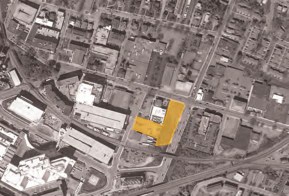
1 CITY OF CHARLOTTESVILLE DEPARTMENT OF NEIGHBORHOOD DEVELOPMENT SERVICES PLANNING COMMISSION PRELIMINARY DISCUSSION: SPECIAL USE PERMIT Author of Memo: Brian Haluska, Neighborhood Planner Date of Meeting: November 12, 2013 RE: 1000 West Main Street Background Erin Hannegan of Mitchell/Matthews Architects, acting as agent for Campus Acquisitions Holdings, LLC, has submitted a special use permit for a mixed-use development at 1000 West Main Street. The request is for additional height and density. The site plan proposes a new building with 240 residential units and 9,340 square feet of commercial space. The property is further identified on City Real Property Tax Map 10 Parcels 68 and 70. The site is zoned WMS (West Main South) with an Architectural Design Control District Overlay Zone and Parking Modified Zone. The property is approximately acres. Vicinity Map
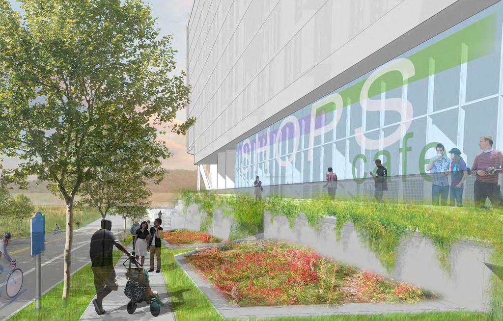
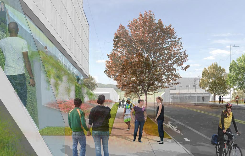
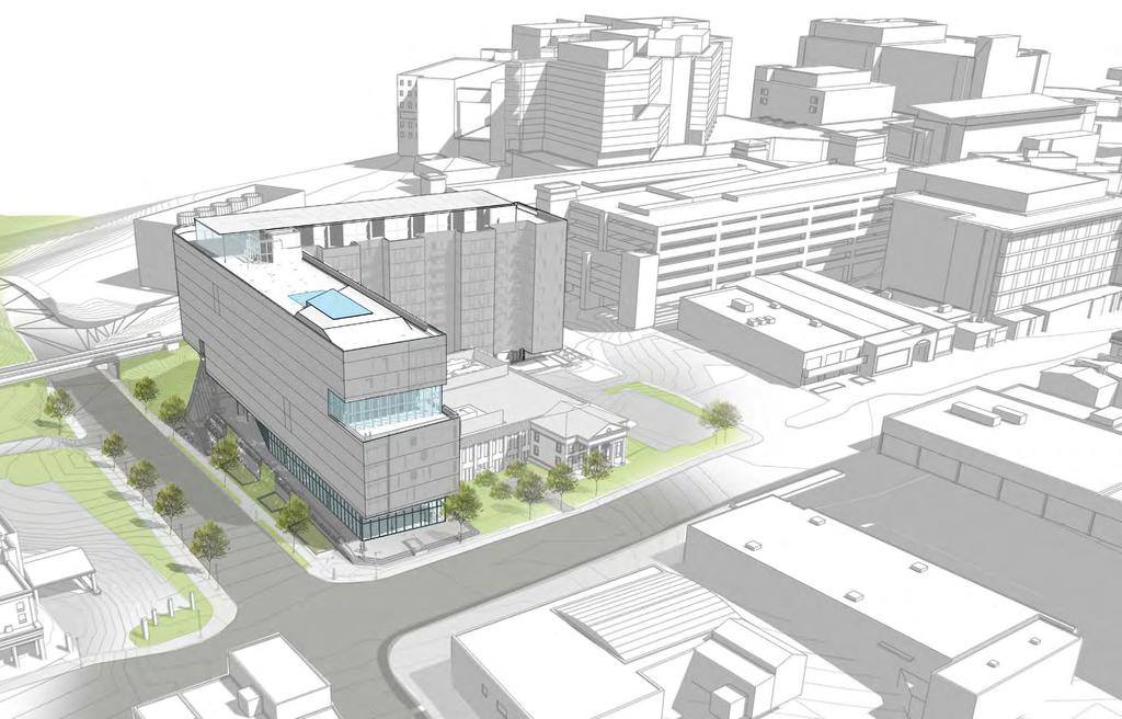
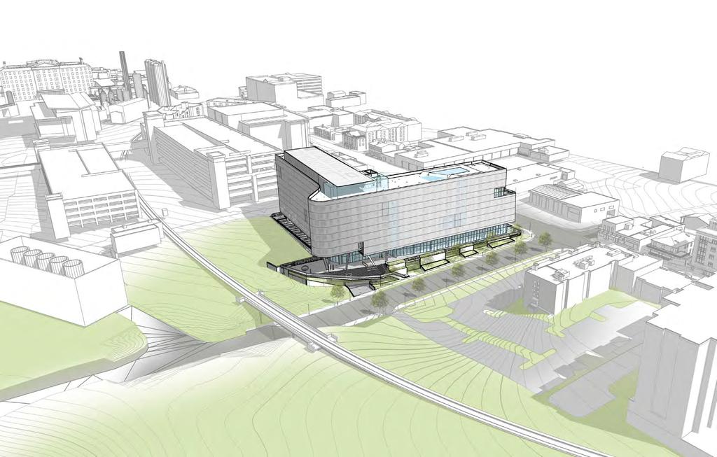
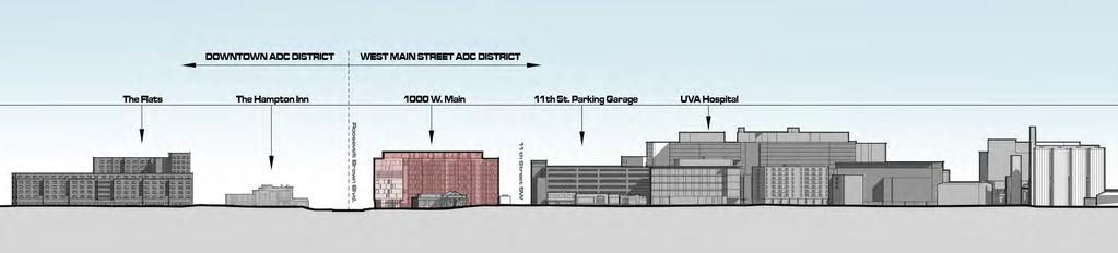
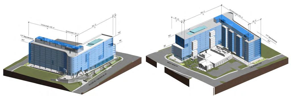
2 Preliminary Analysis Reason for Special Use Permit The applicant is requesting a special use permit for additional height and density. The maximum height permitted by right in the West Main South zoning district is 70 feet, with an additional 31 feet permitted by special use permit. The applicant shows a maximum building height of 101 feet. The maximum by-right residential density in the West Main South corridor is 43 dwelling units per acre, with 240 units per acre permitted by special use permit. The applicant is requesting density of 188 dwelling units an acre. Questions for Discussion Engagement with West Main Street The proposed building will have 100 feet of frontage along West Main Street, a route envisioned by the City as a vital link between the City s Downtown area and the University of Virginia. The City s vision is that this street has a vibrant pedestrian-oriented street life that encourages interaction from residents and visitors alike. The additional height sought by the applicant impacts the experience of pedestrians along the street. How will the proposed project encourage the type of activity the City hopes to see in this area of West Main Street? Engagement with Roosevelt Brown Boulevard The proposed building will take up over 350 feet along Roosevelt Brown Boulevard, a vital pedestrian link between Cherry Avenue and West Main Street. The proposal would permanently impact the pedestrian experience along this corridor. Does the proposed massing and scale of the building improve or diminish the pedestrian experience along the Roosevelt Brown Blvd frontage? Massing and Scale The proposed building would be 101 feet tall, and would be a focal point of persons travelling down West Main Street in either direction. The building is in proximity with several other tall structures. The University Hospital is 150 feet tall, and many of the surrounding medical center structures are in excess of 60 feet tall. Attachments Conceptual plan with Drawings
3 OCTOBER 22, WEST MAIN STREET CAMPUS ACQUISITIONS HOLDINGS, LLC SPECIAL USE PERMIT SUBMITTAL CHARLOTTESVILLE, VA PROJECT NARRATIVE AND DATA EXISTING SITE AND CONTEXT BUILDING PERSPECTIVES AND ELEVATIONS BUILDING HEIGHT CALCULATIONS LOW IMPACT DEVELOPMENT WORKSHEET PRELIMINARY SITE PLAN SUBMITTAL SUPPLEMENTAL INFORMATION MITCHELL MATTHEWS ARCHITECT Erdy McHenry Architecture, LLC 915 North Orianna Street Philadelphia, PA p f CONSULTING PLANNER & ARCHITECT Mitchell/Matthews Architects P.O. Box 5603 Charlottesville, VA p f DEVELOPER / APPLICANT Campus Acquisitions Holdings, LLC 161 N Clark Street, Suite 4900 Chicago, IL p
4 1 PROJECT NARRATIVE AND DATA
5 INTRO: 1000 West Main Street is a proposed mixed-use development located at the southwest corner of Main Street and Roosevelt Brown Boulevard on a land assemblage comprised of West Main Street and th Street SW. The project consists of residential units over commercial / retail space and is situated at a vital pedestrian linkage between the Downtown Mall and the University of Virginia. The project is within the City s West Main Street Architectural Design Control (ADC) District, has mass transit stops immediately adjacent along West Main Street, and is within a Parking Modified Zone to reflect the close walking distance to Grounds and Downtown. It is our opinion the project s design complies with the city s stated vision for the redevelopment of West Main Street, a designated urban development area within the city. Below you will find responses to each of the city s factors to be considered in review of Special Use Permit applications. LOCATION: 1000 West Main is located at the southwest corner of West Main Street and Roosevelt Brown Boulevard on a land assemblage comprised of West Main Street and th Street SW. ZONING: The properties are currently zoned West Main South Corridor (Mixed-Use) in the City of Charlottesville. PROPOSED USE: 1000 West Main is a mixed-use project, consisting primarily of residential units and commercial/retail space along West Main Street and Roosevelt Brown Boulevard. SPECIAL USE PERMIT REQUEST: A Special Use Permit (SUP) is being requested for additional height (from 70 ft. by-right maximum to 101 ft. maximum) and density (from 43 Dwelling Units per Acre [DUA], by right, to approximately 188 DUA. The maximum density allowed with a Special Use Permit is 240 DUA). 1.1 PROJECT NARRATIVE SUP Review Criteria: 1. Whether the proposed use or development will be harmonious with existing patterns of use and development within the neighborhood: The proposed mixed-use project is harmonious with the vision and goals for the West Main Street corridor, the current zoning ordinance, new construction underway on the UVA campus, and recently approved projects along West Main Street. The 1000 West Main development will help bring vibrancy to a currently under-developed stretch of West Main Street that is poorly lit (see UVA s Lighted Pathway Map) and will patch a hole in the evolving fabric of this mixed-use corridor by replacing underutilized vacant property and surface parking with a mix of residential units over street level retail/commercial. This project is expected to increase pedestrian activity, as well as bicycle and mass transit use, along one of the city s main commercial corridors by providing convenient residential, retail, restaurant, street-front dining, and other commercial uses within a markedly improving and pedestrian-friendly street. 2. Whether the proposed use or development and associated public facilities will substantially conform to the city s comprehensive plan: 1000 West Main will conform to the goals and visions of the City s Comprehensive Plan. Specifically, it will contribute to Land Use Goal #1:Enhance the sense of place throughout Charlottesville by replacing a large, vacant lot with a lively, mixed-use building, complete with retail and street-front restaurant dining, adding to the enrichment of the street life on West Main Street. The West Main/Roosevelt Brown Boulevard corridor is a specific area mentioned within this goal West Main will also contribute to the city s Economic Sustainability goal of build(ing) partnerships with private sector groups in order to maximize strategic capital investment in targeted areas in the City. As part of an identified Urban Development Area, this project will play a significant role in the development of the City s key commercial corridors and surrounding site (such as West Main Street ) Economic Sustainability goal 4.3 in the city s revised comprehensive plan. The project will help the city fulfill its sixth Economic Sustainability goal to maintain the economic vitality of the Downtown Mall and surrounding areas, whereby, in partnership with the city, it will help continue the implementation of the West Main Street Plan to the extent feasible (Economic Sustainability point 6.2). Finally, by permitting the increased density along West Main Street in keeping with the SUP provisions of the zoning district, the 1000 West Main development will bolster the east side of the UVA medical campus with residents in a corridor identified by the city as an area appropriate for additional density that will support the city s vision of shaping the community with transit. 3. Whether proposed use or development of any buildings or structures will comply with all applicable building code regulations: The structures and site will be designed to comply with all applicable building code regulations. 4. Whether the proposed use or development will have any potentially adverse impacts on the surrounding neighborhood, or the community in general; and if so, whether there are any reasonable conditions of approval that would satisfactorily mitigate such impacts. Potential adverse impacts to be considered include, but are not necessarily limited to, the following: a. Traffic or parking congestion: The project is located in between downtown and the University of Virginia and near the UVA hospital. Given its proximity to these locations, it is anticipated that residents would not commute to these locations by car. With the restricted parking conditions at these destinations, it is anticipated that most commuters would opt to use alternative modes of transportation such as public transit, biking or walking. The site is located along two CAT bus routes, the trolley and Route 7, with existing bus stops conveniently located nearby. It is also situated along marked bike paths and the project provides ample on-site bicycle storage facilities. In addition, the project is located within a parking modified zone and is taking advantage of the available reductions to limit on-site parking spaces. All of these conditions will limit the potential traffic and parking congestion that could otherwise occur with a by-right commercial development. b. Noise, lights, dust, odor, fumes, vibration, and other factors which adversely affect the natural environment: No activities are anticipated that will adversely affect the natural environment. All exterior lighting will comply with the city s dark sky ordinance. The Preliminary Site Plan submittal demonstrated the Low Impact Development nature of the proposed project in mitigating adverse impacts. c. Displacement of existing residents or businesses: This project will not displace any existing residential units or any businesses. 1.1 PROJECT NARRATIVE
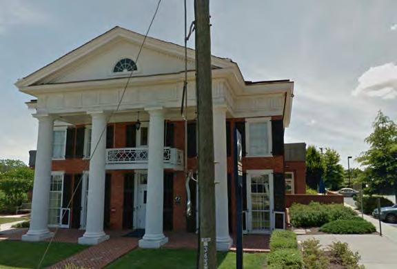
6 d. Discouragement of economic development activities that may provide desirable employment or enlarge the tax base: 1000 West Main will not discourage economic development activities, but rather will contribute to the revitalization of the West Main Street corridor. In addition to enlarging the property and retail tax base in this area with new residential and commercial facilities, it will provide new employment opportunities. Furthermore, it will help to spur new development and investment in this area by providing a residential population base in need of additional goods and services. e. Undue density of population or intensity of use in relation to the community facilities existing or available: The proposed population and intensity of use are consistent with those anticipated under the current zoning designation. No adverse effects to the existing or available community facilities are expected. f. Reduction in the availability of affordable housing in the neighborhood: The proposed development will comply with the affordable housing ordinance through cash contribution, off-site units, or a combination thereof. The site does not currently accommodate any housing; therefore no affordable housing units will be lost. The proposed development will comply with the affordable housing ordinance. g. Impact on school population and facilities: While the units are planned to be market rate rental units and available to the general public, given its proximity to Downtown, the university and the hospital, it is anticipated that the units will be primarily occupied by students, young professionals and employees at the medical school and hospital. It is expected that the project will have minimal impact on the school population and facilities. 1.2 PROJECT NARRATIVE h. Destruction of or encroachment upon conservation or historic districts: West Main Street is a locally designated historic district but it is not listed as a district on the State or National Register of Historical Places. The proposed new project will not destroy any historic buildings within this architectural design control district. Special care will be given to the Patton Mansion, a Virginia Landmark, given its proximity to the site. i. Conformity with federal, state and local laws, as demonstrated and certified by the applicant: The proposed project will conform to all applicable federal, state, and local laws. j. Massing and scale of project: The mass and scale of the proposed mixed-use building provides a respectful backdrop to the neighboring Patton Mansion - the centerpiece of this West Main Street block. Additionally, the proposed building strives to achieve a massing and scale consistent with that of the surrounding context. The West Main Street façade of the building is pulled south, within the requirements of the zoning code, to allow the Patton Mansion to maintain a presence on the street as one approaches from the east. The building presents a narrow façade on Main Street to reduce the mass of the building, to allow more light and airflow to West Main Street and to provide for the extension of a small pocket park to the west, connecting to the existing Patton Mansion Park. Additionally, the retail level façade is inset in response to the scale of the portico of the Patton Mansion, creating a similar covered entry to the building. The covered entry level extends outwards towards Main Street, creating a podium that is envisioned as a present-day agora, or gathering place. The Roosevelt Brown Boulevard massing works with the existing steeply graded site to provide a pedestrian scale façade that works within the rhythm of the existing street trees. The podium that extends along West Main Street wraps the corner and continues south along Roosevelt Brown Boulevard, creating an elevated walkway along the retail shops leading to a monumental stair at the south end of the site that allows access to the podium and retail from lower Roosevelt Brown Boulevard. The taller portions of the building are pulled west from Roosevelt Brown Boulevard to allow for the pedestrian scale of the podium to become the focal point of passersby West Main The building s primary mass, extending south from Main Street and west to 11th Street, is recessed into the site, away from the historic Patton Mansion and the Core Lab Building addition, in order to give this historic structure room to breathe. In this manner, the proposed building will become background, allowing the Patton Mansion to maintain its historically significant presence on West Main Street. Overall, the scale of the proposed project is consistent with the city s stated vision for the West Main Street corridor and is consistent with a range of existing and recently approved projects on West Main Street as illustrated in the accompanying sketches. 5. Whether the proposed use or development will be in harmony with the purposes of the specific zoning district in which it will be placed: It is not only an allowable use permitted for this specific zoning district, but is an encouraged use that will create a pedestrian-friendly development. This project respects the City s desired pattern for commercial and residential development envisioned for West Main Street. The development intensity (approximately 188 DUA) is well below the maximum allowed under an SUP (240 DUA) and is in harmony with the City s intent for the West Main Street Corridor and with recently approved neighboring hotel, housing, and medical projects. 6. Whether the proposed use or development will be in harmony with the purposes of the specific standards set forth within the zoning ordinance, subdivision regulations, or other city ordinances or regulations: The proposed new building and use will contribute to the mixed-use development and revitalization efforts along West Main Street. It is within the city s allowable uses, density and height provided for in this zoning district. The property is located within a design control district and is subject to review by the BAR. An application will be submitted to the BAR for concurrent review with the SUP application. For additional information on the project, see the Project Data sheet in this submittal. SUP SUBMISSION 1 OCTOBER 22, PROJECT NARRATIVE
7 Location WEST MAIN STREET & TH STREET SW Site Area 55,650 Square Feet Acres Zoning Existing: WMS (West Main Street South) Proposed: WMS Use Existing: Vacant Commercial Proposed: Mixed-use Residential/Commercial Height Allowable: 70 Feet + Appurtenance Proposed: 101 (Podium + 10 stories) + Appurtenance 101 Feet + Appurtenance with SUP (117 max) Density Allowable: 43 DUA Proposed: 188 DUA +/- 240 DUA with SUP Tax Map & PROJECT DATA Parking Building Floors Building Area* ( +/- ) Commercial (+/-) Area* STUDIO 1BR 2BR 3BR 4BR TOTAL Required Parking 240 (1 space/unit) Appurtenance 7,740 GSF (Commercial) Level 10 29,509 GSF Total Spaces Level 9 29,509 GSF Level 8 29,453 GSF Reductions -36 spaces Level 7 28,276 GSF Level 6 28,443 GSF Parking Provided 188 spaces Level 5 30,960 GSF Required Contribution 32 spaces Level 4 30,960 GSF Actual Provided 207 spaces Level 3 30,960 GSF (including tandem) Level 2 25,476 GSF Level 1 16,827 GSF Parking Ratio.86 Spaces/Unit Ground 21,729 GSF 9,340 GSF Spaces/Bed Parking 2 42,908 GSF Parking 1 39,519 GSF ,453 GSF +/- 9,340 GSF +/ /- UNITS +94,816 GSF Parking (22%) (7%) (16%) (4%) (51%) (% UNIT MIX) * All quantities, areas, and dimensions are approximate and subject to change as the project is refined and further input is received from city planning staff /- BEDS 1.3 PROJECT DATA
8 2 EXISTING SITE AND CONTEXT

9 ROTUNADA 10 MIN. WALK THE LAWN 10 MIN. WALK UNIVERSITY AVE. THE CORNER 5 MIN. WALK 2.1 NEIGHBORHOOD MAP JEFFERSON PARK AVE. 10TH ST. NW WEST MAIN ST W M West Main DOWNTOWN MALL 15 MIN. WALK 1000 WEST MAIN UNIVERSITY HOSPITAL & MEDICAL CENTER 5 MIN. WALK SUP SUBMISSION 1 OCTOBER 22, EXISTING SITE AND CONTEXT: NEIGHBORHOOD MAP

10 1000 W M West Main 2.2 VICINITY MAP JEFFERSON PARK AVE. EMILY COURIC CANCER CENTER UVA HOSPITAL COURTYARD BATTLE BUILDING PARKING DECK PARKING DECK STACEY HALL 11TH STREET SW CHILLER PLANT PATTON MANSION TEAM TIRES 1000 WEST MAIN ROOSEVELT BROWN BOULEVARD 10TH ST. NW HAMPTON INN THE STANDARD WEST MAIN ST. THE PLAZA AMTRAK STATION SUP SUBMISSION 1 OCTOBER 22, EXISTING SITE AND CONTEXT: VICINITY MAP

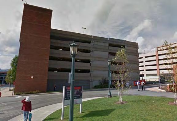
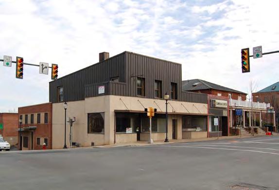
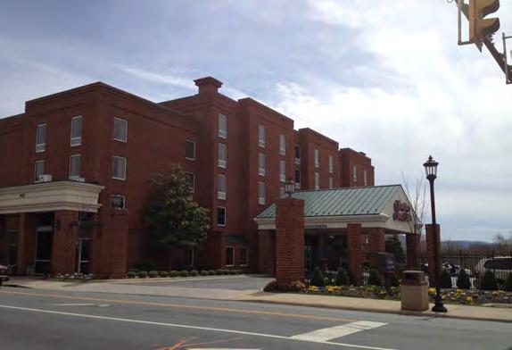
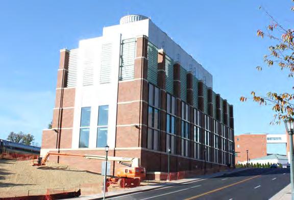
11 ADJACENT STRUCTURES SUP SUBMISSION EXISTING SITE AND CONTEXT: ADJACENT STRUCTURES 5 OCTOBER 22, 2013


12 CANCER CENTER HAMPTON INN 2.4 NEIGHBORHOOD SCALES CANCER CENTER CHILDREN S HOSPITAL THE STANDARD HOSPITAL HAMPTON INN THE FLATS THE STANDARD HOSPITAL CHILDREN S HOSPITAL THE FLATS 2.4 EXISTING SITE AND CONTEXT: NEIGHBORHOOD SCALES


13 3. THE FLATS 4. THE GLEASON PRECEDENTS 1 2. THE STANDARD UVA 2 UVA HOSPITAL W. MAIN ST. DOWNTOWN PROJECT SITE THE PAVILION 2.5 EXISTING SITE AND CONTEXT: PRECENDENTS

14 2.6 LIGHTED PATH MAP 1000 WEST MAIN 2.6 EXISTING SITE AND CONTEXT: LIGHTED PATH MAP

15 1000 WEST MAIN 2.7 PUBLIC TRANSIT MAP POTENTAL ADDITIONAL CARSHARE LOCATION 2.7 EXISTING SITE AND CONTEXT: PUBLIC TRANSIT MAP


16 1 3 11TH STREET SW 1 W. MAIN ST. 2.8 EXISTING SITE & CONTEXT 2 2 ROOSEVELT BROWN BLVD EXISTING SITE AND CONTEXT
17 3 BUILDING PERSPECTIVES AND ELEVATIONS
18 3.1 PERSPECTIVE PERSPECTIVE 1
19 3.2 PERSPECTIVE PERSPECTIVE 2
20 3.3 PERSPECTIVE PERSPECTIVE 3
21 3.4 PERSPECTIVE PERSPECTIVE 4
22 3.5 PERSPECTIVE PERSPECTIVE 5
23 3.6 PERSPECTIVE PERSPECTIVE 6
24 3.7 PERSPECTIVE PERSPECTIVE 7
25 3.8 PERSPECTIVE PERSPECTIVE 8
26 3.9 NEIGHBORING BUILDING MASSING DIAGRAM 3.9 NEIGHBORING BUILDING MASSING DIAGRAM
 3.")
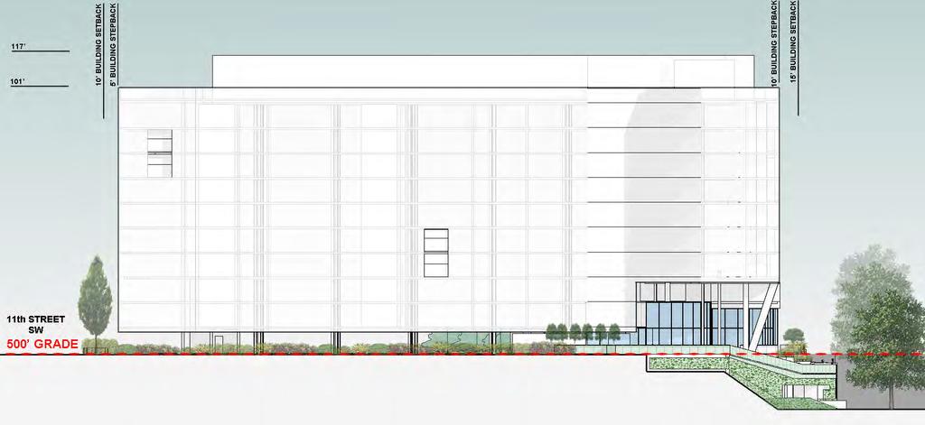
27 3.10 NORTH ELEVATION (WEST MAIN STREET) 3.10 WEST MAIN STREET ELEVATION
 3.")
28 3.11 EAST ELEVATION (ROOSEVELT BROWN BLVD.) 3.11 ROOSEVELT BROWN BLVD ELEVATION
 3.")
29 3.12 WEST ELEVATION (11TH STREET SW) TH STREET SW ELEVATION
30 3.13 SOUTH ELEVATION 3.13 SOUTH ELEVATION
31 4 BUILDING HEIGHT CALCULATIONS
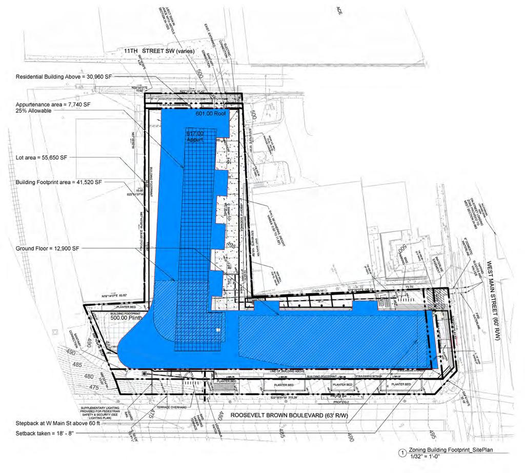
32 4.1 BUILDING HEIGHT CALCULATIONS: SITE PLAN 4.1 BUILDING HEIGHT CALCULATIONS: SITE PLAN
33 4.2 BUILDING HEIGHT CALCULATIONS: ELEVATIONS 4.2 BUILDING HEIGHT CALCULATIONS: ELEVATIONS
34 4.3 BUILDING HEIGHT CALCULATIONS: PERSPECTIVES 4.3 BUILDING HEIGHT CALCULATIONS: PERSPECTIVES
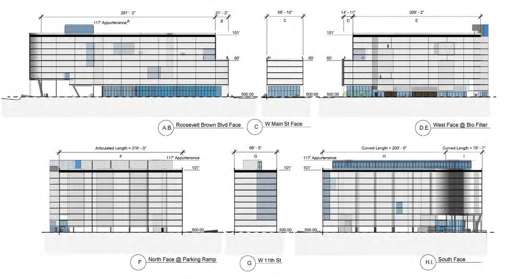
35 4.4 BUILDING HEIGHT CALCULATIONS AVERAGE BUILDING HEIGHT (weighted)**: ** Sum of the total wall area divided by the total length of the building perimeter. 4.4 BUILDING HEIGHT CALCULATIONS
36 5 LOW IMPACT DEVELOPMENT WORKSHEET
37 5.1 LOW IMPACT DEVELOPMENT WORKSHEET 5.1 LOW IMPACT DEVELOPMENT WORKSHEET
MEADOWBROOK FLATS SPECIAL USE PERMIT APPLICATION
 MEADOWBROOK FLATS SPECIAL USE PERMIT APPLICATION March 26, 2013 Submitted by: Bluestone Land, L.L.C. William N. Park, Manager 1821 Avon St. Suite 200 Charlottesville VA 22902 434-979-2900 wpark@pinnacleconstructionva.com
CITY OF CHARLOTTESVILLE DEPARTMENT OF NEIGHBORHOOD DEVELOPMENT SERVICES STAFF REPORT APPLICATION FOR A SPECIAL USE PERMIT
 CITY OF CHARLOTTESVILLE DEPARTMENT OF NEIGHBORHOOD DEVELOPMENT SERVICES STAFF REPORT APPLICATION FOR A SPECIAL USE PERMIT PLANNING COMMISSION AND CITY COUNCIL JOINT PUBLIC HEARING DATE OF HEARING: May
CITY OF CHARLOTTESVILLE DEPARTMENT OF NEIGHBORHOOD DEVELOPMENT SERVICES STAFF REPORT APPLICATION FOR A SPECIAL USE PERMIT
 CITY OF CHARLOTTESVILLE DEPARTMENT OF NEIGHBORHOOD DEVELOPMENT SERVICES STAFF REPORT APPLICATION FOR A SPECIAL USE PERMIT PLANNING COMMISSION AND CITY COUNCIL JOINT PUBLIC HEARING DATE OF HEARING: December
CITY OF CHARLOTTESVILLE DEPARTMENT OF NEIGHBORHOOD DEVELOPMENT SERVICES STAFF REPORT APPLICATION FOR A SPECIAL USE PERMIT
 CITY OF CHARLOTTESVILLE DEPARTMENT OF NEIGHBORHOOD DEVELOPMENT SERVICES STAFF REPORT APPLICATION FOR A SPECIAL USE PERMIT PLANNING COMMISSION AND CITY COUNCIL JOINT PUBLIC HEARING DATE OF HEARING: APPLICATION
CITY OF CHARLOTTESVILLE DEPARTMENT OF NEIGHBORHOOD DEVELOPMENT SERVICES STAFF REPORT APPLICATION FOR A SPECIAL USE PERMIT
 CITY OF CHARLOTTESVILLE DEPARTMENT OF NEIGHBORHOOD DEVELOPMENT SERVICES STAFF REPORT APPLICATION FOR A SPECIAL USE PERMIT PLANNING COMMISSION AND CITY COUNCIL JOINT PUBLIC HEARING DATE OF HEARING: July
CITY OF CHARLOTTESVILLE DEPARTMENT OF NEIGHBORHOOD DEVELOPMENT SERVICES PLANNING COMMISSION
 CITY OF CHARLOTTESVILLE DEPARTMENT OF NEIGHBORHOOD DEVELOPMENT SERVICES PLANNING COMMISSION PRELIMINARY DISCUSSION: SPECIAL USE PERMIT Author of Memo: Brian Haluska, Neighborhood Planner Date of Meeting:
Jasper 115 Street DC2 Urban Design Brief
 Jasper 115 Street DC2 Urban Design Brief Greenlong Construction Ltd. Stantec Consulting Ltd. 2017 Overview The proposed rezoning application supports the development of two mixed-use high-rise buildings
MEMORANDUM. I1 District Industrial Living Overlay District 110,703 square feet / 2.54 acres
 Department of Community Planning & Economic Development 250 South 4th Street, Room 300 Minneapolis, MN 55415-1385 MEMORANDUM To: City Planning Commission, Committee of the Whole Prepared By: Peter Crandall,
PUBLIC NOTICE* Studies Requested: Parking analysis. Other Required Permits: Building Permit, Site Development Permit
 C I T Y O F T A C O M A Planning & Development Services Department 747 Market St, Rm 345 Tacoma, WA 98402 PUBLIC NOTICE* Date of Notification: 1/15/2019 Application Received: 12/03/2018 Application Complete:12/07/2018
Charlottesville Planning Commission, Neighborhood Associations & News Media
 CITY OF CHARLOTTESVILLE A World Class City Department of Neighborhood Development Services City Hall Post Office Box 911 Charlottesville, Virginia 22902 Telephone 434-970-3182 Fax 434-970-3359 www.charlottesville.org
EXHIBIT 1 PROJECT DESCRIPTION AND DESCRIPTION OF REQUESTED AREA VARIANCES REDEVELOPMENT OF 201 ELLICOTT STREET
 EXHIBIT 1 PROJECT DESCRIPTION AND DESCRIPTION OF REQUESTED AREA VARIANCES REDEVELOPMENT OF 201 ELLICOTT STREET I. PROJECT DESCRIPTION: Ciminelli Real Estate Corporation (the Applicant ) is seeking area
Provide a diversity of housing types, responsive to household size, income and age needs.
 8 The City of San Mateo is a highly desirable place to live. Housing costs are comparably high. For these reasons, there is a strong and growing need for affordable housing. This chapter addresses the
Charlottesville Planning Commission, Neighborhood Associations & News Media
 CITY OF CHARLOTTESVILLE A World Class City Department of Neighborhood Development Services City Hall Post Office Box 911 Charlottesville, Virginia 22902 Telephone 434-970-3182 Fax 434-970-3359 www.charlottesville.org
Bike/Pedestrian Connection at Street Level. Project Underway. Illustrative Master Plan: Traditional Downtown VISION DOWNTOWN STATE COLLEGE MASTER PLAN
 Significant Redevelopment Opportunities 16 West Campus Square Academic, Residential and Commercial 3 Atherton East 4 Atherton West Retail, Student Housing Residential, Commercial and Other 5 Beaver Ave.
Montreal Road District Secondary Plan [Amendment #127, October 9, 2013]
![Montreal Road District Secondary Plan [Amendment #127, October 9, 2013]](/thumbs/72/66783104.jpg "Montreal Road District Secondary Plan [Amendment #127, October 9, 2013]") [Amendment #127, October 9, 2013] 1.0 General The following policies are applicable to the Montreal Road District as set out in Schedule 1. 1.1 District Objectives The objective of this Plan is to guide
[Amendment #127, October 9, 2013] 1.0 General The following policies are applicable to the Montreal Road District as set out in Schedule 1. 1.1 District Objectives The objective of this Plan is to guide
1417, , 1427 & 1429 Yonge Street - Official Plan Amendment and Zoning Amendment Applications - Preliminary Report
 STAFF REPORT ACTION REQUIRED 1417, 1421-1425, 1427 & 1429 Yonge Street - Official Plan Amendment and Zoning Amendment Applications - Preliminary Report Date: March 24, 2015 To: From: Wards: Reference Number:
DRAFT FOR DISCUSSION PURPOSES ONLY. Port Credit Local Area Plan Built Form Guidelines and Standards DRAFT For Discussion Purposes
 Port Credit Local Area Plan Built Form Guidelines and Standards DRAFT For Discussion Purposes 1 Local Area Plan - Project Alignment Overview Directions Report, October 2008 (General Summary Of Selected
Residences at Grove Park 425 Hillsborough St. Chapel Hill, NC
 9 ATTACHMENT 1 Residences at Grove Park 425 Hillsborough St. Chapel Hill, NC Zoning Atlas Amendment Application Statement of Justification December 12 th, 2008 Introduction This is a request for a Zoning
6040 Bathurst Street and 5 Fisherville Road Zoning Bylaw Amendment Application Preliminary Report
 STAFF REPORT ACTION REQUIRED 6040 Bathurst Street and 5 Fisherville Road Zoning Bylaw Amendment Application Preliminary Report Date: January 24, 2017 To: From: Wards: Reference Number: North York Community
66 Isabella Street Rezoning Application - Preliminary Report
 STAFF REPORT ACTION REQUIRED 66 Isabella Street Rezoning Application - Preliminary Report Date: November 15, 2010 To: From: Wards: Reference Number: Toronto and East York Community Council Director, Community
DEVELOPMENT DEPARTMENT STAFF REPORT STAFF REPORT EASTSIDE CHAMBLEE LINK DCI
 DEVELOPMENT DEPARTMENT STAFF REPORT Public Hearing Date: April 12, 2018 Item #: PZ-2018-248 STAFF REPORT EASTSIDE CHAMBLEE LINK DCI Request: Development of Community Compact (DCI), ten concurrent variances,
1061 The Queensway - Official Plan and Zoning By-law Amendment Applications - Preliminary Report
 STAFF REPORT ACTION REQUIRED 1061 The Queensway - Official Plan and Zoning By-law Amendment Applications - Preliminary Report Date: January 28, 2015 To: From: Wards: Reference Number: Etobicoke York Community
Charlottesville Planning Commission, Neighborhood Associations & News Media
 CITY OF CHARLOTTESVILLE A World Class City Department of Neighborhood Development Services City Hall Post Office Box 911 Charlottesville, Virginia 22902 Telephone 434-970-3182 Fax 434-970-3359 www.charlottesville.org
PLANNING COMMISSION STAFF REPORT
 PLANNING COMMISSION STAFF REPORT West Capitol Hill Zoning Map Amendment Petition No. PLNPCM2011-00665 Located approximately at 548 W 300 North Street, 543 W 400 North Street, and 375 N 500 West Street
College Avenue. Sowers Street. Calder Way. Beaver Avenue
 K L M Illustrative Master Plan: Collegiate District Calder Way Beaver Avenue High Street ner 16 Sowers Street Stre et 17 Hetzel Street 18 Gar Heister Street 15 Collegiate District 183 4-C: East End Collegiate
20 Edward Street Zoning Amendment Application - Preliminary Report
 STAFF REPORT ACTION REQUIRED 20 Edward Street Zoning Amendment Application - Preliminary Report Date: January 20, 2015 To: From: Wards: Reference Number: Toronto and East York Community Council Director,
The demolition required for the project came before the Landmark Preservation Commission (LPC) on November 3, 2016, where no action was taken.
 on November 3, 2016, where no action was taken.") D E S I G N R E V I E W C O M M I T T E E S t a f f R e p o r t 2072 ADDISON STREET PRELIMINARY DESIGN REVIEW For Committee Discussion/ Majority Recommendation JULY 20, 2017 Design Review #DRCP2016-0002
D E S I G N R E V I E W C O M M I T T E E S t a f f R e p o r t 2072 ADDISON STREET PRELIMINARY DESIGN REVIEW For Committee Discussion/ Majority Recommendation JULY 20, 2017 Design Review #DRCP2016-0002
City of Coral Gables Planning and Zoning Staff Report
 City of Coral Gables Planning and Zoning Staff Report Applicant: Application: Public Hearing: Date & Time: Location: City of Coral Gables Giralda Restaurant Row Overlay Zoning Code Text Amendment Planning
GENERAL PLAN UPDATE SPECIFIC AREAS OF THE CITY
 GENERAL PLAN UPDATE SPECIFIC AREAS OF THE CITY Background There are a total of 14 specific areas that are being reviewed as part of the update of the General Plan. Requests to review these areas came from
Chapter SPECIAL USE ZONING DISTRICTS
 Chapter 20.20 Sections: 20.20.010 Urban Transition (U-T) Zoning District 20.20.020 Planned Development (P-D) Zoning Districts 20.20.010 Urban Transition (U-T) Zoning District A. Purpose. The purpose of
770 BROOKFIELD ROAD Site Plan Control Atlantis Investments November 2017
 770 BROOKFIELD ROAD Site Plan Control Atlantis Investments November 2017 Prepared for: Atlantis Investments Inc. Prepared by: Fotenn Planning + Design 223 McLeod Street Ottawa, ON K2P 0Z8 fotenn.com October
ARLINGTON COUNTY, VIRGINIA. County Board Agenda Item Meeting of September 19, 2015
 ARLINGTON COUNTY, VIRGINIA County Board Agenda Item Meeting of September 19, 2015 DATE: August 28, 2015 SUBJECT: Request to authorize advertisement of public hearings by the Planning Commission and the
Bunker Hill Part II Urban Design. Specific Plan. Case No. CPC SP TABLE OF CONTENTS
 Bunker Hill Part II Urban Design Specific Plan Case No. CPC-2011-684-SP TABLE OF CONTENTS Section 1. Section 2. Section 3. Section 4. Section 5. Section 6. Section 7. Section 8. Section 9. Section 10.
Appendix A: Guide to Zoning Categories Prince George's County, Maryland
 Appendix A: Guide to Zoning Categories Prince George's County, Maryland RESIDENTIAL ZONES 1 Updated November 2010 R-O-S: Reserved Open Space - Provides for permanent maintenance of certain areas of land
Planning Justification Report
 Planning Justification Report 101 Kozlov Street, Barrie, Ont. Destaron Property Management Ltd. November 2015 Revised February 2017 TABLE OF CONTENTS Page 1.0 INTRODUCTION... 1 2.0 DESCRIPTION OF SUBJECT
DIVISION 1 PURPOSE OF DISTRICTS
 ARTICLE 2 ZONING DISTRICTS AND MAP DIVISION 1 PURPOSE OF DISTRICTS Section 2.101 Zoning Districts. For the purpose of this Ordinance, the City of Richmond is hereby divided into districts as follows: DISTRICT
MONROE WARD REZONING SUMMARY. October 2018
 MONROE WARD REZONING SUMMARY October 2018 WHY IS THE CITY REZONING MONROE WARD? In July of 2017 Richmond City Council adopted The Pulse Corridor Plan, a corridor-long planning document that outlines steps
PROJECT DESCRIPTION STATION 1300
 PROJECT DESCRIPTION STATION 1300 Introduction Several principles underpin Greenheart Land Company s design of Station 1300. Primary was to create a community resource: a place where people eat, shop, recreate,
Director, Community Planning, Etobicoke York District
 STAFF REPORT ACTION REQUIRED 3555 Don Mills Road Zoning By-law Amendment Application Preliminary Report Date: May 22, 2012 To: From: Wards: Reference Number: North York Community Council Director, Community
SCANDINAVIAN DESIGNS - CORTE MADERA
 CONCEPT PHASE - PRELIMINARY PLANNING REVIEW DOCUMENTS FEBRUARY 4, 2017 SCANDINAVIAN DESIGNS HISTORY FAMILY RUN COMPANY : 32 FURNITURE STORES IN 7 STATES MARIN COUNTY RESIDENTS : 3 GENERATIONS FIRST STORE
320 Maple Mixed Use PDR Narrative Fort Collins, CO Project # 1525
 320 Maple Mixed Use PDR Narrative Fort Collins, CO Project # 1525 July 28, 2015 (a) What are you proposing/use? A 47,00 S.F., 3-story, mixed used project with 30 for-sale condo residential units and 2
Planning Justification Report
 Planning Justification Report Kellogg s Lands City of London E&E McLaughlin Ltd. June 14, 2017 Zelinka Priamo Ltd. Page i TABLE OF CONTENTS Page No. 1.0 2.0 2.1 2.2 3.0 4.0 5.0 5.1 5.2 5.3 5.4 5.5 5.6
DEVELOPMENT DEPARTMENT STAFF REPORT THE PARK AT 5 TH
 DEVELOPMENT DEPARTMENT STAFF REPORT ARB Meeting Date: July 3, 2018 Item #: _PZ2018-293_ THE PARK AT 5 TH Request: Site Address: Project Name: Parcel Number: Applicant: Proposed Development: Current Zoning:
50 and 52 Finch Avenue East - Official Plan and Zoning By-law Amendment Applications - Preliminary Report
 STAFF REPORT ACTION REQUIRED 50 and 52 Finch Avenue East - Official Plan and Zoning By-law Amendment Applications - Preliminary Report Date: August 16, 2016 To: From: Wards: Reference Number: North York
LINCOLN CORRIDOR REDEVELOPMENT PROJECT UPDATE FOR DOWNTOWN GATEWAY FOCUS AREA
 ITEM: 51 BACKGROUND: Staff Report LINCOLN CORRIDOR REDEVELOPMENT PROJECT UPDATE FOR DOWNTOWN GATEWAY FOCUS AREA March 27, 2018 The City has been working for two years to develop, adopt, and implement the
COMMISSION ACTION FORM SUBJECT: ZONING TEXT AMENDMENT FOR LINCOLN WAY CORRIDOR PLAN DOWNTOWN GATEWAY COMMERCIAL ZONING DISTRICT STANDARDS
 ITEM #: 7 DATE: _02-07-18 COMMISSION ACTION FORM SUBJECT: ZONING TEXT AMENDMENT FOR LINCOLN WAY CORRIDOR PLAN DOWNTOWN GATEWAY COMMERCIAL ZONING DISTRICT STANDARDS BACKGROUND: The Downtown Gateway area
Bylaw No , being "Official Community Plan Bylaw, 2016" Schedule "A" DRAFT
 Bylaw No. 2600-2016, being "Official Community Plan Bylaw, 2016" Schedule "A" Urban Structure + Growth Plan Urban Structure Land use and growth management are among the most powerful policy tools at the
Chapter URBAN VILLAGE ZONING DISTRICTS
 Chapter 20.16 Sections: 20.16.010 Purpose of the Urban Village Zoning Districts 20.16.020 Land Use Regulations for the Urban Village Zoning Districts 20.16.030 Development Standards & Guidelines for the
From Policy to Reality
 From Policy to Reality Updated ^ Model Ordinances for Sustainable Development 2000 Environmental Quality Board 2008 Minnesota Pollution Control Agency Funded by a Minnesota Pollution Control Agency Sustainable
Rapid City Planning Commission Planned Development Project Report
 Rapid City Planning Commission Planned Development Project Report December 8, 2016 Item 7 Applicant Request(s) Case # 16PD057, a Final Planned Development to allow a group home with accessory offices Companion
City of Reno October 30, 2012 Draft Midtown Zoning Text Amendments 1
 Section 18.08.405 Regional Center and Transit Corridor Overlay Districts (i) SVTC South Virginia Street Transit Corridor Overlay Zoning District. (1) Applicability. This Section 18.08.405(l)'s standards
Yonge Street and 3 Gerrard Street East - Zoning Amendment Application - Preliminary Report
 STAFF REPORT ACTION REQUIRED 363-391 Yonge Street and 3 Gerrard Street East - Zoning Amendment Application - Preliminary Report Date: May 22, 2015 To: From: Wards: Reference Number: Toronto and East York
25 St. Dennis Drive - Zoning By-law Amendment Application - Preliminary Report
 STAFF REPORT ACTION REQUIRED 25 St. Dennis Drive - Zoning By-law Amendment Application - Preliminary Report Date: February 4, 2016 To: From: Wards: Reference Number: North York Community Council Director,
MEMORANDUM. C3A District Shoreland Overlay District 32,055 square feet / 0.74 acres. West Calhoun, adjacent to Cedar-Isles-Dean
 Department of Community Planning & Economic Development 250 South 4th Street, Room 300 Minneapolis, MN 55415-1385 MEMORANDUM To: City Planning Commission, Committee of the Whole Prepared By: Peter Crandall,
Approval of Takoma Amended Joint Development Agreement and Compact Public Hearing
 Planning, Program Development and Real Estate Committee Item IV - B March 13, 2014 Approval of Takoma Amended Joint Development Agreement and Compact Public Hearing Washington Metropolitan Area Transit
Staff Contact: Darcy C. Schmitt Phone No.: PC Agenda: November 16, 2016
 Department of Planning, Building & Development Staff Contact: Darcy C. Schmitt Phone No.: 517-319-6941 PC Agenda: November 16, 2016 STAFF REPORT November 10, 2016 Special Use Permit/Site Plan Application
COMMUNICATION URBAN DESIGN REVIEW BOARD CITY OF DES MOINES, IOWA NOVEMBER 1, 2016, 2016 MEETING
 COMMUNICATION URBAN DESIGN REVIEW BOARD CITY OF DES MOINES, IOWA NOVEMBER 1, 2016, 2016 MEETING Subject: Recommendation Prepared by: PRELIMINARY DESIGN AND FINANCIAL REVIEW 401 SE 6 TH STREET- CONNOLLY
COUNTY OF ALBEMARLE PLANNING STAFF REPORT SUMMARY
 COUNTY OF ALBEMARLE PLANNING STAFF REPORT SUMMARY Project Name: ZMA 2011-00006, Albemarle Health and Rehab Center and SP 2011-00014, Albemarle Health and Rehab Center Planning Commission Public Hearing:
DEVELOPMENT DEPARTMENT STAFF REPORT STAFF REPORT DRESDEN DRIVE TOWNHOMES DCI
 DEVELOPMENT DEPARTMENT STAFF REPORT Meeting Date: September 13, 2018 Item #: PZ2018-319 STAFF REPORT DRESDEN DRIVE TOWNHOMES DCI Request: Project Name: Development of Community Compact (DCI) and six concurrent
Bowie Marketplace Residential Detailed Site Plan Statement of Justification January 13, 2017 Revised February 2, 1017
 Bowie Marketplace Residential Detailed Site Plan Statement of Justification January 13, 2017 Revised February 2, 1017 Submitted on behalf of: BE Bowie LLC 5410 Edson Lane, Suite 220 Rockville, MD 20852
DRAFT. Transit Oriented Development Design Guidelines. Introduction. Path Forward
 Transit Oriented Development Design Guidelines Introduction Transit Oriented Development (TOD) Design Guidelines are being developed by the Florida Department of Transportation (FDOT) to provide general
Sherwood Forest (Trinity) Housing Corporation. Urban Design Brief
 Housing Corporation. Urban Design Brief") Sherwood Forest (Trinity) Housing Corporation Sherwood Place Affordable Housing Apartments Trinity Presbyterian Church Orchard Park Nursery School 590 Gainsborough Road, London Urban Design Brief REVISED
Sherwood Forest (Trinity) Housing Corporation Sherwood Place Affordable Housing Apartments Trinity Presbyterian Church Orchard Park Nursery School 590 Gainsborough Road, London Urban Design Brief REVISED
Trenton Train Station Redevelopment Process. Applying the Principles of Successful Transit Oriented Development
 Trenton Train Station Redevelopment Process Applying the Principles of Successful Transit Oriented Development The Basics The City of Trenton has designated the area around the train station and has adopted
4 DEVELOPMENT STANDARDS FOR
 4 DEVELOPMENT STANDARDS FOR RESIDENTIAL MIXED-USE PROJECTS This chapter presents standards for residential mixed-use projects in the Ashland-Cherryland Business District and the Castro Valley Central Business
Appendix1,Page1. Urban Design Guidelines. Back to Back and Stacked Townhouses. DRAFT September 2017
 Appendix1,Page1 Urban Design Guidelines DRAFT September 2017 Back to Back and Stacked Townhouses Appendix1,Page2 Table of Contents 1 Introduction 1 1.1 Purpose 1 1.2 Urban Design Objectives 1 1.3 Building
Goal 1 - Retain and enhance Cherry Creek North s unique physical character.
 Introduction This document summarizes the proposed new zoning for the area of roughly bordered by University Boulevard, Steele Street, 3rd Avenue, and 1st Avenue. It provides a high-level review of the
5 to 25 Wellesley Street West and 14 to 26 Breadalbane Street - Zoning Amendment Application - Preliminary Report
 STAFF REPORT ACTION REQUIRED 5 to 25 Wellesley Street West and 14 to 26 Breadalbane Street - Zoning Amendment Application - Preliminary Report Date: May 16, 2013 To: From: Wards: Reference Number: Toronto
CITY OF NAPLES STAFF REPORT
 Meeting of 05/13/15 Conditional Use Petition 15-CU3 CITY OF NAPLES STAFF REPORT To: Planning Advisory Board From: Planning Department Subject: Conditional Use Petition 15-CU3 Petitioner: Hazelden Betty
250, 252, 254 and 256 Royal York Road and 8 and 10 Drummond Street - Zoning By-law Amendment Application - Preliminary Report
 STAFF REPORT ACTION REQUIRED 250, 252, 254 and 256 Royal York Road and 8 and 10 Drummond Street - Zoning By-law Amendment Application - Preliminary Report Date: May 28, 2013 To: From: Wards: Reference
Creative Approaches to Land Acquisition
 2007 Legislative Session Review CALIFORNIA TRANSIT ASSOCIATION JANUARY/FEBRUARY 2008 Creative Approaches to Land Acquisition Result From Creative Approaches to Land Acquisition It should not surprise anyone
MEMORANDUM. B4S-2 Downtown Service District DP Downtown Parking Overlay District 42,390 square feet / 0.97 acres. DMNA; adjacent to North Loop
 Department of Community Planning & Economic Development 0 South th Street, Room 00 Minneapolis, MN -8 MEMORANDUM To: City Planning Commission, Committee of the Whole Prepared By: Janelle Widmeier, Senior
LITTLE MOUNTAIN ADJACENT AREA REZONING POLICY
 LITTLE MOUNTAIN ADJACENT AREA REZONING POLICY JANUARY 2013 CONTENTS 1.0 INTENT & PRINCIPLES...1 2.0 APPLICATION...2 3.0 HOUSING TYPES, HEIGHT & DENSITY POLICIES...3 3.1 LOW TO MID-RISE APARTMENT POLICIES...4
PLANNING COMMISSION REPORT Regular Agenda - Public Hearing Item
 Z-11-25-09; Z-11-26-09; Z-11-28-09 Item No. 2-1 PC Staff Report 3/28/11 PLANNING COMMISSION REPORT Regular Agenda - Public Hearing Item ITEM NO. 2A RM32 TO MU;.19 ACRES; 1340 TENNESSEE ST (MJL) Z-1-1-11:
Site & Architectural Design Study for the Conversion of Parking Lots
 Site & Architectural Design Study for the Conversion of Parking Lots Town of Manchester, Connecticut 41 Center Street 06040 (860) 647-5235 Issued: April 18, 2008 Table of Contents Preface Introduction
An implementation document is forthcoming. - A1-1 -
 OFF-STREET PARKING GUIDELINES FOR MULTI-FAMILY RESIDENTIAL PROJECTS APPROVED BY SPECIAL EXCEPTION IN THE ROSSLYN-BALLSTON AND JEFFERSON DAVIS METRO CORRIDORS 12/01/2017 This is a draft of the guidelines
AGENDA SLOT HOME EVALUATION & TEXT AMENDMENT. 5:30 - Welcome
 AGENDA 5:30 - Welcome Please sign-in, put a sticker on the map, grab snacks, materials and a seat 5:45 - Staff Presentation 6:15 - Open House Stations Background Information Mixed Use Districts Multi Unit
DEPARTMENT OF COMMUNITY DEVELOPMENT SERVICES. Planning Division. m e m o r a n d u m
 DEPARTMENT OF UNITY DEVELOPMENT SERVICES Planning Division m e m o r a n d u m TO: FROM: The Urbana Zoning Board of Appeals Marcus Ricci, Planner II DATE: August 11, 2017 SUBJECT: ZBA Case 2017-C-01: a
Cambridge Planning Board Zoning Submission Overview 7/25/2017
 Cambridge Planning Board Zoning Submission Overview 7/25/2017 Agenda 1. Introduction and Process to Date 2. Zoning Petition Overview 3. Conceptual Site Plans and Renderings 2 Planning Board Hearings Hearing
Yonge Street, 5-9 St. Joseph Street and 11-19, 25 St. Nicholas Street Rezoning Application - Preliminary Report
 STAFF REPORT ACTION REQUIRED 606-618 Yonge Street, 5-9 St. Joseph Street and 11-19, 25 St. Nicholas Street Rezoning Application - Preliminary Report Date: December 11, 2008 To: From: Wards: Reference Number:
Penny Flats North 323 N Mason
 Taft Hill Lemay Mason Ct Timberline Mason Ct Penny Flats North 323 N Mason Vicinity Map Aerial Site Map 287 «1 Douglas 25 Mountain Vista UV 14 287 ^_ Vine Mulberry Prospect Shields Drake Horsetooth 25
David J. Gellner, AICP, Principal Planner, ,
 Staff Report PLANNING DIVISION COMMUNITY & ECONOMIC DEVELOPMENT To: From: Salt Lake City Planning Commission David J. Gellner, AICP, Principal Planner, 801-535-6107, david.gellner@slcgov.com Date: March
CONNECTING ARLINGTON S POLICY FRAMEWORK TO THE RESIDENTIAL PARKING WORKING GROUP
 CONNECTING ARLINGTON S POLICY FRAMEWORK TO THE RESIDENTIAL PARKING WORKING GROUP Contents Arlington County Development and Growth Goals... 1 Master Transportation Plan Policies Related to Multi Family
DEVELOPMENT STANDARDS FOR RESIDENTIAL PROJECTS RESIDENTIAL BUILDING TYPES: APPROPRIATE ZONES AND DENSITIES 2-1
 2 DEVELOPMENT STANDARDS FOR RESIDENTIAL PROJECTS RESIDENTIAL BUILDING TYPES: APPROPRIATE ZONES AND DENSITIES 2-1 This Chapter presents the development standards for residential projects. Section 2.1 discusses
A. Districts Concept
 L A N D U S E 6 This chapter discusses the land use concept and provides land use designations for Downtown, including associated development intensities that will apply in Downtown. In order to support
Cambridge Ordinance Committee Zoning Submission Overview 8/2/2017
 Cambridge Ordinance Committee Zoning Submission Overview 8/2/2017 Agenda 1. Introduction and Process to Date 2. Zoning Petition Overview 3. Conceptual Site Plans and Renderings 2 Ordinance Committee Hearings
Chapter DOWNTOWN ZONING DISTRICTS
 Chapter 20.14 Sections: 20.14.010 Purpose of the Downtown Zoning Districts 20.14.020 Land Use Regulations for Downtown Zoning Districts 20.14.030 Development Standards for Downtown Zoning Districts 20.14.010
DEPARTMENT OF PLANNING AND COMMUNITY DEVELOPMENT STAFF REPORT
 DEPARTMENT OF PLANNING AND COMMUNITY DEVELOPMENT STAFF REPORT PLANNING COMMISSION AGENDA ITEM # 5: Project Name: Star Dance Zoning Map Amendment, ZMA-13-02 Prepared By: Toby Stauffer, AICP City Planner
Church Street and 117 Dundas Street East - Zoning Amendment Application - Preliminary Report
 STAFF REPORT ACTION REQUIRED 215-229 Church Street and 117 Dundas Street East - Zoning Amendment Application - Preliminary Report Date: February 26, 2015 To: From: Wards: Reference Number: Toronto and
SUBJECT: Official Plan and Zoning By-law Amendment Applications for 4853 Thomas Alton Boulevard
 Page 1 of Report PB-100-16 SUBJECT: Official Plan and Zoning By-law Amendment Applications for 4853 Thomas Alton Boulevard TO: FROM: Development and Infrastructure Committee Planning and Building Department
2 Holiday Drive - Zoning Application - Preliminary Report
 STAFF REPORT ACTION REQUIRED 2 Holiday Drive - Zoning Application - Preliminary Report Date: June 12, 2007 To: From: Wards: Reference Number: Etobicoke York Community Council Director, Community Planning,
PLANNING COMMISSION REPORT Regular Agenda -Public Hearing Item
 PDP-13-00518 Item No. 3B- 1 PLANNING COMMISSION REPORT Regular Agenda -Public Hearing Item PC Staff Report 2/24/14 ITEM NO. 3B PRELIMINARY DEVELOPMENT PLAN FOR HERE @ KANSAS; 1101 INDIANA ST (SLD) PDP-13-00518:
Weston Road (Phase 2) - Official Plan and Zoning By-law Amendment and Lifting of the (H) Holding Symbol Applications - Preliminary Report
 - Official Plan and Zoning By-law Amendment and Lifting of the (H) Holding Symbol Applications - Preliminary Report") STAFF REPORT ACTION REQUIRED 3415-3499 Weston Road (Phase 2) - Official Plan and Zoning By-law Amendment and Lifting of the (H) Holding Symbol Applications - Preliminary Report Date: March 8, 2016 To:
STAFF REPORT ACTION REQUIRED 3415-3499 Weston Road (Phase 2) - Official Plan and Zoning By-law Amendment and Lifting of the (H) Holding Symbol Applications - Preliminary Report Date: March 8, 2016 To:
LAND USE AMENDMENT ITEM NO: 05
 REPORT TO CALGARY PLANNING COMMISSION LAND USE AMENDMENT ITEM NO: 05 FILE NO: LOC2012-0069 CPC DATE: 2013 February 14 COUNCIL DATE: BYLAW NO: HILLHURST (Ward 7 - Alderman Farrell) ISC: Protected Page 1
3.0 Project Description
 3.0 Project Description City of Long Beach Shoreline Gateway Project Environmental Impact Report 3.0 PROJECT DESCRIPTION 3.1 PROJECT LOCATION AND SETTING PROJECT LOCATION The proposed Shoreline Gateway
Urban Design Brief Dundas Street. London Affordable Housing Foundation. November Zelinka Priamo Ltd.
 Urban Design Brief 1039-1047 Dundas Street London Affordable Housing Foundation November 2017 Zelinka Priamo Ltd. TABLE OF CONTENTS Page No. INTRODUCTION... 3 SECTION 1 LAND USE PLANNING CONTEXT... 3 1.1
Streamlining the Entitlement Process for Transit-Oriented Development
 October 2012 Streamlining the Entitlement Process for Transit-Oriented Development Best Practices Summary Setting Ideas in Motion Introduction and Overview Entitlement Process: The legal method of obtaining
Staff Report PLANNING DIVISION COMMUNITY & ECONOMIC DEVELOPMENT. Alley Closure
 Staff Report PLANNING DIVISION COMMUNITY & ECONOMIC DEVELOPMENT To: From: Salt Lake City Planning Commission Doug Dansie, 801-535-6182, doug.dansie@slcgov.com Date: March 23, 2016 Re: PLNPCM2015-00941
Parking Challenges and Trade-Offs
 Parking Challenges and Trade-Offs What is the best way to balance competing interests and priorities while updating the City s off street parking regulations? Updating off street parking regulations can
ADELAIDE APARTMENTS TOWER EXTENSION
 ADELAIDE APARTMENTS TOWER EXTENSION SEPTEMBER 2016 CONTENTS INTRODUCTION 1 PURPOSE OF THE APPLICATIONS 1 SITE CONTEXT 2 EXISTING CONDITIONS 2 SURROUNDING AREA 3 SITE PHOTOS 4 PUBLIC TRANSIT 6 ROAD NETWORK
DRAFT Plan Incentives. Part A: Basic Discount
 DRAFT 2030 Plan Incentives July 26, 2006 Part A: Basic Discount In order for a development to be eligible for any 2030 Land Resource Management Plan Discounts it must be located in the Urban Corridor and