4.14: Aesthetics : Existing conditions
|
|
|
- Abel Bruce
- 5 years ago
- Views:
Transcription
1 4.14: Aesthetics : Existing conditions Physical context The MLK subarea is located at the top edge of the hill that rises approximately 300 feet from the Thea Foss Waterway through the downtown core to the Hilltop plateau and neighborhood. The south end of the MLK subarea overlooks the Nalley Valley, Center Street and Interstate 5. The central and northern portions of the MLK subarea overlook the downtown core, the tideflats and Thea Foss Waterway. Grid street development pattern The early settlement or surveyor s plan for Tacoma defined the original sections of the city, including Old Town and the Hilltop, within a pattern of streets creating regular block divisions that extended west as the city developed. The initial grid roughly paralleled Commencement Bay's shoreline and the slope of the hill rising westward from the water. The alignment was roughly 10 degrees askew from the regular north-south grid. In later developments, located west of the prominent slope and across the flatter hilltop, the street grid turned slightly to run north-south, aligning itself with the Federal system of land division. The transition occurred in the vicinity of South Alaska Street, where a gulch descending toward Center Street provided a logical demarcation between the two grid systems. Land is divided into a regular grid of square blocks composed of two tiers of 25 foot wide and 130 foot deep lots, divided by a central alley. However, as development moved west and south away from the downtown, intermediate streets were often omitted in favor of longer north/south blocks as in Hilltop or MLK subarea neighborhoods. Cable and streetcars As development on the hill lagged behind construction in Tacoma's central business district and lower slopes of the hill, property owners in the Hilltop petitioned the city for development of a cable car line between the downtown and Hilltop. The locally based Tacoma Railway & Motor Company acquired a cable car franchise for the Hilltop in Under the terms of the city franchise, the company built a single track loop line up South 11th Street, south on MLK Jr Way (K Street at the time), and back down to South A Street via South 13th Street. The Tacoma cable car, one of only three in the United States became a popular tourist attraction as well. The cable car lines were eventually expanded to connect Hilltop and the downtown to the emerging neighborhoods to the west and north. Hilltop s historical development context Principal landholdings had been platted in Hilltop's largest additions by In general, lots were sold to individuals or small contracting outfits rather than large-scale residential developers. Consequently, development leapfrogged up and across the blocks, as owners or contractors assembled the resources to construct homes on their particular lots. By the 1880s, development had concentrated around South 9th, South 11th, South 15th, and South 17th Streets, before giving way to woods and squatter settlements again along present day MLK Jr Way. Although a few companies constructed several similar structures on adjacent lots at one time, (seldom more than half a dozen) it was far more typical to see varied, individualized building designs. Waves of ethnically diverse peoples from around the globe and throughout the Eastern States moved in and established the Hilltop area as a predominantly working class community. An extensive inventory of historic houses, apartments, churches, clubs, parks, and stores narrate the story of Hilltop s evolution. Development exploded over the eastern bluff in 1891 with the 11th to 13th Street cable car. A network of subsequent trolley lines led new waves of growth into the 20th Century. Popular architectural styles of the day, the American Foursquares of the 1900s, the Craftsmans of the 1910's, and Bungalows of the 1920's, record the irregular pattern of residential infill. They were interwoven with essential services establishing a strong and cohesive community. Surges of growth continued until the Great Depression of 1929, after which scattered infill and modernizations reflect the changing needs of Hilltop s residential population. The district was originally developed with 1 and 2-story single-family homes, with occasional double houses. They were tightly packed on the standard 25 foot wide lot, with some homes Page 281

2 occupying one lot while others were constructed one two or three. A vibrant apartment district transformed much of the original neighborhood. Many of the smaller wooden buildings were demolished for the 3 to 4-story brick structures that typically stretch the depth of corner lots. Near the historical commercial core at South 11th and MLK Jr Way, business pressures continuously transformed original structures into contemporary, larger commercial buildings. Many older historic structures remain, although scattered throughout the district. Generally, other than the hospitals and buildings cited above, the MLK subarea is characterized by older, including some historic, single family and 3-story apartment buildings, 1 to 2-story commercial buildings, as well as vacant or underutilized parcels scattered throughout the subarea and along MLK Jr Way, especially around the intersection of South 11th Street and MLK Jr Way. Viewscapes At an elevation over 14,410 feet, Mount Rainier creates one of the dominant views throughout Tacoma and the MLK subarea. The result is Hilltop's diverse quilt of architectural periods, styles, and building types. As a result, Hilltop has a concentration of older and some possibly historic properties that include single family homes, double homes, apartments and neighborhood commercial buildings. MLK s contemporary development context The MLK subarea s current development pattern reflects Hilltop s historical development as well as the emergence of higher density structures within MultiCare Health System s Mary Bridge Children s and Tacoma General Hospitals on the north between Division Avenue and South 6th Avenue, and the Franciscan Health System s St Joseph Medical Center on South J Street between South 16th and 19th Streets. The MLK subarea will also contain Community Health Care s Clinic on MLK Jr Way and Ernest S Brazill Street. Other major buildings in and adjacent to the MLK subarea include the Evergreen State College s Tacoma campus located on 6th Avenue, Bates Technical College s downtown campus located on Yakima Avenue, People s Community Center and Pool located on MLK Jr Way at South 16th Street, and McCarver Elementary School located on South J Street at South 21st Street. While the MLK subarea has recently been zoned for mixed use development allowing construction of 3 to 4-story (35-45 maximum foot height) buildings in the single family residential neighborhoods, 5 to 6-story (65-88 foot maximum height) platform buildings along MLK Jr Way, and 10-story (150 foot maximum height) buildings in the hospital zones - very little development has occurred within the subarea other than a couple of new mixed-use residential projects located along the southwest edge of the MLK subarea boundary, along Yakima Avenue. On clear days, Mount Rainier can be seen from vantage points at McCarver Elementary School and its playground, from an overlook plaza on the east side of St Joseph Hospital on South I Street, from undeveloped lots at the top of the hillside on South I and J Street, and from adjacent low density single family neighborhoods in the MLK subarea, among other sites. Captivating views are also provided from most of the MLK subarea s east-west public road corridors as well as the upper floors of most development structures from the top of the ridge at South J Street east to Yakima Avenue of Commencement Bay, downtown Tacoma, the Thea Foss Waterway, the SR-509 Cable Bridge, the historic Brewery District and University of Washington Tacoma campus structures, the Tacoma Dome, and the Port of Tacoma industrial district and waterways. Conversely, St Joseph s Hospital s iconic round and elevated structure, the historical water standpipe to the south on J Street, McCarver Elementary School, and some older apartment and new mixed use buildings along the west side of Yakima Avenue provide a defining backdrop to the MLK subarea from motorists on Interstate 5 and Interstate 705, SR-509, and most surrounding streets and roadways within downtown Tacoma and the flat lands in the Port of Tacoma industrial district. Page 282
3 Page 283


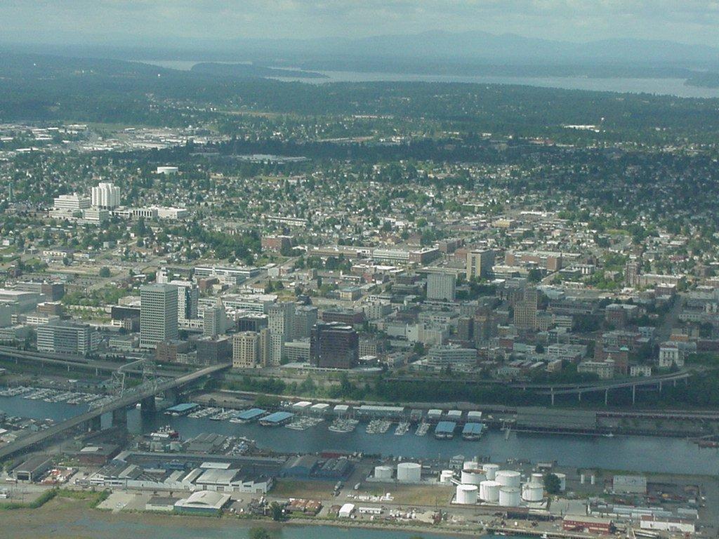
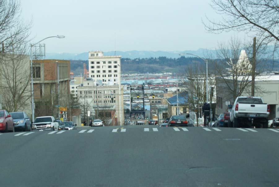
4 Previous page, top - aerial view of the Hilltop (highlighted in the yellow box) illustrating key visual features such as St Joseph Hospital which can be seen on the left side of the picture Previous page, bottom left water standpipe on South J Street Previous page, bottom right view down South 11th Street of Murray Morgan Bridge Above top view down South 9th of Port Industrial Area and waterways Above bottom view down South 19th of UWT and Port district Page 284

5 Page 285

6 The hospital structures are likely to remain the most visible landmarks in the MLK subarea given the 150 foot height limit allowed in the hospital mixed use zone. Streetscape, wayfinding, and gateways Street trees were planted along scattered segments of Yakima Avenue as a result of previous projects to develop the avenue into a parkway or boulevard. With few exceptions, the MLK subarea streetscapes do not include regular or continuous street trees or any other types of regular plantings or vegetative accents. Hilltop Business District promotional banners have been installed on street light standards along portions of South 11th Street that serves as a gateway from the downtown to the MLK subarea and on streets within the business district. Vegetation In 1886 the Tacoma Land Company, under the leadership of its president, Charles B. Wright, donated a parcel of land approximately 20 acres in size to Tacoma for the sole purpose of being developed as a public park. The original 20-acre parcel quickly grew to its current size of 27 acres filling out 10 city blocks. Wright Park conserves old growth woodlands and specimen trees including the Gettysburg Juniper Tree (1914), the Grant Memorial Tree (1922), the Tacoma Mother Tree (1929), 6 Japanese Flowering Cherries and 5 Japanese Dogwoods (1936), and a giant sequoia planted in commemoration of the 150th anniversary of the adoption of the US Constitution (1937). Over 350 varieties of trees were planted in Wright Park containing specimens of nearly every flora in the United States and Europe. A number of the original trees and plantings, however, were destroyed in the Columbus Day Storm in Large deciduous trees are scattered throughout the MLK subarea, particularly in the older single family neighborhoods from South 6th to 9th Streets and South 21st to 27th Streets, in and around People s Park at South 10th Street and MLK Jr Way, and in and around parking lots at MultiCare and Franciscan Health Systems medical and hospital facilities. In general, the MLK subarea is lightly vegetated as a result of the ground clearing that occurred during its early development and in deference to those lots or buildings seeking to preserve views. Public art has been painted on the side of the Johnson Candy Company s building that adjoins People s Park and on a commercial building wall across MLK Jr Way from the park. Other artworks have been installed elsewhere in the MLK subarea including in Peoples Park and the Zina Linnik tribute in McCarver Park. A landscaped public plaza has been created by MultiCare Health System that connects their main facility on the east side of MLK Jr Way with their ancillary facilities to the west of MLK Jr Way on South L Street. Similar plaza improvements are proposed by the Franciscan Health System to connect their new medical office building and parking garage on MLK Jr Way with the main facilities on South J Street. Traffic circles and median islands with landscaped plantings have been developed at the major pedestrian crossings of South J Street into McCarver Elementary School at South 21st Street, and as traffic calming and one-way traffic controls on South L Street. Site/building development grains A number of 1 and 2-story buildings survive from historical periods within the 6-block core of the business district including the Browne s Star Grill, Pochert Building, Hilltop Savings & Loan, and others on MLK Jr Way between South 10th and 13th Streets and South L and South J Streets. Taken together, these buildings retain some of the historical scale of the original business district even though the individual buildings are not, in and of themselves, significantly historical. Page 286
7 Solar, light, and glare The MLK subarea s street grid caused most buildings to be oriented to face east or west along the length of the original surveyed city blocks. The narrow lots created narrow commercial building roofs aligned east to west, a number of which incorporated skylights and interior light wells for natural light exposure. Proposed mixed-use development projects, however, will create sizable roofs which could support solar applications as well as green roof and recreational activity enhancements. To date, however, no buildings have been developed within the MLK subarea with solar or green roof adaptations. Ambient light and glare are produced within the MLK Jr Way corridor from cobra overhead street lights on some of the cross streets, including South 11th Street, and on segments of MLK Jr Way as well from vehicle headlights, exterior building and site illumination, particularly from commercial storage lots and lighted advertising signs. Generally, however, MLK Jr Way and some of the principal side streets are not well lit for safe pedestrian use, or with shielded street lights with which to illuminate roadways without glare spill over : Impacts Both alternatives Both alternatives will allow development and redevelopment in the MLK subarea for urban uses and activities to various intensities. An increase in urban development and thereby the overall population will create more activity and a impact on aesthetic resources and viewscapes including landmark buildings, street corridors, streetscapes, pedestrian areas and activities, and other features. Potential reuse or redevelopment of some of these areas could alter their aesthetic and historical character possibly enhancing their potential or destroying community value if not properly protected. Potential redevelopment could obscure aesthetic resources and potential visual imagery of MLK subarea from the surrounding community, and from within specific sites and buildings if not properly planned and designed. And, poorly designed or overtly contemporary building designs could overpower the MLK subarea s historical, though eclectic building mix and streetscape diluting the subarea s cultural and visual context and continuity. Alternative 1: No-action The Washington Administrative Code requires a no-action alternative be considered within the environmental review process. Under a noaction alternative, the prevailing Tacoma Comprehensive Plan, Zoning Map, and Development Regulations would remain in effect and all MLK subarea planning and implementation policies would continue to be coordinated with that document. The present plan and policies or no-action would result in the following: Catalytic projects under way Alternative 1: No-action will complete the following catalytic projects on MLK Jr Way to stimulate development activities in accordance with existing mixed use district design standards: Community Health Care Clinic construction has been initiated on the 3-story regional health center on the northwest corner of Ernest S Brazill Street and MLK Jr Way for treating lowincome patients. A separate 3-story parking garage with 250 stalls is being built next to the clinic. Franciscan Medical Building & Parking Garage construction on the block east of MLK Jr Way between South 16th and 17th Streets of the 5- story Franciscan Medical Office Building with an adjoining 7-story 770 stall parking garage, skybridge, MLK Jr Way street level retail spaces, and outdoor sitting area. MultiCare Health System Milgard Pavilion addition of 2 floors to the top of the 5-story Milgard Pavilion on MLK Jr Way to house Mary Bridge general pediatric beds and the Pediatric Intensive Care Unit. People s Community Center Pool will be reconfigured and expanded in a 3-phase project of which phase 1 will demolish and rebuild the natatorium with all aquatic features, party rooms, and the stair tower for the water slide. Phase 2 will install the water slide and construct the outdoor spray ground. A future phase 3 will expand the center north to provide for an enlarged fitness facility, concessions, and storage. These developments provide the momentum and opportunity to create and implement a revitalization strategy for the MLK subarea and Page 287
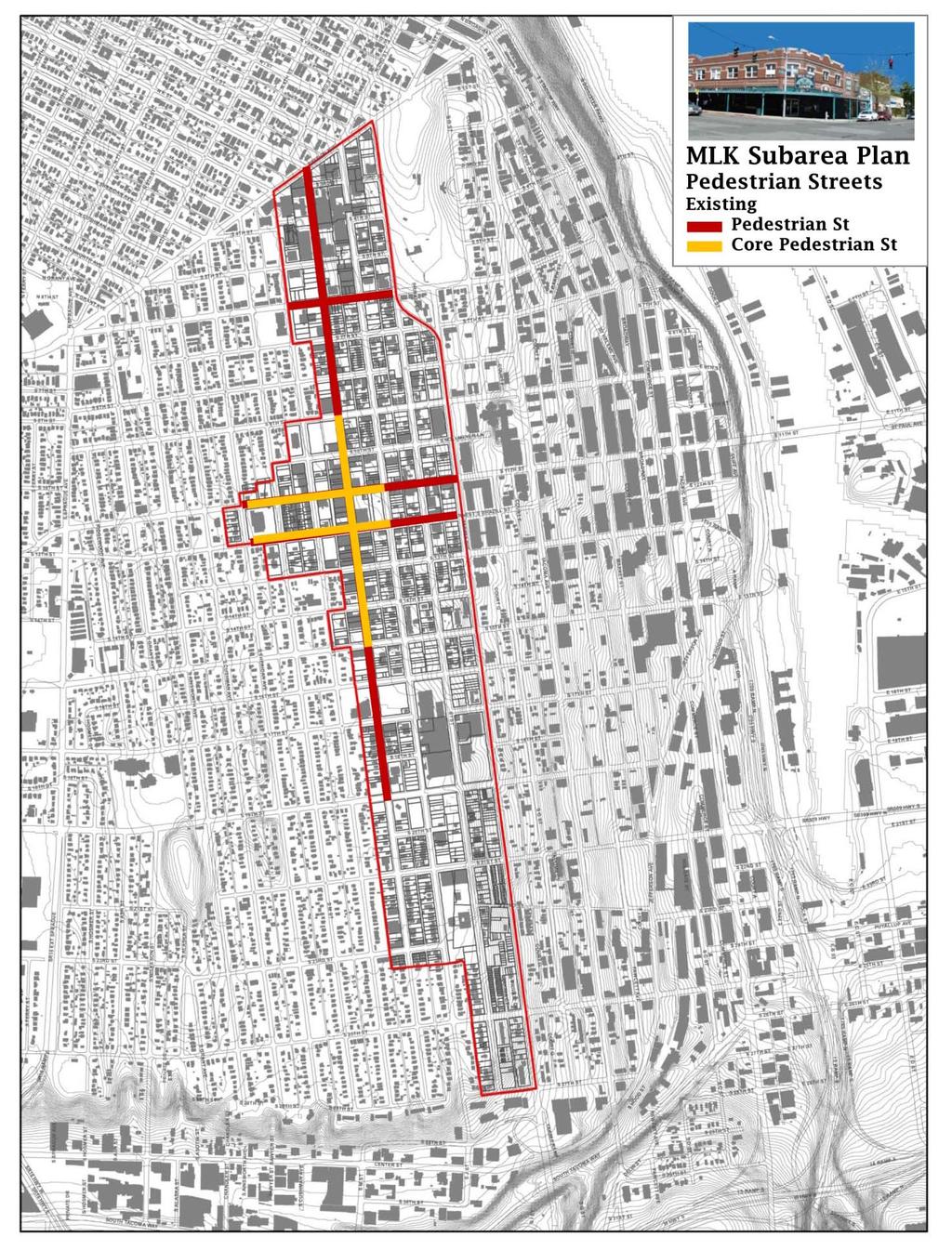
8 MLK Jr Way in particular under existing mixed use district design standards. Alternative 2: Alternative 2: will complete the catalytic projects defined in Alternative 1 and initiate a series of other development projects to stimulate development activities on MLK Jr Way in accordance with the Comprehensive Plan and Neighborhood Policies: Catalytic projects to be initiated MLK Housing Development Association (MLKHDA) the site could be repackaged and the property redeveloped to potentially provide ground floor artist/retail and upper floor educational community space, mixed income housing units over parking decks, and restore the historic Tally Ho Tavern to retail activity. Browne s Star Grill and Pochert Buildings could potentially restore and retain the historic Browne s Star Grill and Pochert Buildings and develop the surrounding property to provide ground floor artist/retail and upper floor mixed income housing units over parking decks if the development conforms to the bonus provision requirements outlined in Tacoma s Title 13 Development Regulations. Municipal Services Center could potentially develop ground floor parking with retail frontage on MLK Jr Way and upper floor mixed income housing. Save-A-Lot could be repackaged to retain the existing Save-A-Lot building for retail use and redevelop the surrounding parking lots to potentially provide artist live/work on J Street, retail frontage with upper floor office on MLK Jr Way and upper floor office and mixed income housing over parking decks. Safeway could be repackaged to retain the existing Safeway store and redevelop the surface parking lots behind the building and fronting on South 12th Street to potentially provide artist live/work units fronting on South Sheridan Avenue, and live/work units fronting on Earnest S Brazill/South 12th Street. Economic considerations may assume the property developer can qualify for and sell historic tax credits from the Browne s Star Grill and Pochert Building restorations to other parties developing property in the MLK subarea. The combined catalytic projects will potentially retain significant historic buildings with street front potential, develop additional street front retail and upper floor offices, house a community educational facility, and generate at least 465 or more dwelling units for urban households within the business district core : Mitigation measures Both alternatives Both alternatives provide the following measures to mitigate the impact of more intensive development under the mixed use zoning designations: MLK designated pedestrian streets Pedestrian streets are considered to be key streets in the development and utilization of Tacoma s mixed use center districts due to pedestrian use, traffic volumes, transit connections, and/or visibility. The streets are designated for use with certain provisions in the mixed use zoning regulations, including use restrictions and design requirements, such as increased transparency, weather protection, and street furniture standards. In some centers, these pedestrian streets and/or portions thereof are further designated as core pedestrian streets for use with certain additional provisions. The core pedestrian streets are a subset of the pedestrian streets, and thus, those provisions that apply to designated pedestrian streets also apply to the designated core pedestrian streets. In centers where multiple streets are designated, one street is designated the primary pedestrian street. The designation is used when applying certain provisions, such as the maximum setback requirements for projects that abut more than one pedestrian street. Pedestrian Streets MLK Jr Way (Primary Pedestrian Street), South 11th Street, South Earnest S Brazill Street, and 6th Avenue Core Pedestrian Streets MLK Jr Way (from South 9th to South 15th Street), South 11th Street, and South Earnest S Brazill Street X(Mixed-Use)-District design regulations The mixed use district design standards, which apply to the entire MLK subarea, were conceived to ensure new project developments provide buildings which are appropriate for pedestrian streetscapes principally by breaking up the building mass, introducing windows and other openings along the sidewalk, using textured materials, and other people-friendly and contextually interesting features. Page 288
9 Page 289
10 Tacoma s Development Regulations Chapter X-Districts Design Regulations applies to all new construction and additions and alterations to existing buildings depending of the value of work being done within a 2-year period. If the value of work to an existing building within a 2-year period is: less than 50% of the value of the building the project simply must not lead to further nonconformance with the standards; between 50% and 200% of the value of the building - all standards that do not require repositioning the building have to be met; greater than 200% of the value of the building - all standards have to be met. The mixed use district design standards specify guidelines for mass reduction, rooflines, windows and openings, façade surfaces, pedestrians, fencing and retaining wall, and utilities, single, 2, and 3-family dwellings, and townhouses. The X (mixed use) district design standards are interpreted administratively by the Tacoma Community and Economic Development Department. (The X district design standards most affecting mixed use structures within the neighborhood and commercial mixed use districts are provided in the tables below and do not include fencing, retaining wall, and utilities, single, 2, and 3-family dwellings, and townhouses.) X(Mixed-use) district standards H. Mass reduction standards 1. Façade Articulation: The following design choices are intended to help reduce the apparent mass of structures and achieve a more human scale environment by providing physical breaks in the building volume that reduce large, flat, geometrical planes on any given building elevation. a. All building facades fronting directly on a Designated Pedestrian Street must include at least 2 of the following articulation features at intervals no greater than 40 feet to reinforce the desired pattern of small storefronts adjacent to the sidewalk. Buildings that have 60 feet or less of frontage on the designated pedestrian street are exempt from this standard. b. All non-residential facades fronting on a non-pedestrian Designated Street or containing a pedestrian entrance must include at least three of the following articulation features at intervals no greater than 60 feet. Buildings that have 120 feet or less of frontage on the nondesignated street are exempt from this standard. Buildings that employ brick as the siding material on a majority of the subject façade are required to only provide two of the articulation features instead of three. (1) Use of window and/or entries that reinforce the pattern of small storefront spaces. (2) Use of vertical piers to reinforce the pattern of small storefront spaces. Such piers must project at least 2 inches from the façade and extend from the ground floor to the roofline. (3) Use of weather protection features that reinforce the pattern of small storefronts. For example, for a business that occupies three lots, use three separate awnings to break down the scale of the storefronts. Alternating colors of the awnings may be useful as well. (4) Roofline modulation as defined in Section I (5) Change in building material or siding style. (1) Use of window configurations and/or entries that reinforce the pattern of storefront spaces. (2) Vertical building modulation. The minimum depth and width of modulation shall be 2 and 4 feet, respectively, if tied to a change in building material/siding style and/or roofline modulation as defined in Section I. Otherwise, the minimum depth and width of modulation shall be 10 and 15 feet, respectively. (3) Use of separate weather protection features that reinforce the pattern of storefront spaces. (4) Roofline modulation as defined in Section I (5) Horizontal modulation (upper level step-backs). To qualify for this measure, the minimum horizontal modulation shall be 5 feet and the treatment must be used in increments at no greater than the articulation interval or provided along more than 75 feet of the facade. (6) Change in building material or siding style. (7) Use of vertical piers. Such piers must project at least 2 inches from the façade and extend from the ground floor to the roofline. Page 290
11 c. All residential buildings and residential portions of mixeduse buildings shall include at least three of the following articulation features at intervals of no more than 30 feet along all facades facing a street, common open space, or common parking areas. Buildings that have 60 feet or less of frontage on the street or façade width facing the common open space or common parking area are exempt from this standard. Buildings that employ brick as the siding material on a majority of the subject façade are required to only provide two of the articulation features instead of three. (8) Providing a trellis, tree, or other landscape feature within each interval. Such feature must be at least one-half the height of the building (at planting time for any landscaping element). (1) Repeating distinctive window patterns at intervals less than the required interval. (2) Vertical building modulation. Minimum depth and width of modulation is 2 feet and 4 feet, respectively, if tied to a change in building material/siding style and/or roofline modulation as defined in Section I Otherwise, minimum depth and width of modulation is 10 and 15 feet, respectively. Balconies may not be used to meet modulation option unless they are recessed or projected from the facade at least 18 inches. (3) Horizontal modulation (upper level step-backs). To qualify for this measure, the minimum horizontal modulation shall be 5 feet and the treatment must be used in increments at no greater than the articulation interval or provided along more than 75 percent of the façade (4) Roofline modulation as defined in Section I (5) Vertical articulation of the façade. This refers to design treatments that provide a clear delineation of the building s top, middle and bottom. (a) Top features may include a sloped roofline or strong cornice line as defined in Section I. For facades utilizing upper level stepbacks, the top design treatment may be applied to the top of the front vertical plane of the building or the top of the building where it is set back from the building s front vertical wall (provided the top of the building is visible from the centerline of the adjacent street). (b) Middle features: provide consistent articulation of middle floors with windows, balconies, exterior materials, modulation, and detailing (c) Bottom: provide a distinctive ground floor or lower floors design that contrasts with other floors through the use of both contrasting window design/configuration and contrasting exterior materials (d) Façade reduction elements including balconies and bay windows may project into street rights-of-way, where allowed by the Public Works Department, but not into alley rights-of-way 2. Mass Reduction: Upper Floor Streetfront Stepbacks. The following standards are intended to reduce the appearance of bulk and reduce the potential for shade and shadow impacts on Pedestrian Streets. They apply to all development along designated pedestrian streets, unless specifically exempted. 2. Mass Reduction: Upper Floor Streetfront Stepbacks. The following standards are intended to reduce the appearance of bulk and reduce the potential for shade and shadow impacts on pedestrian streets. They apply to all development along designated pedestrian streets, unless specifically exempted. a. 8 minimum stepback along the streetfront façade for 4th floor and above in RCX Districts. b. 8 minimum horizontal stepback along for 5th floor and above in X Districts other than RCX, where the ROW width is less than 100. c. 8 minimum horizon stepback for 6th floor and above in X zones other than RCX, where the ROW width is 100 or greater. d. Exceptions to b and c, above: Portions of buildings adjacent to street corners along designated pedestrian streets can depart from this standard to incorporate distinctive street corner design elements such as a turret. Such corner building features shall be no more than 25 feet in width along both streets and other portions of the building shall meet applicable stepback standards. Page 291
12 3. Mass Reduction: Maximum Façade Widths. The following standards are intended to incorporate a significant modulation of the exterior wall through all floors except the ground floor. They apply to the upper story facades of multi-story buildings that are greater than 120 feet in width. Such buildings shall include at least one of the following features to break up the massing of the building and add visual interest: 3. Mass Reduction: Maximum Façade Widths. The following standards are intended to incorporate a significant modulation of the exterior wall through all floors except the ground floor. They apply to the upper story facades of multistory buildings that are greater than 120 feet in width. Such buildings shall include at least one of the following features to break up the massing of the building and add visual interest: a. Provide vertical building modulation at least 20 feet deep and 30 feet wide. For multi-story buildings the modulation must extend through more than one-half of the building floors. b. Use of a contrasting vertical modulated design component that extends through all floors above the first floor fronting on the street (upper floors that are stepped back more than 10 feet from the façade are exempt) and featuring at least two of the following: (1) Utilizes a change in building materials that effectively contrast from the rest of the façade. (2) Component is modulated vertically from the rest of the façade by an average of 6 inches. (3) Component is designed to provide roofline modulation per I, below. c. Façade employs building walls with contrasting articulation that make it appear like two distinct buildings. To qualify for this option, these contrasting facades must employ the following: (1) Different building materials and/or configuration of building materials. (2) Contrasting window design (sizes or configurations). Examples of facades wider than 120 feet that effectively use techniques to reduce the apparent bulk and scale of the structure. I. X-District Roofline Standards. The following requirements apply to all development located in any X-District, unless specifically exempted. They are intended to ensure that roofline is addressed as an integral part of building design to discourage flat, unadorned rooflines that can result in an industrial appearing, monotonous skyline. Roofline features are also intended to further reduce apparent building volume and further enhance features associated with human scale development. 1. Roofline modulation. Roofline modulation is not required of all buildings. However, in order to qualify as a façade articulation element in other mass reduction standards herein, the roofline shall meet the following modulation requirements along façades facing a street: 2. Flat roof standards. Buildings or portions thereof featuring flat roofs (horizontal roofs with either no slope or only a slope sufficient to effect drainage, often which incorporate surrounding parapets) that do not incorporate roofline modulation, as described above, shall employ decorative roofline treatments incorporating one or more of the following design elements along façades facing a street: a. For flat roofs or facades with horizontal eave, fascia, or parapet, the minimum vertical dimension of roofline modulation is the greater of 2 feet or 0.1 multiplied by the wall height (finish grade to top of the wall) when combined with vertical building modulation techniques. Otherwise, the minimum vertical dimension of roofline modulation is the greater of 4 feet or 0.2 multiplied by the wall height. b. Buildings with pitched roofs must include a minimum slope of 5:12 and feature modulated roofline components (such as gabled, hipped, shed, or other similar roof forms) at the interval required per the applicable standard in Section H, above. Rounded, gambrel, and/or mansard forms may be averaged. a. A cornice of two parts with the top projecting at least 6 inches from the face of the building and at least 2 inches further from the face of the building than the bottom part of the cornice. See graphic at right. The height of the cornice shall be at least 12- inches high for buildings 10 feet or less in height; 18-inches for buildings greater than 10 feet and less than 30 feet in height; and 24-inches for buildings 30 feet and greater in height. The cornice must extend along at least 75 percent of the façade. b. A one-piece cornice element that projects at least 18 inches from the façade for buildings four stories or less or at least 2 feet from the façade for buildings taller than 4 stories. The cornice line must extend along at least 75 percent of the façade. c. Use of balcony/deck railings that function as a visual roofline element. Such railings must be at least 2 feet in height and extend along at least 75 percent of the facade and shall be visible from the Page 292
13 adjacent street centerline. d. Use of contrasting building materials on the top floor or top two floors for buildings five stories or taller, for at least 75 percent of the facade. 3. Roofline elements shall not project over property lines, except where permitted on property lines abutting public right-of-way. 4. Canopy Exemption. Fueling station canopies, drive through canopies, or similar canopies are exempt from roofline requirements J. X-District Windows and Openings: Façade Transparency and Solar Access. The following requirements apply all development in any X District, unless specifically exempted. These requirements are intended to increase public visibility for public safety, to provide visual interest to pedestrians that helps encourage pedestrian mobility, to provide for natural lighting to buildings interiors to conserve energy, and to provide architectural detailing and variety to building elevations on each story. 1. Street level transparency standards for non-residential uses: a. Facades facing a designated Core Pedestrian Street shall have transparent windows or openings for at least 60 percent of the ground level wall area. b. Facades facing a designated Pedestrian Street shall have transparent windows or openings for at least 50 percent of the ground level wall area. c. Facades facing a non-pedestrian street, internal courtyard, plaza or containing customer entrances and facing customer parking lots of 20 stalls or greater shall have transparent windows or openings for at least 40 percent of the ground level wall area. d. Flexibility for sloping properties. The window and opening requirements shall be reduced to 30 percent of the ground level wall area for building elevations where the finished grade level adjacent to the building is four feet above or below the level of the sidewalk. The requirement shall be further reduced to 20 percent of the ground level wall area in instances where the application of this standard is not possible due to steep grades running parallel to the elevation and crossing the floor plates of the building. e. Flexibility for industrial uses. The window and opening requirements shall be reduced to 30 percent of the ground level wall area for the facades of industrial uses located along designated Pedestrian Streets and reduced to 20 percent of the ground level wall area for the facades of industrial uses facing a non-pedestrian street, internal courtyard, plaza or containing customer entrances and facing customer parking lots of 20 stalls or greater. f. Flexibility for structured parking. For structured parking or portions of a building containing structured parking that is located at the ground level and subject to these requirements, the window and opening requirement for that portion of the ground-level wall area shall be reduced to 30 percent along façades facing designated Pedestrian Streets and 20 percent along façades facing a non-pedestrian street, internal courtyard, plaza or containing customer entrances and facing customer parking lots of 20 stalls or greater. Additionally, alternatives such as decorative grilles, art work, display windows, or similar features can be substituted for the transparency required in that portion of the ground-level façade. g. Required view. Required windows or openings must provide either views into building work areas, sales areas or lobbies. Art or display windows may substitute for transparent elements for up to 25% of the requirement on facades facing designated Pedestrian Streets and up to 50% on all other applicable facades. Art and display windows shall be at least 2 feet deep, recessed and integrated into the façade of the building (tack on display cases do Page 293
14 2. Upper level transparency standards for non-residential uses: not qualify). h. The ground level wall area is defined as the area between 2 feet and 8 feet above the adjacent finished grade. i. This standard shall apply on a maximum of 2 such building elevations, and shall apply in the order provided above. As an example, for a building that faces: a Core Pedestrian Street, a nonpedestrian street, and a qualifying parking lot, the requirements would apply to the façade facing the Core Pedestrian and either the façade facing the non-designated street or the façade facing the parking lot. j. Rough openings are used to calculate this requirement. a. Exterior walls facing streets or containing a customer entrance and facing customer parking lots of 20 stalls or greater shall use a combination of transparent windows or openings and architectural relief that provide visual demarcation of each floor. b. Upper level windows shall be a different type than the ground level windows on the same elevation. c. For purposes of this requirement, a window type is either a grouping of windows, a window size, or a window shape. 3. Residential buildings and residential portions of mixed-use buildings shall incorporate transparent windows and doors equal to at least 15% of all vertical façade surfaces facing the street and equal to at least 10% of all vertical surfaces facing alleys, courtyards, plazas and surface parking lots. 4. Solar access for residential units. a. Buildings or portions thereof containing dwelling units whose solar access is only from the side or rear of the building (facing towards the side or rear property line) shall be set back from the applicable side or rear property lines at least 15 feet. This standard shall not apply in cases where the rear or side property line abuts an alley. Examples are provided below. 5. Window/Trim Detailing. Building facades shall employ techniques to recess or project individual windows or groupings of windows above the ground floor at least two inches from the surrounding facade or incorporate window trim at least four inches wide surrounding the windows. Windows on façades that face the rear property line or alleys are exempt from this standard. K. X-District Façade Surface Standards. The following requirements apply to all development in any X-Districts, unless specifically exempted. These requirements are intended to help reduce the apparent mass of structures and achieve a more human scale environment by providing visual breaks at more frequent intervals to the building volume that reduce large, flat, geometrical planes on any given building elevation, especially at the first story. The choices are also intended to encourage variety in the selection of facade materials and/or treatment and to encourage more active consideration of the surrounding setting. 1. Blank walls limitation a. Blank wall definition: A ground floor wall or portion of a ground floor wall that is over 4 feet in height and has a horizontal length greater than 15 feet without a transparent window or door b. Blank walls facing a street, internal pathway, or customer parking lot of 20 stalls or greater must be treated in one or more of the following ways: (1) Transparent windows or doors. (2) Display windows at least 2 feet in depth and integrated into the façade (tack-on display cases do not qualify). (3) Landscape planting bed at least 5 feet wide or a raised planter bed at least 2 feet high and 3 feet wide in front of the wall. Such planting areas shall include planting materials that are sufficient to obscure or screen at least 60 percent of the wall s surface within 3 years. (4) Installing a vertical trellis in front of the wall with climbing vines or plant materials sufficient to obscure or screen at least 60 percent of the wall s surface within 3 years. For large areas, trellises should be used in conjunction with other blank wall treatments. 2. Building face orientation a. The building elevation(s) facing street public rights-of-way shall be a front, side, or corner side and shall not contain elements Page 294
15 commonly associated with a rear elevation appearance, such as loading docks, utility meters, and/or dumpsters. b. For buildings that have more than 2 qualifying elevations, this requirement shall only be applied to two of them. 3. Building Details Storefront details for designated Core Pedestrian Streets. All buildings fronting on designated Core Pedestrian Streets shall be enhanced with appropriate details. All new buildings shall employ at least one detail element from each of the three categories below. To qualify as an element, features must be used continuously along the façade or at 30-foot intervals. a. Window and/or entry treatment: (1) Display windows divided into a grid of multiple panes. (2) Transom windows. (3) Roll-up windows/doors. (4) Recessed entry. (5) Decorative door. (6) Arcade. (7) Landscaped trellises or other permanent decorative elements that incorporate landscaping near the building entry. b. Decorative facade attachments: (1) Decorative weather protection element(s) such as a steel canopy or glass, fixed-fabric, or retractable awning. (2) Decorative building-mounted light fixtures c. Decorative building materials and other facade elements: (1) Use of brick, stonework, and architectural pre-cast concrete for at least 10 percent of siding material on the façade. (2) Incorporating a decorative mix of building materials. (3) Decorative kick-plate, pier, or belt course. L. X-District Pedestrian Standards. The following requirements apply to all development in any X-District, except where noted or specifically exempted. These requirements are intended to enhance pedestrian mobility and safety in commercial areas by providing increased circulation, decreasing walking distances required to enter large developments, and providing walkways partially shielded from rain and/or snow. 1. Customer entrances a. Additional entrances. An additional direct customer entrance(s) shall be provided to the same building elevation which contains the primary customer entrance so that customer entrances are no further than 250 feet apart when such elevations face the public street or customer parking lot. If a corner entrance is used, this requirement applies to only 1 elevation. b. Designated streets. Non-residential or mixed-use buildings on designated pedestrian streets noted in Section E or Section C shall provide at least 1 direct customer entrance, which may be a corner entrance, within 20 feet, facing, and visible to the designated street. For such buildings over 30,000 square feet of floor area, the maximum distance is increased to 60 feet. 2. Street level weather protection a. Weather protection shall be provided above a minimum of 50 percent of the length of hard surfaced, public or private walkways and/or plazas along façades containing customer and/or public building entries or facing public street frontage. Façades or portions of façades where planting strips of more than 5 feet in width separate the walkway from the building wall are exempt from these standards. b. Mixed-Use Center District designated pedestrian streets. Weather protection shall be provided above a minimum of 80 percent of the length of hard surfaced, public or private walkways and/or plazas along façades containing customer and/or public building entries or facing public street frontage. c. Weather protection may be composed of awnings, canopies, Page 295
16 arcades, overhangs, marquees, or similar architectural features. It is required to cover only hard surfaced areas intended for pedestrian use and not areas such as landscaping. d. Weather protection must cover at least 5 feet of the width of the public or private sidewalk and/or walkway, but may be indented as necessary to accommodate street trees, street lights, bay windows, or similar accessories to not less than 3 feet in width. e. Weather protection is required for all multi-family building entries. For private entries, required weather protection must be at least 3 feet deep along the width of the entry. For common building entries, the required weather protection shall be 5 feet. Source: Tacoma Development Regulations (TMC Chapter 13.06) Open Space Habitat and Recreation Plan (OSHRP) OSHRP is an element of the Tacoma Comprehensive Plan that will create an integrated system of habitat and recreation lands and facilities in Tacoma that defines and enhances the built and natural environment, supports and nurtures plant and wildlife habitat, offers a well-balanced range of recreation opportunities and enriches the lives of Tacoma s current and future citizens. OS-LF-8 Historic, Cultural, and Art Resources Pursue incorporation, preservation and, if appropriate, display of historic, cultural and art resources within open spaces. Adopt formalized policies, procedures and criteria for accepting, siting, and designing public art, interpretive displays, historical monuments, commemorative displays, or other cultural or artistic installations within publicly-owned open space and parks. The presence of historic and/or cultural features supports the conservation of an area as open space. OS-LF-11 Way-Finding System Provide consistent and easily understood wayfinding features using common architectural elements, maps, and signage to connect trails, recreation facilities, and habitat corridors with public access. Where appropriate, develop interpretive displays reflecting the historic, cultural and ecological features of the site. OS-LF-13 Scenic Views Public Benefit Preserve and enhance existing public scenic views, vistas and landscape panoramas. A public survey, or other suitable public involvement techniques such as comprehensive, shoreline, or neighborhood planning, should be used to identify and nominate additional public natural and/or scenic views. Seek mechanisms to protect significant public views when planning and reviewing public and private development proposals. New planting on public property should consider potential impact on public views and seek a balance between view and habitat restoration objectives. Alternative 2: Alternative 2: will apply the measures outlined under both alternatives as well as the following action items outlined in the : 48: Ground floor retail requirements designate Pedestrian Street mixed use ground floor retail requirements to reflect market capacity and desired concentrated retail corridor locations, with a focus on MLK Jr. Way and South 11th Street in the business district core. This task may seek to include artist live/work galleries and workshops as part of the street façade on designated Pedestrian Street alignments. 49: Design standards create and adopt a design overlay for the district that utilizes a hybrid form-based approach that illustrates building and street-level design objectives using examples to better address historic character, pedestrian vibrancy, compatibility and design quality issues within a flexible administrative procedure that recognizes innovation. This action will develop a design overlay zone of the mixed use districts in the MLK subarea employing form-based principles, examples, and processes that illustrate desired design solutions in a much simplified and more effective manner than the formulaic standards described in existing Tacoma development regulations documented herein. Page 296
17 50: View corridors and visual preservation identify public view corridors, focused on the key east-west streets in the MLK subarea and create appropriate view protection measures to preserve and protect them. This action task will seek to enhance views from the public road rights-of-way and public properties, such as McCarver Elementary School and Park. Where feasible and desirable, this task may also seek to acquire and improve sites adjacent to roadways or public facilities, such as the water standpipe on South J Street, to capture significant vistas. In addition, this action task may seek to add bonus provisions to Title 13 where private developments provide public overlook or viewpoints as part of the project s amenities : Unavoidable adverse impacts Both alternatives will redevelop lands within the MLK subarea for higher density development using design standards to improve local access streets, streetscapes, building features, and other pedestrian-friendly elements. Alternative 2:, however, will improve upon existing measures to provide a more predictable system of design examples and processes. Page 297
City of Tacoma Planning and Development Services
 Agenda Item D-5 City of Tacoma Planning and Development Services To: Planning Commission From: Brian Boudet, Manager, Planning Services Division Subject: Mixed-Use Centers Zoning Code Update Meeting Date:
Goal 1 - Retain and enhance Cherry Creek North s unique physical character.
 Introduction This document summarizes the proposed new zoning for the area of roughly bordered by University Boulevard, Steele Street, 3rd Avenue, and 1st Avenue. It provides a high-level review of the
Composition of traditional residential corridors.
 Page 1 of 7 St. Petersburg, Florida, Code of Ordinances >> PART II - ST. PETERSBURG CITY CODE >> Chapter 16 - LAND DEVELOPMENT REGULATIONS >> SECTION 16.20.060. CORRIDOR RESIDENTIAL TRADITIONAL DISTRICTS
Chapter DOWNTOWN ZONING DISTRICTS
 Chapter 20.14 Sections: 20.14.010 Purpose of the Downtown Zoning Districts 20.14.020 Land Use Regulations for Downtown Zoning Districts 20.14.030 Development Standards for Downtown Zoning Districts 20.14.010
Sedro woolley, WA 720 MURDOCK ST. FOR sale. 14,500 +/- sf office building with 8,500 +/- sf unfinished basement space on 0.
 720 MURDOCK ST Sedro woolley, WA FOR sale 14,500 +/- sf office building with 8,500 +/- sf unfinished basement space on 0.27 +/- AC Former City Hall built in 1930 Located in the Downtown Sedro Woolley core
900 BURRARD STREET CD-1 GUIDELINES (BY-LAW NO. 6421) (CD-1 NO. 229) CONTENTS. 1 Application and Intent... 1
 (CD-1 NO. 229) CONTENTS. 1 Application and Intent... 1") 50 City of Vancouver Land Use and Development Policies and Guidelines Community Services, 453 W. 12th Ave Vancouver, BC V5Y 1V4 F 604.873.7344 fax 873.7060 planning@city.vancouver.bc.ca 900 BURRARD STREET
50 City of Vancouver Land Use and Development Policies and Guidelines Community Services, 453 W. 12th Ave Vancouver, BC V5Y 1V4 F 604.873.7344 fax 873.7060 planning@city.vancouver.bc.ca 900 BURRARD STREET
Anacortes, WA. 718 commercial ave. FOR lease. 2,320 +/- sf retail space in a 10,820 +/- sf building. Located in historic downtown Anacortes
 718 commercial ave Anacortes, WA FOR lease 2,320 +/- sf retail space in a 10,820 +/- sf building Located in historic downtown Anacortes Frontage on Commercial Ave alongside four other retail spaces Zoned
Article 3. SUBURBAN (S-) NEIGHBORHOOD CONTEXT
 NEIGHBORHOOD CONTEXT") Article 3. SUBURBAN (S-) NEIGHBORHOOD CONTEXT this page left intentionally blank Contents ARTICLE 3. SUBURBAN (S-) NEIGHBORHOOD CONTEXT DIVISION 3.1 NEIGHBORHOOD CONTEXT DESCRIPTION...3.1-1 Section 3.1.1
Article 3. SUBURBAN (S-) NEIGHBORHOOD CONTEXT this page left intentionally blank Contents ARTICLE 3. SUBURBAN (S-) NEIGHBORHOOD CONTEXT DIVISION 3.1 NEIGHBORHOOD CONTEXT DESCRIPTION...3.1-1 Section 3.1.1
ARTICLE 5. COMMERCIAL AND OFFICE DISTRICTS 5.1 PURPOSE STATEMENTS 5.2 USES 5.3 DIMENSIONAL STANDARDS 5.4 DESIGN STANDARDS 5.5 DK DISTRICT STANDARDS 5
 ARTICLE 5. COMMERCIAL AND OFFICE DISTRICTS 5.1 PURPOSE STATEMENTS 5.2 USES 5.3 DIMENSIONAL STANDARDS 5.4 DESIGN STANDARDS 5.5 DK DISTRICT STANDARDS 5.6 CU DISTRICT STANDARDS 5.7 SW DISTRICT STANDARDS THE
3.1 Existing Built Form
 3.1 Existing Built Form There is a wide variety of built form in the study area, generally comprising 2 and 3 storey buildings. This stretch of Queen Street East is somewhat atypical of Toronto's main
Draft Town Center Development and Design Guidelines w/placeholder graphics 11/21/15 Joint Commission Meeting
 CHAPTER 19.11 Sections 19.11.010 General 19.11.020 Town Center development-general. Land Uses 19.11.030 Nonconforming development Bulk Regulations 19.11.040 Building height. 19.11.050040 Significant ppublic
Architectural Narrative Columbia & Hawthorn responds to its unique location as a gateway to Little Italy and the Bay in several ways. 1. The visual ch
 Architectural Narrative Columbia & Hawthorn responds to its unique location as a gateway to Little Italy and the Bay in several ways. 1. The visual character of the building is intended to symbolically
Wilson Bridge Corridor Zoning. Department of Planning & Building
 Wilson Bridge Corridor Zoning Department of Planning & Building Background: Wilson Bridge Road Corridor Study The City conducted a strategic study of one of the community s primary economic centers, the
Appendix1,Page1. Urban Design Guidelines. Back to Back and Stacked Townhouses. DRAFT September 2017
 Appendix1,Page1 Urban Design Guidelines DRAFT September 2017 Back to Back and Stacked Townhouses Appendix1,Page2 Table of Contents 1 Introduction 1 1.1 Purpose 1 1.2 Urban Design Objectives 1 1.3 Building
Table of Contents ARTICLE 5A CHARACTER-BASED ZONING 1
 Table of Contents ARTICLE 5A CHARACTER-BASED ZONING 1 SECTION 10.5A10 GENERAL... 1 10.5A11 Purpose and Intent... 1 10.5A12 Applicability... 1 10.5A13 Compliance with Regulating Plan... 1 10.5A14 Relationship
City of Reno October 30, 2012 Draft Midtown Zoning Text Amendments 1
 Section 18.08.405 Regional Center and Transit Corridor Overlay Districts (i) SVTC South Virginia Street Transit Corridor Overlay Zoning District. (1) Applicability. This Section 18.08.405(l)'s standards
The demolition required for the project came before the Landmark Preservation Commission (LPC) on November 3, 2016, where no action was taken.
 on November 3, 2016, where no action was taken.") D E S I G N R E V I E W C O M M I T T E E S t a f f R e p o r t 2072 ADDISON STREET PRELIMINARY DESIGN REVIEW For Committee Discussion/ Majority Recommendation JULY 20, 2017 Design Review #DRCP2016-0002
D E S I G N R E V I E W C O M M I T T E E S t a f f R e p o r t 2072 ADDISON STREET PRELIMINARY DESIGN REVIEW For Committee Discussion/ Majority Recommendation JULY 20, 2017 Design Review #DRCP2016-0002
COMMISSION ACTION FORM SUBJECT: ZONING TEXT AMENDMENT FOR LINCOLN WAY CORRIDOR PLAN DOWNTOWN GATEWAY COMMERCIAL ZONING DISTRICT STANDARDS
 ITEM #: 7 DATE: _02-07-18 COMMISSION ACTION FORM SUBJECT: ZONING TEXT AMENDMENT FOR LINCOLN WAY CORRIDOR PLAN DOWNTOWN GATEWAY COMMERCIAL ZONING DISTRICT STANDARDS BACKGROUND: The Downtown Gateway area
CITY OF MERCED SMALL LOT SINGLE-FAMILY HOME DESIGN GUIDELINES
 CITY OF MERCED SMALL LOT SINGLE-FAMILY HOME DESIGN GUIDELINES Development Services Department Planning and Permitting Adopted August 15, 2005 SMALL LOT SINGLE FAMILY HOME GUIDELINES A. Purpose and Applicability.
ARTICLE 4: SCHEDULE OF DISTRICT, USE AND SETBACK REGULATIONS
 Page 1 of 48 City of Hollywood Zoning and Land Development Regulations 4.6.I Beach Community Redevelopment Districts. 1. Purpose. To establish development standards for the Beach Community Redevelopment
Table of Contents ARTICLE 5A CHARACTER-BASED ZONING 1
 Table of Contents ARTICLE 5A CHARACTER-BASED ZONING 1 SECTION 10.5A10 GENERAL... 1 10.5A11 Purpose and Intent... 1 10.5A12 Applicability... 1 10.5A13 Compliance with Regulating Plan... 1 10.5A14 Relationship
Jasper 115 Street DC2 Urban Design Brief
 Jasper 115 Street DC2 Urban Design Brief Greenlong Construction Ltd. Stantec Consulting Ltd. 2017 Overview The proposed rezoning application supports the development of two mixed-use high-rise buildings
DRAFT FOR DISCUSSION PURPOSES ONLY. Port Credit Local Area Plan Built Form Guidelines and Standards DRAFT For Discussion Purposes
 Port Credit Local Area Plan Built Form Guidelines and Standards DRAFT For Discussion Purposes 1 Local Area Plan - Project Alignment Overview Directions Report, October 2008 (General Summary Of Selected
College Avenue. Sowers Street. Calder Way. Beaver Avenue
 K L M Illustrative Master Plan: Collegiate District Calder Way Beaver Avenue High Street ner 16 Sowers Street Stre et 17 Hetzel Street 18 Gar Heister Street 15 Collegiate District 183 4-C: East End Collegiate
DAVIDSON PLANNING ORDINANCE AMENDMENTS AFTER SEPTEMBER 2009 SECTION 9
 AMENDMENT ADOPTED 6/12/2012 Section 9.1.3.3.1 Wall Murals Entire Section Added: 9.1.3.3.1 Wall Murals DAVIDSON PLANNING ORDINANCE AMENDMENTS AFTER SEPTEMBER 2009 SECTION 9 Exterior wall murals are only
Montreal Road District Secondary Plan [Amendment #127, October 9, 2013]
![Montreal Road District Secondary Plan [Amendment #127, October 9, 2013]](/thumbs/72/66783104.jpg "Montreal Road District Secondary Plan [Amendment #127, October 9, 2013]") [Amendment #127, October 9, 2013] 1.0 General The following policies are applicable to the Montreal Road District as set out in Schedule 1. 1.1 District Objectives The objective of this Plan is to guide
[Amendment #127, October 9, 2013] 1.0 General The following policies are applicable to the Montreal Road District as set out in Schedule 1. 1.1 District Objectives The objective of this Plan is to guide
RM-8 and RM-8N Districts Schedule
 Districts Schedule 1 Intent The intent of this schedule is to encourage development of ground-oriented stacked townhouses or rowhouses, including courtyard rowhouses, while continuing to permit lower intensity
RM-7, RM-7N and RM-7AN Districts Schedules
 1 Intent Districts Schedules The intent of this schedule is to encourage development of ground-oriented stacked townhouses or rowhouses, while continuing to permit lower intensity development. In RM-7AN,
Plan Dutch Village Road
 Plan Dutch Village Road Objective: The lands around Dutch Village Road are a minor commercial area that services the larger Fairview community. Maintaining the vibrancy of the area by planning for redevelopment
Urban Design Brief (Richmond) Corp. 1631, 1635, 1639, 1643 and 1649 Richmond Street City of London
 Corp. 1631, 1635, 1639, 1643 and 1649 Richmond Street City of London") Urban Design Brief 1635 (Richmond) Corp. 1631, 1635, 1639, 1643 and 1649 Richmond Street City of London Site Plan Control Application Holding Provision Application April 1, 2015 Prepared for: Rise Real
Urban Design Brief 1635 (Richmond) Corp. 1631, 1635, 1639, 1643 and 1649 Richmond Street City of London Site Plan Control Application Holding Provision Application April 1, 2015 Prepared for: Rise Real
BOROUGH OF HOPATCONG ORDINANCE No
 BOROUGH OF HOPATCONG ORDINANCE No. 10-2014 AN ORDINANCE OF THE BOROUGH OF HOPATCONG, SUSSEX COUNTY, NEW JERSEY TO ADOPT A FORM BASED CODE AS AN OVERLAY DISTRICT AFFECTING PORTIONS OF THE B-1 AND R-1 ZONING
Durant Ave., Berkeley
 Page 1 of 6 Attachment: 2121-2123 Durant Ave., Berkeley Proposed Project Analysis for New Construction Prepared for: Kahn Design Associates 1810 6 th Street Berkeley, CA. 94710 19 December 2014 Revised
320 Maple Mixed Use PDR Narrative Fort Collins, CO Project # 1525
 320 Maple Mixed Use PDR Narrative Fort Collins, CO Project # 1525 July 28, 2015 (a) What are you proposing/use? A 47,00 S.F., 3-story, mixed used project with 30 for-sale condo residential units and 2
Public Review of the Slot Home Text Amendment
 Public Review of the Slot Home Text Amendment The proposed amendments to the Denver Zoning Code have been informed by the Slot Home Strategy Report. This document has been developed out of a robust process
Article 2. Rules of Interpretation
 Article 2. Rules of Interpretation Article 2. Rules of Interpretation Sec. 2.1. Building Types 2.1.1. Building Type Descriptions... 2-2 Sec. 2.2. Rules Applicable to all Districts 2.2.1. Site... 2-5 2.2.2.
DEVELOPMENT STANDARDS FOR RESIDENTIAL PROJECTS RESIDENTIAL BUILDING TYPES: APPROPRIATE ZONES AND DENSITIES 2-1
 2 DEVELOPMENT STANDARDS FOR RESIDENTIAL PROJECTS RESIDENTIAL BUILDING TYPES: APPROPRIATE ZONES AND DENSITIES 2-1 This Chapter presents the development standards for residential projects. Section 2.1 discusses
VERTICAL MIXED USE DEVELOPMENT (Urban Village)
") VERTICAL MIXED USE DEVELOPMENT (Urban Village) Overall Goal Statement Vertical Mixed Use (Urban Villages) have similar goals to Horizontal Mixed Use except densities are usually higher and projects frequently
VERTICAL MIXED USE DEVELOPMENT (Urban Village) Overall Goal Statement Vertical Mixed Use (Urban Villages) have similar goals to Horizontal Mixed Use except densities are usually higher and projects frequently
RT-11 and RT-11N Districts Schedules
 Districts Schedules 1 Intent The intent of this schedule is to allow a variety of housing options by encouraging development of multiple small houses and duplexes on larger lots and assembled sites, while
Wyman Historic District
 Wyman Historic District DISTRICT DESCRIPTION The Wyman Historic District is a large district that represents the many architectural styles in fashion between the late 1800s through 1955. With the establishment
SECTION 822 "R-1-A" AND "R-1-AH" - SINGLE FAMILY RESIDENTIAL DISTRICTS
 SECTION 822 "R-1-A" AND "R-1-AH" - SINGLE FAMILY RESIDENTIAL DISTRICTS The "R-1-A" and "R-1-AH" Districts are intended to provide for the development of single family residential homes at urban standards
2. The modification is consistent with the objectives of this chapter.
 DRAFT February 11, 2009 BMC 20.28 Infill Housing 20.28.010 Purpose. This chapter establishes special development regulations for a series of housing forms that are different than the traditional detached
Bylaw No , being "Official Community Plan Bylaw, 2016" Schedule "A" DRAFT
 Bylaw No. 2600-2016, being "Official Community Plan Bylaw, 2016" Schedule "A" Urban Structure + Growth Plan Urban Structure Land use and growth management are among the most powerful policy tools at the
DEVELOPMENT DEPARTMENT STAFF REPORT THE PARK AT 5 TH
 DEVELOPMENT DEPARTMENT STAFF REPORT ARB Meeting Date: July 3, 2018 Item #: _PZ2018-293_ THE PARK AT 5 TH Request: Site Address: Project Name: Parcel Number: Applicant: Proposed Development: Current Zoning:
Infill & Other Residential Design Review
 Infill & Other Residential Design Review December 2018 Infill and Other Residential Design Review applies to projects that are located within the Infill Regulations District, on properties immediately
ARTICLE 887. PD 887. Valley View - Galleria Area Special Purpose District
 ARTICLE 887. PD 887. Valley View - Galleria Area Special Purpose District SEC. 51P-887.101. LEGISLATIVE HISTORY. PD 887 was established by Ordinance No. 29032, passed by the Dallas City Council on June
STAFF DESIGN REVIEW RESIDENTIAL BUILDING APPLICATION SUPPLEMENT
 STAFF DESIGN REVIEW RESIDENTIAL BUILDING APPLICATION SUPPLEMENT OFFICIAL USE ONLY Case #: Received By: Master File #: Project Planner: Date: Related Cases: Single Family, including Townhomes (ln-fill housing
A APPENDIX A: FORM-BASED BUILDING PROTOTYPES
 A : A.1 Introduction Form-based prototypes are specific building types that are either encouraged or discouraged in historic multi-family residential or mixed-use neighborhoods. Their intent is to ensure
CHAPTER MFR 22 Multi-Family Residential
 CHAPTER 19.28 MFR 22 Multi-Family Residential Sections: 19.28.010 PURPOSE 19.28.020 PERMITTED USES 19.28.030 USES SUBJECT TO A CONDITIONAL USE PERMIT 19.28.040 PERMITTED ACCESSORY USES 19.28.050 PROHIBITED
RT-3 District Schedule
 District Schedule 1 Intent The intent of this Schedule is to encourage the retention of neighbourhood and streetscape character, particularly through the retention, renovation and restoration of existing
8.5.1 R1, Single Detached Residential District
 8.5.1 R1, Single Detached Residential District The purpose of this district is to provide for residential development in the form of single detached dwellings. Dwelling, Single Detached Home Business,
CASTLES OF CALEDON URBAN DESIGN REPORT
 CASTLES OF CALEDON URBAN DESIGN REPORT PROPOSED RESIDENTIAL DEVELOPMENT CALEDON, ONTARIO 10 JULY, 2015 TABLE CONTENTS: 1.0 DEVELOPMENT 4.0 CONCLUSION 1.1 Introduction 1.2 Castles of Caledon- Urban Design
4.2.8 Westwood/VA Hospital Station Area
 4.2.8 Westwood/VA Hospital Station Area The Westwood/VA Hospital Station area is north of the VA Hospital and surrounded by large, open landscaped areas and several parking lots. I-405 is a prominent visual
LITTLE MOUNTAIN ADJACENT AREA REZONING POLICY
 LITTLE MOUNTAIN ADJACENT AREA REZONING POLICY JANUARY 2013 CONTENTS 1.0 INTENT & PRINCIPLES...1 2.0 APPLICATION...2 3.0 HOUSING TYPES, HEIGHT & DENSITY POLICIES...3 3.1 LOW TO MID-RISE APARTMENT POLICIES...4
MEMORANDUM. I1 District Industrial Living Overlay District 110,703 square feet / 2.54 acres
 Department of Community Planning & Economic Development 250 South 4th Street, Room 300 Minneapolis, MN 55415-1385 MEMORANDUM To: City Planning Commission, Committee of the Whole Prepared By: Peter Crandall,
RT-5 and RT-5N Districts Schedule
 Districts Schedule 1 Intent The intent of this District Schedule is to strongly encourage the retention and renovation of existing character houses by providing incentives such as increased floor area,
RM-11 and RM-11N Districts Schedule
 Districts Schedule 1 Intent The intent of this Schedule is to permit medium density residential development primarily in the form of four-storey T -shaped apartments, and to foster compact, sustainable,
PLANNING COMMISSION REPORT Regular Agenda -Public Hearing Item
 PDP-13-00518 Item No. 3B- 1 PLANNING COMMISSION REPORT Regular Agenda -Public Hearing Item PC Staff Report 2/24/14 ITEM NO. 3B PRELIMINARY DEVELOPMENT PLAN FOR HERE @ KANSAS; 1101 INDIANA ST (SLD) PDP-13-00518:
DEVELOPMENT DEPARTMENT STAFF REPORT STAFF REPORT DRESDEN DRIVE TOWNHOMES DCI
 DEVELOPMENT DEPARTMENT STAFF REPORT Meeting Date: September 13, 2018 Item #: PZ2018-319 STAFF REPORT DRESDEN DRIVE TOWNHOMES DCI Request: Project Name: Development of Community Compact (DCI) and six concurrent
MARKET & OCTAVIA AREA PLAN FUNDAMENTAL DESIGN PRINCIPLES
 SAN FRANCISCO PLANNING DEPARTMENT FOR BUILDING MASSING AND ARTICULATION The way we experience a building is determined largely by its massing and articulation. Buildings in most San Francisco neighborhoods
C-2B District Schedule
 District Schedule 1 Intent The intent of this Schedule is to provide for a wide range of goods and services, to maintain commercial activities and personal services that require central locations to serve
ARTICLE 3: RESIDENTIAL DISTRICTS
 ARTICLE 3: RESIDENTIAL DISTRICTS SECTION 2.3.010 DISTRICTS 1) Purpose Roseburg s residential Zoning Districts are primarily intended to create, maintain and promote a variety of housing opportunities for
RT-6 District Schedule
 District Schedule 1 Intent The intent of this Schedule is to encourage the retention, renovation and restoration of existing residential buildings which maintain the historic architectural style and building
PLANNING RATIONALE REPORT CODEAU BUILDING LTD RIDEAU STREET OTTAWA DECEMBER 2013
 PLANNING RATIONALE REPORT CODEAU BUILDING LTD 541-545 RIDEAU STREET OTTAWA DECEMBER 2013 1 This report has been prepared on behalf of Codeau Building Ltd. in support of a Zoning By-law Amendment Application
Accessory Coach House
 Updated July 2018 Accessory Coach House Development Permit Guidelines 1 Accessory Coach House Development Permit Guidelines Zoning Bylaw, 1995 DIVISION VII C. Contents Part I General Reglations 1 Introduction
Town of Siler City - Unified Development Ordinance ARTICLE XII - Density and Dimensional Regulations
 ARTICLE XII - Density and Dimensional Regulations 167 Minimum Lot Size Subject to the provisions of 173 (Cluster Subdivisions) and all lots in the following zones shall have at least the amount of square
RM-1 and RM-1N Districts Schedule
 Districts Schedule 1 Intent The intent of this Schedule is to encourage development of courtyard rowhouses on larger sites while continuing to permit lower intensity development on smaller sites. Siting
4 DEVELOPMENT STANDARDS FOR
 4 DEVELOPMENT STANDARDS FOR RESIDENTIAL MIXED-USE PROJECTS This chapter presents standards for residential mixed-use projects in the Ashland-Cherryland Business District and the Castro Valley Central Business
That the Planning Commission finds and advises EBMUD that the proposed disposal of property is in conformance with the County General Plan.
 STAFF ANALYSIS JUNE 19, 2006 GPC 2006-02 DISPOSAL OF PROPERTY EAST BAY MUNICIPAL UTILITY DISTRICT PROPOSED SALE OF EAST BAY MUNICIPAL UTILITY DISTRICT S SYDNEY RESERVOIR PROPERTY: Request by the Real Estate
These design guidelines were adopted by: Knoxville-Knox County Metropolitan Planning Commission on August 10, 2000 Knoxville Historic Zoning
 Fort Sanders Neighborhood Conservation District Design Guidelines These design guidelines were adopted by: Knoxville-Knox County Metropolitan Planning Commission on August 10, 2000 Knoxville Historic Zoning
TABLE OF CONTENTS. Chapters and Sections
 TABLE OF CONTENTS Chapters and Sections Chapter 9.02 Permits and Approvals [Addition]... 1 9.02.090 Administrative variances.... 1 Chapter [New]... 1 9.07.091 Purpose and Intent... 1 9.07.092 Applicability...
Sherwood Forest (Trinity) Housing Corporation. Urban Design Brief
 Housing Corporation. Urban Design Brief") Sherwood Forest (Trinity) Housing Corporation Sherwood Place Affordable Housing Apartments Trinity Presbyterian Church Orchard Park Nursery School 590 Gainsborough Road, London Urban Design Brief REVISED
Sherwood Forest (Trinity) Housing Corporation Sherwood Place Affordable Housing Apartments Trinity Presbyterian Church Orchard Park Nursery School 590 Gainsborough Road, London Urban Design Brief REVISED
ANDERSON HALL PUD TEXT AMENDMENT PRESENTED BY STEVEN D. HARDIN, ESQ.
 ANDERSON HALL PUD TEXT AMENDMENT PRESENTED BY STEVEN D. HARDIN, ESQ. TOWN COUNCIL REQUEST FOR THIRD READING MARCH 17, 2014 TABLE OF CONTENTS 141ST STREET & PROMISE ROAD PUD Petitioner Craig H. Lintner
RECOMMENDED ACTION: Council may vote to make specific changes to the draft. Staff will be available to help in guiding specific motions.
 CITY COUNCIL Agenda Item #16-164. Date: June 8, 2016 Consent Discussion _x_ SUBJECT: Presentation of Part 2 Unified Development Bylaws SUBMITTING DEPARTMENT: Planning RECOMMENDED ACTION: Council may vote
RM-3 District Schedule
 District Schedule 1 Intent The intent of this Schedule is to permit medium density residential development, including high-rise apartment buildings, and to secure a higher quality of parking, open space
COMMUNICATION URBAN DESIGN REVIEW BOARD CITY OF DES MOINES, IOWA NOVEMBER 1, 2016, 2016 MEETING
 COMMUNICATION URBAN DESIGN REVIEW BOARD CITY OF DES MOINES, IOWA NOVEMBER 1, 2016, 2016 MEETING Subject: Recommendation Prepared by: PRELIMINARY DESIGN AND FINANCIAL REVIEW 401 SE 6 TH STREET- CONNOLLY
PLANNING COMMISSION STAFF REPORT
 106 William Avenue PC Meeting: 8/26/14 Agenda Item: 3 PLANNING COMMISSION STAFF REPORT DATE: August 26, 2014 RE: DR/FAR 14-26, Geoffrey Butler, Applicant; House Properties 77 LLP, Property Owner; 106 William
THE CITY COUNCIL OF NORTH ROYALTON, OHIO
 THE CITY COUNCIL OF NORTH ROYALTON, OHIO ORDINANCE NO. 16-113 INTRODUCED BY: Nickell, Kasaris, Antoskiewicz AN ORDINANCE AMENDING THE CODIFIED ORDINANCES OF THE CITY OF NORTH ROYALTON, PART 12 PLANNING
Multi-unit residential uses code
 9.3.11 Multi-unit residential uses code 9.3.11.1 Application (1) This code applies to assessable development identified as requiring assessment against the Multi-unit residential uses code by the tables
SPECIAL ZONING DISTRICTS
 SPECIAL ZONING DISTRICTS 5.01 5.99 RESERVED 5.100 PLANNED DEVELOPMENTS: Purpose: This district is intended to accommodate unified design of residential, commercial, office, professional services, retail
Rezoning Petition Pre-Hearing Staff Analysis April 17, 2017
 Rezoning Petition 2017-041 Pre-Hearing Staff Analysis April 17, 2017 REQUEST Current Zoning: R-5 (single family residential), R-22MF (multifamily residential), and I-1 (light industrial) Proposed Zoning:
Coding For Places People Love Main Street Corridor District
 Coding For Places People Love Main Street Corridor District 1) Scope a) District boundaries are assigned according to the District Boundary Map. b) The Primary Retail Corridor is assigned according to
Code Update Process For: Downtown Neighborhood Conservation Buffer (NCB)
") Code Update Process For: Downtown Neighborhood Conservation Buffer (NCB) Code Update Objectives Retain and enhance our sense of place Strengthen compatibility and transition standards Promote individual
Code Update Process For: Downtown Neighborhood Conservation Buffer (NCB) Code Update Objectives Retain and enhance our sense of place Strengthen compatibility and transition standards Promote individual
C-2C1 District Schedule
 District Schedule 1 Intent The intent of this Schedule is to provide for a wide range of goods and services, to maintain commercial activities and personal services that require central locations to serve
3 3 MIXED-USE DISTRICTS
 .1 INTENT MIXED-USE DISTRICTS.1 INTENT For the purposes of this ordinance, the standards and provisions for mixed-use districts are designed to create walkable, mixed-use environments whereas the rural,
RM 4 and RM 4N Districts Schedule
 Districts Schedule 1 Intent The intent of this Schedule is to permit medium density residential development, including a variety of multiple dwelling types, to encourage the retention of existing buildings
Article Optional Method Requirements
 Article 59-6. Optional Method Requirements [DIV. 6.1. MPDU DEVELOPMENT IN RURAL RESIDENTIAL AND RESIDENTIAL ZONES Sec. 6.1.1. General Requirements... 6 2 Sec. 6.1.2. General Site and Building Type Mix...
Residential Design Guide Appendices
 Residential Design Guide Appendices Appendix 1 Thorndon Appendix 2 Mt Victoria Appendix 3 Aro Valley Appendix 4 Southern Inner Residential Areas Appendix 5 Oriental Bay Appendix 6 Residential Coastal Edge
this page left intentionally blank DENVER ZONING CODE
 Article 1. GENERAL PROVISIONS this page left intentionally blank Contents ARTICLE 1. GENERAL PROVISIONS DIVISION 1.1 GENERAL...1.1-1 Section 1.1.1 Purpose...1.1-1 Section 1.1.2 Intent...1.1-1 Section 1.1.3
2.35 BVT G Bow Valley Trail General Commercial District [ ]
![2.35 BVT G Bow Valley Trail General Commercial District [ ]](/thumbs/94/119006025.jpg "2.35 BVT G Bow Valley Trail General Commercial District [ ]") 2.35 BVT G Bow Valley Trail General Commercial District [2014 07] 2.35.1 Purpose This district is intended to form the core of Canmore s visitor accommodation outside the resorts and provide a variety
2.35 BVT G Bow Valley Trail General Commercial District [2014 07] 2.35.1 Purpose This district is intended to form the core of Canmore s visitor accommodation outside the resorts and provide a variety
SCHEDULE B. Comprehensive Mixed Use Sign and Awning Package Replacing Section VI.P.3 of the Redevelopment Plan As amended January 22, 2013
 SCHEDULE B Comprehensive Mixed Use Sign and Awning Package Replacing Section VI.P.3 of the Redevelopment Plan As amended January 22, 2013 3. Mixed Use District a. All dwellings shall clearly display the
6. RESIDENTIAL ZONE REGULATIONS
 6. RESIDENTIAL ZONE REGULATIONS PART 6A PURPOSE OF CHAPTER (1) The purpose of this Chapter is to provide detailed regulations and requirements that are relevant only to residential zones and specific residential
C-2C District Schedule
 District Schedule 1 Intent The intent of this Schedule is to provide for a wide range of goods and services, to maintain commercial activities and personal services that require central locations to serve
published by title and summary as permitted by Section 508 of the Charter. The approved "Summary
 Introduced by: ORDINANCE NO. AN ORDINANCE OF THE CITY OF PASADENA AMENDING TITLE 17 (THE ZONING CODE) TO CHANGE THE DEVELOPMENT STANDARDS OF THE MULTIFAMILY RESIDENTIAL DISTRICTS (RM-16,32 AND 48; CITY
Director, Community Planning, Toronto and East York District
 STAFF REPORT September 1, 2005 To: From: Subject: Toronto and East York Community Council Director, Community Planning, Toronto and East York District Further Report Applications to amend Official Plan
Introduction. General Development Standards
 Introduction The development standards will set the zoning regulations for the East Park development. This section will illustrate lot standards, approximate open space locations and road standards. The
th Avenue NW Early Design Guidance Meeting - SDCI # EDG Meeting
 - Proposed New Residential Construction Project (SDCI #3024352) 1 SEATTLE DESIGN REVIEW Date of EDG Meeting Early Design Guidance Meeting 1 PROJECT SUMMARY The proposed project consists of 74 residential
Section 1. Appendix A, "Zoning" of the Code of the City of Charlotte is hereby amended as follows:
 Petition No. 2009-078 Petitioner: Charlotte-Mecklenburg Planning Commission ORDINANCE NO. AN ORDINANCE AMENDING APPENDIX A OF THE CITY CODE ZONING ORDINANCE Revised 12-10-09 BE IT ORDAINED BY THE CITY
RM-2 District Schedule
 District Schedule 1 Intent The intent of this Schedule is to permit low to medium density residential development, including low-rise apartment buildings, and to secure a higher quality of parking, open
SALT LAKE CITY ORDINANCE No. of 2016
 SALT LAKE CITY ORDINANCE No. of 2016 (Amending the Sugar House Master Plan, amending the zoning ordinance to create the SC and SE Form Based Special Purpose Corridor districts, and amending the zoning
Article 6. GENERAL URBAN (G-) NEIGHBORHOOD CONTEXT
 NEIGHBORHOOD CONTEXT") Article 6. GENERAL URBAN (G-) NEIGHBORHOOD CONTEXT this page left intentionally blank Contents ARTICLE 6. GENERAL URBAN (G-) NEIGHBORHOOD CONTEXT DIVISION 6.1 NEIGHBORHOOD CONTEXT DESCRIPTION...6.1-1 Section
Article 6. GENERAL URBAN (G-) NEIGHBORHOOD CONTEXT this page left intentionally blank Contents ARTICLE 6. GENERAL URBAN (G-) NEIGHBORHOOD CONTEXT DIVISION 6.1 NEIGHBORHOOD CONTEXT DESCRIPTION...6.1-1 Section