NOTICE OF PLANNING COMMITTEE MEETING
|
|
|
- Belinda Morton
- 5 years ago
- Views:
Transcription
1 November 14, 2014 ACS2014-PAI-PGM-0227 NOTICE OF PLANNING COMMITTEE MEETING Dear Sir/Madam: Re: 2014 Zoning Review: Official Plan Implementation for Major Hubs and Corridors This is to advise you that the above-noted matter will be considered by the City of Ottawa Planning Committee on Tuesday, November 25, 2014 The meeting will begin at 9:30 a.m. in the Champlain Room, City Hall, 110 Laurier Avenue West, Ottawa. You are welcome to attend the meeting and present your views. Attached is a copy of the report outlining the Departmental recommendations, including a copy of the proposed Official Plan Amendment. If you wish to speak to the Committee, please call the Committee Coordinator, Christopher Zwierzchowski, at , extension in advance of the meeting and preferably, by at least 4:30 p.m. on the day before the meeting. If you wish to listen to this meeting via audiocast on Ottawa.ca, you may do so by accessing the URL below when the meeting is underway: If you wish to speak to the Committee or hear this item, please call Christopher Zwierzchowski at , extension by 4:00 p.m. on the day before the meeting. If a person or public body does not make oral submissions at the public meeting or make written submissions to the City of Ottawa before the proposed official plan amendment is adopted or the zoning by-law is passed, the person or public body is not entitled to appeal the decision of the Council of the City of Ottawa to the Ontario Municipal Board.
2 If a person or public body does not make oral submissions at the public meeting, or make written submissions to the City of Ottawa before the proposed official plan amendment is adopted or the zoning by-law is passed, the person or public body may not be added as a party to the hearing of an appeal before the Ontario Municipal Board unless, in the opinion of the Board, there are reasonable grounds to add the person or public body as a party. If you wish to be notified of the adoption of the proposed Official Plan Amendment, or of the refusal of the request to amend the official plan, you must make a written request to the City of Ottawa to the attention of Chris Brouwer, Planning and Growth Management Department, 110 Laurier Avenue West, 4 th floor, Ottawa, Ontario K1P 1J1 by facsimile at , or at chris.brouwer@ottawa.ca. For information on the item itself, please contact the undersigned at , extension or at chris.brouwer@ottawa.ca Yours truly, Original signed by Chris Brouwer, Planner Planning and Growth Management Department Attach.
3 14 novembre 2014 ACS2014-PAI-PGM-0227 AVIS DE RÉUNION DU COMITÉ DE L URBANISME Objet : Révision de zonage 2014 : mise en œuvre du Plan officiel pour les plaques tournantes et les couloirs Madame, Monsieur, La présente vise à vous informer que le Comité de l'urbanisme de la Ville d'ottawa étudiera l'article cité sous rubrique le mardi 25 novembre La réunion commencera à 9 h 30 dans la salle Champlain, hôtel de ville, 110, avenue Laurier Ouest, Ottawa. Nous vous invitons à assister à la réunion et à présenter votre point de vue. Veuillez trouver ci-joint une copie du rapport comprenant la recommandation du Service et une copie de la modification proposée du Plan officiel. Le Comité étudiera les rapports écrits traitant de la question qui sont présentés à la coordinatrice du Comité de l urbanisme, 110, avenue Laurier Ouest, Ottawa, K1P 1J1, par télécopieur au ou par courrier électronique à Christopher.Zwierzchowski@ottawa.ca. Si vous souhaitez prendre la parole devant le Comité, veuillez téléphoner au coordonnateur du Comité, Christopher Zwierzchowski, au , poste 21359, avant la réunion et préférablement avant 16 h 30 la journée précédant la réunion. Si vous souhaitez écouter la réunion à l aide de la diffusion audio sur ottawa.ca, vous n avez qu à accéder au lien URL ci-dessous lorsque la réunion aura commencé : Si vous désirez être avisé(e) de l adoption de la modification proposée au Plan officiel ou du rejet de la demande de modification, vous devez présenter une demande par écrit en ce sens à la Ville d Ottawa, à l attention de Chris Brouwer, Service de l Urbanisme et Gestion de la croissance, 110, avenue Laurier Ouest, 4 e étage, Ottawa (Ontario) K1P 1J1, par télécopieur au , ou par courrier électronique à chris.brouwer@ottawa.ca.
4 Si une personne ou un organisme public ne présente pas d'exposé oral à la réunion publique ou ne présente pas d'exposé écrit à la Ville d'ottawa avant l'adoption de la modification au Plan officiel, la personne ou l organisme public ne pourra pas interjeter appel de la décision du Conseil de la Ville d Ottawa devant la Commission des affaires municipales de l'ontario. Si une personne ou un organisme public ne présente pas d'exposé oral à la réunion publique ou ne présente pas d'exposé écrit à la Ville d'ottawa avant l'adoption de la modification au Plan officiel, la personne ou l organisme public ne pourra être joint en tant que partie à l audition de l appel devant la Commission des affaires municipales de l Ontario à moins que, de l avis de la Commission, il existe des motifs raisonnables de le faire. Pour obtenir des renseignements sur l article même, veuillez communiquer avec la personne soussignée, au , poste ou par courriel à chris.brouwer@ottawa.ca. Veuillez agréer, Madame, Monsieur, l expression de mes sentiments les meilleurs. Original signé par Chris Brouwer, Urbaniste Service de l Urbanisme et Gestion de la croissance p.j.
580-9609.")
5 Request to speak form Fiche de demande d intervention ITEM NO NUMÉRO DE L ARTICLE Please complete the Request to Speak form and give the Committee Coordinator at the beginning of the meeting or sent it to by Fax at Veuillez remplir la fiche de Demande d intervention et la remettre à la coordinatrice/au coordonateur du Comité de la réunion ou l envoyer par Facsimile au (613) Committee and Meeting Date Comité et date de la réunion Subject/objet Please indicate your position with respect to the report recommendation: I agree I oppose Veuillez donner votre opinion sur la recommandation du rapport : Je suis d accord Je suis en désaccord Name/nom Company, Agency or Community Organization (if applicable) Société, agence ou organisme communautaire (s il y a lieu) Street and/or address, Postal Code and Telephone/Adresse municipal et/ou courriel, code postal et numéro de téléphone Personal Information contained on this form is collected pursuant to s.75 (4) of By-Law No , and will be used as a record of, and possible follow up to, participation in this meeting. Questions about this collection should be directed to the Manager, Council and Committee Services, 110 Laurier Avenue, Ottawa, Ontario K1P 1J1. Telephone (613) , ext / Les renseignements personnels contenus dans le présent formulaire sont recueillis en vertu du p.75(4) du Règlement municipal , et seront utilisés à des fins de référence et de suivi éventuel à la participation à cette réunion. Toute question concernant cette collecte de renseignements doit être adressée au Gestionnaire des services au Conseil et aux Comités, 110, avenue Laurier Ouest, Ottawa (Ontario) K1P 1J1. Téléphone (613) , poste 26836
6 1 Report to Rapport au: Planning Committee Comité de l'urbanisme and Council et au Conseil November 13, novembre 2014 Submitted by Soumis par: Nancy Schepers, Deputy City Manager / Directrice municipale adjointe, Planning and Infrastructure / Urbanisme et Infrastructure Contact Person Personne ressource: Lee Ann Snedden, Manager / Gestionnaire, Policy Development and Urban Design / Élaboration de la politique et conception urbaine, Planning and Growth Management / Urbanisme et Gestion de la croissance (613) , 25779, LeeAnn.Snedden@ottawa.ca Ward: CITY WIDE / À L'ÉCHELLE DE LA File Number: ACS2014-PAI-PGM-0227 VILLE SUBJECT: 2014 Zoning Review: Official Plan Implementation for Major Hubs and Corridors OBJET: Révision de zonage 2014 : mise en œuvre du Plan officiel pour les plaques tournantes et les couloirs REPORT RECOMMENDATIONS That Planning Committee recommend Council: 1. Approve Amendment No. XXX to the Official Plan, Volume 2a, former City of Nepean, Merivale Road Secondary Plan, as detailed in Document 1;
7 2 2. Approve Amendment No. XXX to the Official Plan, Volume 2a, former City of Ottawa, 7.0 Confederation Heights Secondary Plan, as detailed in Document 2; 3. Approve Amendment No. XXX to the Official Plan, Volume 2a, Old Ottawa East Secondary Plan, as detailed in Document 3; and 4. Approve Amendments to Zoning By-law affecting multiple properties along Arterial Mainstreets, Traditional Mainstreets and Mixed-Use Centres, as shown in Document 5 and as detailed in Document 6. RECOMMANDATIONS DU RAPPORT Que le Comité de l urbanisme recommande au Conseil : 1. D approuver la modification n o XXX au Plan officiel, Volume 2a, ancienne Ville de Nepean, Plan secondaire du chemin Merivale, telle qu elle est décrite dans le Document 1; 2. D approuver la modification n o XXX au Plan officiel, Volume 2a, ancienne Ville d Ottawa, Plan secondaire 7.0 Confederation Heights, telle qu elle est décrite dans le Document 2; 3. D approuver la modification n o XXX au Plan officiel, Volume 2a, Plan secondaire du vieil Ottawa-Est, telle qu elle est décrite dans le Document 3; et 4. D approuver les modifications au Règlement de zonage touchant de multiples terrains le long des artères principales, des rues principales traditionnelles et des aires désignées comme centres polyvalents, telles qu elles sont illustrées dans le Document 5 et décrites dans le Document 6. EXECUTIVE SUMMARY Assumption and Analysis This report concludes the second of four phases of a zoning review that implements the new Official Plan (OP), adopted by Council in December This report rezones close to 2000 properties located along key road corridors (which comprise eight Traditional Mainstreets and nine Arterial Mainstreets), as well as three important transit hubs (two in suburban Town Centres and one inside the Greenbelt). These rezonings are aimed at strengthening these hubs and corridors by allowing more flexibility in how buildings can be used, putting in place new rules regarding
8 3 compatibility with adjacent neighbourhoods, ensuring that development creates good public realm and is pedestrian and transit friendly, and allows for the building heights envisioned by the OP. These rezonings will essentially translate into increasing the permitted building height, will orient buildings to the street and provide better opportunities for retail at grade. These rezonings will allow as-of-right for the type of urban evolution and city-building also that current zoning rules do not. They are an important part of the strategy to support the Transportation Master Plan s goal of achieving a 50 per cent non-car mode split by Public Consultation / Input Through the Building Liveable Ottawa 2013 Official Plan update, stakeholders were consulted extensively and participated in the formulation of the policies which are being implemented through the 2014 Zoning Review project. In concert with this prior public process, consultation for the Review included several presentations to community groups and a series of three public information sessions held in the spring of Public notification for the amendments associated with the Review was carried out in accordance with the City s Public Notification and Consultation Policy and the alternative measures of the OP. Notice of the project was ed to all affected Community Associations, was mailed to all review area land owners and a project flyer was mailed to all addresses within 120 metres of the Zoning Review Study areas. All affected residents and interest groups therefore have received direct notice and have had opportunity to participate in the project. Details of public consultation are set out in Document 7. The input generally demonstrated satisfaction with both the consultation process and the implementation of the OP policies as set out in this Review. RÉSUMÉ Hypothèse et analyse Ce rapport conclut la deuxième des quatre phases d un examen du zonage visant à mettre en œuvre des politiques dans le nouveau Plan officiel (PO), adopté par le Conseil en décembre Ce rapport présente des révisions de zonage touchant près de terrains situés le long d importants corridors routiers (dont huit rues principales traditionnelles et neuf artères principales) ainsi que trois carrefours majeurs de transport en commun (deux dans des centres urbains de banlieue et un à l intérieur de la Ceinture de verdure).
9 4 Ces révisions de zonage visent à améliorer ces corridors et carrefours, notamment en assouplissant les règles d utilisation des immeubles, en instaurant des règles relatives à la compatibilité avec les quartiers avoisinants, en veillant à ce que les aménagements contribuent positivement à la sphère publique et favorisent la marche et le transport en commun, et en assurant la conformité à la hauteur des bâtiments prévue dans le PO. Ces révisions de zonage permettront essentiellement d augmenter la hauteur permise des bâtiments, d orienter les bâtiments vers la rue et d améliorer les occasions d usage commercial au rez-de-chaussée. De plus, ces révisions de zonage assureront un type d évolution et de construction urbaines que les règles de zonage actuelles ne permettent pas. Elles sont un élément important de la stratégie à l appui de l objectif du Plan directeur des transports : atteindre un taux de déplacement par des moyens autres que l automobile de 50 % d ici Consultation/commentaires du public Dans le cadre de l initiative Une collectivité viable à Ottawa, qui a mené à la mise à jour du Plan officiel en 2013, de vastes consultations ont été menées auprès d intervenants qui ont ainsi participé à la formulation des politiques mises en œuvre par l entremise du projet d examen du zonage Outre ce processus de consultation publique, d autres consultations ont été menées : des groupes communautaires ont pu assister à diverses présentations et trois séances d information publiques ont eu lieu au printemps Des avis sur les modifications proposées dans le projet d examen ont été envoyés au public, conformément à la politique sur les avis publics et la consultation de la Ville et aux mesures de rechange énoncées dans le PO. Un avis concernant le projet a été envoyé par courriel à toutes les associations communautaires touchées et par la poste à tous les propriétaires fonciers du secteur visé par l examen. Un feuillet de projet a également été expédié par la poste aux adresses situées dans un rayon de 120 mètres des secteurs visés par l examen du zonage. Tous les résidents et groupes d intérêt concernés ont donc été directement avisés et ont eu l occasion de prendre part au projet. Les détails de la consultation publique sont énoncés dans le Document 7. Les commentaires indiquent une satisfaction générale par rapport au processus de consultation autant qu à la mise en œuvre des politiques du PO, comme il est décrit dans cet examen. BACKGROUND In December 2013 Council approved a new OP through adoption of Official Plan Amendment (OPA) 150. As part of the approval of the new OP, staff was directed to
10 5 review the Zoning By-law to align zoning regulations with OP policies that affect intensification target areas. The principal objectives of the 2014 Zoning Review included providing for development that encompasses urban design elements, is compatible within the context of the surrounding community and achieves densities that support an increase in the level of service of public transit. An additional objective of the Review was to create greater clarity for landowners, developers and the public by ensuring that the Zoning By-law regulations are consistent with OP policies affecting intensification target areas. A number of Zoning By-law amendments are recommended as a result of the Review to clearly implement OP policies that specify minimum and maximum building heights, create active street frontages and permit a broad range of land use. The Review commenced early in 2014 and was undertaken in two phases. It focuses on select Traditional Mainstreets, Arterial Mainstreets, and Mixed-use Centres. The first phase included Zoning By-law changes affecting the Kanata Town Centre, Eagleson Road and Hazeldean Road as well as an OP amendment for the Kanata Town Centre. A series of anomaly and omnibus Zoning By-law amendments of a city-wide nature also formed part of the first phase. The Phase 1 amendments were approved by Council on July 9, 2014 (city-wide omnibus amendments) and on September 10, 2014 (Kanata amendments). The second phase of the Review, the subject of this report to Committee, focuses on properties designated in the OP as Traditional Mainstreet (TM), Arterial Mainstreet (AM) and Mixed Use Centre / Town Centre (MC). Please refer to the 2014 Zoning Review key maps for Review area locations (Document 4). Phase 2 of the 2014 Zoning Review includes: Three Mixed Use Centres / Town Centres including Barrhaven, Orléans and Billings Bridge; Eight Traditional Mainstreets including McArthur Avenue, Dalhousie Street, Main Street / Hawthorne Avenue, Merivale Road (north), Bronson Avenue, Gladstone Avenue, Somerset Street and Preston Street; and Nine Arterial Mainstreets including Montreal Road, Ogilvie Road, Merivale Road (south), Robertson Road, Carling Avenue, Walkley Road, Innes Road, St. Laurent Boulevard and St. Joseph Boulevard. Although included in the Review this year, recommendations for Zoning By-law amendments for the St. Joseph Boulevard Arterial Mainstreet are not being made as part of this report. A discussion of the St. Joseph Boulevard Review area is included
11 6 later in this report. Also, Density Index implementation will proceed as part of Phase 3 to a meeting of Planning Committee in the first quarter of The recommended changes for properties within Arterial Mainstreet, Traditional Mainstreet and Mixed-Use Centre / Town Centre areas studied as part of the 2014 Zoning Review generally include: Providing as-of-right zone permission for a broad range of uses of land as contemplated in the OP. Providing as-of-right zone permission for the building heights contemplated in the OP, subject to appropriate performance standards that respond to the OP s compatibility provisions. Removing maximum Floor Space Index requirements in applicable zones in order to provide the flexibility to achieve development potential envisioned for target areas for intensification, and set the stage for Density Index regulations that will be introduced in the next phase of OP implementation (Phase 3). Providing zoning standards for most Arterial Mainstreets that help to create active frontage streets. To enable recommended Zoning By-law amendments to proceed in portions of some Review areas, minor amendments are required to existing secondary plans to update policies to align with the new Official Plan. The details of the streets and areas subject to the Review and the specific Zoning By-law and Official Plan amendments recommended are discussed in later sections of this report. All target areas for intensification are subject to Design Priority Area policies in the OP. As such, each development application being considered in the future on land affected by the Zoning By-law recommendations within this report will also be subject to review by the Urban Design Review Panel. A third phase of the Zoning Review will be brought to Planning Committee in the first quarter of 2015 and will include: The introduction of the Density Index into the Zoning By-law (minimum density requirements). New regulations related to building heights and setbacks for residential development (including infill) inside the Greenbelt.
12 7 New regulations for small-scale retail and local commercial uses in the Mature Neighbourhoods. A fourth phase of the Zoning Review will be brought to Planning Committee later in 2015 or early 2016 and will include: New or revised standards for high-rise buildings. New limits on office floor space permissible beyond a walking distance of a transit station. A review of parking requirements and parking policy zones. New provisions for bicycle parking. A review of the MD Mixed Use Downtown Zone. New provisions for secondary dwellings in accessory buildings. Adjustments to the TM Traditional Mainstreet and AM Arterial Mainstreet zones to better reflect the intent of Official Plan Amendment 150. Review of the TD Transit Oriented Development Zones to implement minimum density requirements. DISCUSSION Policy Background The recommendations of the proposed Zoning By-law and Official Plan amendments are consistent with the Provincial Policy Statement respecting appropriate mix of residential and non-residential uses, a range of housing types and efficient use of land, infrastructure and public services. The recommended amendments also conform to the policies of OPA 150 that affect the intensification target areas subject to this Review. These include permitting a broad mix of land use (OP Sections and ), establishing maximum permitted building heights (OP Sections , and ), requiring minimum building heights for office and residential uses in Mixed- Use Centres (OP Section ) and that support the creation of pedestrian friendly, transit supportive streets (OP Sections 3.6.3, , and ). The Official Plan policies respecting building heights provide for the following: Maximum of six storeys along Traditional Mainstreets.
13 8 Maximum of nine storeys and up to 12 storeys depending on location along Arterial Mainstreets. Maximum of 12 storeys for all uses and a minimum of four storeys for residential and office uses in Mixed Use Centres / Town Centres. Where Secondary Plans or Community Design Plans contain more specific direction regarding building profile, those directions prevail. The current zoning affecting many of the properties in the Review areas is reflective of approved Secondary Plan policies guiding land use and permitted building height. In such cases zoning amendments are not required. Where existing zoning does not reflect approved Secondary Plan policy for permitted building heights and land use, zoning amendments are recommended to bring the properties into conformity. For other properties Zoning By-law amendments generally have been recommended to bring zoning into conformity with OP polices respecting land use permission, maximum building height and minimum building height. Where a greater maximum height is permitted in the Zoning By-law, height reductions have not been recommended in accordance with OP policy. The majority of the Zoning By-law amendments recommended as part of this report comply with the approved policies of the Official Plan. However, some of the recommended Zoning By-law and Secondary Plan amendments in this report rely on, and will not come into force and effect until, final approval by the Ontario Municipal Board of OPA 150 as adopted by Council in December The amendments for which implementation are contingent upon approval of appealed policies include: Recommended Arterial Mainstreet zones on Walkley Road, Ogilvie Road, Innes Road and the southerly portion of St. Laurent Boulevard that correspond with new Arterial Mainstreet designations in the OP. Recommended maximum building height of 12 storeys for all uses and minimum building height of four storeys for residential and office uses in Mixed Use Centres. The 2014 Zoning Review is considered to be a Zoning Consistency Study under the Secondary Plan process policies as provided for in Section of the OP.
14 9 General The following sections describe the recommended zoning changes that generally affect property in the review areas. Details of the changes for each street and area, including variations from the generally recommended changes described below, are set out in later sections of this report. Review Areas and Zoning Approach The Review Area boundaries were established by including all properties considered to be within the Arterial Mainstreet, Traditional Mainstreet or Mixed Use Centre OP designations. Generally this included properties with frontage abutting the rights-of-way of the Arterial Mainstreets and Traditional Mainstreets or located within the Mixed Use Centres. Additionally, in the case of Traditional and Arterial Maintstreets, lots on side streets within the Mainstreet designation were included in the study area in some instances depending on site circumstance and lot configuration. Each property was reviewed in consideration of height and land use polices, its location and context in the community and for its potential for the consolidation of the street and area in which it is located. The zoning recommendations in the Review Areas have been tailored to the context of each property and in consideration of compatibility policies. In cases where the existing zoning for a property does not match the relevant OP land use designation, these properties generally have been recommended to be rezoned to the corresponding zone or subzone Arterial Mainstreet (AM) zone within areas designated Arterial Mainstreet in the OP, and Traditional Mainstreet (TM) zone within areas designated Traditional Mainstreet in the OP, for example. In instances where properties have not been recommended to be rezoned to the matching zone, the reasons are discussed in the section(s) of this report for the specified street or area. For some properties zoning for building heights, densities, active frontages and mix of land use was already implemented as part of approved studies such as Community Design Plans (CDP) and Secondary Plans (SP) and additional changes are not required. In cases where properties are part of in-progress CDP and/or SP studies, zoning changes to these properties generally have not been recommended through the 2014 Zoning Review. Where previously approved CDP s or SP s have not been implemented in the Zoning By-law, amendments to the zoning on affected properties generally have been recommended to bring them into conformity based on direction within the approved plan(s).
15 10 Where properties are subject to site-specific zoning exceptions, the provisions of the exceptions generally have been maintained or carried forward to new recommended zoning, unless the exception provisions become redundant as a result of the change to the recommended rezoning (the new zone provides for the same or more permissive regulations). Existing uses of land that do not conform with the permitted uses of recommended new zoning generally have been included as additionally permitted use(s) through implementation of a site-specific zoning exception. Areas subject to recent planning studies Generally, no additional zoning changes have been proposed within areas that were the subject of recent comprehensive studies such as a secondary plan study or Community Design Plan. In most cases the appropriate zoning changes already have been undertaken by these studies so no additional changes are required. In-stream Zoning By-law amendments This zoning review is not intended to interfere with in-stream, owner-initiated Zoning Bylaw amendments. Where these site-specific rezonings have been approved by Planning Committee, staff has removed these sites from consideration under the present zoning review. Where a site-specific zoning amendment is still under consideration but has not been approved by Planning Committee, staff proposes to proceed as if there were no site-specific amendment underway. This is done with the understanding that the sitespecific amendment, once concluded, will amend the changes proposed through this review. The amending by-laws for City-initiated and owner-initiated amendments will be coordinated to ensure the intent of each amendment can be properly implemented once approved by Council. Transition provisions Transition provisions are proposed to address zoning compliance issues associated with in-stream development applications. Where a complete application for minor variance, site plan control approval and extension, building permit, part lot control, or plan of subdivision has been received by the City, transition provisions are proposed to provide the ability for the application to be considered under the zoning provisions in effect prior to December 10, The transition provisions would apply to complete applications received on or after December 10, These provisions will remain in effect until December 10, Applicants will have until this date to obtain a building permit.
16 11 Institutional uses and zones Institutional uses and zones such as schools, parks, places of worship or community centres are generally not proposed to be rezoned. Highlights of the recommended zoning amendments are summarised as follows: Mixed Use Centres / Town Centres The Billings Bridge, Orléans and Barrhaven Town Centres / Mixed-Use Centres (MUC) are included in the Review. The OP policies in Section Mixed Use Centres and Town Centres permit buildings of up to 12 storeys (40 metres) and a broad range of uses of land. The OP also specifies a minimum building height of four storeys for office and residential uses. The predominant zoning of properties in the MUC areas is Mixed-Use Centre (MC). Generally it has been recommended as part of the Review to rezone properties in the Mixed Use Centre OP designation that have zoning other than MC, to the MC zone to permit a broader range of land use. The MC zone does not have maximum building height regulations, except for building height transition requirements adjacent to R1 to R4 residential zones. Also, many properties zoned MC are subject to a height suffix that specifies a maximum permitted height. Where a height suffix specifies a maximum building height of less than 40 metres, height increases to 40 metres (12 storeys) have generally been recommended, unless the lesser heights implement a CDP or Secondary Plan. Where there were previously no height regulations, a maximum of 40 metres (12 storeys) is recommended. Where a greater maximum height than 40 metres is permitted, height reductions have not been recommended in accordance with OP policy. The ability to construct a building to the maximum permitted height is subject to compliance with building height transition requirements adjacent to R1 to R4 residential zones. Other recommended changes to the MC zones to implement the MUC policies include requiring a minimum building height of four storeys for office and residential uses. Maximum Floor Space Index (FSI) requirements are recommended to be removed from zones in the MUC s in order to provide the flexibility to achieve the development potential envisioned for target areas for intensification, and set the stage for Density Index regulations that will be introduced in Phase 3 of the Zoning Review. Details of recommended zoning amendments specific to each MUC part of the Review are set out in later sections of this report. The recommended zoning approach that generally applies to the MUC areas is summarised as follows:
17 12 Increase permitted building height where appropriate to 12 storeys (40 metres). Require minimum four storeys for office and residential uses. Delete maximum Floor Space Index. Change zoning on select properties to MC to permit a broad range of land use. Implement permitted height and land use provisions from Secondary Plans and site-specific policy as may be required. Traditional Mainstreets The McArthur Avenue, Dalhousie Street, Main Street / Hawthorne Avenue, Merivale Road (north), Bronson Avenue, Gladstone Avenue, Somerset Street and Preston Street Traditional Mainstreet areas are included in the Review. The OP policies in Section Mainstreets permit buildings of up to six storeys (20 metres) and a broad range of land uses. Most properties in the Traditional Mainstreet OP designation are currently zoned Traditional Mainstreet (TM) in the Zoning By-law. Generally it has been recommended as part of the Review to rezone properties within the Traditional Mainstreet designation that have zoning other than TM, to the TM zone to permit a broader range of land use. This will allow for an evolution of these streets in the direction contemplated by the OP without the necessity of a separate rezoning process to establish zoning permissions that the policy framework supports. Permitted building heights in some cases will increase to six storeys as part of the rezoning to TM. The maximum permitted building height of six storeys in the Traditional Mainstreet OP designation is unchanged as a result of OPA 150. Where a height suffix specifies a maximum building height of less than 20 metres, height increases to 20 metres (six storeys) generally have been recommended, unless the lesser heights implement a CDP or Secondary Plan. Where a greater maximum height than 20 metres is permitted, height reductions have not been recommended in accordance with OP policy. The ability to construct a building to the maximum permitted height is subject to compliance with building height transition requirements when a rear lot line abuts R1 to R4 residential zones. The TM12 King Edward Avenue subzone is recommended for use in rezoning certain properties within the Dalhousie Street TM, Preston Street TM and Merivale TM. The Zoning By-law will be amended to rename this zone to TM12 to avoid confusion
18 13 for this rezoning as well as in the event of its reuse on other TM designated streets. Details of this recommendation are set out in the sections of this report for the abovenoted streets. Details of recommended zoning amendments specific to each Traditional Mainstreet subject to the Review are set out in later sections of this report. The recommended zoning approach that generally applies to the TM areas is summarised as follows: Maintain the existing permitted building height in TM zone at six storeys (20 metres). Change zoning on select properties to TM to permit a broader range of land use. Maintain existing active frontage requirements in the TM zone. Implement permitted height and land use provisions from CDPs and Secondary Plans as may be required. Arterial Mainstreets The Montreal Road, Ogilvie Road, Merivale Road (south), Robertson Road, Carling Avenue, Walkley Road, Innes Road, St. Laurent Boulevard and St. Joseph Boulevard Arterial Mainstreets are included in the Review. Note however that recommendations for Zoning By-law amendments for the St. Joseph Boulevard Arterial Mainstreet are not being made as part of this report. Owing to soil stability concerns, it has been determined that the most appropriate way to implement height increases is by way of site-specific development proposals supported by technical investigation. Please refer to the St. Joseph Boulevard Review area discussion later in this report. The OP policies in Section Mainstreets permit a broad range of land use and buildings of up to nine storeys (30 metres). The OP also permits maximum building height of up to 12 storeys at specified nodes, subject to compatibility policies and subject to a Zoning Bylaw amendment. The policy permitting up to 12 storeys at specified nodes is not being implemented as part of this Review. Most properties in the Arterial Mainstreet OP designation are currently zoned Arterial Mainstreet (AM) in the Zoning By-law. Generally it has been recommended as part of the Review to rezone properties within the Arterial Mainstreet designation that have zoning other than AM, to the AM zone to permit a broader range of land use. The existing AM zone permits building height of 25 metres (eight storeys). Many properties zoned AM are subject to a height suffix that specifies lesser or greater height than 25 metres. Building height increases to 30 metres (nine storeys) generally have been
19 14 recommended where existing zoning permits less height. Where a greater maximum height than 30 metres is permitted, height reductions have not been recommended in accordance with OP policy. The ability to construct a building to the maximum permitted height is subject to compliance with building height transition requirements adjacent to R1 to R4 residential zones. The maximum permitted building height of nine storeys in the Arterial Mainstreet OP designation is unchanged as a result of OPA 150. The increase in the default permitted height from 25 metres (eight storeys) to 30 metres (nine storeys) is being implemented through a change to the AM primary zone. Properties zoned AM on Arterial Mainstreets that were not part of the 2014 Zoning Review will continue to have a maximum permitted height of 25 metres. Review and recommended zoning updates for AM streets not part of the 2014 Zoning Review will be brought forward in a separate report to Committee, in Phase 4 of the Review. Other recommended changes to the AM zones to implement Arterial Mainstreet policies include removing maximum Floor Space Index (FSI) in order to provide the flexibility to achieve the development potential envisioned for target areas for intensification, and set the stage for Density Index regulations that will be introduced in Phase 3 of the Zoning Review. Also, Active Street Frontage (ASF) zoning requirements, structured to create an urban edge and more pedestrian-friendly streets, are recommended as part of the creation of a new AM subzone to be applied to properties along sections of some Arterial Mainstreets. The recommended components of the new ASF subzone are discussed in the next section of this report. Part of the Review includes recommendations to rezone property from existing AM subzones that do not adequately implement the OP, to the AM primary zone or to other AM subzones that perform better in terms of OP implementation. An outcome of this rezoning process is that all AM4 and AM6 subzones will change to other AM subzones and will no longer apply to property within or outside of the Review areas. Since the AM4 and AM6 subzones are no longer required, it is recommended to delete them from the Zoning By-law. These subzone numbers then will be available for use with new by-law provisions in the future. Details of recommended zoning amendments specific to each Arterial Mainstreet subject to the Review are set out in later sections of this report. The recommended zoning approach that generally applies to the AM areas is summarised as follows: Increase permitted building height to nine storeys (30 metres). Delete maximum floor space index (FSI) where applicable.
20 15 Change zoning on select properties to AM, or to an AM subzone, to permit a broader range of land use. Create a new Active Street Frontage subzone (AM10) to help create pedestrian friendly active frontage streets. Active Street Frontage (ASF) Requirements The Official Plan calls for the creation of compact, pedestrian-oriented and transitfriendly streets in the intensification target areas (OP Sections 3.6.3, , and ). The existing Traditional Mainstreet (TM) Zone that presently applies to most properties in the Traditional Mainstreet land use designation has ASF regulations. These include, for example, maximum front yard and interior side yard setbacks, minimum building height along the street, maximum width of individual retail frontage and building façade stepback requirements. Also, some Arterial Mainstreets are presently subject to ASF requirements including portions of Bank Street (the AM8 subzone) and St. Joseph Boulevard (the AM3 subzone). A new ASF subzone AM10 Active Street Frontage Subzone has been formulated as part of the 2014 Zoning Review (Document 6, Details of Proposed Zoning). The new AM10 subzone is recommended in order to provide a zoning tool to assist in the creation of pedestrian-friendly Arterial Mainstreets over time. The AM10 subzone establishes building setbacks that increase development potential and at the same time requires street-oriented building placement and function. It also incorporates phasing provisions that have the effect of permitting portions of sites to be developed, provided that compliance with the ASF requirements is achieved at the conclusion of all phases of development. Most of the Arterial Mainstreets within the 2014 Zoning Review were studied for implementation of the new ASF regulations. Generally, the ASF regulations have been applied at this time to the Arterial Mainstreets that are subject to the minimum density requirements of the OP, Figure 2.3. The streets that are recommended at this time for implementation of the ASF regulations are identified in the individual sections of this report. The following summarizes the recommended zoning regulations for the AM10 Active Street Frontage Subzone: Minimum front yard and corner side yard setbacks for residential uses reduced to 0 metres.
21 16 Minimum interior side yard setback, for that part of a building within 20 metres of a front lot line, reduced to 3.0 metres when that yard abuts a residential zone. Minimum rear yard setback, for that part of a building within 20 metres of a public street, reduced to 3.0 metres, 7.5 metres in all other cases. A minimum of 50 per cent of the lot width along the Arterial Mainstreet must be occupied by building walls within 4.5 metres in the case of a residential use building, and within 3.0 metres in the case of any other building. A minimum of 50 per cent of the ground floor façade facing the Arterial Mainstreet to be composed of windows. Requirement for active entrances (not just fire, loading or emergency doors) facing the Arterial Mainstreet for each use. Minimum height for the ground floor storey to be 4.5 metres in the case of a non-residential-use building. Minimum building height of two storeys and 7.5 metres for that part of the building within 10 metres of the Arterial Mainstreet. For greater clarity, where a lot abuts more than one Arterial Mainstreet, the Active Street Frontages apply to all frontages abutting Mainstreets, regardless of which lot line is the legal front lot line. Additions, not exceeding the greater of 600 square metres or 20 per cent of the gross floor area to an existing building, and specified automobile-related uses, are exempt from certain active frontage provisions. Phased development, where individual phases may not meet the Active Street Frontage requirements, are permitted only where the Active Street Frontage requirements will be met at the completion of the final phase. Most sections of Arterial Mainstreet recommended for implementation of active frontage requirements will be brought into the new AM10 subzone. Some properties on sections of Arterial Mainstreets are presently zoned in existing AM subzones such as AM2 and AM5. In cases where the new AM10 active frontage subzone is recommended on these properties but the provisions of the existing subzones are desirable to maintain, those
22 17 existing subzone provisions will be implemented through site-specific zone exceptions applied to the AM10 subzone. Floor Space Index (FSI) FSI is a zoning tool used primarily to restrict the density of building on a property. Maximum FSI is currently included in zones used in Arterial Mainstreet and Mixed Use Centre / Town Centre land use designations. Since these locations are target areas for intensification in the OP, maintaining FSI is no longer appropriate and it is recommended that it be deleted in order to provide the flexibility to achieve the development potential envisioned for target areas for intensification, and set the stage for Density Index regulations that will be introduced in Phase 3 of the Zoning Review. This change would be implemented by deleting the maximum FSI requirements of the AM primary zone, and for properties zoned MC by deleting maximum FSI from the zone maps for properties in the Review areas. Properties zoned AM on Arterial Mainstreets or MC in Mixed Use Centres that were not part of the 2014 Zoning Review will continue to have existing maximum FSI regulations. Review and recommended zoning updates to delete FSI for these streets and areas will be brought forward in a separate report to Committee. Residential segments deemed premature to rezone Although OPA 150 defines streets as Arterial Mainstreet, staff has not, in some cases, proposed to zone AM along that entire length as illustrated in the Official Plan at this time. The approach, rather, has been to concentrate AM zoning on stretches that show the most potential to evolve as foreseen by the Official Plan in the short to medium-term. Re-zoning some stretches of Arterial Mainstreets that are dominated by existing residential high-rises and/or small residential lots that are primarily oriented towards the side streets, or have rear yards facing the Arterial Mainstreet have been considered premature to pre-zone at this time. It is intended that in the long term, as the streetscape changes and housing stock ages these areas will be zoned to Arterial Mainstreet. This should not be taken to preclude consideration of future applications to rezone all, any or parts of these lands to Arterial Mainstreet zoning. However, the context and site conditions of these areas are complex enough to warrant the detailed review of a proposed project through a site-specific rezoning.
23 18 Official Plan Amendments Resulting From the 2014 Zoning Review Three of the zoning review areas are subject to proposed Official Plan Amendments. These are necessary minor amendments to existing secondary plans to update detailed policies to align them with the 2013 Official Plan and to enable some of the recommended Zoning By-law amendments included in the Review to proceed. Amendments are recommended to the Secondary Plans affecting all or portions of the Merivale Road Arterial Mainstreet (Merivale Road Secondary Plan Document 1), Billings Bridge Mixed Use Centre (Confederation Heights Secondary Plan Document 2) and the Main Street Traditional Mainstreet (Old Ottawa East Secondary Plan Document 3). Details of the proposed Secondary Plan amendments are described in later sections of this report Zoning Review Phase 2 Project Areas The following describes the project areas, community context and planning recommendations that are unique to the project area and differ from the general project area recommendations and approach described earlier in this report. 1. Barrhaven Town Centre The Barrhaven Town Centre Zoning Review area is located south of Strandherd Drive, and west of Longfields Drive and Greenbank Road in the southerly part of the Barrhaven community. The entire Barrhaven Town Centre, extending south to the Jock River, is approximately 165 hectares in area but presently is largely undeveloped. The zoning Review area therefore includes only the predominantly built commercial and residential area located in the northerly part of the Town Centre, an area of approximately 57 hectares that is comprised of approximately 80 properties (refer to Key Map 1 in Document 4). Existing uses of land in the Review area includes a range of retail commercial uses, a retirement residence and several stacked dwellings with building heights ranging from one to four storeys. The Barrhaven Town Centre is designated as a Mixed-Use Centre in the OP. The area is also subject to the policies of the South Nepean Secondary Plan (SP). The SP provides specific policies on building heights and land use, and exempts properties located in the Strandherd Retail District from minimum building height requirements. Existing zoning in the Review Area includes for example the MC Mixed-Use Commercial, I1B Minor Institutional and R5A Residential Fifth Density zones.
24 19 In addition to the general approach for rezoning Mixed-Use Centres / Town Centres, the following is recommended: Increasing maximum permitted building heights for properties zoned MC from a maximum of 18.5 metres to 20 metres (six storeys) and from 18.5 metres to 40 metres (12 storeys) in accordance with locations set out in the South Nepean Secondary Plan Removing maximum Floor Space Index requirements Requiring minimum building height of four storeys for all uses of land on select properties to the east of the Strandherd Retail District in accordance with the South Nepean Secondary Plan, and Rezoning the property on the southwest corner of Strandherd and Longfields from Minor Institutional (I1B) to Mixed-Use Centre (MC) in order to permit additional uses of land. Please refer to Document 5, Maps Illustrating Recommended Zoning - Barrhaven Town Centre Maps 1 and 2 and to Document 6, Details of Recommended Zoning for details of the recommended changes to the Barrhaven Town Centre Zoning Review area. 2. Orléans Town Centre The Orléans Town Centre Zoning Review area is mainly located west of Tenth Line Road and east of St. Pierre Street, between Highway 174 and St. Joseph Boulevard. It extends north up to Jeanne d Arc Boulevard between the northsouth segment of Bilberry Street to the west, and Champlain Street to the east. The Review area is approximately 80 hectares and is comprised of approximately 180 properties (refer to Key Map 2 in Document 4). Existing uses of land in the Review area includes the Place d Orléans Shopping Centre, the Shenkman Arts Centre, the City of Ottawa Client Service Centre, the YMCA, the Transitway Park and Ride, other existing built commercial and medium to high density residential areas, and vacant land. Building height is ranging from one to six storeys. Existing zoning in the Review area includes MC and GM mixed-use zones and R5 - Residential Fifth Density zones. Some properties also have site-specific zoning exceptions that regulate building heights and limit or allows additional permitted uses. The Orléans Town Centre is designated as a Mixed-Use Centre in the OP.
25 20 In addition to the general approach for rezoning Mixed-Use Centres / Town Centres, the following is recommended: Amending the height suffix to increase maximum building height to 40 metres (12 storeys) Deleting the maximum Floor Space Index requirements Requiring, through exception provisions, a minimum building height of four storeys for Office and residential uses. Existing maximum permitted building heights prescribed under Schedule 152 will not be changed. Schedule 152 will be expanded to include the property located at 3055 St. Joseph Boulevard, where the height suffix is to be deleted. Please refer to Document 5, Maps Illustrating Recommended Zoning - Orléans Town Centre Maps 1 to 4 and to Document 6, Details of Recommended Zoning for details of the recommended changes to the Orléans Town Centre Zoning Review area. 3. Billings Bridge Mixed Use Centre The Billings Bridge Zoning Review area contains about 83 properties, covers 93 hectares and is bounded by Bank Street to the north, the Transitway to the east, Heron Road and Brookfield Road to the south, and Riverside Drive to the west (refer to Key Map 3 in Document 4). Billings Bridge in the review area is designated in the Official Plan as a Mixed Use Centre. Existing uses of land in the Billings Bridge review area include a shopping centre, office and recreation, with building heights ranging from two to 23 storeys. Existing zoning includes the MC Mixed-Use Centre Zone, which includes a rage of office and retail uses; and L1 - Leisure Zone, which includes a range of recreation uses. In addition to the general approach for rezoning Mixed-Use Centres / Town Centres, the following is recommended: Setting maximum permitted building heights for all properties zoned MC to a maximum of 40 metres (12 storeys);
26 21 Removing maximum Floor Space Index (FSI) requirements; The zoning review for Billings Bridge has also resulted in a need for a Secondary Plan Amendment to the Confederation Heights Secondary Plan. In Section of the Secondary Plan there is a reference to Floor Space Index (FSI) which requires removal from the Plan in order to bring it into conformance with the new density requirements direction of Official Plan Amendment 150. Please refer to Document 2, Proposed Official Plan Amendment Confederation Heights Secondary Plan, Document 5, Maps Illustrating Recommended Zoning - Billings Bridge Map 1 and to Document 6, Details of Recommended Zoning for details of the recommended changes to the Billings Bridge Mixed-Use Centre Zoning Review area. 4. McArthur Avenue Traditional Mainstreet The McArthur Avenue Zoning Review area contains about 200 properties and covers 36 hectares. It generally includes those properties along McArthur Avenue between North River Road and St. Laurent Boulevard (refer to Key Map 4 in Document 4). The area is currently home to a mix of residential and institutional uses and commercial businesses. Most of the street is zoned TM (Traditional Mainstreet), with some Residential and Institutional zoning, such as the École Horizon-Jeunesse Elementary School. Buildings along McArthur Avenue are typically one to four storeys. Unless otherwise noted in the Details of the Recommended Zoning (see Document 6) the following rationale applies to McArthur Avenue: The proposed zoning amendment applies the Traditional Mainstreet (TM) zone to most lots abutting McArthur Avenue where the TM zone or one of its subzones is not already in place (generally between Allen Boulevard and Belisle Street, but also some isolated properties elsewhere on McArthur between North River Road and St. Laurent Boulevard.) However, institutional uses and zones such as schools, parks, places of worship or community centres generally will not be rezoned as they do not represent redevelopment potential for intensification in the foreseeable future. Where TM zoning is already in place, existing zoning exceptions that are obsolete or inconsistent with OP direction will be removed.
27 22 TM zoning will generally result in a permitted building height of up to 20 metres or six storeys, subject to provisions in the existing TM zone text that require buildings to "step down" to lower heights where the lot abuts a residential zone. Where an existing building exceeds 20 metres in height, the existing building's height will be recognized in the new zoning through an H(##) suffix. Official Plan Policy directs that "Existing gas bars, service stations, automobile sales and drive-through facilities located on Traditional Mainstreets that are permitted under the zoning existing on the date of adoption of this Plan, will continue to be permitted in the Zoning By-law as permitted uses..." Accordingly, site-specific zoning exceptions will permit car-oriented uses such as automobile service stations and automobile dealerships only where these are both (a) already permitted by the existing zoning, and (b) already in existence on the site. Nonconforming service stations and dealerships will continue to be treated as nonconforming uses, and new ones will not be permitted. Please refer to Document 5, Maps Illustrating Recommended Zoning - McArthur Avenue Maps 1 and 2 and to Document 6, Details of Recommended Zoning for details of the recommended changes to the McArthur Avenue Zoning Review area. 5. Dalhousie Street Traditional Mainstreet The Dalhousie Street Zoning Review area contains about 110 properties and covers 5 hectares and extends from St. Patrick Street in the south to Boteler Street in the north (refer to Key Map 5 in Document 4). The 500-metre stretch of Dalhousie Street is designated in the Official Plan as a Traditional Mainstreet. Existing uses of land in the stretch generally includes retail, restaurants and residential buildings. Building heights generally range from two to three storeys, with the exception of a 12-storey apartment building. Existing zoning is predominantly TM - Traditional Mainstreet Zone but also includes OS - Open Space Zone (Bingham Park), R4 and R5 - Residential Fourth and Fifth Density Zones (respectively on the east side between Cathcart and Boteler and the residential tower at 110 Boteler Street). Zoning changes are only proposed where needed. Two of the existing TM zones presently have a height suffix of 15 metres. These maximum building heights, although lesser than 20 metres (six storeys) as prescribed for Traditional
28 23 Mainstreets, are to be maintained due to the Review area being located within a Heritage Overlay and the Lower Town Community Heritage Conservation District. This is meant to avoid height inconsistencies between new developments on vacant or exempted properties with existing buildings. The effect of the changes is more specifically to: Rezone all properties fronting onto Dalhousie Street presently zoned R4S - Residential Fourth Density Zone to TM12 H (14.5) - Traditional Mainstreet Subzone with height suffix. In addition to the uses to be introduced by the TM zoning, this subzone would essentially also allow for all residential uses presently permitted under R4S. The 14.5 metre suffix is equivalent to the maximum building height presently permitted under R4S. This is also meant to minimise height inconsistencies. Where properties in the TM zone abut R1 to R4 residential zones, existing building height setback zoning regulations apply. Please refer to Document 5, Maps Illustrating Recommended Zoning - Dalhousie Street Map 1 and to Document 6, Details of Recommended Zoning for details of the recommended changes to the Dalhousie Street Zoning Review area. 6. Main Street Traditional Mainstreet The Main Street Zoning Review area is located in the neighbourhood of Old Ottawa East. The Review area contains about 134 properties, covers 17 hectares and extends from Colonel By Drive to Clegg Street (refer to Key Map 6 in Document 4). The 1.0 kilometre stretch of Main Street and 200 metre stretch of Hawthorne Avenue in the review area are designated in the OP as Traditional Mainstreet. Existing uses of land in the Main Street review area includes mixed use retail, office and institutional. The institutional includes academic facilities, with building heights ranging from two to six storeys. Existing zoning includes for example the R3 - Residential Third Density Zone which includes single family homes, townhouses and duplexes; TM - Traditional Mainstreet Zone which includes a broad range of commercial, retail, office and institutional. In addition to the general approach for rezoning Traditional Mainstreets, the following is recommended:
29 24 Rezoning select properties to the Traditional Mainstreet Zone (TM) in order to permit additional uses of land. Create zoning exceptions which will reinforce the performance standards already in place on segments of Main Street, including a 2 metre front setback and parking provisions. Alter an existing exception which requires an absolute 2 metre setback, to allow for more flexibility by making the 2 metre setback a minimum. Remove a number of redundant exceptions which are no longer required. Amend the Traditional Mainstreet parent zone to fix an error within Section 197 (5) (e) from Main Street, from Echo to the Rideau River to Main Street, from Echo Drive to the Clegg Street. The Zoning Review for Main Street has also resulted in a need for a Secondary Plan Amendment to the Old Ottawa East Secondary Plan. In Section of the Secondary Plan there is a requirement to zone properties fronting on Main Street to Traditional Mainstreet (TM) as development proceeds in this precinct. This statement requires removal in order to conform to the overall implementation goals of Official Plan Amendment 150. Please refer to Document 3, Proposed Official Plan Amendment Old Ottawa East Secondary Plan, to Document 5, Maps Illustrating Recommended Zoning - Main Street Maps 1 and 2 and to Document 6, Details of Recommended Zoning for details of the recommended changes to the Main Street Zoning Review area. 7. Bronson Avenue Traditional Mainstreet The Bronson Avenue Zoning Review area contains about 250 properties and covers 21 hectares (refer to Key Map 7 in Document 4). Much of Bronson Avenue is zoned Residential, although numerous exceptions provide for smallscale businesses and several parcels are zoned TM (Traditional Mainstreet). There are also institutional uses and zones such as the Bronson Centre, and some industrial uses such as mini-storage warehouses. Buildings are typically low-rise, two-to-four-storey structures, although there are a few apartment buildings up to 20 storeys at the north end of Bronson.
30 25 Unless otherwise noted in the Details of the Recommended Zoning (see Document 6) the following rationale applies to Bronson Avenue: The proposed zoning applies the Traditional Mainstreet (TM) zone to most lots abutting Bronson Avenue between Gloucester Street and Carling Avenue where this zoning is not already in place. However, institutional uses and zones such as schools, parks, places of worship or community centres will generally not be rezoned. Where TM zoning is already in place, existing zoning exceptions that are obsolete or inconsistent with OP direction will be removed. Existing low-density residential uses not otherwise allowed in the TM zone will generally be permitted uses in the new zoning by means of a site-specific exception. TM zoning will generally result in a permitted building height of up to 20 metres or six storeys, subject to provisions in the existing TM zone text that require buildings to "step down" to lower heights where the lot abuts a residential zone. Where an existing building exceeds 20 metres in height, the existing building's height will be recognized in the new zoning through an H (##) suffix. Official Plan Policy directs that "Existing gas bars, service stations, automobile sales and drive-through facilities located on Traditional Mainstreets that are permitted under the zoning existing on the date of adoption of this Plan, will continue to be permitted in the Zoning By-law as permitted uses..." Accordingly, site-specific zoning exceptions will permit car-oriented uses such as automobile service stations and automobile dealerships only where these are both (a) already permitted by the existing zoning, and (b) already in existence on the site. Nonconforming service stations and dealerships will continue to be treated as nonconforming uses, and new ones will not be permitted. Please refer to Document 5, Maps Illustrating Recommended Zoning - Bronson Avenue Maps 1 to 4 and to Document 6, Details of Recommended Zoning for details of the recommended changes to the Bronson Avenue Zoning Review area. 8. Gladstone Avenue Traditional Mainstreet The Gladstone Avenue Zoning Review area contains about 225 properties and covers 22 hectares. It generally includes those properties along Gladstone Avenue between Bank Street and Preston Street (refer to Key Map 8 in
31 26 Document 4). The area is currently home to residential uses such as apartments, rooming houses and townhouses, plus some commercial businesses. Buildings along Gladstone Avenue are all low-rise and generally less than three storeys. Most of Gladstone is zoned TM (Traditional Mainstreet). McNabb Park and McNabb Community Centre, between Bronson and Percy, are zoned Institutional and Leisure. Unless otherwise noted in the Details of the Recommended Zoning (see Document 6) the following rationale applies to Gladstone Avenue: The proposed zoning amendment applies the Traditional Mainstreet (TM) zone to most lots abutting Gladstone Avenue between Bronson Avenue and Rochester Street where this zoning is not already in place. However, institutional uses and zones such as schools, parks, places of worship or community centres will generally not be rezoned. Where TM zoning is already in place, existing zoning exceptions that are obsolete or inconsistent with Official Plan direction will be removed. Existing low-density residential uses not otherwise allowed in the TM zone will generally be permitted uses in the new zoning by means of a site-specific exception. TM zoning will generally result in a permitted building height of up to 20 metres or six storeys, subject to provisions in the existing TM zone text that require buildings to "step down" to lower heights where the lot abuts a residential zone. Where an existing building exceeds 20 metres in height, the existing building's height will be recognized in the new zoning through an H (##) suffix. East of Bronson Avenue to Bank Street, the "TMx" Secondary (Traditional) Mainstreet zone will implement both the Official Plan and the Centertown Secondary Plan on Gladstone Avenue and will permit small-scale, neighbourhood-oriented commercial uses such as retail stores, restaurants, retail food stores, and personal service shops as well as low-rise residential use buildings. Existing building height permissions will be maintained on this stretch of Gladstone through an H (##) suffix on the zoning code. The proposed zoning implements the intent of the new Centretown Secondary Plan and CDP with respect to the Secondary Traditional Mainstreet policies by establishing a maximum floor area for non-residential uses under this designation, in keeping with the direction of Centretown Secondary Plan Policy that "...in addition to low-rise forms of housing, small-scale,
32 27 neighbourhood-oriented commercial uses shall be permitted on properties fronting these streets..." The proposed 225 square metres floor area limit for non-residential uses is based on the seventy-fifth percentile of retail commercial floor areas on Traditional Mainstreets in the inner urban area (i.e. three-quarters of existing retail businesses on those streets have floor areas of 225 square metres or less). Official Plan Policy directs that "Existing gas bars, service stations, automobile sales and drive-through facilities located on Traditional Mainstreets that are permitted under the zoning existing on the date of adoption of this Plan, will continue to be permitted in the Zoning By-law as permitted uses..." Accordingly, site-specific zoning exceptions will permit car-oriented uses such as automobile service stations and automobile dealerships only where these are both (a) already permitted by the existing zoning, and (b) already in existence on the site. Nonconforming service stations and dealerships will continue to be treated as nonconforming uses, and new ones will not be permitted. Please refer to Document 5, Maps Illustrating Recommended Zoning - Gladstone Avenue Maps 1 and 2 and to Document 6, Details of Recommended Zoning for details of the recommended changes to the Gladstone Avenue Zoning Review area. 9. Somerset Street West Traditional Mainstreet The Somerset Street Zoning Review area is located in the Centretown community. The Review area contains about 379 properties, covers 39 hectares and extends from Wellington Street West to Elgin Street (refer to Key Map 9 in Document 4). The 2.0 kilometres stretch of Somerset in the review area is designated in the Official Plan as a Traditional Mainstreet. Existing uses of land in the Somerset Street review area includes residential, mixed use and office, with building heights ranging from two to 10 storeys. Existing zoning includes for example Residential Fourth (R4) Density Zone which includes single family heritage homes, townhouses and duplexes; as well as Traditional Mainstreet Zone and General Mixed Use zones, which includes a broad range of commercial, retail and office. In addition to the general approach for rezoning Traditional Mainstreets, the following is recommended:
33 28 Rezoning select properties to the Traditional Mainstreet Zone (TM) in order to permit additional uses of land along the corridor. Implementing the Centretown Secondary Plan provisions which identify different segments of Somerset as appropriate for different levels of density and uses. The Centertown Secondary Plan identifies Somerset as a Secondary Traditional Mainstreet which stretches across three different character areas: the Residential Character Area, the Central Character Area and the Northern Character Area. Each character area has different guiding and implementing policies that have resulted in a varied zoning approach across the Traditional Mainstreet. In addition a number of redundant exceptions are proposed for removal as they are no longer required. Please refer to Document 5, Maps Illustrating Recommended Zoning - Somerset Street Maps 1 to 3 and to Document 6, Details of Recommended Zoning for details of the recommended changes to the Somerset Street Zoning Review area. 10. Preston Street Traditional Mainstreet The Preston Street Zoning Review area is located in the neighbourhood of Little Italy. The review area contains about 248 properties, covers 14 hectares and extends from Albert Street to Carling Avenue (refer to Key Map 10 in Document 4). The 1.7 kilometres stretch of Preston Street in the Review area is designated in the Official Plan as a Traditional Mainstreet. Existing uses of land in the Preston Street Review area generally includes residential, mixed use and office, with building heights ranging from two to six storeys. Existing zoning includes for example R4 - Residential Fourth Density Zone which includes single family heritage homes, townhouses and duplexes; as well as TM - Traditional Mainstreet Zone and GM - General Mixed Use zones, which includes a broad range of commercial, retail and office. Some properties also have site-specific zoning exceptions that regulate special conditions such as permitting additional or reduced building heights, special setbacks from property lines and additional permitted uses. In addition to the general approach for rezoning Traditional Mainstreets, the following is recommended:
34 29 Rezoning select properties to the Traditional Mainstreet Zone (TM) in order to permit additional uses of land. Utilizing the Traditional Mainstreet (TM), subzone 12 in order to permit a range of lower density residential uses, which would otherwise not be permitted in the parent TM zone and creating zone exceptions to recognize currently permitted land uses on certain properties. Please refer to Document 5, Maps Illustrating Recommended Zoning - Preston Street Maps 1 and 2 and to Document 6, Details of Recommended Zoning for details of the recommended changes to the Preston Street Zoning Review area. 11. Merivale Road (north) Traditional Mainstreet The Merivale Road Zoning Review area is located in the neighbourhood of Carlington. The Review area contains about 156 properties, covers 14 hectares and extends from Carling Avenue to Caldwell Avenue (refer to Key Map 11 in Document 4). The 2.0 kilometres stretch of Merivale Road in the review area is designated in the Official Plan as a Traditional Mainstreet. Existing uses of land in the Merivale Road review area generally include residential, retail and institutional, with building heights ranging from two to six storeys. Existing zoning includes R4 - Residential Fourth Density Zone which includes single family homes, townhouses and duplexes; TM - Traditional Mainstreet Zone which includes a broad range of commercial, retail and office; and I1 - Institutional which includes academic facilities. In addition to the general approach for rezoning Traditional Mainstreets, the following is being applied: Rezoning select properties to the Traditional Mainstreet Zone (TM) in order to permit additional uses of land. Utilizing the Traditional Mainstreet (TM), subzone 12 in order to permit a range of lower density residential uses, which would otherwise not be permitted in the parent TM zone and creating zone exceptions to recognize currently permitted land uses on certain properties. Please refer to Document 5, Maps Illustrating Recommended Zoning - Merivale Road (north) Maps 1 and 2 and to Document 6, Details of Recommended Zoning
35 30 for details of the recommended changes to the Merivale Road (north) Zoning Review area. 12. Carling Avenue Arterial Mainstreet The Carling Avenue Zoning Review area contains about 875 properties and covers 280 hectares. It generally includes those properties along Carling Avenue between Bronson Avenue in the east and Andrew Haydon Park (between Bayshore Drive and Holly Acres Road) in the west. A section of Richmond Road between Carling Avenue and the Sir John A. Macdonald Parkway is also included in the review area (refer to Key Map 12 in Document 4). The area is home to a wide variety of residential, commercial and major institutional uses at a range of densities and scales. The Arterial Mainstreet (AM) zone or one of its subzones will be applied on selected lots abutting Carling Avenue between Bronson Avenue and Maplehurst Avenue, and on Richmond Road where it meets Carling Avenue. Where AM zoning is already in place, existing zoning exceptions that are obsolete or inconsistent with Official Plan direction will be removed. As a general rule, unless otherwise noted in the Details of the Recommended Zoning (see Document 6) the following principles are followed: Active Street Frontage: The AM10 subzone is generally proposed for the following stretches of Carling Avenue: from Birchdale Avenue to Grenon Avenue (an area which is substantially congruent with the area of the Carling Avenue Community Improvement Plan, designed to encourage new development along this corridor); from the intersection of Richmond Road to the Transitway (on both Richmond Road and Carling Avenue.); from Woodland Avenue to Churchill Avenue, including all four corners of the Churchill Avenue / Carling Avenue intersection; from the Queensway interchange and the Westgate Shopping Centre to Fisher Avenue (on the south side of Carling Avenue) and Parkdale Avenue (on the north side of Carling Avenue);
36 31 the large Federal Government complex and vacant land on the south side of Carling Avenue opposite Melrose Avenue, Gwynne Avenue, Fairmont Avenue and Irving Place; and the east end of Carling Avenue as it approaches Bronson Avenue and the Glebe neighbourhood. These stretches have been selected as Active Frontage areas even though some of the properties contained within may not match the description in OP Section 3.6.3; it is the corridor as a whole that presents an opportunity for evolution. Given the range of uses foreseen by the Arterial Mainstreet designation and zoning and the tension between the more automobile-oriented uses foreseen by OP Section and the pedestrian/cyclist/transit-supportive environments also directed by that policy, it is appropriate to identify some areas as being more conducive to the automobile and others as being targeted for evolution away from this form. Therefore, active frontage requirements are not proposed for those areas clustered around highway interchanges, where evolution to a more pedestrian-oriented environment is less feasible in the short- to medium-term. Height limits Official Plan (OPA 150) Policy directs that "On Arterial Mainstreets, unless a secondary plan states otherwise, building heights up to nine storeys will predominate, and that The Zoning By-law may establish building heights lower than nine storeys based on site conditions, existing character and compatibility." Accordingly, the default height limit is 30 metres (enough to permit a nine-storey building but not a 10-storey building) and is implemented through the proposed change to the AM parent zone. However, buildings in the AM zones are also subject to step-down height requirements under the existing zoning provisions. In other words, even if the overall maximum permitted height is 30 metres, that part of a building that is within a specified distance of an abutting residential zone is limited to a lower height, typically 11 metres or 20 metres. In practice, this means that a building on a shallower lot abutting a residential zone will not be able to reach the nominal 30 metres height permitted by the zone.
37 32 The proposed zoning on Carling Avenue takes into account the depth of the lot (i.e. site conditions) and the zoning of abutting lots (i.e. existing character and compatibility) and in appropriate cases imposes a height limit of H(11) or H(20). These lower height limits are intended to foster clarity and certainty, by making explicit what would otherwise be a practical height limit implied by the step-down requirements in the base AM zone. The rationale for selecting H(11), H(20) or the default 30 metres height is generally as follows: Where a lot abutting a Residential zone is clearly less than 30 metres deep, it is proposed to cap the height at 11m. This, on the assumption that 10m is the minimum required to allow practical development of a floor plan with doubleloaded corridors ( metres depth for leasable spaces, plus metre for corridor.) So less than 30 metre depth precludes anything higher than 11 metres, given that the 20 metres closest to a Residential zone must be no higher than 11 metres. Where a lot abutting a Residential zone is clearly more than metres deep, it is assumed that at least 10m of that depth lies outside the 30 metres within which step-down requirements apply (i.e. a maximum height of 11 metres within 20 metres of a Residential zone, then a maximum height of 20 metres between 20 metres and 30 metres of a Residential zone) and would therefore not be constrained from reaching 30 metres height. Notwithstanding the above, where a lot or block of lots does not abut a Residential zone, the step-down requirements are not applicable and so the default 30 metre height is appropriate. These thresholds take into account the fact that on much of Carling Avenue, significant street widenings are directed by the Official Plan, which in some cases will result in up to eight meters off the front of the lot when redevelopment undergoes Site Plan Control. In borderline cases, measuring sites and pre-evaluating a cost-effective building massing would be impractical. As a result, some sites on lots of middling depth have been restricted to 20 metres height, even though a fine measuring or innovative building design might otherwise have allowed 30 metres height on part of their area while still conforming to the step-down requirements. This represents a conservative approach, limiting the height to 20 metres unless it is clear that 30 metres can be accommodated on the lot depth, net of step-down requirements and Official Plan-mandated road widenings. It is anticipated that in
38 33 such cases a variance to allow that 30 metres height could be supported, if the step-down requirements are still met. This approach presumes that, when it comes to certainty, the requirements for compatibility (implemented in part through the step-down requirements) should take precedence over the nominal maximum height foreseen for a particular zone. Preston-Carling CDP area No zoning changes are proposed within the boundaries of the study area of the Preston/Carling Secondary Plan area. Any appropriate zoning changes will be undertaken through that study. Please refer to Document 5, Maps Illustrating Recommended Zoning - Carling Avenue Maps 1 to 12 and to Document 6, Details of Recommended Zoning for details of the recommended changes to the Carling Avenue Zoning Review area. 13. Montreal Road Arterial Mainstreet The Montreal Road Zoning Review area contains about 280 properties comprising over 135 hectares. It extends from St. Laurent Boulevard to Highway 174 at St. Joseph Boulevard (refer to Key Map 13 in Document 4). This 4.7 kilometres stretch of Montreal Road is designated in the Official Plan as an Arterial Mainstreet. Current uses of land in the review area include commercial, retail, institutional and residential uses with existing building heights range from one to more than 20 storeys. Existing zoning in the Review Area includes Residential Third Density (R3) zone with townhouses as well as Local Commercial (LC), Institutional (I1) which includes school zones, high rise apartment style developments in the Residential Fifth density (R5) zone and mixed uses in various Arterial Mainstreet (AM) zones. In addition to the general approach for rezoning Arterial Mainstreets, the following is recommended: Rezoning certain properties to an Arterial Mainstreet Subzone (AM) in order to permit additional uses of land. Removing maximum Floor Space Index requirements from all properties. Increasing maximum permitted building heights for all properties zoned AM to a maximum of 30 metres (nine storeys).
39 34 Introducing active street frontage zoning standards to ensure new development contributes to a pedestrian-oriented streetscape. Rezoning select areas to include a provision to require a minimum lot size of 1500 square metres for automobile dealer uses. Please refer to Document 5, Maps Illustrating Recommended Zoning - Montreal Road Maps 1 to 6 and to Document 6, Details of Recommended Zoning for details of the recommended changes to the Montreal Road Zoning Review area. 14. Ogilvie Road Arterial Mainstreet The Ogilvie Road Zoning Review area contains about 31 properties comprising over 17 hectares and extends from the Aviation Parkway to the intersection of City Park Drive and Bathgate Drive (refer to Key Map 14 in Document 4). This 900 metre stretch of Ogilvie Road is designated in the Official Plan as an Arterial Mainstreet. Existing uses of land along this Arterial Mainstreet include commercial, retail, institutional and residential uses with existing building heights ranging from one to 12 storeys. Existing zoning in the review area includes Residential Third Density (R3) zone with townhouses as well as Local Commercial (LC), Institutional (I1) which includes retirement homes and high rise apartment style development in the Residential 5th density (R5) zone. In addition to the general approach for rezoning Arterial Mainstreets, the following is recommended: Rezoning certain properties to an Arterial Mainstreet Subzone (AM) in order to permit additional uses of land. Removing maximum Floor Space Index requirements from all properties. Increasing maximum permitted building heights for all properties zoned AM to a maximum of 30 metres (nine storeys). Introducing active street frontage zoning standards to ensure new development contributes to a pedestrian-oriented streetscape. Please refer to Document 5, Maps Illustrating Recommended Zoning - Ogilvie Road Map 1 and to Document 6, Details of Recommended Zoning for details of the recommended changes to the Ogilvie Road Zoning Review area.
40 Merivale Road (south) Arterial Mainstreet. The Merivale Road Zoning Review area contains about 257 properties and covers 160 hectares. It extends south from Baseline Road to Hunt Club Road and includes the lands south of Baseline Road bounded by Clyde Avenue and Merivale Road (refer to Key Map 15 in Document 4). Lands north of Baseline Road to Kingston Avenue are not included in the Review area as these lands have been the subject of recent rezoning applications. This 5 kilometre stretch of Merivale Road is designated in the Official Plan as an Arterial Mainstreet. The purpose of the Merivale Road Arterial Mainstreet Review is to ensure the Zoning By-law implements the Official Plan with regard to maximum building heights and land use. In addition, amendments are proposed to support active street frontages and to ensure a broad range of uses are permitted. Zoning provisions for Arterial Mainstreets is intended to encourage the street to evolve over time into a more compact, pedestrian-oriented and transit-friendly place. The majority of the lands in the Merivale Arterial Mainstreet designation are already zoned AM Arterial Mainstreet. All lands zoned AM or in an AM subzone will be affected by the amendments to the primary zone provisions. Lands currently zoned AM5 are proposed to be rezoned to eliminate restrictive provisions regarding permitted uses. The proposed amendments affecting these lands will result in the full range of uses in an Arterial Mainstreet zone being permitted, without conditions. A portion of a property in a Minor Institutional zone located at 8 Withrow Avenue is proposed to be rezoned to AM10, in accordance with the wishes of the Church administrators. A number of properties currently zoned R2M Residential Second Density subzone M are proposed to be rezoned to an Arterial Mainstreet subzone to implement the policies of the Official Plan. An exception will be applied to continue to permit the existing residential use of the land. Exception provisions that affect lands along Merivale Road were amended to delete provisions that limit the density of new development. Provisions in the exceptions that comply with Official Plan policies were carried forward in the proposed zoning for the lands. Active Street Frontage The active street frontage provisions (new AM10 subzone) were applied to the majority of lands along Merivale Road in order to encourage pedestrian-friendly forms of development. Official Plan policies encourage the evolution of
41 36 automobile oriented streetscapes along Arterial Mainstreets into higher quality, pedestrian-oriented streetscapes. The active street frontage provisions are intended to support this evolution. Merivale Road is entering a second phase in its development. Most of the lands have been developed and have reached the stage where they are ready for redevelopment. This Zoning Review is an opportunity to apply building setbacks that will result in the construction of buildings that frame the street, with windows and doors facing the public right-of-way. These requirements are integral to creating a pedestrian-oriented environment. Policy of the Official Plan requires that minimum building heights be established in the Zoning By-law within Mixed-Use Centres, Town Centres and Mainstreets. The proposed minimum building height is intended to support compact, mixed-use development in an intensification target area. The active street frontage provisions will also support a higher quality streetscape edge from an urban design perspective, keeping in mind that only the first 10 metres of the building as measured from the street edge needs to comply with this provision, and that only 50 per cent of frontage is required to be occupied by a building wall. The provisions are intended to be a reasonable standard that will support a higher quality streetscape and achieve compact, mixed-use development. Certain lands fronting on Merivale Road did not receive the AM10 active street frontage provisions because of steep slopes along the road allowance combined with the width of the right-of-way or because the lands are at the outside edge of the designation and are immediately adjacent to a heavy industrial use. In addition to the general approach for rezoning Arterial Mainstreets, the following is recommended: Rezoning certain properties to an Arterial Mainstreet Subzone (AM) in order to permit additional uses of land. Removing maximum Floor Space Index requirements from all properties. Increasing maximum permitted building heights for all properties zoned AM to a maximum of 30 metres (nine storeys). Introducing active street frontage zoning standards to ensure new development contributes to a pedestrian-oriented streetscape.
42 37 Amendments are also proposed to the Merivale Road Secondary Plan to ensure these policies do not conflict with Section of the Official Plan regarding minimum density requirements. It is proposed to delete policies in Section and of the Secondary Plan regarding maximum gross floor area and maximum floor space index as these policies may limit density in an area that is identified as a target area for intensification. Please refer to Document 1, Proposed Official Plan Amendment Merivale Road Secondary Plan, Document 5, Maps Illustrating Recommended Zoning - Merivale Road (south) Maps 1 to 4 and to Document 6, Details of Recommended Zoning for details of the recommended changes to the Merivale Road (south) Zoning Review area. 16. Robertson Road Arterial Mainstreet The Robertson Road Zoning Review area is located in the Bells Corners community. The Review area contains about 110 properties and covers approximately 77 hectares of land. It extends approximately from Mill Hill Road in the west to the railway overpass in the east (refer to Key Map 16 in Document 4). The 2.8 kilometres stretch of Robertson Road in the review area is designated in the Official Plan as an Arterial Mainstreet. Existing uses of land in the Robertson Road Review area include retail, office, light industrial, restaurants and residential. Building heights generally range from one to six storeys. Existing zoning is predominantly the AM - Arterial Mainstreet Zone but also includes for example the R5A - Residential Fifth Density, IP - Business Park Industrial and I1 - Minor Institutional zones. In addition to the general approach for rezoning Arterial Mainstreets, the following is recommended: Rezoning certain properties to an Arterial Mainstreet Subzone (AM) in order to permit additional uses of land. Removing maximum Floor Space Index requirements from all properties. Increasing maximum permitted building heights for all properties zoned AM to a maximum of 30 metres (nine storeys). Please refer to Document 5, Maps Illustrating Recommended Zoning Robertson Road Maps 1 to 3 and to Document 6, Details of Recommended
43 38 Zoning for details of the recommended changes to the Robertson Road Zoning Zoning Review area. 17. St. Joseph Boulevard Arterial Mainstreet The St. Joseph Boulevard Zoning Review area is located in the Orléans community and extends approximately from Youville Drive in the west to Duford Drive in the east. It contains about 220 properties and covers 56 hectares (refer to Key Map 17 in Document 4). Existing uses of land in the review area includes retail, restaurants, offices and residential. Building height is generally one storey. Existing zoning is predominantly the AM3 - Arterial Mainstreet Subzone 3 but also includes MC - Mixed-use Centre zones where the Place d Orléans Shopping Centre property fronts onto St. Joseph Boulevard. Some properties also have site-specific zoning exceptions to allow additional permitted uses and regulate special conditions. Zoning By-law changes for building height and other performance standards were proposed through the Zoning Review. More specifically, the changes considered were to increase the maximum permitted building height to 30 metres (nine storeys) and remove maximum floor space requirements. Through the Zoning Review public consultations, residents of the area have expressed their concern with regards to soil stability. The Councillor shares the concerns of Ward 1 constituents with respect to the presence of Leda clay in the area. As areas along St. Joseph are presently designated on Schedule K of the Official Plan as having unstable soils, it has been determined that the most appropriate way to implement height increases along the St. Joseph Boulevard corridor is by way of site-specific development proposals accompanied by supporting technical plans and studies. 18. Innes Road Arterial Mainstreet The Innes Road Zoning Review area contains about 123 properties comprising over 35 hectares. It is located entirely in the community of Blackburn Hamlet, and extends along Innes Road from Tauvette Street/ Glen Park Drive to approximately East Park Drive (refer to Key Map 18 in Document 4). This 1.7 kilometres stretch of Innes Road is designated in the Official Plan as an Arterial Mainstreet.
44 39 Current uses of land in the Review area include commercial, residential, institutional and residential, and building heights range from one to eight storeys. Existing zoning in the Review area includes Residential Third Density (R3) zone with townhouses as well as Local Commercial (LC), Institutional (I1) which includes school zones and mid-high rise apartment style developments in the Residential Fifth density (R5) zone. In addition to the general approach for rezoning Arterial Mainstreets, the following is recommended: Increasing maximum permitted building heights for all properties zoned AM to a maximum of 30 metres (nine storeys). Removing maximum Floor Space Index requirements from all properties zoned AM. A new Arterial Mainstreet Subzone (AM) specific to Blackburn Hamlet is proposed. The new subzone recognizes the distinct character of the Innes Road Arterial Mainstreet in order to permit a range of additional uses of land and includes, among other matters, certain active street frontage provisions and a provision to require a minimum lot size of 1500 square metres for automobile dealer uses. Please refer to Document 5, Maps Illustrating Recommended Zoning Innes Road Maps 1 to 3 and to Document 6, Details of Recommended Zoning for details of the recommended changes to the Innes Road Zoning Zoning Review area. 19. St. Laurent Boulevard Arterial Mainstreet The St. Laurent Boulevard Zoning Review area contains about 280 properties comprising over 115 hectares and extends from Montreal Road to the north through to Pleasant Park Road to the south (refer to Key Map 19 in Document 4). This 5.5 kilometres stretch of St. Laurent Boulevard is designated in the Official Plan as an Arterial Mainstreet. Existing use of land in the Review area includes a range of residential uses varying from detached to high-rise apartment dwelling and commercial buildings. Building heights throughout this corridor range from one-storey commercials plazas to 18-storey apartment buildings. Existing zoning in the Review area includes a variety of Residential First Density through to Fifth Density Zones (R1,
45 40 R2, R3, R4, R5), Institutional (I1A), Arterial Mainstreet (AM, AM1), General Mixed-Use (GM), Transit Oriented Development (TD2, TD3), and Industrial (IG, IL) zones. In addition to the general approach for rezoning Arterial Mainstreets, the following is recommended: Rezoning certain properties to an Arterial Mainstreet Subzone (AM) in order to permit additional uses of land. Removing maximum Floor Space Index requirements from all properties. Increasing maximum permitted building heights for all properties zoned AM to a maximum of 30 metres (nine storeys). Introducing active street frontage zoning standards to ensure new development contributes to a pedestrian-oriented streetscape. Select areas proposed for rezoning include a provision to require a minimum lot size of 1500 square metres for automobile dealer uses. Please refer to Document 5, Maps Illustrating Recommended Zoning St. Laurent Boulevard Maps 1 to 7 and to Document 6, Details of Recommended Zoning for details of the recommended changes to the St. Laurent Boulevard Zoning Zoning Review area. 20. Walkley Road Arterial Mainstreet The Walkley Road Zoning Review area contains about 200 properties comprising over 56 hectares and extends from Walkley Station on the Transitway to the intersection of Walkley and Heron Road at Holly Lane (refer to Key Map 20 in Document 4). This 2.5 kilometres stretch of Walkley Road is designated in the Official Plan as an Arterial Mainstreet. Current uses of land in the review area include commercial, retail, institutional and residential uses with existing building heights ranging from one to 16 storeys. Existing zoning in the review area includes Residential Third Density (R3) zone with townhouses as well as Local Commercial (LC), Institutional (I1), and high rise apartment tower-in-the-park style development in the Residential Fifth density (R5) zone.
46 41 In addition to the general approach for rezoning Arterial Mainstreets, the following is recommended: Rezoning certain properties to an Arterial Mainstreet Subzone (AM) in order to permit additional uses of land. Removing maximum Floor Space Index requirements from all properties. Increasing maximum permitted building heights for all properties zoned AM to a maximum of 30 metres (nine storeys). Introducing active street frontage zoning standards to ensure new development contributes to a pedestrian-oriented streetscape. Please refer to Document 5, Maps Illustrating Recommended Zoning Walkley Road Maps 1 and 2 and to Document 6, Details of Recommended Zoning for details of the recommended changes to the Walkley Road Zoning Zoning Review area. RURAL IMPLICATIONS There are no rural implications associated with this report. CONSULTATION Public notification for the City-initiated Zoning By-law and Official Plan amendments associated with the Zoning Review was carried out in accordance with the City s Public Notification and Consultation Policy and the alternative measures of the Official Plan. In general, the proposed Secondary Plan and Zoning By-law amendments were well received. Details of the consultation process and comments of clarification or concern are noted along with staff responses in Document 7, Consultation Details. COMMENTS BY THE WARD COUNCILLORS This is a city-wide report not applicable. LEGAL IMPLICATIONS There are no legal impediments to adopting the recommendations outlined in this report. RISK MANAGEMENT IMPLICATIONS There are no risk management implications associated with this report.
47 42 FINANCIAL IMPLICATIONS There are no direct financial implications; however, this report implements several key directions of the Official Plan s growth management strategy (as adopted in OPA 150), which aims to support growth within the urban boundary to better manage and control the costs of providing municipal services and infrastructure. ACCESSIBILITY IMPACTS This Zoning Review aims at ensuring more human scale development by orienting buildings to the street, therefore improving accessibility. ENVIRONMENTAL IMPACTS This Zoning Review is an important part of the strategy to support the Transportation Master Plan s goal of achieving a 50 per cent non-car mode split by TECHNOLOGY IMPLICATIONS Information Technology and Planning and Growth Management have agreed that for Land Use reports from Development Review Services and Policy Development and Urban Design Branches, there is no technology component. TERM OF COUNCIL PRIORITIES Council s strategic priorities related to the 2014 Zoning Review are: TM2 - Maximize density in and around transit stations (Plan well-designed, compact neighbourhoods where residents can live, work, shop and play close by, complete daily activities easily, access viable transit, and support local businesses.) SE2 Improve operational performance GP1 Improve the public s confidence in and satisfaction with the way Council works. SUPPORTING DOCUMENTATION Document 1 Document 2 Document 3 Proposed Official Plan Amendment Merivale Road Secondary Plan Proposed Official Plan Amendment Confederation Heights Secondary Plan Proposed Official Plan Amendment Old Ottawa East Secondary Plan
48 43 Document 4 Document 5 Document 6 Document 7 Review Area Key Maps Maps Illustrating Recommended Zoning for AM streets, TM streets and MUC areas (attached separately on file with the City Clerk) Details of Proposed Zoning (attached separately on file with the City Clerk) Consultation Details (attached separately on file with the City Clerk) DISPOSITION Planning and Growth Management Department to: 1. prepare implementing by-laws and forward to Legal Services; 2. undertake the statutory notification; and 3. notify those persons who made oral submissions at Planning Committee or written submissions to City Council; Legal Services to forward the implementing by-laws to City Council. City Clerk and Solicitor Department, Legislative Services to notify Ghislain Lamarche, Program Manager, Assessment, Financial Services Branch )Mail Code 26-76) of City Council s decision.
49 Document 1 Proposed Official Plan Amendment Merivale Road Secondary Plan 44 Official Plan Amendment XX to the Official Plan for the City of Ottawa -- Merivale Road Secondary Plan Volume 2A
50 45 PART A THE PREAMBLE PART A THE PREAMBLE introduces the actual amendment but does not constitute part of Amendment No. XX to the Official Plan for the City of Ottawa. PART B THE AMENDMENT constitutes Amendment XX to the Official Plan for the City of Ottawa. 1. Purpose The purpose of the proposed amendments to Volume 2A - Merivale Road Seconday Plan is to remove policies which cap the amount of floor space permitted on properties along Merivale Road. These limits to growth on Merivale Road are no longer in conformity with policies in Section of the Official Plan, which require a density of 120 people and jobs per hectare on Merivale Road between Caldwell Avenue and Hunt Club Road and on the triangle of land bounded by Merivale Road, Clyde Avenue and Baseline Road. 2. Location The lands affected include parts of properties along the south side of Baseline Road between Clyde Avenue and Merivale Road, and properties along both sides of Clyde Avenue and Merivale Road between Baseline Road and Viewmount Drive, as shown on Schedule 1 - Land Use in the Merivale Road Secondary Plan. 3. Basis This section of the preamble to the proposed Official Plan amendment explains why the amendments are proposed, whereas Part B includes the actual amendments that will be applied to the Official Plan, if approved. The purpose of the proposed amendment is to bring the Merivale Road Secondary Plan into conformity with policies in Section of Volume 1 of the Official Plan regarding required densities along certain Arterial Mainstreet designations. Policies in Section identify the Arterial Mainstreet designation as a target area for intensification. Table Minimum Density Requirements assigns a minimum density of 120 people and jobs per gross hectare to the Merivale Road Arterial Mainstreet designation. The Merivale Road Secondary Plan affects a portion of the lands in the Merivale Road Arterial Mainstreet designation. While the policies in Section require a minimum density, the policies in the
51 46 secondary plan limit the density of development that is permitted. Amendments are needed to delete the secondary plan policies regarding gross floor area and floor space index as they may conflict with the policies in Section
52 47 PART B THE AMENDMENT 1. Introduction All of this part of this document entitled Part B The Amendment consisting of the following text and the attached Schedule(s)constitutes Amendment No. XX to the Official Plan for the City of Ottawa. 2. Details Volume 2A Merivale Road Secondary Plan is hereby amended as follows: a. Delete the following text from Section : with a gross floor area of 2,700 square metres or less ; b. Delete the following text from Section : Applications for rezoning may be considered up to the following maximum densities: i. a single use building shall generally not exceed a floor space index of 0.33; ii. residential buildings fronting onto Merivale Road or Clyde Avenue must provide retail or office space at grade and shall generally not exceed an overall floor space index of 0.66, with the residential, component being limited to a floor space index of 0.33 and the retail component limited to a floor space index of 0.33; iii. mixed use buildings containing only retail and office uses shall generally not exceed an overall floor space index of 0.6 with the retail component being limited to a floor space index of 0.33 and the office component limited to a floor space index of 0.33; and iv. mixed use buildings containing retail, office and residential uses must provide retail space at grade and shall generally not exceed an overall floor space index of 1.0, with the retail, component being limited to a floor space index of 0.33, the office component limited to a floor space index of 0.33 and the residential component limited to a floor space index of Implementation and Interpretation Implementation and interpretation of this Amendment shall be in accordance with the policies of the Official Plan for the City of Ottawa.
53 Document 2 Proposed Official Plan Amendment Confederation Heights Secondary Plan 48 Official Plan Amendment XX to the Official Plan for the City of Ottawa - Confederation Heights Secondary Plan
54 49 PART A THE PREAMBLE PART A THE PREAMBLE introduces the actual amendment but does not constitute part of Amendment No. XX to the Official Plan for the City of Ottawa. PART B THE AMENDMENT constitutes Amendment No. XX to the Official Plan for the City of Ottawa. 1. Purpose The purpose of the amendment is to remove policy that caps density from the Confederation Heights Secondary Plan and to alter a land use designation, which is contained in Volume 2a of the Official Plan. In Section of the Secondary Plan there is a reference to Floor Space Index (FSI) which requires deletion from the Secondary Plan in order to remove the potential for conflict with the density requirements of the Official Plan. Further, on Schedule N the lands known municipally as 2670 Riverside Drive require an amendment to change the designation from Major Open Space to Primary Employment Centre. This change is to reflect the current zoning on the site and the current use of the land. 2. Location The Confederation Heights Secondary Plan is located in south-ottawa, west of Bank Street, north of Brookfield Road and south-east of the Rideau River. These areas are located in the Billings Bridge Mixed Use Centre, as identified on Schedule B of the Official Plan. 3. Basis This section of the preamble to the proposed Official Plan amendment explains why the amendments are proposed, whereas Part B includes the actual amendments that will be applied to the Official Plan, if approved. Rationale The Confederation Heights Secondary Plan (CHSP) is a policy document within Volume 2a of the Official Plan. This specific policy document was included as part of the Official Plan at the time of amalgamation. Therefore this Secondary Plan predates the current version of Official Plan, Volume 1. The purpose of this report is to bring the CHSP in line with Volume 1 of the Official Plan. This requires the removal of Floor Space Index (FSI) as a method to regulate density in
55 50 accordance with Official Plan policy for density requirements, within Section Further, the land use schedule for the Confederation Heights area needs to be updated to reflect the current zoning and use of land at one particular site.
56 51 PART B THE AMENDMENT 1. Introduction All of this part of the document entitled Part B - The amendment, consisting of the following text constitutes Amendment XX to the Official Plan, Volume 2a of the City of Ottawa. 2. Details The Official Plan for the City of Ottawa is hereby amended as follows: 1. Volume 2a, Confederation Heights Secondary Plan is hereby amended: a. Section 7.5.1, A. Primary Employment Centre, item b) residential uses: Replace the last sentence in the second paragraph down from: Residential development will be required in instances where an increase in floor space index (f.s.i) is being considered. to Residential development will be required in instances where an increase maximum permitted height is being considered. b. Schedule N, change the lands known municipally as 2670 Riverside Drive from Major Open Space to Primary Employment Centre, in accordance with the attached map. 2. Implementation and Interpretation Implementation and interpretation of this Amendment shall be in accordance with the policies of the Official Plan for the City of Ottawa.
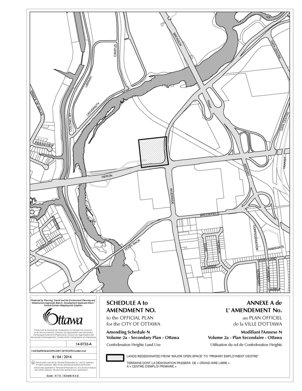
57 52
58 53 Document 3 Proposed Official Plan Amendment Old Ottawa East Secondary Plan Official Plan Amendment XX to the Official Plan for the City of Ottawa - Old Ottawa East Secondary Plan
59 54 PART A THE PREAMBLE PART A THE PREAMBLE introduces the actual amendment but does not constitute part of Amendment No. XX to the Official Plan for the City of Ottawa. PART B THE AMENDMENT constitutes Amendment No. XX to the Official Plan for the City of Ottawa. 1. Purpose The purpose of the amendment is to remove policy from the Old Ottawa East Secondary Plan, which is contained in Volume 2a of the Official Plan. In Section of the Secondary Plan there is a requirement to zone properties fronting on Main Street to Traditional Mainstreet (TM) as development proceeds in this precinct. This statement requires removal in order to conform to the overall implementation goals of Official Plan Amendment Location Old Ottawa East is located in the centre of Ottawa, south-east of the Rideau Canal, north of Clegg Street and west of the Rideau River. This area is identified as the Old Ottawa East Community and contains two designated Traditional Mainstreets, one along Main Street and the other along Hawthorne Avenue, as identified on Schedule B of the Official Plan. 3. Basis Rationale The Old Ottawa East Secondary Plan (OOESP) is contained within Volume 2a of the Official Plan and was adopted in September The purpose of this amendment is to bring the OOESP in line with the overall implementation goals of Volume 1 of the Official Plan, as amended by Official Plan Amendment 150. This requires the removal of a statement which states that the rezoning of properties to Traditional Mainstreet will occur as development proceeds. Instead the policy framework will match the Official Plan designation and allow for the rezoning of affected properties immediately, as envisioned by Volume 1 of the Official Plan.
60 55 PART B THE AMENDMENT 1. Introduction All of this part of the document entitled Part B - The amendment, consisting of the following text constitutes Amendment XX to the Official Plan of the City of Ottawa. 2. Details Volume 2a, Old Ottawa East Secondary Plan, Section , is hereby amended by removing policy 2: a. Which states: Zone properties fronting on Main Street to Traditional Mainstreet (TM) as development proceeds in this precinct. Subsequent policies should be renumbered accordingly. 3. Implementation Implementation and interpretation of this Amendment shall be in accordance with the policies of the Official Plan for the City of Ottawa.
61 56 Document 4 - Review Area Key Maps The key maps in Document 4 illustrate the 2014 Zoning Review Area boundaries, adjacent Review Area boundaries as well as approved and in-progress Community Design Plans and Secondary Plans.
62 57 1. Barrhaven Town Centre Zoning Review Area

63 58 2. Orléans Town Centre Zoning Review Area

64 59 3. Billings Bridge Mixed Use Centre Zoning Review Area

65 60 4. McArthur Avenue Zoning Review Area
66 61 5. Dalhousie Street Zoning Review Area

67 6. Main Street Zoning Review Area 62

68 63 7. Bronson Avenue Zoning Review Area

69 64 8. Gladstone Avenue Zoning Review Area

70 65 9. Somerset Street West Zoning Review Area

71 Preston Street Zoning Review Area
")
72 Merivale Road (north) Zoning Review Area

73 Carling Avenue Zoning Review Area

74 Montreal Road Zoning Review Area
75 14. Ogilvie Road Zoning Review Area 70
")
76 Merivale Road (south) Zoning Review Area
77 Robertson Road Zoning Review Area

78 St. Joseph Boulevard Zoning Review Area
79 18. Innes Road Zoning Review Area 74

80 St. Laurent Boulevard Zoning Review Area

81 20. Walkley Road Zoning Review Area 76
Report to/rapport au : Planning Committee Comité de l'urbanisme. March 4, mars 2013
 1 Report to/rapport au : Planning Committee Comité de l'urbanisme March 4, 2013 4 mars 2013 Submitted by/soumis par : Nancy Schepers, Deputy City Manager/Directrice municipale adjointe,planning and Infrastructure/Urbanisme
NOTICE OF PLANNING COMMITTEE MEETING
 May 2, 2014 ACS2014-PAI-PGM-0102 NOTICE OF PLANNING COMMITTEE MEETING Dear Sir/Madam Re: Zoning 1131 Teron Road This is to advise you that the above-noted matter will be considered by the City of Ottawa
PLANNING COMMITTEE REPORT JULY COMITÉ DE L URBANISME RAPPORT 34 LE 11 JUILLET ZONING 1008 SHEFFORD ROAD
 28 COMITÉ DE L URBANISME 4. ZONING 1008 SHEFFORD ROAD ZONAGE 1008, CHEMIN SHEFFORD COMMITTEE RECOMMENDATION That Council approve an amendment to the Zoning By-law 2008-250 to change the zoning of 1008
That Council approve amendments to Zoning By-law , as illustrated and detailed in Documents 1 and 2.
 1 COMITÉ DE L URBANISME 1. COMPREHENSIVE ZONING BY-LAW 2008-250: ANOMALIES AND MINOR CORRECTIONS, Q1-2015 RÈGLEMENT DE ZONAGE 2008-250 : ANOMALIES ET CORRECTIONS MINEURES T1-2015 AGRICULTURE AND RURAL
PLANNING COMMITTEE REPORT JULY COMITÉ DE L URBANISME RAPPORT 34 LE 11 JUILLET ZONING 5611 FERNBANK ROAD
 20 COMITÉ DE L URBANISME 3. ZONING 5611 FERNBANK ROAD ZONAGE 5611, CHEMIN FERNBANK COMMITTEE RECOMMENDATION That Council approve an amendment to the Zoning By-law 2008-250 to change the zoning of part
13. OFFICIAL PLAN AMENDMENT AND ZONING CRESTHAVEN DRIVE MODIFICATION AU PLAN OFFICIEL ET ZONAGE - 350, PROMENADE CRESTHAVEN
 292 COMITÉ DE L URBANISME 13. OFFICIAL PLAN AMENDMENT AND ZONING - 350 CRESTHAVEN DRIVE MODIFICATION AU PLAN OFFICIEL ET ZONAGE - 350, PROMENADE CRESTHAVEN COMMITTEE RECOMMENDATIONS That Council: 1. Approve
Report to Rapport au: Built Heritage Sub-Committee / Sous-comité du patrimoine bâti January 13, 2015 / 13 janvier and / et
 1 Report to Rapport au: Built Heritage Sub-Committee / Sous-comité du patrimoine bâti January 13, 2015 / 13 janvier 2015 and / et Planning Committee / Comité de l'urbanisme January 20, 2015 / 20 janvier
Report to/rapport au : Planning Committee Comité de l'urbanisme. and Council / et au Conseil. June 18, juin 2012
 303 Report to/rapport au : Planning Committee Comité de l'urbanisme and Council / et au Conseil June 18, 2012 18 juin 2012 Submitted by/soumis par : Nancy Schepers, Deputy City Manager, Directrice municipale
A Zoning By-law Amendment Proposal will be considered at. Planning Committee and Agriculture and Rural Affairs Committee
 August 12, 2016 ACS2016-PE-PGM-0127 A Zoning By-law Amendment Proposal will be considered at Planning Committee and Agriculture and Rural Affairs Committee am contacting you today to inform you that the
2. Not enact the Zoning By-law until such time as the Delegated Authority Report for the Draft Plan of Subdivision is approved.
 1 COMITÉ DE L AGRICULTURE ET 1. ZONING - 6000 MARY ANNE DRIVE ZONAGE - 6000, PROMENADE MARY ANNE COMMITTEE RECOMMENDATIONS AS AMENDED That Council 1. Approve an amendment to the Zoning By-law 2008-250
Report to/rapport au : Transportation Committee Comité des transports. and Council / et au Conseil. June 21, juin 2012
 1 Report to/rapport au : Transportation Committee Comité des transports and Council / et au Conseil June 21, 2012 21 juin 2012 Submitted by/soumis par : Nancy Schepers, Deputy City Manager/Directrice municipale
Report to Rapport au: Planning Committee Comité de l'urbanisme 11 July 2017 / 11 juillet 2017
 1 Report to Rapport au: Planning Committee Comité de l'urbanisme 11 July 2017 / 11 juillet 2017 and Council / et au Conseil August 23, 2017 / 23 août 2017 Submitted on June 27, 2017 Soumis le 27 juin 2017
PLANNING COMMITTEE REPORT JULY COMITÉ DE L URBANISME RAPPORT 34 LE 11 JUILLET ZONING 5306 AND 5358 FERNBANK ROAD
 150 COMITÉ DE L URBANISME 10. ZONING 5306 AND 5358 FERNBANK ROAD ZONAGE 5306 ET 5358, CHEMIN FERNBANK COMMITTEE RECOMMENDATION AS AMENDED That Council approve an amendment to Zoning By-law 2008-250 to
AGRICULTURE AND RURAL AFFAIRS COMMITTEE REPORT JUNE COMITÉ DE L AGRICULTURE ET DES AFFAIRES RURALES RAPPORT 20 LE 13 JUIN 2012
 15 COMITÉ DE L AGRICULTURE ET 2. ZONING 2352A MANOTICK STATION ROAD ZONAGE 2352A, CHEMIN MANOTICK STATION COMMITTEE RECOMMENDATION That Council approve an amendment to the Zoning By-law 2008-250 to change
Report to/rapport au : Planning Committee Comité de l'urbanisme. and Council / et au Conseil. June 6, juin 2012
 182 Report to/rapport au : Planning Committee Comité de l'urbanisme and Council / et au Conseil June 6, 2012 6 juin 2012 Submitted by/soumis par : Nancy Schepers, Deputy City Manager/Directrice municipale
Report to/rapport au : Agriculture and Rural Affairs Committee Comité de l'agriculture et des affaires rurales. and Council / et au Conseil
 1 Report to/rapport au : Agriculture and Rural Affairs Committee Comité de l'agriculture et des affaires rurales and Council / et au Conseil October 12, 2012 12 octobre 2012 Submitted by/soumis par : Nancy
AGRICULTURE AND RURAL AFFAIRS COMMITTEE REPORT JUNE COMITÉ DE L AGRICULTURE ET DES AFFAIRES RURALES RAPPORT 20 LE 13 JUIN 2012
 23 COMITÉ DE L AGRICULTURE ET 3. ZONING - 6007 AND 6021 BROWNLEE ROAD ZONAGE 6007 ET 6021, CHEMIN BROWNLEE COMMITTEE RECOMMENDATION That Council approve an amendment to Zoning By-law 2008-250 to change
Report to/rapport au : Agriculture and Rural Affairs Committee Comité de l'agriculture et des affaires rurales. and Council / et au Conseil
 1 Report to/rapport au : Agriculture and Rural Affairs Committee Comité de l'agriculture et des affaires rurales and Council / et au Conseil September 6, 2012 6 septembre 2012 Submitted by/soumis par :
Report to Rapport au: Planning Committee Comité de l'urbanisme. and Council et au Conseil. May 9, mai 2014
 1 Report to Rapport au: Planning Committee Comité de l'urbanisme and Council et au Conseil May 9, 2014 9 mai 2014 Submitted by Soumis par: Nancy Schepers, Deputy City Manager / Directrice municipale adjointe,
Report to/rapport au : Agriculture and Rural Affairs Committee Comité de l'agriculture et des affaires rurales. and Council / et au Conseil
 31 Report to/rapport au : Agriculture and Rural Affairs Committee Comité de l'agriculture et des affaires rurales and Council / et au Conseil May 31, 2012 31 mai 2012 Submitted by/soumis par : Nancy Schepers,
Report to Rapport au: Planning Committee / Comité de l'urbanisme August 25, 2015 / 25 août 2015
 1 Report to Rapport au: Planning Committee / Comité de l'urbanisme August 25, 2015 / 25 août 2015 and Council / et au Conseil September 9, 2015 / 9 septembre 2015 Submitted on July 22, 2015 Soumis le 22
Report to/rapport au : Planning Committee Comité de l'urbanisme. and Council / et au Conseil. May 23, mai 2012
 52 Report to/rapport au : Planning Committee Comité de l'urbanisme and Council / et au Conseil May 23, 2012 23 mai 2012 Submitted by/soumis par : Nancy Schepers, Deputy City Manager Directrice municipale
6. OFFICIAL PLAN AMENDMENT BANKFIELD ROAD AND FIRST LINE ROAD
 49 COMITÉ DE L AGRICULTURE ET 6. OFFICIAL PLAN AMENDMENT 1346 1380 BANKFIELD ROAD AND 5537 5599 FIRST LINE ROAD MODIFICATION AU PLAN OFFICIEL - 1346-1380, CHEMIN BANKFIELD ET 5537-5599, CHEMIN FIRST LINE
Report to Rapport au: Planning Committee Comité de l'urbanisme 14 November 2017 / 14 novembre 2017
 1 Report to Rapport au: Planning Committee Comité de l'urbanisme 14 November 2017 / 14 novembre 2017 and Council / et au Conseil November 22, 2017 / 22 novembre 2017 Submitted on October 18, 2017 Soumis
Report to Rapport au:
 1 Report to Rapport au: Finance and Economic Development Committee Comité des finances et du développement économique 10 September 2018 / 10 septembre 2018 and Council et au Conseil 26 September 2018 /
Report to Rapport au: Built Heritage Sub-Committee / Sous-comité du patrimoine bâti March 8, 2018 / 8 mars and / et
 1 Report to Rapport au: Built Heritage Sub-Committee / Sous-comité du patrimoine bâti March 8, 2018 / 8 mars 2018 and / et Planning Committee / Comité de l'urbanisme March 27, 2018 / 27 mars 2018 and Council
7. APPLICATION FOR NEW CONSTRUCTION IN THE CENTRETOWN HERITAGE CONSERVATION DISTRICT AT BANK STREET
 137 COMITÉ DE L URBANISME 7. APPLICATION FOR NEW CONSTRUCTION IN THE CENTRETOWN HERITAGE CONSERVATION DISTRICT AT 406-408 BANK STREET DEMANDE EN VUE D UNE NOUVELLE CONSTRUCTION DANS LE DISTRICT DE CONSERVATION
M:\2016\116063\DATA\APPLICATIONS\SITE PLAN\PLANNING ADDENDUM\PLANNING BRIEF WATERFORD.DOCX.PAGE 1
 December 8, 2016 Development Review Services City of Ottawa 110 Laurier Ave West, 4 th Floor Ottawa, ON K1P 1J1 Attention: Reference: Don Herweyer, Manager, Development Review South 125 Marketplace Ave/101A
FEASIBILITY REPORT. 1486, 1490 and 1494 Clementine. Prepared by: Lloyd Phillips & Associates Ltd. For: Ottawa Salus
 DRAFT FEASIBILITY REPORT 1486, 1490 and 1494 Clementine Prepared by: Lloyd Phillips & Associates Ltd. For: Ottawa Salus LPA File No. 1008 Lloyd Phillips & Associates June 9, 2010 Feasibility Report Page
MINTO COMMUNITIES INC. AVALON WEST STAGE 4 PLANNING RATIONALE. July Prepared for:
 MINTO COMMUNITIES INC. AVALON WEST STAGE 4 PLANNING RATIONALE July 2015 Prepared for: MINTO COMMUNITIES INC. 200 180 Kent Street Ottawa, Ontario K1P 0B6 Prepared by: J.L. RICHARDS & ASSOCIATES LIMITED
Report to/rapport au : Finance and Economic Development Committee Comité des finances et du développement économique. and Council / et au Conseil
 283 Report to/rapport au : Finance and Economic Development Committee Comité des finances et du développement économique and Council / et au Conseil September 25, 2012 le 25 septembre 2012 Submitted by/soumis
Report to/rapport au : Finance and Economic Development Committee Comité des finances et du développement économique. and Council / et au Conseil
 193 Report to/rapport au : Finance and Economic Development Committee Comité des finances et du développement économique and Council / et au Conseil May 29, 2012 29 mai 2012 Submitted by/soumis par : Nancy
8. LEASE - RIVERAIN PARK OTHER PROPERTIES - NATIONAL CAPITAL COMMISSION BAIL PARC RIVERAIN AUTRE PROPRIÉTÉS COMMISSION DE LA CAPITALE NATIONALE
 325 COMITÉ DES FINANCES ET DU 8. LEASE - RIVERAIN PARK OTHER PROPERTIES - NATIONAL CAPITAL COMMISSION BAIL PARC RIVERAIN AUTRE PROPRIÉTÉS COMMISSION DE LA CAPITALE NATIONALE COMMITTEE RECOMMENDATION That
Residential Intensification in Established Neighbourhoods Study (RIENS)
") Residential Intensification in Established Neighbourhoods Study (RIENS) EXECUTIVE SUMMARY In December 2015, the City of Kitchener retained Meridian Planning Consultants to undertake the Residential Intensification
Residential Intensification in Established Neighbourhoods Study (RIENS) EXECUTIVE SUMMARY In December 2015, the City of Kitchener retained Meridian Planning Consultants to undertake the Residential Intensification
Report to Rapport au: Planning Committee Comité de l'urbanisme 24 October 2017 / 24 octobre 2017
 1 Report to Rapport au: Planning Committee Comité de l'urbanisme 24 October 2017 / 24 octobre 2017 and Council et au Conseil 8 November 2017 / 8 novembre 2017 Submitted on September 5, 2017 Soumis le 5
Director, Community Planning, Toronto and East York District
 STAFF REPORT September 1, 2005 To: From: Subject: Toronto and East York Community Council Director, Community Planning, Toronto and East York District Further Report Applications to amend Official Plan
Document 7 Consultation Details
 1 Document 7 Consultation Details Through the Building Liveable Ottawa 2013 Official Plan update, stakeholders were consulted extensively and participated in the formulation of the policies which are being
Report to/rapport au : Finance and Economic Development Committee Comité des finances et du développement économique. and Council / et au Conseil
 271 Report to/rapport au : Finance and Economic Development Committee Comité des finances et du développement économique and Council / et au Conseil September 25, 2012 le 25 septembre 2012 Submitted by/soumis
Part 10 Mixed Use/Commercial Zones (Sections )
") Part 10 Mixed Use/Commercial Zones (Sections 185-198) This part comprises the zones that are applied to the urban and suburban areas of the City in accordance with the mixed-use and commercial land use
Part 10 Mixed Use/Commercial Zones (Sections 185-198) This part comprises the zones that are applied to the urban and suburban areas of the City in accordance with the mixed-use and commercial land use
Omnibus Zoning Amendment (FILE # D ) Proposals
 Proposals") Omnibus Zoning Amendment (FILE # D02-02-17-0011) Proposals The Omnibus Zoning report will recommend amendments to modify the intent of certain provisions and to correct minor errors in the Zoning By-law.
Omnibus Zoning Amendment (FILE # D02-02-17-0011) Proposals The Omnibus Zoning report will recommend amendments to modify the intent of certain provisions and to correct minor errors in the Zoning By-law.
50 and 52 Finch Avenue East - Official Plan and Zoning By-law Amendment Applications - Preliminary Report
 STAFF REPORT ACTION REQUIRED 50 and 52 Finch Avenue East - Official Plan and Zoning By-law Amendment Applications - Preliminary Report Date: August 16, 2016 To: From: Wards: Reference Number: North York
BROCKVILLE CITY OF BROCKVILLE COMPREHENSIVE ZONING BY-LAW REVIEW DISCUSSION PAPER OCTOBER 2013 FINAL D
 BROCKVILLE CITY OF BROCKVILLE COMPREHENSIVE ZONING REVIEW DISCUSSION PAPER OCTOBER 2013 FINAL D14-13-010 TABLE OF CONTENTS 1. INTRODUCTION... 1 1.1 Purpose and Goals of this Project... 1 1.2 Study Process...
PIN , Part 1, Plan SR-713 in Lot 2, Concession 5, Township of McKim (1096 Dublin Street, Sudbury)
") STAFF REPORT Applicant: Dalron Construction Limited Location: PIN 02124-0103, Part 1, Plan SR-713 in Lot 2, Concession 5, Township of McKim (1096 Dublin Street, Sudbury) Official Plan and Zoning By-law:
STAFF REPORT Applicant: Dalron Construction Limited Location: PIN 02124-0103, Part 1, Plan SR-713 in Lot 2, Concession 5, Township of McKim (1096 Dublin Street, Sudbury) Official Plan and Zoning By-law:
PLANNING RATIONALE 680 BRONSON AVENUE OTTAWA, ONTARIO PROPOSED ZONING BY-LAW AMENDMENT
 PLANNING RATIONALE 680 BRONSON AVENUE OTTAWA, ONTARIO PROPOSED ZONING BY-LAW AMENDMENT FRANK PARAVAN APRIL 2014 Planning Rationale Introduction FOTENN Consultants Inc. has been engaged by Frank and Michael
0000 NAME: P.C.: L7C1J6 CONTACT: If necessary, please update above information - Si nécessaire, veuillez mettre à jour les renseignements ci-dessus
 Building and demolition folders Monthly Report Permis de construction et de démolition Rapport mensuel 0000 NAME: The Corporation of the Town of Caledon STATUS: T ADDRESS: CITY: 63 Old Church Road Caledon
Part 10 Mixed Use/Commercial Zones (Sections )
") Part 10 Mixed Use/Commercial Zones (Sections 185-198) This part comprises the zones that are applied to the urban and suburban areas of the City in accordance with the mixed-use and commercial land use
Part 10 Mixed Use/Commercial Zones (Sections 185-198) This part comprises the zones that are applied to the urban and suburban areas of the City in accordance with the mixed-use and commercial land use
Planning Rationale in Support of an Application for Plan of Subdivision and Zoning By-Law Amendment
 Planning Rationale in Support of an Application for Plan of Subdivision and Zoning By-Law Amendment The Kilmorie Development 21 Withrow Avenue City of Ottawa Prepared by: Holzman Consultants Inc. Land
6040 Bathurst Street and 5 Fisherville Road Zoning Bylaw Amendment Application Preliminary Report
 STAFF REPORT ACTION REQUIRED 6040 Bathurst Street and 5 Fisherville Road Zoning Bylaw Amendment Application Preliminary Report Date: January 24, 2017 To: From: Wards: Reference Number: North York Community
774 BRONSON AVENUE MINOR ZONING BY-LAW AMENDMENT + SITE PLAN CONTROL PLANNING RATIONALE + DESIGN BRIEF
 774 BRONSON AVENUE MINOR ZONING BY-LAW AMENDMENT + SITE PLAN CONTROL PLANNING RATIONALE + DESIGN BRIEF JANUARY 2016 Prepared for: Textbook Suites 51 Caldari Road, Suite A1M Concord, ON L4K 4G3 T: 416 477
770 BROOKFIELD ROAD Site Plan Control Atlantis Investments November 2017
 770 BROOKFIELD ROAD Site Plan Control Atlantis Investments November 2017 Prepared for: Atlantis Investments Inc. Prepared by: Fotenn Planning + Design 223 McLeod Street Ottawa, ON K2P 0Z8 fotenn.com October
STAFF REPORT PLN September 11, 2017
 Page: 1 TO: SUBJECT: GENERAL COMMITTEE APPLICATIONS FOR OFFICIAL PLAN AMENDMENT AND ZONING BY-LAW AMENDMENT 37 JOHNSON STREET WARD: WARD 1 PREPARED BY AND KEY CONTACT: SUBMITTED BY: GENERAL MANAGER APPROVAL:
Montreal Road District Secondary Plan [Amendment #127, October 9, 2013]
![Montreal Road District Secondary Plan [Amendment #127, October 9, 2013]](/thumbs/72/66783104.jpg "Montreal Road District Secondary Plan [Amendment #127, October 9, 2013]") [Amendment #127, October 9, 2013] 1.0 General The following policies are applicable to the Montreal Road District as set out in Schedule 1. 1.1 District Objectives The objective of this Plan is to guide
[Amendment #127, October 9, 2013] 1.0 General The following policies are applicable to the Montreal Road District as set out in Schedule 1. 1.1 District Objectives The objective of this Plan is to guide
Kingston Road - Zoning Amendment and Draft Plan of Subdivision Applications - Preliminary Report
 STAFF REPORT ACTION REQUIRED 6480-6484 Kingston Road - Zoning Amendment and Draft Plan of Subdivision Applications - Preliminary Report Date: April 19, 2016 To: From: Wards: Reference Number: Scarborough
PLANNING PRIMER. Elective: Understanding Residential Intensification and Infill. Planning and Growth Management Department.
 PLANNING PRIMER Elective: Understanding Residential Intensification and Infill Planning and Growth Management Department Amended 2015 Agenda Information re: Infill and Intensification Initiatives Residential
900 ALBERT STREET PLANNING RATIONALE ADDENDUM NO. 2
 900 ALBERT STREET PLANNING RATIONALE ADDENDUM NO. 2 March 26, 2018 Planning Rationale Addendum No. 2 Official Plan and Zoning By-law Amendment Prepared for: TIP Albert GP Inc. 485 Bank Street, Suite 200
Infrastructure, Development and Enterprise Services
 Staff Report To Service Area City Council Infrastructure, Development and Enterprise Services Date Monday, April 9, 2018 Subject Report Number Statutory Public Meeting 671 Victoria Road North Proposed
Report to. Rapport au: Planning Committee Comité de l'urbanisme. and Council et au Conseil. March 17, mars 2014
 1 Report to Rapport au: Planning Committee Comité de l'urbanisme and Council et au Conseil March 17, 2014 17 mars 2014 Submitted by Soumis par: Nancy Schepers, Deputy City Manager / Directrice municipale
50+54 BELL STREET NORTH
 50+54 BELL STREET NORTH SITE PLAN CONTROL APPLICATION OCTOBER 2014 PREPARED BY: FOTENN Consultants Inc. 223 Mcleod Street Ottawa, ON K2P OZ8 (613) 730-5709 PREPARED FOR: Ottawa Chinese Alliance Church
Report to/rapport au : Planning Committee Comité de l'urbanisme. and Council / et au Conseil. July 27, juillet 2012
 144 Report to/rapport au : Planning Committee Comité de l'urbanisme and Council / et au Conseil July 27, 2012 27 juillet 2012 Submitted by/soumis par : Nancy Schepers, Deputy City Manager Directrice municipale
Official Plan & Zoning By-law Amendment Application Preliminary Report
 STAFF REPORT ACTION REQUIRED 847 873 Sheppard Avenue West Official Plan & Zoning By-law Amendment Application Preliminary Report Date: January 13, 2010 To: From: Wards: Reference Number: North York Community
Ashcroft Homes Trim Road Development Planning Rationale
 18 Antares Drive Ottawa, ON K2E 1A9 Ashcroft Homes Trim Road Development Planning Rationale Proposed Site Plan & Zoning Amendment Applications File No: D02-02-17-0129 & D07-12-17-0175 August 2018 Planning
Report to Rapport au: Built Heritage Sub-Committee / Sous-comité du patrimoine bâti March 26, 2015 / 26 mars and / et
 1 Report to Rapport au: Built Heritage Sub-Committee / Sous-comité du patrimoine bâti March 26, 2015 / 26 mars 2015 and / et Planning Committee / Comité de l'urbanisme April 14, 2015 / 14 avril 2015 and
STAFF REPORT. January 25, North York Community Council. Director, Community Planning, North District
 STAFF REPORT January 25, 2005 To: From: Subject: Purpose: North York Community Council Director, Community Planning, North District Refusal Report OPA & Rezoning Application 04 194214 NNY 33 OZ Applicant:
3.1. OBJECTIVES FOR RESIDENTIAL LAND USE DESIGNATIONS GENERAL OBJECTIVES FOR ALL RESIDENTIAL DESIGNATIONS
 3. RESIDENTIAL LAND USE DESIGNATIONS INTRODUCTION The Residential land use designations provide for housing and other land uses that are integral to, and supportive of, a residential environment. Housing
VACANT URBAN RESIDENTIAL LAND SURVEY 2016 UPDATE. City of Ottawa Planning, Infrastructure and Economic Development
 VACANT URBAN RESIDENTIAL LAND SURVEY 2016 UPDATE City of Ottawa Planning, Infrastructure and Economic Development May 2017 This page has been intentionally left blank Vacant Urban Residential Land Survey
SPECIAL PUBLIC MEETING NOTICE/ AVIS DE SÉANCE EXTRAORDINAIRE PUBLIQUE
 To/À : From/De : Mayor & Members of City Council/Maire et membres du Conseil municipal Barbara A. Quigley City Clerk/Greffière municipale Date : October 22, 2013 Re/Sujet : Meeting Notice/ Avis de réunion
6208 Jeanne D Arc Boulevard North. Planning Rationale. Site Plan Control
 Site Plan Control Prepared By: NOVATECH Suite 200, 240 Michael Cowpland Drive Ottawa, Ontario K2M 1P6 November / 24 / 2015 Novatech File: 115100 Ref: R-2015-179 November 24, 2015 City of Ottawa 110 Laurier
KANATA WEST RETAIL CENTRE
 KANATA WEST RETAIL CENTRE June 13, 2017 Zoning By-law Amendment and Site Plan Control Prepared for: 225 Metcalfe Street, Suite 708 Ottawa, ON K2P 1P9 Prepared by: Fotenn Planning + Design 223 McLeod Street
12, 14, 16 and 18 Marquette Avenue and 7 Carhartt Street Zoning By-law Amendment Application - Preliminary Report
 STAFF REPORT ACTION REQUIRED 12, 14, 16 and 18 Marquette Avenue and 7 Carhartt Street Zoning By-law Amendment Application - Preliminary Report Date: July 17, 2014 To: From: Wards: Reference Number: North
Zoning St. Laurent Boulevard Zonage , boulevard St. Laurent. Recommendations
 April 9, 1999 Department of Urban Planning and Public Works Planning and Economic Development Committee / Comité de l'urbanisme et de l'expansion économique City Council / Conseil municipal Zoning - 2043
1012 & 1024 MCGARRY TERRACE
 0 & 0 MCGARRY TERRACE December, 07 Planning Rationale and Design Brief Official Plan Amendment, Zoning By-law Amendment, and Site Plan Control 0 & 0 McGARRY TERRACE OFFICIAL PLAN AMENDMENT, ZONING BY-LAW
25 Leonard Avenue - Official Plan Amendment and Zoning Amendment Applications - Preliminary Report
 STAFF REPORT ACTION REQUIRED 25 Leonard Avenue - Official Plan Amendment and Zoning Amendment Applications - Preliminary Report Date: March 8, 2017 To: From: Wards: Reference Number: Toronto and East York
Staff Report. October 19, 2016 Page 1 of 17. Meeting Date: October 19, 2016
 October 19, 2016 Page 1 of 17 Staff Report Report No.: PDSD-P-58-16 Meeting Date: October 19, 2016 Submitted by: Subject: Recommendation: Ben Puzanov, RPP, Senior Planner Application for Zoning By-law
Bylaw No , being "Official Community Plan Bylaw, 2016" Schedule "A" DRAFT
 Bylaw No. 2600-2016, being "Official Community Plan Bylaw, 2016" Schedule "A" Urban Structure + Growth Plan Urban Structure Land use and growth management are among the most powerful policy tools at the
507, 509 and 511 Kingston Road - Official Plan and Zoning By-law Amendment Applications - Preliminary Report
 STAFF REPORT ACTION REQUIRED 507, 509 and 511 Kingston Road - Official Plan and Zoning By-law Amendment Applications - Preliminary Report Date: March 9, 2017 To: From: Wards: Reference Number: Toronto
and King Street West Part Lot Control Exemption Application Final Report
 STAFF REPORT ACTION REQUIRED 260 270 and 274 322 King Street West Part Lot Control Exemption Application Final Report Date: December 16, 2016 To: From: Wards: Reference Number: Toronto and East York Community
7.0 IMPLEMENTATION. 2.0 Centretown Today: Analysis. 3.0 Centretown Tomorrow: The Vision. 5.0 Greening Centretown: Parks & Open Space
 THE STUDY TODAY THE VISION MOBILITY GREENING BUILDING IMPLEMENTING 7.0 IMPLEMENTATION 107 1.0 The Study 2.0 Centretown Today: Analysis 3.0 Centretown Tomorrow: The Vision 4.0 Moving Around Centretown:
SUBJECT: Character Area Studies and Site Plan Approval for Low Density Residential Areas. Community and Corporate Services Committee
 Page 1 of Report PB-70-16 SUBJECT: Character Area Studies and Site Plan Approval for Low Density Residential Areas TO: FROM: Community and Corporate Services Committee Planning and Building Department
Public Copy/Copie du public
 Ministry of Health and Long-Term Care Inspection Report under the Long-Term Care Homes Act, 2007 Ministère de la Santé et des Soins de longue durée Rapport d inspection sous la Loi de 2007 sur les foyers
Part 10 Mixed Use/Commercial Zones (Sections )
") Part 10 Mixed Use/Commercial Zones (Sections 185-198) This part comprises the zones that are applied to the urban and suburban areas of the City in accordance with the mixed-use and commercial land use
Part 10 Mixed Use/Commercial Zones (Sections 185-198) This part comprises the zones that are applied to the urban and suburban areas of the City in accordance with the mixed-use and commercial land use
Q2. Normally, the landowner insurance covers for any cost related to clean-up should a disaster (spill or fire) occur.
 occur.") Réponses aux questions et inquiétudes des résidants et contribuables du Canton d Alfred et Plantagenet concernant la demande d amendement au Plan officiel des CUPR et de modification au Règlement de zonage
Réponses aux questions et inquiétudes des résidants et contribuables du Canton d Alfred et Plantagenet concernant la demande d amendement au Plan officiel des CUPR et de modification au Règlement de zonage
ADELAIDE APARTMENTS TOWER EXTENSION
 ADELAIDE APARTMENTS TOWER EXTENSION SEPTEMBER 2016 CONTENTS INTRODUCTION 1 PURPOSE OF THE APPLICATIONS 1 SITE CONTEXT 2 EXISTING CONDITIONS 2 SURROUNDING AREA 3 SITE PHOTOS 4 PUBLIC TRANSIT 6 ROAD NETWORK
AGENDA L'ORDRE DU JOUR
 TOWNSHIP OF RUSSELL PLANNING ADVISORY COMMITTEE MEETING May 30, 2016 at 7:00 p.m. Gaston R. Patenaude Hall 717 Notre-Dame Street Embrun ON CANTON DE RUSSELL RÉUNION DU COMITÉ CONSULTATIF SUR L'AMÉNAGEMENT
111 Wenderly Drive Official Plan and Zoning By-law Amendment Applications - Preliminary Report
 STAFF REPORT ACTION REQUIRED 111 Wenderly Drive Official Plan and Zoning By-law Amendment Applications - Preliminary Report Date: August 17, 2015 To: From: Wards: Reference Number: North York Community
Planning Justification Report - Update Castlegrove Subdivision, Gananoque Draft Plan of Subdivision and Class III Development Permit
 Planning Justification Report - Update Castlegrove Subdivision, Gananoque Draft Plan of Subdivision and Class III Development Permit by IBI Group Table of Contents Executive Summary... 1 1 Introduction...
PLANNING COMMITTEE REPORT AUGUST COMITÉ DE L URBANISME RAPPORT 35 LE 29 AOÛT ZONING GLEBE AVENUE ZONAGE 174, AVENUE GLEBE
 137 COMITÉ DE L URBANISME 8. ZONING - 174 GLEBE AVENUE ZONAGE 174, AVENUE GLEBE COMMITTEE RECOMMENDATION That Council refuse an amendment to the Zoning By-law 2008-250 to change the zoning of 174 Glebe
MINOR VARIANCE REQUESTED:
 November 6 th, 2016 Committee of Adjustment 101 Centrepointe Dr. Ottawa, ON K2G 5K7 Re: 83 Hinton Avenue Ave. Applications for Minor Variances APPLICATION OVERVIEW The applicant proposes to construct a
Deeming By-law, Maple Leaf Drive, Bourdon Avenue, Venice Drive, Stella Street and Seabrook Avenue Final Report
 STAFF REPORT ACTION REQUIRED Deeming By-law, Maple Leaf Drive, Bourdon Avenue, Venice Drive, Stella Street and Seabrook Avenue Final Report Date: October 16, 2007 To: From: Wards: Reference Number: Etobicoke
Director, Community Planning, South District
 STAFF REPORT October 21, 2002 To: Midtown Community Council From: Director, Community Planning, South District Subject: Refusal Report Applications for Amendments to the Official Plan and Zoning By-law,
71 RUSSELL AVENUE. PLANNING RATIONALE FOR SITE PLAN CONTROL APPLICATION (Design Brief)
") ` 71 RUSSELL AVENUE Ottawa September 14, 2018 PLANNING RATIONALE FOR SITE PLAN CONTROL APPLICATION (Design Brief) Introduction The intent of this Planning Rationale and Design Brief is to provide planning
` 71 RUSSELL AVENUE Ottawa September 14, 2018 PLANNING RATIONALE FOR SITE PLAN CONTROL APPLICATION (Design Brief) Introduction The intent of this Planning Rationale and Design Brief is to provide planning
1202 & 1204 Avenue Road Zoning By-law Amendment Application - Preliminary Report
 STAFF REPORT ACTION REQUIRED 1202 & 1204 Avenue Road Zoning By-law Amendment Application - Preliminary Report Date: March 17, 2017 To: From: Wards: Reference Number: North York Community Council Director,
Director, Community Planning, North York District NNY 10 OZ and NNY 10 RH
 STAFF REPORT ACTION REQUIRED 847 873 Sheppard Avenue West - Official Plan Amendment and Zoning By-law Amendment and Rental Housing Demolition and Conversion Applications - Preliminary Report Date: April
7.0 IMPLEMENTATION. 2.0 Centretown Today: Analysis. 3.0 Centretown Tomorrow: The Vision. 5.0 Greening Centretown: Parks & Open Space
 7.0 IMPLEMENTATION 109 1.0 The Study 2.0 Centretown Today: Analysis 3.0 Centretown Tomorrow: The Vision 4.0 Moving Around Centretown: Mobility 5.0 Greening Centretown: Parks & Open Space 6.0 Building Centretown:
MCGARRY TERRACE & LONGFIELDS DRIVE
 DEVELOPMENT LAND FOR SALE MCGARRY TERRACE & LONGFIELDS DRIVE OTTAWA, ONTARIO STRANDHERD DRIVE GREENBANK ROAD 1034 MCGARRY TERRACE & 1117 LONGFIELDS DRIVE VIMY MEMORIAL BRIDGE 1034 MCGARRY TERRACE & 1117
Yonge Street and 3 Gerrard Street East - Zoning Amendment Application - Preliminary Report
 STAFF REPORT ACTION REQUIRED 363-391 Yonge Street and 3 Gerrard Street East - Zoning Amendment Application - Preliminary Report Date: May 22, 2015 To: From: Wards: Reference Number: Toronto and East York
Planning Justification Report
 Planning Justification Report 101 Kozlov Street, Barrie, Ont. Destaron Property Management Ltd. November 2015 Revised February 2017 TABLE OF CONTENTS Page 1.0 INTRODUCTION... 1 2.0 DESCRIPTION OF SUBJECT
4027 and 4031 Ellesmere Road Zoning Amendment and Draft Plan of Subdivision Applications - Request for Direction Report
 STAFF REPORT ACTION REQUIRED 4027 and 4031 Ellesmere Road Zoning Amendment and Draft Plan of Subdivision Applications - Request for Direction Report Date: August 22, 2013 To: From: Wards: Reference Number:
PLANNING REPORT Gordon Street City of Guelph. Prepared on behalf of Ontario Inc. March 17, Project No. 1507
 PLANNING REPORT 1131 Gordon Street City of Guelph Prepared on behalf of 1876698 Ontario Inc. March 17, 2016 Project No. 1507 423 Woolwich Street, Suite 201, Guelph, Ontario, N1H 3X3 Phone (519) 836-7526
Islington Avenue - Official Plan and Zoning By-law Amendment Application - Preliminary Report
 STAFF REPORT ACTION REQUIRED 3002-3014 Islington Avenue - Official Plan and Zoning By-law Amendment Application - Preliminary Report Date: Febuary 2, 2016 To: From: Wards: Reference Number: Etobicoke York
DRAFT. 171, 173, 175 Greenbank Road Zoning Review. Planning Report
 DRAFT 171, 173, 175 Greenbank Road Zoning Review Planning Report March 2013 Introduction and Scope of Work Meloshe and Associates Ltd was retained by the City of Ottawa s General Manager, Planning and