CHAIR AND MEMBERS PLANNING & ENVIRONMENT COMMITTEE JOHN M. FLEMING MANAGING DIRECTOR, PLANNING AND CITY PLANNER
|
|
|
- Eustace Benson
- 6 years ago
- Views:
Transcription
1 TO: FROM: SUBJECT: CHAIR AND MEMBERS PLANNING & ENVIRONMENT COMMITTEE JOHN M. FLEMING MANAGING DIRECTOR, PLANNING AND CITY PLANNER APPLICATION BY: RICHMOND MEDICAL CENTRE INC. 1643, 1649 and 1653 RICHMOND STREET PUBLIC PARTICIPATION MEETING ON OCTOBER 7, 2014 RECOMMENDATION That, on the recommendation of the Managing Director, Planning and City Planner, the following actions be taken with respect to the application of Richmond Medical Centre Inc. relating to the properties located at 1643, 1649 and 1653 Richmond Street: (a) (b) (c) The proposed by-law attached hereto as Appendix "A" BE INTRODUCED at the Municipal Council meeting on October 14, 2014 to amend the Official Plan to change the designation of the subject lands FROM a Low Density Residential designation, TO a Multi-Family, Medium Density Residential designation; and, to ADD a Special Policy to Section 3.5 Policies for Specific Residential Areas to the Official Plan to guide the future development of the lands; The proposed by-law attached hereto as Appendix "B" BE INTRODUCED at the Municipal Council meeting on October 14, 2014 to amend Zoning By-law No. Z.-1, in conformity with the Official Plan as amended in part (a) above, to change the zoning of the subject property FROM a Holding Residential R5 Special Provision/Residential R6 Special Provision (h-5 R5-2(12)/R6-4(14)) Zone, TO Holding Residential R9 Special Provision (h-5 h-55 h-(*) R9-7(*)) Zone and a Holding Residential R9 Special Provision (h-5 h-(*) R9-7(*)) Zone; and The Site Plan Approval Authority BE REQUESTED to consider the following design issues through the site plan process: i) Ensure all exterior signage is incorporated into the design of the building and restrict standalone exterior signage in order to maintain the residential character of the proposed building at 1653 Richmond Street to the extent possible; ii) The construction of a curbed exit barrier, signage or other impediments at the site access along Hillview Boulevard to restrict left turn movements out of the site. PREVIOUS REPORTS PERTINENT TO THIS MATTER January 21, 2014 Report to the Planning and Environment Committee , 1609 (eastern portion), 1611, 1615, 1619, 1623, 1627, 1631, 1635, 1639, 1643, 1649, and 1653 Richmond Street (OZ-7965) This report from the Managing Director, Planning and City Planner recommended approval of a new Official Plan and Zoning By-law framework for the lands located on the west side of Richmond Street, between Hillview Boulevard and Shavian Boulevard, which would have resulted in: a) the lands being re-designated from Low Density Residential to Multi-Family, Medium Density Residential ; b) the addition of special policies to Section 3.5 of the Official Plan to allow for greater height and density than is normally contemplated through the Multi-Family, Medium Density Residential policies; c) adoption of the Richmond Street-Old Masonville Master Plan and Urban Design Guidelines as a guideline document to the Official Plan to guide the future development of the corridor; and, d) a re-zoning 1
2 to permit the development of multiple attached dwellings such as row houses or cluster houses and mid-rise apartment buildings with a convenience commercial component. These amendments were subsequently approved by Council on January 28, April 29, 2014 Report to the Planning and Environment Committee 1607, 1609 (eastern portion), 1611, 1615, 1619, 1623, 1627, 1631, 1635, 1639, 1643, 1649, and 1653 Richmond Street (OZ-7965) This report from the Managing Director, Planning and City Planner notified Municipal Council that the City had received the appeal from McKenzie Lake Lawyers LLP and Cercelli Law regarding its January 28, 2014 decision to approve Official Plan Amendment No. 564 and Zoning By-laws Z , Z , Z , and Z and recommended that Municipal Council continue to support its previous decision for approval before the OMB. PURPOSE AND EFFECT OF RECOMMENDED ACTION The purpose and effect of the recommendations is to provide for a comprehensive Official Plan and Zoning framework, for the properties known as 1643, 1649 and 1653 Richmond Street, which generally implements the principles of the Council-approved Richmond Street-Old Masonville Master Plan and Urban Design Guidelines, allowing for the development of apartment buildings on the east half of the subject lands and townhouses on the western half of the subject lands while requiring a comprehensive development through special Official Plan and zoning provisions which apply to the block of three (3) properties. These special provisions require internal access between the subject lands and lands to the south. More specifically, the recommended Official Plan and Zoning changes would permit the development of a five (5) storey mixed-use building at 1653 Richmond Street which may contain up to fourteen (14) residential apartment units and up to 430m 2 of medical/dental office space, and a 6-storey apartment building and six (6) townhouse dwellings on 1643 and 1649 Richmond Street with the proposed apartment building containing up to approximately 95 apartment units. The proposed development is intended to occur in two phases with the northern phase (Phase 1) comprising 1653 Richmond Street and the southern phase (Phase 2) comprising 1643 and 1649 Richmond Street. The ultimate development of each phase shall be in compliance with a conceptual block development plan which includes internal driveway connections and shared parking to form a comprehensive development block and limit access points to the adjacent road network. RATIONALE i) The recommended amendments are consistent with the policies of the Provincial Policy Statement (PPS), 2014, which promote intensification, redevelopment and compact form in appropriate locations in order to minimize land consumption and servicing costs and provide for a range of housing types and densities to meet projected requirements of current and future residents of the municipality; ii) The recommended amendments are supported by the objectives of Section of the Provincial Policy Statement, 2014 which promote densities and a mix of land uses which support active transportation and are transit supportive, where transit is planned, exists or may be developed; iii) The recommended amendments will facilitate a form of development which conforms to the intent of the permitted uses policies outlined for the Multi-Family, Medium Density Residential designation of the Official Plan wherein land uses may serve as a transition between low density residential areas and more intensive forms of commercial land uses; iv) The subject lands satisfy the location criteria provided by Section of the Official Plan for the addition or expansion of the Multi-Family, Medium Density Residential designation, 2
3 including proximity to a major commercial shopping area and frontage on an arterial road; v) The recommended amendments, in conjunction with the Conceptual Block Development Plan (page 52-56), will facilitate a form of development which is consistent with the residential intensification policies of the Official Plan requiring that new development be sensitive to adjacent low density residential areas, that mitigation measures be included to buffer any impacts on surrounding properties, and that the new development incorporates innovative design features. vi) The recommended amendments are supported by the objectives of Section 18 Transportation of the Official Plan which require that Council support the long-term development of compact, transit oriented and pedestrian friendly activity centres at identified nodes and corridors by encouraging residential intensification and an appropriate mix of land uses adjacent to existing or planned transit nodes and along existing or planned transit corridors. vii) The recommended amendments will facilitate a form of development that is consistent with the Near-Campus Neighbourhood policies of Section of the Official Plan which promote intensification and redevelopment in the form of purpose-built, multi-unit residential apartment buildings located along arterial roads that are serviced by alternative modes of transportation. viii) The recommended Official Plan and Zoning By-law amendments will facilitate a built form which is generally consistent with the principles and concepts embedded in the Councilapproved Richmond Street-Old Masonville Master Plan and Urban Design Guidelines and established through the collaborative planning process for that document which involved a range of stakeholders including the Old-Masonville community, the ward councillor, interested landowners and Planning Staff. 3
4 4
5 BACKGROUND Date Application Accepted: Dec. 30, 2013 Agent: Kirkness Consulting Inc. REQUESTED ACTION: Change the Official Plan land use designation FROM a Low Density Residential designation which permits single detached; semi-detached; and duplex dwellings; rowhousing and other forms of multiple attached housing up to a maximum density of 30 units per hectare TO a Multi-Family, Medium Density Residential designation which permits multiple attached dwellings such as row houses or cluster townhouses, low-rise apartment buildings; and smallscale nursing homes, rest homes and homes for the aged. Amend the Official Plan to ADD a Special Policy to Section 3.5 (Policies for Specific Residential Areas) of the Official Plan to permit a small-scale medical/dental office within an apartment building, permit the development of multi-unit buildings in the form of apartment buildings and townhouses up to a maximum density of 200 units per hectare across the entire development site with maximum height restrictions ranging from 20 metres along Richmond Street to 9.5 metres along the western portion of the site with special policies generally requiring a 15 metre landscaped open space buffer adjacent to the low density residential neighbourhood to the west and requiring that the lands be developed generally in accordance with comprehensive site concept plan submitted with the Official Plan and Zoning By-law amendment application. Change Zoning By-law Z.-1 FROM a Holding Residential R5 Special Provision/Residential R6 Special Provision (h-5 R5-2(12)/R6-4(14)) Zone which permits cluster single detached dwellings, cluster semi-detached dwellings, cluster duplex dwellings, and cluster townhouse dwellings subject to special zoning provisions which regulate: minimum lot area (0.6 ha.), minimum lot frontage (70m), maximum lot coverage (35%), maximum density (30 units per hectare), maximum height (10.5m), minimum front yard setback (3m), minimum rear yard setback (7.5m) and restricts the location of parking areas TO a Holding Residential R9 Special Provision (h-5 h-55 h-(*) R9-7(*)) Zone for the properties located at 1643, 1649 Richmond Street which would permit cluster townhouses and apartment buildings with sitespecific special zoning provisions which prescribe: a minimum lot frontage (50m); minimum lot area (0.4 ha.); minimum interior side yard setback (3m); and, maximum height (20.0m on the eastern portion and 9.5m on the western portion); subject to holding provisions to ensure that a public site plan meeting is held, future development is consistent with the proposed comprehensive site development concept, and that a traffic impact study be completed prior to site plan approval AND a Holding Residential R9 Special Provision (h-5 h-(*) R9-7(*)) Zone for the property located at 1653 Richmond Street which would permit apartment buildings with site-specific special zoning provisions which prescribe: additional permitted uses (medical/dental offices within an apartment building); maximum gross floor area for medical/dental offices (430m 2 ); minimum lot frontage (20m); minimum lot area (0.16 ha.); minimum interior side yard setback (3m); minimum exterior side yard setback (0m); maximum height (17m); and, medical/dental office parking rate (1 space per 15m 2 GFA); subject to holding provisions which ensure that a public site plan meeting is held and future development is consistent with the proposed comprehensive site development concept. The proposed amendments would allow for the construction of a canopy or vestibule within the 15 metre rear yard setback at 1653 Richmond Street in order to shelter the stairway opening which is required to provide a secondary pedestrian exit to the underground parking structure. A range of special zoning provisions included in the proposed Residential R9 Special Provision (R9-7(*)) Zone would apply to the broader Zone boundaries so as to facilitate a comprehensive development which considers the three existing lots, within the block, comprehensively. Such provisions include: maximum density (200 units per hectare); maximum lot coverage (45%), maximum front yard depth (3m), parking rate for residential uses (0.8 spaces/unit), rear yard depth (15m); and, rear yard setback to apartment buildings (50m). 5
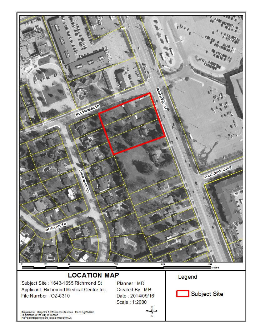
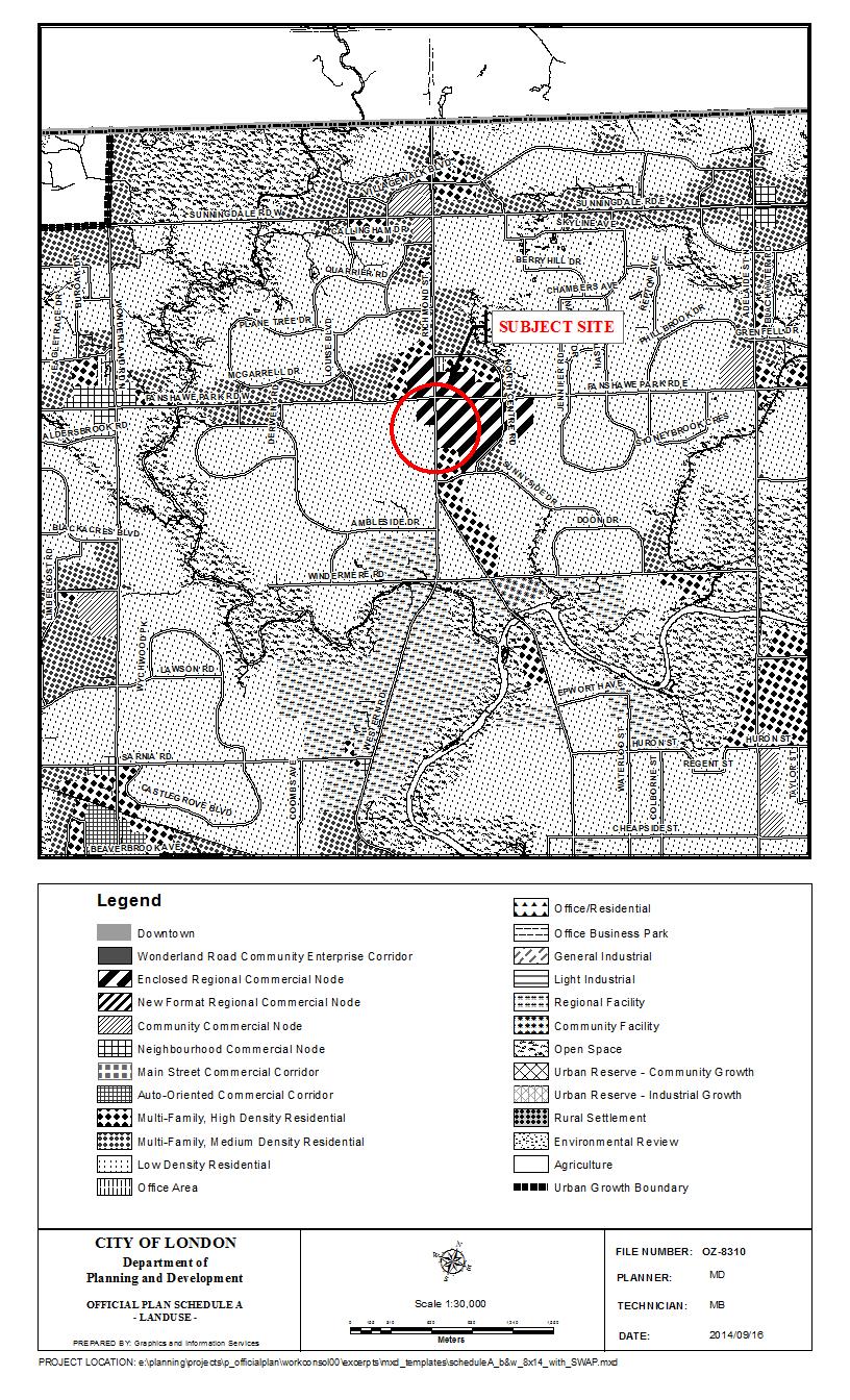
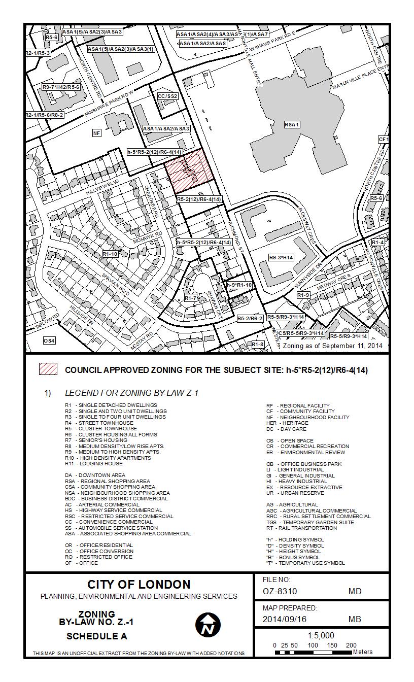
6 SITE CHARACTERISTICS: Current Land Use Single detached dwellings Frontage 70 metres (230 ft.) Depth 85 metres (280 ft.) Area 0.6 hectares (1.5 acres) Shape Rectangular SURROUNDING LAND USES: North TD Bank Branch South Single detached dwellings East Masonville Mall West Single detached dwellings OFFICIAL PLAN DESIGNATION: (refer to Official Plan Map on page 7) Low Density Residential EXISTING ZONING: (refer to Zoning Map on page 8) Holding Residential R5 Special Provision/Residential R6 Special Provision (h-5 R5 2(12)/R6-4(14)) Zone 6
7 7
8 8
9 PLANNING HISTORY In March of 2011, Civic administration received direction from Council, based on communications from Councillor Matt Brown, to report back at a future meeting with respect to a new Official Plan and Zoning By-law framework for the lands including Richmond Street that considers a form and intensity of development that: Is supportive of infill; Is respectful of the character of the corridor and the neighbourhood to the west; Allows for appropriate intensity of use (recognizing the propensity for 5 bedrooms for unit within residential development at this location; Manages and mitigates impacts on the rear yards of development to the west; Manages and consolidates access to avoid impact on Richmond Street; and Provides for a built form and urban design that enhances the Richmond Street corridor and Masonville node. In response to this Council direction, Planning Staff undertook a series of consultation sessions with representatives of the Old-Masonville Community, Mr. Farid Metwaly (owner of lands at 1631, 1635, and 1639 Richmond Street), Civic Administration and the Ward Councillor. The result of these collaborative consultation efforts was a new concept for the future development of the lands including Richmond Street which adds residential intensity toward the Richmond Street corridor and Masonville Node while increasing setbacks from the existing single detached dwellings to the south and west, reducing the number of bedrooms per unit and appealing to a wider mix of residents (see Figure 1 below). Figure 1: Development Concept for Richmond Street On December 12, 2011, Planning Staff presented a series of Official Plan and Zoning By-law amendments to the Planning and Environment Committee to, effectively, implement the development concept resulting from the Council direction and community consultation. These were endorsed by Council on January 10, 2012 but 3 readings of the by-laws were withheld, until such time as site plan approval has been obtained for the properties at 1631, 1635, and 1639 Richmond Street, following a public site plan review, and a development agreement 9
10 entered into with the City of London, which is consistent with the site plan drawings and elevation drawings [presented to Council]. On January 21, 2014, revised Official Plan and Zoning By-law amendments were presented to the Planning and Environment Committee to allow for adoption of the previously considered approvals with holding provisions to provide further assurances as to the ultimate form of development. On January 28, 2014, Municipal Council approved the recommended Official Plan and Zoning By-law amendments which would result in the re-designation of the subject lands to Multi-Family, Medium Density Residential, the adoption of special Official Plan policies to Section 3.5 Policies for Specific Residential Areas of the Official Plan, the adoption of the Richmond Street Old-Masonville Master Plan and Urban Design Guidelines as a guideline document to the Official Plan and the rezoning of the subject properties to allow for the development of multiple attached dwellings such as row houses or cluster houses, low-rise apartment buildings, small scale nursing homes, rest homes, and homes for the aged with a convenience commercial component with holding provisions to ensure development occurs in accordance with the Richmond Street-Old Masonville Master Plan and Urban Design Guidelines. On February 27, 2014, appeals were submitted by McKenzie Lake Lawyers LLP on behalf of Richmond Medical Centre Inc. (owner of 1653 Richmond Street), and Cercelli Law on behalf of Anthony Cercelli (owner of 1609 Richmond Street), in opposition to Municipal Council s decision to approve the Official Plan and Zoning By-law amendments. The appeal documents outline a range of reasons for appeal. With regard to the appeal received from Richmond Medical Centre Inc., it was understood at the time of appeal that the group had concerns about the lack of flexibility the new plan offered for the mix of secondary permitted uses contemplated by Section 3.6 of the City s Official Plan. At the time of appeal, Richmond Medical Centre Inc. had also submitted an application to the City for an Official Plan and Zoning By-law amendment to allow for the development of a small-scale medical/dental office at 1653 Richmond Street. It is important to note that this matter remains before the Ontario Municipal Board and, as such, the Council-approved amendments outlined in the planning history above are not in force and effect. Urban Forestry: No Comment SIGNIFICANT DEPARTMENT/AGENCY COMMENTS Wastewater and Drainage Engineering: The outlet for the subject lands is the 250mm sanitary sewer on Richmond Street. A sanitary inspection manhole is required for the proposed development. Upper Thames River Conservation Authority: No objections to this application Transportation Planning & Design: A transportation impact assessment (TIA) was undertaken in 2012 which included these and land to the south along the Richmond St corridor. This study determined the transportation infrastructure and access requirements for all lands in the study area. Therefore a holding provision for a TIA will not be required. Other significant issues that will be discussed through the site plan review process include road widening dedication, left turn lane requirements on Hillview Blvd, access design and an easement for access for lands to the south through this site. 10
11 Urban Design Peer Review Panel: Initial Review February 2014: The proposed development falls under the City s Richmond Street-Old Masonville Master Plan and Urban Design Guidelines. That document envisages the integrated development of the three separate properties at 1653, 1649 and 1643 Richmond Street. The proposed development under consideration is for 1653 Richmond Street only. Nevertheless, the proponent acknowledged the noted plan and guidelines and proposes a development that could be integrated with the complementary development of 1649 and 1643 Richmond Street assuming either acquisition of those properties or a cooperative property owner/developer. The proposal deviates further from the city plan and guidelines in that it proposes commercial use for the ground floor. A mixed use building at the corner of Richmond St. and Hillview Boulevard relates to the commercial use of the TD Bank site to the north. Ground floor apartments at the Richmond and Hillview corner are not appropriate given the proximity of the two roads and the volume of traffic. Underground parking is proposed in keeping with the city plan and guidelines but surface parking is required still given the proposed use. That parking will serve as a buffer between the street and townhouses called for to the south in keeping with the city plan and guidelines. In light of the above, the Panel offers the following observations and comments regarding the medical office and residential apartment project proposed for 1653 Richmond Street, London, ON: 1. Provide a more prominent and identifiable entrance to the proposed second through fourth floor apartments; 2. Provide a drawing of the building s south elevation confirming the architect s verbal intention to add windows to the proposed elevator lobby; 3. Provide a stronger hard landscape corner treatment in keeping with the scale of the proposed building, its entrances and urban context; 4. Provide appropriate buffer planting to screen the surface parking lot from Hillview Boulevard and the potential townhouses to the south; 5. Delete the westerly access driveway to the surface parking lot thus creating a greater buffer strip adjacent the westerly abutting residential lot. Extensively landscape this buffer; 6. Ensure the building s north and east exterior walls (including fenestration) are appropriately detailed to attenuate the traffic noise from Richmond Street; and 7. Consider juliet balconies for the apartment units facing Richmond Street and Hillview Boulevard. The medical office and residential apartment development proposed for 1653 Richmond Street, London, ON offers a site plan and building form in keeping with the intent of the City of London s Urban Design Principles. Though the development proposal deviates from the city plan and guidelines for the property, the proposed development responds appropriately to the Richmond Street-Old Masonville Master Plan and Urban Design Guidelines provided the design provisions for future connection of this project to the property immediately south of 1653 Richmond Street are realized. Final Review August 2014: The Urban Design Peer Review Panel (UDPRP) appreciated meeting with you and your client on Aug 20, 2014 to discuss your client s proposal for a 5 storey Medical Office/Residential Development at the intersection of Richmond Street and Hillview Boulevard, London, ON. We understand that the Addendum to the Urban Design Brief dated July, 2014 and prepared by Kirkness Consulting Incorporated with graphics by R Ritz Architect forms part of the application for Official Plan Amendment and Zoning Bylaw Amendment. The proposed development consists of medical offices on the ground floor and with this addendum fourteen (14) residential units as opposed to twelve (12) units located on four as opposed to three stories above. The addendum further notes that the project is now proposed 11
12 as a comprehensive development that acknowledges and integrates with the buildings proposed for the two southerly properties of 1643 and 1649 Richmond Street. The Panel offers the following observations and comments as part of the proposed project s official plan amendment and zoning bylaw amendment application: 1. Expand the amount of surface parking by extending the surface parking lot to align with the underground parking below as shown on the 1653 Richmond Site Plan drawing dated July 7, 2014; 2. Partially screen the expanded lot referenced in item 1 from the abutting westerly property by positioning an egress stair from the underground parking west of the proposed surface lot; and 3. Provide a clearer separation of the building s corner element from the top floor. On behalf of the Panel, I thank you for your submission and presentation. In consideration of the above comments, the Panel finds that the Medical Office / Residential development proposed for 1653 Richmond Street, London, ON generally presents a built form on the site in keeping with the intent of the City of London s Urban Design Principles. PUBLIC LIAISON: On August 14, 2014, Notice of Application was sent to 158 property owners in the surrounding area. Notice of Application was also published in the Public Notices and Bidding Opportunities section of The Londoner on August 14, A Possible Land Use Change sign was also posted on the site. Ten (10) replies were received Nature of Liaison: The purpose and effect of this Official Plan and Zoning change is to permit the development of a five (5) storey mixed-use building at 1653 Richmond Street which may contain up to fourteen (14) residential apartment units and up to 430m2 of medical/dental office space, and a 6-storey apartment building and six (6) townhouse dwellings on 1643 and 1649 Richmond Street with the proposed apartment building containing up to 125 apartment units. The proposed development is intended to occur in two phases with the northern phase (Phase 1) comprising 1653 Richmond Street and the southern phase (Phase 2) comprising 1643 and 1649 Richmond Street. The ultimate development of each phase is proposed to be in compliance with a comprehensive conceptual area plan which includes internal driveway connections and shared parking to form a comprehensive development block and limit access points to the adjacent road network. Change the Official Plan land use designation FROM a Low Density Residential designation which permits single detached; semi-detached; and duplex dwellings; rowhousing and other forms of multiple attached housing up to a maximum density of 30 units per hectare TO a Multi-Family, Medium Density Residential designation which permits multiple attached dwellings such as row houses or cluster townhouses, low-rise apartment buildings; and smallscale nursing homes, rest homes and homes for the aged. Possible amendment to the Official Plan to ADD a Special Policy to Section 3.5 (Policies for Specific Residential Areas) of the Official Plan to permit a small-scale medical/dental office within an apartment building, permit the development of multi-unit buildings in the form of apartment buildings and townhouses up to a maximum density of 200 units per hectare across the entire development site with maximum height restrictions ranging from 20 metres along Richmond Street to 9.5 metres along the western portion of the site with special policies generally requiring a 15 metre landscaped open space buffer adjacent to the low density residential neighbourhood to the west and requiring that the lands be developed generally in accordance with the comprehensive site concept plan submitted with the Official Plan and Zoning By-law amendment application. Change Zoning By-law Z.-1 FROM a Holding Residential R5 Special Provision/Residential R6 Special Provision (h-5 R5-2(12)/R6-4(14)) Zone which permits cluster single detached 12
13 dwellings, cluster semi-detached dwellings, cluster duplex dwellings, and cluster townhouse dwellings subject to special zoning provisions which regulate: minimum lot area (0.6 ha.), minimum lot frontage (70m), maximum lot coverage (35%), maximum density (30 units per hectare), maximum height (10.5m), minimum front yard setback (3m), minimum rear yard setback (7.5m) and restricts the location of parking areas TO a Holding Residential R9 Special Provision (h-5 h-55 h-(*) R9-7(*)) Zone for the properties located at 1643, 1649 Richmond Street which would permit cluster townhouses and apartment buildings with sitespecific special zoning provisions which prescribe: a minimum lot frontage (50m); minimum lot area (0.4 ha.); minimum interior side yard setback (3m); and, maximum height (20.0m on the eastern portion and 9.5m on the western portion); subject to holding provisions to ensure that a public site plan meeting is held, future development is consistent with the proposed comprehensive site development concept, and that a traffic impact study be completed prior to site plan approval AND a Holding Residential R9 Special Provision (h-5 h-(*) R9-7(*)) Zone for the property located at 1653 Richmond Street which would permit apartment buildings with site-specific special zoning provisions which prescribe: additional permitted uses (medical/dental offices within an apartment building); maximum gross floor area for medical/dental offices (430m 2 ); minimum lot frontage (20m); minimum lot area (0.16 ha.); minimum interior side yard setback (3m); minimum exterior side yard setback (0m); maximum height (17m); and, medical/dental office parking rate (1 space per 15m2 GFA); subject to holding provisions which ensure that a public site plan meeting is held and future development is consistent with the proposed comprehensive site development concept. The proposed amendments would allow for the construction of a canopy or vestibule within the 15 metre rear yard setback at 1653 Richmond Street in order to shelter the stairway opening which is required to provide a secondary pedestrian exit to the underground parking structure. A range of special zoning provisions included in the proposed Residential R9 Special Provision (R9-7(*)) Zone would apply to the broader Zone boundaries so as to facilitate a comprehensive development which considers the three existing lots, within the block, comprehensively. Such provisions include: maximum density (200 units per hectare); maximum lot coverage (45%), maximum front yard depth (3m), parking rate for residential uses (0.8 spaces/unit), rear yard depth (15m); and, rear yard setback to apartment buildings (50m). The lands under consideration are subject to a pending Official Plan and Zoning By-law amendment, initiated by the City of London, which affects the lands fronting on the west side of Richmond Street between Hillview Boulevard and Shavian Boulevard ( Richmond Street). The pending amendments would result in the adoption of the Old- Masonville Master Plan and Urban Design Guidelines to Section 19.2 Guideline Documents of the Official Plan, the re-designation of the subject lands from Low Density Residential to Multi-Family, Medium Density Residential, and the addition of special Official Plan policies to Section 3.5 Policies for Specific Residential Areas of the Official Plan to provide for the development of multi-unit buildings in the form of apartment buildings, stacked townhouses, or townhouses on the eastern half and townhouses on the western half of the subject lands with densities ranging from 45 units per hectare on the southern portion and gradually increasing to 200 units per hectare on the northern portion of the subject lands and requiring that the lands be developed in conformity with the Master Plan and Urban Design Guidelines. These amendments (OPA 564, OPA 565, OPA 566, Z , Z , Z and Z ) are currently under appeal to the Ontario Municipal Board. Responses: Support Concern Supportive of the proposed architectural design which appears to be high-quality and a good fit for the corner. Concerns regarding existing and potential additional cut-through traffic on Hillview Boulevard to Fanshawe Park Road West. Like the lower height of the proposed building at 1653 Richmond Street. Holding provisions for a public site plan review should remain. 13
14 Not in support of any commercial uses South of Hillview important to uphold the residential nature of properties along Richmond Street, south of Hillview. Original Masonville Plan did not call for medical/dental offices. Many other sites in the area already zoned for medical/dental offices. Critical that 15 metre rear yard buffer remains. Fear this is precedent setting Seven (7) townhouses at the rear is too many should be six. 14

15 ANALYSIS Site Description: The subject site is comprised of three properties, municipally known as 1643, 1649 and 1653 Richmond Street. The site is situated at the southwest corner of the intersection of Richmond Street and Hillview Boulevard, is rectangular in shape, and includes approximately 70 metres of frontage along Richmond Street. The site spans approximately 90 metres of depth, reaching from Richmond Street on the east to an established low density residential neighbourhood to the west. The total area of the subject site is approximately 0.6 hectares (1.5 acres). All three properties within the development site currently accommodate existing single detached dwellings. It is anticipated the existing dwellings would be demolished in a phased manner as potions of the site ultimately develop for more intense land uses. The site is surrounded by a range and mix of land uses with commercial development to the north and east, including Masonville Mall, and low density residential development to the west and south. It is important to note that the lands to the south, along the west side of Richmond Street, are zoned to permit cluster townhouses with site-specific zoning regulations and a holding provision for public site plan review but, to date, have not been developed for such uses. A portion of the existing dwellings have been converted for a mix of home occupation uses. Figure 2: Site Location Note: Location of numbered icons corresponds to vantage point of street level views below. 15


16 Street View: Looking southwest toward site from Richmond St. and Hillview Blvd. Street View: Looking north toward site from Richmond St., south of site. Street View: Looking east along Hillview Blvd., along northern boundary of site. 16
17 Nature of Application: The application from Richmond Medical Centre Inc. would result in changes to both the Official Plan and Zoning By-law Z.-1. The nature of these changes is as follows: 1) Change the Official Plan designation on Schedule A Land Use of the Official Plan from Low Density Residential to Multi-Family, Medium Density Residential. 2) Add a special policy to Section 3.5 Policies for Specific Residential Areas of the Official Plan to permit increases to the scale of development permitted, allow for limited office uses as part of an apartment building, and to ensure a comprehensive development with shared internal connections, driveways and access to abutting streets. 3) Change the zoning on the lands FROM a Holding Residential R5 Special Provision/Residential R6 Special Provision (h-5 R5-2(12)/R6-4(14)) Zone which permits cluster single detached dwellings, cluster semi-detached dwellings, cluster duplex dwellings, and cluster townhouse dwellings subject to special zoning provisions which regulate: minimum lot area (0.6 ha.), minimum lot frontage (70m), maximum lot coverage (35%), maximum density (30 units per hectare), maximum height (10.5m), minimum front yard setback (3m), minimum rear yard setback (7.5m) and restricts the location of parking areas TO a Holding Residential R9 Special Provision (h-5 h-55 h-(*) R9-7(*)) Zone for the properties located at 1643, 1649 Richmond Street which would permit cluster townhouses and apartment buildings with site-specific special zoning provisions which prescribe: a minimum lot frontage (50m); minimum lot area (0.4 ha.); minimum interior side yard setback (3m); and, maximum height (20.0m on the eastern portion and 9.5m on the western portion); subject to holding provisions to ensure that a public site plan meeting is held, future development is consistent with the proposed conceptual block development plan, and that a traffic impact study be completed prior to site plan approval AND a Holding Residential R9 Special Provision (h-5 h-(*) R9-7(*)) Zone for the property located at 1653 Richmond Street which would permit apartment buildings with site-specific special zoning provisions which prescribe: additional permitted uses (medical/dental offices within an apartment building); maximum gross floor area for medical/dental offices (430m 2 ); minimum lot frontage (20m); minimum lot area (0.16 ha.); minimum interior side yard setback (3m); minimum exterior side yard setback (0m); maximum height (17m); and, medical/dental office parking rate (1 space per 15m 2 GFA); subject to holding provisions which ensure that a public site plan meeting is held and future development is consistent with the proposed conceptual block development plan. The proposed amendments would allow for the construction of a canopy or vestibule within the 15 metre rear yard setback at 1653 Richmond Street in order to shelter the stairway opening which is required to provide a secondary pedestrian exit to the underground parking structure. A range of special zoning provisions included in the proposed Residential R9 Special Provision (R9-7(*)) Zone would apply to the broader Zone boundaries so as to facilitate a comprehensive development which considers the three existing lots, within the block, comprehensively. Such provisions include: maximum density (200 units per hectare); maximum lot coverage (45%), maximum front yard depth (3m), parking rate for residential uses (0.8 spaces/unit), rear yard depth (15m); and, rear yard setback to apartment buildings (50m). The proposed Official Plan and zoning changes, as described above, are intended to allow for the development of a five (5) storey mixed-use building at 1653 Richmond Street which may contain up to fourteen (14) residential apartment units and up to 430m 2 of medical/dental office space, and a 6-storey apartment building and six (6) townhouse dwellings on 1643 and 1649 Richmond Street with the proposed apartment building containing up to approximately 95 apartment units. The proposed development is intended to occur in two phases with the northern phase (Phase 1) comprising 1653 Richmond Street and the southern phase (Phase 2) comprising 1643 and 1649 Richmond Street. The ultimate development of each phase is proposed to be in compliance with a conceptual block development plan which includes internal driveway connections and shared parking to form a comprehensive development block and limit 17

18 access points to the adjacent road network. A visual overview of the proposed form of development, as described above, is provided in the Site Plan and Illustrations below. Figure 3(a): Conceptual Block Development Plan Site Plan Figure 3(b): Conceptual East Elevations 18

19 Figure 3(c): 1653 Building Rendering Northeast Elevation Figure 3(d): 1653 Building Rendering Southwest Elevation Provincial Policy Statement, 2014: The Provincial Policy Statement, 2014 (PPS) provides policy direction on matters of provincial interest related to land use planning and development. The objectives of the PPS pertain to three major policy areas including 1.0 Building Strong Healthy Communities, 2.0 Wise Use and Management of Resources, and 3.0 Protecting Public Health and Safety. The PPS is more than a set of individual policies. It is intended to be read in its entirety and the relevant policies are applied to each situation. Section 3 of the Planning Act requires that decisions of any authority affecting planning matters shall be consistent with the PPS. As it relates to the Richmond Medical Centre Inc. application, the PPS provides the following direction. A primary objective of the Province with regard to land use planning, as expressed by the PPS, is to facilitate the efficient use of lands and infrastructure within urban areas. The policies of the 19
20 PPS provide for the efficient use of land and resources in urban areas, primarily by promoting intensification. The PPS defines intensification, in part, as the development of a property, site or area at a higher density than currently exists through development of vacant and/or underutilized lots within previously developed areas. Policy of the PPS states that, Planning authorities shall identify appropriate locations and promote opportunities for intensification and redevelopment where this can be accommodated taking into account existing building stock or areas and the availability of suitable existing or planned infrastructure and public service facilities required to accommodate projected needs. It is worth noting that redevelopment is defined as, the creation of new units, uses or lots on previously developed land in existing communities and infrastructure is defined as, physical structures (facilities and corridors) that form the foundation for development [including] transit and transportation corridors and facilities As indicated above, the PPS (2014), requires that Council promote opportunities for development of new units on previously developed land in existing communities at a higher density that currently exists where it can be accommodated taking into account existing building stock and available infrastructure, including such services as water, sewage, and transit. The recommended Official Plan and Zoning By-law amendments will provide for intensification and redevelopment in a built form which decreases in height and intensity from the eastern half to the western half of the site to, provide for intensity along the Richmond Street corridor and increased setbacks from surrounding single family residential development to the west. Policy states that, Healthy, active communities should be promoted by planning public streets, spaces and facilities to be safe, meet the needs of pedestrians, foster social interaction and facilitate active transportation and community connectivity. In this regard, the recommended amendments will facilitate a form of development that is conducive to alternative modes of transportation including walking, cycling and public transit. The recommended amendments provide for the development of mid-rise apartment buildings and increased residential intensity in close proximity to commercial and personal service uses, along a major transit corridor and adjacent to an existing transit terminal. In addition, the form of construction outlined in the Conceptual Block Development Plan, intended to guide immediate and future phases of development on these lands, requires the proposed apartment buildings to be constructed with active frontages, including a mix of uses with medical/dental offices at 1653 Richmond Street to support active modes of transportation in conformity to the policies of the PPS (2014). Policy (Transportation Systems) of the PPS requires that, A land use pattern, density and mix of uses should be promoted that minimize the length and number of vehicle trips and support current and future use of transit and active transportation. Similarly, policy of the PPS (2014) states that, Transportation and land use considerations shall be integrated at all stages of the planning process. As previously mentioned, one of the primary goals of the recommended amendments is to facilitate a transit-supportive form of development at this strategic location. By providing for intensification and mixed-use development at the Masonville node, within close proximity to transit and commercial services, the recommended amendments serve to contribute to a land use pattern which is supportive of and enhances the viability of higher order transit. Policy (Energy Conservation, Air Quality and Climate Change) of the PPS (2014) requires planning authorities to support energy conservation and efficiency, improved air quality, reduced greenhouse gas emissions and climate change adaptation through land use and development patterns which: promote a compact structure of nodes and corridors; promote the use of active transportation and transit; and improve the mix of employment and housing uses to shorten commute journeys and decrease transportation congestion. As part of the local implementation of this policy, the City of London s 2030 Transportation Master Plan: Smart Moves recommends strategies to assist the City of London and the London Transit Commission (LTC) in meeting a 20% transit modal share target by To achieve 20
21 this objective, the growth management strategies in the Transportation Master Plan encourage directing growth to locations where it supports transit ridership, walking and biking. Such locations include the Downtown Area and planned rapid transit nodes and corridors identified in the 2030 Transportation Master Plan. Masonville Mall has been identified as a Rapid Transit node and Richmond Street as a planned Rapid Transit corridor. Based on a strategic review of ridership potential, both Richmond Street and Western Road, in proximity to the subject lands, have been identified as rapid transit corridors that can be implemented in the short-term. The Growth Strategy stresses the importance of strengthening land use policies around nodes and corridors to focus future high-density development and employment in these areas. The recommended amendments to introduce higher density residential uses with a small-scale office facility on the subject lands represent a land use pattern which supports transit objectives, in conformity with the PPS (2014), at this strategic location. City of London Official Plan: The Official Plan contains Council s objectives and policies to guide the short-term and longterm physical development of the municipality. The policies promote orderly urban growth and compatibility among land uses. While objectives and policies in the Official Plan primarily relate to the physical development of the municipality, they also have regard for relevant social, economic and environmental matters. i) Summary of Changes: Notwithstanding the January 28, 2014 Council-approved Official Plan and Zoning changes summarized in the planning history on pages 9 & 10 of this report, the subject lands are currently designated Low Density Residential on Schedule A Land Use - of the City of London Official Plan. The primary permitted uses in areas designated Low Density Residential include single detached; semi-detached; and duplex dwellings. Low-rise multiple-attached dwellings, such as row houses or cluster houses may also be permitted provided they do not exceed the maximum density of 30 units per hectare. As such, an Official Plan amendment is necessary to facilitate the development of the proposed apartment buildings and provide for a greater mix of uses and residential intensification along the Richmond Street corridor. The proposed amendments, as recommended in this report, will result in these lands being redesignated to Multi-Family, Medium Density Residential on Schedule A Land Use of the City of London Official Plan. This report also recommends the adoption of special Official Plan policies to provide additional and specific guidance for the development of 1643, 1649 and 1653 Richmond Street. The recommended special policies are intended to allow for densities in excess of 75 units per hectare, provide permission for small-scale office development in a mixed-use building format, and require that immediate and future phases of development conform to a conceptual block development plan which includes internal driveway connections, shared parking facilities and coordinated access points to the adjacent road network. The rationale for the recommended re-designation to Multi-Family, Medium Density Residential is outlined in the planning analysis provided below. In general, the subject lands are consistent with the location criteria outlined in Section of the Official Plan for areas designated Multi- Family, Medium Density Residential and the proposed townhouses and mid-rise apartment buildings are consistent with the permitted uses contemplated by Multi-Family, Medium Density Residential policies. With regard to the application by Richmond Medical Centre Inc., the policies of the Multi-Family, Medium Density Residential (MFMDR) designation also permit a range of secondary uses including small-scale offices where certain location and land use compatibility criteria can be met. The restrictions and criteria surrounding small-scale office development in the MFMDR designation are outlined in Section of the Official Plan and analyzed below. These criteria include spatial characteristics as location along an arterial roadway and compatibility criteria regarding sensitivity to adjacent residential land uses. The location of the subject lands along the Richmond Street corridor, directly adjacent to the Masonville Enclosed Regional Shopping 21
22 Centre, as well as the significant setbacks from the low density residential neighbourhood to the west provide a favourable setting. In considering the appropriate land use designation to facilitate the proposed development, regard was also given to the appropriateness of the Multi-Family, High Density Residential designation (MFHDR) wherein the policies contemplate densities in excess of 75 units per hectare. In general, there are many similarities between the permitted uses and location criteria provided by the policies of the MFMDR and MFHDR designations. However, the latter also contemplates the development of high rise apartment buildings and apartment hotels which are not recommended nor considered for the subject lands. Given the more restrictive range of permitted uses, Staff suggest that the Multi-Family, Medium Density Residential designation implements the proposed development and conceptual block development plan, while providing assurances that these lands will be reserved for mid- rise development as opposed to high-rise development in the long term. Additionally, the expressed intent of development within areas designated Multi-Family, Medium Density Residential, as provided by the Official Plan, is to provide for a low-rise form and a site coverage that could serve as a transition between low density residential areas and more intensive forms of commercial, industrial, or high density residential development. The location of the subject lands between the low density residential dwellings of Cherokee Road, the major commercial areas of the Masonville node and the planned Rapid Transit Route along the Richmond Street Corridor provides an opportunity to facilitate a development that implements the intent of the Multi-Family, Medium Density designation by providing a buffer between these uses. ii) Evaluation: Without limiting the applicability of additional policies of the Official Plan, the following sections of the Official Plan provide particularly relevant guidance with respect to Staff s evaluation of the requested amendments: Figure 4: Official Plan policies Applicable Official Plan Policies 3. Residential Land Use Designations 3.3 Multi-Family, Medium Density Residential Locations Scale of Development Residential Intensification 3.5 Policies for Specific Residential Areas Policies for Near-Campus Neighbourhoods 3.6 General Provisions for all Residential Land Use Designations New Office Development The relevant policies, as illustrated in Figure 4 above, have been applied and considered below. Staff s evaluation of the proposal s conformity with those policies generally follows each section. 3. Residential Land Use Designations The City s Official Plan provides three (3) primary residential land use designations. Lands within the residential designations are intended to provide for housing and other land uses which are integral to and supportive of a residential environment. The range of land uses and intensities contemplated by the policies of each designation are differentiated based on physical context of the site, including proximity to services, and the existing character/built context of the neighbourhood. Each designation regulates development through policies on scale, form and intensity. As noted previously, the recommended amendment would result in a re-designation of the subject site from Low Density Residential to Multi-Family, Medium Density Residential. The following objectives and policies provide the evaluative framework for Council to consider in determining the appropriateness of this request: 22
23 3.3.2 Locations (Multi-Family, Medium Density Residential) In addition to areas predominantly composed of existing or planned medium density residential development, the preferred locations for the Multi-Family, Medium Density Residential designation include lands in close proximity to Shopping Areas, Commercial Districts, designated Open Space areas or Regional Facilities; lands adjacent to a Multi-Family, High Density Residential designation; and, lands abutting an arterial, primary collector or secondary collector street. Consideration will also be given to the following criteria in designating lands for Multi-Family, Medium Density Residential uses: i) Development of the site or area for medium density residential uses shall take into account surrounding land uses in terms of height, scale and setbacks and shall not adversely impact the amenities and character of the surrounding area. ii) iii) iv) Adequate municipal services can be provided to accommodate the needs of the development. Traffic to and from the location should not have a significant impact on stable, low density residential areas. The site or area is of suitable shape and size to accommodate medium density housing and to provide for adequate buffering measures to protect any adjacent low density residential uses. The policies of Section of the Official Plan outlined above provide criteria for Council to consider locations which are appropriate to accommodate medium density residential land uses. The Richmond Medical Centre Inc. proposal conforms to these criteria as follows: The subject site is located directly adjacent to a major regional commercial shopping and employment centre, abuts an arterial road planned for future rapid transit, and is planned for medium density residential development in the Council-approved Richmond Street- Old Masonville Master Plan and Urban Design Guidelines. The recommended amendments will ensure that the form of development is such that the highest buildings and greatest intensity is located along the eastern portion of the site, toward Richmond Street and as far as possible from the neighbourhood to the west. Building heights decrease from 20 metres along Richmond Street to 9.5 metres for the townhouses along the rear of the site. Additionally, generous building setbacks have been included in the recommended amendments to provide a landscaped and visual buffer from any new development and the existing low density residential neighbourhood to the west. In this regard, the amendments take into account surrounding uses in terms of height and scale. The proposed development can be serviced by, and will increase the utilization of, existing municipal services and infrastructure. The recommended amendments will provide for a form and intensity which is not anticipated to generate significant additional traffic given the extent of development which would result through the Council-approved Old Masonville Master Plan and Urban Design Guidelines. Notwithstanding, a westbound left turn lane will be constructed along Hillview Boulevard in front of the subject site to help facilitate traffic flow at the proposed site access and minimize impacts on the adjacent road network. The increased rear yard and south interior side yard setbacks provided by the recommended amendments will result in greater separation between the existing built form of the Cherokee Road dwellings and any future townhouse dwellings and also 23
24 increase the potential for the retention of existing mature vegetation between these lands. The potential for preservation of mature vegetation in conjunction with decreased maximum townhouse heights described above serves to enhance these buffering efforts and protect adjacent low density residential uses. Building setbacks are generally in keeping with those recommended through the Richmond Street-Old Masonville Master Plan and Urban Design Guidelines planning process New Office Development As noted previously throughout this report, the application from Richmond Medical Centre Inc. is intended to allow for the development of up to 430m 2 of medical/dental office space within the ground floor of a mixed-use apartment building at 1653 Richmond Street. Although the primary permitted uses within the various residential land use designations are intended to be residential in nature, the policies of Section provide a framework for considering the establishment of offices as secondary uses within the Multi-Family, Medium Density Residential designation. In considering the appropriateness of the proposed amendments to allow for small-scale medical/dental offices on a portion of the subject lands, the policies of the Official Plan require that consideration be given to the following criteria: Small-scale, free-standing office buildings may be permitted as secondary uses in the Multi Family, Medium and Multi-Family, High Density Residential designations, subject to the following provisions: i) Office developments shall be located on an arterial or primary collector road. In established neighbourhoods, office developments will only be permitted in areas where the residential amenity of properties fronting onto the arterial or primary collector road has been substantially reduced. ii) iii) iv) Provision shall be made for landscaping, privacy screening, building setbacks and other appropriate measures necessary to protect the amenity of adjacent residential properties. The proposed building shall be sensitive to the scale and appearance of adjacent residential uses. Proposals for new office developments shall require a Zoning By-law amendment. A Planning Impact Analysis as described in Section 3.7. will be required to determine if the proposed development is appropriate. The Richmond Medical Centre Inc. proposal conforms to the above noted policies regarding the appropriate siting of office development within the Multi-Family, Medium Density Designation as follows: The subject site fronts directly onto Richmond Street which as an arterial street and a future rapid transit line. The residential amenity of a large portion of the existing single detached dwellings along Richmond Street between Hillview Boulevard and Shavian Boulevard has been significantly reduced by the increasing utilization of Richmond Street and its location opposite a major regional shopping centre. Also, the City has previously approved amendments which would allow for mid-rise apartment buildings and residential intensification on these lands. Given the proposed positioning of the buildings and its proximity to the arterial road, the residential amenity of the ground floor of the proposed apartment building at 1653 Richmond Street may be more suited to the proposed medical/dental office use. 24
25 The proposed 430m 2 medical/dental office will be located within the ground floor of an apartment building subject to a conceptual block development plan that includes significant setbacks and a distinct transition in the intensity of the built form as you move from the eastern portion of the lands to the west ensuring sensitivity to the scale and appearance of adjacent residential uses. Additionally, a 15 metre landscaped buffer has been incorporated at the rear of 1653 Richmond Street to provide for the maximum retention of existing mature vegetation and screening which will protect the amenity of adjacent single family homes. The recommended amendments have been considered in the context of the planning impact analysis outlined in Section 3.7 of the Official Plan. In general, the Planning Impact analysis criteria are embedded throughout the land use policies in Section 3 of the Official Plan and strive to achieve compatibility among land uses Residential Intensification Residential intensification refers to the development of a property, site or area at a higher density than currently exists through a variety of means including redevelopment and the development of underutilized lots. The residential intensification policies of the Official Plan strike a balance between encouraging and promoting opportunities for intensification and redevelopment while ensuring that residential intensification proposals are sensitive to, compatible with, and a good fit within, the existing surrounding neighbourhood based on, but not limited to, a review of both the existing and proposed built form, massing and architectural details as outlined in Section of the Plan. The Neighbourhood Character Statement and Compatibility Report submitted by the applicant address the proposal s conformity with the residential intensification criteria provided in Section In general, the following elements (illustrated in figure 5 below) allow for an effective integration of the proposed built form into the existing fabric of the surrounding neighbourhood: The proposed apartment buildings are positioned along the eastern portion of the subject lands, oriented toward Richmond Street. The proposed building heights will decrease as you move from east to west with the greatest heights oriented towards Richmond Street. A maximum of 6-storeys will be permitted along Richmond Street, with a requirement to step down to 5-storeys beyond the first 25 metres of lot depth, with a maximum height of 9.5 metres for the townhouses positioned closest to the existing low density neighbourhood. The recommended amendments provide significant setbacks and buffers from existing low density residential uses to the west. A 15 metre landscaped buffer is required between rear lot lines and the future townhouses while a 50 metre setback is required for the proposed apartment buildings. These setbacks provide a significant visual separation and will allow for maximum retention of existing mature vegetation located along the westerly lot line. The maximum number of townhouse dwellings permitted per block has been capped at 4 in order to reduce the visual mass of housing forms closest to the existing residential neighbourhood to the west. The recommended amendments serve to minimize the ability for surface parking which will allow for greater landscaping coverage and a more pedestrian oriented character. 25


26 Figure 5: Illustrated Site Plan 17M Height 15M 15M Height 50M 20M Height 15M Height 18. Transportation The Transportation policies contained in Section 18 of the Official Plan deal with the various elements of the transportation system in the City of London. The Official Plan recognizes that the transportation system provides a major part of the framework for urban growth and development and influences the function and compatibility of land uses and the quality of life in the City. These policies are intended to guide future public investment in the development of transportation facilities and also provide guidance for aligning land use decisions with transportation priorities. The objectives of the Transportation policies of the Official Plan promote land use planning that is conducive to the efficient operation and increased use of the public transit system and alternative modes of transportation. In order to implement these objectives, the policies of Section of the Official Plan require that Council shall support the long-term development of compact, transit-oriented and pedestrian friendly activity centres at identified nodes and corridors. The Downtown and the Transit Nodes and Transit Corridors identified on figure 18.1 of the Official Plan (see Figure 6 below) and in the City s 2030 Transportation Master Plan, are target areas for growth, redevelopment and revitalization. Additional policies that support the recommended amendments and, in general, growth, redevelopment and revitalization include the following: In the review and evaluation of development proposals located along identified transit nodes and corridors Council will discourage site-specific Official Plan amendments and site-specific Zoning By-law amendments which propose a lower intensity of use where a higher intensity of use has been planned to support compact urban form, discourage sprawl, and provide for efficient infrastructure and transportation. 26
 for full-size buses and/or HOV lanes will be discouraged The above noted")
27 Residential intensification will be encouraged adjacent to Transit Nodes and along Transit Corridors. Development or corridor improvements which may hinder the usage of the Transit Corridors identified in Figure 5 (below) for full-size buses and/or HOV lanes will be discouraged The above noted policies articulate the importance of establishing a system of nodes and corridors to encourage transit supportive development and to provide for density and land use patterns in locations which enhance the viability of higher order public transit, including bus rapid transit, in the future. As illustrated in Figure 5 below, Masonville Mall, located directly east of the subject lands, has been identified as a Transit Node where the policies support the longterm development of compact, transit oriented and pedestrian friendly activity centres. In addition, the subject lands directly abut Richmond Street which has been identified as a Transit Corridor in the Official Plan, and are in close proximity to Fanshawe Park Road West and Western Road which are also identified as Transit Corridors in the Official Plan. Given the location of the subject lands adjacent to an identified Node, directly abutting an identified Transit Corridor, and in proximity to two additional Transit Corridors, the recommended amendments, which seek to intensify the subject lands by facilitating the development of multi-unit buildings in the form of apartment buildings, cluster stacked townhouses, and cluster townhouses, are supported by the objectives of Transportation policies of the Official Plan. Figure 6: Transit Nodes and Corridors Section 18.1 of Official Plan Subject Lands Policies for Near Campus Neighbourhoods The policies contained in Section 3.5 of the Official Plan provide special policy direction for land use and development in specific residential areas. The subject lands are located within the Near-Campus Neighbourhood as identified by the Official Plan. In general, the policies relating to Near Campus Neighbourhoods outlined in section are intended to facilitate intensification at strategic locations along transit corridors and nodes, in higher intensity forms of 27
28 housing including mid-rise and high-rise apartment buildings and discourage intensification and residential intensity in the interior of primarily single family neighbourhoods. Specifically, Section contains guidance for Council in considering the appropriateness of intensification proposals with regard to location and form. Section provides that Appropriate locations are those areas within Near-Campus Neighbourhoods that are designated Multi-Family, Medium Density Residential and Multi-Family, High Density Residential that are located along arterial roads and serviced by public transit. Additional areas may be identified for higher density forms of housing through an Official Plan and Zoning By-law amendment process. These proposals will be approached in a coordinated and comprehensive fashion, rather than on a site-specific basis. The foregoing planning analysis has identified the subject lands as an appropriate location for the Multi-Family, Medium Density Residential designation. The recommended amendments will facilitate residential intensification along Richmond Street, an arterial road and future rapid transit corridor, in the form of mid-rise apartment buildings. The recommended amendments, in conjunction with the proposed Conceptual Block Development Plan require a coordinated and comprehensive approach to the future development of these lands including internal access and driveways. Given the location of the subject lands and the form of development contemplated through the recommended amendments, the recommended amendments are supported by the objectives of the Policies for Near Campus Neighbourhoods. 3.5 Policies for Specific Residential Areas Section 3.5 (Policies for Specific Residential Areas) states that, The provisions in this Section apply to specific areas where it is appropriate to address development opportunities, and constraints through specific policies that provide additional guidance to the policies contained in the various residential land use designations. Given the prominent location of the subject site, and Council s intention for these lands as was generally endorsed through the Richmond Street- Old Masonville Master Plan, it is recommended that a special policy be added to Section 3.5 of the Official Plan to provide additional guidance than that contained in the policies outlined in Section 3.3 of the Official Plan for the Multi-Family, Medium Density Residential Designation. Scale: In addition to the permitted uses policies and location criteria evaluated previously in this report, Section of the Multi-Family, Medium Density Residential policies provides a framework which guides the scale of development permitted in the designation. Specifically, Section ii) provides that, Normally height limitations will not exceed four storeys and that Medium density development will not exceed an approximate net density of 75 units per hectare (30 units per acre). As outlined throughout this report, the recommended amendments are intended to facilitate the development of mid-rise apartment buildings with height limitations of up to six storeys and densities of up to 200 units per hectare. The planning analysis provided in previous sections of this report demonstrates the appropriateness of the proposed development. Given the prominent location of the lands along an arterial roadway, adjacent to a major regional shopping and employment centre, and a future rapid transit node, it is appropriate to allow for an increased density. In fact, the spatial characteristics of the subject lands are consistent with the location criteria provided in Section 3.4 of the Official Plan for the Multi- Family, High Density Residential designation which lends further rationale for increased residential intensity. The application of the Medium Density designation will provide an appropriate policy framework to guide the development of mid-rise apartment buildings and townhouses, while the special policies will give guidance for increased density (200 units per hectare) and height (6-storeys) recognizing the Official Plan objectives relating to intensification along future rapid transit corridors and nodes. Mixed-Use: Also of significance to the Richmond Medical Centre Inc. (RMCI) application, Section of 28
29 the Official Plan provides a framework for considering the establishment of offices as secondary uses within the Multi-Family, Medium Density Residential designation. In general, the policies allow for the development of small-scale office uses subject to a range of compatibility and location criteria analyzed in previous sections of this report. However, the preamble to Section describes that free-standing office buildings may be permitted as secondary uses. The recommended special policy would allow for the development of a small-scale office within a mixed-use apartment building as opposed to the free-standing format contemplated in the more general policies of Section The use of a special policy is appropriate in this circumstance given that the mixed-use building format is preferable to a standalone office building at this prominent location, and that the residential amenity of the ground floor apartments at 1653 Richmond Street could be compromised by high traffic activity at this corner. It is also appreciated that the PPS encourages a mixing uses to support active transportation and reduce the necessity of automobile trips. Comprehensive Development: Lastly, in addition to the wide range of principles established for the subject lands through the Council-approved Richmond Street-Old Masonville Master Plan regarding the form and intensity of development, it was intended and planned that development would occur in a comprehensive manner with shared internal connections, consistency in built form, and limited common access points to minimize impacts on the adjacent road network and properties. In order to ensure that these lands develop in a comprehensive manner, as was intended through the Councilapproved Richmond Street-Old Masonville Master Plan and is currently implemented through a 70 metre frontage requirement in the zoning by-law, it is recommended that special policies be added to Section 3.5 that require the preparation of a conceptual block development plan to guide immediate and future phases of development on these lands. Summary: The recommended special policies for the subject lands will permit densities of up to 200 units per hectare, building heights of up to 6-storeys, a small-scale medical/dental office within a mixed use building and generally implement the principles surrounding comprehensive development established through the Council-approved Richmond Street-Old Masonville Master Plan. The recommended special policies generally include: For the lands located at 1653 Richmond Street, the permitted uses shall include apartment buildings and small-scale medical/dental offices within the ground floor of an apartment building. For the lands located at 1643, 1649 and 1653 Richmond Street Notwithstanding the height and density maximums identified in the general Multi-Family, Medium Density Residential policies, a maximum density of 200 units per hectare and a maximum height of up to 6-storeys shall be permitted for apartment buildings subject to the regulations of the Zoning By-law. The development of these lands will occur in a comprehensive manner wherein internal driveway connections are required to connect various phases of development and redevelopment. Mutual access to underground parking facilities shall be provided to properties within this block to connect various phases of development. Mutual access to Hillview Boulevard shall be provided through these properties for the benefit of all of the subject properties identified in this special policy as well as all properties located south of the subject lands. Applications for Zoning By-law amendments will require the submission of a comprehensive area plan which includes a site plan and conceptual building elevations, which conforms to the policies of this Section. Holding provisions may be utilized to secure a development agreement which ensures that the ultimate form of development be consistent with the conceptual area plan. 29

30 Old Masonville Richmond Street Master Plan and Urban Design Guidelines: As outlined in the planning history section (page 9 & 10) of this report, in January of 2014, City Council approved a series of Official Plan and Zoning By-law amendments which were intended to facilitate a comprehensive development for the lands on the West side of Richmond Street generally stretching from Hillview Boulevard in the north to Shavian Boulevard at the south. These amendments were the result of a collaborative planning process between a range of stakeholders including neighbours, the community association, the ward councillor, Mr. Farid Metwaly and Planning Staff. In general, these amendments were intended to facilitate the development of cluster townhouses on the western portion of the corridor, where the lands are adjacent to the existing single family neighbourhood and mid-rise apartment buildings on the eastern portion of the lands oriented towards Richmond Street. It is important to recognize, that these amendments were the result of co-operation amongst many parties and were driven, largely, by neighbourhood displeasure with the form of development which could result from the existing townhouse zoning on the subject lands. Due to the appeals of the City-initiated amendments, the townhouse zoning continues to exist on this corridor, including the subject site. In general, the intention of the applicant through this planning process has been to generally mimic the land uses permissions which were established through the appealed Richmond Street-Old Masonville Master Plan and Urban Design Guidelines while allowing for some additional flexibility for mixed-use by providing 430m 2 of medical/dental office space on the ground floor of an apartment building, and allowing for a phased development to occur. With regard to the Richmond Medical Centre Inc., application, Staff have reviewed it s conformity with the Official Plan principles and zoning permissions granted through the previous process. The following graphics and analysis highlight the key similarities and differences. Noting that, the Old-Masonville Master Plan is not in force and effect and remains the subject of an appeal to the OMB, in part, for the reason that it restricts secondary land uses on 1653 Richmond Street, whereas small-scale offices are normally permitted in the Multi-Family, Medium Density Residential designation if the policies of Section are satisfied. Graphic Comparison: Figure 7: Conceptual rendering of the Richmond Street-Old Masonville Master Plan 30
31 1643, 1649 & 1653 Agenda Item # Page # Figure 7(b): Site Plan Richmond Street-Old Masonville Master Plan 31
32 Figure 8(a): Rendering Proposed Development at 1653 Richmond Street (Phase 1) Figure 8(b): Conceptual Block Development Plan (1643, 1649 & 1653 Richmond Street) Phase 2 Phase 1 32

33 Figure 8 (c): Conceptual Block Development Plan East Elevation (1643, 1649 & 1653 Richmond Street) Phase 2 Phase 1 Principles: As summarized above, the completion of the Council-approved Richmond Street-Old Masonville Master Plan and Urban Design Guidelines was the result of a collaborative planning process with extensive input from a wide range of stakeholders including the community, ward councillor, interested landowners, and City Staff. Through this process, a number of principles were established, and further, embedded within special Official Plan policy to provide an overarching guiding framework for the future development of the lands on the west side of Richmond Street between Hillview Boulevard and Shavian Boulevard. The following chart provides an overview of those principles and an evaluation of the Richmond Medical Centre Inc. proposal s consistency with those principles. Table 1: Comparative Analysis Richmond Street-Old Masonville Principles Increasing setback distances from low density residential areas to the west and south of the subject lands to provide for enhanced buffering opportunities. Facilitating appropriate intensity by establishing a cap on the number of bedrooms at 3 per dwelling unit. Apartment buildings shall be required to include a mix of 1, 2, and 3 bedroom units. Mitigation of impacts onto the surrounding established low density residential neighbourhood by lowering the maximum height of townhouse dwellings and restricting the above-grade height of basements through the use of zoning Proposed amendments for Richmond Medical Site The building setbacks from the low density areas to the west are consistent with those recommended through the Council-approved Old Masonville Zoning with a minimum 15 metre setback to townhouses and 50 metre setback to apartment buildings. The Near-Campus Neighbourhoods policies and zoning by-law refinements have established a cap of three bedrooms for residential development on the subject lands. The proposed development is intended to include a mix of dwelling sizes. As with the original plan, townhouse heights within the recommended amendments have been limited to 9.5 metres, as opposed to the 10.5 metre heights permitted by way of the existing zoning. Similarly, the above grade height of basements has been restricted to 33
34 regulations. Implementing a mix of at-grade and belowgrade parking to provide opportunities for more landscaped open space. Abovegrade parking decks shall not be permitted. Below-grade parking shall be utilized in the development of the properties located at 1631, 1635, 1639, 1643, 1649, and 1653 Richmond Street in the event that parking requirements cannot be provided at grade without an accompanying reduction in the lot coverage and/or landscaped open space coverage regulations. Apartment buildings shall be oriented toward the Richmond Street corridor as well as Hillview Boulevard along the northern perimeter. Front yard depths from the apartment buildings to Richmond Street and Hillview Boulevard shall be minimized. Decreasing the height of the buildings from east to west and from north to south such that the greatest heights shall be located at the northern and eastern portions of the subject lands with lower heights along the western and southern portion of the subject lands. Retaining existing vegetation and providing for dense landscaping to maximize privacy between the subject lands and the abutting low density residential properties to the west and south. Limiting the number of townhouse dwellings to four per block to break up the visual massing. Require the comprehensive development of these lands through the use of internal driveway access and limited mutual access points. 0.5 metres. The proposed development will rely primarily on underground parking in order to maintain the same coverage and preserve all setbacks and buffers that formed part of the Councilapproved Richmond Street-Old Masonville Plan. As with the Council approved plan, the proposed apartment buildings are oriented towards Richmond Street, with a minimum setback of 50 metre required to the rear property line where the site abuts the low density residential neighbourhood to the west. The recommended amendments provide for 0m setbacks from the front and exterior lot lines along Richmond Street and Hillview Boulevard. Building heights gradually decrease from east to west across the subject site to provide transition. The greatest height and intensity is oriented toward Richmond Street and the lower heights and built form along the western portion of the site. As with the Council-approved Master Plan, the 15 metre rear yard setback has been maintained in order to maximize opportunities for the retention of existing mature vegetation. Townhouse blocks have been limited to 4 per block through the recommended zoning regulations. The proposed site plan further limits townhouse blocks to 3 per block. The recommended Official Plan amendment requires that a comprehensive block development plan be prepared in consideration of a zoning by-law amendment for the subject lands. Further, the policies require the owner(s) to enter into an agreement with the City of London to ensure that future development of lands within the block conforms to the provisions outlined in the comprehensive block development plan and which shall include the requirement for shared internal driveways linking properties within the block, and to the south of the block, and mutual shared access points to the 34
35 adjacent road network. Key Similarities: Form: As noted in figures 7 (a)-(b) above, the City initiated application intended that the subject lands would be developed for mid-rise apartment buildings along the eastern portion of the subject lands and townhouses along the western portion. The Richmond Medical Centre Inc. application proposes the same form of development as was contemplated through this process. With regard to urban design, it has been established through the review process that the proposed mixed-use apartment building at 1653 Richmond Street, as presented, is generally in keeping with the urban design guidelines relating to built form which were articulated in the Council-approved Richmond Street-Old Masonville Master Plan and Urban Design Guidelines. The building illustrations have been included in the comprehensive block development plan which will guide the future development of these lands including any immediate or future phases of development. A holding provision has been recommended to ensure that the proposed site plan is consistent with these drawings and a public site plan meeting is held prior to its removal. Height: The Old Masonville Master plan set height limitations based on the principle that building heights would decrease from east to west across the site with the greatest building heights oriented toward Richmond Street. In this regard, the height restrictions established in the Old Masonville Master Plan have been included in the zoning regulations for 1643 and 1649 Richmond Street. These height restrictions allow for a 6-storey height along Richmond Street, for the first 25 metres of lot depth, a maximum height of 15 metres beyond the first 25 metres of lot depth, and then a max height of 9.5 metres for townhouses at the rear of the property. Since the plans for 1653 Richmond Street only contemplate the development of a single apartment building, the height restrictions have been limited to 17 metres as has been proposed through the application. This represents a further reduction to the building height. Density: The Old Masonville-Richmond Street Master Plan and Urban Design Guidelines allowed for a net density of up to 200 units per hectare within the block including 1643, 1649 and 1653 Richmond Street. The recommended amendments also allow for a net density of up to 200 units per hectare meaning there will be no increase through the approval of these most current amendments. 15 Metre Rear Yard Setback: A major principle established through the Richmond Street-Old Masonville Master Plan and Urban Design Guidelines was the preservation of a 15 metre buffer from the rear lot lines so as to provide a significant measure of visual separation from adjacent single family homes and also allow for maximum retention of existing mature vegetation along the property line. In this regard, a 15 metre landscaped buffer is also required in the recommended amendments. A minor exception has been recommended so as to allow for the construction of a vestibule to shelter a secondary pedestrian exit to the underground parking structure at 1653 Richmond Street. The secondary exit is required under the Ontario Building Code. Key Differences: Permitted uses at 1653: The Richmond Medical Centre Inc. application would allow for a small-scale (430m 2 ) medical/dental office on the ground floor of an apartment building at 1653 Richmond Street. The inclusion of small-scale office uses are permitted by the general policies of Section within the Multi-Family, Medium Density Residential designation as a secondary use and will serve to provide a more active interface with the pedestrian realm on Richmond and Hillview. The applicants have demonstrated that through the incorporation of significant proportion of 35
36 underground parking, the site can accommodate the additional parking that is required to support the use while not undermining the ability of the block to achieve the density that was secured through the Old-Masonville Planning process. Phasing: Further, the previous by-law included provisions which required the consolidation of 3 properties (1643, 1649 and 1653 Richmond Street) prior to development occurring. The Richmond Medical Centre Inc. application would allow for development to occur in phases such that the proposed apartment building and office at 1653 Richmond could develop in isolation with future phases providing for the additional residential apartment buildings. As part of the application, Richmond Medical Inc. has tabled a conceptual block development plan demonstrating how the block could develop and redevelop comprehensively over time. The proposed special official plan policies include provisions that allow the City to enter into an agreement with the owner of the lands such that any future or subsequent phases of development would need to conform to the block development plan and include measures that ensure the ultimate block forms a comprehensive development both in form and in function. In general, Staff view this proposal as a reasonable planning solution that will achieve the objectives outlined in the Richmond Street-Old Masonville Master Plan and intended by the 70 metre frontage requirement on in the existing zoning. Zoning By-law Z.-1: The recommended Zoning By-law amendment would change the zoning on the subject lands from a Holding Residential R5 Special Provision/Residential R6 Special Provision (h-5 R5-2(12)/R6-4(14)) Zone, to Holding Residential R9 Special Provision (h-5 h-55 h-(*) R9-7(*)) Zone and a Holding Residential R9 Special Provision (h-5 h-(*) R9-7(*)) Zone. Residential R9 Zone: Section 13.1 General Purpose of the Residential R9 Zone of Zoning By-law Z.-1 describes the rationale behind the Residential R9 zone variations. This section simply states that, The R9 Zone provides for and regulates a wide range of medium and higher density residential developments in the form of apartment buildings. As noted throughout this report, the intent of the Richmond Medical Centre Inc. application is to allow for the development of mid-rise apartment buildings along Richmond Street. As such, the Residential R9 Zone provides the most appropriate framework to guide the future development of these lands. Special Regulations: Further to the zoning framework established by the standard regulations of the R9 zone, a range of special regulations have been recommended in order to implement the Special Official Plan policies which provide for a greater scale of development, a mix of uses, and a comprehensive development with buildings height and intensity oriented toward Richmond street, significant buffers from the low density residential area to the west and ensuring shared internal connections. The following summary provides an overview of the purpose, intent and rationale for the various special regulations: Part a) of the special regulations provides a series of block-wide special zone standards that are intended to apply to the R9-7(*) Zone boundaries as a whole. Regulations outlined in part a) that apply to the zone boundaries included density (200 units per hectare), lot coverage (45%), front yard depth (3m max.), rear yard depth (15m) and parking requirements for residential uses (0.8 spaces/unit). These regulations allow for flexibility in the floorplates and intensity of various buildings which may develop in phases within the block, without requiring that lots be consolidated to allow for this type of flexibility. It will ensure that the ultimate development of these properties in considered comprehensively, much in the same way they would be considered if all three properties were to be consolidated under single ownership. 36
37 Part b) of the special regulations provides a series of site-specific regulations that apply only to 1643 and 149 Richmond Street. These regulations include permission for cluster townhouses in addition to the apartment buildings permitted by the R9 Zone. Further use specific regulations for the height and location of townhouses and apartment buildings will provide for a form of development which is consistent with that envisioned through the Council-approved Richmond Street-Old Masonville Master Plan. Part c) of the special regulations provides a series of site-specific regulations for 1653 Richmond Street. These regulations allow for the proposed small-scale medical dental office in a mixed use apartment building and include similar regulations regarding the form of apartment buildings to ensure that the development is generally consistent with that envisioned through the Council-approved Richmond Street-Old Masonville Master Plan. Holding provisions: Both an h-5 holding provision and an h-(*) have been included in the recommended zoning for all three properties within the development block. These holding provisions will ensure that a public site plan review is conducted and that the ultimate built form is consistent with the comprehensive block development plan submitted and vetted publically through the Official Plan and Zoning By-law amendment process. Similar holding provisions were approved by Council for these lands in the January 2014 amendments. Additionally, an h-55 holding provision has been recommended for the Phase 2 lands at 1643 and 1649 Richmond Street. Recognizing the variability in terms of timing between current and subsequent phases of development, the h-55 holding provision will ensure that a traffic impact study is completed prior to site plan approval for Phase 2. CONCLUSION The recommended amendments have been supported by the foregoing planning analysis. The proposal has been evaluated in the context of the applicable land use policy and is supported by the objectives of the Provincial Policy Statement, 2014 and the City of London Official Plan which promote intensification, redevelopment and compact form in appropriate locations, particularly in areas which support existing and future transit, in order to minimize land consumption and servicing costs across the municipality and provide for a range of housing types and densities to meet the needs of current and future residents. The recommended amendments will facilitate a built form which, through strategic building siting, transition in height and intensity, and significant setbacks and vegetated buffers, is sensitive to its location adjacent to a low density residential neighbourhood. The proposed development design orients the apartment buildings and office uses toward Richmond Street to provide maximum visual separation from adjacent single family homes and serve the planned function of medium density development as a buffer between the future rapid transit line and Masonville mall and the neighbourhood to the west. Further, the proposed development will produce a design which supports the City s Urban Design Principles outlined in Section 11 of the Official Plan, particularly with regard to providing a street oriented development that sets a positive context for pedestrian activity along this portion of Richmond Street and Hillview Boulevard. The recommended special policies will allow for increased residential density and height as well as providing opportunity for a small-scale office use within the ground floor of an apartment building. This form of development supports active transportation while balancing the issues of compatibility with the adjacent residential neighbourhood. Road improvements including a westbound left turn lane will be added through the site plan approval process in order to minimize the impact from any additional traffic entering and leaving the site. The applicants have maintained a form which is generally consistent with that envisioned by the 37
38 Council-approved Richmond Street-Old Masonville Master Plan and Urban Design Guidelines and maintains the principles which were established through the planning process. Given the foregoing, the recommended amendments represent sound land use planning. PREPARED BY: SUBMITTED BY: MIKE DAVIS, B.U.R.Pl. PLANNER ll, CURRENT PLANNING MICHAEL TOMAZINCIC, MCIP, RPP MANAGER, CURRENT PLANNING RECOMMENDED BY: JOHN M. FLEMING, MCIP, RPP MANAGING DIRECTOR, PLANNING AND CITY PLANNER September 29, 2014 Mike Davis Y:\Shared\implemen\DEVELOPMENT APPS\2014 Applications 8309 to\8310oz Richmond St (MD)\OZ OPA-ZBL Amendment Report (Final).docx 38
39 Responses to Public Liaison Letter and Publication in The Londoner *Copies of all written correspondence is available for review upon request citing file OZ Telephone Myrna McDermid 29 Cherokee Road Judy Siskind N/A Written Elizabeth Harris 36 Cherokee Rd. Mary Lake-Collins 1603 Richmond Street Bill Davis Old Masonville Ratepayers Association 25 Cherokee Rd. Lin Hardick 39 Cherokee Rd. Clint Wilson 45 Cherokee Rd. Geoff & Jane Dilworth N/A Sarah Poole 51 Shavian Boulevard Jane Lowman 1650 Hillside Drive 39
40 Bibliography of Information and Materials OZ-8310 Request for Approval: City of London Official Plan and Zoning By-law Amendment Application Form, completed by Kirkness Consulting Inc., December 30, 2013 Reference Documents: Ontario. Ministry of Municipal Affairs and Housing. Planning Act, R.S.O. 1990, CHAPTER P.13, as amended. Ontario. Ministry of Municipal Affairs and Housing. Provincial Policy Statement, City of London. Official Plan, June 19, 1989, as amended. City of London. Zoning By-law No. Z.-1, May 21, 1991, as amended. Kirkness Consulting Inc. Planning Justification Report, February Kirkness Consulting Inc. Urban Design Brief, February Kirkness Consulting Inc. Addendum to Planning Justification Report and Urban Design Brief, July 2014 R Ritz Architects. Site Concept Plan, September Correspondence: (all located in City of London File No. Insert File No. unless otherwise stated) City of London Postma R., Urban Forestry. to M. Davis, August 28, Couvillon A., Transportation Planning and Design. to M. Davis, August 28, Moore R., Wastewater & Drainage Engineering. to M. Davis, August 15, Departments and Agencies - Creighton C., UTRCA. Memo to M. Davis. September 2, Ries S., Urban Design Peer Review Panel. Memo to M. Davis, February 19, Ries S., Urban Design Peer Review Panel. Memo to M. Davis, August 20, Other: Site visit September 9, and photographs of the same date. 40
41 Appendix "A" Bill No. (number to be inserted by Clerk's Office) 2014 By-law No. C.P A by-law to amend the Official Plan for the City of London, 1989 relating to 1643, 1649 and 1653 Richmond Street. follows: The Municipal Council of The Corporation of the City of London enacts as 1. Amendment No. (to be inserted by Clerk's Office) to the Official Plan for the City of London Planning Area 1989, as contained in the text attached hereto and forming part of this by-law, is adopted. 2. This by-law shall come into effect in accordance with subsection 17(38) of the Planning Act, R.S.O. 1990, c.p.13. PASSED in Open Council on October 14, J. Baechler Mayor Catharine Saunders City Clerk First Reading October 14, 2014 Second Reading October 14, 2014 Third Reading October 14,
42 AMENDMENT NO. to the OFFICIAL PLAN FOR THE CITY OF LONDON A. PURPOSE OF THIS AMENDMENT The purpose of this Amendment is to change the designation of certain lands described herein from Low Density Residential to Multi-Family, Medium Density Residential on Schedule A Land Use to the Official Plan for the City of London, and to establish a Special Policy in Section 3.5 Policies for Specific Residential Areas of the Official Plan for the City of London to facilitate a comprehensive, transit-supportive development on the subject lands with opportunity for increased scale and mixed-use development through specific policies that provide additional guidance to the general policies contained in the Official Plan. B. LOCATION OF THIS AMENDMENT This Amendment applies to lands located at 1643, 1649 and 1653 Richmond Street in the City of London. C. BASIS OF THE AMENDMENT The primary permitted uses in the Multi-Family, Medium Density Residential designation include multiple attached dwellings, such as row houses or cluster houses; low-rise apartment buildings; and small-scale nursing homes, rest homes and homes for the aged. Additionally, limited office uses are permitted as secondary permitted uses subject to the general policies of Section These permitted uses are generally consistent with those recommended throughout this report. The policies state that the preferred locations for the Multi-Family, Medium Density Designation include lands within close proximity to Shopping Areas, and lands abutting an arterial roadway. In this regard, the physical context of the subject site aligns with the locational criteria for the Multi-Family, Medium Density designation. The general Multi-Family, Medium Density Residential policies of the Official Plan include policies related to the scale of development permitted within the designation as well as permitted uses. These policies provide for maximum building heights of four storeys and net densities of 75 units per hectare. The permitted uses policies allow for small-scale office uses within stand-alone buildings subject to certain location and compatibility criteria. The form of development proposed for the subject lands contemplates height limitations ranging from 3-6 storeys and densities of up to 200 units per hectare as well as an opportunity for small-scale medical/dental offices within the ground floor of an apartment building. Notwithstanding the general restrictions, the Multi-Family, Medium Density Residential policies permit modifications to the scale of development and form of permitted uses to meet specific policy objectives, such as the implementation of a comprehensive development plan and urban design guidelines envisioned for the subject lands, where these policy objectives are identified in Section 3.5 of the Official Plan. Given that the development proposed for the subject lands is consistent with the intent of the Multi-Family, Medium Density Residential policies, as it relates to permitted uses and location adjacent to a future rapid transit node, and the built form is sensitive to the existing context of the area by orienting the greatest heights toward Richmond Street with transition and significant setbacks to the low density residential neighbourhood to the west, it is appropriate to provide special development policies which allow for additional height and density as well as limited opportunity for mixed-use development while requiring a 42
43 comprehensive approach to the development of the subject lands. D. THE AMENDMENT The Official Plan for the City of London is hereby amended as follows: 1. Schedule A Land Use to the Official Plan for the City of London is hereby amended by designating those lands located at 1643, 1649 and 1653 Richmond Street in the City of London, as indicated on Schedule 1 attached hereto, from Low Density Residential to Multi-Family, Medium Density Residential. 2. Section 3.5 Policies for Specific Residential Areas of the Official Plan for the City of London is amended by adding the following: 1643, 1649 and 1653 Richmond Street: The subject lands are located on the west side of Richmond Street, south of Hillview Boulevard, including the lands that are municipally known as 1643, 1649 and 1653 Richmond Street. These lands are situated along an important gateway into the City of London from the north, along a future rapid transit corridor, and are adjacent to Masonville Mall, a regional activity and employment centre. Given the prominent location of the subject lands, it is desirable to increase the scale of development and range of uses permitted on these lands. It is intended that the following site-specific policies will facilitate the development of an aesthetically pleasing, functional and transit-supportive development which simultaneously preserves the residential amenity of the abutting low density residential lands to the west. A limited amount of medical/dental office space within a mixed-use building may be provided to service surrounding neighbourhoods and provide an effective pedestrian oriented interface with the corner of Richmond Street and Hillview Boulevard. Future development of these lands shall be generally in accordance with a conceptual block development plan developed in support of a Zoning By-law amendment application which meets the general intensification criteria outlined in Section and the Urban Design Principles outlined in Section 11 of the Official Plan as well as the following sitespecific policies: a) For the lands located at 1643 and 1649 Richmond Street, the permitted uses shall include cluster townhouses and apartment buildings. For the lands located at 1653 Richmond Street, the permitted uses shall include apartment buildings and small-scale medical/dental offices up to a maximum gross floor area of 430m 2 within the ground floor of an apartment building. For the lands located at 1643, 1649 and 1653 Richmond Street, the location of apartment buildings shall be restricted to the eastern portion of these properties, thereby locating the maximum heights and densities away from the existing single detached dwellings to the west. b) Notwithstanding the height and density maximums identified in the general Multi-Family, Medium Density Residential policies, a maximum density of 200 units per hectare and a maximum height of up to 6-storeys shall be permitted for subject to the regulations of the Zoning By-law. c) The development of the subject lands will occur in a comprehensive manner wherein internal driveway connections are required to connect various phases of development and redevelopment as well as properties to the south including Richmond Street. Similarly, mutual access to underground parking facilities may be provided to properties within this block to connect various phases of development. Mutual access to Hillview Boulevard shall be provided through these properties for the benefit of all of the subject properties identified in this special policy as well as all properties located south of the subject lands, on the west side of Richmond Street including Richmond Street. d) Applications for Zoning By-law amendments will require the submission of a 43
44 comprehensive block development plan which shall include a site plan and conceptual building elevations, which conform to the policies of this Section. Holding provisions may be utilized to ensure a development agreement is entered into with the City of London which provides assurances that the ultimate form of development be consistent with the conceptual block development plan. The requirement to provide a conceptual block development plan is intended to ensure that development, which may occur in phases over time, generally appears and functions as a comprehensive development. e) Other principles that will guide the development of the conceptual block development plan and the associated zoning regulations include: i) Minimum setback distances from low density residential properties to the west shall be specified in the Zoning By-law in order to provide for significant buffering opportunities. ii) iii) iv) The construction of below-grade parking shall be required. Limited opportunities for surface parking may be provided. Above-grade parking structures shall not be permitted. Additional below-grade parking shall be encouraged to reduce the amount of surface parking area and, if required, to maintain the minimum lot coverage and landscaped open space requirements specified in the Zoning By-law. The maximum height of townhouse dwellings and restrictions regarding the above-grade height of basements shall be implemented through the zoning provisions to ensure the visual impacts on adjacent low density properties to the west are minimized. Apartment buildings shall include primary entrances oriented toward the Richmond Street corridor. Primary entrances may be oriented toward the corner of Richmond Street and Hillview Boulevard along the northern portion of the site. v) Yard depths from the apartment buildings to Richmond Street and Hillview Boulevard shall be minimized. vi) vii) Existing vegetation along the western property line shall be retained to the greatest extent possible with additional vegetation maximized to provide for privacy between the subject lands and the abutting low density residential uses to the west. The number of townhouse dwellings shall be limited to four per block to break up the visual massing. 44
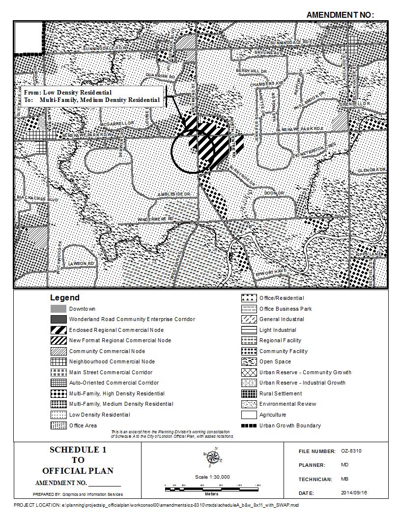
45 45
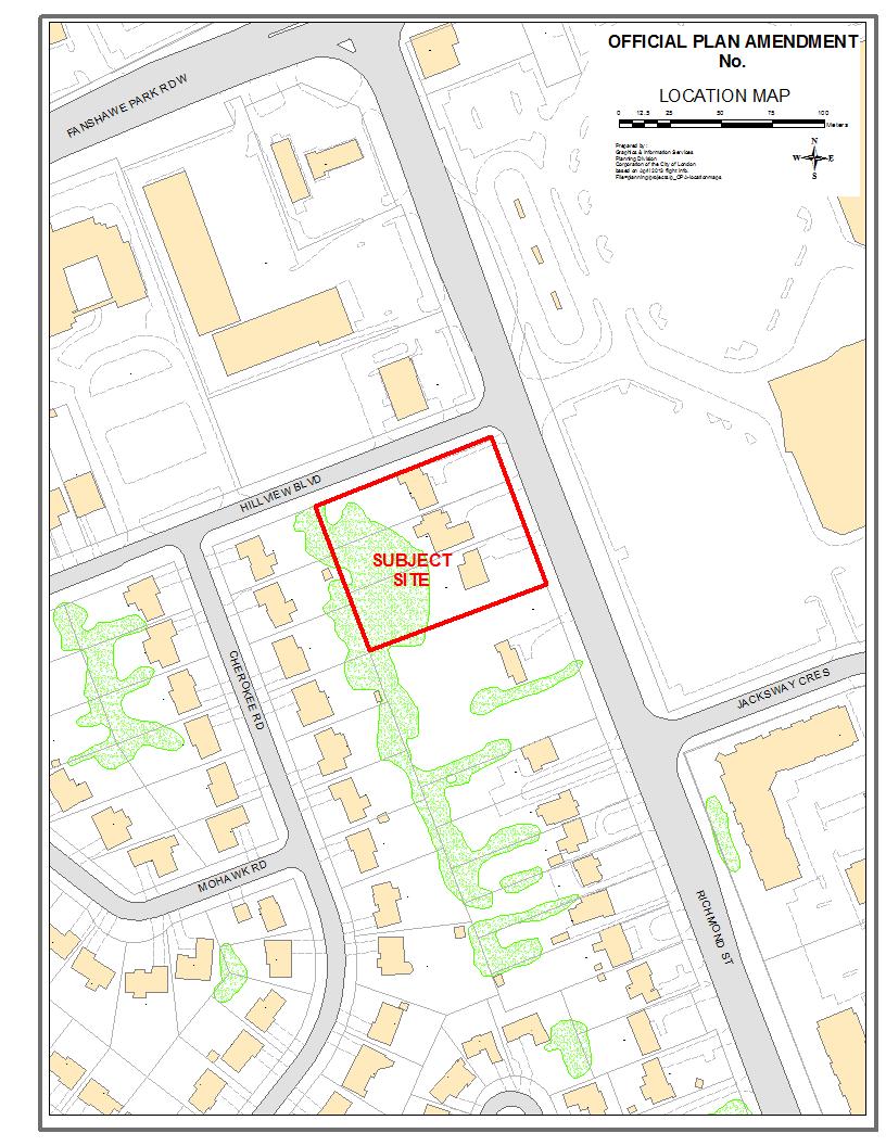
46 46
47 Appendix "B" Bill No. (number to be inserted by Clerk's Office) 2014 By-law No. Z A by-law to amend By-law No. Z.-1 to rezone an area of land located at 1643, 1649 and 1653 Richmond Street. WHEREAS Richmond Medical Centre Inc. has applied to rezone an area of land located at 1643, 1649 and 1653 Richmond Street, as shown on the map attached to this by-law, as set out below; AND WHEREAS upon approval of Official Plan Amendment Number (number to be inserted by Clerk s Office) this rezoning will conform to the Official Plan; THEREFORE the Municipal Council of The Corporation of the City of London enacts as follows: 1) Schedule A to By-law No. Z.-1 is amended by changing the zoning applicable to lands located at 1643, 1649 and 1653 Richmond Street, as shown on the attached map compromising part of Key Map No. A102, from a Holding Residential R5 Special Provision/Residential R6 Special Provision (h-5 R5-2(12)/R6-4(14)) Zone to a Holding Residential R9 Special Provision (h-5 h-55 h-(*) R9-7(*)) Zone and a Holding Residential R9 Special Provision (h-5 h-(*) R9-7(*)) Zone. 2) Section Number 3.8 of the Holding h Zones to By-law No. Z.-1 is amended by adding the following new holding provision: _) h-(*) Purpose: To ensure that the Conceptual Block Development Plan, established through the Official Plan and Zoning amendment review process and attached as Schedule 1 to the amending by-law, is implemented, a development agreement shall be entered into which ensures that future development of these lands incorporates the concepts and design principles identified in the Conceptual Block Development Plan to the satisfaction of the Managing Director, Land Use Planning and City Planner prior to the removal of the h-(*) symbol. 3) Section Number 13.4 of the Residential R9 (R9-7) Zone is amended by adding the following new Special Provision: _) R9-7(*) 1643, 1649 and 1653 Richmond Street a) Regulations applicable to and measured based on R9-7(*) Zone Boundaries: i) Density 200 Units Per Hectare (Max.) (80 units per acre) ii) Lot Coverage 45% (Max.) iii) Front Yard Depth 3m (10 ft.) (Max.) iv) Bedrooms per dwelling unit 3 (Max.) v) Rear yard depth 15m (49 ft.) 47
48 vi) Parking for residential uses 0.8 spaces/unit b) Regulations for 1643 and 1649 Richmond Street: i) Permitted uses: Apartment Buildings Cluster Townhouses ii) Frontage 50m (Min.) (165 ft.) iii) Lot Area 0.4ha (Min.) (1 acre) iv) Interior Yard Depth 3m (Min.) (10 ft.) v) No part of any required front yard, required side yard, or required rear yard shall be used for any purpose other than landscaped open space except where a common internal driveway connects to abutting properties located in a required side yard, or where access to an underground parking garage is necessary in a required side yard. Additional regulations for Apartment Buildings: i) Height (Max.) 20.0 metres (first 25.0 metres of lot depth) (65.5 ft.) ii) Height (Max.) 15.0 metres (beyond the first 25.0 metres (49.2 ft.) of lot depth) iii) Setback from Rear property line 50.0 metres (Min.) (164 ft.) Additional regulations for Cluster Townhouses: i) Height 9.5 metres (Max.) (31.2 ft.) ii) Maximum height is to be measured from grade to roof peak. iii) Basement ceiling height 0.5 metres above grade (1.6 ft.) (Max.) iv) Number of townhouse 6 dwelling units (Max.) v) Number of vertically 4 attached dwelling units (Max.) c) Regulations for 1653 Richmond Street: i) Permitted uses: Apartment buildings Medical/Dental Offices on ground floor of an apartment 48
49 building ii) Frontage 20m (Min.) (66 ft.) iii) Lot Area 0.16ha (Min.) (0.4 acres) iv) Interior Yard Depth 3m (Min.) (10 ft.) v) Exterior Yard Depth 0.0m (Min.) (0.0 ft.) vi) No part of any required front yard, required side yard, or required rear yard shall be used for any purpose other than landscaped open space except where a common internal driveway connects to abutting properties located in a required interior side yard, where access to an underground parking garage is necessary in a required interior side yard, where a common driveway provides vehicular access to Hillview Boulevard in the required exterior side yard, or where a vestibule structure is required to provide secondary entrance to an underground parking structure in accordance with the Ontario Building Code in the required rear yard. Additional regulations for Apartment Buildings i) Height (Max.) 20.0 metres (first 25.0 metres of lot depth) (65.5 ft.) ii) Height (Max.) 17m (beyond the first 25.0 metres (56 ft.) of lot depth) iii) Setback from rear property line 50.0m (Min.) (164 ft.) Additional regulations for Medical/Dental Offices: i) Gross Floor Area 430m 2 (Max.) (4,630 ft 2 ) ii) Parking 1 space/15m 2 GFA The inclusion in this By-law of imperial measure along with metric measure is for the purpose of convenience only and the metric measure governs in case of any discrepancy between the two measures. This By-law shall come into force and be deemed to come into force in accordance with Section 34 of the Planning Act, R.S.O. 1990, c. P13, either upon the date of the passage of this by-law or as otherwise provided by the said section. PASSED in Open Council on October 14,
50 J. Baechler Mayor Catharine Saunders City Clerk First Reading October 14, 2014 Second Reading October 14, 2014 Third Reading October 14,
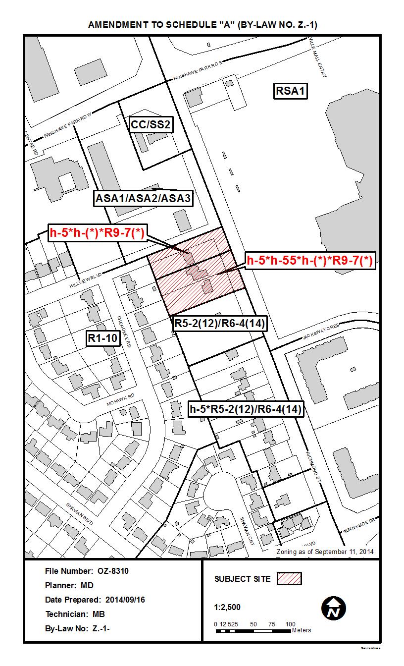
51 51
52 Schedule 1 Conceptual Block Development Plan Site Plan 52

53 Schedule 1 Conceptual Block Development Plan Building Elevations 53


54 Schedule 1 Conceptual Block Development Plan 1653 Richmond Street Building Elevations 54

55 Schedule 1 Conceptual Block Development Plan 1653 Richmond Street Building Elevations 55


56 Schedule 1 Conceptual Block Development Plan 1653 Richmond Street Building Elevations 56
3.1. OBJECTIVES FOR RESIDENTIAL LAND USE DESIGNATIONS GENERAL OBJECTIVES FOR ALL RESIDENTIAL DESIGNATIONS
 3. RESIDENTIAL LAND USE DESIGNATIONS INTRODUCTION The Residential land use designations provide for housing and other land uses that are integral to, and supportive of, a residential environment. Housing
STAFF REPORT PLN September 11, 2017
 Page: 1 TO: SUBJECT: GENERAL COMMITTEE APPLICATIONS FOR OFFICIAL PLAN AMENDMENT AND ZONING BY-LAW AMENDMENT 37 JOHNSON STREET WARD: WARD 1 PREPARED BY AND KEY CONTACT: SUBMITTED BY: GENERAL MANAGER APPROVAL:
Planning Justification Report
 Planning Justification Report Kellogg s Lands City of London E&E McLaughlin Ltd. June 14, 2017 Zelinka Priamo Ltd. Page i TABLE OF CONTENTS Page No. 1.0 2.0 2.1 2.2 3.0 4.0 5.0 5.1 5.2 5.3 5.4 5.5 5.6
Kingston Road - Zoning Amendment and Draft Plan of Subdivision Applications - Preliminary Report
 STAFF REPORT ACTION REQUIRED 6480-6484 Kingston Road - Zoning Amendment and Draft Plan of Subdivision Applications - Preliminary Report Date: April 19, 2016 To: From: Wards: Reference Number: Scarborough
Planning Justification Report
 Planning Justification Report 101 Kozlov Street, Barrie, Ont. Destaron Property Management Ltd. November 2015 Revised February 2017 TABLE OF CONTENTS Page 1.0 INTRODUCTION... 1 2.0 DESCRIPTION OF SUBJECT
PLANNING RATIONALE 680 BRONSON AVENUE OTTAWA, ONTARIO PROPOSED ZONING BY-LAW AMENDMENT
 PLANNING RATIONALE 680 BRONSON AVENUE OTTAWA, ONTARIO PROPOSED ZONING BY-LAW AMENDMENT FRANK PARAVAN APRIL 2014 Planning Rationale Introduction FOTENN Consultants Inc. has been engaged by Frank and Michael
PIN , Part 1, Plan SR-713 in Lot 2, Concession 5, Township of McKim (1096 Dublin Street, Sudbury)
") STAFF REPORT Applicant: Dalron Construction Limited Location: PIN 02124-0103, Part 1, Plan SR-713 in Lot 2, Concession 5, Township of McKim (1096 Dublin Street, Sudbury) Official Plan and Zoning By-law:
STAFF REPORT Applicant: Dalron Construction Limited Location: PIN 02124-0103, Part 1, Plan SR-713 in Lot 2, Concession 5, Township of McKim (1096 Dublin Street, Sudbury) Official Plan and Zoning By-law:
Planning Rationale in Support of an Application for Plan of Subdivision and Zoning By-Law Amendment
 Planning Rationale in Support of an Application for Plan of Subdivision and Zoning By-Law Amendment The Kilmorie Development 21 Withrow Avenue City of Ottawa Prepared by: Holzman Consultants Inc. Land
50 and 52 Finch Avenue East - Official Plan and Zoning By-law Amendment Applications - Preliminary Report
 STAFF REPORT ACTION REQUIRED 50 and 52 Finch Avenue East - Official Plan and Zoning By-law Amendment Applications - Preliminary Report Date: August 16, 2016 To: From: Wards: Reference Number: North York
PLANNING REPORT Gordon Street City of Guelph. Prepared on behalf of Ontario Inc. March 17, Project No. 1507
 PLANNING REPORT 1131 Gordon Street City of Guelph Prepared on behalf of 1876698 Ontario Inc. March 17, 2016 Project No. 1507 423 Woolwich Street, Suite 201, Guelph, Ontario, N1H 3X3 Phone (519) 836-7526
Urban Design Brief Dundas Street. London Affordable Housing Foundation. November Zelinka Priamo Ltd.
 Urban Design Brief 1039-1047 Dundas Street London Affordable Housing Foundation November 2017 Zelinka Priamo Ltd. TABLE OF CONTENTS Page No. INTRODUCTION... 3 SECTION 1 LAND USE PLANNING CONTEXT... 3 1.1
Planning Justification Report
 Planning Justification Report 103 and 105 Toronto Street Town of Markdale, Municipality of Grey Highlands Maverick Developments November 5, 2016 Zelinka Priamo Ltd. Page i TABLE OF CONTENTS Page No. 1.0
12, 14, 16 and 18 Marquette Avenue and 7 Carhartt Street Zoning By-law Amendment Application - Preliminary Report
 STAFF REPORT ACTION REQUIRED 12, 14, 16 and 18 Marquette Avenue and 7 Carhartt Street Zoning By-law Amendment Application - Preliminary Report Date: July 17, 2014 To: From: Wards: Reference Number: North
1202 & 1204 Avenue Road Zoning By-law Amendment Application - Preliminary Report
 STAFF REPORT ACTION REQUIRED 1202 & 1204 Avenue Road Zoning By-law Amendment Application - Preliminary Report Date: March 17, 2017 To: From: Wards: Reference Number: North York Community Council Director,
25 Leonard Avenue - Official Plan Amendment and Zoning Amendment Applications - Preliminary Report
 STAFF REPORT ACTION REQUIRED 25 Leonard Avenue - Official Plan Amendment and Zoning Amendment Applications - Preliminary Report Date: March 8, 2017 To: From: Wards: Reference Number: Toronto and East York
Infrastructure, Development and Enterprise Services
 Staff Report To Service Area City Council Infrastructure, Development and Enterprise Services Date Monday, April 9, 2018 Subject Report Number Statutory Public Meeting 671 Victoria Road North Proposed
3005 Bloor Street West and 14 Humbervale Boulevard - Official Plan and Zoning Amendment Applications - Preliminary Report
 STAFF REPORT ACTION REQUIRED 3005 Bloor Street West and 14 Humbervale Boulevard - Official Plan and Zoning Amendment Applications - Preliminary Report Date: March 10, 2018 To: From: Wards: Reference Number:
P. H. Robinson Consulting Urban Planning, Consulting and Project Management
 PLANNING RATIONALE REPORT FOR SITE PLAN AND DRAFT PLAN OF CONDOMINIUM APPLICATIONS 73-75 HARVEY STREET CITY OF OTTAWA PREPARED BY: P H ROBINSON CONSULTING AUGUST 2012 1 This report has been prepared on
1417, , 1427 & 1429 Yonge Street - Official Plan Amendment and Zoning Amendment Applications - Preliminary Report
 STAFF REPORT ACTION REQUIRED 1417, 1421-1425, 1427 & 1429 Yonge Street - Official Plan Amendment and Zoning Amendment Applications - Preliminary Report Date: March 24, 2015 To: From: Wards: Reference Number:
Proposed London Plan Amendment 1631, 1635, 1639, 1643, and 1649 Richmond Street London, ON
 Sent via e-mail July 26, 2018 Cathy Saunders City Clerk City Clerk s Office City of London 300 Dufferin Avenue London, ON N6A 4L9 Dear Ms. Saunders: Re: Our File: Proposed London Plan Amendment 1631, 1635,
STAFF REPORT. January 25, North York Community Council. Director, Community Planning, North District
 STAFF REPORT January 25, 2005 To: From: Subject: Purpose: North York Community Council Director, Community Planning, North District Refusal Report OPA & Rezoning Application 04 194214 NNY 33 OZ Applicant:
Islington Avenue - Official Plan and Zoning By-law Amendment Application - Preliminary Report
 STAFF REPORT ACTION REQUIRED 3002-3014 Islington Avenue - Official Plan and Zoning By-law Amendment Application - Preliminary Report Date: Febuary 2, 2016 To: From: Wards: Reference Number: Etobicoke York
Bylaw No , being "Official Community Plan Bylaw, 2016" Schedule "A" DRAFT
 Bylaw No. 2600-2016, being "Official Community Plan Bylaw, 2016" Schedule "A" Urban Structure + Growth Plan Urban Structure Land use and growth management are among the most powerful policy tools at the
Director, Community Planning, North York District NNY 10 OZ and NNY 10 RH
 STAFF REPORT ACTION REQUIRED 847 873 Sheppard Avenue West - Official Plan Amendment and Zoning By-law Amendment and Rental Housing Demolition and Conversion Applications - Preliminary Report Date: April
250, 252, 254 and 256 Royal York Road and 8 and 10 Drummond Street - Zoning By-law Amendment Application - Preliminary Report
 STAFF REPORT ACTION REQUIRED 250, 252, 254 and 256 Royal York Road and 8 and 10 Drummond Street - Zoning By-law Amendment Application - Preliminary Report Date: May 28, 2013 To: From: Wards: Reference
i. The only permitted uses shall be a maximum of two (2) multiple dwellings and related accessory uses;
 multiple dwellings and related accessory uses;") Presented To: Planning Committee Request for Decision Application for rezoning in order to permit 80 dwelling units, comprising two (2) six-storey multiple dwellings with 40 units, Paris Street, Sudbury
Presented To: Planning Committee Request for Decision Application for rezoning in order to permit 80 dwelling units, comprising two (2) six-storey multiple dwellings with 40 units, Paris Street, Sudbury
PLANNING RATIONALE REPORT
 PLANNING RATIONALE REPORT Zoning By-law Amendment Application 2920 Danbury Way Prepared for: Bravar Custom Builders Inc. and Village View Estates Ltd. by: 6393 Roslyn Street Ottawa (Orleans), Ontario K1C
SUBJECT: Official Plan and Zoning By-law Amendment Applications for 4853 Thomas Alton Boulevard
 Page 1 of Report PB-100-16 SUBJECT: Official Plan and Zoning By-law Amendment Applications for 4853 Thomas Alton Boulevard TO: FROM: Development and Infrastructure Committee Planning and Building Department
Urban Design Brief (Richmond) Corp. 1631, 1635, 1639, 1643 and 1649 Richmond Street City of London
 Corp. 1631, 1635, 1639, 1643 and 1649 Richmond Street City of London") Urban Design Brief 1635 (Richmond) Corp. 1631, 1635, 1639, 1643 and 1649 Richmond Street City of London Site Plan Control Application Holding Provision Application April 1, 2015 Prepared for: Rise Real
Urban Design Brief 1635 (Richmond) Corp. 1631, 1635, 1639, 1643 and 1649 Richmond Street City of London Site Plan Control Application Holding Provision Application April 1, 2015 Prepared for: Rise Real
770 BROOKFIELD ROAD Site Plan Control Atlantis Investments November 2017
 770 BROOKFIELD ROAD Site Plan Control Atlantis Investments November 2017 Prepared for: Atlantis Investments Inc. Prepared by: Fotenn Planning + Design 223 McLeod Street Ottawa, ON K2P 0Z8 fotenn.com October
Director, Community Planning, Scarborough District ESC 44 OZ & ESC 44 SB
 STAFF REPORT ACTION REQUIRED 6175, 6183 Kingston Road and 1, 2, 4, 5, 7,10 & 11 Franklin Avenue - Official Plan Amendment, Zoning Amendment and Draft Plan of Subdivision Applications Preliminary Report
3390, 3392, 3394, 3396 and 3398 Bayview Avenue - Official Plan Amendment, Zoning By-law Amendment Application - Preliminary Report
 STAFF REPORT ACTION REQUIRED 3390, 3392, 3394, 3396 and 3398 Bayview Avenue - Official Plan Amendment, Zoning By-law Amendment Application - Preliminary Report Date: March 14, 2016 To: From: Wards: Reference
4027 and 4031 Ellesmere Road Zoning Amendment and Draft Plan of Subdivision Applications - Request for Direction Report
 STAFF REPORT ACTION REQUIRED 4027 and 4031 Ellesmere Road Zoning Amendment and Draft Plan of Subdivision Applications - Request for Direction Report Date: August 22, 2013 To: From: Wards: Reference Number:
MINTO COMMUNITIES INC. AVALON WEST STAGE 4 PLANNING RATIONALE. July Prepared for:
 MINTO COMMUNITIES INC. AVALON WEST STAGE 4 PLANNING RATIONALE July 2015 Prepared for: MINTO COMMUNITIES INC. 200 180 Kent Street Ottawa, Ontario K1P 0B6 Prepared by: J.L. RICHARDS & ASSOCIATES LIMITED
111 Wenderly Drive Official Plan and Zoning By-law Amendment Applications - Preliminary Report
 STAFF REPORT ACTION REQUIRED 111 Wenderly Drive Official Plan and Zoning By-law Amendment Applications - Preliminary Report Date: August 17, 2015 To: From: Wards: Reference Number: North York Community
4650 Eglinton Avenue West - Zoning By-law Amendment Application - Preliminary Report
 STAFF REPORT ACTION REQUIRED 4650 Eglinton Avenue West - Zoning By-law Amendment Application - Preliminary Report Date: August 14, 2015 To: From: Wards: Reference Number: Etobicoke York Community Council
8.5.1 R1, Single Detached Residential District
 8.5.1 R1, Single Detached Residential District The purpose of this district is to provide for residential development in the form of single detached dwellings. Dwelling, Single Detached Home Business,
TO: CHAIR AND MEMBERS PLANNING AND ENVIRONMENT COMMITTEE
 TO: CHAIR AND MEMBERS PLANNING AND ENVIRONMENT COMMITTEE FROM: GEORGE KOTSIFAS, P.ENG. MANAGING DIRECTOR, DEVELOPMENT & COMPLIANCE SERVICES AND CHIEF BUILDING OFFICIAL SUBJECT: APPLICATION BY: SIFTON PROPERTIES
50+54 BELL STREET NORTH
 50+54 BELL STREET NORTH SITE PLAN CONTROL APPLICATION OCTOBER 2014 PREPARED BY: FOTENN Consultants Inc. 223 Mcleod Street Ottawa, ON K2P OZ8 (613) 730-5709 PREPARED FOR: Ottawa Chinese Alliance Church
307 Sherbourne Street - Zoning Amendment Application - Preliminary Report
 STAFF REPORT ACTION REQUIRED 307 Sherbourne Street - Zoning Amendment Application - Preliminary Report Date: August 14, 2015 To: From: Wards: Reference Number: Toronto and East York Community Council Director,
39 Thora Avenue Zoning Amendment Application Preliminary Report
 STAFF REPORT ACTION REQUIRED 39 Thora Avenue Zoning Amendment Application Preliminary Report Date: January 28, 2014 To: From: Wards: Reference Number: Scarborough Community Council Director, Community
Official Plan & Zoning By-law Amendment Application Preliminary Report
 STAFF REPORT ACTION REQUIRED 847 873 Sheppard Avenue West Official Plan & Zoning By-law Amendment Application Preliminary Report Date: January 13, 2010 To: From: Wards: Reference Number: North York Community
Members of the City of Brantford Committee of Adjustment. 1.0 TYPE OF REPORT Committee of Adjustment Decision Regarding an Application for Consent
 DATE: October 18 th 2017 REPORT NO. CD2017-168 TO: Members of the City of Brantford Committee of Adjustment FROM: Brandon Kashin, Current Development Planner 1.0 TYPE OF REPORT Committee of Adjustment
377 Spadina Rd and 17 Montclair Ave - Zoning Amendment Application - Preliminary Report
 STAFF REPORT ACTION REQUIRED 377 Spadina Rd and 17 Montclair Ave - Zoning Amendment Application - Preliminary Report Date: May 15, 2015 To: From: Wards: Reference Number: Toronto and East York Community
CHAIR AND MEMBERS PLANNING & ENVIRONMENT COMMITTEE JOHN M. FLEMING MANAGING DIRECTOR, PLANNING AND CITY PLANNER
 TO: FROM: SUBJECT: CHAIR AND MEMBERS PLANNING & ENVIRONMENT COMMITTEE JOHN M. FLEMING MANAGING DIRECTOR, PLANNING AND CITY PLANNER APPLICATION BY: KIM NGUYEN 1448 ADELAIDE STREET NORTH PUBLIC PARTICIPATION
Director, Community Planning, Toronto and East York District
 STAFF REPORT September 1, 2005 To: From: Subject: Toronto and East York Community Council Director, Community Planning, Toronto and East York District Further Report Applications to amend Official Plan
Keele Street - Official Plan and Zoning By-law Amendment Application - Preliminary Report
 STAFF REPORT ACTION REQUIRED 406-410 Keele Street - Official Plan and Zoning By-law Amendment Application - Preliminary Report Date: September 20, 2017 To: From: Wards: Reference Number: Etobicoke York
York Neighbourhood Area Structure Plan
 York Neighbourhood Area Structure Plan Office Consolidation March 2006 Prepared by: Planning and Policy Services Branch Planning and Development Department City of Edmonton Bylaw 7064 was adopted by Council
45 & 77 Dunfield Avenue - Zoning Amendment Application - Preliminary Report
 STAFF REPORT ACTION REQUIRED 45 & 77 Dunfield Avenue - Zoning Amendment Application - Preliminary Report Date: January 22, 2014 To: From: Wards: Reference Number: Toronto and East York Community Council
STAFF REPORT. March 14, Toronto and East York Community Council. Director, Community Planning, South District
 STAFF REPORT March 14, 2005 To: From: Subject: Toronto and East York Community Council Director, Community Planning, South District Preliminary Report Official Plan Amendment and Rezoning Application 05
3035 Weston Road - Official Plan and Zoning By-law Amendment and Draft Plan of Subdivision Applications - Request for Directions Report
 STAFF REPORT ACTION REQUIRED 3035 Weston Road - Official Plan and Zoning By-law Amendment and Draft Plan of Subdivision Applications - Request for Directions Report Date: December 18, 2007 To: From: Wards:
6208 Jeanne D Arc Boulevard North. Planning Rationale. Site Plan Control
 Site Plan Control Prepared By: NOVATECH Suite 200, 240 Michael Cowpland Drive Ottawa, Ontario K2M 1P6 November / 24 / 2015 Novatech File: 115100 Ref: R-2015-179 November 24, 2015 City of Ottawa 110 Laurier
66 Isabella Street Rezoning Application - Preliminary Report
 STAFF REPORT ACTION REQUIRED 66 Isabella Street Rezoning Application - Preliminary Report Date: November 15, 2010 To: From: Wards: Reference Number: Toronto and East York Community Council Director, Community
507, 509 and 511 Kingston Road - Official Plan and Zoning By-law Amendment Applications Request for Interim Directions Report
 REPORT FOR ACTION 507, 509 and 511 Kingston Road - Official Plan and Zoning By-law Amendment Applications Request for Interim Directions Report Date: June 6, 2018 To: From: Wards: Reference Number: Toronto
Urban Design Brief. Italian Seniors Project 1090, 1092, 1096 Hamilton Road City of London
 Urban Design Brief Italian Seniors Project City of London October 1, 2017 TABLE OF CONTENTS Page No. INTRODUCTION... 2 1.0 LAND USE PLANNING CONCEPT... 2 1.1 Subject Lands... 2 1.2 Official Plan and Zoning
Director, Community Planning, Etobicoke York District WET 13 OZ and WET 13 RH
 STAFF REPORT ACTION REQUIRED 35, 41-63, 65 and 95 High Park Avenue and 66 and 102-116 Pacific Avenue - Official Plan and Zoning By-law Amendment and Rental Housing Demolition Applications - Preliminary
17-23 Clairtrell Road and 391 Spring Garden Avenue - OPA & Rezoning, Site Plan - Preliminary Report
 STAFF REPORT ACTION REQUIRED 17-23 Clairtrell Road and 391 Spring Garden Avenue - OPA & Rezoning, Site Plan - Preliminary Report Date: April 10, 2008 To: From: Wards: Reference Number: North York Community
507, 509 and 511 Kingston Road - Official Plan and Zoning By-law Amendment Applications - Preliminary Report
 STAFF REPORT ACTION REQUIRED 507, 509 and 511 Kingston Road - Official Plan and Zoning By-law Amendment Applications - Preliminary Report Date: March 9, 2017 To: From: Wards: Reference Number: Toronto
Paul D. Ralph, BES, RPP, MCIP, Commissioner, Development Services Department
 Public Report To: From: Report Number: Development Services Committee Paul D. Ralph, BES, RPP, MCIP, Commissioner, Development Services Department DS-16-50 Date of Report: April 14, 2016 Date of Meeting:
Staff Report. October 19, 2016 Page 1 of 17. Meeting Date: October 19, 2016
 October 19, 2016 Page 1 of 17 Staff Report Report No.: PDSD-P-58-16 Meeting Date: October 19, 2016 Submitted by: Subject: Recommendation: Ben Puzanov, RPP, Senior Planner Application for Zoning By-law
1061 The Queensway - Official Plan and Zoning By-law Amendment Applications - Preliminary Report
 STAFF REPORT ACTION REQUIRED 1061 The Queensway - Official Plan and Zoning By-law Amendment Applications - Preliminary Report Date: January 28, 2015 To: From: Wards: Reference Number: Etobicoke York Community
Request for Decision STAFF REPORT. Recommendation. Applicant: Location: Application: Proposal: Presented To: Planning Committee
 Request for Decision Application for rezoning in order to permit an automotive lube shop in the southeasterly corner of the Lasalle Court Mall property, 900 Lasalle Boulevard, Sudbury - Laurentian Shield
3445 Sheppard Avenue East - Zoning Amendment Application - Preliminary Report
 STAFF REPORT ACTION REQUIRED 3445 Sheppard Avenue East - Zoning Amendment Application - Preliminary Report Date: August 14, 2013 To: From: Wards: Reference Number: Scarborough Community Council Director,
40-58 Widmer Street - Zoning Amendment Application - Preliminary Report
 STAFF REPORT ACTION REQUIRED 40-58 Widmer Street - Zoning Amendment Application - Preliminary Report Date: April 19, 2013 To: From: Wards: Reference Number: Toronto and East York Community Council Director,
1 Application Form 4
 1 Application Form 4 5 2 Project Summary Location The proposed development is located at 216 Cobequid Road in Sackville, Nova Scotia. Site Characteristics The mixed-use development is situated on the corner
SECTION 9 RESIDENTIAL R5 ZONE
 SECTION 9 RESIDENTIAL R5 ZONE 9.1 GENERAL PURPOSE OF THE R5 ZONE This R5 Zone provides for and regulates medium density residential development in the form of cluster townhouses. Different intensities
666 Spadina Ave - Official Plan Amendment and Zoning Amendment Applications - Preliminary Report
 STAFF REPORT ACTION REQUIRED 666 Spadina Ave - Official Plan Amendment and Zoning Amendment Applications - Preliminary Report Date: October 25, 2016 To: From: Wards: Reference Number: Toronto and East
Planning Rationale. 224 Cooper Street
 Submitted by: Robertson Martin Architects Tel 613.567.1361 Fax 613.567.9462 216 Pretoria Ave, Ottawa, Ontario, K1S 1X2 Planning Rationale 224 Cooper Street Planning Rationale Application to City of Ottawa
TO: CHAIR AND MEMBERS - PLANNING & ENVIRONMENT COMMITTEE
 TO: CHAIR AND MEMBERS - PLANNING & ENVIRONMENT COMMITTEE FROM: SUBJECT: JOHN M. FLEMING MANAGING DIRECTOR, PLANNING AND CITY PLANNER CITY OF LONDON CITY WIDE OFFICIAL PLAN AND ZONING BY-LAW AMENDMENTS
Sheppard Ave East and 6, 8 and 10 Greenbriar Road - Official Plan Amendment and Zoning Amendment Applications - Preliminary Report
 STAFF REPORT ACTION REQUIRED 625-627 Sheppard Ave East and 6, 8 and 10 Greenbriar Road - Official Plan Amendment and Zoning Amendment Applications - Preliminary Report Date: April 15, 2016 To: From: Wards:
Director, Community Planning, North York District NNY 23 OZ and NNY 23 RH
 STAFF REPORT ACTION REQUIRED 2 & 50 Sheppard Avenue East 4841 to 4881 Yonge Street and 2 to 6 Forest Laneway Official Plan Amendment, Zoning By-law Amendment and Rental Housing Demolition Applications
The City of Burlington 4880 VALERA ROAD PLANNING JUSTIFICATION REPORT. December 2017 ZONING BY-LAW AMENDMENT. AJC Project Number:
 The City of Burlington 4880 VALERA ROAD PLANNING JUSTIFICATION REPORT ZONING BY-LAW AMENDMENT December 2017 AJC Project Number: 178295 Table of Contents 1 Introduction... 2 2 Description of Subject Lands
Zoning Amendment. Public Meeting: February 7, 2018
 Zoning Amendment Public Meeting: February 7, 2018 Application: Applicant: D14-01/18 HMAT Homes Inc Location of Subject Lands Lot 108 and Part of Lots 107 and 109, Plan 30, Bracebridge Ward of the Town
Cover Letter with Narrative Statement
 Cover Letter with Narrative Statement March 31, 2017 rev July 27, 2017 RE: Rushton Pointe Residential Planned Unit Development Application for Public Hearing for RPUD Rezone PL2015 000 0306 Mr. Eric Johnson,
Financial Impact Statement There are no immediate financial impacts associated with the adoption of this report.
 STAFF REPORT Planning and Development Department Subject: Application by RYC Property to rezone a portion of lands on John Murray Dr. and Megan Lynn Dr. from R2 to R3 and to enter into a Development Agreement
Community & Infrastructure Services Committee
 REPORT TO: DATE OF MEETING: September 12, 2016 Community & Infrastructure Services Committee SUBMITTED BY: Alain Pinard, Director of Planning, 519-741-2200 ext. 7319 PREPARED BY: Natalie Goss, Senior Planner,
Housing & Residential Intensification Study Discussion Paper Township of King
 Housing & Residential Intensification Study Discussion Paper Prepared by Planning Department January 2011 1.0 Background 1.1 Provincial Policies (Greenbelt and Growth Plan) Since 2001, the Province of
6040 Bathurst Street and 5 Fisherville Road Zoning Bylaw Amendment Application Preliminary Report
 STAFF REPORT ACTION REQUIRED 6040 Bathurst Street and 5 Fisherville Road Zoning Bylaw Amendment Application Preliminary Report Date: January 24, 2017 To: From: Wards: Reference Number: North York Community
Church Street and 117 Dundas Street East - Zoning Amendment Application - Preliminary Report
 STAFF REPORT ACTION REQUIRED 215-229 Church Street and 117 Dundas Street East - Zoning Amendment Application - Preliminary Report Date: February 26, 2015 To: From: Wards: Reference Number: Toronto and
150 Eglinton Avenue East - Zoning Amendment Application - Preliminary Report
 STAFF REPORT ACTION REQUIRED 150 Eglinton Avenue East - Zoning Amendment Application - Preliminary Report Date: May 15, 2015 To: From: Wards: Reference Number: Toronto and East York Community Council Director,
PLANNING REPORT. 33 Arkell Road City of Guelph. Prepared on behalf of OHM Arkell Inc. August 4, Project No. 1327
 PLANNING REPORT 33 Arkell Road City of Guelph Prepared on behalf of OHM Arkell Inc. August 4, 2015 Project No. 1327 423 Woolwich Street, Suite 201, Guelph, Ontario, N1H 3X3 Phone (519) 836-7526 Fax (519)
355 King St W and 119 Blue Jays Way - OPA & Rezoning Applications - Preliminary Report
 STAFF REPORT ACTION REQUIRED 355 King St W and 119 Blue Jays Way - OPA & Rezoning Applications - Preliminary Report Date: May 27, 2008 To: From: Wards: Reference Number: Toronto and East York Community
Paul D. Ralph, BES, RPP, MCIP, Commissioner, Development Services Department
 Public Report To: From: Report Number: Development Services Committee Paul D. Ralph, BES, RPP, MCIP, Commissioner, Development Services Department DS-18-64 Date of Report: March 22, 2018 Date of Meeting:
900 ALBERT STREET PLANNING RATIONALE ADDENDUM NO. 2
 900 ALBERT STREET PLANNING RATIONALE ADDENDUM NO. 2 March 26, 2018 Planning Rationale Addendum No. 2 Official Plan and Zoning By-law Amendment Prepared for: TIP Albert GP Inc. 485 Bank Street, Suite 200
FEASIBILITY REPORT. 1486, 1490 and 1494 Clementine. Prepared by: Lloyd Phillips & Associates Ltd. For: Ottawa Salus
 DRAFT FEASIBILITY REPORT 1486, 1490 and 1494 Clementine Prepared by: Lloyd Phillips & Associates Ltd. For: Ottawa Salus LPA File No. 1008 Lloyd Phillips & Associates June 9, 2010 Feasibility Report Page
Planning & Strategic Initiatives Committee
 REPORT TO: DATE OF MEETING: February 2, 2015 SUBMITTED BY: Planning & Strategic Initiatives Committee Alain Pinard, Director of Planning PREPARED BY: Katie Anderl, Senior Planner, 519-741-2200 ext. 7987
Acting Director, Community Planning, Toronto and East York District
 STAFF REPORT ACTION REQUIRED 620 Avenue Road, 215 & 217 Lonsdale Road OPA & Rezoning Application Preliminary Report Date: March 13, 2008 To: From: Wards: Reference Number: Toronto and East York Community
Request for Approval Proposed Expansion to the Puccini Drive Neighbourhood Residential Infill Study Town File D (SRPRS.17.
 Staff Report for Committee of the Whole Meeting Department: Division: Subject: Planning and Regulatory Services Development Planning Request for Approval Proposed Expansion to the Puccini Drive Neighbourhood
STAFF REPORT. September 25, City Council. Chief Planner and Executive Director, City Planning Division
 STAFF REPORT September 25, 2006 To: From: Subject: City Council Chief Planner and Executive Director, City Planning Division Request for Directions Report Toronto & East York Community Council, Report
470, 490 and 530 Wilson Avenue - Zoning Amendment and Rental Housing Demolition and Conversion Applications - Preliminary Report
 STAFF REPORT ACTION REQUIRED 470, 490 and 530 Wilson Avenue - Zoning Amendment and Rental Housing Demolition and Conversion Applications - Preliminary Report Date: January 31, 2017 To: From: Wards: Reference
Bloor Street West, 6-14 Oakmount Road and 35 and 37 Pacific Avenue Official Plan Amendment and Rezoning Applications - Preliminary Report
 STAFF REPORT ACTION REQUIRED 1844-1854 Bloor Street West, 6-14 Oakmount Road and 35 and 37 Pacific Avenue Official Plan Amendment and Rezoning Applications - Preliminary Report Date: February 23, 2011
250 Lawrence Avenue West - Official Plan and Zoning By-law Amendment Applications Preliminary Report
 STAFF REPORT ACTION REQUIRED 250 Lawrence Avenue West - Official Plan and Zoning By-law Amendment Applications Preliminary Report Date: April 22, 2015 To: From: Wards: Reference Number: North York Community
Director, Community Planning, North York District
 STAFF REPORT ACTION REQUIRED 1-35, 45-69 and 6-66 Adra Villaway, 1-25, 2-24, 30-44 and 37-53 Grado Villaway, 1-29 and 2-28 Tomar Villaway Official Plan and Zoning By-law Amendment Applications and Rental
1970 Victoria Park Avenue and 9 Clintwood Gate Zoning By-law Amendment Application Preliminary Report
 STAFF REPORT ACTION REQUIRED 1970 Victoria Park Avenue and 9 Clintwood Gate Zoning By-law Amendment Application Preliminary Report Date: September 23, 2013 To: From: Wards: Reference Number: North York
740 and 750 York Mills Road and 17 Farmstead Road Zoning By-law Amendment Application Preliminary Report
 STAFF REPORT ACTION REQUIRED 740 and 750 York Mills Road and 17 Farmstead Road Zoning By-law Amendment Application Preliminary Report Date: September 20, 2013 To: From: Wards: Reference Number: North York
1555 Midland Avenue - Zoning Amendment & Subdivision Applications - Preliminary Report
 STAFF REPORT ACTION REQUIRED 1555 Midland Avenue - Zoning Amendment & Subdivision Applications - Preliminary Report Date: October 24, 2013 To: From: Wards: Reference Number: Scarborough Community Council
Planning and Building Department
 Page 1 of Report PB-83-13 TO: Development and Infrastructure Committee Planning and Building Department SUBJECT: OP & Rezoning 5001 Corporate Drive Appleby Gardens LJM Developers Report Number: PB-83-13
PREPARED FOR: ADI DEVELOPMENT GROUP INC.
 Acronym Urban Design and Planning/Mark Sterling Consulting Inc. 111 Clendenan Avenue, Toronto, Ontario M6P 2W7 URBAN DESIGN BRIEF PROPOSED DEVELOPMENT 4880 VALERA ROAD, CITY OF BURLINGTON PREPARED FOR:
BROCKVILLE CITY OF BROCKVILLE COMPREHENSIVE ZONING BY-LAW REVIEW DISCUSSION PAPER OCTOBER 2013 FINAL D
 BROCKVILLE CITY OF BROCKVILLE COMPREHENSIVE ZONING REVIEW DISCUSSION PAPER OCTOBER 2013 FINAL D14-13-010 TABLE OF CONTENTS 1. INTRODUCTION... 1 1.1 Purpose and Goals of this Project... 1 1.2 Study Process...
2306 St. Clair Avenue West Zoning By-law Amendment Application - Preliminary Report
 STAFF REPORT ACTION REQUIRED 2306 St. Clair Avenue West Zoning By-law Amendment Application - Preliminary Report Date: August 10, 2017 To: From: Wards: Reference Number: Etobicoke York Community Council