Marshall s Mill Holbeck
|
|
|
- Jeremy Warren
- 6 years ago
- Views:
Transcription


1 Marshall s Mill Holbeck Masterplanning Framework Prepared by... URBED with Bauman Llyons Architects Martin Stockley Associates and King Sturge For Igloo
2
3 Leeds Marshall s Mill MASTERPLANNING FRAMEWORK Submitted with Outline Planning Application Revised 8 th June 2004 Amended 7 th July 2004 Amended 8 th August 2004 Amended 6 th December 2005 Amended 24 th February 2005 Amended 18 th April 2005 Developers Igloo Design Team URBED Martin Stockley Associates King Sturge Bauman Lyons Masterplanners Transport Engineers Planning Consultants Architects
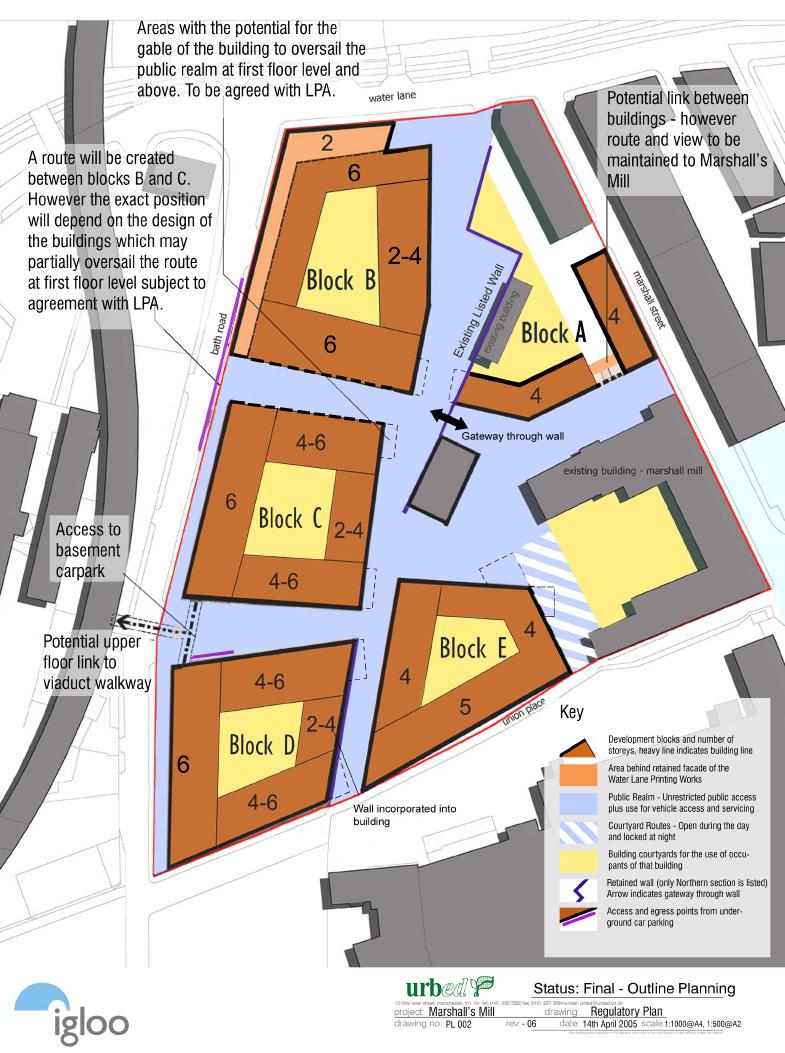
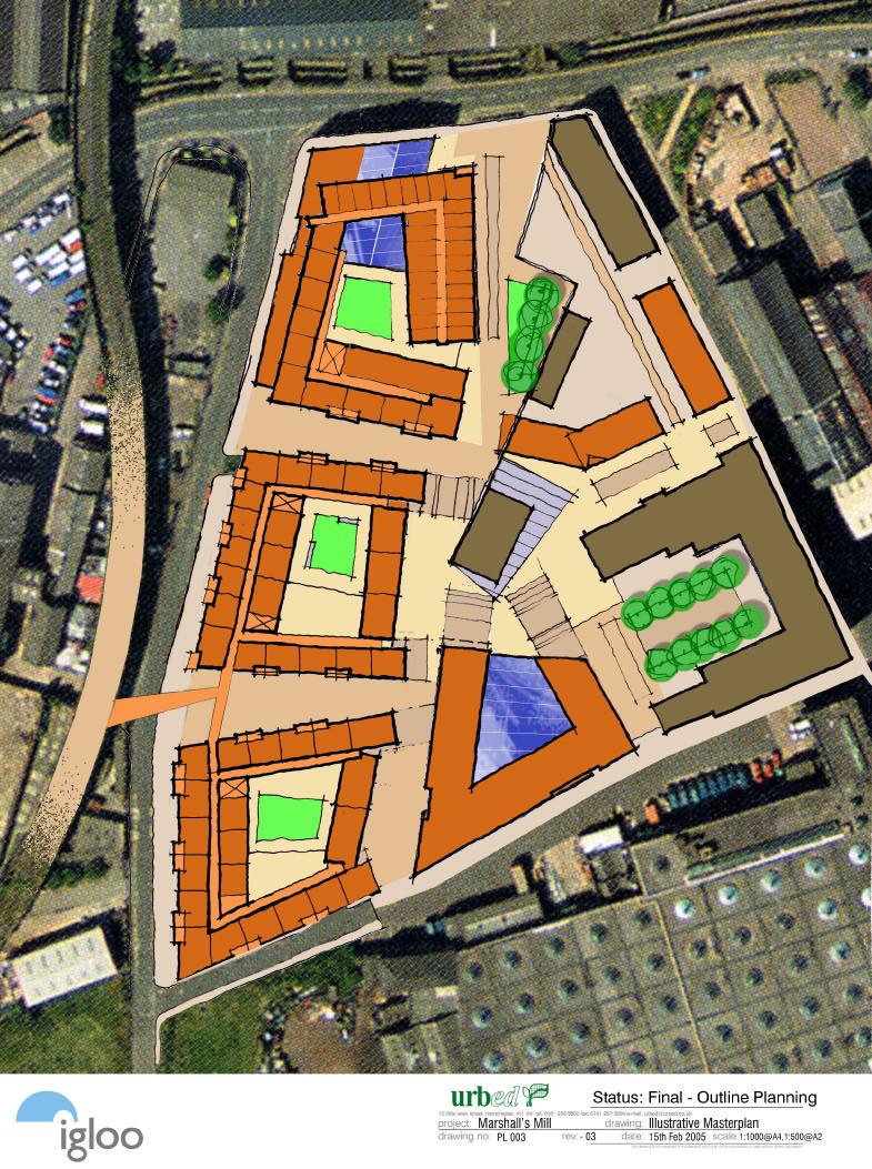
4 Contents 1. Introduction 2 2. Background 4 3. Design principles 5 4. Uses and areas 7 5. Siting and massing Access and Parking Public realm Site briefs Phasing 25 Tables Table 1: Table 2: Table 3: Table 4: Table 5: Uses and Floor Space of existing buildings GEAs based on the illustrative masterplan Block heights Exisisting Building Heights Public Realm Provision Plans Plan 1: Plan 2: Plan 3: Plan 4: Plan 5: Plan 6: Plan 7: Plan 8: Plan 9: Plan 10: Site edged red Regulatory Plan Illustrative Masterplan Illustrative Ground floor Illustrative Typical upper floor Illustrative Parking plan Illustrative Access and servicing Illustrative Public realm Illustrative Parcellation Plan Illustrative Privacy Distance Plan Page 1 of 26
5 1. Introduction 1.01 The purpose of this document is set out the parameters of the outline planning application of the development known as Marshall s Mill in Holbeck, Leeds and to regulate the development of reserved matters applications following the grant of outline planning permission. The site is shown edged red on Plan The outline planning application is seeking consent for a mixed-use development comprising the erection of 5 new urban blocks to provide; approximately 240 residential apartments, B1 business space, live/ work units, hotel with health and fitness club and active uses at ground floor level including bars, cafes and restaurants (A3/A4) retail/service uses (A1/A2), non-residential uses falling within class D1. Consent is also sought for provision of new streets, public space, basement and surface car parking As part of this application we are seeking consent for, siting, height and massing and means of access together with the overall floorspace for the different uses within the proposed development. This document sets out these parameters as well as the principles that should govern the design of buildings and the characteristics of the public realm, details of which are to be brought forward as individual reserved matters applications. The Regulatory Plan (Plan 2) defines the footprints of buildings and the dimensions of the roads and spaces, the location and function of open space and the main routes that connect the site to Marshall Street, Water Lane, Bath Road, Union Place and surrounding areas. This is accompanied by an illustrative plan (Plan 3) that shows how the development could look. This is intended to interpret the Regulatory Plan but makes assumptions about the design of buildings that will be part of reserved matters applications This document should be read in conjunction with the Design Statement (dated May 2004). It was originally submitted in draft form as part of the original planning submission but has now been updated to incorporate changes agreed during the planning process so that it can form the basis of the planning consent. This finally agreed document therefore comprises that to which any planning conditions can be tied, as it will provide the definitive scheme so far as the planning consent is concerned. In the case of conflict with the Design Statement this document takes Page 2 of 26
6 precedence. However the illustrative and supporting information in the Design Statement remains relevant and is not repeated here The Marshall s Mill complex is listed and comprises Marshall s Mill itself, Marshall Court and the small Smithy building. Whilst these buildings lie within the application site, no internal or external changes are proposed nor any change of use. Hence listed building consent is not required and the floorspace figures provided on the application form exclude those buildings, which will continue in their current use as B1 floorspace The Flax Warehouse is an unlisted structure standing within the Marshall s Mill complex and it is envisaged that the building will be refurbished following negotiations with the main stakeholders. This however, will be dealt with as a separate application There is also a listed wall that runs north/south throughout the site. The proposed development requires partial demolition of this wall for which a separate listed building application has been made The proposals also involve partial demolition of the former Water Lane Printing Works located on the corner of Bath Road and Water Lane, which lies within Holbeck Conservation Area. A separate application for Conservation Area consent for demolition of the majority of that building has been made Page 3 of 26
7 2. Background 2.01 The masterplan relates to 2.1 hectares (5.2 acres) of land in Holbeck to the south west of Leeds city centre. The triangular site is bounded by Bath Road, Water Lane, Marshall Street and Union Place and lies partly within the Holbeck Conservation area. Igloo acquired Marshall s Mill and Marshall s Court in July 2003 and now managed the space as workspace for a range of creative businesses This application seeks consent for a compact mixed-use development of the land around Marshall s Mill as well as land on Bath Road between Water Lane and Union Place, which is in a number of ownerships. This includes a number of existing buildings including a commercial property on Bath Road, the Water Lane Printing Works at the corner of Bath Road and Water Lane and the Flax Warehouse to the rear of Marshall s Mill. It is proposed that the Bath Road building be demolished, that the Water Lane Printing Works, other than its northern and western façade and part of the roof be demolished and that the Flax Warehouse is retained and refurbished although this is currently in a different ownership to the mill The site lies within the area, which has been promoted since 1999 as the Holbeck Urban Village by Leeds City Council and Yorkshire Forward. This has been the subject of a number of studies in the last few years as described in the Design Statement that accompanies this application. The area is the subject of Revised Planning Framework for Holbeck Urban Village published in draft form in December Yorkshire Forward also have authorisation to take CPO action as required to deliver the overall vision for the area. The development that is the subject of this application is entirely consistent with the vision for the area and will contribute positively to the development of the urban village Planning Permission has been previously granted in 1999 for the development of Marshall s Modern, a 2,700m 2 (29,000sqft) development of offices on Union Place. The approved development is for a 5-storey building with parking to the rear in the location of the proposed Block E. Page 4 of 26
8 3. Design principles 3.01 The proposals for Holbeck Urban Village aim to develop the area as a dense, mixeduse, urban area that incorporates housing, retail space, hotels, offices, workspace and community facilities. Igloo s vision for the Marshall s Mill site is inline with this vision and has been set out as follows: Our vision is to create a contemporary and locally distinctive, sustainable, finegrained, mixed use, e-connected, inclusive, media savvy, buzzing creative community in a historical environment-enhancing e-neighbourhood, whose development makes a socially responsible return on capital and allows the use of different architects to create a place appealing to creative, design-conscious, environmentally sensitive people as a place to live, work and play. Chris Brown (Igloo), 2003 Scheme principles 3.02 The masterplan for the site has been developed in accordance with Igloo s Socially responsible Investment (SRI) Guidelines. These cover urban design, regeneration and environmental sustainability. The initial SRI assessment is summarised in the Design Statement and is available in full as a separate document The following principles have guided the masterplan: (a) A network of streets and squares: The scheme is designed as part of an urban neighbourhood based upon a network of streets and squares. The public realm of the scheme and the surrounding streets are envisaged to be both routes through the area, and spaces that are animated with activities and the life of the adjacent buildings. (b) Local distinctiveness: The masterplan has grown out of a detailed investigation of the urban structure and form of the Holbeck area. This includes the historic development of the area and the super block form of development. Page 5 of 26
9 (c) Quality public spaces: The scheme is based around a high-quality public realm that will be built with quality materials, enclosed by well-proportioned buildings, with a high degree of permeability and links to the surrounding areas. (d) A rich mix of uses: It incorporates a horizontal and vertical mix of residential, leisure and business uses to ensure that streets are active throughout the day, that there is sufficient activity to sustain a range of commercial uses and to encourage walking rather than the use of the car. (e) A critical mass of development: The masterplan provides for a development that is sufficiently dense to create a compact, walkable neighbourhood. It includes about 240 x 2 bed residential units, just under 12,000m 2 of workspace and 103 room hotel. This gives a gross-residential density across the site of around 114 units per hectare. (f) A feeling of stewardship: It is designed to create places that can foster a sense of responsibility and ownership from the people who live and work locally not just in the proposed development, but also in the neighbouring communities. (g) Area regeneration: In line with Igloo s SRI policy, the scheme is designed to contribute positively to the regeneration of Holbeck Urban Village and the wider area. It will not be an exclusive enclave but a scheme that encourages use by a wide range of people and generates services, employment and residential opportunities for local people. (h) Minimal environmental harm: Igloo s SRI policy requires that the scheme achieves a rigorous set of environmental targets for energy, resource use and transport to become an exemplar for private sustainable urban development. Page 6 of 26
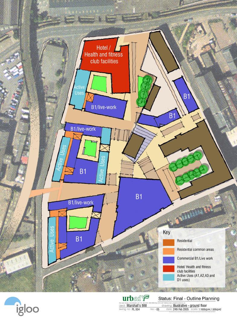
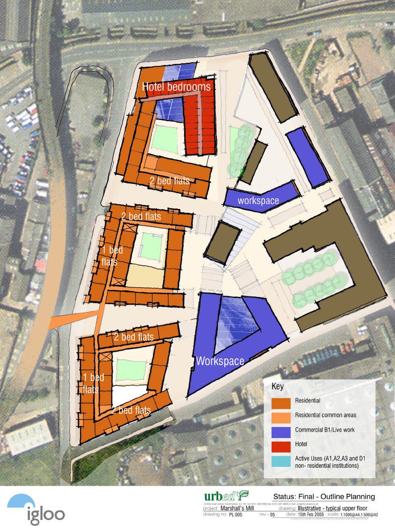
10 4. Uses and areas 4.01 Section 2.02 of this document gives the background to the site as it stands. There are a number of existing buildings including a commercial property on Bath Road, the Water Lane Printing Works at the corner of Bath Road and Water Lane, the Flax Warehouse which is currently used as a training centre, Marshall s Mill and Marshall s Court. The areas are shown in the table below. (i) Table1: Existing uses and floor areas. Building Area Sq. m. Uses Marshall s Mill B1 Marshall s Court B1 Flax Warehouse 690 B1 (training centre) Smithy Building 75 B1 Total This scheme seeks consent for a total of 36,972m 2 gross external floorspace which comprises 18,603m 2 of residential apartments (indicatively 240 units), 11,930m 2 of B1 business space, including live/work units, 4,644m 2 of hotel and gym space (illustratively 102 rooms) and 1,795m 2 of Active uses at ground floor level. The table below shows the illustrative distribution of this floorspace between the blocks based on the masterplan (see also Plans 4 and 5).) Block (ii) Table 2: GEAs based on the illustrative masterplan Area Residential Workspace Hotel Active Uses *1. Sq. m. Sq. m. Units Sq. m. Sq. m. Sq. m. Block A 2,772 2,772 Block B 9,683 3, *2 4,644 *3 662 Block C 9,315 7, ,185 *2 760 Block D 9,480 7, ,619 *2 373 Block E 5,722 5,722 TOTAL 36,972 18, ,930 4,644 1,795 *1. Active uses include A1 retail, A2 Professional and Financial Services; A3/A4 food and drink; and D1 non-residential uses such as galleries. *2. The ground floor of Blocks B-D will be B1 space with the potential for shop fronts and live/work space. These could also include D1 non-residential uses such as galleries. *3. This equates to 102 hotel bedspaces. Page 7 of 26
11 4.03 These floor areas are based on the indicative scheme (Plans 3-5). The floor areas of individual blocks and the distribution of uses between blocks may vary as a result of detailed design work as part of the preparation of reserved matters applications. The outline planning application is therefore for the overall floor areas for each use not the specific floor areas for each block. The consent would therefore allow block areas and uses to vary within the overall totals and within the constraints of the massing model The illustrative disposition of these uses is shown on Illustrative Plans 4 and 5. These break down as follows: Block A: This is proposed as a workspace building that will operate in a similar way to Marshall s Mill. The illustrative scheme includes 2,772m 2 of space on 4 floors. The fourth floor of the block will be set back and glazed. The use of the ground floor could be used in a way that animates the public realm and will include reception facilities and gallery space. Block B: This is shown on the illustrative plans as a 103 room hotel attached to a 51 unit residential block with a GEA of 9,683m 2. The ground floor of the hotel would include reception, gym and public facilities to create active frontages onto Water Lane and the north/south route running through the site. The ground floor space under the residential block would be B1/live-work space. Block C: The illustrative plans show this block with 7,370m 2 of residential accommodation. The number of units will depend on the mix although the indicative scheme shows 96 apartments. The ground floor block iwill include a range of uses to animate the public realm. The illustrative plan shows 719m 2 of café/restaurant space fronting Bath Road and onto interior of the scheme. The ground floor also includes entrance lobbies for the housing above, workspace and B1/live-work units. To accommodate these uses, the ground floor will have a 5.5m ceiling height which will allow a mezzanine level to be inserted if occupants wish. The live/work units will be linkable to the apartments on the first floor. These units together with the workspace will have entrances off the surrounding streets and shop frontages for the display and potential sale of goods. We are therefore seeking a flexible planning consent for these ground floor units that allows them to be used for workspace and active uses. A basement car park will run below block C and D. Block D: This block is designed to be similar to Block C. The indicative scheme has 7,488m 2 of residential space, which in the indicative plan relates to 93 flats. Page 8 of 26
12 The ground floor will include some 373 m 2 active uses facing onto Bath Road and live-work units facing onto the internal courtyard. The Listed Wall will be incorporated into the ground floor of the block. Block E: This is a commercial block with 5,722m 2 of commercial space which will be 5 floors on Union Place and drops down to 4 floors facing onto the Flax Warehouse. It is a U shaped block with a central atrium that will relate to the central Inner court public space The residential mix will be broadly as set out above but the figures are indicative and the number of units may vary depending on the final mix. The proportion of housing to be developed as affordable housing units will be conditioned so that it is provided in accordance with the adopted policy for Holbeck Urban Village as applies at the time that the first phase of reserved matters are approved. Page 9 of 26
13 5. Siting and massing 5.01 The masterplanning team has sought to balance the need to maximise the development potential of the site and the aim to create an urban density of development with the need to scale the development so that it is in keeping with the character of the surrounding area, the setting of Marshall s Mill, Marshall s Court, the listed wall and views of the site from the surrounding area. This section describes the siting and massing of the blocks within the masterplan to achieve this. Siting 5.02 The Regulatory Plan (Plan 2) defines building lines for all blocks for which siting approval is sought. This represents the outward face of each block (the heavy solid line on the Regulatory Plan). This will ensure that individual buildings contribute to the creation of the public realm as envisaged by the masterplan One of the elements of the masterplan is a series of gable ends that create the enclosure of the spaces within the scheme. These gables are intended to project forward of the building line at 1 st floor level and above. This includes occasions when the gables project above the listed wall. The Regulatory Plan indicates locations where gables can project over the building line with dotted lines. The positioning of gables will require approval as part of the reserved matters application when buildings will be designed in more detail. Other projections forward of the building line (such as balconies) and set backs (such as recessed doorways) are acceptable provided that they do not significantly interrupt the overall line of the buildings The building line may be adjusted by up to 1.5m in either direction if required during the detailed design process. This will have to be approved by the LPA as part of the reserved matters application. This will only be done where it is possible to show a continuity of building between adjacent blocks and where the buildings do not unduly reduce the width of the public realm The building frontages onto internal courtyards are not part of the siting approval sought at this stage. Massing Page 10 of 26
14 5.06 A massing approach has been developed with the masterplan. This is based on Super-block structure with higher buildings around the edge of the site relating to the massing of Marshall s Mill and lower buildings are the heart of the site relating to the more intimate scale of the public realm. This is illustrated on the indicative masterplan and modelling and is set out on the Regulatory Plan (Plan 2) and in the table below. a) Table 3: Block heights Block Heights Comments Maximum Height (m) Storeys A Predominant height B Height onto Water Lane Height on east wing opposite wall C Height onto Bath Road Height on east/west wings Height of section facing east D Predominant height to Bath Road Height on east/west wings Height of section facing east E Height to Union Place Height to the north 5.07 The heights of the existing buildings within and adjacent to the application site are as shown in the table below. b) Table 4: Existing building heights Building Heights Comments Maximum Height (m) Storeys Marshall s Court 12 3 Predominant height The Flax Warehouse 10 3 Flat roof Water Lane Printing Wks 12 2 Height to roof apex Temple Mill 1 Marshall s Mill Height to top of chimney-roof height is 24.7m Viaduct 12.2 N/A Page 11 of 26
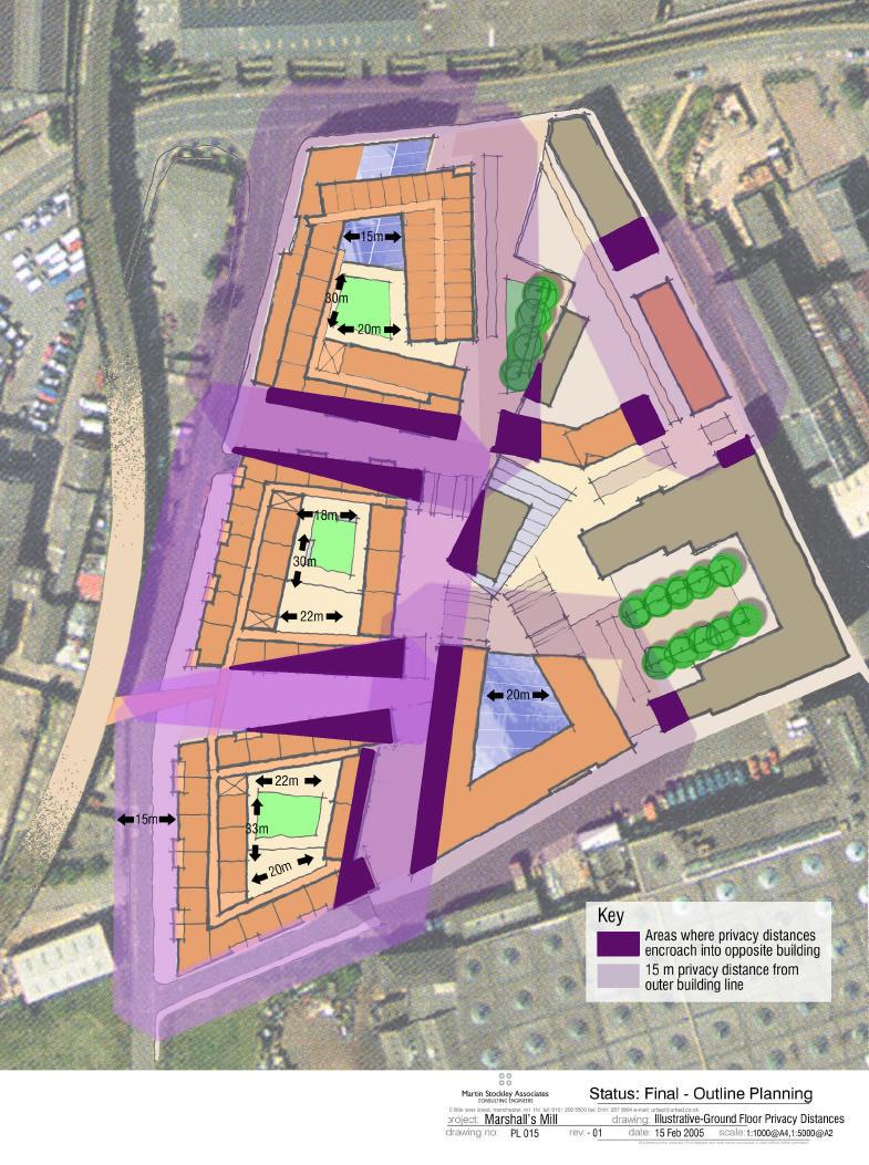
15 5.11 The massing principles that we are seeking to fix as part of the outline consent are the maximum heights of the block around the edge of the site and the predominant height onto the internal public realm. The relationship and maximum heights of the buildings are shown on the cross sections submitted as part of this application The other massing element within the indicative plan is the idea of U shaped blocks with the open end of the U being lower element facing onto the internal public realm These heights represent the maximum heights of the buildings above the predominant ground level. It is intended that this should be apparent as the height of the building from the public realm.. The Listed Wall 5.14 The wall that runs north/south throughout the site is listed for 50 m. The wall forms an important part of the site and we have incorporated parts of the wall into the proposed development. The southern section of the wall will be incorporated into Block D to form part of the eastern elevation. The existing rendering on that part of the wall will be removed and the wall restored appropriately. We are proposing partial demolition to form a square around the Flax Warehouse and facilitate access through the site. A gateway will be provided through the wall between Block A and the Flax Warehouse of 4 metres in width to allow some vehicular movement and pedeatrian movement through the site. On the southern side of the Flax Warehouse a larger area of wall will be demolished to open up the area around the central square and allow servicing movements east west through the site. However, to maintain the integrity of the line of the wall, a 2 metre wide stubb of wall will be retained attached to the Flax warehouse with a further section of about 2 metres crumbling down to the ground The line of the demolished part of the wall will be delineated by setts or other appropriate paving to provide visitors with a sense of historical topography of the site. Privacy Distances 5.15 The buildings of the scheme are designed to create a robust urban environment. The streets and pedestrian routes that make up the masterplan will be between 7m and 12m wide. The building heights described above will therefore mean that enclosure Page 12 of 26
16 ratios will be above 1:1 throughout the scheme. Most of the streets will be significantly higher than they are wide in keeping with the character of the Holbeck Urban Village. More careful consideration has been given to the internal layouts of the apartments where privacy distances fall below 15m. A more detailed section showing internal layouts can be seen in the accompanying sections. Page 13 of 26
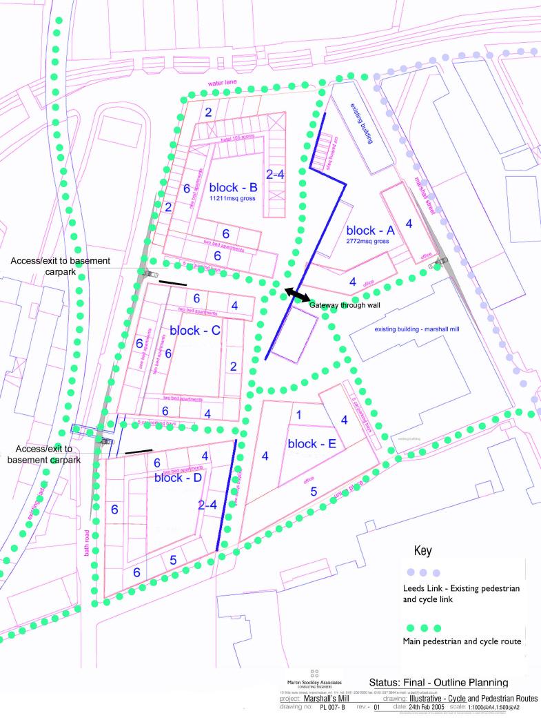
17 6. Access and Parking 6.01 The scheme has been designed to minimise car use and to encourage walking and the use of public transport. The location of the scheme near to Leeds City Centre and the main line station is clearly a benefit in this respect. As described in the Design Statement, the scheme promotes walking through a high quality public realm and good links to surrounding areas. The elements of this strategy covered by this planning application are set out below. Travel Plans 6.02 All major commercial occupiers of the development will be required to prepare, implement and operate a Travel Plan. These plans will be prepared in conjunction with the Council and will include a survey of existing facilities, information to employees, surveys of staff travel patterns, monitored targets and the promotion of schemes such as car sharing. This can be dealt with by a condition attached to the outline consent. Cycle Facilities 6.03 The area is highly accessible by bicycle because of its proximity to the centre but the quality of available cycle routes leaves much to be desired. Cycle parking for residents and employees will be provided in the basement while a number of short stay spaces will be provided within the public realm. Pedestrian Movement 6.04 The site is within easy reach of the station, existing bus routes and a range of facilities particularly in the city centre. Movement on foot to the City Centre is currently limited to routes under the main railway viaduct or via Globe Road to the West. However, there are plans for a new footbridge across the River Aire and the canal into the new development site on Whitehall, giving direct access to the centre. The public realm throughout the scheme has been designed to prioritise pedestrian movement as described below. All of the new spaces that we are creating are pedestrian priority and we are also in support of proposals to create pedestrian priority on Bath Lane and Marshall Street and the improvement the pedestrian route though Union Place. Page 14 of 26
18 6.05 The Masterplan allows for a possible high-level connection from the residential blocks C and D to the disused railway viaduct in order to support the plan to create a park along this structure. Vehicle Movement Strategy 6.06 The Marshall s Mill Masterplan advocates a change to a Shared Space approach to the streets and Public Realm. This recognises that, in local areas, priority must be given to the most vulnerable (people on foot and on bikes), that speeds must be below 20 mph, that surfaces can be shared (rather than providing separate zones for the different uses), that all users will co-operate in the use of the space. On-street parking (short-stay) can be used to support local businesses and also to generate natural narrowing of routes for vehicles. At junctions, no priority is given so that all vehicles must initially give way. All streets however narrow are available for two-way movement so that routes are slow but direct Applied to Marshall s Mill this means that the four streets forming the main block and all internal streets could become shared space. Surfaces would be level (other than falls for drainage) with no raised kerbs to impede movement on foot, bikes, buggies etc. People not in vehicles can walk safely on any part of the street as they always have priority. On street parking is encouraged in particular areas to narrow the possible routes for vehicles. People on bikes can use the entire street surface so they are not forced into the highest risk area beside kerbs. Vehicles are allowed to move through the area but must give way whenever necessary to other users The existing access point into the site from Water Lane will be closed to all but pedestrian/cycle movements at the request of the City Council s Highway Engineer. There will also be no vehicular access from Union Place as this is to comprise a part of the main east/west pedestrian route across Holbeck Urban Village. Parking 6.09 The parking strategy for the area is aimed at providing car storage for residents and good short term parking for local businesses. This is aimed at making best use of the very good and accessible public transport and creating a pedestrian friendly public realm An Electric Car Pool will be provided to enable residents to choose not to own a car and to use a car pool for the limited but regular trips for weekly shopping etc., which are best done in individual vehicles. Page 15 of 26
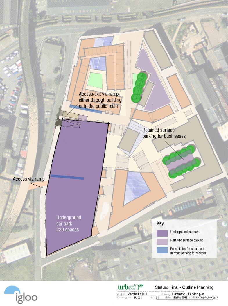
19 6.11 Parking provision for residents is primarily storage of vehicles during the daytime, mid-week with occasional use at weekends. This generates very low vehicle usage and is therefore not a problem in terms of local movement. Local planning policy sets a residential parking standard of 100%. The masterplan envisages provision of 70% parking for residents, which equates to 188 spaces The local plan parking standard for B1 space is one space per 175m2 of floor space, which would equate to 68 spaces for the new accommodation proposed as part of the masterplan. However the plan seeks to discourage commuter parking and has therefore not provided for significant business parking. The exception to this is small local businesses where parking for key personnel is regarded as important. 20 spaces have therefore been provided for these businesses The plan involves the loss of 180 surface parking spaces currently associated with Marshall s Mill and Marshall s Court. Around 50 spaces are to be retained in the courtyards of these buildings, primarily for the use of existing tenants The local plan standard suggests a parking standard for hotels of one space per 3 bedrooms. However it is not planned to provide any parking for the hotel, which is seen as serving the city centre market and being particularly accessible to the main railway station No parking is provided for café/restaurant uses as part of the scheme There is to be some provision of on-street, short term parking for the use of visitors to businesses and residents on the site This equates to 270 parking spaces that are to be provided in two locations (see Plan 6): A basement car park below Blocks C and D. This will accommodate 220 parking spaces and will therefore cover the entire residential parking requirement, plus accommodation for the car pool and the 20 long-term business spaces. Access to this car park is provided off Bath Road. Retained parking in the courtyard of Marshall s Mill and Marshall s Court. The retained area will accommodate around 50 spaces that likely to be used by existing business tenants. Some additional short stay on street parking spaces (see parking plan) for visitors to the scheme will be provided. Page 16 of 26
20 Service Access 6.18 Service access will be possible between Bath Road and Marshall Street. The shared space approach outlined above allows very straightforward servicing arrangements. All surfaces are designed to accommodate vehicle loading so access for deliveries, waste collection, and removals, emergency services are relatively unlimited. Movement speeds are slow generally and the lack of speed humps avoids the unnecessary additional noise and disruption caused by larger vehicles negotiating them. Service access will also be possible via the basement car park as the blocks will be accessible from the basement In conventional roads a delivery/collection vehicle parks on a carriageway and then crosses the footpath to deliver/collect. This impedes both vehicle and pedestrian movements and generates a cycle hazard. In shared space a delivery/collection vehicle can pull up very close to the delivery/collection point and other movements still have the whole remaining width of street in which to pass. The system is regulated by individual good sense and civil behaviour rather than an imposed third party regulation to which nobody feels any empathy. Traffic Impact 6.19 A Separate Transport Assessment has been produced and demonstrates that the additional traffic generated by this proposed development at peak times will be low, less than one car every two minutes on each main route. There will not, therefore, be any significant impact on the highway network. Page 17 of 26
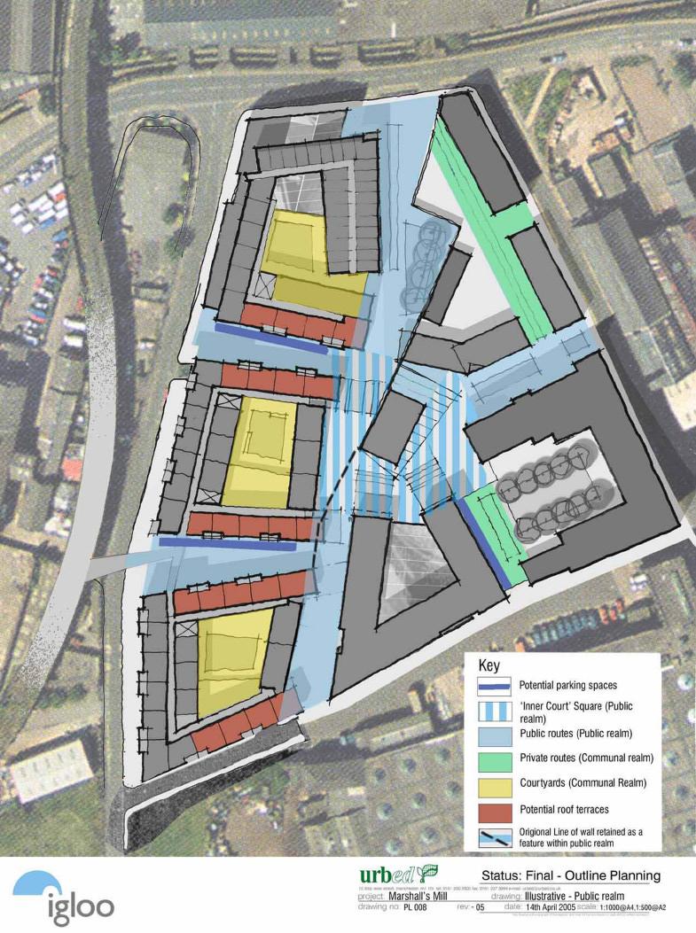
21 7. Public realm 7.01 As described above the scheme is designed as a dense mixed-use neighbourhood. Because of this the public realm is conceived as a network of streets, squares, communal courtyards and informal open spaces rather than as large areas of recreational space or as buildings in a landscape. Much of the public realm will therefore be intensively used and will be enclosed and animated by the surrounding buildings SPG 12 and UDP policy CC10 requires a minimum of 20% of the developable site area to be provided as public realm. The total public realm area for the masterplan is 5,916m 2, making up 30% of the site area. This is above the council policy requirement and we envisage that all the publicly accessible space will be well used and enjoyed by visitors, residents and workers. The buildings have been designed to be secure by design, overlooking public realm with active frontage onto streets so that there is activity throughout the day with eyes onto the street The spaces available to residents within the scheme also include private streets totalling 481m 2, courtyards within blocks totalling 2,238 sq m as well as walkways and roof gardens. Public realm 7.04 The public realm of the scheme which makes up well above the 20% required by the UDP and Revised Planning Framework is made up of the following elements: 7.05 The Inner Court: At the heart of the scheme is the inner court of 1660m2 around the retained Flax Warehouse. No changes are currently proposed in relation to this building, which is currently used as a training centre. However, it will be important to ensure that the Flax Warehouse plays an appropriate role within the overall scheme. Furthermore the building, which appears to have originally been built almost as a brick fortress with few window openings, has been altered in an unsympathetic way in the recent past and its roof altered and lowered to a flat roof structure. It is therefore intended to make a separate application in due course with a public use on the ground floor such as a restaurant or gallery with a potential additional story in the form of a lightweight glass box. Any application submitted will pay attention to the Page 18 of 26
22 historical importance of the building and take account of the views of West Yorkshire Archaeological Service and English Heritage in drawing up a detailed scheme Public routes: There are proposed to be a number of public routes passing through the scheme via the Inner Court. The main route runs north south along the line of the listed wall. A further route runs between Block A and Marshall s Mill and between Blocks B and C, C and D. These will be 24 hour public routes but will not be adopted highway. They will be designed on a shared surface basis as described above. They will be predominantly pedestrian routes with a high quality of surfacing and street furniture In addition there are other public realm elements outside of the application site itself which can also make a valuable contribution to the way in which Holbeck Urban Village will function as an integrated neighbourhood as follows; 7.08 Surrounding roads: As part of the scheme we have suggested that the surrounding streets should become shared surface routes shared by pedestrians and vehicles Temple Square: While not part of the scheme we agree with the suggested new public square in front of Marshall s Mill and Temple Works. This should be a public space with high quality, hard landscaping. It would be animated by public uses and housing in the surrounding buildings. Communal realm 7.10 The scheme includes a range of spaces that are available to the residents of the blocks but which are not public spaces. These include: 7.11 Courtyards: The development form is based on a series of urban blocks around internal courtyards. As we describe in the design statement, these are communal spaces available to the residents of the block. The circulation and access to the residential accommodation is from these courtyards and they provide space to sit out and to socialise with other residents. In some blocks these courtyards might be wholly or partially at first floor level. Page 19 of 26
23 7.12 Private routes: The routes between Marshall s Mill and Block E and the route to the rear of Marshall s Court will be private routes in that they will be gated at night. These routes will be part of the communal realm of the scheme available to residents and open to other users during the day Walkways and roof terraces: There will also be space on upper levels of the residential blocks. This will include access balconies, roof terraces and individual balconies. The amount and type of this space will depend on the detailed design. (i) Table 5: Public Realm Provision Location Usage Area m 2 Inner Court Within site General public. 1,660 (public realm) Public Routes Within site General public. 4,256 (making up 30%) Temple Square Outside site General public. 3,370 Private Routes Within site General public during the day, residents of adjacent blocks at night. Courtyards Within site Residents of blocks and possible use by cafes ,238 Page 20 of 26
24 8. Site briefs Block A 8.01 Description: The regulatory plan indicates Block A as a 2,772m 2 block, which will enclose a new street through the Marshall s Mill site. The block is designed to enclose the newly created square around the Flax Warehouse and will have a prominent corner with Marshall Street. The fourth floor of the block will be recessed and glazed to reduce the bulk of the fourth floor and to enhance the setting of the listed Marshall s Mill. The block is shown with a break opposite the main entrance to Marshall s Mill to retain the vista from Water Lane Uses: This is proposed as workspace operated in a similar way to Marshall Mill. The planning consent should allow for the use of the ground floor of these blocks for active uses such as a gallery Access and parking: Access to the building will be off the street with secondary entrances provided from the courtyard where some parking will be provided Siting: The bold black line indicates the building line to be fixed as part of the planning consent. This creates enclosure to the inner court and the new street north of Marshall s Mill as well as completing the frontage onto Marshall Street Massing: The massing of Block A seeks to relate to the 3-storey Marshall s Court. The block is therefore limited to 4 storeys, 14.5m and the fourth floor of the block recessed and glazed to reduce the bulk of the fourth floor within the setting of the listed buildings. Block B 8.07 Description: Consent is sought for 9,683m 2 of space. The indicative scheme shows this as a 103 room hotel attached to a residential block. The ground floor of the hotel will include its reception and public facilities to create active frontage onto the north/south route running through the site. As part of the proposal the façade of the Water Lane Printing Works has been retained. This corner of Water Lane and Bath Road is a prominent location and should be designed accordingly. Page 21 of 26
25 8.06 Uses: This block is proposed as a mixed-use block comprising a 102 room hotel totalling 4,644m 2, 3,745m 2 of residential space, 632m 2 of workspace and 662 m 2 of active uses at ground level Access and parking: The main entrance to the hotel and the reception area will be via Water Lane. The active uses on the ground floors will front onto Water Lane and Bath Road allowing for activities to spill out onto the streets. There will be no parking associated with the hotel. The residential and business space will have access to the basement car park under Blocks C and D Siting: The outer building line for which consent is sought will create a corner block, which retains the façade of the existing printing works along Water Lane and Bath Road. The new block will be built behind the existing façade. It is agreed with the LPA that the widening of Bath Road will not affect the retention of the Water Lane Printing Works façade. A new access route will be created between blocks B and C allowing for public use. Flexibility is to be retained about the exact position of this route in order to allow different block configurations. For this reason the building line on the Regulatory Plan (Plan 2) is shown as a dotted line on the southern wing to allow for movement of up to 2m either way Massing: We are seeking consent for a maximum height of 20.5m creating a prominent corner with Bath Road and Water Lane. The ground floor is 5.5m in height to allow for public uses and a possible mezzanine. It is envisaged that there would be an atrium for the hotel on Water Lane and a courtyard to the rear. The block drops to 2 4 storeys on its inner face with the other parts of the block all being of up to 6 storey sin height. Block C 8.09 Description: Block C is envisaged as a block with workspace comprising of 1,185m 2 ; active uses on the ground level comprising of 760m 2 and 96 residential units on the upper levels creating 7,370m 2 of residential space. There is a basement car park below both this and Block D. The ground floor includes café space and workspace/livework units Uses: The ground floor of these blocks will not be residential but will include a range of uses to animate the public realm. These could include café/restaurant space fronting onto Bath Road and onto the Inner Court, entrance lobbies into the courtyard for the housing above and workspace, live-work units with active frontages. Page 22 of 26
26 8.11 Access and parking: These units together with the workspace will have entrances off the surrounding streets and shop frontages for the display and potential sale of goods. The basement car park will be accessible via a two-way ramp onto Bath Road. This could either be accommodated within the building or be incorporated into the public route. There will be provision for some on the street parking for servicing and car users with limited mobility. The block incorporates a potential footbridge at an upper level linking to the proposed linear park on the railway viaduct Siting: Block C is set back from the pavement to allow for the widening of Bath Road. The predominant building line is shown on the regulatory plan with the northern wing marked with a dotted line to allow for movement of up to 2m either way. The building is an important part of the frontage onto Bath Road and the north/south route running through the scheme. There is the potential for the gable ends of the north and south wings of the block to oversail the building line fronting the inner court at first floor and above Massing: The building rises to a maximum 20.5m on Bath Road and drops down towards the Inner Court open space. A number of massing options have been explored including a U shaped block with a lower section fronting onto the inner court. The stepped form also allows for the possibilities of roof gardens. This U shaped form is however just one option and is not being fixed at this stage. To accommodate flexibility of uses the ground floor will have a 5.5m ceiling heights. Block D 8.14 Description: Block D will operate in a similar way to block C with mixed ground floor uses making up 1,619m 2 of workspace, 373m 2 of active uses and 93 residential units occupying 7,488m 2. The building rises to 6 storeys along Bath Road and steps down into the core of the site. The block will be set back as with Block C to allow for the widening of Bath Road and will have an internal courtyard and roof terraces Uses: As with Block C the ground floor allows for a mix of uses and highly versatile space that can adapt to the market. Uses could include café, restaurants, workspace, live/work units, galleries, shops etc Access and parking: These units together with the workspace will have entrances off the surrounding streets with the more active uses along Bath Road. The basement will provide parking with an access ramp off the internal street created between Block C and D. There will be a pedestrian entrance onto ground level from the car park allowing for residents to access the block and the streets. Page 23 of 26
27 8.17 Siting: Block D is shown as a complete block set back from Bath Road to allow for potential widening with public realm on all four sides. The eastern elevation has incorporated the retained wall and there is the potential for the gable ends of the north and south wings of the block to oversail this wall at first floor and above Massing: This block is similar in form to Block C. The predominant height of the building will front onto Bath Road where consent is sought for a maximum height of 20.5m. The building steps down into the core of the site. The stepping down will also create additional open space, which could be used as roof gardens. To accommodate flexibility of uses the ground floor will have a 5.5m ceiling heights. Block E 8.19 Description: This is a commercial block with 5,722m 2 of space. The ground floor is to include an entrance lobby and atrium. This building will be operated in a similar fashion to Marshall s Mill offering versatile space with broadband connection and shared facilities with the surrounding blocks encouraging networking to take place. The northern elevation of the building will front onto the Inner Court and is anticipated to be the main access into the building Uses: This block will be entirely commercial and comprises of 5,722 m2 of office space Access and Parking: Access to the building will be from the north. The block will have access to the shared basement car park with some on-street parking spaces for visitors Siting: Block E is sited on the plan creating a U shaped perimeter block with a lower wing facing the Inner Court and again the possibility of the gables of the west and east blocks oversailing the building line at first floor level. The elevation facing Marshall s Mill is onto a private route and is not subject to a building line Massing: The massing of this building has been designed not to dominate Marshall s Mill and rises to five storeys (17.5m) onto Union Place and steps down into the centre of the site. Page 24 of 26
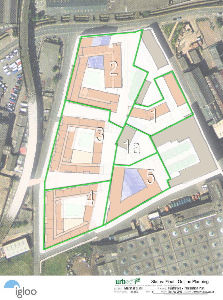
28 9. Phasing 9.01 Plan 9 indicates a proposed parcelation plan for the scheme. This is called a parcelation plan rather than a phasing plan because the order in which each block is developed will depend on the market. The hotel for example could be a very early phase if current interest materialises but if not could be a later phase The parcelation plan has therefore been designed to ensure that each section of the development is viable and can be developed independently. It is likely that Block A will be developed first and this will include the Flax Warehouse provided that this can be acquired in the appropriate timescale. This will allow the inner court to be developed and to act like the hub of a wheel giving access to each of the other development parcels Each of the parcels is linked to part of the public realm. This allows each block to be accessed and also attributes the public realm costs to each development parcel. This will require design guidance to be prepared to ensure consistency, which we anticipate being a condition attached to the outline consent The car park under blocks C and D has been designed so that it can be built in tow if parts of the buildings are not built together. For this reason each of the access ramps accommodates two-way traffic. The undeveloped parts of the site will be used as surface parking in advance of the car park being completed. Page 25 of 26
29
30
31
32
33
34
35
36
37
38
39
40
A mix of uses. Housing:
 7 Massing and uses Page 79 7:1. A mix of uses % Total Habitable Occ/ People Rooms HR Studio 6.8% 308 1 0.90 277 1 bed 32.0% 1442 2 0.90 2,595 2 bed 37.6% 1691 3 0.90 4,567 3 bed 21.2% 955 4 0.90 3,438
LITTLE MOUNTAIN ADJACENT AREA REZONING POLICY
 LITTLE MOUNTAIN ADJACENT AREA REZONING POLICY JANUARY 2013 CONTENTS 1.0 INTENT & PRINCIPLES...1 2.0 APPLICATION...2 3.0 HOUSING TYPES, HEIGHT & DENSITY POLICIES...3 3.1 LOW TO MID-RISE APARTMENT POLICIES...4
PLANNING BRIEF SITE ND7, TEMPLE QUAY, BRISTOL
 PLANNING BRIEF SITE ND7, TEMPLE QUAY, BRISTOL Site Description Plot ND7 is located within the area known as Temple Quay North in central Bristol, north of the Floating Harbour, and is incorporated within
WELCOME TIMESCALES. Thank you for attending Anthology s final public exhibition on the emerging plans for Kennington Stage. ANTHOLOGY S COMMITMENTS
 WELCOME Thank you for attending Anthology s final public exhibition on the emerging plans for Kennington Stage. Since the second consultation in October 2018, which asked your views on the preferred approach,
DESIGN, ACCESS & PLANNING STATEMENT
 (MADRON STREET) LONDON SE1 5UB DESIGN, ACCESS & PLANNING STATEMENT The architectural response for the site has been designed with regard to the following: The New Southwark Plan The London Plan: Spatial
Southall Gas Works: Design Statement by URBED with Capita Symonds, WYG, Lovejoys, Jestico and Whiles and RPSDesign Statement. Typologies.
 9 Typologies Page 95 9:1. Approach to typologies 1. 3. 2. 4. Far left: Traditional walk-up flats: With 2 of 4 flats per landing off a core. The bottom plan shows a perimeter block arrangement based on
5.0 Development Strategy 32
 5.0 Development Strategy 32 Objectives To ensure the long term future of the Bazaar Market building by giving it a higher order retail use, reflecting the development of retail on the Guy s site To ensure
Cressingham Gardens Estate, Brixton. DRAFT Masterplan Objectives for discussion. September 2015
 Cressingham Gardens Estate, Brixton DRAFT Masterplan Objectives for discussion September 2015 Contents Introduction 1 Project objectives 2 Masterplan objectives 4 Draft masterplan objectives for the Cressingham
Multi-unit residential uses code
 9.3.11 Multi-unit residential uses code 9.3.11.1 Application (1) This code applies to assessable development identified as requiring assessment against the Multi-unit residential uses code by the tables
H5. Residential Mixed Housing Urban Zone
 H5. Residential Mixed Housing Urban Zone [ENV-2016-AKL-000197: Robert Adams] Addition sought H5.1. Zone description The Residential Mixed Housing Urban Zone is a reasonably high-intensity zone enabling
Hotel and Multi Storey Cycle Park Two The Square, Station Square, Cambridge
 Hotel and Multi Storey Cycle Park Two The Square, Station Square, Cambridge Introduction Completed in 2016 for Brookgate, this project in Cambridge is the first of its kind in the UK; a building which
Proposed Demolition of Existing Shop & Erection of New Build Development to Form 11 Flats
 Proposed Demolition of Existing Shop & Erection of New Build Development to Form 11 Flats Wern Goch Hirani Stores, 56 Wern Goch West, Cardiff CF23 7AB Design & Access Statement for Pre-Application Consultation
H4. Residential Mixed Housing Suburban Zone
 H4. Residential Mixed Housing Suburban Zone H4.1. Zone description The Residential Mixed Housing Suburban Zone is the most widespread residential zone covering many established suburbs and some greenfields
Pre-Applica on Design Statement : Residen al Development, The Gas Works, 113 Bury Road, The ord, Norfolk 1
 13-188 Pre-Applica on Design Statement: Residen al Development, The Gas Works, 113 Bury Road, The ord, Norfolk Prepared by: Gary Johns Architects Date: October 2015 15-311 Pre-Applica on Design Statement
NORTH LEEDS MATTER 2. Response to Leeds Sites and Allocations DPD Examination Inspector s Questions. August 2017
 NORTH LEEDS MATTER 2 Response to Leeds Sites and Allocations DPD Examination Inspector s Questions August 2017 CLIENT: TAYLOR WIMPEY, ADEL REFERENCE NO: CONTENTS 1.0 INTRODUCTION 2.0 TEST OF SOUNDNESS
P. H. Robinson Consulting Urban Planning, Consulting and Project Management
 PLANNING RATIONALE REPORT FOR SITE PLAN AND DRAFT PLAN OF CONDOMINIUM APPLICATIONS 73-75 HARVEY STREET CITY OF OTTAWA PREPARED BY: P H ROBINSON CONSULTING AUGUST 2012 1 This report has been prepared on
H5. Residential Mixed Housing Urban Zone
 H5. Residential Mixed Housing Urban Zone H5.1. Zone description The Residential Mixed Housing Urban Zone is a reasonably high-intensity zone enabling a greater intensity of development than previously
The site is located within the area forming phase 2 of the Town Centre redevelopment scheme. The relevant previous planning history is as follows:-
 2017/1601 Applicant: Barnsley Metropolitan Borough Council, C/o IBI Group Description: Erection of an electrical substation. Site Address: Land at Kendray Street, Barnsley, S70 2JL No comments have been
Proposals for the Redevelopment of the Magistrates Court & Police Station, Normandy Street / Orchard Lane, Alton
 THE SITE THE SITE The Site in Context WELCOME Welcome to our public exhibition in connection with our draft proposals ahead of a planning application being proposals for the redevelopment of the magistrates
Ku-ring-gai Local Environmental Plan No 194
 New South Wales Ku-ring-gai Local Environmental Plan No 194 under the Environmental Planning and Assessment Act 1979 I, the Minister Assisting the Minister for Infrastructure and Planning (Planning Administration),
Director, Community Planning, Toronto and East York District
 STAFF REPORT September 1, 2005 To: From: Subject: Toronto and East York Community Council Director, Community Planning, Toronto and East York District Further Report Applications to amend Official Plan
DRAFT FOR DISCUSSION PURPOSES ONLY. Port Credit Local Area Plan Built Form Guidelines and Standards DRAFT For Discussion Purposes
 Port Credit Local Area Plan Built Form Guidelines and Standards DRAFT For Discussion Purposes 1 Local Area Plan - Project Alignment Overview Directions Report, October 2008 (General Summary Of Selected
Masshouse Plot 3, Land at Masshouse Lane/Park Street, Masshouse Plaza, City Centre, Birmingham, B5
 Committee Date: 21/08/2014 Application Number: 2014/02950/PA Accepted: 07/05/2014 Application Type: Full Planning Target Date: 06/08/2014 Ward: Nechells Masshouse Plot 3, Land at Masshouse Lane/Park Street,
apply sustainability principles to all residential developments in Ardee;
 3. Housing 3.1 Introduction Ardee is currently experiencing considerable pressure for residential development as improved road infrastructure, together with the availability of serviced land, makes the
3.1 Existing Built Form
 3.1 Existing Built Form There is a wide variety of built form in the study area, generally comprising 2 and 3 storey buildings. This stretch of Queen Street East is somewhat atypical of Toronto's main
Activities which do not satisfy the General Rules and are not provided for as Restricted Discretionary activities... 9
 16.0 PAPAKAINGA AND MARAE SETTLEMENTS... 1 16.1 INTRODUCTION... 1 16.2 ISSUES... 1 16.3 OBJECTIVE (PAPAKAINGA)... 2 16.4 POLICIES (PAPAKAINGA)... 2 16.5 OBJECTIVE (SURROUNDING ENVIRONMENT)... 2 16.6 POLICIES
18. Appendix H Urban Design Panel Presentation
 18. Appendix H Urban Design Panel Presentation new hotel and serviced apartments 12 lakewood court manukau city URBAN DESIGN PANEL PRESENTATION site context plan neighbourhood analysis plan site context
SCHEDULE 32 TO CLAUSE DESIGN AND DEVELOPMENT OVERLAY
 --/--/20-- Proposed GC81 SCHEDULE 32 TO CLAUSE 43.02 DESIGN AND DEVELOPMENT OVERLAY Shown on the planning scheme map as DDO32. FISHERMANS BEND WIRRAWAY PRECINCT 1.0 Design objectives --/--/20-- Proposed
RYEDALE SITES LOCAL PLAN MATTER 4 PROPOSED HOUSING SITE OPTION REF. 116 LAND AT MIDDLETON ROAD, PICKERING BARRATT HOMES & DAVID WILSON HOMES
 RYEDALE SITES LOCAL PLAN MATTER 4 PROPOSED HOUSING SITE OPTION REF. 116 LAND AT MIDDLETON ROAD, PICKERING BARRATT HOMES & DAVID WILSON HOMES REPRESENTOR ID: 1064 INTRODUCTION 1.1 We write on behalf of
LIBERTY HOUSE. Paul Keogh Architects. Paul Keogh Architects LIBERTY HOUSE HOMES
 150 151 Award: Highly Commended 2015 RIAI Irish Architecture Awards Client: Dublin City Council Liberty House takes its inspiration from the Georgian brick terraces Project Photography: Peter Cook Location:
Planning Policy Report for the Proposed Residential Development at The Old Sorting Office
 Planning Policy Report for the Proposed Residential Development at The Old Sorting Office Greenwich Unitary Development Plan UDP 1. Status of the UDP The current UDP was adopted on 20 July 2006. The UDP
H6 Residential Terrace Housing and Apartment Buildings Zone
 H6. Residential Terrace Housing and Apartment Buildings Zone [CIV-2016-404-002333: Franco Belgiorno-Nettis]-Note: The properties affected by this appeal are identified on the Auckland Unitary Plan viewer.
RYEDALE SITES LOCAL PLAN MATTER 3 PROPOSED HOUSING SITE OPTION REF. 116 LAND AT MIDDLETON ROAD, PICKERING BARRATT HOMES & DAVID WILSON HOMES
 RYEDALE SITES LOCAL PLAN MATTER 3 PROPOSED HOUSING SITE OPTION REF. 116 LAND AT MIDDLETON ROAD, PICKERING BARRATT HOMES & DAVID WILSON HOMES REPRESENTOR ID: 1064 INTRODUCTION 1.1 We write on behalf of
Simon Court 2-4 Neeld Crescent London NW4 3RR
 Location Simon Court 2-4 Neeld Crescent London NW4 3RR Reference: 17/1019/FUL Received: 20th February 2017 Accepted: 23rd February 2017 Ward: West Hendon Expiry 20th April 2017 Applicant: Proposal: Mr
On: 20 April Report by: Director of Development and Housing Services. Heading: Paisley West End - Regeneration Masterplan. 1.
 To: Council On: 20 April 2017 Report by: Director of Development and Housing Services Heading: Paisley West End - Regeneration Masterplan 1. Summary 1.1 This report sets out proposals for the regeneration
PLANNING RATIONALE REPORT CODEAU BUILDING LTD RIDEAU STREET OTTAWA DECEMBER 2013
 PLANNING RATIONALE REPORT CODEAU BUILDING LTD 541-545 RIDEAU STREET OTTAWA DECEMBER 2013 1 This report has been prepared on behalf of Codeau Building Ltd. in support of a Zoning By-law Amendment Application
Grosvenor House, Drury Lane, London, WC2. October 2003
 Grosvenor House, 141-143 Drury Lane, London, WC2 October 2003 The material contained in this document is private and confidential and for issue to and use by the client and the project team only. Acknowledgments
SOUTH CAMBRIDGESHIRE DISTRICT COUNCIL. S/1744/05/F Thriplow House and Garage on land Adjacent 22 Middle Street for S Hurst
 SOUTH CAMBRIDGESHIRE DISTRICT COUNCIL REPORT TO: Development and Conservation Control Committee 2 nd November 2005 AUTHOR/S: Director of Development Services S/1744/05/F Thriplow House and Garage on land
ERECTION OF 42 NO. HOUSING UNITS (OUTLINE) AT Reserve Sites A And D, Hindhead Knoll, Walnut Tree FOR English Partnerships
 AT Reserve Sites A And D, Hindhead Knoll, Walnut Tree FOR English Partnerships") 05/01386/OUT ERECTION OF 42 NO. HOUSING UNITS (OUTLINE) AT Reserve Sites A And D, Hindhead Knoll, Walnut Tree FOR English Partnerships INTRODUCTION The 13 Week Date for the determination of this major
05/01386/OUT ERECTION OF 42 NO. HOUSING UNITS (OUTLINE) AT Reserve Sites A And D, Hindhead Knoll, Walnut Tree FOR English Partnerships INTRODUCTION The 13 Week Date for the determination of this major
OVERVIEW PROJECT SUMMARY. A two storey detached townhouse which is modern and affordable.
 OVERVIEW A two storey detached townhouse which is modern and affordable. PROJECT SUMMARY This speculative house was developed as part of the greenfield development at Hobsonville Point. There had been
Canterbury City Council Military Road Canterbury Kent CT1 1YW. Title: CA//16/02739/FUL. Author: Planning and Regeneration.
 O Crown copyright and database rights 2017 Ordnance Survey 100019614 Title: CA//16/02739/FUL Author: Planning and Regeneration Scale 1:1,250 Map Dated: 22/02/2017 Canterbury City Council Military Road
Urban Design Brief (Richmond) Corp. 1631, 1635, 1639, 1643 and 1649 Richmond Street City of London
 Corp. 1631, 1635, 1639, 1643 and 1649 Richmond Street City of London") Urban Design Brief 1635 (Richmond) Corp. 1631, 1635, 1639, 1643 and 1649 Richmond Street City of London Site Plan Control Application Holding Provision Application April 1, 2015 Prepared for: Rise Real
Urban Design Brief 1635 (Richmond) Corp. 1631, 1635, 1639, 1643 and 1649 Richmond Street City of London Site Plan Control Application Holding Provision Application April 1, 2015 Prepared for: Rise Real
MAKING THE MOST EFFECTIVE AND SUSTAINABLE USE OF LAND
 165 SOC146 To deliver places that are more sustainable, development will make the most effective and sustainable use of land, focusing on: Housing density Reusing previously developed land Bringing empty
Richmond Street West Zoning Amendment Application - Preliminary Report
 STAFF REPORT ACTION REQUIRED 543-553 Richmond Street West Zoning Amendment Application - Preliminary Report Date: April 24, 2015 To: From: Wards: Reference Number: Toronto and East York Community Council
H4. Residential Mixed Housing Suburban Zone
 H4. Residential Mixed Housing Suburban Zone H4.1. Zone description The Residential Mixed Housing Suburban Zone is the most widespread residential zone covering many established suburbs and some greenfields
AT Land Adjacent to Tollgate Cottage, Broughton Grounds Lane, Milton Keynes. Parish: Broughton & Milton Keynes Parish Council
 APPLICATION 06 Application Number: 13/00553/FUL Major Revision to plans approved under 11/01760/MKPC for Plots 59-71 to provide 16 affordable one, two and three bedroom apartments with associated parking
The Flour Mill MARGATE RD, RAMSGATE
 The Flour Mill MARGATE RD RAMSGATE THE FORMER RANK HOVIS FLOUR MILL RAMSGATE A RESIDENTIAL DEVELOPMENT OPPORTUNITY WITH PLANNING CONSENT FOR DEVELOPMENT OF 72 APARTMENTS AND 17 HOUSES Summary Planning
1 Cumbrian Gardens London NW2 1EB
 Location 1 Cumbrian Gardens London NW2 1EB Reference: 16/0469/FUL Received: 25th January 2016 Accepted: 29th January 2016 Ward: Golders Green Expiry 25th March 2016 Applicant: Mr REZA FARD Proposal: Conversion
Urban Design Brief 6233, 6237, 6241 and 6245 Main Street, Stouffville Pace Savings and Credit Union June 15, 2012
 Pace Savings and Credit Union June 15, 2012 1.0 Introduction 3 2.0 The Proposal 4 3.0 Site and Development Context 5 4.0 Planning Background 7 5.0 Design Rationale 8 5.1 Limited Opportunities 5.2 Overall
108 Holders Hill Road London NW4 1LJ
 Location 108 Holders Hill Road London NW4 1LJ Reference: 16/4234/FUL Received: 28th June 2016 Accepted: 7th July 2016 Ward: Finchley Church End Expiry 1st September 2016 Applicant: Proposal: Mr b menahem
CASTLES OF CALEDON URBAN DESIGN REPORT
 CASTLES OF CALEDON URBAN DESIGN REPORT PROPOSED RESIDENTIAL DEVELOPMENT CALEDON, ONTARIO 10 JULY, 2015 TABLE CONTENTS: 1.0 DEVELOPMENT 4.0 CONCLUSION 1.1 Introduction 1.2 Castles of Caledon- Urban Design
Staff Report for Council Public Meeting
 Agenda Item 3.3 a Staff Report for Council Public Meeting Date of Meeting: February 7, 2018 Report Number: SRPRS.18.022 Department: Division: Subject: Planning and Regulatory Services Development Planning
Description: Change of use from job centre (A1) to 15 bedroom sui generis HMO (C4)
 to 15 bedroom sui generis HMO (C4)") 2018/0656 Applicant: Job Centre Plus, c/o Andrew Bailey Architects Description: Change of use from job centre (A1) to 15 bedroom sui generis HMO (C4) Site Address: Job Centre Plus, High Street, Goldthorpe,
2018/0656 Applicant: Job Centre Plus, c/o Andrew Bailey Architects Description: Change of use from job centre (A1) to 15 bedroom sui generis HMO (C4) Site Address: Job Centre Plus, High Street, Goldthorpe,
New Marrickville Library
 1 New Library Precinct C Heritage Cottages Commericial Use Precinct C New Residential Building 2 & 8 storeys Precinct D New Residential Building 6 storeys Precinct D Possible Refurbishment of Existing
8.5.1 R1, Single Detached Residential District
 8.5.1 R1, Single Detached Residential District The purpose of this district is to provide for residential development in the form of single detached dwellings. Dwelling, Single Detached Home Business,
Sherwood Forest (Trinity) Housing Corporation. Urban Design Brief
 Housing Corporation. Urban Design Brief") Sherwood Forest (Trinity) Housing Corporation Sherwood Place Affordable Housing Apartments Trinity Presbyterian Church Orchard Park Nursery School 590 Gainsborough Road, London Urban Design Brief REVISED
Sherwood Forest (Trinity) Housing Corporation Sherwood Place Affordable Housing Apartments Trinity Presbyterian Church Orchard Park Nursery School 590 Gainsborough Road, London Urban Design Brief REVISED
Bylaw No , being "Official Community Plan Bylaw, 2016" Schedule "A" DRAFT
 Bylaw No. 2600-2016, being "Official Community Plan Bylaw, 2016" Schedule "A" Urban Structure + Growth Plan Urban Structure Land use and growth management are among the most powerful policy tools at the
Zone 8B Park Central, Spring Street, Birmingham, B15 2GD
 Committee Date: 08/05/2014 Application Number: 2014/01127/PA Accepted: 18/02/2014 Application Type: Full Planning Target Date: 20/05/2014 Ward: Ladywood Zone 8B Park Central, Spring Street, Birmingham,
Site Allocations Plan
 Site Allocations Plan Leeds Local Plan Development Plan Document Note of clarification for Inspector on Matter 2 and inclusion of UDP allocations as HG1 sites July 2018 Page 1 of 6 Note of clarification
LAND USE AMENDMENT SOUTHWOOD (WARD 11) MACLEOD TRAIL S AND ANDERSON ROAD SW BYLAWS 140D2018 AND 141D2018
 MACLEOD TRAIL S AND ANDERSON ROAD SW BYLAWS 140D2018 AND 141D2018") Page 1 of 30 EXECUTIVE SUMMARY This land use amendment application is to redesignate the parcel currently containing the Anderson Light Rail Transit (LRT) Station s Park N Ride surface parking lots from
Page 1 of 30 EXECUTIVE SUMMARY This land use amendment application is to redesignate the parcel currently containing the Anderson Light Rail Transit (LRT) Station s Park N Ride surface parking lots from
4027 and 4031 Ellesmere Road Zoning Amendment and Draft Plan of Subdivision Applications - Request for Direction Report
 STAFF REPORT ACTION REQUIRED 4027 and 4031 Ellesmere Road Zoning Amendment and Draft Plan of Subdivision Applications - Request for Direction Report Date: August 22, 2013 To: From: Wards: Reference Number:
71 RUSSELL AVENUE. PLANNING RATIONALE FOR SITE PLAN CONTROL APPLICATION (Design Brief)
") ` 71 RUSSELL AVENUE Ottawa September 14, 2018 PLANNING RATIONALE FOR SITE PLAN CONTROL APPLICATION (Design Brief) Introduction The intent of this Planning Rationale and Design Brief is to provide planning
` 71 RUSSELL AVENUE Ottawa September 14, 2018 PLANNING RATIONALE FOR SITE PLAN CONTROL APPLICATION (Design Brief) Introduction The intent of this Planning Rationale and Design Brief is to provide planning
230 Oak Street- Official Plan Amendment and Zoning Bylaw Amendment Applications - Preliminary Report
 STAFF REPORT ACTION REQUIRED 230 Oak Street- Official Plan Amendment and Zoning Bylaw Amendment Applications - Preliminary Report Date: February 6, 2014 To: From: Wards: Reference Number: Toronto and East
The Miramar Santa Monica
 The Miramar Santa Monica Project Description The Santa Monica Miramar Hotel (the Miramar or the Hotel ) has been an institution in the City of Santa Monica since originally opening on the site in 1920.
3390, 3392, 3394, 3396 and 3398 Bayview Avenue - Official Plan Amendment, Zoning By-law Amendment Application - Preliminary Report
 STAFF REPORT ACTION REQUIRED 3390, 3392, 3394, 3396 and 3398 Bayview Avenue - Official Plan Amendment, Zoning By-law Amendment Application - Preliminary Report Date: March 14, 2016 To: From: Wards: Reference
PREPARED FOR: ADI DEVELOPMENT GROUP INC.
 Acronym Urban Design and Planning/Mark Sterling Consulting Inc. 111 Clendenan Avenue, Toronto, Ontario M6P 2W7 URBAN DESIGN BRIEF PROPOSED DEVELOPMENT 4880 VALERA ROAD, CITY OF BURLINGTON PREPARED FOR:
Appendix1,Page1. Urban Design Guidelines. Back to Back and Stacked Townhouses. DRAFT September 2017
 Appendix1,Page1 Urban Design Guidelines DRAFT September 2017 Back to Back and Stacked Townhouses Appendix1,Page2 Table of Contents 1 Introduction 1 1.1 Purpose 1 1.2 Urban Design Objectives 1 1.3 Building
20 Edward Street Zoning Amendment Application - Preliminary Report
 STAFF REPORT ACTION REQUIRED 20 Edward Street Zoning Amendment Application - Preliminary Report Date: January 20, 2015 To: From: Wards: Reference Number: Toronto and East York Community Council Director,
[2010] VSC (2004) 18 VPR 229
![[2010] VSC (2004) 18 VPR 229](/thumbs/74/70555400.jpg "[2010] VSC (2004) 18 VPR 229") MOOT COURT 2017 PREPARED BY TIM RETROT VICTORIAN CIVIL AND ADMINISTRATIVE TRIBUNAL PLANNING PERMIT APPLICATION NO. TP418/2016 OUTLINE OF SUBMISSIONS ON BEHALF OF LIONHEART HOMES 93-95 VICTORIA STREET,
MOOT COURT 2017 PREPARED BY TIM RETROT VICTORIAN CIVIL AND ADMINISTRATIVE TRIBUNAL PLANNING PERMIT APPLICATION NO. TP418/2016 OUTLINE OF SUBMISSIONS ON BEHALF OF LIONHEART HOMES 93-95 VICTORIA STREET,
Design and Access Statement Volume III Part 6 of 9 Plot A1. May 2018 Allies and Morrison
 Design and Access Statement Volume III Part 6 of 9 Plot A1 May 2018 Allies and Morrison 6 OFFICE 135 CANADA WATER MASTERPLAN PLOT A1 Design and Access Statement May 2018 6.1 Introduction The office development
Requirements for accepted development and assessment benchmarks for assessable development
 9.3.10 Small Lot Housing Design Code 9.3.10.1 Application (1) This code applies to development identified as requiring assessment against the Small Lot Housing Design Code by the categories of development
Land at Upper Dean Street/Pershore Street (including Upper Dean Street), City Centre, Birmingham
, City Centre, Birmingham") Committee Date: 19/03/2015 Application Number: 2014/09503/PA Accepted: 22/12/2014 Application Type: Full Planning Target Date: 23/03/2015 Ward: Nechells Land at Upper Dean Street/Pershore Street (including
Committee Date: 19/03/2015 Application Number: 2014/09503/PA Accepted: 22/12/2014 Application Type: Full Planning Target Date: 23/03/2015 Ward: Nechells Land at Upper Dean Street/Pershore Street (including
The Horizon, 54 New Coventry Road, Sheldon, Birmingham, B26 3BB
 Committee Date: 17/07/2014 Application Number: 2014/02479/PA Accepted: 22/04/2014 Application Type: Full Planning Target Date: 22/07/2014 Ward: Sheldon The Horizon, 54 New Coventry Road, Sheldon, Birmingham,
APPLICATION No. 17/01532/MNR APPLICATION DATE: 29/06/2017
 COMMITTEE DATE: 11/10/2017 APPLICATION No. 17/01532/MNR APPLICATION DATE: 29/06/2017 ED: APP: TYPE: RIVERSIDE Full Planning Permission APPLICANT: Mr PROTHERO LOCATION: 49 DESPENSER STREET, RIVERSIDE, CARDIFF,
No , Crwys Road, Cardiff. Conversion and New Build Student Accommodation Development in Crwys Road, Cardiff
 No. 38-48, Crwys Road, Cardiff Conversion and New Build Student Accommodation Development in Crwys Road, Cardiff Contents 1.0 Introduction 2.0 Site Analysis 3.0 Context 4.0 Planning History 5.0 Planning
Montreal Road District Secondary Plan [Amendment #127, October 9, 2013]
![Montreal Road District Secondary Plan [Amendment #127, October 9, 2013]](/thumbs/72/66783104.jpg "Montreal Road District Secondary Plan [Amendment #127, October 9, 2013]") [Amendment #127, October 9, 2013] 1.0 General The following policies are applicable to the Montreal Road District as set out in Schedule 1. 1.1 District Objectives The objective of this Plan is to guide
[Amendment #127, October 9, 2013] 1.0 General The following policies are applicable to the Montreal Road District as set out in Schedule 1. 1.1 District Objectives The objective of this Plan is to guide
250, 252, 254 and 256 Royal York Road and 8 and 10 Drummond Street - Zoning By-law Amendment Application - Preliminary Report
 STAFF REPORT ACTION REQUIRED 250, 252, 254 and 256 Royal York Road and 8 and 10 Drummond Street - Zoning By-law Amendment Application - Preliminary Report Date: May 28, 2013 To: From: Wards: Reference
900 BURRARD STREET CD-1 GUIDELINES (BY-LAW NO. 6421) (CD-1 NO. 229) CONTENTS. 1 Application and Intent... 1
 (CD-1 NO. 229) CONTENTS. 1 Application and Intent... 1") 50 City of Vancouver Land Use and Development Policies and Guidelines Community Services, 453 W. 12th Ave Vancouver, BC V5Y 1V4 F 604.873.7344 fax 873.7060 planning@city.vancouver.bc.ca 900 BURRARD STREET
50 City of Vancouver Land Use and Development Policies and Guidelines Community Services, 453 W. 12th Ave Vancouver, BC V5Y 1V4 F 604.873.7344 fax 873.7060 planning@city.vancouver.bc.ca 900 BURRARD STREET
Plan Dutch Village Road
 Plan Dutch Village Road Objective: The lands around Dutch Village Road are a minor commercial area that services the larger Fairview community. Maintaining the vibrancy of the area by planning for redevelopment
Royal Pier Waterfront, Southampton. Financial Viability Assessment
 Royal Pier Waterfront, Southampton Financial Viability Assessment August 2015 1. INTRODUCTION CBRE has been instructed by Royal Pier Waterfront (Southampton) Limited ( RPW ), a company owned by the Lucent
Planning Committee 4 March 2014
 Planning Committee 4 March 2014 Agenda Item No: 9 Planning application no. Site Proposal Ward Applicant Cabinet Member with lead responsibility Accountable director 13/01262/FUL Former Sunbeam Factory,
STAFF REPORT. March 14, Toronto and East York Community Council. Director, Community Planning, South District
 STAFF REPORT March 14, 2005 To: From: Subject: Toronto and East York Community Council Director, Community Planning, South District Preliminary Report Official Plan Amendment and Rezoning Application 05
16 Sevington Road London NW4 3SB
 Location 16 Sevington Road London NW4 3SB Reference: 18/5641/FUL Received: 19th September 2018 Accepted: 19th September 2018 Ward: West Hendon Expiry 14th November 2018 Applicant: Proposal: Hussaini Conversion
TOTTENHAM SECONDARY PLAN
 TOTTENHAM SECONDARY PLAN AMENDMENT NO. 11 TO THE OFFICIAL PLAN OF THE TOWN OF NEW TECUMSETH The following text and schedules to the Official Plan of the Town of New Tecumseth constitute Amendment No. 11
Newlands Planning Application - Public Consultation Frequently Asked Questions
 Newlands Planning Application - Public Consultation Frequently Asked Questions 5 th April 2017 We have collated the most frequently raised issues and queries following the latest stage of consultation.
PROPOSED APARTMENT DEVELOPMENT 32 & 34 TENNYSON AVE TAKAPUNA INTEGRATED TRANSPORT ASSESSMENT
 PROPOSED APARTMENT DEVELOPMENT 32 & 34 TENNYSON AVE TAKAPUNA INTEGRATED TRANSPORT ASSESSMENT Prepared by E.R Hebner 30 th November 2016 Z:\2015_Projects\15155-34 Tennyson Ave\doc\34 Tennyson Ave - Traffic
Design & Access Statement 704 Woolwich Road, London SE7 8LQ February 2018
 Design & Access Statement 704 Woolwich Road, London SE7 8LQ February 2018 Moji Karami, BA(hons)Arch CONTENTS 1.0 Introduction 2.0 Executive Summary 3.0 Existing Site and Surrounding Area 4.0 Transport
Director, Community Planning, North York District NNY 23 OZ and NNY 23 RH
 STAFF REPORT ACTION REQUIRED 2 & 50 Sheppard Avenue East 4841 to 4881 Yonge Street and 2 to 6 Forest Laneway Official Plan Amendment, Zoning By-law Amendment and Rental Housing Demolition Applications
6.0 DEVELOPMENT OPPORTUNITIES
 6.0 DEVELOPMENT OPPORTUNITIES Urban neighbourhoods are in a constant process of change and evolution. In successful cities, such as Ottawa, development pressures are a constant. To help direct this growth
4 DEVELOPMENT STANDARDS FOR
 4 DEVELOPMENT STANDARDS FOR RESIDENTIAL MIXED-USE PROJECTS This chapter presents standards for residential mixed-use projects in the Ashland-Cherryland Business District and the Castro Valley Central Business
40-58 Widmer Street - Zoning Amendment Application - Preliminary Report
 STAFF REPORT ACTION REQUIRED 40-58 Widmer Street - Zoning Amendment Application - Preliminary Report Date: April 19, 2013 To: From: Wards: Reference Number: Toronto and East York Community Council Director,
Jasper 115 Street DC2 Urban Design Brief
 Jasper 115 Street DC2 Urban Design Brief Greenlong Construction Ltd. Stantec Consulting Ltd. 2017 Overview The proposed rezoning application supports the development of two mixed-use high-rise buildings
UNIT 1 and 2, 23 SALISBURY GROVE, MYTCHETT, CAMBERLEY, GU16 6BP
 2014/0764 Reg Date 15/08/2014 Mytchett/Deepcu t LOCATION: PROPOSAL: TYPE: APPLICANT: OFFICER: UNIT 1 and 2, 23 SALISBURY GROVE, MYTCHETT, CAMBERLEY, GU16 6BP Change of Use from Class B1 (Offices) to Class
Richmond Street West - Zoning Amendment Application - Preliminary Report
 STAFF REPORT ACTION REQUIRED 457-457 Richmond Street West - Zoning Amendment Application - Preliminary Report Date: March 10, 2017 To: From: Wards: Reference Number: Toronto and East York Community Council
REPRESENTATIONS TO SHEPWAY DISTRICT COUNCIL (SDC) PLACES AND POLICIES LOCAL PLAN SUBMISSIONS DRAFT SDC/COZUMEL ESTATES LIMITED
 PLACES AND POLICIES LOCAL PLAN SUBMISSIONS DRAFT SDC/COZUMEL ESTATES LIMITED") REPRESENTATIONS TO SHEPWAY DISTRICT COUNCIL (SDC) PLACES AND POLICIES LOCAL PLAN SUBMISSIONS DRAFT SDC/COZUMEL ESTATES LIMITED OTTERPOOL PARK 19 MARCH 2018 Quod Limited Contents 1 Introduction 3 2 Site
REPRESENTATIONS TO SHEPWAY DISTRICT COUNCIL (SDC) PLACES AND POLICIES LOCAL PLAN SUBMISSIONS DRAFT SDC/COZUMEL ESTATES LIMITED OTTERPOOL PARK 19 MARCH 2018 Quod Limited Contents 1 Introduction 3 2 Site
6. RESIDENTIAL ZONE REGULATIONS
 6. RESIDENTIAL ZONE REGULATIONS PART 6A PURPOSE OF CHAPTER (1) The purpose of this Chapter is to provide detailed regulations and requirements that are relevant only to residential zones and specific residential
Andrew Cormie s comments on Policies from the BPNDP Draft of May 2015
 Read in conjunction with AC_BPNDP_Comment.doc / pdf Policy as in the BPNDP Draft May 2015 As amended by Andrew Cormie. AC PROPOSED POLICY - This Bray Parish Neighbourhood Development Plan excludes from
Accessory Coach House
 Updated July 2018 Accessory Coach House Development Permit Guidelines 1 Accessory Coach House Development Permit Guidelines Zoning Bylaw, 1995 DIVISION VII C. Contents Part I General Reglations 1 Introduction
WELCOME! to the resident consultation on the initial designs for Bessborough Road. Bessborough Road. Your Views Matter
 Your Views Matter WELCOME! to the resident consultation on the initial designs for Bessborough Road The Bessborough Road site will be the first site to be developed for the regeneration of the Alton Estate
3.1. OBJECTIVES FOR RESIDENTIAL LAND USE DESIGNATIONS GENERAL OBJECTIVES FOR ALL RESIDENTIAL DESIGNATIONS
 3. RESIDENTIAL LAND USE DESIGNATIONS INTRODUCTION The Residential land use designations provide for housing and other land uses that are integral to, and supportive of, a residential environment. Housing